prelude to the atlantic trade: new perspectives on ... · prelude to the atlantic trade: new...
TRANSCRIPT
HAL Id halshs-00688359httpshalshsarchives-ouvertesfrhalshs-00688359
Submitted on 17 Apr 2012
HAL is a multi-disciplinary open accessarchive for the deposit and dissemination of sci-entific research documents whether they are pub-lished or not The documents may come fromteaching and research institutions in France orabroad or from public or private research centers
Lrsquoarchive ouverte pluridisciplinaire HAL estdestineacutee au deacutepocirct et agrave la diffusion de documentsscientifiques de niveau recherche publieacutes ou noneacutemanant des eacutetablissements drsquoenseignement et derecherche franccedilais ou eacutetrangers des laboratoirespublics ou priveacutes
Prelude to the Atlantic Trade New Perspectives onSouthern Ghanarsquos pre-Atlantic History (800-1500)
Geacuterard Chouin Christopher Decorse
To cite this versionGeacuterard Chouin Christopher Decorse Prelude to the Atlantic Trade New Perspectives on SouthernGhanarsquos pre-Atlantic History (800-1500) Journal of African History Cambridge University Press(CUP) 2010 51 (2) pp123-145 lthalshs-00688359gt
Journal of African History 51 (2010) pp 123-45 copy Cambridge University Press 2010 123 doi 10 101 780021853710000241
PRELUDE TO THE ATLANTIC TRADE NEW PERSPECTIVES ON SOUTHERN GHANAS
PRE-ATLAKTIC HISTORY (800-1500)
BY GERARD L CHOUIN AND CHRISTOPHER R DECORSE
CElVIAf France and Syracuse University
ABSTRACT The Ghanaian forest was well settled by agricultural commumtles prior to the opening of the Atlantic trade in the late fifteenth century The most prominent of these settlements were earthworks sites construction of which began in the first millennium CE and continued until their abrupt abandonment prior to the mid-fifteenth century In this article previous archaeological data are evaluated in light of current research to provide a plausible alternative hypothesis for the history of the Akan placing that history in a much broader and deeper context
KEY WORDS West Africa Ghana archaeology black death earthworks preshycolonial
INTRODUCTION
T HIS research considers the history and archaeology of southern Ghana an area now primarily inhabited by Akan-speaking peoples The most comshyprehensive model of the pre- and early Atlantic history of the region has been proposed by Ivor Wilks According to this big bang model of Akan origins the history of agriculture in the Ghanaian forest and Akan sociopolitical development were the result of a series of transformations that occurred after the advent of European trade at the end of the fifteenth century These obshyservations and the conclusions they entail have important implications for the understanding of both the Atlantic and the pre-Atlantic past of vVest Africa as well as how that past is conceptualized Current research includshying a growing amount of archaeological data from southern Ghana suggests a substantial settlement of the forest by agricultural populations well before the beginning of European trade
Analysis of the early history of Atlantic Africa is made particularly difficult because of the extremely fragmentary - and sometimes imagined - knowlshyedge of the continent before the fifteenth century The lack of early historical data for Africa has contributed to an essentialist view of Africas involvement in the making of the Atlantic world as mainly that of a passive participant Although archaeological and historical studies have addressed the role played by the continent in the genesis of the modern world the relative paucity of
1 Akan is a linguistic classification referring to several closely related languages exshytending from south-eastern Cote dIvoire to the Volta river in eastern Ghana Although it is a linguistic classification a high degree of cultural homogeneity and subsistence pracshytices resulting from shared historical processes characterizes groups within the language family For further discussion see for example M E K Dakubu The Languages of Ghana (London 1988) D Kiyaga-Mulindwa The Akan problem Current Anthropology 2-4 (1980)503-6 K Schidkrout (cd) The Golden Stool Studies of the Asante Center and Periphery (New York 1987)
124 GERARD L CHOUIN A-D CHRISTOPHER R DECORSE
studies of pre-Atlantic Africa makes it difficult to assess the nature of longshyterm historical forces particularly those along the West African coasts and in their hinterlands - the new frontiers of the Atlantic world
A major aspect of West African historical studies has dealt with the origins of particular ethnic or cultural groups In African historiography the concept of origins often provides a nebulous foundation on which the researcher elevates the narrative walls of the pre-Atlantic past The reliance on less demanding standards of historical criticism is obscured by the rarity of sources by the lack of trained scholars able to assess them and by the Western philosophical inclination to prefer weak arguments to emptiness The concept of origins also exists among African caretakers of various hisshytoricallegacies Here however it operates quite differently Although clearly of a historical nature traditions of origins are also constructed discourses about the past that reflect the contexts that produced them Turning these traditions of origin into discourses that fit modern standards of scholarship is therefore a delicate exercise of historical criticism
The limitations of these fragmentary sources and the challenges in their interpretation are well illustrated by the interpretation of the pre- and early Atlantic history of southern Ghana The early political history of the region has received limited attention with the exception of some of the coastal polities for which our knowledge extends back into the sixteenth or even the late fifteenth century2 Early Portuguese sources indicate that Europeans encountered hierarchical societies politically organized on a territorial basis Yet the nature of these early sociopolitical organizations remains unclear 3
The lack of written sources and the absence of oral traditions - other than potentially helpful myths - about such a remote period of time make historical evaluation difficult It follows that the scholarly literature about state formation in southern Ghana mainly concerns political entities that arose from the seventeenth century onward 4
2 For review of the early textual sources see P E H Hair The Founding of Castelo de sao Jorge da Mina An Analysis of the Sources (Madison 1994) and A Teixeira da Mota and P E H Hair East of Mina Afro-European Relations on the Gold Coast (Madison 1988) See also J B Ballong-Wen-Mewuda La vie dun comptoir portugais en Afrique Occidentale (Lisbon 1993) J Vogt Portuguese Rule on the Gold Coast I469-r682 (Athens OH 1979)
3 See Hair Founding pp 55-6 n 37 See also C R DeCorse Varied pasts history oral tradition and archaeology on the Mina coast in J F Brooks C R N DeCorse and J Walton (eds) Small Worlds Method Meaning and Narrati7)e in Microhistory (Santa Fe zo08) 77-96
4 G L Chouin Eguafo un royaume africain au cmur fran(ois (I637-I688) (Paris 1998) K Y Daaku Trade and Politics on the Gold Coast I600-I720 (London 1970) Y Deffontaine Guerre et societe au royaume de Fetu Ghana If7I-1720 (Ibadan 1993) H]1 Feinberg Africans and Europeans in West Africa Elminans and Dutchmen on the Gold Coast during the eighteenth century Transactions of the American Philosophical Society 79 7 (1989) J Fynn Asante and its Neighbors I7oo-I807 (London 1971) R Kea Settlements Trade and Polities in the Seventeenth-century Gold Coast (Baltimore 198Z) T Riviere Economie et politiques des peuples Ga dAccra (Ghana) au XVIIe siecie (unpublished PhD thesis Centre de Recherche Africaine Universite de Paris I 1994) E Terray Une histoire du royaume abron du Gyaman (Paris 1995) P Valsecchi I Signori di Appolonia poter e fnrmazione dello ~tatn in Africa occidentale Ira XVI e XVIII secolo (Rome zooz)
PRELUDE TO THE ATLANTIC TRADE 125
All of these polities however are primarily known through limited European sources associated with a well-established and expanding Atlantic economy While their emergence is well documented compared with pre-fifteenth-century political entities they nevertheless cannot serve as pristine models of state formation and analogues for earlier undocumented sociopolitical systems Interpretation is constrained by the sources both oral and written which notably do not antedate the 1500s Nonetheless the origins of major historical events and processes such as the founding of lineages and settlement histories as well as the genesis of sociopolitical complexity and the beginnings of agriculture are frequently placed in the fifteenth and sixteenth centuries that is at the time written sources first become available Is this coincidence We believe that such interpretations are shaped by the (documentary and oral) sources on which they depend
HISTORY BEFORE THE BIG BANG THE EARTHWORKS OF
SOUTHERN GHANA
Archaeological evidence from earthworks as well as from other sites in southern Ghana establishes the existence of a sedentary agrarian society well adapted to the forest environment long before the opening of the Atlantic trade5 This is in contradistinction to Ivor Wilkss big bang model of the emergence of sociopolitical complexity in southern Ghana in the fifteenth and sixteenth centuries 6 This theory has remained largely accepted and unchallenged with the exception of a few archaeologists who have found it difficult to reconcile such a presentation of the past with emerging archaeshyological data 7
5 The archaeological data referred to includes ongoing work by the Central Region Project Currently the project is focusing on the survey of archaeological sites between the Pra River basin in the west and the Kakum River in the east See C R DeCorse An Archaeology of Elmina Africans and Europeans on the Gold Coast 14()()-I900
(Washington DC ZOOl) 4-6 G L Chouin Forests of power and memory an archaeology of sacred groves in the Eguafo polity southern Ghana 500-1900 AD (unpublished PhD thesis Syracuse University zo09) S Spiers The Eguafo kingdom investigating complexity in southern Ghana (unpublished PhD thesis Syracuse University zo07) E Carr They were looking for white jobs the archaeology of postcolonial capitalist expansion in coastal Ghana (unpublished PhD thesis Syracuse University ZOOl) G L Chouin Archaeological perspectives on sacred groves in Ghana in M J Sheridan and C Nyamweru (eds) African Sacred Groves Ecological Dynamics and Social Change (Oxford zo08) 178-94 G Cook and S Spiers Central Region Project ongoing research on early contact trade and politics in coastal Ghana AD 500-zooo Nyame Akuma 61 1 (Z004) 17-z8 C R DeCorse G Cook R Horlings A Pietruszka and S Spiers Transformation in the era of the Atlantic world the Central Region Project coastal Ghana Z007-2008 NyameAkuma 7z (z009) 85-93
6 See I Wilks Forests oj Gold Essays on the Akan and the Kingdom of Asante (Athens OIl 1993)
7 For example see C R DeCorse Coastal Ghana in the first and second millennia AD
change in settlement patterns subsistence and technology Journal des Africanistes 75 (zooS) 43-5Z P Shinnie Early Asante is Wilks right in] Hunwick and N Lawler (cds) The Cloth oj Many Colored Silks Papers on History and Society Ghanaian and Islamic in Honor of Ivol Wilks (Evanston IL 1996)
126 GERARD L CHOU [)J AiD CHRISTOPHER R DECORSE
In the following discussion the term earthwork is used to designate a monumental trench system an enclosure - often roughly elliptical - comshyposed of a deep ditch and raised earthen bankss They are believed to have been part of a settlement system Earthworks are of particular note because of the implications they have for communal labor and long-term settlement 9
Earthworks sites have been reported in southern Ghana for the past seven decades and recent archaeological evidence on earthworks can be used to review and reinterpret earlier data
The earthwork system of the Birim valley was first reported in the early 1930S by N R Junner lO Test excavations were undertaken at five sites and a short report published Some of the material excavated was sent to the British Museum and examined by H J Braunholtz who submitted a brief report to the Geological Survey and published a more detailed noteY Thurstan Shaw who also pioneered archaeological work in Ghana did not excavate any earthworks but made useful notes on their structure and was the first to suggest that they might be related to similar monuments in the region particularly in Cote d Ivoire and N igeriau
In 1953 Oliver Davies excavated the Kokobin earthwork His report provided a list of all known earthworks with the comment added that other entrenchments exist in the district but no details are available Y Davies also noted that entrenchments seem confined to this district of the forest but prudently added that such a distribution might be a reflection of the fact that the area had been intensively prospected for diamonds 14
From the report and the site map it appears that Davies chose to open a trench in the western rampart and a large test unit in the interior of the
8 For a review and synthesis see Chouin Forests ch 9 9 Features of this kind as well as hilltop sites are an ancient settlement form in West
Africa and they have wide distribution including both Atlantic and pre-Atlantic period sites See C R DeCorse Fortified towns of the Koinadugu plateau northern Sierra Leone in the Atlantic world in C Monroe and A Ogundiran (cds) Landscapes of Power Regional Perspectives on West African Polities in the Atlantic Era (forthcoming) G E Brooks Landlords and Strangers Ecology Society and Trade in Western Africa Iuuu-I630 (Boulder 1993) 238-9 24(J 250 255-6 Chouin Forests G L Chouin Sacred groves as historical and archaeological markers in southern Ghana Ghana Studies 5 (2002) 177-96 Chouin Archaeological perspectives 178-94
10 N R J unner Ancient trenches in the Birim district in Report on the Geological Survey Departrnentfor the Financial Year I933-I934 (Accra 1934) 14 Junner was then director of the Gold Coast Geological Survey For a review of the initial reports of earthworks and a map of their distribution see D Kiyaga-Mulindwa The earthworks of the Birim valley southern Ghana (unpublished PhD thesis Johns Hopkins University 1979) 19-23 see also F J Kense Archaeology in Anglophone West Africa in P Robertshaw (ed) A History of African Archaeology (Portsmouth NH 1990) 135-54
11 H J Braunholtz Report by Dr H J Braunholtz on pottery etc excavated from an ancient entrenched site near Abodum Birim district Report on the Geological Survey Department for the Financial Year 1935-[936 (Accra 1936) 34-6 idem Archaeology in the Gold Coast Antiquity 10 (1936) 469-74
12 T Shaw Prehistory and archaeology in the Gold Coast in Conference Internationale des Africanistes de lOuest II (Dakar 1951) 467-99
13 O Davies Excavations at Kokobin and the entrenchments in the Oda area in Archaeology in Ghana (London 96) 25 See also idem West Africa before the Europeans (London 1967) 287-90 14 Davies Excavations 25
PRELUDE TO THE ATLAITIC TRADE 127 earthwork I5 Importantly the ditch which was part of the entrenchment system was not fully excavated and its stratigraphy remained poorly deshyscribed I6
A more comprehensive study of the Ghanaian earthworks was carried out by David Kiyaga-Mulindwa in the 1970S as part of his doctoral research I7
He studied a cluster of 2 I earthworks in the Birim valley excayating at two of them He distinguished two distinct ceramic traditions associated with difshyferent periods of occupation These were the Earthworks Vare the earlier of the ware types and the one that he associated with the construction of the earthworks and the Atwea Ware associated with the Atweafo and similar in style and manufacture to ethnographically documented ceramics IS The Atweafo are the current inhabitants of the Birim valley whose oral traditions claim they have always lived there Howeyer they have no traditions relating to construction or occupation of the earthworks which they describe as being made by the Tetefo the people of long long ago 19
The amount of work that Kiyaga-lVlulindwa carried out at the various sites differed significantly The two earthworks tested archaeologically were the Monsa and Batabi sites The Monsa earthwork was the most thoroughly excavated and it provided the most significant data 20 The stratigraphy is briefly described and the only detailed drawings available are sections of the
15 See ibid 15 16 Ibid Areas were also selected and cleared in the southern and eastern ramparts as
Davies looked for evidence of a palisade These areas although marked excavation on the site map seem not to have been excavated Other stratigraphic information was obtained from two existing surveyors pits and a cut made for the railway the latter providing an interesting section of the eastern rampart See ibid plates 3 and 4
17 Kivaga-Mulindwa Earthworks see also idem Social and dcmographic changes in the Birim valley southern Ghana c 1450 to c 1800 Journal of African History 23 (1982) 63-82 Kiyaga-Mulindwa a Ugandan may have been inspired by the research design and approach to the use of oral traditions developed in the framework of previous archaeological research on the earthworks of western Uganda which had taken place before Idi Amin seized power in 1971 See for instance P Robertshaw Archaeological survey ceramic analysis and state formation in western Uganda African Archaeological Re7Jiew 12 (1994)105-12 P Robertshaw and D Taylor Climate change and the rise of political complexity in western Uganda Journal of African History 41 (2000) 4-5
19 Kiyaga-Mulindwa Earthworks 179-89 19 Ibid 31 186 228 n I The collection of oral traditions was included in the projects
research design While some traditions were recorded Kiyaga-Mulindwa was clearly disappointed by the quality and utility of tradition in the Birim valley (ibid 33) He pointed out a variety of problems including the predominance of traditions belonging to dominant groups and families as well as the compression of local traditions in a chronology dominated by Asante history He mainly seems to have overestimated the potential of oral traditions to directly complement archaeological data Elsewhere we have noted that the interface between oral historical data and archaeological data can be very narrow G L Chouin and C R DeCorse Trouble with siblings archaeological and historical interpretations of the West African past in T Faiola and C Jennings (eds) Sources and Methods in African History Spoken Written Unearthed (Rochester 2003) 7-15 DeCorse Varied pasts
20 The sites were mainly selected on the basis of their accessibility from Akim Manso The other sites served to provide comparative data and were used to elaborate the elrthworkAtwea theory of population replacement developed by Kiyaga-Mulindwa Kiyaga-Mulindwa Earthworks 78
128 GERARD L CHOU IN AND CHRISTOPHER R DECORSE
o
Fig r Section of the Monsa earthwork Birim valley Original drawing from Kiyaga-Mulindwa bullEarthworks 95-6 redrawn by Gerard Chcmin
cutting across the ditch (see Fig r)21 Kiyaga-Mulindwa was able to obtain six radiocarbon dates including four directly related to the occupation of the earthworks Before work conducted by Gerard Chouin at Akrokrowa these
21 Ibid 95-6
PRELUDE TO THE TLANTIC TRADE 129
were the only available dates related to earthworks 22 Overall while an imshyportant pioneering study Kiyaga-Mulindwas research offers a preliminary assessment of a problem that appears much more complex The limited inshyformation on the contexts of the radiocarbon dates and the uncritical interpretation of oral historical data contributed to a series of misrepshyresentations of the chronology structure and function of the earthworks The interpretation of the Monsa radiocarbon dates is of particular importance because it is inconsistent with more recent data For this reason the earthshyworks chronology is examined in detail below
A REVISED CHRONOLOGY A PRE-ATLANTIC AGRARIAN SOCIETY
Archaeological data has provided increasing evidence that the Ghanaian forest was well occupied by settled agricultural communities prior to the advent of the Atlantic trade In particular Brian Vivians and Peter Shinnies data from Asante indicate the existence of stable village communities as early as 800 CE 23 Additional data emerging from the Central Region suggests a pre-Atlantic settlement density greater than the post-I500 period These settlements include hilltop and lowland sites of various sizes as well as entrenchments all with substantial emiddotidence for iron production Sites with entrenchments are the most visible of these pre-Atlantic settlements Their chronology is therefore of particular significance
The main challenge is to determine whether earthworks belong to the preshyor post-Atlantic period if they were built before or after the opening of the Atlantic trade The amount of work involved in their construction suggests a social organization capable of mobilizing controlling and co-ordinating labor and relatively sedentary settlement over long periods of time
Unfortunately sites excavated before the 1970S were poorly dated mainly because radiometric dating was not yet available Chronologies were posited on the basis of the relative depth of the archaeological deposits the weathshyered nature of some of the ceramics and the presenceabsence of European trade materials Prior to Kiyaga-Mulindwas excavations in the Birim valley most authors agreed - not without some doubt - that earthworks were ancient but belonged to the Atlantic period or to the immediate pre-Atlantic period 24 Kiyaga-Mulindwa did not dispute this assessment and he proyided
22 Two new series of dates were obtained by James Boachie-Ansah in 2009 from a test excavation outside and inside the enclosure of a newly documented earthwork at Ngyeduam Dates obtained outside the enclosure suggest a possible reoccupation of the earthwork in the second half of the fifteenth century while dates obtained from trenches excavated within the enclosure belong to both the first and second millennia CEo See J Boachie-Ansah vVho were the builders of the earthworks in the forests of southern Ghana Studies in the African Past 8 (forthcoming) Future archaeological investigashytions of the ditch are planned to provide comparative data with that of Akrokrowa (personal communication from James Boachie-Ansah 2009)
23 B C Vivian Recent excavations of Adansemanso Nyame Akuma 46 (1996) 37-42 P Shinnie Early Asante and European contacts Journal des Africanistes 75 (2005) 25-42
24 In 1936 Braunholtz pointed to the absence of European imports - tobacco pipes in particular - in the assemblage excavated by Junner (see above) and suggested an anshytiquity of at least three or four centuries Braunholtz further remarked that the weathshyered condition of many of the sherds and the silting up of trenches also suggest some
13 0 GERARD L CHOUIN AND CHRISTOPHER R DECORSE
a more substantive chronology by obtaining radiocarbon dates His inshyterpretation was that the period of earthwork construction coincided with an ethnocide and period of population replacement the latter being the direct explanation for the shift in pottery traditions observable archaeologically25 Kiyaga-Mulindwa published six radiocarbon dates four of them came from the Monsa Earthworks and more precisely from two units MN4 (date N-2208) and 1V1NS (date 81-271681-2717 8I-2718)26 Table 1 summarizes Kiyaga-Mulindwas interpretation of the occupational history of the Monsa earthwork site while Table 2 presents the details available for the four dates 27 These results are very heterogeneous two mid-second millennium dates one from the first millennium CE and one with an unknown and therefore invalid standard deviation28
81-2717 is an intriguing date because it is very early and because we do not know at what depth it was found There is some confusion over the origin of the sample 29 From Kiyaga-Mulindwas brief description it is clear that this sample was found in the ditch If the date is not contaminated and
age before concluding that all evidence pointed to the sites having been deserted by the 16th century if not earlier and the accumulation of material suggests a lengthy period of occupation previous to this In his studv of Kokobin Davies did not go much further than Braunholtz even judging hazardous the latters suggestion of an antiquity of at least three or four centuries (Davies Excavations 25) He only noted that the earthshyworks were likely to be roughly contemporary and that they belonged to the same cultural stage (ibid 26) Finally he seems to have accepted Wilkss suggestion that the entrenchments are fortified settlements built by the Akwamu in the second half of the seventeenth century to resist pressure from Akim to the west This comment was added to the paper in the form of a nota bene and Davies did not provide any specific comment on Vilkss suggestion He later revised his position however and considered the earthworks as dating to pre-European times and as proto-Akan (Davies West Africa 289-90)
25 Kiyaga-Mulindwa Social and demographic changes 73-7 Bellis criticized Kiyaga-Mulindwas interpretation pointing out that the transition in pottery tradition as noted above was not a phenomenon limited to the Birim valley but is observable throughout the forest area of Ghana See J O Bellis A late archaeological horizon in Ghana proto-Akan or pre-Akan in E Schildkrout (ed) The Golden Stool Studies of the Asante Center and Periphery (New York 1987) 47 DeCorse Archaeology 118 I Wilks The forest and the Twis Transactions of the Historical Society of Ghana new series 8 (2004) 50-I
26 Kiyaga-Mulindwa Earthworks 91 97100-2 27 The information given by Kiyaga-Mulindwa has been recalibrated using the online
version of the program CALIB Revso I written at the Quaternary Isotope Lab of the University of Vashington and maintained by Paula and Ron Reimer The program is based on calibration datasets ratified at the 18th International Radiocarbon Conference See P J Reimer et al IntCal04 terrestrial radiocarbon age calibration 26 - 0 ka TIP Radiocarbon 46 (2004) 1029-58 We thank Jean Polet for calling our attention to the program
28 Kiyaga-Mulindwa Earthworks 97 Unfortunately Kiyaga-Mulindwa did not provide us with mueh stratigraphic detail regarding the samples on which these radioshycarbon dates are based SI-2717 and SI-2718 for example were collected from the middle of the ditch
29 James Bellis expressed reservations about the samples context noting that this date was derived from a carbon sample stratigraphically located on an old surface below the earliest construction of the earthwork I t is apparently associated in no specific way with earlier cultural material (eg a clearly defined hearth or rubhish pit containing cultural association) (Bellis Late archaeological horizon 45 personal communication 2009)
131 PRELUDE TO THE ATLAlTIC TRADE
Table I Summary of Kiyaga-Mulindwas chronology for the ~lJonsa earthshywork The I55()-I740 range is given in Kiyaga-Mulindwa Earthworks I9I
First millennium Continuous occupation of a settlement site by CE-CISSO Group A ( earthwork people )
After 155o-before Transitional period Construction of the entrenchment 1740 system by Group A to defend themselves against
Group B ( Atwea people ) Gradual ethnocide of Group A replaced by Group B who reoccupy the earthworks as well as establishing new settlements
After c 17degdeg Group A now entirely displaced Domination of Group B in the Birim valley
Table 2 Recalibrated radiocarbon dates from the Monsa earthwork Birim valley The most probable age ranges (ie age ranges with the largest areas under
distribution) are shown in bold italics
68 (ra) Relative 95middot4 (20) Relative calibrated area under calibrated area under
Lab Code 14C age yr BP age ranges distribution age ranges distribution
N-2208 48Splusmn6S BP 1325-1344 CE 011 0859 13deg1-1367 CE 0176642 Id Id I394-I470 CE 0middot889I4I I38Z-I5zZ CE 0758857 ld ld Ni Nil 1574-1626 CE 00645
SI-2716 4IOplusmn8o BP I430-I5zZ CE 0667858 133 I-I 338 CE 00deg5 1 Id Id 1573-1628 CE 033 21 42 I397-I654 CE 0middot9949
SI-2717 1935plusmn90 BP 43 BC-I40 CE 0middot88757 I70 BC-Z57 CE 0middot9888I 4 Id Id ISO-170 CE 00604deg3 299-318 CE 0middot01 I 186 Id Id 194-210 CE 0middot052028 Nil Nil SI-2718 1IOsplusmn(none Invalid Invalid
given) BP standard standard deviation deviation
incorrect which is always a possibility two interpretations of SI-2717 are possible either the sample was found in the ditch in deposits associated with the occupation of the earthworks and is evidence that the construction of earthworks started at the beginning of the first millennium CE or the sample was found just below the bottom of the ditch in which case it is unrelated to the earthworks Further evaluation can only be assessed on the basis of additional work at the site
Sample SI-27 I 8 was also taken from the ditch Unfortunately the fact that the standard deviation is unknown makes its interpretation difficult Recalibrating the date using standard deviation ranging from 50 to 90 yielded 20 age ranges clustered between 782 and I 151 CE strongly suggesting that this sample dates between the eighth and the twelfth centuries CEo KiyagashyMulindyva however suggests that this sample has nothing to do with the construction of the earthworks having been carried into the ditch by erosion
132 GERARD L CHOUIN A]D CHRISTOPHER R DECORSE
and subsequently buried in the silt 30 Yet this conclusion merits further consideration The content of a pit or ditch is usually considered to be more recent than the making of the depression unless specific depositional features suggest a different conclusion In the case of the Monsa earthworks such indices are missing On the contrary Kiyaga-Mulindwa notes that most of the bank soil appears to have been washed away from the ditch and not the reverse31 In addition he found a later date (SI-2716) for the bank Evaluating the dates John Sutton rightly noted since the silting of the ditch could not have begun until after the bank (with its sixteenth-century date [sic]) was built there is something wrong here 32 Kiyaga-Mulindwas assessment of the date appears to have been derived from his own conviction that although this valley has been inhabited continuously from the beginning of the first millennium AD the ditch was a post-settlement phenomenon post-dating the fifteenth century 33 On the basis of the information provided SI-2718 suggests in fact that the Monsa ditch is a first-millennium or early second-millennium feature an age consistent with the new earthwork dates presented below
The interpretation of SI-2716 date also requires careful assessment The sample is located in layer 4 in the drawing of the south-east section of the ditch and banks34 I3ased on its shape that layer appears to be the original outer bank of the entrenchment although the author describes it as the layer representing the original ground level before the construction of the Monsa earthworks 35 Based on the available drawing however layer 3 -located statigraphically beneath layer 4 - seems to be the original ground level (see the plan redrawn in Fig I) It is also notable that the SI-2716 sample appears to have been located beneath the post-holes found at almost equal intervals along the top of the outer bank at Monsa and interpreted as the remains of a barricade made of posts of about IS centimeters in diameter spaced out at intervals of about 2 to 3 meters (see Fig 1)36 The presence of intrusive features such as post-holes may suggest that this sample was from a disturbed context It is even possible that the organic sample from which the date was obtained relates to the inferred palisade The palisade however was probably not part of the original earthwork In other contexts palisades have only been noted in earthworks assemblages that include Akan ware inshy(hcating that these features were added during more recent occupations The possibility that SI-27I6 is related to the palisade could explain its closeness in age to N-2208 another radiocarbon date clearly associated with a later occupation of the site37 It follows that SI-27I6 is not associated with the original construction of the banks and ditch system
An alternative chronology emerges from this critical assessment of the Monsa data (summarized in Table 3) This chronology enables us to explain the seemingly brutal transition from the early ware to the Akan ware
30 Kiyaga-Ylulindwa Earthworks 97 31 Ibid 93 32 ] Sutton Akim Kotoku Archaeology in Ghana 2 (1981) 6 33 Kiyaga-Mulindwa Earthworks 188 34 See ibid 96-7 This stratigraphic section is redrawn in Fig I of this article 35 Kiyaga-Mulindwa Earthworks 188 36 Kiyaga-Mulindwa provides no detailed information about the nature of the material
culture associated with SI-2716 ibid 92196 37 Ihid 188
133 PRELUDE TO THE ATLAiTIC TRADE
Table 3
First millennium CE
Before 1400 CE
After c 1500 CE
After c 1600 CE
Revised chronology for the M ansa earthwork
Occupation of a settlement site by Group A ( earthwork people ) and construction of the entrenched system
Abandonment of Monsa earthworks Reoccupation of Ylonsa earthworks by Group B
( Atwea people ) Group B could be descendants of Group A
Second abandonment of Monsa site
observed in the archaeological record In fact according to our intershypretation this transition does not indicate a replacement of population but could rather hide a gap in occupation Some of the sites were abandoned and reoccupied after a century or two Some were never resettled During such a gap the society experienced drastic changes that have yet to be understood but which had a deep impact on its material culture 3s
NEW ClIR01OLOGICAL EYIDENCE FROI THE
AKROKROWAEARTHWORKS
Archaeological research undertaken as part of the Central Region Project was specifically aimed at evaluating the age of the earthworks Although some sites such as the Monsa earthwork excavated by Kiyaga-Mulindwa were reoccupied during historic times others are only associated with early cershyamics and therefore appear not to have been reoccupied after their abanshydonment To avoid archaeological disturbances associated with settlement reoccupations entrenchment sites only showing evidence of a single occushypation were considered to be the best sites from which to obtain radiocarbon chronologies The Akrokrowa earthworks site identified near Abrem Berase by Gerard Chouin in 2002 produced only early ceramics and no evidence of reoccupation after its abandonment39 It was therefore an ideal site from which to collect samples for radiocarbon dating and to compare results with Kiyaga-Mulindwas
The Akrokrowa site was subsequently excavated by Chouin and six samples sent for radiocarbon dating (see Figs 2 and 3) The ditch is the only place within the earthwork to allow archaeological access to the 260 em deep wellshystratified layers that testify to the very long occupation of these settlements To compare the Akrokrowa data with those of Kiyaga-Mulindwas samples were collected from the inner bank (enit K) the ditch (Unit L) and the outer bank (Unit iVI) They included four samples collected at different depths in the ditch as shown in Figure 4 (Unit L Beta- I 84397 Beta-184398
38 The abandonment of the earthworks is discussed below For a more detailed disshycussion on the reoccupation of earthworks in the historic period see Chouin Forests chmiddot9middot
39 Chouin Forests Abrem Berase is the capital of the Abrem Traditional Area located in the Komenda-Edina-Eguafo-Abrem district of the Central Region of Ghana
134 GERARD L CHOUIN AlD CHRISTOPHER R DECORSE
Main mad Slt_OHdltvy rOd r~trthW(Jft
Contourlinff SltlltfOO grov1ilItImettlogiltd lit11 ~g(qwf 19th (enRtry$(trt~ftnt
Fig 2 Earthworks and other known settlement sites in the area around Abrem Berase Drawn by Gerard Chouin
Beta-184399 Beta-216471) Two samples were collected from the banks (Unit IV1 Beta-184396 and Unit K Beta-zI68z6) The dates provide a very homogeneous grouping with the exception of Beta-I84399 These results are summarized in Table 4
Beta-I84397 and Beta-zI6471 were obtained from charred palm kernels found in Unit L respectively in Level 6 (50-60 em below the surface) and Level 19 (180-190 em below the surface) Beta-I84398 was obtained from a piece of charred wood found in the same unit in Level 10 at 100 cm below the surface From their relative stratigraphic positions we expected Betashy184397 to be more recent than Beta-l 84398 and Beta-2 16471 to be the oldest of the three This relative chronology was confirmed by the radiocarbon
135 PRELUDE TO THE ATLA0TIC TRADE
Fig 3 Location of units A to M at Akrokrowa Abrem Berase Drawn by Gerard Chouin 2009
results The fact that the radiocarbon dates are consistent with the stratigraphic position of the three samples demonstrates that the deposits are relatively undisturbed
Beta-I84396 was obtained from a palm kernel found within the outer bank in Unit lVI Level 4 between 30 and 40 em below the top of the bank The bank is a by-product of the ditch and logically by dating the bank one dates the construction of the earthworks Interpretively this is somewhat simplistic as it is likely that the banks - the portions of the earthworks most susceptible to erosion - were reworked regularly over the centuries and may have included older material Nevertheless comparison of Beta- 184396 and Beta-z 1 6471 seems to strengthen such reasoning
Beta-zI68z6 was derived from a fragment of palm kernel found in the inner bank in Unit K Level 1I between 107 and 110 em below the surface This fragment was associated with an occupation layer that seems to have been cut by the ditch Ve might expect the date to be anterior to the construction of the ditch roughly contemporary with Beta-r84396 and
136 GERARD L CHOUIN AlD CHRISTOPHER R DECORSE
tight Brown omngQ11egt Ylible llttmeHMfo~
lW
12Q
130
140
no
230
iSO
stone potsherd posiblesurfilce or limit between two strilta
limits of excavation
were
Fig 4 Stratigraphy of unit L at Akrokrowa Drawn by Gerard Chouin 2009
older than the deposits found in the ditch In fact the results seem to show that the level of occupation found in Unit K is contemporaneous with the construction of the ditch that cuts it They also help definitively place the construction of the Akrokrowa earthworks in the eighth or ninth century CE which is consistent with the radiocarbon dates obtained for the deposits found in the ditch
The single outlier in the series is Beta- 1 84399 a sample collected from Unit L at the bottom of the ditch 198 cm below the surface It yielded a z-slgma calibrated age of 53 IO-5060 BCE which clearly lies outside the
Table 4 Radiocarbon dating of samples collected at Akrokrowa The most probable age ranges (ie age ranges with the largest areas under distribution) are indicated in bold italics
Lab Code 68 (10) Relative 95410 (20) Relative (stratigraphic calibrated area under calihrated area under position) 14C age yr BP age ranges distribution age ranges distribution
B~ta-216826 II8oplusmn40 BP 779-794 eE 014deg935 717-743 eE 0deg39723 (Unit Klev II) Id Id 799-89I CE 0859065 768-907 CE 0805398
tl l tltJ
Id Id Nil Nil 911-971 CE 0154879 r c
B~ta-I84396 1220plusmn6o BP 7II-746 CE 0207 175 669-899 CE 0937566 t) tltJ
(Unit lVIlev 4) e-J Id Id 766-884 CE 0middot49Z8Z5 918-954 eE 0deg56492 0
Id Id Nil Nil 957-961 CE 0degdeg5942 gt-J r
B(~ta-I84397 (Unit Llev 6)
590plusmn60 BP I304-I365 CE 0middot7II009 Iz87-I4z8 CE I tltJ
Jgt e-J
Id Id 1384-1409 eE 028899 1 Nil Nil r gt
Beta-I84398 (Unit Llev 10) Id
1I4oplusmn40 BP
ld
831-836 CE
869-975 CE
0028364
0middot97I 636
779-794 CE
800-987 CE
0deg435 89
0middot9564II
Z gt-J ~
(l
gt-J Beta-216471 (Unit Llev 19)
127oplusmn40 BP 684-773 CE I 66z-8z8 CE 0946549 u gt t)
Id Id Nil Nil 838-866 CE 005345 1 tltJ
Beta-I84399 6240plusmn40 BP 5303-5z07 BC 0middot887I09 53IO-5I99 BC 0middot66z978 (Unit Llev 2O) Id Id 5145-5138 BC 0degdeg3deg81 4 5178-5066 Be 0337deg22 lel Id 5127-5121 Be 0024627 Nil Nil lel Id 5092-5081 Be 0deg5745 Nil Nil
w --J
138 GERARD L CHOUIN AND CHRISTOPHER R DECORSE
earthworks occupation The sample probably represents an old surface or organic material buried in subsoil 40
The Akrokrowa radiocarbon dates point to the construction of the enshytrenchment system in the second half of the first millennium CE most likely during the eighth century long before the arrival of the first Europeans on the Costa da Mina 41 Notably these results coincide nicely with SI-2718 collected by Kiyaga-Mulindwa in the ditch at Monsa The radiocarbon results from the Akrokrowa earthworks provide the first series of radiocarbon dates undoubtedly entirely related to the construction and occupation of earthworks by the makers of the Atetefo pottery The fact that the site is located far away from the Birim valley but seems to belong to the same historical period radically changes our perception of sociopolitical and economic life in the forests of southern Ghana before the opening of the Atlantic trade In the forest area that Wilks envisioned as being sparsely populated by bands of hunter-gatherers 42 a network of fully formed agrarian settlements now comes to light
STRUCTURE AND FUNCTJOlS OF EARTHWORKS
At this stage it is too early to make broad generalizations about the nature of the earthwork societies A large quantity of fragments of palm-nut shells was found during excavations suggesting large-scale cultivation of palm trees Fragments of oil lamps were found The inhabitants of the earthworks also made iron tools Fragments of slag as well as pieces of iron objects were found at the Akrokrowa site together with possible quartz tools polished axes and stone beads No bone shells or macrobotanical remains were found on the site to provide more information about the earthwork builders There is therefore a need for further archaeological investigation inshycorporating specific strategies to gather botanical evidence from archaeshyological deposits
In the same vein we do not have the proper data or epistemological tools to infer from the excavations the nature of the political system of which the earthworks were a part We can only notice that their construction suggests a type of social organization capable of mobilizing material and human reshysources to build the huge embankments On the basis of available data however we cannot be more precise about the character of the political organization or forms of authority
The function of earthworks has been debated by both archaeologists and historians most of the times in relation to their structural features but
40 This sample was recovered from the north-west part of Unit L embedded in reddish-gray clay characteristic of the culturally sterile subsoil It is worth noting that cultural material was found in the southern part of the unit to a depth of 260 cm below the surface Beta-184399 was given in the Report of Radiocarbon Dating Analyses submitted 12 November 2003 by Beta Analytic Inc Conventional Radiocarbon Age was 6240plusmn40 BP 13Cf2C ratio used was -26middot250
41 A probableabandonment in the fourteenth century is basedonour interpretation ofBetashyI 84397ata Iucalibrated age that offers amoreprecisedatinginterval(c 1304-65 CE) Chouin Forests ch 9 notes the need for a mort detaileo studyofthe stratigraphy of the Akrokrowa earthwork 42 Wilks Forest 48-52
PRELUDE TO THE ATLA~TIC TRADE 139
the relatively poor description of earthworks in Ghana did not allow for a detailed understanding of the nature and functions of these sites43 The interpretation of earthworks as defensive sites is based on common-sense observations as well as on comparative data from other parts of the world As early as 1932 comparisons were made with Iron Age entrenchments found in Great Britain44 In his paper on the Kokobin earthwork Davies did not discuss the issue of the function of the entrenchments but it is clear from his use of words such as rampart or fosse that he did not doubt that they were defensive features45 In 1967 he called these sites entrenched forts although noting that the fortifications do not follow strategic contours and even spread across small valleys 46 Clearly he doubted the military value of these sites47 In his 1957 study on the rise of the Akwamu polity in the seventeen century Ivor Wilks suggested that they were fortifications that may have represented Akwamu attempts to strengthen its western frontier against Akim aggression 48
Kiyaga-Mulindwa also suggested that earthworks were fortifications that evolved as the result of the military pressure of the Atwea against the Tetefo earthworks were constructed so as to be used as community defenses They were a response to small intermittent attacks they seem to be responses to intermittent low-level pressure from the outside rather than to large-scale invasion 49 The long-term occupation of the earthworks and the extensive spread of earthworks throughout the forest zone of West Africa do not seem to support such a hypothesis
The efficiency of entrenchment as defensive works is difficult to evaluate because we are far from understanding what these sites would have originally looked like and what the usages were in warfare Once again there is need to strengthen our understanding of the archaeological record It could be that entrenchments were part of a more complex system of fortification combining fosse banks and vegetal defensive rings not unlike those documented by European explorers in nineteenth-century Sierra Leone50
Earthworks may also have been used as barriers to keep elephants away from settlements The protection of communities against the threat posed by elephants should probably be studied very seriously especially considering the fact that pre-Atlantic earthworks do not seem to have had any permanent causeways The presence of defensive forest belts added to the earthworks
43 Ve note similar discussions concerning the earthworks of western Uganda See for instance p Robertshaw The age and function of ancient earthworks of western Uganda Uganda Joumal 47 (ZOOI)
44 N R Junner Archaeological notes ancient fortified settlements Annual Report of the Geological Survey I9JI-I932 (Accra 193Z) 16 45 Davies Excavations IS
46 Davies West Africa 287-8 47 Ibid 2 89 48 1 Wilks The rise of the Akwamu empire 1650-1710 Transactions of the Historical
Society of Ghana 3 (1957) quoted in Kiyaga-Mulindwa Earthworks 27 49 Kiyaga-Mulindwa Earthworks 196 50 D J Siddle The evolution of rural settlement forms in Sierra Leone circa 1400
to 1968 Sierra Leone Geographical Journal 13 (1969) 34 the author quotes several nineteenth-century European sources On Sierra Leone see also C R DeCorse An archaeological survey of protohistoric defensive sites in Sierra Leone Nyame A kuma 19 (1980)14-17 C R DeCorse Fortified towns
140 G ERA R D L C H 0 U I NAN D C H R 1ST 0 P HER R DEC 0 R S E
could have represented a form of fortification strong enough for the type of warfare practiced at the time or to keep away dangerous animals At the same time forest belts would have protected the village from bushfires a strategy well known in Guinea 51
As early as 1964 in an unpublished paper another theory emerged that suggested earthwork systems yere made to prevent exit and not entry 52
This theory which held that earthworks might have been used as camps for gold miners was part of Ozannes 197 I review of the state of archaeology in Ghana and captivated for some time the attention of Marxist historians 53
Ozanne never excayated an earthwork His argument was based on the misshytaken impression that earthworks would have served as a rampart to forcibly retain laborers inside the camp He noted that they were defined by a deep ditch with a bank on either side-the outer one usually being the higher54 The argument did not stand up to new evidence brought forward by KiyagashyMulindvYa who demonstrated that the distribution of earthworks did not coincide with that of ancient placers 55 After 1978 to our knowledge only Wilks continued to regard them as possible work camps56
This theory still subtly persists in the historiography however although all archaeologists with a practical knowledge of earthworks agree on the relative profile of the embankments In 195 I Shaw could write that it is usually higher on the inner side than on the outer 57 His view is supported by the profile of the Kokobin entrenchment published by Davies 58 The profile of the Manso earthwork published by Kiyaga-Mulindwa also shows that the inner part is higher than the outer bank59
Yet the profile of any entrenchment varies from one segment of an earthwork to another At Akrokrowa we took measurements at three differshyent places along the entrenchment and observed important variations deshypending on the position of the entrenchment vis-a-vis the existing slopes Where the fosse was dug halfway down a slope outer banks are naturally positioned below the inner bank but where the trench is sunk on leveled ground the outer banks are usually of greater height than their inner corshyollary Looking at the general profile and commenting upon the relative height of banks is not enough It is also necessary to study the structure of the banks and their stratigraphy to understand when and how they were conshystructed
In fact ve may have stratigraphic evidence from Akrokrowa that what we consider today as an inner bank might actually be the melted remains of a clay wall that defended access to the settlement behind the ditch Such a wall if confirmed would reinforce the military function of the early earthworks
51 See J Fairhead and M Leach Misreading the African Landscape Society and Ecology in a Forest-Savanna Mosaic (Cambridge 1996)
52 P Ozanne quoted in Kiyaga-lVlulindwa Earthworks 27 53 See for instance Ray A Kea Trade state formation and warfare on the Gold Coast
1600-1826 (unpublished PhD thesis University of London 1974)91 54 P Ozanne Ghana in P Shinnie (ed) The African Iron Age (London 1971)48-9 55 Sutton Akim 7-8 56 Vilks Forests 95 57 Shaw Prehistory 496 58 Davies Excavations 16 Fig 2
59 Kiyaga-Mulindwa Earthworks 95-6
PRELUDE TO THE ATLA-JTIC TRADE
Earthworks were settlements and trenches marked the limit of these setshytlements This was clear at Akrokrowa where we found no evidence of archaeological deposits outside the area delimited by the ditch This latter we believe did not fulfill a single unique function but played a multifunctional role in the life of the people who lived there For instance the fact that entrenchments vere used for waste disposal is clearly demonstrated by the nature of the material found in the ditches as well as their stratigraphy which illustrates the slow accumulation of refuse throughout centuries There is a parallel to be drawn between the ditches used as rubbish dumps and midden deposits that form a belt of small mounds around historic and contemporary settlements This area forms the kurotia that is the border outskirt of a town 60 Pescheux suggested that the kurotia was the borderline located at the edge of a settlement (cultural space) and more exactly the area where settlement (the cultural space) and forest (the natural space or world) interact 61 Entrenchments might have been a form of kurotia an area where everything broken useless or considered as dirty was deposited
Pescheux also reminds us that the kurotia was mainly a liminal area where rituals aimed at protecting the community against social disorder diseases and attacks were conducted Indeed the use of the trenches as sites for mundane waste disposal could have been extended to include spiritual waste disposal By strongly marking the border between the settlement and the forest the ditch formed a physical separation between the mundane and spiritual worlds As a liminal space it must also have been the ideal place to carryon rituals and sacrifices Traces of such ritual activities may be found in the archaeological record in the form of objects or features that would not be expected in an ordinary waste disposal site In the case of Akrokrowa the test unit was far too narrow to enable us to examine this hypothesis It is clear that further excavations of earthworks should be planned on a larger scale with the trenches as a particular focus
At this stage of the research many other potential functions could be suggested Ve can only point out the fact that available data are not sufficient to allow us to state what the actual functions of earthworks were and if they evolved through time Consequently a multifunctional approach to these structures is recommended to embrace a larger perspective and to fuel and orient further research
Polet and Saison noted that the earthwork they excavated in Cote d Ivoire was located away from main water bodies and that there was no ground water available up to 20 meters below the surface62 Getting water would have been a tedious task for a community living in such an environment The situation might have been different for each earthwork but the fact remains that being most often constructed on hills and raised grounds they tend to be away from main river courses Large quantities of shards may testify to the
60 J G R Christaller A Dictionary of the Asante and Fante Language Called Tshi (Chwee Twi) (Basel 1881)266
61 G Pescheux Centre limite frontiere dans Ie royaume Asante precolonial Journal des Africanistes 74 (2004) I91 our translation
62 ] Polet and B Saison Enceintes fortifiees de la Seguie (Cote dIvoire) Recherche Pedagogie et Culture 55 (1981 ) 55
142 G ERA RD L CH 0 li I N AI D C HRI STO PH ER R DEe 0 RSE
necessity to store water in the entrenched settlements Trenches might also have been used to retain water during the dry season in the same way that artificial ponds are dug in contemporary villages to cope with the chronic lack of water If this is the case we could better understand why trenches are often built half-way down slopes since there would be no better way to collect runoff Possibly the shade provided by the surshyrounding forest cover would have prevented quick evaporation Water would probably not have filled the trench but would form a series of small ponds all around the earthwork in depressions Such reservoirs of stagnant water would have been fairly similar to those observed near Nsadwer along the course of the Hua river during the rainy season They would also have resembled the small ponds of standing water observed by Kelly and Norman at Savi and Connah at Benin City albeit only during the rainy season63
Iron and iron technology were crucial factors in the process of digging earthworks the latter being tangible evidence of the working power of this metal and at the same time a display of prestige for the elite who could demonstrate their ability to accumulate and control kin and followers Indeed to build earthworks two major things were needed iron excavation tools and human resources In fact evidence of iron smelting and smithing were found on all excavated earthworks in the form of slag and fragments of iron Akrokrowa was no exception although we did not find any fragments of furnace The presence of slag suggests that iron was smelted locally The dialectic relationship between iron production earthworks and prestigedemography is yet to be explored in Ghana One of the functions of earthworks could have been to raise a community andor elite groups to a higher status position in a larger sociopolitical system To achieve such a rite of passage communities would have had to acquire the requisite technological knowledge and the adequate number of tools In adshydition they would have been demographically strong enough to carryon large-scale excavation works In this case the ditch would also play the role of a social boundary Such a process of social differentiation could exshyplain the presence during the same period of smaller settlements without earthworks
ABA~DONMENTOFTHEEARTHWORKS
Excavations at Akrokrowa and associated sites afford a glimpse of a wellshysettled landscape predating initial European contact in the fifteenth century The chronology of Akrokrowa is in agreement with an abandonment of the site by the mid-fourteenth century This in turn is amplified by data coming from other earthworks in southern Ghana suggesting a major change in settlement pattern before the opening of the Atlantic trade characterized by the abandonment of earthworks This remains a working hypothesis that
63 G Connah Archaeological research in Benin City 1961-1964 Journal of the Historical Society of Nigeria 2 (1963) 473 N Korman and K Kelly Landscape polishytics the serpent ditch amI the rainhow in West Africa American Anthropologist 106
(2004) 102
PRELUDE TO THE ATLANTIC TRADE 143
needs to be tested on a larger number of entrenchment sites If the hypothesis is confirmed why were they abandoned Whatever happened must have been quite sudden able to affect a vast area and traumatic enough to dramatically alter peoples way of life within a generation wiping out the structures of a centuries-old agrarian order
Looking at world history during this period it seems that only one event can possibly explain such a large-scale phenomenon the occurrence of the Black Death or Great Plague64 vVell documented in Europe65 as well as in North Africa where it may have killed a third or more ofthe total population between 1346 and 1352 for lack of direct evidence the Great Plague is often believed to have spared sub-Saharan Africa 66 Looking at the highly infectious nature of this disease and the dense network of links between West Africa and North Africa as well as between eastern Africa and the Arab world and Asia during this period this seems highly improbable The Plague reached the Maghrib in 134867 and it is plausible that it reached the forests of West Africa in the mid-fourteenth century In affecting societies living in forest areas of southern Ghana the Plague would have had exactly the same effect as in other parts of the world it would have destroyed a large portion of the population living in densely populated settlements resulting in their abandonment - a well-documented phenomenon in many other contexts
Here it is useful to quote Merrick Posnansky one of the few researchers to
have considered the Plague as an unknown component of Vest African hisshytory We have no idea if the plague spread across the Sahara in the 14th century but we should not discount its possibility 68 Ve believe the wideshyspread abandonment of earthworks in the fourteenth century is an indirect indication that Posnansky might have been right While the only considershyation here is the abandonment of the earthworks of southern Ghana it may be more than coincidental that other abandonments and transformations in
64 The Plague was probably caused by the gram-negative coccobacillus Yersinia pestis Y pestis (bubonic plague) is transmitted to humans through flea bites It affects the lymphatic system engendering a strong immune reaction that causes extensive inflamshymation resulting in swelling and internal bleeding The Plague was referred to as the Black Death because accumulated blood under the skin and in the extremities of the body dries and turns black Victims die from septicemia or organ failure caused by the drop in blood pressure and the lack of circulating oxygen The disease can also establish itself in the lungs becoming highly contagious in the form of pneumonic plague In pre-antibiotic times pneumonic plague killed in a maximum of three days For more information see for instance httpwwwimmunobloggingblogspotcom200603hisshytory-of-plaguehtml (last visited 31 July 2010)
65 See for example S Cohn The Black Death Transformed Disease and Culture in Early Renaissance Europe (London 2002) F Cartwright Disease and History (New York 199 I)
66 For example see J Iliffe Africans The History of a Continent (Cambridge I995) 47-8 67 67 Ibid47
68 M Posnansky Prelude to Akan civilization in E Schildkrout (ed) The Golden Stool Studies of the Asante Center and Periphery (New York I987) I 7 Cartwright notes that the Black Death spread southward into Africa eastward into China and northward to Russia ~nd the Scandinavian countries describing it as a world-wide pandemic (Cartwright Disease 32)
144 GERARD L CHOU IN AND CHRISTOPHER R DECORSE
settlement organization appear to have occurred in other parts of subshySaharan Africa during the same period 69
C()NCLUSIO~
Compared with America and Europe we know very little about the forest zone of West Africa at the opening of the Atlantic trade Past and present scholarship has been insufficient to evaluate the pre-Atlantic past and preshyvious reconstructions require critical reassessment Limitations in our knowledge have had a direct impact on the perception of Africas role in the Atlantic revolution We should now conclusively admit that the Atlantic trade did not bring agrarian order to the peoples of the Vest African forest In the first millennium CE a sociopolitical order that was well adapted to the forest environment probably extended across the whole of the Gulf of Guinea Iron tools were used to modify the forest environment to farm and to dig entrenched settlements Palm oil and yam may have formed an imshyportant part of the subsistence base This pre-Atlantic agrarian order is coming to light as a growing number of sites and earthworks are discovered in the forest zone of Vest Africa 70
There is a growing body of evidence suggesting that this pre-Atlantic settlement pattern collapsed rapidly possibly following a deadly plague People abandoned their settlements and dispersed across the farmlands beshyfore reorganizing themselves according to new patterns This hypothesis cannot be ignored and we need to revisit the available data pertaining to the archaeology of Africa along these new lines The advent of people from the Atlantic world may have coincided with the aftermath of this epidemic The first Europeans arriving on the West African coast in the late fifteenth century may have viewed a region still emerging from the demographic and social impacts of the Plague As in other world areas forests may have reshyconquered previously farmed lands and dramatically altered the landscape It was this landscape -largely reforested and evocative of wilderness - that early Europeans met as they arrived on the West African coast The Atlantic market may have become central to a restructuring of society a means of empowering a new generation of West Africans seizing new opportunities
69 Chouin initially provided a brief review of possible supportive evidence ( Forests ch 9) but there is a need for a complete re-evaluation of the archaeological dataset in Africa In iVest Africa Jenne Teno and the associated sites in the inland Niger delta were abandoned prior to the beginning of the fifteenth century (see R J McIntosh The Peoples of the Middle Niger (Oxford I988) 203) Settlement occupations in Sierra Leone may show a similar break in occupation (DeCorse Fortified towns ) With regard to other parts of Africa it is perhaps worthy of note that Zimbabwe complex sites were also abandoned before the mid-fifteenth century (1 Pikirayi The Zimbabwe Culture Origins and Decline of Southern Zambezian States (New York 200I) ISO-I
70 Entrenchment sites have also been found in south-eastern Cote dIvoire A cluster of more than a dozen earthworks similar to those in the Birim valley were discovered at La Seguie in the late I960s during forest clearance In I969 and I 97 I Jean Polet conducted excavations at Enceinte nO 2 In the absence of radiocarbon dates and data on the age of the entrenchments he has recently suggested that these sites may need reassessment (J Polet personal communication 2009)
PRELUDE TO THE ATLANTIC TRADE 145
The Atlantic factor in African history as well as Africas role in the Atlantic past are essential themes in the study of the modern world Yet examination of the myriad of intersections represented have often been conducted from the perspective of a history of impact - sometimes coupled with an archaeology of impact - that looks at change in the later part of the second millennium CE as a process primarily resulting from the irresistible spread of capitalism outside its European cradle The history of the Atlantic world was transformative in terms of the ways in which people (particularly aspiring elites from different continents) manipulated new opportunities in exchanging their goods genes germs and values on an unprecedented scale Yet such a Eurocentric view of Atlantic history is not consistent with hisshytorical realities 71 We prefer to conceptualize Atlantic history as one aspect of a complex past that encompasses interactions both within and without Africa This is a provocative way of rethinking Africas integration into the Atlantic space
71 While there is no question that the European capitalist economy and its associated technologies had dramatic consequences these were nonetheless articulated within the framework of local responses and cultural traditions For example see DeCorse Archaeology 175-92 See also A B Stahl Makpoundng History in Banda Anthropological Visions oj Africas Past (New York 2001)12-15
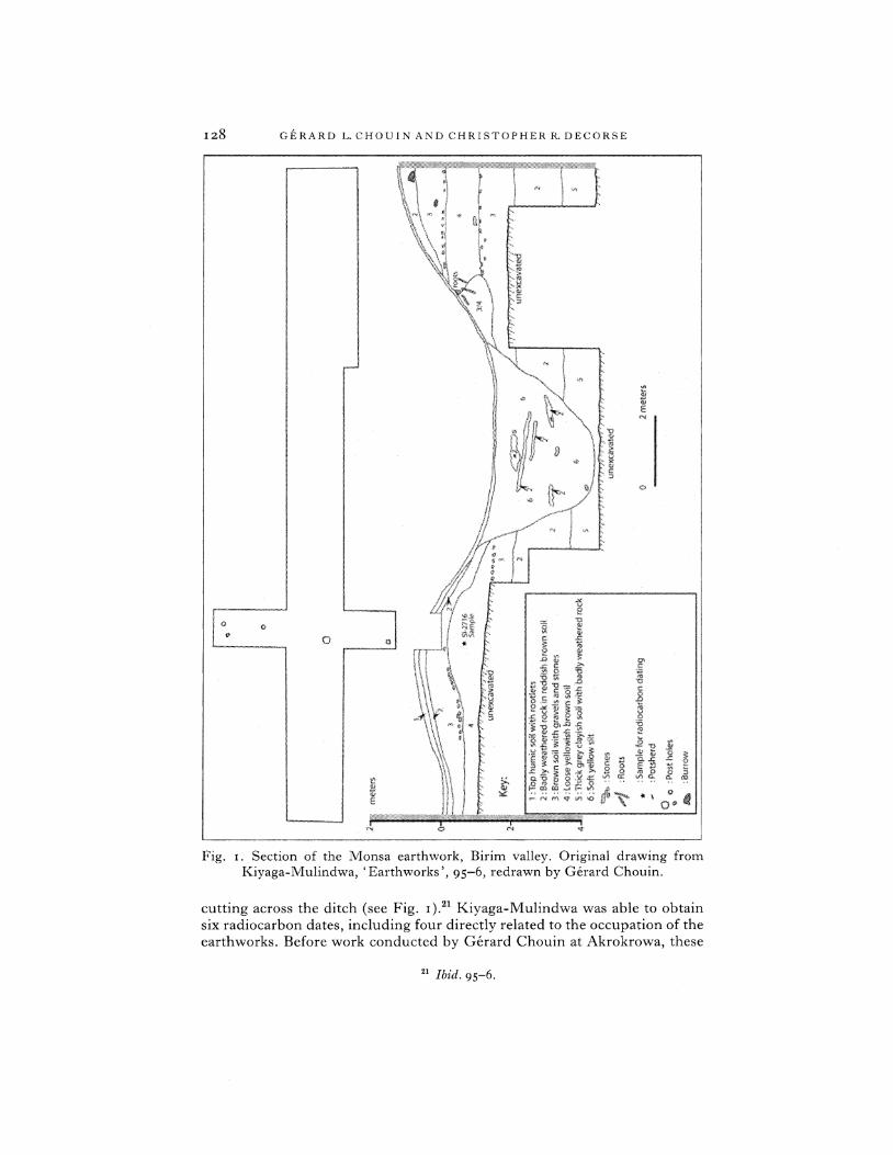
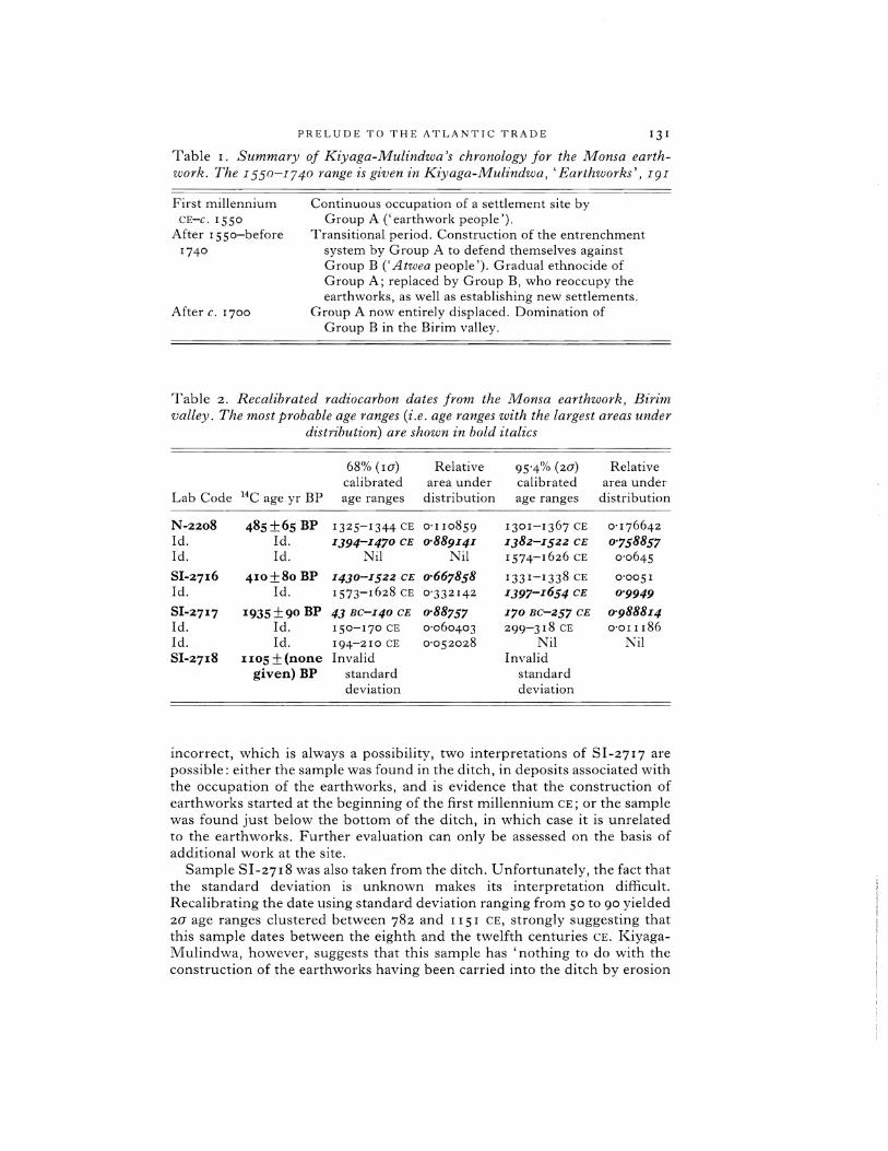
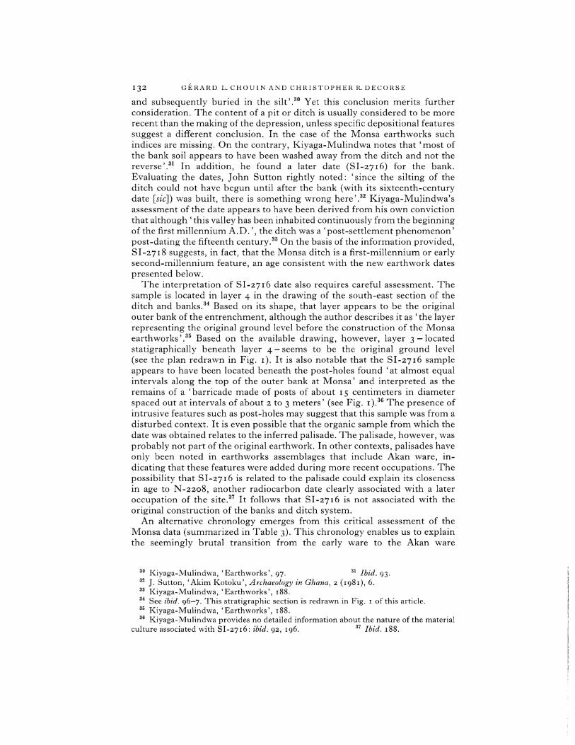
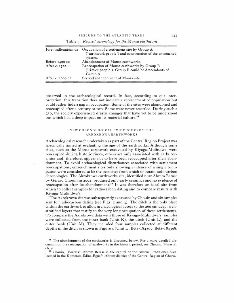
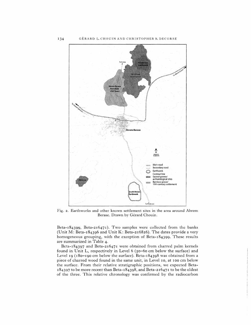
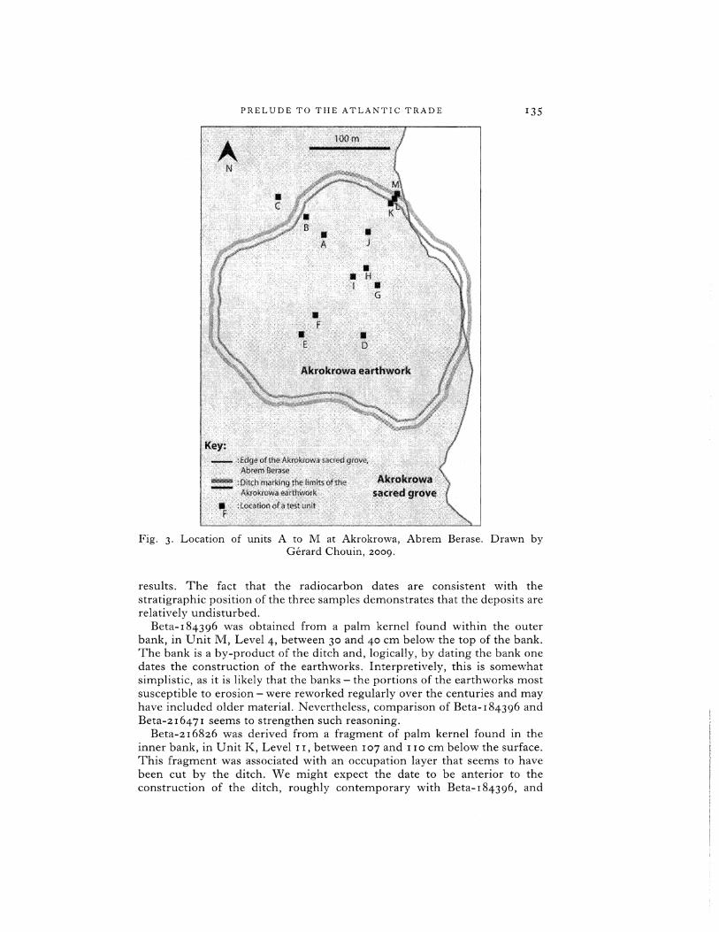
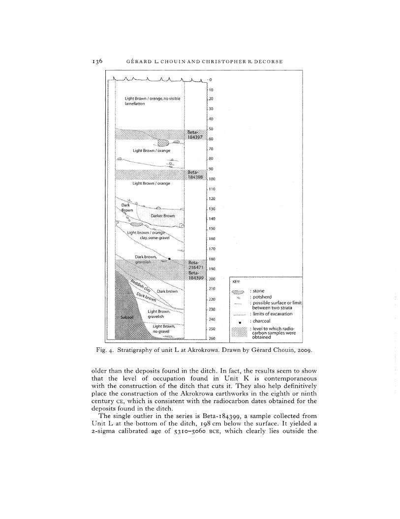
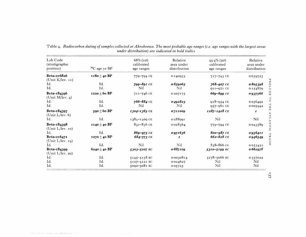