preparatory survey on western …open_jicareport.jica.go.jp/pdf/12231759.pdf · western bangladesh...
TRANSCRIPT

15-025
JR ( )4 R
PREPARATORY SURVEY ON
WESTERN BANGLADESH BRIDGES IMPROVEMENT PROJECT
FINAL REPORT
VOLUME 4: APPENDIX 2
APRIL 2015
JAPAN INTERNATIONAL COOPERATION AGENCY
ORIENTAL CONSULTANTS GLOBAL CO., LTD.
KATAHIRA & ENGINEERS INTERNATIONAL
ROADS AND HIGHWAYS DEPARTMENT MINISTRY OF ROAD TRANSPORTATION AND BRIDGES THE PEOPLE’S REPUBLIC OF BANGLADESH

People's Republic of Bangladesh Preparatory Survey on Western Bangladesh Bridges Improvement
Project
Final Report Volume
List of Appendix
APPENDIX 1 (Final Report Volume 3)
Appendix 1.1 The Result of Site Survey for 200 Bridges Appendix 1.2 Minutes of Discussion (M/D) with RHD at 26th January Appendix 1.3 List of 105 Bridges with Score and Photos Appendix 1.4 Geological Survey Works Appendix 1.5 Additional investigation for application of weathering steel
APPENDIX 2 (Final Report Volume 4)
Appendix 2.1 EIA Report (For 105 Bridges) Appendix 2.2 ARP Report (For 105 Bridges) Appendix 2.3 EIA Report (For EZ bridge) Appendix 2.4 ARP Report (For EZ Bridge) Appendix 2.5 Form of Monitoring Appendix 2.6 TOR for IA for ARP Implementation Appendix 2.7 TOR for External Monitoring Consultant
APPENDIX

ROADS AND HIGHWAYS DEPARTMENT MINISTRY OF ROAD TRANSPORT AND BRIDGES GOVERNMENT OF THE PEOPLE’S REPUBLIC OF BANGLADESH
PREPARATORY SURVEY
ON
WESTERN BANGLADESH BRIDGE INPROVEMENT
PROJECT
ENVIRONMENTAL IMPACT ASSESSMENT STUDY
December 2014
Prepared by
Oriental Consultants Co. Ltd.
Katahira & Engineers International
On behalf of
Roads and Highways Department (RHD)

i
TABLE OF CONTENTS
CHAPTER 1. INTRODUCTION....................................................................................................... 1-1
1.1 Description of the project .............................................................................................. 1-1 1.2 Sub-project Interventions and Locations ....................................................................... 1-1 1.3 Project Background ........................................................................................................ 1-2 1.4 Importance of the Project .............................................................................................. 1-2 1.5 Objective of the Project ................................................................................................. 1-3 1.6 Brief Description of the Subprojects sites ..................................................................... 1-3
CHAPTER 2. ENVIRONMENTAL LEGISLATIONS ........................................................................... 2-1
2.1 Policy, Legal and Administrative Frameworks ............................................................... 2-1 GoB Requirements .................................................................................................. 2-1 2.1.1 National Environmental Legislations ...................................................................... 2-1 2.1.2
2.2 EIA System and DoE Procedures .................................................................................... 2-4 Environmental Clearance Certificate (ECC) ............................................................ 2-5 2.2.1 Policy Safeguards .................................................................................................... 2-5 2.2.2
2.3 Harmonization of GoB and international Policies ......................................................... 2-6 2.4 Land Acquisition Frameworks ........................................................................................ 2-6 2.5 Framework for Resettlement......................................................................................... 2-7
Objective of the Abbreviated Resettlement Plan (ARP) ......................................... 2-7 2.5.1 Methodology for Preparing the Abbreviated Resettlement Plan .......................... 2-8 2.5.2
CHAPTER 3. IMPORTANT ENVIRONMENTAL COMPONENTS ..................................................... 3-1
3.1 Physical Components ..................................................................................................... 3-1 Climate .................................................................................................................... 3-1 3.1.1 Topography and Geology ........................................................................................ 3-2 3.1.2 Soils and land uses .................................................................................................. 3-3 3.1.3 Sedimentology and seismicity ................................................................................ 3-4 3.1.4 Hydro-geology ......................................................................................................... 3-6 3.1.5 Landscape ............................................................................................................... 3-6 3.1.6 Ground subsidence ................................................................................................. 3-7 3.1.7 Bottom sediments ................................................................................................... 3-7 3.1.8
3.2 Ecological Components .................................................................................................. 3-8 The floral species .................................................................................................... 3-8 3.2.1 The faunal and avifaunal species ............................................................................ 3-9 3.2.2 Biodiversity status ................................................................................................... 3-9 3.2.3 Wetlands ............................................................................................................... 3-10 3.2.4
3.3 Socio-cultural Components .......................................................................................... 3-10 Water Use ............................................................................................................. 3-10 3.3.1 Cultural Heritage ................................................................................................... 3-11 3.3.2

ii
Socio-cultural infrastructures ............................................................................... 3-11 3.3.3 Indigenous/ethnic communities ........................................................................... 3-11 3.3.4 Health care facilities .............................................................................................. 3-12 3.3.5 Educational facilities ............................................................................................. 3-12 3.3.6 Professional communities ..................................................................................... 3-13 3.3.7 Fisherman community .......................................................................................... 3-13 3.3.8 River transportation .............................................................................................. 3-13 3.3.9
Road and water route accidents ........................................................................... 3-14 3.3.10 Protected areas ..................................................................................................... 3-15 3.3.11 HIV/AIDS ................................................................................................................ 3-15 3.3.12 Gender equity ....................................................................................................... 3-15 3.3.13 Children’s right ...................................................................................................... 3-16 3.3.14 Climate change...................................................................................................... 3-16 3.3.15
3.4 Pollution ....................................................................................................................... 3-16 Air pollution .......................................................................................................... 3-17 3.4.1 Water pollution ..................................................................................................... 3-18 3.4.2 Soil pollution ......................................................................................................... 3-21 3.4.3 Noise and vibration ............................................................................................... 3-21 3.4.4 Wastes and effluents ............................................................................................ 3-21 3.4.5 Offensive odor ...................................................................................................... 3-22 3.4.6
CHAPTER 4. ACTIVITIES DURING IMPLEMENTATION STAGES .................................................... 4-1
CHAPTER 5. IMPACTS AND MITIGATIONS .................................................................................. 5-1
5.1 Environmental Impact Identification ............................................................................. 5-1 5.2 Environmental Impact Scoping Matrices ....................................................................... 5-1 5.3 Mitigation Measures by bridges .................................................................................... 5-5
CHAPTER 6. ANALYSIS OF ALTERNATIVES .................................................................................. 6-1
6.1 Alternative Alignment .................................................................................................... 6-1 6.2 No Action Alternative..................................................................................................... 6-3
CHAPTER 7. ENVIRONMENTAL MANAGEMENT PLAN ................................................................ 7-1
7.1 Institutional framework ................................................................................................. 7-1 7.2 Environmental Monitoring Plan ..................................................................................... 7-3
Compliance monitoring .......................................................................................... 7-3 7.2.1 Environmental Management Implementation ...................................................... 7-3 7.2.2 Environmental Monitoring Plan .............................................................................. 7-4 7.2.3 Reporting................................................................................................................. 7-5 7.2.4 Environmental Management Cost Estimated ........................................................ 7-5 7.2.5
CHAPTER 8. PUBLIC CONSULTATION .......................................................................................... 8-1

iii
8.1 Summarized Stakeholders Opinions at least Affected Subproject Sites ....................... 8-1 8.2 Summarized Stakeholders Opinions at Moderately Affected Subproject Sites ............ 8-1 8.3 Summarized Stakeholders Opinions at Seriously Affected Subproject Sites ................ 8-1
Appendix-I Primary Pollution Data Collected from the Bridge Sites
Appendix-II The EA Reports of the individual Bridge Sites
List of Table
Table 1.1Total number, type and total length (m) of the bridges under each type ............... 1-2
Table 2.1 Environment related Legislatures enacted by MoEF and other Ministries ............ 2-1
Table 3.1 Monthly rainfall (mm) and temperature (0C) for Khulna, Rajshahi, Barisal Divisions ....................................................................................................................... 3-2
Table 3.2 Status of the resident inland vertebrates in Bangladesh ........................................ 3-9
Table 3.3 National Health Services facilities available in Bangladesh. ................................. 3-12
Table 3.4 Total number and types of academic institutions in Bangladesh ......................... 3-13
Table 3.5 Organized and unorganized water and land transports in Bangladesh ................ 3-14
Table 3.6 National Air Quality Standards for Bangladesh ..................................................... 3-17
Table 3.7 Water pollution status in different rivers at selected sites ................................... 3-18
Table 3.8 National Standard for drinking water ................................................................... 3-19
Table 3.9 National Standards for Sound for different areas ................................................. 3-21
Table 4.1 Project activities and key environmental issues ..................................................... 4-2
Table 5.1 Comparison of Scoping before/after Study ............................................................ 5-2
Table 5.2 Mitigation measures pre-construction/during construction Stage: ....................... 5-6
Table 5.3 Mitigation measures in operation stage: ................................................................ 5-8
Table 6.1 Comparison of Alternatives ..................................................................................... 6-2
Table 7.1 Environmental Monitoring Plan: ............................................................................. 7-5
Table 7.2 Estimates for environmental monitoring costs borne by Contractor ..................... 7-6
Table 7.3 Estimates for environmental monitoring costs borne by RHD ............................... 7-6

iv
List OF Figure
Figure 1.1 Location of Bridge site ............................................................................................ 1-1
Figure 1.2 Mohasthan Bridge site ........................................................................................... 1-4
Figure 1.3 Chanda Bridge site ................................................................................................. 1-4
Figure 1.5 Naiori Bridge site .................................................................................................... 1-4
Figure 1.4 Kazirhat Bridge site ................................................................................................ 1-4
Figure 3.1 Meghna, Tista, Jamuna and Ganges Floodplains ................................................... 3-3
Figure 3.2 The Barind Tract Land ............................................................................................ 3-4
Figure 3.3 Different seismic risk zone in Bangladesh (GoB 1979) .......................................... 3-5
Figure 3.4 The most Earthquake prone Eastern region of Indo-Bangladesh .......................... 3-7
Figure 7.1 Institutional framework for environmental management and monitoring .......... 7-2
ABREVIATIONS
ADB - Asian Development Bank ARP - Abbreviated Resettlement Plan BFD - Bangladesh Forest Department BBS - Bangladesh Bureau of Statistics BCAS - Bangladesh Centre for Advance Studies BNBC - Bangladesh National Building Code BECA - Bangladesh Environmental Conservation Act BECR - Bangladesh Environmental Conservation Rules BUET - Bangladesh University of Engineering Technology CARE - Cooperative American Relief Everywhere CITES - Centre against Illegal Trade and Export of Species Cox - Oxides of Carbon CSC - Construction Supervision Consultant DCs - Deputy Commissioners DG - Director General DGWT - Deep Ground Water Table DoE - Department of Environment EA - Environmental Assessment EC - Executive Committee ECC - Environmental Clearance Certificate EIA - Environmental Impact Assessment EMP - Environmental Management Plan FAO - Food and Agriculture Organization GoB - Government of Bangladesh GDP - Gross Development Product IEE - Initial Environmental Examination

v
IECs - Important Environmental Components EMC - Environmental Management Committee GDP - Gross Development Product IUCN - International Union for Conservation of Nature IWTA - Inland Water Transport Authority JICA - Japan International Cooperation Agency LGED - Local Government Engineering Department MoEF - Ministry of Environment and Forest NCR - North Central Region NCS - National Conservation Strategy NEMAP - National Environmental Management Action Plan NEP - National Environmental Policy NGO - Non-Governmental Organization N0x - Nitrous Oxides O&M - Operation and Management PAPs - Project Affected Persons Pb - Lead PPEs - Personal Protection Equipment RCC - Rod concrete cement RAMSAR - Convention on Wetlands of International Significance REA - Rapid Environmental Assessment RHD - Roads and Highways Department RoW - Right of Way NCR - North Central Region NWR - North West Region SCR - South Central Region SE - Site Engineer SOx - Oxides of Sulphur SRDI - Soil Resources Development Institute SWR - South West Region SGWT - Shallow Ground Water Table SIDA - Swedish International Development Agency WARPO - Water Resources Planning Organization WB - World Bank

EXECUTIVE SUMMARY
A. Background of the Project A preparatory Survey on Western Bangladesh Bridge Project (WBBIP) has been carried out and necessary materials are prepared by JICA Survey Team in order to appraise feasibility of the Project under Japanese ODA loan.
The Project is comprised of 105 candidate bridges and have been selected though the screening process. These selected bridges are located under 37 districts of the western Bangladesh area such as Barisal, Khulna, Rajshahi, Rangpur Division and Gopalganj area.
The interventions that may cause include (i) reconstruction/construction of PC/Steel bridges along the existing bridge alignment, (ii) construction of approach roads on bridges sides and (iii) enhancement activities at bridges approaches. The project sites under WBBIP are situated on North Central Region (NCR), South West Region (SWR), North West Region (NWR) and South Central Region (SCR) of Bangladesh.
The 2-lane new bridges on National Highways will be reconstructed next and parallel to 2-lane existing bridges and those are on Regional Highways and Zilla roads will be replaced by new 2-lane bridge at the same location. The new bridge specifications including bridge type, length, width and height are summarized in Table ES-1. The approach roads on both sides of the bridge will also be constructed keeping pace with the requirements. Trees will be planted on both sides of the approach roads to ensure slope protection against gully erosion and for environmental enhancement.
Rivers and Canals on which interventions may be caused, have two different scenarios. That is Rajshahi, Rangpur and Gopalganj are mostly dry or with patches of water at places of the bed and that in Khulna and Barisal division have got flow of water having Ebb-Tide effect. The following table shows the length, width and height of the Project candidate bridges determined based on preliminary design.
ES-1

Table ES-1: Total number, type and total length of the Project bridge candidates
1 N8_178a Barisal Boalia Bazar Bridge N 8 176.88 Dhaka (Jatrabari)Mawa Bhanga Barisal Patuakhali PC-I 10.4 40 13.82 N509_19a Rangpur Sharnamoti Bridge N 509 19.553 Barabari-Lalmonirhat-Burimary Road PC-I 10.4 70 8.13 N5_119a Rajshahi Chanda Bridge N 5 118.748 Dhaka (Mirpur)-Paturia- Natakhola-Bogra-Rangpur- Banglabandh PC-I 10.4 60 5.04 N5_127a Rajshahi Palgari Bridge N 5 126.806 Dhaka (Mirpur)-Paturia- Natakhola-Bogra-Rangpur- Banglabandh PC-I 10.4 60 6.05 N5_176a Rajshahi Bhuyagati Bridge N 5 173.833 Dhaka (Mirpur)-Paturia- Natakhola-Bogra-Rangpur- Banglabandh PC-I 10.4 80 9.86 N5_235a Rangpur Mohosthan Bridge N 5 232.973 Dhaka-Utholi-Paturia-Bogra-Rangpur-Banglabandh Road Steel-I 10.4 120 10.17 N5_120a Rajshahi Chanda Bridge N 5 119.227 Dhaka (Mirpur)-Paturia- Natakhola-Bogra-Rangpur- Banglabandh PC-I 10.4 60 4.48 N5_128a Rajshahi Goilhar Bridge N 5 127.046 Dhaka (Mirpur)-Paturia- Natakhola-Bogra-Rangpur- Banglabandh PC-I 10.4 60 8.09 N5_158a Rajshahi Purbodalua Bridge N 5 155.583 Dhaka (Mirpur)-Paturia- Natakhola-Bogra-Rangpur- Banglabandh PC-I 10.4 80 7.7
10 N5_265a Rangpur Bupinath Bridge N 5 262.719 Dhaka-Paturia-Kashinathpur-Bogra-Rangpur-Banglabondh PC-I 10.4 60 8.011 N5_350b Rangpur Barati Bridge N 5 348.448 Dhaka -Paturia-Kashinathpur- Bogra-Rangpur-Beldanga- Banglabandh Road Steel-I 10.4 160 13.412 N8_182a Barisal Bakerganj Steel Bridge N 8 180.819 Dhaka (Jatrabari)MawaBhangaBarisalPatuakhali PC-I 10.4 35 6.513 N7_025a Gopalganj Jhuldibazar Bridge N 7 25.993 Dauladia-Faridpur -Magura-Jhenaidah-Jessore-Khulna-Mongla PC-I 10.4 30 5.914 N7_039a Gopalganj Karimpur Bridge N 7 39.64 Dauladia-Faridpur -Magura-Jhenaidah-Jessore-Khulna-Mongla PC-I 10.4 65 9.815 N7_049a Gopalganj Porkitpur Bridge N 7 49.629 Dauladia-Faridpur -Magura-Jhenaidah-Jessore-Khulna-Mongla PC-I 10.4 30 6.116 N5_134a Rajshahi Nukali Bridge N 5 132.062 Dhaka (Mirpur)-Paturia- Natakhola-Bogra-Rangpur- Banglabandh Steel-I 10.4 50 10.017 N6_97a Rajshahi Dattapara Bridge N 6 97.587 Kashinathpur-Dasuria-Natore-Rajshahi PC-I 10.4 40 7.818 R681_10a Rajshahi Horisonkorpur Bridge R 681 10.266 Ujanpara-Bijoynagar Road (Old Part) PC-I 10.4 50 5.919 N5_140a Rajshahi Jugnidaha Bridge N 5 138.201 Dhaka (Mirpur)-Paturia- Natakhola-Bogra-Rangpur- Banglabandh PC-I 10.4 65 8.020 N5_118a Rajshahi Punduria Bridge N 5 117.143 Dhaka (Mirpur)-Paturia- Natakhola-Bogra-Rangpur- Banglabandh Steel-I 10.4 130 10.121 N704_43a Khulna G.K. Bridge N 704 44.135 Jhenaidah-Kushtia-Paksey Ferry-Dasuria PC-I 10.4 55 6.022 N7_248c Khulna Gora bridge N 7 248.844 Daulatdia-Faridpur -Magura-Jhenaidah-Jessore -Khulna-Mongla PC-I 10.4 30 6.023 N7_054a Gopalganj Barashia Bridge N 7 55.168 Dauladia-Faridpur -Magura-Jhenaidah-Jessore-Khulna-Mongla PC-I 10.4 90 13.224 N5_356a Rangpur - N 5 354.204 Dhaka -Paturia-Kashinathpur- Bogra-Rangpur-Beldanga- Banglabandh Road PC-I 10.4 30 6.825 N7_246a Khulna Balai bridge. N 7 246.112 Daulatdia-Faridpur -Magura-Jhenaidah-Jessore -Khulna-Mongla PC-I 10.4 60 8.226 N8_095a Gopalganj Amgram bridge N 8 94.098 Dhaka(Jatrabari)-Mawa-Banga-Barisal- Patuakhali PC-I 10.4 40 10.127 N505_2a Rajshahi Kazir Hat Bridge N 505 2.47 Baderhat-Kazirhat (Latifpur) Steel-I 10.4 160 10.328 R548_28b Rajshahi Atrai Bridge R 548 27.8 Naogaon-Atrai-Natore Steel-I 10.4 160 16.229 N7_036c Gopalganj Kanaipur Bridge N 7 37.369 Dauladia-Faridpur -Magura-Jhenaidah-Jessore-Khulna-Mongla PC-I 10.4 40 8.930 N7_048a Gopalganj Brahmonkanda Bridge N 7 48.48 Dauladia-Faridpur -Magura-Jhenaidah-Jessore-Khulna-Mongla PC-I 10.4 30 6.531 N5_378a Rangpur Gaudangi Bridge N 5 375.421 Dhaka-Paturia-Kashinathpur- Bogra-Rangpur- Banglabandh. PC-I 10.4 65 5.832 N7_047a Gopalganj Bimankanda bridge N 7 47.833 Dauladia-Faridpur -Magura-Jhenaidah-Jessore-Khulna-Mongla PC-I 10.4 60 11.233 N5_156a Rajshahi Chowkidhoh Bridge N 5 153.977 Dhaka (Mirpur)-Paturia- Natakhola-Bogra-Rangpur- Banglabandh PC-I 10.4 60 8.634 N5_172a Rajshahi Notun Dhoh Bridge N 5 169.626 Dhaka (Mirpur)-Paturia- Natakhola-Bogra-Rangpur- Banglabandh PC-I 10.4 60 8.335 N5_179a Rajshahi Dhatia Bridge N 5 176.746 Dhaka (Mirpur)-Paturia- Natakhola-Bogra-Rangpur- Banglabandh PC-I 10.4 65 7.3
New Bridge Height (m)
Chainage (km)
New Bridge Width (m)Road Name New Bridge
Length (m)New Bridge
TypeBridge ID Road NoRank RHD Zone Bridge Name Road Type
ES-2

36 N5_188a Rangpur Ghoga Bridge N 5 185.73 Dhaka (Mirpur)-Utholi-Paturia- Bogra-Rangpur- Banglabandh PC-I 10.4 60 8.637 N5_126a Rajshahi Vitapara Bridge N 5 125.093 Dhaka (Mirpur)-Paturia- Natakhola-Bogra-Rangpur- Banglabandh Steel-I 10.4 100 11.038 N518_4a Rangpur Khorkhori bridge N 518 3.959 Sayedpur Town Old Section (Sutkir More-Sonapukur) PC-I 10.4 60 7.239 N7_141b Khulna Buri Bhairab Bridge N 7 142.096 Dauladia-Faridpur -Magura-Jhenaidah-Jessore-Khulna-Mongla PC-I 10.4 35 7.040 R720_44a Khulna Gurakhali Bridge R 720 43.568 Magura-Narail PC-I 10.4 55 8.541 N703_Sd Khulna Dhopa Ghata Bridge N 703 0.508 Jhenaidah Town Old Section PC-I 10.4 150 9.242 R890_45a Barisal Dawrey Bridge R 890 45.766 Bhola(Paran Talukderhat)-Burhanuddin-Lalmohon-Char Fassion-Char Manika PC-I 10.4 65 9.643 N704_14a Khulna Barda Bridge N 704 15.342 Jhenaidah-Kushtia-Paksey Ferry-Dasuria PC-I 10.4 105 12.944 N704_33b Khulna Balipara Bridge N 704 34.625 Jhenaidah-Kushtia-Paksey Ferry-Dasuria PC-I 10.4 40 7.745 N5_344c Rangpur Kharua Vanga Bridge N 5 342.366 Dhaka -Paturia-Kashinathpur- Bogra-Rangpur-Beldanga- Banglabandh Road Steel-I 10.4 40 16.546 N5_382a Rangpur Ichamoti Bridge N 5 379.45 Dhaka-Paturia-Kashinathpur- Bogra-Rangpur- Banglabandh. PC-I 10.4 65 6.747 N5_360a Rangpur Chikli Bridge N 5 358.013 Dhaka -Paturia-Kashinathpur- Bogra-Rangpur-Beldanga- Banglabandh Road PC-I 10.4 60 6.748 Z5025_55a Rangpur Kakra Bridge Z 5025 54.359 Rangpur-Badarganj-Parbatipur-Dinajpur. Steel-I 9.8 170 8.549 Z5025_64a Rangpur Gabura Bridge. Z 5025 63.739 Rangpur-Badarganj-Parbatipur-Dinajpur. PC-I 9.8 90 7.150 Z5401_45a Rangpur Mathpara Bridge Z 5401 44.585 Sirajganj-Kazipur-Dhunat-Sherpur Steel-I 9.8 80 11.051 Z5072_14a Rangpur Bombgara Bridge Z 5072 13.52 Dhunot-Nanglu-Baliadighi-Gabtali-Pirgachha-Mokamtala PC-I 9.8 60 7.052 Z5025_60a Rangpur Madarganj Bridge Z 5025 59.364 Rangpur-Badarganj-Parbatipur-Dinajpur. PC-I 9.8 95 8.053 Z5472_6a Rangpur Raktodaho Bridge Z 5472 6.28 Adamdighi-Santahar Sailo-Raninagar PC-I 9.8 75 5.254 N5xx_Sa Rajshahi Pura Mukto Monch Bridge N 5xx 0.92 Ullahpara town portion of Dhaka - Banglabandh road. PC-I 10.4 50 8.055 Z5552_10a Rangpur Barodia Khali Bridge Z 5552 10.295 Gaibanda-Phulchari-Vratkhali-Saghata Steel-I 9.8 60 12.556 N8_152c Barisal Rahamatpur bridge N 8 150.977 Dhaka (Jatrabari)MawaBhangaBarisalPatuakhali PC-I 10.4 60 8.857 N8_127b Barisal gounagata bridge N 8 126.358 Dhaka(Jatrabari)MawaBangaBarisal Patuakhali PC-I 10.4 35 6.858 Z8052_009d Barisal Gabtala Steel Bridge Z 8052 9.88 Kachua Betagi Mirjaganj Patuakhali Lohalia Nijbot Kalaiya PC-I 9.8 30 3.359 Z5015_22a Rangpur Bahagili Bridge Z 5015 22.244 Taxerhat-Laldighi-Taraganj-Kishoreganj Steel-I 9.8 200 7.160 Z5701_1a Rangpur Anandababur Pool Z 5701 0.518 Nilphamari-Jaldhaka PC-I 9.8 35 4.561 Z5701_9a Rangpur Duhuli Bridge Z 5701 7.362 Nilphamari-Jaldhaka PC-I 9.8 50 6.762 R545_115c Rangpur Mongle bari kuthibari Bridge R 545 116.535 Bogra-Naogaon-Mohadebpur-Patnitala-Dhamoirhat-Joypurhat Steel-I 10.4 90 10.363 R760_049c Khulna Shakdaha bridge R 760 49.478 Khulna - Chuknagar - Satkhira road. PC-I 10.4 50 3.364 N8_123a Barisal Souderkhal bridge N 8 121.734 Dhaka(Jatrabari)MawaBangaBarisal Patuakhali PC-I 10.4 35 6.965 Z8701_3d Barisal Bottala Bridge Z 8701 3.806 CharkhaliTushkhaliMathbariaPatharghata PC-I 9.8 35 5.166 N5_260b Rangpur Katakhali Bridge N 5 258.224 Dhaka-Paturia-Kashinathpur-Bogra-Rangpur-Banglabondh. Steel-I 10.4 170 16.667 N704_27b Khulna Bittipara Bridge N 704 28.708 Jhenaidah-Kushtia-Paksey Ferry-Dasuria PC-I 10.4 35 5.868 R750_22c Khulna Bhangura Bridge R 750 21.434 Jessore-Narail PC-I 20.8 35 7.569 N8_129a Barisal Asokoti bridge N 8 127.737 Dhaka(Jatrabari)MawaBangaBarisal Patuakhali PC-I 10.4 30 7.470 R890_16a Barisal Banglabazar Bridge R 890 16.347 Bhola(Paran Talukderhat)-Burhanuddin-Lalmohon-Char Fassion-Char Manika PC-I 10.4 50 11.7
New Bridge Height (m)
Chainage (km)
New Bridge Width (m)Road Name New Bridge
Length (m)New Bridge
TypeBridge ID Road NoRank RHD Zone Bridge Name Road Type
ES-3

Source: JICA Survey Team
71 R890_21a Barisal Box-a-ali Bridge R 890 21.584 Bhola(Paran Talukderhat)-Burhanuddin-Lalmohon-Char Fassion-Char Manika PC-I 10.4 30 8.472 R890_28a Barisal Borhanuddin Bridge R 890 28.699 Bhola(Paran Talukderhat)-Burhanuddin-Lalmohon-Char Fassion-Char Manika PC-I 10.4 40 9.973 R548_40a Rajshahi Mohis Mari Bridge R 548 0 Naogaon-Atrai-Natore PC-I 10.4 50 5.974 R451_1a Rajshahi Naiori Bridge R 451 0.907 Nalka-Sirajganj PC-I 10.4 60 6.975 R451_7a Rajshahi Chondi Das Bridge R 451 6.561 Nalka-Sirajganj Steel-I 10.4 80 10.576 R550_28b Rangpur Bottoli Bridge R 550 28.826 Mokamtala-Kalai-Joypurhat. Steel-I 10.4 80 11.777 R860_31a Gopalganj Paprail Bailey Bridge R 860 29.6 Mostafapur-Madaripur-Shariatpur-Ibrahimpur-Harina-Chandpur PC-I 10.4 40 7.878 Z8708_1c Barisal Afalbarir Khal Bridge Z 8708 1.807 RajapurKathaliaAmuaBamnaPatharghata PC-I 9.8 40 6.179 N5_458a Rangpur - N 5 454.302 Dhaka (Mirpur)-Paturia- Natakhola-Bogra-Rangpur- Banglabandh PC-I 10.4 35 5.680 N5_488a Rangpur Chawai Bridge N 5 483.864 Dhaka (Mirpur)-Paturia- Natakhola-Bogra-Rangpur- Banglabandh PC-I 10.4 70 6.281 Z8708_12b Barisal Boda Bridge Z 8708 12.174 RajapurKathaliaAmuaBamnaPatharghata PC-I 9.8 60 5.882 Z8033_017a Barisal Raiyer hat bridge Z 8033 17.477 GariarparBanariparaSawrupkatiKawkhaliNaikati PC-I 9.8 50 8.983 R860_34a Gopalganj Jajihar Bridge R 860 32.943 Mostafapur-Madaripur-Shariatpur-Ibrahimpur-Harina-Chandpur PC-I 10.4 50 6.284 R860_44c Gopalganj Gazipur Bridge R 860 43.024 Mostafapur-Madaripur-Shariatpur-Ibrahimpur-Harina-Chandpur PC-I 10.4 130 12.085 R860_53d Gopalganj Balar Bazar Bridge R 860 52.069 Mostafapur-Madaripur-Shariatpur-Ibrahimpur-Harina-Chandpur PC-I 10.4 100 8.686 N8_69a Gopalganj Kumar Bridge N 8 68.726 Dhaka (Jatrabari)-Mawa-Bhanga-Barisal-Patuakhali PC-I 10.4 120 6.187 Z6010_12b Rajshahi Faliarbil Bridge Z 6010 12.34 Rajshahi-Hatgodagari-Faliarbil-Mohonganj PC-I 9.8 35 5.088 Z5008_1a Rangpur Choto Dhepa bridge. Z 5008 1.13 Birganj-Khansama-Darwani. PC-I 9.8 55 7.589 Z5024_5c Rangpur Shampur Bridge. Z 5024 5.67 Modhupur-Shampur PC-I 9.8 35 5.290 Z5025_46a Rangpur Bondorer pool Bridge Z 5025 45.643 Rangpur-Badarganj-Parbatipur-Dinajpur. PC-I 9.8 60 6.091 Z5040_4a Rangpur Khottapara Bridge Z 5040 3.9 Sultanganj (Lichutala)-Madla-Bagbari-Gabtali (Pachmile) PC-I 9.8 40 6.392 Z8810_13a Barisal Banogram Bridge Z 8810 13.913 BakerganjPadrishibpurKathaltaliSubidkhaliBarguna PC-I 9.8 60 7.893 R585_80a Rangpur Bhela Bridge R 585 80.501 Gobindagnj-Goraghat-Birampur-Fulbari-Dinajpur. PC-I 10.4 40 4.694 Z8033_008a Barisal Kalijira bridge Z 8033 0 GariarparBanariparaSawrupkatiKawkhaliNaikati PC-I 9.8 115 10.695 Z8033_019a Barisal Masrong bridge Z 8033 19.103 GariarparBanariparaSawrupkatiKawkhaliNaikati PC-I 9.8 40 5.296 Z8034_011a Barisal Padarhat bridge Z 8034 12.418 RahamatpurBabuganjMuladiHizla PC-I 9.8 50 5.597 Z8044_004a Barisal Talukdarhat Bailey Bridge Z 8044 3.57 Barisal (Dinerpool)LaxmipashaDumki PC-I 9.8 40 6.399 R860_35a Gopalganj Shajonpur Bailey Bridge R 860 34.021 Mostafapur-Madaripur-Shariatpur-Ibrahimpur-Harina-Chandpur PC-I 10.4 35 4.2
100 Z5041_2a Rajshahi Debokbazar Bridge Z 5041 1.8 Raiganj (Bhuiyagati)-Nimgachhi-Taras Road Steel-I 9.8 80 11.0N706_14b Khulna Jhikorgacha Bridge N 706 14.349 Jessore (Daratana More)-Benapole PC-I 20.8 105 7.8N5_435a Rangpur - N 5 432.44 Dhaka (Mirpur)-Paturia-Natakhola-Bogra-Rangpur-Banglabandh PC-I 10.4 40 8.3N704_12c Khulna Chandi Pur Bridge N 704 13.855 Jhenaidah-Kushtia-Paksey Ferry-Dasuria PC-I 10.4 30 7.8N805_24a Gopalganj Garakola Bridge N 805 24.19 Bhanga-Bhatiapara-Mollahhat PC-I 20.8 110 7.8R750_25a Khulna Tularampur Bridge R 750 24.18 Jessore-Narail PC-I 20.8 95 7.8Z7503_5a Khulna Hawai khali Bridge Z 7503 5.213 Narail-Lohagara Bazar-Naragati PC-I 20.8 30 7.8
Note: N: National Highway R: Regional Highway Z: Zilla Road
New Bridge Height (m)
Chainage (km)
New Bridge Width (m)Road Name New Bridge
Length (m)New Bridge
TypeBridge ID Road NoRank RHD Zone Bridge Name Road Type
ES-4

Scope of the EIA
To prepare the EIA report, the EIA Study Team (Figure 1) was concentrated on field investigations, stakeholder consultation, primary and secondary data collection, screening of all baseline environmental parameters, environmental quality baseline monitoring, and preliminary engineering design of bridges with approach roads.
The EIA covers the general environmental profile of the Project area including physical, ecological, environmental, social, cultural and economic resources. Baseline environmental monitoring was carried out on water (surface and ground), air, noise, soil and sediment quality measurements. The EIA includes an overview of the potential environmental impacts and their severity, and proposes necessary mitigation measures and environmental management plan for each of the identified impacts.
Figure 1: EIA Team Composition
ES-5

Methodology for conducting EIA
The methodology used for this study is based on the procedures described in Environmental Guidelines and the other relevant regulation of Bangladesh as well as “JICA Guidelines for Environmental and Social Considerations (April 2010)”. Methodology adopted for completion of the EIA study of bridges is as follows:
Scoping workshop organization with various stake holders at the beginning of the Project preparation activities; Reconnaissance survey was taken up to collect baseline information in devised formats; Analysis of collected data was carried out; Documentation of baseline conditions was done by doing on site environmental monitoring; Analysis and assessment of various alternatives was taken up; Identification and assessment of various impacts was done; Formulation of mitigation, and avoidance measures was done for identified impacts, and community consultations were carried out. The steps followed during EIA study are:
(i) Collection of baseline data; (ii) Identification of environmental impacts on IECs; (iii) Prediction regarding potential impacts; (iv) Evaluation of the impacts; (v) Prescribing the mitigation measures; (vi) Monitoring program; (vii) Risk analysis; (viii) Documentation;
B. Legislation, Regulation and Policy
GoB Requirements of legislations for EIA
The BECA (1995), BECR (1997) enacted by the Government and EIA is obligatory during feasibility study, planning, design and implementation stages. An ECC is required from DOE to initiate project implementation activities. The EIA documents are in reality the guiding tool to implementation agencies, management tools to the stakeholders during construction and operation stages.
The BECR (1997) categorized development interventions as Green, Amber (A, B) and Red. As per JICA, the provision is made as:
A: Remarkable Negative Impact is predicted. B: Negative Impact is expected to some extent.
ES-6

C: Extent of Impact is unknown. (A further examination is needed and the impact could be defined as study progresses) D: Impact is very small or nil and further survey is not required
The gradation in this subject document has been made as above depending on their degree of impacts on environment. The proposed upgrading of bridges involves construction reconstruction and widening of bridges on National Highways, Regional Highways and Zilla roads managed by RHD. However, the Survey team conducted EIA for all bridges as per JICA requirements.
C. Alternative Alignment The locations of new bridges have been determined in consideration of impact to existing residences, shops, cost and so on. However, National Highways have been kept under provision for widening into 4-lanes in future.
As a result of comparison, Alternative 4 (Replacement Existing Bridge) was selected from the viewpoint of the cheapest initial cost. Regarding National Highways, Alternative 3 (New Bridge Construction next to Existing Bridge) was selected in consideration of easy future widening. And Alternative 3 was selected for Regional Highways and Zilla road. The selection of alignments alternatives are shown in the following Table.
ES-7
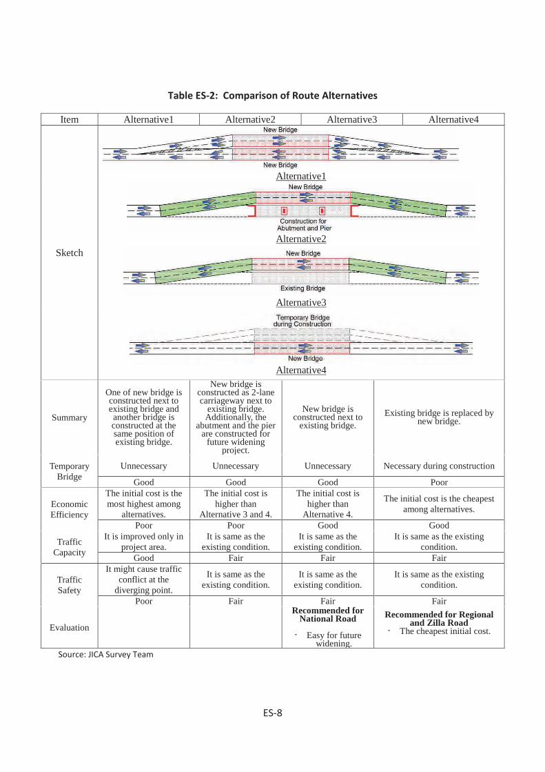
Table ES-2: Comparison of Route Alternatives
Item Alternative1 Alternative2 Alternative3 Alternative4
Sketch
Alternative1
Alternative2
Alternative3
Alternative4
Summary
One of new bridge is constructed next to existing bridge and another bridge is constructed at the same position of existing bridge.
New bridge is constructed as 2-lane carriageway next to
existing bridge. Additionally, the
abutment and the pier are constructed for
future widening project.
New bridge is constructed next to
existing bridge. Existing bridge is replaced by
new bridge.
Temporary Bridge
Unnecessary Unnecessary Unnecessary Necessary during construction
Good Good Good Poor
Economic Efficiency
The initial cost is the most highest among
alternatives.
The initial cost is higher than
Alternative 3 and 4.
The initial cost is higher than
Alternative 4.
The initial cost is the cheapest among alternatives.
Poor Poor Good Good
Traffic Capacity
It is improved only in project area.
It is same as the existing condition.
It is same as the existing condition.
It is same as the existing condition.
Good Fair Fair Fair
Traffic Safety
It might cause traffic conflict at the
diverging point.
It is same as the existing condition.
It is same as the existing condition.
It is same as the existing condition.
Poor Fair Fair Fair
Evaluation
Recommended for National Road
- Easy for future widening.
Recommended for Regional and Zilla Road
- The cheapest initial cost.
Source: JICA Survey Team
ES-8

D. Policy Framework and Administrative Procedures
(1) Policy Framework
The National Conservation Strategy (NCS 1991) and National Environmental Management Action Plan (NEMAP 1995) emphasize on the inter-sector coordination and participation of public as well as the private sector in development activities. Basic guidelines of the National Environmental Policy (NEP, 1992) are:
To ensure protection and conservation of physical, ecological and cultural resourcesfrom depletion, deterioration and degradation due to human activities;To identify activities that induce pollution/degradation/ deterioration of naturalenvironmental resources;To ensure protection and conservation of historical/archaeological/ culturalstructures/sites and relics from deterioration and degradation due to humanactivities;Protection of identities, rights, livelihood and heritages of the indigenous tribes;
The pivotal environmental safeguards are sustainable and environment friendly development, poverty reduction, women empowerment and planned employment generation. To achieve these goals emphasis should be given on avoidance, reduction and/or mitigation of impacts on environmental resources during project implementation stages and enhancement of the positive impacts to harvest optimum benefits from the development endeavors.
(2) Administrative Procedures
An ECC from DOE is required before initiating the project implementation activities. An application to the DG of DOE was submitted through the local office in prescribed application form (Vide Rule 7.5) fulfilling the requirements detailed in BECR 1997 (BCAS 1999).
E. Land Acquisition Frameworks Land Acquisition Law in the Bengal was first enacted in 1824. The provisions and scopes of that law were subsequently amended and expanded in 1850, 1857, and 1863 leading to the enactment of Land Acquisition Act 1984. This Act continued enforced until partition of India through proclamation of independence in 1947. This Act however lacked the provision for payment of compensation for the acquired land and other immovable properties, as a result the requiring bodies used to overestimate the actual land requirements to cause loss to the land owners. The Acquisition of Immoveable Properties Ordinance-II 1982 was enacted to safeguard owners right regarding payment of compensation and to reduce wastage of land. Under this Ordinance the DCs or their
ES-9

nominees are authorized to examine the claim for compensation taking into consideration all factors regarding entitlement of compensation and empowered to divide the compensation amount amongst all the legitimate shareholders.
The Emergency Property Acquisition Act was enacted in 1989, this Act empowered the Government authority to acquire private properties on during high floods, tidal bores, river bank erosion and other sorts of natural calamities to act swiftly to check those calamities. Hence, it is clear that the Act 1989 did not replace the Ordinance 1982, rather both the legislatures remained enforced simultaneously and applied during implementation of the Bangabandhu Multipurpose (Jamuna) Bridge Project.
The Deputy Commissioners (DCs) as Chief Executives of the district or any officer authorized by them can exercise the power conferred on the DCs regarding requisition of Immovable Properties under the Ordinance 1982 and Act 1989. The Bangabandhu Multipurpose Bridge (Land Acquisition) Act 1995 (Annexure-6) was enacted later on July9 1995. Under provisions of this Act persons constructing structure/establishments and or modifying the land class/type that is likely to be acquired with the intention of extraction higher compensation rate will not be entitled any compensation for such structures. Land acquisition issue may not be a significantly disturbing issue during implementation of WBBIP. A comprehensive Abbreviated Resettlement Plan (ARP) has been formulated and shown in standalone report in details.
F. Physical Environment
(1) Climate
Bangladesh has upper humid mega-thermal climate with no water shortage at 50 cm depth at any part of the year. Maximum temperature during May-October period is 31-340C and minimum temperature during November-February period is 11-160C. Winter climate (November-January) is cold and dry, spring climate (February-March) is pleasant, and summer climate (March-May) is hot and dry while the monsoon season (June- September) is wet. The temperature and rainfall during the monsoon season are high. Peak temperature during April-May locally may reach up to 400C. Bangladesh has tropical rainy climate. The mean temperature in coldest month is about 180C and the mean rainfall in driest month remains below 6.0 mm.
ES-10

(2) Topography
Topography of western Bangladesh that is covered by the Meghna, Tista, Jamuna and Ganges floodplains is almost level with convex ridges and concave basin sites. Part of the North Central region in Bogra and North West region Rajshahi, Rangpur and Dinajpur is occupied by level and/or undulated terrace lands.
The undulated terrace lands of Rangpur, Dinajpur and Rajshahi districts were previously covered with dense deciduous Sal forest managed by private ownership and subsequently by the Bangladesh Forest Department (BFD). Presently the Sal forest particularly in level lands is heavily depleted and used for rain fed or irrigated paddy production. Patches of the Sal forest still occurs as remnants on undulated terrace lands of the Barind in Rangpur, Dinajpur and Rajshahi districts.
(3) Geology and Soils Strata
Soils of the Barind tract are weakly structured, olive, acidic clays in the subsoil overlying an unaltered clayey substratum at variable depths. The landscape was probably colonized by pioneer vegetation.
ES-11
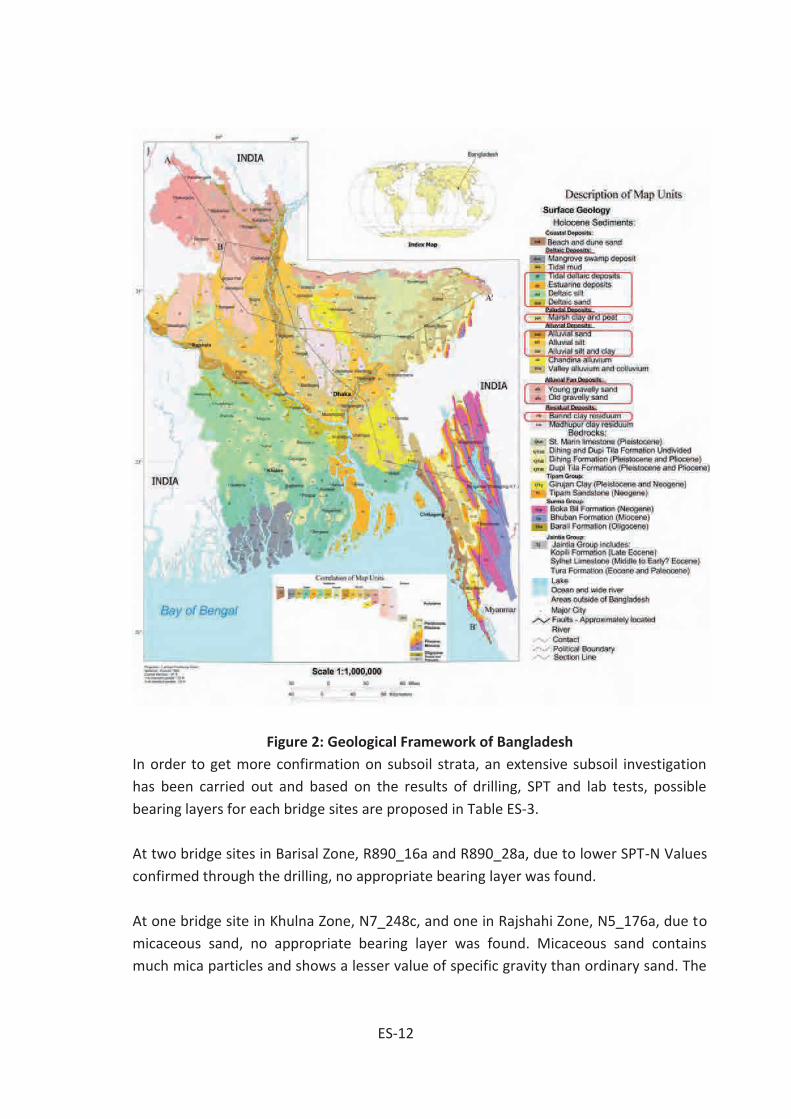
Figure 2: Geological Framework of Bangladesh In order to get more confirmation on subsoil strata, an extensive subsoil investigation has been carried out and based on the results of drilling, SPT and lab tests, possible bearing layers for each bridge sites are proposed in Table ES-3.
At two bridge sites in Barisal Zone, R890_16a and R890_28a, due to lower SPT-N Values confirmed through the drilling, no appropriate bearing layer was found.
At one bridge site in Khulna Zone, N7_248c, and one in Rajshahi Zone, N5_176a, due to micaceous sand, no appropriate bearing layer was found. Micaceous sand contains much mica particles and shows a lesser value of specific gravity than ordinary sand. The
ES-12

highest specific gravity of micaceous sand recorded in the Study was 2.57g/cm3; most of the results of micaceous sand show specific gravity of around 2.4-2.5 g/cm3. Mica is a luster mineral with flat fragile structure and slippery surface and usually found in the sediments underlying Bangladesh flatland. With its fragile and slippery property, mica richly contained in micaceous sand provides much lower bearing capacity and/or skin friction than expected from SPT-N value of a layer and has caused a number of problems in construction of pile foundations in Bangladesh. Based on the experience in Bangladesh, bearing capacity and/or skin friction cannot be expected in micaceous sand.
Table ES-3: Subsoil Investigation Results
SN
Bridge Data Bearing Layer
Bridge ID Zone Division Sub-Division Depth (GL-m) Soil Type SPT N
Value Remarks
1 N8_178a Barisal Barisal Barisal 46 Silty Sand w Gravel, SM 50<
2 N509_19a Rangpur Lalmonirhat Lalmonirhat 23 Poorly Graded Sand w Gravel, SP 50 <
3 N5_119a Rajshahi Pabna Pabna-1 29 Poorly Graded Silty Sand w Gravel, SP-
SM 50<
4 N5_127a Rajshahi Pabna Ullahpara 28 Silty Sand w Gravel, SM 50 <
5 N5_176a Rajshahi Serajganj Serajganj-2 No Micaceous Silty Sand w Gravel,
SP-SM
50 < (28m~)
Micaceous sand shall not be used as a bearing layer.
6 N5_235a Rangpur Bogra Bogra 25 Silty Sand w Gravel, SM 50 <
7 N5_120a Rajshahi Pabna Pabna-1 27 Poorly Graded Silty Sand w Gravel, SP-
SM 50 <
8 N5_128a Rajshahi Serajganj Ullahpara 31 Poorly Graded Silty Sand w Gravel, SP-
SM 50 <
9 N5_158a Rajshahi Serajganj Ullahpara 24 Silty Sand w Gravel, SM 50 <
ES-13

SN
Bridge Data Bearing Layer
Bridge ID Zone Division Sub-Division Depth (GL-m) Soil Type SPT N
Value Remarks
10 N5_265a Rangpur Gaibanda Palashbari 22 Poorly Graded Sand w Gravel, SP 50 <
11 N5_350b Rangpur Rangpur Rangpur 22 Silty Sand w Gravel, SM 50 <
12 N8_182a Barisal Barisal Barisal 40 Silty Sand w Gravel, SM 30<
13 N7_025a Gopalganj Faridpur Faridpur-2 38 Silty Sand w Gravel, SM 50<
14 N7_039a Gopalganj Faridpur Faridpur-1 45 Silty Sand w Gravel, SM 50<
15 N7_049a Gopalganj Faridpur Faridpur-1 33 Poorly Graded Sand w Gravel, SP 50<
16 N5_134a Rajshahi Serajganj Ullahpara 29 Poorly Graded Sand w Gravel, SP 50 <
17 N6_97a Rajshahi Natore Natore-2 27 Poorly Graded Sand w Gravel, SP 50 <
Thickness shall be confirmed during D/D.
18 R681_10a Rajshahi Rajshahi Rajshahi-1 29 Silty Sand w Gravel, SM 50 <
Thickness shall be confirmed during D/D.
19 N5_140a Rajshahi Serajganj Ullahpara 23 Poorly Graded Sand w Gravel, SP 50 <
20 N5_118a Rajshahi Pabna Pabna-1 25 Silty Sand w Gravel, SM 50<
21 N704_43a Khulna Kushtia Kushtia 30 Silty Sand w Gravel, SM 50<
22 N7_248c Khulna Bagerhat Bagerhat-2 No Micaceous Silty Sand w Gravel,
SP-SM
50 < (51m~)
Micaceous sand shall not be used as a bearing layer.
23 N7_054a Gopalganj Faridpur Faridpur-1 52 Silty Sand w Gravel, SM 50<
24 N5_356a Rangpur Rangpur Rangpur 24 Silty Sand w 50 <
ES-14

SN
Bridge Data Bearing Layer
Bridge ID Zone Division Sub-Division Depth (GL-m) Soil Type SPT N
Value Remarks
Gravel, SM
25 N7_246a Khulna Bagerhat Bagerhat-2 54 Poorly Graded Silty Sand w Gravel, SP-
SM 50<
26 N8_095a Gopalganj Madaripur Madaripur 36 Poorly Graded Silty Sand w Gravel, SP-
SM 50<
27 N505_2a Rajshahi Pabna Pabna-1 29 Silty Sand w Gravel, SM 50 <
28 R548_28b Rajshahi Naogaon Naogaon 28 Silty Sand w Gravel, SM 50 <
Thickness shall be confirmed during D/D.
29 N7_036c Gopalganj Faridpur Faridpur-1 33 Silty Sand w Gravel, SM 50<
30 N7_048a Gopalganj Faridpur Faridpur-1 34 Poorly Graded Sand w Gravel, SP 50<
31 N5_378a Rangpur Dinajpur Dinajpur 25 Silty Sand w Gravel, SM 50 <
32 N7_047a Gopalganj Faridpur Faridpur-1 36 Poorly Graded Silty Sand w Gravel, SP-
SM 50<
33 N5_156a Rajshahi Serajganj Ullahpara 28 Silty Sand w Gravel, SP-SM 50 <
34 N5_172a Rajshahi Serajganj Serajganj-2 32 Silty Sand w Gravel, SM 50 <
35 N5_179a Rajshahi Serajganj Serajganj-2 25 Silty Sand w Gravel, SM 50 <
36 N5_188a Rangpur Bogra Sherpur 21 Silty Sand w Gravel, SM 50 <
37 N5_126a Rajshahi Pabna Pabna-1 24 Poorly Graded Sand w Gravel, SP 50 <
38 N518_4a Rangpur Nilphamari Nilphamari 31 Fine Sand, SM 50 <
ES-15

SN
Bridge Data Bearing Layer
Bridge ID Zone Division Sub-Division Depth (GL-m) Soil Type SPT N
Value Remarks
39 N7_141b Khulna Jessore Jessore-1 38 Silty Sand w Gravel, SM 50<
40 R720_44a Khulna Narail Narail 48 Poorly Graded Silty Sand w Gravel, SP-
SM 50<
41 N703_Sd Khulna Jhenaidah Jhenaidah 30 Poorly Graded Silty Sand w Gravel, SP-
SM 50<
42 R890_45a Barisal Bhola Bhola 45 Silty Sand w Gravel, SM 50<
43 N704_14a Khulna Jhenaidah Jhenaidah 31 Poorly Graded Silty Sand w Gravel, SP-
SM 50<
44 N704_33b Khulna Kushtia Kushtia 27 Silty Sand w Gravel, SM 50<
45 N5_344c Rangpur Rangpur Rangpur 26 Silty Sand w Gravel, SM 50 <
46 N5_382a Rangpur Dinajpur Dinajpur 38 Silty Sand w Gravel, SM 50 <
47 N5_360a Rangpur Rangpur Rangpur 28 Silty Sand w Gravel, SM 50 <
48 Z5025_55a Rangpur Dinajpur Dinajpur 23 Poorly Graded Silty Sand w Gravel, SP-
SM 50 <
49 Z5025_64a Rangpur Dinajpur Dinajpur 22 Silty Sand w Gravel, SM 50 <
50 Z5401_45a Rangpur Bogra Sherpur 24 Silty Sand w Gravel, SM 50 <
51 Z5072_14a Rangpur Bogra Sherpur 23 Silty Sand w Gravel, SM, Shale 50 <
52 Z5025_60a Rangpur Dinajpur Dinajpur 50 Clay w Sand, CL or CH 20<
53 Z5472_6a Rangpur Bogra Bogra 19 Poorly Graded Silty Sand w Gravel, SP-
50 <
ES-16

SN
Bridge Data Bearing Layer
Bridge ID Zone Division Sub-Division Depth (GL-m) Soil Type SPT N
Value Remarks
SM
54 N5xx_Sa Rajshahi Serajganj Ullahpara 18 Silty Sand w Gravel, SP-SM 50 <
55 Z5552_10a Rangpur Gaibanda Gaibandha 21 Poorly Graded Silty Sand w Gravel, SP-
SM 50 <
56 N8_152c Barisal Barisal Barisal1 39 Silty Sand w Gravel, SM 50<
57 N8_127b Barisal Barisal Barisal1 59 Silt w Sand, ML 50<
58 Z8052_009d Barisal Patuakhali Patuakhali 53 Silty Sand w Gravel, SM 50<
59 Z5015_22a Rangpur Nilphamari Nilphamari 23 Poorly Graded Sand w Gravel, SP 50 <
60 Z5701_1a Rangpur Nilphamari Nilphamari 26 Silty Sand w Gravel, SM 50 <
61 Z5701_9a Rangpur Nilphamari Nilphamari 18 Poorly Graded Sand w Gravel, SP 50<
62 R545_115c Rangpur Joypurhat Joypurhat 21 Poorly Graded Sand w Gravel, SP 50 <
63 R760_049c Khulna Satkhira Satkhira-1 66 Fine Sand, SM 50<
64 N8_123a Barisal Barisal Barisal1 44 Silty Sand w Gravel, SM 50<
65 Z8701_3d Barisal Pirojpur Kawkhali 37 Silty Sand w Gravel, SM 50<
66 N5_260b Rangpur Gaibanda Palashbari 28 Silty Sand w Gravel, SM 50 <
67 N704_27b Khulna Kushtia Kushtia 24 Silty Sand w Gravel, SM 50<
68 R750_22c Khulna Narail Narail 45 Poorly Graded Silty Sand w Gravel, SP-
SM 50<
ES-17

SN
Bridge Data Bearing Layer
Bridge ID Zone Division Sub-Division Depth (GL-m) Soil Type SPT N
Value Remarks
69 N8_129a Barisal Barisal Barisal1 44 Low Plasticity Clay w Sand, CL 30<
70 R890_16a Barisal Bhola Bhola No No appropriate bearing layer was found.
71 R890_21a Barisal Bhola Bhola 50 Silty Sand w Gravel, SM 50<
72 R890_28a Barisal Bhola Bhola No No appropriate bearing layer was found.
73 R548_40a Rajshahi Natore Natore-1 24 Silty Sand w Gravel, SM 50 <
74 R451_1a Rajshahi Serajganj Sirajganj-2 33 Silty Sand w Gravel, SM 50 <
75 R451_7a Rajshahi Serajganj Sirajganj-2 43 Sand w Gravel, SP 50 <
76 R550_28b Rangpur Joypurhat Joypurhat 12 Silty Sand w Gravel, SM 50 <
77 R860_31a Gopalganj Shariatpur Shariatpur 41 Silty Sand w Gravel, SM 50<
78 Z8708_1c Barisal Jhalokati Jhalokati 37 Silty Sand w Gravel, SM 50<
79 N5_458a Rangpur Panchagarh Panchagarh 17 Poorly Graded Silty Sand w Gravel, SP-
SM 50 <
80 N5_488a Rangpur Panchagarh Panchagarh 14 Poorly Graded Silty Sand w Gravel, SP-
SM 50 <
81 Z8708_12b Barisal Jhalokati Jhalokati 36 Fine Sand, SM 50<
82 Z8033_017a Barisal Barisal Barisal1 49 Silty Sand w Gravel, SM 50<
83 R860_34a Gopalganj Shariatpur Shariatpur 31 Silty Sand w Gravel, SM 50<
ES-18

SN
Bridge Data Bearing Layer
Bridge ID Zone Division Sub-Division Depth (GL-m) Soil Type SPT N
Value Remarks
84 R860_44c Gopalganj Shariatpur Shariatpur 48 Silty Sand w Gravel, SM 50<
85 R860_53d Gopalganj Shariatpur Shariatpur 38 Poorly Graded Sand w Gravel, SP 50<
86 N8_69a Gopalganj Madaripur Bhanga 41 Poorly Graded Silty Sand w Gravel, SP-
SM 50<
87 Z6010_12b Rajshahi Rajshahi Rajshahi-2 26 Silty Sand w Gravel, SM 50 <
Thickness shall be confirmed during D/D.
88 Z5008_1a Rangpur Dinajpur Dinajpur 18 Silty Sand w Gravel, SM 50 <
89 Z5024_5c Rangpur Rangpur Rangpur-1 25 Silty Sand w Gravel, SP-SM 50 <
90 Z5025_46a Rangpur Dinajpur Dinajpur 34 Fine Sand, SM 50 <
91 Z5040_4a Rangpur Bogra Sherpur 25 Sand w Gravel, SP 50 <
92 Z8810_13a Barisal Barisal Barisal1 57 Silty Sand w Gravel, SM 30<
93 R585_80a Rangpur Dinajpur Fulbari 24 Silty Sand w Gravel, SM 50 <
94 Z8033_008a Barisal Barisal Barisal1 51 Silty Sand w Gravel, SM 50<
95 Z8033_019a Barisal Barisal Barisal1 45 Low Plasticity Clay w Sand, CL 20<
96 Z8034_011a Barisal Barisal Barisal1 38 Silty Sand w Gravel, SM 50<
97 Z8044_004a Barisal Barisal Barisal2 39 Silty Sand w Gravel, SM 50<
98 R760_003a Khulna Khulna Khulna-2 50 Silty Sand w Gravel, SM 50<
99 R860_35a Gopalganj Shariatpur Shariatpur 34 Poorly Graded Silty Sand w Gravel, SP-
50<
ES-19

SN
Bridge Data Bearing Layer
Bridge ID Zone Division Sub-Division Depth (GL-m) Soil Type SPT N
Value Remarks
SM
100 Z5041_2a Rajshahi Serajganj Sirajganj-2 30 Silty Sand w Gravel, SM 50 <
N706_14b Khulna Jessore Jessore-1 39 Silty Sand w Gravel, SM 50<
N5_435a Rangpur Thakurgaon Thakurgaon 18 Poorly Graded Silty Sand w Gravel, SP-
SM 50 <
N704_12c Khulna Jhenaidah Jhenaidah 37 Silty Sand w Gravel, SM 50<
N805_24a Gopalganj Gopalganj Bhatiapara 34 Silty Sand w Gravel, SM 50<
R750_25a Khulna Narail Narail 37 Silty Sand w Gravel, SM 50<
Z7503_5a Khulna Narail Narail 44 Silty Sand w Gravel, SM 50<
Source: JICA Survey Team
(4) Geomorphology
Geomorphologically, Bangladesh has five basic landscape categories:
Tertiary hills, which include the hills of Chittagong and the Chittagong Hill Tractsand hills in Sylhet, all marked by deeply weathered lateritic red soils;
Pleistocene terraces which include the Barind (North Bengal), the MadhupurTract (Tangail and Dhaka), the Lalmi Tract (Comilla) and some higher ground inSylhet; these areas are also lateritic;
The Flood Plain, which is the broad area mainly north and east of the PadmaRiver, which includes the Sylhet Basin, the Faridpur Trough and the piedmontalluvial plain of north Bengal. The soils are little-weathered gray silts and clays;locally there are near-surface peats;
The Deltaic Plain which covers the area between the Ganges and the Bay ofBengal, passing southwards into the Sundarbans–the low tidal area of Khulnaand Patuakhali;
ES-20

The South Coastal Plain, the low coastal area extending from Noakhali to southof Cox’s Bazar;
However, roughly 80 percent of the landmass of Bangladesh is made up of fertile alluvial low land called the Bangladesh Plain. The plain is part of the larger Plain of Bengal, which is sometimes called the Lower Gangetic Plain. Although altitudes up to 105 meters above sea level occur in the northern part of the plain, most elevations are less than 10 meters above sea level; elevations decrease in the coastal south, where the terrain is generally at sea level. With such low elevations and numerous rivers, water--and concomitant flooding--is a predominant physical feature. About 10,000 square kilometers of the total area of Bangladesh is covered with water, and larger areas are routinely flooded during the monsoon season.
Figure 3: Geomorphological Division of Bangladesh
ES-21

(5) Hydrology
The landscape both of the Barind and floodplains has a southeast slope alignment and flow direction of the major rivers contribute to this assumption. The rivers in the downstream regions along flow directions either receive run-off through different tributaries or distribute run-off through many distributaries until finally shed the water to the sea. The rivers remain at spate during the monsoon due to local run-off in addition the trans-boundary rivers receive run-off from nearly 1.6 million Km2 catchment in India Nepal and China. Usually 10-12 percent floodplain area in Bangladesh is flooded during monsoon in normal years. But up to 24 percent floodplain area of Bangladesh may submerge during abnormal floods peak flood levels in Padma and Jamuna coincides. This happens once in ten years or so.
The Deep Ground Water Table (DGWT) on Barind tract land fluctuates between 20 and 30 meters during the dry season and reaches near to the surface during the rainy season. Ground water table on terrace lands sinks up to 7.0 m during lean season due to draw down by deep tube wells. Further exploitation of DGW table may create imbalance between water demand and annual recharge affecting the poor people living on Barind land.
Ground water both shallow and deep in the floodplains are also being used intensively for irrigated agriculture, industrial and domestic uses throughout Bangladesh. This country though rich in ground water reserve and there exists ample opportunity for ground water recharge during monsoon and during floods but consistent and growing rate of exploitation ground water has already created a seasonal imbalance between demand and supply of water.
In addition to above, the annual highest / lowest water level and annual maximum / minimum discharge are collected at 86 gauge stations from BWDB. The design high water level necessary for proposed bridge sites are basically calculated from BDWB’s historical data and are re-examined by checking the historical water level of interview survey etc. The criteria of HFL for each classification of proposed bridges is "20 year flood" for Z road and "50 year flood" for other high-standard roads, in reference to the RHD standards. The freeboard of each bridge for the clearance with bridge-girder is set to 30 cm or more at least. And, in case of a steel-girder bridge, the clearance of 3.0m for 1.1 year flood will be taken. Also, the designated clearance against SHWL will be secured if the underneath of a bridge is an official navigable waterway. Design High Water Levels (HWL) of candidate bridges are shown in Table ES-4.
ES-22

Table ES-4: Design High water Level for WBBIP Candidate Bridges Water Level (m, MSL) Vertical Clearance (m, MSL)
1.1 yr (NHWL
)10 yr
20 yr (Design HWL)
50 yr (Design HWL)
100 yrBottom of Existing
Brd. Girder,
Necessary
Freeboard
Design Bottom Level
Free-board
1 N8_178a Barisal Barisal 22.57523 90.33665Boalia Bazar Bridge
1.61 2.36 2.54 2.76 2.93 2.76 50yr 2.78 2007 2.78 Interview 4.767 1 3.08 4.77 1.99
2 N509_19a Rangpur Lalmonirhat 25.90944 89.36611Sharnamoti Bridge
33.52 34.66 34.92 35.26 35.52 35.26 50yr 32.91 1988 35.26 50yr 34.352 3 35.56 35.56 0.30
3 N5_119a Rajshahi Pabna 24.04596 89.60433 Chanda Bridge 10.92 11.25 11.64 12.14 12.51 12.14 50yr 10.21 1988 12.14 50yr 12.547 3 12.44 12.55 0.40
4 N5_127a Rajshahi Pabna 24.10685 89.58131 Palgari Bridge 9.59 11.52 11.95 12.51 12.92 12.51 50yr 10.70 1988 12.51 50yr 11.918 3 12.81 12.81 0.30
5 N5_176a Rajshahi Serajganj 24.49098 89.50970 Bhuyagati Bridge 11.03 13.80 14.44 15.26 15.88 15.26 50yr 12.43 1988 15.26 50yr 16.592 3 15.56 16.59 1.33
6 N5_235a Rangpur Bogra 24.95429 89.35218Mohosthan Bridge
15.77 17.64 18.06 18.58 19.00 18.58 50yr 18.13 1988 18.58 50yr 19.504 4 18.88 19.50 0.92
7 N5_120a Rajshahi Pabna 24.05006 89.60539 Chanda Bridge 9.56 11.30 11.59 12.14 12.51 12.14 50yr 10.29 1988 12.14 50yr 12.803 3 12.44 12.80 0.66
8 N5_128a Rajshahi Serajganj 24.10884 89.58032 Goilhar Bridge 9.59 11.52 11.95 12.51 12.92 12.51 50yr 10.51 1988 12.51 50yr 12.424 3 12.81 12.81 0.30
9 N5_158a Rajshahi Serajganj 24.34696 89.56022Purbodalua Bridge
10.43 12.80 13.35 14.09 14.63 14.09 50yr 11.93 1988 14.09 50yr 14.192 3 14.39 14.39 0.30
10 N5_265a Rangpur Gaibanda 25.20998 89.37933 Bupinath Bridge 20.02 21.87 22.36 22.90 23.58 22.90 50yr 20.00 1988 22.90 50yr 22.030 3 23.20 23.20 0.30
11 N5_350b Rangpur Rangpur 25.81133 89.04645 Barati Bridge 34.71 36.82 37.37 37.59 38.03 37.59 50yr 37.61 1988 37.61 Interview 38.652 1 37.91 38.65 1.04
12 N8_182a Barisal Barisal 22.54080 90.33331Bakerganj Steel Bridge
1.60 2.41 2.59 2.84 3.02 2.84 50yr 2.57 2007 2.84 50yr 4.249 2 3.14 4.25 1.41
13 N7_025a Gopalganj Faridpur 23.60797 89.77770Jhuldibazar Bridge
4.45 7.29 7.89 8.75 9.39 8.75 50yr 7.62 1988 8.75 50yr 8.956 2 9.05 9.05 0.30
14 N7_039a Gopalganj Faridpur 23.53718 89.74696 Karimpur Bridge 3.39 6.25 6.96 7.97 8.64 7.97 50yr 6.34 1988 7.97 50yr 10.140 3 8.27 10.14 2.17
15 N7_049a Gopalganj Faridpur 23.53743 89.65488 Porkitpur Bridge 5.27 7.26 7.84 8.45 9.16 8.45 50yr 7.81 1988 8.45 50yr 7.878 2 8.75 8.75 0.30
16 N5_134a Rajshahi Serajganj 24.15113 89.58649 Nukali Bridge 9.74 11.70 12.15 12.73 13.17 12.73 50yr 10.86 1988 12.73 50yr 12.314 4 13.03 13.03 0.30
17 N6_97a Rajshahi Natore 24.39912 89.03121 Dattapara Bridge 11.21 13.44 13.96 14.65 15.15 14.65 50yr 14.29 1988 14.65 50yr 15.380 2 14.95 15.38 0.73
18 R681_10a Rajshahi Rajshahi 24.42377 88.36178Horisonkorpur Bridge
16.95 18.79 19.22 19.77 20.18 19.77 50yr 21.61 1998 21.61 Interview 21.072 1 21.91 21.91 0.30
19 N5_140a Rajshahi Serajganj 24.20225 89.58975 Jugnidaha Bridge 9.91 12.05 12.53 13.09 13.57 13.09 50yr 11.45 1988 13.09 50yr 13.330 3 13.39 13.39 0.30
20 N5_118a Rajshahi Pabna 24.03262 89.60422 Punduria Bridge 9.59 11.21 11.58 12.06 12.47 12.06 50yr 10.36 1988 12.06 50yr 12.028 4 12.59 12.59 0.53
21 N704_43a Khulna Kushtia 23.88814 89.10800 G.K. Bridge 10.57 12.24 12.62 13.05 13.45 13.05 50yr 14.11 1988 14.11 Interview 13.615 1 14.41 14.41 0.30
22 N7_248c Khulna Bagerhat 22.55598 89.59497 Gora bridge 2.17 3.01 3.20 3.44 3.64 3.44 50yr 5.36 1988 5.36 Interview 4.547 1 5.66 5.66 0.30
23 N7_054a Gopalganj Faridpur 23.52929 89.60843 Barashia Bridge 5.86 7.80 8.22 8.72 9.14 8.72 50yr 8.77 1988 8.77 Interview 9.886 1 9.07 9.89 1.12
24 N5_356a Rangpur Rangpur 25.81108 88.98938 - 35.34 37.58 38.03 38.37 38.82 38.37 50yr 38.19 1988 38.37 50yr 39.267 2 38.67 39.27 0.89
25 N7_246a Khulna Bagerhat 22.57306 89.61417 Balai bridge. 2.19 2.97 3.16 3.36 3.54 3.36 50yr 4.75 1988 4.75 Interview 7.342 1 5.05 7.34 2.59
26 N8_095a Gopalganj Madaripur 23.19906 90.06697 Amgram bridge 2.93 4.47 4.82 5.29 5.63 5.29 50yr 7.05 1988 7.05 Interview 7.465 1 7.35 7.47 0.42
27 N505_2a Rajshahi Pabna 23.88051 89.66450 Kazir Hat Bridge 8.65 10.18 10.54 11.03 11.38 11.03 50yr 11.72 1988 11.72 Interview 11.778 1 12.02 12.02 0.30
28 R548_28b Rajshahi Naogaon 24.61256 88.97474 Atrai Bridge 12.58 13.85 14.14 14.52 14.81 14.52 50yr 14.00 1988 14.52 50yr 17.890 4 18.84 18.84 4.32
29 N7_036c Gopalganj Faridpur 23.53911 89.76787 Kanaipur Bridge 3.11 6.18 7.11 7.88 8.57 7.88 50yr 6.81 1988 7.88 50yr 8.761 2 8.18 8.76 0.89
30 N7_048a Gopalganj Faridpur 23.53526 89.66585Brahmonkanda Bridge
5.12 7.22 7.75 8.44 8.99 8.44 50yr 7.69 1988 8.44 50yr 8.017 2 8.74 8.74 0.30
31 N5_378a Rangpur Dinajpur 25.76659 88.83297 Gaudangi Bridge 37.95 39.77 40.16 40.54 40.92 40.54 50yr 39.85 1988 40.54 50yr 40.393 3 40.84 40.84 0.30
32 N7_047a Gopalganj Faridpur 23.53437 89.67187Bimankanda bridge
4.94 7.12 7.67 8.48 8.99 8.48 50yr 7.68 1988 8.48 50yr 10.092 3 8.78 10.09 1.61
33 N5_156a Rajshahi Serajganj 24.33330 89.56192Chowkidhoh Bridge
10.36 12.69 13.23 14.01 14.45 14.01 50yr 11.01 1988 14.01 50yr 13.822 3 14.31 14.31 0.30
34 N5_172a Rajshahi Serajganj 24.46282 89.53583Notun Dhoh Bridge
10.89 13.67 14.28 15.12 15.74 15.12 50yr 13.38 1988 15.12 50yr 15.577 3 15.42 15.58 0.45
35 N5_179a Rajshahi Serajganj 24.51525 89.51174 Dhatia Bridge 11.13 13.93 14.61 15.43 16.22 15.43 50yr 13.51 1988 15.43 50yr 14.367 3 15.73 15.73 0.30
36 N5_188a Rangpur Bogra 24.57326 89.46623 Ghoga Bridge 11.34 14.26 14.93 15.82 16.47 15.82 50yr 13.08 1988 15.82 50yr 15.625 3 16.12 16.12 0.30
37 N5_126a Rajshahi Pabna 24.09295 89.58880 Vitapara Bridge 9.64 11.43 11.89 12.38 12.83 12.38 50yr 10.68 1988 12.38 50yr 12.784 4 12.68 12.78 0.40
38 N518_4a Rangpur Nilphamari 25.77357 88.87754 Khorkhori bridge 37.99 39.50 40.02 40.45 41.25 40.45 50yr 39.83 1988 40.45 50yr 39.771 3 40.75 40.75 0.30
39 N7_141b Khulna Jessore 23.24180 89.16655Buri Bhairab Bridge
2.89 5.00 5.49 6.11 6.58 6.11 50yr 5.43 1988 6.11 50yr 6.595 2 6.41 6.60 0.48
40 R720_44a Khulna Narail 23.19756 89.51320 Gurakhali Bridge 2.41 4.21 4.63 5.14 5.54 5.14 50yr 6.16 1971 6.16 Interview 5.106 1 6.46 6.46 0.30
41 N703_Sd Khulna Jhenaidah 23.54434 89.18502Dhopa Ghata Bridge
5.03 7.04 7.50 8.04 8.53 8.04 50yr 4.28 1972 8.04 50yr 7.721 3 8.34 8.34 0.30
42 R890_45a Barisal Bhola 22.39444 90.75028 Dawrey Bridge 2.74 3.50 3.68 3.87 4.04 3.87 50yr 3.39 2007 3.87 50yr 4.334 3 4.17 4.33 0.46
43 N704_14a Khulna Jhenaidah 23.66693 89.19069 Barda Bridge 5.61 8.11 8.68 9.42 9.98 9.42 50yr 6.93 2004 9.42 50yr 9.344 3 9.72 9.72 0.30
44 N704_33b Khulna Kushtia 23.81508 89.10669 Balipara Bridge 9.59 10.59 11.67 11.76 12.43 11.76 50yr 11.13 1988 11.76 50yr 11.019 2 12.06 12.06 0.30
45 N5_344c Rangpur Rangpur 25.81161 89.10748 - 33.87 36.06 36.49 36.81 37.24 36.81 50yr 37.55 1988 37.55 Interview 38.710 1 37.85 38.71 1.16
46 N5_382a Rangpur Dinajpur 25.77362 88.79370 Ichamoti Bridge 38.51 39.96 40.32 40.95 41.31 40.95 50yr 41.61 1988 41.61 Interview 42.006 1 41.91 42.01 0.40
47 N5_360a Rangpur Rangpur 25.79629 88.95549 Chikli Bridge 35.48 37.31 37.84 38.40 39.24 38.40 50yr 37.89 1988 38.40 50yr 37.143 3 38.70 38.70 0.30
48 Z5025_55a Rangpur Dinajpur 25.65236 88.76100 Kakra Bridge 34.35 35.95 36.35 36.88 37.26 36.35 20yr 35.72 1988 36.35 20yr 36.024 4 37.35 37.35 0.99
49 Z5025_64a Rangpur Dinajpur 25.63913 88.67052 Gabura Bridge. 33.05 34.52 34.88 35.38 35.72 34.88 20yr 35.16 1988 35.16 Interview 35.912 1 35.46 35.91 0.75
50 Z5401_45a Rangpur Bogra 24.67306 89.51615 Mathpara Bridge 12.47 15.12 15.73 16.51 17.11 15.73 20yr 14.61 1988 15.73 20yr 15.416 4 16.03 16.03 0.30
Division Latitude Longitude Bridge Name
Historical WL (by Interview)
Applied Design High Water Level
Applied Calculation High
WaterLevel
Rank File No. Zone
ES-23

Source: JICA Survey Team
51 Z5072_14a Rangpur Bogra 24.77375 89.51114Bombgara Bridge
13.54 15.73 16.27 16.94 17.49 16.27 20yr 15.71 1988 16.27 20yr 15.478 3 16.57 16.57 0.30
52 Z5025_60a Rangpur Dinajpur 25.64322 88.71289Madarganj Bridge
33.75 35.54 35.91 36.13 36.56 35.91 20yr 35.05 1988 35.91 20yr 35.614 3 36.21 36.21 0.30
53 Z5472_6a Rangpur Bogra 24.78607 89.00834Raktodaho Bridge
13.65 14.91 15.20 15.58 15.86 15.20 20yr 13.32 1995 15.20 20yr 14.047 3 15.50 15.50 0.30
54 N5xx_Sa Rajshahi Serajganj 24.31051 89.56874Pura Mukto Monch Bridge
10.29 12.60 13.13 13.80 14.32 13.80 50yr 13.08 1988 13.80 50yr 14.133 2 14.10 14.13 0.33
55 Z5552_10a Rangpur Gaibanda 25.24301 89.55842Barodia Khali Bridge
19.03 21.57 22.14 22.82 23.38 22.14 20yr 19.00 1988 22.14 20yr 21.566 4 22.44 22.44 0.30
56 N8_152c Barisal Barisal 22.78977 90.29966Rahamatpur bridge
1.74 2.64 2.84 3.11 3.26 3.11 50yr 3.42 2007 3.42 Interview 6.004 1 3.72 6.00 2.58
57 N8_127b Barisal Barisal 22.97476 90.22227gounagata bridge
1.73 3.49 3.89 4.41 4.83 4.41 50yr 3.47 2007 4.41 50yr 5.776 2 4.71 5.78 1.36
58 Z8052_009d Barisal Patuakhali 22.36149 90.23581Gabtala Steel Bridge
2.02 2.88 3.07 3.33 3.52 3.07 20yr 2.93 2007 3.07 20yr 2.534 2 3.37 3.37 0.30
59 Z5015_22a Rangpur Nilphamari 25.84820 89.01941 Bahagili Bridge 36.90 38.42 38.84 39.63 40.03 38.84 20yr 39.64 1988 39.64 Interview 39.493 1 39.94 39.94 0.30
60 Z5701_1a Rangpur Nilphamari 25.93820 88.85464Anandababur Pool
42.68 45.00 45.54 46.23 47.75 45.54 20yr 46.67 1988 46.67 Interview 47.561 1 46.97 47.56 0.89
61 Z5701_9a Rangpur Nilphamari 25.95899 88.92791 Duhuli Bridge 43.13 44.85 45.25 45.76 46.15 45.25 20yr 44.90 1988 45.25 20yr 45.089 2 45.55 45.55 0.30
62 R545_115c Rangpur Joypurhat 25.11106 88.98848Mongle bari kuthibari Bridge
18.17 20.70 21.29 22.04 22.61 22.04 50yr 21.82 1995 22.04 50yr 22.542 4 22.34 22.54 0.50
63 R760_049c Khulna Satkhira 22.76601 89.13783 Shakdaha bridge 2.48 3.48 3.71 4.00 4.22 4.00 50yr 2.18 2004 4.00 50yr 1.748 2 4.30 4.30 0.30
64 N8_123a Barisal Barisal 23.01499 90.21573Souderkhal bridge
1.95 3.68 4.07 4.57 4.94 4.57 50yr 4.11 1988 4.57 50yr 4.554 2 4.87 4.87 0.30
65 Z8701_3d Barisal Pirojpur 22.45557 89.99217 Bottala Bridge 2.05 2.47 2.58 2.67 2.77 2.58 20yr 3.02 2007 3.02 Interview 2.378 1 3.32 3.32 0.30
66 N5_260b Rangpur Gaibanda 25.17302 89.38917 Katakhali Bridge 19.47 21.27 21.69 22.29 22.70 22.29 50yr 21.86 1988 22.29 50yr 22.587 4 22.59 22.59 0.30
67 N704_27b Khulna Kushtia 23.76316 89.11935 Bittipara Bridge 8.72 9.60 10.87 10.90 11.62 10.90 50yr 9.12 2007 10.90 50yr 9.522 2 11.20 11.20 0.30
68 R750_22c Khulna Narail 23.17611 89.41748 Bhangura Bridge 2.17 3.58 3.90 4.32 4.63 4.32 50yr 3.16 1988 4.32 50yr 4.144 2 4.62 4.62 0.30
69 N8_129a Barisal Barisal 22.96278 90.22483 Asokoti bridge 1.72 3.40 3.79 4.29 4.67 4.29 50yr 3.51 1988 4.29 50yr 4.676 2 4.59 4.68 0.39
70 R890_16a Barisal Bhola 22.59354 90.65823Banglabazar Bridge
2.64 3.38 3.55 3.77 3.93 3.77 50yr 3.56 1988 3.77 50yr 4.294 2 4.07 4.29 0.53
71 R890_21a Barisal Bhola 22.55647 90.68513 Box-a-ali Bridge 2.74 3.50 3.68 3.87 4.04 3.87 50yr 1.98 1988 3.87 50yr 3.789 2 4.17 4.17 0.30
72 R890_28a Barisal Bhola 22.50263 90.71806Borhanuddin Bridge
2.74 3.50 3.68 3.87 4.04 3.87 50yr 3.09 1988 3.87 50yr 3.780 2 4.17 4.17 0.30
73 R548_40a Rajshahi Natore 24.51393 88.95990Mohis Mari Bridge
11.67 13.68 14.27 14.85 15.41 14.85 50yr 12.94 1988 14.85 50yr 13.417 2 15.15 15.15 0.30
74 R451_1a Rajshahi Serajganj 24.42991 89.60143 Naiori Bridge 11.34 13.50 13.92 14.46 14.87 14.46 50yr 12.81 1988 14.46 50yr 13.155 3 14.76 14.76 0.30
75 R451_7a Rajshahi Serajganj 24.44847 89.65045Chondi Das Bridge
12.01 13.84 14.32 14.81 15.32 14.81 50yr 13.91 1988 14.81 50yr 14.041 4 15.11 15.11 0.30
76 R550_28b Rangpur Joypurhat 25.06914 89.09408 Bottoli Bridge 16.65 18.59 19.06 19.81 20.28 19.81 50yr 19.31 1988, 1995 19.81 50yr 20.041 4 20.11 20.11 0.30
77 R860_31a Gopalganj Shariatpur 23.18750 90.39278Paprail Bailey Bridge
3.05 4.52 4.86 5.29 5.61 5.29 50yr 4.81 1988 5.29 50yr 5.479 2 5.59 5.59 0.30
78 Z8708_1c Barisal Jhalokati 22.55173 90.14478Afalbarir Khal Bridge
1.75 2.31 2.44 2.64 2.77 2.44 20yr 2.96 2007 2.96 Interview 3.028 1 3.26 3.26 0.30
79 N5_458a Rangpur Panchagarh 26.19750 88.55333 - 55.81 61.30 62.84 64.37 66.93 64.37 50yr 63.41 1988 64.37 50yr 63.910 2 64.67 64.67 0.30
80 N5_488a Rangpur Panchagarh 26.45259 88.56027 Chawai Bridge 77.43 79.45 79.91 80.52 80.97 80.52 50yr 80.86 1988 80.86 Interview 81.710 1 81.16 81.71 0.85
81 Z8708_12b Barisal Jhalokati 22.48093 90.15608 Boda Bridge 1.85 2.53 2.68 2.89 3.04 2.68 20yr 2.70 2007 2.70 Interview 3.846 1 3.00 3.85 1.15
82 Z8033_017a Barisal Barisal 22.77733 90.16790 Raiyer hat bridge 1.68 2.36 2.52 2.67 2.88 2.52 20yr 2.81 1988 2.81 Interview 4.179 1 3.11 4.18 1.37
83 R860_34a Gopalganj Shariatpur 23.19173 90.42214 Jajihar Bridge 3.16 4.52 4.84 5.28 5.60 5.28 50yr 4.24 1988 5.28 50yr 5.187 2 5.58 5.58 0.30
84 R860_44c Gopalganj Shariatpur 23.16974 90.48852 Gazipur Bridge 3.22 4.43 4.71 5.05 5.31 5.05 50yr 4.88 1988 5.05 50yr 11.061 3 5.35 11.06 6.02
85 R860_53d Gopalganj Shariatpur 23.19181 90.54877Balar Bazar Bridge
3.50 4.50 4.74 5.09 5.32 5.09 50yr 5.51 1988 5.51 Interview 6.604 1 5.81 6.60 1.10
86 N8_69a Gopalganj Madaripur 23.38619 89.98333 Kumar Bridge 3.25 5.22 5.68 6.28 6.72 6.28 50yr 6.39 1988 6.39 Interview 12.157 1 6.69 12.16 5.77
87 Z6010_12b Rajshahi Rajshahi 24.44441 88.69412 Faliarbil Bridge 12.94 14.87 15.31 15.92 16.37 15.31 20yr 13.84 1998 15.31 20yr 15.080 2 15.61 15.61 0.30
88 Z5008_1a Rangpur Dinajpur 25.86823 88.66274Choto Dhepa bridge.
40.50 43.50 44.20 45.09 45.76 44.20 20yr 42.99 1988 44.20 20yr 43.085 3 44.50 44.50 0.30
89 Z5024_5c Rangpur Rangpur 25.69610 89.12868 Shampur Bridge. 30.10 32.09 32.56 33.20 33.65 32.56 20yr 33.09 1988 33.09 Interview 33.577 1 33.39 33.58 0.49
90 Z5025_46a Rangpur Dinajpur 25.66036 88.84279Bondorer pool Bridge
34.60 37.00 37.53 38.05 38.68 37.53 20yr 36.56 1988 37.53 20yr 36.837 3 37.83 37.83 0.30
91 Z5040_4a Rangpur Bogra 24.79717 89.42718Khottapara Bridge
13.49 15.79 16.32 17.01 17.52 16.32 20yr 15.73 1988 16.32 20yr 16.555 2 16.62 16.62 0.30
92 Z8810_13a Barisal Barisal 22.45972 90.27722Banogram Bridge
1.79 2.60 2.79 3.04 3.23 2.79 20yr 3.25 2007 3.25 Interview 5.787 1 3.55 5.79 2.53
93 R585_80a Rangpur Dinajpur 25.54303 88.83569 Bhela Bridge 29.80 32.03 32.52 32.96 33.48 32.96 50yr 32.36 1988 32.96 50yr 32.310 2 33.26 33.26 0.30
94 Z8033_008a Barisal Barisal 22.78109 90.25389 Kalijira bridge 1.72 2.49 2.67 2.90 3.08 2.67 20yr 4.44 2007 4.44 Interview 6.409 1 4.74 6.41 1.97
95 Z8033_019a Barisal Barisal 22.77402 90.15490 Masrong bridge 1.67 2.33 2.49 2.69 2.76 2.49 20yr 2.80 2007 2.80 Interview 2.687 1 3.10 3.10 0.30
96 Z8034_011a Barisal Barisal 22.83763 90.37638 Padarhat bridge 2.03 2.90 3.10 3.36 3.56 3.10 20yr 3.30 1988 3.30 Interview 3.883 1 3.60 3.88 0.59
97 Z8044_004a Barisal Barisal 22.66268 90.41371Talukdarhat Bailey Bridge
1.88 2.37 2.52 2.67 2.73 2.52 20yr 2.19 1988 2.52 20yr 3.602 2 2.82 3.60 1.08
99 R860_35a Gopalganj Shariatpur 23.19230 90.43252Shajonpur Bailey Bridge
3.20 4.51 4.82 5.26 5.57 5.26 50yr 4.77 1988 5.26 50yr 6.327 2 5.56 6.33 1.06
100 Z5041_2a Rajshahi Serajganj 24.48767 89.48966Debokbazar Bridge
10.99 13.76 14.39 15.11 15.71 14.39 20yr 14.63 1988 14.63 Interview 14.259 1 14.93 14.93 0.30
101 N706_14b Khulna Jessore 23.10002 89.09856Jhikorgacha Bridge
2.65 4.68 5.16 5.77 6.23 5.77 50yr 3.77 2000 5.77 50yr 4.790 3 6.07 6.07 0.30
102 N5_435a Rangpur Thakurgaon 26.01972 88.46917 - 48.28 49.59 49.90 50.07 50.58 50.07 50yr 52.76 1988 52.76 Interview 52.497 1 53.06 53.06 0.30
103 N704_12c Khulna Jhenaidah 23.65560 89.19864Chandi Pur Bridge
5.19 7.76 8.36 9.21 9.80 9.21 50yr 6.93 ? 9.21 50yr 9.834 2 9.51 9.83 0.62
104 N805_24a Gopalganj Gopalganj 23.28778 89.81083 Garakola Bridge 2.55 4.87 5.40 6.07 6.59 6.07 50yr 5.73 1988 6.07 50yr 8.691 3 6.37 8.69 2.62
105 R750_25a Khulna Narail 23.16694 89.44167Tularampur Bridge
2.18 3.57 3.89 4.30 4.61 4.30 50yr 3.39 1971 4.30 50yr 5.704 3 4.60 5.70 1.40
106 Z7503_5a Khulna Narail 23.18000 89.55861Hawai khali Bridge
2.39 4.20 4.62 5.10 5.50 5.10 50yr 6.03 1971 6.03 Interview 5.761 1 6.33 6.33 0.30
ES-24

G. Biological Environment
(1) The floral species
The WBBIP sites do not pass through the national forests managed by BFD except the localized patches of Sal forest in the northwest region. The tree planting culture on road sides developed since the Moghul and subsequently British periods. BFD since eighties began roadside tree planting keeping in mind the economic, ecological and aesthetic objectives. Later CARE, SIDA and Proshika planted trees on roadsides with multiple objectives e.g. to generate rural employment, to boost production of timber, industrial raw material and fuel wood and for alleviation of rural poverty.
The species planted on road sides are: rain tree (Samanea saman), krishnachura (Cassia fistula), mehagony (Swietonia macrophylla), raj koroi (Albizia richardiana), auricoliformis (Acasiaauri coliformis), eucalyptus (Eucalyptus Camaldulensis) and sisoo (Dalbarziasisoo).
The homestead species are: mango (Mangifera indica), black berry (Syzygium cumini), jack fruit (Artocarpus heterophyllus), coconut (Cocos nucifera), betel nut (Areca catechu), etc.
Hijal (Baringtonia acutangula), mandar (Erithrina indica), pitali (Trewia nudiflora), silk cotton (Bombax ceiba), toddy palm (Borassus flabellifer) are planted in flooded land.
The aquatic floral species include: kochuripana (Eichhornia crassipes), khudipana (Lemna minor), shapla (Nymphaea spp.) kolmi (Ipomea aquatic), halencha (Enhydra fluctuant) and many weed species. The kochoripana, khudipan and several other floating species are treated as eutropic vegetations.
(2) The faunal and avifaunal species
Commonly observed wildlife species are: jackal (Vulpes bengalensis), mongoose (Herpestes edwarsi), civet cat (Viverricula indica), otter, snake, rodents, frogs, toad, and turtles still suspected to appear at WBBIP site.
The commonly observed birds are: spotted dobe (Streptopelia spp.), rock pigeon (Columba livia), parakeet (Psittacula krameri), cuckoo (Hierococcyx spp.), koel (Eudynamis scolopacea), owl (Athene brama), drongos (Dicrusus spp.), common myna (Acridotheres spp.), crow (Corvus spp.), magpie robin (Copsychus saularis), red vented bulbul (Pycnonotus cafer), jungle babbler (Turdodais striatus), tailored bird (Orthotomus sutorius), heron, little egret, cattle egret, storks and several wetland bird species.
ES-25

(3) Biodiversity status
The major habitats for floral and faunal diversities in Bangladesh are the hill forests, inland upland forest, homesteads, wetlands, coastal mangrove forest, agriculture lands, etc. All the ecosystems have been disturbed since the past decades due to poor management, demographic pressure, natural calamities and deteriorated law and order situation. Consequently, diversity and population of flora and fauna declined in Bangladesh. Many wildlife species as a result is under stress and 50 of those are endangered already. Ten percent mammal, 3.0 percent avifauna and 4.0 percent reptile species are extinct in Bangladesh. The biodiversity status should be examined in DD stage.
H. Socio-economic Environment
(1) Water Uses
Almost 86% of the affected households use tube well water, 72% use canal water for drinking and other daily use. They use pond or canal water mainly for bathing, cloth and dish washing, etc. Sanitation condition of the project area is well. On the other hand the households living in urban area use piped water (2.57%).
Table ES-5: Source of Drinking Water of the Households by Zone
Source : JICA Survey Team
Like waste management majority of the household through away the waste water directly outside of the house. As majority of the households are rural dwellers they do not have facilities to through water in a planned manner. However, more than 5% household through their water in their septic tank and only 2% household use public drains for the purpose.
ES-26

(2) Socio-cultural infrastructures
The socio-cultural structures built during the Buddhists period revealed from archaeological excavations at Mohasthangarh and Paharpur. Lakes, wells, temples and stone sculptures of Radha-Krishna and different Gods and Goddess represent the Hindu period. Many sculptures of Hindu period are engraved in stone, bronze, wood and terracotta drawings on temple walls have been unveiled in the recent past from different parts of Bangladesh as well as WBBIP areas. Muslim and Mughal structures are mosques, tombs and military structures that exist in the Project areas. However, the bridges were selected to avoid the socio-cultural infrastructures.
(3) Indigenous/ethnic communities
Based on findings of the survey, the Project will affect 3,253 PAUs of which 788 are residential and 2,367 are commercial households and rest 98 are CPRs. The impacts and their losses have been described in Chapter 3. Out of total 3,155 households 2,662 are Muslim, 477 are Hindu, 07 are Christian, 03 are Buddhist by faith and 06 are by other faith. No ethnic minority is found in the proposed project locations. Detail of households in terms of religion is shown in Table ES-6.
Table ES-6: Affected Households by Zones and Religion
Source: SES (2014) by JICA Survey Team
ES-27

(4) Fisherman community
I. The fisherman community in Bangladesh are engaged in marine and/or fresh water fishing, fishing may be their fulltime or part time occupation. The fisherman community in Bangladesh is struggling hard to survive, because reduced fish catch, increased cost of living, shrinking of wetland and due to conflicts with the privileged adopted the profession as interest shooters. Pollution of open water bodies due to disposal of industrial and urban wastes affected the population and diversity of fresh water fish species. It is found from reconnaissance survey that WBBIP implementation will however not impact the fisherman communities adversely.Environmental Quality
(1) Air pollution
The air quality of different locations (105 points of bridges in the Western Bangladesh) had been assessed. The major components of air pollution are respirable suspended particulate matter, and gaseous pollutants such as: CO, CO2, NOx and SO2.
The PM10 concentration standard is 500μg/m3 for industrial and mixed zone, and is 100μg/m3 for sensitive zone. In this study, it has been observed that the PM10 concentration of 48 sampling points (45.3% of sampling sites) is below the standard limit (<100 μg/m3) while only for 7 locations, PM10 concentration exceeds the limit 500μg/m3. The highest PM10 concentration was found in Dattapara Bridge (Rank 17) and Harishankarpur Bridge (Rank -8) where the value exceeds 1,000μg/m3. These two points were located in a very busy road and the sampling was performed in a sunny day (average temperature ~370C). The minimum PM10 concentration was observed in sampling point named Rayerhat Bridge (Rank-82); it was mainly because rain started in the middle of sampling. Due to the monsoon, there are several points where sampling was performed in the middle of raining or after the raining, and therefore, the lower pollutant concentration was observed. The average ratio of total suspended particulate matters (SPM) and PM10 is about 3.5.
The gaseous pollutant standard limit is 0.045ppm for SO2, 4.36ppm for CO and 0.053 ppm for NOx. For most of the selected sites, the gaseous pollutant concentration was below the standard limit. Only for three sites carbon monoxide concentration was found higher than the standard limit. The average carbon dioxide concentration was about 480 ppm. There are few sites (about 5%) where carbon dioxide concentration was found comparatively higher. The higher gaseous concentration was observed in the sampling points which were located either in busy area or near to the industrial area or brick fields. The concentrations of NOx and SO2 were found either in trace amount or below the detection range.
ES-28

(2) Water pollution
Surface and ground water samples near 105 bridge points in the Western Bangladesh had been collected and tested for different parameters according to the methods described earlier. Apart from few exceptions, most of the water parameters were found to be consistent and within the limit proposed by Environment Conservation Rules, (ECR), 1997 of the Government of Bangladesh. Surface water pH values were mostly within 6.5 to 8.5, the range allowed by ECR. Only 3.8% samples had pH value higher than 9 with only one sample higher than 10. All of the ground water pH readings were found to be within the range suggested by ECR. Most of the surface water samples had temperature within the range of 20-30oC; however, a significant number of samples also had higher temperature mainly because of the high ambient temperature in summer. Groundwater samples were relatively cooler than the surface water of the same location and were rarely found to be higher than 300C.
Dissolved oxygen is one of the most important parameters that need to be higher than 5 mg/L according to ECR and other international standards. Though around 38.6% surface water samples had DO less than 5 mg/L, only 5.6% samples had DO really low (less than3.5 mg/L). These water sources might have been contaminated with inorganic or other pollutants. Moreover, samples were collected during the months of summer when the ambient temperature was very high on most of the days causing a low level for dissolved oxygen in water. Ground water samples had lower DO, as expected, and few of them were found to be as low as ~1 mg/L.
The surface water turbidity values were found to be very scattered ranging from 3 to 750 FTU. This is because of different types and extent of sedimentation and insoluble contamination from run-off and nearby populations. Some might have been affected by waste water from different sources as well. One thing to be noted is that the turbidity values in the southern region (especially, Barishal and Patuakhali) tend to be relatively higher and that might be explained by the presence of salt in water. Turbidity is not a major concern for ground water and thus was not considered in this study. Conductivity is an important parameter for ground water and 87% samples exhibited conductivity lower than 1 ms/cm. For rest 13% of ground water samples, slightly higher conductivity was found, which might be related to the presence of higher metal ions (such as: iron).
As surface water is exposed to the atmosphere, it might retain significant amount of suspended solid. Our analysis found varying amount of total suspended solid (TSS) in surface water samples, where most of the samples (85%) had TSS lower than 0.2g/L and only few (4.7%) had TSS as high as 0.4g/L. This can be a rainy and windy weather,
ES-29

populated neighborhood and many more influenced factors. Since there is no standard set for this parameter in Bangladesh (ECR, 97), it is not possible to compare the experimental values with the national standard.
Finally, biochemical oxygen demand (BOD) was analyzed for both surface and ground water samples. ECR suggested maximum value for BOD5 is 6mg/L for surface water and 0.2mg/L for drinking water if supplied after disinfecting. Most of the surface water samples (76.5%) were found to be good according to ECR, 97 and remaining 23.5% water samples had BOD5 higher than 6mg/L. Those water sources could have been contaminated with different types of organic pollutants such as: municipal, domestic and agricultural wastes. Only very few (1.8%) samples had relatively higher BOD5 (higher than 9mg/L) and that indicates an overall good quality of surface water in that region. Ground water is supposed to be less contaminated and our analysis result also suggested the same. 46% ground water samples had BOD5 higher than 3mg/L indicating presence of organic contamination to some extent. It is not uncommon for the tube wells to go under water during flood and that can introduce organic contamination in ground water. In many areas, ground water could also be contaminated with microorganisms causing a slightly higher BOD5 value. This can only be confirmed with any type of coliform test. Since BOD5 values of the above ground water samples exceed the standard value of drinking water BOD5 (0.2mg/L, ECR, 97).
(3) Soil pollution
The agricultural soils at bridges construction sites can be polluted due to accumulation of agro-chemical residues, non-essential ingredients and impurities accumulated due to application of chemical fertilizers. The solid wastes disposed from household sites, industries and commercial sites can pollute soil. The plant nutrients removed each year with crops and crop residues deplete soil fertility. Pollution of soil along the highway sides may be caused due to spillage of petroleum products, bituminous materials, and noxious chemicals and due to accumulation of heavy metals emitted from automobile engines with exhausts. Use of dredge materials for embankment construction may contain noxious metals that can pollute the agriculture lands along road alignment. Moreover, accidental spillage of petroleum derivatives and various noxious fluids and chemicals can also pollute soil along road alignments. Therefore, proper mitigation measures should be undertaken in construction stage.
(4) Noise and vibration
The noise level was monitored for each selected sites. In most of the sites, the average noise level was below the standard limit (~80 dB). There were few locations located
ES-30

near the bazar (market) areas or busy road where noise level exceeded the standard limit.
J. Activities during Implementation Stage The impacts indicated in this Chapter are relevant to the activities under taken during the implementation stages. The measures to be undertaken to avoid, and/or minimize these impacts during the planning, design and implementation stages have also been suggested. Long-term impacts (loss of land, loss of wetland, disturbance to ecological/archaeological and vulnerable sites, psychological stress, etc.) can though be minimized by adopting mitigation measures but scars of such impacts will persist in PAPs minds. Impacts of activities during project implementation stages are shown in the following Table ES-7.
Table ES-7: Project activities and key environmental issues
Project Stage
Construction Activities Key Environmental Issues
Pre-
cons
truc
tion
Stag
e
Alignments fixing on map No impact
Survey camp setting and conducting survey work
Psychological stressDisturbance on privacy
Cons
truc
tion
Stag
e
Base camp and labour camps setting at work sites
Employment generationPsychological stressSocial disturbance
Mobilization of construction machinery/ vehicles and plants
Noise and vibration/dust blowingRoad pavement damage/ traffic disruptionPsychological stressEmployment generation
Site clearance Loss of ecological balanceDisturbance to services facilitiesDemolition of domestic/industrial/commercial structuresLoss of livelihoodPollution due to noise and dust blowingEmployment generation
ES-31

Earth work for approach road construction
Stockpiling of fill materials for bypass road construction
Land lossTraffic disruptionLoss of landscape beautyEmployment generation
Haulage and storage of construction materials
Loss of landscape beautyPollution due to dust blowing
Pavement construction Air pollution by smoke / Asphalt mix plantoperation
Construction of bridge, toll plaza and bypass road
Induced traffic congestionAir pollutionNoise pollutionInduced road accident risk
Ope
ratio
n St
age
Traffic management Improvement of road traffic systemIncreased risk of traffic accident
Maintenance of bridge, approach roads and side slopes
Temporary disruption to traffic movement
Monitoring regarding Resource generationImproved aesthetic beautyImproved socio-economic situation
K. Environmental Impact Identification Identification of environmental impacts (IECs) during implementation stages was done during field visits. IECs as bridges sites that can be impacted are different at different bridge sites that have been identified and described along with the different bridges relating to interventions. The IECs identified in respect of importance are physical, ecological, socio-cultural components and pollution that can directly impact food production, livelihood, quality of life and pollution of environmental resources. Implementation stages like pre-construction, construction and operation stages involve different activities and different type of impacts on environmental components. Magnitudes of the impacts on different environmental components can be assessed comparing with the ambient conditions.
Impact identification on IECs significantly affected, is done in Bangladesh adopting the standard checklist, flow chart and matrices. New bridges that to be reconstructed and replaced under WBBIP along existing road alignment and on RHD land. Hence, under the situation minimal impact on IECs apprehended during subproject implementation stages. However, the findings have mainly been included in the EIAs prepared for the individual bridges. From this context this report is of general type that can be followed in
ES-32

preparing the EIAs for individual bridges during implementation stage of the WBBIP wherever so required.
L. Environmental Impact Scoping Matrices
The impacts of any development endeavor particularly due to implementation of infrastructure project can be considered under different situations e.g. as per the proposed project alignment, considering alternative alignment and under no change situation. The 3rd alternative may not apply for WBBIP as the bridges already occur, hence scoping of matrices should be considered keeping in mind the remaining two situations.
It should be noted that activities associated with implementation of WBBIP will impact the IECs positively and/or negatively to different magnitudes. The matrices of environmental impacts on IECs are therefore used to identify the impacts systematically in relation to project activities and the impacts on environmental parameters maintaining rational with the cause and effect relationships.
Impacts of bridges construction on IECs during pre-construction, construction and operation stages indicted in Table ES-8 are for general considerations and may not apply for individual bridge.
Table ES-8: Environment Pollution Impact Study
Anti-Pollution Measures
No. Items of Impact
Assessed Impact
Reason of Assessment
Before/ During Const- ruction Stage
Operation Stage
1 Air pollution B D
Air pollution will be caused during construction stage due to vehicular emissions and dust blowing.
2 Water pollution B D
Water pollution during construction stage likely due to construction activities.
3 Soil pollution B D
Soil pollution during construction stage may be caused due to spilling of oil and lubricants.
ES-33

4 Waste B D Camp sites and construction wastes may pollute soil.
5 Noise and vibration B C
Noise level may increase during construction.
6 Ground subsidence D D
No ground subsidence likely during implementation stages.
7 Offensive odors D D No offensive odor likely at any stage of project implementation.
8 Global warming/Climate change
D D No impact anticipated due to global warming.
Natural Environment
9 Topography and geology D D
No impact anticipated due to implementation of the project.
10 Bottom sediment D D No impact anticipated
11 Biota and ecosystem D D No impact anticipated
12 Hydrology D D No impact on hydrology apprehended.
13 Water use D D
No impact on water use apprehended due to project implementation.
14 Protected area D D No protected site will be affected.
15 Involuntary resettlement B C
Displacement is required in pre-construction stage.
16
Local economies, such as employment, livelihood, etc.
B D
At several bridges sites livelihoods may be affected due to removal of shops and acquisition lands.
17 Land use and utilization of local resources
D D
Impact on land use may not be serious due to acquisition of agriculture lands at several bridge sites.
18
Social institutions and local decision-making institutions and social service facilities
B D
Some utilities might be affected due to the new bridge construction.
19 Poor B C Poor people living on
ES-34

RHD land may be affected.
20 Indigenous or ethnic minority people
D D
No indigenous tribal people likely to be affected due to WBBIP implementation.
21 Misdistribution of benefits and damages
D D No impact might be anticipated.
22 Local conflicts of interest D D No impact might be
anticipated.
23 Gender D D No negative impact on gender issues apprehended.
24 Children’s right D D No legal rights of children are anticipated.
25 Cultural heritage D D
No cultural and/or historical relics occurs at bridges sites hence will not be affected.
26 Infectious diseases such as HIV/AIDS
B D Influx of worker may cause the possibility of infectious diseases.
27 Landscape D D No impact might be anticipated.
28 Working conditions B D
Insufficient safety management will cause the accidents in construction stage.
29 Social consensus B D
The physical construction activities might be hampered without appropriate local consensus.
Others
30 Accident B D In-appropriate traffic control may induce accidents.
Source: JICA Survey Team Note: A: Remarkable Negative Impact is predicted.
B: Negative Impact is expected to some extent. C: Extent of Impact is unknown. (A further examination is needed and the impact could be defined as study progresses) D: Impact is very small or nil and further survey is not required
M. Mitigation Measures
Surrounding environmental condition and nature of the WBBIP are very similar. Thus, Table ES-7 and Table ES-8 present the combined mitigation measures on anticipated
ES-35

adverse impacts in pre-construction, construction stage and operation stages, respectively. The mitigation measures are summarized in following table.
Table ES-9: Mitigation measures pre-construction/during construction Stage
Item of Impact Magnitude of
adverse impact
Mitigation Measures
Air pollution B
- Contractors are required to conduct daily routine equipment and machinery check-ups to ensure that these are in the optimum working conditions.
- Regular preventive maintenance service of construction equipment and machineries will strictly comply with.
- To reduce the dust, periodical water spray should be taken.
Water pollution B
- Temporary coffer dam must be provided to accelerate sedimentation of turbid water and prevent a straight water flow into the present water way.
- Temporary sanitation facilities such as portable toilets and garbage bins will be provided by the contractors to ensure that the domestic wastes to be generated by the construction personals are properly handled and not thrown into the drainage to prevent further pollution.
Soil pollution B
- The operator of heavy equipment should pay attention to prevent fuel leakage when he feeds.
- The contractor and consultant of supervision should monitor the manner of fuel feed.
Waste B
- Contractors are required to facilitate proper disposal plan and manage the construction waste.
- The consultant of supervision should monitor the waste disposal.
Noise and vibration B
- Noise suppressors such as mufflers will be installed whenever deemed necessary to maintain the noise the noise generated by the various heavy equipment and other construction machinery within permissible limits.
- Contractors are required to use low-noise equipped machinery whenever it is necessary.
ES-36

Involuntary resettlement B
- Conduct census survey and local stakeholder meeting. - Prepare ARP involving the following measures.
PAPs must be acknowledged as an eligible forcompensation.Identify the eligibility of non-titled people at thecensus survey intended to PAPs and ensure thecompensation and support.Refer the previous/on-going projects by otherdonors, determine the requirement for socialvulnerability and compensate to them.Resettlement site must be prepared when PAPsneed it.
- Establish external monitoring committee consists of the third party.
Local economies, such as employment, livelihood etc. B
- Prepare ARP involving the following measure. Measure to restore PAPs’ livelihood must besecured.
Social institutions, such as social infrastructure and local decision making institutions. Existing social infrastructure and services
B
- Social utilities; such as power supply, drinking water, drainage and communication line are to be diverted before starting the construction activity.
Poor people B
- To minimize impact on presentagricultural activities, the construction schedule should be disclosed to the PAPs at the earliest possible stage.
- The proper compensation should be given to the PAPs. Infectious diseases such as HIV/AIDS B - Contactor will be required to conduct a periodical
health education to his personnel.
Working conditions B
- Construction personnel provides with the necessary safety gears such as protective hard hat and safety belt as necessary.
- Contractor must provide temporary scaffolding, temporary landslide protection wall etc. to protect workers.
Social consensus B - PIU/RHD must hold local stakeholder meetings
periodically, and release project information to neighbor villagers.
Accident B
- A sound traffic management and detour plans duly approved by the local RHD must bel strictly implemented.
- Traffic enforcers and flagmen will be designated when heavy equipment/vehicle will be operated adjacent to public road.
Source: JICA Survey Team
ES-37
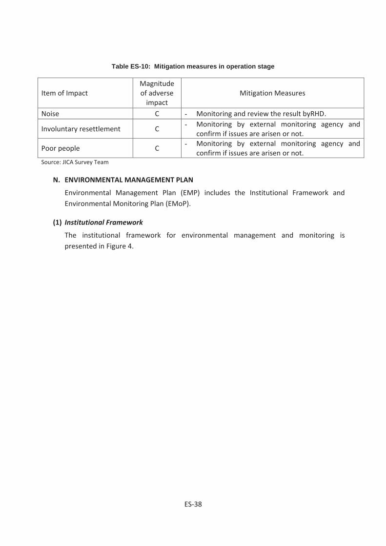
Table ES-10: Mitigation measures in operation stage
Item of Impact Magnitude of adverse
impact Mitigation Measures
Noise C - Monitoring and review the result byRHD.
Involuntary resettlement C - Monitoring by external monitoring agency and
confirm if issues are arisen or not.
Poor people C - Monitoring by external monitoring agency and
confirm if issues are arisen or not. Source: JICA Survey Team
N. ENVIRONMENTAL MANAGEMENT PLAN
Environmental Management Plan (EMP) includes the Institutional Framework and Environmental Monitoring Plan (EMoP).
(1) Institutional Framework
The institutional framework for environmental management and monitoring is presented in Figure 4.
ES-38

Figure 4: Institutional Framework for Environmental Management and Monitoring
Project site
Third parties/local communities
Report Instruction/technical assistance
Government
JICA
Executing Body
Project Implementation Unit (PIU)
Report
Instruction/technical assistance
Dept. of Env.
Roads and Highways Dept.
Construction phase
Contractor
Consultant/supervision
firm Monitor
Monitor
Instruction/mitigation Report
Mitigation measures
Env. and social issues
Mitigation measures
Necessary actions
Report
Social & Env. Circle
ES-39

(2) Environmental Monitoring Plan
Environmental Monitoring Plan (EMoP) is to evaluate the extent and severity of environmental impacts against the predicted impact and the performance of environmental protection measures. The following table shows the monitoring plan during implementation phase:
Table ES-11: Environmental Monitoring Plan
Sl.No. Environmental Indicator
Parameters/Units Means of Monitoring
Frequency Responsible agency
01. Air/Water/Soil Quality
N/A Inspection Daily Contractor/Consultant of supervision
02. Dust Control Spraying of water Visual Daily Contractor/Consultant of supervision
03. Noise Control Measurement (db) Monitoring Daily Contractor/Consultant of supervision
04. Waste Management
Monitoring of collection, transportation and disposal of solid waste. Inspection of construction camp.
Inspection Daily Contractor/Consultant of supervision
05. Working conditions and Accident
Monitoring Health & Safety of Workers
Inspection Daily Contractor/Consultant of supervision
06. Involuntary resettlement, Poor
Monitoring by external monitoring agency
Monitoring 6 months later from resettlement
External monitoring agency/RHD
Source: JICA Survey Team
O. Environmental Management Cost Estimated
ES-40
Confidential

Table ES-12: Probable Cost of Environmental Enhancement Works and Mitigation Measures of the Boalia Bazar Bridge
P. PUBLIC CONSULTATION
Two times stakeholder meetings were conducted at different bridges sites or some cases three times for problematic bridges identified. The discussions with the stakeholders were concentrated mostly on the positive aspects of subprojects implementation, magnitudes of socio-cultural and environmental impacts; compensation entitled by PAPs and resettlement requirements for affected persons and
ES-41
Confidential
families that to be dealt by RHD and other authorities. Accordingly minutes of the meeting were prepared incorporating the opinions from the stakeholder.
Q. PROJECT SCHEDULE
The implementation plan is established based on the month/year for the milestones of key events of the Project. The plan includes the stage of detailed design, tender procedure and construction work. The construction period was estimated as 3 years for North Packages and 2.5 years for South Packages.
It is assumed that International Competitive Bidding (ICB) shall be applied for procurement of Contractor and Consultant for the Project. The time required for the procurement is assumed based on the procedures for a financing scheme of Japanese-ODA Loan. The milestones for the implementation of the Project undertaken by Japanese-ODA Loan are formulated as follows:
Loan agreement (L/A) will be signed in February, 2015.
10 months will be required for the selection of consultant for the detailed design,tender assistance and construction supervision.
Period of detailed design will be 12 months.
17 months will be required for the procurement of contractor.
Construction period will be 36 months.
The total implementation schedule will begin with L/A in February 2015, and the construction will be completed in February 2021.
R. CONCLUSION AND RECOMMENDATION
Implementation of the Project bridges under WBBIP may not cause any major and persistent environmental impact. The construction related impacts therefore can be dealt by the Contractor as per the Environmental Code of Practices and Environment-friendly best practices. Although IEE study did not identify significant adverse impact, but according to DOE requirement, bridges longer than 100 m need comprehensive EIA study. Prior to the implementation of WBBIP, updates of EMP will be required following the outputs to be obtained from DD stage.
However, the EIA report in its present format has been prepared based on the DOE’s TOR and the additional comments made in the meeting held on December 03, 2014, whereas the Abbreviated Resettlement Plan (ARP) has also been prepared as an integral part of EIA report for formulating the socio-environmental issues undertaken in WBBIP areas. Therefore, EIA report along with ARP report should be considered for obtaining the Environmental Clearance Certificate (ECC) from the DOE, Government of Bangladesh (GOB).
ES-42

1-1
CHAPTER 1. INTRODUCTION
1.1 Description of the project
The RHD as per request of JICA to conduct environmental impact assessment (EIA) study at feasibility study level hired BCL to do the job. The reports will be used by engineers during design and implementation stages of 105 bridges under the WBBIP.
1.2 Sub-project Interventions and Locations
The interventions include (i) reconstruction/construction of RCC bridges along the existing bridges alignments, (ii) construction of approach roads on bridges sides and (iii) enhancement activities at bridges approaches. The sites of proposed bridges have been selected by the RHD. The subproject sites under WBBIP are situated on north central region (NCR), south west region (SWR), northwest region (NWR), southwest region (SWR) and south central region (SCR) of Bangladesh (WARPO 2000). Locations of the bridge are shown on Topographic map of the areas ( Figure 1.1). In all 105 bridges will be constructed, reconstructed and widened under the WBBIP.
Figure 1.1 Location of Bridge site

1-2
Bridge shall be over 100 m long and 94 bridges of western Bangladesh shall be shorter than 100 m. As per the requirement of DoE, bridges shorter than 100m shall not require EIA hence no EMP will be needed for these bridges. The total number, type and total lengths (m) of each bridge types are given (Table 1.1).
Table 1.1 Total number, type and total length (m) of the bridges under each type
Types of Bridges Nos. Total length(m) RCC Box/ Girder Bridges 62 3,215.12 Truss with Steel Beam/Steel Deck 06 472.08 Bailey with Steel Deck 35 1,867.45 PC Girder 02 161.95 Total length of bridges 105 5,716.60 Source: BCL
1.3 Project Background
The government of Bangladesh (GoB) has the expectation of raising the Gross National Income to $ 2000/capita by 2021 from the existing income /capita of $ 650. To achieve the target goal the GDP growth rate shall have to be raised from 6.0% to 8.0% by 2015 and 10.0% by 2020 (BB Perspective Plan). The physical infrastructures e.g. roads, railways, river ways, ports and air ways are the major factors of communication are to be developed on priority basis to achieve the projected growth rate of per capita income.
Bangladesh at present has 161, 400 km road infrastructure, 21,000 km of which is managed by RHD and remaining 140,000 km managed by LGED. There are 8,000 km flood protection embankment, 4,300 km irrigation channel and 5,000 km drainage channel in addition used for seasonal or perennial movement of transports and/or pedestrians.
The ratio between road length/land area in Bangladesh is 1.31, this ratio varies division wise as Rajshahi 1.52 for Rajshahi, 1.32 Khulna, Chittagong 0.99 for Chittagong and 1.50 for Dhaka Division (BBS 2012).
1.4 Importance of the Project
Bangladesh is situated in a zone where the average annual rainfall is 2.0 meters or more. Large part of the rain falls during the monsoon (July-October). The country receives in addition huge volume of run-off from 1.6 million Km2 catchments outside the Bangladesh boundary during monsoon season when the local rivers are at spate. These cause floods at northeast north central and in other floodplain regions. The floodplains have an overall gentle slope from north toward south that permits run-off flow to the Bay. The country is cress-crossed by innumerable rivers and channels over which 19,000 bridges have been constructed maintaining continuity on

1-3
road infrastructures. Of the 19,000 road bridges 4,500 small and medium bridges on RHD roads are managed by RHD as routine task while large bridges e.g Jamuna Bridge, Rupsha Bridge and other bridges are managed by the Shetu Bibhagh.
One of the major functions of RHD is to identify the bridges with damaged structure due to aging affects, faulty design and the narrow, risky Bailey Bridges on highways for construction, reconstruction and improvement. RHD felt the necessity for improvement of 2-lane roads and bridges to 4-lane, and construction and reconstruction of 105 the bridges in the western Bangladesh either with internal resources and/or with donor’s assistance. JICA under the WBBIP offered assistance for improvement of 106 bridges managed by RHD on highways, regional highways and district roads in western Bangladesh.
1.5 Objective of the Project
Objective of the study is to prepare environmental impact assessment (EIA) report for construction of 105 bridges fulfilling all requirements of JICA and of GoB at feasibility study level.
The EIA reports and environmental assessment reports of individual bridges will be used as guideline by decision makers, design engineers and Contractor during implementation stages. The EIA document of 105 bridges has been prepared following DoE format and maintaining the information as per JICA requirements. This report meets all legal requirements of DoE, hence can be used with the application for environmental clearance certificate (ECC) from DoE.
1.6 Brief Description of the Subprojects sites
As stated earlier the subprojects under WBBIP include construction, reconstruction, replacement and widening of 105 bridges of western Bangladesh. The existing RCC, Steel deck and Bailey bridges will be reconstructed and widened from 2-lane to 4-lane matching with the road width. The bridge approach roads on both sides will also be constructed keeping pace with the requirements of existing roads and highways. Trees will be planted on both sides of the approach roads to ensure slope protection against gully erosion and for environmental enhancement.
Environmental conditions particularly the ecological conditions at subproject sites for several bridges are shown (Plates 1.1,1.2.1.3, and 1.4) in this section.

1-4
1.7 Executive Agency of the Project
The RHD will execute construction and shall remain responsible for maintenance of the highways, regional and inter district roads and bridges during the operation stage. The RHD is presently headed by a Chief Engineer with power and authority of Head of the Department. Additional Chief Engineers head the Technical Services Wings of RHD that include a Social and Environmental Wing. This Wing includes two Circles (Social and Environmental) in one Division (Resettlement and Environmental). The Division provide services that relate environmental issues and social management aspects of RHD activities and ensure sustainable development in compliance with the GoB requirements and of donor agencies.
Figure 1.3 Chanda Bridge site
Figure 1.2 Mohasthan Bridge site
Figure 1.5 Naiori Bridge site Figure 1.4 Kazirhat Bridge site

2-1
CHAPTER 2. ENVIRONMENTAL LEGISLATIONS
2.1 Policy, Legal and Administrative Frameworks
GoB Requirements 2.1.1
The BECA (1995), BECR (1997) enacted by MoEF (BCAS 1999) make EIA obligatory during feasibility study, planning, design and implementation stages. An ECC is required from DoE to initiate project implementation activities. The EIA documents (REA, IEE, EIA, EMP) are in reality the guiding tool to implementation agencies, management tools to the stakeholders during construction and operation stages. The BECR (1997) categorized development interventions as Green, Amber (A, B) and Red depending on their degree of impacts on environment. The proposed upgrading of bridges involves construction reconstruction and widening of bridges on regional, national and inter-district roads managed by RHD. The subproject activities of WBBIP fall under Categories Amber- A and B hence an EIA (DoE 1997) will be needed for bridges longer than 100 m and IEE will suffice for bridges shorter than 100 m (BCAS 1999).
National Environmental Legislations 2.1.2
The Environmental Legislations enacted by MoEF and other Ministries intend conservation and proper management of natural, ecological, socio cultural resources and to keep the pollution impacts minimal keeping pace with world communities regarding conservation of nature. The GoB through enactment of legislatures strengthened MoEF and other Ministries to combat the adverse environmental impacts and to enforce all the legislatures in their intended spirits (Farooq and Rizwana 1996). The relevant Environmental legislations are given (Table 2.1).
Table 2.1 Environment related Legislatures enacted by MoEF and other Ministries
Environmental Legislations Implementing Agencies Key Features
The Environment Conservation Act, 1995 (Amendments 2000, 2002, 2010)
Environment Conservation Rules, 1997 (Amendments 2000 and 2003)
Department of Environment (DoE)
-Protection of areas of major environmental concerns.
-Issue of Environmental Clearance Certificate.
-Enforcement of Environmental Legislations, Acts and Rules
-Monitoring the compliance of environmental legislations and standards.
Environment Court Act, 2000 and (Amendments 2010)
District Environmental Court/ DoE/MoEF
-Enforcement of punitive measures as per Legislations, Acts and Rules against the offenders.
-Empowers officers of the concerned Departments to enforce the BECR (1997)
-The amendments (2010) empower to open environmental court in every district.
-Trial for environmental pollution under BECA (1995)

2-2
Environmental Legislations Implementing Agencies Key Features
can be conducted under mobile court
Bangladesh Penal Code (1860)
Civil Administration/DCs -Prohibits all activities that pollute the water bodies like spring, reservoir, open water bodies
- Prohibits activities that affect public health and create public nuisance
Bangladesh Hill Cutting Act (1986)
DoE, Civil Administration/LGED
-Prevents Hill Cutting without prior clearance from DoE and/or from other responsible authorities
Vehicle Act (1927),
Motor Vehicles Ordinance (1983)
Bengal Motor Vehicle Rules, (1940)
Bangladesh Road Transport Authority (BRTA)/ Police/ Civil Administration
-Road safety, licensing, monitoring and maintenance of the vehicles standard on public roads/highways
-Control air pollution due to emission from engine and check noise pollution
Brick Burning Act (1989) and Amendments (1992, 2011)
MoEF /DoE and Forest Department
-To control the legal aspects regarding brick burning including imposing restriction on use of biomass in brick burning kilns
Bangladesh Environmental Policy (1992)
MoEF - Main objectives are maintaining the ecological balance, to protect natural resources, identification of environment polluting activities and ensure environment friendly development.
-This policy helps protection of natural resources (air, water and soil)
Bangladesh National Land Transport Policy (2004)
MoC/Police/ RHD -To ensure road safety and to reduce death and injury due to road accidents
Bangladesh Environmental
Management Action Plan (NEMAP) 1995
MoEF a document prepared following the bottom up mechanism and participation of people.
- NEMAP helped identification of the actions needed to arrest/reduce environmental degradation, conservation of biodiversity, habitats and natural resources.
-Promote sustainable development and quality of human life
Bangladesh Water Pollution Control Ordinance (1973)
Ministry of Water -Taking steps both at governmental and private levels toward prevention of water pollution and environmental degradation.
Bangladesh Social Forestry Rules (2004)
MoEF, and ADB (2002) - Provisions of these rules can permits GoB to extend forestry activities on private land and vice versa entering into mutual agreement amongst both sides.
National Land use Policy (2001)
Ministry of Land -The land policy basically identified different users of land with the intention fixing priority amongst different uses land.
National Biodiversity, Strategy and Action Plan (2004) and Amendment (2011)
MoEF -Main intention of the plan is to conserve biodiversity, ensure unique biological heritages and restrict introduction of invasive species

2-3
Environmental Legislations Implementing Agencies Key Features
Acquisition and Requisition of immovable Property Ordinance (1982 Amendments1994,1995
,2004)
Ministry of Land -To ensure legitimate compensation, rehabilitation
for the PAPs.
Removal of Wreckage and Obstructions in inland Navigable Water Ways Rules (1973)
Bangladesh Inland Water Transport Authority (BIWTA)/Civil Administration/Police
- Removal of Wrecks and Obstructions from the Navigable Inland Waterways
-Protection, maintenance development of the waterways for navigation
Water Supply and Sanitation Act, (1996)
Ministry of Local Government, Rural Development and Co-operatives (LGRD&C)
-Management and Control of water supply and sanitation particularly in urban areas
Forest Act, (1927) and Amendments (1989, 2000)
MoEF and Forest Department
-Conservation of Reserve, Protected, Rural and Unclassified State Forests,
- Conservation of Forest Ecology and Wildlife natural environment throughout Bangladesh
Private Forest Ordinance (1959),
Forest Department/
MoEF
-Control movement of timber and/or other products by land or water routes from the forests owned by private individuals and/or organizations
Bangladesh Wild Life (Preservation) Act (1974), (Amendment 1998)
MoEF, FD and Bangladesh Wild Life Advisory Board
-Conservation of wildlife in Bangladesh, in protected areas like Wildlife Sanctuaries, National Parks, Eco-Parks, in Forests and elsewhere
East Bengal Protection and
Conservation of Fish Act
1950(Amendment (1982)
Ministry of Fishery/ Fisheries Department, Public Health Department
-Protection and Conservation of fish in Government owned water bodies and open water bodies
- Restriction on fishing during fish hatching season July 15-September 30)
Natural Water Bodies Protection Act (2000)
LGRD and C Ministry/ Civil Administration
-Conservation of natural and man-made wetlands
Solid waste management Rules (2011)
Ministry of Environment and Forest (2011)
-Intended to manage the solid wastes including the urban wastes in environment friendly manner
- Introduction of 3R(reduce ,reuse and recycle) strategies
Bangladesh Social Forestry Rules(2004)
Forest Department and MoEF
-Benefits sharing of rural forests
-Forestry for poverty alleviation, involvement of landless, destitute women and economically backward communities
The Land Acquisition Act, (1894) and Amendments (1993, 1994, 2004)
Revenue Department, LGRD and C, Civil Administration
-Current GoB Act & guidelines, relating land acquisition
- To pay maximum compensation to the PAPs
Wetland Protection Act (2000) MoEF -Restriction imposed on indiscriminate filling of wetland particularly by Development Farms for residential purpose.
Water Supply and Sanitation Act (1996)
Ministry of Local Government, Rural Development and
-Development of infrastructure for sustained supply of safe water both in rural and urban residents.

2-4
Environmental Legislations Implementing Agencies Key Features Cooperative
Biodiversity conservation Act (2011)
MoEF Conservation of floral and faunal diversity in Bangladesh
Bangladesh Climate Change Strategy and Action Plan (2008)
MoEF -Setting of several strategies e.g. social protection of health, disaster management, protective infrastructure development, decreased carbon release in atmosphere.
Before enactment of the mentioned environmental legislations the ecological and natural resources of Bangladesh e.g. air, water, soil, forests and wetlands had been protected under provisions of the Bangladesh Penal Code (1860).
Pollution of the natural resources, protection of public and occupational health and conservation of labor interests at work site during implementation stages not covered by the environmental legislations as best practice in Bangladesh are protected under the contractual agreement reached between RHD and Contractor.
Bangladesh also ratified and/or acceded to 22 international conventions, protocols and signed 24 treaties relating to environmental conservation and protection. In addition, the international obligations that Bangladesh ratified are (i) Law of the Sea, (ii) Montreal Protocol, (iii) CITES Convention, (iv) Framework Convention on Global Climate Change (v) RAMSAR Convention (1971), (vi) Washington Convention (1972), (vii) Rome Convention (1951), (viii) International Convention to Combat Desertification, (ix) International Convention on Climate Change (Tokyo Protocol, 1997), (x) Occupational Health Hazards due to sound Pollution and vibration (1981), etc.
2.2 EIA System and DoE Procedures
All development projects require clearance from the DG, DoE for initiating the implementation process. Environmental clearance certificate (ECC) from DoE is issued based on the findings of IEE that also stipulate whether an EIA be carried out by the project proponent or the IEE is enough. EIA study focuses on addressing the unresolved environmental issues in IEE report. The unresolved environmental issues may be because of inadequacy of data, lack of impact identification and/or lack of mitigation measures. The steps to be followed during EIA study are (i) collection of baseline study, (ii) identification of environmental impacts on IECs,(iii) prediction regarding potential impacts,(iv) evaluation of the impacts, (v) prescribing the

2-5
mitigation measures,(vi) monitoring program, (vii) risk analysis and (viii) documentation and communication(DoE 19970, BCAS 1999).
Environmental Clearance Certificate (ECC) 2.2.1
An ECC from DoE is required before initiating the project implementation activities. An application to the DG DoE is to be submitted through the local office in prescribed application form (Vide Rule 7.5) fulfilling the requirements detailed in BECR 1997 (BCAS 1999). The requirement of an ECC from the DoE can be bypassed during implementation of WBBIP provided the Social and Environmental Circle of RHD processes the matter like that of the Environmental Circle of LGED. The LGED deals all its project related matters including evaluation of EIA reports by the Environmental Circle of LGED while copies of the EIA reports are sent to the DoE for information. The WBBIP covers a large geographic region covering many administrative areas falling under different DoE office jurisdiction. Hence, processing of the environmental clearance issue routinely as per the BECA (1997) will be cumbersome and time consuming. Moreover, bridges under WBBIP include improvement and reconstruction of existing bridges on RHD managed highways where during implementation minimal environmental impacts are anticipated, therefore the matter may be dealt by RHD itself with minimal and formal involvement of DoE.
Policy Safeguards 2.2.2
The National Conservation Strategy (NCS 1991) and National Environmental Management Action Plan (NEMAP 1995) emphasize on the inter-sector coordination and participation of public as well as the private sector in development activities. Basic guidelines of the National Environmental Policy (NEP,1992) are:
to ensure protection and conservation of physical, ecological and cultural resources from depletion, deterioration and degradation due to human activities,
identification of activities that induce pollution/degradation/ deterioration of natural environmental resources,
to ensure protection and conservation of historical/archaeological/ cultural structures/sites and relics from deterioration and degradation due to human activities and
Protection of identities, rights, livelihood and heritages of the indigenous tribes.
The pivotal environmental safeguards are sustainable and environment friendly development, poverty reduction, women empowerment and planned employment generation. To achieve these goals emphasis should be given on avoidance, reduction and/or mitigation of impacts on environmental resources during project implementation stages and enhancement of the positive impacts to harvest optimum benefits from the development endeavors.

2-6
2.3 Harmonization of GoB and international Policies
(a) GoB/DoE: BECR (1997) provided provisions for conservation of environment, improvement of environmental standards, mitigation and control of environmental pollutions and made EIA study obligatory before initiation of project implementation activities.
Made it obligatory obtaining a clearance certificate from DoE for implementation of development endeavors, categorized the different development endeavors (projects, industries) in respect of their EIA studies requirements. And set the environmental pollution standards for air, water, land and noise under different conditions.
(b) JICA: Made EIA study obligatory at the early stage of project planning. Considers multiple alternatives in order to avoid and/or minimize the adverse project impacts and chooses the project options with minimal environmental impacts.
(c) World Bank: The environmental safeguard policy of WB is though the best practice of local governments but the main objective of the policy is to prevent and mitigate the harm to people and the environment. WB has also categorized different development endeavors financed by it based on environmental impacts hence made EIA study obligatory for project initiation and implementation.
(d) ADB: Categorized all development endeavors based on their impacts on environment and developed elaborate environmental safeguard policies for different project categories. As per ADB categorization the projects with significant adverse impacts( Category-A) require EIA and EMP to address the adverse impacts, projects with lesser adverse impacts (Categories-B,C) require either IEE or no EIA study.
(e) Policy harmonization: However, environmental aspects due to due to implementation of any development endeavor should be harmonized during implementation stages so that the adverse environmental impacts are kept minimal and the positive impacts are enhanced. These to be done to harvest maximum benefits to the majority people from any project investment.
2.4 Land Acquisition Frameworks
Land Acquisition Law in Bengal was first enacted in 1824.The provisions and scopes of that law were subsequently amended and expanded in 1850, 1857, and 1863 leading to the enactment of Land Acquisition Act 1984. This Act continued enforced until partition of India through proclamation of independence in 1947. This Act however lacked the provision for payment of compensation for the acquired land and other immovable properties, as a result the requiring bodies used to overestimate the actual land requirements to cause loss to the land owners. The Acquisition of Immoveable Properties Ordinance-II 1982 was enacted to safe guard owners right regarding payment of compensation and to reduce wastage of land. Under this Ordinance

2-7
the DCs or their nominees are authorized to examine the claim for compensation taking into consideration all factors regarding entitlement of compensation and empowered to divide the compensation amount amongst all the legitimate shareholders.
The Emergency Property Acquisition Act was enacted in 1989, this Act empowered the Government authority to acquire private properties on during high floods, tidal bores, river bank erosion and other sorts of natural calamities to act swiftly to check those calamities. Hence, it is clear that the Act 1989 did not replace the Ordinance 1982, rather both the legislatures remained enforced simultaneously and applied during implementation of the Bangabandhu Multipurpose Bridge Project.
The Deputy Commissioners (DCs) as chief executives of the district or any officer authorized by them can exercise the power conferred on the DCs regarding requisition of Immovable Properties under the Ordinance 1982 and Act 1989. The Bangabandhu Multipurpose Bridge (Land Acquisition) Act 1995 (Annexure-6) was enacted later on July 9 1995. Under provisions of this Act persons constructing structure/establishments and or modifying the land class/type that is likely to be acquired with the intention of extraction higher compensation rate will not be entitled any compensation for such structures. Land acquisition issue may not be a significantly disturbing issue during implementation of WBBIP.
2.5 Framework for Resettlement
Objective of the Abbreviated Resettlement Plan (ARP) 2.5.1
As per the JICA bounded guidelines for Environmental and Social Considerations require if screening for social assessment make it necessary that resettlement of some people at several bridges sites will impacts a time-bound action plan with budget provisions. A budget for resettlement is to be prepared in that case and be incorporated as integral part of the project design. However, World Bank (WB) clearly indicated the provisions for resettlement where involuntary settlement of population from project sites fewer than 200 are needed at bridges sites, an ARP may be prepared to serve the purpose. ARP according to such principal might address issues like land acquisition and resettlement following the legal framework of GoB and JICA’s guidelines for Environmental and Social considerations highlighting the impacts on involuntary resettlement. The aspects of human rights of indigenous people and cover the APs under resettlement/rehabilitation program including income restoration, poverty reduction and legitimate assistance for poor and informal settlers. Hence, the ARP approach may involve (i) land acquisition and resettlement issues, (ii) mitigation of impacts to the distressed women and vulnerable groups, (iii) income generation support to the eligible members of project affected families and (iv) assistance for poverty reduction to the poorest section of people.
2-8
According to GoB policy a plan is be prepared setting out provisions for compensation and rehabilitation to the PAPs and/or families before the project is executed. It should be a policy that implementation of projects does not affect any PAPs in a way that their
• living standards are adversely affected,
• income earning opportunities, business, occupation, work or place of residence or habitat adversely affected even temporarily,
• right, title and/or interest in ancestral houses, right to use any land, properties, premises are affected. Right on grazing land, common properties, tenancy, annual or perennial crops and trees are affected temporarily or permanently,
• social and cultural activities and relationships amongst the family clans and keens may be affected during resettlement planning process..
The objective of the ARP is to provide a strategy for providing PAUs with replacement value of land, structure, trees and other physical assets and restoration of income levels/living standards either through a compensation and rehabilitation package that ensures that PAUs are not left in a position where they are worse off with the project than without it. Thus, in accordance with JICA policy, abbreviated resettlement plan, depending on the magnitude of impacts - has been prepared for the Project.
Objectives of the project and Abbreviated Resettlement Planning have been disclosed to the affected persons through community based consultation meetings and focus group discussions in local language in two phases of stakeholders/community consultation as well as during conducting census and socioeconomic survey. Compensation and other assistances will have to be paid to APs prior to displacement or dispossession of assets. Upon approval, the final ARP will be uploaded immediately on the RHD website.
Methodology for Preparing the Abbreviated Resettlement Plan 2.5.2
The Consultant conducted census & socioeconomic survey in April through June 2014 for information necessary for preparation of this ARP. The survey was also associated with stakeholders’ consultation, focus group discussion and property valuation survey.
The adverse impacts include land acquisition and displacement of households and shops. The data gathered during the survey has been entered into an electronic database which identified each affected household (AH) and the way they are impacted and losses they will incur. The objective of the census and socioeconomic survey was to establish a detailed inventory of the households and physical assets to be affected by the project; develop a socioeconomic profile

2-9
of the AHs and affected persons (APs). The surveys also serve as a benchmark for monitoring and evaluation.
The surveys indicate that improvement of the 105 bridges will require acquisition of 53.35 hectare of land. In total the Project will displace 3,253 Project Affected Units (PAUs) of which 788 residential households, 2,367 Commercial & Business enterprises (CBEs) and 98 common Property Resources (CPRs) with a total population of 15,903. As per JICA guidelines the appropriate Environmental and Social Considerations are to be given on vulnerable women, children, and distressed elderly people and ethnic minorities. All concerned who are susceptible to environmental and social impacts having little/no access to decision making process re to be given due consideration. Therefore, this ARP has been prepared with due consideration to all concerned to mitigate impacts on Affected Households (AHs) toward restoration of their livelihoods at least to the pre-project level.
The ARP is to be prepared based on National Law ARIPO (GoB) and on JICA guidelines for upliftment of the affected families from environmental and social considerations. The ARP therefore establishes the provisions for resettlement of project affected households so that incomes of the affected households are restored effectively particularly the affected poor and vulnerable households get due compensation and resettlement benefits as per the legal provisions.
This ARP during discussion meetings will elaborately review all sorts of impacts that the PAPs can suffer during the implementation stages and the appropriate mitigation measures. The budget for impact mitigation can be revised from time to time reflecting the changes in AHs number and/or the losses identified at later stages due to increased volume of impacts, addition of properties and/or price escalation.
.

3-1
CHAPTER 3. IMPORTANT ENVIRONMENTAL COMPONENTS
3.1 Physical Components
Climate 3.1.1
Bangladesh has a per humid mega-thermal climate with no water shortage at 50 cm depth (Thornthwait 1948) at any part of the year. Maximum temperature during May-October period is 31-340 C and minimum temperature during November-February period is 11-160C. Winter climate (November-January) is cold and dry, spring climate (February-March) is pleasant, and summer climate (March-May) is hot and dry while the monsoon season (June- September) is wet. The temperature and rainfall during the monsoon season are high. Peak temperature during April-May locally may reach up to 400C (Hassan 1999, Manalo 1975, FAO 1971). According to Kopen’s (1936) classification Bangladesh has tropical rainy climate (A-type). The mean temperature in coldest month in this type of climate remains above 180C and the mean rainfall in driest month remains below 6.0 mm. The average climatic data of Khulna, Rajshahi and Barisal stations are shown (Table 3.1). Normal activities during construction stage may be hindered due to incisive rains and high floods.
Bangladesh has virtually a homogeneous climate with slight local variations. The north east region has maximum rainfall while the northwest region has minimum rainfall. Temperature also shows little local variation from the north east region toward south west region. Occasion nocturnal rain with thunder shower observed in the south east region is due to its vicinity to the sea. The monthly rainfall and temperature of Khulna, Rajshahi and Barisal divisions are shown (Table 3.1).

3-2
Table 3.1 Monthly rainfall (mm) and temperature (0C) for Khulna, Rajshahi, Barisal Divisions
Months Khulna Rajshahi Barisal Temp(0C) Rainfall(mm) Temp(0C) Rainfall(mm) Temp(0C) Rainfall(mm)
January 25.7 12 24.5 11 25.6 8 February 28.4 40 27.7 17 28.2 27 March 33.1 57 33.3 24 32.2 56 April 34.7 85 36.3 63 33.3 128 May 34.2 192 35.0 137 33.0 230 June 32.8 335 33.5 257 31.7 409 July 31.8 349 32.1 327 30.9 408 August 31.7 336 32.3 268 30.9 370 September 32.0 269 32.2 297 31.5 268 October 32.0 136 31.7 113 31.5 162 November 29.9 33 29.3 17 29.6 53 December 26.6 5 25.8 12 26.6 15 Annual average 31.2 1,852 31.2 1,543 30.4 2,134 Source: BBS 2012 (Average of 2006 and2007)
Topography and Geology 3.1.2
Topography of western Bangladesh that is covered by the Meghna, Tista, Jamuna and Ganges floodplains is almost level with convex ridges and concave basin sites. Part of the North Central region in Bogra and North West region Rajshahi, Rangpur and Dinajpur is occupied by level and/or undulated terrace lands.
The undulated terrace lands of Rangpur, Dinajpur and Rajshahi districts were previously covered with dense deciduous sal forest managed by private ownership and subsequently by the Bangladesh Forest Department (BFD). Presently the sal forest particularly in level lands is heavily depleted and used for rain fed or irrigate paddy production. Patches of the sal forest still occurs as remnants on undulated terrace lands of the Barind in Rangpur, Dinajpur and Rajshahi districts (SRDI 1963-1973). Figure 3.1 shows the Teesta floodplain (Legend 4a), Meghna and Jamuna floodplains (Legend 4c) and the Ganges floodplain (Legend 4b)..

3-3
Figure 3.1 Meghna, Tista, Jamuna and Ganges Floodplains
Soils and land uses 3.1.3
Soils of the Barind tract are weakly structured, olive, acidic clays in the subsoil overlying an unaltered clayey substratum at variable depths. The landscape was probably colonized by pioneer vegetation species (grasses and/or sedges) initially several thousand years back. The early settlers cleared the pioneer vegetation to bring the land under agricultural uses. The early settlers disliked the well-drained upland for sedentary agriculture because of shortage of water. The indigenous tribes (Santal Kool and others) on the contrary preferred to settle on undulated uplands and practiced shifting cultivation initially (SRDI 1963-1973, FAO 1999)). The Barind Tract (Legend 2) and the Tista floodplain soils (Legend 4a) are shown in Figures 3.1 and 3.2. The lands on floodplains were also initially covered by reeds, sedges and other sorts of grass varieties. The floodplain soils were either cleared for agriculture by early settlers or were brought directly under agricultural uses.
Legend (Source: IUCN 2002) 3 Madhupur Tract 4a Teesta Flood Plan 4b Ganges Flood Plan 4 c Meghna-Jamuna Flood Plans

3-4
Figure 3.2 The Barind Tract Land
Sedimentology and seismicity 3.1.4
Geologically, lands of the Barind Tract belong to the Plio-Plaistocene age and the lands in river floodplains (Jamuna, Meghna,Teesta, Ganges and of other rivers) are of recent origins. In Bangladesh, the floodplain sediments from the consideration of sedimentation patterns are classed as meander, estuarine and tidal.
Legend( Source: IUCN 2002) 2 Barind Tract Land 4a Teesta Flood Plan

3-5
Figure 3.3 Different seismic risk zone in Bangladesh (GoB 1979)
The floodplain sediments have been uplifted and down warped at places subsequently either due to sedimentation and/or due to tectonic activities. The vertical homogeneity of the Barind Tract sediment if treated as an indicator these sediments can probably be assumed as of Plio-Pleistocene period. This assumption could not be confirmed till date because of conspicuous absence of stratification and/or of marine fossils (animal or plant) in them. The Bangladesh National Building Code (1996) and the Seismic map of Bangladesh (GoB 1979) did sub-divide Bangladesh into three seismic zones based on the tremor intensities. The command areas of WBBIP are situated in low/ seismic risk zone (Zones-II and III). This is evident from Figure 3.3. Bangladesh is situated between the Indian and Eurasian continental land masses. Occurrence of

3-6
the Himalayan Mountain belt in the north and Mayanmarian Mountain belt in the east make Bangladesh seismically active (Morgan and McIintire 1959).
The Bangladesh Building Code (GoB 1983) and Bangladesh Geological Survey (GoB 1979) divided Bangladesh into three seismic zones. Zone-I has high seismic risk, Zone-II has medium seismic risk and Zone-III has least seismic risk. The DBR site passes through the seismic Zone-II that has seismic coefficient value (Z-Value) 0.15-0.25 Richter. The seismic factors require to be considered during design phase of the DBR upgrading program.
Hydro-geology 3.1.5
The landscape both of the Barind and floodplains has a southeast slope alignment and flow direction of the major rivers contribute to this assumption. The rivers in the downstream regions along flow directions either receive run-off through different tributaries or distribute run-off through many distributories until finally shed the water to the sea. The rivers remain at spate during the monsoon due to local run-off in addition the trans-boundary rivers receive run-off from nearly 1.6 million Km2 catchment in India Nepal and China. Usually 10-12 percent floodplain area in Bangladesh is flooded during monsoon in normal years. But up to 24 percent floodplain area of Bangladesh may submerge during abnormal floods peak flood levels in Padma and Jamuna coincides. This happens once in ten years or so.
The deep ground water table (DGWT) on Barind tract land fluctuates between 20 and 30 meters during the dry season and reaches near to the surface during the rainy season. Ground water table on terrace lands sinks up to 7.0 m during lean season due to draw down by deep tube wells. Further exploitation of DGW table may create imbalance between water demand and annual recharge affecting the poor people living on Barind land (WARPO 2000).
Ground water both shallow and deep in the floodplains are also being used intensively for irrigated agriculture, industrial and domestic uses throughout Bangladesh. This country though rich in ground water reserve and there exists ample opportunity for ground water recharge during monsoon and during floods but consistent and growing rate of exploitation ground water has already created a seasonal imbalance between demand and supply of water.
Landscape 3.1.6
Bangladesh has the total land area of 147,470 km2 of which 79.1 percent is floodplain, 12.6 percent in north, northeast and south southeast is occupied by Mio-Pliocene hills and 8.3 percent in north central and in northwest regions is Plio-Pleistocene terrace land.

3-7
Ground subsidence 3.1.7
Bangladesh because of location is situated in the earthquake prone region. This country jolted by over 200 quakes since past two years. No major case of ground subsidence occurred either in floodplains or elsewhere due to earth quake. The devastating earthquakes namely the Chakhar (1869), Bengal (1885), Assam (1897), Srimangal (1918), Dubrigarh (1930) had tremor intensities over 7.0 (Richter). The epicenters of all the earth quakes were outside the Bangladesh boundary. The Assam earthquake that caused large scale damage in Assam, Bengal and Bihar had tremor intensity of 8.7 Richter. But no large scale ground subsidence occurred in Bangladesh due to the Assam earth quake (Bangladesh Building Code 1996, Seismic Map of Bangladesh 1979).
The most seismically vulnerable eastern part of Indo-Bangladesh where most devastating earthquakes occurred during past one hundred years is shown in Figure 3.4.
Source: FAO 1971, Hassan MM 1999
Figure 3.4 The most Earthquake prone Eastern region of Indo-Bangladesh
Bottom sediments 3.1.8
Bangladesh was formed due to deposition of sediments transported by major rivers that had been deposited under meander, tidal and/or estuarine conditions. The floodplain sediments are therefore vertically well sorted. The sediments in bottom layers settled down earlier are therefore coarser and coarseness of sediments increases with the depth of the layer. The

3-8
coarse textured sediments occur below 100 m depth in floodplains and level terrace regions. This is evident from the borehole records of deep tube wells and from the available sporadic geotechnical study data from different bore whole sites.
The presence of harmful heavy metals like arsenic, cadmium, chromium, lead and mercury, etc are required to be tested in dredge material to confirm whether these metals exist in bottom sediments.
3.2 Ecological Components
The village forests are observed on homesteads, waste and marginal lands along road and embankment sides. Total households (H/H) in Bangladesh are 25 million spreading over 85,650 villages (BBS 2007). Village forest cover in Bangladesh is 0.27 million hectare out of the 2.56 million hectare total forests area (Forestry Master Plan, 1993). The per capita forest land area was 225 m2 in 1993 showing a declining trend due to over exploitation, demographic pressure and natural calamities. Tree species on homesteads include fruit, fuel wood, timber, medicinal plants, MPTS and bamboos; trees on roadsides include timber, fuel wood, fruit, aesthetic and medicinal species. Fruit trees on road sides comprise 10 percent. Huge quantity of forest produces (fuel wood, timber, raw materials for industries, building materials and fruit) are obtained from rural forest (Katebi, N.A. 1997).
The floral species 3.2.1
The WBBIP sites do not pass through the national forests managed by BFD except the localized patches of sal forest in the northwest region. The tree planting culture on road sides developed since the Moghul and subsequently British periods. BFD since eighties began roadside tree planting keeping in mind the economic, ecological and aesthetic objectives. Later CARE, SIDA and Proshika planted trees on roadsides with multiple objectives e.g. to generate rural employment, to boost production of timber, industrial raw material and fuel wood and for alleviation of rural poverty.
The species planted on road sides are: rain tree (Samanea saman), krishnachura (Cassia spp.), mehagony (Swietonia spp), raj koroi (Albizia richardiana), auricoliformis (Acasia auricoliformis), eucalyptus (Eucalyptus camaldulensis) and sisoo (Dalbarzia sisoo).
The homestead species are: mango (Mangifera indica), black berry (Syzygium cumini), jack fruit (Artocarpus heterophyllus), cocnut (Cocos nucifera), betel nut (Areca catechu), etc.
Hijal (Baringtonia acutangula), mandar (Erithrina indica), pitali (Trewia nudiflora), silk cotton (Bombax ceiba), toddy palm (Borassus flabellifer) are planted in flooded land.

3-9
The aquatic floral species include: kochuripana (Eichhornia crssipes), khudipana (Lemna minor), shapla (Nymphaea spp.) kolmi (Ipomea aquatic), halencha (Enhydra fluctuant) and many weed species. The kochoripana khudipan and several other floating species are treated as eutropic vegetations.
The faunal and avifaunal species 3.2.2
Commonly observed wildlife species are: jackal (Vulpes bengalensis), mongoose (Herpestes edwarsi), civet cat (Viverricula indica), otter, snake, rodents, frogs, toad, turtles still occur at WBBIP site (IUCN 2002).
The commonly observed birds are: spotted dobe (Streptopelia spp.), rock pigeon (Columba livia), parakeet (Psittacula krameri), cuckoo (Hierococcyx spp.), koel (Eudynamis scolopacea), owl (Athene brama), drongos (Dicrusus spp.), common myna (Acridotheres spp), crow (Corvus spp.), magpie robin (Copsychus saularis), red vented bulbul (Pycnonotus cafer), jungle babbler (Turdodais striatus), tailored bird (Orthotomus sotorius), heron, little egret, cattle egret, storks and several wetland bird species.
Biodiversity status 3.2.3
The major habitats for floral and faunal diversities in Bangladesh are the hill forests, inland upland forest, homesteads, wetlands, coastal mangrove forest, agriculture lands, etc. All the ecosystems have been disturbed since the past decades due to poor management, demographic pressure, natural calamities and deteriorated law and order situation. Consequently, diversity and population of flora and fauna declined in Bangladesh. Many wildlife species as a result is under stress and 50 of those are endangered already. Ten percent mammal, 3.0 percent avifauna and 4.0 percent reptile species are extinct in Bangladesh (IUCN 2000). Status of the resident inland vertebrates in Bangladesh as indicated in the IUCN Red Book (2000) is shown in Table 3.2.
Table 3.2 Status of the resident inland vertebrates in Bangladesh
Groups Total living Extinct
Threatened Not threatened
Critically endangered Endangered Vulnerable
Fishes 266 0 12 28 14 146 Amphibians 22 0 0 3 5 7 Reptiles 109 1 12 24 22 12 Avifauna 388 2 19 18 4 189 Mammals 110 10 21 13 6 17 Source: IUCN 2000

3-10
Wetlands 3.2.4
In Bangladesh wetlands include the fresh and tidal rivers; ponds, lakes, beels, haors, baors and pools and the seasonal and tidal floodplains. Wetland ecosystem in Bangladesh serves as the rich habitats for numerous floral and faunal species including 266 fresh water fish species. The large haors in northwest, northeast and in north central regions play pivotal roles in flood abatement, fish propagation and stocking. In addition, these habitats provide shelter to innumerable local and migratory bird species. Unfortunately, the wetlands in Bangladesh depleted due to conflict between agriculture and fisheries, poor water management, water withdrawal by upper riparian countries and watershed degradation. All these affected capture fisheries, navigation, aquatic wild lives and the bio-diversity in general (RAMSAR Convention)
The wetlands also stabilize local weather, influence ground water recharge, catch pollutants and toxicants, regulate hydro-ecological condition and maintain the soil organic matter balance.
3.3 Socio-cultural Components
Water Use 3.3.1
Water of open water bodies (rivers and channels) throughout Bangladesh is used extensively for navigation, capture fisheries, agriculture and for industrial uses. The people settled on river sides usually depend on water for domestic uses that include potable water collection, bathing and washing and cattle washing. Though at present most of the rural people collect their drinking water from shallow and deep tube wells sunk on homesteads or at agriculture land. Fishermen and boatmen communities living along the river banks adopted fishing and boat plying as professions. Presently many industries that developed on river adjacent sites and banks make industrial use of river water. Unfortunately wastes and effluents from many of these industries are discharged in the rivers. Part of the solid wastes from these industries and from urban/rural residences are also discharged untreated in open water bodies that pollute the river water.
Water in pond, lake, harbor are used for stocking capture fish and for captive fisheries by a section of people. Water in closed water bodies like the open water bodies are used for domestic and limited agricultural uses. The closed water bodies are extensively used for fish culture. Fish culture has presently turned as a sustainable source for supply of fish to the local markets and generated work for a large number of poor.
The seasonally flooded croplands though shallowly flooded are also used for short rotation fresh water fishes culture while shrimps and white fish species are cultured in brackish water zones. Cat fish culture in transplanted paddy fields as alley generates additional income to the farmers and play roles in biological control of insects.

3-11
The rivers are used for navigation, fisheries, industrial uses and irrigation purposes. The boatmen, fishermen and poor people use river water for domestic purposes.
Cultural Heritage 3.3.2
The mentionable cultural heritages include relics of the structures constructed during the rule of different political dynasties since over two thousand years past. Oldest cultural relics are of the Buddhist period flowed by the structures of Hindu period. Muslim and Mughal periods followed the Hindu period. Structures of the English period are Universities, Colleges, High court, district courts, post offices, railway track, etc. can in fact be treated as the nuclei of modern developments approaches (Hannan,M.Dr.1995). Amongst other cultural, archeological and historical structures that are scattered everywhere in villages and townships are the mosques, temples, graveyards, cremation sites, majors, ancient feudal structures are of recent origins hence are not very important from archeological and historical considerations.
Socio-cultural infrastructures 3.3.3
The socio-cultural structures built during the Buddhists period revealed from archaeological excavations at Mohasthangarh, Paharpur, Mainamati, Munshiganj and at other places that are of over one thousand years old. Cultural advancements achieved during the Buddhist period in fine art and sculptures are observable on the terracotta drawings and stone and bronze sculptures of Lord Buddhya recovered at Mohasthangarh, Paharpur, Mainamati and at other excavation sites. Lakes, wells, temples and stone sculptures of Radha-Krishna and different Gods and Goddess represent the Hindu period. Bangladesh progressed tremendously during the reign of Pal kings in 8th century. Progress of the Pal period is well reflected in their art, sculpture and literature. Many sculptures of Hindu period are engraved in stone, bronze, wood and terracotta drawings on temple walls have been unveiled in the recent past from different parts of Bangladesh. Muslim and Mughal structures are the royal palaces, shrines, mosques, tombs and military structures that exist in Bangladesh and elsewhere in India. The modern cities, townships and infrastructures were initiated during the British rule are virtually the nucleus of modern cities all over India and Bangladesh (Dr. Hannan, M. 1995).
Indigenous/ethnic communities 3.3.4
The Chakma, Khami, Kuki, Boum, Banjogi, Khiang, Lushai, Marma, Moorang, Mroo, Pankhoo, Rakhain, Tanchunga, Tipra, Khiang and Chak live in Chittagong and Chittagong Hill Tract; Khasia, Monipuri, Khami, Khiang live in Sylhet, Habiganj, Moulvibazar, and Garo, Hajong, Santhal, Kool and Kotch live in the Madhupur and Barind Tract regions (BBS 2005,2012). The ethnic population size in Bangladesh is nearly 10 million; 0.7 million live on eastern and southeastern hilly regions and 0.3 million in other districts. The Santhal, Sakh, Hajong, Orao, Koch and Kool live in Rajshahi, Harijan and Rajbangsi tribes live in wetlands and nearly 30,000 Rakhain people

3-12
live in Patuakhali district. Many of these ethnic minority people particularly of Patuakhali and Rajshahi districts have virtually merged with the mainstream culture. The merging trend of indigenous people are steadily merging with the mainstream population at an expedited rate since past several decades due to improved road communication that induced internal movement of labor.
Health care facilities 3.3.5
Heath care facilities in Bangladesh are provided by GoB, NGOs, private clinics and individual practitioners. In addition, service from Homeopaths and Ayurvedic practitioners are also available at low cost both at rural and urban areas. The available health care facilities in Bangladesh are shown in Table 3.3. Information on health care facilities in more detail may be available in Bangladesh. Table 3.3 shows the health care facilities developed in Bangladesh.
Table 3.3 National Health Services facilities available in Bangladesh.
Healthcare facilities (Total in Bangladesh) Survey years 2003 2004 2005 2006
Hospitals (total) 1,384 1,676 1,676 1,683 Govt. Hospitals 672 672 672 678 Govt. Dispensaries 1,297 1,397 1397 1,397 No of Hospital beds (total) 46,125 50,655 50,827 51,044 Registered Nurse (total) 19,500 20,000 20,097 20,129 Registered Midwives(total) 17,622 18,037 18,937 19,911 Registered Doctors(total) 36,576 40,210 41,933 44,632 Govt. Medical College(total) 13 13 13 13 Source: BBS 2007
Educational facilities 3.3.6
Present national literacy rate in Bangladesh is 45.3 percent of which 49.6 percent is male and 40.8 percent female. The health care rate varies from one district to another district and from one region to another region. Lowest literacy rate is in Sherpur and Jamalpur districts (31.0 percent) and highest in Dhaka district (64.3 percent). The literacy rate in Ghazipur district is 56.4 percent. The number of academic institutions in Bangladesh (Government and non-government) is shown in Table 3.4. Implementation of WBBIP bridges in no way will impact the education facilities of this country adversely.

3-13
Table 3.4 Total number and types of academic institutions in Bangladesh
Types of Institutions Survey years 2001 2002 2003 2004
Primary schools 63,255 63,545 86,373 - Secondary Schools 15,837 15,806 17,386 - Colleges 2,551 2,870 2,577 - Madrasas 7,277 7,373 7,920 - Govt Universities 17 17 22 - Non-govt Universities 24 41 53 - Source: BBS 2012
Professional communities 3.3.7
Nearly a century back most people in Bangladesh earned their livelihoods based on eco-dependent professions e.g. wood cutter, wood craftsman, cultivator, weaver, fisherman, mate weaver, boatman, and the cultivator community. In addition there were potter, black smith, gold smith, basket maker, cattle rearer, etc. Many such professional communities have changed their professions and/or are struggling to survive because the products they produces cannot longer compete with the industrial produces in open markets, reduced demand for their produces, shortage of raw materials for cottage industry products due to eco-degradation, etc.
Fisherman community 3.3.8
The fisherman community in Bangladesh are engaged in marine and/or fresh water fishing, fishing may be their fulltime or part time occupation. The fisherman community in Bangladesh is struggling hard to survive, because reduced fish catch, increased cost of living, shrinking of wetland and due to conflicts with the privileged adopted the profession as interest shooters. Pollution of open water bodies due to disposal of industrial/ urban wastes affected the population and diversity of fresh water fish species.
The WBBIP implementation will however not impact the fisherman or any other professional communities adversely.
River transportation 3.3.9
Water vessels like country boat, steamer and motorized water transports were the major means of transportation in Bangladesh several decades back. Most of the towns and growth centers were situated on big and small river banks for convenience of river transportation. Development of river routes continued to facilitate movement of cargo ships, country boats trawlers and fishing boats. At present most of the big rivers amongst the 700 perennial rivers indicate that that the water routes are mostly used for movement of trawlers, barges, fishing boats, etc. for cargo transportation. Only few large rivers are used as classified water routes for

3-14
movement of passenger steamers and launches. Amongst the 19,000 bridges across different rivers and channels that exist in Bangladesh many are turtle backed to facilitate movement of water transports.
The situation changed since 1972, at present length of LGED road is 151,610 Km and RHD managed road is 20,878 Km. Road transportation system improved and each district, upazila town even the growth centers are connected by all-weather motor able road linkage. The district towns were connected by 4,053 Km railway track that transported 44.5 million passengers (BBS 2005, 2012).
The number of motorized road transports in Bangladesh was 36,000 in 1997, increased to 930,000 in 2006 (BBS 2012). This is due to rapid improvement of road network over the past decades. In addition, many motor bikes, auto rickshaw and Nasimon type motorized transports ply on Bangladesh roads. Innumerable unconventional road transports like rickshaw, push cart, bullock cart also ply both in urban and rural roads. The number of organize, unorganized and private transports in 2006-7 compared to 2002-3 is shown in Table 3.5.
Dependence on water transportation has drastically been reduced in Bangladesh over the past several centuries due to surface water management, flood control, withdrawal of water by upper riparian countries and due to watershed degradation in vast catchments outside Bangladesh border.
Table 3.5 Organized and unorganized water and land transports in Bangladesh
Transport s Road transports Water transports(Public) Private
Organized transport 2002-3 2006-7 2002-3 2006-7 Bus microbus, truck, motor car,/taxi/jeep, auto-rickshaw, others
284,000 365,000 221 mechanized river transports
530 mechanized river transports
253 mechanized river transports
Motor bike 239,884 366,031 - - - Unorganized transport Rickshaw,push cart, bullock cart
1,900,000 2,195,000 boat, fishing boat,trawler,
Source: BBS 2012
Road and water route accidents 3.3.10
Narrow width structural weakness, defective bridges due to age, risky Bailey Bridges and ill maintained road transports, lack of pedestrians’ traffic awareness and poor law and order

3-15
situation combined are the causes of high road accident rate ( 10/1,000 registered vehicles/year) to cause many deaths and grievous injuries to many pedestrians and passengers. The road accident alone costs Bangladesh $0.35 million annually to import spare parts to repair the damaged vehicles.
Ministry of Communication in the newly enacted National Transport Policy (MoC 2004) put emphasis on movement of environmentally sound transports on national highways and other road network system. The actions suggested to achieve the goal are (i) conversion of 2-lane roads into 4-lane with divider, (ii) improvement of the defective, narrow, risk prone bridges, (iii) maintenance of road transports properly and (iv) careful driving by well-trained drivers . If the NRTP (2004) can be implemented road accident rate can probably be reduced in Bangladesh significantly.
Accidents due to sinking of river vessels caused in 2009 were over 200, out of which 10 were in Sitalakhya and two were in Meghna River. The river vessels sank due to overloading, plying of imperfect vessels, collision with other motorized or non-motorized vessels and due to defiance of storm warning signals.
Protected areas 3.3.11
There exist 34 Protected areas in Bangladesh declared by MoEF under the Bangladesh Wildlife (Preservation) Order (1973) and subsequent Amendment (2011) . Moreover, the National Parks at Kuacuta, Nawabganj, Kadigarh, Singra and Tengragiri Wildlife Sanctuary at Barguna have also been declared Protected Areas (MoEF 2010-2011). Bhawal National Park, Balda Garden and Madhabkunda Eco-park have also been declared Protected Areas ( MoEF 2010-11).
HIV/AIDS 3.3.12
Spread of HIV/AIDS in Bangladesh particularly rural areas is minimal as per results of studies conducted so far. AIDS bearing patients have rarely and sporadically been observed amongst the sex workers who live in port cities Mangla and Chittagong. The HIV/AIDS issue is not serious in Bangladesh. The cautionary measures to avoid spread of AIDS and the manner of dealing with AID patients and/or the prospective AIDS carriers in the society are given wide scale spread publicity in electronic and printed media.
Gender equity 3.3.13
Gender equity in case of recruitment of staff, payment and other facilities is to be maintained as per the GoB rules and donor agencies’ requirements. Women workers’ camp sites should be situated at far place from the male workers camps. Separate toilet and washing facilities with due privacy should be provided for women workers.

3-16
Children’s right 3.3.14
The restrictions on child labor, appointing children in jobs that might pose health hazard, accident moral lapses, should be strictly followed. The concerned authorities must be careful dealing with children’s right issue so that rights of the children are not abused in any way and at any stage during WBBIP implementation.
Climate change 3.3.15
Large part of the coastal regions of Bangladesh and part of SCR may be the affected due apprehended sea level rise @ 0.18 m/ 40 years that may accelerate during next 40 years. If the rate of apprehended sea level accelerates the assumed impacts on the coastal plain of Bangladesh may become serious. Bangladesh however, can do nothing to combat impacts of the global issue, because of shortage of resources and lacking of necessary technological advancement.
However, implementation of the WBBIP in no way will impact the region adversely directly or indirectly. The sea level rise issue being a global phenomenon to which Bangladesh contributed least but it will be impacted highly if at all the sea level rises at apprehended rate, hence at the stage Bangladesh can only leave the issue fate destined and alternatively can only high light its grievances to the global conscious regarding the crisis at apprehends due to climate change and consequent sea level rise.
3.4 Pollution
The most serious environmental concerns Bangladesh faces presently are the pollution caused due to urbanization, eco-degradation, demographic pressure and ill planned socio- industrial and commercial structures developed here and there and over 16,000 ill managed growth centers throughout. Air and water pollution is caused due to improper management of solid wastes and effluents from rural/urban/commercial sites and industrial plants. Intensified traditionally managed chemical agriculture to increase grain production also pollutes soil, water and air throughout Bangladesh and at WBBIP sites. Dust blowing and emissions from vehicles, industries, agriculture and urban sites pollute air and water. The ambient primary data regarding pollution of air, water, soil and noise and vibration at the bridges sites have collected by the Chemical Engineering Department of BUET from WBBIP sites has been included as Appendix-I. It can be said that environmental impact at individual bridges sites may not be significant but cumulative socio-ecological impacts of the WBBIP may be significant because the proposed bridges collectively will claim lands, wetlands and require felling of trees along the RoW and bridges command areas.

3-17
Air pollution 3.4.1
The air quality of different locations (105 points of bridges in the Western Bangladesh) had been assessed. The major components of air pollution are respirable suspended particulate matter, and gaseous pollutants such as: CO, CO2, NOx and SO2.
The maximum allowable limit of pollutant concentration is given in Table 3.6.
Table 3.6 National Air Quality Standards for Bangladesh
SI No.
Categories of
Area
Suspended Particulate
maters, PM10 (μg/ m3)
Sulphur dioxide Carbon
Monoxide Oxides of Nitrogen
μg/ m3 ppm μg/ m3 ppm μg/ m3 ppm
1 Industrial and
mixed
500
120
0.045
5,000
4.36
100
0.053
2 Commercial
and mixed
400
100
0.038
5,000
4.36
100
0.053
3 Residential
and Rural
200
80
0.030
2,000
1.75
80
0.043
4
Sensitive
100
30
0.011
1,000
0.87
30
0.016
Source: Environment Conservation Rules, 1997
The PM10 concentration standard is 500μg/m3 for industrial and mixed zone, and is 100μg/m3 for sensitive zone. In this study, it has been observed that the PM10 concentration of 48 sampling points (45.3% of sampling sites) is below the standard limit (<100 μg/m3) while only for 7 locations, PM10 concentration exceeds the limit 500μg/m3. The highest PM10 concentration was found in Dattapara Bridge (Rank 17) and Harishankar Pur Bridge (Rank 18) where the value exceeds 1,000μg/m3. These two points were located in a very busy road and the sampling was performed in a sunny day (average temperature ~37 0C). The minimum PM10 concentration was observed in sampling point named Rayerhat Bridge (Rank 82); it was mainly because rain started in the middle of sampling. Due to the monsoon, there are several points where sampling was performed in the middle of raining or after the raining, and therefore, the lower pollutant concentration was observed. The average ratio of total suspended particulate matters (SPM) and PM10 is about 3.5.
The gaseous pollutant standard limit is 0.045ppm for SO2, 4.36ppm for CO and 0.053ppm for NOx. For most of the selected sites, the gaseous pollutant concentration was below the standard limit. Only for three sites carbon monoxide concentration was found higher than the standard limit. The average carbon dioxide concentration was about 480ppm. There are few sites (about 5%) where carbon dioxide concentration was found comparatively higher. The higher gaseous concentration was observed in the sampling points which were located either in

3-18
busy area or near to the industrial area or brick fields. The concentrations of NOx and SO2 were found either in trace amount or below the detection range.
The ambient air pollution data at bridges sites as per measurement by the Chemical Engineering Department, BUET are shown as Appendix-I: . Primary pollution data collected from the bridges sites
Water pollution 3.4.2
According to Environment Conservation Rules, 1997, National Standard for inland surface water is shown in Table 3.7. Based on the application sectors, there are six different types of surface water standards mentioned in the ECR, 97. Table 3.8 shows the relevant parameters of the drinking water standard according to ECR, 97. Since there is no specific standard for groundwater, Table 3.8 has been considered for groundwater comparison during this study.
Table 3.7 Water pollution status in different rivers at selected sites
Best Practice based classification
Parameter
pH
BOD5 (mg/L)
DO
(mg/L)
Total Coliform
(number/100ml)
a. Source of drinking water for supply only after disinfecting:
6.5-8.5
2 or less 6 or
above
50 or less
b. Water usable for recreational activity :
6.5-8.5
3 or less 5 or
more
200 or less
c. Source of drinking water for supply after conventional treatment :
6.5-8.5
6 or less
6 or more
5000 or less
d. Water usable by fisheries
6.5-8.5
6 or less
5 or more
-
e. Water usable by various process and cooling industries :
6.5-8.5
10 or less
5 or more
5000 or less
f. Water usable for irrigation:
6.5-8.5 10 or
less 5 or more
1000 or less
Source: Environment Conservation Rules, 1997

3-19
Table 3.8 National Standard for drinking water
Parameter Unit Standard
BOD5 at 20°C mg/L 0.2
DO mg/L 6
pH - 6.5-8.5
Suspended particulate matters
mg/L
10
Total dissolved solid (TDS)
mg/L
1000
Temperature °C 20-30
Turbidity NTU 10 Source: Environment Conservation Rules, 1997
Surface and ground water samples near 105 points of bridges in the Western Bangladesh had been collected and tested for different parameters according to the methods described earlier. Apart from few exceptions, most of the water parameters were found to be consistent and within the limit proposed by Environment Conservation Rules, (ECR), 1997 of the Government of Bangladesh. Surface water pH values were mostly within 6.5 to 8.5, the range allowed by ECR. Only 3.8% samples had pH value higher than 9 with only one sample higher than 10. All of the ground water pH readings were found to be within the range suggested by ECR. Most of the surface water samples had temperature within the range of 20-30oC; however, a significant number of samples also had higher temperature mainly because of the high ambient temperature in summer. Groundwater samples were relatively cooler than the surface water of the same location and were rarely found to be higher than 300C.
Dissolved oxygen is one of the most important parameters that need to be higher than 5 mg/L according to ECR and other international standards. Though around 38.6% surface water samples had DO less than 5 mg/L, only 5.6% samples had DO really low (less than 3.5 mg/L). These water sources might have been contaminated with inorganic or other pollutants. Moreover, samples were collected during the months of summer when the ambient temperature was very high on most of the days causing a low level for dissolve oxygen in water. Ground water samples had lower DO, as expected, and few of them were found to be as low as ~1 mg/L.
The surface water turbidity values were found to be very scattered ranging from 3 to 750 FTU. This is because of different types and extent of sedimentation and insoluble contamination from run-off and nearby populations. Some might have been affected by waste water from

3-20
different sources as well. One thing to be noted is that the turbidity values in the southern region (especially, Barishal and Patuakhali) tend to be relatively higher and that might be explained by the presence of salt in water. Turbidity is not a major concern for ground water and thus was not considered in this study. Conductivity is an important parameter for ground water and 87% samples exhibited conductivity lower than 1 mS/cm. For rest 13% of ground water samples, slightly higher conductivity was found, which might be related to the presence of higher metal ions (such as: iron).
As surface water is exposed to the atmosphere, it might retain significant amount of suspended solid. Our analysis found varying amount of total suspended solid (TSS) in surface water samples, where most of the samples (85%) had TSS lower than 0.2g/L and only few (4.7%) had TSS as high as 0.4g/L. This can be a rainy and windy weather, populated neighborhood and many more influenced factors. Since there is no standard set for this parameter in Bangladesh (ECR, 97), it is not possible to compare the experimental values with the national standard.
Finally, biochemical oxygen demand (BOD), a very critical parameter of water quality, was analyzed for both surface and ground water samples. ECR suggested maximum value for BOD5 is 6mg/L for surface water and 0.2mg/L for drinking water if supplied after disinfecting. Most of the surface water samples (76.5%) were found to be good according to ECR, 97 and remaining 23.5% water samples had BOD5 higher than 6mg/L. Those water sources could have been contaminated with different types of organic pollutants such as: municipal, domestic and agricultural wastes. Only very few (1.8%) samples had relatively higher BOD5 (higher than 9mg/L) and that indicates an overall good quality of surface water in that region. Ground water is supposed to be less contaminated and our analysis result also suggested the same. 46% ground water samples had BOD5 higher than 3mg/L indicating presence of organic contamination to some extent. It is not uncommon for the tube wells to go under water during flood and that can introduce organic contamination in ground water. In many areas, ground water could also be contaminated with microorganisms causing a slightly higher BOD5 value. This can only be confirmed with any type of coliform test. Since BOD5 values of the above ground water samples exceed the standard value of drinking water BOD5 (0.2mg/L, ECR, 97), the ground water samples do not comply with ECR, 97. It is to be noted that there is no ground water standard set by the Government of Bangladesh.
The ground water in Bangladesh is polluted largely due to seepage from non-sanitary latrines and leakage of agro-chemicals (WARPO 2000). Ground water at bridges sites may be polluted due to seepage from cement concrete mixing and working sites. This can however be reversed after the project activities are completed and work camps dismantled sites are cleared properly.

3-21
Soil pollution 3.4.3
The agricultural soils at bridges construction sites can be polluted due to accumulation of agro-chemical residues, non-essential ingredients and impurities accumulated due to application of chemical fertilizers. The solid wastes disposed from household sites, industries and commercial sites can pollute soil. The plant nutrients removed each year with crops and crop residues deplete soil fertility. Pollution of soil along the highway sides may be caused due to spillage of petroleum products, bituminous materials, and noxious chemicals and due to accumulation of heavy metals emitted from automobile engines with exhausts. Use of dredge materials for embankment construction may contain noxious metals that can pollute the agriculture lands along road alignment. Moreover, accidental spillage of petroleum derivatives and various noxious fluids and chemicals can also pollute soil along road alignments.
Noise and vibration 3.4.4
The National standard for sound is set based on areas of different categories. The standards for different areas are given in Table 3.12. Areas up to a radius of 100m around hospital, educational institutions or special institutions/establishments are designated by the government as silent zone.
Table 3.9 National Standards for Sound for different areas
SI. No.
Categories of Area
Standard for Day Time
(6 AM to 9PM) dB
Standard for Night Time
(9 PM to 6 AM) dB
1 Silent zone 45 40 2 Residential 50 40
3 Mixed area, includes both for
Residential and commercial
60
50
4 Commercial 70 60 5 Industrial 75 70
Source: Environment Conservation Rules, 1997
The noise level was monitored for each selected sites. In most of the sites, the average noise level was below the standard limit (~80 dB). There were few locations located near the bazar (market) areas or busy road where noise level exceeded the standard limit.
Wastes and effluents 3.4.5
The solid wastes, effluents and other garbage that may be generated at subproject sites are domestic wastes, effluents at work camp/work sites and variety of materials at construction sites during the construction stage. The solid wastes generated at work camp, labor camp and construction sites due to construction activities may be handled, dumped and to be disposed in

3-22
safe and environment friendly manner at authorized dumping grounds available nearby the construction sites. Disposal of wastes and effluents from the construction sites haphazardly and at helter shelter will otherwise pollute surface water, ground water and agriculture soils around the construction site.
If no specified dumping ground is available near the construction sites, wastes in that case can be buried in deep pits around near the construction sites. All the valuable materials e.g. cellulose, glass, plastic and metals, etc. may be separated for recycle and reuses.
Offensive odor 3.4.6
Materials like the organic wastes, faecal residues, effluents and other decomposable wastes if dumped near to the work camp and/or residential sites may spread stinky and offensive odor on decomposition. This may adversely affect the work camp and residential sites creating annoyance to the work camp dwellers, passersby and locals.

4-1
CHAPTER 4. ACTIVITIES DURING IMPLEMENTATION STAGES The impacts indicated in this Chapter are relevant to the activities under taken during the implementation stages. The measures to be undertaken to avoid, and/or minimize these impacts during the planning, design and implementation stages have also been suggested. The activities to be undertaken during project implementation stages are mentioned here. This is worth mention that the activities mentioned in this chapter are not project specific rather these are of general nature applied in most infrastructure development projects including the WBBIP subprojects.
1. Pre- construction Stages
Site survey and technical investigations, Land and properties acquisition Assessment of environmental losses (land, wetland and other asset, biodiversity, etc), Payment of compensation to PAPs, Preparation of subproject design
2. Construction Stage
Setting of Field office and workers camps, Procurement and engaging of workers, Site clearance ( removal of trees, residential, commercial and other structures), Procurement and storage of construction materials and equipment, Management of traffic at subproject site and site management, Site selection for collection of fill materials, Construction of bridge, toll plaza and other structures, Protection of road embankment slope by grass carpeting, Pavement of the approach roads Pollution control during paving activities Planting trees on road sides.
3. Operation Stage
Monitoring of traffic operation, Road maintenance and monitoring activities, Roadside slopes and trees management
Potential impacts due to subproject implementation stages should be evaluated based on significance, extent, effect, duration and stability.

4-2
Short-term impacts (crop loss, pollution and social disturbance) will terminate with the completion of subproject activities and/or by adopting mitigation measures.
Moderately long-term impacts (fill material collection, loss of landscape beauty, camps setting, dumping construction materials, dumping, handling and disposal of solid wastes, construction of diversion roads, etc.) will also terminate with the termination of construction activities.
Long-term impacts (loss of land, loss of wetland, disturbance to ecological/archaeological and vulnerable sites, psychological stress, etc.) can though be minimized by adopting mitigation measures but scars of such impacts will persist in PAPs minds. Impacts of activities during project implementation stages are shown in Table4.1
Table 4.1 Project activities and key environmental issues
Project Stage
Construction Activities Key Environmental Issues
Pre-
cons
truc
tion
Stag
e
Alignments fixing on map No impact
Survey camp setting and conducting survey work
Psychological stress Disturbance on privacy
Cons
truc
tion
Stag
e
Base camp and labour camps setting at work sites
Employment generation Psychological stress Social disturbance
Mobilization of construction machinery/ vehicles and plants
Noise and vibration/dust blowing Road pavement damage/ traffic disruption Psychological stress Employment generation
Site clearance Loss of ecological balance Disturbance to services facilities Demolition of
domestic/industrial/commercial structures Loss of livelihood Pollution due to noise and dust blowing Employment generation

4-3
Earth work for approach road construction
Stockpiling of fill materials for bypass road construction
Land loss Traffic disruption Loss of landscape beauty Employment generation
Haulage and storage of construction materials
Loss of landscape beauty Pollution due to dust blowing
Pavement construction Air pollution by smoke / Asphalt mix plant operation
Construction of bridge, toll plaza and bypass road
Induced traffic congestion Air pollution Noise pollution Induced road accident risk
Ope
ratio
n St
age
Traffic management Improvement of road traffic system Increased risk of traffic accident
Maintenance of bridge, approach roads and side slopes
Temporary disruption to traffic movement
Monitoring regarding
Resource generation Improved aesthetic beauty Improved socio-economic situation

5-1
CHAPTER 5. IMPACTS AND MITIGATIONS
5.1 Environmental Impact Identification
Identification of environmental impacts on IECs during implementation stages was done during field visits, discussion with local people during ARP studies and discussion with the RHD staff. IECs as bridges sites that can be impacted are different at different bridge sites that have been identified and described along with the different bridges relating to interventions. The IECs identified in respect of importance are physical, ecological, socio-cultural components and pollution that can directly impact food production, livelihood, quality of life and pollution of environmental resources. Implementation stages like pre-construction, construction and operation stages involve different activities and different type of impacts on environmental components. Magnitudes of the impacts on different environmental components can be assessed comparing with the ambient conditions. As stated earlier environmental components may impact on the IECs to different magnitude during implementation stages and during O & M. Impact identification on IECs significantly affected, is done in Bangladesh adopting the standard checklist, flow chart and matrices. New bridges that to be reconstructed/constructed under WBBIP along existing road alignment and on RHD land. Hence, under the situation minimal impact on IECs apprehended during subproject implementation stages. However, the findings have mainly been included in the EIAs prepared for the individual bridges. From this context this report is of general type that can be followed in preparing the EIAs for individual bridges during implementation stage of the WBBIP wherever so required.
5.2 Environmental Impact Scoping Matrices
The impacts of any development endeavor particularly due to implementation of infrastructure project can be considered under different situations e.g. as per the proposed project alignment, considering alternative alignment and under no change situation. The 3rd alternative may not apply for WBBIP as the bridges already occur, hence scoping of matrices should be considered keeping in mind the remaining two situations.
It should be noted that activities associated with implementation of WBBIP will impact the IECs positively and/or negatively to different magnitudes. The matrices of environmental impacts on IECs are therefore used to identify the impacts systematically in relation to project activities and the impacts on environmental parameters maintaining rational with the cause and effect relationships.
Impacts of bridges construction on IECs during pre-construction, construction and operation stages indicted in Table 5.1 are for general consideration and may not apply for individual

5-2
bridge. The impacts of individual bridge on IECs have been shown as Appendix-II: The environmental assessment of the individual bridges sites.
Table 5.1 Comparison of Scoping before/after Study
Anti-Pollution Measures
No. Items of Impact
Predicted Impact Assessed Impact
Reason of Assessment
Before/ During Const- ruction Stage
Operation Stage
Before/ During Const- ruction Stage
Operation Stage
1 Air pollution B D B D
Air pollution will be caused during construction stage due to vehicular emissions and dust blowing.
2 Water pollution B D B D
Water pollution during construction stage likely due to construction activities.
3 Soil pollution B D B D
Soil pollution during construction stage may be caused due to spilling of oil and lubricants.
4 Waste B D B D
Camp sites and construction wastes may pollute soil.
5 Noise and vibration B D B C
Noise level may increase during construction.
6 Ground subsidence D D D D
No ground subsidence likely during implementation

5-3
stages.
7 Offensive odors D D D D
No offensive odor likely at any stage of project implementation.
8 Global warming/Climate change
D D D D No impact anticipated due to global warming.
Natural Environment
9 Topography and geology D D D D
No impact anticipated due to implementation of the project.
10 Bottom sediment D D D D No impact
anticipated
11 Biota and ecosystem B B D D No impact
anticipated
12 Hydrology B D D D No impact on hydrology apprehended.
13 Water use D D D D
No impact on water use apprehended due to project implementation.
14 Protected area D D D D No protected site will be affected.
Social Environment
15 Involuntary resettlement B B B C
Displacement is required in pre-construction stage.
16
Local economies, such as employment, livelihood, etc.
B-/B+ D B D
At several bridges sites livelihoods may be affected due to removal of shops and acquisition lands.
17 Land use and utilization of local resources
D D D D Impact on land use may not be serious due to acquisition

5-4
of agriculture lands at several bridge sites.
18
Social institutions and local decision-making institutions and social service facilities
B D B D
Some utilities might be affected due to the new bridge construction.
19 Poor B B B C Poor people living on RHD land may be affected.
20 Indigenous or ethnic minority people
D D D D
No indigenous tribal people likely to be affected due to WBBIP implementation.
21 Misdistribution of benefits and damages
D D D D No impact might be anticipated.
22 Local conflicts of interest D D D D No impact might
be anticipated.
23 Gender D D D D
No negative impact on gender issues apprehended.
24 Children’s right D D D D No legal rights of children is anticipated.
25 Cultural heritage D D D D
No cultural and/or historical relics occurs at bridges sites hence will not be affected.
26 Infectious diseases such as HIV/AIDS
B D B D
Influx of worker may cause the possibility of infectious diseases.
27 Landscape D D D D No impact might

5-5
be anticipated.
28 Working conditions B D B D
Insufficient safety management will cause the accidents in construction stage.
29 Social consensus B D B D
The physical construction activities might be hampered without appropriate local consensus.
Others
30 Accident B D B D In-appropriate traffic control may induce accidents.
Note: A: Remarkable Negative Impact is predicted. B: Negative Impact is expected to some extent. C: Extent of Impact is unknown. (A further examination is needed and the impact could
be defined as study progresses) D: Impact is very small or nil and further survey is not required
5.3 Mitigation Measures by bridges
Surrounding environmental condition and nature of the WBBIP are very similar. Thus, Table 5.2 and Table 5.3 present the combined mitigation measures on anticipated adverse impacts in pre-construction/construction stage and operation stage, respectively. The mitigation measures individual bridge on IECs have been shown as Appendix-II: The environmental assessment of the individual bridges sites.

5-6
Table 5.2 Mitigation measures pre-construction/during construction Stage:
Item of Impact Magnitude of adverse
impact Mitigation Measures
Air pollution B
- Contractors are required to conduct daily routine equipment and machinery check-ups to ensure that these are in the optimum working conditions.
- Regular preventive maintenance service of construction equipment and machineries will strictly comply with.
- To reduce the dust, periodical water spray should be taken.
Water pollution B
- Temporary coffer dam must be provided to accelerate sedimentation of turbid water and prevent a straight water flow into the present water way.
- Temporary sanitation facilities such as portable toilets and garbage bins will be provided by the contractors to ensure that the domestic wastes to be generated by the construction personals are properly handled and not thrown into the drainage to prevent further pollution.
Soi pollution B
- The operator of heavy equipment should pay attention to prevent fuel leakage when he feeds.
- The contractor and consultant of supervision should monitor the manner of fuel feed.
Waste B
- Contractors are required to facilitate proper disposal plan and manage the construction waste.
- The consultant of supervision should monitor the waste disposal.
Noise and vibration B
- Noise suppressors such as mufflers will be installed whenever deemed necessary to maintain the noise the noise generated by the various heavy equipment and other construction machinery within permissible limits.
- Contractors are required to use low-noise equipped machinery whenever it is necessary.
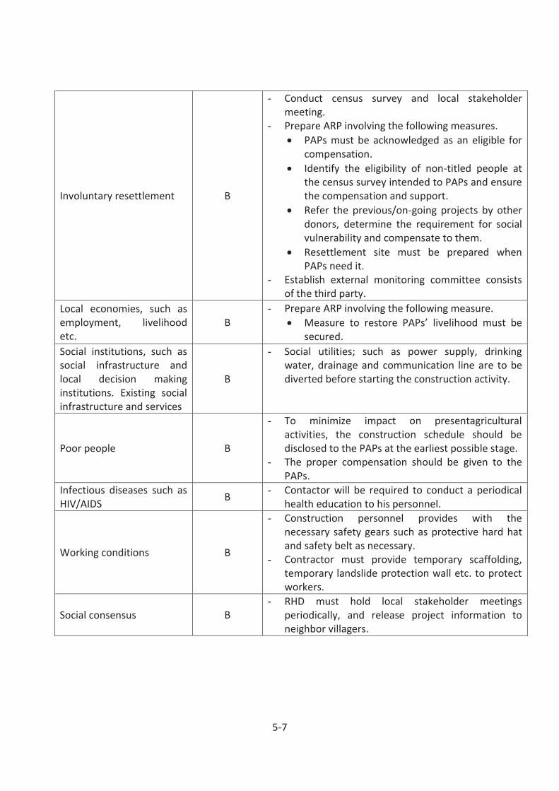
5-7
Involuntary resettlement B
- Conduct census survey and local stakeholder meeting.
- Prepare ARP involving the following measures. PAPs must be acknowledged as an eligible for
compensation. Identify the eligibility of non-titled people at
the census survey intended to PAPs and ensure the compensation and support.
Refer the previous/on-going projects by other donors, determine the requirement for social vulnerability and compensate to them.
Resettlement site must be prepared when PAPs need it.
- Establish external monitoring committee consists of the third party.
Local economies, such as employment, livelihood etc.
B - Prepare ARP involving the following measure.
Measure to restore PAPs’ livelihood must be secured.
Social institutions, such as social infrastructure and local decision making institutions. Existing social infrastructure and services
B
- Social utilities; such as power supply, drinking water, drainage and communication line are to be diverted before starting the construction activity.
Poor people B
- To minimize impact on presentagricultural activities, the construction schedule should be disclosed to the PAPs at the earliest possible stage.
- The proper compensation should be given to the PAPs.
Infectious diseases such as HIV/AIDS B - Contactor will be required to conduct a periodical
health education to his personnel.
Working conditions B
- Construction personnel provides with the necessary safety gears such as protective hard hat and safety belt as necessary.
- Contractor must provide temporary scaffolding, temporary landslide protection wall etc. to protect workers.
Social consensus B - RHD must hold local stakeholder meetings
periodically, and release project information to neighbor villagers.

5-8
Accident B
- A sound traffic management and detour plans duly approved by the local RHD must bel strictly implemented.
- Traffic enforcers and flagmen will be designated when heavy equipment/vehicle will be operated adjacent to public road.
Table 5.3 Mitigation measures in operation stage:
Item of Impact Magnitude of adverse
impact Mitigation Measures
Noise C - Monitoring and review the result by RHD.
Involuntary resettlement C - Monitoring by external monitoring agency and confirm if issues are arisen or not.
Poor people C - Monitoring by external monitoring agency and confirm if issues are arisen or not.

6-1
CHAPTER 6. ANALYSIS OF ALTERNATIVES
6.1 Alternative Alignment
The location of new bridge shall be determined in consideration of impact to existing residences/shops, cost and so on. However, National Road shall be considered future widening project, additionally.
As a result of comparison (see Table 6.1), Alternative 4 (Replacement Existing Bridge) was selected from the viewpoint of the cheapest initial cost. Regarding National Road, Alternative 3 (New Bridge Construction next to Existing Bridge) was selected in consideration of easy future widening. And Alternative 3 was selected for Regional and Zilla road.

6-2
Table 6.1 Comparison of Alternatives
Item Alternative1 Alternative2 Alternative3 Alternative4
Figure
Alternative1
Alternative2
Alternative3
Alternative4
Summary
One of new bridge is constructed next to existing bridge and another bridge is
constructed at the same position of existing bridge.
New bridge is constructed as 2-lane carriageway next to
existing bridge. Additionally, the
abutment and the pier are constructed for future widening
project.
New bridge is constructed next to
existing bridge. Existing bridge is replaced by
new bridge.
Temporary Bridge
Unnecessary Unnecessary Unnecessary Necessary during construction
Good Good Good Poor
Economic Efficiency
The initial cost is the most highest among
alternatives.
The initial cost is higher than
Alternative 3 and 4.
The initial cost is higher than
Alternative 4.
The initial cost is the cheapest among alternatives.
Poor Poor Good Good
Traffic Capacity
It is improved only in project area.
It is same as the existing condition.
It is same as the existing condition.
It is same as the existing condition.
Good Fair Fair Fair
Traffic Safety
It might cause traffic conflict at the
diverging point.
It is same as the existing condition.
It is same as the existing condition.
It is same as the existing condition.
Poor Fair Fair Fair
Evaluation
Recommended for National Road
- Easy for future
widening.
Recommended for Regional and Zilla Road
- The cheapest initial cost.

6-3
6.2 No Action Alternative
All the 105 bridges under WBBIP shall be constructed or reconstructed to replace the existing bridges existing on different national, regional and zilla roads. Under the situation probably ‘no action alternative’ is practically not practicable.

7-1
CHAPTER 7. ENVIRONMENTAL MANAGEMENT PLAN The RHD itself or the Construction Supervision Consultant (CSC) farm hired by RHD shall remain responsible to look after all day to day activities of Contractor during implementation stages of the subprojects and ensure that all environmental provisions as per Environmental Management Plan (EMP), and/or other EIA documents are properly and timely implemented by Contactor during the implementation stages. Fully and timely compliance of the environmental provisions as per the EMP, other EIA documents and environmental Clauses is legally binding for the Contractor as per the contractual agreement.
The Environmental and Social Circle of RHD if probably equipped with necessary equipment and trained staff can probably manage supervision of the social and environmental requirements during project implementation stages. RHD Under the situation can therefore perform the functions stated below:
Supervision and monitoring of environmental and social activities of the WBBIP subprojects done by Contractor during implementation stages,
Monitoring the compliance of the provisions of EIA/EMP and the contractual Clauses by
Contractor during implementation stages of WBBIP sub-projects.
7.1 Institutional framework
Environmental Management of the WBBIP subprojects involves highly specialized multidisciplinary and multi-sector activities that may be different from mere construction of bridges and the associated components. The Environmental Circle of RHD at present may not have sufficient expertise and requisite experience to perform the job properly. Moreover, the Environmental Management of infrastructure projects is a growing discipline in Bangladesh and rather worldwide, hence it is not quite expected that RHD possesses the requisite expertise and experience and the time to supervise implementation of WBBIP and of the EIA provisions properly by Contractor during implementation stages.
RHD shall remain responsible for implementation of the environmental provisions as per EMP and other EIA documents during WBBIP implementation stages. Environmental management during implementation stages as mentioned earlier shall require services of a specialized multidisciplinary team with multi-sector backgrounds. RHD or its hired specialized consultants can monitor due fulfillment of the environmental provisions by Contractor during construction stage. The WBBIP involves low environmental impacts as the bridges will be constructed, reconstructed and/or improved along the existing road alignments and existing bridges sites. The Environmental and Social Circle of RHD may decide how and who to conduct monitoring activities during WBBIP implementation stages.

7-2
The institutional framework for environmental management and monitoring is presented in Figure 7.1.
Figure 7.1 Institutional framework for environmental management and monitoring
Project site
Third parties/local communities
Report Instruction/technical assistance
Government
JICA
Executing Body
Project Implementation Unit (PIU)
Report
Instruction/technical assistance
Dept. of Env.
Roads and Highways Dept.
Construction phase
Contractor
Consultant/supervision
firm Monitor
Monitor
Instruction/mitigation Report
Mitigation measures
Env. And social. issues
Mitigation measures
Necessary actions
Report
Social & Env. Circle

7-3
7.2 Environmental Monitoring Plan
Environmental Monitoring of a development intervention is required to be done periodically for use of the management authorities during the project implementation stages. Two approaches are followed usually during monitoring of environmental impacts. These are (i) compliance monitoring during pre-construction and construction stages and (ii) monitoring of impacts on environmental components during construction and operation stages.
Compliance monitoring 7.2.1
The fulfillment of environmental provisions as per the EIA documents and EMP where applicable at WBBIP subproject sites will require monitoring during implementation stages. The issue of environmental concerns are (i) safety and security workers and pedestrian, onlookers and passengers of road transports, (ii) proper hauling, storage, handling and disposal of wastes from construction sites to the GoB authorized dumping places (if any), (iii) provisions for protection against air and noise pollution, (iv) compliance to the gender equity provisions as per regulations, (v) compliance to the labor welfare regulations, (vi) compliance to the provisions regarding public and professional health and sanitation standards and (vii) maintenance of day to day tidiness at work and work camp sites.
Required compliance monitoring during pre-construction stage are (i) to check the measures taken by Contractor to mitigate environmental impacts, (ii) inclusion of environment related provisions of EIA documents and EMP in the contract documents for compliance by Contractor and (iii) regarding payment of compensation to PAPs for the environmental damages that might have caused due to WBBIP implementation activities.
Environmental Management Implementation 7.2.2
The RHD reorganized the Environmental and Social Circle under an Addl. Chief Engineer, with one Supt. .Engineer and one Ex. En. and necessary supporting staff. Activities of the Circle are:
To review the EIA documents including EMP, supervise and monitor activities of Contractor during project implementation stages. Ensure proper implementation of the environmental provisions by Contractor and other stakeholders as per the EIA documents and Clauses during implementation of RHD projects.
To take care that all the environmental provisions and day-to-day activities at RHD executed project sites fulfill the environmental requirements regarding environment friendliness. The work camp sites, field office site and the overall environment at subproject sites is clean, tidy and environment friendly.
The subproject activities under WBBIP include construction of bridges and approach roads. Enhancement activities include tree planting on approach roads, command areas and take care

7-4
that no squatter sheds and other structures constructed on approach roads during operation stage.
The impact mitigation measures undertaken during construction stage and the enhancement activities as per EMP may continue even during the operation stage. Contractor during implementation stages shall act as key stakeholder and remain responsible regarding implementation of the environmental provisions as per EMP and contractual Clauses (if any). The RHD/ CSC during construction stage shall periodically supervise activities that may impact IECs.
The IECs affected directly due to WBBIP implementation stages particularly during the construction stage are earthwork, fill materials collection for approach construction, piling of junks, haulage and storage of construction materials, pavement work, demolition of existing structures and other related activities like pile driving, construction of super and sub-structures, etc. Impacts during construction of approach road embankments and bridges shall require instant mitigation to avoid/minimize the potential environmental hazards.
Environmental Monitoring Plan 7.2.3
Environmental Monitoring Plan for this sub -project will help to evaluate the extent and severity of environmental impacts against the predicted impact and the performance of environmental protection measures. The following table has been prepared for monitoring the operation & maintenance phase activities of the sub-project:

7-5
Table 7.1 Environmental Monitoring Plan:
Sl.No.
Environmental Indicator
Parameters/Units
Means of Monitoring
Frequency Responsible agency
01. Air/Water/Soil Quality
N/A Inspection Dairy Contractor/Consultant of supervision
02. Dust Control Spraying of water Visual Daily Contractor/Consultant of supervision
03. Noise Control Measurement (db)
Monitoring
Daily Contractor/Consultant of supervision
04. Waste Management
Monitoring of collection, transportation and disposal of solid waste. Inspection of construction camp.
Inspection Daily Contractor/Consultant of supervision
05. Working conditions and Accident
Monitoring Health & Safety of Workers
Inspection Daily Contractor/Consultant of supervision
06. Involuntary resettlement, Poor
Monitoring by external monitoring agency
Monitoring
6 months later from resettlement
External monitoring agency/RHD
Reporting 7.2.4
The Site Engineer (SE) shall report regarding compliance of the EMP and other environment related issues by concerned stakeholders to RHD in his periodic progress report for reviewed by RHD during the construction stage. Periodic one in a month report of the SE shall indicate clearly regarding the compliance of environmental provisions by Contractor. Contractor’s failures to implement the environmental provisions are to be reported to RHD regularly with request for action. Incidents of contamination or pollution due to Contractor’s activities whether due to negligence or otherwise are to be mentioned in periodic reports.
Environmental Management Cost Estimated 7.2.5
The costs for environmental management are involved in mitigation of the impacts during implementation stages for environmental enhancement activities e.g. planting tree saplings on roadsides, construction of public facilities, etc. The estimates for incurring the environmental costs are shown in Table 7.2 and Table 7.3.

7-6
Confidential

8-1
CHAPTER 8. PUBLIC CONSULTATION Several Senior Consultants named Mrs Hasina Khatun, and Messrs Md. Ekramul Huq, Md Faruque Ahmed and Shahidul Islam from BCL conducted the stakeholders meetings at different bridges sites. The discussions with the stakeholders were concentrated mostly on the positive aspects of subprojects implementation, magnitudes of socio-cultural and environmental impacts, compensation entitled by PAPs and resettlement requirements for affected persons and families that to be dealt by RHD and other authorities.
The minutes of stakeholder meeting is attached in Annex-VI: Minutes of SHM in ARP.
8.1 Summarized Stakeholders Opinions at least Affected Subproject Sites
In general, people at subproject sites agreed to the implementation of subprojects and made comments that the subproject implementation will improve road communication system, augment economic activities and allow faster and safer movement of passengers and commodities to and from subproject sites. The mentioned opinions came mostly from the people who were are not directly affected by the project and where impacts of the subproject has tolerable environmental and socio-cultural impacts.
This represent a group of bridges that show relatively mild type of environmental and socio-cultural impacts that can be mitigated relatively easily.
8.2 Summarized Stakeholders Opinions at Moderately Affected Subproject Sites
The PAPs and many amongst the locals who attended the stakeholders’ meetings held at 13 bridges sites at Bhola, Jhalkathi, Faridpur sadar, Shariatpur, Madaripur, Muladi and Barisal opposed implementation of the subprojects at the sites selected by RHD. The objections were based on the high socio-cultural and ecological impacts involved to affect many people provided the bridges are constructed/reconstruction at the proposed sites. The matter can however be referred to the RHD to decide how the disputes regarding the bridges location can be resolved amicably consulting with the local people.
The bridges Ranks (23, 29, 42, 71, 78, 81, 83, 85, 86, 94, 96, 97, 99) in south central regions (SCR) pose rather serious environmental and socio-cultural impacts. Hence the participants in ARP meets raised objections to construct /reconstruct the bridges along their existing alignments.
8.3 Summarized Stakeholders Opinions at Seriously Affected Subproject Sites
The stakeholders who participated in the meeting comprised of RHD officials, local elites, local businessmen, service holders, students, women representative and local working class people. All present in the discussion firmly opposed construction of a 43.0 m RCC bridge over the

8-2
Gabdigara channel because of high ecological impacts, moreover the bridge if constructed along the proposed alignment will impact an irrigation channel and considerable area of agricultural land.
The 60 percent of the PAPs who attended the meets though in general support construction of 4-lane bridges that will improvement of communication, but at the same time strongly oppose the ecological, socio-cultural and loss of agricultural land due to construction of bridges as per the proposed designs. Hence they plead for realignment of bridges to reduce the socio-cultural and environmental impacts.

BIBLIOGRAPHY-2
BIBLIOGRAPHY
1.ADB,2003. Guidelines on Operational Procedures- Environmental Considerations in Bank Operations 2.BBS 2005. Handbook on Environmental Statistics. Government of Bangladesh, Dhaka 3.BBS 2007. Statistical Pocket Book, Bangladesh. Government of Bangladesh, Dhaka 4.BBS 2012. Statistical Year Book of Bangladesh,2012 , Government of Bangladesh, Dhaka. 5.BCAS,1999. Guide to the Environmental Conservation Act 1995 and Rules 1997, Bangladesh Centre for Advanced Studies, Dhaka. 6.DoE, 1997. EIA Guidelines for Industries: Ministry of Environment and Forests (MOEF) Government of Bangladesh, Dhaka. 7.DoE, 2006. Environment for Sustainable Development, Annual Report 2006, Ministry of Environment and Forest, Government of Bangladesh, Dhaka 8.DoE, 2O1O-11.Barshik Pratibedan, Paribesh o Ban Mantranalaya, Government of Bangladesh 9.FAO 1988. Land Resources Appraisal of Bangladesh for Agricultural Development: UNDP/FAO Project, BDG/18/035 Technical Report No.2-13: FAO Rome. 10.FAO,1971. Soil Resources of Bangladesh, Soil Survey Project of Pakistan, Special/Pakistan-6, Technical Report-3,FAO, Rome. 11.Farooq, M. and Rezwana, S.1996. Laws Regulating the Environment in Bangladesh, BELA Dhaka, Bangladesh. 12.GoB, 1979. Seismic Zone Map of Bangladesh and Outline of the Code for Earthquake Resistant Design for Structures: Final Report. Geological Survey of Bangladesh, Dhaka 13.GoB, 1996. Bangladesh National Building Code. Ministry of Housing and Public Works, Government of Bangladesh, Dhaka. 14.GoB, 2004. Guidelines for Environmental Impact Assessment of Roads and Bridges: Social Environment Circle, Roads and Highways Department, Dhaka. 15.GoB, 2004. National Land Transport Policy, Ministry of Communication, Government of Bangladesh, Dhaka 16.GoB, 2009. Bangladesh Climate Change Strategy and Action Plan, Ministry of Environment and Forest, Government of Bangladesh. Dhaka 17.GoB, 1995. National Environmental Management Action Plan, Ministry of Environment and Forest, Government of Bangladesh, Dhaka.

BIBLIOGRAPHY-2
18.Hannan, M. Dr. 1995. Hazar Bachharer Bangladeh, etihasher album. Bais Printing and Publishing 19.Koppen,W. 1936.Das Geographic system der climate,Berlin, Geogr.Vorntesger, Germany. Motijheel C/A , Dhaka. Bangladesh. 20.Hassan, M.M. 1999. Soils of Bangladesh - Their Genesis, Classification and Use Potential: The March Printers Ltd, Dhaka. 21.IUCN 2000. Red List of Threatened Animals of Bangladesh: IUCN, Bangladesh Dhaka. 22.IUCN 2002. Bio-ecological Zones of Bangladesh, IUCN, Dhaka. 23.Katebi, N.A.,1997. Bangladesher Ban, Chief Conservator of Forest (Rtd) ,Government of Bangladesh. 24.Malano, E.B.1975. Annals of Climatic Survey of Bangladesh, International Rice Research Institute, Manila. 25.MoC,2007. Inception Report, Dhaka Chittagong Expressway Project, Roads and Highway Project, Government of Bangladesh. 26.MoEF, 1991. National Conservation Strategies, IUCN, Government of Bangladesh, Dhaka. 27.MoEF, 1992. National Environmental Policy: The Department of Environment, Ministry of Environment and Forests, Dhaka. 28.MoEF, 2004. The Social Forestry Act, Ministry of Forest AND environment, Government of Bangladesh, Dhaka 29.Morgan,J.P. and W.G. McIntire 1959. Quaternary Geology of Bengal Basin, East Pakistan and India: Geological Survey of America Bulletin-70, USA. 30.SRDI, 1963-73. Reconnaissance Soil Survey Report of Dhaka district (greater district), Ministry of Agriculture, Government of Bangladesh 31.SRDI,1965. Reconnaissance Soil Survey Report of Tangail district, Ministry of Agriculture, Government of Bangladesh 32.Thornthwaite,C.W. 1948. An approach toward a rational classification of climate. Geographic Review,38, USA 33.WB 2002. Draft Manual on Environment, World Bank, Dhaka 34.WARPO August 2000. National Water Development Plan Project, Development Strategy,Vol.-1 Annex-O: Regional Environmental Profile.

December 09, 2014
EIA Report Prepared for Western Bangladesh Bridges Improvement Project
Checklist of DOE’s TOR where it is incorporated in EIA Report and ARP Report
TOR approved by DOE. Reference to EIA Report / ARP Report
1. Environmental Impact Assessment (EIA) is prepared considering with the overall activity of the said Project in accordance with DOE’s TOR and additional suggestions provided therein:
2. The EIA report has been prepared in accordance with following iindicative outlines: EIA Report 1. Executive Summary (ES) As enclosed
2. Introduction:
Background Brief description Scope of study Methodology and limitation EIA team
Chap. 1 (Sec. 1.3, P.1-2), [also ES (Sec. A)] Chap. 1 (Sec. 1.1, P. 1-1; Sec. 1.6, P. 1-3) Chap. (Sec. 1.2, P.1-1; Sec.1.4, P1-1; Sec.1.5, P. 1-3) ES (Subsec. of A: Methodology for conducting EIA) ES (Sec. A, P. ES-5)
3. Legislative, regulation and policy consideration
Potential legal, administrative Planning Policy framework within which the EIA will be prepared
Chap 2 (Sec. 2.1, P-2-1; Table 2.1), [also ES (Sec. B)]
Chap. 2 (Sec. 2.2, P.2-4; Subsec. 2.2.1, P.2-5) Chap. 2 (Sec. 2.3, P.2-6)
4a Project activities: A list of the main project activities to be undertaken during site clearing, construction as well as operation.
Chap. 4 (Table 4.1)
4b Project schedule: The phase and timing for development of the project ES (Sec. Q, P. ES-39); [also ARP (Chap. 9)]

4c.
Resources and utilities demand: Resources required to develop the project, such as soil and construction material and demand for utilities (water, electricity, sewerage, waste disposal and others), as well as infrastructure (road, drains, and others) to support the project.
A topographic survey has been prepared for each bridge site. However, its detailing and material sources material for construction will be surveyed during DD stage.
4d.
Map and survey information: Location map, cadastral map showing land plots (project and adjacent area), Geological map showing geological units, fault zone, and other natural features.
Chap. 1 (Fig. 1.1) Chap. 3 (Fig. 3.3, 3.4)
5. Baseline Environmental Condition should include, inter alia, following:
Physical Environment Geology and soil Topology Geomorphology Meteorology Hydrology
Chap. 3 (Subsec. 3.1.2, 3.1.3, P.3-2); [also ES (Sec.
F)] Chap. 3 (Sec. 3.1.2, P. 3-2); [also ES (Sec. F)] ES (Sec. F (4), P. ES-19) Chap. 3 ( Subsec. 3.1.1, P. 3-1) Chap. 3 (Subsec. 3.1.5, P.3-6), [also ES (Sec. F (5),
Table ES-4)]
Biological Environment Habitats, aquatic life and fisheries, terrestrial Habitats and flora and Fauna
Chap.3 (Sec. 3.2, P.3-8) [also ES (Sec. G, P. ES-24)]
Environment Quality
Air, water, soil Sediment quality
Chap. 3 (Sec. 3.4), [also ES (Sec. I, P. ES-26) Chap. 3 (Subsec. 3.1.4, P. 3-4), Chap. 5 (Table 5.1)
6. Socio-economic environment should include, inter alia, following: AAbbreviated Resettlement Plan (ARP) Report
Population: Demographic profile and ethnic composition
Chap. 2 Sec. 2.3.1, Table-2.3, 2.4, 2.5, 2.6. Sec. 2.3.2, Table 2.7, 2.8, 2.9. Sec. 2.3.4, Table 2.10, 2.11, 2.12, Sec. 2.3.5, Table 2.13
Settlement and housing Chap.3 (Sec. 3.4, P.3-2)

Traffic and transport
Traffic volume study already conducted for bridge/road design purpose. But traffic management and traffic safety issues will be incorporated in DD stage.
Public utilities: water supply, sanitation and solid waste Chap.2 (Sec-2.3.4, Table-2.10, 2.15, 2.16 & 2.17)
Economy and employment: employment structure and cultural issues in employment
Chap. 2 Sec. 2.1, Subsec. 2.3.2
Fisheries: fishing activities, fishing communities, commercial important species, fishing resources, commercial factors
Refer to EIA Report Chap. 3 (Subsec. 3.3.8, P. 3-13), Chap. 5 (Table 5.1)
7. Identification, Prediction and Evaluation of Potential Impact EIA Report
Identification, prediction and assessment of positive and negative impacts likely to result from the proposed project.
Identification and analysis of potential impacts’ – the ‘Analysis’ part shall
include the analysis of relevant spatial and non-spatial data. The outcome of the analysis shall be presented with the scenarios, maps, graphics etc. for the cases of anticipated impacts on baseline. Description of the impacts of the project on air, water, land, hydrology, vegetation-man maid or natural, wildlife, socio-economic aspect shall be incorporated in detail.
Chap. 3 (Sec.-3.1, Subsec. 3.1.1 to 3.1.8
Sec.-3.2, Subsec. 3.2.1 to 3.2.4 Sec.-3.3, Subsec. 3.3.1 to 3.3.15 Sec.-3.4, Subsec. 3.4.1 to 3.4.6) Chap. 6 (Sec. 6.1, 6.2)
[also refer to ARP (Chap.2]
8-15 EEIA Report

8.
Management Plan/Procedures: For each significant major impact, proposed mitigation measures will be set out
for incorporation into project design or procedures, impacts which are not capable of mitigation, will be identified as residual impacts Both technical and financial plans shall be incorporated for proposed mitigation measures.
An outline of the Environmental Management Plan shall be developed for the project. In Environmental Monitoring Plan, a detail technical and financial proposal shall be included for developing an in-house environmental monitoring system to be operated by the proponent’s own resources (equipments and expertise).
Chap. 5 and Annex II of EIA Report (individual
bridges) EMP (Chap. 7) EMoP cost (Chap 7, Table 7.2)
9.
Consultation with Stakeholders/Public Consultation (ensures that consultation with interested parties and the general public will take place and their views taken into account in the planning and execution of the project) Beneficial Impacts (summarize the benefits of the project to the Bangladesh nation, people and local community and the enhancement potentials)
Chap. 8 [also ES (Sec. P)]
10. Conclusion and Recommendations ES (Sec. R), P. ES-40
Additional comments made by DOE in the meeting held on December 03, 2014
11 Climate change effect in bridge design
Currently no specific and recommended guideline are available in Bangladesh, it shall be therefore studied in DD stage and incorporate the findings accordingly in the bridge design.
12 Fish migration during bridge pier construction
To be studied in DD stage. Construction schedule should be prepared in such a way that the construction of bridge pier will not make any hindrance on fish migration, if any finds out significantly.

13 Siltation effect due to bridge pier construction Not addressed in the EIA report. However, it shall be studied details in DD stage.
14 Keeping adequate river channel width New bridge length is longer than existing one. Therefore, new bridge construction will not make any constraint to natural river channel width.
15 EIA and mitigation measures for a critical type bridge ( as an example)
These issues are fully explained in Annex-II (The EIA Reports of the Individual Bridge Sites) for respective bridges with recommendations and budget for mitigation.

APPENDIX

ROADS AND HIGHWAYS DEPARTMENTMINISTRY OF ROAD TRANSPORT AND BRIDGESGOVERNMENT OF THE PEOPLE’S REPUBLIC OF BANGLADESH
PREPARATORY SURVEY
ON
WESTERN BANGLADESH BRIDGE INPROVEMENT
PROJECT
ABBREVIATED RESETTLEMENT PLAN
SEPTEMBER 2014
Prepared by
Oriental Consultants Co. Ltd.
Katahira & Engineers International
On behalf of
Roads and Highways Department (RHD)

i
Table of Contents
Page 1 DESCRIPTION OF THE PROJECT _______________________________________________ 1-1 1.1 Background of the Project _____________________________________________________ 1-1 1.2 Objectives & Purpose of the Project _____________________________________________ 1-6
Potential Impacts ___________________________________________________________ 1-6 1.2.1 Objective of the Abbreviated Resettlement Plan ___________________________________ 1-6 1.2.2 Methodology for Preparing the Abbreviated Resettlement Plan _______________________ 1-7 1.2.3
2 SOCIO-ECONOMIC CHARACTERISTICS OF AFFECTED HOUSEHOLDS ________________ 2-1 2.1 Methodology for Census and Socioeconomic Survey ________________________________ 2-1 2.2 The Project Area ____________________________________________________________ 2-1 2.3 Profile of Affected Households _________________________________________________ 2-5
Population ________________________________________________________________ 2-5 2.3.1 Ethnicity, Religion and Gender ________________________________________________ 2-6 2.3.2 Level of education __________________________________________________________ 2-7 2.3.3 Age and Occupation ________________________________________________________ 2-8 2.3.4 Income and Poverty Dimensions ______________________________________________ 2-10 2.3.5
2.4 Gender Impacts and Mitigation Measures ________________________________________ 2-11 2.5 Water and Sanitation ________________________________________________________ 2-12
3 LAND ACQUISITION AND RESETTLEMENT IMPACTS _______________________________ 3-1 3.1 Minimizing Land Acquisition and Displacement ____________________________________ 3-1 3.2 Scope of Land Acquisition _____________________________________________________ 3-1 3.3 Displacement and Other Impacts _______________________________________________ 3-1 3.4 Asset Inventory and Assessment of Losses _______________________________________ 3-2
Affected Households & Business Enterprises _____________________________________ 3-2 3.4.1 Physical Structures Affected __________________________________________________ 3-2 3.4.2 Trees and Crops Affected ____________________________________________________ 3-3 3.4.3 Common Property Resources _________________________________________________ 3-8 3.4.4
3.5 Significance of Impact ________________________________________________________ 3-8 3.6 Special Measures for Vulnerable Groups _________________________________________ 3-9 3.7 Employment Loss of Wage Earners _____________________________________________ 3-9 3.8 Business Loss of Business Enterprises _________________________________________ 3-10 3.9 Bridge-wise Detail __________________________________________________________ 3-11
4 LEGAL AND POLICY FRAMEWORK ______________________________________________ 4-1 4.1 Purposes and Objectives of Land Acquisition and Resettlement _______________________ 4-1 4.2 Legal Framework for Land Acquisition ___________________________________________ 4-1 4.3 JICA’s Guidelines for Environmental and Social Considerations _______________________ 4-2 4.4 Gap and Gap Filling Measures _________________________________________________ 4-3 4.5 Types of Losses and Impact Category ___________________________________________ 4-7 4.6 Principles, Legal and Policy Commitments ________________________________________ 4-7 4.7 Eligibility Policy and Entitlement Matrix ___________________________________________ 4-9
Eligibility Criteria ___________________________________________________________ 4-9 4.7.1

ii
Compensation and Entitlement Policy ___________________________________________ 4-9 4.7.24.8 Compensation and Resettlement Assistances ____________________________________ 4-13
Compensation Payment Procedure to Title Holder: ________________________________ 4-13 4.8.1 Compensation Payment Procedure to Non-Title Holder: ____________________________ 4-16 4.8.2 Assistance from Relevant Government Departments ______________________________ 4-18 4.8.3
5 CONSULTATION, PARTICIPATION AND DISCLOSURE ______________________________ 5-1 5.1 Project Stakeholders _________________________________________________________ 5-1 5.2 Disclosure and Public Consultation ______________________________________________ 5-1 5.3 Stakeholders Meeting ________________________________________________________ 5-2
Meetings Phase I __________________________________________________________ 5-2 5.3.1 Meetings Phase II __________________________________________________________ 5-5 5.3.2
5.4 Mechanism for Stakeholders' Participation ________________________________________ 5-8 5.5 Disclosure of the ARP ________________________________________________________ 5-8 5.6 Strategy for Community Consultation and Participation during implementation ____________ 5-9 5.7 Eligibility of Cut-off Date ______________________________________________________ 5-9
6 RELOCATION RESETTLEMENT AND INCOME RESTORATION ________________________ 6-1 6.1 Scope of Displacement and Relocation __________________________________________ 6-1 6.2 Relocation of housing and other establishment_____________________________________ 6-1
Site Selection ______________________________________________________________ 6-2 6.2.1 Housing infrastructure _______________________________________________________ 6-2 6.2.2 Changing School ___________________________________________________________ 6-2 6.2.3
6.3 AP Preference for Relocation __________________________________________________ 6-2 6.4 Replacement of Agricultural Land _______________________________________________ 6-3 6.5 Income and Livelihood Restoration Strategy _______________________________________ 6-3 6.6 Capital Support _____________________________________________________________ 6-4 6.7 Employment in Construction ___________________________________________________ 6-5 6.8 Re-Establishment of Common Property Resources _________________________________ 6-5
7 IMPLEMENTATION ARRANGEMENTS ____________________________________________ 7-1 7.1 Roads & Highways Department (RHD) ___________________________________________ 7-1 7.2 Responsibilities of Resettlement Unit Officials _____________________________________ 7-3 7.3 Functional Description ________________________________________________________ 7-3
Role of Deputy Project Director (DPD)/Chief Resettlement Officer (CRO) _______________ 7-3 7.3.1 Role of Assistant Directors (ADs): Resettlement ___________________________________ 7-4 7.3.2
7.4 Other Agencies Involved in the Process __________________________________________ 7-5 Deputy Commissioner _______________________________________________________ 7-5 7.4.1 Project Supervision Consultant ________________________________________________ 7-6 7.4.2 Implementing Agencies ______________________________________________________ 7-6 7.4.3 Ministry of Communications (MOC) _____________________________________________ 7-7 7.4.4 Joint Verification Team ______________________________________________________ 7-7 7.4.5 Property Valuation Advisory Team _____________________________________________ 7-7 7.4.6 Grievance Redress Committees _______________________________________________ 7-8 7.4.7 Resettlement Advisory Committee (RAC) _______________________________________ 7-10 7.4.8 Women Groups in Resettlement Process _______________________________________ 7-11 7.4.9

iii
7.5 Appointment of Implementing Agency (Non - Government Organization (NGO) or Social Consulting Firm) ___________________________________________________________ 7-11
7.6 Community (Stakeholders) Participation in ARP Implementation ______________________ 7-11 8 RESETTLEMENT AND COMPENSATION COSTS AND BUDGET _______________________ 8-1 8.1 Budgeting and Financial Planning _______________________________________________ 8-1 8.2 Assessment of Unit Value for Compensation _____________________________________ 8-15 8.3 Approval of the Resettlement Budget ___________________________________________ 8-15 8.4 Management of Compensation and Flow of Awards ________________________________ 8-16
9 ARP IMPLEMENTATION SCHEDULE _____________________________________________ 9-1 10 MONITORING AND EVALUATION _______________________________________________ 10-1 10.1 Monitoring and Evaluation ____________________________________________________ 10-1 10.2 Internal Monitoring _________________________________________________________ 10-1 10.3 External Monitoring and Evaluation _____________________________________________ 10-3 10.4 Reporting Requirements _____________________________________________________ 10-3 10.5 Conclusion and Recommendations: ____________________________________________ 10-4
Conclusion ______________________________________________________________ 10-4 10.5.1 Recommendation_________________________________________________________ 10-5 10.5.2
Annex-I : List of Project Affected Household Annex-II : List of Affected Common Property Resorces and Its Losses Annex-III : List of Vulnerable Household Annex-IV : List of Wage Laborers Affected in Non-Farm Sector
Annex-V Bridge-wise Detail
Annex-VI : Minute of Stakeholder Meeting Annex-VII : ToR for IA for ARP Implemention Annex-VIII : ToR for External Monitoring Consultant Annex-IX : ARP Implementation Monitoring Format
List of Table
Page Table 1.1 Bridges to be replaced by type, length and zone in the project area __________________ 1-2
Table 2.1 Zone wise number of bridges and project affected units ____________________________ 2-1
Table 2.2 Distribution of Impacts by Zones _____________________________________________ 2-4
Table 2.3 Number of male and female population by zone __________________________________ 2-5
Table 2.4 Affected Household Heads by Zone and Gender ________________________________ 2-5

iv
Table 2.5 Households Size of the Affected f Household by Zone ____________________________ 2-6
Table 2.6 Affected head of households by age group by Zone ______________________________ 2-6
Table 2.7 Affected Households by Zones and Religion ____________________________________ 2-7
Table 2.8 Level of education of the Head of the households in percentage by zone ______________ 2-7
Table 2.9 Level of education of the Affected Population (7 years and above) by zone _____________ 2-8
Table 2.10 Age Distribution of Affected Population in Percentage ____________________________ 2-8
Table 2.11 Principal Occupation Head of the Households by Zone ___________________________ 2-9
Table 2.12 Principal Occupation of the Population (10 Years and above) by Zone ______________ 2-10
Table 2.13 Poverty Level and Annual income of head of the households by Zone ______________ 2-11
Table 2.14 Type of Toilet Facilities of the Households by Zone ____________________________ 2-12
Table 2.15 Management of Household Garbage by Head and by Zone ______________________ 2-13
Table 2.16 Source of Drinking Water of the Households by Zone ____________________________ 2-13
Table 2.17 Management of Waste Water of the Households by Zone ________________________ 2-14
Table 3.1 Displacement and other Impacts ______________________________________________ 3-2
Table 3.2 Quantity of All Affected Structure (sqm) by type and by Zone _______________________ 3-3
Table 3.3 Affected Secondary Structures _______________________________________________ 3-3
Table 3.4 Affected Trees on private land _______________________________________________ 3-4
Table 3.5 Affected Trees on RHD/Government land _______________________________________ 3-4
Table 3.6 List of Affected Trees on Private land by Tree Name ______________________________ 3-4
Table 3.7 List of Affected Trees on Government Land by Tree Name _________________________ 3-7
Table 3.8 Affected CPRs by Zone ____________________________________________________ 3-8
Table 3.9 AHs Experiencing Significant Impacts _________________________________________ 3-9
Table 3.10 Type of Business Loss by Zone ____________________________________________ 3-11
Table 4.1 Comparison between the Government of Bangladesh and JICA Guidelines for
Environment and Social Consideration - Land Acquisition and Resettlement _____________ 4-3
Table 4.2 Compensation and Entitlement Matrix _________________________________________ 4-10
Table 5.1 Stakeholders Consultation (Issues and out-come) Phase I __________________________ 5-4
Table 5.2 Stakeholders Meeting (Issues and out-come) Phase II _____________________________ 5-6
Table 6.1 Livelihood Restoration Options _______________________________________________ 6-4
Table 7.1 Institutional Responsibilities in Resettlement Process ______________________________ 7-5
Table 7.2 Grievance Redress Procedures ______________________________________________ 7-9
Table 8.1 Land Acquisition and Resettlement Budget ______________________________________ 8-2
Table 9.1 ARP Implementation Schedule _______________________________________________ 9-1
Table 10.1 Potential Monitoring Indicators _____________________________________________ 10-2
Table 10.2 A Model Format for ARP implementation Monitoring – Quarterly Report _____________ 10-5

v
List of Figure
Page Figure 1.1 Location of Bridge sub-projects under WBBIP ___________________________________ 1-1
Figure 3.1 Distribution of the Wage Losers by Zone ______________________________________ 3-10
Figure 4.1 Compensation Mechanism for Legal Title Holder________________________________ 4-15
Figure 4.2 Compensation Mechanism for Non-title Holder _________________________________ 4-17
Figure 6.1 Type of structures used by the affected Business enterprises ______________________ 6-1
Figure 6.2 Type of Affected Residential structures ________________________________________ 6-2
Figure 7.1 ARP implementation organogram ____________________________________________ 7-2
Figure 7.2 Procedure of Determining Valuation of Property _________________________________ 7-8
Figure 7.3 Grievance Redress Mechanism _____________________________________________ 7-10

vi
Abbreviations AB Acquiring Body AC Land Assistant Commissioner Land ADC Additional Deputy Commissioner AH Affected household AP Affected person APD Additional Project Director ARP Abbreviated Resettlement Plan BBS Bangladesh Bureau of Statistics CBE Commercial and Business Enterprise CCL Cash Compensation under Law COI Corridor of Impact CMP Current Market Price CPR Common Property Resources CRO Chief Resettlement Officer CSC Construction Supervision Consultant DAE Department of Agriculture Extension DC Deputy Commissioner DCI Direct Calorie Intake DOF Department of Forest DoF Department of Fisheries EA Executing Agency EC Entitlement Card EP Entitled Person FGD Focused Group Discussion ft foot / feet (3.28 ft = 1 m) GDP Gross Domestic Product GOB Government of Bangladesh GRC Grievance Redress Committee ha hectare HIES Household Income and Expenditure Survey HH Household IA Implementing Agency ID Card Identify Card IOL Inventory of losses IR Involuntary Resettlement JVS Joint Verification Survey JVT Joint Verification Team LA Land Acquisition LA&R Land Acquisition and Resettlement

vii
LAO Land Acquisition Officer LAP Land Acquisition Plan LGI Local Government Institution M/m Meter LMS Land Market Survey LIRP Livelihood and Income Restoration Program MARV Maximum Allowable Replacement Value M&E Monitoring & Evaluation MIS Management Information System MOL Ministry of Land NGO Non-government Organization NRS National Resettlement Specialist PAH Project Affected Household PAU Project Affected Unit PIU Project Management Unit PD Project Director PIB Public Information Brochure PMO Project Management Office PPR Project Progress Report PPTA Project Preparatory Technical Assistance PRA Participatory Rapid Appraisal PVAT Property Valuation Advisory Team PWD Public Works Department R&R Resettlement and Rehabilitation RAC Resettlement Advisory Committee RAP Resettlement Action Plan RB Requiring Body RF Resettlement Framework RHD Roads & Highways Department RO Resettlement Officer RoR Record of Rights RU Resettlement Unit RV Replacement Value SES Socioeconomic Survey Sqm Square Meter TA Technical Assistance TOR Terms of Reference VH Vulnerable Household WBBIP Western Bangladesh Bridge Improvement Project

viii
Glossary of Terms Affected Person (AP): includes any person, affected households (AHs), firms or private institutions who, on account of changes that result from the project will have their (i) standard of living adversely affected; (ii) right, title, or interest in any house, land (including residential, commercial, agricultural, forest, and/or grazing land), water resources, or any other moveable or fixed assets acquired, possessed, restricted, or otherwise adversely affected, in full or in part, permanently or temporarily; and/or (iii) business, occupation, place of work or residence, or habitat adversely affected, with or without displacement. Assistance: means support, rehabilitation and restoration measures extended in cash and/or kind over and above the compensation for lost assets. Awardee: means the person with interests in land to be acquired by the project after their ownership of said land has been confirmed by the respective Deputy Commissioner's office as well as persons with interests in other assets to be acquired by the project. Compensation for acquired assets is provided to ‘awardees’ through notification under Section 7 of the Land Acquisition Ordinance. Compensation: means payment in cash or kind for an asset to be acquired or affected by a project at replacement cost at current market value. Cut-off date: means the date after which eligibility for compensation or resettlement assistance will not be considered is the cut-off date. Date of service of notice under Section 3 of Land Acquisition Ordinance is considered to be the cut-off date for recognition of legal compensation and the starting date of carrying out the census/inventory of losses is considered as the cut-off date for eligibility of resettlement benefit for the properties standing on the GoB land and not covered by DC. Encroachers: mean those people who move into the project area after the cut-off date and are therefore not eligible for compensation or other rehabilitation measures provided by the project. The term also refers to those extending attached private land into public land. Entitlement: means the range of measures comprising cash or kind compensation, relocation cost, income restoration assistance, transfer assistance, income substitution, and business restoration which are due to AHs, depending on the type and degree /nature of their losses, to restore their social and economic base. Eminent Domain: means the regulatory authority of the Government to obtain land for public purpose/interest or use as described in the 1982 Ordinance and Land Acquisition Law. Household: A household includes all persons living and eating together (sharing the same kitchen and cooking food together as a single-family unit). Inventory of losses: means the pre-appraisal inventory of assets as a preliminary record of affected or lost assets. Non-titled: means those who have no recognizable rights or claims to the land that they are occupying and includes people using private or public land without permission, permit or grant i.e. those people without legal title to land and/or structures occupied or used by them. ADB’s policy explicitly states that such people cannot be denied resettlement assistance. Project: means the Western Bangladesh Bridge Improvement Project to be implemented in 29 districts in western zones of Bangladesh to improve/reconstruct 105 RHD bridges. Project Affected Unit: combines residential households (HHs), commercial and business enterprises (CBEs), common property resources (CPRs) and other affected entities as a whole. Project Affected Household: includes residential households and commercial & business enterprises except CPRs.
ix
Relocation: means displacement or physical moving of the APs from the affected area to a new area/site and rebuilding homes, infrastructure, provision of assets, including productive land/employment and re-establishing income, livelihoods, living and social systems Replacement cost: means the value of assets to replace the loss at current market price, or its nearest equivalent, and is the amount of cash or kind needed to replace an asset in its existing condition, without deduction of transaction costs or for any material salvaged. Replacement Land: means the land affected by the project that is compensated through provision of alternative land, rather than cash, of the same size and/or productive capacity as the land lost and is acceptable to the AP. Resettlement: means mitigation of all the impacts associated with land acquisition including restriction of access to, or use of land, acquisition of assets, or impacts on income generation as a result of land acquisition. Significant impact: means where 200 or more APs suffer a loss of 10% or more of productive assets (income generating) or physical displacement. Squatters: means the same as non-titled and includes households, business and common establishments on land owned by the State. Under the project this includes land on part of the crest and slopes of canal dykes, flood control embankments, and similar areas of the drainage channels. Structures: mean all buildings including primary and secondary structures of houses and ancillary buildings, commercial enterprises, living quarters, community facilities and infrastructures, shops, businesses, fences, and walls. Vulnerable Households: means households that are (i) headed by single woman or woman with dependents and low incomes; (ii) headed by elderly/ disabled people without means of support; (iii) households that fall on or below the poverty line;1 (iv) households of indigenous population or ethnic minority; and (v) households of low social group or caste.
1 The poverty lines (updated for 2008) for Chittagong to be cited in the RAP as per BBS report.

ES-1
Executive Summary Description of the Project: The Government of Bangladesh with the financial loan from Japan International Cooperation Agency (JICA), has undertaken a project in order to improve the road network system in the Western part of Bangladesh aimed at poverty reduction and improvement of selected existing one-lane bridges of Roads and Highways Department (RHD). In the western region a total of 105 bridges have been selected for improvement. Many of the bridges are baily bridges and not suitable for road bridges due to lack of capability and safely function and some of them are already collapsed. To improve road safety and remove the traffic jams at the bridge sites, these bridges will be two-lane RCC (Reinforced Cement Concrete) bridges. RHD will be the implementing authority of the project. RHD has prepared Abbreviated Resettlement Plan (ARP) that will govern adverse social impacts due to the project. The ARP is consistent with the JICA Guidelines for Environmental and Social Considerations. An ARP Implementing Agency (IA) i.e. NGO or Social Consulting Firm will be engaged by the RHD for implementation of the ARP. The selected 105 bridges are located in five zones i.e. Rangpur zone, Rajshahi zone, Gopalganj zone, Khulna zone and Barisal zone. A total of 32 bridges are located in Rangpur zone, 23 bridges are in Rajshahi zone, 15 bridges are in Gopalganj zone, 15 bridges are in Khulna zone and 20 bridges are in Barisal zone Land Acquisition and Displacement: The project work requires land acquisition and relocation of households and business enterprises from the right of way. A total of 39.96 ha of land will need to be acquired of which 18.50 ha in Rangpur zone, 8.41 ha in Rajshahi zone, 5.51 ha in Gopalganj zone, 2.70 ha in Khulna zone and 4.85 ha in Barisal zone. A total of 109,538 sqm structures have got affected of which 33,208 sqm is residential and 69,604 sqm commercial structure. Besides, about 98 community properties will be affected within the corridor of impact. Land acquisition, displacement and other impacts are shown in Table 1 below.

ES-2
Table 1 Displacement and other Impacts Sl. # Type of impacts
Zones Total
Rangpur Rajshahi Gopalganj Khulna Barisal 1 Total quantity of land
to be acquired (ha) 18.50 8.41 5.51 2.70 4.85 39.97
2 Total No. Households affected (No) 207 190 54 171 166 788
3 Total No. Commercial enterprises (CBEs) affected (No)
765 318 264 470 550 2,367
4 Community property (CPR) affected 43 07 08 21 19 98
5 Total Quantity of all structure (Sqm) affected
37,445 12,931 13,589 21,687 23,886 109,538
5.a Total Quantity of Residential structure (Sqm) affected
10,778 5,902 2,437 7,674 6,417 33,208
5.b Total Quantity of Commercial structure (Sqm) affected
24,161 6,796 10,270 12,954 15,423 69,604
6 No. of toilets affected 14 40 14 05 38 111 7 No. of tube wells
affected 38 41 12 20 31 142
8 No. of wage laborers losing job 864 367 553 789 429 3,002
A total of 47,712 people have been enlisted during socioeconomic survey of the affected households and business enterprises in both areas. A total of 3,155 project affected units (PAUs) including 788 households, 2,367 commercial and business enterprise (CBEs) and 98 community properties have been affected by the intervention. The Affected Persons (APs) and their communities have been consulted for their perception on land acquisition process, compensation process, scope and importance of participation in the project process, relocation requirements and views on alternative options. A series of stakeholder consultation meetings were held in several times with different affected communities within and surrounding the project area during selection of the bridge location, detailed design and discloser of compensation packages. Besides, during conducting survey and preparation of the ARP 210 consultation meetings, numbers of group discussions and personal contact were held to seek opinion of the various stakeholders on the project. People’s opinion have been incorporated in the ARP and reflected in the entitlement matrix. The ARP will be summarized in an information booklet in local language (Bengali) and disclosed to the affected people during implementation period after the cut-off date is established. The APs will participate in the ARP implementation process through representing in the Grievance Redress Committees (GRCs). The affected persons will be paid compensation for their lost assets by the DC as cash compensation under law (CCL) and resettlement grants from RHD. Compensation is based on entitlements including: (i) replacement value for land (ii) replacement value for structure & trees, and (iii) other resettlement assistance as required such as structure transfer grants, business restoration grant, compensation for crops, access to cultivable lands, loss of workdays/income due to dislocation, etc. Female-headed and other vulnerable households will be eligible for

ES-3
further cash assistance to help at least, restore, if not improve, their livelihoods. Compensation and entitlements have been identified based on impacts and losses, and are similar to those approved under other projects. These are presented in Table 2 below.
Table 2 Compensation and Entitlements Item No. Type of loss Entitled Persons
(Beneficiaries) Entitlement (Compensation
Package) Implementation
issues/Guidelines 1 Loss of
homestead, commercial, Agriculture land, pond, ditches and orchards etc.
Legal owner(s) of land
i. Replacement value (RV) of land (Cash Compensation under Law (CCL) and additional grant to cover the current market price of land and stamp duty & registration cost @ 10.5% of CMP for land) to be determined by PVAT.
ii. Dislocation allowance @ BDT 100 per decimal for agricultural, fish pond, ditch, etc. and @ BDT 200/decimal for homestead, orchard and commercial lands.
iii. Compensation for standing crops to actual owners/ cultivators as determined by PVAT.
a. Assessment of quantity and quality of land by Joint Verification Survey
b. Assessment of Market Value by Land Market Survey (LMS)
c. Assessment of Cash Compensation under Law (CCL)
d. Updating of title of the affected persons
e. Payment of Cash Compensation under Law (CCL)
f. APs will be fully informed of the entitlements and procedures regarding payments
g. Additional cash grant to be paid to cover the replacement value of land compensation based on DC’s CCL .
h. Stamp duty and registration fees will be added with current market price (CMP) for land @ 10.5% of CMP to facilitate the APs in purchasing alternative lands.
2 Loss of access to cultivable land by owner cultivator/ tenant/ sharecropper
Tenants/ sharecropper/ Legal owner/ grower/ socially recognized owner/ lessee/ unauthorized occupant of land
i. Compensation for standing crops to owner cultivator/ sharecroppers or lessees as determined by PVAT.
ii. Owner/grower to take away the crop
a. All the individuals identified bythe JVS as tenants or sharecroppers of land
b. Compensation to be paid after taking possession of land and the legal /socially recognized owner is paid cash compensation for crop and on certification of receipt by legal/socially recognized owner
c. Additional cash grant to cover current market value of crop compensation as prescribed by PVAT in case of private owner himself cultivating crop
d. Crop compensation and the crop will be shared between owner and sharecropper as per terms of sharecropping in case of privately owned
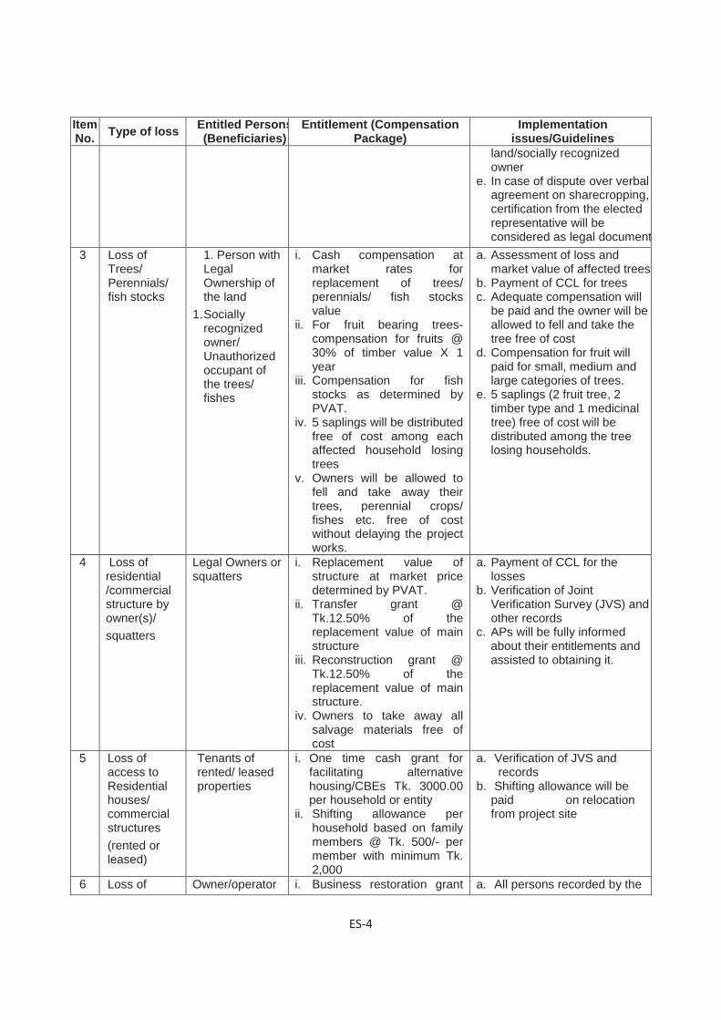
ES-4
Item No. Type of loss Entitled Persons
(Beneficiaries) Entitlement (Compensation
Package) Implementation
issues/Guidelines land/socially recognized owner
e. In case of dispute over verbal agreement on sharecropping, certification from the elected representative will be considered as legal document
3 Loss of Trees/ Perennials/ fish stocks
1. Person with Legal Ownership of the land
1. Socially recognized owner/ Unauthorized occupant of the trees/ fishes
i. Cash compensation at market rates for replacement of trees/ perennials/ fish stocks value
ii. For fruit bearing trees- compensation for fruits @ 30% of timber value X 1 year
iii. Compensation for fish stocks as determined by PVAT.
iv. 5 saplings will be distributed free of cost among each affected household losing trees
v. Owners will be allowed to fell and take away their trees, perennial crops/ fishes etc. free of cost without delaying the project works.
a. Assessment of loss and market value of affected trees
b. Payment of CCL for trees c. Adequate compensation will
be paid and the owner will be allowed to fell and take the tree free of cost
d. Compensation for fruit will paid for small, medium and large categories of trees.
e. 5 saplings (2 fruit tree, 2 timber type and 1 medicinal tree) free of cost will be distributed among the tree losing households.
4 Loss of residential /commercial structure by owner(s)/ squatters
Legal Owners or squatters
i. Replacement value of structure at market price determined by PVAT.
ii. Transfer grant @ Tk.12.50% of the replacement value of main structure
iii. Reconstruction grant @ Tk.12.50% of the replacement value of main structure.
iv. Owners to take away all salvage materials free of cost
a. Payment of CCL for the losses
b. Verification of Joint Verification Survey (JVS) and other records
c. APs will be fully informed about their entitlements and assisted to obtaining it.
5 Loss of access to Residential houses/ commercial structures (rented or leased)
Tenants of rented/ leased properties
i. One time cash grant for facilitating alternative housing/CBEs Tk. 3000.00 per household or entity
ii. Shifting allowance per household based on family members @ Tk. 500/- per member with minimum Tk. 2,000
a. Verification of JVS and records
b. Shifting allowance will be paid on relocation from project site
6 Loss of Owner/operator i. Business restoration grant a. All persons recorded by the

ES-5
Item No. Type of loss Entitled Persons
(Beneficiaries) Entitlement (Compensation
Package) Implementation
issues/Guidelines business by CBEs due to dislocation
of the business as recorded by JVS
@ Tk. 10,000 for each business unit.
JVS b. Cash grant to be paid while
taking possession of land 7 Loss of
Income and work days due to displacement
Employees identified by the Joint Verification Team (JVT)
i. Cash grant to the affected employees/wage earners equivalent to 30 days wage @ Tk. 300/per day
ii. Preferential employment in the project construction work, if available.
a. All persons recorded by the JVS
b. Cash grant to be paid while taking possession
c. Involvement of the incumbents in project civil works
d. Training on income generating activities such as Psiculture, livestock and poultry, horticulture, welding, mechanics, plant cultivation, social forestry, etc.
8 Poor and vulnerable households
Poor and vulnerable households as identified by JVT
i. Additional cash grant of Tk. 3,000 for affected poor women headed households and other vulnerable households
ii. Training on IGA for AP/ nominated by AP.
a. Identification of Vulnerable households
b. Income restoration schemes for vulnerable households
c. Arrange training on income generating activities
9 Loss of Common Property Resources
Affected Common Property Resources (Mosque, school, community infrastructure etc.)
i. Grant for each affected CPR for reconstruction Or Reconstruction of CPR through the project
a. Identification of the management committee of the CPRs
b. Cash grant to the Management committee of CPR
c. Or Reconstruction of the CPRby the project
10 Temporary impact during construction
Community / Individual
i. The contractor shall bear the cost of any impact on structure or land due to movement of machinery and in connection with collection and transportation of borrow materials.
ii. All temporary use of lands outside proposed CoI to be through written approval of the landowner and contractor.
iii. Land will be returned to owner rehabilitated to original preferably better standard.
a. Community people should be consulted before starting of construction regarding air pollution, noise pollution and other environmental impact
b. The laborers in the camp would be trained about safety measures during construction, aware of healthsafety, STDs, safe sex etc. The contractor shall ensure first aid box and other safety measures like condoms at construction site.
Vulnerable Project Affected Households including poor and female headed, elderly headed, the landless, share croppers, etc and wage loser from the CBEs will be given additional support for

ES-6
livelihood and income restoration. Long-term income restoration and livelihood reconstruction program will be designed in the form of Livelihood and Income Restoration Program (LIRP) for rehabilitation of the poor & vulnerable PAHs. The RHD will engage an experienced NGO for implementing the LIRP. A need based survey would be conducted among the affected persons by that NGO for prioritizing training needs and accordingly held training. The RHD will develop TOR for LIRP implementing NGO. Cost Estimate and Budget: The total estimated cost for implementation of the ARP includes compensation for land, structure, trees, crops, transition allowance, relocation assistance, wage income, etc. All resettlement funds including training and cash grants and service charge of ARP implementing agency will be provided by the EA (RHD) based on the financing plan agreed by the GoB. The total estimated amount is BDT- 2,755,013,374 equivalent to USD 35,617,497 (1 $=BDT 77.35) shown in the Table 3 below.
Table 3 Summary of Resettlement Cost for project
Confidential

1-1
DESCRIPTION OF THE PROJECT 1
Background of the Project 1.1The Government of Bangladesh with the financial loan from Japan International Cooperation Agency (JICA) has undertaken a project in order to improve the road network system in the Western part of Bangladesh. This initiative has taken with aim of becoming a middle income country by 2021 by reducing poverty and improvement of selected existing deteriorated or one-lane bridges of Roads and Highways Department (RHD). In the western region covering 5 zones (Rangpur, Rajshahi, Gopalganj, Khulna and Barisal) a total of 105 bridges have been selected for improvement of which almost all of them are unsafe for road users because of major damage on the structure (Figure 1.1). Many of the bridges are baily bridges and not suitable for road bridges due to lack of capability and safely function and some of them are already collapsed. To improve road safety and remove the traffic jams at the bridge sites, majority of these bridges will be two-lane Reinforced Cement Concrete(RCC) bridges and some of them will be weathered steel bridge. Weathered bridges will be in northern zones (Rangpur and Rajshahi), because of less airborne salt amount. RHD will be the implementing authority of the project.
Figure 1.1 Location of Bridge sub-projects under WBBIP

1-2
Out of 105 bridges, some bridges will be replaced by RCC structure at the same locations, and some bridges will be replaced with bridges at nearby locations with new approach roads to connect these bridges and few will be repaired.
This is the Abbreviated Resettlement Plan (ARP) for the project complies with the Resettlement Framework (RF) prepared based on relevant national law of the Government of Bangladesh (GOB) Acquisition and Requisition of Immovable Property Ordinance 1982 (ARIPO), amended in 1993 and 1994 and with the policy of the JICA Guidelines for Environmental and Social Considerations and World Bank OP 4.12. An ARP Implementing NGO (INGO) i.e. NGO will be engaged by the RHD for implementation of the ARP.
These bridges are already there and those are to be replaced with some improvement. It is observed that only small number people (less than 200) are to be affected at each bridge site for long term and short term due to the relevant activities. By following OP 4.12 of WB when impacts on the entire displaced population are minor or fewer that 200 people are displaced at each bridge site, an Abbreviated Resettlement Plan (ARP) needs to be prepared for the project.
The selected 105 bridges are located in five zones i.e. Rangpore zone, Rajshahizone, Gopalganj zone, Khulna zone and Barisal zone (Table 1.1). A total of 32 bridges are located in Rangpur zone (Bogra, Dinajpur, Gaibandha, Joypurhat, Lalmonirhat, Panchagarh, Rangpur and Thakurgaondistricts), 23 bridges are in Rajshahi zone (Naogaon, Natore, Pabna, Rajshahi, and Serajganjdistricts), 15 bridges are in Gopalganjzone (Faridpur, Gopalganj, Madaripur, and Shariatpurdistricts), 15 bridges are in Khulna zone (Bagerhat, Jessore, Jhenaidah, Kustia and Satkhiradistricts), and 20 bridges are in Barisal zone (Barisal, Bhola, JhalokatiPatuakhali and
Pirojpurdistricts). Only 12 bridges are more than 100m in length and rest (93) are less than 100m in length. The bridges are of different types including PC Girder Bridge, RCC Girder Bridge, RCC box Girder Bridge, Bailey with steel Deck, Truss with steel Deck and Steel Beam & RCC Slab.
Table 1.1 Bridges to be replaced by type, length and zone in the project area
Sl. No Zone Division Bridge Type Length
Less than 100 (m)
Length Above 100
(m) Total
A Barisal Barisal PC Girder Bridge, RCC Girder Bridge, Bailey with Steel Deck,
11 1
Bhola Bailey with Steel Deck, 4 Jhalokati Bailey with Steel Deck, 2
Patuakhali Bailey with Steel Deck, 1 Pirojpur Bailey with Steel Deck, 1
Sub-Total 19 1 20
B Khulna Bagerhat RCC Box Girder Bridge, RCC Girder Bridge 2
Jessore RCC Girder Bridge, 1 1 Jhenaidah RCC Girder Bridge, 2 1
Kushtia RCC Girder Bridge, 3 Narail RCC Girder Bridge, 4
Satkhira RCC Girder Bridge, 1 Sub-Total 13 2 15
C Gopalganj Faridpur RCC Girder Bridge, 7 Gopalganj PC Girder Bridge, 1

1-3
Madaripur RCC Girder Bridge, 1 1 Shariatpur Bailey with Steel Deck 4 1
Sub-Total 12 3 15
D Rangpur Bogra RCC Girder Bridge, Bailey with Steel Deck 6
Dinajpur
RCC Girder Bridge, Bailey with Steel Deck, Truss with Steel Deck, Steel Beam and RCC slab
7 1
Gaibanda RCC Girder Bridge, Bailey with Steel Deck 2 1
Joypurhat RCC Girder Bridge, 2
Lalmonirha
t RCC Girder Bridge, biley with Steel Deck 1
Nilphamari RCC Girder Bridge, Bailey with Steel Deck 3 1
Panchagar
h Steel Beam and RCC Slab, RCC Girder Bridge 2
Rangpur RCC Girder Bridge, 4 1
Thakurgao
n RCC Girder Bridge, 1
Sub Total 28 4 32 E Rajshahi Naogaon Truss with Steel Deck 1
Natore RCC Girder Bridge, Bailey with Steel Deck 2
Pabna RCC Girder Bridge, Truss with Steel Deck 5 1
Rajshahi Bailey with Steel Deck, RCC Girder Bridge 2
Serajganj RCC Girder Bridge, Steel Beam and RCC Slab, Bailey with Steel Deck
12
Sub-Total 21 2 23
Total Less than 100m 93 Total above 100m 12
Grand Total (A+B+C+D+E) 105
The proposed interventions in project will cause adverse resettlement impacts through displacement of households, shops and businesses. The affected households (AHs) include owners of land, squatters, sharecroppers, lease holders and non-tilted users of land. Besides some trees on the RHD and private lands will need to be fell down due to the project. However, regardless of lack of title to the land, the impacts on these people will be mitigated in accordance with JICA’s safeguard policies. Therefore, this abbreviate resettlement plan (ARP) has been prepared for this project, and is designed to assist project affected units (PAUs) to restore their livelihoods and socio-economic conditions to their pre-project status. A total of 3253 (PAUs) that includes Households (HHs), Commercial and Business Enterprises (CBEs) and Common Property Resources (CPRs) have been identified in 105 bridge locations.

1-4
Some photographs of bridges
Ghoga bridge-Rank-36, Bogra Sarnamoti bridge- Rank-2, Lalmonirhat
Karimpur bridge-Rank-14, Faridpur Porkitpur bridge-Rank-15, Faridpur
GK bridge-Rank-21, Kushtia Gora bridge-Rank-22, Bagerhat

1-5
Khorkhoribridge-Rank-38,Nilphamari Paprail Baily bridge- Rank-77, Shariatpur
Jajihar bridge-Rank-83, Shariatpur Bupibath bridge-Rank-10, Gaibandha
Naori Bridge-Rank-74, Sirajganj Dhupa Ghata bridge-Rank-41, Jhenaidah
Chanda Bridge-2, Rank-7, Sirajganj Bittipara Bridge, Rank-67, Kushtia
1-6
Objectives & Purpose of the Project 1.2
Potential Impacts 1.2.1All bridges will be replaced with new bridges at adjacent locations toward downstream or upstream of present one with new approach roads to connect these bridges.
These bridges are already there and those are to be replaced with some improvements.
Objective of the Abbreviated Resettlement Plan 1.2.2The JICA’s Guidelines for Environmental and Social Considerations April 2010 requires that if the screening or social assessment determines that people will experience resettlement impacts a time-bound action plan with appropriate budget provisions is to be prepared and incorporated as an integral part of project design. However, The OP 4.12 of World Bank (WB) clearly narrated that where entire involuntary displaced population is minor, or fewer than 200 people are displaced at each bridge site, an Abbreviated Resettlement Plan (ARP) may serve the purpose. By following this principle this ARP addresses both land acquisition and resettlement issues within the legal framework of the Government of Bangladesh (GOB) and JICA’s Guidelines for Environmental and Social Considerations that highlights on social impacts including involuntary resettlement, respect for the human rights of indigenous people and so on and covers the APs under resettlement/rehabilitation program providing income restoration and poverty reduction assistance to the eligible APs and the poor and informal settlers on the Corridor of Impact (CoI). Thus, the ARP approach incorporates (i) land acquisition and resettlement issues; (ii) impact mitigation with special attention to the women and vulnerable groups and (iii) income generation support to the eligible members of the AP families and (iv) poverty reduction assistance to the poorest section of the people.
The policy requires that a plan be prepared that sets out all of the compensation and rehabilitation support to be provided to any person, family or household who on account of the execution of the project would have his, her or their:
• Standard of living adversely affected;
• Income earning opportunities, business, occupation, work or place of residence or habitat adversely affected temporarily or permanently;
• Right, title or interest in any house, or interest in or right to use any land including premises, agricultural and grazing land, commercial properties, tenancy, or right in annual or perennial crops and trees or any other fixed or moveable assets, acquired or possessed, temporarily or permanently; or
• Social and cultural activities and relationships and other losses that may be identified during the process of resettlement planning.
The objective of the ARP is to provide a strategy for providing PAUs with replacement value of land, structure, trees and other physical assets and restoration of income levels/living standards either through a compensation and rehabilitation package that ensures that PAUs are not left in a position where they are worse off with the project than without it. Thus, in accordance with JICA policy, abbreviated resettlement plan, depending on the magnitude of impacts - has been prepared for the Project.
Objectives of the project and Abbreviated Resettlement Planning have been disclosed to the affected persons through community based consultation meetings and focus group discussions in local language in two phases of stakeholders/community consultation as well as during conducting census and socioeconomic survey. Compensation and other assistances will have

1-7
to be paid to Affected Persons (Aps) prior to displacement or dispossession of assets. Upon approval, the final ARP will be uploaded immediately on the RHD website.
Methodology for Preparing the Abbreviated Resettlement Plan 1.2.3The Consultant conducted census & socioeconomic survey in April through June 2014 for information necessary for preparation of this ARP. The survey was also associated with stakeholders’ consultation, focus group discussion and property valuation survey.
The adverse impacts include land acquisition and displacement of households and shops. The data gathered during the survey has been entered into an electronic database which identified each affected household (AH) and the way they are impacted and losses they will incur. The objective of the census and socioeconomic survey was to establish a detailed inventory of the households and physical assets to be affected by the project; develop a socioeconomic profile of the AHs and affected persons (APs). The surveys also serve as a benchmark for monitoring and evaluation.
The surveys indicate that improvement of the 105 bridges will require acquisition of about 40 hectare (39.96 ha) of land. In total the Project will affect 3,253 Project Affected Units (PAUs) of which 788 residential households, 2,367 Commercial & Business enterprises (CBEs) and 98 common Property Resources (CPRs) with a total population of 15,903. According to the JICA’s “Guidelines for Environmental and Social Considerations” appropriate consideration must be given to vulnerable social groups such as women, children, the elderly, the poor and ethnic minorities, all members of which are susceptible to environmental and social impacts and may have little access to decision making process in the society. Therefore, this ARP has been prepared to mitigate the impacts on Affected Households (AHs) and restore their livelihoods and incomes to pre-project level.
This ARP has been prepared based on the National Law ARIPO (GoB) and the JICA’s Guidelines for Environmental and Social Considerations. The ARP establishes the provisions for resettlement of AHs by providing income restoration assistance to the poor and vulnerable households and compensation under law and additional resettlement benefits where applicable; provides a description of socio-economic characteristics of AHs; sets out the implementation schedule; and, provides the budget and cost estimate of implementing this ARP.
This ARP will be reviewed at implementation stage and updated by the RHD if required. At that time the budget will be revised to reflect any changes in numbers of AHs or losses compared with those identified during the survey as well as adjusting for any changes in inflation.

2-1
SOCIO-ECONOMIC CHARACTERISTICS OF AFFECTED 2HOUSEHOLDS
Methodology for Census and Socioeconomic Survey 2.1The census and a socio-economic survey was carried out in April through June 2014 to provide requisite details on the Project Affected Units (PAUs) to further assess the magnitude of likely impacts and to identify measures for mitigation of adverse impacts. The survey included (i) full census and socioeconomic survey with structured questionnaire and inventory of losses (Annex -I and II), (ii) surveys for land valuation and other assets through structured questionnaire (Annex-III); (iii) Video filming of the affected properties and (iv) community based public consultation etc. The survey identified the households, commercial and business enterprises, land owners, sharecroppers, squatters, tenants and community properties on project right of way.
The socioeconomic survey collected a wide range of data, for example, demography, age/sex distribution, education, occupation, income/poverty data, types of businesses, types and ownership status of affected structures and other assets.
The Project Area 2.2The selected 105 bridges are located in five zones i.e. Rangpur zone, Rajshahi zone, Gopalganj zone, Khulna zone and Barisal zone. A total of 32 bridges are located in Rangpur zone (Bogra, Dinajpur, Gaibandha, Joypurhat, Lalmonirat, Nilphamari, Panchagarh, Rangpur and Thakurgaon districts), 23 bridges are in Rajshahi zone (Naogaon, Natore, Pabna, Rajshahi, and Serajganj districts), 15 bridges are in Gopalganj zone (Faridpur, Gopalganj, Madaripur, and Shariatpur districts), 15 bridges are in Khulna zone (Bagerhat, Jessore, Jhenaidah, Kustia, Narail and Satkhira districts), and 20 bridges are in Barisal zone (Barisal, Bhola, Jhalokati Patuakhali and Pirojpur districts).Distribution of zone wise number of bridges and project affected units are shown in the Table 2.1.
Table 2.1 Zone wise number of bridges and project affected units Zone Districts Number
of bridges Project Affected Units (PAUs)
No. of HHs [Land with Resi.Stru. & Trees + Residential Structure + Rented Residential Structures + Private Trees + Others- Ponds, Fish, gate etc.)
No. of CBEs [ Land with Busi. Stru. & Trees + Business with Structure + Rented Business)
No. of CPRs
Total
Rangpur Bogra 06 30 16 02 48 Dinajpur 08 68 228 15 311 Gaibandha 03 12 80 00 92 Joypurhat 02 17 73 01 91 Lalmonirhat 01 10 00 00 10

2-2
Zone Districts Number of bridges
Project Affected Units (PAUs) No. of HHs [Land with Resi.Stru. & Trees + Residential Structure + Rented Residential Structures + Private Trees + Others- Ponds, Fish, gate etc.)
No. of CBEs [ Land with Busi. Stru. & Trees + Business with Structure + Rented Business)
No. of CPRs
Total
Nilphamari 04 34 115 10 159 Panchagarh 02 12 93 05 110 Rangpur 05 23 114 07 144 Thakurgaon 01 01 46 03 50 Sub-total 32 207 765 43 1015
Rajshahi Naogaon 01 10 94 01 105 Natore 02 26 26 02 54 Pabna 06 44 41 00 85 Rajshahi 02 33 07 01 41 Serajganj 12 77 150 03 230 Sub-total 23 190 318 07 515
Gopalganj Faridpur 07 29 85 01 115 Gopalganj 01 06 00 00 06 Madaripur 02 06 111 03 120 Shariatpur 05 13 68 04 85 Sub-total 15 54 264 08 326
Khulna Bagerhat 02 22 45 00 67 Jessore 02 43 208 10 261 Jhenaidah 03 38 70 02 110 Kustia 03 35 62 03 100
Narail 04 33 85 04 122
Satkhira 01 00 00 00 01
Sub-total 15 171 470 19 660
Barisal Barisal 12 116 462 15 593
Bhola, 04 18 44 04 66 Jhalokati 02 14 39 01 54 Patuakhali 01 09 04 01 14 Pirojpur 01 09 01 00 10 Sub-total 20 166 550 21 737
Total 105 788 2,367 98 3,253 Source: Census & Socioeconomic survey, June 2014

2-3
Out of the total 3,253 affected units, 2,367 commercial enterprises, 788 residential households and 98 community properties identified on the Corridor of Impact (CoI). Out of 788 households 545 households are going to lose their housing structure, 190 households are going to lose their trees and 53 households are going to lose their other properties like ponds, gate and other minor infrastructures. Most of the affected units are located on the private land and some are on the RHD land. Community properties are mainly located on RHD land. A total of 109,538 square meter different categories of structures are getting affected by the interventions. Zone wise impacts are shown in the Table 2.2.
.

2-4
Table 2.2 Distribution of Impacts by Zones Sl. # Loss type
Zones Total
Rangpur Rajshahi Gopalganj Khulna Barisal 1 Total number of bridges 32 23 15 15 20 105
2 Total quantity of land (ha) affected 18.50 8.41 5.51 2.70 4.85 39.97
3 Total Project Affected Units (PAUs) 1,015 515 326 660 737 3,253
4
Total Households affected [Land with Resi. Stru.&Trees+Residential Structure+Rented Resident Structure+ Private Trees+Others-Ponds, Fish, Gate]
207 190 54 171 166 788
5
Total commerce and business enterprises (CBEs) affected [Land with Busi. Stru. & Tree+ Business with Structure + Rented Business]
765 318 264 470 550 2,367
6 Total community property (CPR) affected 43 07 08 21 19 98
7 Total number of structures affected 1,030 494 349 724 766 3,363
7a Total quantity of all structure (sqm) affected 37,445 12,931 13,589 21,687 23,886 109,538
7.b Total quantity of residential structure (sqm) affected 10,778 5,902 2,437 7,674 6,417 33,208
7.c Total quantity of commercial structure (sqm) affected 24,161 6,796 10,270 12,954 15,423 69,604
7.d Total quantity of CPR structures (sqm) affected 2,506 233 882 1,059 2,046 6,726
8 Total no. of toilets affected 14 40 14 05 38 111
9 Total no. of tube wells affected 38 41 12 20 31 142
10 Total no. of trees on private land affected 15,825 8,692 3,830 7,081 9,350 44,778
11 No of trees on government land affected 2,500 2,502 1,852 818 1,776 9,448
Source: Census & Socioeconomic survey, June 2014
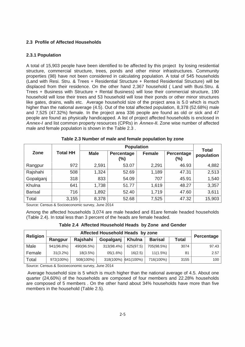
2-5
Profile of Affected Households 2.3
Population 2.3.1
A total of 15,903 people have been identified to be affected by this project by losing residential structure, commercial structure, trees, ponds and other minor infrastructures. Community properties (98) have not been considered in calculating population. A total of 545 households (Land with Resi. Stru. & Trees + Residential Structure + Rented Residential Structure) will be displaced from their residence. On the other hand 2,367 household ( Land with Busi.Stru. & Trees + Business with Structure + Rental Business) will lose their commercial structure, 190 household will lose their trees and 53 household will lose their ponds or other minor structures like gates, drains, walls etc. Average household size of the project area is 5.0 which is much higher than the national average (4.5). Out of the total affected population, 8,378 (52.68%) male and 7,525 (47.32%) female. In the project area 336 people are found as old or sick and 47 people are found as physically handicapped. A list of project affected households is enclosed in Annex-I and list common property resources (CPRs) in Annex-II. Zone wise number of affected male and female population is shown in the Table 2.3 .
Table 2.3 Number of male and female population by zone
Zone Total HH Population
Total population Male Percentage
(%) Female Percentage
(%) Rangpur 972 2,591 53.07 2,291 46.93 4,882 Rajshahi 508 1,324 52.69 1,189 47.31 2,513 Gopalganj 318 833 54.09 707 45.91 1,540 Khulna 641 1,738 51.77 1,619 48.27 3,357 Barisal 716 1,892 52.40 1,719 47.60 3,611 Total 3,155 8,378 52.68 7,525 47.32 15,903 Source: Census & Socioeconomic survey, June 2014
Among the affected households 3,074 are male headed and 81are female headed households (Table 2.4). In total less than 3 percent of the heads are female headed.
Table 2.4 Affected Household Heads by Zone and Gender
Religion Affected Household Heads by zone
Percentage Rangpur Rajshahi Gopalganj Khulna Barisal Total
Male 941(96.8%) 490(96.5%) 313(98.4%) 625(97.5) 705(98.5%) 3074 97.43
Female 31(3.2%) 18(3.5%) 05(1.6%) 16(2.5) 11(1.5%) 81 2.57
Total 972(100%) 508(100%) 318(100%) 641(100%) 716(100%) 3155 100
Source: Census & Socioeconomic survey, June 2014 Average household size is 5 which is much higher than the national average of 4.5. About one quarter (24,60%) of the households are composed of four members and 22.28% households are composed of 5 members . On the other hand about 34% households have more than five members in the household (Table 2.5).

2-6
Table 2.5 Households Size of the Affected f Household by Zone
Zone Rangpur Rajshahi Gopalganj Khulna Barisal Total
Household Size No. % No. % No % No. % No. % No. %
1 45 4.63 06 1.18 09 2.83 28 4.37 16 2.23 104 3.30
2 42 4.32 26 5.12 09 2.83 24 3.74 30 4.19 131 4.15
3 11
2 11.52 72 14.17 39 12.26 59 9.20 94 13.13 376 11.92
4 23
9 24.59 136 26.77 86 27.04 144 22.46 171 23.88 776 24.60
5 20
3 20.88 121 23.82 72 22.64 155 24.18 152 21.23 703 22.28
More than 5
331 34.05 14
7 28.94 103 32.39 231 36.04 253 35.34 1065 33.76
Total 97
2 100.0
0 50
8 100.00 318 100.00 641 100.00 716 100.00 3,155 100.00
Majority of the households are headed by population within the age group of 31 to 50. About one fifth heads are within the range of 20-30. It is remarkable that head of about 14% households are more than 60 years of age. Table 2.6 shows the age of head of the affected households in the project area.
Table 2.6 Affected head of households by age group by Zone
Zone Rangpur Rajshahi Gopalganj Khulna Barisal Total
Age Group No. % No. % No % No. % No. % No. %
<20 15 1.54 05 0.98 02 0.63 05 0.78 10 1.40 37 1.17
20-30 189 19.44 126 24.80 69 21.70 107 16.69 148 20.67 639 20.25
31-40 280 28.81 137 26.97 98 30.82 183 28.55 205 28.63 903 28.62
41-50 248 25.51 115 22.64 69 21.70 177 27.61 176 24.58 785 24.88
51-59 109 11.21 58 11.42 44 13.84 73 11.39 72 10.06 356 11.28
60+above 131 13.48 67 13.19 36 11.32 96 14.98 105 14.66 435 13.79
Total 972 100.00 508 100.00 318 100.00 641 100.00 716 100.00 3,155 100.00
Ethnicity, Religion and Gender 2.3.2Based on findings of the survey, the Project will affect 3,253 PAUs of which 788 are residential and 2,367 are commercial households and rest 98 are CPRs. The impacts and their losses have been described in Chapter 3. Out of total 3,155 households 2,662 are Muslim, 477 are Hindu, 07 are Christian, 03 are Buddhist by faith and 06 are by other faith. No ethnic minority is found in the proposed project locations. Detail of households in terms of religion is shown in Table 2.7
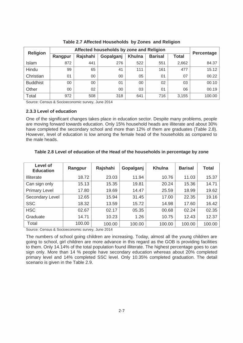
2-7
Table 2.7 Affected Households by Zones and Religion
Religion Affected households by zone and Religion
Percentage Rangpur Rajshahi Gopalganj Khulna Barisal Total
Islam 872 441 276 522 551 2,662 84.37 Hindu 99 65 41 111 161 477 15.12 Christian 01 00 00 05 01 07 00.22 Buddhist 00 00 01 00 02 03 00.10 Other 00 02 00 03 01 06 00.19 Total 972 508 318 641 716 3,155 100.00 Source: Census & Socioeconomic survey, June 2014
Level of education 2.3.3One of the significant changes takes place in education sector. Despite many problems, people are moving forward towards education. Only 15% household heads are illiterate and about 30% have completed the secondary school and more than 12% of them are graduates (Table 2.8). However, level of education is low among the female head of the households as compared to the male heads.
Table 2.8 Level of education of the Head of the households in percentage by zone
Level of Education Rangpur Rajshahi Gopalganj Khulna Barisal Total
Illiterate 18.72 23.03 11.94 10.76 11.03 15.37 Can sign only 15.13 15.35 19.81 20.24 15.36 14.71 Primary Level 17.80 19.69 14.47 25.59 18.99 19.62 Secondary Level 12.65 15.94 31.45 17.00 22.35 19.16 SSC 18.32 13.59 15.72 14.98 17.60 16.42 HSC 02.67 02.17 05.35 00.68 02.24 02.35 Graduate 14.71 10.23 1.26 10.75 12.43 12.37 Total 100.00 100.00 100.00 100.00 100.00 100.00 Source: Census & Socioeconomic survey, June 2014
The numbers of school going children are increasing. Today, almost all the young children are going to school, girl children are more advance in this regard as the GOB is providing facilities to them. Only 14.14% of the total population found illiterate. The highest percentage goes to can sign only. More than 14 % people have secondary education whereas about 20% completed primary level and 14% completed SSC level. Only 10.35% completed graduation. The detail scenario is given in the Table 2.9.

2-8
Table 2.9 Level of education of the Affected Population (7 years and above) by zone
Zone Rangpur Rajshahi Gopalganj Khulna Barisal Total
Level of Education No. % No. % No % No. % No. % No. %
Illiterate 730 16.80 498 22.31 175 12.75 317 10.37 301 09.26 2,021 14.17 Can sign only
887 20.41 453 20.30 326 23.74 569 18.61 684 21.04 2,919 20.47
Primary level
818 18.82 418 18.73 260 18.94 683 22.34 649 19.96 2,828 19.83
Secondary level 602 13.85 379 16.98 355 25.86 471 15.41 674 20.73 2,481 17.40
SSC level 686 15.78 237 10.62 166 12.09 475 15.54 483 14.86 2,047 14.36
HSC level 122 2.81 89 3.99 71 5.17 55 1.80 150 4.61 487 3.42
Graduate 501 11.53 158 7.08 20 1.46 487 15.93 310 9.54 1,476 10.35 Source: Census & Socioeconomic survey, June 2014
Age and Occupation 2.3.4The largest proportion of population is in age group 19-34 followed by age group of 5-18 and 35 - 49 irrespective of male and female population in all the zones. Population within the age group 51-60 and above 60 is found almost similar in all zones. The Table 2.10 shown in detail.
Table 2.10 Age Distribution of Affected Population in Percentage
Zone Rangpur Rajshahi Gopalganj Khulna Barisal Total
Age Group No. % No. % No % No. % No. % No. %
0-4 340 06.96 179 07.12 116 07.53 202 06.02 217 6.01 1,054 06.63
5-18 1,408 28.83 657 26.14 409 26.56 858 25.56 994 27.53 4,326 27.20
19-34 1,416 29.00 792 31.52 466 30.26 964 28.72 1,020 28.25 4,658 29.29
35-49 932 19.09 454 18.07 271 17.60 674 20.08 668 18.50 2,999 18.86
50-59 395 08.09 215 08.56 145 09.42 295 08.79 315 08.72 1,365 08.58
60+above 392 8.03 216 8.60 133 8.64 364 10.84 397 10.99 1,502 9.44
Total 4,883 100.00 2,513 100.00 1,540 100.00 3,357 100.00 3,611 100.00 15,904 100.00 Source: Census & Socioeconomic survey June 2014
Most of the bridges under this project are located nearer to the locality or business center where people usually gather. This is why people who are living around the bridges have moved to business and some small shops are established around the bridges on government land. It is found that about 68% household head are involved in business. Whereas considering family members 53% male and 1% female are doing business. A total of 7.73% of the household heads are involved in agriculture and 1.74% are aged/retired and have no specific income source. About 8% household heads are labors with special skill. Among them 7.4% of the male members and 0.50% female members of the households are of this category. Principal occupation of the head of the households is shown in Table 2.11.

2-9
Table 2.11 Principal Occupation Head of the Households by Zone
Zone Rangpur Rajshahi Gopalganj Khulna Barisal Total
Principal Occupation No. % No. % No % No. % No. % No. %
Farming/livestock
85 8.74 71 13.98 24 7.55 39 6.08 25 3.49 244 7.73
Business 673 69.24 279 54.92 249 78.30 438 68.33 494 68.99 2,133 67.61
Service 32 3.29 39 7.68 7 2.20 38 5.93 46 6.42 162 5.13
Labor 12 1.23 22 4.33 3 0.94 9 1.40 7 0.98 53 1.68
Labor with Special skill
67 6.89 41 8.07 11 3.46 53 8.27 79 11.03 251 7.96
Rickshaw/Vanpooler
17 1.75 18 3.54 3 0.94 8 1.25 17 2.37 63 2.00
Domestic Work
19 1.95 9 1.77 10 3.14 6 0.94 7 0.98 51 1.62
Teacher/Doctor/ Lawyer/Contractor
17 1.75 14 2.76 0 0.00 18 2.81 16 2.23 65 2.06
Driver 2 0.21 4 0.79 1 0.31 2 0.31 4 0.56 13 0.41
Retired/Old age /Jobless
15 1.54 7 1.38 3 0.94 19 2.96 11 1.54 55 1.74
Others
33 3.40 4 0.79 7 2.20 11 1.72 10 1.40 65 2.06
Total 972 100.00 508 100.00 318 100.00 641 100.00 716 100.00 3,155 100.00
Source: Census & Socioeconomic survey June 2014
Principal occupation of the population (10 years and above) of the affected households is domestic work followed by business. Most of the female population identified themselves involved in domestic work. In other words majority of the male members are involved with business. By following BBS data all the population of more than 10 years old is being considered here. As a result more than one fifth of them are found as student. It reflects that almost all the school going children are going to school. Only 3 % population are found involved in agriculture. More than 9% population is found to be old and retired (Table 2.12).
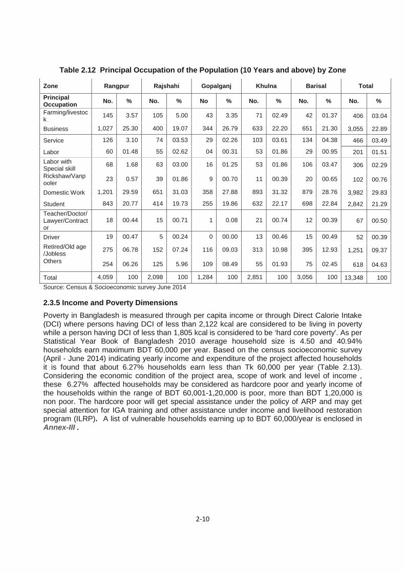
2-10
Table 2.12 Principal Occupation of the Population (10 Years and above) by Zone
Zone Rangpur Rajshahi Gopalganj Khulna Barisal Total
Principal Occupation No. % No. % No % No. % No. % No. %
Farming/livestock 145 3.57 105 5.00 43 3.35 71 02.49 42 01.37 406 03.04
Business 1,027 25.30 400 19.07 344 26.79 633 22.20 651 21.30 3,055 22.89
Service 126 3.10 74 03.53 29 02.26 103 03.61 134 04.38 466 03.49
Labor 60 01.48 55 02.62 04 00.31 53 01.86 29 00.95 201 01.51 Labor with Special skill
68 1.68 63 03.00 16 01.25 53 01.86 106 03.47 306 02.29
Rickshaw/Vanpooler
23 0.57 39 01.86 9 00.70 11 00.39 20 00.65 102 00.76
Domestic Work 1,201 29.59 651 31.03 358 27.88 893 31.32 879 28.76 3,982 29.83
Student 843 20.77 414 19.73 255 19.86 632 22.17 698 22.84 2,842 21.29 Teacher/Doctor/ Lawyer/Contractor
18 00.44 15 00.71 1 0.08 21 00.74 12 00.39 67 00.50
Driver 19 00.47 5 00.24 0 00.00 13 00.46 15 00.49 52 00.39 Retired/Old age /Jobless 275 06.78 152 07.24 116 09.03 313 10.98 395 12.93 1,251 09.37
Others
254 06.26 125 5.96 109 08.49 55 01.93 75 02.45 618 04.63
Total 4,059 100 2,098 100 1,284 100 2,851 100 3,056 100 13,348 100 Source: Census & Socioeconomic survey June 2014
Income and Poverty Dimensions 2.3.5Poverty in Bangladesh is measured through per capita income or through Direct Calorie Intake (DCI) where persons having DCI of less than 2,122 kcal are considered to be living in poverty while a person having DCI of less than 1,805 kcal is considered to be ‘hard core poverty'. As per Statistical Year Book of Bangladesh 2010 average household size is 4.50 and 40.94% households earn maximum BDT 60,000 per year. Based on the census socioeconomic survey (April - June 2014) indicating yearly income and expenditure of the project affected households it is found that about 6.27% households earn less than Tk 60,000 per year (Table 2.13). Considering the economic condition of the project area, scope of work and level of income , these 6.27% affected households may be considered as hardcore poor and yearly income of the households within the range of BDT 60,001-1,20,000 is poor, more than BDT 1,20,000 is non poor. The hardcore poor will get special assistance under the policy of ARP and may get special attention for IGA training and other assistance under income and livelihood restoration program (ILRP). A list of vulnerable households earning up to BDT 60,000/year is enclosed in Annex-III .

2-11
Table 2.13 Poverty Level and Annual income of head of the households by Zone
Zone Rangpur Rajshahi Gopalganj Khulna Barisal Total
Income (Tk) No. % No. % No % No. % No. % No. %
<15000 04 0.41 02 0.39 01 0.31 00 0.00 01 0.14 08 0.25
15001-30,000 07 0.72 06 1.18 01 0.31 01 0.16 03 0.42 18 0.57
30,001-45,000 21 2.16 04 0.79 03 0.94 06 0.94 04 0.56 38 1.20
45,001-60,000 62 6.38 28 5.51 12 3.77 16 2.50 16 2.23 134 4.25
60,001-80,000 59 6.07 21 4.13 04 1.26 17 2.65 22 3.07 123 3.90
80,001-100,000 100 10.29 45 8.86 13 4.09 41 6.40 45 6.28 244 7.73 100,001-120,000 196 20.16 116 22.83 57 17.92 111 17.32 152 21.23 632 20.03
120.001-135,000
16 1.65 03 0.59 01 0.31 07 1.09 02 0.28 29 0.92
135,001-150,000
67 6.89 23 4.53 13 4.09 46 7.18 45 6.28 194 6.15
150.001-165.000 13 1.34 06 1.18 03 0.94 06 0.94 04 0.56 32 1.01
165,001-180,000
129 13.27 62 12.20 49 15.41 85 13.26 122 17.04 447 14.17
>=180.001 298 30.66 192 37.80 161 50.63 305 47.58 300 41.90 1,256 39.81
Total 972 100.00 508 100.00 318 100.00 641 100.00 716 100.00 3,155 100.00 Source: Census & Socioeconomic survey June 2014
Gender Impacts and Mitigation Measures 2.4Women can be particularly impacted during resettlement, and especially relocation, as they are predominantly responsible for maintaining the cohesion of the family unit as well as being extensively involved in household chores in addition to participating in economic activities. Preparation of food, organizing shelter, arranging sanitation and water facilities and schooling of children are common areas where women play important roles in Bangladeshi households.
The census & SES was designed, undertaken and analyzed in a way to adequately identify gender differences and gender specific impacts. Based on the information provided in the census and SES, only 81 (2.57% of the total) households headed by female have been identified. Heads of these households will be eligible for training and other income generating activities. They will be preferentially employed in project civil work.
These female headed households will be disproportionately affected by resettlement due to traditional roles and responsibilities combined with lack of empowerment. Female APs will require additional support and assistance by income generation activities under LIRP. These female APs or representative of the family as nominated by the head will receive training on Income generating Activities (IGA) through LIRP. Participation of women in decision making is slowly increasing and the projects of various NGOs have played an important role in this improvement. Micro-credit aimed at female beneficiaries is also making a positive impact of poor households.
Considering the disproportionate impact on women and since legal ownership (in terms of title) does not reflect gender equity (i.e. women’s names are not generally recorded on the title), sufficient measures will be taken to ensure women’s rights are protected during the resettlement process. The measures included in the ARP to address gender impacts are:

2-12
• Identification of the socio-economic condition, needs, and priorities of women, and monitor and evaluate the impact of land acquisition and resettlement on women separately;
• Identification of the female headed households to be affected and setting of entitlement criteria to recognize female-headed households;
• Provision of such entitlements that women are not disadvantaged by the process of land acquisition and resettlement;
• Preferential employment of affected women in civil construction including road slope turfing, tree plantation, watering and some other similar types of works.
• Female and vulnerable APs will form Labor Contracting Society to bargain with the Contractor
• Separate labor shed with toilets will have to provide for female laborers at construction sites.
• Hiring of female staff in the ARP implementing agency to assist female-headed AHs and women during resettlement activities, including planning and implementation of income restoration programs; and
• Involvement of women's groups in resettlement planning, management, and operations and in job creation and income generation.
Water and Sanitation 2.5Health and sanitation status of the affected households seems to be good. In the project area 96% households own toilet inside the household property with septic tank. Only 2% household use open space for the purpose (Table 2.14). Sanitation condition is better in Gopalganj followed by Khulna and Barisal. On the other hand it is comparatively poor in Rajshahi.
Table 2.14 Type of Toilet Facilities of the Households by Zone
Zone Rangpur Rajshahi Gopalganj Khulna Barisal Total
Where Place No. % No. % No % No. % No. % No. %
Own toilet inside household property Septic tank
932 95.88 458 90.16 314 98.74 626 97.66 694 96.93 3,024 95.85
Public toilet 04 0.41 04 0.79 03 0.94 02 0.31 02 0.28 15 0.48 In the field/open space
26 2.67 25 4.92 01 0.31 08 1.25 03 0.42 63 2.00
In the canal 05 0.51 07 1.38 00 0.00 03 0.47 04 0.56 19 0.60
Other 05 0.51 14 2.76 00 0.00 02 0.31 13 1.82 34 1.08
Total 972 100.00 508 100.00 318 100.00 641 100.00 716 100.00 3,155 100.00 Source: Census & Socioeconomic survey June 2014
Almost all the project affected households are living in rural areas. As a result garbage management practice has not been developed among them. On the other hand there is no arrangement to manage the garbage like collection by an organized institution. The Table 2.15 reflects the facts by showing that about 74% of the household throw the garbage any where and thrown in canal by 10% of the households. Only 4% households through the garbage in bean and those are collected by government garbage collector. These households are from urban area and have the garbage management system.

2-13
Table 2.15 Management of Household Garbage by Head and by Zone
Zone Rangpur Rajshahi Gopalganj Khulna Barisal Total
Occurred Type No. % No. % No % No. % No. % No. %
Through the government garbage collector
33 3.40 21 4.13 02 0.63 70 10.92 04 0.56 130 4.12
Burn it 31 3.19 40 7.87 29 9.12 08 1.25 24 3.35 132 4.18 Throw anywhere 800 82.30 258 50.79 284 89.31 526 82.06 456 63.69 2,324 73.66
Throw In the canal
82 8.44 145 28.54 03 0.94 11 1.72 79 11.03 320 10.14
Other 26 2.67 44 8.66 00 0.00 26 4.06 153 21.37 249 7.89
Total 972 100.00 508 100.00 318 100.00 641 100.00 716 100.00 3,155 100.00 Source: Census & Socioeconomic survey June 2014
Almost 86% of the affected households use tube well water, 72% use canal water for drinking and other daily use (Table 2.16). They use pond or canal water mainly for bathing, cloth and dish washing, etc. Sanitation condition of the project area is well. On the other hand the households living in urban area use piped water (2.57%).
Table 2.16 Source of Drinking Water of the Households by Zone
Zone Rajshahi Rangpur Barishal Gopalganj Khulna Total
Where get No. % No. % No % No. % No. % No. %
Pump well 469 92.32 929 95.58 501 69.97 309 97.17 494 77.07 2,702 85.64
Piped water
from utility company
14 2.76 6 0.62 8 1.12 5 1.57 48 7.49 81 2.57
Private water seller
2 0.39 3 0.31 2 0.28 0 0.00 2 0.31 9 0.29
Canal 16 3.15 17 1.75 165 23.04 4 1.26 26 4.06 228 7.23
Other 7 1.38 17 1.75 40 5.59 0.00 71 11.08 135 4.28 Grand Total 508 100.00 972 100.00 716 100.00 318 100.00 641 100.00 3,155 100.00
Like waste management majority of the household through away the waste water directly outside of the house. As majority of the households are rural dwellers they do not have facilities to through water in a planned manner. However, more than 5% household through their water in their septic tank and only 2% household use public drains for the purpose (Table 2.17).

2-14
Table 2.17 Management of Waste Water of the Households by Zone
Zone Rangpur Rajshahi Gopalganj Khulna Barisal Total
Where Through No. % No. % No % No. % No. % No. %
Septic tank 52 5.35 21 4.13 6 1.89 55 8.58 26 3.63 160 5.07
Public drainage
21 2.16 13 2.56 1 0.31 36 5.62 2 0.28 73 2.31
Directly outside
the house 874 89.92 307 60.43 311 97.80 475 74.10 311 43.44 2,278 72.20
Other 25 2.57 167 32.87 0 0.00 75 11.70 377 52.65 644 20.41
Total 972 100.00 508 100.00 318 100.00 641 100.00 716 100.00 3,155 100.00

3-1
LAND ACQUISITION AND RESETTLEMENT IMPACTS 3
Minimizing Land Acquisition and Displacement 3.1RHD has undertaken efforts to minimize and/or avoid land acquisition and resettlement impacts. Out of 105 bridges 98 bridges will require land acquisition with a total quantity of 39.96 hectare. Only few bridges will be reconstructed /improved within the RHD land. Some squatter households and business enterprises will need to be relocated for the project.
Scope of Land Acquisition 3.2A total of 39.96 ha land will be required to be acquired to implement the project. All of these lands are privately owned. Out of the total private land 18.50 ha in Rangpur zone, 8.41 ha in Rajshahi zone, 5.51 ha in Gopalganj zone, 2.70 ha in Khulna zone and 4.85 ha in Barisal zone. In addition to this acquired land some government owned land including khash and RHD land will be used to construct these bridges.
Displacement and Other Impacts 3.3In addition to land acquisition, the works will require to affect 788 households 2,367 commercial/business premises and 98 community properties. Out of 788 households 545 of them will be displaced due to loss of residential structure (Land with Res. Stru. & Trees+Residential Structure+ Rented Residential Structure), 190 households are going to lose trees and 53 households are going to lose some other infrastructures like pond, gate, drains etc. About 2,725 people will be displaced due to loss of homesteads. A total of 109,538 sq.m structure will need to be relocated of which 69,604 sq.m commercial and 33,208 sq.m residential structure. Beside some secondary structure i.e.111 toilets and 142 tube wells will need to be relocated due to the project. A total of 3,002 wage laborers from non-farm sector will lose their livelihood due to the project (Table 3.1). In total 3002 wage labors are going to lose their wage income from the affected CBEs (Businesses).

3-2
Table 3.1 Displacement and other Impacts
Sl. # Type of impacts
Zones Total
Rangpur Rajshahi Gopalganj Khulna Barisal 1 Total quantity of land to be
acquired (ha) 18.50 8.41 5.51 2.70 4.85 39.97
2 Total No. Households affected (No)
[Land with Resi. Stru.&Trees+Residential
Structure+Rented Resident Structure+ Private Trees+Others-
Ponds, Fish, Gate]
207 190 54 171 166 788
3 Total No. Commercial enterprises (CBEs) affected (No)
[Land with Busi. Stru. & Tree+ Business with Structure +
Rented Business]
765 318 264 470 550 2,367
4 Community property (CPR) affected 43 07 08 21 19 98
5 Total Quantity of all structure (Sqm) affected 37,445 12,931 13,589 21,687 23,886 109,538
5.a Total Quantity of Residential structure (Sqm) affected 10,778 5,902 2,437 7,674 6,417 33,208
5.b Total Quantity of Commercial structure (Sqm) affected 24,161 6,796 10,270 12,954 15,423 69,604
5.c Total quantity of CPR structures (sqm) affected 2,506 233 882 1,059 2,046 6,726
6 No. of toilets affected 14 40 14 05 38 111 7 No. of tube wells affected 38 41 12 20 31 142 8 No. of wage laborers losing job 864 367 553 789 429 3,002
Source: Census & Socioeconomic survey June 2014
Asset Inventory and Assessment of Losses 3.4
Affected Households & Business Enterprises 3.4.1Households and business structures will be physically displaced by the Project. All the households and shops both titled and non-titled are included in the ARP as impacts that are to be mitigated through compensation and resettlement assistance. The households and business premises will be encouraged for self relocation and adequate compensation and other resettlement benefits will be paid to them for losses.
Physical Structures Affected 3.4.2A total 105 bridges are to be improved/reconstructed under the project of which 07 bridge will not need any land acquisition. A total of 788 households, 2367 business enterprises and 98 community properties are getting affected by the project. A total of 109,538 sqm different categories of structure have been affected of which 33,208 sqm residential, 69,604,sqm commercial and 6,726,sqm CPR structures. Out of the total affected structure, 39,426 sqm is tin made, 33,543 sqm semi-pucca, 30,355 sqm pucca, 4,809 sqm katcha 1,045 sqm thatched 10 sqm tripal and 350 sqm polithin (Table 3.2).

3-3
Table 3.2 Quantity of All Affected Structure (sqm) by type and by Zone
Zone Rangpur Rajshahi Gopalganj Khulna Barisal Total
Type of Str. No. % No. % No % No. % No. % No. %
Pucca 8,243 22.01 1,503 11.62 1,659 12.21 12,332 56.86 6,618 27.71 30,355 27.71
Samipucca 18,574 49.60 3,880 30.01 3,134 23.06 4,527 20.87 3,428 14.35 33,543 30.62
Tin 8,393 22.41 6,161 47.65 8,535 62.81 3,419 15.77 12,918 54.08 39,426 35.99
Katcha 2,045 5.46 1,211 9.37 51 0.38 936 4.32 566 2.37 4,809 4.39 Thatchad Structure
190 0.51 166 1.28 210 1.55 473 2.18 6 0.03 1,045 0.95
Tripal Structure 0.00 10 0.08 0.00 0 0.00 0 0.00 10 0.01
Polithin 0.00 0.00 0.00 0 0.00 350 1.47 350 0.32
Total 37,445 100.00 12,931 100.00 13,589 100.00 21,687 100.00 23,886 100.00 109,538 100.00 Source: Census & Socioeconomic survey June 2014
Besides, 142 tube wells, 94 sanitary latrine (Pucca), 04 slab latrines and 17 katcha latrine have been affected by the interventions. Detail of the affected structures is shown in the Table 3.3.
Table 3.3 Affected Secondary Structures Type of affected
structure Rangpur Rajshahi Gopalganj Khulna Barisal Total
Latrine (Pucca) No. 14 31 13 00 36 94 Latrine (Ring slab) No. 02 00 00 01 01 04
Latrine (Katcha) No. 00 09 01 05 02 17 Tube well No. 38 41 12 20 31 142 Source: Census & Socioeconomic survey June 2014
Trees and Crops Affected 3.4.3The project will also require removal of 44,778 trees of various sizes and categories from privately owned land, both fruit bearing and timber type, from the private land. Out of these, 23,556 big, 11,386 medium, 7,264 small and 2,572 sapling. Timber trees are more in number in all the zones.
Besides about 99 species of trees with a total quantity of 9,448 (Rangpur zone 2,500, Rajshahi 2,520 , Gopalganj 1852, Khulna 1,776 and Barisal 818) on RHD land will need to be fell down due to the project. Except Rangpur all the zones have timber trees more in number than that of fruit trees. The affected households will get 5 saplings each for social afforestation. Details of trees on private and government land with types and species are shown in the Table 3.4, Table 3.5, Table 3.6.and Table 3.7.

3-4
Table 3.4 Affected Trees on private land
Zone Types of Trees
Category wise no. of affected trees Total Big Medium Small Sapling Rangpur Fruit Tree 3,114 691 601 128 4,534
Timber 6,280 2,123 2,406 482 11,291 Rajshahi Fruit Tree 2,013 657 191 102 2,963
Timber 2,067 2,685 726 251 5,729 Gopalganj Fruit Tree 233 469 224 55 981
Timber 1,129 1,028 587 105 2,849 Khulna Fruit Tree 2,616 861 668 291 4,436
Timber 3,167 467 723 557 4,914 Barisal Fruit Tree 2,220 1,308 507 265 4,300
Timber 717 1,097 631 336 2,781 Total 23,556 11,386 7,264 2,572 44,778
Source: Census & Socioeconomic survey June 2014
Table 3.5 Affected Trees on RHD/Government land
Zone Types of Trees
Category wise no. of affected trees Total Big Medium Small Sapling Rangpur Fruit Tree 791 101 84 04 980
Timber 526 248 495 251 1,520 Rajshahi Fruit Tree 145 215 258 50 668
Timber 143 1,342 315 34 1,834 Gopalganj Fruit Tree 181 69 17 00 267
Timber 772 496 247 70 1,585 Khulna Fruit Tree 73 171 115 52 411
Timber 215 262 829 59 1,365 Barisal Fruit Tree 46 58 65 29 198
Timber 127 194 264 35 620 Total 3,019 3,156 2,689 554 9,448
Source: Census & Socioeconomic survey June 2014
Table 3.6 List of Affected Trees on Private land by Tree Name Tree Name Big Medium Small Saplings Total
Acacia /Babla 1 2 4 3 10 Akasmani 93 64 182 159 498 Amoloki 0 2 0 0 2 Amra 41 45 38 7 131 Arjun 2 6 3 0 11 Arsus 5 0 0 0 5 Ashfol 9 10 4 15 38 Badam 2 12 2 0 16 Bakul 1 0 1 0 2 Bamboo 12,028 4,904 2,490 290 19,712 Banana 6,324 1,225 504 157 8,210 Banyan/Botgach 10 5 11 0 26 Batter/Pita 13 0 5 0 18 Belgium 0 1 1 0 2 Berry/Jam 28 37 34 28 127

3-5
Tree Name Big Medium Small Saplings Total Bettle Nut trees/Supari 1,802 813 228 118 2,961 Bori (Kul) 49 18 13 3 83 Cambul trees 54 181 69 1 305 Chalta 2 4 1 2 9 Chamon 2 3 0 0 5 Coconut 386 199 89 73 747 Cotton Tree/Tula 3 0 1 0 4 Custard apple/Ata 4 21 23 6 54 Dalim 4 5 3 1 13 Debdaru 12 11 32 19 74 Dembura 3 8 5 0 16 Deoua 0 1 1 0 2 Douya 0 2 0 0 2 Electropul 22 0 0 0 22 Epilepil 0 1 49 136 186 Figs/Dumur 23 17 3 1 44 Gab 22 33 40 0 95 Gainaji 1 0 0 0 1 Gambura 2 1 0 0 3 Gamma 2 2 3 0 7 Goti 0 0 15 40 55 Guava 45 55 145 9 254 Harataki 0 1 2 0 3 Horseradish/Sajina 231 60 47 6 344 Jackfruit 466 434 286 112 1,298 Jambura 36 21 5 3 65 Jamrul 10 11 28 1 50 Jarul 1 0 0 0 1 Jharul 0 3 0 0 3 Jiapat 0 0 2 0 2 Jibali 1 3 3 0 7 Jibon 5 1 0 0 6 Jiga 126 55 16 4 201 Jigna 1 41 2 0 44 Joist plant/Kori 8 0 5 0 13 Kajla 0 0 1 0 1 Kambadi 1 0 0 0 1 Kamini 1 21 0 0 22 Khai 1 0 1 0 2 Khil Koroi 0 4 0 0 4 Khoksa 2 0 1 0 3 Kodbel 2 2 11 2 17 Kormocha 0 0 1 0 1 Koroi 284 277 138 61 760 Krishnochura 6 2 3 0 11 Lambo 4 11 1 2 18 Latakana 0 1 3 0 4

3-6
Tree Name Big Medium Small Saplings Total Lemon 24 35 27 14 100 Litchi 129 127 160 1 417 Madar 8 25 17 0 50 Mango 400 515 426 166 1,507 Mehaguni 403 830 943 542 2,718 Neem 78 120 236 58 492 Olive 6 5 11 6 28 Orange 0 0 1 0 1 Pakhu 0 1 2 0 3 Pakor 1 3 5 0 9 Palmyra/Tal 27 115 9 9 160 Papaya 89 139 15 27 270 Papra 0 1 0 0 1 Payaa 2 7 1 2 12 Pepolti 0 4 1 0 5 Persimmon/Khejur 54 36 34 66 190 Pithali 9 0 4 0 13 Pitraj 4 8 19 10 41 Plum 0 2 0 0 2 Pomegranate 3 1 2 0 6 Rayana 4 20 2 0 26 Readychamol 12 11 16 20 59 Safeda 3 2 9 1 15 Saiton 1 0 0 0 1 Shara 5 0 0 0 5 Shimul 22 12 22 3 59 Shishu 5 14 32 3 54 Sonali 4 1 0 0 5 Sormali 0 0 1 0 1 Soti 0 500 4 0 504 Teak trees/Segun 1 4 1 3 9 Tejpata 2 1 1 0 4 Tetul (Tartar) 5 10 7 0 22 Trot/ Kadom 29 32 20 14 95 Ucaliptus 32 143 659 360 1,194 Wood 1 4 1 0 6 Wooden Apple (Bel) 12 22 21 8 63 Total 23,556 11,386 7,264 2,572 44,778 Source: Census & Socioeconomic Survey June 2014

3-7
Table 3.7 List of Affected Trees on Government Land by Tree Name Tree Name Big Medium Small Saplings Total
Acacia /Babla 37 203 85 6 331 Akasmani 174 378 573 270 1,395 Amra 3 11 21 4 39 Arjun 24 10 49 1 84 Asaka 4 0 0 0 4 Bamboo 331 83 59 0 473 Banana 850 125 3 7 985 Banyan/Botgach 31 23 8 2 64 Batter/Pita 2 10 0 0 12 Belgium 0 1 0 0 1 Berry/Jam 7 4 11 0 22 Bettle Nut trees/Sup 5 4 0 10 19 Bhenna 0 0 5 0 5 Bori (Kul) 32 10 9 1 52 Cambul trees 10 14 6 3 33 Chara arjana 5 0 0 0 5 Coconut 33 13 1 2 49 Cotton Tree/Tula 2 0 0 7 9 Custard apple/Ata 8 13 25 0 46 Debdaru 1 37 13 0 51 Dembura 0 58 0 0 58 Electropul 16 0 0 0 16 Epilepil 3 79 17 1 100 Figs/Dumur 7 20 0 0 27 Gamma 22 23 55 2 102 Guava 6 8 41 0 55 Horseradish/Sajina 23 9 20 0 52 Jackfruit 32 120 72 21 245 Jambura 0 0 4 0 4 Jarul 0 2 23 2 27 Jiga 2 6 60 0 68 Khai 10 10 0 0 20 Khil Koroi 34 75 12 0 121 Kodbel 0 6 3 0 9 Koroi 451 463 197 42 1153 Krishnochura 6 1 0 0 7 Lemon 0 0 0 13 13 Litchi 22 73 4 0 99 Lotapeople 0 2 2 0 4 Mango 27 125 114 3 269 Mehaguni 218 323 358 32 931 Neem 64 144 145 29 382 Olive 0 0 2 0 2 Pakhu 1 0 0 0 1 Pakor 0 47 20 4 71 Palmyra/Tal 86 56 94 40 276

3-8
Tree Name Big Medium Small Saplings Total Payaa 2 123 27 2 154 Pepolti 0 9 0 0 9 Persimmon/Khejur 66 26 100 26 218 Plum 1 0 0 0 1 Readychamol 0 2 0 0 2 Saiton 1 0 1 0 2 Shimul 17 22 37 6 82 Shishu 53 192 248 1 494 Teak trees/Segun 1 0 0 0 1 Tetul (Tartar) 30 0 0 0 30 Trot/ Kadom 11 12 11 0 34 Ucaliptus 241 167 139 46 593 Wood 3 3 0 0 6 Wooden Apple (Bel) 4 11 15 1 31 Total 3,019 3,156 2,689 584 9,448 Source: Census & Socioeconomic survey June 2014
Common Property Resources 3.4.4There are 98 common property resources in five zones of the project and are getting affected. Out of these 43 in Rangpur zone, 7 in Rajshahi zone, 8 in Gopalganj zone, 19 in Khulna zone and 21 in Barisal zone. The common properties are mostly government and private offices, School and colleges, mosques, club or community societies, pedestrian shed etc. built beside the bridge where people usually gather. Affected Common Property Resources are shown by Zone in Table 3.8.
Table 3.8 Affected CPRs by Zone
Zone Rangpur Rajshahi Gopalganj Khulna Barisal Total
Description No. % No. % No % No. % No. % No. %
Mosque 04 9.30 00 0.00 02 25.00 04 21.05 03 14.29 13 13.27
School/College 06 13.95 03 42.86 01 12.50 01 5.26 07 33.33 18 18.37
Samity/Club/Community 05 11.63 01 14.29 02 25.00 00 0.00 02 9.52 10 10.20
Madrasha 01 2.33 01 14.29 00 0.00 00 0.00 01 4.76 03 3.06
Temple 00 0.00 00 0.00 00 0.00 01 5.26 01 4.76 02 2.04
Graveyard 00 0.00 00 0.00 00 0.00 02 10.53 00 0.00 02 2.04
Office 14 32.56 01 14.29 03 37.50 10 52.63 03 14.29 31 31.63 Others (Police Box, Bus stand) 13 30.23 01 14.29 00 0.00 01 5.26 04 19.05 19 19.39
Total 43 100.00 07 100.00 08 100.00 19 100.00 21 100.00 98 100.00 Source: Census & Socioeconomic survey June 2014
Significance of Impact 3.5In terms of significance of impact, an estimated 788 households, 2,367 commercial/business premises and 98 community properties will be impacted. About 2,725 people will be displaced due to loss of homesteads. A total of 547 households and CBEs are losing land with other

3-9
properties of which 223 households losing land with residential structure and trees, 81 are losing land with business structure and tree, 190 are losing land and trees and 53 are losing land with other infrastructures like pond, gate, drains etc. A lot of business enterprises and residential households are affected on the government land. The AHs experiencing significant impacts are shown in Table 3.9.
Table 3.9 AHs Experiencing Significant Impacts
Zone Rangpur
Rajshahi
Gopalganj Khulna Barisal Total
Type of Losses No No No No No No Land with Resi. Stru & Tree 44 71 31 23 54 223 Resident Structure 100 65 07 90 46 308 Rented Resident Structure 00 00 04 00 10 14 Land with Busi. Stru & Tree 29 16 03 03 30 81 Business with Structure 585 146 71 218 206 1,226 Rented Business 151 156 190 249 314 1,060 Land and Tree 42 53 07 44 44 190 Other –Pond,Gate, drains etc. 21 01 05 14 12 53
Total 972 508 318 641 716 3,155 Source: Census & Socioeconomic survey June 2014
Special Measures for Vulnerable Groups 3.6Vulnerable groups to be affected by the project include (i) Poor female headed households without elderly support (ii) female EPs who are poor or otherwise disadvantaged; (iii) households living below poverty line (iv) elderly headed households (v) household with disable member; Special assistance will be required to support these vulnerable AHs including additional subsistence and relocation assistance, opportunity for skill training and income restoration, employment opportunity in civil work.
Employment Loss of Wage Earners 3.7In total 3002 people are going to lose their income as wage earners in the business and commercial enterprises affected by the project. Highest numbers are from Rangpur zone followed by Khulna and Gopalganj zones. Lowest number is found in Rajshahi zone. These wage losers will be provided 30 days wage loss as resettlement assistance to recover their losses within the stipulated time. As these areas are suburban in nature, it is expected that they will get another job in the vicinity within very short time.

3-10
Figure 3.1 Distribution of the Wage Losers by Zone
Business Loss of Business Enterprises 3.8Thirteen category or type businesses have been identified to be affected by this project. In total 2,513 businesses are going to be affected by this project. It is to be mention here that some of the affected person owns more than one CBEs. More than one third (34%) are small mobile kiosk followed by market stall. About 18% of the business losers are identified as others including vegetable shops and other vendors, mostly temporary sellers. Highest number of business losers are from Rangpur zone followed by Khulna and Barisal zone (Table 3.10).

3-11
Table 3.10 Type of Business Loss by Zone
Zone Rangpur Rajshahi Gopalganj Khulna Barisal Total
Business Type No. % No. % No % No. % No. % No. %
Small mobile Kiosk 375 45.73 75 21.25 15 5.45 44 7.80 348 69.46 857 34.10
Market Stall 163 19.88 121 34.28 14 5.09 216 38.30 59 11.78 573 22.80
Restaurant./Guest 54 6.59 07 1.98 13 4.73 28 4.96 13 2.59 115 4.58 Other Service (Barber, Tailor, Boucher)
44 5.37 21 5.95 23 8.36 43 7.62 15 2.99 146 5.81
Retail-Garage/Vehicle store Repair
25 3.05 17 4.82 25 9.09 20 3.55 09 1.80 96 3.82
Rod ,Cement 11 1.34 28 7.93 14 5.09 14 2.48 11 2.20 78 3.10
Tea Stall 08 0.98 02 0.57 16 5.82 11 1.95 00 0.00 37 1.47
Pharmacy 11 1.34 13 3.68 3 1.09 24 4.26 02 0.40 53 2.11
Fruits 2 0.24 0 0.00 7 2.55 11 1.95 0 0.00 20 0.80
Furniture 12 1.46 7 1.98 14 5.09 14 2.48 3 0.60 50 1.99
Hardware 6 0.73 7 1.98 1 0.36 9 1.60 0 0.00 23 0.92
Workshop 4 0.49 2 0.57 12 4.36 5 0.89 2 0.40 25 0.99
Others 105 12.80 53 15.01 118 42.91 125 22.16 39 7.78 440 17.51
Total 820 100.00 353 100.00 275 100.00 564 100.00 501 100.00 2513 100.00 Source: Census and Socioeconomic Survey June 2014
Bridge-wise Detail 3.9Summary of census and socioeconomic survey is presented in Annex-V.

4-1
LEGAL AND POLICY FRAMEWORK 4
Purposes and Objectives of Land Acquisition and Resettlement 4.1The project includes construction/improvement of bridge and approach roads needing acquisition of 39.96 hectares of private land. The acquisition of land will eventually displace households and commercial premises both titled and non-titled. The Abbreviated Resettlement Plan (ARP) covers compensation and assistance for resettlement and rehabilitation of APs. Thus, the ARP approach incorporates (i) land acquisition and resettlement issues; (ii) impact mitigation with special attention to the women and vulnerable groups and (iii) income generating support to the members of the AHs to include them in the poverty reduction and livelihood enhancement program.
The main principles of the ARP are to (i) minimize negative impacts in consultation with the design engineers and the APs; (ii) closely consult the affected persons on ARP policy, needs assessment, poverty and rehabilitation issues; (iii) carry out resettlement activities to improve or at least restore the pre-project living standards of the affected persons; (iv) provide compensation for affected property at market price prior to relocation and mainstream the poor and vulnerable APs with the poverty reduction and social development program for rehabilitation and livelihood regeneration.
Legal Framework for Land Acquisition 4.2The current legislations governing land acquisition for Bangladesh is the Acquisition and Requisition of Immovable Property Ordinance 1982 (ARIPO) and subsequent amendments during 1993 - 1994. The Ordinance requires that compensation be paid for (i) land and assets permanently acquired (including standing crops, fisheries, trees, houses); and (ii) any other damages caused by such acquisition. The Deputy Commissioner (DC) determines the market price of assets based on the approved procedure and in addition to that pays an additional 50 percent (as premium) on the assessed value as the market price established by Land Acquisition Officer (LAO) which remains much below the replacement value. The 1994 amendment made provisions for payment of crop compensation to tenant cultivators. The Ordinance, however, does not cover project-affected persons without titles or ownership record, such as informal settler/squatters, occupiers, and informal tenants and lease-holders (without document) and does not ensure replacement value of the property acquired. The act has no provision of resettlement assistance and transitional allowances for restoration of livelihoods of the non-titled affected persons. The Acquisition and Requisition of Immovable Property Ordinance (ARIPO, 1982) with its subsequent amendments will be applied for this project.
The Deputy Commissioner (DC) processes land acquisition under the Ordinance and pays compensation to the legal owners of the acquired land. The Ministry of Lands (MOL) is authorized to deal with land acquisition through the DCs. Khas (government owned) lands should be acquired first when a project acquires both khas and private land. If a project acquires only khas, the land will be transferred through an inter-ministerial meeting following the preparation of acquisition proposal submitted to DC/MOL.
The land owner has to establish ownership by producing a record-of-rights in order to be eligible for compensation under the law. The record of rights prepared under Section 143 or 144 of the State Acquisition and Tenancy Act 1950 (revised 1994) are not always updated and as a result legal land owners have to face difficulties in trying to “prove” ownership. The APs must also produce rent receipt or receipt of land development tax, but this does not assist in some

4-2
situations as a person is exempted from payment of rent if the area of land is less than 25 bighas (3.37 ha).
The Government of Bangladesh has prepared a draft national policy on involuntary resettlement funded by ADB but yet to be enacted, which is consistent with the general policy of the Government that the rights of those displaced by development project shall be fully respected, and persons being displaced shall be treated with dignity and assisted in such a way that safeguards their welfare and livelihoods irrespective of title, gender, and ethnicity.
The Policy on involuntary resettlement recognizes that:
i.) All those displaced involuntarily by either project or non-project impacts like erosion and eviction must be resettled and rehabilitated in a productive and sustainable manner.
ii.) People who are resettled must be able, through their own efforts and/or with support as may be required, to restore or improve upon their level of living.
iii.) Cash compensation shall be paid in development project at replacement value to those displaced from land and dispossessed of other assets acquired based on established prior ownership and/or user rights. In addition to cash compensation and resettlement, a benefit sharing may be considered where feasible.
iv.) Cultural and customary rights of people affected by project are to be protected, particularly those belonging to adibasis (indigenous people) and ethnic minorities.
v.) Gender equality and equity in all stages and processes of resettlement and rehabilitation will be fully respected.
vi.) Affected persons will be informed and consulted in a transparent manner, including formal disclosure of project impacts and mitigation measures.
vii.) Vulnerable groups, including landless, adibasis, poor women headed households, physically challenged people, elderly and those falling below the nationally defined poverty line (by the government) displaced by project or non-project impacts, are entitled to additional benefits and assistance in a manner that addresses their specific needs related to socio-economic vulnerability.
viii.) Similarly, affected persons and/or businesses on government leased land will be eligible for compensation for loss of access to land and sites.
The draft Policy was submitted to the Government in November 2007. It has been approved by the Ministry of Land on 1 January 2008 and is placed before the Cabinet later in February 2008. After cabinet approval, the Government will undertake further work towards legislative changes to safeguard resettlement rights by law.
JICA’s Guidelines for Environmental and Social Considerations 4.3The resettlement policy of JICA is almost similar to other donor’s policy on involuntary resettlement. The JICA Guidelines for Environmental and Social Considerations (April 2010) on the other hand, recognize & address the R&R impacts of all the affected persons irrespective of their titles and requires for the preparation of ARP in every instance where involuntary resettlement occurs. The JICA policy requirements are:
i.) Avoid or minimize impacts where possible;
ii.) Consultation with the local stakeholders people or group (including illegal dwellers), local NGOs, etc. who have views about cooperation projects.

4-3
iii.) Payments of compensation for acquired assets at the replacement value;
iv.) Ensure that no one is worse off as a result of resettlement and would maintain their at least original standard of living.
v.) Resettlement assistance to affected persons, including non-titled persons; and
vi.) Special attention to vulnerable people/groups and ethnic minorities.
Gap and Gap Filling Measures 4.4The land acquisition law of Bangladesh, the Acquisition and Requisition of Immovable Property Ordinance (ARIPO) 1982 with subsequent amendments during 1993 – 1994 is followed for acquisition and requisition of properties required for the development project in Bangladesh, which is not consistent with the Government’s commitment to reducing poverty. There are some gaps in the land acquisition law of Bangladesh and The JICA Guidelines for Environmental and Social Considerations (GESC, April 2010). Here is the comparative analysis between the GoB laws (ARIPO) related to land acquisition, compensation and involuntary resettlement and JICA’s requirements as prescribed in the GESC 2010. The Table 4.1 describes details.
Table 4.1 Comparison between the Government of Bangladesh and JICA Guidelines for Environment and Social Consideration - Land Acquisition and Resettlement
Sl. No.
JICA’s GESC (2010)
GOB’s Acquisition and Requisition of
Immovable Property Ordinance (ARIPO) of
1982
Gaps Between ARIPO and JICA’s Policies and Action Taken to
Bridge the Gap
Proposed Gap Filling Measures
1 Involuntary resettlement should be avoided wherever possible.
Not specified The 1982 ordinance legislated nothing, while the JICA Guidelines require to avoid/minimize resettlement/loss of livelihood
Like other donor funded projects in Bangladesh the approach of avoiding involuntary resettlement has already been taken care during preparing this project. This will be further practiced during design and implementation stages.
2 When population displacement is unavoidable, effective measures to minimize impact and to compensate for losses should be taken.
Not specified for non-titled people
There is no provisions for compensation to the non-titled residents in Bangladesh ordinance, while JICA guidelines acknowledge all affected persons whether legally residing or not, eligible for compensation
Compensations are proposed even if non-titled affected people providing: - Compensation for
structures, trees - Structure transfer
assistance - Structure reconstruction
assistance - Moving assistance for
residential house owner - Tenant moving allowance
3 People who must be settled involuntarily and people whose means of livelihood will be hindered or lost must be sufficiently compensated and supported, so that they can improve or at least restore their standard
Not specific for keeping living standard of affected people same or above pre-project levels.
There is no provisions for maintaining living standard of affected people at same or above pre-project levels in Bangladesh ordinance, while JICA guidelines require that no one is worse off as a result of resettlement and would
Assistances were proposed in the form of: - Grant for business loss - Compensation for loss of
plant and fish-stock - Grant for loss of wage
employment - Rental fee loss for
displaced rented house owner

4-4
Sl. No.
JICA’s GESC (2010)
GOB’s Acquisition and Requisition of
Immovable Property Ordinance (ARIPO) of
1982
Gaps Between ARIPO and JICA’s Policies and Action Taken to
Bridge the Gap
Proposed Gap Filling Measures
of living, income opportunities and production levels to pre0project levels.
maintain their living level at least original levels
- One time moving assistance for tenant business owner
- Introduction of micro-credit
- Provision of job training - Provision of priority
employment etc. 4 Compensation must be
based on the full replacement cost as much as possible
Compensation is made based on the pre-determined government prices as are usually quite cheaper than market price
Compensation is made based on the pre-determined government prices that are usually lower than replacement cost
The resettlement plan addresses all these issues and spells out a mechanism to fix the replacement cost by having an independent evaluator (committee) who will be responsible for deciding the replacement costs.
5 Compensation and other kinds of assistance must be provided prior to displacement
Payment is made on predetermined time, regardless before or after the construction starts
Compensations and other assistances are made regardless before or after construction, while JICA Guidelines requires to make it prior to relocation
The resettlement plan addresses all these issues and spells out a mechanism for all the compensation will be paid prior to possession of the acquired land / prior to displacement
6 For projects that entails large-scale involuntary resettlement, resettlement action plans must be prepared and made available to the public.
There is no provision for the formulation of ARP and public hearing. Deputy Commissioner contacts to land owner through land Acquisition Officer (LO), and if landowner has no objection, confirm operation for compensation amount etc. will be proceeded.
There is no provision for preparation of resettlement action plan that describes all features of resettlement requirements and ready to disclose to public.
The Abbreviated Resettlement Plan (ARP) prepared for this project with all features of resettlement requirements and mechanism of disclosure to the public is integral part of ARP. This will be further practiced during design and implementation stages.
7 In preparing a resettlement action plan, consultations must be held with the affected people and their communities based on sufficient information made available to them in advance.
The 1982 Ordinance have provisions to notify only the owners of property to be acquired
There is no provision in the law for consulting the stakeholders but the land allocation committees at district, division and central government level.
The ARP/resettlement plan for the project has been prepared following a consultation process which involves all stakeholders (affected persons, government department/line agencies, local community, NGORP, etc.), and the consultation will be a continuous process at all stages of the project development such as project formulation, feasibility study, design, implementation, and post-implementation, including the monitoring phase.
8 When consultation held, explanation must be given in a form,
There is no provisions Requirements of JICA Guidelines are not specifically mentioned in
The resettlement plan for the project has been prepared following a consultation

4-5
Sl. No.
JICA’s GESC (2010)
GOB’s Acquisition and Requisition of
Immovable Property Ordinance (ARIPO) of
1982
Gaps Between ARIPO and JICA’s Policies and Action Taken to
Bridge the Gap
Proposed Gap Filling Measures
manner, and language that are understandable to the affected people
the Bangladesh laws and rules
process with all stakeholders in local language and by following participatory process with question and explanation on the components of the ARP through participation of all the stakeholders representing different groups and the consultation will be a continuous process at all stages of the project development such as project formulation, feasibility study, design, implementation, and post-implementation, including the monitoring phase.
9 Appropriate participation of affected people must be promoted in planning, implementation, and monitoring of resettlement action plans
There is no provision for the monitoring related activities with the participation of affected people
There is no provisions in Bangladesh ordinances, while JICA Guidelines recommend a participation of affected people in planning, implementation and monitoring of ARP
The resettlement plan for the project has been prepared following a consultation process with all stakeholders and the consultation will be a continuous process at all stages of the project development such as project formulation, feasibility study, design, implementation, and post-implementation, including the monitoring phase.
10 Appropriate and accessible grievance mechanisms must be established for the affected people and their communities
Increase AP have objection to compensation amount, the AP should protest and entrust the matter to the Arbitrator. If AP has to appeal against Arbitrator’s decision, then AP should file a law suit to the court and wait for the sentence.
The laws of Bangladesh states appeal to Arbitrator and court case, while JICA guidelines recommend establishing appropriate grievance redress mechanism for amicable settlement to minimize legal confrontation.
The resettlement plan prepared for this project has made a provision of setting up of grievance redress mechanism accessible for all the affected people including non-titled affected people.
11 Affected people are to be identified and recorded as early as possible in order to establish their eligibility through an initial baseline survey (including population census that serves as an eligibility cut-off date, asset inventory, and socio-economic survey), preferably at the project identification stage, to prevent a
No such an activity required
There is no provision in Bangladesh ordinances, while JICA Guidelines recommend identification of affected people there in least possible time preferably at the project identification stage.
This ARP has been prepared based on the data collected through conducting a census, socioeconomic survey for the displaced persons and making inventory of losses. Video filming has also been done for the affected properties.

4-6
Sl. No.
JICA’s GESC (2010)
GOB’s Acquisition and Requisition of
Immovable Property Ordinance (ARIPO) of
1982
Gaps Between ARIPO and JICA’s Policies and Action Taken to
Bridge the Gap
Proposed Gap Filling Measures
subsequent influx of encroachers of others who wish to take advantage of such benefit.
12 Eligibility of benefits includes, the PAPs who have formal legal rights to land (including customary and traditional land rights recognized under la), the PAPs who do not have formal legal rights to land at the time of census but have a claim to such land or assets and the PAPs who have no recognizable legal right to the land they are occupying
There is no provision. Requirements of JICA guidelines are not specifically mentioned in the Bangladesh laws and rules.
The resettlement plan ensures the compensation and assistance to all affected persons, whether physically displaced or economically displaced, irrespective of their legal status. The end of the census survey will be considered as the cut-off date, and affected persons listed before the cut-off date will be eligible for assistance.
13 Preference should be given to land –based resettlement strategies for displaced persons whose livelihoods are land-based.
There is no provision. Requirements of JICA Guidelines are not specifically mentioned in the Bangladesh laws and rules.
Though this option may be a difficult proposition given the lack of government lands and the difficulties associated with the acquisition of private lands, the resettlement plan proposes land-for-land compensation as its priority, if feasible. Attempt will be made to find alternate land for the loss of land, in case it is available and if it is feasible, looking at the concurrence of host community and land value.
14 Provide support for the transition period (between displacement and livelihood restoration)
There is no provision for support for the transition period.
There is no provision in Bangladesh ordinances, while JICA Guidelines require providing support for the transition period.
Following are provided in the ARP: - Moving assistance for
residential house owners - Tenant moving allowance
15 Particular attention must be paid to the needs of the vulnerable groups among those displaced, especially those below the poverty line, landless, elderly, women and children, ethnic minorities etc.
There is no provision for either acknowledgment of or compensation to vulnerable groups
There is no provision in Bangladesh ordinances, while JICA Guidelines require providing special attention to vulnerable people and groups.
Vulnerable allowances were proposed to widowed, old, disabled and poor house head families such as : - Special Assistance for
Vulnerable households
16 For project that entails land acquisition or involuntary resettlement of fewer than 200 people, abbreviated
There is no provision Requirements of JICA Guidelines are not specifically mentioned in the Bangladesh laws and rules
ARP has been prepared since the displaced people are estimated fewer than 200 at each project bridge.

4-7
Sl. No.
JICA’s GESC (2010)
GOB’s Acquisition and Requisition of
Immovable Property Ordinance (ARIPO) of
1982
Gaps Between ARIPO and JICA’s Policies and Action Taken to
Bridge the Gap
Proposed Gap Filling Measures
resettlement plan is to be prepared
JICA = Japan International Cooperation Agency, ARIPO = Acquisition and Requisition of Immovable Property Ordinance 1982, GESC = Guidelines for Environmental and Social Consideration
Types of Losses and Impact Category 4.5The types of losses due to undertaking of the project include (i) loss of land (homestead, commercial, agricultural and pond); (ii) residential/ commercial and community structures; (iii) loss of trees and crops; (iv) loss of work days/incomes due to dislocation and relocation of households and businesses, (v) loss of access to land and premises for residence, cropping and trading.
The following categories of APs are likely to be impacted during implementation of the project:
i.) APs whose land is affected– APs whose land is being used for agricultural, residential or commercial purposes and is affected either in part or in total and the effects are either temporary or permanent;
ii.) APs whose structures are affected– APs whose structures (including ancillary and secondary structures) are being used for residential, commercial or worship purposes which are affected in part or in total and the effects are either temporary or permanent;
iii.) APs with other assets affected– APs who have other assets, such as crops or trees, affected either temporarily or permanently;
iv.) APs losing access to vested and non-resident property– APs who are enjoying access to vested and non-resident property, both owned and purchased, will be losing their rights to cultivate and use those lands, when acquired.
v.) APs losing income or livelihoods– APs whose tenancy right, business, source of income or livelihood (including employees of affected businesses) is affected in part or in total, and affected either temporarily or permanently;
vi.) Vulnerable APs– APs included in any of the above categories who are defined as vulnerable.
Principles, Legal and Policy Commitments 4.6The ARP has the following specific principles based on the government provisions and JICA’s Guidelines for Environmental and Social Considerations:
The land acquisition and resettlement impacts on persons affected by the project would be a)avoided or minimized as much as possible through alternate design options;
Where the negative impacts are unavoidable, the persons affected by the project and b)vulnerable groups will be identified and assisted in improving or regaining their standard of living.

4-8
Information related to the preparation and implementation of resettlement plan will be c)disclosed to all stakeholders and people’s participation will be ensured in planning and implementation. The resettlement plan will be disclosed to the APs in local language;
Land acquisition for the project would be done as per the Acquisition and Requisition of d)Immovable Property Ordinance 1982 and subsequent amendments during 1993-1994. Additional support would be extended for meeting the replacement value of the property. The affected persons who does not own land or other properties, but have economic interests or lose their livelihoods will be assisted as per the broad principles described in this document.
Before taking possession of the acquired lands and properties, compensation and e)Resettlement and Rehabilitation (R&R) assistance will be paid in accordance with the provisions described in this document;
An entitlement matrix for different categories of people affected by the project has been f)prepared. People moving in the project area after the cut-off date will not be entitled to any assistance. In case of land acquisition the date of notification under section 3 for acquisition will be treated as cut-off date. For non-titleholders such as informal settlers / squatters and encroachers the date of census survey or a similar designated date declared by the executing agency will be considered as cut-off date.
Appropriate grievance redress mechanism will be established to ensure speedy resolution g)of disputes.
All activities related to resettlement planning, implementation, and monitoring would ensure h)the involvement of women and other vulnerable groups.
Consultations with the APs will continue during the implementation of resettlement and i)rehabilitation works.
(j). There should be a clause in the contract agreement that the construction contractor will j)compensate any loss or damage in connection with collection and transportation of burrow-materials.
In accordance with the resettlement principles suggested for the project, all affected households and persons will be entitled to a combination of compensation packages and resettlement assistance depending on the nature of ownership rights on lost assets, scope of the impacts including socio-economic vulnerability of the affected persons and measures to support livelihood restoration if livelihood impacts are envisaged. The affected persons will be entitled to (i) compensation for the loss of land, crops/ trees at their replacement value; (ii) compensation for structures (residential/ commercial) and other immovable assets at their replacement value; (iii) assistance for loss of business/ wage income; (iv) assistance for shifting and reconstruction of affected structures. This will ensure that persons affected by land acquisition; whether titled or non-titled will be eligible for appropriate compensation/resettlement benefit. Persons having no legal title but using the land under acquisition if vacated for the project purpose would be provided with compensation and resettlement benefit for structures and shifting/reconstruction allowance. Households having customary rights to land and physical property like the owners and users of vested and non-resident property, lessees of homestead, commercial and agricultural land, sharecroppers, renters of land and structure, etc. are also covered under the resettlement action plan. The ARP also includes opportunities for occupational skill development training for income generation activities for the APs, especially for poor households. The people involuntarily displaced from homes, assets, or income sources as well as non-titled people affected by the project will receive priority access to these income restoration measures. The resettlement activities of the project will be carried out in consultation

4-9
with the APs and all efforts will be made to minimize disruption during project implementation. APs will be encouraged for self-relocation and their preferences will be taken into account in the selection of alternative relocation sites.
Eligibility Policy and Entitlement Matrix 4.7
Eligibility Criteria 4.7.1All APs will be entitled to compensation and resettlement assistance based on severity (significance) of impacts. Nevertheless, eligibility to receive compensation and other assistance will be limited by the cut-off date. The cut-off date for compensation under law (Ordinance II of 1982 and its 1994 amendments) is considered for those identified on the project right of way land proposed for acquisition at the time of serving notice under Section 3 or joint verification by DC whichever is earlier. The cut-off date of eligibility for resettlement assistance under this ARP is the commencement date of the disclose of entitlements and consultation meeting with the stakeholders which is the 5th August 2014 for Rangpur and Rajshahi zones and 20th August 2014 for Gopalganj, Khulna and Barisal zones for the APs staying on public lands. The absence of legal title will not bar APs from compensation and assistance, as specified in the entitlement matrix (Table 4.2).
Structures located on non-titled land or GOB land, if displaced, will be entitled for compensation under the Project. Vulnerable APs or AHs will qualify for additional assistance to facilitate them relocation and restoration of their livelihoods.
Non-vulnerable households with structures affected will be entitled to compensation for structures and assistance for shifting and reconstruction of the same. Any structure not directly used by a non-vulnerable household i.e. rented out for income will also not qualify for additional resettlement assistance.
Compensation and Entitlement Policy 4.7.2An Entitlement Matrix has been prepared on the basis of census and socioeconomic survey conducted in 11th April 2014 to 30th June 2014. It identifies the categories of impact based on the census & SES and shows the entitlements for each type of loss. The matrix describes the units of entitlements for compensating the lost assets, and various resettlement benefits. Cash Compensation under law (CCL) for lost assets (land, tree, structure & other physical establishments) will be accorded to the owners through the DCs as per market value assessed through legal procedure. The resettlement benefit for indirect losses and difference between replacement value and the CCL will be paid by RHD through ARP Implementing Agency.
The compensation and entitlement matrix is presented in Table 4.2.

4-10
Table 4.2 Compensation and Entitlement Matrix Item No. Type of loss Entitled Persons
(Beneficiaries) Entitlement (Compensation
Package) Implementation
issues/Guidelines 1 Loss of
homestead, commercial, Agriculture land, pond, ditches and orchards etc.
Legal owner(s) of land
i. Replacement value (RV) of land (Cash Compensation under Law (CCL) and additional grant to cover the current market price of land and stamp duty & registration cost @ 10.5% of CMP for land) to be determined by PVAT.
ii. Dislocation allowance @ BDT 100 per decimal for agricultural, fish pond, ditch, etc. and @ BDT 200/decimal for homestead, orchard and commercial lands.
iii. Compensation for standing crops to actual owners/ cultivators as determined by PVAT.
a. Assessment of quantity and quality of land by Joint Verification Survey
b. Assessment of Market Value by Land Market Survey (LMS)
c. Assessment of Cash Compensation under Law (CCL)
d. Updating of title of the affected persons
e. Payment of Cash Compensation under Law (CCL)
f. APs will be fully informed of the entitlements and procedures regarding payments
g. Additional cash grant to be paid to cover the replacement value of land compensation based on DC’s CCL .
h. Stamp duty and registration fees will be added with current market price (CMP) for land @ 10.5% of CMP to facilitate the APs in purchasing alternative lands.
2 Loss of access to cultivable land by owner cultivator/ tenant/ sharecropper
Tenants/ sharecropper/ Legal owner/ grower/ socially recognized owner/ lessee/ unauthorized occupant of land
i. Compensation for standing crops to owner cultivator/ sharecroppers or lessees as determined by PVAT.
ii. Owner/grower to take away the crop
a. All the individuals identified by the JVS as tenants or sharecroppers of land
b. Compensation to be paid after taking possession of land and the legal /socially recognized owner is paid cash compensation for crop and on certification of receipt by legal/socially recognized owner
c. Additional cash grant to cover current market value of crop compensation as prescribed by PVAT in case of private owner himself cultivating crop
d. Crop compensation and the crop will be shared between owner and sharecropper as per terms of sharecropping in case of privately owned

4-11
Item No. Type of loss Entitled Persons
(Beneficiaries) Entitlement (Compensation
Package) Implementation
issues/Guidelines land/socially recognized owner
e. In case of dispute over verbal agreement on sharecropping, certification from the elected representative will be considered as legal document
3 Loss of Trees/ Perennials/ fish stocks
1. Person with Legal Ownership of the land
2. Socially recognized owner/ Unauthorized occupant of the trees/ fishes
i. Cash compensation at market rates for replacement of trees/ perennials/ fish stocks value
ii. For fruit bearing trees- compensation for fruits @ 30% of timber value X 1 year
iii. Compensation for fish stocks as determined by PVAT.
iv. 5 saplings will be distributed free of cost among each affected household losing trees
v. Owners will be allowed to fell and take away their trees, perennial crops/ fishes etc. free of cost without delaying the project works.
a. Assessment of loss and market value of affected trees
b. Payment of CCL for trees c. Adequate compensation
will be paid and the owner will be allowed to fell and take the tree free of cost
d. Compensation for fruit will paid for small, medium and large categories of trees.
e. 5 saplings (2 fruit tree, 2 timber type and 1 medicinal tree) free of cost will be distributed among the tree losing households.
4 Loss of residential /commercial structure by owner(s)/ squatters
Legal Owners or squatters
i. Replacement value of structure at market price determined by PVAT.
ii. Transfer grant @ Tk.12.50% of the replacement value of main structure
iii. Reconstruction grant @ Tk.12.50% of the replacement value of main structure.
iv. Owners to take away all salvage materials free of cost
a. Payment of CCL for the losses
b. Verification of Joint Verification Survey (JVS) and other records
c. APs will be fully informed about their entitlements and assisted to obtaining it.
5 Loss of access to Residential houses/ commercial structures (rented or leased)
Tenants of rented/ leased properties
i. One time cash grant for facilitating alternative housing/CBEs Tk. 3000.00 per household or entity
ii. Shifting allowance per household based on family members @ Tk. 500/- per member with minimum Tk. 2000
a. Verification of JVS and records
b. Shifting allowance will be paid on relocation from project site

4-12
Item No. Type of loss Entitled Persons
(Beneficiaries) Entitlement (Compensation
Package) Implementation
issues/Guidelines 6 Loss of
business by CBEs due to dislocation
Owner/operator of the business as recorded by JVS
i. Business restoration grant @ Tk. 10,000 for each business unit.
a. All persons recorded by the JVS
b. Cash grant to be paid while taking possession of land
7 Loss of Income and work days due to displacement
Employees identified by the Joint Verification Team (JVT)
i. Cash grant to the affected employees/wage earners equivalent to 30 days wage @ Tk. 300/per day
ii. Preferential employment in the project construction work, if available.
a. All persons recorded by the JVS
b. Cash grant to be paid while taking possession
c. Involvement of the incumbents in project civil works
d. Training on income generating activities such as Psiculture, livestock and poultry, horticulture, welding, mechanics, plant cultivation, social forestry, etc.
8 Poor and vulnerable households
Poor and vulnerable households as identified by JVT
i. Additional cash grant of Tk. 3000for affected poor women headed households and other vulnerable households
ii. Training on IGA for AP/ nominated by AP.
a. Identification of Vulnerable households
b. Income restoration schemes for vulnerable households
c. Arrange training on income generating activities
9 Loss of Common Property Resources
Affected Common Property Resources (Mosque, school, community infrastructure etc.)
i. Grant for each affected CPR for reconstruction Or Reconstruction of CPR through the project
a. Identification of the management committee of the CPRs
b. Cash grant to the Management committee of CPR
c. Or Reconstruction of the CPR by the project
10 Temporary impact during construction
Community / Individual
i. The contractor shall bear the cost of any impact on structure or land due to movement of machinery and in connection with collection and transportation of borrow materials.
ii. All temporary use of lands outside proposed CoI to be through written approval of the landowner and contractor.
iii. Land will be returned to owner rehabilitated to original preferably better standard.
a. Community people should be consulted before starting of construction regarding air pollution, noise pollution and other environmental impact
b. The laborers in the camp would be trained about safety measures during construction, aware of health safety, STDs, safe sex etc. The contractor shall ensure first aid box and other safety measures like condoms at construction site.
4-13
Compensation and Resettlement Assistances 4.8 RHD will ensure that the land and property (structure, tree, crops and non-structure assets) to be acquired for the project interest will be compensated at their full replacement cost determined by a legally constituted body like the Property Valuation Advisory Team (PVAT) as per the resettlement Plan. The principle for determining valuation and compensation for assets, incomes and livelihoods targets resettlement assistance for substituting and restoration of loss of income and workdays by the relocated households, especially the vulnerable households.
Compensation Payment Procedure to Title Holder: 4.8.1 Upon obtaining administrative approval of the Land Acquisition Proposal from the Ministry a)
of Land (MoL) the DC serves notice under section 3 of the Acquisition and Requisition of the Immovable Property Ordinance 1982 (Amended in 1993 and 1994 ) to the recorded owner of the affected property for public appraisal.
Acquiring Body (DC) and Requiring Body (here RHD) representatives conduct joint b)verification of the affected property within 3 days of serving notice u/s-3.
After that the DC serves notice u/s 6 for entertaining claims (appeals) from the potential c)affected persons.
On the basis of joint verification survey data DC writes letter to Public Works Department d)(PWD) with information of affected structures, list of trees to the Forest Department and type of crops to the Agriculture Department for valuation as per government rule.
DC also collects recorded land price of lands of similar description from the concerned Sub-e)register’s office for last 12 months from the date of notice under section 3.
After receiving rates from the PWD, Forest and Agriculture Department the DC prepares f)estimates and send it to the RB for placement of fund within 60 days.
The DC prepares award for compensation in the name of recorded owner. g)
Upon placement of fund, the DC serves notice u/s 7 to the APs for receiving cash h)compensation under law (CCL) within 15 days from the date of issuing notice u/s
The affected people are notified to produce record of rights to the property with updated tax i)receipt of land, declaration on Tk. 150 (now Tk. 300) non-judicial stamp, photograph etc before Land Acquisition section of DC office.
Upon fulfillment of the criteria of the DC office i.e. requisite papers and document, the LA j)section disburse CCL in the office or field level issuing prior notice to the entitled persons (EPs).
Local Government Institutions representative identifies the affected people during receiving k)CCL.
As per Land Acquisition Law, DC pays compensation to the legal owners of the properties l)for land, structure, trees and crops.
After receiving CCL from the LA office and obtaining clearance from the Treasury Section of m)the DC the entitled person (EP) deposits the CCL to his own bank account.
One copy of the CCL will be submitted to the implementing agency (IA) (NGO or Social n)Consulting Firm) office for additional payment of compensation as per ARP policy
The IA will create ID number for the CCL holder and prepare EP & Entitlement Card (EC) o)for payment

4-14
The IA will prepare ID cards with photograph of the EPs p)
The ID card will be jointly signed by the RHD and IA representative and photograph will be q)attested by the concerned UP Chairman/Member.
The IA will disburse Account Payee Cheque in public place or office the UP Chairman r)

4-15
Figure 4.1 Compensation Mechanism for Legal Title Holder
Notice under section- 3 for public appraisal
Joint verification survey by DC (AB) &RHD (RB)
Notice under section 6 for entertainment of claim of APs
PWD for structure
Forest for trees
Agriculture for crops
Sub-registry office for land
DC to collect value/rates
Preparation of estimate by DC and claim fund from RHD
RHD to place fund with DC and IA
EPs Receive CCL
Serving notice under section 7 for updating of
ARP & receiving CCL
Finalization award & payment of CCL to EPs within 15 days
from notice u/s 7
Document submitted to IA
Prepare payment debit voucher
Prepare EP EC& Indent
IA to prepare CCL statement &ID cardwith photo
Claim fund from RHD
by IA
Payment of RV & Grants to EPs
CCL deposited to Bank
RHD to hand over the encumbrance free land to
Contractor
EPs will vacate the land and relocate elsewhere
Propose DC (AB) for land acquisition for bridge and
approach roads
Field survey by LA office
4-16
Compensation Payment Procedure to Non-Title Holder: 4.8.2The non-titled holder means having no legal ownership of the affected property but socially recognized and enlisted during census, SES and or Joint verification survey on the CoI. The Acquisition and Requisition of Immovable Property Ordinance 1982 has no provision to compensate these types of affected people. The JICA’s policy of involuntary resettlement prescribes to address these people without having legal title to the property.
As per tripartite joint verification survey by the Joint Verification Team (JVT) the list of affected persons will be prepared by the IA and then the following steps would be taken-
Individual Identity number will be created by IA against the name of all entitled persons a)(EPs)
Photography of the affected people for preparation of ID cards b)
The IA will prepare entitle persons file and entitlement card for each of the EPs. c)
The IA will assist the EPs opening Bank Account in the name of EPs d)
The tenants of the house or commercial premises and employees will collect documents in e)favor of their tenancy or identification from the owner of the structure/employer which will be attested by the concerned UP Chairman
The IA will create ID number for each of the EP and ID card with photograph f)
The IA will prepare Entitled Persons file and Entitlement Card (EP file & EC) based on g)category and quantity of losses
The IA will prepare indent and submit to RHD enclosing EP&EC h)
The ID card will be jointly signed by the RHD and IA representative and photograph will be i)attested by the concerned UP Chairman//Ward Councilor.
The IA will arrange disbursement of Cheque (Account payee) in public place or office of the j)UP Chairman and representative from the RHD will hand over cheque to EPs.

4-17
Figure 4.2 Compensation Mechanism for Non-title Holder
Ministry of Road Transport and Bridges to form
Committees (JVT, PVAT & GRC)
Joint Verification Survey by JVT & provide data to
IA, MIS
MIS to prepare Quantum of loss and EP list
Property valuation survey by PVAT & provide data to IA,
MIS
IA to prepare compensation budget and submit to RHD for
approval and placement of fund in Installment
Prepare payment debit voucher and other papers
Prepare EP & EC
IA to prepare individual entitlement of EPs and ID cards
with photograph
Prepare indent & submit to RHD for
approval
Payment of RV & Resettlement Grants to EPs
IA to update data and assist Consultant for
updating ARP
Resettlement Specialist from Consultant Team to update ARP
and submit to RHD
Ministry of Road Transport and Bridges to approve
updated ARP
Consultant to supervise the
activities
RHD to approve budget and place
fund with IA Entertain grievances
of the aggrieved persons by IA on
behalf of GRC
Grievances to be redress by GRC
Identification of right of way, APs and Affected Properties by RHD
EPs will vacate the land and self-
relocate
RHD to hand over
encumbrance

4-18
Assistance from Relevant Government Departments 4.8.3The District Land Acquisition office takes help of relevant departments for determination of prices of land and other properties. Normally, the Public Works Department, the Forest Department, Sub-Registrar's Office, etc. are consulted. Land price from the Sub-Registrar's Offices for preceding one year from the date of serving notice under section 3 is considered for valuation of land. But in most cases, the price remains far below the market rate. To ensure that the APs can replace the lost property, the transacted price, recorded price, existing price and expected prices are averaged to reach at Replacement Value (RV). For valuation of affected property, a legal body called Property Valuation Advisory Team (PVAT), with representatives from acquiring body (AB) DC, requiring body (RB) here RHD, and Implementing Agency will be formed by Ministry of Road Transport and Bridges.
PVAT will have representatives from the RHD as the convener, representative from the implementing agency as the member secretary and representatives from the DC as member. A land and property valuation survey by the implementing agency based on the price recorded from formal and informal sources will determine the Replacement Value (RV) of land and structure and be recommended by PVAT to Ministry of Road Transport and Bridges through Project Director. RHD will pay the difference between RV and CCL. Stamp duty and land registration fees will be paid to the AP, if replacement land is purchased within one year from the date of receiving full compensation for land. Further, the implementing agency will assist in all possible ways, including finding land for purchasing replacement land, etc. After issuance of notice under section 3 by the DC and census cut-off date for non-title holders or a similar designated date declared by RHD, joint verification of the acquired properties will be carried-out by the requiring and acquiring bodies. The Joint Verification Team records the quality and quantity of the affected properties and identifies the structure owner on the spot. A representative of the Implementing agency will also be present in the JVT as a member of the team. The Implementing Agency will computerize the Joint Verification data to be used for payment of compensation/resettlement benefits. A Terms of Reference for ARP Implementing Agency (IA) (NGO or Social Consulting Firm) is enclosed in Annex-IV. After payment of compensation, APs would be allowed to take away the materials salvaged from their dismantled houses, shops or CPRs and no charges will be levied upon them for the same. A notice to that effect will be issued by RHD intimating that APs can take away the materials. Payment of compensation will be made at least 1 month prior to the actual possession of the acquired lands and removal of the structures from the COI so that they have sufficient time to dismantle and remove all salvageable material for rebuilding of houses and re-establishment of businesses. Further, all compensation and assistance will be paid to all APs prior to displacement or dispossession of assets or 1 month before commencement of civil works whichever comes first. The possession will be handed over to the contractor after payment of compensation/assistance to the APs is completed.

5-1
CONSULTATION, PARTICIPATION AND DISCLOSURE 5
Project Stakeholders 5.1The primary stakeholders of the project include the Affected household (AHs), CBE owners, agriculture farmers as well as community people. Other stakeholders include Roads & Highways Department (RHD), under the Ministry of Road Transport and Bridges as the EA and other government agencies such as Power Development Board (PDB), Rural Electrification Board (REB), Forest Department, etc.
This ARP has been prepared based on the findings of consultation meetings and the participatory census and SES. The Requiring Body, here RHD will acquire land for the project through the DC offices Barisal, Jhalokathi, Patuakhali, Pirojpur, Bagerhat, Jessore, Jhinaidah, Kushtia, Narail, Satkhira, Faridpur, Gopalganj, Madaripur, Shariatpur, Bogra, Dinajpur, Gaibandha, Joypurhat, Lalmonirhat, Nilphamari, Panchagarh, Rangpur, Thakurgaon, Naogaon, Natore, Pabna, Rajshahi and Serajganjdistricts. The other stakeholders include the businessmen groups like contractors, sub-contractors and suppliers during the construction period. The local government representatives will also be benefited in gaining peoples support as a result of local development. The local NGOs working in the area will also find their wider scope for poverty reduction activities. An Implementing NGO (INGO) will be engaged to implement the ARP by the RHD during project implementation period.
Disclosure and Public Consultation 5.2Goals and objectives of the project have been disclosed to the affected people and other stakeholders through community based stakeholders’ consultation meetings and focus group discussion. Objective of consultation meetings and focus group discussions were to disclose the information about the project to the stakeholders as well as get feedback and suggestion from the stakeholders through participation. The feedback and suggestions have been incorporated in the project design for improvement of the project and smooth implementation through participation.
1 Information on disclosure:
Dialogue with local people through public meetings and discussed about goals and a)objective of the project and for specific bridge
Information and consultation meetings (ICM) in the locality about the project as well as b)planned activities about the specific bridge
Disclosure of the project components and other related issues, more specifically about the c)specific bridge in the locality among stakeholders of all levels through conducting public meeting
Focus group discussion with local stakeholders with primary focus with the project affected d)people (directly or indirectly affected people irrespective of gender and social status)
Disclosure of the Land Acquisition and Resettlement Issues among the potential affected e)persons

5-2
2 Consultation:
Consultation of resettlement and rehabilitation issues, mechanism of compensation, a)participation of the affected households in implementation of ARP with all level stakeholders and gather feedback on potential risks and probable mitigation measures
Encourage all level stakeholders to participate in the consultation by receiving views of b)representatives from different groups including directly and indirectly affected households, structure owners, agriculture land losers, owners and employees of CBEs, committee members of CPRs, fishermen, local traders, women and vulnerable groups etc.
Stakeholders Meeting 5.3Stakeholders meetings were conducted in two stages or phases. At the initial stage, in every bridge location the consultants disclosed about the goal, objective, different component of the project as a whole and narrated the tentative design of the proposed bridge of that particular location, where stakeholders meetings were conducted. Consultants also narrated the potential land acquisition status in that specific area. Feedback of the consultation meetings were incorporated and considered to finalize the project and bridge locations. After finalization of the bridge locations second phase of consultation took place in selected bridge locations. The Consultants disclosed the entitlements of the affected households and other stakeholders as designed in the ARP based on GoB policy and JICA guideline. The consultants also declared the cut-off date as the commencement date of second phase SCMs for eligibility of receiving resettlement benefits for the non-titled affected peoples. The consultants also disclosed the procedure of receiving the compensation, mechanism of participation of the stakeholders in the process of compensation as well as grievance redresses process.
Minute of stakeholder meeting is presented in Annex-VI.
Meetings Phase I 5.3.1In the initial stage of the project in April 2014 the local potential affected persons of each bridge location along with local community leaders and other stakeholders like RHD representatives, local government representatives were consulted through consultation meetings and personal contract. Stakeholders were informed about the meeting time and location ahead of time through personal contact and over telephone. Local people were also called by announcing in person and well as instantly through using hand microphone.
The consultants narrated the goal and objective of the project. Different components of the projects with proposed design of the bridge with location were also discussed. Consultants also narrated the potential land acquisition status in that specific area. GoB policy including JICA policy on land acquisition and compensation were discussed in the meeting. The opinion of the different levels stakeholders regarding the project was considered during selection of the bridge with location for improvement. Detail community level stakeholders consultation meetings were conducted in each bridge location (in total 105) and opinion of the stakeholders are recorded and incorporated in finalization of the project (detail stakeholder meeting in each bridge location is presented in Appendix A).
Stakeholders of the majority bridge area expressed their positive view regarding replacement of the bridge provided the affected people should get appropriate compensation according to the present market price. However, during the initial level of discussion the stakeholders of 28bridges expressed their strong resentment about the proposed plan of construction of new bridge beside the existing one. Most of these bridges are passing through markets or densely populated area. Almost all of the stakeholders of these bridges expressed their opinion

5-3
regarding the design of the bridge. They proposed many options like widening of the bridge should be on both side not only on one side; bridge should be on the other side than it is designed; bridge should be short in length than it is designed etc. Many of them expressed social issues like bridge is passing through private land, they are not in favor of giving up the land as previous experience of compensation receiving from government is not pleasant, some of the proposed bridge will affect mosque, school, graveyard, telephone tower etc.
The inputs from the stakeholders meetings have been used to finalize the project developed measures and principles for mitigation of loss on APs. Summary of consultation meetings with affected people and other stakeholders are described in Table 5.1.

5-4
Table 5.1 Stakeholders Consultation (Issues and out-come) Phase I
Sl. No.
Dates of holding
meetings
Type of Participants & Methodology
Issues Discussed Outcome of the discussion
1
During conducting survey from the 12to 22 April2014 in Rangpur and Rajshahi zone and -7 to 27 May 2014 in Barisal, Khulna and Gopalganj zone.
A total of 105 stakeholders meetings were held in 105 bridge locations. People attended the meeting including farmer, homestead owner, service holder, shop owner, community leader, RHD representative, Local government representatives (Chairman, member) etc. People were consulted through Consultation meetings.
Issue based discussion was held on community people’s perception, attitude, needs and aspiration from the project. Following issues were discussed along with their raised issues: - Knowledge of people about the project
- Attitude of the people towards the project
- Major problems relating to the project,
- Proposed suggestion to minimize the problem
- Identification of alternate location/alignment of the proposed bridge
- Potential benefit of the project for the locality,
- Need of the project, specifically the proposed bridge for that area
- Relocation of houses and other establishments
- JICA’s Guidelines for Environmental and Social Considerations
- Gender issues, especially the local practice/attitude about women working in construction site.
a. The bridges need to be replaced by wider bridges and with good material to reduce very frequent accidents;
b. Well-constructed bridges are required for better communication and transportation of the commodities;
c. Proper compensation for land, crops, business enterprises, etc. to be paid;
d. Land used for existing bridge need to be utilised for the proposed one instead of totally a new one. This way land acquisition can be reduced;
e. Local people should be employed during construction of the new bridge irrespective of gender;
f. Construction of new bridge on one side should not be done. Existing bridge should be widened on both side;
g. Proposed Bridge location should be on the other side;
h. Try to build the bridge on RHD land rather than on private land
f. Facilities for using river water will be kept undisturbed for the community

5-5
Some photographs of consultation meetings.
Naori bridge, 74 Anandobabur Pool,60 Kanaipur bridge, 29 Dhopaghata br. ,41 Sirajganj Nilphamari Faridpur Jhenaidah
Ichamoti bridge 46 Mohishmari bridge, 73 Garakola bridge, I Bakerganj Steel bri, 12 Dinajpur Natore Gopalganj Barisal
Meetings Phase II 5.3.2After selection of the bridge locations and completion of the detailed design, community level stakeholders consultations were held in all bridge sites. A total of 105 stakeholders consultation meetings (Barisal zone 20, Khulna zone 15, Gopalganj zone 15, Rangpur zone 32and Rajshahi zone 23) were held for the period from August 5 2014 to August 30 2014 covering affected communities in all bridge locations. Stakeholders were informed about the meeting time and location ahead of time through personal contact and over telephone. Local people were also called by announcing in person and well as instantly through using hand microphone.
Process of land acquisition, DC’s payment procedure, JICA’s policy on involuntary resettlement, entitlements of the affected PAUs and vulnerable people, cut-off-date for listing property and probable resettlement benefits, etc. were discussed in the meetings.
The ARP design, compensation, relocation options, benefits and adverse social impacts were discussed with the affected persons and their community. Stakeholders were asked for their views on the project overall as well as more specific discussion about their perception on land acquisition process, compensation process, relocation requirements, and views on alternative options. Women and other vulnerable groups were also consulted concerning the specific project impacts and their livelihood aspects. Detail stakeholder meeting in each bridge location is presented in Appendix A.
The inputs from the stakeholders meetings have been used to develop measures and principles for mitigation of loss on APs. Summary of consultation meetings with affected people and other stakeholders are described in Table 5.2.

5-6
Table 5.2 Stakeholders Meeting (Issues and out-come) Phase II
Sl. No.
Dates of holding
meetings
Type of Participants & Methodology
Issues Discussed Out come of the discussion
1
During conducting survey from the 5 to16August 2014 in Rangpur and Rajshahi zone and 20 to30 August 2014 in Barisal, Khulna and Gopalganj zone.
A total of 105 stakeholders meetings were held in 105 bridge locations. People attended the meeting including farmer, homestead owner, service holder, shop owner, community leader, RHD representative, Local government representative Chairman/Member etc. People were consulted through Consultation, Group Discussion and personal contact.
Issue based discussion was held on community people’s perception, attitude, needs and aspiration from the project. Following issues were discussed along with their raised issues: - Impact (positive and
negative) of the project & mitigation measures against negative impact,
- Policy of compensation and resettlement grants for land, crops, houses and shops on private and public lands,
-Discloser of the compensation packages for different kinds of losses. Additional assistance for the vulnerable and others were also discussed,
- People’s preference on mode of compensation payment
- Relocation of houses and other establishments
- JICA’s Guidelines for Environmental and Social Considerations
- Cut-off date for listing affected properties i.e. commencement date of 2nd phase stakeholders consultation meeting (5thAugust 2014 for Rangpur and RajshahiZone and 20 th August 2014 for Barisal, Khulna and Gopalganj zone) for indirect EPs and notice under section
a. Entitlements of the affected people and cut-off-date for listing of the lost properties are known to the people
b. Land price should be fixed on open market rate and compensation should be paid at their door step before displacement;
c. Proper compensation for land, crops, business enterprises, etc. to be paid
d. People will be encouraged for self relocation for living within the kin groups with mutual support.
e. Vulnerable APs will be preferentially employed in the civil construction of the project on the basis of their qualification end eligibility irrespective of gender.
f. Facilities for using river water will be kept undisturbed for the community
g. Training on some income generating activities should be provided to the poor.
h. People know their right and responsibilities at the initial stage of the project by FGD, consultation, information campaign, etc.

5-7
Sl. No.
Dates of holding
meetings
Type of Participants & Methodology
Issues Discussed Out come of the discussion
3 is for land owners. - Training and cash grant
for vulnerable households, etc.
- Gender issues, especially the scope of work for women in project civil work.
Some photographs of consultation meetings-Phase ii
Palgari bridge- 04 Chikli bridge-47 GK bridge-21 Balai bridge-25 Pabna Rangpur Kushtia Bagerhat
Harisankarpur-18 Mathpara bridge-50 Boksheali bridge-72 Gazipur bridge-84 Rajshahi Bogra Bhola Shariatpur
The Minutes of Meeting with local stakeholder is enclosed in Annex-IV.

5-8
Mechanism for Stakeholders' Participation 5.4During the preparation of the ARP, APs and their communities have been informed, closely consulted three times, during bridge identification and selection, during conducting socio-economic survey and during disclosure of ARP entitlements, other options and declaration of cut-off dates and encouraged to participate in the discussion and project preparation. This process will be continued during detail design, implementation and monitoring of the ARP. Consultation and communication with APs and other stakeholders during design stage of the project will be an integral part of the process of gathering additional data.
Consultation is a continuous process and will also be carried out during updating of the ARP, as well as during implementation and monitoring. During the implementation stage, union based Resettlement Advisory Committees (RACs) will be formed to seek cooperation from various stakeholders in the decision-making and implementation of the ARP. Through public consultations, the APs will be informed that they have a right to grievance redress from the RHD. The APs can call upon the support of ARP Implementing Agency (IA)(NGO or Social Consulting Firm) to assist them in presenting their grievances to the GRCs. The GRCs will review grievances involving all resettlement benefits, relocation and other assistance. Union based grievance redress committees (GRCs) will be formed and the grievances will be redressed within a month from the date of lodging the complaints. The GRC as well as the JVT and PVAT will be formed by the Ministry of Road Transport and Bridges and activated during land acquisition process to allow APs sufficient time to lodge complaints and safeguard their recognized interests.
The areas for participation of the primary stakeholders include: (i) identify alternatives to avoid or minimize resettlement; (ii) assist in inventory and assessment of losses; (iii) assist developing alternative options for relocation and income restoration; (iv) identify relocation sites for displaced households and businesses; (v) provide inputs for entitlement provisions; and (vi) identify likely conflict areas with re-settlers.
Disclosure of the ARP 5.5Project design, impact and policies for mitigation of adverse social and environmental impacts have already been disclosed to the affected community through consultation meetings. This information will be disclosed to the corridor of impact (COI) area people particularly the affected persons in other different forms. An information booklet will be designed in Bengali and after getting approval of the government, will be distributed among the affected persons during ARP implementation as the primary tool for disclosure. Disclosures will also be continued using the following other instruments:
• Community workshops;
• Information brochures;
• Information in focal points at district, upazila and union levels;
• Information pamphlets;
• Personal contact; and
• Village level meetings.
In case of change in Project design thereby entailing change in resettlement impacts, this ARP will be updated. The updated ARP will be disclosed to the APs, endorsed by the EA. The updated ARP will be submitted to Co-financier for approval prior to award of civil works contracts for the Project.

5-9
Strategy for Community Consultation and Participation during implementation 5.6RHD will continue the consultation process during the implementation of the ARP. Resettlement-related brochures, leaflets and other communications materials in the local language (Bangla) will be published for distribution among the affected households. Further steps will be taken to (i) keep the affected people informed about additional land acquisition plan, compensation policies and payments, resettlement plan, schedules and process, and (ii) ensure that project-affected persons are involved in making decisions concerning their relocation and implementation of the ARP. The consultation and participation will be instrumented through individual contacts, FGDs, open meetings and workshops. The larger goal of this plan is to ensure that adequate and timely information is made available to the project affected people and communities and sufficient opportunities are provided to them to voice their opinions and concerns and participate in influencing upcoming project decisions. In sum, consultation will remain a hallmark in the project implementation processes. The consultation meetings, issues discussed and outcomes and subsequent follow–up actions will be recorded for future verification.
The main themes and scope of the ARP will be disclosed in detail to the affected community, after it has been approved and translated into Bangla. The ARP’s provisions will be further explained to APs in group discussions, personal contact and community level meetings during implementation of the ARP. An English version will be uploaded to RHD’s website.
This ARP will be summarized in an information booklet in local language (Bengla) and disclosed to APs during implementation of the ARP after it has been reviewed and approved/endorsed.
The Implementing Agency (IA)(NGO or Social Consulting Firm) engaged to assist RHD in implementation this ARP, will update, publish and distribute the booklet explaining the impact of the project, compensation policies for APs, resettlement options/strategies for households and shops, and tentative implementation schedule of the project. Further steps will be taken to (i) keep the affected persons informed about land acquisition plan, compensation policy and payments, and (ii) ensure that APs will be involved in making decisions concerning relocation and implementation of the ARP.
Eligibility of Cut-off Date 5.7Service of notice under Section 3 of the Acquisition and Requisition of Immovable Property Ordinance 1982 will follow as the cut-off date for legal owners of property to be acquired. First round consultation meeting, the census & socio-economic survey has been conducted in April 2014 to June 2014. Second round consultation meetings were held from August 5 2014 to August 30 2014. During the second round consultation meeting disclosures of the entitlements have been done and cut-off dates for eligibility of compensation have been declared during these meetings. The commencement dates of second round consultation meeting is 5thAugust 2014 for Rangpur and Rajshahizones and 20thAugust 2014 for Gopalganj, Khulna and Barisal zones are the cut-off dates for establishing eligibility for resettlement assistance by all the APs staying on the others/public lands (Uthulies/Squatters) of the project. During implementation of the project, the RHD will issue ID card to the entitled persons after joint verification done by JVT with all details of their entitlements as per ARP.

6-1
RELOCATION RESETTLEMENT AND INCOME RESTORATION 6
Scope of Displacement and Relocation 6.1According to the census & SES data, implementation of the project will require to affect 788 households living on RHD or their own land. Out of that 545 households are going to be displaced for intervention of this project. Besides, 2,367 commercial/business premises and 98 common property resources will need to be relocated for the proposed Corridor of Impact (CoI) of the bridges. About 2,725 people will be displaced due to loss of housing structure. The affected households and other entities are encouraged for self- relocation. The project may provide some civic amenities to the EPs if they relocate in cluster manner. It is mentionable that there are about 9,448 trees standing on the RHD/government land and 44,778 trees of different species and sizes are enlisted within the private land within the CoI. About 3,363 structures are going to be affected with total structure quantity of 109,538 sqm. Among the CBEs most of them are small business with temporary sheds made of CI sheet (40%) followed by semi-pucca (34%) and pucca (21%) structures and only 2% are katcha made of wood/bamboo. Figure 6.1 shows the type of structure used by the business enterprises.
Figure 6.1 Type of structures used by the affected Business enterprises
Relocation of housing and other establishment 6.2The project is taking land for construction/improvement of the 105 bridges in the western Bangladesh for facilitating easy communication and poverty reduction. A total 545 households will need to be relocated due to the project with structures amounting total quantity of 33,208 sqm. The project will therefore encourage "self-relocation" by affected households selecting replacement homestead land in the vicinity of their own. The objective is to minimize social disruption in the resettlement process and allow people to remain together within kin groups for mutual support.
Type of Structure
Pucca
Samipucca
Tin
Katcha
Thatchad Structure
Tripal Structure
Polithin

6-2
Site Selection 6.2.1Minimal social disruption is the main objective of the project. There will be 105 bridges in different location of the western zone of the country. In each location affected households will be small in number. People will be encouraged for self- relocation with appropriate assistance. As a result project will not develop any site for relocation of the affected households. The project might provide some infrastructure facilities if the APs are relocated in cluster manner.
If possible, the project authority may request concern authority for allocation of khash land for relocation of the affected households in cluster manner.
Housing infrastructure 6.2.2It is observed that among the affected residential infrastructures majority of them are tin made followed by pucca and semi-pucca structures. Only few of these are tin and thatched structure. Figure 6.2 illustrates the type of residential structures going to be affected. The structure losers are going to receive compensation for the affected structure according to current market price as well as assistance for relocation and rebuild the structure by the AP on his/her own chosen location.
Figure 6.2 Type of Affected Residential structures
Changing School 6.2.3It is understood from the socio-economic survey and consultation meetings that the affected households will move within the vicinity of their earlier location. They prefer to remain with the kin group and continue their earlier occupation. As these households are not moving very far but within vicinity, it is understood that the children can continue their education in same school. Project will not trigger any situation which might need to change their school.
AP Preference for Relocation 6.3During the census survey as well as in public consultation and FGDs, the relocation choices of the affected persons were asked. The households to be relocated are homestead loser prefer to remain in the adjoining area of the project location to continue their present occupation. Almost
Type of Affected Residential Structures
Pucca
Samipucca
Tin
Katcha
Thatchad Structure
Polithin

6-3
all are demanding financial assistance from the project during relocation. Therefore the APs are encouraged for self-relocation to get mutual support of the kin groups.
All the affected CBEs owners prefer assistance as cash grant so that they can buy/shift their business in new location and continue their livelihood.
Replacement of Agricultural Land 6.4There are AHs that will lose private land, agriculture and non-agriculture land. The project will not arrange any alternate land for loss of land but will encourage the APs to buy alternate land. The AHs will not get any replacement land but will be paid cash compensation at replacement cost at current market value of the land. The stamp duty and registration cost for purchasing a replacement land will be handed over with the replacement cost of the land. In case of agriculture land DC will compensate for lost crops and trees at the rate estimated by the Department of Agriculture Extension (DAE) and the Department of Forest (DOF) and confirmed through consultation and market appraisal.
Income and Livelihood Restoration Strategy 6.5Mitigation of loss of assets and livelihood is the main focus of the resettlement plan. Additional measures will be taken to provide appropriate support to the livelihood restoration aspects of AHs. According to the known impacts, AHs will be relocated and will lose income from wages and business operation during the re-establishment period. Other AHs will lose access to agricultural and commercial land, adequate compensation will be awarded to these AHs before relocation. In addition, vulnerable APs will receive other support and also get preference for employment in civil construction works.
In compliance with the ARP, the updated ARP will identify resources, in addition to compensation, for income restoration assistance. This will be through linking resettlement activities with a Livelihood and Income Restoration Program (LIRP). Social Development fund is being allocated in the budget to organize and provide livelihood restoration training for the vulnerable household head or any household member nominated by the head.
The ARP includes the following categories of AHs for income restoration and livelihood support:
Vulnerable households to be relocated from the project Corridor of Impact (CoI). Eligible a)members of such family will be identified during planning the LIRP.
Vulnerable households having no adult male members to shoulder household responsibility b)(women headed households). The women heading the household will preferably be the eligible member.
Vulnerable households of the employees and daily wage earners of the diminished c)businesses or their nominated representatives.
Vulnerable households losing access to agriculture land including sharecropper, and d)leaseholders.
Vulnerable households losing access to commercial land including business proprietorship. e)
Vulnerable households losing more than 10% of their agricultural income due to acquisition f)of agricultural land.
For additional support to usual income restoration assistance as mentioned above, the ARP Implementing Agency (IA) will specifically undertake assessment of needs and skill base of vulnerable APs of age between 15 to 60 years. The IA (NGO or Social Consulting Firm) will

6-4
recommend the eligible members of affected vulnerable households with their relevant profile to the LIRP implementing organization through RHD. The short-term livelihood regeneration assistance under the ARP and long-term income generation program under the LIRP will be organized as follows:
Table 6.1 Livelihood Restoration Options
1.Eligible members of poor households to be relocated from the project right of way.
1.1Short-term: Compensation for structure, shifting allowance, reconstruction assistance, cash assistance for loss of workdays due to relocation, and priority in employment in construction.
1.2Long-term: Needs and capacity identification, human development and skill training, institutional support under the LIRP.
2.Eligible members from poor female headed households having no adult male members to shoulder household responsibility.
2.1Short-term: In addition to support as 1.1, additional subsistence allowance.
2.2Long-term: As 1.2 above.
3.Poor and vulnerable employees of affected businesses.
3.1Short-term: Subsistence for loss of income and employment.
3.2 Long-term: As 1.2 above.
4.Eligible members of poor households losing access to agriculture land including sharecropper, and leaseholders.
4.1 Short-term: Compensation for crops.
4.2 Long-term: As 1.2 above.
5.Eligible members of poor households losing access to commercial land including business proprietorship.
5.1Short-term: Compensation for loss of business income, shifting and reconstruction assistance.
5.2Long-term: As per need, livelihood and income generating training and employment in construction.
6.Eligible members of poor households losing more than 10% of their agricultural land.
6.1Short-term: Compensation for crops, replacement value of land, assistance for land purchase, and employment in construction.
6.2Long-term: As 1.2 above.
Capital Support 6.6Funds for income restoration programs become a major constraint to the project affected people utilizing their skill obtained/enhanced through IGA training. Capital support for potential income generation activities to the trained and efficient target group people will therefore be provided from any source i.e. local level NGO, banks, etc. arranged by the development project in the form of grant/credit.

6-5
Employment in Construction 6.7Local people whose livelihood is impacted by the project will get preference in jobs associated with the project construction. Female affected people will form labor contracting society (LCS) with the help of RHD through the Implementing Agency (IA) and be deployed by the Contractor in road slope turfing, watering, tree plantation etc. or any other suitable works. Affected persons will get preferential employment in project civil works based on their eligibility. The jobs, in the semi-skilled and unskilled category, shall be offered to the APs in preference to the other. A clause should be incorporated in the contract documents requiring contractors to give employment, if available, to project affected people having EP ID cards in preference to other persons.
Re-Establishment of Common Property Resources 6.8Different kind of common property resources like mosque, school, madrasa, graveyards, clubs, local samities are going to be affected by this project. Many of them will be affected partially or fully. For repairing or re-establishment of these CPRs the community people will be consulted. The management committee of these CPRs will be consulted to identify the mechanism of repair or re-establishment of the CPRs. The management committee can be given a financial support to re-establish the CPR in their desired location under their own management or project can re-establish the CPR with cooperation from the community in their preferred location.

7-1
IMPLEMENTATION ARRANGEMENTS 7
Roads & Highways Department (RHD) 7.1 Roads & Highways Department will establish, for the Project, a Project Implementation Unit (PIU) headed by a Project Director (PD), at the project office that will be responsible for the overall execution of the Project. The PIU will consist of two units namely Engineering Service Unit (ESU) and Resettlement Unit (RU) for total implementation of the project. The PD will work on deputation from RHD at the level of Superintend Engineer or Additional Chief Engineer. The project will be overseeing by the PD, RHD. One implementation committee will be formed to provide overall guidelines and cooperation for project implementation and keep liaison with various stakeholders including JICA, different government organizations and other relevant agencies.
The PD will recruit and appoint an experienced NGO or Social Consulting Firm which will be called as Implementing Agency (IA) as required for implementation of resettlement activities. RHD will implement the ARP through setting a Resettlement Unit (RU) within the PIU. The RU, under the overall responsibility of the Additional Project Director (DPD) / Chief Resettlement Officer (CRO), will undertake day-to-day activities with the appointed Implementing Agency (IA) and Resettlement Specialist/ Supervision Consultants.
The appointed Implementing Agency (IA) will open field offices, carry out information campaign and involve affected persons including women in the implementation process from the very beginning. The Implementing Agency (IA) will collect, collate, computerize and process data for identification of eligible persons correctly for resettlement benefits and assess their entitlements as per ARP policy. However, the RU will affect the payments after necessary scrutiny. The Additional Project Director/Chief Resettlement Officer (RU) in charge of the land acquisition and resettlement management will report to the Project Director. He/she will work in close coordination with the respective field-based offices and Implementing Agency (IA) on the day-to-day activities of the resettlement implementation.
The DPD/CRO through the field officials and staffs, LA Office and the Implementing Agency (IA) will execute and monitor the progress of the LA and ARP implementation work. He/she will ensure coordination between the relevant departments, Implementing Agency (IA), the GRC, RAC, PVAT and the Project affected people (APs). Apart from the GRC, Joint Verification Team (JVT) for quantification of affected properties and Property Valuation Advisory Team (PVAT) will be formed by the Ministry of Road Transport and Bridges for valuation of affected property and resolution of disputes. The composition and formation of committees and mechanisms for quantification and valuation of properties and grievance resolution will be constituted through government gazette. People's participation will be ensured through recruiting their representatives in these committees. The mechanism of implementation and organization/position involved in the implementation process is shown in Figure 7.1.

7-2
Figure 7.1 ARP implementation organogram
Affected Communities/ Project Affected Persons/Women’s Group/Entitled Person/ Elected Representatives
ADs (XEN), RU, RHD
JVT PVAT
Resettlement Specialist
(Supervision Consultant)
MIS Specialist, ARP implementing agency
Area Manager, ARP implementing agency
SDEs, RU, RHD
GRC
Team Leader (TL), RP Implementing Agency
(IA)
RAC
Project Director (PD)
Additional Project Director (APD)/ Chief Resettlement Officer (CRO)
Deputy Commissioner
(DC)
Land Acquisition Officer (LAO) (DC Office)
ADC
(Revenue)

7-3
Responsibilities of Resettlement Unit Officials 7.2CRO will be the head of RU and coordinate all land acquisition and resettlement issues with two Assistant Directors (AD) RU, IA, Consultant, DC office, Contractors and all stakeholders with assistance from other RU officials and staffs including five Sub Divisional Engineers (SDE), one SDE for each zone. CRO will come from RHD on deputation of the position of at the level of Superintend Engineer/Additional Chief Engineer. AD1 will be responsible for the region covered Rangpur and Rajshahi zones and AD2 will be responsible for the region covered Gopalganj, Khulna and Barisal zones.
Two ADs will be responsible for all land related issues and all kinds of resettlement issues (compensation, relocation, and rehabilitation etc.) for all the EPs for their respective regions of the project. ADs will keep close liaison with DC office, will be the chairperson of GRC and RAC to be formed for this assigned area. ADs will maintain close liaison with CRO, IA, Consultant, Contractor and other stake holders of the project. ADs will come from RHD on deputation of the position of Executive Engineer.
ADs will make compensation; approve indents made by IA for payment to EPs with consultation of CRO. The payment will be done through SDEs in respective zones. Cheques for the EPs will be signed by ADs of the respective regions. IA will assist SDE in preparation of payment Debit Voucher and other required papers. SDE will keep close liaison with the Area Managers of the IA and the EPs in the field level and assist ADs in all relevant issues for smooth implementation of the Land Acquisition and Resettlement program. SDEs will be the convener of JVT and PVAT to be formed for this assigned area. SDEs will come from RHD on deputation of the position of Sub Divisional Engineer.
Institutional Responsibilities in Resettlement Process is shown in Table 7.1.
Functional Description 7.3
Role of Deputy Project Director (DPD)/Chief Resettlement Officer (CRO) 7.3.1The DPD/CRO for land acquisition, resettlement and rehabilitation will perform the following activities (Table 7.1).
• Implement the resettlement program according to and in agreements with the JICA.
• Formulate necessary policy, administrative and financial decisions and actions necessary for the successful implementation of the program in consultation with GoB.
• Timely release of funds to the DC and the Resettlement Unit (RU) necessary to implement the Land Acquisition and Resettlement program according to the approved implementation schedule.
• Delegate responsibility and powers to the other resettlement officers as required for smooth implementation of the ARP.
• Prepare Terms of Reference for a “Post-Resettlement Survey”, select and appoint an appropriate agency to execute these survey(s).
• Propose RHD any remedial action based on the Post-Resettlement Survey.
• Pay additional grant for replacement land purchase, house/business establishment construction grant, and dismantling and removal assistance and all other assistances in cash or kind stipulated under the resettlement policy to all the eligible PAPs.

7-4
• Update Land Market Survey to determine the replacement cost of land in and around the project area and accordingly recommend Replacement Value (RV) for replacement land purchase.
• Negotiate with Contractors for arranging employment for PAPs in project construction works.
• Study and monitor unforeseen adverse effects during and after construction and take necessary mitigation measures.
• Liaise with other government and non-government agencies in the country on matters of mutual interest related to resettlement, etc.
Role of Assistant Directors (ADs): Resettlement 7.3.2Ads, RU will basically be the field level implementing officers of the Resettlement Unit. He/She will be responsible for the overall implementation of all field level activities related to resettlement (Table 7.1). This would include:
• Keep liaison with LAO for timely compensation of CCL.
• Issue ID Cards to all eligible Entitled Persons (EPs).
• Will attend and chair the meetings of GRC /RAC in different zones of respective regions of the project area.
• Arrange and provide all necessary assistance to EPs for purchase of replacement land.
• Ensure that all structure-losing HHs are evacuated and relocated on time and are provided with transportation assistance in cash.
• Ensure timely entries of the losses identified and benefit accrued into the Entitlement Cards manifesting the benefits given to PAPs.
• In consultation with DC and local leaders, organize meetings in host area villages to persuade and encourage the host population to provide replacement lands to PAPs.
• Provide various cash grants planned under the ARP to entitled persons, and ensure that transfer of these grants are made according to the system described in ARP.
• Liaise with the IA for the implementation of information campaign, IGA Training, and other activities delegated to them.
• Keep close contact and liaison with CRO, DC, IA and Consultants and submission of monthly/quarterly field progress report.
• Perform effective management and timely implementation of the directives.
• Participate in all the activities and meetings of the Resettlement Committees.
• Issue the Cheque to EPs.
• Keep all records in electronic data base.

7-5
Table 7.1 Institutional Responsibilities in Resettlement Process Related Activities and Responsibilities Responsibility
A. Preparation of Updated ARP Preparation of land acquisition plans RHD/Eng Firm LA process and land acquisition DC/RHD Recruitment of National Resettlement Specialist (NRS) RHD Recruitment of Implementing Agency RHD Design and reproduction of ARP Information Brochures RHD/NRS Disclosure and public consultations RHD/IA Selection of members for resettlement advisory bodies RHD/IA Carry out joint verification survey JVT Market survey on prices of lands, structure, crops and trees. PVAT Establishment of unit prices PVAT/RHD Assessing AHs to be relocated and any vulnerable APs IA/RHD/NRS Determination of entitlements and consultations with individual APs RHD/IA Consultation of ARP to EA, APs and stakeholders NRS/RHD Concurrence on ARP RHD Approval of developed ARP RHD
B. ARP Implementation Mobilization of GRC RHD/IA Establishment of internal monitoring Ministry of Road
Transport and Bridges/DC/RHD
Budget approval for compensation and resettlement RHD Release of funds for compensation RHD Filing and resolution of complaints of APs, RHD/GRCs/IA Assess needs, RHD/IA/APs Consultation with APs on schedule of clearing the lands RHD/IA Clearing of lands APs Confirmation of “No Objection” for the award of civil works contract RHD Relocation and livelihood restoration assistance IA/RHD/LIRP
C. Monitoring and Evaluation Internal monitoring RHD/NRS/IA Independent external monitoring and evaluation RHD
Other Agencies Involved in the Process 7.4
Deputy Commissioner 7.4.1The DC has the power to acquire land and to assess compensation of property thus acquired. The 1982 Ordinance provides the power to the DC, who conducts the acquisition through the Land Acquisition Officer (LAO) of concerned districts. The LAO (or his/her officers) along with

7-6
RU/RHD and IA staff will conduct joint physical verification of property on the land in accordance with the Land Acquisition Proposal (LAP) to be submitted by RU/RHD as soon as the detailed design and alignments for the project interventions will be available.
The DC office is responsible for the entire acquisition process from notification to affected households to award of compensation to owners of property and payments of compensation. Upon fulfillment of criteria of the LA office (i.e. necessary documents to make payment) the LA officials will prepare cheque and disburse to the EPs in the concern Union office in presence of the UP Chairman issuing prior notice to the concern EPs. RHD and IA officials shall liaise with concerned DC offices to complete the land acquisition process in a timely fashion. However, the LAO will prepare estimates of LA and request placement of fund from the RHD. RHD will place fund with DC within 60 days time limit from the date of claiming fund from DC.
Project Supervision Consultant 7.4.2There will be provision for National Resettlement Specialist (NRS) as part of the Consultants supervising the implementation of the Project. He/She will be involved for full period of ARP implementation. The resettlement specialist will provide technical support to RU and supervise & review the field activities of the ARP Implementing Agency in collaboration with the Resettlement Unit of RHD.
Implementing Agencies 7.4.3RHD will engage an experienced Implementing Agency (IA) for implementation of the ARP in the field level in coordination with the DC, RHD and consultants. The Implementing Agency (IA) will be engaged to assist the supervision consultant for updating of ARP during detailed design phase and will be continuing for implementation of the ARP. RHD, the EA will contract out clearly defined tasks of the ARP implementing agency in detailed Terms of Reference such as consultation /public information campaign for rapport building, issuance of ID cards to EPs, payment of eligible benefits to affected households/ individuals, institutional development, skill training/management training, community awareness and empowerment, etc. The IA will initially create ID number for each affected person as identified during Joint Verification survey by JVT for both title and non-title holder. If the entitled person (EP) is not included in joint survey report but awarded newly based on ownership documents of the property by DC during CCL payment, the IA will create new ID for them. The ID card will be prepared for EPs as identified by the DC and/or Joint Verification Survey (JVS) by the implementing agency and issued with joint signature of the SDE of RU and Area Manager of the Implementing Agency. Photograph of the EPs will be attested by the concerned UP Chairman and pasted on the ID card or digital photo will be attached in the ID card and concerned Chairman will sign on it. The ID card will comprise information on name, father’s/husband’s name, mother’s name, age, education, identifiable marks, detail address, details of quantity of losses etc. The sample of ID card will be prepared by IA and approved by EA.
The Implementing Agency (IA) will assist the APs in preparing record of rights to the property and receive compensation under law (CCL) from DC office. They will form focus group with the affected people based on homogeneity and/or nearness and hold meetings on regular basis to let them know their right and entitlements as prescribed in the ARP, updating of record of rights (RoR), opening of bank account, process of receiving cash compensation under law (CCL) from DC office and additional payments/ grants from RHD through IA etc.
The implementing agency will form Union based resettlement advisory committee (RAC) to involve the local communities and APs in the implementation process.

7-7
Implementing Agency will have to establish an MIS section in their central office for record keeping of the APs, creating individual ID number of the entitled persons, preparing entitled person’s (EP) file based on quantity of losses and entitlement card (EC) based of loss type and budget.
Upon fulfillment of criteria i.e. necessary documents to make additional payment/grants to the EPs the IA will prepare payment debit voucher & other documents and disburse account payee cheque to the EPs. The payment debit voucher will be jointly signed by the concerned SDE, IA representative and UP Chairman. Prior notice will be issued to the concerned EPs on relevant issues. The consultants updating the ARP during detail design stage will also prepare and attach detailed Terms of Reference for ARP implementing Agency.
Ministry of Road Transport and Bridges 7.4.4The Ministry of Road Transport and Bridges, through a gazette notification, will form various committees/teams for implementation of the ARP at the field level. The implementing Agency will work as member secretary of all the committees/teams involving representatives from DC, RHD, Local Government Institutes (LGI) and APs. These committees/teams will ensure stakeholders' participation and uphold the interest of the vulnerable APs. The powers and jurisdictions of the committees will be clearly defined in the gazette notification.
Joint Verification Team 7.4.5The Ministry of Road Transport and Bridges will form a Joint Verification Team (JVT), for the project through a gazette notification to compare and review the physical verification data conducted by Implementing Agency with the DCs' assessment of loss of physical assets and their owners. The scope and responsibility of the JVT will be clearly defined in the gazette. The implementing Agency will process the entitlements of the project-affected persons using the JVT data as one of the determinants. The JVT will be a three-member body and be comprised as:
• Sub-Divisional Engineer or equivalent, RHD - Convener
• LAO or his/her designated representative of concerned district – Member;
• Area Manager, ARP Implementing Agency – Member secretary;
Property Valuation Advisory Team 7.4.6A Property Valuation Advisory Team (PVAT) will be formed by the Ministry of Road Transport and Bridges through a gazette notification for the project. The PVAT will review the assessment of the implementing agency on the market price of land and other property affected by the project at their replacement cost. The scope and responsibility of the PVAT will clearly be defined in the gazette. The Implementing agency will process the entitlements of the project-affected persons using the PVAT data as one of the determinants. The PVAT will be comprised as:
• Sub-Divisional Engineer or equivalent, RHD - Convener
• LAO or his/her designated representative of concerned district – Member
• Area Manager, ARP Implementing Agency – Member secretary;

7-8
Figure 7.2 Procedure of Determining Valuation of Property
Grievance Redress Committees 7.4.7GRCs will be formed at Union level for any grievances involving resettlement benefits, relocation, and other assistance. A gazette notification on the formation and scope of the GRCs will be required from the Ministry of Road Transport and Bridges. The GRC for each Ward will be comprised as
• Executive Engineer, RHD - Convener
• Area Manager, ARP Implementing Agency, member secretary.
• UP Chairman - member.
• One representative of APs – member
• One UP member (female)- Member
Identification of Alignment and Affected
Property by RHD
PVAT to Collect Information
Conduct PVS for Land, Structure, Trees
CRO for approval of Unit Rate
Sub-Register Office for the Recorded Value of Land
PVAT members
SDE, RHD IA Representative DC Representative
Prepare Mouja wise existing Replacement Value for lost assets and resettlement benefits as per ARP policy
Implementing Agency for Preparing Budget
Key Informants
Potential Buyer Potential Seller Deed Writer Religious Leader Local Elites

7-9
Table 7.2 Grievance Redress Procedures
Step 1 The Implementing Agency informs DPs/APs about their losses and entitlements If satisfied, the DP/AP claims resettlement payments to the EA. If confused,
Step 2 The DP/AP approaches the IA field level officials for clarification. The IA will clarify the DPs/APs about their losses & entitlements as per ARP.
If resolved, the DP/AP claims resettlement payments to the EA. If not resolved,
Step 3 The DP/AP approaches to the GRC. IA staff assists the DPs/APs producing the complaints and organize hearing in 15-21 days of receiving the complaints.
Step 4 GRC to scrutinize applications, cases referred to DC through EA if beyond their mandate as per scope of work
Step 5 If within the mandate, GRC sessions held with aggrieved DPs/APs, minutes recorded.
If resolved, the Project Director approves. If not resolved,
Step 6 The DP/AP may accept GRC decision, if not, he/she may file a case to the court of law for settlement.
Step 7 The GRC minutes, approved by the Project Director, received at Conveners’ office back. The approved verdict is communicated to the complainant DP/AP in writing. The DP/AP then claims resettlement payments to EA

7-10
Figure 7.3 Grievance Redress Mechanism
Resettlement Advisory Committee (RAC) 7.4.8The implementing Agency will form Union based RAC at project level to involve the local communities and APs in the implementation process. The RACs will be comprised of XEN, RHD as the convener/chair, Area Manager, implementing agency as member secretary, UP Chairman, Female UP member and APs representatives (2) including at least one female AP in the respective area as selected by Implementing Agency in consultation with the concerned UP Chairman. The committees will seek local inputs from the affected people and communities in the implementation process and assist the implementing agency in all matters related to
Securitization of complaints by GRC
Aggrieved Person
Application submitted to GRC through IA
Complaints under Arbitration or existing LA Law
Not Redressed
Recommendation for compensation
Not under Arbitration or Law and be settled as per ARP policy
Referred to DC
GRC members
AD/Executive Engineer, RHD IA Representative LGI Representative AP Representative Legal Advisor
GRC Hearing within 30 days of lodging the claim
Civil Court
Redressed
APD for Approval
IA for Payment
Seeking Legal Settlement
Decision Accepted
Claim Rejected

7-11
resettlement. The RACs will ensure local participation in the implementation of the resettlement plan.
Women Groups in Resettlement Process 7.4.9The ARP implementation will ensure a gender sensitive approach in planning, management and operations of land acquisition and resettlement. Separate groups of women affected persons will be formed and operated by the implementing agency. Feedback from the female APs and female headed AHs will be obtained through these female focused groups for planning relocation and resettlement. The female members of the households will get special considerations in getting job opportunities in civil construction.
The female staff engaged by implementing agency will identify needs of female APs for income restoration approaches and implementation of the income restoration component of the ARP. Women were consulted during social appraisal and will be further consulted during the review of the ARP after the detailed design and in the process of implementation.
Appointment of Implementing Agency (Non - Government Organization (NGO) or 7.5Social Consulting Firm)
RHD will appoint an experienced Implementing Agency through standard procurement system. The IA can be a Non-Government Organization (NGO) or Social Consulting Firm. This IA will be appointed for implementation of the ARP in the field level in coordination with DC, RHD and National Resettlement Consultant (NRS). The EA will contract out clearly defined tasks of the ARP with details Terms of Reference. A TOR is attached in Annex-VII of this document for the implementing agency.
Community (Stakeholders) Participation in ARP Implementation 7.6During the implementation of the ARP, APs and their communities will be informed, closely consulted, and encouraged to participate in the process. This process will be continued until completion of the implementation of ARP as well as in monitoring stage.
During the implementation stage, Union based Resettlement Advisory Committees (RACs) will be formed to seek cooperation from various stakeholders in the decision-making and implementation of the ARP. Through public consultations, the APs will be informed that they have a right to grievance redress from the RHD. The APs can call upon the support of ARP Implementing Agency (IA) to assist them in presenting their grievances to the GRCs. The GRCs will review grievances involving all resettlement benefits, relocation and other assistance. Union based grievance redres committees (GRCs) will be formed and the grievances will be redressed within a month from the date of lodging the complaints. The GRC as well as the JVT and PVAT will be formed by the Ministry of Road transport and Bridges and activated during land acquisition process to allow APs sufficient time to lodge complaints and safeguard their recognized interests. Host area villagers will be the part of ARP implementation by joining the meetings organized the ADs in consultation with the DC to persuade and encourage the host population to provide replacement lands to PAPs.
The areas for participation of the primary stakeholders include: (i) identify alternatives to avoid or minimize resettlement; (ii) assist in inventory and cross check in assessment of losses; (iii) assist developing alternative options for relocation and income restoration; (iv) provide inputs for entitlement provisions; and (v) identify likely conflict areas with re-settlers; (vi) Identify livelihood restoration options and participate in the concern training.

8-1
RESETTLEMENT AND COMPENSATION COSTS AND BUDGET 8
Budgeting and Financial Planning 8.1All resettlement funds will be provided by the EA based on the financing plan agreed by the Government of Bangladesh and JICA. Land acquisition, compensation, relocation and rehabilitation of income and livelihood will be considered as an integral component of project costs. The rehabilitation and training to the potential affected persons will be provided under the LIRP based on vulnerability and needs assessed through a special census and consultation exercise.
The estimate for land acquisition by the DC will be prepared by his/her LA section and placed to the RHD for transfer of the fund to the account of the DC. The additional benefits as per the policy will be paid by the EA through Implementing Agency (IA). However, the Implementing Agency (IA) will assess the quantity of losses and the eligible persons for resettlement benefits and produce a resettlement budget to RHD for approval and periodic release.
The RU of RHD will ensure that the land acquisition and resettlement budgets are delivered on time to the DC and the Implementing Agency (IA) account for payment of compensation for land, structure, trees and crops and other assets on privately owned land and resettlement grants.The RU will also ensure that the ARP should be submitted to RHD for approval, and that fundfor compensation and entitlement under the ARP are fully provided to APs prior to the award of the civil work contract.
The ARP budgets for compensation for land, structures, other assets, crops and trees, and special assistance will be calculated using the market rates reflecting replacement cost at the time of dispossession. The costs for relocation and special assistance will be consistent with the resettlement policy. Other costs involving project disclosure, public consultations and focus group discussions, have been included in the ARP budget under ‘Operation cost for IA’ head. On the other hand training on IGA will be organized under Livelihood and Income Restoration Program (LIRP). Budget has been allocated for the purpose. There is also a budget allocation for 5% as contingency.
Confidential

8-2
Confidential

8-3
Confidential

8-4
C. Confidential

8-5
Confidential

8-6
Confidential

8-7
Confidential

8-8
Confidential

8-9
Confidential

8-10
Confidential

8-11
Confidential

8-12
Confidential

8-13
Confidential

8-14
Confidential

8-15
USD 6,765,682 (1 $=BDT 77.35)
Assessment of Unit Value for Compensation 8.2For preparation of an indicative budget as integral part of the Abbreviated Resettlement Plan, the methodologies followed for assessing unit compensation values and grants of different items is as follows:
• Land has been valued at replacement cost based on current market price determined bycollection of data from interviewing land owners and mouja rates collected from Sub-registeroffice.
• Houses/buildings have been valued at replacement cost based on cost of materials, type ofconstruction, labor, and transport and other construction costs. Experience and bestpractices from other development project have been applied in this regard.
• Trees have been valued based on age and girth category (a. large b. medium c. small and d.sapling) separately for timber and fruit bearing trees. Experience and best practices fromother development project have been applied in this regard.
• Banana groves have been valued as one time crop of each grown up tree (large andmedium) and small or plant at the market rates.
• Fruits will be valued for grown up trees (large and medium) as 30% of the timber value Xone year.
• Transfer grant for structures has been calculated @ 12.50% of the structure value.
• Reconstruction grant for structures has been calculated @ 12.50% of the structure value.
• Crop value has been determined on the basis of current market price of paddy per mound(about 40 Kg) and gross production.
• Additional cash grant for vulnerable household’s particularly very poor will be paid @ BDT3,000/per persons
• Poor female EPs heading the household will get one time additional assistance of Tk 3000each
• EPs will be allowed to take salvage materials free of cost
The valuation survey registered recent current crop and tree sales at markets and was based on AP and community consultation (including relevant local government agencies). The conclusion of the survey is that in most cases the actual transaction values are higher than the values officially documented and registered.
Approval of the Resettlement Budget 8.3Land acquisition and resettlement budget included in the ARP will need to be approved by the Ministry of Road Transport and Bridges. Upon approval of land acquisition by Ministry of Land, the DC will prepare estimates for compensation including service charge and produce that to the RHD for placement of fund within 60 days.
Confidential

8-16
The rates for compensation and cash entitlements for rehabilitation as well as allowances payable to AHs will be adjusted annually, based on the actual annual inflation rate. RHD will determine the annual inflation rates to be applied to all cash entitlements in each year.
The ARP implementing Agency (AI) will assist RU, (RHD) to prepare resettlement budgets covering all eligible loss and entitlements confirmed through joint verification and determination of replacement market price of land and property by PVAT.
Management of Compensation and Flow of Awards 8.4The RHD does not have any set codified rules for payment of grants to APs for resettlement of affected persons. Under the circumstances, a detail administrative guideline (payment modality) will be required to implement the ARP at the field level. Both the RHD and the ARP implementing agency (IA) will follow the administrative guideline after its approval from the Project Director. The consultants (resettlement specialists) will prepare the guidelines and the DPD/CRO at RU (RHD) will concur it for adopting. The modality should include definition of various resettlement terms, the entitlements, detail procedure for identification of eligible persons for resettlement entitlements of the ARP, and assess loss and entitlement of individual APs, process of payments, effecting their disbursement and documentation.
The RU with requisition of payments under annual assessment from the DPD/CRO, will place fund with the IA account in installment as per requisition made by the IA. The administrative guidelines will contain details of the management aspects and monitoring mechanism. The SDE, RHD and authorized representative from IA will sign the vouchers. Payment will be made and records maintained as per approved ARP administrative guidelines.
Compensation under law for land acquisition will be paid to the legal owners of land and property by the concerned Deputy Commissioner’s LA section. DC will prepare individual cheques accompanied with receiving copies of payment and undertaking note.
The IA will collect CCL copy from the DC office and prepare statement, entitled person’s file, entitlement card, indent and other necessary documents for making payment of resettlement benefit. In case of non-titled holder the IA will prepare all necessary documents based on the joint verification survey data and arrange payment of resettlement benefit to the EPs. For both the cases resettlement benefits will be paid by RHD through the IA.

9-1
ARP IMPLEMENTATION SCHEDULE 9
Confidential

10-1
MONITORING AND EVALUATION 10
Monitoring and Evaluation 10.1RHD as the EA, through the RU, will establish a monitoring system involving the DPD/CRO, consultants and the ARP Implementing Agency (IA) for collection, analysis, reporting and use of information about the progress of resettlement, based on the ARP. These stakeholders will be made responsible to monitor the progress of all aspects of land acquisition/ resettlement and income generation. The EA will report to the JICA on land acquisition, resettlement and income regeneration by APs in the quarterly reports, including identification of significant issues. Besides, an annual report stipulating all efforts and outcome will be sought by the RHD. An ARP implementation monitoring format is enclosed in Annex-IX. The ARP implementation monitoring will be done both internally and externally to provide feedback to RU (RHD) and to assess the effectiveness. Mid-term reviews of the resettlement activities drawing upon monitoring and evaluation reports and other relevant data to identify any action needed to improve resettlement performance or respond to the changing circumstances. Evaluation of the resettlement activities will be resorted to during and after implementation of the ARP to assess whether the resettlement objectives were appropriate and whether they were met, specifically, whether livelihoods and living standards have been restored or enhanced. The evaluation will also assess resettlement efficiency, effectiveness, impact and sustainability, drawing lessons as a guide to future resettlement planning.
Internal Monitoring 10.2Internal monitoring will be undertaken by the RU through SDE with assistance from the NRS and IA. The IA will gather information on ARP implementation covering relevant activities as per schedule. All activities listed will be illustrated in Gantt Charts showing the target dates for completing resettlement activities. Internal monitoring reports on ARP implementation will be included in the quarterly Project Progress Report (PPR) to be prepared by RU, RHD. The report of RU will contain: (i) accomplishment to-date, (ii) objectives attained and not attained during the period, (iii) challenges encountered, and (iv) targets for the next quarter. The internal monitoring report will then be integrated by the RU with the overall PPR submitted to RHD. The NRS will assist PIU preparing the overall PPR for RHD. However, the NRS will monitor the activities of IA and report to DPD/CRO, RU on a monthly basis. Table 10.1 shows the potential monitoring indicators that will be reported.

10-2
Table 10.1 Potential Monitoring Indicators Monitoring Issues Monitoring Indicators
Budget and Timeframe • Have all land acquisition and resettlement staff been appointed
and mobilized for field and office work on schedule?
• Have capacity building and training activities been completed on schedule?
• Are resettlement implementation activities being achieved against agreed implementation plan?
• Are funds for resettlement being allocated to resettlement agencies on time?
• Have resettlement offices received the scheduled funds?
• Have funds been disbursed according to ARP?
• Has all land been acquired and occupied in time for project implementation?
Delivery of AP Entitlements • Have all APs received entitlements according to numbers and
categories of loss set out in the entitlement matrix?
• How many affected households have received land titles?
• How many affected households relocated and built their new structure at new location?
• Are income and livelihood restoration activities being implemented as planned?
• Have affected businesses received entitlements?
• Have the APs losing their eroded land received proper compensation?
• Have the squatters, encroachers of RHD or government land, displaced due to the project, been compensated?
• Have the community structures are compensated and rebuilt at new site?
Consultation, Grievances and Special Issues
• Have resettlement information brochures/leaflets been prepared and distributed?
• Have consultations taken place as scheduled including meetings, groups, community activities?
• Have any APs used the grievance redress procedures? What were the outcomes?
• Have conflicts been resolved?
Benefit Monitoring • What changes have occurred in patterns of occupation compared to the pre-project situation?
• What changes have occurred in income and expenditure

10-3
Monitoring Issues Monitoring Indicators patterns compared to pre-project situation?
• Have APs income kept pace with these changes?
• What changes have occurred for vulnerable groups?
External Monitoring and Evaluation 10.3External monitoring which involves social impact evaluation will be assigned to an independent External Monitoring Agency hired by RHD.
The RHD will engage individual/firm to conduct a one-time social impact evaluation, at least six months following the completion of resettlement. It will use appropriate investigative and analytical techniques in assessing the post-project socio-economic conditions of the APs in relation to the baseline socio-economic data generated before undertaking of the resettlement implementation.
The evaluation will describe any outstanding future issues that are required to bring the resettlement into compliance with JICA’s Guidelines for Environmental and Social Considerations and Government policies, and further mitigation measures needed to meet the needs of any APs or families perceiving themselves to be worse off as the result of resettlement. It will include lessons learned from the evaluation that may be useful in developing future policies on involuntary resettlement of APs in Bangladesh.
The Resettlement Specialist within the project consultants will conduct periodic review and supervision mission during the implementation stage. In addition to regular review missions, RHD will undertake a comprehensive mid-term review of the ARP implementation. A post-evaluation of ARP activities will be carried out by RHD to assess the resettlement impact in terms of adequacy and deficiency in planning and R&R operations following the social impact evaluation.
ToR for EMC is presented in Annex-VIII.
Reporting Requirements 10.4During the implementation phase, the Project Director will prepare quarterly report on the progress of resettlement activities and forward copies to the GoB. A format for resettlement implementation monitoring will be devised for quarterly monitoring and data collection by the field officials (sample at chart 10.2). The Resettlement Specialist of the Project Supervision Consultants and Supervision Missions every six months during the implementation stage will conduct review and report to RHD and the JICA on the progress of all aspects of land acquisition and resettlement activities. A post-resettlement impact evaluation will be carried out by the RHD to assess whether adverse impacts of the projects have been mitigated adequately and APs have been able to restore and/or improve their pre-project standard of living as a result of resettlement and development.

10-4
Conclusion and Recommendations: 10.5
Conclusion 10.5.1The project will require a total of 53.35 hectare land of which mostly agriculture and a small quantity is vita/ homestead category. A total of 788 households and 2,367commercial enterprises and 98 community properties got affected by this project. The project is located in western region of Bangladesh covering 29 districts. Some of the bridges are located in semi urban area where land price is very high. Compensation budget for land has been prepared based on the average rate collected from the local people. The project affected persons will get compensation for lost assets at replacement cost and other resettlement benefit. Policy matrix of ARP has kept provision for livelihood and income restoration grant for vulnerable households along with preferential employment in civil construction and distribution of 5 saplings among the displaced households for ensuring social afforestation. The resettlement plan will be implemented in 25 months time period starting from January 2016. Roles of different government and local bodies in proper implementation of the project are described in the ARP. Grievance redress committee will resolve claims of the aggrieved persons related to resettlement. The sample of quarterly report is presented in the following Table 10.2 and ARP Implementation Monitoring Format is attached in Annex-IX.

10-5
Table 10.2 A Model Format for ARP implementation Monitoring – Quarterly Report
Component Unit Total Completed% Cumulative
Achievement Total
Completed% Progress During Reporting Month Status & Remarks
Target Achievement % Resettlement Preparation
Distribution of Brochures
Identification of AHs/CBEs
Issuance of ID cards Consultation Meetings Formation of PVAT/RAC/GRC
Payment of Compensation
Compensation for land Compensation for tree/crop/fish
Res/Commercial structure
Payment for rent/leaseholder
Shifting/relocation costs
Social Development Activities
Grant for loss of wages
Loss of business grant Business restoration grant
Payment for indirect impact
LIRP activities
Recommendation 10.5.2For smooth execution of the project following steps are recommended
i.) The ARP implementing agency is to be deployed before serving notice under section 3 by DC, so that they can jointly verify the affected properties in time.
ii.) A clause should be incorporated in the bid documents with the civil contactors that the vulnerable entitled persons will get preferential employment in civil work.
iii.) The other local agencies such as Union Parishad, Upazila and District administration should be initially informed about their roles and responsibilities in implementation of the ARP. For this a seminar may be arranged with local government bodies in the initial stage of ARP implementation.
iv.) The vulnerable EPs should get special attention under livelihood and income restoration program.

10-6
v.) The affected households may be encouraged for self-relocation. If possible, the project authority may request concern authority for allocation of khash land for relocation of the affected households in cluster manner

APPENDIX

ROADS AND HIGHWAYS DEPARTMENT MINISTRY OF ROAD TRANSPORT AND BRIDGES (MORTB) GOVERNMENT OF THE PEOPLE’S REPUBLIC OF BANGLADESH
PREPARATORY SURVEY
ON
WESTERN BANGLADESH BRIDGE INPROVEMENT PROJECT
ENVIRONMETAL IMPACT ASSESSEMENT (EIA) STUDY
FOR
EZ BRIDGE
FEBRUARY 2015
Prepared by
Oriental Consultants Global Co., Ltd.
Katahira & Engineers International
On behalf of
Roads and Highways Department (RHD)

i
TABLE OF CONTENTS
INTRODUCTION .......................................................................................... 1-1CHAPTER 1.
1.1 Description of the Project ........................................................................................... 1-11.2 Sub-project Interventions and Locations .................................................................... 1-11.3 Project Background .................................................................................................... 1-11.4 Importance of the Project ........................................................................................... 1-21.5 Objective of the Project .............................................................................................. 1-2
ENVIRONMENTAL LEGISLATIONS ............................................................ 2-1CHAPTER 2.
2.1 Policy, Legal and Administrative Frameworks ............................................................ 2-12.1.1 GoB Requirements .............................................................................................. 2-1
2.1.2 National Environmental Legislations .................................................................... 2-1
2.2 EIA System and DoE Procedures .............................................................................. 2-42.2.1 Environmental Clearance Certificate (ECC) ......................................................... 2-4
2.2.2 Policy Safeguards ............................................................................................... 2-5
2.2.3 Harmonization of GoB and international Policies ................................................. 2-5
2.3 Land Acquisition Frameworks .................................................................................... 2-62.4 Framework for Resettlement ...................................................................................... 2-6
2.4.1 Objective of the Abbreviated Resettlement Plan (ARP) ....................................... 2-6
2.4.2 Methodology for Preparing the Abbreviated Resettlement Plan ........................... 2-7
IMPORTANT ENVIRONMENTAL COMPONENTS ...................................... 3-1CHAPTER 3.
3.1 Physical Components ................................................................................................ 3-13.1.1 Climate ................................................................................................................ 3-1
3.1.2 Topography and Geology .................................................................................... 3-2
3.1.3 Soils and land uses ............................................................................................. 3-3
3.1.4 Sedimentology and seismicity ............................................................................. 3-4
3.1.5 Hydro-geology ..................................................................................................... 3-6
3.1.6 River and Characteristics of River Flow ............................................................... 3-6
3.1.7 Landscape ........................................................................................................... 3-7
3.1.8 Ground Subsidence ............................................................................................. 3-7
3.1.9 Bottom sediments ................................................................................................ 3-8
3.2 Ecological Components .............................................................................................. 3-83.2.1 The floral Species ................................................................................................ 3-9
3.2.2 The Faunal and Avifaunal Species ...................................................................... 3-9
3.2.3 Biodiversity status ............................................................................................... 3-9
3.2.4 Wetlands ........................................................................................................... 3-10
3.3 Socio-cultural Components ...................................................................................... 3-103.3.1 Water Use ......................................................................................................... 3-10
3.3.2 Socio-cultural Infrastructures ............................................................................. 3-11
3.3.3 Indigenous/Ethnic Communities ........................................................................ 3-11
3.3.4 Health-care Facilities ......................................................................................... 3-12
3.3.5 Educational Facilities ......................................................................................... 3-12
3.3.6 Professional Communities ................................................................................. 3-13
3.3.7 Fisherman Community ...................................................................................... 3-13
3.3.8 River Transportation .......................................................................................... 3-14
3.3.9 Road and Water Route Accidents ...................................................................... 3-15
3.3.10 Protected Areas ................................................................................................. 3-15
3.3.11 HIV/AIDS ........................................................................................................... 3-15
ii
3.3.12 Gender Equity ................................................................................................... 3-16
3.3.13 Children’s Rights ............................................................................................... 3-16
3.3.14 Climate Change ................................................................................................. 3-16
3.4 Pollution ................................................................................................................... 3-163.4.1 Air Pollution ....................................................................................................... 3-17
3.4.2 Water Pollution .................................................................................................. 3-18
3.4.3 Soil Pollution ..................................................................................................... 3-20
3.4.4 Noise and Vibration ........................................................................................... 3-20
3.4.5 Wastes and Effluents ......................................................................................... 3-21
3.4.6 Offensive Odour ................................................................................................ 3-22
ACTIVITIES DURING IMPLEMENTATION STAGES ................................... 4-1CHAPTER 4.
IMPACTS AND MITIGATIONS ..................................................................... 5-1CHAPTER 5.
5.1 Environmental Impact Identification ............................................................................ 5-15.2 Environmental Impact Scoping Matrices .................................................................... 5-15.3 Mitigation Measures ................................................................................................... 5-4
ANALYSIS OF ALTERNATIVES ................................................................... 6-1CHAPTER 6.
6.1 Route Alternatives ...................................................................................................... 6-16.2 Route Evaluation ........................................................................................................ 6-2
ENVIRONMENTAL MANAGEMENT PLAN .................................................. 7-1CHAPTER 7.
7.1 Institutional framework ............................................................................................... 7-17.2 Environmental Monitoring Plan ................................................................................... 7-2
7.2.1 Compliance monitoring ........................................................................................ 7-3
7.2.2 Environmental Management Implementation ....................................................... 7-3
7.2.3 Environmental Monitoring Plan ............................................................................ 7-4
7.2.4 Reporting ............................................................................................................. 7-4
7.2.5 Environmental Management Cost Estimated ....................................................... 7-4
PUBLIC CONSULTATION ............................................................................ 8-1CHAPTER 8.
8.1 Summarized Opinion of PAPs at 1st SHM on 01-07-14 ............................................... 8-18.2 Summarized Opinion of PAPs at 2nd SHMs on 02-08-14 ............................................ 8-18.3 Summarized Opinion of PAPs at 3rd SHMs on 24-11-14 ............................................. 8-18.4 Summarized Opinion of PAPs at 4th SHMs on 06-02-15 ............................................. 8-18.5 Conclusion ................................................................................................................. 8-2
List of Table
Table 2.1 Environment related Legislatures enacted by MoEF and other Ministries ................ 2-1
Table 3.1 Monthly Rainfall (mm) and Temperature (0C) in Dhaka Divisions ............................. 3-2
Table 3.2 Collected Hydrological Data at Related Gauging Stations in Lahkya River &
Lahkya River and Meghna Riverine System ............................................................ 3-7
Table 3.3 Status of the resident Inland Vertebrates in Bangladesh ....................................... 3-10
Table 3.4 National Health Services facilities available in Bangladesh. .................................. 3-12
Table 3.5 Total Number and Types of academic Institutions in Bangladesh ......................... 3-13

iii
Table 3.6 Organized and unorganized Water and Land Transports in Bangladesh ................ 3-15
Table 3.7 National Air Quality Standards for Bangladesh ...................................................... 3-17
Table 3.8 Air Pollution Data at EZ Bridge Site ....................................................................... 3-18
Table 3.9 Water Pollution Status at EZ Bridge Site ............................................................... 3-18
Table 3.10 National Standard for Drinking Water ................................................................... 3-19
Table 3.11 Water Pollution Status of Sitalakhya River at EZ Bridge Site ................................ 3-19
Table 3.12 National Standards for Sound for different Areas ................................................. 3-21
Table 3.13 Noise Level at EZ Bridge Site .............................................................................. 3-21
Table 4.1 Project Activities and Key Environmental Issues ...................................................... 4-3
Table 5.1 Comparison of Scoping before/after Study ............................................................... 5-2
Table 5.2 Mitigation Measures pre-Construction/during Construction Stage ............................ 5-5
Table 5.3 Mitigation Measures in Operation Stage: ................................................................. 5-6
Table 6.1 Route Evaluation of the EZ Bridge and Road ........................................................... 6-3
Table 7.1 Environmental Monitoring Plan ................................................................................ 7-4
Table 7.2 Estimates for Environmental Monitoring Costs borne by Contractor ......................... 7-5
Table 7.3 Estimates for Environmental Monitoring Costs borne by RHD .................................. 7-5
List of Figure
Figure 1.1 Alignment of Bridge approach Road down to EZ Bridge Site ................................. 1-1
Figure 3.1 Meghna, Tista, Jamuna and Ganges Floodplains .................................................. 3-3
Figure 3.2 The Barind Tract Land ........................................................................................... 3-4
Figure 3.3 Different Seismic Risk Zone in Bangladesh (GoB 1979) ........................................ 3-5
Figure 3.4 The most Earthquake prone Eastern Region of Indo-Bangladesh ........................... 3-8
Figure 6.1 Alternatives of the EZ Bridge and Road .................................................................. 6-2
Figure 7.1 Institutional Framework for Environmental Management and Monitoring ................ 7-2
ABREVIATIONS
ADB - Asian Development Bank ARP - Abbreviated Resettlement Plan BFD - Bangladesh Forest Department BBS - Bangladesh Bureau of Statistics BCAS - Bangladesh Centre for Advance Studies BNBC - Bangladesh National Building Code BECA - Bangladesh Environmental Conservation Act BECR - Bangladesh Environmental Conservation Rules BUET - Bangladesh University of Engineering Technology CARE - Cooperative American Relief Everywhere CITES - Centre against Illegal Trade and Export of Species Cox - Oxides of Carbon CSC - Construction Supervision Consultant

iv
DCs - Deputy Commissioners DG - Director General DGWT - Deep Ground Water Table DoE - Department of Environment EA - Environmental Assessment EC - Executive Committee ECC - Environmental Clearance Certificate EIA - Environmental Impact Assessment EMP - Environmental Management Plan FAO - Food and Agriculture Organization GoB - Government of Bangladesh GDP - Gross Development Product IEE - Initial Environmental Examination IECs - Important Environmental Components EMC - Environmental Management Committee GDP - Gross Development Product IUCN - International Union for Conservation of Nature IWTA - Inland Water Transport Authority JICA - Japan International Cooperation Agency LGED - Local Government Engineering Department MoEF - Ministry of Environment and Forest NCR - North Central Region NCS - National Conservation Strategy NEMAP - National Environmental Management Action Plan NEP - National Environmental Policy NGO - Non-Governmental Organization N0x - Nitrous Oxides O&M - Operation and Management PAPs - Project Affected Persons Pb - Lead PPEs - Personal Protection Equipment RCC - Rod concrete cement RAMSAR - Convention on Wetlands of International Significance REA - Rapid Environmental Assessment RHD - Roads and Highways Department RoW - Right of Way NCR - North Central Region NWR - North West Region SCR - South Central Region SE - Site Engineer SOx - Oxides of Sulphur SRDI - Soil Resources Development Institute SWR - South West Region SGWT - Shallow Ground Water Table SIDA - Swedish International Development Agency WARPO - Water Resources Planning Organization WB - World Bank

Executive Summary
Bangladesh comprises of 1,43,999 km2 total area of which 79.1 percent is level floodplain,
8.3 percent is level and undulated terrace land and remaining12.6 percent is steeply
dissected hilly land. The floodplains consist of the Teesta, Jamuna, Meghna Ganges and of
other rivers that are chopped by innumerable rivers and creeks. The flood plains are subject
to seasonal, tidal and intermittent flash flooding.
Land communication in Bangladesh was poor until the sixties, therefore the major mode of
commodity transportation and movement of passengers from river and sea ports were by rail
and river transports that were also not quite satisfactory. In practice people at the time had to
depend on steamers, engine boats and country boats for internal transportation of
commodities and movement of passengers.
The GoB since the sixties diverted attention on development of land communication on
priority basis compared to development of rail and water communication system. The donor
agencies like ADB and WB and several other countries and donor agencies extended
support to the GoB efforts for development of road communication system. Consequently, at
present transportation of both cargo and passenger in Bangladesh account for 80.0 percent
by road surpassing the combined water, rail and air transportation capacities. There are
19,000 large, medium and small bridges in Bangladesh road system. Amongst these bridges
RHD manages nearly 4,500 that occur on 21,000 km national and regional highways and
inter district roads. As per the information available from RHD source nearly 1,000 bridges
are unsafe due to aging damages and require repair and/or reconstruction. Another 1,000
bridges are unsafe due to structural damages and faults and 1,000 prefabricated Bailey
Bridges are dangerously risky for movement of vehicular transports.
Therefore, the routine activities of RHD involve conducting survey of bridges to find out the
aging damaged bridges, damaged bridge structures, risky Bailey Bridges and narrow bridges
on RHD managed roads and highways for repair, reconstruction and/or improvement either
using GoB resources or to explore availability of assistance from donor agencies.
The proposed EZ Bridge is to be constructed under the JICA assistance across the
Sitalakhya River along with the bridge approach road from Tongi-Bhairab road. The EZ
Bridge project includes construction of a 4,200m bridge approach road from the Tongi-
Bhairab road toward southeast from the 18.5 Km point. The EZ Bridge will be constructed
over Sitalakhya River at Som Natun Bazar meeting point 14.0 Km upstream of Kanchan
Bridge and 6.0 Km downstream of Bhairab Bridge. The bridge approach road on southeast
of Sitalakhya River will be connected with the Dhaka- Sylhet highway (N2) via A K Khan
Industrial Park.
RHD as the executing agency will remain responsible to prepare bridge design, supervise
bridge construction and monitor activities of Contractor during implementation stages either
by own staff or by hired international consulting firm. JICA Study Team conducted
environmental studies (EIA, IEE, EMP) by subcontracting for the EZ Bridge (Kaliganj) and for
the bridge approaches including access road. The environmental study of EZ Bridge and of
the bridge approach/access road shall have to follow JICA guidelines and meet
requirements of DoE. Accordingly, an EIA for the EZ Bridge has been prepared.
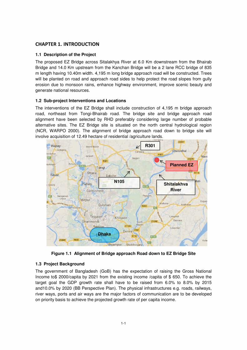
1-1
1.1 Description of the Project
The proposed EZ Bridge across Sitalakhya River at 6.0 Km downstream from the Bhairab
Bridge and 14.0 Km upstream from the Kanchan Bridge will be a 2 lane RCC bridge of 835
m length having 10.40m width. 4,195 m long bridge approach road will be constructed. Trees
will be planted on road and approach road sides to help protect the road slopes from gully
erosion due to monsoon rains, enhance highway environment, improve scenic beauty and
generate national resources.
1.2 Sub-project Interventions and Locations
The interventions of the EZ Bridge shall include construction of 4,195 m bridge approach
road, northeast from Tongi-Bhairab road. The bridge site and bridge approach road
alignment have been selected by RHD preferably considering large number of probable
alternative sites. The EZ Bridge site is situated on the north central hydrological region
(NCR, WARPO 2000). The alignment of bridge approach road down to bridge site will
involve acquisition of 12.49 hectare of residential /agriculture lands.
Figure 1.1 Alignment of Bridge approach Road down to EZ Bridge Site
1.3 Project Background
The government of Bangladesh (GoB) has the expectation of raising the Gross National
Income to$ 2000/capita by 2021 from the existing income /capita of $ 650. To achieve the
target goal the GDP growth rate shall have to be raised from 6.0% to 8.0% by 2015
and10.0% by 2020 (BB Perspective Plan). The physical infrastructures e.g. roads, railways,
river ways, ports and air ways are the major factors of communication are to be developed
on priority basis to achieve the projected growth rate of per capita income.
Dhaka
R301
N105
Planned EZ
Shitalakhva River

1-2
Bangladesh at present has 161,400 km road infrastructure, 21,000 km of which is managed
by RHD and remaining 140,000 km managed by LGED. There are 8,000 km flood
protection embankment, 4,300 km irrigation channel and 5,000 km drainage channel in
addition used for seasonal or perennial movement of transports and pedestrians either
seasonally or perennially.
The ratio between road length/land area in Bangladesh is 1.31, this ratio varies division wise
as 1.52 for Rajshahi, 1.32 Khulna, Chittagong 0.99 and 1.50 for Dhaka Division (BBS
2012). This is quite low compared to road requirement for existing population density per unit
area.
1.4 Importance of the Project
Bangladesh is situated in a high average rainfall zone of 1,600 – 2,000 mm in the west part,
2,000 – 4,000 mm in southeast part and 2,500 – 5,000 mm in northeast part. Large fraction
of the high annual precipitation falls between July and October. Bangladesh in addition
receives large volume of runoff from the 1.6 million Km2 catchments occurring in India, Nepal
and China. The runoff that arrives from catchments reaches Bangladesh during the
monsoon when the local rivers are at spate. This causes flood inundating 12.0 to 24.0
percent floodplains and low lying areas. Large bridges like the Jamuna, Mukterpur Bridge
(Sixth China-Bangladesh Friendship) over river Dhaleswari and others are managed by
Bangladesh Bridge Authority (BBA) while other bridges are managed by RHD and LGED.
The EZ Bridge across the Sitalakhya River is to be constructed on moderately high terrace
lands on both sides, hence is subjected either too shallow rain water flooding or is not
flooded at all except during high flooding. The north central region is inundated during high
flood years that cause once in ten years at downstream site of Gualundo ghat. The high
flood is caused when the flood peaks in Jamuna and Ganges incidentally converge.
JICA extended financial and technical support for construction of EZ Bridge across the
Sitalakhya River along with 4.2 Km bridge approach road on northeast side of Tongi-
Bhairab. The EZ Bridge and the bridge approach road if constructed will help establishment
of road connection between the Tongi-Bhairab road and Dhaka-Sylhet highway (N2) via A K
Khan Industrial Park.
1.5 Objective of the Project
The objectives of Environmental Impact Assessment (EIA) study for the EZ Bridge site is to
assess adverse impacts, enhance mitigation measures that may be encountered for the
construction of the bridge and serve the GoB requirement fulfilling JICA’s Guidelines. This
study at the same time will help the planners, design engineers during design and feasibility
studies and work as guideline for the Contractor during project implementation stages.
This document shall fulfill the DoE requirements and meet the JICA’s Guidelines. It can
therefore be included with the application for obtaining the Environmental Clearance
Certificate (ECC) from DoE.
The objective of EZ Bridge construction on Tongi-Bhairab road, a 4.2 km bridge approach
road and a bridge over the Sitalakhya River 14 Km upstream from the Kanchan Bridge and
6.0 Km down-stream from the Bhairab Bridge is to establish road link with existing road
corridors and with A K Khan Industrial Park on the north side of Sitalakhya River. The

1-3
existing 2 lane Tongi-Bhairab road shall have to be upgraded into 2 lane road to support the
projected traffic loads on National Highway systems (N1, N2, N3, N4,) and the Dhaka
Bypass Road.

2-1
2.1 Policy, Legal and Administrative Frameworks
2.1.1 GoB Requirements
The BECA (1995), BECR (1997) enacted by MoEF (BCAS 1999) make EIA obligatory during feasibility study, planning, design and implementation stages. An ECC is required from DoE to initiate project implementation activities. The EIA documents (REA, IEE, EIA, EMP) are in reality the guiding tool to implementation agencies, management tools to the stakeholders during construction and operation stages. The BECR (1997) categorized development interventions as Green, Amber (A, B) and Red
depending on their degree of impacts on environment. The proposed upgrading of bridges
involves construction reconstruction and widening of bridges on regional, national and inter-
district roads managed by RHD. The subproject activities of WBBIP fall under Categories
Amber- A and B hence an EIA (DoE 1997) will be needed for bridges longer than 100m and
IEE will suffice for bridges shorter than 100 m (BCAS 1999).
2.1.2 National Environmental Legislations
The Environmental Legislations enacted by MoEF and other Ministries intend conservation
and proper management of natural, ecological, socio cultural resources and to keep the
pollution impacts minimal keeping pace with world communities regarding conservation of
nature. The GoB through enactment of legislatures strengthened MoEF and other Ministries
to combat the adverse environmental impacts and to enforce all the legislatures in their
intended spirits (Farooq and Rizwana 1996). The relevant Environmental legislations are
given (Table 2.1).
Table 2.1 Environment related Legislatures enacted by MoEF and other Ministries
Environmental Legislations
Implementing Agencies
Key Features
The Environment Conservation Act, 1995 (Amendments 2000, 2002, 2010) Environment Conservation Rules, 1997 (Amendments 2000 and 2003)
Department of Environment (DoE)
- Protection of areas of major environmental concerns.
- Issue of Environmental Clearance Certificate.
- Enforcement of Environmental Legislations, Acts and Rules
- Monitoring the compliance of environmental legislations and standards.
Environment Court Act, 2000 and (Amendments 2010)
District Environmental Court/ DoE/MoEF
- Enforcement of punitive measures as per Legislations, Acts and Rules against the offenders.
- Empowers officers of the concerned Departments to enforce the BECR (1997)
- The amendments (2010) empower to open environmental court in every district.
- Trial for environmental pollution under BECA (1995) Can be conducted under mobile court
Bangladesh Penal Code (1860)
Civil Administration/DCs
- Prohibits all activities that pollute the water bodies like spring, reservoir, open water bodies
- Prohibits activities that affect public health and create public nuisance

2-2
Environmental Legislations
Implementing Agencies
Key Features
Bangladesh Hill Cutting Act (1986)
DoE, Civil Administration/LGED
- Prevents Hill Cutting without prior clearance from DoE and/or from other responsible authorities
Vehicle Act (1927), Motor Vehicles Ordinance (1983) Bengal Motor Vehicle Rules, (1940)
Bangladesh Road Transport Authority (BRTA)/ Police/ Civil Administration
- Road safety, licensing, monitoring and maintenance of the vehicles standard on public roads/highways
- Control air pollution due to emission from engine and check noise pollution
Brick Burning Act(1989) and Amendments (1992, 2011)
MoEF /DoE and Forest Department
- To control the legal aspects regarding brick burning including imposing restriction on use of biomass in brick burning kilns
Bangladesh Environmental Policy (1992)
MoEF - Main objectives are maintaining the ecological balance, to protect natural resources, identification of environment polluting activities and ensure environment friendly development.
- This policy helps protection of natural resources (air, water and soil)
Bangladesh National Land Transport Policy (2004)
MoC/Police/ RHD - To ensure road safety and to reduce death and injury due to road accidents
Bangladesh Environmental Management Action Plan (NEMAP) 1995
MoEF a document prepared following the bottom up mechanism and participation of people.
- NEMAP helped identification of the actions needed to arrest/reduce environmental degradation, conservation of biodiversity, habitats and natural resources.
- Promote sustainable development and quality of human life
Bangladesh Water Pollution Control Ordinance (1973)
Ministry of Water - Taking steps both at governmental and private levels toward prevention of water pollution and environmental degradation.
Bangladesh Social Forestry Rules (2004)
MoEF, and ADB (2002)
- Provisions of these rules can permits GoB to extend forestry activities on private land and vice versa entering into mutual agreement amongst both sides.
National Land use Policy (2001)
Ministry of Land - The land policy basically identified different users of land with the intention fixing priority amongst different uses land.
National Biodiversity, Strategy and Action Plan (2004) and Amendment (2011)
MoEF - Main intention of the plan is to conserve biodiversity, ensure unique biological heritages and restrict introduction of invasive species
Acquisition and Requisition of immovable Property Ordinance (1982 Amendments1994,1995 ,2004)
Ministry of Land - To ensure legitimate compensation, rehabilitation for the PAPs.
Removal of Wreckage and Obstructions in inland Navigable Water Ways Rules (1973)
Bangladesh Inland Water Transport Authority (BIWTA)/Civil Administration/Police
- Removal of Wrecks and Obstructions from the Navigable Inland Waterways
- Protection, maintenance development of the waterways for navigation
Water Supply and Sanitation Act, (1996)
Ministry of Local Government, Rural Development and Co-operatives (LGRD&C)
- Management and Control of water supply and sanitation particularly in urban areas
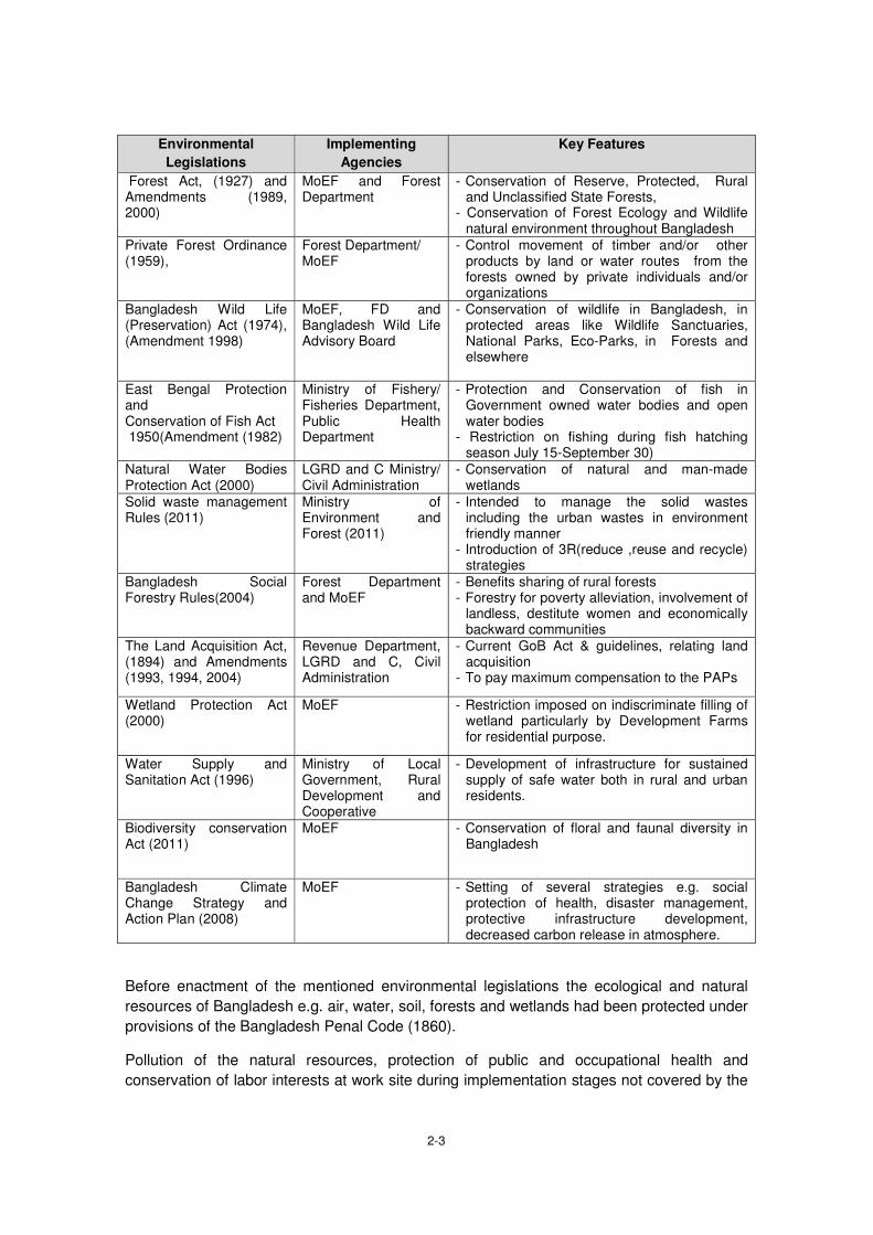
2-3
Environmental Legislations
Implementing Agencies
Key Features
Forest Act, (1927) and Amendments (1989, 2000)
MoEF and Forest Department
- Conservation of Reserve, Protected, Rural and Unclassified State Forests,
- Conservation of Forest Ecology and Wildlife natural environment throughout Bangladesh
Private Forest Ordinance (1959),
Forest Department/ MoEF
- Control movement of timber and/or other products by land or water routes from the forests owned by private individuals and/or organizations
Bangladesh Wild Life (Preservation) Act (1974), (Amendment 1998)
MoEF, FD and Bangladesh Wild Life Advisory Board
- Conservation of wildlife in Bangladesh, in protected areas like Wildlife Sanctuaries, National Parks, Eco-Parks, in Forests and elsewhere
East Bengal Protection and Conservation of Fish Act 1950(Amendment (1982)
Ministry of Fishery/ Fisheries Department, Public Health Department
- Protection and Conservation of fish in Government owned water bodies and open water bodies
- Restriction on fishing during fish hatching season July 15-September 30)
Natural Water Bodies Protection Act (2000)
LGRD and C Ministry/ Civil Administration
- Conservation of natural and man-made wetlands
Solid waste management Rules (2011)
Ministry of Environment and Forest (2011)
- Intended to manage the solid wastes including the urban wastes in environment friendly manner
- Introduction of 3R(reduce ,reuse and recycle) strategies
Bangladesh Social Forestry Rules(2004)
Forest Department and MoEF
- Benefits sharing of rural forests - Forestry for poverty alleviation, involvement of
landless, destitute women and economically backward communities
The Land Acquisition Act, (1894) and Amendments (1993, 1994, 2004)
Revenue Department, LGRD and C, Civil Administration
- Current GoB Act & guidelines, relating land acquisition
- To pay maximum compensation to the PAPs
Wetland Protection Act (2000)
MoEF - Restriction imposed on indiscriminate filling of wetland particularly by Development Farms for residential purpose.
Water Supply and Sanitation Act (1996)
Ministry of Local Government, Rural Development and Cooperative
- Development of infrastructure for sustained supply of safe water both in rural and urban residents.
Biodiversity conservation Act (2011)
MoEF - Conservation of floral and faunal diversity in Bangladesh
Bangladesh Climate Change Strategy and Action Plan (2008)
MoEF - Setting of several strategies e.g. social protection of health, disaster management, protective infrastructure development, decreased carbon release in atmosphere.
Before enactment of the mentioned environmental legislations the ecological and natural
resources of Bangladesh e.g. air, water, soil, forests and wetlands had been protected under
provisions of the Bangladesh Penal Code (1860).
Pollution of the natural resources, protection of public and occupational health and
conservation of labor interests at work site during implementation stages not covered by the

2-4
environmental legislations as best practice in Bangladesh are protected under the
contractual agreement reached between RHD and Contractor.
Bangladesh also ratified and/or acceded to 22 international conventions, protocols and
signed 24 treaties relating to environmental conservation and protection. In addition, the
international obligations that Bangladesh ratified are (i) Law of the Sea, (ii) Montreal
Protocol, (iii) CITES Convention, (iv) Framework Convention on Global Climate Change (v)
RAMSAR Convention(1971), (vi) Washington Convention (1972), (vii) Rome Convention
(1951), (viii) International Convention to Combat Desertification, (ix)International Convention
on Climate Change (Tokyo Protocol, 1997), (x) Occupational Health Hazards due to sound
Pollution and vibration (1981), etc.
2.2 EIA System and DoE Procedures
All development projects require clearance from the DG, DoE for initiating the
implementation process. Environmental clearance certificate (ECC) from DoE is issued
based on the findings of IEE that also stipulate whether an EIA be carried out by the project
proponent or the IEE is enough. EIA study focuses on addressing the unresolved
environmental issues in IEE report. The unresolved environmental issues may be because
of inadequacy of data, lack of impact identification and/or lack of mitigation measures. The
steps to be followed during EIA study are (i) collection of baseline study, (ii) identification of
environmental impacts on IECs,(iii) prediction regarding potential impacts,(iv) evaluation of
the impacts, (v) prescribing the mitigation measures,(vi) monitoring program, (vii) risk
analysis and (viii) documentation and communication(DoE 19970, BCAS 1999).
The JICA requirements incorporate an EIA process based on four part environmental
classification system. Projects under JICA system are screened for the impacts falling under
the following categories:
Category-A : Apprehended serious impacts,
Category-B : Apprehended some impacts,
Category- C: Impacts are unknown hence requires further examination and
Category- D: No significant impacts apprehended.
2.2.1 Environmental Clearance Certificate (ECC)
An ECC from DoE is required before initiating the project implementation activities. An
application to the DG DoE is to be submitted through the local office in prescribed
application form (Vide Rule 7.5) fulfilling the requirements detailed in BECR 1997 (BCAS
1999). The requirement of an ECC from the DoE can be bypassed during implementation of
WBBIP provided the Social and Environmental Circle of RHD processes the matter like that
of the Environmental Circle of LGED. The LGED deals all its project related matters
including evaluation of EIA reports by the Environmental Circle of LGED while copies of the
EIA reports are sent to the DoE for information. The WBBIP covers a large geographic
region covering many administrative areas falling under different DoE office jurisdiction.
Hence, processing of the environmental clearance issue routinely as per the BECA (1997)
will be cumbersome and time consuming. Moreover, bridges under WBBIP include
improvement and reconstruction of existing bridges on RHD managed highways where
during implementation minimal environmental impacts are anticipated, therefore the matter
may be dealt by RHD itself with minimal and formal involvement of DoE.

2-5
2.2.2 Policy Safeguards
The National Conservation Strategy (NCS 1991) and National Environmental Management
Action Plan (NEMAP 1995) emphasize on the inter-sector coordination and participation of
public as well as the private sector in development activities. Basic guidelines of the National
Environmental Policy (NEP,1992) are:
to ensure protection and conservation of physical, ecological and cultural resources from depletion, deterioration and degradation due to human activities,
identification of activities that induce pollution/degradation/ deterioration of natural environmental resources,
to ensure protection and conservation of historical/archaeological/ cultural structures/sites and relics from deterioration and degradation due to human activities and
Protection of identities, rights, livelihood and heritages of the indigenous tribes.
The pivotal environmental safeguards are sustainable and environment friendly
development, poverty reduction, women empowerment and planned employment
generation. To achieve these goals emphasis should be given on avoidance, reduction
and/or mitigation of impacts on environmental resources during project implementation
stages and enhancement of the positive impacts to harvest optimum benefits from the
development endeavors.
2.2.3 Harmonization of GoB and international Policies
GoB/DoE: BECR (1997) provided provisions for conservation of environment,
improvement of environmental standards, mitigation and control of
environmental pollutions and made EIA study obligatory before
initiation of project implementation activities.
Made it obligatory obtaining a clearance certificate from DoE for
implementation of development endeavors, categorized the different
development endeavors (projects, industries) in respect of their EIA
studies requirements. And set the environmental pollution standards
for air, water, land and noise under different conditions.
JICA: Made EIA study obligatory at the early stage of project planning.
Considers multiple alternatives in order to avoid and/or minimize the
adverse project impacts and chooses the project options with minimal
environmental impacts.
World Bank: The environmental safeguard policy of WB is though the best practice
of local governments but the main objective of the policy is to prevent
and mitigate the harm to people and the environment. WB has also
categorized different development endeavors financed by it based on
environmental impacts hence made EIA study obligatory for project
initiation and implementation.
ADB: Categorized all development endeavors based on their impacts on
environment and developed elaborate environmental safeguard
policies for different project categories. As per ADB categorization the

2-6
projects with significant adverse impacts( Category-A) require EIA and
EMP to address the adverse impacts, projects with lesser adverse
impacts (Categories-B,C) require either IEE or no EIA study.
Policy harmonization: However, environmental aspects due to due to implementation of any
development endeavor should be harmonized during implementation
stages so that the adverse environmental impacts are kept minimal
and the positive impacts are enhanced. These to be done to harvest
maximum benefits to the majority people from any project investment.
2.3 Land Acquisition Frameworks
Land Acquisition Law in Bengal was first enacted in 1824.The provisions and scopes of that
law were subsequently amended and expanded in 1850, 1857, and 1863 leading to the
enactment of Land Acquisition Act 1984. This Act continued enforced until partition of India
through proclamation of independence in 1947. This Act however lacked the provision for
payment of compensation for the acquired land and other immovable properties, as a result
the requiring bodies used to overestimate the actual land requirements to cause loss to the
land owners. The Acquisition of Immoveable Properties Ordinance-II 1982 was enacted to
safe guard owners right regarding payment of compensation and to reduce wastage of land.
Under this Ordinance the DCs or their nominees are authorized to examine the claim for
compensation taking into consideration all factors regarding entitlement of compensation
and empowered to divide the compensation amount amongst all the legitimate shareholders.
The Emergency Property Acquisition Act was enacted in 1989, this Act empowered the
Government authority to acquire private properties on during high floods, tidal bores, river
bank erosion and other sorts of natural calamities to act swiftly to check those calamities.
Hence, it is clear that the Act 1989 did not replace the Ordinance 1982, rather both the
legislatures remained enforced simultaneously and applied during implementation of the
Bangabandhu Multipurpose Bridge Project.
The Deputy Commissioners (DCs) as chief executives of the district or any officer authorized
by them can exercise the power conferred on the DCs regarding requisition of Immovable
Properties under the Ordinance 1982 and Act 1989. The Bangabandhu Multipurpose Bridge
(Land Acquisition) Act 1995 was enacted later on July 9, 1995. Under provisions of this Act
persons constructing structure/establishments and or modifying the land class/type that is
likely to be acquired with the intention of extraction higher compensation rate will not be
entitled any compensation for such structures. Land acquisition issue may not be a
significantly disturbing issue during implementation of WBBIP.
2.4 Framework for Resettlement
2.4.1 Objective of the Abbreviated Resettlement Plan (ARP)
As per the JICA bounded guidelines for Environmental and Social Considerations require if
screening for social assessment make it necessary that resettlement of some people at
bridges sites will impacts a time-bound action plan with budget provisions. A budget for
resettlement is to be prepared in that case and be incorporated as integral part of the project
design. However, World Bank (WB) clearly indicated the provisions for resettlement where
involuntary settlement of population from project sites fewer than 200 are needed at bridges
sites, an ARP may be prepared to serve the purpose. ARP according to such principal might

2-7
address issues like land acquisition and resettlement following the legal framework of GoB
and JICA’s guidelines for Environmental and Social considerations highlighting the impacts
on involuntary resettlement. The aspects of human rights of indigenous people and cover the
APs under resettlement/rehabilitation program including income restoration, poverty
reduction and legitimate assistance for poor and informal settlers. Hence, the ARP approach
may involve (i) land acquisition and resettlement issues, (ii) mitigation of impacts to the
distressed women and vulnerable groups, (iii) income generation support to the eligible
members of project affected families and (iv) assistance for poverty reduction to the poorest
section of people.
According to GoB policy a plan is be prepared setting out provisions for compensation and
rehabilitation to the PAPs and/or families before the project is executed. It should be a policy
that implementation of projects does not affect any PAPs in a way that their
living standards are adversely affected,
income earning opportunities, business, occupation, work or place of residence or habitat adversely affected even temporarily,
right, title and/or interest in ancestral houses, right to use any land, properties, premises are affected. Right on grazing land, common properties, tenancy, annual or perennial crops and trees are affected temporarily or permanently,
social and cultural activities and relationships amongst the family clans and keens may be affected during resettlement planning process.
The objective of the ARP is to provide a strategy for providing PAUs with replacement value
of land, structure, trees and other physical assets and restoration of income levels/living
standards either through a compensation and rehabilitation package that ensures that PAUs
are not left in a position where they are worse off with the project than without it. Thus, in
accordance with JICA policy, abbreviated resettlement plan, depending on the magnitude of
impacts - has been prepared for the Project.
Objectives of the project and Abbreviated Resettlement Planning have been disclosed to the
affected persons through community based consultation meetings and focus group
discussions in local language in two phases of stakeholders/community consultation as well
as during conducting census and socioeconomic survey. Compensation and other
assistances will have to be paid to APs prior to displacement or dispossession of assets.
Upon approval, the final ARP will be uploaded immediately on the RHD website.
2.4.2 Methodology for Preparing the Abbreviated Resettlement Plan
The Consultant conducted census & socioeconomic survey in April through June 2014 for
information necessary for preparation of this ARP. The survey was also associated with
stakeholders’ consultation, focus group discussion and property valuation survey.
The adverse impacts include land acquisition and displacement of households and shops.
The data gathered during the survey has been entered into an electronic database which
identified each affected household (AH) and the way they are impacted and losses they will
incur. The objective of the census and socioeconomic survey was to establish a detailed
inventory of the households and physical assets to be affected by the project; develop a
2-8
socioeconomic profile of the AHs and affected persons (APs). The surveys also serve as a
benchmark for monitoring and evaluation.
The surveys indicate that construction of the EZ Bridge will require acquisition of 12.49
hectare of land. In total the Project will displace 39 Project Affected Units (PAUs) of which 39
residential households with a total population of 190 only. As per JICA’s Guidelines the
appropriate Environmental and Social Considerations are to be given on vulnerable women,
children, and distressed elderly people and ethnic minorities. All concerned who are
susceptible to environmental and social impacts having little/no access to decision making
process are to be given due consideration. Therefore, this ARP has been prepared with due
consideration to all concerned to mitigate impacts on Affected Households (AHs) toward
restoration of their livelihoods at least to the pre-project level.
The ARP has been prepared based on National Law ARIPO (GoB) and on JICA guidelines
for the benefits of affected families susceptible to environmental and social impacts due to
implementation of the EZ Bridge project. The ARP therefore establishes the provisions for
resettlement of PAPs so that the affected households can restore a living at least to their
pre-project levels. The affected poor and vulnerable households should get due financial
compensations and if required the resettlement benefits as per legal provisions.
This ARP during discussion meetings will elaborately review all sorts of impacts that the
PAPs can suffer during the implementation stages and the appropriate mitigation measures.
The budget for impact mitigation can be revised from time to time reflecting the changes in
AHs number and/or the losses identified at later stages due to increased volume of impacts,
addition of properties and/or price escalation.

3-1
3.1 Physical Components
3.1.1 Climate
Bangladesh has a per humid mega-thermal climate with no water shortage at 50 cm depth
(Thornthwait 1948) at any part of the year. Maximum temperature during May-October
period is 31-340 C and minimum temperature during November-February period is 11-160C.
Winter climate (November-January) is cold and dry, spring climate (February-March) is
pleasant, and summer climate (March-May) is hot and dry while the monsoon season (June-
September) is wet. The temperature and rainfall during the monsoon season are high. Peak
temperature during April-May locally may reach up to 400C (Hassan 1999, Manalo 1975,
FAO 1971). According to Kopen’s (1936) classification Bangladesh has tropical rainy climate
(A-type). The mean temperature in coldest month in this type of climate remains above 180C
and the mean rainfall in driest month remains below 6.0 mm. The average climatic data of
Khulna, Rajshahi and Barisal stations are shown (Table 3.1). Normal activities during
construction stage may be hindered due to incisive rains and high floods.
Bangladesh has virtually a homogeneous climate with slight local variations. The north east
region has maximum rainfall while the northwest region has minimum rainfall. Temperature
also shows little local variation from the north east region toward south west region.
Occasion nocturnal rain with thunder shower observed in the south east region is due to its
vicinity to the sea. The monthly rainfall and temperature of Khulna, Rajshahi and Barisal
divisions are shown (Table 3.1).

3-2
Table 3.1 Monthly Rainfall (mm) and Temperature (0C) in Dhaka Divisions
Source: BBS 2012 (Average of 2006 and 2007)
Climate of a region depends on geographic location, elevation and vicinity to sea or large
water bodies. Implementation of EZ Bridge will not affect the climatic factors hence will have
no impact on climate at project site or in Bangladesh. However, the climatic elements along
EZ Bridge alignment may be monitored during operation stage to record the local weather
conditions.
3.1.2 Topography and Geology
Topography of Madhupur Tract at EZ Bridge command area is situated on contrasting relief
features. At EZ Bridge site the relief of command area is more or less level medium uplands.
The command area of EZ Bridge occurs on level terrace land with shallow drainage valleys
(bydes). The localized saucer shaped seepage areas occur at places where run-off from
adjoining highlands. Water from the Nagda beel is sheded to the Shitalakhya River at
Ghorasal and to the Turag River at Tongi. The uplands of Madhupur Tract extend north
toward Mymensingh via Gazipur forming vast highland tract amongst the Gazipur,
Mymensingh and Tangail districts. This upland is presently covered by BFD managed
depleted deciduous sal forests. The level terrace lands slope toward southeast (SRDI 1963)
forming vast shallowly flooded land mass.
The fine clay underneath the Bhawal-Madhupur tracts called Geruzen Clay occur at variable
depths whereas the red clay mantle of the Madhupur tract, Barind tract and Mainamati tract
comprise the erosion products from the Gondoana land that floated in Sea of Tethys during
the Mio-Plicene period. This vast land mass that extended from northwesr toward southeast
broke into pieces due to tectonic activities (FAO 1971)forming the Barind, Bhawal-Madhupur
and Mainamati tracts.
The level terrace land covering the EZ Bridge command area passes over either through
irrigated and/or rain fed paddy lands.

3-3
Figure 3.1 Meghna, Tista, Jamuna and Ganges Floodplains
Large scale land filling for road embankment construction will impact surface drainage because of change in local relief condition. Moreover, land filling for construction of A K Khan industrial Park on the northeast bank of Shitalakhya River may induce local flood level unless the storm water discharge management done properly. However, construction of the EZ Bridge and the bridge approach road may not otherwise have serious impact on local drainage condition.
3.1.3 Soils and land uses
Soils of the Barind tract are weakly structured, olive, acidic clays in the subsoil overlying an
unaltered clayey substratum at variable depths. The landscape was probably colonized by
pioneer vegetation species (grasses and/or sedges) initially several thousand years back.
The early settlers cleared the pioneer vegetation to bring the land under agricultural uses.
The early settlers disliked the well-drained upland for sedentary agriculture because of
shortage of water. The indigenous tribes (Santal Kool and others) on the contrary preferred
to settle on undulated uplands and practiced shifting cultivation initially (SRDI 1963-1973,
FAO 1999)). The Barind Tract (Legend 2) and the Teesta floodplain soils (Legend 4a) are
shown in Figures 3.1 and 3.2.
The lands on floodplains were also initially covered by reeds, sedges and other sorts of
grass varieties. The floodplain soils were either cleared for agriculture by early settlers or
were brought directly under agricultural uses.

3-4
Figure 3.2 The Barind Tract Land
Implementation of the EZ Bridge project will not affect soil qualitatively hence will not have
impact on land uses directly and/or indirectly. However, acquisition of 12.59 hectare lands
for the project will have direct impact on few PAPs and cumulative impact on food
production.
3.1.4 Sedimentology and seismicity
Geologically, lands of the Barind Tract belong to the Plio-Plaistocene age and the lands in
river floodplains (Jamuna, Meghna,Teesta, Ganges and of other rivers) are of recent origins.
In Bangladesh, the floodplain sediments from the consideration of sedimentation patterns
are classed as meander, estuarine and tidal.

3-5
Figure 3.3 Different Seismic Risk Zone in Bangladesh (GoB 1979)
The floodplain sediments have been uplifted and down warped at places subsequently either
due to sedimentation and/or due to tectonic activities. The vertical homogeneity of the Barind
Tract sediment if treated as an indicator these sediments can probably be assumed as of
Plio-Pleistocene period. This assumption could not be confirmed till date because of
conspicuous absence of stratification and/or of marine fossils (animal or plant) in them. The
Bangladesh National Building Code (1996) and the Seismic map of Bangladesh (GoB 1979)
did sub-divide Bangladesh into three seismic zones based on the tremor intensities. The
command areas of WBBIP are situated in low/ seismic risk zone (Zones-II and III). This is
evident from Figure 3.3. Bangladesh is situated between the Indian and Eurasian continental
land masses. Occurrence of the Himalayan Mountain belt in the north and Mayanmarian
Mountain belt in the east make Bangladesh seismically active (Morgan and McIintire 1959).
The Bangladesh Building Code (GoB 1983) and Bangladesh Geological Survey (GoB 1979)
divided Bangladesh into three seismic zones. Zone-I has high seismic risk, Zone-II has
medium seismic risk and Zone-III has least seismic risk. The DBR site passes through the

3-6
seismic Zone-II that has seismic coefficient value (Z-Value) 0.15-0.25 Richter. The seismic
factors require to be considered during design phase of the DBR upgrading program.
3.1.5 Hydro-geology
The landscape both of the Barind and floodplains has a southeast slope alignment and flow
direction of the major rivers contribute to this assumption. The rivers in the downstream
regions along flow directions either receive run-off through different tributaries or distribute
run-off through many distributaries until finally shed the water to the sea. The rivers remain
at spate during the monsoon due to local run-off in addition the trans-boundary rivers receive
run-off from nearly 1.6 million Km2 catchment in India Nepal and China. Usually 10-12
percent floodplain area in Bangladesh is flooded during monsoon in normal years. But up to
24 percent floodplain area of Bangladesh may submerge during abnormal floods peak flood
levels in Padma and Jamuna coincides. This happens once in ten years or so.
The deep ground water table (DGWT) on Barind tract land fluctuates between 20 and 30
meters during the dry season and reaches near to the surface during the rainy season.
Ground water table on terrace lands sinks up to 7.0 m during lean season due to draw down
by deep tube wells. Further exploitation of DGW table may create imbalance between water
demand and annual recharge affecting the poor people living on Barind land (WARPO
2000).
Ground water both shallow and deep in the floodplains are also being used intensively for irrigated agriculture, industrial and domestic uses throughout Bangladesh. This country though rich in ground water reserve and there exists ample opportunity for ground water recharge during monsoon and during floods but consistent and growing rate of exploitation ground water has already created a seasonal imbalance between demand and supply of water. The ground water table at EZ Bridge command area sinks down to 7.0 m due to draw down of tube well irrigation.. Further exploitation of DGW table will widen the gap between demand and annual recharge of ground water. This will affect the people in Madhupur tract and at project command area (WARPO 2000).
3.1.6 River and Characteristics of River Flow
The river Lakhya, also known as Shitalakhya River, originates from Old Brahmaputra River
and it is a part of the Old Bhahmmaputra-Lakhya-Meghna river system. The Lakhya River
flows towards south and joins the lower Daleswari near Munshiganj and the combined flow
meets with Meghna River near Gazaria.
The Lakhya River is a well-defined channel and passes through the erosion resistance soils
of the Madhupur Tract without a river-morphology of the meandering and braiding river. The
length of the river from its riverhead up to the confluence with the Dhaleswari is about 112
km. The peak discharge of the river during high-flood, ranges from 660 to 2740 m3/sec at
Demra station. The highest recorded water level at Demra was 7.11 m PWD during 1998
flood which is about 1.0m higher than the natural ground level. The maximum depth of river
around the proposed bridge locations ranges from 15 to 20 m from the existing bank level.
Existing river course of Lakhya River and proposed bridge location are shown below:

3-7
Source: JICA Survey Team
Figure 3.4 Location of Gauging Station
Table 3.2 Collected Hydrological Data at Related Gauging Stations in Lakhya River & Lakhya River and Meghna Riverine System
Source: BWDB, BIWTA
3.1.7 Landscape
Bangladesh has the total land area of 147,470 km2 of which 79.1 percent is floodplain, 12.6
percent in north, northeast and south southeast is occupied by Mio-Pliocene hills and 8.3
percent in north central and in northwest regions is Plio-Pleistocene terrace land.
3.1.8 Ground Subsidence
Bangladesh because of location is situated in the earthquake prone region. This country
jolted by over 200 quakes since past two years. No major case of ground subsidence
occurred either in floodplains or elsewhere due to earth quake. The devastating earthquakes
namely the Chakhar (1869), Bengal (1885), Assam (1897), Srimangal (1918), Dubrigarh
(1930) had tremor intensities over 7.0 (Richter). The epicenters of all the earth quakes were
outside the Bangladesh boundary. The Assam earthquake that caused large scale damage
in Assam, Bengal and Bihar had tremor intensity of 8.7 Richter. But no large scale ground
DailyHigh/Low
Tide
AnnualMaximum
WaterLevel
DailyMean
Discharge
AnnualMaximumDischarge
1 Narayanganj SW180 90.5240 23.660228km to
downstream1971.4-2012.9 1981-2012 - -
2 Demra (Lahkya) SW179 90.5101 23.721728km to
downstream1971.4-2012.9 1968-2012 (1997.6-2006.6) 1966-2012
Daily mean dischargehas many missing data.
3 Demra (Balu) SW7.5 90.5018 23.723228km to
downstream - - - 1994-2012
4 Ghorasal SW178 90.6199 23.93848.1km toupstream - - - -
5 Lakhpur SW177 90.6534 24.039737.2km toupstream - 1983-2012 - - -
No. NameStation ID(WMO)
Latitude Longitude RemarksBathymetric
SurveyDrawings
Collected Item / Period of Record
Distancefrom
ProposedBridge
SHWLSLWL
(statistic)

3-8
subsidence occurred in Bangladesh due to the Assam earth quake (Bangladesh Building
Code 1996, Seismic Map of Bangladesh 1979).
The most seismically vulnerable eastern part of Indo-Bangladesh where most devastating
earthquakes occurred during past one hundred years is shown in Figure 3.4.
Source: FAO 1971
Figure 3.5 The most Earthquake prone Eastern Region of Indo-Bangladesh
3.1.9 Bottom sediments
Bangladesh was formed due to deposition of sediments transported by major rivers that had
been deposited under meander, tidal and/or estuarine conditions. The floodplain sediments
are therefore vertically well sorted. The sediments in bottom layers settled down earlier are
therefore coarser and coarseness of sediments increases with the depth of the layer. The
coarse textured sediments occur below 100 m depth in floodplains and level terrace regions.
This is evident from the borehole records of deep tube wells and from the available sporadic
geotechnical study data from different bore whole sites.
The presence of harmful heavy metals like arsenic, cadmium, chromium, lead and mercury,
etc. are required to be tested in dredge material to confirm whether these metals exist in
bottom sediments.
3.2 Ecological Components
The village forests are observed on homesteads, waste and marginal lands along road and
embankment sides. Total households (H/H) in Bangladesh are 25 million spreading over
85,650 villages (BBS 2007). Village forest cover in Bangladesh is 0.27 million hectare out of
the 2.56 million hectare total forests area (Forestry Master Plan, 1993). The per capita forest
land area was 225 m2 in 1993 showing a declining trend due to over exploitation,
demographic pressure and natural calamities. Tree species on homesteads include fruit, fuel

3-9
wood, timber, medicinal plants, MPTS and bamboos; trees on roadsides include timber, fuel
wood, fruit, aesthetic and medicinal species. Fruit trees on road sides comprise 10 percent.
Huge quantity of forest produces (fuel wood, timber, raw materials for industries, building
materials and fruit) are obtained from rural forest (Katebi, N.A. 1997).
3.2.1 The floral Species
The WBBIP sites do not pass through the national forests managed by BFD except the
localized patches ofsal forest in the northwest region. The tree planting culture on road sides
developed since the Moghul and subsequently British periods. BFD since eighties began
roadside tree planting keeping in mind the economic, ecological and aesthetic objectives.
Later CARE, SIDA and Proshika planted trees on roadsides with multiple objectives e.g. to
generate rural employment, to boost production of timber, industrial raw material and fuel
wood and for alleviation of rural poverty.
The species planted on road sides are: rain tree (Samaneasaman), krishnachura (Cassia
spp.), mehagony (Swietoniaspp), raj koroi (Albiziarichardiana), auricoliformis
(Acasiaauricoliformis), eucalyptus (Eucalyptus camaldulensis) and sisoo (Dalbarziasisoo).
The homestead species are: mango (Mangiferaindica), black berry (Syzygiumcumini), jack
fruit (Artocarpusheterophyllus), cocnut (Cocosnucifera), betel nut (Areca catechu), etc.
Hijal (Baringtoniaacutangula), mandar (Erithrinaindica), pitali (Trewianudiflora), silk cotton
(Bombaxceiba), toddy palm (Borassusflabellifer) are planted in flooded land.
The aquatic floral species include:kochuripana (Eichhorniacrssipes), khudipana (Lemna
minor), shapla (Nymphaea spp.) kolmi (Ipomea aquatic), halencha (Enhydra fluctuant) and
many weed species. The kochoripanakhudipan and several other floating species are
treated as eutropicvegetations.
3.2.2 The Faunal and Avifaunal Species
Commonly observed wildlife species are: jackal (Vulpesbengalensis), mongoose
(Herpestesedwarsi), civet cat (Viverriculaindica), otter, snake, rodents, frogs, toad, turtles
still occur at WBBIP site (IUCN 2002).
The commonly observed birds are: spotted dobe (Streptopelia spp.), rock pigeon (Columba
livia), parakeet (Psittaculakrameri), cuckoo (Hierococcyx spp.), koel (Eudynamisscolopacea),
owl (Athenebrama), drongos (Dicrusus spp.), common myna (Acridotheresspp), crow
(Corvus spp.), magpie robin (Copsychussaularis), red vented bulbul (Pycnonotuscafer),
jungle babbler (Turdodaisstriatus), tailored bird (Orthotomussotorius), heron, little egret,
cattle egret, storks and several wetland bird species.
3.2.3 Biodiversity status
The major habitats for floral and faunal diversities in Bangladesh are the hill forests, inland
upland forest, homesteads, wetlands, coastal mangrove forest, agriculture lands, etc. All the
ecosystems have been disturbed since the past decades due to poor management,
demographic pressure, natural calamities and deteriorated law and order situation.
Consequently, diversity and population of flora and fauna declined in Bangladesh. Many
wildlife species as a result is under stress and 50 of those are endangered already. Ten
percent mammal, 3.0 percent avifauna and 4.0 percent reptile species are extinct in

3-10
Bangladesh (IUCN 2000). Status of the resident inland vertebrates in Bangladesh as
indicated in the IUCN Red Book (2000) is shown in Table 3.3.
Table 3.3 Status of the resident Inland Vertebrates in Bangladesh
Groups Total living
Extinct
Threatened Not threatened
Critically endangered
Endangered Vulnerable
Fishes 266 0 12 28 14 146 Amphibians 22 0 0 3 5 7 Reptiles 109 1 12 24 22 12 Avifauna 388 2 19 18 4 189 Mammals 110 10 21 13 6 17 Source: IUCN 2000
3.2.4 Wetlands
In Bangladesh wetlands include the fresh and tidal rivers; ponds, lakes, beels, haors, baors
and pools and the seasonal and tidal floodplains. Wetland ecosystem in Bangladesh serves
as the rich habitats for numerous floral and faunal species including 266 fresh water fish
species. The large haors in northwest, northeast and in north central regions play pivotal
roles in flood abatement, fish propagation and stocking. In addition, these habitats provide
shelter to innumerable local and migratory bird species. Unfortunately, the wetlands in
Bangladesh depleted due to conflict between agriculture and fisheries, poor water
management, water withdrawal by upper riparian countries and watershed degradation. All
these affected capture fisheries, navigation, aquatic wild lives and the bio-diversity in general
(RAMSAR Convention)
The wetlands also stabilize local weather, influence ground water recharge, catch pollutants
and toxicants, regulate hydro-ecological condition and maintain the soil organic matter
balance.
3.3 Socio-cultural Components
3.3.1 Water Use
Water of open water bodies (rivers and channels) throughout Bangladesh is used
extensively for navigation, capture fisheries, agriculture and for industrial uses. The people
settled on river sides usually depend on water for domestic uses that include potable water
collection, bathing and washing and cattle washing. Though at present most of the rural
people collect their drinking water from shallow and deep tube wells sunk on homesteads or
at agriculture land. Fishermen and boatmen communities living along the river banks
adopted fishing and boat plying as professions. Presently many industries that developed on
river adjacent sites and banks make industrial use of river water. Unfortunately wastes and
effluents from many of these industries are discharged in the rivers. Part of the solid wastes
from these industries and from urban/rural residences are also discharged untreated in open
water bodies that pollute the river water.
Water in pond, lake, harborare used for stocking capture fish and for captive fisheries by a
section of people. Water in closed water bodies like the open water bodies are used for
domestic and limited agricultural uses. The closed water bodies are extensively used for fish

3-11
culture. Fish culture has presently turned as a sustainable source for supply of fish to the
local markets and generated work for a large number of poor.
The seasonally flooded croplands though shallowly flooded are also used for short rotation
fresh water fishes culture while shrimps and white fish species are cultured in brackish water
zones. Cat fish culture in transplanted paddy fields as alley generates additional income to
the farmers and play roles in biological control of insects.
The rivers are used for navigation, fisheries, industrial uses and irrigation purposes. The
boatmen, fishermen and poor people use river water for domestic purposes.
Water available in the Sitalakhya River is used for household utilities, navigation, capture
fisheries, agriculture and industries. People on river banks use river water for domestic uses,
bathing, washing and for cleaning domestic animals. The Sitalakhya River according to
IWTA is a classified navigation route, many industries grew on the banks, many fishermen
depend on Sitalakhya to earn livelihood and water is used for agriculture practice.
3.3.2 Socio-cultural Infrastructures
The socio-cultural structures built during the Buddhists period revealed from archaeological
excavations at Mohasthangarh, Paharpur, Mainamati, Munshiganj and at other places that
are of over one thousand years old. Cultural advancements achieved during the Buddhist
period in fine art and sculptures are observable on the terracotta drawings and stone and
bronze sculptures of Lord Buddhya recovered at Mohasthangarh, Paharpur, Mainamati and
at other excavation sites. Lakes, wells, temples and stone sculptures of Radha-Krishna and
different Gods and Goddess represent the Hindu period. Bangladesh progressed
tremendously during the reign of Pal kings in 8th century. Progress of the Pal period is well
reflected in their art, sculpture and literature. Many sculptures of Hindu period are engraved
in stone, bronze, wood and terracotta drawings on temple walls have been unveiled in the
recent past from different parts of Bangladesh. Muslim and Mughal structures are the royal
palaces, shrines, mosques, tombs and military structures that exist in Bangladesh and
elsewhere in India. The modern cities, townships and infrastructures were initiated during
the British rule are virtually the nucleus of modern cities all over India and Bangladesh (Dr.
Hannan, M. 1995).
The few cultural heritages that occur at EZ Bridge command area are mosques, graveyards,
eidgah, temple, cremation place, etc. The structures of common interests include the
academic and/or religious institutions, play grounds, post offices, public toilet, dispensary,
etc. ( Hannan,M.Dr.1995). Not many such structures likely to be affected by the EZ Bridge
and its bridge approach road.
3.3.3 Indigenous/Ethnic Communities
The Chakma, Khami, Kuki, Boum, Banjogi, Khiang, Lushai, Marma, Moorang, Mroo,
Pankhoo, Rakhain, Tanchunga, Tipra, Khiang and Chak live in Chittagong and Chittagong
Hill Tract; Khasia, Monipuri, Khami, Khiang live in Sylhet, Habiganj, Moulvibazar, and Garo,
Hajong, Santhal, Kool and Kotch live in the Madhupur and Barind Tract regions (BBS
2005,2012). The ethnic population size in Bangladesh is nearly 10 million; 0.7 million live on
eastern and southeastern hilly regions and 0.3 million in other districts. The Santhal, Sakh,
Hajong, Orao, Koch and Kool live in Rajshahi,Harijan and Rajbangsi tribes live in wetlands
and nearly 30,000 Rakhainpeople live in Patuakhali district. Many of these ethnic minority
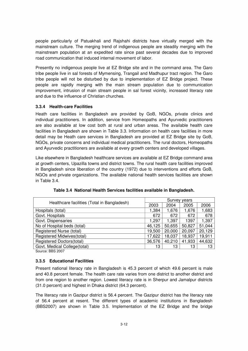
3-12
people particularly of Patuakhali and Rajshahi districts have virtually merged with the
mainstream culture. The merging trend of indigenous people are steadily merging with the
mainstream population at an expedited rate since past several decades due to improved
road communication that induced internal movement of labor.
Presently no indigenous people live at EZ Bridge site and in the command area. The Garo
tribe people live in sal forests of Mymensing, Trangail and Madhupur tract region. The Garo
tribe people will not be disturbed by due to implementation of EZ Bridge project. These
people are rapidly merging with the main stream population due to communication
improvement, intrusion of main stream people in sal forest vicinity, increased literacy rate
and due to the influence of Christian churches.
3.3.4 Health-care Facilities
Heath care facilities in Bangladesh are provided by GoB, NGOs, private clinics and
individual practitioners. In addition, service from Homeopaths and Ayurvedic practitioners
are also available at low cost both at rural and urban areas. The available health care
facilities in Bangladesh are shown in Table 3.3. Information on health care facilities in more
detail may be Heath care services in Bangladesh are provided at EZ Bridge site by GoB,
NGOs, private concerns and individual medical practitioners. The rural doctors, Homeopaths
and Ayurvedic practitioners are available at every growth centers and developed villages.
Like elsewhere in Bangladesh healthcare services are available at EZ Bridge command area
at growth centers, Upazilla towns and district towns. The rural health care facilities improved
in Bangladesh since liberation of the country (1972) due to interventions and efforts GoB,
NGOs and private organizations. The available national health services facilities are shown
in Table 3.4.
Table 3.4 National Health Services facilities available in Bangladesh.
Healthcare facilities (Total in Bangladesh) Survey years
2003 2004 2005 2006 Hospitals (total) 1,384 1,676 1,676 1,683 Govt. Hospitals 672 672 672 678 Govt. Dispensaries 1,297 1,397 1397 1,397 No of Hospital beds (total) 46,125 50,655 50,827 51,044 Registered Nurse (total) 19,500 20,000 20,097 20,129 Registered Midwives(total) 17,622 18,037 18,937 19,911 Registered Doctors(total) 36,576 40,210 41,933 44,632 Govt. Medical College(total) 13 13 13 13 Source: BBS 2007
3.3.5 Educational Facilities
Present national literacy rate in Bangladesh is 45.3 percent of which 49.6 percent is male
and 40.8 percent female. The health care rate varies from one district to another district and
from one region to another region. Lowest literacy rate is in Sherpur and Jamalpur districts
(31.0 percent) and highest in Dhaka district (64.3 percent).
The literacy rate in Gazipur district is 56.4 percent. The Gazipur district has the literacy rate
of 56.4 percent at resent. The different types of academic institutions in Bangladesh
(BBS2007) are shown in Table 3.5. Implementation of the EZ Bridge and the bridge

3-13
approach road will impact rather positively on educational facilities and consequent literacy
rate at bridge command area. This will be because of improved road network, increased
economic activities and change of attitude amongst the rural people due to rapid
urbanization.
During SHM meeting at EZ Bridge command area, it was found that most participants had
least complain regarding the direct or indirect benefits of EZ Bridge. The proposed approach
road if implemented will not affect any of the existing educational institutes.
Table 3.5 Total Number and Types of academic Institutions in Bangladesh
Types of Institutions Survey years
2001 2002 2003 2004 Primary schools 63,255 63,545 86,373 - Secondary Schools 15,837 15,806 17,386 - Colleges 2,551 2,870 2,577 -
Madrasas 7,277 7,373 7,920 - Govt. Universities 17 17 22 - Non-govt. Universities 24 41 53 - Source: BBS 2012
3.3.6 Professional Communities
Nearly a century back most people in Bangladesh earned their livelihoods based on eco-
dependent professions e.g. wood cutter, wood craftsman, cultivator, weaver, fisherman,
mate weaver, boatman, and the cultivator community. In addition there were potter, black
smith, gold smith, basket maker, cattle rearer, etc. Many such professional communities
have changed their professions and/or are struggling to survive because the products they
produces cannot longer compete with the industrial produces in open markets, reduced
demand for their produces, shortage of raw materials for cottage industry products due to
eco-degradation, etc.
3.3.7 Fisherman Community
The fisherman community in Bangladesh are engaged in marine and/or fresh water fishing,
fishing may be their fulltime or part time occupation. The fisherman community in
Bangladesh is struggling hard to survive, because reduced fish catch, increased cost of
living, shrinking of wetland and due to conflicts with the privileged adopted the profession as
interest shooters. Pollution of open water bodies due to disposal of industrial/ urban wastes
affected the population and diversity of fresh water fish species.
Many of the eco-dependent professionals and craftsmen under the situation became heard
hit due to rapid urbanization pace, competition with industrial products, introduction of
synthetic products and increased cost of production. The boatmen community is heavily
affected over the past decades due to road communication improvement, water
management, flood control and introduction of mechanized water transports. The situation is
not the same at EZ Bridge command area because the bridge command area is located on
high and medium high lands.
The implementation of the EZ Bridge will however not impact the fisherman or any other
professional communities adversely.

3-14
3.3.8 River Transportation
Water vessels like country boat, steamer and motorized water transports were the major
means of transportation in Bangladesh several decades back. Most of the towns and growth
centers were situated on big and small river banks for convenience of river transportation.
Development of river routes continued to facilitate movement of cargo ships, country boats
trawlers and fishing boats. At present most of the big rivers amongst the 700 perennial rivers
indicate that that the water routes are mostly used for movement of trawlers, barges, fishing
boats, etc. for cargo transportation. Only few large rivers are used as classified water routes
for movement of passenger steamers and launches. Amongst the 19,000 bridges across
different rivers and channels that exist in Bangladesh many are turtle backed to facilitate
movement of water transports.
The situation changed since 1972, at present length of LGED road is 151,610 Km and RHD
managed road is 20,878 Km. Road transportation system improved and each district, upazila
town even the growth centers are connected by all-weather motor able road linkage. The
district towns were connected by 4,053 Km railway track that transported 44.5 million
passengers (BBS 2005, 2012).
The number of motorized road transports in Bangladesh was 36,000 in 1997, increased to
930,000in 2006 (BBS 2012). This is due to rapid improvement of road network over the past
decades. In addition, many motor bikes, auto rickshaw and Nasimon type motorized
transports ply on Bangladesh roads. Innumerable unconventional road transports like
rickshaw, push cart, bullock cart also ply both in urban and rural roads. The number of
organize, unorganized and private transports in 2006-7 compared to 2002-3 is shown in
Table 3.6. Dependence on water transportation has drastically been reduced in Bangladesh
over the past several centuries due to surface water management, flood control, withdrawal
of water by upper riparian countries and due to watershed degradation in vast catchments
outside Bangladesh border.
The urbanization rate at EZ Bridge command area is rapid hence many roads needed to be
constructed to commensurate the increased load of road traffic. Moreover, the impacts of A
K Khan Industrial Park, Dhaka Bypass Road and National highways (N2, N3, N4) will be
significant at the site. The EZ Bridge command area is getting rapidly urbanized hence
requirements for service roads and highways will be high to commensurate the future traffic
load. Hence, cumulative impacts of EZ Bridge, the bridge approach road and associated
service roads will be significant at the command area.

3-15
Table 3.6 Organized and unorganized Water and Land Transports in Bangladesh
Transport s Road transports Water transports(Public) Private
Organized transport 2002-3 2006-7 2002-3 2006-7 Bus microbus, truck, motor car,/taxi/jeep, auto-rickshaw, others
284,000 365,000 221 mechanized river transports
530 mechanized river transports
253 mechanized river transports
Motor bike 239,884 366,031 - - - Unorganized transport Rickshaw, push cart, bullock cart.
1,900,000 2,195,000 boat, fishing boat, trawler
Source: BBS 2012
3.3.9 Road and Water Route Accidents
Narrow width structural weakness, defective bridges due to age, risky Bailey Bridges and ill
maintained road transports, lack of pedestrians’ traffic awareness and poor law and order
situation combined are the causes of high road accident rate (10/1,000 registered
vehicles/year) to cause many deaths and grievous injuries to many pedestrians and
passengers. The road accident alone costs Bangladesh $0.35 million annually to import
spare parts to repair the damaged vehicles.
Ministry of Communication in the newly enacted National Transport Policy (MoC2004) put
emphasis on movement of environmentally sound transports on national highways and other
road network system. The actions suggested to achieve the goal are (i) conversion of 2-lane
roads into 4-lane with divider, (ii) improvement of the defective, narrow, risk prone bridges,
(iii) maintenance of road transports properly and (iv) careful driving by well-trained drivers .If
the NRTP (2004) can be implemented road accident rate can probably be reduced in
Bangladesh significantly.
Accidents due to sinking of river vessels caused in 2009 were over 200, out of which 10
were in Sitalakhya and two were in Meghna River. The river vessels sank due to
overloading, plying of imperfect vessels, collision with other motorized or non-motorized
vessels and due to defiance of storm warning signals.
3.3.10 Protected Areas
There exist 34 Protected areas in Bangladesh declared by MoEF under the Bangladesh
Wildlife (Preservation) Order (1973)and subsequent Amendment (2011) . Moreover, the
National Parks at Kuacuta, Nawabganj, Kadigarh, Singra and Tengragiri Wildlife Sanctuary
at Barguna have also been declared Protected Areas (MoEF 2010-2011). Bhawal National
Park, Balda Garden and Madhabkunda Eco-park have also been declared Protected Areas
(MoEF 2010-11).
3.3.11 HIV/AIDS
Spread of HIV/AIDS in Bangladesh particularly rural areas is minimal as per results of
studies conducted so far. AIDS bearing patients have rarely and sporadically been observed
amongst the sex workers who live in port cities Mongla and Chittagong. The HIV/AIDS issue
is not serious in Bangladesh. The cautionary measures to avoid spread of AIDS and the

3-16
manner of dealing with AID patients and/or the prospective AIDS carriers in the society are
given wide scale spread publicity in electronic and printed media.
3.3.12 Gender Equity
Gender equity in case of recruitment of staff, payment and other facilities is to be maintained
as per the GoB rules and donor agencies’ requirements. Women workers’ camp sites should
be situated at far place from the male workers camps. Separate toilet and washing facilities
with due privacy should be provided for women workers.
3.3.13 Children’s Rights
The restrictions on child labor, appointing children in jobs that might pose health hazard,
accident moral lapses, should be strictly followed. The concerned authorities must be careful
dealing with children’s right issue so that rights of the children are not abused in any way
and at any stage during WBBIP implementation.
3.3.14 Climate Change
Large part of the coastal regions of Bangladesh and part of SCR may be the affected due
apprehended sea level rise @ 0.18 m/ 40 years that may accelerate during next 40 years. If
the rate of apprehended sea level accelerates the assumed impacts on the coastal plain of
Bangladesh may become serious. Bangladesh however, can do nothing to combat impacts
of the global issue, because of shortage of resources and lacking of necessary technological
advancement.
However, implementation of the Project in no way will impact the region adversely directly or
indirectly. The sea level rise issue being a global phenomenon to which Bangladesh
contributed least but it will be impacted highly if at all the sea level rises at apprehended
rate, hence at the stage Bangladesh can only leave the issue fate destined and alternatively
can only high light its grievances to the global conscious regarding the crisis at apprehends
due to climate change and consequent sea level rise. The EZ Bridge command area occur
at deep inland and on nearly 10 m above PWD level, hence no serious impact anticipated
due to its implementation.
3.4 Pollution
The most serious environmental concerns Bangladesh faces presently are the pollution
caused due to urbanization, eco-degradation, demographic pressure and ill planned socio-
industrial and commercial structures developed here and there and over 16,000 ill managed
growth centers throughout. Air and water pollution is caused due to improper management
of solid wastes and effluents from rural/urban/commercial sites and industrial plants.
Intensified traditionally managed chemical agriculture to increase grain production also
pollutes soil, water and air throughout Bangladesh including EZ sites. Dust blowing and
emissions from vehicles, industries, agriculture and urban sites pollute air and water. The
ambient primary data regarding pollution of air, water, soil and noise and vibration at the
bridge sites have been collected by the Chemical Engineering Department of BUET. It can
be said that environmental impact at individual bridge like EZ Bridge sites may not be
significant.
Impacts of EZ Bridge and of the bridge approach road sites on IECs may be significant
particularly on the ecological components during construction stage of 4,200m bridge

3-17
approach road and 200m long bridge. This will involve felling of 13,159 trees (sapling, small
.medium, large, bamboos and banana) from the homesteads, road sides and from block
plantations. The impacts on wetland ecology due to filling of 5/6 ponds may adversely affect
few people. The impacts due to loss of agriculture land, ancestral homes, socio-cultural
structures due to construction of 4,195 m approach bridge road may be significant. Felling of
tress along the bridge approach road alignment may affect personal economy and the local
ecology adversely.
3.4.1 Air Pollution
The air quality of EZ Bridge locations had been assessed. The major components of air
pollution are respirable suspended particulate matter, and gaseous pollutants such as: CO,
CO2, NOx and SO2. The maximum allowable limit of pollutant concentration is given in Table
3.7.
Table 3.7 National Air Quality Standards for Bangladesh
SI
No.
Categories
of Area
Suspended
Particulate maters,
PM10 (μg/ m3)
SO2
Carbon
Monoxide
Oxides of
Nitrogen
μg/m3 ppm μg/m3 ppm μg/m3 ppm
1 Industrial
and mixed
500 120 0.045 5,000 4.36 100 0.053
2 Commercia
l and
400 100 0.038 5,000 4.36 100 0.053
3 Residential
and Rural
200 80 0.030 2,000 1.75 80 0.043
4 Sensitive
100 30 0.011 1,000 0.87 30 0.016
Source: Environment Conservation Rules, 1997
The PM10 concentration standard is 500μg/m3 for industrial and mixed zone, and is
100μg/m3 for sensitive zone. In this study, it has been observed that the PM10 concentration
at EZ Bridge sites is much below the standard limit of Industrial and mixed/ Commercial and
mixed and also below than Residential & rural standard. But only exceeds the limit of
National standard category of Sensitive area. The National gaseous pollutant standard limit
is 0.045ppm for SO2, 4.36ppm for CO and 0.053ppm for NOx. For the EZ bridge sites, the
gaseous pollutant concentration was below the standard limit. The average carbon dioxide
concentration was about 480ppm. But at bridge site it was found to be 530ppm, which is a
bit higher due to the brick field near vicinity of the bridge site. The higher gaseous
concentration was observed in the sampling points which were located either in busy area or
near to the industrial area or brick fields. The concentrations of NOx and SO2 were found
either in trace amount or below the detection range.
Air pollution due to dust blowing, emissions from construction related vehicles, machineries
and operation of construction plants particularly during the construction stage of EZ Bridge
may be significant. Movement of construction related vehicles, operation of machineries and
plants may be the cause of increased noise pollution at construction sites. Movement of
increased number road transports during the operation stage will cause increased noise
pollution and even road accident during operation stage.

3-18
The ambient air pollution data at bridge sites as per measurement by the Chemical
Engineering Department, BUET is shown below in Table 3.8.
Table 3.8 Air Pollution Data at EZ Bridge Site
Date of Sampling Location Air Pollution Parameter Results Remarks
25-08-14 Kaliganj Avg. Temperature (C0) 32.3
PM10
(Micro gm/m3) at
STP 122
SPM(Micro gm/m3) at
STP 230
NOX (ppm) 0.020
SO2 (ppm) 0.066
CO2 (ppm 530
CO (ppm) 1.000
Source: BUET 2014
3.4.2 Water Pollution
According to Environment Conservation Rules, 1997, National Standard for inland surface
water is shown in Table 3.9. Based on the application sectors, there are six different types of
surface water standards mentioned in the ECR, 97. Table 3.10 shows the relevant
parameters of the drinking water standard according to ECR, 97. Since there is no specific
standard for groundwater, Table 3.11 has been considered for groundwater comparison
during this study.
Table 3.9 Water Pollution Status at EZ Bridge Site
Best Practice based classification
Parameter
pH
BOD5
(mg/L)
DO
(mg/L)
Total Coliform
(number/100ml)
a. Source of drinking water for supply
only after disinfecting:
6.5-8.5
2orless 6orab
ove
50orless
b. Water usable for recreational activity:
6.5-8.5
3orless
5ormore 200orless
c. Source of drinking water for
supply after conventional
treatment:
6.5-8.5
6orless
6ormore 5000orless
d. Water usable by fisheries
6.5-8.5
6orless
5ormore
-
e. Water usable by various
process and cooling
industries:
6.5-8.5
10orless
5ormore 5000orless
f. Water usable for irrigation: 6.5-8.5
10orless 5ormore 1000orless
Source: Environment Conservation Rules, 1997

3-19
Table 3.10 National Standard for Drinking Water
Parameter Unit Standard
BOD5at20°C mg/L 0.2
DO mg/L 6
pH - 6.5-8.5
Suspended particulate matters
mg/L 10
Total dissolved solid(TDS) mg/L 1000
Temperature °C 20-30
Turbidity NTU 10
Source: Environment Conservation Rules, 1997
Table 3.11 Water Pollution Status of Sitalakhya River at EZ Bridge Site
Date of Sampling Parameters Surface Water Ground Water Remarks
25-08-14 Temperature (C0) 32.30 31.1 N/A not applicable
DO(mg/L 3.60 2.47
BOD5 (mg/L) 2.70 0.92
SS (mg/L) 0.194 N/A
Turbidity (FAU) 173 NA
pH 7.2 6.8
Conductivity(mS/cm N/A 1.094 Source : BUET 2014
Surface and ground water samples near points of the proposed EZ Bridge had been
collected and tested for different parameters according to the methods described earlier.
Apart from few exceptions, most of the water parameters were found to be consistent and
within the limit proposed by Environment Conservation Rules, (ECR), 1997 of the
Government of Bangladesh. Surface water pH values were mostly within 6.5 to 8.5, the
range allowed by ECR. The ground water pH reading was found to be within the range
suggested by ECR. The surface water sample had temperature within the range of 30oC-
32.30C; a bit higher temperature mainly because of the high ambient temperature in
summer. Groundwater samples were relatively cooler than the surface water.
Dissolved oxygen is one of the most important parameters that need to be higher than 5
mg/L according to ECR and other international standards. Surface water samples had DO
less than 5 mg/L. The water sources might have been contaminated with inorganic or other
pollutants. Moreover, samples were collected during the months of summer when the
ambient temperature was very high on most of the days causing a low level for dissolve
oxygen in water. Ground water samples had lower DO, as expected.
The surface water turbidity value was found to be 173 FTU. This is because of different
types and extent of sedimentation and insoluble contamination from run-off and nearby
populations. Some might have been affected by waste water from different sources as well

3-20
Turbidity is not a major concern for ground water and thus was not considered in this study.
Conductivity is an important parameter for ground water and exhibited conductivity higher
than 1 mS/cm, which might be related to the presence of higher metal ions (such as: iron).
As surface water is exposed to the atmosphere, it might retain significant amount of
suspended solid. This can be a rainy and windy weather, populated neighborhood and many
more influenced factors. Since there is no standard set for this parameter in Bangladesh
(ECR, 97), it is not possible to compare the experimental values with the national standard.
Finally, biochemical oxygen demand (BOD), a very critical parameter of water quality, was
analyzed for both surface and ground water samples. ECR suggested maximum value for
BOD5 is 6mg/L for surface water and 0.2mg/L for drinking water if supplied after disinfecting.
The surface water sample was found to be good according to ECR, 97
Ground water is supposed to be less contaminated and our analysis result also suggested
the water sample had BOD5 0.92mg/L indicating presence quality drinking water. It is not
uncommon for the tube wells to go under water during flood and that can introduce organic
contamination in ground water. In many areas, ground water could also be contaminated
with microorganisms causing a slightly higher BOD5 value. This can only be confirmed with
any type of coliform test. It is to be noted that there is no ground water standard set by the
Government of Bangladesh.
The ground water in Bangladesh is polluted largely due to seepage from non-sanitary
latrines and leakage of agro-chemicals (WARPO 2000). Ground water at bridges sites may
be polluted due to seepage from cement concrete mixing and working sites. This can
however be reversed after the project activities are completed and work camps dismantled
sites are cleared properly.
3.4.3 Soil Pollution
The agricultural soils at bridges construction sites can be polluted due to accumulation of
agro-chemical residues, non-essential ingredients and impurities accumulated due to
application of chemical fertilizers. The solid wastes disposed from household sites, industries
and commercial sites can pollute soil. The plant nutrients removed each year with crops and
crop residues deplete soil fertility. Pollution of soil along the highway sides may be caused
due to spillage of petroleum products, bituminous materials, and noxious chemicals and due
to accumulation of heavy metals emitted from automobile engines with exhausts. Use of
dredge materials for embankment construction may contain noxious metals that can pollute
the agriculture lands along road alignment. Moreover, accidental spillage of petroleum
derivatives and various noxious fluids and chemicals can also pollute soil along road
alignments.
3.4.4 Noise and Vibration
The National standard for sound is set based on areas of different categories. The
standards for different areas are given in Table 3.12. Areas up to a radius of 100m around
hospital, educational institutions or special institutions/establishments are designated by the
government as silent zone.

3-21
Table 3.12 National Standards for Sound for different Areas
SI.
No. Categories of Area
Standard for
Day Time
(6AMto9PM)
dB
Standard for
Night Time
(9PM to6AM)
dB
1 Silent zone 45 40
2 Residential 50 40
3 Mixed area, includes both for
Residential and commercial 60 50
4 Commercial 70 60
5 Industrial 75 70
Source: Environment Conservation Rules, 1997
The noise level was monitored for each selected sites. In most of the sites, the average
noise level was below the standard limit (~80 dB).
Table 3.13 Noise Level at EZ Bridge Site
Date of Sampling Time Average Noise Level
count
(dB)
Total Vehicle for
10 minutes
25-08-14 9.00 AM 63 7
10.00 AM 62 9
11.00 AM 62 6
12.00 PM 62 10
1.00 PM 63 9
2.00 PM 64 14
3.00 PM 66 12
4.00 PM 66 9 Source: BUET 2014
Noise and vibration pollution at EZ Bridge area will though increase temporarily during
construction stage due to movement of heavy transports, operation of construction related
machineries and plants unless due mitigation measures adapted but it will die down with the
completion of bridge construction activities..
3.4.5 Wastes and Effluents
The solid wastes, effluents and other garbage that may be generated at subproject sites are
domestic wastes, effluents at work camp/work sites and variety of materials at construction
sites during the construction stage. The solid wastes generated at work camp, labor camp
and construction sites due to construction activities may be handled, dumped and to be
disposed in safe and environment friendly manner at authorized dumping grounds available
nearby the construction sites. Disposal of wastes and effluents from the construction sites
haphazardly and at helter shelter will otherwise pollute surface water, ground water and
agriculture soils around the construction site.
If no specified dumping ground is available near the construction sites, wastes in that case
can be buried in deep pits around near the construction sites. All the valuable materials e.g.
cellulose, glass, plastic and metals, etc. may be separated for recycle and reuses.

3-22
3.4.6 Offensive Odour
Materials like the organic wastes, fecal residues, effluents and other decomposable wastes if
dumped near to the work camp and/or residential sites may spread stinky and offensive odor
on decomposition. This may adversely affect the work camp and residential sites creating
annoyance to the work camp dwellers, passersby and locals.

4-1
The impacts indicated in this Chapter are relevant to the activities under taken during the
implementation stages. The measures to be undertaken to avoid, and/or minimize these
impacts during the planning, design and implementation stages have also been suggested.
The activities to be undertaken during project implementation stages are mentioned here.
This is worth mention that the activities mentioned in this chapter are not project specific
rather these are of general nature applied in most infrastructure development projects
including the WBBIP subprojects.
1. Pre- construction Stages
Site survey and technical investigations,
Land and properties acquisition
Assessment of environmental losses (land, wetland and other asset, biodiversity, etc.),
Payment of compensation to PAPs,
Preparation of subproject design
2. Construction Stage
Setting of Field office and workers camps,
Procurement and engaging of workers,
Site clearance ( removal of trees, residential, commercial and other structures),
Procurement and storage of construction materials and equipment,
Management of traffic at subproject site and site management,
Site selection for collection of fill materials,
Construction of bridge, toll plaza and other structures,
Protection of road embankment slope by grass carpeting,
Pavement of the approach roads
Pollution control during paving activities
Planting trees on road sides.
3. Operation Stage
Monitoring of traffic operation,
Road maintenance and monitoring activities,
Roadside slopes and trees management
Potential impacts due to subproject implementation stages should be evaluated based on
significance, extent, effect, duration and stability. Short-term impacts (crop loss, pollution
and social disturbance) will terminate with the completion of subproject activities and/or by
adopting mitigation measures. Moderately long-term impacts (fill material collection, loss of
landscape beauty, camps setting, dumping construction materials, dumping, handling and
disposal of solid wastes, construction of diversion roads, etc.) will also terminate with the
termination of Construction activities. Long-term impacts (loss of land, loss of wetland,

4-2
disturbance to ecological/archaeological and vulnerable sites, psychological stress, etc.) can
though be minimized by adopting mitigation measures but scars of such impacts will persist
in PAPs minds. Impacts of activities during project implementation stages are shown in
Table 4.1

4-3
Table 4.1 Project Activities and Key Environmental Issues
Project Stage
Construction Activities Key Environmental Issues
Pre
-co
nstr
uctio
n
Sta
ge
Alignments fixing on map • No impact
Survey camp setting and conducting
survey work
• Psychological stress • Disturbance on privacy
Con
stru
ctio
n S
tag
e
Base camp and labour camps setting
at work sites
• Employment generation • Psychological stress • Social disturbance
Mobilization of construction machinery/
vehicles and plants
• Noise and vibration/dust blowing • Road pavement damage/ traffic disruption • Psychological stress • Employment generation
Site clearance • Loss of ecological balance • Disturbance to services facilities • Demolition of domestic/industrial/commercial
structures • Loss of livelihood • Pollution due to noise and dust blowing • Employment generation
Earth work for approach road
construction
Stockpiling of fill materials for bypass
road construction
• Land loss • Traffic disruption • Loss of landscape beauty • Employment generation
Haulage and storage of construction
materials
• Loss of landscape beauty • Pollution due to dust blowing
Pavement construction • Air pollution by smoke / Asphalt mix plant operation
Construction of bridge, toll plaza and
bypass road
• Induced traffic congestion • Air pollution • Noise pollution • Induced road accident risk
Opera
tio
n S
tage
Traffic management • Improvement of road traffic system • Increased risk of traffic accident
Maintenance of bridge, approach
roads and side slopes
• Temporary disruption to traffic movement
Monitoring regarding
• Resource generation • Improved aesthetic beauty • Improved socio-economic situation

5-1
5.1 Environmental Impact Identification
The impacts of EZ Bridge, the bridge approach road and approach roads on IECs during
implementation stages have been identified during field visits, discussion with locals, ARP
meets and from discussion with the RHD staff. The IECs at EZ Bridge site and along the
bridge approach road alignment were identified, described and assessed considering the
significance of interventions. The priority IECs are physical, ecological, sociocultural and
pollution that has direct impact on food production, livelihood, living quality and pollution. The
EZ Bridge and its other components during implementation stages involve different activities
and related impact types on IECs. The impacts magnitudes on IECs have been assessed in
respect of ambient conditions at EZ Bridge site and in the command areas.
The impact magnitudes on IECs during implementation stages and O & M are different.
Assessment of the impacts may affect the IECs differently and significantly. This was done
adopting standard checklist, flow chart and matrices. The EZ Bridge is to be constructed
over the Sitalakhya River along with a bridge approach road alignment selected by the RHD.
This may require acquisition of 12.49 hectare private lands and several hectare of RHD
lands. Hence, the anticipated impact the project on IECs during implementation of bridge
and bridge approach road will be significant. The impacts of the project on IECs therefore
have been included in the EIA prepared for the EZ Bridge. From this context the EIA report
is rather project specific.
5.2 Environmental Impact Scoping Matrices
The impacts of a development endeavor particularly during implementation of infrastructure
projects are screened under the proposed project alignment, probable alternative alignments
and under no project situations. The 3rd alternative deserve consideration in case of EZ
Bridge and bridge approach road construction as these are in fact new structures to be
constructed facing local objections, hence scoping of matrices are to be screened
scrupulously in case of EZ Bridge project.
The construction of EZ Bridge, the bridge approach road and associated other activities shall
impact the IECs positively and/or negatively and in variable magnitudes. The matrices of
impacts on IECs therefore are used to identify the impacts systematically relating the project
activities and environmental parameters maintaining rationale between the causes and
effects. The environmental impact assessment for implementation of EZ Bridge and
construction of bridge approach road can be done as:
A: Remarkable Positive/Serious Negative Impact is predicted.
B: Positive/Negative Impact is expected to some extent.
C: Extent of Impact is unknown. (A further examination is needed and the impact could be defined as study progresses)
D: Impact is very small or nil and further survey is not required
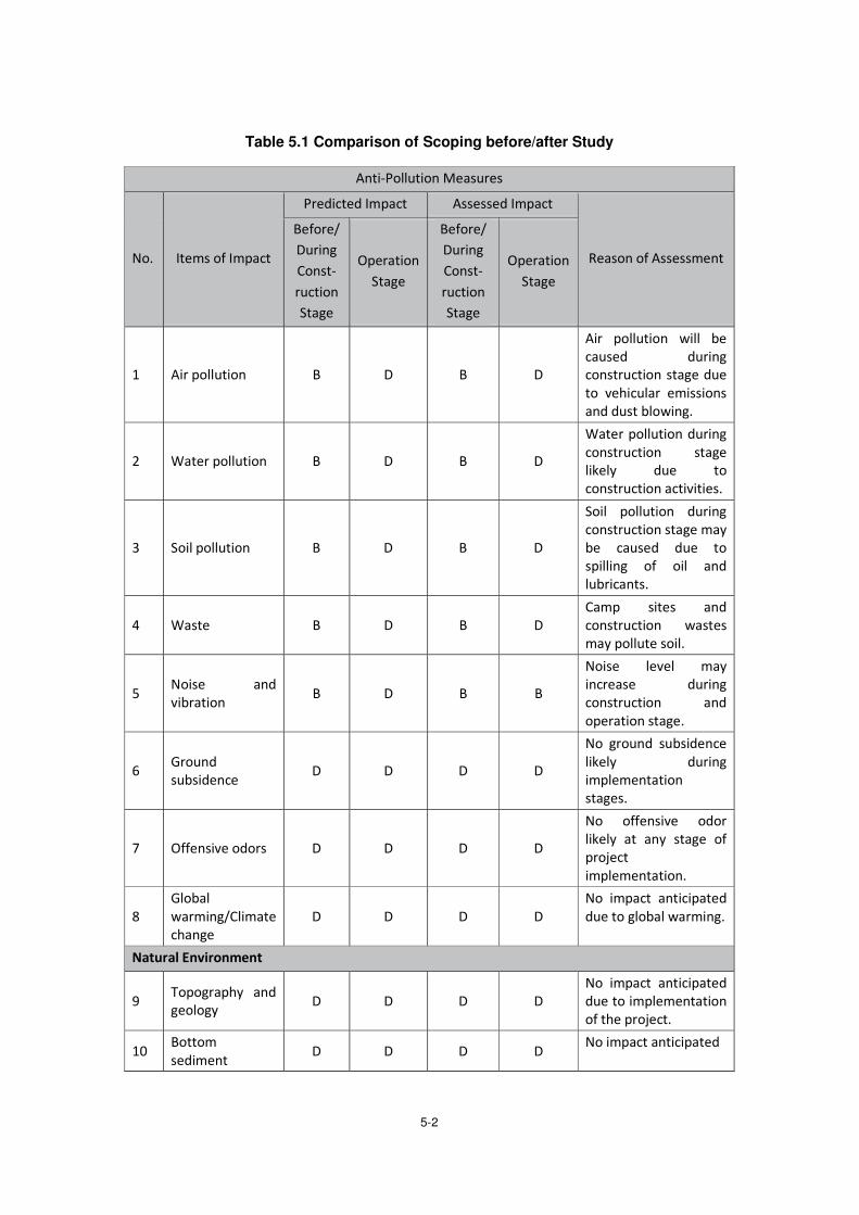
5-2
Table 5.1 Comparison of Scoping before/after Study

5-3

5-4
5.3 Mitigation Measures
Following Table 5.2 presents mitigation measures while in pre-construction and construction
stages and Table 5.3 in operation stage, respectively.

5-5
Table 5.2 Mitigation Measures pre-Construction/during Construction Stage
Item of Impact Magnitude of
adverse impact
Mitigation Measures
Air pollution B
- Contractors are required to conduct daily routine equipment and machinery check-ups to ensure that these are in the optimum working conditions.
- Regular preventive maintenance service of construction equipment and machineries will strictly comply with.
- To reduce the dust, periodical water spray should be taken.
Water pollution B
- Temporary coffer dam must be provided to accelerate sedimentation of turbid water and prevent a straight water flow into the present water way.
- Temporary sanitation facilities such as portable toilets and garbage bins will be provided by the contractors to ensure that the domestic wastes to be generated by the construction personals are properly handled and not thrown into the drainage to prevent further pollution.
Soi pollution B
- The operator of heavy equipment should pay attention to prevent fuel leakage when he feeds.
- The contractor and consultant of supervision should monitor the manner of fuel feed.
Waste B
- Contractors are required to facilitate proper disposal plan and manage the construction waste.
- The consultant of supervision should monitor the waste disposal.
Noise and vibration B
- Noise suppressors such as mufflers will be installed whenever deemed necessary to maintain the noise the noise generated by the various heavy equipment and other construction machinery within permissible limits.
- Contractors are required to use low-noise equipped machinery whenever it is necessary.
Involuntary resettlement B
- Conduct census survey and local stakeholder meeting. - Prepare ARP involving the following measures.
• PAPs must be acknowledged as an eligible for compensation.
• Identify the eligibility of non-titled people at the census survey intended to PAPs and ensure the compensation and support.
• Refer the previous/on-going projects by other donors, determine the requirement for social vulnerability and compensate to them.
• Resettlement site must be prepared when PAPs need it.
- Establish external monitoring committee consists of the third party.
Local economies, such as employment, livelihood etc.
B - Prepare ARP involving the following measure.
• Measure to restore PAPs’ livelihood must be secured.
Social institutions, such as social infrastructure and local decision making institutions. Existing social infrastructure and services
B
- Social utilities; such as power supply, drinking water, drainage and communication line are to be diverted before starting the construction activity.

5-6
Poor people B
- To minimize impact on presentagricultural activities, the construction schedule should be disclosed to the PAPs at the earliest possible stage.
- The proper compensation should be given to the PAPs. Infectious diseases such as HIV/AIDS
B - Contactor will be required to conduct a periodical health
education to his personnel.
Working conditions B
- Construction personnel provides with the necessary safety gears such as protective hard hat and safety belt as necessary.
- Contractor must provide temporary scaffolding, temporary landslide protection wall etc. to protect workers.
Social consensus B - RHD must hold local stakeholder meetings periodically,
and release project information to neighbor villagers.
Accident B
- A sound traffic management and detour plans duly approved by the local RHD must bel strictly implemented.
- Traffic enforcers and flagmen will be designated when heavy equipment/vehicle will be operated adjacent to public road.
Table 5.3 Mitigation Measures in Operation Stage:
Item of Impact Magnitude of
adverse impact
Mitigation Measures
Noise B - Monitoring and review the result by RHD.
Accident B - Provide hump where school/hospital/market exist.

6-1
6.1 Route Alternatives
The location of new bridge shall be determined in consideration of impact to existing
residences/shops, cost and so on. Following eight route alternatives for the EZ Bridge and
Road was planned. The map of alternatives is shown in Figure 6.1.
Alt 1-1
New bridge (L=1,050m) is constructed at the north side of planned EZ, and access road
(L=2,100m) is constructed by the widening of R302 (Kaliganj Bazar).
Alt 1-2
New bridge (L=1,050m) is constructed at the north side of planned EZ, and new access road
(L=2,100m) connecting R301 is constructed.
Alt 2
New bridge (L=835m) is constructed at the south side of planned EZ, and new access road
(L=4,195m) connecting R301 is constructed.
Alt 3-1
New bridge (L=835m) is constructed at the south side of planned EZ, and new access road
(L=6,900m) connecting N105 is constructed.
Alt 3-2
New bridge (L=835m) is constructed at the south side of planned EZ, and new access road
(L=8,700m) connecting N105 is constructed.
Alt 4
New bridge (L=835m) is constructed at the south side of planned EZ, and access road
(L=12,800m) is constructed by the widening of Kaliganji Road.
Alt 5
No bridge is constructed, and new access road (L=12,000m) connecting Kuril-Purbachal
Road (under construction) is constructed.
Alt 6
No bridge is constructed, and access road (L=11,500m) is constructed by the widening of
Danga-Kaliganj Road.

6-2
Figure 6.1 Alternatives of the EZ Bridge and Road
6.2 Route Evaluation
Eight route alternatives were evaluated as shown in Table 6.1. As a result, “ALT- 2” was
selected as the most appropriate route for the EZ Bridge and Road from the following points
of view.
Cheaper construction cost
Cheaper land acquisition and resettlement cost
Minimal affected house number (No affected building, shop and others)
Present accessibility is poor, but it can be connected to national highway in the future.
6-3
Table 6.1 Route Evaluation of the EZ Bridge and Road
Confidential

6-4
Confidential

7-1
The EMP (Environmental Management Plan) is intended to define the process and out puts
necessary to address the potential negative impacts of the physical works to be carried out.
The EMP clearly describes how the potential environmental impacts of all sub-projects will
be managed during preparation, implementation and, in the post-implementation periods.
The management plan is sometimes known as an "action plan." The EMP may be
presented as two or three separate plans covering mitigation, monitoring, and institutional
aspects, depending on client’s requirements. For projects involving rehabilitation, upgrading,
expansion, or privatization of existing facilities, remediation of existing environmental
problems may be more important than mitigation and monitoring of expected impacts.
The RHD itself or the Construction Supervision Consultant (CSC) farm hired by RHD shall
remain responsible to look after all day to day activities of Contractor during implementation
stages of the subprojects and ensure that all environmental provisions as per Environmental
Management Plan (EMP), and/or other EIA documents are properly and timely implemented
by Contactor during the implementation stages. Fully and timely compliance of the
environmental provisions as per the EMP, other EIA documents and environmental Clauses
is legally binding for the Contractor as per the contractual agreement.
Supervision and monitoring of environmental and social activities of the project done by Contractor during implementation stages,
Monitoring the compliance of the provisions of EIA/EMP and the contractual Clauses by Contractor during implementation stages of the projects.
7.1 Institutional framework
Environmental Management of the project involves highly specialized multidisciplinary and
multi-sector activities that may be different from mere construction of the bridge and the
associated components. The Environmental Circle of RHD at present may not have
sufficient expertise and requisite experience to perform the job properly. Moreover, the
Environmental Management of infrastructure projects is a growing discipline in Bangladesh
and rather worldwide, hence it is not quite expected that RHD possesses the requisite
expertise and experience and the time to supervise implementation of the EIA provisions
properly by Contractor during implementation stages.
RHD shall remain responsible for implementation of the environmental provisions as per
EMP and other EIA documents during implementation stages. Environmental management
during implementation stages as mentioned earlier shall require services of a specialized
multidisciplinary team with multi-sector backgrounds. RHD or its hired specialized
consultants can monitor due fulfillment of the environmental provisions by Contractor during
construction stage. The project involves low environmental impacts, the Environmental and
Social Circle of RHD may decide how and who to conduct monitoring activities during bridge
implementation stages.
The institutional framework for environmental management and monitoring is presented in
Figure 7.1.

7-2
Figure 7.1 Institutional Framework for Environmental Management and Monitoring
7.2 Environmental Monitoring Plan
Environmental Monitoring of a development intervention is required to be done periodically
for use of the management authorities during the project implementation stages. Two
approaches are followed usually during monitoring of environmental impacts. These are (i)
compliance monitoring during pre-construction and construction stages and (ii) monitoring of
impacts on environmental components during construction and operation stages.
Project site
Third parties/local
communities
Report Instruction/technic
al assistance
Government
JICA
Executing Body
Project Implementation Unit (PIU)
Report
Instruction/technic
al assistance
Dept. of
Env.
Roads and
Highways Dept.
Construction phase
Contractor
Consultant/s
upervision
firm Monitor
Monitor
Instruction
/mitigation Report
Mitigation
measures
Environment and
social issues
i
Mitigation
measures
Necessary
actions
Report
Social
&Env.

7-3
7.2.1 Compliance monitoring
The fulfillment of environmental provisions as per the EIA documents and EMP where
applicable at subproject sites, will require monitoring during implementation stages. The
issue of environmental concerns are (i) safety and security workers and pedestrian,
onlookers and passengers of road transports, (ii) proper hauling, storage, handling and
disposal of wastes from construction sites to the GoB authorized dumping places (if any), (iii)
provisions for protection against air and noise pollution, (iv) compliance to the gender equity
provisions as per regulations, (v) compliance to the labor welfare regulations, (vi) compliance
to the provisions regarding public and professional health and sanitation standards and (vii)
maintenance of day to day tidiness at work and work camp sites.
Required compliance monitoring during pre-construction stage are (i) to check the measures
taken by Contractor to mitigate environmental impacts, (ii) inclusion of environment related
provisions of EIA documents and EMP in the contract documents for compliance by
Contractor and (iii) regarding payment of compensation to PAPs for the environmental
damages that might have caused due to WBBIP implementation activities.
7.2.2 Environmental Management Implementation
The RHD reorganized the Environmental and Social Circle under an Addl. Chief Engineer,
with one Superintendent Engineer and one Executive Engineer. and necessary supporting
staff. Activities of the Circle are:
To review the EIA documents including EMP, supervise and monitor activities of Contractor during project implementation stages. Ensure proper implementation of the environmental provisions by Contractor and other stakeholders as per the EIA documents and Clauses during implementation of RHD projects.
To take care that all the environmental provisions and day-to-day activities at RHD executed project sites fulfill the environmental requirements regarding environment friendliness. The work camp sites, field office site and the overall environment at subproject sites is clean, tidy and environment friendly.
The subproject activities include construction of bridge and approach roads. Enhancement
activities include tree planting on approach roads, command areas and take care that no
squatter sheds and other structures constructed on approach roads during operation stage.
The impact mitigation measures undertaken during construction stage and the enhancement
activities as per EMP may continue even during the operation stage. Contractor during
implementation stages shall act as key stakeholder and remain responsible regarding
implementation of the environmental provisions as per EMP and contractual Clauses (if
any). The RHD/ CSC during construction stage shall periodically supervise activities that
may impact IECs.
The IECs affected directly due to WBBIP implementation stages particularly during the
construction stage are earthwork, fill materials collection for approach construction, piling of
junks, haulage and storage of construction materials, pavement work, demolition of existing
structures and other related activities like pile driving, construction of super and sub-
structures, etc. Impacts during construction of approach road embankments and bridges
shall require instant mitigation to avoid/minimize the potential environmental hazards.

7-4
7.2.3 Environmental Monitoring Plan
Environmental Monitoring Plan for this sub-project will help to evaluate the extent and
severity of environmental impacts against the predicted impact and the performance of
environmental protection measures. The following Table 7.1 has been prepared for
monitoring the operation & maintenance phase activities of the sub-project:
Table 7.1 Environmental Monitoring Plan
Sl. no.
Environmental Indicator
Parameters/Units Means of Monitoring
Frequency Responsible agency
01. Air/Water/Soil Quality
N/A Inspection Dairy Contractor/Consultantof supervision
02. Dust Control Spraying of water Visual Daily Contractor/Consultant of supervision
03. Noise Control Measurement (db)
Monitoring Daily Contractor/Consultant of supervision
04. Waste Management
Monitoring of collection, transportation and disposal of solid waste. Inspection of construction camp.
Inspection Daily Contractor/Consultant of supervision
05. Working conditions and Accident
Monitoring Health & Safety of Workers
Inspection Daily Contractor/Consultant of supervision
06. Involuntary resettlement, Poor
Monitoring by external monitoring agency
Monitoring 6 months later from resettlement
External monitoring agency/RHD
7.2.4 Reporting
The Site Engineer (SE) shall report regarding compliance of the EMP and other environment
related issues by concerned stakeholders to RHD in his periodic progress report for
reviewed by RHD during the construction stage. Periodic one in a month report of the SE
shall indicate clearly regarding the compliance of environmental provisions by Contractor.
Contractor’s failures to implement the environmental provisions are to be reported to RHD
regularly with request for action. Incidents of contamination or pollution due to Contractor’s
activities whether due to negligence or otherwise are to be mentioned in periodic reports.
7.2.5 Environmental Management Cost Estimated
The costs for environmental management are involved in mitigation of the impacts during
implementation stages for environmental enhancement activities e.g. planting tree saplings
on roadsides, construction of public facilities, etc. The estimates for incurring the
environmental costs are shown in Table 7.2 and Table 7.3.

7-5
Confidential

8-1
1st, 2nd 3rd and 4th round stakeholder meetings were arranged at different sites (South
Chowari, Teura and Alua Bazar) of the EZ Bridge. The discussions with the stakeholders
were concentrated mostly on the positive aspects of subprojects implementation,
magnitudes of socio-cultural and environmental impacts, compensation entitled by PAPs and
resettlement requirements for affected persons and families that to be dealt by RHD and
other authorities. The minutes of stakeholder meetings are attached in Appendix-1.
8.1 Summarized Opinion of PAPs at 1st SHM on 01-07-14
In general, people at EZ Bridge site agreed to accept implementation of the bridge and
bridge approach road and made comments that the project implementation will improve road
communication system, augment economic activities and allow faster and safer movement
of passengers and commodities to and from subproject sites. The mentioned opinions came
mostly from the people who were are not directly affected by the project and where impacts
of the subproject has tolerable environmental and socio-cultural impacts.
The EZ Bridge shows relatively mild type of environmental impact compared to the socio-
cultural impacts that are relatively tedious to mitigate.
8.2 Summarized Opinion of PAPs at 2nd SHMs on 02-08-14
The PAPs and many amongst the locals who attended the 2nd stakeholders’ meetings held
at south Chowari, Teura and Alua Bazar opposed implementation of the bridge approach
road alignment selected. Their objections were because of the involved social, agricultural
and ecological impacts to affect homesteads of a large section of people their cultivable
lands and large number of trees provided the bridge approach road is
constructed/reconstruction along the proposed alignment. The matter can however be
referred to the RHD for its decision how peoples’ disapproval regarding the proposed bridge
site and of the bridge approach road can be resolved amicably consulting with the local
people.
Hence the participants in ARP meet raised objections to construct the bridges along their
existing alignments.
8.3 Summarized Opinion of PAPs at 3rd SHMs on 24-11-14
Their demand was same as of 2nd round meeting; (a) they want the bridge, (b) the existing
embankment road should be widened to build the approach/access road, (c) they will not
allow road to be built by acquiring new lands inflicting damage to the lands and properties of
the people and (d) if the authorities decide against their proposal they will oppose
vehemently and organize agitations.
Thus, PAPs do not agree with the construction of proposed bridge.
8.4 Summarized Opinion of PAPs at 4th SHMs on 06-02-15
The 4th Round SHM was held at the request of the RHD in order to assess if there had been
any change in the observations and demands of the stakeholders since the last SHMs held
on 24 Nov 2014.

8-2
The State Minister for Women and Children Affairs of the GoB, Ms Meher Afroze Chumki
had agreed to attend and chair the meeting.
As a result, both Government of Bangladesh and APs/Stakeholders agreed that (a)
Compensation is a replacement cost based on a market price, (b) Payment will be made to
avoid Middlemen/Agency, (c) Compensation package should be circulated before acquisition,
(d) Suitable land area to build house for displaced people will be considered.
With adequate and proper handling of the acquisition/resettlement process, the
APs/stakeholders unanimously consented in favor of the project and the road alignment.
8.5 Conclusion
The proposed project has been planned to establish improved road linkage and the A.K.
Khan Industrial Park that is developing on the northeast side of Shitalakhya River as
Economic Zone (EZ). Due compensation to be given to the land owners, share croppers,
affected vulnerable people and other affected groups as per rules would facilitate
construction of the bridge approach road and the bridge.
Thus, the propose project has accepted by local stakeholders on 6th February, 2015 at 4th
round SHM.
Bibliography-i
BIBLIOGRAPHY
ADB,2003. Guidelines on Operational Procedures- Environmental Considerations in Bank Operations
2. BBS 2005. Handbook on Environmental Statistics. Government of Bangladesh, Dhaka 3. BBS 2007. Statistical Pocket Book, Bangladesh. Government of Bangladesh, Dhaka 4. BBS 2012. Statistical Year Book of Bangladesh,2012 , Government of Bangladesh,
Dhaka. 5. BCAS,1999. Guide to the Environmental Conservation Act 1995 and Rules 1997,
Bangladesh Centre for Advanced Studies, Dhaka. 6. DoE, 1997. EIA Guidelines for Industries: Ministry of Environment and Forests (MOEF)
Government of Bangladesh, Dhaka. 7. DoE, 2006. Environment for Sustainable Development, Annual Report 2006, Ministry of
Environment and Forest, Government of Bangladesh, Dhaka 8. DoE, 2O1O-11.Barshik Pratibedan, Paribesh o Ban Mantranalaya, Government of
Bangladesh 9. FAO 1988. Land Resources Appraisal of Bangladesh for Agricultural Development:
UNDP/FAO Project, BDG/18/035 Technical Report No.2-13: FAO Rome. 10. FAO,1971. Soil Resources of Bangladesh, Soil Survey Project of
Pakistan,Special/Pakistan-6,Technical Report-3,FAO, Rome. 11. Farooq, M. and Rezwana, S.1996. Laws Regulating the Environment in Bangladesh,
BELA Dhaka, Bangladesh. 12. GoB, 1979. Seismic Zone Map of Bangladesh and Outline of the Code for Earthquake
Resistant Design for Structures: Final Report. Geological Survey of Bangladesh, Dhaka 13. GoB, 1996. Bangladesh National Building Code. Ministry of Housing and Public Works,
Government of Bangladesh, Dhaka. 14. GoB, 2004. Guidelines for Environmental Impact Assessment of Roads and Bridges:
Social Environment Circle, Roads and Highways Department, Dhaka. 15. GoB, 2004. National Land Transport Policy, Ministry of Communication, Government of
Bangladesh, Dhaka 16. GoB, 2009. Bangladesh Climate Change Strategy and Action Plan, Ministry of
Environment and Forest, Government of Bangladesh. Dhaka 17. GoB, 1995. National Environmental Management Action Plan, Ministry of Environment
and Forest, Government of Bangladesh, Dhaka. 18. Hannan, M. Dr. 1995. HazarBachharerBangladeh, etihasher album. Bais Printing and
Publishing

Bibliography-ii
19. Koppen,W. 1936.Das Geographic system der climate,Berlin, Geogr.Vorntesger, Germany.Motijheel C/A , Dhaka. Bangladesh.
20. Hassan, M.M. 1999. Soils of Bangladesh - Their Genesis, Classification and Use
Potential: The March Printers Ltd, Dhaka. 21. IUCN 2000. Red List of Threatened Animals of Bangladesh: IUCN, Bangladesh Dhaka. 22. IUCN 2002. Bio-ecological Zones of Bangladesh, IUCN, Dhaka. 23. Katebi, N.A.,1997. Bangladesher Ban, Chief Conservator of Forest (Rtd) ,Government
of Bangladesh. 24. Malano, E.B.1975. Annals of Climatic Survey of Bangladesh, International Rice
Research Institute, Manila. 25. MoC,2007. Inception Report, Dhaka Chittagong Expressway Project, Roads and
Highway Project, Government of Bangladesh. 26. MoEF, 1991. National Conservation Strategies, IUCN, Government of Bangladesh,
Dhaka. 27. MoEF, 1992. National Environmental Policy: The Department of Environment, Ministry
of Environment and Forests, Dhaka. 28. MoEF, 2004. The Social Forestry Act, Ministry of Forest AND environment, Government
of Bangladesh, Dhaka 29. Morgan,J.P. and W.G. McIntire 1959. Quaternary Geology of Bengal Basin, East
Pakistan and India: Geological Survey of America Bulletin-70, USA. 30. SRDI, 1963-73. Reconnaissance Soil Survey Report of Dhaka district (greater district),
Ministry of Agriculture, Government of Bangladesh 31. SRDI,1965. Reconnaissance Soil Survey Report of Tangail district, Ministry of
Agriculture, Government of Bangladesh 32. Thornthwaite,C.W. 1948. An approach toward a rational classification of climate.
Geographic Review,38, USA 33. WB 2002. Draft Manual on Environment, World Bank, Dhaka 34. WARPO August 2000. National Water Development Plan Project, Development
Strategy,Vol.-1 Annex-O: Regional Environmental Profile.

Appendix-1
Minutes of Stakeholder Meetings
Name of the Bridge: Kaliganj Bridge, Dhaka-Tongi-Pubail-Kaliganj-Gajipur Road
1st round Stakeholder Meetings at Site
The stakeholder meetings (SHMs) for Kaliganj Bridge were conducted at 3 (three) places of
3 (three) different wards of Tumulia Union within Kaliganj Upazila under Gazipur District on
the 9th of July, 2014 with the potentially affected people of the proposed bridge area at South
Chowari Khola, Ward No.3, Teury, Ward No.6 and Alua Market.
The corridor of impact (COI) area is largely agricultural and provided irrigation facility makes
available to produce 3 (three) crops a year. There are several large ponds privately owned
where fish is cultured. 39 (thirty nine) households will be affected and a large number of
trees surrounding the households and located along the local narrow LGED/katcha/foot
roads will be affected, too. Due very close to Dhaka market, it brings large revenue for the
land owners. They said that it is precious for them and they would not part with their lands at
any cost.
Stakeholder Meetings:
The subject consultation meetings were held at the places mentioned above and following senior Consultants of BCL conducted the meeting
1. Md. Ekramul Huq, Sr. Environmentalist, BCL 2. Md. Faruque Ahmed, Survey Coordinator & MIS Specialist, BCL. 3. Md. Omar Faruque, Supervisor.
List of Stakeholders attended:
Stakeholders comprised of local elites, farmers, small business groups, service holders, students, women representatives and labor participated as listed hereunder.
At (a) Teury, Ward No.6, about 16 stakeholders were present;
(b) Alua Bazar, about 15 stakeholders were present and,
(c ) South Chowari Khola, Ward No.3, about 18 stakeholders were present.
Disclosure of the following facts were made to the Stakeholders:
The proposed project is to provide new bridge that would be beneficial to local people in particular. And the whole country in general will be economically benefitted due to the increased movement of traffic and transportation of resources. Besides, the bridge and the approach road have been planned to connect Dhaka with a proposed Economic Zone (EZ) where will be developed across the river Sitalakhya. It will foster the economic boon for the country then increase exports, foreign exchange earnings and create large scale of employment opportunity.
• Land owners will be paid replacement value of lost land, structures and other resettlement assistance before displacement;
• Farmers including sharecroppers and lease holders will be entitled to crop compensation if it is damaged due to the project.
• Affected vulnerable people will be entitled to engage in preferential employment during construction of the project.

• Training on income generating activities may be provided to the poor and vulnerable affected persons (APs), if necessary
Social Impact:
It was informed as follows:
• Good number of trees will be cut. • 39 households (HHs) will be affected. • Considerable quantity of private agricultural land and 5-6 ponds will be affected. • No social impediment for women if they want to work during the construction of the
bridge and the approach road.
SH and PAPs Opinion:
A. The stakeholders presented in the meetings were very much unhappy and spoke strongly against the project and proposed road alignment, and they resolved to resist it to the last. However, they were persuaded to calm down and ventilated their views so that their grievances and sentiments could be conveyed to the authorities. Finally, they listened and the meetings were held peacefully.
B. People wanted wide and four-lane bridge but not at the currently proposed site. They
spoke in favour of the bridge which will be provided at any of the following alternative
sites.
(1) Near the existing bridge (Kanchan Bridge) or use the existing one, and the road
connecting the bridge should be developed / started from the “Bottola” point “or
(2) Starting point of the road should be at “Bottola” and the road should directly meet
“Gudara ghat” point where a new bridge will be constructed.
Observation: It was observed that people not affected were very much interested in the bridge as proposed. But the actual APs were very much against the proposed alignment.
Environmental impacts:
Overview of the Location: The Bridge location is almost flat with some undulations, natural khals Atmosphere and Climate: The project location has a humid climate with variations of temperatures in between summer and winter seasons. Water Quality: Water quality of tube-well of the HHs along-side the bridge and within the CoI is drinkable and with less iron and available at an average depth of 18m to 22m. Air Quality: Clean Air, almost no pollution Noise: As no motorized vehicles except only rickshaws and some battery operated 3 wheelers operate in the area, noise level is normal.

Wild life: There is no other species of wild life other than fox, snake, mongoose etc. other than popular ones.
Plantation: There has been large number of trees mostly belong to individuals within homesteads and proposed COI.
Photographs of the meeting:
1st SHM-SHM-Teury 2
nd SHM-Alua bazaar 3
rd SHM-Chowari khola


7
2nd round Stakeholder Meetings at Site
It was held on 19th of August, 2014 and followings attended:
1. Mr Hiroki Sakai, OC
2. Mr Prasenjit Kumar Ghosh, OC
3. Mr Rezaul Karim Chowdhury, BCL
4. Dr. Mir M Hassan, BCL
5. Dr. Hafiza Khatun, BCL
6. Mr Ekramul Huq, BCL
7. Mr Md Faruque Ahmed, BCL
8. 4 Field Surveyors of BCL
OCL had requested JICA, RHD, BEZA to send representatives who attend the meetings. BCL also tried to bring RHD officials into the meeting, but none of them turned up.
The meetings disclosed the followings:
1. The road alignment
2. Compensation package and resettlement benefits
3. A cut-off date
3 meetings were held where the 1st round SHMs were held before i.e. (a) Teury, (b) Alua Bazar (Hannan Market) and (c) Chowari Khola. The lists of attendees are enclosed.
At Teury
The PAPs mostly belong to poorer of the community those attended. An elderly AP Md. Hanif was persuaded to preside though he agreed with reluctance. The PAPs were very upset and shouted against the proposal construing that construction of the road would force displacement from their ancestral lands and homes. They had the impression that the project would render them to become destitute.
The Consultants disclosed the cut-off date and the compensation package under the backdrop of huge noise raised by the PAPs, and they were unwilling to listen. They said that they would not want any money as compensation; instead, they wanted land for land as it is not available to purchase the lands in the area. Compensation without considering a spiralling escalation of land price would not allow them to find and buy replacement lands. They unequivocally expressed their view to resist the project by raising hands. When asked to show hands in favour of the bridge, none was seen.
They suggested that the road could be constructed over the flood protection embankment (Beribundh) along the river where owned by Govt. This was recorded.

8
One gentleman said that the proposed COI might go over an age-old graveyard which might have been used to bury the dead for generations. He requested to realign the road to avoid the graveyard. PAPs were found sentimental on this issue.
At Alua Bazar (Hannan Market)
The meeting was presided over by Mr. Hannan who is a local elite and opinion maker and he said that he would lose most of the lands and structures, but he was in favour of the road and the bridge. He was quite happy with the compensation package declared but was apprehensive about getting it properly.
He and the attending PAPs said that appropriate measures must be ensured so that the PAPs would get the replacement value of all losses without corruption and hindrance.
The stakeholders were informed that 19 August 2014 was the cut-off date and were requested not to raise any new structures in the proposed alignment.
At South Chowarikhola
Mr Shahjahan who is a local elite and an opinion maker was requested to preside. He said that he did not want to preside, and spent the most of the time to talk and argue. The Consultants reconfirmed the alignment, disclosed the compensation package and declared the cut-off date (19.08.2014). The stakeholders (most of them are land losers only) expressed their dissatisfaction about the proposed alignment and they were not willing to listen about the acquisition and compensations. Instead, they proposed to widen the existing road to Kaliganj. Mr. Ghosh explained that widening of the existing road would require displacement of large number of shops which would result significant impacts. The PAPs said that those are small shops and easily be relocated to the both sides as the lands belong to RHD.
The list of stakeholders attending are enclosed.
1st
SHM-Teury 2nd
SHM-Alua bazaar 3rd
SHM-Chowari khola


13
3rd round Stakeholder Meetings at Site
On 24 Nov. 2014 three Stakeholders Meetings were held in the Kaliganj Bridge and approach areas.
Locations of the Meetings
1. Bangabandhu Bazar in South Shome Village in Tumulia Union at 10AM. The Bridge will land at this location in the Kaliganj side.
2. Hannan Market (In this location the APs and stakeholders of both Aluabazar and Teuri were invited to attend in one meeting, the distance between Aluabazar and Teuri is about 400m) at 12 Noon. The Hannan Market is in Alua Village also under Tumulia Union.
3. South Chowarikhola is in Village Chowarikhola, also under Tumulia Union at 3 PM.
How the APs and Stakeholders were informed and invited to attend
The APs and stakeholders were informed and requested to attend (a) by personal contacts and (b) by announcement using microphone, the previous day and in the morning of 24th Nov. This time, on invitation from RHD, the Executive Engineers of Gazipur and Narsingdi attended and the Executive Engineer of Ghazipur presided the meetings in all 3 SHMs. Additionally the following dignitaries and elites of the project impacted areas also attended.
i) The Upazila Nirbahi Officer (UNO) of Kaliganj
ii) Upazila Chairman of Palash Upazila of Narsingdi district
iii) Chairmen and Members of the adjoining Union Parishads of Kaliganj and Palash
iv) Political leaders of local Awami League and BNP along with their party affiliates and
v) A AGM of A K Khan Group
The Stakeholder/APs actively participated in all the discussions in the three meetings. However the Executive Engineer of Narsingdi RHD and the Upazila Chairman of the Palash and Danga Unions had left after the first meeting at Bangbandhu bazaar site.

Participation of Stakeholders
All the 3 meetings were attended by about 50-100 people but there were some minors present who were not listed. About 62 persons attended at Bangabandhu Bazar, 40 persons attended at Hannan Market and about 80 persons attended at South Chowarikhola meetings but participants of South Chowarikhola meeting initially opposed to enter/sign their names but later on request from Mr Abu Bakkar Mia, Chairman of Tumulia Union, some signed but many refrained.
Because the discussions and AP/Stakeholders reactions had been same or similar hence only one report is prepared for the 3 meetings.
Discussion and decisions arrived at
The Chair of the meetings, Executive Engineer of Ghazipur RHD opened the discussions with a written text in which the project, its impacts and compensation packages and resettlement issues were briefly elaborated. At this the APs and stakeholders shouted in one voice that they have heard this several times before and they want to hear something new. The other dignitaries present spoke in favour of the bridge but assertively said against inflicting any damage to the lands and properties of the people.
The stakeholders present started to talk all at a time to a chaotic situation then the Tumulia Upazila Chairman tried to cool down the stakeholders present with a proposal that “they want the bridge but the approach (access) road should be built by widening the existing road on the right flood protection embankment”. Although a few households and mostly small shops will be affected on this alignment but he said that since that road is build on acquired land of RHD/BWDB it should not be difficult to evacuate the unauthorized installations and they will help the authorities in the process. No new lands will need to be acquired.
The people present unanimously supported the proposal and said that “this should be the only option”. They will not agree to any other proposal and if anything different is imposed on them they will oppose it and will go for public agitation.
One of the stakeholders questioned, who is A K Khan. It is a private group and why they should be sufferer to establish desires of a private group. The Upazila Chairman of Palash and the UNO of Kaliganj both said that it is a govt project and the people of both Palash and Kaliganj will be evenly benefited if the project is implemented. The young men of both the Upazilas will get jobs and due to the improvement of road communication, products of the EZ will quickly reach Dhaka and exported, and the country will be immensely benefited. In the future due to improved and better road, industries will grow on this side (Kaliganj side) to the economic benefit of the people of Kaliganj also. The people calmed down.

But the unimous decision was that, they want the bridge but the road should be built by widening the existing embankment road along the river.
Meetings at the Hannan Market and South Chowarikhola were quite brief because the popular demand was same (a) they want the bridge, (b) the existing embankment road should be widened to build the approach/access road, (c) they will not allow road to be built by acquiring new lands inflicting damage to the lands and properties of the people and (d) if the authorities decide against their proposal they will oppose vehemently and organize agitations. The Chairman of Tumulia Union Mr A Bakkar Mia told the meetings that he had talks with the Minister from Kaliganj area who also corroborated with their demands. She was visiting Thailand and on her return they will deliberate with her and present a memorandum to the authorities. All the meetings ended with vote of thanks to the Chair.
The alignment of the approach road proposed by the stakeholders is attached.
Conclusion
Thus, PAPs do not agree with the construction of proposed bridge.

The lists of stakeholders present area appended. Incidentally the stakeholders of South Chowarikhola refused to sign the list. The Upazila Chairman requested them to sign and some of the APs signed but not all.
Some Photographs of the Meetings
Bangabandhu Bazar-1 Bangabandhu Bazar-2
Hannan Market-1 Hannan Market-2

South Chowarikhola-1 South Chowarikhola-2


27
4th round Stakeholder Meetings at Site
On 06 Feb 2015 the 4th
Round SHM was held at the request of the Client in order to assess if
there had been any change in the observations and demands of the stakeholders since the last
SHMs held on 24 Nov 2014.
It was planned to hold the meetings in all the 3 locations where earlier SHMs were held but
due various constraints the meetings organized on 28 Jan and 02 Feb could not be held.
Subsequently a slot of comparatively less disturbance was identified to hold the meeting(s)
and on 06 Feb this was organized. The day was a Friday and about 2-3 hours at noon time is
not available for work due to Jumma prayer congregation. Moreover the RHD informed that
the State Minister for Women and Children Affairs of the GoB, Ms Meher Afroze Chumki
had agreed to attend and chair the meeting.
Locations of the Meeting(s)
The meeting was organized considering the following local consent to the project:
1. Chowarikhola under Tumulia Union. It may be mentioned here that the stakeholders
of this area were seriously against the access road alignment through their area, lands
and homesteads.
2. Bangabandhu Bazar also under Tumulia Union. At this location the resistance was
less and the stakeholders of this area expressed to consider an alternative alignment
along the Sitalakhya flood control embankment.
3. No meeting was considered/organized at Hannan Market (Alua Bazar) also within the
Tumulia Union. In previous meetings held at this location, the resistance was almost
none. The lands mostly belonged to one person and he was willing to part his lands
for the greater interest of the country.
As is evident from the above all the affected lands and structures are in the Tumulia Union,
the APs and stakeholders belonged to the said Union.
There was no resistance for the construction of the bridge.
How the APs and Stakeholders were informed and invited to attend
As discussed above the stakeholders/APs were informed and invited on 26-27 Jan and on 01
Feb about the meetings, but those meetings scheduled for 28 Jan and 02 Feb could not be
held and was rescheduled for 06 Feb for which miking, personal contacts were done on 05
Feb whole day and 06 Feb morning.
Extensive campaign through personal contacts, miking and meeting the Upazila Chairman at
Dhaka who resides in Dhaka. Since the numbers of meetings were reduced, the APs of the
Hannan Market (Alua Bazar) and Bangabandhu Bazar were requested to attend the meeting
at Chowarikhola, some came but many did not respond.
The SHM at Chowarikhola was attended by vi) The Hon’ble State Minister for Women and Children Affairs (She also is a
resident of the Tumulia Union) vii) Mr Sabuj Uddin Khan, Executive Engineer, RHD, Ghazipur viii) Mr Abul Quashem, Sub-Divisional Engineer, RHD, Ghazipur ix) Mr Moazzem Hoq, Upazila Chairman, Kaliganj and AP x) Mr Abu Bakar Mia, Union Parishad Chairman, Kaliganj Upazila Mohila (Women)
Awami League xi) Ms Sharmili Dashi Mili, Vice Chairman, Kaliganj Upazila xii) Mr Mainul Islam, General Secretary, Kaliganj Thana Juboleague xiii) Mr Kazi Salahuddin, Awami League Leader, Tumulia Union xiv) Mr Yunus Ali, President, Ward # 3, Tumulia Union xv) Mr Jahangir Ahmed, Member, Tumulia Union and AP xvi) Mr Mahfuzur Rahman, Vice President, Alua Union Jubo League
Besides the above dignitaries and local elites and opinion makers about 40 APs attended. Villagewise distribution of attending APs are as below:
• Chowarikhola - 18 and some others • Shome village (Bangabandhu Bazar area) - 3 and several others
• Alua Bazar/Teuri - 2 and several others Note: Several others mean they are APs but absentee landowners (they live elsewhere). Additionally 5 Consultants Team member including M/s Prosenjit Kumar Ghosh and Ashraful Alam Sarkar attended and participated in the proceedings. The list of participants and some representative photographs are enclosed at the end of the report. The Meeting The Hon’ble State Minister presided over the meeting. The Executive Engineer anchored the proceedings. Discussion and decisions taken The Chairperson welcomed the audience, described in brief the purpose of the meeting and how the benefits accrued from the project would benefit the APs, the area and the country at large and requested them to listen and give their valuable and favourable opinions. She then requested the Consultants to describe the compensation package and Mr Rezaul Karim Chowdhury narrated the compensation package. The package was described several times in past meetings and the brief of the package was repeated. In sum the package described is as follows:

• Alternative routes for the bridge and the access road had been considered including the route suggested by the stakeholders in the SHM of 24 Nov 2014. The route proposed by the RHD has the minimum impacts and that the 24 Nov’14 SHM suggested route would impact over 100 HHs/commercial structures as against 39 in the Consultants proposed one.
• The lands and properties affected/acquired will be compensated at replacement value. The replacement value will consist of market value to be determined by a joint market survey and the registration cost and any taxes as may be applicable.
• The APs losing structures will be allowed to take away all salvageable materials free of cost and assistance will be allowed as reconstruction grant.
• APs losing trees, etc will be compensated at market price and will be allowed to take away the felled trees.
• APs will be assisted in the resettlement process like finding land, development of land for house construction purpose, etc.
• And that the acquisition, compensation payment and resettlement process will be closely monitored by appropriate legally formed bodies to ensure that the socio-economic status of the APs would improve, if not, then that will remain as it is/was during pre-project condition and in no way the APs will be impoverished due to the project.
Questions from APs and Consultants’ responses Q.1. The people of the project area are poor and mostly engaged in agriculture due to the
benefits of the polder. They grow 3 crops and being close to Dhaka market they have access the Dhaka market which brings them better prices. They appeared reluctant to let their lands and properties to be acquired but in the greater interest of the country they will agree to the acquisitions if property compensated. They quoted some existing market values of land at Tk. 50,000 per decimal for low/agricultural croplands and Tk. 66,000 for high (suitable for house construction) lands.
Ans: The APs will be compensated at replacement values of all lands and properties
acquired. The market price will be determined by joint market survey, the Joint Market Survey team will also include members from the APs and stakeholders. The replacement value will constitute market value plus registration cost plus taxes if any.
Q.2. In the past when lands were acquired for different purposes and other projects the APs
did not get proper compensations and that there had been problems of middlemen in getting whatever compensation was provided by Govt. and thereby losing fair compensation. They wanted that this time they will not accept presence of middlemen in the process. They expressed that JICA should pay the compensations.

Ans: The compensation amounts will be decided by the Joint Market Survey Team (which will also include representatives from the APs/stakeholders and the Acquiring Body will arrange for opening of bank accounts of the APs and the payment will be made only thorough bank transactions to avoid involvement of Middlemen/Agents. The answer to the demands of APs for receiving compensations from/through JICA was not provided because this is the responsibility of the GoB and if answered, there would have been confusions. Such a situation was avoided.
Q.3. (The Upazila Chairman) demanded that compensation should be paid at double the
market price of land and properties. Ans: The compensation will be paid at replacement value. Q.4. APs voiced that land is not available for purchase in the area and asked if land will be
provided by Govt. Ans: It is known that land is scarce, Govt./Project will assist APs in finding suitable land
for construction/reconstruction of houses for resettlement. Identifying suitable land area to build a resettlement/cluster village to accommodate poor/destitute APs may also be considered.
Q.5. During acquisition if some marginal quantity of land fall outside acquisition and be of
no use (for other purposes) to the owner, what will happen for those situations. Ans: The entire land will be acquired in such a situation. Q.6. The UP Chairman advised that the land/asset prices to be determined mouza and land
type wise. Ans: Agreed. Q.7. The Upazila Chairman opined that compensation package should be circulated before
acquisition. Ans: Agreed, the lands and properties to be acquired will be documented and compensation
package will be attached and circulated/displayed in prominent/conspicuous locations. The APs will be asked to vacate their lands/properties after the compensations have been received.
Q.8. A lady (destitute and heads the family) was crying and expressed that she has only a
piece of land on which a shanti stands where she lives with two minor children. She works in others houses as housemaid and somehow manages the family. She is on the RoW of acquisition, what will happen to her and the family.

Ans: She should describe her status when a land acquisition survey team comes to assess the losses. She/her family will be appropriately and properly compensated and resettled. Her incomes will be restored.
Q.9. Do you plan to acquire land as borrow pit to collect earth for the road embankment. Ans: The Executive Engineer answered this question stating that land (embankment) will
be filled by dredging the Sitalakhya river. No additional land will be acquired. Q.10. Two proposal came up from the APs - (a) Widening of the Dhaka-Kaliganj Road and (b) Constructing a bypass to avoid a
railway level crossing near Nimtoli. Ans: As these were outside the scope of the project, they were not discussed. Summary outcome of the SHM With adequate and proper handling of the acquisition/resettlement process the APs/Stakeholders unanimously consented in favour of the project and the road alignment. Address of the Chairman The Chairperson and her entourage advocated in favour of the project as well as the appropriate resettlement of the APs and other stakeholders. The Chairperson appreciated the attitude of the APs/stakeholders and assured them that all help, assistance and efforts will be channelized to resettle them so that their socio-economic status improves and none impoverished. She also offered that jobs in the project development will go to capable and skilled wards of the APs as far as possible. At the end the Executive Engineer, RHD, declared the meeting closed and thanked everybody for their support for the project. He also advised that as the Minister will not be available and that it was Jumma day and people had been eager to go to mosques, there was no need to hold the second meeting.

Some Photographs of the Meetings


APPENDIX

ROADS AND HIGHWAYS DEPARTMENT MINISTRY OF ROAD TRANSPORT AND BRIDGES (MORTB) GOVERNMENT OF THE PEOPLE’S REPUBLIC OF BANGLADESH
PREPARATORY SURVEY
ON
WESTERN BANGLADESH BRIDGE INPROVEMENT PROJECT
ABBREVIATED RESETTLEMENT PLAN (ARP)
FOR
EZ BRIDGE
FEBRUARY 2015
Prepared by
Oriental Consultants Global Co., Ltd.
Katahira & Engineers International
On behalf of
Roads and Highways Department (RHD)

Table of Contents 1 DESCRIPTION OF THE PROJECT ____________________________________________ 1-1
1.1 Background of the Project _________________________________________________ 1-1
1.2 Objectives & Purpose of the Project _________________________________________ 1-2
1.2.1 Potential Impacts _______________________________________________________ 1-2
1.2.2 Objective of the Abbreviated Resettlement Plan _______________________________ 1-2
1.2.3 Methodology for Preparing the Abbreviated Resettlement Plan ___________________ 1-3
2 SOCIO-ECONOMIC CHARACTERISTICS OF AFFECTED HOUSEHOLDS ____________ 2-1
2.1 Methodology for Census and Socioeconomic Survey ____________________________ 2-1
2.2 The Project Area ________________________________________________________ 2-1
2.3 Profile of Affected Households _____________________________________________ 2-2
2.3.1 Population ____________________________________________________________ 2-2
2.3.2 Ethnicity, Religion and Gender ____________________________________________ 2-3
2.3.3 Level of Education ______________________________________________________ 2-4
2.3.4 Occupation ___________________________________________________________ 2-5
2.3.5 Income and Poverty Dimensions___________________________________________ 2-6
2.4 Gender Impacts and Mitigation Measures _____________________________________ 2-7
2.5 Water and Sanitation _____________________________________________________ 2-8
3 LAND ACQUISITION AND RESETTLEMENT IMPACTS ___________________________ 3-1
3.1 Minimizing Land Acquisition and Displacement ________________________________ 3-1
3.2 Scope of Land Acquisition _________________________________________________ 3-1
3.3 Displacement and Other Impacts ___________________________________________ 3-1
3.4 Asset Inventory and Assessment of Losses ___________________________________ 3-1
3.4.1 Affected Households ____________________________________________________ 3-1
3.4.2 Physical Structures Affected ______________________________________________ 3-1
3.4.3 Trees and Crops Affected ________________________________________________ 3-2
3.4.4 Common Property Resources _____________________________________________ 3-4
3.5 Significance of Impact ____________________________________________________ 3-4
3.6 Special Measures for Vulnerable Groups _____________________________________ 3-4
3.7 Employment Loss of Wage Earners _________________________________________ 3-4
3.8 Business Loss of Business Enterprises ______________________________________ 3-4
4 LEGAL AND POLICY FRAMEWORK __________________________________________ 4-1
4.1 Purposes and Objectives of Land Acquisition and Resettlement ___________________ 4-1
4.2 Legal Framework for Land Acquisition _______________________________________ 4-1
4.3 JICA’s Guidelines for Environmental and Social Considerations ___________________ 4-2
4.4 Gap and Gap Filling Measures _____________________________________________ 4-2
4.5 Types of Losses and Impact Category _______________________________________ 4-6
4.6 Principles, Legal and Policy Commitments ____________________________________ 4-7
4.7 Eligibility Policy and Entitlement Matrix _______________________________________ 4-8
4.7.1 Eligibility Criteria _______________________________________________________ 4-8
4.7.2 Compensation and Entitlement Policy_______________________________________ 4-8
4.8 Compensation and Resettlement Assistances ________________________________ 4-12
4.8.1 Compensation Payment Procedure to Title Holder: ___________________________ 4-12

4.8.2 Compensation Payment Procedure to Non-Title Holder: _______________________ 4-15
4.8.3 Assistance from Relevant Government Departments __________________________ 4-16
5 CONSULTATION, PARTICIPATION AND DISCLOSURE ___________________________ 5-1
5.1 Project Stakeholders _____________________________________________________ 5-1
5.2 Disclosure and Public Consultation __________________________________________ 5-1
5.3 Stakeholders Meeting ____________________________________________________ 5-2
5.3.1 Meetings Phase I ______________________________________________________ 5-2
5.3.2 Meetings Phase II______________________________________________________ 5-4
5.3.3 Meetings Phase III _____________________________________________________ 5-6
5.3.4 Meetings Phase IV _____________________________________________________ 5-7
5.4 Mechanism for Stakeholders' Participation ____________________________________ 5-8
5.5 Disclosure of the ARP ____________________________________________________ 5-8
5.6 Strategy for Community Consultation and Participation during implementation ________ 5-8
5.7 Eligibility of Cut-off Date __________________________________________________ 5-9
6 RELOCATION RESETTLEMENT AND INCOME RESTORATION ____________________ 6-1
6.1 Scope of Displacement and Relocation ______________________________________ 6-1
6.2 Relocation of Housing and other Establishment ________________________________ 6-1
6.2.1 Site Selection _________________________________________________________ 6-1
6.2.2 Housing infrastructure ___________________________________________________ 6-2
6.2.3 Changing School _______________________________________________________ 6-2
6.3 AP Preference for Relocation ______________________________________________ 6-2
6.4 Replacement of Agricultural Land ___________________________________________ 6-2
6.5 Income and Livelihood Restoration Strategy ___________________________________ 6-2
6.6 Capital Support _________________________________________________________ 6-3
6.7 Employment in Construction _______________________________________________ 6-3
6.8 Re-Establishment of Common Property Resources _____________________________ 6-4
7 IMPLEMENTATION ARRANGEMENTS ________________________________________ 7-1
7.1 Roads & Highways Department (RHD) _______________________________________ 7-1
7.2 Responsibilities of Resettlement Unit Officials _________________________________ 7-2
7.3 Functional Description ____________________________________________________ 7-3
7.3.1 Role of Deputy Project Director (DPD)/Chief Resettlement Officer (CRO) ___________ 7-3
7.3.2 Role of Assistant Director (AD): Resettlement ________________________________ 7-3
7.4 Other Agencies Involved in the Process ______________________________________ 7-5
7.4.1 Deputy Commissioner ___________________________________________________ 7-5
7.4.2 Project Supervision Consultant ____________________________________________ 7-5
7.4.3 Implementing Agencies __________________________________________________ 7-5
7.4.4 Ministry of Communications (MOC) ________________________________________ 7-6
7.4.5 Joint Verification Team __________________________________________________ 7-6
7.4.6 Property Valuation Advisory Team _________________________________________ 7-6
7.4.7 Grievance Redress Committees ___________________________________________ 7-7
7.4.8 Resettlement Advisory Committee (RAC) ____________________________________ 7-9
7.4.9 Women Groups in Resettlement Process ___________________________________ 7-10
7.5 Appointment of Implementing Agency (Non - Government Organization (NGO) or Social Consulting Firm) __________________________________________________ 7-10

7.6 Community (Stakeholders) Participation in ARP Implementation __________________ 7-10
8 RESETTLEMENT AND COMPENSATION COSTS AND BUDGET ___________________ 8-1
8.1 Budgeting and Financial Planning ___________________________________________ 8-1
8.2 Assessment of Unit Value for Compensation __________________________________ 8-3
8.3 Approval of the Resettlement Budget ________________________________________ 8-4
8.4 Management of Compensation and Flow of Awards _____________________________ 8-4
9 ARP IMPLEMENTATION SCHEDULE __________________________________________ 9-1
10 MONITORING AND EVALUATION ___________________________________________ 10-1
10.1 Monitoring and Evaluation ________________________________________________ 10-1
10.2 Internal Monitoring ______________________________________________________ 10-1
10.3 External Monitoring and Evaluation _________________________________________ 10-3
10.3.1Social Impact Evaluation ________________________________________________ 10-3
10.4 Reporting Requirements _________________________________________________ 10-3
10.5 Conclusion and Recommendations _________________________________________ 10-3
10.5.1Conclusion __________________________________________________________ 10-3
10.5.2Recommendations: ____________________________________________________ 10-4
Annex I : List of Affected Households
Annex II : List of Vulnerable Households
Annex-III : ToR for IA for ARP implementation
Annex-IV : ToR for External Monitoring Consultant
Annex-V : Monitoring Format
List of Tables Table 2.1 Upazilla wise Project Affected Households ______________________________ 2-1
Table 2.2 Distribution of Impacts of the Project ____________________________________ 2-1
Table 2.3 Population of the Affected Households by Upazilla _________________________ 2-2
Table 2.4 Affected Population of Households by Age group by Upazilla ________________ 2-2
Table 2.5 Households Size of the Affected Household by Upazilla ____________________ 2-3
Table 2.6 Affected head of households by age group by Upazilla _____________________ 2-3
Table 2.7 Affected Households by Upazilla and Religion ___________________________ 2-4
Table 2.8 Level of Education of the Head of the Households by Upazilla ________________ 2-4
Table 2.9 Level of Education of the Affected Population (7 years and above) by Upazilla ___ 2-5
Table 2.10 Principal Occupation Head of the Households by Upazilla __________________ 2-5
Table 2.11 Principal Occupation of the Population (10 Years and above) by Zone ________ 2-6
Table 2.12 Poverty Level and Annual Income of Head of the Households by Upazilla _____ 2-7
Table 2.13 Management of Household Garbage by Head and by Upazilla ______________ 2-8
Table 2.14 Management of Waste Water of the Households by Upazilla ________________ 2-9
Table 3.1 Displacement and other Impacts _______________________________________ 3-1

Table 3.2 Quantity of All Affected Structure (sqm) by type and by Upazilla ______________ 3-2
Table 3.3 Affected Secondary Structures ________________________________________ 3-2
Table 3.4 Affected Trees on private Land ________________________________________ 3-2
Table 3.5 List of Affected Trees on private Land by Tree Name _______________________ 3-3
Table 4.1 Comparison between the Government of Bangladesh and JICA Guidelines for Environment and Social Consideration - Land Acquisition and Resettlement _____ 4-3
Table 4.2 Compensation and Entitlement Matrix ___________________________________ 4-9
Table 5.1 Stakeholders Consultation (Issues and out-come) Phase I ___________________ 5-3
Table 5.2 Stakeholders Meeting (Issues and out-come) Phase II ______________________ 5-4
Table 5.3 Stakeholders Meeting (Issues and out-come) Phase III _____________________ 5-7
Table 5.4 Stakeholders Meeting (Issues and out-come) Phase IV _____________________ 5-7
Table 6.1 Livelihood Restoration Options ________________________________________ 6-3
Table 7.1 Institutional Responsibilities in Resettlement Process ______________________ 7-4
Table 7.2 Grievance Redress Procedures ________________________________________ 7-8
Table 8.1 Land Acquisition and Resettlement Budget _______________________________ 8-1
Table 9.1 ARP Implementation Schedule ________________________________________ 9-1
Table 10.1 Potential Monitoring Indicators _______________________________________ 10-2
Table 10.2 A model format for ARP implementation Monitoring – Quarterly Report _______ 10-5
List of Figures Figure 1.1 Location Map of Planned EZ in Narsingdi ____________________________ 1-1
Figure 4.1 Compensation Mechanism for Legal Title Holder _____________________ 4-14
Figure 4.2 Compensation Mechanism for Non-title Holder _______________________ 4-16
Figure 5.1 Some photographs of consultation meetings. __________________________ 5-4
Figure 5.2 Some photographs of consultation meetings-Phase II ___________________ 5-6
Figure 6.1 Type of structures used by the affected Households ____________________ 6-1
Figure 7.1 ARP Implementation Organogram __________________________________ 7-2
Figure 7.2 Procedure of Determining Valuation of Property _______________________ 7-7
Figure 7.3 Rievance Redress Mechanism _____________________________________ 7-9
Abbreviations
AB Acquiring Body
AC Land Assistant Commissioner Land
ADC Additional Deputy Commissioner
AH Affected household
AP Affected person
APD Additional Project Director
ARP Abbreviated Resettlement Plan
BBS Bangladesh Bureau of Statistics

CBE Commercial and Business Enterprise
CCL Cash Compensation under Law
COI Corridor of Impact
CMP Current Market Price
CPR Common Property Resources
CRO Chief Resettlement Officer
CSC Construction Supervision Consultant
DAE Department of Agriculture Extension
DC Deputy Commissioner
DCI Direct Calorie Intake
DOF Department of Forest
DoF Department of Fisheries
EA Executing Agency
EC Entitlement Card
EP Entitled Person
FGD Focused Group Discussion
ft foot / feet (3.28 ft = 1 m)
GDP Gross Domestic Product
GOB Government of Bangladesh
GRC Grievance Redress Committee
ha hectare
HIES Household Income and Expenditure Survey
HH Household
IA Implementing Agency
ID Card Identify Card
IOL Inventory of losses
IR Involuntary Resettlement
JVS Joint Verification Survey
JVT Joint Verification Team
LA Land Acquisition
LA&R Land Acquisition and Resettlement
LAO Land Acquisition Officer
LAP Land Acquisition Plan
LGI Local Government Institution
M/m Meter
LMS Land Market Survey
LIRP Livelihood and Income Restoration Program
MARV Maximum Allowable Replacement Value
M&E Monitoring & Evaluation
MIS Management Information System
MOL Ministry of Land
MOC Ministry of Communications
NGO Non-government Organization
NRS National Resettlement Specialist

PAH Project Affected Household
PAU Project Affected Unit
PMU Project Management Unit
PD Project Director
PIB Public Information Brochure
PMO Project Management Office
PPR Project Progress Report
PPTA Project Preparatory Technical Assistance
PRA Participatory Rapid Appraisal
PVAT Property Valuation Advisory Team
PWD Public Works Department
R&R Resettlement and Rehabilitation
RAC Resettlement Advisory Committee
RAP Resettlement Action Plan
RB Requiring Body
RF Resettlement Framework
RHD Roads & Highways Department
RO Resettlement Officer
RoR Record of Rights
RU Resettlement Unit
RV Replacement Value
SCF Social Consulting Firm
SES Socioeconomic Survey
SEZ Special Economic Zone
Sqm Square Meter
TA Technical Assistance
TOR Terms of Reference
VH Vulnerable Household

Glossary of Terms
Affected Person (AP): includes any person, affected households (AHs), firms or private institutions who, on account of changes that result from the project will have their (i) standard of living adversely affected; (ii) right, title, or interest in any house, land (including residential, commercial, agricultural, forest, and/or grazing land), water resources, or any other moveable or fixed assets acquired, possessed, restricted, or otherwise adversely affected, in full or in part, permanently or temporarily; and/or (iii) business, occupation, place of work or residence, or habitat adversely affected, with or without displacement.
Assistance: means support, rehabilitation and restoration measures extended in cash and/or kind over and above the compensation for lost assets.
Awardee: means the person with interests in land to be acquired by the project after their ownership of said land has been confirmed by the respective Deputy Commissioner's office as well as persons with interests in other assets to be acquired by the project. Compensation for acquired assets is provided to ‘awardees’ through notification under Section 7 of the Land Acquisition Ordinance.
Compensation: means payment in cash or kind for an asset to be acquired or affected by a project at replacement cost at current market value.
Cut-off date: means the date after which eligibility for compensation or resettlement assistance will not be considered is the cut-off date. Date of service of notice under Section 3 of Land Acquisition Ordinance is considered to be the cut-off date for recognition of legal compensation and the starting date of carrying out the census/inventory of losses is considered as the cut-off date for eligibility of resettlement benefit for the properties standing on the GoB land and not covered by DC.
Encroachers: mean those people who move into the project area after the cut-off date and are therefore not eligible for compensation or other rehabilitation measures provided by the project. The term also refers to those extending attached private land into public land.
Entitlement: means the range of measures comprising cash or kind compensation, relocation cost, income restoration assistance, transfer assistance, income substitution, and business restoration which are due to AHs, depending on the type and degree /nature of their losses, to restore their social and economic base.
Eminent Domain: means the regulatory authority of the Government to obtain land for public purpose/interest or use as described in the 1982 Ordinance and Land Acquisition Law.
Household: A household includes all persons living and eating together (sharing the same kitchen and cooking food together as a single-family unit).
Inventory of losses: means the pre-appraisal inventory of assets as a preliminary record of affected or lost assets.
Non-titled: means those who have no recognizable rights or claims to the land that they are occupying and includes people using private or public land without permission, permit or grant i.e. those people without legal title to land and/or structures occupied or used by them. ADB’s policy explicitly states that such people cannot be denied resettlement assistance.
Project: means the Western Bangladesh Bridge Improvement Project to be implemented in 29 districts in western zones of Bangladesh to improve/reconstruct 105 RHD bridges.
Project Affected Unit: combines residential households (HHs), commercial and business enterprises (CBEs), common property resources (CPRs) and other affected entities as a whole.
Project Affected Household: includes residential households and commercial & business enterprises except CPRs.

Relocation: means displacement or physical moving of the APs from the affected area to a new area/site and rebuilding homes, infrastructure, provision of assets, including productive land/employment and re-establishing income, livelihoods, living and social systems
Replacement cost: means the value of assets to replace the loss at current market price, or its nearest equivalent, and is the amount of cash or kind needed to replace an asset in its existing condition, without deduction of transaction costs or for any material salvaged.
Replacement Land: means the land affected by the project that is compensated through provision of alternative land, rather than cash, of the same size and/or productive capacity as the land lost and is acceptable to the AP.
Resettlement: means mitigation of all the impacts associated with land acquisition including restriction of access to, or use of land, acquisition of assets, or impacts on income generation as a result of land acquisition.
Significant impact: means where 200 or more APs suffer a loss of 10% or more of productive assets (income generating) or physical displacement.
Squatters: means the same as non-titled and includes households, business and common establishments on land owned by the State. Under the project this includes land on part of the crest and slopes of canal dykes, flood control embankments, and similar areas of the drainage channels.
Structures: mean all buildings including primary and secondary structures of houses and ancillary buildings, commercial enterprises, living quarters, community facilities and infrastructures, shops, businesses, fences, and walls.
Vulnerable Households: means households that are (i) headed by single woman or woman with dependents and low incomes; (ii) headed by elderly/ disabled people without means of support; (iii) households that fall on or below the poverty line;1(iv) households of indigenous population or ethnic minority; and (v) households of low social group or caste.

Executive Summary Description of the Project: The Government of Bangladesh with the financial loan from Japan International Cooperation Agency (JICA) has undertaken a project named EZ Bridge Project in order to improve the communication road network with planned Economic Zone (EZ) in Polash Upazilla of Narshingdi district and road network system of the country. The EZ Bridge will be constructed across the river Sitalakhya by connecting Gazipur and Narshingdi districts in the central part of Bangladesh. This initiative has taken with aim of becoming a middle income country by 2021 by reducing poverty and improvement of road communication system by connecting the important economic potential areas with rest of the country. The EZ Bridge project includes construction of a 835 m long bridge with approach bridge roads of total 4,195 m and a transect road connecting Tongi- Kaliganj regional highway. RHD will be the implementing authority of the project.
RHD has prepared Abbreviated Resettlement Plan (ARP) that will govern adverse social impacts due to the project. The ARP is consistent with the JICA Guidelines for Environmental and Social Considerations. An ARP Implementing Agency (IA) i.e. NGO or Social Consulting Firm will be engaged by the RHD for implementation of the ARP.
Land Acquisition and Displacement: The project work requires land acquisition and relocation of households from the right of way. A total of 12.49 ha of land will need to be acquired for construction of bridge itself, bridge approach roads and bridge access road. Total number of affected household is 39. A total of 3,709 sq. m structures have got affected of which all are residential structures. A total of 190 people have been enlisted during socioeconomic survey of the affected households. Land acquisition, displacement and other impacts are shown in Table 1 below.
Table 1 Displacement and other Impacts
Sl. no. Loss type No/Total
1 Total quantity of land (Hectare) affected 12.49
2 Total number of Households (Land with Structure) affected 39
3 Total number of population affected 190
4 Total number of structures affected 81
5 Total quantity of structure (Sq. m) affected 3,709
6 Total no. of toilets affected 36
7 Total no. of tube wells affected 34
8 Total no. of trees on private land affected 12,259
The Affected Persons (APs) and their communities have been consulted for their perception on land acquisition process, compensation process, scope and importance of participation in the project process, relocation requirements and views on alternative options. A series of stakeholder consultation meetings were held two times with affected communities within and surrounding the project area during selection of the bridge location, detailed design and discloser of compensation packages. Besides, during conducting survey and preparation of the ARP, 04 consultation meetings, numbers of group discussions and personal contact

were held to seek opinion of the various stakeholders on the project. Cut-off date for enlisting the impacts on non-titled land has been declared in the project area. People’s opinion have been incorporated in the ARP and reflected in the entitlement matrix. The ARP will be summarized in an information booklet in local language (Bengali) and disclosed to the affected people during implementation period. The APs will participate in the ARP implementation process through representing in the Grievance Redress Committees (GRCs).
The affected persons will be paid compensation for their lost assets by the DC as Cash Compensation under Law (CCL) and resettlement grants from RHD. Compensation is based on entitlements including: (i) replacement value for land (ii) replacement value for structure & trees, and (iii) other resettlement assistance as required such as structure transfer grants, compensation for crops, access to cultivable lands, loss of workdays/income due to dislocation, etc. Female-headed and other vulnerable households will be eligible for further cash assistance to help at least, restore, if not improve, their livelihoods. Compensation and entitlements have been identified based on impacts and losses, and are similar to those approved under other projects. These are presented in Table 2 below.
Table2 Compensation and Entitlements
Item No. Type of loss
Entitled Persons
(Beneficiaries)
Entitlement (Compensation Package)
Implementation issues/Guidelines
1 Loss of homestead, commercial,
Agriculture land, pond, ditches and orchards etc.
Legal owner(s) of land
i. Replacement value (RV) of land (Cash Compensation under Law (CCL) and additional grant to cover the current market price of land and stamp duty & registration cost @ 10.5% of CMP for land) to be determined by PVAT.
ii. Dislocation allowance @ BDT 100 per decimal for agricultural, fish pond, ditch, etc. and @ BDT 200/decimal for homestead, orchard and commercial lands.
iii. Compensation for standing crops to actual owners/ cultivators as determined by PVAT.
a. Assessment of quantity and quality of land by Joint Verification Survey
b. Assessment of Market Value by Land Market Survey (LMS)
c. Assessment of Cash Compensation under Law (CCL)
d. Updating of title of the affected persons
e. Payment of Cash Compensation under Law (CCL)
f. APs will be fully informed of the entitlements and procedures regarding payments
g. Additional cash grant to be paid to cover the replacement value of land compensation based on DC’s CCL .
h. Stamp duty and registration fees will be added with current market price (CMP) for land @ 10.5% of CMP to facilitate the APs in purchasing alternative lands.
2 Loss of access to cultivable land by owner
Tenants/ sharecropper/ Legal owner/
i. Compensation for standing crops to owner cultivator/
a. All the individuals identified by the JVS as tenants or

Item No. Type of loss
Entitled Persons
(Beneficiaries)
Entitlement (Compensation Package)
Implementation issues/Guidelines
cultivator/ tenant/ sharecropper
grower/ socially recognized owner/ lessee/ unauthorized occupant of land
share croppers or lessees as determined by PVAT.
ii. Owner/grower to take away the crop
sharecroppers of land
b. Compensation to be paid after taking possession of land and the legal /socially recognized owner is paid cash compensation for crop and on certification of receipt by legal/socially recognized owner
c. Additional cash grant to cover current market value of crop compensation as prescribed by PVAT in case of private owner himself cultivating crop
d. Crop compensation and the crop will be shared between owner and sharecropper as per terms of sharecropping in case of privately owned land/socially recognized owner
e. In case of dispute over verbal agreement on sharecropping, certification from the elected representative will be considered as legal document
3 Loss of Trees/ Perennials/ fish stocks
1.Person with Legal Ownership of the land
2. Socially recognized owner/ Unauthorized occupant of the trees/ fishes
i. Cash compensation at market rates for replacement of trees/ perennials/ fish stocks value
ii. For fruit bearing trees- compensation for fruits @ 30% of timber value X 1 year
iii. Compensation for fish stocks as determined by PVAT.
iv. saplings will be distributed free of cost among each affected household losing trees
v. Owners will be allowed to fell and take away their trees, perennial
a. Assessment of loss and market value of affected trees
b. Payment of CCL for trees
c. Adequate compensation will be paid and the owner will be allowed to fell and take the tree free of cost
d. Compensation for fruit will paid for small, medium and large categories of trees.
e. 5 saplings (2 fruit tree, 2 timber type and 1 medicinal tree) free of cost will be distributed among the tree losing households.

Item No. Type of loss
Entitled Persons
(Beneficiaries)
Entitlement (Compensation Package)
Implementation issues/Guidelines
crops/ fishes etc. free of cost without delaying the project works.
4 Loss of residential /commercial structure by owner(s)/
squatters
Legal Owners or squatters
i. Replacement value of structure at market price determined by PVAT.
ii. Transfer grant @ Tk.12.50% of the replacement value of main structure
iii. Reconstruction grant @ Tk.12.50% of the replacement value of main structure.
iv. Owners to take away all salvage materials free of cost
a. Payment of CCL for the losses
b. Verification of Joint Verification Survey (JVS) and other records
c. APs will be fully informed about their entitlements and assisted to obtaining it.
5 Loss of access to Residential houses/ commercial structures
(rented or leased)
Tenants of rented/ leased properties
i. One time cash grant for facilitating alternative housing/CBEs Tk. 3000.00 per household or entity
ii. Shifting allowance per household based on family members @ Tk. 500/- per member with minimum Tk. 2000
a. Verification of JVS and records
b. Shifting allowance will be paid on relocation from project site
6 Loss of business by CBEs due to dislocation
Owner/operator of the business as recorded by JVS
i. Business restoration grant @ Tk. 10,000 for each business unit.
a. All persons recorded by the JVS
b. cash grant to be paid while taking possession of land
7 Loss of Income and work days due to displacement
Employees identified by the Joint Verification Team (JVT)
i. Cash grant to the affected employees/wage earners equivalent to 30 days wage @ Tk. 300/per day
ii. Preferential employment in the project construction work, if available.
a. All persons recorded by the JVS
b. Cash grant to be paid while taking possession
c. Involvement of the incumbents in project civil works
d. Training on income generating activities such as Pisiculture, livestock and poultry, horticulture, welding, mechanics, plant cultivation, social forestry, etc.
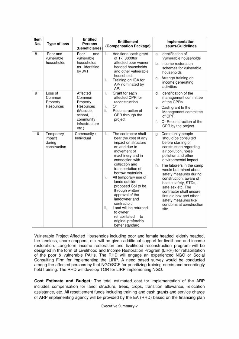
Item No. Type of loss
Entitled Persons
(Beneficiaries)
Entitlement (Compensation Package)
Implementation issues/Guidelines
8 Poor and vulnerable households
Poor and vulnerable households as identified by JVT
i. Additional cash grant of Tk. 3000for affected poor women headed households and other vulnerable households
ii. Training on IGA for AP/ nominated by AP.
a. Identification of Vulnerable households
b. Income restoration schemes for vulnerable households
c. Arrange training on income generating activities
9 Loss of Common Property Resources
Affected Common Property Resources (Mosque, school, community infrastructure etc.)
i. Grant for each affected CPR for reconstruction
ii. Or iii. Reconstruction of
CPR through the project
d. Identification of the management committee of the CPRs
e. Cash grant to the Management committee of CPR
f. Or Reconstruction of the CPR by the project
10 Temporary impact during construction
Community / Individual
i. The contractor shall bear the cost of any impact on structure or land due to movement of machinery and in connection with collection and transportation of borrow materials.
ii. All temporary use of lands outside proposed CoI to be through written approval of the landowner and contractor.
iii. Land will be returned to owner rehabilitated to original preferably better standard.
g. Community people should be consulted before starting of construction regarding air pollution, noise pollution and other environmental impact
h. The laborers in the camp would be trained about safety measures during construction, aware of health safety, STDs, safe sex etc. The contractor shall ensure first aid box and other safety measures like condoms at construction site.
Vulnerable Project Affected Households including poor and female headed, elderly headed, the landless, share croppers, etc. will be given additional support for livelihood and income restoration. Long-term income restoration and livelihood reconstruction program will be designed in the form of Livelihood and Income Restoration Program (LIRP) for rehabilitation of the poor & vulnerable PAHs. The RHD will engage an experienced NGO or Social Consulting Firm for implementing the LIRP. A need based survey would be conducted among the affected persons by that NGO/SCF for prioritizing training needs and accordingly held training. The RHD will develop TOR for LIRP implementing NGO.
Cost Estimate and Budget: The total estimated cost for implementation of the ARP
includes compensation for land, structure, trees, crops, transition allowance, relocation
assistance, etc. All resettlement funds including training and cash grants and service charge
of ARP implementing agency will be provided by the EA (RHD) based on the financing plan

Confidential

1 DESCRIPTION OF THE PROJECT
1.1 Background of the Project
The Government of Bangladesh with the financial loan from Japan International Cooperation Agency (JICA) has undertaken a project named Economic Zone (EZ) Bridge Project in order to improve the communication road network with planned Special Economic Zone (SEZ) in Polash Upazilla of Narshingdi district and road network system of the country. The EZ Bridge will be constructed across the river Sitalakhya by connecting Gazipur and Narshingdi districts in the central part of Bangladesh. This initiative has taken with aim of becoming a middle income country by 2021 by reducing poverty and improvement of road communication system by connecting the important economic potential areas with rest of the country. The EZ Bridge project includes construction of a 835 m long bridge with approach bridge roads of total 4,195 m and a transect road connecting Tongi- Kaliganj regional highway. The EZ Bridge will be constructed over Shitalakhya River at Som Natun Bazar meeting point 14.0 Km up Stream of Kanchan Bridge and 6.0 Km downstream of Bhairab Bridge. The bridge will be connected with the Dhaka- Sylhet highway (N2) via A K Khan Industrial Park, a privately developed industrial park in Polash Upazilla of Narsingdi district. RHD will be the implementing authority of the project.
The location map of planned EZ in Narsingdi is shown in Figure 1.1.
Source: JICA Survey Team
Figure 1.1 Location Map of Planned EZ in Narsingdi
It is observed that only small number people (less than 200) are to be affected at bridge site and along the proposed roads for long term and short term due to the relevant activities. By following OP 4.12 of WB when impacts on the entire displaced population are minor or fewer that 200 people are displaced at bridge site, an Abbreviated Resettlement Plan (ARP) needs to be prepared for the project.
This is the Abbreviated Resettlement Plan (ARP) for the project complies with the Resettlement Framework (RF) prepared based on relevant national law of the Government
Dhaka
R301
N105
Planned EZ
Shitalakhva

of Bangladesh (GOB) Acquisition and Requisition of Immovable Property Ordinance 1982 (ARIPO), amended in 1993 and 1994 and with the policy of the JICA Guidelines for Environmental and Social Considerations and World Bank OP 4.12. An ARP Implementing NGO (INGO) or a Social Consulting Firm (SCF) i.e. NGO or SCF will be engaged by the RHD for implementation of the ARP.
The proposed interventions in the project area to construct the bridge, approach roads and transect road will cause adverse resettlement impacts through displacement of households. The Affected Households (AHs) include owners of land, share croppers and lease holders of land. Besides some trees on the private lands will need to be fell down due to the project. However, the impacts on these people will be mitigated in accordance with Donor’s safeguard policies. Therefore, this abbreviate resettlement plan (ARP) has been prepared for this project, and is designed to assist project affected units (PAUs) to restore their livelihoods and socio-economic conditions to their pre-project status. A total of 39 (PAUs) covering only Households (HHs) have been identified in the Corridor of Impact (COI) of this project including the approach roads and transect road connecting the bridge and Tongi – Kaliganj regional highways.
1.2 Objectives & Purpose of the Project
1.2.1 Potential Impacts
The bridge with a length of 835 m and a width of 10.40m will be constructed with bridge approach roads with a total length of 4,195 m and width of 12.10m on two ends of the bridge and also a transect road to connect the bridge with the national highway.
This EZ Bridge will be a new bridge across the river Shitalakhya at the downstream of Bhairab Bridge and upstream of Kanchan Bridge.
1.2.2 Objective of the Abbreviated Resettlement Plan
The JICA’s Guidelines for Environmental and Social Considerations April 2010 requires that if the screening or social assessment determines that people will experience resettlement impacts a time-bound action plan with appropriate budget provisions is to be prepared and incorporated as an integral part of project design. However, The OP 4.12 of World Bank (WB) clearly narrated that where entire involuntary displaced population is minor, or fewer than 200 people are displaced from COI area of the project, an Abbreviated Resettlement Plan (ARP) may serve the purpose. By following this principle this ARP addresses both land acquisition and resettlement issues within the legal framework of the Government of Bangladesh (GOB) and JICA’s Guidelines for Environmental and Social Considerations that highlights on social impacts including involuntary resettlement, respect for the human rights of indigenous people and so on and covers the APs under resettlement/rehabilitation program providing income restoration and poverty reduction assistance to the eligible APs and the poor and informal settlers on the Corridor of Impact (COI). Thus, the ARP approach incorporates (i) land acquisition and resettlement issues; (ii) impact mitigation with special attention to the women and vulnerable groups and (iii) income generation support to the eligible members of the AP families and (iv) poverty reduction assistance to the poorest section of the people.
The policy requires that a plan be prepared that sets out all of the compensation and rehabilitation support to be provided to any person, family or household who on account of the execution of the project would have his, her or their:
• Standard of living adversely affected; • Income earning opportunities, business, occupation, work or place of residence or
habitat adversely affected temporarily or permanently; • Right, title or interest in any house, or interest in or right to use any land including
premises, agricultural and grazing land, commercial properties, tenancy, or right in

annual or perennial crops and trees or any other fixed or moveable assets, acquired or possessed, temporarily or permanently; or
• Social and cultural activities and relationships and other losses that may be identified during the process of resettlement planning.
The objective of the ARP is to provide a strategy for providing PAUs with replacement value of land, structure, trees and other physical assets and restoration of income levels/living standards either through a compensation and rehabilitation package that ensures that PAUs are not left in a position where they are worse off with the project than without it. Thus, in accordance with JICA policy, abbreviated resettlement plan, depending on the magnitude of impacts - has been prepared for the Project.
Objectives of the project and Abbreviated Resettlement Planning have been disclosed to the affected persons through community based consultation meetings and focus group discussions in local language in two phases of stakeholders/community consultation as well as during conducting census and socioeconomic survey. Compensation and other assistances will have to be paid to Affected Persons (APs) prior to displacement or dispossession of assets. Upon approval, the final ARP will be uploaded immediately on the RHD website.
1.2.3 Methodology for Preparing the Abbreviated Resettlement Plan
The Consultant conducted census & socioeconomic survey during 7 to 10 July 2014 for information necessary for preparation of this ARP. The survey was also associated with stakeholders’ consultation, focus group discussion and property valuation survey.
The adverse impacts include land acquisition and displacement of households. The data gathered during the survey has been entered into an electronic database which identified each affected household (AH) and the way they are impacted and losses they will incur. The objective of the census and socioeconomic survey was to establish a detailed inventory of the households and physical assets to be affected by the project; develop a socioeconomic profile of the AHs and affected persons (APs). The surveys also serve as a benchmark for monitoring and evaluation.
The surveys indicate that construction of bridge, approach bridge roads and transect road will require acquisition of about 12.49 hectare of land. In total the Project will affect 39 Project Affected Units (PAUs), all the PAUs are residential households with a total population of 190. According to the JICA’s “Guidelines for Environmental and Social Considerations” appropriate consideration must be given to vulnerable social groups such as women, children, the elderly, the poor and ethnic minorities, all members of which are susceptible to environmental and social impacts and may have little access to decision making process in the society. Therefore, this ARP has been prepared to mitigate the impacts on Affected Households (AHs) and restore their livelihoods and incomes to pre-project level.
This ARP has been prepared based on the National Law ARIPO (GoB) and the JICA’s Guidelines for Environmental and Social Considerations. The ARP establishes the provisions for resettlement of AHs by providing income restoration assistance to the poor and vulnerable households and compensation under law and additional resettlement benefits where applicable; provides a description of socio-economic characteristics of AHs; sets out the implementation schedule; and provides the budget and cost estimate of implementing this ARP.
This ARP will be reviewed at implementation stage and updated by the RHD if required. At that time the budget will be revised to reflect any changes in numbers of AHs or losses compared with those identified during the survey as well as adjusting for any changes in inflation.

2 SOCIO-ECONOMIC CHARACTERISTICS OF AFFECTED HOUSEHOLDS
2.1 Methodology for Census and Socioeconomic Survey
The census and a socio-economic survey was carried out during 7 to 10 July 2014 to provide requisite details on the Project Affected Units (PAUs) to further assess the magnitude of likely impacts and to identify measures for mitigation of adverse impacts. The survey included (i) full census and socioeconomic survey with structured questionnaire and inventory of losses (Annex 1 and 2), (ii) surveys for land valuation and other assets through structured questionnaire (Annex 3); (iii) Video filming of the affected properties and (iv) community based public consultation etc. The survey identified the households who would lose land, structures and trees on project Corridor of Impact (COI).
The socioeconomic survey collected a wide range of data, for example, demography, age/sex distribution, education, occupation, income/poverty data, types and ownership status of affected structures and other assets.
2.2 The Project Area
The EZ Bridge is to be constructed across the river Shitalakhya connecting two districts Gazipur and Narshingdi through two Upazillas namely Kaliganj and Polash. The project comprised of bridge itself, two bridge approach roads at two end of the bridge and one intersect road in Kaliganj Upazilla connecting the bridge with Kaliganj–Tongi regional highway in Gazipur district. Distribution of Upazilla wise number of project affected households are shown in the Table 2.1.
Table 2.1 Upazilla wise Project Affected Households
Project District
EZ Bridge
Gazipur
Narshingdi
Sub-total Source: Census & Socioeconomic survey, July 2014
Out of the total 39 affected units in other wards residential households identified on the Corridor of Impact (CoI). All the affected households are losing land, structures and trees. A total of 3,709 square meter different categories of structures are getting affected by the interventions. The impacts of this project are shown in the Table 2.2.
Table 2.2 Distribution of Impacts of the Project
Sl. no. Loss type No/Total
1 Total quantity of land (Hectare) affected 12.49
2 Total number of Households (Land with Structure) affected 39
3 Total number of structures affected 81
4 Total quantity of structure (sq.m) affected 3,709
5 Total no. of toilets affected 36
6 Total no. of tube wells affected 34
7 Total no. of trees on private land affected 12,259
Source: Census & Socioeconomic survey, July 2014

2.3 Profile of Affected Households
2.3.1 Population
A total of 190 people have been identified to be affected by this project by losing land, residential structure and trees. Average household size of the project area is 5.0 which is much higher than the national average (4.5). Out of the total affected population, 97 (51.05%) male and 93 (48.95%) are female. One disable person is found in the project area. In the project area no ethnic minority community or people are found. A list of project
affected households is enclosed in Annex-I. Upazilla wise number of affected male and female population is shown in the Table 2.3.
Table 2.3 Population of the Affected Households by Upazilla
District Gazipur Narsingdi Total
Upazilla Kaliganj Polash
Gender No. % No. % No. %
Male 57 54.81 40 46.51 97 51.05
Female 47 45.19 46 53.49 93 48.95
Total 104 100.00 86 100.00 190 100.00 Source: Census & Socioeconomic survey, July 2014
Among the affected households 36 are male headed and 3 are female headed households. Young population comprised a very high percentage of population. More than 35% population is from the age group of 0-18 years of age. Next big group is of the age group of 19-34. On the other hand more than 12% people are of the age of 60 and above. Distribution of households by age group is shown in Table 2.4.
Table 2.4 Affected Population of Households by Age group by Upazilla
District Gazipur Narsingdi Total
Thana Kaliganj Polash
Age Group No. % No. % No. %
0-4 9 8.65 11 12.79 20 10.53
5-18 21 20.19 27 31.40 48 25.26
19-34 36 34.62 30 34.88 66 34.74
35-49 15 14.42 9 10.47 24 12.63
50-59 6 5.77 2 2.33 8 4.21
60+above 17 16.35 7 8.14 24 12.63
Total 104 100.00 86 100.00 190 100.00
Source: Census & Socioeconomic survey, July 2014
Average household size is 5 which is much higher than the national average of 4.5. More than one quarter (25.64%) of the households are composed of four and five members, 20.51% households are composed of 3 members. On the other hand about 26% households have more than five members in the household (Table 2.5).

Table 2.5 Households Size of the Affected Household by Upazilla
District Gazipur Narsingdi Total
Thana Kaliganj Polash
Household Size No. % No. % No. %
1 0 0.00 0 0.00 0 0.00
2 0 0.00 1 5.26 1 2.56
3 4 20.00 4 21.05 8 20.51
4 6 30.00 4 21.05 10 25.64
5 3 15.00 7 36.84 10 25.64
More than 5 7 35.00 3 15.79 10 25.64
Total 20 100.00 19 100.00 39 100.00 Source: Census & Socioeconomic survey, July 2014
High percentage (33.33%) of the households is headed by population of 60 years old or above. About one fourth heads are within the range of 20-30. It is remarkable that no household has been identified in the project area headed by a person less than 20 years of age. Table 2.6 shows the age of head of the affected households in the project area.
Table 2.6 Affected head of households by age group by Upazilla
District Gazipur Narsingdi Total
Thana Kaliganj Polash
Age Group No. % No. % No. %
<20 0 0.00 0 0.00 0 0.00
20-30 1 5.00 9 47.37 10 25.64
31-40 5 25.00 4 21.05 9 23.08
41-50 6 30.00 1 5.26 7 17.95
51-59 0 0.00 0 0.00 0 0.00
60+above 8 40.00 5 26.32 13 33.33
Total 20 100.00 19 100.00 39 100.00
Source: Census & Socioeconomic survey, July 2014
2.3.2 Ethnicity, Religion and Gender
Based on findings of the survey, the Project will affect 39 PAUs, in other words 39 households. The impacts and their losses have been described in Chapter 3. Out of total 39 households 38 are Muslim and one is Christian faith. The survey could not identify any household with any other religious believe. No ethnic minority is found in the proposed project locations. Detail of households in terms of religion is shown in Table 2.7
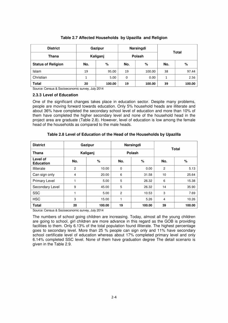
Table 2.7 Affected Households by Upazilla and Religion
District Gazipur Narsingdi Total
Thana Kaliganj Polash
Status of Religion No. % No. % No. %
Islam
Christian
Total Source: Census & Socioeconomic survey, July 2014
2.3.3 Level of Education
One of the significant changes takes place in education sector. Despite many problems, people are moving forward towards education. Only 5% household heads are illiterate and about 36% have completed the secondary school level of education and more than 10% of them have completed the higher secondary level and none of the household head in the project area are graduate (Table 2.8). However, level of education is low among the female head of the households as compared to the male heads.
Table 2.8 Level of Education of the Head of the Households by Upazilla
District Gazipur Narsingdi Total
Thana Kaliganj Polash
Level of Education No. % No. % No. %
Illiterate 2 10.00 0 0.00 2 5.13
Can sign only 4 20.00 6 31.58 10 25.64
Primary Level 1 5.00 5 26.32 6 15.38
Secondary Level 9 45.00 5 26.32 14 35.90
SSC 1 5.00 2 10.53 3 7.69
HSC 3 15.00 1 5.26 4 10.26
Total 20 100.00 19 100.00 39 100.00
Source: Census & Socioeconomic survey, July 2014
The numbers of school going children are increasing. Today, almost all the young children are going to school, girl children are more advance in this regard as the GOB is providing facilities to them. Only 6.13% of the total population found illiterate. The highest percentage goes to secondary level. More than 25 % people can sign only and 11% have secondary school certificate level of education whereas about 17% completed primary level and only 6.14% completed SSC level. None of them have graduation degree The detail scenario is given in the Table 2.9.

Table 2.9 Level of Education of the Affected Population (7 years and above) by Upazilla
District Gazipur Narsingdi Total
Thana Kaliganj Polash
Level of Education No. % No. % No. %
Illiterate 7 7.61 3 4.23 10 6.13
Can sign only 24 26.09 18 25.35 42 25.77
Primary 12 13.04 15 21.13 27 16.56
Secondary Level 29 31.52 27 38.03 56 34.36
SSC 6 6.52 4 5.63 10 6.14
HSC 14 15.22 4 5.63 18 11.04
Total 92 100.00 71 100.00 163 100.00
Source: Census & Socioeconomic survey, July 2014
2.3.4 Occupation
The project area is located predominantly in the rural area but nearer to small urban areas like Upazilla headquarters. This is why people who are living around the proposed bridge and along the proposed roads are principally involved with agriculture activities including farming and livestock rearing. About half of the household heads are involved with farming or livestock rearing. However, 23.08% heads are involved with business, about 8% are involved with service in the nearby Upazilla head quarter or in Dhaka city. More than 10% heads have identified as involved in domestic work. Almost all of them are women. Principal occupation of the head of the households is shown in Table 2.10.
Table 2.10 Principal Occupation Head of the Households by Upazilla
District Gazipur Narsingdi Total
Thana Kaliganj Polash
Principal Occupation No. % No. % No. %
Farming/livestock 9 45.00 10 52.63 19 48.72
Business 4 20.00 5 26.32 9 23.08
Service 2 10.00 1 5.26 3 7.69
Labor 0 0.00 1 5.26 1 2.56
Labor with Special skill
1 5.00 1 5.26 2 5.13
Rickshaw/Vanpooler 1 5.00 0 0.00 1 2.56
Domestic Work 3 15.00 1 5.26 4 10.26
Total 20 100.00 19 100.00 39 100.00
Source: Census & Socioeconomic survey July 2014
Principal occupation of the population (10 years and above) of the affected households is domestic work followed by farming or livestock rearing. Most of the female population identified themselves involved in domestic work. In other words majority of the male members are involved with farming or livestock rearing. By following BBS data all the population of more than 10 years old is being considered here. As a result more 15.44% of them are found as student. It reflects that almost all the school going children are going to

school. Professional job (imam, reporter, kazi) seems to be performed by 13.42% of the people. About 9% people are involved with business and only about 2% populations are found earning their livelihood as labor or rickshaw pulling. More than 5% are involved with services (Table 2.11). Their working places are in the Upazilla head quarter or Dhaka city.
Table 2.11 Principal Occupation of the Population (10 Years and above) by Zone
District Gazipur Narsingdi Total
Thana Kaliganj Polash
Principal Occupation No. % No. % No. %
Farming/livestock 15 17.24 10 16.13 25 16.78
Business 4 4.60 9 14.52 13 8.72
Service 6 6.90 2 3.23 8 5.37
Labor 0 0.00 1 1.61 1 0.67
Labor with Special skill
1 1.15 1 1.61 2 1.34
Rickshaw/Vanpooler 1 1.15 0 0.00 1 0.67
Domestic Work 30 34.48 24 38.71 54 36.24
Student 16 18.39 7 11.29 23 15.44
Retired/Old age /Jobless
1 1.15 1 1.61 2 1.34
Others (imam, Reporter, Kazi)
13 14.94 7 11.29 20 13.42
Total 87 100.00 62 100.00 149 100.00 Source: Census & Socioeconomic survey July 2014
2.3.5 Income and Poverty Dimensions
Poverty in Bangladesh is measured through per capita income or through Direct Calorie Intake (DCI) where persons having DCI of less than 2,122 kcal are considered to be living in poverty while a person having DCI of less than 1,805 kcal is considered to be ‘hard core poverty'. As per Statistical Year Book of Bangladesh 2010 average household size is 4.50 and 40.94% households earn maximum BDT 60,000 per year. Based on the census and socioeconomic survey (July 2014) indicating yearly income and expenditure of the project affected households it is found that about 5.12% households earn up to Tk 60,000 per year (Table 2.12). Considering the economic condition of the project area, scope of work and level of income , these 5.12% affected households may be considered as hardcore poor and yearly income of the households within the range of BDT 60,001-1,20,000 is poor, more than BDT 1,20,000 is non-poor. The hard core poor will get special assistance under the policy of ARP and may get special attention for IGA training and other assistance under income and livelihood restoration program (ILRP). A list of vulnerable households earning up
to BDT 60,000/year is enclosed in Annex-II.

Table 2.12 Poverty Level and Annual Income of Head of the Households by Upazilla
District Gazipur Narsingdi Total
Thana Kaliganj Polash
Income No. % No. % No. %
30,001-45,000 1 5.00 0 0.00 1 2.56
45,001-60,000 1 5.00 0 0.00 1 2.56
60,001-80,000 0 0.00 0 0.00 0 0.00
80,001-100,000 0 0.00 0 0.00 0 0.00
100,001-120,000 10 50.00 9 47.37 19 48.72
120.001-135,000 0 0.00 2 10.53 2 5.13
135,001-150,000 0 0.00 2 10.53 2 5.13
150.001-165.000 0 0.00 1 5.26 1 2.56
165,001-180,000 1 5.00 2 10.53 3 7.69
>=180.001 7 35.00 3 15.79 10 25.64
Total 20 100.00 19 100.00 39 100.00 Source: Census & Socioeconomic survey July 2014
2.4 Gender Impacts and Mitigation Measures
Women can be particularly impacted during resettlement, and especially relocation, as they are predominantly responsible for maintaining the cohesion of the family unit as well as being extensively involved in household chores in addition to participating in economic activities. Preparation of food, organizing shelter, arranging sanitation and water facilities and schooling of children are common areas where women play important roles in Bangladeshi households.
The census & SES was designed, undertaken and analyzed in a way to adequately identify gender differences and gender specific impacts. Based on the information provided in the census and SES, only 3 (7.69% of the total) households headed by female have been identified. Heads of these households will be eligible for training and other income generating activities. They will be preferentially employed in project civil work.
These female headed households will be disproportionately affected by resettlement due to traditional roles and responsibilities combined with lack of empowerment. Female APs will require additional support and assistance by income generation activities under LIRP. These female APs or representative of the family as nominated by the head will receive training on Income generating Activities (IGA) through LIRP. Participation of women in decision making is slowly increasing and the projects of various NGOs have played an important role in this improvement. Micro-credit aimed at female beneficiaries is also making a positive impact of poor households.
Considering the disproportionate impact on women and since legal ownership (in terms of title) does not reflect gender equity (i.e. women’s names are not generally recorded on the title), sufficient measures will be taken to ensure women’s rights are protected during the resettlement process. The measures included in the ARP to address gender impacts are:
• Identification of the socio-economic condition, needs, and priorities of women, and monitor and evaluate the impact of land acquisition and resettlement on women separately;
• Identification of the female headed households to be affected and setting of entitlement criteria to recognize female-headed households;

• Provision of such entitlements that women are not disadvantaged by the process of land acquisition and resettlement;
• Preferential employment of affected women in civil construction including road slope turfing, tree plantation, watering and some other similar types of works.
• Female and vulnerable APs will form Labor Contracting Society to bargain with the Contractor
• Separate labor shed with toilets will have to provide for female laborers at construction sites.
• Hiring of female staff in the ARP implementing agency to assist female-headed AHs and women during resettlement activities, including planning and implementation of income restoration programs; and
• Involvement of women's groups in resettlement planning, management, and operations and in job creation and income generation.
2.5 Water and Sanitation
Health and sanitation status of the affected households seems to be good. In the project area all the households own toilet inside the household property with septic tank.
All the project affected households are living in rural areas. As a result garbage management practice has not been developed among them. On the other hand there is no arrangement to manage the garbage like collection by an organized institution. The Table 2.13 reflects the facts by showing that about 98% of the household throw the garbage anywhere. Only about 3% household burn the garbage.
Table 2.13 Management of Household Garbage by Head and by Upazilla
District Gazipur Narsingdi Total
Thana Kaliganj Polash
Occurred Type No. % No. % No. %
Burn it 1 5.00 0 0.00 1 2.56
Throw anywhere 19 95.00 19 100.00 38 97.44
Total 20 100.00 19 100.00 39 100.00 Source: Census & Socioeconomic survey July 2014
All the affected households use tube well water for all purposes. All the households own individual tube wells. Sanitation condition of the project area is well.
Like waste management majority of the household through away the waste water directly outside of the house. All the households are rural dwellers they do not have facilities to through water in a planned manner. However, about 3% household through their water in their septic tank (Table 2.14).

Table 2.14 Management of Waste Water of the Households by Upazilla
District Gazipur Narsingdi Total
Thana Kaliganj Polash
Where Through No. % No. % No. %
Septic tank 0 0.00 1 5.26 1 2.56
Directly outside the house
20 100.00 18 94.74 38 97.44
Total 20 100.00 19 100.00 39 100.00

3 LAND ACQUISITION AND RESETTLEMENT IMPACTS
3.1 Minimizing Land Acquisition and Displacement
RHD has undertaken efforts to minimize and/or avoid land acquisition and resettlement impacts. This project will require land acquisition with a total quantity of 12.49 hectare for all the components including bridge itself, bridge approach road sections and bridge access road section.
3.2 Scope of Land Acquisition
A total of 12.49 ha land will be required to be acquired to implement the project. It is 1.38 ha for bridge approach road sections at the two ends of the bridge and 11.11 ha for the bridge access road section. All of these lands are privately owned.
3.3 Displacement and Other Impacts
In addition to land acquisition, the project works will require to affect 39 households. All the affected households will be displaced due to loss of residential structure. They will lose land with residential structure and trees. 190 people will be displaced due to loss of homesteads. A total of 3,709 sq.m structure will need to be relocated. Beside some secondary structure i.e.36 toilets and 34 tube wells will need to be relocated due to the project.
Table 3.1 Displacement and other Impacts
Sl No Type of Impact No./ha/sq. m
1 Total quantity of Land to be Acquired (ha) 12.49
2 Total number of Households Affected (No) 39
3 Total Quantity of all structure (sq. m) affected 3,709
4 No. of toilets affected 36
5 No. of tube wells affected 34
Source: Census & Socioeconomic survey July 2014
3.4 Asset Inventory and Assessment of Losses
3.4.1 Affected Households
Household structures will be physically displaced by the Project. All the households are included in the ARP as impacts that are to be mitigated through compensation and resettlement assistance. The households will be encouraged for self- relocation and adequate compensation and other resettlement benefits will be paid to them for losses.
3.4.2 Physical Structures Affected
The project will need land acquisition. A total of 39 households are getting affected by the project. A total of 3,709 sq. m different categories of structure have been affected. Out of the total affected structure, 1,437 sq. m is tin made, 1,288 sq. m semi-pucca, 682 sq. m pucca and 302 sq. m katcha (Table 3.2).

Table 3.2 Quantity of All Affected Structure (sqm) by type and by Upazilla
District Gazipur Narsingdi Total
Upazilla Kaliganj Polash
Type of Structure sq. m % sq. m % sq. m. %
Pucca 596 23.59 86 7.27 682 18.39
Sami pucca 1110 43.94 178 15.05 1288 34.73
Tin 640 25.34 797 67.37 1437 38.74
Katcha 180 7.13 122 10.31 302 8.14
Total 2526 100.00 1183 100.00 3709 100.00 Source: Census & Socioeconomic survey July 2014
Besides, 34 tube wells and 36 sanitary latrines (Pucca) have been affected by the interventions. Detail of the affected structures is shown in the Table 3.3.
Table 3.3 Affected Secondary Structures
District Gazipur Narsingdi Total
Upazilla Kaliganj Polash
Type of secondary structure No. No. No.
Tube well 18 16 34
Latrine (Pucca) 20 16 36
Source: Census & Socioeconomic survey July 2014
3.4.3 Trees and Crops Affected
The project will also require removal of 12,259 trees of various sizes and categories from privately owned land, both fruit bearing and timber type, from the private land. Out of these, 9181 big, 1812 medium, 924 small and 342 sapling. Fruit trees are more in number in both the Upazillas.
Besides about 60 species of trees with a total quantity of 12,259 on privately owned land will need to be fell down due to the project. The affected households will get 5 saplings each for social afforestation. Details of trees on private and government land with types and species are shown in the Table 3.4 and Table 3.5.
Table 3.4 Affected Trees on Private Land
Upazilla Types of Trees
Category wise no. of affected trees Total Big Medium Small Sapling
Kaliganj Fruit Tree 3,333 628 260 275 4,496
Timber 1,486 255 170 37 1,948
Polash Fruit Tree 2,042 752 442 10 3,246
Timber 2,320 177 52 20 2,569
Total 9,181 1,812 924 342 12,259 Source: Census & Socioeconomic survey July 2014

Table 3.5 List of Affected Trees on private Land by Tree Name
Name of Tree Sapling Small Medium Big Total Palmyra/Tal 0 0 0 57 57
Batter/Pita 10 0 0 2 12
Papaya 0 10 10 30 50
Custard apple/Ata 0 0 0 4 4
Bamboo 0 0 110 3,010 3,120
Koroi 5 17 66 342 430
Guava 0 0 72 214 286
Shiml 0 0 0 14 14
Mehaguni 30 125 145 159 459
Lemon 0 10 32 148 190
Coconut 5 17 76 217 315
Figs/Dumur 0 0 20 12 32
Berry/Jam 0 10 63 164 237
Jackfruit 80 115 205 350 750
Mango 40 226 257 379 902
Neem 0 15 47 32 94
Wooden Apple (Bel) 0 0 1 11 12
Trot/ Kadom 0 30 4 22 56
Banana 0 200 254 2,930 3,384
Litchi 0 10 16 11 37
Dalim 0 0 0 7 7
Persimmon/Khejur 0 0 0 31 31
Shishu 0 0 0 10 10
Bori (Kul) 0 10 30 26 66
Akasmani 0 0 3 23 26
Bettle Nut trees/Sup 160 60 335 709 1,264
Wood 0 10 0 20 30
Latakana 0 0 0 3 3
Jamrul 0 0 0 2 2
Jambura 0 12 19 26 57
Krishnochura 0 0 2 1 3
Olive 0 0 0 5 5
Amra 0 0 5 14 19
Rayana 0 5 20 5 30
Epilepil 0 0 0 5 5
Jiga 0 20 0 60 80
Bakul 0 0 0 2 2
Shara 0 0 0 4 4
Tetul (Tartar) 0 0 0 10 10
Chalta 0 0 0 2 2
Teak trees/Segun 0 0 0 4 4
Gab 0 0 5 25 30
Deoua 0 5 0 4 9
Kormocha 0 7 5 7 19
Douya 0 10 0 2 12
Chamon 2 0 0 2 4
Kamranga 0 0 0 10 10
Plum 0 0 0 8 8
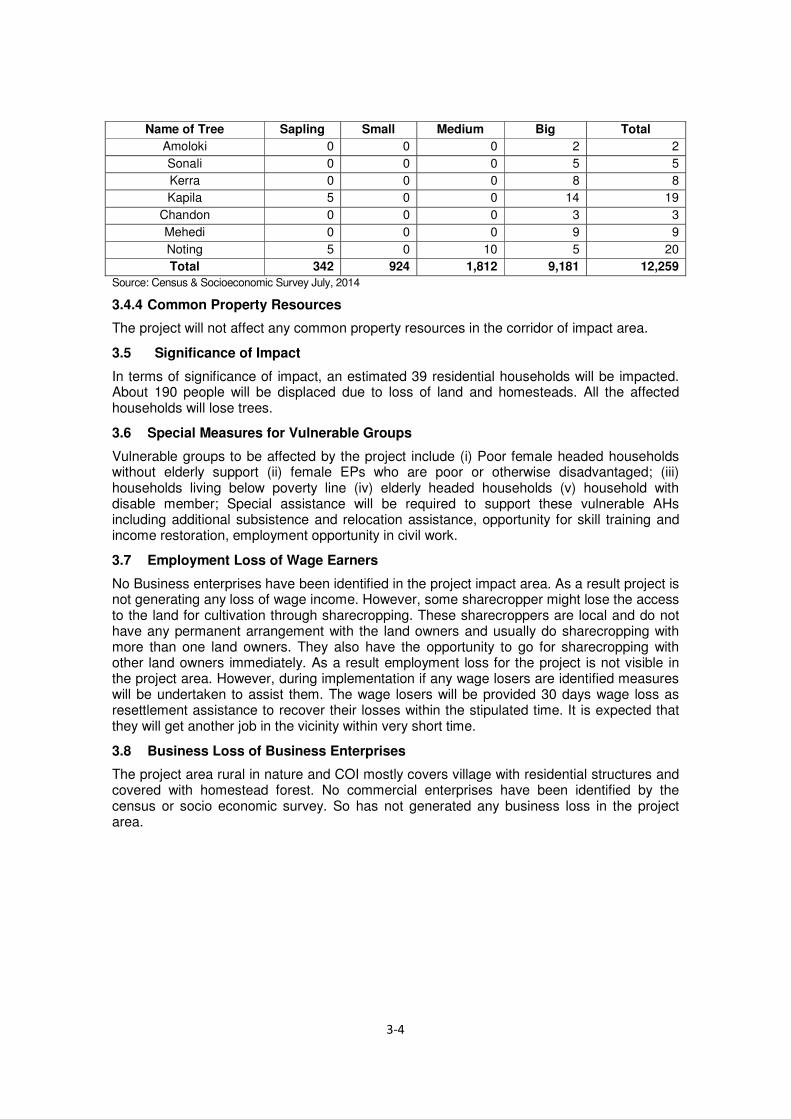
Name of Tree Sapling Small Medium Big Total Amoloki 0 0 0 2 2
Sonali 0 0 0 5 5
Kerra 0 0 0 8 8
Kapila 5 0 0 14 19
Chandon 0 0 0 3 3
Mehedi 0 0 0 9 9
Noting 5 0 10 5 20
Total 342 924 1,812 9,181 12,259 Source: Census & Socioeconomic Survey July, 2014
3.4.4 Common Property Resources
The project will not affect any common property resources in the corridor of impact area.
3.5 Significance of Impact
In terms of significance of impact, an estimated 39 residential households will be impacted. About 190 people will be displaced due to loss of land and homesteads. All the affected households will lose trees.
3.6 Special Measures for Vulnerable Groups
Vulnerable groups to be affected by the project include (i) Poor female headed households without elderly support (ii) female EPs who are poor or otherwise disadvantaged; (iii) households living below poverty line (iv) elderly headed households (v) household with disable member; Special assistance will be required to support these vulnerable AHs including additional subsistence and relocation assistance, opportunity for skill training and income restoration, employment opportunity in civil work.
3.7 Employment Loss of Wage Earners
No Business enterprises have been identified in the project impact area. As a result project is not generating any loss of wage income. However, some sharecropper might lose the access to the land for cultivation through sharecropping. These sharecroppers are local and do not have any permanent arrangement with the land owners and usually do sharecropping with more than one land owners. They also have the opportunity to go for sharecropping with other land owners immediately. As a result employment loss for the project is not visible in the project area. However, during implementation if any wage losers are identified measures will be undertaken to assist them. The wage losers will be provided 30 days wage loss as resettlement assistance to recover their losses within the stipulated time. It is expected that they will get another job in the vicinity within very short time.
3.8 Business Loss of Business Enterprises
The project area rural in nature and COI mostly covers village with residential structures and covered with homestead forest. No commercial enterprises have been identified by the census or socio economic survey. So has not generated any business loss in the project area.

4 LEGAL AND POLICY FRAMEWORK
4.1 Purposes and Objectives of Land Acquisition and Resettlement
The project includes construction of bridge, bridge approach roads and bridge access needing acquisition of 12.49 hectares of private land. The acquisition of land will eventually displace households. The Abbreviated Resettlement Plan (ARP) covers compensation and assistance for resettlement and rehabilitation of APs. Thus, the ARP approach incorporates (i) land acquisition and resettlement issues; (ii) impact mitigation with special attention to the women and vulnerable groups and (iii) income generating support to the members of the AHs to include them in the poverty reduction and livelihood enhancement program.
The main principles of the ARP are to (i) minimize negative impacts in consultation with the design engineers and the APs; (ii) closely consult the affected persons on ARP policy, needs assessment, poverty and rehabilitation issues; (iii) carry out resettlement activities to improve or at least restore the pre-project living standards of the affected persons; (iv) provide compensation for affected property at market price prior to relocation and mainstream the poor and vulnerable APs with the poverty reduction and social development program for rehabilitation and livelihood regeneration.
4.2 Legal Framework for Land Acquisition
The current legislations governing land acquisition for Bangladesh is the Acquisition and Requisition of Immovable Property Ordinance 1982 (ARIPO) and subsequent amendments during 1993 - 1994. The Ordinance requires that compensation be paid for (i) land and assets permanently acquired (including standing crops, fisheries, trees, houses); and (ii) any other damages caused by such acquisition. The Deputy Commissioner (DC) determines the market price of assets based on the approved procedure and in addition to that pays an additional 50 percent (as premium) on the assessed value as the market price established by Land Acquisition Officer (LAO) which remains much below than the replacement value. The 1994 amendment made provisions for payment of crop compensation to tenant cultivators. The Ordinance, however, does not cover project-affected persons without titles or ownership record, such as informal settler/squatters, occupiers, and informal tenants and lease-holders (without document) and does not ensure replacement value of the property acquired. The act has no provision of resettlement assistance and transitional allowances for restoration of livelihoods of the non-titled affected persons. The Acquisition and Requisition of Immovable Property Ordinance (ARIPO, 1982) with its subsequent amendments will be applied for this project.
The Deputy Commissioner (DC) processes land acquisition under the Ordinance and pays compensation to the legal owners of the acquired land. The Ministry of Lands (MOL) is authorized to deal with land acquisition through the DCs. Khas (government owned) lands should be acquired first when a project acquires both khas and private land. If a project acquires only khas, the land will be transferred through an inter-ministerial meeting following the preparation of acquisition proposal submitted to DC/MOL.
The land owner has to establish ownership by producing a record-of-rights in order to be eligible for compensation under the law. The record of rights prepared under Section 143 or 144 of the State Acquisition and Tenancy Act 1950 (revised 1994) are not always updated and as a result legal land owners have to face difficulties in trying to “prove” ownership. The APs must also produce rent receipt or receipt of land development tax, but this does not assist in some situations as a person is exempted from payment of rent if the area of land is less than 25 bighas (3.37 ha).
The Government of Bangladesh has prepared a draft national policy on involuntary resettlement funded by ADB but yet to be enacted, which is consistent with the general policy of the Government that the rights of those displaced by development project shall be fully respected, and persons being displaced shall be treated with dignity and assisted in

such a way that safeguards their welfare and livelihoods irrespective of title, gender, and ethnicity.
The Policy on involuntary resettlement recognizes that:
i.) All those displaced involuntarily by either project or non-project impacts like erosion and eviction must be resettled and rehabilitated in a productive and sustainable manner.
ii.) People who are resettled must be able, through their own efforts and/or with support as may be required, to restore or improve upon their level of living.
iii.) Cash compensation shall be paid in development project at replacement value to those displaced from land and dispossessed of other assets acquired based on established prior ownership and/or user rights. In addition to cash compensation and resettlement, a benefit sharing may be considered where feasible.
iv.) Cultural and customary rights of people affected by project are to be protected, particularly those belonging to adibasis (indigenous people) and ethnic minorities.
v.) Gender equality and equity in all stages and processes of resettlement and rehabilitation will be fully respected.
vi.) Affected persons will be informed and consulted in a transparent manner, including formal disclosure of project impacts and mitigation measures.
vii.) Vulnerable groups, including landless, adibasis, poor women headed households, physically challenged people, elderly and those falling below the nationally defined poverty line (by the government) displaced by project or non-project impacts, are entitled to additional benefits and assistance in a manner that addresses their specific needs related to socio-economic vulnerability.
viii.) Similarly, affected persons and/or businesses on government leased land will be eligible for compensation for loss of access to land and sites.
The draft Policy was submitted to the Government in November 2007. It has been approved by the Ministry of Land on 1 January 2008 and is placed before the Cabinet later in February 2008. After cabinet approval, the Government will undertake further work towards legislative changes to safeguard resettlement rights by law.
4.3 JICA’s Guidelines for Environmental and Social Considerations
The resettlement policy of JICA is almost similar to other donor’s policy on involuntary resettlement. The JICA Guidelines for Environmental and Social Considerations (April 2010) on the other hand, recognize & address the R&R impacts of all the affected persons irrespective of their titles and requires for the preparation of ARP in every instance where involuntary resettlement occurs. The JICA policy requirements are:
i.) Avoid or minimize impacts where possible; ii.) Consultation with the local stakeholders people or group (including illegal dwellers),
local NGOs, etc. who have views about cooperation projects. iii.) Payments of compensation for acquired assets at the replacement value; iv.) Ensure that no one is worse off as a result of resettlement and would maintain their at
least original standard of living. v.) Resettlement assistance to affected persons, including non-titled persons; and vi.) Special attention to vulnerable people/groups and ethnic minorities.
4.4 Gap and Gap Filling Measures
The land acquisition law of Bangladesh, the Acquisition and Requisition of Immovable Property Ordinance (ARIPO) 1982 with subsequent amendments during 1993 – 1994 is followed for acquisition and requisition of properties required for the development project in Bangladesh, which is not consistent with the Government’s commitment to reducing poverty. There are some gaps in the land acquisition law of Bangladesh and The JICA Guidelines for

Environmental and Social Considerations (GESC, April 2010). Here is the comparative analysis between the GoB laws (ARIPO) related to land acquisition, compensation and involuntary resettlement and JICA’s requirements as prescribed in the GESC 2010. The Table 4.1 describes details.
Table 4.1 Comparison between the Government of Bangladesh and JICA Guidelines for Environment and Social Consideration - Land Acquisition and Resettlement
Sl. No. JICA’s GESC (2010)
GOB’s Acquisition and Requisition of
Immovable Property Ordinance (ARIPO)
of 1982
Gaps Between ARIPO and JICA’s Policies and Action Taken to
Bridge the Gap
Proposed Gap Filling Measures
1 Involuntary resettlement should be avoided wherever possible.
Not specified The 1982 ordinance legislated nothing, while the JICA Guidelines require to avoid/minimize resettlement/loss of livelihood
Like other donor funded projects in Bangladesh the approach of avoiding involuntary resettlement has already been taken care during preparing this project. This will be further practiced during design and implementation stages.
2 When population displacement is unavoidable, effective measures to minimize impact and to compensate for losses should be taken.
Not specified for non-titled people
There is no provisions for compensation to the non-titled residents in Bangladesh ordinance, while JICA guidelines acknowledge all affected persons whether legally residing or not, eligible for compensation
Compensations are proposed even if non-titled affected people providing:
- Compensation for structures, trees
- Structure transfer assistance
- Structure reconstruction assistance
- Moving assistance for residential house owner
- Tenant moving allowance
3 People who must be settled involuntarily and people whose means of livelihood will be hindered or lost must be sufficiently compensated and supported, so that they can improve or at least restore their standard of living, income opportunities and production levels to pre0project levels.
Not specific for keeping living standard of affected people same or above pre-project levels.
There is no provisions for maintaining living standard of affected people at same or above pre-project levels in Bangladesh ordinance, while JICA guidelines require that no one is worse off as a result of resettlement and would maintain their living level at least original levels
Assistances were proposed in the form of:
- Grant for business loss - Compensation for loss
of plant and fish-stock - Grant for loss of wage
employment - Rental fee loss for
displaced rented house owner
- One time moving assistance for tenant business owner
- Introduction of micro-credit
- Provision of job training - Provision of priority
employment etc. 4 Compensation must
be based on the full replacement cost as much as possible
Compensation is made based on the pre-determined government prices as are usually quite cheaper than market price
Compensation is made based on the pre-determined government prices that are usually lower than replacement cost
The resettlement plan addresses all these issues and spells out a mechanism to fix the replacement cost by having an independent evaluator (committee) who will be responsible for deciding the replacement

Sl. No. JICA’s GESC (2010)
GOB’s Acquisition and Requisition of
Immovable Property Ordinance (ARIPO)
of 1982
Gaps Between ARIPO and JICA’s Policies and Action Taken to
Bridge the Gap
Proposed Gap Filling Measures
costs.
5 Compensation and other kinds of assistance must be provided prior to displacement
Payment is made on predetermined time, regardless before or after the construction starts
Compensations and other assistances are made regardless before or after construction, while JICA Guidelines requires to make it prior to relocation
The resettlement plan addresses all these issues and spells out a mechanism for all the compensation will be paid prior to possession of the acquired land / prior to displacement
6 For projects that entails large-scale involuntary resettlement, resettlement action plans must be prepared and made available to the public.
There is no provision for the formulation of ARP and public hearing. Deputy Commissioner contacts to land owner through land Acquisition Officer (LO), and if landowner has no objection, confirm operation for compensation amount etc. will be proceeded.
There is no provision for preparation of resettlement action plan that describes all features of resettlement requirements and ready to disclose to public.
The Abbreviated Resettlement Plan (ARP) prepared for this project with all features of resettlement requirements and mechanism of disclosure to the public is integral part of ARP. This will be further practiced during design and implementation stages.
7 In preparing a resettlement action plan, consultations must be held with the affected people and their communities based on sufficient information made available to them in advance.
The 1982 Ordinance have provisions to notify only the owners of property to be acquired
There is no provision in the law for consulting the stakeholders but the land allocation committees at district, division and central government level.
The ARP/resettlement plan for the project has been prepared following a consultation process which involves all stakeholders (affected persons, government department/line agencies, local community, NGORP, etc.), and the consultation will be a continuous process at all stages of the project development such as project formulation, feasibility study, design, implementation, and post-implementation, including the monitoring phase.
8 When consultation held, explanation must be given in a form, manner, and language that are understandable to the affected people
There is no provisions Requirements of JICA Guidelines are not specifically mentioned in the Bangladesh laws and rules
The resettlement plan for the project has been prepared following a consultation process with all stakeholders in local language and by following participatory process with question and explanation on the components of the ARP through participation of all the stakeholders representing different groups and the consultation will be a continuous process at all stages of the project development such as project formulation, feasibility study, design, implementation, and post-implementation, including the monitoring phase.
9 Appropriate There is no provision There is no provisions The resettlement plan for

Sl. No. JICA’s GESC (2010)
GOB’s Acquisition and Requisition of
Immovable Property Ordinance (ARIPO)
of 1982
Gaps Between ARIPO and JICA’s Policies and Action Taken to
Bridge the Gap
Proposed Gap Filling Measures
participation of affected people must be promoted in planning, implementation, and monitoring of resettlement action plans
for the monitoring related activities with the participation of affected people
in Bangladesh ordinances, while JICA Guidelines recommend a participation of affected people in planning, implementation and monitoring of ARP
the project has been prepared following a consultation process with all stakeholders and the consultation will be a continuous process at all stages of the project development such as project formulation, feasibility study, design, implementation, and post-implementation, including the monitoring phase.
10 Appropriate and accessible grievance mechanisms must be established for the affected people and their communities
Increase AP have objection to compensation amount, the AP should protest and entrust the matter to the Arbitrator. If AP has to appeal against Arbitrator’s decision, then AP should file a law suit to the court and wait for the sentence.
The laws of Bangladesh states appeal to Arbitrator and court case, while JICA guidelines recommend establishing appropriate grievance redress mechanism for amicable settlement to minimize legal confrontation.
The resettlement plan prepared for this project has made a provision of setting up of grievance redress mechanism accessible for all the affected people including non-titled affected people.
11 Affected people are to be identified and recorded as early as possible in order to establish their eligibility through an initial baseline survey (including population census that serves as an eligibility cut-off date, asset inventory, and socio-economic survey), preferably at the project identification stage, to prevent a subsequent influx of encroachers of others who wish to take advantage of such benefit.
No such an activity required
There is no provision in Bangladesh ordinances, while JICA Guidelines recommend identification of affected people there in least possible time preferably at the project identification stage.
This ARP has been prepared based on the data collected through conducting a census, socioeconomic survey for the displaced persons and making inventory of losses. Video filming has also been done for the affected properties.
12 Eligibility of benefits includes, the PAPs who have formal legal rights to land (including customary and traditional land rights recognized under la), the PAPs who do not have formal legal rights to land at the time of census but have a claim to such land or assets and the PAPs who have no recognizable legal right to the land they
There is no provision. Requirements of JICA guidelines are not specifically mentioned in the Bangladesh laws and rules.
The resettlement plan ensures the compensation and assistance to all affected persons, whether physically displaced or economically displaced, irrespective of their legal status. The end of the census survey will be considered as the cut-off date, and affected persons listed before the cut-off date will be eligible for assistance.

Sl. No. JICA’s GESC (2010)
GOB’s Acquisition and Requisition of
Immovable Property Ordinance (ARIPO)
of 1982
Gaps Between ARIPO and JICA’s Policies and Action Taken to
Bridge the Gap
Proposed Gap Filling Measures
are occupying
13 Preference should be given to land –based resettlement strategies for displaced persons whose livelihoods are land-based.
There is no provision. Requirements of JICA Guidelines are not specifically mentioned in the Bangladesh laws and rules.
Though this option may be a difficult proposition given the lack of government lands and the difficulties associated with the acquisition of private lands, the resettlement plan proposes land-for-land compensation as its priority, if feasible. Attempt will be made to find alternate land for the loss of land, in case it is available and if it is feasible, looking at the concurrence of host community and land value.
14 Provide support for the transition period (between displacement and livelihood restoration)
There is no provision for support for the transition period.
There is no provision in Bangladesh ordinances, while JICA Guidelines require providing support for the transition period.
Following are provided in the ARP:
- Moving assistance for residential house owners
- Tenant moving allowance
15 Particular attention must be paid to the needs of the vulnerable groups among those displaced, especially those below the poverty line, landless, elderly, women and children, ethnic minorities etc.
There is no provision for either acknowledgment of or compensation to vulnerable groups
There is no provision in Bangladesh ordinances, while JICA Guidelines require providing special attention to vulnerable people and groups.
Vulnerable allowances were proposed to widowed, old, disabled and poor house head families such as :
- Special Assistance for Vulnerable households
16 For project that entails land acquisition or involuntary resettlement of fewer that 200 people, abbreviated resettlement plan is to be prepared
There is no provision Requirements of JICA Guidelines are not specifically mentioned in the Bangladesh laws and rules
ARP has been prepared since the displaced people are estimated fewer than 200 at each project bridge.
JICA = Japan International Cooperation Agency, ARIPO = Acquisition and Requisition of Immovable Property Ordinance 1982, GESC = Guidelines for Environmental and Social Consideration
4.5 Types of Losses and Impact Category
The types of losses due to undertaking of the project include (i) loss of land (homestead, commercial, agricultural and pond); (ii) residential/ commercial and community structures; (iii) loss of trees and crops; (iv) loss of work days/incomes due to dislocation and relocation of households and businesses, (v) loss of access to land and premises for residence, cropping and trading.
The following categories of APs are likely to be impacted during implementation of the project:

i.) APs whose land is affected–APs whose land is being used for agricultural, residential or commercial purposes and is affected either in part or in total and the effects are either temporary or permanent;
ii.) APs whose structures are affected–APs whose structures (including ancillary and secondary structures) are being used for residential, commercial or worship purposes which are affected in part or in total and the effects are either temporary or permanent;
iii.) APs with other assets affected–APs who have other assets, such as crops or trees, affected either temporarily or permanently;
iv.) APs losing access to vested and non-resident property–APs who are enjoying access to vested and non-resident property, both owned and purchased, will be losing their rights to cultivate and use those lands, when acquired.
v.) APs losing income or livelihoods–APs whose tenancy right, business, source of income or livelihood (including employees of affected businesses) is affected in part or in total, and affected either temporarily or permanently;
vi.) Vulnerable APs– APs included in any of the above categories who are defined as vulnerable.
4.6 Principles, Legal and Policy Commitments
The ARP has the following specific principles based on the government provisions and JICA’s Guidelines for Environmental and Social Considerations:
a) The land acquisition and resettlement impacts on persons affected by the project would
be avoided or minimized as much as possible through alternate design options;
b) Where the negative impacts are unavoidable, the persons affected by the project and
vulnerable groups will be identified and assisted in improving or regaining their standard
of living.
c) Information related to the preparation and implementation of resettlement plan will be
disclosed to all stakeholders and people’s participation will be ensured in planning and
implementation. The resettlement plan will be disclosed to the APs in local language;
d) Land acquisition for the project would be done as per the Acquisition and Requisition of
Immovable Property Ordinance 1982 and subsequent amendments during 1993-1994.
Additional support would be extended for meeting the replacement value of the property.
The affected persons who does not own land or other properties, but have economic
interests or lose their livelihoods will be assisted as per the broad principles described in
this document.
e) Before taking possession of the acquired lands and properties, compensation and
Resettlement and Rehabilitation (R&R) assistance will be paid in accordance with the
provisions described in this document;
f) An entitlement matrix for different categories of people affected by the project has been
prepared. People moving in the project area after the cut-off date will not be entitled to
any assistance. In case of land acquisition the date of notification under section 3 for
acquisition will be treated as cut-off date. For non-titleholders such as informal settlers /
squatters and encroachers the date of census survey or a similar designated date
declared by the executing agency will be considered as cut-off date.
g) Appropriate grievance redress mechanism will be established to ensure speedy
resolution of disputes.
h) All activities related to resettlement planning, implementation, and monitoring would
ensure the involvement of women and other vulnerable groups.
i) Consultations with the APs will continue during the implementation of resettlement and
rehabilitation works.
j) There should be a clause in the contract agreement that the construction contractor will
compensate any loss or damage in connection with collection and transportation of
burrow-materials.
In accordance with the resettlement principles suggested for the project, all affected households and persons will be entitled to a combination of compensation packages and resettlement assistance depending on the nature of ownership rights on lost assets, scope of the impacts including socio-economic vulnerability of the affected persons and measures to support livelihood restoration if livelihood impacts are envisaged. The affected persons will be entitled to (i) compensation for the loss of land, crops/ trees at their replacement value; (ii) compensation for structures (residential/ commercial) and other immovable assets at their replacement value; (iii) assistance for loss of business/ wage income; (iv) assistance for shifting and reconstruction of affected structures. This will ensure that persons affected by land acquisition; whether titled or non-titled will be eligible for appropriate compensation/resettlement benefit. Persons having no legal title but using the land under acquisition if vacated for the project purpose would be provided with compensation and resettlement benefit for structures and shifting/reconstruction allowance. Households having customary rights to land and physical property like the owners and users of vested and non-resident property, lessees of homestead, commercial and agricultural land, sharecroppers, renters of land and structure, etc. are also covered under the resettlement action plan. The ARP also includes opportunities for occupational skill development training for income generation activities for the APs, especially for poor households. The people involuntarily displaced from homes, assets, or income sources as well as non-titled people affected by the project will receive priority access to these income restoration measures. The resettlement activities of the project will be carried out in consultation with the APs and all efforts will be made to minimize disruption during project implementation. APs will be encouraged for self-relocation and their preferences will be taken into account in the selection of alternative relocation sites.
4.7 Eligibility Policy and Entitlement Matrix
4.7.1 Eligibility Criteria
All APs will be entitled to compensation and resettlement assistance based on severity (significance) of impacts. Nevertheless, eligibility to receive compensation and other assistance will be limited by the cut-off date. The cut-off date for compensation under law (Ordinance II of 1982 and its 1994 amendments) is considered for those identified on the project right of way land proposed for acquisition at the time of serving notice under Section 3 or joint verification by DC whichever is earlier. The cut-off date of eligibility for resettlement assistance under this ARP is the commencement date of the disclose of entitlements and consultation meeting with the stakeholders which was held on 9th July 2014 and 19th August 2014 for the APs staying on public lands. The absence of legal title will not bar APs from compensation and assistance, as specified in the entitlement matrix (Table 4.2).
Structures located on non-titled land or GOB land, if displaced, will be entitled for compensation under the Project. Vulnerable APs or AHs will qualify for additional assistance to facilitate them relocation and restoration of their livelihoods.
Non-vulnerable households with structures affected will be entitled to compensation for structures and assistance for shifting and reconstruction of the same. Any structure not directly used by a non-vulnerable household i.e. rented out for income will also not qualify for additional resettlement assistance.
4.7.2 Compensation and Entitlement Policy
An Entitlement Matrix has been prepared on the basis of census and socioeconomic survey conducted during 7 to 10 July 2014. It identifies the categories of impact based on the census & SES and shows the entitlements for each type of loss. The matrix describes the

units of entitlements for compensating the lost assets, and various resettlement benefits. Cash Compensation under law (CCL) for lost assets (land, tree, structure & other physical establishments) will be accorded to the owners through the DCs as per market value assessed through legal procedure. The resettlement benefit for indirect losses and difference between replacement value and the CCL will be paid by RHD through ARP Implementing Agency.
The compensation and entitlement matrix is presented in Table 4.2.
Table 4.2 Compensation and Entitlement Matrix
Item No. Type of loss
Entitled Persons
(Beneficiaries)
Entitlement (Compensation Package)
Implementation issues/Guidelines
1 Loss of homestead, commercial,
Agriculture land, pond, ditches and orchards etc.
Legal owner(s) of land
i. Replacement value (RV) of land (Cash Compensation under Law (CCL) and additional grant to cover the current market price of land and stamp duty & registration cost @ 10.5% of CMP for land) to be determined by PVAT.
ii. Dislocation allowance @ BDT 100 per decimal for agricultural, fish pond, ditch, etc. and @ BDT 200/decimal for homestead, orchard and commercial lands.
iii. Compensation for standing crops to actual owners/ cultivators as determined by PVAT.
a. Assessment of quantity and quality of land by Joint Verification Survey
b. Assessment of Market Value by Land Market Survey (LMS)
c. Assessment of Cash Compensation under Law (CCL)
d. Updating of title of the affected persons
e. Payment of Cash Compensation under Law (CCL)
f. APs will be fully informed of the entitlements and procedures regarding payments
g. Additional cash grant to be paid to cover the replacement value of land compensation based on DC’s CCL .
h. Stamp duty and registration fees will be added with current market price (CMP) for land @ 10.5% of CMP to facilitate the APs in purchasing alternative lands.
2 Loss of access to cultivable land by owner cultivator/ tenant/ sharecropper
Tenants/ sharecropper/ Legal owner/ grower/ socially recognized owner/ lessee/ unauthorized occupant of land
i. Compensation for standing crops to owner cultivator/ sharecroppers or lessees as determined by PVAT.
ii. Owner/grower to take away the crop
a. All the individuals identified by the JVS as tenants or sharecroppers of land
b. Compensation to be paid after taking possession of land and the legal /socially recognized owner is paid cash compensation for crop and on certification of receipt by legal/socially

Item No. Type of loss
Entitled Persons
(Beneficiaries)
Entitlement (Compensation Package)
Implementation issues/Guidelines
recognized owner
c. Additional cash grant to cover current market value of crop compensation as prescribed by PVAT in case of private owner himself cultivating crop
d. Crop compensation and the crop will be shared between owner and sharecropper as per terms of sharecropping in case of privately owned land/socially recognized owner
e. In case of dispute over verbal agreement on sharecropping, certification from the elected representative will be considered as legal document
3 Loss of Trees/ Perennials/ fish stocks
1. Person with Legal Ownership of the land
3. Socially recognized owner/ Unauthorized occupant of the trees/ fishes
i. Cash compensation at market rates for replacement of trees/ perennials/ fish stocks value
ii. For fruit bearing trees- compensation for fruits @ 30% of timber value X 1 year
iii. Compensation for fish stocks as determined by PVAT.
iv. saplings will be distributed free of cost among each affected household losing trees
v. Owners will be allowed to fell and take away their trees, perennial crops/ fishes etc. free of cost without delaying the project works.
a. Assessment of loss and market value of affected trees
b. Payment of CCL for trees
c. Adequate compensation will be paid and the owner will be allowed to fell and take the tree free of cost
d. Compensation for fruit will paid for small, medium and large categories of trees.
e. 5 saplings (2 fruit tree, 2 timber type and 1 medicinal tree) free of cost will be distributed among the tree losing households.
4 Loss of residential /commercial structure by owner(s)/
Legal Owners or squatters
i. Replacement value of structure at market price determined by PVAT.
ii. Transfer grant @
a. Payment of CCL for the losses
b. Verification of Joint Verification Survey (JVS) and other records

Item No. Type of loss
Entitled Persons
(Beneficiaries)
Entitlement (Compensation Package)
Implementation issues/Guidelines
squatters
Tk.12.50% of the replacement value of main structure
iii. Reconstruction grant @ Tk.12.50% of the replacement value of main structure.
iv. Owners to take away all salvage materials free of cost
c. APs will be fully informed about their entitlements and assisted to obtaining it.
5 Loss of access to Residential houses/ commercial structures
(rented or leased)
Tenants of rented/ leased properties
i. One time cash grant for facilitating alternative housing/CBEs Tk. 3000.00 per household or entity
ii. Shifting allowance per household based on family members @ Tk. 500/- per member with minimum Tk. 2000
a. Verification of JVS and records
b. Shifting allowance will be paid on relocation from project site
6 Loss of business by CBEs due to dislocation
Owner/operator of the business as recorded by JVS
i. Business restoration grant @ Tk. 10,000 for each business unit.
a. All persons recorded by the JVS
b. cash grant to be paid while taking possession of land
7 Loss of Income and work days due to displacement
Employees identified by the Joint Verification Team (JVT)
i. Cash grant to the affected employees/wage earners equivalent to 30 days wage @ Tk. 300/per day
ii. Preferential employment in the project construction work, if available.
a. All persons recorded by the JVS
b. Cash grant to be paid while taking possession
c. Involvement of the incumbents in project civil works
d. Training on income generating activities such as Pisiculture, livestock and poultry, horticulture, welding, mechanics, plant cultivation, social forestry, etc.
8 Poor and vulnerable households
Poor and vulnerable households as identified by JVT
i. Additional cash grant of Tk. 3000for affected poor women headed households and other vulnerable households
ii. Training on IGA for AP/ nominated by AP.
a. Identification of Vulnerable households
b. Income restoration schemes for vulnerable households
c. Arrange training on income generating activities
9 Loss of Common Property Resources
Affected Common Property Resources
i. Grant for each affected CPR for reconstruction
ii. Or
a. Identification of the management committee of the CPRs
b. Cash grant to the

Item No. Type of loss
Entitled Persons
(Beneficiaries)
Entitlement (Compensation Package)
Implementation issues/Guidelines
(Mosque, school, community infrastructure etc.)
iii. Reconstruction of CPR through the project
Management committee of CPR
c. Or Reconstruction of the CPR by the project
10 Temporary impact during construction
Community / Individual
i. The contractor shall bear the cost of any impact on structure or land due to movement of machinery and in connection with collection and transportation of borrow materials.
ii. All temporary use of lands outside proposed CoI to be through written approval of the landowner and contractor.
iii. Land will be returned to owner rehabilitated to original preferably better standard.
a. Community people should be consulted before starting of construction regarding air pollution, noise pollution and other environmental impact
b. The laborers in the camp would be trained about safety measures during construction, aware of health safety, STDs, safe sex etc. The contractor shall ensure first aid box and other safety measures like condoms at construction site.
4.8 Compensation and Resettlement Assistances
RHD will ensure that the land and property (structure, tree, crops and non-structure assets) to be acquired for the project interest will be compensated at their full replacement cost determined by a legally constituted body like the Property Valuation Advisory Team (PVAT) as per the resettlement Plan. The principle for determining valuation and compensation for assets, incomes and livelihoods targets resettlement assistance for substituting and restoration of loss of income and workdays by the relocated households, especially the vulnerable households.
4.8.1 Compensation Payment Procedure to Title Holder:
a) Upon obtaining administrative approval of the Land Acquisition Proposal from the
Ministry of Land (MoL) the DC serves notice under section 3 of the Acquisition and
Requisition of the Immovable Property Ordinance 1982 (Amended in 1993 and 1994 ) to
the recorded owner of the affected property for public appraisal.
b) Acquiring Body (DC) and Requiring Body (here RHD) representatives conduct joint
verification of the affected property within 3 days of serving notice u/s-3.
c) After that the DC serves notice u/s 6 for entertaining claims (appeals) from the potential
affected persons.
d) On the basis of joint verification survey data DC writes letter to Public Works
Department (PWD) with information of affected structures, list of trees to the Forest
Department and type of crops to the Agriculture Department for valuation as per
government rule.

e) DC also collects recorded land price of lands of similar description from the concerned
Sub-register’s office for last 12 months from the date of notice under section 3.
f) After receiving rates from the PWD, Forest and Agriculture Department the DC prepares
estimates and send it to the RB for placement of fund within 60 days.
g) The DC prepares award for compensation in the name of recorded owner.
h) Upon placement of fund, the DC serves notice u/s 7 to the APs for receiving cash
compensation under law (CCL) within 15 days from the date of issuing notice u/s
i) The affected people are notified to produce record of rights to the property with updated
tax receipt of land, declaration on Tk. 150 (now Tk. 300) non-judicial stamp, photograph
etc. before Land Acquisition section of DC office.
j) Upon fulfillment of the criteria of the DC office i.e. requisite papers and document, the
LA section disburse CCL in the office or field level issuing prior notice to the entitled
persons (EPs).
k) Local Government Institutions representative identifies the affected people during
receiving CCL.
l) As per Land Acquisition Law, DC pays compensation to the legal owners of the
properties for land, structure, trees and crops.
m) After receiving CCL from the LA office and obtaining clearance from the Treasury
Section of the DC the entitled person (EP) deposits the CCL to his own bank account.
n) One copy of the CCL will be submitted to the implementing agency (IA) (NGO or Social
Consulting Firm) office for additional payment of compensation as per ARP policy
o) The IA will create ID number for the CCL holder and prepare EP & Entitlement Card
(EC) for payment
p) The IA will prepare ID cards with photograph of the EPs
q) The ID card will be jointly signed by the RHD and IA representative and photograph will
be attested by the concerned UP Chairman/Member.
r) The IA will disburse Account Payee Cheque in public place or office the UP Chairman

Source: Census & Socioeconomic survey July 2014
Figure 4.1 Compensation Mechanism for Legal Title Holder
Notice under section- 3
for public appraisal
Notice under section 6 for
entertainment of claim of APs
DC to collect value/rates
RHD to place fund with
DC and IA
Serving notice under
section 7 for updating of
ARP & receiving CCL
Finalization award & payment
of CCL to EPs within 15 days
from notice u/s 7
Document
submitted to IA
IA to prepare CCL statement &ID card
Claim fund
from RHD
by IA
RHD to hand over the encumbrance free land to
Contractor
Propose DC (AB) for land acquisition for bridge and
approach roads
Field survey by
LA office

4.8.2 Compensation Payment Procedure to Non-Title Holder:
The non-titled holder means having no legal ownership of the affected property but socially recognized and enlisted during census, SES and or Joint verification survey on the CoI. The Acquisition and Requisition of Immovable Property Ordinance 1982 has no provision to compensate these types of affected people. The Donors policy of involuntary resettlement prescribes to address these people without having legal title to the property.
As per tripartite joint verification survey by the Joint Verification Team (JVT) the list of affected persons (if any) will be prepared by the IA and then the following steps would be taken-
a) Individual Identity number will be created by IA against the name of all entitled persons
(EPs)
b) Photography of the affected people for preparation of ID cards
c) The IA will prepare entitle persons file and entitlement card for each of the EPs.
d) The IA will assist the EPs opening Bank Account in the name of EPs
e) The tenants of the house or commercial premises and employees will collect documents
in favor of their tenancy or identification from the owner of the structure/employer which
will be attested by the concerned UP Chairman
f) The IA will create ID number for each of the EP and ID card with photograph
g) The IA will prepare Entitled Persons file and Entitlement Card (EP file & EC) based on
category and quantity of losses
h) The IA will prepare indent and submit to RHD enclosing EP&EC
i) The ID card will be jointly signed by the RHD and IA representative and photograph will
be attested by the concerned UP Chairman//Ward Councilor.
j) The IA will arrange disbursement of Cheque (Account payee) in public place or office of
the UP Chairman and representative from the RHD will hand over Cheque to EPs.

Source: Census & Socioeconomic survey July 2014
Figure 4.2 Compensation Mechanism for Non-title Holder
4.8.3 Assistance from Relevant Government Departments
The District Land Acquisition office takes help of relevant departments for determination of prices of land and other properties. Normally, the Public Works Department, the Forest
MOC to form Committees
(JVT, PVAT & GRC) Joint Verification Survey
by JVT & provide data to
IA,
MIS to prepare Quantum
of loss and EP list
Property valuation survey by
PVAT & provide data to IA,
MIS
IA to prepare compensation
budget and submit to RHD for
approval and placement of fund
in
Prepare payment debit
voucher
Prepare EP &
EC
IA to prepare individual
entitlement of EPs and ID cards
with photograph
Prepare indent &
submit to RHD for
approval
IA to update data and
assist Consultant for
updating ARP
Resettlement Specialist from
Consultant Team to update ARP
and submit to
Ministry of Communications
(MOC) to approve updated
ARP
Consultant to
supervise the
activities
RHD to approve
budget and place
fund with IA
Entertain grievances
of the aggrieved
persons by IA on
behalf of GRC
Grievances to be
redress by GRC
Identification of right of way, APs and
Affected Properties by RHD
EPs will vacate
the land and self-
relocate
RHD to hand
over
encumbrance

Department, Sub-Registrar's Office, etc. are consulted. Land price from the Sub-Registrar's Offices for preceding one year from the date of serving notice under section 3 is considered for valuation of land. But in most cases, the price remains far below the market rate. To ensure that the APs can replace the lost property, the transacted price, recorded price, existing price and expected prices are averaged to reach at Replacement Value (RV). For valuation of affected property, a legal body called Property Valuation Advisory Team (PVAT), with representatives from acquiring body (AB) DC, requiring body (RB) here RHD, and Implementing Agency will be formed by Ministry of Communications (MOC).
PVAT will have representatives from the RHD as the convener, representative from the implementing agency as the member secretary and representatives from the DC as member. A land and property valuation survey by the implementing agency based on the price recorded from formal and informal sources will determine the Replacement Value (RV) of land and structure and be recommended by PVAT to MOC through Project Director. RHD will pay the difference between RV and CCL. Stamp duty and land registration fees will be paid to the AP, if replacement land is purchased within one year from the date of receiving full compensation for land. Further, the implementing agency will assist in all possible ways, including finding land for purchasing replacement land, etc. After issuance of notice under section 3 by the DC and census cut-off date for non-title holders or a similar designated date declared by RHD, joint verification of the acquired properties will be carried-out by the requiring and acquiring bodies. The Joint Verification Team records the quality and quantity of the affected properties and identifies the structure owner on the spot. A representative of the Implementing agency will also be present in the JVT as a member of the team. The Implementing Agency will computerize the Joint Verification data to be used for payment of compensation/resettlement benefits. A Terms of Reference for ARP Implementing Agency
(IA) (NGO or Social Consulting Firm) is enclosed in Annex-III. After payment of compensation, APs would be allowed to take away the materials salvaged from their dismantled houses, shops or CPRs (if any) and no charges will be levied upon them for the same. A notice to that effect will be issued by RHD intimating that APs can take away the materials. Payment of compensation will be made at least 1 month prior to the actual possession of the acquired lands and removal of the structures from the COI so that they have sufficient time to dismantle and remove all salvageable material for rebuilding of houses and re-establishment of businesses. Further, all compensation and assistance will be paid to all APs prior to displacement or dispossession of assets or 1 month before commencement of civil works whichever comes first. The possession will be handed over to the contractor after payment of compensation/assistance to the APs is completed.

5 CONSULTATION, PARTICIPATION AND DISCLOSURE
5.1 Project Stakeholders
The primary stakeholders of the project include the Affected Household (AHs), agriculture farmers as well as community people. Other stakeholders include Roads & Highways Department (RHD), under the Ministry of Communications (MOC) as the EA and other government agencies such as Power Development Board (PDB), Rural Electrification Board (REB), Forest Department, etc.
This ARP has been prepared based on the findings of consultation meetings and the participatory census and SES. The Requiring Body, here RHD will acquire land for the project through the DC offices of Gazipur and Narsingdi districts. The other stakeholders include the businessmen groups like contractors, sub-contractors and suppliers during the construction period. The local government representatives will also be benefited in gaining peoples support as a result of local development. The local NGOs working in the area will also find their wider scope for poverty reduction activities. An Implementing NGO (INGO) or a Social Consulting Firm (SCF) will be engaged to implement the ARP by the RHD during project implementation period.
5.2 Disclosure and Public Consultation
Goals and objectives of the project have been disclosed to the affected people and other stakeholders through community based stakeholders’ consultation meetings and focus group discussion. Objective of consultation meetings and focus group discussions were to disclose the information about the project to the stakeholders as well as get feedback and suggestion from the stakeholders through participation. The feedback and suggestions have been incorporated in the project design for improvement of the project and smooth implementation through participation.
1) Information on disclosure:
a) Dialogue with local people through public meetings and discussed about goals and objective of the project
b) Information and consultation meetings (ICM) in the locality about the project as well as planned activities
c) Disclosure of the project components and other related issues, more specifically about each component of the project in the locality among stakeholders of all levels through conducting public meeting
d) Focus group discussion with local stakeholders with primary focus with the project affected people (directly or indirectly affected people irrespective of gender and social status)
e) Disclosure of the Land Acquisition and Resettlement Issues among the potential affected persons
2) Consultation:
a) Consultation of resettlement and rehabilitation issues, mechanism of compensation, participation of the affected households in implementation of ARP with all level stakeholders and gather feedback on potential risks and probable mitigation measures
b) Encourage all level stakeholders to participate in the consultation by receiving views of representatives from different groups including directly and indirectly affected households, structure owners, agriculture land losers, fishermen, local traders, women and vulnerable groups etc.

5.3 Stakeholders Meeting
Stakeholders meetings were conducted in two stages or phases. At the initial stage, in the project area the consultants disclosed about the goal, objective, different components of the project as a whole and narrated the tentative design of the proposed bridge, bridge approach roads and bridge access road. Consultants also narrated the potential land acquisition status in that specific area. Feedback of the consultation meetings were incorporated and considered to finalize the project. After finalization of the project second phase of consultation took place in the project area. The Consultants disclosed the entitlements of the affected households and other stakeholders as designed in the ARP based on GoB policy and JICA’s Guidelines. The consultants also declared the cut-off date as the commencement date of second phase SCMs for eligibility of receiving resettlement benefits for the non-titled affected peoples (if any). The consultants also disclosed the procedure of receiving the compensation, mechanism of participation of the stakeholders in the process of compensation as well as grievance redresses process.
5.3.1 Meetings Phase I
In the initial stage of the project in July 2014 the local potential affected persons of the project area along with local community leaders and other stakeholders like RHD representatives, local government representatives were consulted through consultation meetings and personal contract. Stakeholders were informed about the meeting time and location ahead of time through personal contact and over telephone. Local people were also called by announcing in person and well as instantly through using hand microphone.
The consultants narrated the goal and objective of the project. Different components of the projects with proposed design of the bridge and roads were also discussed. Consultants also narrated the potential land acquisition status in the project area. GoB policy, Donors’ policy including JICA policy on land acquisition and compensation were discussed in the meeting. The opinion of the different levels stakeholders regarding the project was considered during selection of the project area for improvement. Detail community level stakeholders consultation meetings were conducted in three locations and opinion of the stakeholders are recorded and incorporated in finalization of the project.
Stakeholders of the project area expressed their positive view regarding construction of the bridge provided the affected people should get appropriate compensation according to the present market price. However, during the initial level of discussion the stakeholders of expressed their strong resentment about the proposed plan of construction of new bridge in this location as well as proposed alignment of the access road. They proposed many options like shifting of the bridge location near the existing road network; bridge should be connected through existing road; existing road can be widened instead of acquiring new land to construct new access road etc. Many of them expressed social issues like bridge and roads are passing through private land, they are not in favor of giving up the land as previous experience of compensation receiving from government is not pleasant the proposed bridge will affect graveyard.
The inputs from the stakeholders meetings have been used to finalize the project, developed measures and principles for mitigation of loss on APs. Summary of consultation meetings with affected people and other stakeholders are described in Table 5.1.
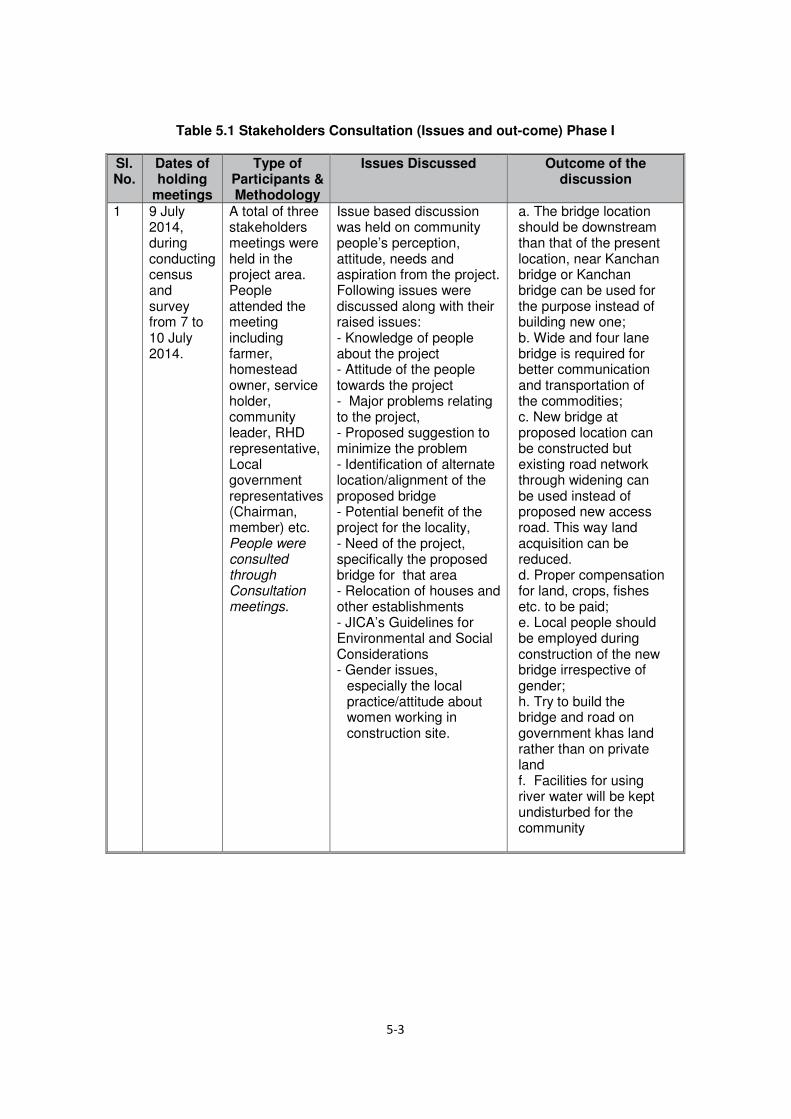
Table 5.1 Stakeholders Consultation (Issues and out-come) Phase I
Sl. No.
Dates of holding
meetings
Type of Participants & Methodology
Issues Discussed Outcome of the discussion
1
9 July 2014, during conducting census and survey from 7 to 10 July 2014.
A total of three stakeholders meetings were held in the project area. People attended the meeting including farmer, homestead owner, service holder, community leader, RHD representative, Local government representatives (Chairman, member) etc. People were consulted through Consultation meetings.
Issue based discussion was held on community people’s perception, attitude, needs and aspiration from the project. Following issues were discussed along with their raised issues: - Knowledge of people about the project - Attitude of the people towards the project - Major problems relating to the project, - Proposed suggestion to minimize the problem - Identification of alternate location/alignment of the proposed bridge - Potential benefit of the project for the locality, - Need of the project, specifically the proposed bridge for that area - Relocation of houses and other establishments - JICA’s Guidelines for Environmental and Social Considerations - Gender issues,
especially the local practice/attitude about women working in construction site.
a. The bridge location should be downstream than that of the present location, near Kanchan bridge or Kanchan bridge can be used for the purpose instead of building new one; b. Wide and four lane bridge is required for better communication and transportation of the commodities; c. New bridge at proposed location can be constructed but existing road network through widening can be used instead of proposed new access road. This way land acquisition can be reduced. d. Proper compensation for land, crops, fishes etc. to be paid; e. Local people should be employed during construction of the new bridge irrespective of gender; h. Try to build the bridge and road on government khas land rather than on private land f. Facilities for using river water will be kept undisturbed for the community

1st SHM-Chowari khola 2nd SHM-Teury 3rd SHM-Alua bazaar
Figure 5.1 Some photographs of consultation meetings.
5.3.2 Meetings Phase II
After finalization of the project location and completion of the detailed design, community level stakeholders consultations were held in the project site. A total of three stakeholders consultation meetings (Teury, Alua Bazar (Hannan Market) and Chowari Khola) were held on 19 August 2014. Stakeholders were informed about the meeting time and location ahead of time through personal contact and over telephone. Local people were also called by announcing in person and well as instantly through using hand microphone.
Process of land acquisition, DC’s payment procedure, donors policy on involuntary resettlement, entitlements of the affected PAUs/HHs and vulnerable people, cut-off-date for listing property and probable resettlement benefits, etc. were discussed in the meetings.
The ARP design, compensation, relocation options, benefits and adverse social impacts were discussed with the affected persons and their community. Stakeholders were asked for their views on the project overall as well as more specific discussion about their perception on land acquisition process, compensation process, relocation requirements, and views on alternative options. Women and other vulnerable groups were also consulted concerning the specific project impacts and their livelihood aspects.
The inputs from the stakeholders meetings have been used to develop measures and principles for mitigation of loss on APs. Summary of consultation meetings with affected people and other stakeholders are described in Table 5.2.
Table 5.2 Stakeholders Meeting (Issues and out-come) Phase II
Sl. No.
Dates of holding
meetings
Type of Participants & Methodology
Issues Discussed Outcome of the discussion
1
On 19 August 2014
A total of three stakeholders meetings were held in three locations in the project area. People attended the meeting including farmer, homestead owner, service holder, community leader, RHD
Issue based discussion was held on community people’s perception, attitude, needs and aspiration from the project. Following issues were discussed along with their raised issues: - Impact (positive and
negative) of the project & mitigation measures against negative impact,
a. Entitlements of the affected people and cut-off-date for listing of the lost properties are known to the people b. Land price should be fixed on open market rate and compensation should be paid at their door step before displacement; c. Proper compensation

Sl. No.
Dates of holding
meetings
Type of Participants & Methodology
Issues Discussed Outcome of the discussion
representative, Local government representative Chairman/Member etc. People were consulted through Consultation, Group Discussion and personal contact.
- Policy of compensation and resettlement grants for land, crops, houses on private,
-Discloser of the compensation packages for different kinds of losses. Additional assistance for the vulnerable and others were also discussed,
- People’s preference on mode of compensation payment
- Relocation of houses and other establishments
- JICA’s Guidelines for Environmental and Social Considerations
- Cut-off date for listing affected properties i.e. date of 2nd phase stakeholders consultation meeting (19 August 2014) for indirect EPs and notice under section 3 is for land owners.
- Training and cash grant for vulnerable households, etc.
- Gender issues, especially the scope of work for women in project civil work.
for land, crops, trees etc. to be paid d. People will be encouraged for self-relocation for living within the kin groups with mutual support. e. Access road could follow the existing road by widening it instead of acquiring private land f. Access road can be constructed by following the flood protection embankment along the river on government land rather than private land g. One very old graveyard is going to be affected, they do not want that h. The affected household wants alternate land rather compensation money, it would be difficult to get alternate land in the locality and cost would be too high and beyond their buying capacity i. Vulnerable APs will be preferentially employed in the civil construction of the project on the basis of their qualification end eligibility irrespective of gender. j. Facilities for using river water will be kept undisturbed for the community g. Training on some income generating activities should be provided to the poor. h. People know their right and responsibilities at the

Sl. No.
Dates of holding
meetings
Type of Participants & Methodology
Issues Discussed Outcome of the discussion
initial stage of the project by FGD, consultation, information campaign, etc.
1st
SHM-Chowari khola 2nd
SHM-Teury 3rd
SHM-Alua bazaar
Figure 5.2 Some photographs of consultation meetings-Phase II
5.3.3 Meetings Phase III
A total of three stakeholders consultation meetings (Bangabandhu Bazar, Hannan Market and Chowari Khola) were held on 24 November 2014. Summary of consultation meetings with affected people and other stakeholders are described in Table 5.3.

Table 5.3 Stakeholders Meeting (Issues and out-come) Phase III
Dates of holding
meetings
Type of Participants & Methodology
Issues Discussed Outcome of the
discussion
24 November 2014
A total of three stakeholders meetings were held in three locations in the project area. People attended the meeting including farmer, homestead owner, service holder, community leader, RHD representative, Local government representative Chairman/Member etc.
- Impact (positive and negative) of the project & mitigation measures against negative impact,
- Policy of compensation and resettlement grants for land, crops, houses on private,
-Discloser of the compensation packages for different kinds of losses. Additional assistance for the vulnerable and others were also discussed.
a. Local people want the bridge
b. They proposed that the existing embankment road should be widened to build the approach/access road
c. They will not allow road to be built by acquiring new lands inflicting damage to the lands and properties of the people and
d. If the authorities decide against their proposal they will oppose vehemently and organize agitations.
5.3.4 Meetings Phase IV
One stakeholder consultation meeting was held on 06 February, 2015.
Summary of consultation meetings with affected people and other stakeholders are described in Table 5.4.
Table 5.4 Stakeholders Meeting (Issues and out-come) Phase IV
Dates of holding
meetings
Type of Participants & Methodology
Issues Discussed Outcome of the
discussion
06 February 2015
Meeting was held in the Tumulia Union where locates in the project area. People attended the meeting including farmer, homestead owner, service holder, community leader, State Minister, RHD representative, Local government representative Chairman, Member of Tumukia Union etc.
- Alternative routes for bridge and access
- Discloser of the compensation packages for different kinds of losses.
- Methods of restoration the livelihoods
- Methods of land acquisition and resettlement monitoring
a. Compensation is a replacement cost based on a market price
b. Payment will be made to avoid Middlemen/Agency
c. Compensation package should be circulated before acquisition
d. Suitable land area to build house for displaced people will be considered

Thus, APs have agreed with the EZ Bridge and access road construction.
5.4 Mechanism for Stakeholders' Participation
During the preparation of the ARP, APs and their communities have been informed, closely consulted three times, during bridge identification and selection, during conducting socio-economic survey and during disclosure of ARP entitlements, other options and declaration of cut-off dates and encouraged to participate in the discussion and project preparation. This process will be continued during detail design, implementation and monitoring of the ARP. Consultation and communication with APs and other stakeholders during design stage of the project will be an integral part of the process of gathering additional data.
Consultation is a continuous process and will also be carried out during updating of the ARP, as well as during implementation and monitoring. During the implementation stage, Resettlement Advisory Committees (RACs) will be formed to seek cooperation from various stakeholders in the decision-making and implementation of the ARP. Through public consultations, the APs will be informed that they have a right to grievance redress from the RHD. The APs can call upon the support of ARP Implementing Agency (IA)(NGO or Social Consulting Firm) to assist them in presenting their grievances to the GRCs. The GRCs will review grievances involving all resettlement benefits, relocation and other assistance. Two grievance redress committees (GRCs) will be formed at union level in two Upazillas at two end of bridge and the grievances will be redressed within a month from the date of lodging the complaints. The GRC as well as the JVT and PVAT will be formed by the Ministry of Communications and activated during land acquisition process to allow APs sufficient time to lodge complaints and safeguard their recognized interests.
The areas for participation of the primary stakeholders include: (i) identify alternatives to avoid or minimize resettlement; (ii) assist in inventory and assessment of losses; (iii) assist developing alternative options for relocation and income restoration; (iv) identify relocation sites for displaced households; (v) provide inputs for entitlement provisions; and (vi) identify likely conflict areas with resettlers.
5.5 Disclosure of the ARP
Project design, impact and policies for mitigation of adverse social and environmental impacts have already been disclosed to the affected community through consultation meetings. This information will be disclosed to the corridor of impact (COI) area people particularly the affected persons in other different forms. An information booklet will be designed in Bengali and after getting approval of the government, will be distributed among the affected persons during ARP implementation as the primary tool for disclosure. Disclosures will also be continued using the following other instruments:
• Community workshops; • Information brochures; • Information in focal points at district, Upazilla and union levels; • Information pamphlets; • Personal contact; and • Village level meetings.
In case of change in Project design thereby entailing change in resettlement impacts, this ARP will be updated. The updated ARP will be disclosed to the APs, endorsed by the EA. The updated ARP will be submitted to Co-financier for approval prior to award of civil works contracts for the Project.
5.6 Strategy for Community Consultation and Participation during implementation
RHD will continue the consultation process during the implementation of the ARP. Resettlement-related brochures, leaflets and other communications materials in the local language (Bangla) will be published for distribution among the affected households. Further steps will be taken to (i) keep the affected people informed about additional land acquisition

plan, compensation policies and payments, resettlement plan, schedules and process, and (ii) ensure that project-affected persons are involved in making decisions concerning their relocation and implementation of the ARP. The consultation and participation will be instrumented through individual contacts, FGDs, open meetings and workshops. The larger goal of this plan is to ensure that adequate and timely information is made available to the project affected people and communities and sufficient opportunities are provided to them to voice their opinions and concerns and participate in influencing upcoming project decisions. In sum, consultation will remain a hallmark in the project implementation processes. The consultation meetings, issues discussed and outcomes and subsequent follow–up actions will be recorded for future verification.
The main themes and scope of the ARP will be disclosed in detail to the affected community, after it has been approved and translated into Bangla. The ARP’s provisions will be further explained to APs in group discussions, personal contact and community level meetings during implementation of the ARP. An English version will be uploaded to RHD’s website.
This ARP will be summarized in an information booklet in local language (Bengali) and disclosed to APs during implementation of the ARP after it has been reviewed and approved/endorsed.
The Implementing Agency (IA)(NGO or Social Consulting Firm) engaged to assist RHD in implementation this ARP, will update, publish and distribute the booklet explaining the impact of the project, compensation policies for APs, resettlement options/strategies for households, and tentative implementation schedule of the project. Further steps will be taken to (i) keep the affected persons informed about land acquisition plan, compensation policy and payments, and (ii) ensure that APs will be involved in making decisions concerning relocation and implementation of the ARP.
5.7 Eligibility of Cut-off Date
Service of notice under Section 3 of the Acquisition and Requisition of Immovable Property Ordinance 1982 will follow as the cut-off date for legal owners of property to be acquired. First round consultation meeting, the census & socio-economic survey has been conducted during 7 to 10 July 2014. Second round consultation meetings were held on 19 August 2014. During the second round consultation meeting disclosures of the entitlements have been done and cut-off dates for eligibility of compensation have been declared during these meetings. The date of second round consultation meeting is 19 August 2014, is the cut-off date for establishing eligibility for resettlement assistance by all the APs staying on the others/public lands (Uthulies/Squatters) (if any) of the project. During implementation of the project, the RHD will issue ID card to the entitled persons after joint verification done by JVT with all details of their entitlements as per ARP.

6 RELOCATION RESETTLEMENT AND INCOME RESTORATION
6.1 Scope of Displacement and Relocation
According to the census & SES data, implementation of the project will require to affect 39 households living on their own land. All these households are going to be displaced for intervention of this project. The affected households are encouraged for self- relocation. The project may provide some civic amenities to the EPs if they relocate in cluster manner. It is mentionable that there are about 12,259 trees of different species and sizes are enlisted within the private land within the CoI. Total 81 structures are going to be affected with total structure quantity of 3,709 sq. m. Among the affected housing structures most of them are made of CI sheet (38.74%) followed by semi-pucca (34.73%) and pucca (18.39%) structures and only 8.14% are katcha made of wood/bamboo. Figure 6.1 shows the type of structure used by the households.
Figure 6.1 Type of structures used by the affected Households
6.2 Relocation of Housing and other Establishment
The project is taking land for construction bridge and bridge approach and bridge access roads for facilitating easy communication between Special Economic Zone (SEZ) and national highways and poverty reduction. A total 39 households will need to be relocated due to the project with structures amounting total quantity of 3,709 sq. m. The project will therefore encourage "self-relocation" by affected households selecting replacement homestead land in the vicinity of their own. The objective is to minimize social disruption in the resettlement process and allow people to remain together within kin groups for mutual support.
6.2.1 Site Selection
Minimal social disruption is the main objective of the project. The affected households are small in number. People will be encouraged for self- relocation with appropriate assistance. As a result project will not develop any site for relocation of the affected households. The project might provide some infrastructure facilities if the APs are relocated in cluster manner.
If possible, the project authority may request concern authority for allocation of khas land for relocation of the affected households in cluster manner.

6.2.2 Housing infrastructure
It is observed that among the affected residential infrastructures majority of them are tin made followed by semi-pucca and pucca structures. Only few of these are katcha structure. Figure 6.1 illustrates the type of residential structures going to be affected. The structure losers are going to receive compensation for the affected structure according to current market price as well as assistance for relocation and rebuild the structure by the AP on his/her own chosen location.
6.2.3 Changing School
It is understood from the socio-economic survey and consultation meetings that the affected households will move within the vicinity of their earlier location. They prefer to remain with the kin group and continue their earlier occupation. As these households are not moving very far but within vicinity, it is understood that the children can continue their education in same school. Project will not trigger any situation which might need to change their school.
6.3 AP Preference for Relocation
During the census survey as well as in public consultation and FGDs, the relocation choices of the affected persons were asked. The households to be relocated are homestead loser prefer to remain in the adjoining area of the project location to continue their present occupation. Almost all are demanding financial assistance from the project during relocation. Therefore the APs are encouraged for self-relocation to get mutual support of the kin groups.
6.4 Replacement of Agricultural Land
There are AHs that will lose private land, agriculture and non-agriculture land. The project will not arrange any alternate land for loss of land but will encourage the APs to buy alternate land. The AHs will not get any replacement land but will be paid cash compensation at replacement cost at current market value of the land. The stamp duty and registration cost for purchasing a replacement land will be handed over with the replacement cost of the land. In case of agriculture land DC will compensate for lost crops and trees at the rate estimated by the Department of Agriculture Extension (DAE) and the Department of Forest (DOF) and confirmed through consultation and market appraisal.
6.5 Income and Livelihood Restoration Strategy
Mitigation of loss of assets and livelihood is the main focus of the resettlement plan. Additional measures will be taken to provide appropriate support to the livelihood restoration aspects of AHs. AHs will lose access to agricultural land, adequate compensation will be awarded to these AHs before relocation. In addition, vulnerable APs will receive other support and also get preference for employment in civil construction works.
In compliance with the ARP, the updated ARP will identify resources, in addition to compensation, for income restoration assistance. This will be through linking resettlement activities with a Livelihood and Income Restoration Program (LIRP). Social Development fund is being allocated in the budget to organize and provide livelihood restoration training for the vulnerable household head or any household member nominated by the head.
The ARP includes the following categories of AHs for income restoration and livelihood support:
i.) Vulnerable households to be relocated from the project Corridor of Impact (CoI). Eligible members of such family will be identified during planning the LIRP.
ii.) Vulnerable households having no adult male members to shoulder household responsibility (women headed households). The women heading the household will preferably be the eligible member.

iii.) Vulnerable households losing access to agriculture land including sharecropper, and leaseholders.
iv.) Vulnerable households losing more than 10% of their agricultural income due to acquisition of agricultural land.
For additional support to usual income restoration assistance as mentioned above, the ARP Implementing Agency (IA) will specifically undertake assessment of needs and skill base of vulnerable APs of age between 15 to 60 years. The IA (NGO or Social Consulting Firm) will recommend the eligible members of affected vulnerable households with their relevant profile to the LIRP implementing organization through RHD. The short-term livelihood regeneration assistance under the ARP and long-term income generation program under the LIRP will be organized as follows:
Table 6.1 Livelihood Restoration Options
1. Eligible members of poor households to be relocated from the project right of way.
1.1 Short-term: Compensation for structure, shifting allowance, reconstruction assistance, cash assistance for loss of workdays due to relocation, and priority in employment in construction.
1.2 Long-term: Needs and capacity identification, human development and skill training, institutional support under the LIRP.
2. Eligible members from poor female headed households having no adult male members to shoulder household responsibility.
2.1 Short-term: In addition to support as 1.1, additional subsistence allowance.
2.2 Long-term: As 1.2 above.
3. Eligible members of poor households losing access to agriculture land including sharecropper, and leaseholders.
3.1 Short-term: Compensation for crops.
3.2 Long-term: As 1.2 above.
4. Eligible members of poor households losing more than 10% of their agricultural land.
4.1 Short-term: Compensation for crops, replacement value of land, assistance for land purchase, and employment in construction.
4.2 Long-term: As 1.2 above.
6.6 Capital Support
Funds for income restoration programs become a major constraint to the project affected people utilizing their skill obtained/enhanced through IGA training. Capital support for potential income generation activities to the trained and efficient target group people will therefore be provided from any source i.e. local level NGO, banks, etc. arranged by the development project in the form of grant/credit.
6.7 Employment in Construction
Local people whose livelihood is impacted by the project will get preference in jobs associated with the project construction. Female affected people will form labor contracting society (LCS) with the help of RHD through the Implementing Agency (IA) and be deployed by the Contractor in road slope turfing, watering, tree plantation etc. or any other suitable works. Affected persons will get preferential employment in project civil works based on their

eligibility. The jobs, in the semi-skilled and unskilled category, shall be offered to the APs in preference to the other. A clause should be incorporated in the contract documents requiring contractors to give employment, if available, to project affected people having EP ID cards in preference to other persons.
6.8 Re-Establishment of Common Property Resources
According to the census and socio economic survey the project is not going to affect any common property resources. However, any CRP identified to be affected during implementation of the project will be repaired or reconstructed. For repairing or re-establishment of the affected CPRs the community people will be consulted. The management committee of these CPRs will be consulted to identify the mechanism of repair or re-establishment of the CPRs. The management committee can be given a financial support to re-establish the CPR in their desired location under their own management or project can re-establish the CPR with cooperation from the community in their preferred location.

7 IMPLEMENTATION ARRANGEMENTS
7.1 Roads & Highways Department (RHD)
Roads & Highways Department will establish, for the Project, a Project Management Unit (PMU) headed by a Project Director (PD), at the project office that will be responsible for the overall execution of the Project. The PMU will consist of three units namely Engineering Service Unit (ESU), Environmental Management Unit (EMU) and Resettlement Unit (RU) for total implementation of the project. The PD will work on deputation from RHD at the level of Superintend Engineer or Additional Chief Engineer. The project will be overseeing by the PD, RHD. One implementation committee will be formed to provide overall guidelines and cooperation for project implementation and keep liaison with various stakeholders including Donor, different government organizations and other relevant agencies.
The PD will recruit and appoint an experienced NGO or Social Consulting Firm which will be called as Implementing Agency (IA) as required for implementation of resettlement activities. RHD will implement the ARP through setting a Resettlement Unit (RU) within the PMU. The RU, under the overall responsibility of the Additional Project Director (DPD) / Chief Resettlement Officer (CRO), will undertake day-to-day activities with the appointed Implementing Agency (IA) and Resettlement Specialist/ Supervision Consultants.
The appointed Implementing Agency (IA) will open field office, carry out information campaign and involve affected persons including women in the implementation process from the very beginning. The Implementing Agency (IA) will collect, collate, computerize and process data for identification of eligible persons correctly for resettlement benefits and assess their entitlements as per ARP policy. However, the RU will affect the payments after necessary scrutiny. The Additional Project Director/Chief Resettlement Officer (RU) in charge of the land acquisition and resettlement management will report to the Project Director. He/she will work in close coordination with the respective field-based offices and Implementing Agency (IA) on the day-to-day activities of the resettlement implementation.
The DPD/CRO through the field officials and staffs, LA Office and the Implementing Agency (IA) will execute and monitor the progress of the LA and ARP implementation work. He/she will ensure coordination between the relevant departments, Implementing Agency (IA), the GRC, RAC, PVAT and the Project affected people (APs). Apart from the GRC, Joint Verification Team (JVT) for quantification of affected properties and Property Valuation Advisory Team (PVAT) will be formed by the Ministry of Communications for valuation of affected property and resolution of disputes. The composition and formation of committees and mechanisms for quantification and valuation of properties and grievance resolution will be constituted through government gazette. People's participation will be ensured through recruiting their representatives in these committees. The mechanism of implementation and organization/position involved in the implementation process is shown in Figure 7.1.

Figure 7.1 ARP Implementation Organogram
7.2 Responsibilities of Resettlement Unit Officials
CRO will be the head of RU and coordinate all land acquisition and resettlement issues with Assistant Director (AD) RU, IA, Consultant, DC office, Contractors and all stakeholders with assistance from other RU officials and staffs including two Sub Divisional Engineers (SDE). CRO will come from RHD on deputation of the position of at the level of Superintend Engineer/Additional Chief Engineer.
Deputy
Commissioner
(DC)
ADC

AD will be responsible for all land related issues and all kinds of resettlement issues (compensation, relocation, and rehabilitation etc.) for all the EPs of the project. AD will keep close liaison with DC office, will be the chairperson of GRC and RAC to be formed for the project area. AD will maintain close liaison with CRO, IA, Consultant, Contractor and other stake holders of the project. AD will come from RHD on deputation of the position of Executive Engineer.
AD will make compensation; approve indents made by IA for payment to EPs with consultation of CRO. The payment will be done through SDE in the project area. Cheques for the EPs will be signed by AD. IA will assist SDE in preparation of payment Debit Voucher and other required papers. SDE will keep close liaison with the Area Managers of the IA and the EPs in the field level and assist AD in all relevant issues for smooth implementation of the Land Acquisition and Resettlement program. SDE will be the convener of JVT and PVAT to be formed for this assigned area. SDE will come from RHD on deputation of the position of Sub Divisional Engineer.
Institutional Responsibilities in Resettlement Process is shown in Table 7.1.
7.3 Functional Description
7.3.1 Role of Deputy Project Director (DPD)/Chief Resettlement Officer (CRO)
The DPD/CRO for land acquisition, resettlement and rehabilitation will perform the following activities (Table 7.1).
• Implement the resettlement program according to and in agreements with the Donor. • Formulate necessary policy, administrative and financial decisions and actions
necessary for the successful implementation of the program in consultation with GoB. • Timely release of funds to the DC and the Resettlement Unit (RU) necessary to
implement the Land Acquisition and Resettlement program according to the approved implementation schedule.
• Delegate responsibility and powers to the other resettlement officers as required for smooth implementation of the ARP.
• Prepare Terms of Reference for a “Post-Resettlement Survey”, select and appoint an appropriate agency to execute these survey(s).
• Propose RHD any remedial action based on the Post-Resettlement Survey. • Pay additional grant for replacement land purchase, house/business establishment
construction grant, and dismantling and removal assistance and all other assistances in cash or kind stipulated under the resettlement policy to all the eligible PAPs.
• Update Land Market Survey to determine the replacement cost of land in and around the project area and accordingly recommend Replacement Value (RV) for replacement land purchase.
• Negotiate with Contractors for arranging employment for PAPs in project construction works.
• Study and monitor unforeseen adverse effects during and after construction and take necessary mitigation measures.
• Liaise with other government and non-government agencies in the country on matters of mutual interest related to resettlement, etc.
7.3.2 Role of Assistant Director (AD): Resettlement
AD, RU will basically be the field level implementing officer of the Resettlement Unit. He/She will be responsible for the overall implementation of all field level activities related to resettlement (Table 7.1). This would include:
• Keep liaison with LAO for timely compensation of CCL. • Issue ID Cards to all eligible Entitled Persons (EPs). • Will attend and chair the meetings of GRC /RAC in all the unions of two Upazilla on two
sides of the river of the project area.

• Arrange and provide all necessary assistance to EPs for purchase of replacement land. • Ensure that all structure-losing HHs are evacuated and relocated on time and are
provided with transportation assistance in cash. • Ensure timely entries of the losses identified and benefit accrued into the Entitlement
Cards manifesting the benefits given to PAPs. • In consultation with DC and local leaders, organize meetings in host area villages to
persuade and encourage the host population to provide replacement lands to PAPs. • Provide various cash grants planned under the ARP to entitled persons, and ensure that
transfer of these grants are made according to the system described in ARP. • Liaise with the IA for the implementation of information campaign, IGA Training, and
other activities delegated to them. • Keep close contact and liaison with CRO, DC, IA and Consultants and submission of
monthly/quarterly field progress report. • Perform effective management and timely implementation of the directives. • Participate in all the activities and meetings of the Resettlement Committees. • Issue the Cheque to EPs. • Keep all records in electronic data base.
Table 7.1 Institutional Responsibilities in Resettlement Process
Related Activities and Responsibilities Responsibility A. Preparation of Updated ARP
Preparation of land acquisition plans RHD/Eng Firm LA process and land acquisition DC/RHD Recruitment of National Resettlement Specialist (NRS) RHD/Donor Recruitment of Implementing Agency RHD Design and reproduction of ARP Information Brochures RHD/NRS Disclosure and public consultations RHD/IA Selection of members for resettlement advisory bodies RHD/IA Carry out joint verification survey JVT Market survey on prices of lands, structure, crops and trees. PVAT Establishment of unit prices PVAT/RHD Assessing AHs to be relocated and any vulnerable APs IA/RHD/NRS Determination of entitlements and consultations with individual APs
RHD/IA
Consultation of ARP to EA, APs and stakeholders NRS/RHD Concurrence on ARP RHD Approval of ARP RHD
B. ARP Implementation Mobilization of GRC RHD/IA Establishment of internal monitoring MOC/DC/RHD Budget approval for compensation and resettlement RHD Release of funds for compensation RHD Filing and resolution of complaints of APs, RHD/GRCs/IA Assess needs, RHD/IA/APs Consultation with APs on schedule of clearing the lands RHD/IA Clearing of lands APs Confirmation of “No Objection” for the award of civil works contract
RHD
Relocation and livelihood restoration assistance IA/RHD/LIRP C. Monitoring and Evaluation
Internal monitoring RHD/NRS/IA Independent external monitoring and evaluation RHD

7.4 Other Agencies Involved in the Process
7.4.1 Deputy Commissioner
The DC has the power to acquire land and to assess compensation of property thus acquired. The 1982 Ordinance provides the power to the DC, who conducts the acquisition through the Land Acquisition Officer (LAO) of concerned districts. The LAO (or his/her officers) along with RU/RHD and IA staff will conduct joint physical verification of property on the land in accordance with the Land Acquisition Proposal (LAP) to be submitted by RU/RHD as soon as the detailed design and alignments for the project interventions will be available.
The DC office is responsible for the entire acquisition process from notification to affected households to award of compensation to owners of property and payments of compensation. Upon fulfillment of criteria of the LA office (i.e. necessary documents to make payment) the LA officials will prepare Cheque and disburse to the EPs in the concern Union office in presence of the UP Chairman issuing prior notice to the concern EPs. RHD and IA officials shall liaise with concerned DC offices to complete the land acquisition process in a timely fashion. However, the LAO will prepare estimates of LA and request placement of fund from the RHD. RHD will place fund with DC within 60 days’ time limit from the date of claiming fund from DC.
7.4.2 Project Supervision Consultant
There will be provision for National Resettlement Specialist (NRS) as part of the Consultants supervising the implementation of the Project. He/She will be involved for full period of ARP implementation. The resettlement specialist will provide technical support to RU and supervise & review the field activities of the ARP Implementing Agency in collaboration with the Resettlement Unit of RHD.
7.4.3 Implementing Agencies
RHD will engage an experienced Implementing Agency (IA) for implementation of the ARP in the field level in coordination with the DC, RHD and consultants. The Implementing Agency (IA) will be engaged to assist the supervision consultant for updating of ARP during detailed design phase and will be continuing for implementation of the ARP. RHD, the EA will contract out clearly defined tasks of the ARP implementing agency in detailed Terms of Reference such as consultation /public information campaign for rapport building, issuance of ID cards to EPs, payment of eligible benefits to affected households/ individuals, institutional development, skill training/management training, community awareness and empowerment, etc. The IA will initially create ID number for each affected person as identified during Joint Verification survey by JVT for both title and non-title holder. If the entitled person (EP) is not included in joint survey report but awarded newly based on ownership documents of the property by DC during CCL payment, the IA will create new ID for them. The ID card will be prepared for EPs as identified by the DC and/or Joint Verification Survey (JVS) by the implementing agency and issued with joint signature of the SDE of RU and Area Manager of the Implementing Agency. Photograph of the EPs will be attested by the concerned UP Chairman and pasted on the ID card or digital photo will be attached in the ID card and concerned Chairman will sign on it. The ID card will comprise information on name, father’s/husband’s name, mother’s name, age, education, identifiable marks, detail address, details of quantity of losses etc. The sample of ID card will be prepared by IA and approved by EA.
The Implementing Agency (IA) will assist the APs in preparing record of rights to the property and receive Compensation under Law (CCL) from DC office. They will form focus group with the affected people based on homogeneity and/or nearness and hold meetings on regular basis to let them know their right and entitlements as prescribed in the ARP, updating of record of rights (RoR), opening of bank account, process of receiving cash

Compensation under Law (CCL) from DC office and additional payments/ grants from RHD through IA etc.
The implementing agency will form Union based Resettlement Advisory Committee (RAC) to involve the local communities and APs in the implementation process.
Implementing Agency will have to establish an MIS section in their central office for record keeping of the APs, creating individual ID number of the entitled persons, preparing entitled person’s (EP) file based on quantity of losses and entitlement card (EC) based of loss type and budget.
Upon fulfillment of criteria i.e. necessary documents to make additional payment/grants to the EPs the IA will prepare payment debit voucher & other documents and disburse account payee Cheque to the EPs. The payment debit voucher will be jointly signed by the SDE, IA representative and UP Chairman. Prior notice will be issued to the concerned EPs on relevant issues. The consultants updating the ARP during detail design stage will also prepare and attach detailed Terms of Reference for ARP implementing Agency.
7.4.4 Ministry of Communications (MOC)
The Ministry of Communications, through a gazette notification, will form various committees/teams for implementation of the ARP at the field level. The implementing Agency will work as member secretary of all the committees/teams involving representatives from DC, RHD, Local Government Institutes (LGI) and APs. These committees/teams will ensure stakeholders' participation and uphold the interest of the vulnerable APs. The powers and jurisdictions of the committees will be clearly defined in the gazette notification.
7.4.5 Joint Verification Team
The MOC will form a Joint Verification Team (JVT), for the project through a gazette notification to compare and review the physical verification data conducted by Implementing Agency with the DCs' assessment of loss of physical assets and their owners. The scope and responsibility of the JVT will be clearly defined in the gazette. The implementing Agency will process the entitlements of the project-affected persons using the JVT data as one of the determinants. The JVT will be a three-member body and be comprised as:
• Sub-Divisional Engineer or equivalent, RHD - Convener • LAO or his/her designated representative of concerned district – Member; • Area Manager, ARP Implementing Agency – Member secretary;
7.4.6 Property Valuation Advisory Team
A Property Valuation Advisory Team (PVAT) will be formed by the MOC through a gazette notification for the project. The PVAT will review the assessment of the implementing agency on the market price of land and other property affected by the project at their replacement cost. The scope and responsibility of the PVAT will clearly be defined in the gazette. The Implementing agency will process the entitlements of the project-affected persons using the PVAT data as one of the determinants. The PVAT will be comprised as:
• Sub-Divisional Engineer or equivalent, RHD - Convener • LAO or his/her designated representative of concerned district – Member • Area Manager, ARP Implementing Agency – Member secretary;

Figure 7.2 Procedure of Determining Valuation of Property
7.4.7 Grievance Redress Committees
GRCs will be formed at Union level for any grievances involving resettlement benefits, relocation, and other assistance. A gazette notification on the formation and scope of the GRCs will be required from the MOC. The GRC for each Ward will be comprised as
• Executive Engineer, RHD - Convener • Area Manager, ARP Implementing Agency, member secretary. • UP Chairman - member. • One representative of APs – member • One UP member (female)- Member
Identification of
Alignment and Affected
Property by RHD
PVAT to Collect
Information
Conduct PVS for
Land, Structure, Trees
CRO for approval
of Unit Rate
Sub-Register Office for the
Recorded Value of Land
PVAT members • SDE, RHD • IA Representative • DC Representative
Prepare Mouza wise existing
Replacement Value for lost
assets and resettlement
benefits as per ARP policy
Implementing Agency
for Preparing Budget
• Potential Buyer • Potential Seller • Deed Writer • Religious Leader • Local Elites

Table 7.2 Grievance Redress Procedures
Step 1 The Implementing Agency informs DPs/APs about their losses and entitlements
If satisfied, the DP/AP claims resettlement payments to the EA. If confused,
Step 2 The DP/AP approaches the IA field level officials for clarification. The IA will clarify the DPs/APs about their losses & entitlements as per ARP.
If resolved, the DP/AP claims resettlement payments to the EA.
If not resolved,
Step 3 The DP/AP approaches to the GRC. IA staff assists the DPs/APs producing the complaints and organize hearing in 15-21 days of receiving the complaints.
Step 4 GRC to scrutinize applications, cases referred to DC through EA if beyond their mandate as per scope of work
Step 5 If within the mandate, GRC sessions held with aggrieved DPs/APs, minutes recorded.
If resolved, the Project Director approves.
If not resolved,
Step 6 The DP/AP may accept GRC decision, if not, he/she may file a case to the court of law for settlement.
Step 7 The GRC minutes, approved by the Project Director, received at Conveners’ office back. The approved verdict is communicated to the complainant DP/AP in writing. The DP/AP then claims resettlement payments to EA

Figure 7.3 Grievance Redress Mechanism
7.4.8 Resettlement Advisory Committee (RAC)
The implementing Agency will form Union based RAC at project level to involve the local communities and APs in the implementation process. The RACs will be comprised of AD/XEN, RHD as the convener/chair, Area Manager, implementing agency as member secretary, UP Chairman, Female UP member and APs representatives (2) including at least one female AP in the respective area as selected by Implementing Agency in consultation with the concerned UP Chairman. The committees will seek local inputs from the affected people and communities in the implementation process and assist the implementing agency in all matters related to resettlement. The RACs will ensure local participation in the implementation of the resettlement plan.
Securitization of
complaints by GRC
Aggrieved Person
Application submitted to GRC
through IA
Complaints under
Arbitration or existing
LA Law
Not
Redressed
Recommendation for
compensation
Not under Arbitration or Law
and be settled as per RAP
policy
Referred to DC
GRC members • AD/Executive Engineer,
RHD • IA Representative • LGI Representative • AP Representative
• Legal Advisor
GRC Hearing within 30 days of
lodging the claim
Civil Court
Redressed
APD for
Approval
IA for
Payment
Seeking Legal
Settlement
Decision
Accepted
Claim
Rejected

7.4.9 Women Groups in Resettlement Process
The ARP implementation will ensure a gender sensitive approach in planning, management and operations of land acquisition and resettlement. Separate groups of women affected persons will be formed and operated by the implementing agency. Feedback from the female APs and female headed AHs will be obtained through these female focused groups for planning relocation and resettlement. The female members of the households will get special considerations in getting job opportunities in civil construction.
The female staff engaged by implementing agency will identify needs of female APs for income restoration approaches and implementation of the income restoration component of the ARP. Women were consulted during social appraisal and will be further consulted during the review of the ARP after the detailed design and in the process of implementation.
7.5 Appointment of Implementing Agency (Non - Government Organization (NGO) or Social Consulting Firm)
RHD will appoint an experienced Implementing Agency through standard procurement system. The IA can be a Non-Government Organization (NGO) or Social Consulting Firm. This IA will be appointed for implementation of the ARP in the field level in coordination with DC, RHD and National Resettlement Consultant (NRS). The EA will contract out clearly
defined tasks of the ARP with details Terms of Reference. A TOR is attached in Annex III of this document for the implementing agency.
7.6 Community (Stakeholders) Participation in ARP Implementation
During the implementation of the ARP, APs and their communities will be informed, closely consulted, and encouraged to participate in the process. This process will be continued until completion of the implementation of ARP as well as in monitoring stage.
During the implementation stage, Union based Resettlement Advisory Committees (RACs) will be formed to seek cooperation from various stakeholders in the decision-making and implementation of the ARP. Through public consultations, the APs will be informed that they have a right to grievance redress from the RHD. The APs can call upon the support of ARP Implementing Agency (IA) to assist them in presenting their grievances to the GRCs. The GRCs will review grievances involving all resettlement benefits, relocation and other assistance. Union based grievance redress committees (GRCs) will be formed and the grievances will be redressed within a month from the date of lodging the complaints. The GRC as well as the JVT and PVAT will be formed by the Ministry of Communication and activated during land acquisition process to allow APs sufficient time to lodge complaints and safeguard their recognized interests. Host area villagers will be the part of ARP implementation by joining the meetings organized the AD in consultation with the DC to persuade and encourage the host population to provide replacement lands to PAPs.
The areas for participation of the primary stakeholders include: (i) identify alternatives to avoid or minimize resettlement; (ii) assist in inventory and cross check in assessment of losses; (iii) assist developing alternative options for relocation and income restoration; (iv) provide inputs for entitlement provisions; and (v) identify likely conflict areas with resettlers; (vi) Identify livelihood restoration options and participate in the concern training.

8 RESETTLEMENT AND COMPENSATION COSTS AND BUDGET
8.1 Budgeting and Financial Planning
All resettlement funds will be provided by the EA based on the financing plan agreed by the Government of Bangladesh and JICA. Land acquisition, compensation, relocation andrehabilitation of income and livelihood will be considered as an integral component of projectcosts. The rehabilitation and training to the potential affected persons will be provided under the LIRP based on vulnerability and needs assessed through a special census and consultation exercise.
The estimate for land acquisition by the DC will be prepared by his/her LA section and placed to the RHD for transfer of the fund to the account of the DC. The additional benefits as per the policy will be paid by the EA through Implementing Agency (IA). However, the Implementing Agency (IA) will assess the quantity of losses and the eligible persons for resettlement benefits and produce a resettlement budget to RHD for approval and periodic release.
The RU of RHD will ensure that the land acquisition and resettlement budgets are delivered on time to the DC and the Implementing Agency (IA) account for payment of compensation for land, structure, trees and crops and other assets on privately owned land and resettlement grants. The RU will also ensure that the ARP should be submitted to JICA for approval, and that fund for compensation and entitlement under the ARP are fully provided to APs prior to the award of the civil work contract.
The ARP budgets for compensation for land, structures, other assets, crops and trees, and special assistance will be calculated using the market rates reflecting replacement cost at the time of dispossession. The costs for relocation and special assistance will be consistent with the resettlement policy. Other costs involving project disclosure, public consultations and focus group discussions, have been included in the ARP budget under ‘Operation cost for IA’ head. On the other hand training on IGA will be organized under Livelihood and Income Restoration Program (LIRP). Budget has been allocated for the purpose. There is also a budget allocation for 5% as contingency.
Confidential

Confidential

8.2 Assessment of Unit Value for Compensation
For preparation of an indicative budget as integral part of the Abbreviated Resettlement Plan, the methodologies followed for assessing unit compensation values and grants of different items is as follows:
• Land has been valued at replacement cost based on current market price determined bycollection of data from interviewing land owners and mouza rates collected from Sub-register office.
• Houses/buildings have been valued at replacement cost based on cost of materials,type of construction, labor, and transport and other construction costs. Experience andbest practices from other development project have been applied in this regard.
• Trees have been valued based on age and girth category (a. large b. medium c. smalland d. sapling) separately for timber and fruit bearing trees. Experience and bestpractices from other development project have been applied in this regard.
• Banana groves have been valued as one time crop of each grown up tree (large andmedium) and small or plant at the market rates.
• Fruits will be valued for grown up trees (large and medium) as 30% of the timber valueX one year.
• Transfer grant for structures has been calculated @ 12.50% of the structure value.• Reconstruction grant for structures has been calculated @ 12.50% of the structure value.
Confidential

• Crop value has been determined on the basis of current market price of paddy per mound (about 40 Kg) and gross production.
• Additional cash grant for vulnerable household’s particularly very poor will be paid @ BDT 3,000/per persons
• Poor female EPs heading the household will get one time additional assistance of Tk 3000 each
• EPs will be allowed to take salvage materials free of cost
The valuation survey registered recent current crop and tree sales at markets and was based on AP and community consultation (including relevant local government agencies). The conclusion of the survey is that in most cases the actual transaction values are higher than the values officially documented and registered.
8.3 Approval of the Resettlement Budget
Land acquisition and resettlement budget included in the ARP will need to be approved by the Ministry of Communications. Upon approval of land acquisition by Ministry of Land, the DC will prepare estimates for compensation including service charge and produce that to the RHD for placement of fund within 60 days.
The rates for compensation and cash entitlements for rehabilitation as well as allowances payable to AHs will be adjusted annually, based on the actual annual inflation rate. RHD will determine the annual inflation rates to be applied to all cash entitlements in each year.
The ARP implementing Agency (AI) will assist RU, (RHD) to prepare resettlement budgets covering all eligible loss and entitlements confirmed through joint verification and determination of replacement market price of land and property by PVAT.
8.4 Management of Compensation and Flow of Awards
The RHD does not have any set codified rules for payment of grants to APs for resettlement of affected persons. Under the circumstances, a detail administrative guideline (payment modality) will be required to implement the ARP at the field level. Both the RHD and the ARP implementing agency (IA) will follow the administrative guideline after its approval from the Project Director. The consultants (resettlement specialists) will prepare the guidelines and the DPD/CRO at RU (RHD) will concur it for adopting. The modality should include definition of various resettlement terms, the entitlements, detail procedure for identification of eligible persons for resettlement entitlements of the ARP, and assess loss and entitlement of individual APs, process of payments, effecting their disbursement and documentation.
The RU with requisition of payments under annual assessment from the DPD/CRO, will place fund with the IA account in installment as per requisition made by the IA. The administrative guidelines will contain details of the management aspects and monitoring mechanism. The SDE, RHD and authorized representative from IA will sign the vouchers. Payment will be made and records maintained as per approved ARP administrative guidelines.
Compensation under law for land acquisition will be paid to the legal owners of land and property by the concerned Deputy Commissioner’s LA section. DC will prepare individual cheques accompanied with receiving copies of payment and undertaking note.
The IA will collect CCL copy from the DC office and prepare statement, entitled person’s file, entitlement card, indent and other necessary documents for making payment of resettlement benefit. In case of non-titled holder the IA will prepare all necessary documents based on the joint verification survey data and arrange payment of resettlement benefit to the EPs. For both the cases resettlement benefits will be paid by RHD through the IA.

9 ARP IMPLEMENTATION SCHEDULE
A time-bound implementation schedule for the ARP has been prepared in accordance with the project construction schedule. The overall schedule of implementation is based on the principle that people affected by the project are paid their due resettlement benefits prior to displacement. The Implementing Agency (IA) will assist the APs in the process of relocation and resettlement. Individual entitlements on household basis will be processed by the IA. Each EP will receive an ID card and an entitlement card. The ID card will be issued to the EPs as identified by the DC and/or Joint Verification Survey (JVS) with joint signature of the RHD and IA representatives. Photograph of the EPs will be attested by the concerned UP Chairman and pasted on the ID card.
Confidential
10 MONITORING AND EVALUATION
10.1 Monitoring and Evaluation
RHD as the EA, through the RU, will establish a monitoring system involving the DPD/CRO, consultants and the ARP Implementing Agency (IA) for collection, analysis, reporting and use of information about the progress of resettlement, based on the ARP. These stakeholders will be made responsible to monitor the progress of all aspects of land acquisition/ resettlement and income generation. The EA will report to the Donor on land acquisition, resettlement and income regeneration by APs in the quarterly reports, including identification of significant issues. Besides, an annual report stipulating all efforts and outcome will be sought by the
Donor from the RHD. An ARP implementation monitoring format is enclosed in Annex-V. The ARP implementation monitoring will be done both internally and externally to provide feedback to RU (RHD) and to assess the effectiveness. Mid-term reviews of the resettlement activities drawing upon monitoring and evaluation reports and other relevant data to identify any action needed to improve resettlement performance or respond to the changing circumstances. Evaluation of the resettlement activities will be resorted to during and after implementation of the ARP to assess whether the resettlement objectives were appropriate and whether they were met, specifically, whether livelihoods and living standards have been restored or enhanced. The evaluation will also assess resettlement efficiency, effectiveness, impact and sustainability, drawing lessons as a guide to future resettlement planning.
10.2 Internal Monitoring
Internal monitoring will be undertaken by the RU through SDE with assistance from the NRS and IA. The IA will gather information on ARP implementation covering relevant activities as per schedule. All activities listed will be illustrated in Gantt Charts showing the target dates for completing resettlement activities. Internal monitoring reports on ARP implementation will be included in the quarterly Project Progress Report (PPR) to be prepared by RU, RHD. The report of RU will contain: (i) accomplishment to-date, (ii) objectives attained and not attained during the period, (iii) challenges encountered, and (iv) targets for the next quarter. The internal monitoring report will then be integrated by the RU with the overall PPR submitted to Donor. The NRS will assist PMU preparing the overall PPR for Donor. However, the NRS will monitor the activities of IA and report to DPD/CRO, RU on a monthly basis. Table 10.1 shows the potential monitoring indicators that will be reported.
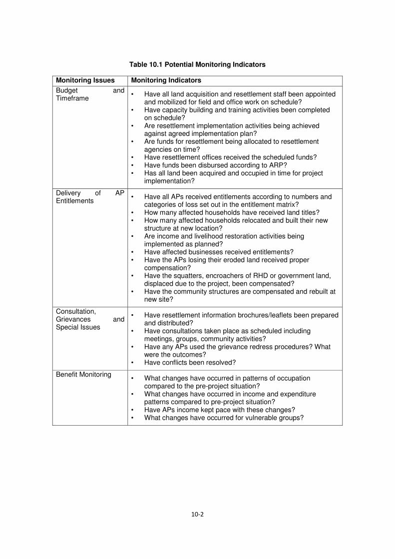
Table 10.1 Potential Monitoring Indicators
Monitoring Issues Monitoring Indicators Budget and Timeframe
• Have all land acquisition and resettlement staff been appointed and mobilized for field and office work on schedule?
• Have capacity building and training activities been completed on schedule?
• Are resettlement implementation activities being achieved against agreed implementation plan?
• Are funds for resettlement being allocated to resettlement agencies on time?
• Have resettlement offices received the scheduled funds? • Have funds been disbursed according to ARP? • Has all land been acquired and occupied in time for project
implementation?
Delivery of AP Entitlements
• Have all APs received entitlements according to numbers and categories of loss set out in the entitlement matrix?
• How many affected households have received land titles? • How many affected households relocated and built their new
structure at new location? • Are income and livelihood restoration activities being
implemented as planned? • Have affected businesses received entitlements? • Have the APs losing their eroded land received proper
compensation? • Have the squatters, encroachers of RHD or government land,
displaced due to the project, been compensated? • Have the community structures are compensated and rebuilt at
new site?
Consultation, Grievances and Special Issues
• Have resettlement information brochures/leaflets been prepared and distributed?
• Have consultations taken place as scheduled including meetings, groups, community activities?
• Have any APs used the grievance redress procedures? What were the outcomes?
• Have conflicts been resolved?
Benefit Monitoring • What changes have occurred in patterns of occupation
compared to the pre-project situation? • What changes have occurred in income and expenditure
patterns compared to pre-project situation? • Have APs income kept pace with these changes? • What changes have occurred for vulnerable groups?

10.3 External Monitoring and Evaluation
External monitoring which involves social impact evaluation will be assigned to an independent External Monitoring Agency hired by RHD..
10.3.1 Social Impact Evaluation
The Donor will engage individual/firm to conduct a one-time social impact evaluation, at least six months following the completion of resettlement. It will use appropriate investigative and analytical techniques in assessing the post-project socio-economic conditions of the APs in relation to the baseline socio-economic data generated before undertaking of the resettlement implementation. The Tor for external monitoring agency is presented in
Annex-IV. The evaluation will describe any outstanding future issues that are required to bring the resettlement into compliance with JICA’s Guidelines for Environmental and Social Considerations and Government policies, and further mitigation measures needed to meet the needs of any APs or families perceiving themselves to be worse off as the result of resettlement. It will include lessons learned from the evaluation that may be useful in developing future policies on involuntary resettlement of APs in Bangladesh.
The Resettlement Specialist within the project consultants will conduct periodic review and supervision mission during the implementation stage. In addition to regular review missions, JICA will undertake a comprehensive mid-term review of the ARP implementation. A post-evaluation of ARP activities will be carried out by JICA to assess the resettlement impact in terms of adequacy and deficiency in planning and R&R operations following the social impact evaluation.
10.4 Reporting Requirements
During the implementation phase, the Project Director will prepare quarterly report on the progress of resettlement activities and forward copies to the GoB and the donors. A format for resettlement implementation monitoring will be devised for quarterly monitoring and data collection by the field officials (sample at Table 10.2). The Resettlement Specialist of the Project Supervision Consultants and Supervision Missions every six months during the implementation stage will conduct review and report to RHD and the donors on the progress of all aspects of land acquisition and resettlement activities. A post-resettlement impact evaluation will be carried out by the donor to assess whether adverse impacts of the projects have been mitigated adequately and APs have been able to restore and/or improve their pre-project standard of living as a result of resettlement and development.
10.5 Conclusion and Recommendations
10.5.1 Conclusion
The project will require a total of 12.49 hectare land of which mostly agriculture and a small quantity is vita/ homestead category. A total of 39 households got affected by this project. The project is located in the central part of Bangladesh covering two districts namely Gazipur and Narshingdi. Compensation budget for land has been prepared based on the average rate collected from the local people. The project affected persons will get compensation for lost assets at replacement cost and other resettlement benefit. Policy matrix of ARP has kept provision for livelihood and income restoration grant for vulnerable households along with preferential employment in civil construction and distribution of 5 saplings among the displaced households for ensuring social afforestation. The resettlement plan will be implemented in 20 months’ time period starting from January 2016. Roles of different government and local bodies in proper implementation of the project are described in the ARP. Grievance redress committee will resolve claims of the aggrieved persons related to resettlement.
10.5.2 Recommendations:
For smooth execution of the project following steps are recommended
The ARP implementing agency is to be deployed before serving notice under section 3 by DC, so that they can jointly verify the affected properties in time.
ii.) A clause should be incorporated in the bid documents with the civil contactors that the vulnerable entitled persons will get preferential employment in civil work.
iii.) The other local agencies such as Union Parishad, Upazilla and District administration should be initially informed about their roles and responsibilities in implementation of the ARP. For this a seminar may be arranged with local government bodies in the initial stage of ARP implementation.
iv.) The vulnerable EPs should get special attention under livelihood and income restoration program.
v.) The affected households may be encouraged for self-relocation. If possible, the project authority may request concern authority for allocation of khas land for relocation of the affected households in cluster manner.

Table 10.2 A model format for ARP implementation Monitoring – Quarterly Report
Component Unit Total Completed%
Cumulative
Achievement
Total
Completed%
Progress During Reporting Month Status &
Remarks Target
Achievement
(%)
Resettlement
Preparation
Distribution of
Brochures
Identification of
AHs/CBEs
Issuance of ID cards
Consultation Meetings
Formation of
PVAT/RAC/GRC
Payment of
Compensation
Compensation for land
Compensation for
tree/crop/fish
Res/Commercial
structure
Payment for
rent/leaseholder
Shifting/relocation costs
Social Development
Activities
Grant for loss of wages
Loss of business grant
Business restoration
grant
Payment for indirect
impact
LIRP activities

APPENDIX
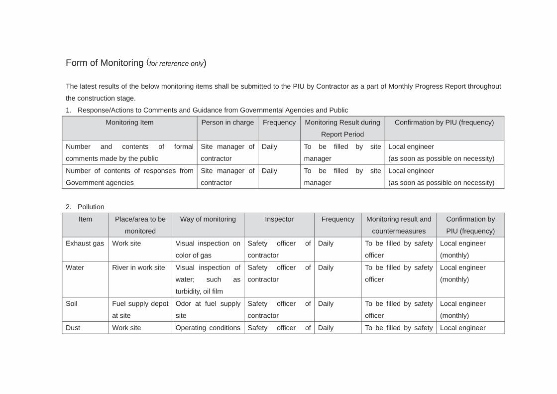
Form of Monitoring (for reference only)
The latest results of the below monitoring items shall be submitted to the PIU by Contractor as a part of Monthly Progress Report throughout
the construction stage.
1. Response/Actions to Comments and Guidance from Governmental Agencies and Public
Monitoring Item Person in charge Frequency Monitoring Result during
Report Period
Confirmation by PIU (frequency)
Number and contents of formal
comments made by the public
Site manager of
contractor
Daily To be filled by site
manager
Local engineer
(as soon as possible on necessity)
Number of contents of responses from
Government agencies
Site manager of
contractor
Daily To be filled by site
manager
Local engineer
(as soon as possible on necessity)
2. Pollution
Item Place/area to be
monitored
Way of monitoring Inspector Frequency Monitoring result and
countermeasures
Confirmation by
PIU (frequency)
Exhaust gas Work site Visual inspection on
color of gas
Safety officer of
contractor
Daily To be filled by safety
officer
Local engineer
(monthly)
Water River in work site Visual inspection of
water; such as
turbidity, oil film
Safety officer of
contractor
Daily To be filled by safety
officer
Local engineer
(monthly)
Soil Fuel supply depot
at site
Odor at fuel supply
site
Safety officer of
contractor
Daily To be filled by safety
officer
Local engineer
(monthly)
Dust Work site Operating conditions Safety officer of Daily To be filled by safety Local engineer

of water sprinkle
vehicle
contractor officer (monthly)
Waste Work site,
contractor’s office
and worker camp
Visual inspection on
garbage, toilet
Safety officer of
contractor
Daily To be filled by safety
officer
Local engineer
(monthly)
3. Noise
Item Unit Measured
Value
(Mean)
Bangladesh
Standards in daytime
Place to be
monitored
Frequency Monitoring result and
countermeasures
Confirmation
by PIU
(frequency)
Noise level dB School: 45 dB
Residential: 50 dB
Mixed residential and
commercial: 60 dB
Commercial: 70 dB
Industrial: 75 dB
Nearest structures
as described
previously
Daily when
equipment works
To be filled by safety
officer
Local engineer
(monthly)

4. Working Conditions and Accident
Inspected
place/area
Way of monitoring Inspector Frequency Monitoring result and
countermeasures
Confirmation
by PIU
(frequency)
Work site Visual inspection on workers hard
hat/safety belt, scaffolding, traffic
safety etc..
Safety officer of
contractor
Daily Local engineer
(monthly)

APPENDIX

TOR for RAP implementing Agency
Government of the People’s Republic of Bangladesh
Roads and Highways Department (RHD)
EZ Bridge Project
TERMS OF REFERENCE FOR ARP IMPLEMENTING NGO (INGO)
1. Introduction
The Government of Bangladesh with the financial loan from Japan International Cooperation Agency (JICA) has undertaken a project named EZ Bridge Project in order to improve the communication road network with planned Special Economic Zone (SEZ) in Polashupazila of Narshingdi district and road network system of the country. The EZ Bridge will be constructed across the river Sitalakhya by connecting Gazipur and Narshingdi districts in the central part of Bangladesh. This initiative has taken with aim of becoming a middle income country by 2021 by reducing poverty and improvement of road communication system by connecting the important economic potential areas with rest of the country. The EZ Bridge project includes construction of a 835 m long bridge with approach bridge roads of total 4,195 m and a transect road connecting Tongi- EZ road. The EZ Bridge will be constructed over Sitalakhya River at SomNatun Bazar meeting point 14.0 Km up Stream of Kanchan Bridge and 6.0 Km downstream of Bhairab Bridge. The bridge will be connected with the Dhaka- Sylhet highway (N2) via A K Khan Industrial Park, a privately developed industrial park in Polashupazila of Narsingdi district. RHD will be the implementing authority of the project.
This is the Abbreviated Resettlement Plan (ARP) for the project complies with the Resettlement Framework (RF) prepared based on relevant national law (Government of Bangladesh (GOB) Acquisition and Requisition of Immovable Property Ordinance 1982 (ARIPO), amended in 1993 and 1994) and with the policy of the JICA Guidelines for Environmental and Social Considerations and World Bank OP 4.12. An ARP Implementing Agency (IA) i.e. NGO or Social Consulting Firm will be engaged by the RHD for implementation of the ARP.
2. Description of the Project
The EZ bridge is going to connect Gazipur an Narshingdi districts by constructing the bridge across the river Shitalakhaya. The bridge access road is going to connect the bridge with Tongi - EZ highway. The bridge is going to be connected with Dhaka Sylhet highway through privately developed AK Kham industrial park in Polashupazila of Narshingdi district.

3. SCOPE OF WORK- GENERAL
The general scope of work shall include i) dissemination of information as described in the policy framework regarding ARP implementation procedure; ii) conducting public consultations, iii) assisting Project Directors and his/her staff in implementation of Abbreviated Resettlement Plan and iv) maintain close co-ordination with National Resettlement Specialist (NRS)& RHD (Executing Agency) staff. Displacement and other impacts due to the project are shown in the table below-
Displacement and other impacts
Sl No Loss type No/Total 1 Total quantity of land (Hectare) affected 12.49
2 Total number of Households (Land with Structure) affected 39
3 Total number of population affected 190
4 Total number of structures affected 81
5 Total quantity of structure (Sqm) affected 3,709
6 Total no. of toilets affected 36
7 Total no. of tube wells affected 34
8 Total no. of trees on private land affected 12,259
A list of the affected households with demographic and socioeconomic information will be provided to the implanting agency (IA) by RHD.
Key implementation issues in the delivery of the tasks includes: (i) consultation and stakeholder participation; (ii) dissemination of relevant information; (iii) assisting executing agency (RHD) in payment of compensation and other resettlement grants (iv) assisting affected persons (APs) in the process of resettlement.
4. SCOPE OF WORK- SPECIFIC TASKS
Information Campaign: The consultant will design, plan and implement an information campaign in the affected areas to facilitate the implementation of ARP. The campaign would include measures such as distribution of information booklets, leaflets, notices and other materials among the APs, carrying out community meetings, public announcements and any other measures necessary to provide information to all APs in the project area. The consultant will assist the APs during pre and post relocation period. The IA staff will also assist APs, where necessary, in preparing grievance redress cases for consideration by the GRCs. Assistance to

RHD in payment of Resettlement Benefits to APs. The selected Implementing agency will be responsible to assist RHD in processing entitlements for the APs and making payment of resettlement benefits to them. The IA will compile and process data and develop & operate a menu driven computerized Management Information System (MIS) for preparation of entitled persons file and entitlement card for EPs.
Identification of Entitled Persons: Consult census/survey data and prepare final list of affected households, commercial business enterprises and community establishment now staying within the ROW from the list.
Assistance to APs during relocation: The IA will assist the APs during pre and post relocation period in close coordination with Resettlement Advisory Committee (RAC) and RHD
Assistance to RHD in Payment of Resettlement Benefits to APs: The selected Agency will assist RHD in processing entitlements for the APs and making payment of resettlement benefits to them. The Agency will compile and process data and develop & operate a menu driven computerized Management Information System (MIS). The IA will prepare Entitled Person (EP) files with type and quantity wise losses and Entitlement Card (EC) mentioning amount of compensation/benefits for each of the EPs and prepare Indent mentioning category wise amount of compensation /benefits. The indent would be approved by the Project Director before making payment. The IA will prepare payment debit voucher on behalf of RHD and assist RHD in preparing Measurement Book. The debit voucher will be signed jointly by IA and EA representative and the cheque will be signed by IA and be issued in public place in presence of LGI representatives. The RHD will place fund with Implementing Agency for making payment and the IA will submit vouchers with other documents on regular basis to the Project Director after making payment.
5. ARP Implementation Schedule and Tasks
The implementation of the ARP is scheduled to start from August 2016 and expected to be completed in July 2018. The IA will be deployed for a period of 16 (sixteen) months and will be responsible to implement all resettlement activities stated in the TOR. The Project Director, in consultation with the National Resettlement Specialist (NRS) of the CSC will provide time schedule as per the requirement of the resettlement program. The Implementing Agency will assist RHD but not necessarily limited to the following:
Information Campaign and ARP Disclosure: The IA will carry out consultation regarding policies and options and collection of legal documents required to claim compensation. Property owners require being advised/helped to gather all required documents. The affected people will be made aware of the GRC procedures for disputes over claims.
Disbursement of Compensation: Payment of compensation to titled and non-titled owners will be processed and paid by RHD through implementing agency with assistance from NRS of the CSC. The Resettlement Specialist will supervise and monitor the process and the IA will keep record of the payments and report to the RHD on monthly basis.

Notice for Encumbrance Free: Written notice will be given to individual affected persons at completion of payment of all compensation/entitlement from RHD. The RHD will keep records of issuance date of notice for making ROW encumbrance free signed by both RHD and EPs.
Taking-over and handing-over sites: The IA will assist RHD take-over acquired land from DC office and then hand-over to contractors. Contractors will move into sites the day following expiration of the encumbrance free notice.
6. Major Activities to be performed by Implementing Agency
The selected Agency will assist RHD in implementing successfully all stipulations agreed in the ARP in their entirety, fairly and transparently. In this context, the major functions to be performed by the Implementing Agency are:
A: Information dissemination and feedback:
(i) Ensure dissemination of the project and resettlement policy related information to the project-affected persons and others (community groups, local administration, etc.) that might be considered instrumental in the effective and transparent implementation of the ARP. Even though the ARP recommends some dissemination mechanisms, the IA can suggest more in the process of its implementation and would gather information and disseminate it upward to the project authority.
(ii) During implementation of the project, extensive consultation and collaboration with key stakeholders on a continued basis is planned. The selected IA will be required to assist RHD in organizing such consultation programs and facilitate consultation with local government representatives, local leaders, etc.
B. Assisting APs in resettlement process:
(i) The main purpose is to make the APs and entitled persons (EPs) aware of the project goals, importance, GRC procedures, compensation entitlement and receiving procedures, etc. Some of the major activities are: (a) Inform the EPs about the documents required for claiming compensation from DC office & resettlement benefit from RHD (b) checking with the APs to make sure that they have all the required documents to claim compensation from DC and RHD (c) whether or not there are usufruct rights of others on the properties within ROW and informing the people with such rights about the compensation policies.
(ii) Inform the AP households, especially the vulnerable ones, about the “compensation in cash and/or kind” option stipulated in the ARP and ensure fulfillment of the choices made by them.
(iii) Counseling and helping the households, whose previous incomes have been seriously affected, to find alternative source of income.
C. Grievances redress procedure

The selected IA will play vital role in the grievance redress process. The most important preconditions for doing this with maximum effectiveness are that the IA operatives will build personal rapport and confidence with the APs and will be fully aware of all socioeconomic problems/issues arising from the project. Among other things, the IA will:
(i) Ensure that the APs are fully aware of the grievance redress procedure and the process of bringing their complaints to the grievance redress committees (GRCs).
(ii) Assist the APs in any usual manner (e.g., preparing applications, accompanying them to the hearing and explaining the grievance to the GRCs and the like) to bring the complaints to the committee.
(iii) Impartially investigate the veracity of the complaints and try to settle them amicably, fairly and transparently before they go to the redress committee or the courts of law.
(iv) For more focused work in this area, the IA will prepare a list of problem cases in implementation of ARP. In doing so, the IA will pay special attention to the problems and needs of the vulnerable APs and recommend to the RHD with probable mitigation measures.
D. Information management
The selected IA will collect computerized Census and SES data related to the pre-acquisition condition of the AP households and the nature and magnitude of all categories of losses as well as the compensation thereof determined by RHD. All essential information will have to be generated by using one or more menu-driven MIS. Among other things, the IA will:
(i) Collect CCL from the DC office and prepare statement for assessing additional payment on the basis of quantity of affected properties and ARP PVAC rate.
(ii) Collect and computerize all information related to different types of payments and additional supports provided to the entitled person (EP) and update the EP file and EC.
(iii) Prepare ‘entitlement card’ for the individual EPs as per their types of losses and the amount of compensation due for each type of loss from legal title and the amount of additional compensation/resettlement benefits if any, to be paid by RHD through IA.
(iv) Record and maintain details of the issues/disputes causing delay in the disbursement/receipt of compensation and the persons involved in them, including the cases brought to the courts of law, if there is any.
(v) Document information on the cases, with reasons, brought to and resolved by the GRC, with decisions going in favor of or against the complainants.
(vi) Collect and maintain relocation information on the homestead losers by categories of EP households such as legal owners, squatters, tenants and others.
E. Progress reports

The ARP requires that all APs are paid the stipulated compensations/entitlements before they are evicted from the properties and/or construction work begins. The selected IA will provide RHD weekly report on the progress in ARP implementation, including any issue that might be hindering progress, separately for each bridge. The report will be brief consisting of both quantitative and qualitative information on:
(i) The IA in its report should reflect the status of total number of EPs identified by DC for compensation and progress of payment in a particular period and resettlement benefits paid against DC’s payment and other benefits as per ARP policy by zones and EP categories.
(ii) Number of focus groups formed and meeting held with the affected persons with issues discussed.
(iii) Number of vulnerable affected households male headed and female headed have received cheques and be deployed in project civil works according to their eligibility.
(iv) Number of cases received by the Grievance Redress Committee indicating the types of grievance made in favor of or against the complainants.
(v) Any other issues that are relevant to implementing the policies stipulated in the ARP.
7. Staff requirements
The IA is free to determine the number of members to be working in the team. A bar chart shall indicate the proposed timing of their input. The team members shall meet the following criteria:
(i) The Team Leader (Resettlement Specialist) is the spokesman for the Implementing Agency. He/she shall hold Masters in Social Science or any other relevant field and have at least 10 years of relevant experience in implementation of RAP, report writing etc. He shall have conducted at least 5 trainings/ workshops in Resettlement Issues, and must be fluent in English.
(ii) The Deputy Team Leader (Resettlement Expert) will assist Team Leader in RAP Implementation process. He/she shall hold Masters in Social Science or any other relevant field and have at least 10 years of relevant experience in implementation of RAP. He/she shall have conducted at least 5 trainings/ workshops in Resettlement Issues, and must be fluent in English.
(iii) MIS specialist shall hold a degree in Statistics, Mathematics or Computer Science having more than 10 years of relevant experience in Resettlement tools (EP/EC), and be fluent in English.
(iv) Gender and livelihood development specialist will have at least masters in any discipline with 7 years experience in the relevant field.
(v) Area Manager shall hold Masters in Social Science and have at least 5 years of relevant experience in implementation of RAP. He shall have conducted at least 3 trainings/ workshops in Resettlement Issues, and must be fluent in English.

(vi) Enumerators shall be graduates with at least two years relevant experience
G. Implementing Agency selection criteria:
The Implementing Agency should have registration with concern Authorities and experience in implementation of Resettlement Action Plan. The IA will be selected through quality and cost based selection method.
H. Implementation arrangements
The Implementing Agency has to keep office near the concerned locality (more than one in each zone) during the time of implementation of the RAP in order to ease contact with the APs, the cost of which will be specified in the budget.
The IA will make its own transport arrangements, which will be reflected in the budget.
The Project Director
Western Bangladesh Bridges Improvement Project (WBBIP)
Roads and Highways Department (RHD)
Sarak Bhaban, Ramna, Dhaka

APPENDIX

Terms of Reference for External Monitoring Agency (EMA)
A. Project Background The Government of Bangladesh with the financial loan from Japan International Cooperation Agency (JICA) has undertaken a project named Economic Zone (EZ) Bridge Project in order to improve the communication road network with planned Special Economic Zone (SEZ) in Polash upazila of Narshingdi district and road network system of the country. The EZ Bridge will be constructed across the river Sitalakhya by connecting Gazipur and Narshingdi districts in the central part of Bangladesh. The EZ Bridge project includes construction of a 835 m long bridge with approach bridge roads of total 4,195 m and a transect road connecting Tongi- Kaliganj road. RHD has prepared Abbreviated Resettlement Plan (ARP) that will govern adverse social impacts due to the project. The ARP is consistent with the JICA Guidelines for Environmental and Social Considerations. An ARP Implementing Agency (IA) i.e. NGO or Social Consulting Firm will be engaged by the RHD for implementation of the ARP. The location map of planned EZ in Narsingdi is shown in Figure 1-1.
Figure-1: Location of the Project
Dhaka
R301
N105 (Dhaka Eastern bypass)
Planned EZ
Shitalakhva River

B. Key Objective of External Monitoring Monitoring involves the collection and analysis of data on resettlement activities with the applying accruing information. Monitoring allows project participants to keep track of resettlement activities, to determine whether resettlement objectives are being achieved, and to make whatever changes are necessary to improve resettlement performance. Evaluation is an assessment of resettlement performance and results in light of stated the objectives. Evaluation for purposes of the ARP is proposed to include a participatory component allowing the project participants to comment on their experience of the project. To be successful, monitoring and evaluation begins with clear resettlement design followed by identification and elaboration of appropriate criteria and indicators. Indicators and Means for Verification Indicators form the key elements of any monitoring and evaluation system. Indicators also make possible the comparison of inputs with the completion of outputs and achievement of objectives and goals, thus providing the basis for performance evaluation. Four categories of indicators have been formulated to facilitate monitoring of Progress, Outputs, Effects, Impacts and Compliance in implementing the resettlement. Effect Monitoring This will be used to measure the extent to which the immediate objectives have been achieved and give an idea of the results emanating from implementing the ARP e.g., percentage of APs now accessing better housing or improved livelihoods on account of being successfully resettled. Impact Monitoring This is the process through which, assessment of the overall achievement of the resettlement goal will be made. Specifically, this is the system that will generate data to gauge success towards implementation of this ARP in terms of impact of the resettlement on the APs. The basis for impact monitoring is the baseline social-economic survey data against which the wellbeing of APs will be compared. The Independent External Monitoring Agency (EMA) will review implementation process as per set policies in the ARP and assess the achievement of resettlement

objectives, the changes in living standards and livelihoods, restoration of the economic and social base of the affected people, the effectiveness, impact and sustainability of entitlements, the need for further mitigation measures if any, and to learn strategic lessons for future policy formulation and planning.
Scope of Work The scope of work of the Independent EMA will include the following tasks: (1) To review and verify the progress in land acquisition/resettlement implementation
of the Project and whether they have been followed as provided in the ARP. (2) Provide a summary of whether involuntary resettlement was implemented (a) in
accordance with the ARP, and (b) in accordance with the stated policy. (3) Verify expenditure & adequacy of budget for resettlement activities. (4) Describe any outstanding actions that are required to bring the resettlement
activities in line with ARP. Describe further mitigation measures needed to meet the needs of any affected person or families judged and/or perceiving themselves to be worse off as a result of the Project. Provide a timetable and define budget requirements for these supplementary mitigation measures.
(5) Describe any lessons learned that might be useful in developing the new national resettlement policy and legal/institutional framework for involuntary resettlement.
(6) To Identify, quantify, and qualify the types of conflicts and grievances reported and resolved and assess whether the consultation and participation procedures followed in accordance with the ARP.
(7) To identify the strengths and weaknesses of the land acquisition/resettlement objectives and approaches, implementation strategies.
(8) Identification of the categories of impacts and evaluation of the quality and timeliness of delivering entitlements (compensation and rehabilitation measures) for each category and how the entitlements were used and their impact and adequacy to meet the specified objectives of the plans. The quality and timeliness of delivering entitlements, and the sufficiency of entitlements as per approved policy.
(9) To review the quality and suitability of the relocation sites from the perspective of the both affected and host communities.
(10) Review results of internal monitoring and verify claims through sampling check at the field level to assess whether land acquisition/resettlement objectives have been generally met. Involve the affected people and community groups in assessing the impact of land acquisition for monitoring and evaluation purposes.

(11) To monitor and assess the adequacy and effectiveness of the consultative process with affected APs, particularly those vulnerable, including the adequacy and effectiveness of grievance procedures and legal redress available to the affected parties, and dissemination of information about these.
C. Methodology and Approach The general approach to be used is to monitor activities and evaluate impacts ensuring participation of all stakeholders especially women and vulnerable groups. Monitoring tools should include both quantitative and qualitative methods. The external monitor should reach out to cover: (1) 100% APs who had property, assets, incomes and activities severely affected by
Project works and had to relocate either to resettlement sites or who chose to self-relocate, or whose source of income was severely affected.
(2) 10% of persons who had property, assets, incomes and activities marginally affected by project works and did not have to relocate;
(3) 10% of those affected by off-site project activities by contractors and sub-contractors including employment, use of land for contractor's camps, pollution, public health etc.;
D. Other Stakeholders and their Responsibility 1. Roads and Highways Department (RHD): Roads & Highways Department will establish, for the Project, a Project Implementation Unit (PIU) headed by a Project Director (PD), at the project office that will be responsible for the overall execution of the Project. The PIU will consist of two units namely Engineering Service Unit (ESU) and Resettlement Unit (RU) for total implementation of the project. The PD will work on deputation from RHD at the level of Superintend Engineer or Additional Chief Engineer. The project will be overseeing by the PD, RHD. One implementation committee will be formed to provide overall guidelines and cooperation for project implementation and keep liaison with various stakeholders including Donor, different government organizations and other relevant agencies. (1) Acquire, hold, manage and dispose of land and other property to private sector
developers, to carry out the planning, engineering, design, construction, marketing, sales and other operations under the regulations of master plan

(2) Execute works in connection with the utilization of infrastructure such as supply and discharge of water, electricity, transportation and other services and amenities and generally to do anything necessary or expedient for purposes of such development and for purposes incidental thereto, provided that save as provided in this Act, nothing contained in this Act shall be construed as authorizing the disregard by the Authority of any law for the time being in force.
(3) Lead, monitor and evaluate the implementation of the project. 2. Implementing Agency (IA): RHD will engage an experienced Implementing Agency (IA) for implementation of the ARP in the field level in coordination with the DC, RHD and consultants. The Implementing Agency (IA) will be engaged to assist the supervision consultant for updating of ARP during detailed design phase and will be continuing for implementation of the ARP. The tasks of the IA are to:
(1) Verify results of internal monitoring; (2) Assess whether resettlement objectives have been met; specifically, whether (3) Livelihoods and living standards have been restored or enhanced; (4) Assess resettlement efficiency, effectiveness, impact and sustainability, drawing (5) Lessons as a guide to future resettlement policy making and planning; and (6) Ascertain whether the resettlement entitlements were appropriate to meeting the
objectives, and whether the objectives were suited to AP conditions. (7) Undertake any other assessment relevant to the resettlement process.
E. Team Composition of the Independent External Monitoring Agency Table-1 Team composition and qualifications
Position/expertise Qualification and experience 1.TeamLeader/ Resettlement Expert
Masters in social science with 10 years working background in planning, implementation and monitoring of involuntary resettlement for infrastructure projects. Experience in institutional capacity analysis and implementation arrangement for preparation and implementation of resettlement plans, and knowledge in latest social safeguard policies of the international development financing institutions in Afghanistan
2. Social Impact Masters in social science with 5 years working
Specialist/Anthropology experience in social impact assessment including census and socio-economic surveys, stakeholders’ consultation, and analysing social impacts to identify mitigation measures in compliance with social safeguard policies of the international development financing institutions and national legislations. Experience of preparing resettlement framework and action plans and implementation of plans for externally financed projects is essential.
3. Data Analyst Graduate with working experience and knowledge of software, preferably relational, those are most commonly used in Afghanistan; demonstrated ability to design and implement automated MIS(s) for monitoring progress, comparing targets with achieved progress and the procedural steps
F. Time Frame and Reporting External monitoring of the ARP will be undertaken alongside that of other project components. EMA will take place as follows: Post Project Monitoring: In order to determine final impacts of the resettlement activity, a final evaluation cum an impact assessment will be undertaken 6 months after conclusion of resettlement to evaluate whether the intended objectives were realised. For this, suitable baseline indicators related to income, assets, land ownership, expenditure pattern of key activities, housing conditions, access to basic amenities, demographic characteristics, indebtedness, etc. will be applied.
The monitoring reports should be submitted to RHD. An evaluation report at the end of the project should be submitted to the RHD and concerned parties with critical analysis of the achievement of the program and performance of RHD and IA. The external monitors will provide monitoring and evaluation report covering the following aspects: Whether the resettlement activities have been completed as planned and budgeted; The extent to which the specific objectives and the expected outcomes/results have
been achieved and the factors affecting their achievement or non-achievement;

The extent to which the overall objective of the Resettlement Plan, pre project or improved social and economic status, livelihood status, have been achieved and the reasons for achievement / non achievement;
Major areas of improvement and key risk factors; Major lessons learnt; and Recommendations.
Formats for collection and presentation of monitoring data will be designed in consultation with RHD, consultant’s resettlement specialist.

G. Qualification of the Independent External Monitoring Agency The I-EMA will have at least 5 years of experience in resettlement policy analysis and implementation of resettlement plans. Further, work experience and familiarity with all aspects of resettlement operations would be desirable. NGOs, Consulting Firms or University Departments (consultant organization) having requisite capacity and experience as follows can qualify for services of and external monitor for the project. NGOs, Consulting firms duly registered with GOB agencies or a department of any recognized university is eligible. The applicant should have prior experience in social surveys in land based infrastructure projects and preparation of resettlement plans (RP, ARP/RAP, LARP) as per guidelines on involuntary resettlement of any of the JICA, ADB, World Bank and DAC-OECD. The applicant should have extensive experience in implementation and monitoring of resettlement plans, including the preparation of implementation tools. The applicant should be able to produce evidences of monitoring using tools such as computerized Management Information System with set criteria for measuring achievement. The applicant should have adequate manpower with capacity and expertise in the field of planning, implementation and monitoring of involuntary resettlement projects as per donor's guidelines. The applicant should not have involved in resettlement planning, as they have a vested interest in reporting smooth implementation. However, having the same agency conduct the work with a brief statement of the approach, methodology, and relevant information concerning previous experience on monitoring of resettlement implementation and preparation of reports. The profile of consultant agency, along with full signed CVs of the team to be engaged, must be submitted along with the proposal.
H. Budget and Logistics Consultants should quite for respective time inputs and other deliverables within in the framework of a Quality Cost based selection criteria.

Table-2 Criteria for Independent External Monitoring Agency Criteria for monitoring
Indicators for monitoring
Basic Information on AP Households
Location Composition and structure, ages, educational and skill levels and gender of household head Ethnic group Access to health, education, utilities and other social services Housing type Land and other resource owning and using patterns Occupations and employment patterns , income sources and levels Agricultural production data (for rural households) Participation in neighbourhood or community groups and access to cultural sites and events Value of all assets forming entitlements and resettlement entitlements
Livelihood Restoration Programme
Were house compensation payments made free of depreciation, fees or transfer costs to the AP? Have perceptions of “community” been restored? Have APs achieved replacement of key social and cultural elements? Were compensation payments free of deductions for depreciation, fees or transfer costs to the AP? Were compensation payments sufficient to replace lost assets? Did income substitution allow for re-establishment of enterprises and production? Have enterprises affected received sufficient assistance to re-establish themselves? Have vulnerable groups been provided income earning opportunities? Are these effective and sustainable? Do jobs provided restore pre-project income levels and living standards?
Levels of How much do APs know about resettlement procedures and

Satisfaction entitlements? Do APs know their entitlements?
Do they know if these have been met? How do APs assess the extent to which their own living standards and livelihoods have been restored? How much do APs know about grievance procedures and conflict resolution procedures?
Effectiveness of Resettlement Planning
Were the APs and their assets correctly enumerated? Was the time frame and budget sufficient to meet objectives? How did resettlement implementers deal with unforeseen problems? Were there unintended environmental impacts?
Other Impacts Were there unintended impacts on employment or incomes?
End