presentation on hydrogeology, climate and … · presentation on hydrogeology, climate and water...
TRANSCRIPT
PRESENTATION ON PRESENTATION ON HYDROGEOLOGY, CLIMATE AND HYDROGEOLOGY, CLIMATE AND
WATER SUPPLY OF TONGAWATER SUPPLY OF TONGA
‘‘AkapeiAkapei VaileaVaileaKingdom of TongaKingdom of Tonga

INTRODUCTIONINTRODUCTION
The Kingdom of Tonga (the Friendly Islands) The Kingdom of Tonga (the Friendly Islands) was united into a Polynesian kingdom in 1845. was united into a Polynesian kingdom in 1845. Constitutional monarchy in 1875 and a British Constitutional monarchy in 1875 and a British protectorate in 1900.protectorate in 1900.Tonga acquired its independence in 1970 and Tonga acquired its independence in 1970 and became a member of Commonwealth of became a member of Commonwealth of Nations.Nations.It remains the only monarchy in the Pacific.It remains the only monarchy in the Pacific.
GEOGRAPHYGEOGRAPHY
LOCATIONLOCATION
-- The Kingdom of Tonga is a Polynesian The Kingdom of Tonga is a Polynesian country which lies in the South West Pacific country which lies in the South West Pacific between Fiji, Western Samoa and New between Fiji, Western Samoa and New Zealand.Zealand.

Location Map of the Kingdom of TongaLocation Map of the Kingdom of TongaTonga comprises some Tonga comprises some 176 islands of which 35 176 islands of which 35 are inhabited.are inhabited.Tonga consists of four Tonga consists of four clusters of islands clusters of islands extended over the northextended over the north--south axis:south axis:TongatapuTongatapu and and EuaEua in in
the south,the south,Ha'apaiHa'apai in the middle in the middle
Vava'uVava'u in the north in the north Niuafo'ouNiuafo'ou and and NiuaNiuaToputapu Toputapu in the far in the far north. north.

Nuku'alofa, the capital is situated in Nuku'alofa, the capital is situated in TongatapuTongatapu, the , the largest island (King Palace).largest island (King Palace).
POPULATIONPOPULATION
The last census in the Kingdom of Tonga was in The last census in the Kingdom of Tonga was in 1996. 1996.
The census revealed that the total population of the The census revealed that the total population of the Kingdom of Tonga was 97,784. Kingdom of Tonga was 97,784.
Of that total, 66,979 were in the Of that total, 66,979 were in the TongatapuTongatapu Division Division 4,934 in the ‘4,934 in the ‘EuaEua DivisionDivision8,138 in 8,138 in Ha’apaiHa’apai Division Division 15,715 in 15,715 in Vava’uVava’u DivisionDivision2,018 in the 2,018 in the NiuasNiuas Division Division
LANDS USELANDS USE
The pursuit of agriculture in Tonga has The pursuit of agriculture in Tonga has followed traditional patterns of subsistence followed traditional patterns of subsistence cropping and fallowing for centuries. cropping and fallowing for centuries.
The mainstay of agriculture for export is yam, The mainstay of agriculture for export is yam, cassava, cassava, kumalakumala, taro, vanilla, squash , taro, vanilla, squash pumpkin, water melons and western pumpkin, water melons and western vegetables.vegetables.
GEOLOGYGEOLOGYThe islands are recognized as either volcanic or uplifted The islands are recognized as either volcanic or uplifted coral limestone on a deep pile of sediments of volcanic coral limestone on a deep pile of sediments of volcanic origin. origin. The volcano’s form a linear chain on the western side The volcano’s form a linear chain on the western side and the coral islands to the east. and the coral islands to the east. Volcanic islands are recently formed and several are Volcanic islands are recently formed and several are currently dormant or slightly active.currently dormant or slightly active.The limestone islands have been uplifted in blocks in The limestone islands have been uplifted in blocks in response to response to crustalcrustal movements. movements. During this uplift, which occurred in stages, coral During this uplift, which occurred in stages, coral terraces and accumulation of volcanic debris formed terraces and accumulation of volcanic debris formed the base of the islands seen today.the base of the islands seen today.

Tonga's archipelago lies along the boundary of the Tonga's archipelago lies along the boundary of the Pacific and IndianPacific and Indian--Australian tectonic plates. Australian tectonic plates. It comprises both volcanic and uplifted coral islands It comprises both volcanic and uplifted coral islands and reefs, which cap the peaks of two parallel and reefs, which cap the peaks of two parallel submarine ridges stretching south of Fiji. submarine ridges stretching south of Fiji. TongatapuTongatapu and ‘and ‘EuaEua are limestone capped islands are limestone capped islands which with low islands form the which with low islands form the TongatapuTongatapu group. group. The south of the The south of the Vava'uVava'u group is generally composed of group is generally composed of high volcanic and elevated limestone islands with reef high volcanic and elevated limestone islands with reef communities or fringing reefs. communities or fringing reefs. Ha’apaiHa’apai group has high volcanic and low limestone group has high volcanic and low limestone islands. islands. The The NiuasNiuas are high volcanic islands surrounded by are high volcanic islands surrounded by fringing and barrier reefs. fringing and barrier reefs.
CLIMATECLIMATEThe Kingdom of Tonga lies within the trade wind zone The Kingdom of Tonga lies within the trade wind zone of the South Pacific. of the South Pacific. A belt of high pressure spanning the South Pacific is A belt of high pressure spanning the South Pacific is centered on the latitudes 25S to 30S.centered on the latitudes 25S to 30S.In northern Tonga easterly and south easterly winds In northern Tonga easterly and south easterly winds have their highest frequencies during the period May to have their highest frequencies during the period May to October, October, When the trade wind are strongest. Mean monthly wind When the trade wind are strongest. Mean monthly wind speeds vary from four to eleven knots. speeds vary from four to eleven knots. Mean wind speeds from May to October in northern Mean wind speeds from May to October in northern Tonga are stronger than at other times of the year. Tonga are stronger than at other times of the year. In southern Tonga the mean speeds are stronger during In southern Tonga the mean speeds are stronger during November to April tropical cyclone season. November to April tropical cyclone season.
The humidity of the air may reach 75% at midday. By contrast, The humidity of the air may reach 75% at midday. By contrast, during the Dry season, the amount of rain received is less than during the Dry season, the amount of rain received is less than 250mm and the humidity is lowered to 67% at midday.250mm and the humidity is lowered to 67% at midday.Rainfall is highly variable from year to year with abnormally Rainfall is highly variable from year to year with abnormally low or high rainfall persisting for more than three months is low or high rainfall persisting for more than three months is extremely rare. extremely rare. Two predominant causes of rainfall variation in Tonga are Two predominant causes of rainfall variation in Tonga are ENSO and Tropical Cyclones. ENSO and Tropical Cyclones. ENSO causes prolong drought whereas Tropical cyclones can ENSO causes prolong drought whereas Tropical cyclones can result in unusually wet years. result in unusually wet years. The mean annual rainfall for the major island groups, Tonga The mean annual rainfall for the major island groups, Tonga was calculated starting from year 1947 to 2001. was calculated starting from year 1947 to 2001. Nuku’alofa, Nuku’alofa, TongatapuTongatapu received 1753mm , 1689mm (received 1753mm , 1689mm (LifukaLifuka, , HaapaiHaapai), and 2185mm (), and 2185mm (NeiafuNeiafu, , VavauVavau) )
CLIMATIC PARAMETERSCLIMATIC PARAMETERSRAINFALLRAINFALLThe area of convergence between the equatorial The area of convergence between the equatorial easterly trades and the subeasterly trades and the sub--tropical southtropical south--easterlies. easterlies. Tonga’s annual rainfall can be defined by two Tonga’s annual rainfall can be defined by two seasons, the Wet and Dry seasons. A wet season seasons, the Wet and Dry seasons. A wet season (also the cyclone season) is noticeable from (also the cyclone season) is noticeable from November to April and a dry season runs from May November to April and a dry season runs from May to October. to October. Wet season contributes to about two thirds of the Wet season contributes to about two thirds of the total annual precipitation. total annual precipitation. The wettest months are particularly January, The wettest months are particularly January, February and March which may receive up to February and March which may receive up to 250mm of rain. 250mm of rain.

Vava’uVava’u GroupGroup

Mean Annual Rainfall (mm) in major island Mean Annual Rainfall (mm) in major island groups, Tonga (1947groups, Tonga (1947--2001)2001)
Nukualofa,Tongatapu
Pangai, Haapai Neiafu, Vavau
1753 16892185
0
500
1000
1500
2000
2500
Mean Annual Rainfall (mm)
Major island groups, Tonga
Mean Annual Rainfall (mm)in major island groups, Tonga (1947-2001)

Water Supply and Means of Water Supply and Means of augmentationsaugmentations
The water supplies for most of the villages and outer islands The water supplies for most of the villages and outer islands are sourced from groundwater. are sourced from groundwater. Groundwater is normally pumped from drilled wells and some Groundwater is normally pumped from drilled wells and some old dug wells. old dug wells. In some cases, supplementary rainwater is harvested from roof In some cases, supplementary rainwater is harvested from roof catchments. catchments. On the island of ‘On the island of ‘EuaEua, small streams flowing from caves are , small streams flowing from caves are used for the primary water supply. used for the primary water supply. On the island of On the island of LifukaLifuka, where the groundwater resource , where the groundwater resource (freshwater lens) is limited, water supply improvements have (freshwater lens) is limited, water supply improvements have been implemented by constructing infiltration galleries to been implemented by constructing infiltration galleries to replace earlier boreholes. replace earlier boreholes.

Water Supply in urban areaWater Supply in urban area
The Tonga Water Board (TWB) operates the The Tonga Water Board (TWB) operates the water supply systems for the four main urban water supply systems for the four main urban centers. centers. Groundwater extraction by the TWB has Groundwater extraction by the TWB has increased by 40% over the last 5 years. increased by 40% over the last 5 years. Usage averages around 100L/capita/day The Usage averages around 100L/capita/day The rural water supplies are operated by Village rural water supplies are operated by Village Water Committees with support and training Water Committees with support and training provided by the Ministry of Healthprovided by the Ministry of Health

Groundwater in Rural Area and Groundwater in Rural Area and Outer islandsOuter islands
Most of the islands in Tonga fall into the category “very small Most of the islands in Tonga fall into the category “very small island” with island” with and area not greater than 100 km square or a width greater than and area not greater than 100 km square or a width greater than 3 km 3 km
very small size, the water resources on these islands are primarvery small size, the water resources on these islands are primarily ily dependent on rainwater and supplemented by underground water. dependent on rainwater and supplemented by underground water.
Furness and Furness and HeluHelu (1993) report on visit to all inhabited island of Tonga (1993) report on visit to all inhabited island of Tonga and make preliminary assessments of the potential for groundwateand make preliminary assessments of the potential for groundwater r development and recommendation for the improvement of water resodevelopment and recommendation for the improvement of water resources.urces.
Most of these recommendations were to improve the rainwater collMost of these recommendations were to improve the rainwater collection ection system such as the guttering and also additional rainwater tank.system such as the guttering and also additional rainwater tank.
The outer small islands of Tonga have received much less attentiThe outer small islands of Tonga have received much less attention in on in terms of terms of hydrogeologicalhydrogeological investigation and climate data. investigation and climate data.
location map of the Tonga islands with a zooming out map of location map of the Tonga islands with a zooming out map of LifukaLifukaisland.island.

LIFUKA ISLAND, HA’APAI GROUPLIFUKA ISLAND, HA’APAI GROUP

Outlined of Tonga Water ResourcesOutlined of Tonga Water ResourcesGROUNDWATERGROUNDWATER
Groundwater in the islands of Tonga is found in the Groundwater in the islands of Tonga is found in the form of freshwater lenses, which occurring under the form of freshwater lenses, which occurring under the island overlying seawater island overlying seawater The interface between the freshwater zone and The interface between the freshwater zone and seawater is not sharp but rather is in the form of a seawater is not sharp but rather is in the form of a transition zone. transition zone. The upper surface of a freshwater lens is the The upper surface of a freshwater lens is the
groundwater table and the lower surface is defined by groundwater table and the lower surface is defined by the maximum salinity limit adopted for potable water the maximum salinity limit adopted for potable water ((AlamAlam & Falkland, 1997). & Falkland, 1997).

Water quality test for Water quality test for TongatapuTongatapu
Tongatapu Village wells (Houma 166, Vaini 27 and Tatakamotonga 19)
0
500
1000
1500
2000
2500
3000
3500
04-0
2-65
01-0
2-71
01-0
7-79
01-0
5-81
29-0
5-90
24-0
7-90
31-1
0-90
21-0
1-91
23-0
1-91
09-0
5-91
27-1
1-91
02-0
3-92
04-0
3-92
05-1
1-92
23-0
3-93
25-0
3-93
31-0
8-93
07-1
2-93
14-0
3-95
19-1
0-95
01-0
7-96
13-1
1-96
26-0
6-97
14-1
1-97
24-0
3-98
10-0
7-98
22-7
-99
Date
Cond
uctiv
ity (u
S/cm
) Houma Vaini Takamtong
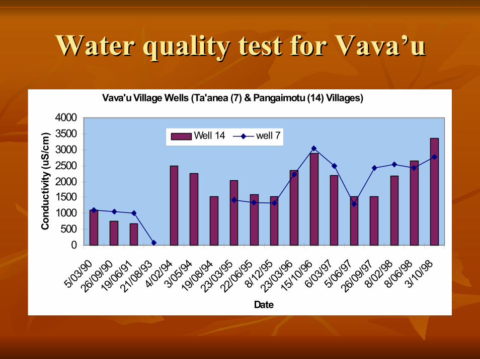
Water quality test for Water quality test for Vava’uVava’uVava'u Village Wells (Ta'anea (7) & Pangaimotu (14) Villages)
0500
1000150020002500300035004000
5/03/9
026
/09/90
19/06
/9121
/08/93
4/02/9
43/0
5/94
19/08
/9423
/03/95
22/06
/958/1
2/95
23/03
/9615
/10/96
6/03/9
75/0
6/97
26/09
/978/0
2/98
8/06/9
83/1
0/98
Date
Cond
uctiv
ity (u
S/cm
) Well 14 well 7

Water quality test for Water quality test for Ha’apaiHa’apai
Ha'apai wells (Lotofoa (34) & Koulo (39) Village)
010002000300040005000600070008000
3/08/8
505
/03/19
9031
/01/91
28/01
/9418
/08/94
13/06
/9514
/03/96
15/03
/97
3/10/9
714
/06/98
Date
Con
duct
ivity
(uS/
cm)
Well 39 Welll 34

Typical freshwater lens on a coral island atoll situation.

Surface waterSurface water
Surface water resources are only occurring on some Surface water resources are only occurring on some of the high volcanic and mixed geology islands in the of the high volcanic and mixed geology islands in the form of springs and lakes. form of springs and lakes. Crater lakes exist on the islands of Crater lakes exist on the islands of Niuafo'ouNiuafo'ou and and
TofuaTofua. . The former lake has been used in dry periods as a The former lake has been used in dry periods as a source of potable water. source of potable water. Surface water is collected from cave systems on the Surface water is collected from cave systems on the island of 'island of 'EuaEua and used for potable water supply.and used for potable water supply.

Rainwater Rainwater Rainwater systems are another freshwater resource for the Rainwater systems are another freshwater resource for the islands and they represent an important source of potable water islands and they represent an important source of potable water on many of the islands. on many of the islands. On some of the smaller islands in the On some of the smaller islands in the Ha'apaiHa'apai and and Vava'uVava'ugroups they are the only source of freshwater.groups they are the only source of freshwater.Rainwater is the supplementary source to groundwater, which Rainwater is the supplementary source to groundwater, which is collected by rooftop and stored by different types of tanks is collected by rooftop and stored by different types of tanks such as galvanize ion, reinforced concrete and fiberglass.such as galvanize ion, reinforced concrete and fiberglass.There have been numerous programs involving the installation There have been numerous programs involving the installation of water catchments tanks for the rural area and outer islands of water catchments tanks for the rural area and outer islands (Furness & (Furness & HeluHelu, 1993). , 1993). In addition to private installation of water collection tanks, In addition to private installation of water collection tanks, foreign aid and various NGO groups have organized foreign aid and various NGO groups have organized construction and installation of rainwater tanks in rural area construction and installation of rainwater tanks in rural area and outer islands. and outer islands.
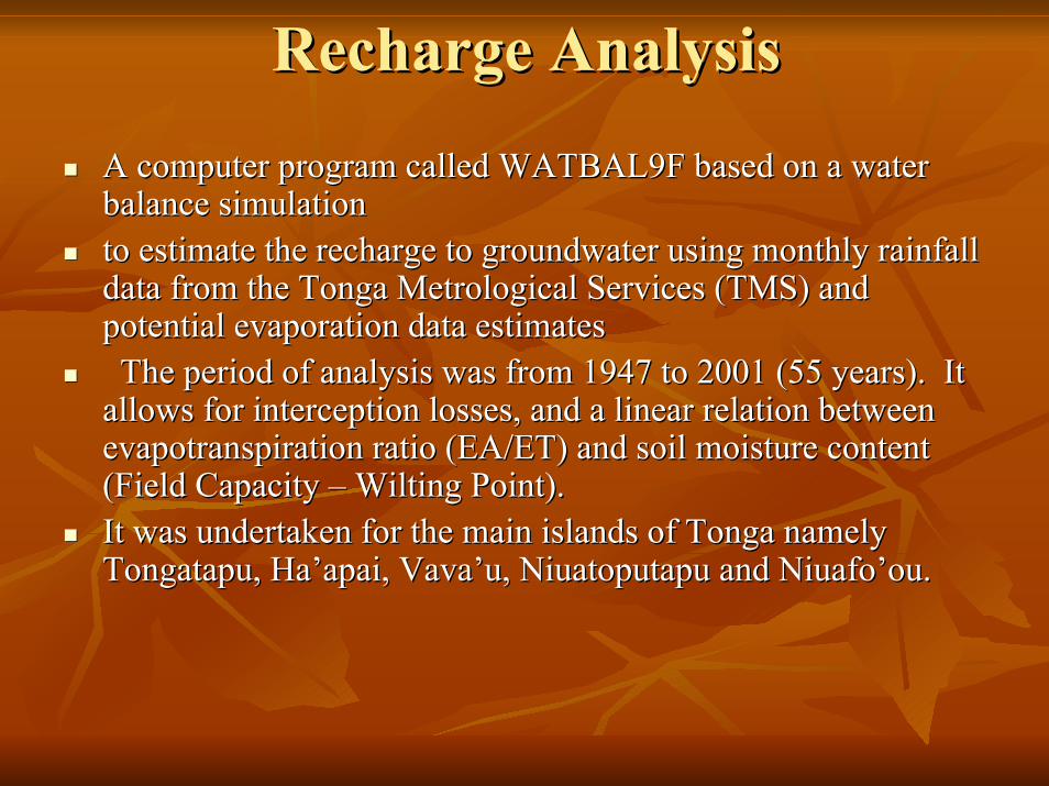
Recharge AnalysisRecharge Analysis
A computer program called WATBAL9F based on a water A computer program called WATBAL9F based on a water balance simulation balance simulation to estimate the recharge to groundwater using monthly rainfall to estimate the recharge to groundwater using monthly rainfall data from the Tonga Metrological Services (TMS) and data from the Tonga Metrological Services (TMS) and potential evaporation data estimatespotential evaporation data estimatesThe period of analysis was from 1947 to 2001 (55 years). It The period of analysis was from 1947 to 2001 (55 years). It
allows for interception losses, and a linear relation between allows for interception losses, and a linear relation between evapotranspirationevapotranspiration ratio (EA/ET) and soil moisture content ratio (EA/ET) and soil moisture content (Field Capacity (Field Capacity –– Wilting Point). Wilting Point). It was undertaken for the main islands of Tonga namely It was undertaken for the main islands of Tonga namely TongatapuTongatapu, , Ha’apaiHa’apai, , Vava’uVava’u, , NiuatoputapuNiuatoputapu and and Niuafo’ouNiuafo’ou. .

Annual Recharge for Annual Recharge for LifukaLifukaLifuka, Ha'apai
Annual Recharge From 1947 to 2001
-200
0
200
400
600
800
1000
1200
1400
1947
1949
1951
1953
1955
1957
1959
1961
1963
1965
1967
1969
1971
1973
1975
1977
1979
1981
1983
1985
1987
1989
1991
1993
1995
1997
1999
2001
Year
An
nu
al R
ech
arg
e (
mm
)
Recharge Statistics for 55 years period 1947 - 2001Mean = 524mmMax = 1296mmMin = -36mm

Annual Rainfall and RechargeAnnual Rainfall and RechargeLifuka, Ha'apai
Annual Raifall and Recharge from 1947 to 2001
-500
0
500
1000
1500
2000
2500
3000
1947
1949
1951
1953
1955
1957
1959
1961
1963
1965
1967
1969
1971
1973
1975
1977
1979
1981
1983
1985
1987
1989
1991
1993
1995
1997
1999
2001
Year
An
nu
al R
ain
fall a
nd
Re
ch
arg
e (
mm
)
Rainfall RechargeStatistics for 55 years period1 947-2001Average Annual Rainfall=1749mmAnnual RechargeMean = 524mmMax = 1296mmMin = -36mm

Summary and ConclusionSummary and ConclusionThe water resources of rural area and outer islands of The water resources of rural area and outer islands of Tonga are vulnerable to the impacts of climate and sea Tonga are vulnerable to the impacts of climate and sea level changes. level changes. Impacts of climate and sea level changes are outlined Impacts of climate and sea level changes are outlined below.below.Salinity data from selected wells has shown an impact Salinity data from selected wells has shown an impact of the decreasing rainfall on the quality of groundwater of the decreasing rainfall on the quality of groundwater lens. lens. LifukaLifuka in the in the Ha’apaiHa’apai group has the lowest percentage group has the lowest percentage of recharge (27%) for the 55 years period (1947of recharge (27%) for the 55 years period (1947--2001) 2001) of analysis in comparison to other islands of Tonga.of analysis in comparison to other islands of Tonga.
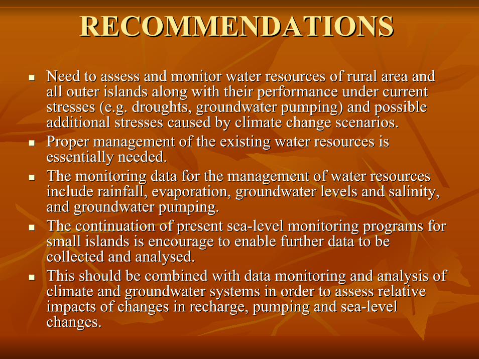
RECOMMENDATIONSRECOMMENDATIONSNeed to assess and monitor water resources of rural area and Need to assess and monitor water resources of rural area and all outer islands along with their performance under current all outer islands along with their performance under current stresses (e.g. droughts, groundwater pumping) and possible stresses (e.g. droughts, groundwater pumping) and possible additional stresses caused by climate change scenarios. additional stresses caused by climate change scenarios. Proper management of the existing water resources is Proper management of the existing water resources is essentially needed. essentially needed. The monitoring data for the management of water resources The monitoring data for the management of water resources include rainfall, evaporation, groundwater levels and salinity, include rainfall, evaporation, groundwater levels and salinity, and groundwater pumping.and groundwater pumping.The continuation of present seaThe continuation of present sea--level monitoring programs for level monitoring programs for small islands is encourage to enable further data to be small islands is encourage to enable further data to be collected and collected and analysedanalysed. . This should be combined with data monitoring and analysis of This should be combined with data monitoring and analysis of climate and groundwater systems in order to assess relative climate and groundwater systems in order to assess relative impacts of changes in recharge, pumping and seaimpacts of changes in recharge, pumping and sea--level level changes.changes.

MaloMalo ‘‘AupitoAupito
VinakaVinaka vakavaka levulevu
Thank you very muchThank you very much