presublp 050314 tkt - south derbyshire district council local plan... · settlement reference...
TRANSCRIPT
South Derbyshire Local Plan PART 2
1010 Appendix CLocal Green
Spaces Maps
THIS PAGE IS INTENTIONALLY BLANK
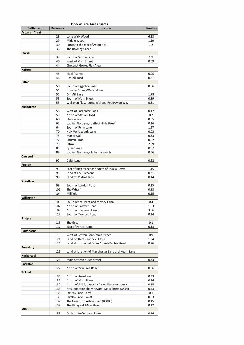
Settlement Reference Location Size (ha)
Aston on Trent
28 Long Walk Wood 6.23
29 Middle Wood 1.19
30 Ponds to the rear of Aston Hall 1.2
36 The Bowling Green 1
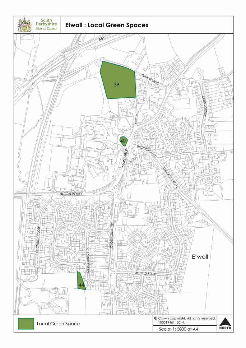
Etwall
39 South of Sutton Lane 1.9
40 West of Main Street 0.09
44 Chestnut Grove, Play Area
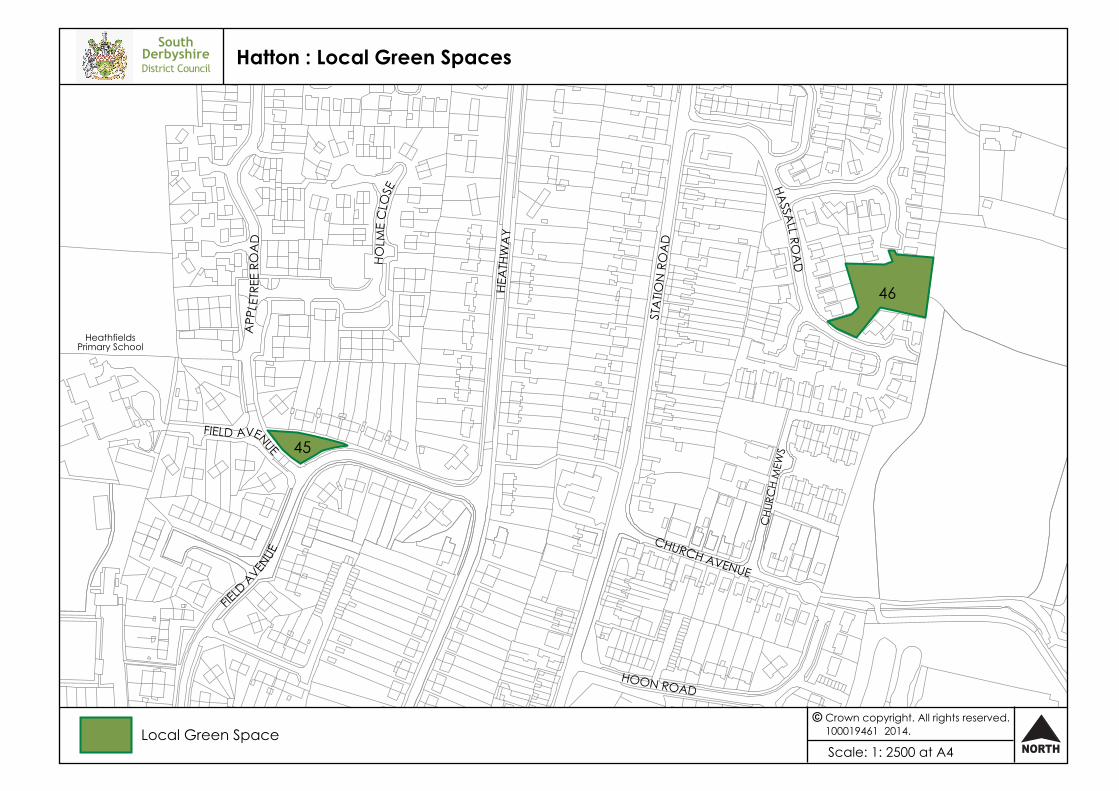
Hatton
45 Field Avenue 0.05
46 Hassall Road 0.21
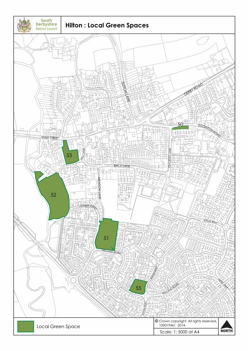
Hilton
50 South of Egginton Road 0.06
51 Humber Street/Welland Road 1
52 Off Mill Lane 1.78
53 South of Main Street 0.39
55 Wellavon Playground, Welland Road/Avon Way 0.31
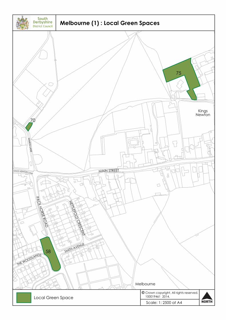
Melbourne
58 West of Packhorse Road 0.17
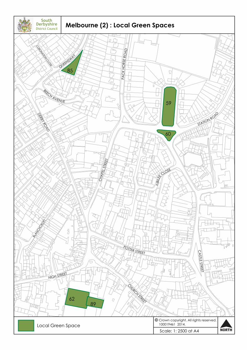
59 North of Station Road 0.2
60 Station Road 0.05
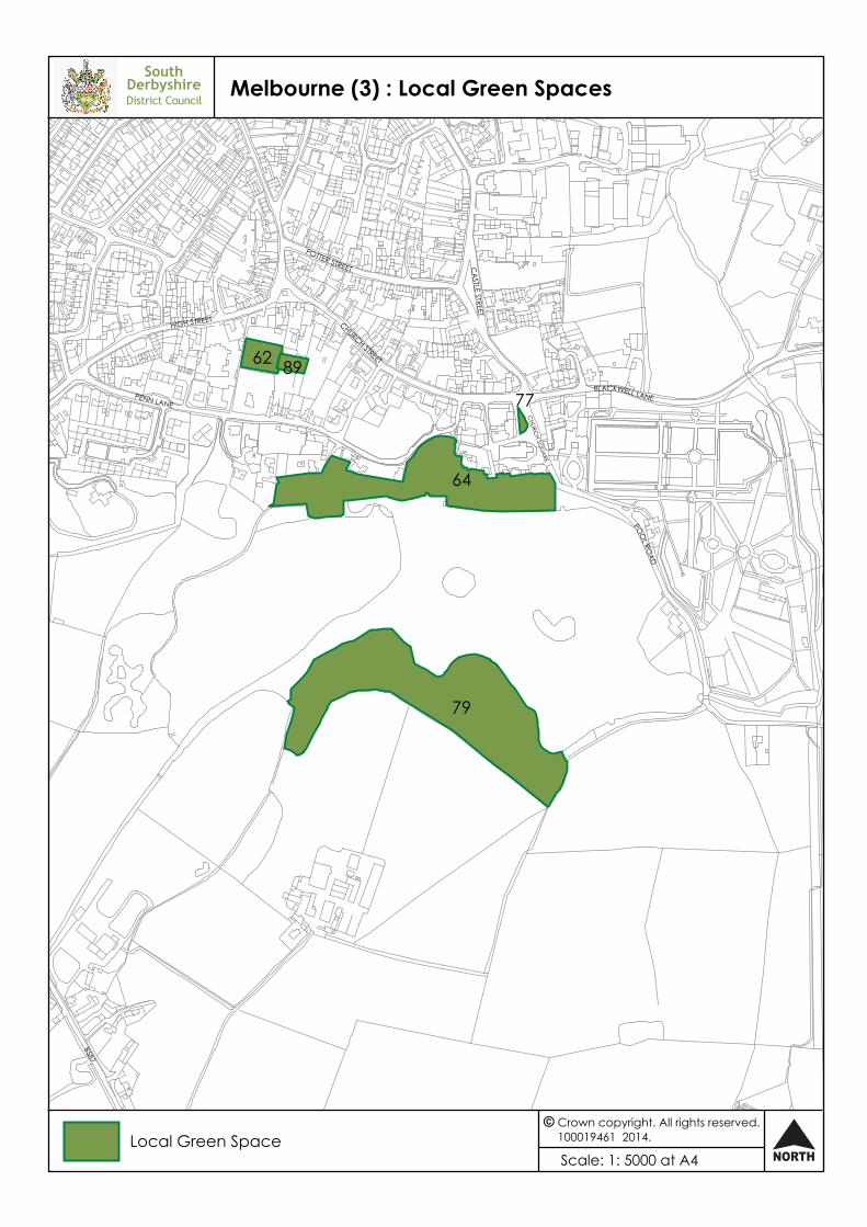
62 Lothian Gardens, south of High Street 0.16
64 South of Penn Lane 1.57
70 Holy Well, Wards Lane 0.02
75 Manor Oak 0.33
77 Church Close 0.02
79 Intake 2.69
85 Queensway 0.07
89 Lothian Gardens, old tennis courts 0.06
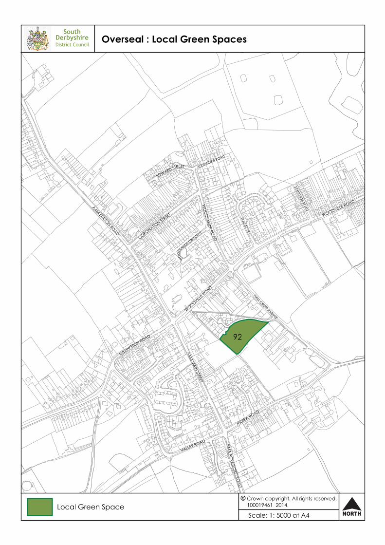
Overseal
92 Daisy Lane 0.62
Repton
93 East of High Street and south of Askew Grove 1.15
95 Land at The Crescent 0.31
98 Land off Pinfold Lane 0.14
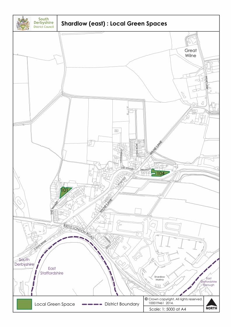
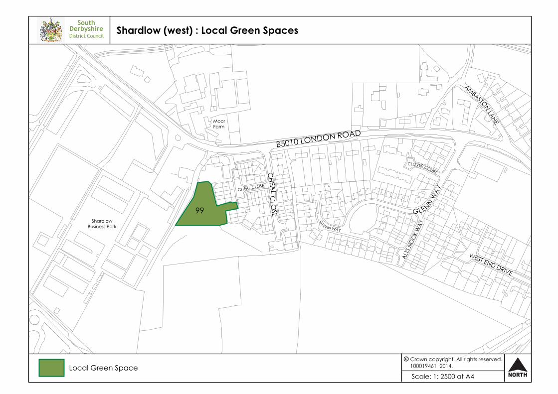
Shardlow
99 South of London Road 0.25
101 The Wharf 0.13
104 Millfield 0.15
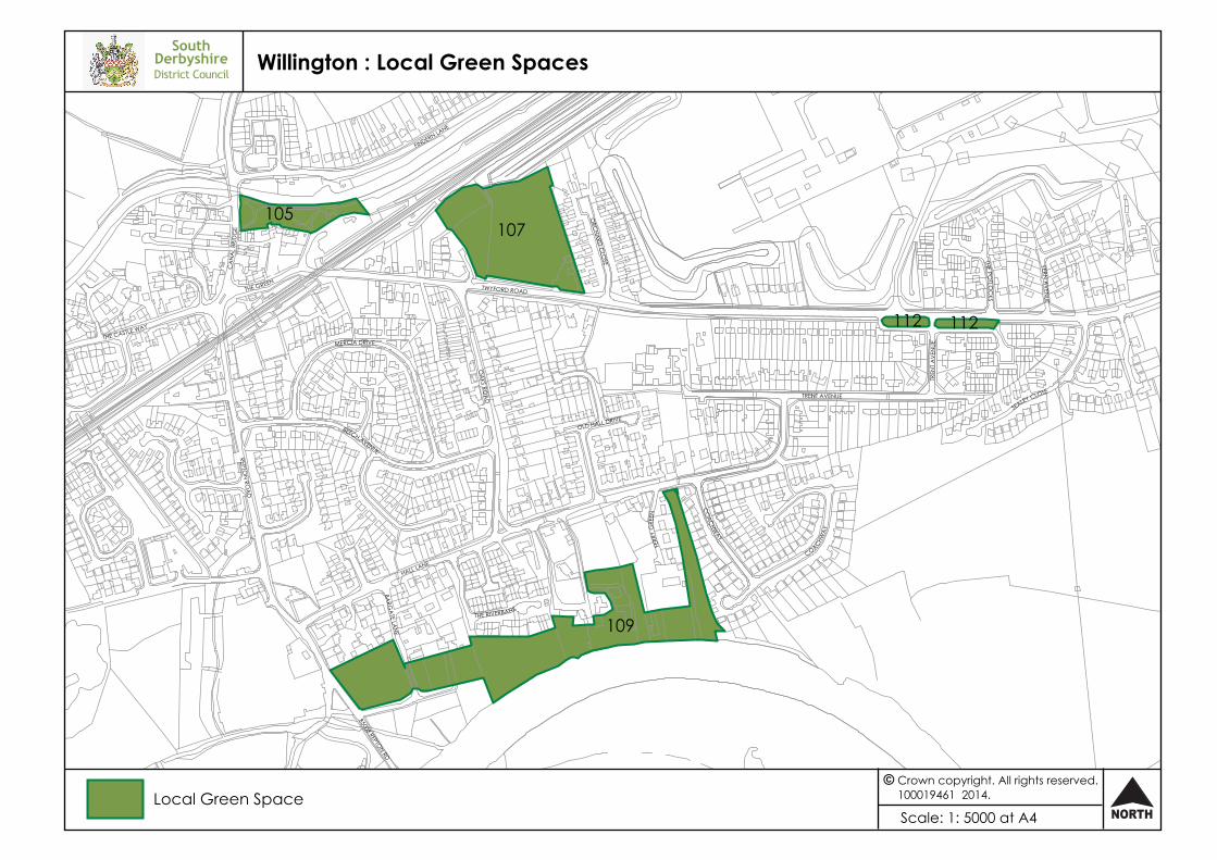
Willington
105 South of the Trent and Mersey Canal 0.4
107 North of Twyford Road 1.63
109 North of the River Trent. 3.06
112 South of Twyford Road 0.14
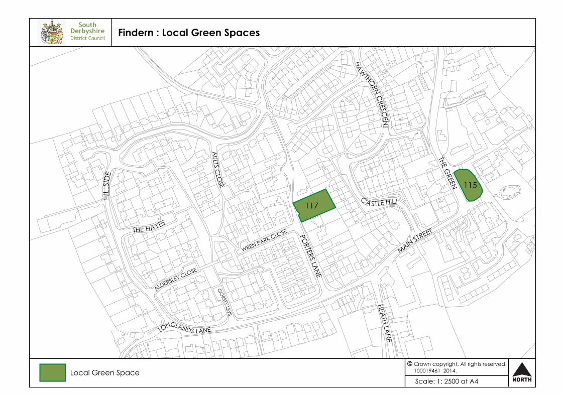
Findern
115 The Green 0.1
117 East of Porters Lane 0.13
Hartshorne
118 West of Repton Road/Main Street 0.9
121 Land north of Kendricks Close 1.84
124 Land at junction of Brook Street/Repton Road 0.76
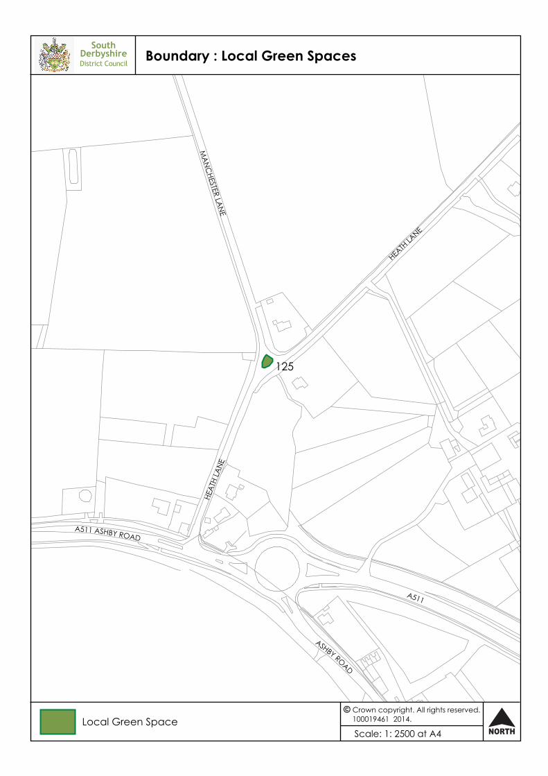
Boundary
125 Land at junction of Manchester Lane and Heath Lane
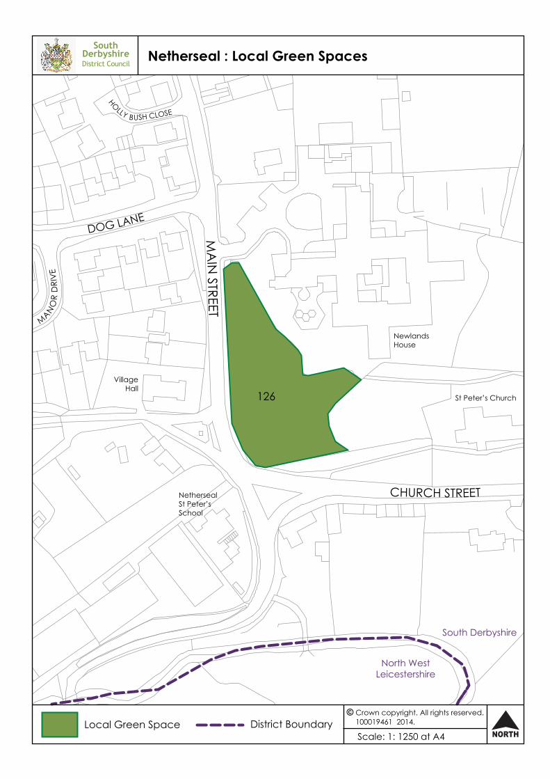
Netherseal
126 Main Street/Church Street 0.33
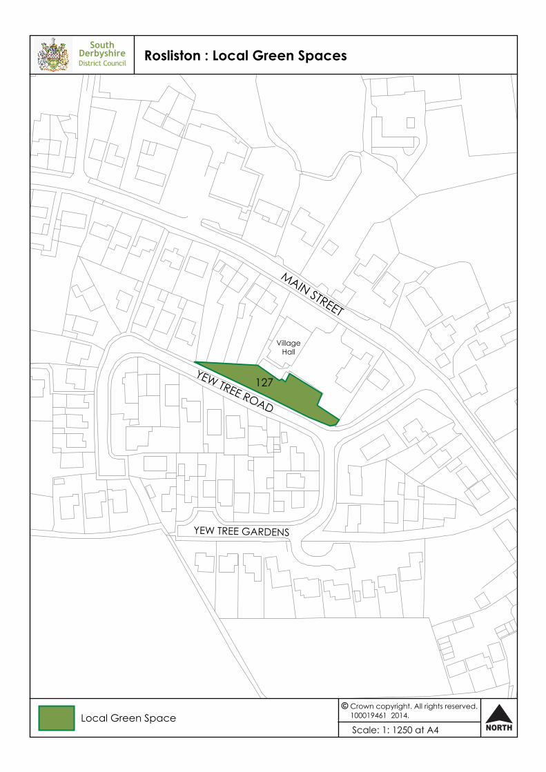
Rosliston
127 North of Yew Tree Road 0.06
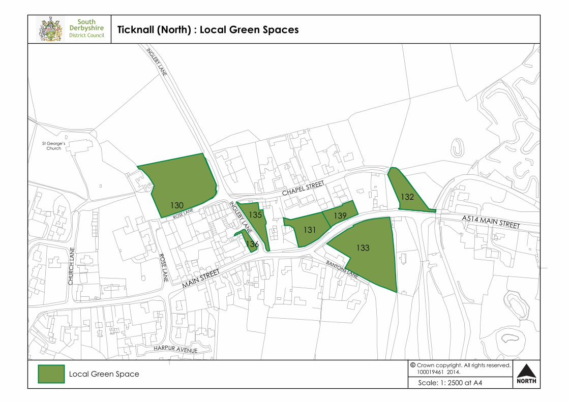
Ticknall
130 North of Rose Lane 0.53
131 North of Main Street 0.16
132 North of A514, opposite Calke Abbey entrance 0.15
133 Area opposite The Vineyard, Main Street (A514) 0.53
135 Ingleby Lane – east 0.1
136 Ingelby Lane – west 0.03
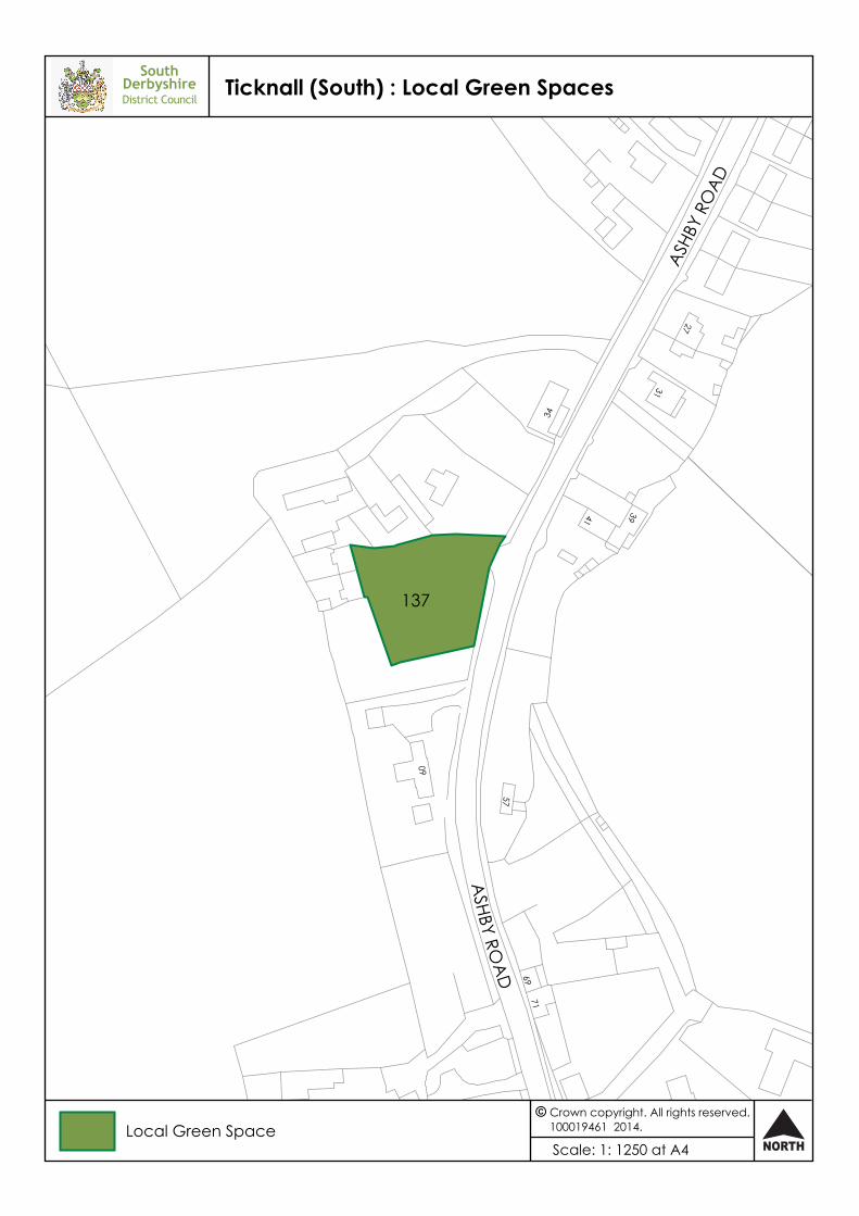
137 The Green, off Ashby Road (B5006) 0.15
139 The Vineyard, Main Street 0.12
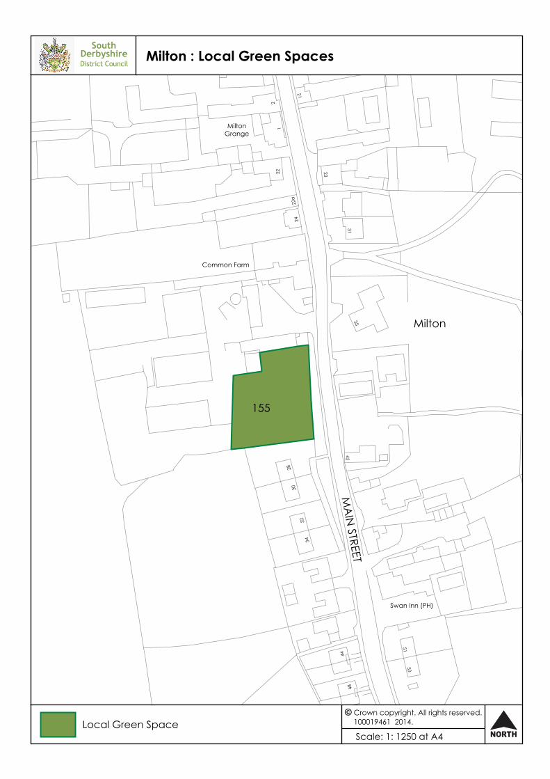
Milton
155 Orchard to Common Farm 0.16
Index of Local Green Spaces
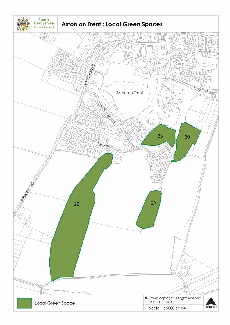
WES
TON
ROA
D
LONG WALKWOOD
WES
TON
ROAD
M
AP LE DRIVE
MIDDLEWOOD
Aston-on-Trent
WILLOW
PARK WAY
SHARDLOW ROAD
Aston on Trent : Local Green SpacesSouth
DerbyshireDistrict Council
Scale: 1: 5000 at A4 NORTH
Crown copyright. All rights reserved.100019461 2014.Local Green Space
28 29
36 30
SouthDerbyshireDistrict Council
Boundary : Local Green Spaces
Scale: 1: 2500 at A4 NORTH
Crown copyright. All rights reserved.100019461 2014.Local Green Space
A511 ASHBY ROAD
A511
HEA
TH L
AN
E
MA
NC
HESTER LAN
E
HEATH
LANE
ASHBY ROAD
125
MA
IN S
TREE
T
WILLINGTON RD
LAW
N A
VENUE
SUTTON LANE
HILTON ROAD
EGG
INTO
N RO
AD
Etwall
A516O
LD S
TATIO
N C
LOSE
CHU
RCH
HILL
OAKLANDS RO
AD
BELFIELD ROAD
CH
ESTNUT G
ROV
E
SouthDerbyshireDistrict Council
Etwall : Local Green Spaces
Scale: 1: 5000 at A4 NORTH
Crown copyright. All rights reserved.100019461 2014.Local Green Space
39
40
44
SouthDerbyshireDistrict Council
Findern : Local Green Spaces
Scale: 1: 2500 at A4 NORTH
Crown copyright. All rights reserved.100019461 2014.Local Green Space
HILL
SID
E
THE HAYES
WREN PARK CLOSE
LONGLANDS LANE
GO
RSTY LEYS
ALDERSLEY CLOSE
PORTERS LA
NE
C A STLE HILL
THE GREEN
HA
WTHORN C
RESCEN
T
MAIN STREET
HEATH LA
NE
AULTS C
LOSE
117
115

SouthDerbyshireDistrict Council
Hartshorne : Local Green Spaces
Scale: 1: 2500 at A4 NORTH
Crown copyright. All rights reserved.100019461 2014.Local Green Space
REPTON ROAD
PEAR TREE
CLO
SE
BRO
OK
STRE
ET
AD
AM
SC
LOSE
A514 MAIN STREET
A51
4 TIC
KNA
LL R
OA
D
Hartshorne
MILLPOOL CLOSE
124
121
118
SouthDerbyshireDistrict Council
Hatton : Local Green Spaces
Scale: 1: 2500 at A4 NORTH
Crown copyright. All rights reserved.100019461 2014.Local Green Space
FIELD
AVEN
UE
HEA
THW
AY
HASSA
LLRO
AD
CHURCH AVENUE
CHU
RCH
MEW
S
STA
TION
RO
AD
HOL M
E C
LOSE
APP
LETR
EE R
OA
D
HeathfieldsPrimary School
FIELD AVENUE
HOON ROAD
45
46
Hilton : Local Green SpacesSouth
DerbyshireDistrict Council
Scale: 1: 5000 at A4 NORTH
Crown copyright. All rights reserved.100019461 2014.Local Green Space
MAIN STREET
MIL
L LA
NE
BACK LANE
MEA
DO
W LA
NE
WELLAND ROAD
HUMBER STREET
DERBY ROAD
EGGINTON ROAD
SUTTON
LAN
E
PEA
CRO
FT L
AN
E
WELLAND ROAD
AVON
WAY
AVO
N W
AY
NENE WAY
AVON WAY
52
51
55
53
50
SouthDerbyshireDistrict Council
Melbourne (1) : Local Green Spaces
Scale: 1: 2500 at A4 NORTH
Crown copyright. All rights reserved.100019461 2014.Local Green Space
KingsNewton
Melbourne
MAIN STREET
NETTLEFOLD
CRESC
ENT
PAC
K HORSE RO
AD
THE WOODLANDSSMITH AVENUE
WA
RDS LA
NE
KINGS NEWTON LANE
75
70
58
STATION ROAD
CHA
PEL
STRE
ET
POTTER STREET
CHURCH STREET
HIGH STREET
CA
STLE STREET
JUBI
LEECLOSE
BLAN
CHCRO
FT
PAC
K HO
RSE
ROA
D
QUEENSW
AY
DERBY ROAD
BEECH AVENUE
CORO
NATION CLO
SE
SouthDerbyshireDistrict Council
Melbourne (2) : Local Green Spaces
Scale: 1: 2500 at A4 NORTH
Crown copyright. All rights reserved.100019461 2014.Local Green Space
59
60
85
6289
SouthDerbyshireDistrict Council
Melbourne (3) : Local Green Spaces
Scale: 1: 5000 at A4 NORTH
Crown copyright. All rights reserved.100019461 2014.Local Green Space
POTTER STREET
CHURCH STREET
HIGH STREET
PENN LANEC
ASTLE STREET
B587
BLACKWELL LANE
POO
L ROAD
CHURC
H SQUA
RE
62 89
77
64
79
SouthDerbyshireDistrict Council
Milton : Local Green Spaces
Scale: 1: 1250 at A4 NORTH
Crown copyright. All rights reserved.100019461 2014.Local Green Space
MA
IN STREET
Common Farm
2422
a
22
35
45
2830
3234
Swan Inn (PH)
5153
44
48
31
23
21
MiltonGrange
12
Milton
155
South Derbyshire
North WestLeicestershire
SouthDerbyshireDistrict Council
Netherseal : Local Green Spaces
Scale: 1: 1250 at A4 NORTH
Crown copyright. All rights reserved.100019461 2014.Local Green Space District Boundary
CHURCH STREET
MA
IN STREET
DOG LANE
NewlandsHouse
St Peter’s Church
HOLLY BUSH CLOSE
VillageHall
NethersealSt Peter’sSchool
MANO
R D
RIV
E
126
SouthDerbyshireDistrict Council
Overseal : Local Green Spaces
Scale: 1: 5000 at A4 NORTH
Crown copyright. All rights reserved.100019461 2014.Local Green Space
A444 A
CRESFO
RD RO
AD
A444 MAIN STREET
A444 BURTON ROAD
WOODVILLE R
OAD
LULLINGTON ROAD
MOIRA ROAD
VALLEY ROAD
CORONATION ST
REET
WO
OD
LAN
DS RO
ADEDWARD STREET ALEXANDRA ROAD
FOREST VIEW
WOO
DLANDS C
RESCENT
WOODVILLE ROAD
STANLEIGH RO
AD
HALL CROFT AVENUE
92

SouthDerbyshireDistrict Council
Repton : Local Green Spaces
Scale: 1: 2500 at A4 NORTH
Crown copyright. All rights reserved.100019461 2014.Local Green Space
HIGH STREET
PINFOLD CLOSE
SPRING
FIELD RO
AD
ASKEW GROVE
THE
CRE
SCEN
T
MILTON ROAD
PINFOLD LANE
WELL LANE
WYSTAN COURT
MAIN STREET
95
93
98
SouthDerbyshireDistrict Council
Rosliston : Local Green Spaces
Scale: 1: 1250 at A4 NORTH
Crown copyright. All rights reserved.100019461 2014.Local Green Space
YEW TREE ROAD
MAIN STREET
VillageHall
YEW TREE GARDENS
127
SouthDerbyshire
EastStaffordshire
EastStaffordshire
Borough
District Boundary
WILN
E LANE
MILLFEILDTHE WHARF
CA
VEN
DIS
H C
L
THE
WHA
RF
B5010 LONDON ROAD
WILN
E LANE
LON
G R
OW
GreatWilne
CAVENDISHCOURT
CANAL BANK
ShardlowMarina
THE M
ALTINGS
WILN
E LAN
E
SouthDerbyshireDistrict Council
Shardlow (east) : Local Green Spaces
Scale: 1: 5000 at A4 NORTH
Crown copyright. All rights reserved.100019461 2014.Local Green Space
101
104
SouthDerbyshireDistrict Council
Shardlow (west) : Local Green Spaces
Scale: 1: 2500 at A4 NORTH
Crown copyright. All rights reserved.100019461 2014.Local Green Space
B5010 LONDON ROAD
CHEA
L CLO
SE
GLE NN WAY
ALTS
NO
OK
WA
Y
GLENN WAY
CLOVER COURT
AMBASTON LANE
WEST END DRIVE
MoorFarm
CHEAL CLOSE
ShardlowBusiness Park
99
SouthDerbyshireDistrict Council
Ticknall (North) : Local Green Spaces
Scale: 1: 2500 at A4 NORTH
Crown copyright. All rights reserved.100019461 2014.Local Green Space
MAIN STREET
HARPUR AVENUE
INGLEBY LANE
ROSE LA
NE
CHU
RCH
LAN
E
CHAPEL STREET
BANTONS LANE
A514 MAIN STREET
St George’sChurch
ROSE LANE
INGLEBY LANE
130
136
135
131
133
139
132
ASHBY RO
AD
THE GREEN
ASHB
Y RO
AD
57
6971
60
34
3941
31
27
SouthDerbyshireDistrict Council
Ticknall (South) : Local Green Spaces
Scale: 1: 1250 at A4 NORTH
Crown copyright. All rights reserved.100019461 2014.Local Green Space
137
TWYFORD ROAD
OA
KS ROA
D
MERCIA DRIVE
BEECH AVENUE
CA
NA
L BR
IDG
E
THE GREEN
THE CASTLE WAY
REPTON
ROA
D
HALL LANE
BARG
ATE LA
NE
B5008 REPTON RD
THE RIVERBANK
FERR
Y G
REEN
CO
ACHW
AY
OLD HALL DRIVE
ORC
HARD
CLO
SE
TRENT AVENUE
THE POTLO
CKS
FERN A
VEN
UE
TREN
T A
VEN
UE
SEALEY CLOSE
COACHW
AY
FINDERN LANE
SouthDerbyshireDistrict Council
Willington : Local Green Spaces
Scale: 1: 5000 at A4 NORTH
Crown copyright. All rights reserved.100019461 2014.Local Green Space
105107
112 112
109