prevention (marine safety) department navigation systems division basicatontraining
TRANSCRIPT

Prevention(Marine Safety)
Department
Navigation SystemsDivision
BASICBASIC
ATONATON
TRAININGTRAINING

Basic ATON TrainingToday’s Subject Agenda
Basic ATON Training.
ATON Discrepancy Review.
Getting AUXDATA credit for AN Activity.

AtoN Training ObjectivesAtoN Training Objectives
1. Review the definitions for the various Federal and Private Aids to Navigation.
2. Understand why AtoNs are established.
3. Understand the specific purpose of the various AtoNs.
4. Become familiar with the flash characteristics used on AtoNs.

AtoN Operational ObjectivesAtoN Operational Objectives
1. A high level of professionalism required on the part of each NS Team member.
2. Accurate and complete AtoN reports to the Coast Guard.
3. A high level of quality data to increase the credibility of our AtoN Program.
3. Reports forwarded to the Coast Guard in a timely manner.

AtoN – FEDERAL SHORT RANGE AID TO NAVIGATION.
PAtoN – PRIVATE AID TO NAVIGATION.
TERMINOLOGY UPDATE
5

ATON System Definitions
IALA - International Association of Lighthouse Authorities.
Divides the world into 2 regions:
Region “A”: Most of the World
Region “B”: North & South America, Japan, Korea, and the Philippines.
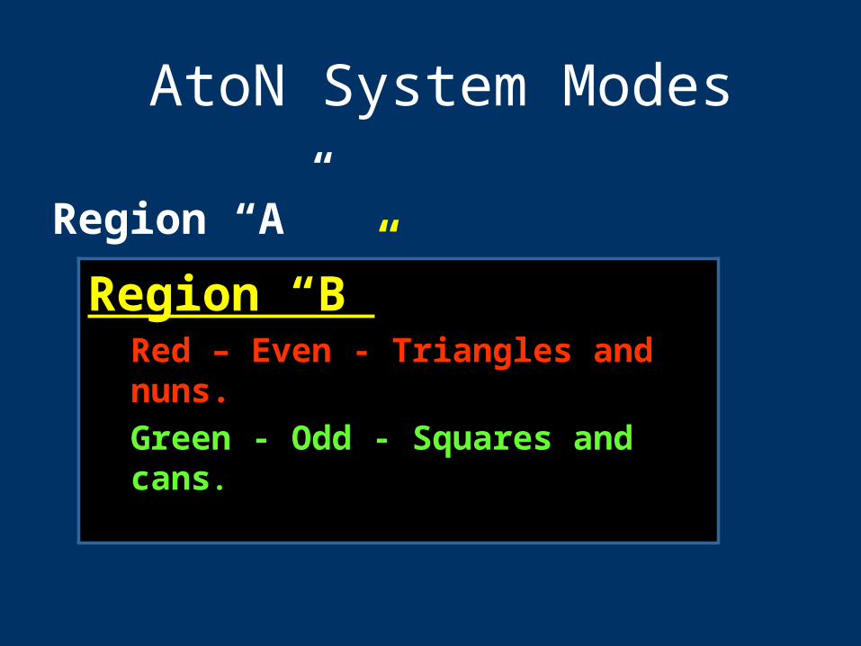
AtoN System Modes
Region “A” Green Even Triangles Red Odd SquaresRegion “B”
Red – Even - Triangles and nuns.
Green - Odd - Squares and cans.

AtoN System Names
U.S. Marking SystemU.S. Marking SystemIntracoastal Waterway System
Western River System

U. S. Marking SystemU. S. Marking SystemLateral System:
Employs a simple arrangement of . . .
1. colors,
2. numbers, and
3. shapes,and when you can’t see the shape,,
light colors and light characteristics.. . . to show on which side an aid should be passed when proceeding in the Conventional Direction of Buoyage.
“Red Right Returning from the sea”Red Right Returning from the sea”

Conventional Directionof Buoyage in channels:
Numbering starts at seaward and increases toward the shore.
Numbering starts at the mouth of rivers and increases upstream.
Numbering is clockwise around islands.

Conventional Directionof Outer Buoys
Purpose: To identify how aids should be passed in areas other than channels.
Regions: Atlantic Coast: Southerly Gulf Coast: North and Westerly Pacific Coast: Northerly Great Lakes: North and Westerly
(Lake Michigan: Southerly)

Conventional Direction of Buoyage
Used for marking the Intracoastal
Waterway (ICW) and the off-shore ocean
buoys along the coast.

Definition of an Aid to Definition of an Aid to NavigationNavigation
Any device, external to a vessel,
intended to assist mariners to:
a. Determine their position,
b. Determine a safe course, or
c. To warn them of dangers or
obstructions to navigation.

Definition of a BuoyDefinition of a BuoyAny unmanned, floating aid to navigation that is moored to the seabed.
May be lighted or unlighted.
The seabed is owned by the Corps of Engineers (USACE) and is licensed to the Coast Guard who deploy ATONs and authorize private parties to deploy PATONs.

Unlighted Nun Buoy
6Conical shape
RedRetro
WhiteNumber

Definition of a BeaconDefinition of a Beacon
Any fixed aid to navigation located
on a shore or marine site.
Lighted beacons are called LightsLights..
Unlighted beacons are called
DaybeaconsDaybeacons or DaymarksDaymarks..

Definition of a DaymarkDefinition of a Daymark
The daytime identifier of an aid to
navigation presenting one of
several colors, shapes, numerals
or letters.
The shape may be a square, triangle, rectangle, diamond or octagon.

Unlighted Red Daymark
2
Is there anything wrong with this daymark? 2
It should have a contrasting
red number

Starboard Lateral Marks
Color: RedShape: Triangularor conical—nuns.Character: Even
NumbersLight: Red
LightedBuoy
Daymark
Small Light
Nun

Large Lighted Red Buoy
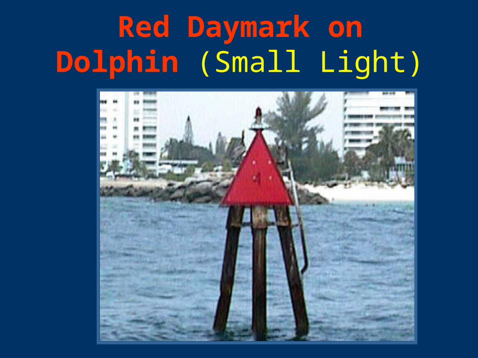
Red Daymark on Dolphin (Small Light)

Port Lateral Marks
Color: Green
Shape: Square /
Cans
Character: Odd
Numbers
Light: Green Can
Daymark
LightedBuoy
Small Light

Unlighted Can Buoy
7It should have a white number.
7
Is there anything wrong with this can buoy?

Unlighted Green Can Buoy
Most likely a Private Aid to Navigation.

Lighted Green Buoy

Unlighted Green Daymark
3
It should have a contrasting GREEN number.
3
Is there anything wrong with this daybeacon?

A good reason A good reason to take it slow to take it slow
and watch and watch where you’re where you’re
going!going!

1 2
3
5 6
7 8
910
12
2
3
“Lateral” systems define the navigable channel.
Always operate your boat in the channel!

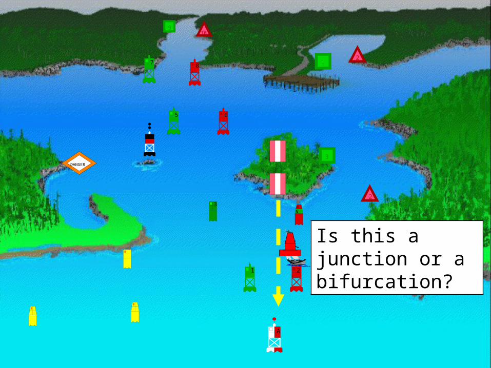
Preferred Channel MarksPurpose: Marks junctions / bifurcationsDescription:
Color: Red & Green horizontally banded(The top color band is for the preferred channel)
Shape: Same as for the preferred channel (Use the uppermost band in preferred channel)
Character: Letter not number.Light: Same color as uppermost band.
Characteristic: Gp Fl (2+1) 6s
NN
A

JUNCTIONTwo channels join to form one channel.
Preferred channel buoy is placed upstream.
BIFURCATIONOne channel splits to form two channels.
Preferred channel buoy is placed downstream.
CROSSINGOne channel crosses another channel.
No requirement to mark all four corners.

Junctions and Bifurcation Patterns

In the main (primary or preferred) channel, pass these buoys on your port side (to your left) when returning from the sea.
In the secondary channel, pass these buoys on your starboard side (to your right) – “Red Right Returning from the sea.”

1 2
3
5 6
7 8
910
12
2
3
How do you know which is the main
channel?
Always reference your NOAA nautical
chart! BR

Purpose: Indicates navigable water all around the mark. Description:
Color: Red and White vertically striped. Shape: Sphere or Buoy with Topmark.
• Character: White letters.(ex. “NC” North Channel)
• Light Color: White• Characteristic: Mo(A)
Safe Water Mark
G
NN

Safe Water Marks
MR
Spherical
Lighted and or sound

Lighted Safe Water Mark

Isolated Danger MarkIsolated Danger Mark Purpose: Marks isolated dangers or
obstructions that can be passed on all sides Description:
Color: Black and Red horizontal bands. Shape: Buoy with two black top marks. Character: White Lettering – no numbers. Light: White. Light Characteristic: Gp Fl (2) 5s.
D

Special Purpose AidsPurpose: Not intended to assist safe
navigation but to indicate special areas marked on charts (anchorages, traffic separation schemes, data gathering, etc)
Description: Aid Color: Yellow. Aid Shape: Various. Characters: Black lettering, no numbers. Light Color: Yellow Light Characteristic: Fixed, Flashing
(except Mo A, 2+1, Qk)
A
B
C
A

Special Purpose Aids


Regulatory and Information Marks
Purpose: Alert the mariner to such things as submerged pipes, no wake zones, etc.
Description:Aid Color: White with orange band or border.Shape: Square, Round, or Diamond.Character: Lettering (black, usually words)Light Color: WhiteLight Characteristic: Any flash not otherwisealready reserved.
DANGER
EXCLUSION AREA
RESTRICTEDOPERATIONS
DANGER

Regulatory and Information Marks
Diamond - means danger and words may appear explaining the danger.Called a Danger Buoy
Circle- means restricted operations.Speed Buoys (5 MPH) or No Wake Buoys.
Diamond with a Cross - tells you that vessels are not allowed in the area.Called Exclusion Buoys
Square - contains directions for the boater.Bridge Regulatory Signs.

Regulatory and Information Marks
DANGER
ExclusionArea
RestrictedOperations
DANGERIf lighted
White only
What’s wrong with this picture?
No Cross inside the diamond

Restricted Operations - Minimum Wake

Restricted Operations - Manatee Zone
Bridge Discrepancy
Report

DANGER

Restricted Operations - No Wake
Check thestructureand piles!
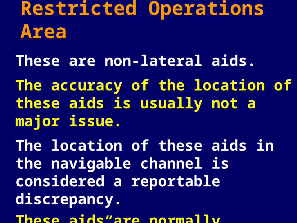
Restricted Operations Area
These are non-lateral aids.
The accuracy of the location of these aids is usually not a major issue.
The location of these aids in the navigable channel is considered a reportable discrepancy.
These aids are normally “Private.”

Restricted Operations - No Wake

Exclusion Area - No Anchoring

Definition of a Range
A pair of beacons arranged so
that, when they are aligned, they
indicate the navigable center line of the channel.
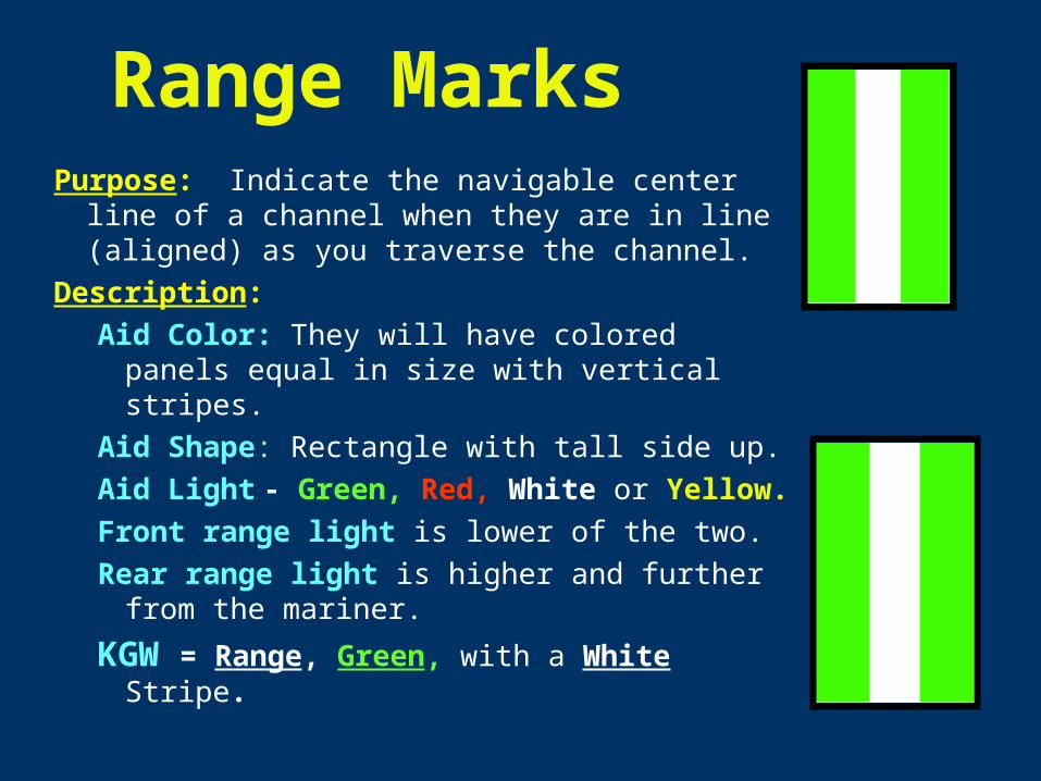
Range MarksPurpose: Indicate the navigable center line of
a channel when they are in line (aligned) as you traverse the channel.
Description:
Aid Color: They will have colored panels equal in size with vertical stripes.
Aid Shape: Rectangle with tall side up.
Aid Light - Green, Red, White or Yellow.
Front range light is lower of the two.
Rear range light is higher and further from the mariner.
KGW = Range, Green, with a White Stripe.

Range Marks
FR – Front Range Mark
RR - Rear Range Mark

WRECK MARKS
Purpose: To alert the mariner to wrecks.
Description:
Aid Color: Appropriate to side of channel.
Aid Shape: Appropriate to side of channel.
Character: White lettering “WR”, numbered
in sequence with channel (WR2).
Aid Light: Same as buoy color.
Light Characteristic: Quick Flashing
(unless aid is a preferred channel aid)
WRWR

LOCATION MARK
Some markers will have no lateral
significance. They are not designed to
indicate the channel but rather,
to help you determine where
you are.
N
A
DANGER
21
2
3
3
65
7 8
109
21
Is this a junction or a bifurcation?

Light StructuresMajor Lighthouses
Are named. e.g. Boston Light
Symbol is large exclamation point.
Fixed position
Minor Lights
Not named
Same symbol
Fixed position

Boston Light

Inside the Boston Light tower.

Other Lights

Understanding Light Patterns
Learn how to time a light.1. Time multiple light cycles.2. Divide the time by the number of cycles.

Light Patterns
Fixed (F) – continuous, unblinking light
Flashing (Fl) – light duration shorter than darkness. Frequency not greater than 30 per minute.
Quick Flashing (Q) – light duration shorter than darkness. Frequency is at least 60 per minute.
Very Quick Flashing (VQ) – light duration shorter than darkness. Frequency is at least 100 per minute.
Interrupted Quick Flashing (IQ) – like quick flashing but having a brief, extended darkness period.
Isophase (Iso) – Light has equal duration between light and darkness. Period consists of both light and dark interval. Also called Equal Interval (E Int).

Light PatternsGroup Flashing (Gp Fl (x+x)) – Combination of two patterns in one period, i.e. 2 flashes followed by three flashes.
Occulting (Occ) – Opposite of flashing – light is on more than it is off.
Alternating (AL) – Alternating light changes color. Special purpose light for situations requiring significant caution. Example shows AL.WG…alternating white and green light.
Morse (Mo) – Morse code light signal. Example is Morse “U” which is two short flashes followed by one prolonged flash then a period of darkness. Shown as (Mo(U)) on charts.
Long Flashing (LFL) – One long flash in a period with lighted period of at least 2 seconds.

Review the symbols and abbreviations on your NOAA chart for every aid that you check.
Check that the charted symbols and abbreviations
match your on-scene observations of the aid.
Report any discrepancies to the Coast Guard and as a chart
update to NOAA.

Chart SymbolsCAN - Green Diamond withsmall watch circle
NUN – Red diamond with small watch circle.
Watch circle overprinted with magenta when lighted.
Italics used for buoys and other floating aids.

Symbols - Daymarks and Minor Lights
Minor Light - Magenta exclamation mark
(teardrop with black dot)Note the vertical letters
used for fixed marks
Green Daymark
Green square.
Red Daymark
Red triangle

Charted Symbols
Always validate that the symbol shown on your chart
matches the aid that you observe and the entry for the
aid in the Light List.
Symbol data in quotes indicates that the characters appears on the aid.
Symbol data in italics indicates that the aid is floating.
Vertical symbol data indicates that the aid is fixed.

68
87
88
89
90
91
A
21
2
3
3
65
7 8
109
21
92
N
DANGER
Is there anything on this chart . . .
…that you do not understand?

AtoN - Reference Materials• Local Notice to Mariners – LNM - online
• Chart No. 1: Nautical Chart Symbols, Abbreviations, and Terms - online
• Light List 1– ME to New Jersey - online
• Coast Pilot 1 – ME to Cape Cod - online

Chart No. 1 Purpose is to help
you identify AtoNs.
Standard conventions for all charts Listed in Chart
No. 1 On Line

Supports the Local Notice to Mariners
The Local Notice to Mariner is generated
using the ATONIS Database
• Chart Corrections
• Discrepancies
• Light List Changes
• On line.
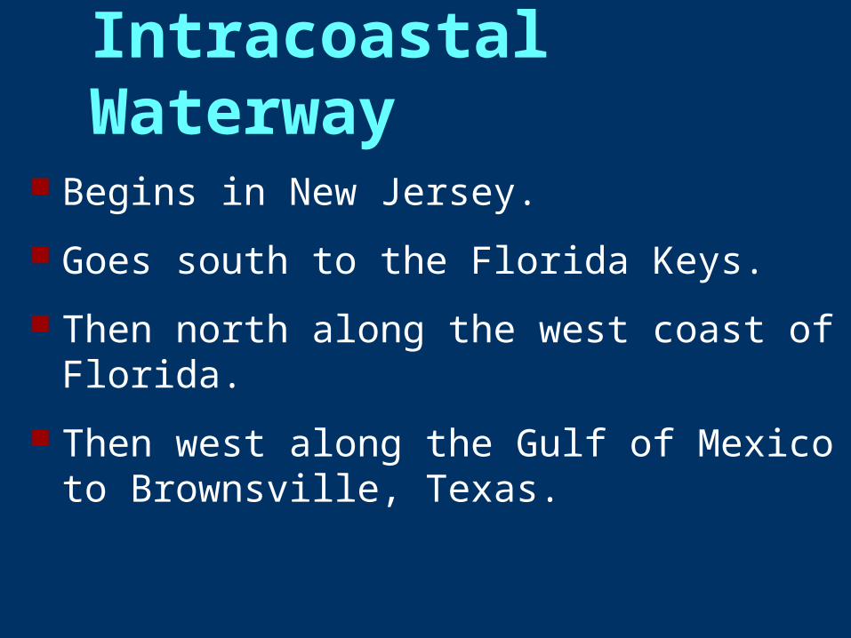
Intracoastal Waterway Begins in New Jersey.
Goes south to the Florida Keys.
Then north along the west coast of Florida.
Then west along the Gulf of Mexico to Brownsville, Texas.

Intracoastal Waterway Marks
When aids in a channel are also used to identify an ICW channel.
The normal “Red right returning from the sea” rule applies to both.

Intracoastal Waterway Marks Yellow Yellow triangles, squares and bands are used to
identify ICW marks.
The material used is retroreflective.
YellowYellow triangles are usually displayed on red lateral marks used on the ICW.
Yellow Yellow squares usually are usually displayed on greengreen lateral marks used on the ICW.
Yellow Yellow bands are displayed on non-lateral marks used on the ICW.
retroreflective

Aidsmarking
theIntracoastal Waterway

Red Daymark/Small Light with ICW Mark
ICW Triangle

Green Daymark/Small Light with ICW Mark
ICW Square

Dual Purpose Marks
When aids in a channel are also used to identify an ICW channel.
The “Red right returning from the sea” rule applies to the regular aids.
The role for the regular aids is reversed and marked for ICW transit - - called “dual purpose.”

Dual Purpose Marks Are found on port and starboard marks in
the ICW. Sometimes a yellow triangle appears on a
can or square daymark or a yellow square appears on a nun or triangle daymark. The mark has dual purpose.
To transit the ICW, follow the yellow marks. When following the local waterway, use the
IALA-B lateral system marks.

Intracoastal Waterway Marks
Dual Purpose Marks

Electronic Aids To Navigation
• Loran-C• Obsolete• Not usable for positioning in the ATON program.
• GPS - Global Positioning SystemsGPS - Global Positioning Systems• Differential GPS – used by Coast Guard.Differential GPS – used by Coast Guard.• WAAS - Wide Area Augmentation SystemsWAAS - Wide Area Augmentation Systems• These are the preferred positioning systemsThese are the preferred positioning systems..
• Electronic Nautical Charts.• Integrated to GPS, RADAR, and Depth Sounder.• Must be supplemented with a NOAA paper chart.

REVIEW

87
88
89
90
91
A
21
2
3
3
65
78
109
21
92
N
DANGER

The End