previous section volume contents relation between basement
TRANSCRIPT
Volume contents
Previous section
Relation Between Basement Structures and FractureSystems in Cover Rocks, Northeastern and
Southwestern Colorado Plateau
By Earl R. Verbeek1 and Marilyn A. Grout2
111
CONTENTSAbstract ........................................................................................................................... 113Introduction..................................................................................................................... 113Hualapai Indian Reservation, Northwestern Arizona ..................................................... 113
Tectonic Overview.................................................................................................. 115Basement Structure beneath Hualapai Reservation ................................................ 117
Sources of Evidence........................................................................................ 117Interpreted Basement Structure ...................................................................... 117
Early Fracture Sets in the Redwall Limestone........................................................ 118Later Fracture Sets .................................................................................................. 121
Southern Marble Plateau, North-Central Arizona .......................................................... 121Tectonic Overview.................................................................................................. 122Basement Structure beneath Southern Marble Plateau........................................... 123Alignments of Breccia Pipes on Southern Marble Plateau..................................... 123Surface Fracture System of the Southern Marble Plateau ...................................... 125
Zoned Fracture Sets ........................................................................................ 125Areally Pervasive Fracture Sets ...................................................................... 125Summary of Surface Fracture Network .......................................................... 128
Piceance Basin, Northwestern Colorado ........................................................................ 128Tectonic Overview.................................................................................................. 130Basement Structure beneath the Piceance Basin .................................................... 130Basement-Related Fracture Sets along the Grand Hogback Monocline................. 133Local Fracture Sets on Divide Creek Anticline ...................................................... 134Later Regional Fracture Sets................................................................................... 134Summary of Surface Fracture Network .................................................................. 137
Discussion....................................................................................................................... 139Effect of Depth and Geologic History on Basement-Cover Fracture Relations..... 139Fracture Networks and Tectonic Heredity.............................................................. 140
Local Formation of Zoned Fracture Sets ........................................................ 140Regional Formation of Areally Pervasive Fracture Sets................................. 140
Evidence against Upward Propagation of Regional Joint Sets............................... 141Some Common Problems ............................................................................... 141Joint Development in a Rotational Stress Field.............................................. 141Timing of Joint Development ......................................................................... 141
Geologic Significance of Regional Joint Sets on the Colorado Plateau ................. 144Conclusions..................................................................................................................... 144Unresolved Structural Problems ..................................................................................... 144Acknowledgments .......................................................................................................... 145References Cited ............................................................................................................. 145

LACCOLITH COMPLEXES OF SOUTHEASTERN UTAH
112
FIGURES
1. Map showing location of the three study areas discussed in this report ........... 114 2. Generalized vertical section through a solution-collapse breccia pipe
of the Grand Canyon region ............................................................................. 116 3–6. Maps showing:
3. Generalized basement fault systems of northwestern and north-central Arizona ....................................................................................................... 117
4. Major basement-related structures on the Hualapai Indian Reservation .... 118 5. Average orientations of F
1
joints in the Redwall Limestone,Hualapai Indian Reservation ...................................................................... 120
6. Average orientations of F
2
joints in the Redwall Limestone,Hualapai Indian Reservation ...................................................................... 121
7. Histograms comparing trends of major basement structures on theHualapai Plateau to strikes of joints of the F
1
and F
2
sets ................................ 122 8. Map showing interpreted basement-related structures in the eastern
Grand Canyon region........................................................................................ 124 9. Map showing interpreted alignments of solution-collapse breccia pipes
on the southern Marble Plateau ........................................................................ 126 10. Three sketch portrayals of the structure of the Snake graben ........................... 127 11. Vertical aerial photograph showing discontinuous graben typical of
those found on and near the Marble Plateau .................................................... 128 12. Photograph showing vertical joints in tilted beds of the Moenkopi
Formation along the Black Point monocline at the Riverview mine ................ 129 13. Photograph showing members of two well-developed sets of
vertical joints in weakly cemented volcaniclastic sandstones near theRiverview mine................................................................................................. 129
14. Map showing major structural features in and near the Piceance Basin ........... 131 15. Stratigraphic column of Upper Cretaceous and Tertiary rocks in and
bordering the Piceance Basin north of the Colorado River .............................. 132 16. Structure section beneath Divide Creek and Wolf Creek anticlines near
the eastern margin of the Piceance Basin ......................................................... 13317–20. Maps showing:
17. Reconstructed (bed-horizontal) orientations of the older of twoprominent sets of joints in beds of the Upper CretaceousMesaverde Group and lowermost Wasatch Formation (Paleocene)along the Grand Hogback monocline ........................................................ 135
18. Reconstructed (bed-horizontal) orientations of the younger of twoprominent sets of joints in beds of the Upper CretaceousMesaverde Group and Paleocene to lower Eocene Wasatch Formationalong and near the Grand Hogback monocline.......................................... 136
19. Orientations of two sets of fold-parallel joints on the Divide Creekand Wolf Creek anticlines near the eastern marginof the Piceance Basin ................................................................................. 137
20. Distribution and orientations of four regional sets of post-Laramidejoints in Tertiary rocks of the Piceance Basin ........................................... 138
21. Photograph of small thrust fault in thin coal bed of Wasatch Formation,central Piceance Basin ...................................................................................... 139
22. Paired lower-hemisphere equal-area projections of poles to F
2
joints,showing their difference in orientation in lean oil shale versus rich oilshale in the same outcrops................................................................................ 142

113
BASEMENT STRUCTURES AND FRACTURE SYSTEMS, COLORADO PLATEAU
ABSTRACT
The degree to which the structural geometry of Pre-cambrian crystalline basement rocks beneath the ColoradoPlateau influenced fracture development in overlying sedi-mentary rocks was assessed for three areas: the Hualapai In-dian Reservation (Hualapai and western Coconino Plateaus)bordering the Grand Canyon in northwestern Arizona, thesouthern Marble Plateau in north-central Arizona, and thePiceance Basin along the northeastern edge of the ColoradoPlateau in western Colorado. Depths to basement rock rangefrom 460 meters on parts of the Hualapai Plateau to at least7,900 meters in the deepest portions of the Piceance Basin.The fracture system in all three areas includes local fracturezones related to movement along basement structures aswell as regional sets of extension joints that developedindependently of basement control.
Differential strain due to reactivation of basement faultzones is expressed in overlying rocks in a variety of ways:on the Hualapai Reservation, as zones of closely spacedjoints and well-developed karst features in Mississippianlimestones above high-angle fault zones in the basementrocks; on the Marble Plateau, as 0.5–1.0 kilometer-widebelts of minor faults in Permian limestones, again abovehigh-angle basement fault zones; and in the Piceance Basin,as a 25-kilometer-wide, 135-kilometer-long zone of joints inCretaceous and Paleocene rocks above a basement-involvedthrust fault. Common to all these basement-related fracturesets is their local rather than regional extent and theirposition above a known or inferred basement fault zone indeeper rocks.
In addition to fracture zones related to basementstructures, strata in all three areas contain multiple sets ofregionally pervasive joints, which resulted from post-Laramide tectonic extension and decreasing burial depthsdue to regional uplift and erosion. These sets are presentover vast areas and in most places dominate the fracturenetwork of the sedimentary rocks. Though continuousupward propagation of preexisting joint networks in thebasement rocks has been suggested for their development,particularly for the Arizona examples, the regional joint setshave many properties incompatible with any such mecha-nism, including their orientations, stratigraphic distribution,mineralization histories, and sequence of formation.Orientations of these joints are unrelated to basementstructure and instead reflect regional stress trajectories in thesedimentary cover during sequential episodes of failure,
1Present address: Earl R. Verbeek, Geologist, Bureau of LandManagement, Bldg. 102, Military Circle, P.O. Box 911, Tonopah, NV89049-0911.
2Present address: Marilyn A. Grout, Consulting Geologist, 5407S.W. Viewpoint Terrace, Portland, OR 97201.
each of which affected areas of thousands to tens ofthousands of square kilometers. Much of the fracture systemas we see it today in exposed rocks of the Colorado Plateauis a comparatively young element (commonly Miocene oryounger) of that region’s complex geologic history.
INTRODUCTION
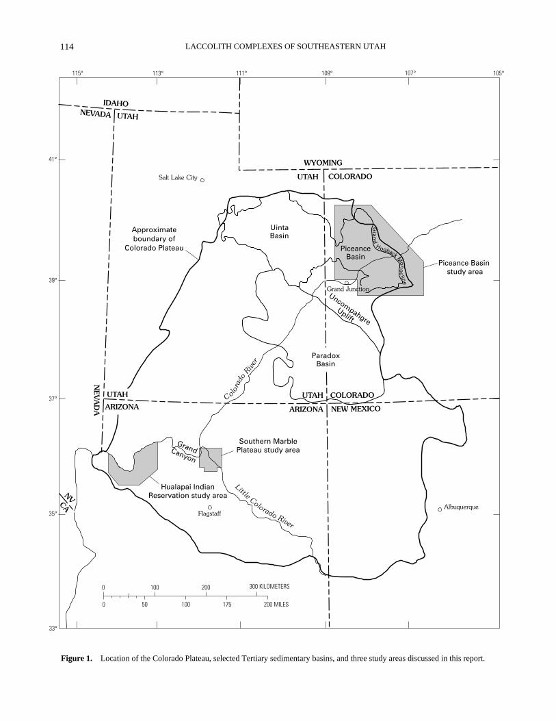
We studied relations between basement structures inPrecambrian crystalline rocks and fracture systems in over-lying sedimentary rocks in three parts of the Colorado Pla-teau (fig. 1) and, subsequently, in the Paradox Basin (Groutand Verbeek, this volume). Areas and stratigraphic unitsdiscussed here include (1) the Hualapai Indian Reservation(Hualapai and western Coconino Plateaus) in northwesternArizona, where Upper Mississippian strata of the RedwallLimestone are exposed over a large area; (2) the southernMarble Plateau of north-central Arizona, capped by Permianstrata of the Kaibab Limestone and locally by Lower to Mid-dle Triassic rocks of the Moenkopi and Chinle Formations;and (3) the Piceance Basin of northwestern Colorado, whereTertiary strata of the Wasatch, Green River, and Uinta For-mations overlie Upper Cretaceous strata of the MesaverdeGroup. Units exposed on the Marble Plateau are comparablein age to those exposed in the Paradox Basin, but those onthe Hualapai Reservation and in the Piceance Basin aremostly older and younger, respectively. Depths to crystal-line basement in the three areas range from 460 m to at least7,900 m, providing excellent opportunity to assess the influ-ence of basement structure on surface fracture systems as afunction of depth to basement. Fracture systems in all threeareas are complex and contain not only local fracture setspossibly related to movements along basement structures butalso multiple regional sets demonstrably unrelated to them.The results of these basin studies have helped guide our in-terpretation of the relationship between basement structureand fracture systems in the Paradox Basin (Grout and Ver-beek, two reports in this volume).
Our methods for investigating basement-cover fracturerelations inevitably differed from one region to anotherdepending on the relative availability of detailed geologic,geophysical, and outcrop fracture data. The fragmentarynature of structural knowledge in each region necessitatedmore than the usual amount of caution in interpreting thestructural record, as illustrated by our first example.
HUALAPAI INDIAN RESERVATION, NORTHWESTERN ARIZONA
The Hualapai Reservation in northwestern Arizona(fig. 1) is capped by nearly flatlying sedimentary rocks ofMississippian through Triassic age. The Mississippianrocks are extensively exposed on the Hualapai Plateau in the
LACCOLITH COMPLEXES OF SOUTHEASTERN UTAH
114
107° 105°109°111°113°115°
41°
39°
37°
35°
33°
300 KILOMETERS
200 MILES
2001000
0 50 100 175
Salt Lake City
Grand Junction
AlbuquerqueFlagstaff
UintaBasin
PiceanceBasin
ParadoxBasin
Southern MarblePlateau study area
Hualapai IndianReservation study area
WYOMING
UTAH COLORADO
IDAHONEVADA UTAH
UTAH
NEV
AD
A ARIZONA
UTAH COLORADO
ARIZONA NEW MEXICO
NVCA
GrandCanyon
Uncompahgre
Uplift
Color
ado
River
Little Colorado River
Approximateboundary of
Colorado Plateau
Gra
nd
Hogback Mon
oc
line
Piceance Basin study area
Figure 1.
Location of the Colorado Plateau, selected Tertiary sedimentary basins, and three study areas discussed in this report.

115
BASEMENT STRUCTURES AND FRACTURE SYSTEMS, COLORADO PLATEAU
western half of the reservation; the adjacent CoconinoPlateau to the east is capped mostly by strata of Permian age.Older rocks are well exposed within the Grand Canyon to thenorth, where the Colorado River has cut deeply into thePaleozoic succession and locally into the crystalline Protero-zoic basement rocks beneath. The region offers an idealopportunity to trace the influence of basement structure onthe development of fracture networks in overlying strata.
New attention was focused on the Hualapai Reservationin the 1980’s during geologic studies of uranium-mineralized breccia pipes of the Grand Canyon region. Thebreccia pipes (fig. 2) are solution-collapse features thatoriginated from extensive cavern systems in the Upper Mis-sissippian Redwall Limestone (Wenrich, 1985) and thatstoped upward through overlying rocks for vertical distancesof 200–920 m. Today, more than 2,000 confirmed andsuspected pipes are known from the Grand Canyon region,about 900 of them on the Hualapai Reservation alone (Bill-ingsley and others, 1986, in press; Wenrich and others,1995a,b). The existence in parts of the region ofconspicuous linear belts of pipes led to repeated suggestionsthat pipe positions were influenced by underlying structure,possibly of basement origin (Sutphin and others, 1983;Sutphin and Wenrich, 1983; Sutphin, 1986). The nature andextent of that influence, however, remained conjectural.Accordingly, we and our colleagues began reconnaissancework in 1986 to document the fracture system in exposedunits on the Hualapai Reservation and to test the possiblerelations between fracture-system evolution, caverndevelopment in the Redwall Limestone, and underlyingbasement structures (Roller, 1987, 1989; Sutphin andWenrich, 1988; Verbeek and others, 1988; Wenrich andothers, 1989).
TECTONIC OVERVIEW
The earliest Paleozoic sediments of the Hualapai Reser-vation were deposited upon a Proterozoic basement complexthat had already been highly metamorphosed, intruded,extensively and recurrently faulted, and deeply eroded. Pro-terozoic faults striking northwest through north to northeastand dipping steeply westward are abundant in the basementrocks (Billingsley and others, in press), whereas thosestriking within 40° of east-west are decidedly less common.Similar faults are known from throughout the Grand Canyonregion (Sears, 1973; Huntoon, 1974; Shoemaker and others,1978). Offsets on the largest faults were several hundredmeters or more and were dominantly normal (Billingsley andothers, in press), although right-lateral and reverse move-ments on some faults of north and northeast strike have alsobeen documented in areas nearby (Shoemaker and others,1978).
The whole of the Paleozoic Era, and much of theCenozoic Era as well, was a time of net regional subsidence,accumulation of 2,500–4,000 m of sedimentary strata, and
relative tectonic quiescence. The term relative, however, isused advisedly, for at least some of the ancient Proterozoicfaults of the Grand Canyon region were mildly reactivatedduring this period (Huntoon, 1974), and minor episodes ofuplift and emergence have been documented from the sedi-mentary record. As discussed below, such movements,though slight, nevertheless loom large in the interpretation ofthe region’s fracture history. Among the most importantevents in the present context was a Late Mississippian periodof regional uplift and erosion, which signaled a major changein the geologic development of the Grand Canyon region(McKee, 1979).
The Laramide orogeny of Late Cretaceous throughEocene time was the most important Phanerozoic tectonicevent to have affected the Grand Canyon region, though itseffects there were slight compared to most other areas of theLaramide orogenic belt. Crustal shortening during Laramidecompression, with maximum horizontal compressive stressdirected approximately N. 70° E. (Reches, 1978), reactivatedmany of the steeply west dipping basement faults as high-angle reverse faults. Slip was thus in the opposite sense fromthat which had occurred in Proterozoic time, and amounts ofoffset generally were smaller (Shoemaker and others, 1978).The overlying Paleozoic strata failed along reverse faultsabove the preexisting basement faults and, at higher levels,were flexed to form a series of east-facing monoclines. Thestructure of a typical Grand Canyon monocline, whichpasses upward from a high-angle reverse fault to a tight,steep monoclinal flexure and thence into a broad, gentle foldnearer the surface, was reviewed by Huntoon (1981, 1993)and described in detail for one monocline by Reches (1978).The numerous monoclines of the Grand Canyon region arethat region’s most prominent structural features and provideone means by which the position of major reactivated base-ment faults can be traced far beyond the area of exposedProterozoic rocks. Dating the monoclines more closely than“Laramide” in the broadest sense of that term is madedifficult by the absence from most of the region of rocksyounger than Triassic but older than Miocene.
The late Tertiary Period in the Grand Canyon regionwas a time of dominantly west directed crustal extension andnormal faulting, related by most authors to the inception ofthe Basin and Range orogeny farther west. During this timemany of the ancient basement faults were reactivated oncemore, as were their upward extensions in Paleozoic rocks;also many new faults were created. Slip on preexisting faultsin the Paleozoic rocks was opposite in sense to that duringLaramide compression. A common result was faultedmonoclines, the monoclines facing generally east but thefaults in many places having the west side downthrown.Some of the principal late Tertiary faults on the HualapaiReservation are coincident with early Tertiary monoclinesfor many kilometers and extend beyond them for consider-able distances, providing another means by which thepositions of the underlying basement faults can be traced.

LACCOLITH COMPLEXES OF SOUTHEASTERN UTAH
116
�������������������
�����������
������������
������������
������������
��������������������
��������
��������������������
��������
����������������
��������������
������������������������
�����������������������������������������
�T
RIA
SS
ICP
ER
MIA
NP
EN
NS
YL-
VAN
IAN
MIS
SIS
SIP
PIA
ND
EVO
NIA
N
ChinleFormation
Petrified ForestMember
Shinarump Member
MoenkopiFormation
KaibabLimestone
ToroweapFormation
CoconinoSandstone
Hermit Shale
Harrisburg GypsiferousMember
Fossil MountainMember
Woods Ranch Member
Brady Canyon Member
Seligman Member
Su
pai
Gro
up Esplanade Sandstone
Ridenour mine
Wescogame Formation
Manakacha Formation
Watahomigi Formation
Surprise CanyonFormation
(Mississippian/Pennsylvanian (?))
Redwall Limestone
Temple Butte Limestone
Diameter of surface depression
Holocene alluvium
Average thickness or rangein thickness (in meters)
HualapaiReservation
MarblePlateau
Eroded Eroded
Eroded
40-73
MarblePlateau
6-45
30
38
7580
42
18
9
28-30
60
9
180-30555
150 0-18
140 60
45
60
45
185
0-90 0-12
EsplanadePlatform
HualapaiReservation
140-185 140-150
120 42
(partlyeroded)
Figure 2.
Generalized vertical section through a solution-collapse breccia pipe of the Grand Canyon region. Thicknesses and lithologiesof the stratigraphic units shown are typical of those on and near the Hualapai and Marble Plateaus. Figure modified from Van Gosen andWenrich (1988); thickness data from Wenrich and others (1995a,b), Billingsley and others (1985), and G.H. Billingsley (oral commun.,1994).
The Cenozoic Era in the Grand Canyon region,commencing with the Laramide tectonic movements andcontinuing into the period of late Tertiary normal faulting,was a time of regional uplift and erosion on a grand scale.
Vertical uplift ultimately totaled 3.2–4.8 km and resulted inthe removal of at least 1.5 km of rock—nearly all of the post-Paleozoic strata—from the Hualapai lands (Wenrich andothers, 1995b). More than any other event, rapid Cenozoic

117
BASEMENT STRUCTURES AND FRACTURE SYSTEMS, COLORADO PLATEAU
0 25 50 KILOMETERS
0 25 50 MILES
111°112°113°114°37°
36°
35°
UTAH
NEV
AD
A
ARIZONA
HualapaiIndian
Reservationstudy area
Marble Plateaustudy area
ChinoValley
System
Toro
wea
pS
yste
m
Cataract Creek System
Mes
a
Butte
Syste
mBrig
ht
Ange
l
System
Morm
onRidges
SystemSinya
laSys
tem
KaibabSystem
Oak
Cre
ekC
anyo
nS
yste
m
Figure 3.
Generalized basement fault systems of northwesternand north-central Arizona, from Shoemaker and others (1978).
uplift and erosional unloading had a pronounced effect onthe fracture history of exposed rocks in the Grand Canyonregion and beyond. That topic is discussed at some lengthlater. We first discuss, for the Hualapai Reservation, thepossible relation of selected elements of the fracture networkto basement structure.
BASEMENT STRUCTURE BENEATH HUALAPAI RESERVATION
SOURCES OF EVIDENCE
Outlines of basement blocks and locations of majorfault zones beneath the Hualapai Reservation and adjacentareas of the Grand Canyon region have been inferred fromseveral lines of evidence, the first two already noted in thepreceding section.
1. Major exposed faults, many repeatedly active overtime. Some of the faults can be traced directly into exposedbasement rocks and shown to be of Precambrian ancestry(Huntoon, 1974, 1993). Others of similar dimension andorientation but exposed only in younger rocks are assumedto have a similar history.
2. Monoclines, widely regarded as the surface expres-sions of deep Precambrian fault zones that were reactivatedduring the Laramide and that define boundaries between ma-jor basement blocks (Davis, 1978). The structure of severalmonoclines transected by the Grand Canyon can be followedin continuous outcrop from a broad fold in Paleozoic sedi-mentary rocks to a high-angle fault zone in the Precambriancrystalline rocks, thus establishing the basement-cover rela-tionship directly (Lucchitta, 1974; Huntoon, 1974, 1993;Huntoon and Sears, 1975). A similar relationship is pre-sumed for numerous other monoclines exposed on plateausurfaces flanking the Grand Canyon (Davis, 1978).
3. Geophysical data, chiefly linear aeromagnetic andgravity anomalies, that presumably reflect either differentialelevation of the basement blocks to either side (Shoemakerand others, 1978) or different rock types juxtaposed along abasement fault zone. The use of geophysical data as a guideto basement structure is especially effective in the GrandCanyon region because the sedimentary cover rocks are veryweakly magnetic and in most places are less than 2 km thick(Shoemaker and others, 1978).
4. Aligned volcanic features, including not onlyindividual vents (McLain, 1965) but also apparent align-ments of major eruptive centers over distances of 65–175 km(Eastwood, 1974; Shoemaker and others, 1978).
Many individual basement fault zones are reflectedalong different parts of their length by one or more of thetypes of features listed, often in combination. Thecoincidence of gravity and aeromagnetic anomalies witheach other and with exposed portions of major fault zones,
for example, led Shoemaker and others (1978) to concludethat the geophysical anomalies are reliable indicators of un-derlying basement structure. Similarly, volcanic ventsaligned with the on-strike extensions of known fault zonesprovide good evidence that the fault zones persist beneaththe volcanic rocks. Thus, a combination of geologic andgeophysical data can be used to trace the buried extensionsof known fault zones far beyond their limits of exposure andacross plateau surfaces of only modest topographic relief.
INTERPRETED BASEMENT STRUCTURE
A generalized, regional interpretation of the majorbasement fault zones beneath much of northern Arizona, asdepicted by Shoemaker and others (1978), is shown in fig-ure 3. Three major trends are apparent, with approximateaverage directions of N. 40° E. (Sinyala, Bright Angel, andMesa Butte systems), N. 40° W. (Chino Valley, CataractCreek, Kaibab, and Mormon Ridges systems), and N. 5° E.(Toroweap and Oak Creek Canyon systems). The recent1:48,000 geologic maps of Wenrich and others (1995a,b)and Billingsley and others (1986, in press) show that allthree trends persist into the area of the Hualapai Reserva-tion (fig. 4), though gradations from one to another are ap-parent as well. The northeast trend of the Sinyala system,for example, is defined by the Meriwhitica and PeachSprings monoclines; the Grand Wash, Separation, Lava,and Sinyala faults; and by parts of the sinuous Hurricane,Toroweap, and Lone Mountain monoclines. The Aubreymonocline, northern segment of the Hurricane monocline,and Toroweap fault define the north trend of the Toroweapsystem in the eastern part of the reservation. Farther west,

LACCOLITH COMPLEXES OF SOUTHEASTERN UTAH
118
113°00'113°15'113°30'113°45'114°00'
36°00'
35°45'
35°30'
0 15 KILOMETERS5 10
0 5 10 MILES
36°15'
Limit of map
RMPR
OS
PEC
TPO
INT
GR
AB
EN
GR
AN
DW
ASH
FAU
LT
SEPARATIO
NFA
ULT
HO
RS
EFL
AT
MO
NO
CLI
NE
Colorado River
HU
RR
ICA
NE
FAU
LT
ZON
E
PEACH SPRIN
GS MONOCLIN
ET
OR
OW
EAP
MON
OC
LIN
E AU
BR
EY
MO
NO
CLIN
E
Hualapai Indian R
eserv
ation boundary
Granite Park
Fault ZoneN
utter
Graben
LAVA
FAULT
LON
EM
OU
NTA
IN
MO
NO
CLINE
TO
RO
WE
AP
FAU
LT
MO
HA
WK
-STA
IRW
AY
FAU
LT
HU
RR
ICA
NE
MO
NO
CLI
NE
MER
IWH
ITIC
AFA
ULT
Laguna
Graben
SIN
YALA
FAU
LT
MERIWHITICA
MONOCLINE
MER
IWH
ITIC
AM
ON
OC
LIN
E
Figure 4
. Major basement-related structures on the Hualapai Indian Reservation, as interpreted from the geologic maps of Wenrichand others (1995a,b) and Billingsley and others (1986; in press). Arrows indicate facing direction of monoclines.
RM
, Ridenour mine.
the Horse Flat monocline, part of the Meriwhitica mono-cline, and an unnamed monocline to the north are part ofthe same trend. The northwest trend is reflected mostly insmaller features such as the northern segment of the LoneMountain monocline, the Granite Park fault zone, and theNutter, Laguna, and Prospect Point grabens; all are part ofthe Cataract Creek system. Of the three major trends, theirrelative prominence as judged from surface structures onthe Hualapai Reservation is northeast (strongest), north(intermediate), and northwest (weakest, but locallyconspicuous).
EARLY FRACTURE SETS IN THE REDWALL LIMESTONE
The Redwall Limestone, well known to legions ofhikers and rafters of the Grand Canyon for its tendency toform imposing cliffs, is a fine-grained, thickly bedded
limestone and dolomite unit commonly 135–180 m thick(Billingsley and others, 1986, in press; Wenrich and others,1995a). The importance of this unit in the present contextderives from the possibility that reactivation of basementfaults influenced the distribution of fractures in the brittlecarbonate rock and thus also influenced early cavern devel-opment and the stoping of breccia pipes. The depth from thebase of the Redwall to the underlying Precambrian metamor-phic basement rocks is 460–610 m on the Hualapai lands(Billingsley and others, 1986, in press; Wenrich and others,1995a).
The Redwall Limestone, the upper part of which wasdeposited in Late Mississippian time, was uplifted shortlythereafter and exposed to subaerial weathering and erosion.The effects of this event included the development of atleast two sets of joints, erosional incision of the exposedlimestone surface, extensive cave development, and minorreactivation of basement faults. Late Mississippian clastic

119
BASEMENT STRUCTURES AND FRACTURE SYSTEMS, COLORADO PLATEAU
sediments (Surprise Canyon Formation, fig. 2), flushed intoand preserved within the cave system, show that uplift andkarst development began before the close of the Mississip-pian Period (Billingsley and Beus, 1985). The erosion sur-face subsequently was buried during deposition of theWatahomigi Formation (Pennsylvanian) and overlyingunits.
Joints of the two earliest sets within the RedwallLimestone have median strikes of N. 50° E. and N. 51° W.(figs. 5 and 6; Roller, 1987, 1989), similar to two of thethree regional trends of basement fault zones defined byShoemaker and others (1978) from geologic and geophysi-cal data. Both joint sets are absent from the WatahomigiFormation and younger units, suggesting that they formedduring the same period of Late Mississippian uplift that re-sulted in karstification. A possible scenario suggested byWenrich and others (1989, 1995b) is that (a) minor reacti-vation of high-angle basement faults during uplift resultedin low-amplitude flexing of the overlying strata and atten-dant formation of joints along those flexures; (b) the jointsformed in greatest abundance within the flexed zones,where extensional strains presumably were greatest, and inlesser abundance within the interfault areas; and (c) cavernsin the Redwall Limestone developed preferentially withinthe zones of most-fractured rock. If this scenario is correct,the distribution of solution-collapse breccia pipes on theHualapai Reservation was controlled at least in part bybasement structure (Wenrich and others, 1995b; Billingsleyand others, in press). As supporting evidence we note thefollowing:
1. Field evidence for minor post-Redwall, pre-SupaiGroup movement on several ancient faults of the GrandCanyon region was noted by McKee and Gutschick (1969),Huntoon (1970), and Huntoon and Sears (1975). Similarmovements may well have occurred on other basementfaults beneath the Hualapai Reservation.
2. Joints of the two earliest sets in the Redwall Lime-stone tend to be unusually abundant near breccia pipes,locally to such an extent that the limestone looks like rub-ble (Roller, 1989). Roller (1989, p. 31) suggested as onelikely explanation that the closely spaced early fractures“localized and concentrated fluid flow, which initiated cav-ern formation***.”
3. Pipes that stoped through structurally intact,unjointed rock of the Supai Group above the RedwallLimestone are bordered by a well-defined zone of “ringfractures” that dip outward from the pipe and that formedduring stoping (Verbeek and others, 1988). No such ringfractures were found by Roller (1989) adjacent to pipeswithin the Redwall, suggesting that the limestone was al-ready well fractured when stoping of the pipes commenced.
4. Many breccia pipes mapped by Billingsley andothers (1986) in the Blue Mountain area of the southeasternHualapai Reservation are elongated in a N. 50°–60° E.direction. The joint-set maps of Roller (1989, fig. 7) show
that her F1 (oldest) set, with a median strike of N. 50° E., isexceptionally prominent in this area. The observed pipeasymmetry was attributed by Verbeek and others (1988) tostoping of the pipes through prejointed rock.
5. The distribution of pipes mapped by Billingsleyand others (1986, in press) and Wenrich and others(1995a,b) on the Hualapai Reservation shows several prom-inent northeast-trending alignments. In a recent, informaltest, all but one of seven geologists working independentlywith maps showing pipe distribution but no other informa-tion recognized the northeast trend (K.J. Wenrich, oralcommun., 1993). Fourteen alignments of varying promi-nence, all trending N. 46°–48° E., have been mapped byWenrich and others (1995b).
6. Mapping by Wenrich and Sutphin (1989) of brecciapipes within one large Redwall cave disclosed five pipeswithin cave passages parallel to the two early joint sets.Nearly rectilinear cave passages of differentdirections—passages inferred by Wenrich and Sutphin toreflect dissolution along younger joint sets—contain nopipes.
The above relations seemingly imply a close linkbetween Late Mississippian regional uplift, the formationof early joint sets in the Redwall Limestone, cavern devel-opment, and the distribution of solution-collapse brecciapipes. The link between all of these and basement struc-ture, however, is less clear: the principal evidence for it isthe approximate parallelism between median strikes ofRoller’s (1987, 1989) early joint sets and the generalizedbasement fault trends defined earlier by Shoemaker andothers (1978) for the entire Grand Canyon region. A morerigorous appraisal of the degree of parallelism is given infigure 7, in which basement trends for the Hualapai landsspecifically (top, from fig. 4) are compared to strike-frequency distributions of the F1 and F2 joint sets (bottom,from Roller’s data). Some obvious observations: (1) Aclear distinction between the north trend of the Toroweapsystem (fig. 3) and northeast trend of the Sinyala system isnot evident at this scale; (2) the earliest (F1) joint set, withcommon strikes of N. 35°–60° E., corresponds only to aweak maximum in the basement-trend data; (3) the F2 jointpeak, with common strikes of N. 40°–60° W., is offsetnearly 20° from the N. 25°–40° W. peak in the basement-trend data; and (4) neither joint set parallels the prominent,broad basement trend between N. 10° W. and N. 40° E.Viewed in this manner, the notion that basement structureinfluenced early joint formation in the Redwall Limestoneseems considerably less appealing.
Assessing the degree of parallelism still more closely,by comparing joint orientations in specific areas to thetrends of individual basement structures nearby, is limitedby the irregular distribution of data from the Haulapai Res-ervation. The joint measurements of Roller (1987, 1989)cluster into four areas; between them, no information isavailable. The F1 joints in two of those areas (fig. 5)

LACCOLITH COMPLEXES OF SOUTHEASTERN UTAH
120
113°00'113°15'113°30'113°45'114°00'
36°00'
35°45'
35°30'
0 15 KILOMETERS5 10
0 5 10 MILES
36°15'
RM
Hualapai Indian R
eserv
ation boundary
Colorado River
Limit of map
Figure 5.
Average orientations of joints of the F
1
regional set of Roller (1987, 1989) in the Redwall Limestone in relation to interpretedbasement-related structures (from fig. 4) on the Hualapai Indian Reservation.
parallel nearby basement structures closely and in a thirdshow tolerably good agreement. The fourth area containsno known northeast-trending basement structures for com-parison. Similarly, joints of the F2 set (fig. 6) strike subpar-allel to a nearby basement structure of northwest trend inone area near the Ridenour mine, but the other three areaslack any basis for comparison. One might thus argue thatthe imperfect correspondence shown in figure 7 betweenjoint strikes and basement structures reflects only the factthat the two were measured in largely different places.Nonetheless, other properties of the same joint sets are fullyconsistent with an origin unrelated to basement structure:the joints of both sets undeniably are widely distributed,both near and far from known basement structures of liketrend (figs. 5 and 6), and neither set shows any tendency tocurve in response to the sinuosity of individual monoclinesor basement-related faults. Thus, though few would arguethe strong influence of basement structure on the Cenozoicfault pattern of the Hualapai Reservation, firm evidence of
the possible influence of basement structure on jointformation in the Redwall Limestone remains elusive.
We emphasize that much of the evidence (both proand con) discussed here is circumstantial and based on re-connaissance data. No one has yet shown how the fracturehistory of the Redwall Limestone compares with that ofany unit below: from the crystalline basement through theentire lower Paleozoic succession, the nature of the fracturenetwork and of vertical variations within it remains largelyunknown. Specific mechanism(s) by which rejuvenatedbasement faults in the Grand Canyon region could have in-fluenced rock failure in the Redwall strata more than 460 mabove have been discussed only in broad, qualitative terms,and much of the field evidence required to address the topicis lacking. That the hypothesis of basement control canseem alternately appealing or unconvincing, depending onhow one looks at the evidence, underscores the need forcare—and a generous measure of skepticism—in any studyof this type.
121
BASEMENT STRUCTURES AND FRACTURE SYSTEMS, COLORADO PLATEAU
113°00'113°15'113°30'113°45'114°00'
36°00'
35°45'
35°30'
0 15 KILOMETERS5 10
0 5 10 MILES
36°15'
RM
Hualapai Indian R
eserv
ation boundary
Colorado River
Limit of map
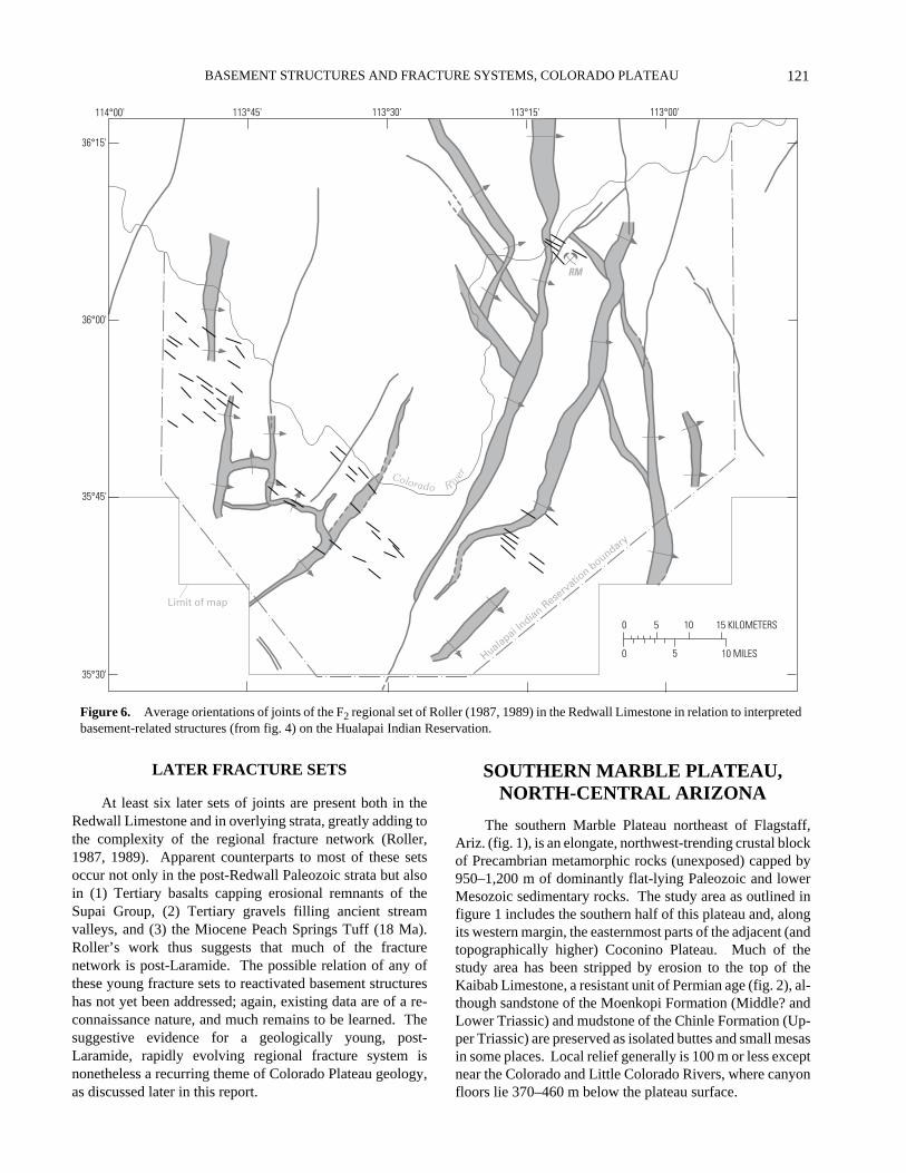
Figure 6.
Average orientations of joints of the F
2
regional set of Roller (1987, 1989) in the Redwall Limestone in relation to interpretedbasement-related structures (from fig. 4) on the Hualapai Indian Reservation.
LATER FRACTURE SETS
At least six later sets of joints are present both in theRedwall Limestone and in overlying strata, greatly adding tothe complexity of the regional fracture network (Roller,1987, 1989). Apparent counterparts to most of these setsoccur not only in the post-Redwall Paleozoic strata but alsoin (1) Tertiary basalts capping erosional remnants of theSupai Group, (2) Tertiary gravels filling ancient streamvalleys, and (3) the Miocene Peach Springs Tuff (18 Ma).Roller’s work thus suggests that much of the fracturenetwork is post-Laramide. The possible relation of any ofthese young fracture sets to reactivated basement structureshas not yet been addressed; again, existing data are of a re-connaissance nature, and much remains to be learned. Thesuggestive evidence for a geologically young, post-Laramide, rapidly evolving regional fracture system isnonetheless a recurring theme of Colorado Plateau geology,as discussed later in this report.
SOUTHERN MARBLE PLATEAU, NORTH-CENTRAL ARIZONA
The southern Marble Plateau northeast of Flagstaff,Ariz. (fig. 1), is an elongate, northwest-trending crustal blockof Precambrian metamorphic rocks (unexposed) capped by950–1,200 m of dominantly flat-lying Paleozoic and lowerMesozoic sedimentary rocks. The study area as outlined infigure 1 includes the southern half of this plateau and, alongits western margin, the easternmost parts of the adjacent (andtopographically higher) Coconino Plateau. Much of thestudy area has been stripped by erosion to the top of theKaibab Limestone, a resistant unit of Permian age (fig. 2), al-though sandstone of the Moenkopi Formation (Middle? andLower Triassic) and mudstone of the Chinle Formation (Up-per Triassic) are preserved as isolated buttes and small mesasin some places. Local relief generally is 100 m or less exceptnear the Colorado and Little Colorado Rivers, where canyonfloors lie 370–460 m below the plateau surface.

LACCOLITH COMPLEXES OF SOUTHEASTERN UTAH
122
70
60
50
40
30
20
10
0
15
10
5
0
80 70 60 50 40 30 20 10 NW 10 20 30 40 50 60 70 80 E
80 70 60 50 40 30 20 10 NW 10 20 30 40 50 60 70 80 E
FRE
QU
EN
CY
(K
M)
FRE
QU
EN
CY
(N
UM
BE
R O
F LO
CA
LIT
IES
)
STRIKE OF JOINTS
TREND OF BASEMENT STRUCTURES
2 3 2 1 2 2 1 2
11
17
3237
31
10
19 21
32
40
51
24
68
46
68
4137 35
17
39
14
4 5 3 2
10
06
n=735 km
n=56
34
12
1514
8
1 1
8
4
13 13
10
5
1
ntotal =112
F2 setn=56
F1 set
Figure 7.
Histograms comparing trends of major basement structures on the Hualapai Plateau (top, from map of fig. 4) to strikes of jointsof the F
1
and F
2
sets of Roller (1987, 1989) (bottom, from figs. 5 and 6). In order to show basement trends for the Hualapai lands specifi-cally, we divided the 735 km of inferred basement structures shown in figure 4 into small (average 2.85 km) linear segments, measured thelength and orientation of each of the 258 segments so defined, and plotted the length-weighted frequency distribution of figure 7
A
. Belowthis, in figure 7
B
, are shown strike frequency distributions of the F
1
and F
2
joint sets derived from the data of Roller (1987, 1989).
The impetus for fracture studies on the Marble Plateau,like that on the Hualapai Indian Reservation 170 km fartherwest, stemmed from USGS work on uranium-mineralizedbreccia pipes during the 1980’s. Breccia pipes on the MarblePlateau are well exposed and were first described in detail bySutphin (1986). Recent fracture work includes a field studyof joint networks at 18 localities (Sutphin, 1986), detailedphotogeologic mapping of fracture traces across large tractsof exposed bedrock (E.R. Verbeek, unpub. data,1980–1987), and delineation of faults during geologicquadrangle mapping (Billingsley and others, 1985).
TECTONIC OVERVIEW
Much of what is known of the geologic evolution ofthe Hualapai lands of the western Grand Canyon regionapplies as well to the Marble Plateau. The same formations
underlie both areas (fig. 2), albeit with some notable thick-ness and facies changes, and the structural inventory isvirtually identical. Principal differences are that structureson the Marble Plateau are exposed at a higher stratigraphiclevel than those on the Hualapai lands, and the largestCenozoic faults on the Marble Plateau are of much lesserdisplacement than their counterparts farther west.
The most prominent structures on and near the southernMarble Plateau are breccia pipes, monoclines, and normalfaults. The breccia pipes of this area were extensively inves-tigated by Sutphin (1986), who mapped 90 of them and in-terpreted them as solution-collapse features related toMississippian-age caverns in the Redwall Limestone. Thecommon presence of pipes in Late Triassic strata of theChinle Formation, the youngest bedrock unit preserved inthe area, shows that the upper parts of some pipes formed100 m.y. or more after cavern formation began. Some of the

123
BASEMENT STRUCTURES AND FRACTURE SYSTEMS, COLORADO PLATEAU
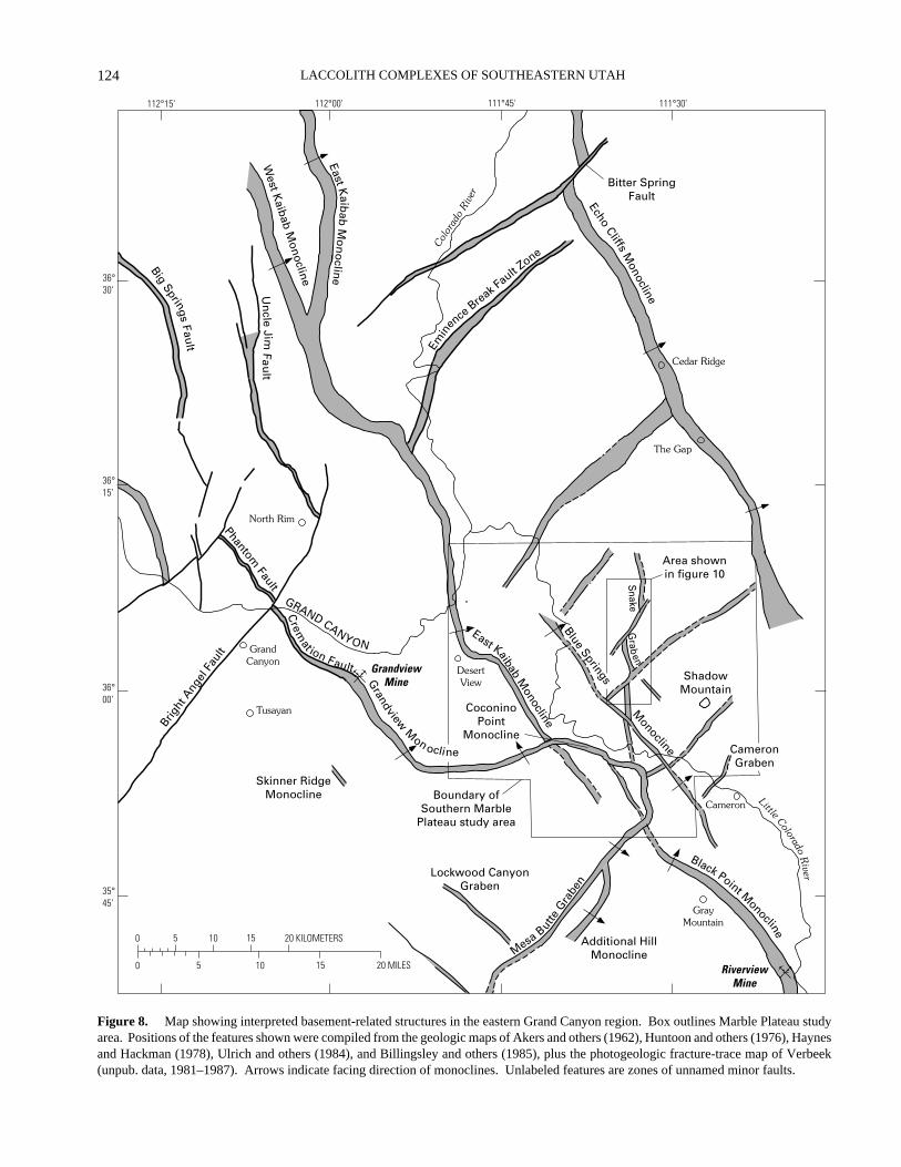
pipes show elevated gamma radiation counts (Sutphin, 1986;Sutphin and Wenrich, 1988), and one of them, the Riverviewpipe south of the study area (fig. 8, lower right), was minedfor uranium (Chenoweth and Blakemore, 1961).
Lengthy, sinuous monoclines are the dominant struc-tures on and near the Marble Plateau and are the main ex-pression of Laramide crustal compression in the area.Several monoclines—notably the Grandview, East Kaibab,Coconino Point, Black Point, and Echo Cliffs monoclines(fig. 8)—exert a profound influence on the topography of theregion. The 500-m elevation difference between the Marbleand Coconino Plateaus in the south-central part of the studyarea, for example, is a direct reflection of structural reliefacross the Coconino Point monocline. The major,northwest-trending monoclines of the region all face north-east, a feature interpreted to reflect reverse movement on re-activated Proterozoic basement faults of steep southwest dip(Reches, 1978; Davis, 1978).
Minor normal faults are abundant on the Marble Plateauand conspicuous on aerial photographs. Some of the faultsare coincident with monoclines or lie along their on-strikeprojections and reflect post-Laramide normal movement onthe same basement faults that earlier had been reactivated ina reverse sense. Most of the other faults strike within 30° ofdue north and probably are products of crustal extensionrelated to basin-range extensional tectonism farther west.Dating the onset of normal faulting on the Marble Plateau isdifficult owing to insufficient stratigraphic control, but theabundance of faults in late Paleozoic and Triassic rocks, con-trasted with their paucity in Pliocene to Pleistocene volcanicrocks immediately to the south, shows that much of the fault-ing occurred before 6 Ma (Babenroth and Strahler, 1945). Ina few places, however, faulted lava flows (Babenroth andStrahler, 1945; Barnes, 1974), terrace gravels (Reiche,1937), and debris fans (Holm, 1987) show that normal fault-ing continued into the Quaternary Period, and contemporaryseismicity (Sturgul and Irwin, 1971; Wong and Humphrey,1989) suggests that it continues still.
Late Cenozoic regional uplift resulted in erosion ofnearly all post-Paleozoic strata from much of the MarblePlateau. The drainage net that developed on the exhumedKaibab surface is of probable Miocene age (G.H.Billingsley, oral commun., 1989) and is incised in the areasof maximum uplift (Barnes, 1987). Normal faults havedisrupted the original drainage in many places.
BASEMENT STRUCTURE BENEATHSOUTHERN MARBLE PLATEAU
Interpretation of basement structure beneath the south-ern Marble Plateau is drawn from some of the same sourcesof evidence already discussed for the Hualapai lands.Laramide monoclines outlining the edges of crustal blocksare particularly abundant on and near the Marble Plateau,
and parts of several fault zones have a strong geophysicalexpression (Shoemaker and others, 1978). Only one mono-cline, however, has been sufficiently dissected by erosionthat its deep structure and underlying fault zone, wellexposed within the gorge of the Colorado River and one ofits tributaries, have been studied in detail (Reches, 1978).Moreover, major fault zones similar to the ancient andrepeatedly active Hurricane and Toroweap faults fartherwest (fig. 4) are missing from the Marble Plateau area; intheir place are faults of similar style but much lesserdisplacement. Greater depth to basement (915–1,220 m),shallower erosional incision, and consequent lack of base-ment exposure make interpretation of basement structuremore inferential on the Marble Plateau than for areas fartherwest.
Parts of the Marble Plateau overlie the zone of intersec-tion of three major basement fault systems (fig. 3) withtrends similar to those across other parts of northern Arizona.Individual surface structures that define these trends on andnear the southern Marble Plateau are shown in figure 8. Theprominent northwest trend of the Kaibab fault system is ex-pressed at the surface principally by monoclines, notably theEast Kaibab and Blue Springs monoclines within the studyarea, and the Black Point monocline farther south. Theequally prominent northeast basement trend is defined by thesouthern segment of the Coconino Point monocline, the Ad-ditional Hill monocline nearby, and by at least six belts ofminor faults, including topographically expressed grabens;collectively these structures mark the northeasternmostextent of the Mesa Butte fault system of Shoemaker and oth-ers (1978). The north trend of the Oak Creek Canyon faultsystem is more weakly defined than the other two and withinthe study area is expressed only by the easternmost portionof the Coconino Point monocline and by several lengthysegments of the Snake graben. Farther south, however, thisfault system gains in prominence and coincides with amagnetic anomaly that marks its signature in basement rocks(Shoemaker and others, 1978).
The interpretive map of figure 8 combines informationfrom existing geologic maps with results from more recentstructural work. Some of the features shown on that map,particularly those of northeast trend as noted above, corre-spond to belts of minor faults. Also present (fig. 9) are ap-parent alignments of solution-collapse breccia pipesanalogous to the pipes already discussed for the HualapaiIndian Reservation. The possible relation of both kinds offeatures to basement structure is discussed below.
ALIGNMENTS OF BRECCIA PIPES ON SOUTHERN MARBLE PLATEAU
Numerous breccia pipes on the Marble Plateau appearto be aligned within northeast- and northwest-trending beltsinterpreted by Sutphin and Wenrich (1983, 1988), Sutphin
LACCOLITH COMPLEXES OF SOUTHEASTERN UTAH
124
North Rim
GrandCanyon
Tusayan
GrayMountain
Cameron
Cedar Ridge
ShadowMountain
Little ColoradoR
iver
GRAND CANYON
Colo
rado
Riv
er
BigSprings
Fault
Un
cleJim
Fau
lt
PhantomFault
Crem
at ion Fault
Brig
htAng
elFa
ult
Grandview
Mon ocline
Skinner RidgeMonocline
Lockwood CanyonGraben
Additional HillMonocline
Black Point Monocline
CameronGraben
CoconinoPoint
Monocline
GrandviewMine
DesertView
Boundary ofSouthern Marble
Plateau study area
East KaibabM
onocline
Monocline
Blue Springs
Area shownin figure 10
The Gap
Emin
enceBre
ak Fault Zone
Bitter SpringFaultEcho
CliffsM
onocline
0 5 10 15 20 KILOMETERS
0 5 10 15 20 MILES
111°30'111°45'112°00'112°15'
36°30'
36°15'
36°00'
35°45'
West K
aibab Monocline
East Kaib
abM
on
oclin
e
Snake
Grab
en
RiverviewMine
MesaBut
teG
rabe
n
Figure 8.
Map showing interpreted basement-related structures in the eastern Grand Canyon region. Box outlines Marble Plateau studyarea. Positions of the features shown were compiled from the geologic maps of Akers and others (1962), Huntoon and others (1976), Haynesand Hackman (1978), Ulrich and others (1984), and Billingsley and others (1985), plus the photogeologic fracture-trace map of Verbeek(unpub. data, 1981–1987). Arrows indicate facing direction of monoclines. Unlabeled features are zones of unnamed minor faults.

125
BASEMENT STRUCTURES AND FRACTURE SYSTEMS, COLORADO PLATEAU
(1986), and Wenrich and others (1989) as evidence of base-ment influence on pipe position. The map of figure 9, mod-ified from that of Sutphin and Wenrich (1988), shows ninesuch alignments, labeled A–I in approximate decreasingorder of believability. Seven of the alignments parallelknown structures of the Mesa Butte fault system; the othertwo parallel monoclines of the Kaibab system. One line of19 pipes, labeled A on the map, extends N. 45° W. for 27 kmand coincides throughout its length with the Blue Springsmonocline. A second alignment (E) of similar trend, 18 kmlong and including 15 pipes, lies between and parallel to twomonoclines and probably overlies a buried basement faultzone that has no other known expression in the surface rocks.A third alignment (B, fig. 9) trends N. 40° E. and lies whollywithin one of the northeast-trending fracture zones shown infigure 8. That breccia-pipe alignments, belts of minor faults,and monoclines are mutually parallel, and in some placesspatially coincident, reinforces the view that all are manifes-tations of underlying basement structure.
SURFACE FRACTURE SYSTEM OF THE SOUTHERN MARBLE PLATEAU
Photogeologic mapping of the surface fracture networkof the southern Marble Plateau (E.R. Verbeek, unpub. data,1980–1987) was done at 10× magnification on 1:50,000black-and-white vertical aerial photographs of good to ex-cellent resolution. The visibility of many fracture tracesfrom the air is enhanced by the sparsity of soil and vegetationcover and, in carbonate rocks and calcite-cemented sand-stones, by solution-widening of fracture openings. A closecorrespondence between fracture traces mapped from thephotographs and those measured at the outcrop was demon-strated by the field work of Sutphin (1986). Fracture setsvisible on the aerial photographs are broadly divisible intotwo classes: (1) fractures within rectilinear to gently curvedzones, between which fractures of the same orientation aresparse or absent, and (2) areally pervasive sets present overmuch of the plateau.
ZONED FRACTURE SETS
Straight to gently curved belts of fractures 0.5–1.0 kmwide and 5–25 km long are locally conspicuous elements ofthe surface fracture network of the Marble Plateau. Morethan a dozen such belts have been identified. The individualfractures (or narrow fracture zones) within the beltsgenerally have traces 0.3–1.5 km long, and many are smallfaults with throws of only a few meters or less. Fracturesbetween the zones are generally shorter, more pervasivelydistributed, and, with the exception of a few north-trendingzones, of different orientation. Few of the fracture belts areportrayed as such on conventional geologic maps, and most
remained unrecognized until recent photogeologic mappingof the plateau. Six of the fracture belts trend N. 40°–60° E.,four others N. 30°–45° W., and several more nearly duenorth. These are the same directions identified byShoemaker and others (1978) from independent data(monoclines, geophysical anomalies, exposed fault zones,aligned volcanic features) as the principal basement trends inthis and adjacent areas (fig. 3). The coincidence in trendsuggests to us that these fracture belts, like the largerHurricane and Toroweap fault zones to the west, are thesurface expression of underlying high-angle basement faultzones; hence they are included in figure 8. Along thesebasement faults, however, movement since the end of thePaleozoic resulted only in minor faulting of the overlyingstrata and was of insufficient magnitude to produce eithermonoclines or large offsets in the Permian and Triassicsurface rocks.
Some of the most interesting fracture zones on theMarble Plateau are those that collectively define the Snakegraben, a lengthy (>20 km), topographically expressed faulttrough that bisects the study area from north to south (fig.8). The Snake graben, sinuous in plan view (fig. 10A), iscomposed of several north-trending fracture zones offsetfrom one another in a dextral sense (fig. 10B), presumablyby slip along some of the northeast-trending fault zonesmentioned above (fig. 10C). Inasmuch as no evidence ex-ists of substantial strike-slip movement in the exposed Pale-ozoic rocks, the apparent offsets of 1.5–5 km presumablyreflect displacement of basement fault blocks in Precam-brian time. This interpretation agrees with the findings ofSears (1973) and Shoemaker and others (1978), who dis-cussed evidence of 1,300–1,600 Ma dextral offsets alongnortheast-trending basement fault zones in the Grand Can-yon region. Similar dextral offsets of 2–5 km occur wherethe Phantom and Cremation faults are intersected by theBright Angel fault, west of the study area (fig. 8), andwhere the Bitter Spring fault crosses the Echo Cliffs mono-cline north of the study area.
AREALLY PERVASIVE FRACTURE SETS
Combined field and photogeologic work suggests thatat least five areally pervasive sets of joints are present in thePermian and Triassic rocks capping the Marble Plateau. Thejoints of all five sets are vertical, or nearly so, and have thefollowing general properties:
Average Strike Photogeologic Expression
N. 10°–15° E. Strong to moderateN. 00°–05° W. Strong to moderateN. 15°–25° W. Strong to moderateN. 60°–70° E. WeakN. 70°–80° W. Weak

LACCOLITH COMPLEXES OF SOUTHEASTERN UTAH
126
0 5 10 15 KILOMETERS
0 5 10 MILES
111°30'111°45'112°00'36°15'
36°00'
35°45'
111°00'
Cameron
Boundary ofstudy area
RiverviewMine
GrandviewMine
Colorado Rive r
C
B
D
A
HE
FG
I
Figure 9.
Map showing interpreted alignments of solution-collapse breccia pipes on the southern Marble Plateau in relation tobasement-related monoclines and fault zones (from fig. 8). Modified from Sutphin and Wenrich (1988).
A
–
I
, explained in text.
Many joints of the first three sets, nearly all of whichstrike within 30° of due north, were reactivated as smallnormal faults during post-Laramide regional extension.The Marble Plateau thus exhibits a pronounced northerlystructural “grain” of elongate fault blocks, with each faultcorresponding to a narrow zone of faulted joints (fig. 11).Most such faults are highly visible on aerial photographs aslong, low scarps across the landscape and are readilymapped; between them, the unfaulted joints of the same
sets exhibit much shorter traces. Evidence that the faultingis of post-Laramide age, and that it is related to the onset ofbasin-range tectonism farther west, is based partly on anal-ogy to similar but larger faults of the Grand Canyon region(Lucchitta, 1974; Huntoon, 1974) and partly on new infor-mation presented in a later section of this report. The west-northwest- and east-northeast-striking joints of the othertwo sets, in contrast, are oriented at low angles to theregional extension direction (approximately east-west) and

127
BASEMENT STRUCTURES AND FRACTURE SYSTEMS, COLORADO PLATEAU
F
li
1
thus generally were not reactivated. Their traces on aerialphotographs are invariably short and their photogeologicexpression subdued.
No evidence exists at present that any of the five ar-eally pervasive joint sets are genetically related to base-ment structure. Their distribution shows no obviousrelation to known or inferred basement fault zones, and thetwo major basement-fault trends (N. 40° W., N. 50°E.)have no counterpart among common strike directions of thejoints. The parallelism between the third, subordinatebasement trend and the many north-striking fractures at the
GRA
BEN
SN
AK
E
111°35' 111°35'
36°05'
36°00'
0 1
0 1
A B
igure 10. Three portrayals of the structure of the Snake graben. See fshed geologic map (Billingsley and others, 1985). B, Actual fracture st981–1987). C, Interpretation of underlying basement structure. Bar an
surface probably is fortuitous; the broad, nonzoned distri-bution of the joints again is inconsistent with basement-fault reactivation and instead is a product of regional crust-al extension. At present, the only north-trending elementof the fracture network that we can confidently relate tobasement structure is the Snake graben (fig. 10), by far thelongest north-trending graben on the Marble Plateau. Theposition of this graben, in line with the north-trendingportion of the Coconino Point monocline (fig. 8), suggeststhat both features are surface expressions of the sameunderlying fault zone.
111°35'
2 3 KILOMETERS
2 3 MILES
C
igure 8 for location. A, Continuously curved walls as portrayed on pub-ructure as mapped from aerial photographs (E.R. Verbeek, unpub. data,d ball, downthrown sides of normal faults bounding graben.

LACCOLITH COMPLEXES OF SOUTHEASTERN UTAH
128
Figure 11.
Vertical aerial photograph showing discontinuousgraben typical of those found on and near the Marble Plateau. Theserrated walls and discontinuous fault trough are the result ofreactivation of preexisting vertical joints. Width of horizontal fieldof view approximately 4 km.
The sequence of formation and absolute ages of theregional joint sets of the Marble Plateau have not yet beenestablished with certainty, but available evidence suggeststhat most or all of the sets are post-Laramide. Along thenorthwest-trending Black Point monocline south ofCameron, for example, joints of the N. 15°–25° W. set dipwithin 5° of vertical on both the horizontal and tilted limbsof the fold (fig. 12), showing that this joint set—the oldestset present in these particular rocks—was superimposed ona preexisting Laramide structure. Two additional sets ofjoints in weakly cemented volcaniclastic sandstones, datedby Damon and others (1974) at less than 700,000 yearsB.P., provide additional evidence of geologically youngjointing in this part of Arizona (fig. 13). Though much re-mains to be done in studying fracture evolution in this re-gion, one plausible interpretation consistent with knownfacts is that (1) the three major sets that strike within 30° ofdue north are products of regional basin-range extension,the differing orientations of the joints reflecting noncoaxialextension over time, and (2) continuing crustal extensionresulted in minor faulting by dominantly dip-slip movementalong preexisting joints. The dogleg bends and discontinu-ous nature of many of the minor grabens that offset theKaibab surface (fig. 11) are a natural consequence of fault-ing by reactivation of multiple, preexisting fracture sets.The other two sets, whose short joints strike at high anglesto the northerly structural grain of the surface rocks, proba-bly reflect near-surface stress-relief jointing upon progres-sive reduction of confining pressure by erosion. Similarsmall joints are common to many areas of uplifted, flat-ly-ing sedimentary rocks; the mechanism of their formationwas discussed recently by Gross (1993).
SUMMARY OF SURFACE FRACTURE NETWORK
The fracture network in exposed rocks of the MarblePlateau has two major components: (1) basement-relatedfractures that owe their origin to episodic reactivation ofPrecambrian fault zones, and (2) shallow, dominantly post-Laramide, high-angle normal faults and joints resulting fromregional extension related to basin-range extensionaltectonism in areas to the west. The major basement-controlled fracture zones trend, on average, about N. 40° W.and N. 50° E., directions that fortuitously are poorly repre-sented among the post-Laramide fractures. The basement-related structures generally fall within gently sinuous zonesthat are expressed at the surface as prominent monoclines,belts of minor faults, and chains of volcanoes. The post-Laramide joints and normal faults, in contrast, are morewidespread and dominate the fracture network at the surface.The different styles of expression and different trends be-tween these two major groups of fractures are the principalmeans, exclusive of geophysical methods, by which buriedbasement fault zones can be recognized in the region.
PICEANCE BASIN, NORTHWESTERN COLORADO
The Piceance Basin of northwestern Colorado liesalong the northeastern edge of the Colorado Plateau (figs. 1and 14) and is one of a series of intermontane basins thatdeveloped during Laramide orogenesis by segmentation ofthe Late Cretaceous seaway that once stretched north-to-south across North America. The basin is separated from theadjacent Rocky Mountains to the east by the Grand Hogbackmonocline, from the Uinta Basin on the west by the DouglasCreek arch, and from the Paradox Basin on the south by theUncompahgre uplift. Nearly flat-lying upper Paleocene andEocene sedimentary rocks of the Wasatch, Green River, andUinta Formations (fig. 15) are exposed within the PiceanceBasin, and Upper Cretaceous (prebasin) rocks of theMesaverde Group crop out over large areas along the basinmargins. The nearest exposures of Precambrian basementrocks lie east of the basin (principally in Glenwood Canyon,where the Colorado River has cut deeply into the upliftedWhite River block) and in small areas of the Uncompahgreuplift bordering the basin on the southwest. Depths tocrystalline basement within the basin interior range fromabout 5,000 m to more than 7,900 m.

129
BASEMENT STRUCTURES AND FRACTURE SYSTEMS, COLORADO PLATEAU
Figure 12.
Vertical joints (N. 15°–25° W.) in tilted beds of the Moenkopi Formation along the Black Pointmonocline at the Riverview mine. Approximate height of outcrop is 5 m. See figure 8 (lower right) forlocation.
Figure 13.
Members of two well-developed sets of vertical joints in weakly cemented volcaniclastic sand-stones near the Riverview mine; see figure 8 (lower right) for location. Large fracture in foreground strikesabout N. 20° W.; sunlit fracture above canteen is member of second set striking about N. 70° E.

LACCOLITH COMPLEXES OF SOUTHEASTERN UTAH
130
TECTONIC OVERVIEW
Seismic reflection lines across the east-central part ofthe Piceance Basin and basin margin (Waechter andJohnson, 1986; Grout and others, 1991) reveal evidence oftwo episodes of basement-involved deformation. Theearliest is recorded by northwest-trending high-angle faultsthat penetrate crystalline basement and persist upward intoPennsylvanian rocks (fig. 16). These faults were activeduring Middle Pennsylvanian time and controlled faciespatterns within the evaporitic rocks that formed during thatperiod (Dodge and Bartleson, 1986; Johnson and others,1988), when hypersaline deposits (halite and gypsum)accumulated within subsiding grabens, and penesaline andclastic sediments were deposited in adjacent areas. Thefaults subsequently were buried beneath 5.5–6.1 km ofoverlying sediment and have no expression in Tertiary rocksat the surface, either directly or through components of thefracture network.
The second episode of basement-involved deformationtook place during the Laramide Orogeny when a large, base-ment-cored block (Perry and others, 1988) advanced south-westward beneath the eastern part of the basin along a 135-km-long front. As thrusting proceeded, strata above thethrust block were uplifted and tilted basinward to form theGrand Hogback monocline, which now marks the boundarybetween the Piceance Basin on the Colorado Plateau to thewest and the structurally higher White River uplift of theRocky Mountains province to the east. The dogleg trace ofthe monocline in map view (fig. 14) suggests that this greatfold developed through reactivation of one or more preexist-ing basement fault zones. From its northern end, the mono-cline trends approximately S. 5° E. for 45 km, bends abruptlyto a S. 70° E. trend for 50 km, and then bends abruptly oncemore to a S. 10° E. trend for an additional 40 km before dyingout. MacQuown (1945) and Stone (1969) speculated that thenorthern and southern legs were once continuous and thattheir current positions reflect ancient sinistral slip along themiddle segment, whose trend parallels the regional schistosi-ty of the basement rocks. Strata along the steep limb dipfrom 30° to slightly overturned. Involvement of the middleEocene Green River Formation in this tilting suggests thatmuch of the fold development is late Eocene or younger.Much of the thrust-induced strain was accommodated in thislarge fold, but strata basinward of the thrust block wereshortened slightly along a series of imbricate splay faults thatmark the leading edge of a décollement within the mechani-cally weak Pennsylvanian evaporitic rocks (Grout and oth-ers, 1991; fig. 16). At and near the thrust front, gas-producing intrabasin folds formed by tectonic repetition ofMiddle Pennsylvanian through Upper Cretaceous strata (forexample, the Divide Creek anticline) and flowage of MiddlePennsylvanian salt (the Wolf Creek anticline); details of theirgeologic evolution are given in Grout and others (1991),Gunneson and others (1995), and Hoak and Klawitter
(1996). Additional consequences of the same general defor-mation include the local development of several basement-related fracture sets, as described in a following section.
BASEMENT STRUCTURE BENEATH THE PICEANCE BASIN
Several factors inhibit confident interpretation of base-ment structure beneath the Piceance Basin. First is thelarge depth to basement, more than 5,000 m for much ofthe basin interior. Second, most of the natural resources forwhich the region has been explored (chiefly oil shale,petroleum, and natural gas) are located within the upper2,500 m of the sedimentary section—thus, with few excep-tions, the deepest boreholes penetrate only into Permianand Pennsylvanian sedimentary rocks. Seismic lines de-picting deep structure are likewise few in the public do-main. Interpretation of basement structure beneath this partof northwestern Colorado, then, rests chiefly on aeromag-netic and gravity data and on extrapolation from moredeeply exposed areas farther southwest (Uncompahgre up-lift, Paradox Basin) and east (Rocky Mountains).
In a general way the pattern of northwest- and north-east-trending basement fault zones discussed earlier for theGrand Canyon region is considered by many geologists tobe characteristic also of areas farther northeast, includingthe Paradox Basin, the Uncompahgre uplift, and at leastpart of the Piceance Basin. The existence of most of thesefeatures has been inferred from geophysical data rather thansurface evidence, and their character and geologic historyremain topics of lively debate. Discussion is well beyondthe scope of this paper, but see, for example, Case (1966),Case and Joesting (1972), Hite (1975), Friedman and Simp-son (1980), Friedman and others (1994), and Johnson(1983). The interpretive map of basement faults in this lastreport includes the southwestern part of the area shown infigure 14, along the border between the Uncompahgre up-lift and the Piceance Basin. Dominant basement trends inthis area, as in the Paradox Basin to the south, are approxi-mately N. 50° W. and N. 45° E.
Surface structural evidence for the northeast trendwithin the Paradox and Piceance Basins is sparse, but thenorthwest trend is reflected in monoclines and faults similarto those along the same trend (Shoemaker and others, 1978)in the Grand Canyon region. Along the southwestern marginof the Piceance Basin, west of Grand Junction (fig. 14),principal components of this trend include the DevilsCanyons, Lizard Canyon, Fruita Canyon, and Ladder Creekmonoclines and associated Redlands and Kodels Canyonfaults (Williams, 1964; Cashion, 1973; Lohman, 1981).Collectively these features separate Jurassic and youngerrocks of the Piceance Basin on the northeast from older rocks,including Proterozoic schists and gneisses, of theUncompahgre uplift on the southwest. On the opposite side

131
BASEMENT STRUCTURES AND FRACTURE SYSTEMS, COLORADO PLATEAU
Uncompahgre Uplift
107°108°109°
40°
39°
0 10 20 30 40 50 KILOMETERS
30 MILES20100
RangelyMeeker
Glenwood SpringsRifle
GrandJunction
DeltaGunnison River
Colorado River
Color
ado
River
Pi ceance Creek
White River
Grand Hogback Monocline
Piceance CreekDome
MultiwellExperiment
site
RedMountain
site
Divide CreekAnticline
Wolf CreekAnticline
PorcupineCreekDome
Line of sectionshown infigure 16
Do
ug
las
Cre
ekA
rch
PICEANCEBASIN
PICEANCEBASIN
Glenwood
Canyon
White River Uplift
Figure 14.
Major structural features in and near the Piceance Basin and outcrop belt of the Upper Cretaceous Mesaverde Group(shaded) along the basin margins. Profile line of cross section shown in figure 16 also shown. Arrows indicate facing direction ofmonoclines. Grand Hogback monocline marks the boundary between the Colorado Plateaus province on the west and the RockyMountain province on the east. Trace of monocline southwest of Grand Junction (from Williams, 1964; Cashion, 1973; and Lohman,1981) represents zone of contiguous basement-related features along northern edge of Uncompahgre uplift, including Devils Canyon,Lizard Canyon, Fruita Canyon, and Ladder Creek monoclines and associated Redlands and Kodels Canyon faults.
of the basin, the aforementioned Grand Hogback monoclineseparates the Cenozoic basin rocks from older rocks,including Proterozoic crystalline rocks, of the White Riveruplift to the northeast. As interpreted by Davis (1978, his fig.7), the Grand Hogback represents the middle section of alengthy (220 km) basement fault zone of overall N. 35° W.
trend. Between these basin-margin structures, the basement-penetrating faults beneath the Piceance Basin, shown on deepseismic lines by Waechter and Johnson (1986) and Grout andothers (1991), are additional elements of the regional north-west trend. As noted above, during Pennsylvanian time thesefaults controlled the subsidence of elongate troughs within

LACCOLITH COMPLEXES OF SOUTHEASTERN UTAH
132
����������������������������������������������������
�������������
ERATHEM SYSTEM SERIES UNIT GENERAL LITHOLOGY(THICKNESS IN METERS)
CE
NO
ZO
IC (
PAR
T)
ME
SO
ZO
IC
TE
RT
IAR
YC
RE
TAC
EO
US
Pliocene
Miocene
Oligocene
Eocene
Paleocene
Upper
Basalt on Grand Mesa, 9.7 +– 0.5 million years old (60-150)
Granodiorite and related rocks of West Elk Mountains, 29 to 34 million years old
Uinta Formation
Parachute CreekMember
GardenGulch
Member
Do
ug
las
Cre
ekM
emb
er
An
vil P
oin
tsM
emb
er
Gre
en R
iver
Fo
rmat
ion
Gray and yellow-brown marlstone, siltstone, sandstone, and tuff. Intertongues with Green River Formation
(300+)
Only four major members shown. Gray sandstone, green to gray siltstone, claystone, mudstone, shale, marlstone, oolitic algal limestone, and dark- brown oil shale. Complexly intertongued sequence of stream, swamp, nearshore, lake, mudflat, and evaporite origin
(1,060)
Wasatch Formation
(north and northeast)
Fort UnionFormation
MesaverdeGroup
Williams ForkFormation
Iles Formation
Mancos Shale
Wasatch: Varicolored claystone and clay shale, lenticular sandstone, and conglomerate. Intertongues with Green River Formation
(1,500+)
Fort Union: Gray, brown sandstone, lenticular to crossbedded, massive; brown, gray shale, claystone, siltstone, mudstone, carbonaceous shale, coaly shale, and coal
(425+)
Brown/white sandstone, gray/black shale; coal
(1,370)
Brown/white sandstone; gray shale, coal (300-450)
Gray shale, gray sandstone (1,500-1,800)
Figure 15.
Stratigraphic column of Upper Cretaceous and Tertiary rocks in and bordering the Piceance Basin north of theColorado River, from MacLachlan (1987) and MacLachlan and Welder (1987).
which evaporite sediments accumulated. Similar fault-bounded troughs farther east were inferred from stratigraphicrelations by Dodge and Bartleson (1986).
For many of these structures their early history is poorlyknown, but some, like the basin-margin fault zones discussed
previously, are reactivated elements of an older, probablyPrecambrian, fault pattern. The discussion below centers onthe Grand Hogback monocline and associated structuresbecause the record of late basement-related fracturing isclearest in this area.

133
BASEMENT STRUCTURES AND FRACTURE SYSTEMS, COLORADO PLATEAU
��������������������������DIVIDE CREEK
ANTICLINEWOLF CREEKANTICLINE
GRAND HOGBACKMONOCLINE
Complexly thrustedand folded shale
Tw
Kmv
Tw
Salt pillow
Kmv
Tw
Km
Kmd-Kd
hP wmhmbe
Merep
hP wm
Merep
d-Kd
WEST EAST SOUTHWEST NORTHEAST
00
1 KILOMETER
1 KILOMETER
Figure 16.
Structure beneath Divide Creek and Wolf Creek anticlines near the eastern margin of the Piceance Basin, fromGrout and others (1991). Location of section shown in figure 14. Geology shown is combined interpretation from seismic,gravity, and drill-hole data. Geologic units:
Tw
, Tertiary Wasatch Formation;
Kmv
, Upper Cretaceous Mesaverde Group;
Km
, Upper Cretaceous Mancos Shale;
d
-
Kd
, Triassic strata through Upper Cretaceous Dakota Sandstone, undivided;
P
h
wm
,Lower Permian to Middle Pennsylvanian Weber Sandstone and Maroon Formation;
h
mbe
, Middle Pennsylvanian Minturnand Belden Formations, including Eagle Valley evaporite sequence;
M
e
r
, Mississippian through Cambrian rocks, undivided;
p
e
, Precambrian metamorphic basement rocks.
BASEMENT-RELATED FRACTURE SETS ALONG THE GRAND HOGBACK
MONOCLINE
The oldest fracture sets known within the UpperCretaceous rocks bordering the Piceance Basin are thosealong the Grand Hogback monocline. Two joint sets, bothpossibly related to basement tectonism, dominate this earlyfracture system; a third set, weakly developed and little stud-ied, will be considered no further here. Collectively thesejoint sets constitute the Hogback system as described in Ver-beek and Grout (1984a, 1984b). Surface structures on jointsof all three sets show that they are extension fractures.
Joints of the two dominant sets form a rectangular net-work of fractures everywhere perpendicular to beddingregardless of present bed orientation, which ranges widelyboth in strike (from northeast through north to west-north-west) and dip (from 30° through vertical to slightly over-turned). The joints thus formed when the beds were nearlyhorizontal and were tilted with those beds to new attitudes asthe Grand Hogback developed. Bed-parallel slickensidestriations, common on the joints of both sets, record minorshear adjustments during tilting. Restored, pretilt strikes forthe older set (fig. 17) range from west-northwest throughwest along the entire length of the monocline; those for theyounger set (fig. 18) range from northeast through north.Average strikes are about N. 80° W. and N. 10° E., respec-tively. Joints of the older set are abundant within sandstonesof the Late Cretaceous Mesaverde Group but penetrate nohigher stratigraphically than the lower part of the Paleoceneto early Eocene Wasatch Formation. Joints of the younger
set, in contrast, are present higher in the Wasatch Formation,but they too are missing from the uppermost Wasatch bedsand from the overlying middle to late Eocene beds of theGreen River and Uinta Formations. The stratigraphicevidence thus suggests an age of late Paleocene for the olderset and latest Paleocene to early Eocene for the younger set.
Interpretation of both sets as basement-related rests ontwo principal lines of evidence: (1) their restricted arealdistribution, as documented both in outcrop and in orientedcore from two well sites in the basin (Multiwell Experi-ment site and Red Mountain site in fig. 14), and (2) thestratigraphic record of early movements in the area of thefuture Grand Hogback monocline. Joints of the older setare abundant along the entire 135-km-long outcrop belt ofthe Mesaverde Group along the Grand Hogback (Verbeekand Grout, 1984a) and are present also in Mesaverde stratabeneath the Multiwell Experiment (MWX) site 16 km intothe basin (Lorenz and Finley, 1987; Finley and Lorenz,1989; Lorenz and others, 1989), but they are absent fromthe Divide Creek anticline (Grout and Verbeek, 1992),whose crest lies 15–19 km from the monocline. They aresimilarly absent from the Red Mountain (RM) well site, 43km into the basin (Seccombe and Decker, 1986), and fromthe extensive outcrop belt of the Mesaverde Group (fig. 14)along the southern and western margins of the basin (Ver-beek and Grout, 1984b; Grout and Verbeek, 1985). Theavailable evidence thus suggests that these joints exist onlyin and near the Grand Hogback. Joints of the younger setare similarly restricted: they are abundant only along andnear the Grand Hogback and are sparsely present on theDivide Creek fold (Grout and Verbeek, 1992); they have

LACCOLITH COMPLEXES OF SOUTHEASTERN UTAH
134
been found nowhere else. That two prominent joint setstraceable for more than 130 km along the length of a mono-cline should die out so dramatically within 25 km awayfrom it suggests some causative link between all thesestructures.
The nature of that link now seems more clear fromnew stratigraphic evidence. Eastward thinning of the Pale-ocene section (R.C. Johnson, USGS, oral commun., 1991),in response to broad warping along the trace of the futureGrand Hogback, likely records the earliest stages ofLaramide reactivation of the underlying basement faultzone. Along the northern end of the monocline, for exam-ple, the combined Fort Union and Wasatch Formations thineastward from about 1,550 m to 1,060 m over a lateraldistance of only 5.5 km as the monocline is approached(Izett and others, 1985). These early, premonocline move-ments probably record the initial stages of Laramidecompression along the eastern margin of the basin (Groutand Verbeek, 1992). The oldest of the two prominent jointsets along the Grand Hogback (fig. 17) probably resultedfrom this compression; if so, the early compressive move-ments were directed west-northwest to west, parallel to thestrike of the older joints, and only later were directed moresouthwesterly.
Joints of the younger set (fig. 18), unlike the olderjoints, are present only in structurally elevated areas: theyare found along the monocline itself, and on the DivideCreek anticline, but not at depth beneath the MWX site.This distribution suggests that they developed upon upliftas a set of stress-release joints nearly at right angles tothose of the earlier set; their consistent orientation perpen-dicular to bedding shows that bed dips at the time were stillquite low. In our interpretation (Grout and Verbeek, 1992),they formed during the early (late Paleocene–early Eocene)stages of fold growth, as strata along the trace of the na-scent monocline were being warped upward over the ad-vancing thrust wedge at depth, and as splay faults had juststarted to develop beneath the Divide Creek anticline.
LOCAL FRACTURE SETS ON DIVIDE CREEK ANTICLINE
The Divide Creek anticline near the eastern margin ofthe Piceance Basin (fig. 14) is a northwest-trending intraba-sin fold approximately 35 km long and 15 km wide; limbdips at the surface are 15° or less (Grout and others, 1991).Two local fracture sets on this anticline are basement-related, but only in the indirect sense that they formed nearthe leading edge of a thrust system that involved basementrocks farther east. The joints of both sets strike N. 28°–55°W., about parallel to the axial trace of the fold (fig. 19), anddip in opposite directions to intersect bedding at angles of60°–70°, thereby dividing the beds into rhomboidal blocks.Joints of the two sets are unequal in size: on both fold limbs
the largest fractures generally dip toward the axial trace ofthe fold and the smallest dip away, implying that the anti-cline had already started to form when jointing occurred sothat structural position on the fold determined which setwould grow to larger size. Moreover, the set dipping towardthe fold axis has the shallower dip, by amounts of 2°–11°,suggesting that folding continued after jointing so that jointsinclined toward the fold axis were rotated to shallower dipsand their counterparts to steeper ones. Joint developmentduring growth of the Divide Creek anticline thus bestexplains the observed geometry (Grout and Verbeek, 1992).Abutting relations between coexisting joint sets confirm thatthese joints are younger than the N. 10° E.-strikingpremonocline joints discussed above, which formed whilebed dips were still nearly horizontal.
LATER REGIONAL FRACTURE SETS
The regional fracture network of the Tertiary surfacerocks in the Piceance Basin consists of five sets of verticalextension joints collectively termed the Piceance system(Verbeek and Grout, 1984a; Grout and Verbeek, 1985).Orientations of joints of the first four sets are shown in fig-ure 20. Joints of the fifth and youngest set (not shown)form only a minor component of the fracture network; theyare parallel to the present-day direction of maximum hori-zontal compressive stress (Bredehoeft and others, 1976;Zoback and Zoback, 1980; Wong and Humphrey, 1989)and are present only in near-surface rocks. All five sets areof regional extent and have been traced throughout thewhole of the Piceance Basin and far beyond, into prebasinPaleocene and Cretaceous rocks to the south and south-west. The same five sets are present in the neighboringUinta Basin farther west (Verbeek and Grout, 1992, 1993),across the Douglas Creek arch between the two basins, andprobably within the Paradox Basin of southwestern Colo-rado and southeastern Utah (Grout and Verbeek, this vol-ume). The geographic limits of each set remain onlypartially defined.
The area dominated by joints of the Piceance systemis at least 25,000 km2 and includes much of the northernColorado Plateau north of lat 39° N. Within this vast re-gion the joints of all five sets show broad variations in rela-tive abundance, especially among the three oldest sets.Joints of the F1 set, for example, are the most strongly ex-pressed joints in scattered parts of the Piceance Basin northof the Colorado River but are sparse elsewhere; in the Uin-ta Basin they are uncommon in the eastern part of the basinbut are superbly developed farther west (M.A. Grout andE.R. Verbeek, unpub. data, 1992). Joints of the F2 and F3sets show comparable geographic variations in prominence,each being the dominant set in parts of both basins and sub-ordinate to one of the other sets elsewhere. These arealchanges in prominence among the joint sets of the Piceance
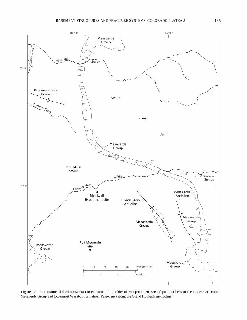
135
BASEMENT STRUCTURES AND FRACTURE SYSTEMS, COLORADO PLATEAU
0 5 10 15 20 25 KILOMETERS
15 MILES0 5 10
107°30'108°00'
40°00'
39°30'
MeekerWhite River
Piceance Creek
Colorado River
Rifle
MultiwellExperiment site
Red Mountainsite
Divide CreekAnticline
Wolf CreekAnticline
GlenwoodSprings
Piceance CreekDome
MesaverdeGroup
MesaverdeGroup
MesaverdeGroup
MesaverdeGroup
MesaverdeGroup
MesaverdeGroup
PICEANCEBASIN
White
River
Uplift
Pic
eanc
eC
reek
Figure 17. Reconstructed (bed-horizontal) orientations of the older of two prominent sets of joints in beds of the Upper CretaceousMesaverde Group and lowermost Wasatch Formation (Paleocene) along the Grand Hogback monocline.

LACCOLITH COMPLEXES OF SOUTHEASTERN UTAH136
0 5 10 15 20 25 KILOMETERS
15 MILES0 5 10
107°30'108°00'
40°00'
39°30'
Meeker
Piceance Creek
Colorado River
Rifle
Red Mountainsite
Divide CreekAnticline
Wolf CreekAnticline
GlenwoodSprings
Piceance CreekDome
MesaverdeGroup
MesaverdeGroup
MesaverdeGroup
MesaverdeGroup
MesaverdeGroup
MesaverdeGroup
PICEANCEBASIN
Wh ite River
MultiwellExperiment site
White
River
Uplift
Pic
eanc
eC
reek
Figure 18. Reconstructed (bed-horizontal) orientations of the younger of two prominent sets of joints in beds of the Upper CretaceousMesaverde Group and Paleocene to lower Eocene Wasatch Formation along and near the Grand Hogback monocline.

137BASEMENT STRUCTURES AND FRACTURE SYSTEMS, COLORADO PLATEAU
HightowerMountain
72
6866
64
7564 72
73
66
72
FlagpoleMountain
64
70
57
68
BaldMountain Four Mile Creek
Middle Thompson Creek
East Divide
Creek
West D
ivi deC
r eek
CREEK
ANTICLINE
WO
LFC
REEK
AN
TICLIN
E
GR
AN
D
HO
GB
AC
K
107°15'107°30'107°45'
39°22'30"
39°15'00"0
0
5
5 MILES
10 KILOMETERS
EXPLANATION
64
66Average strike and dip of joints in fold-parallel sets
Fracture station where the fold-parallel joint sets are not present
Anticline
Syncline
Monocline
DIVIDE
Figure 19. Orientations of two sets of fold-parallel joints on the Divide Creek and Wolf Creek anticlines near the eastern margin of thePiceance Basin, from Grout and Verbeek (1992).
system are broad and gradual, unlike the abrupt changesdescribed earlier for the older, thrust-related fracture sets.We have noted no relation between degree of joint-setprominence and proximity to any recognized basement-related structure for any of the five sets.
We emphasize here the young age of the Piceancesystem of joints. Within the Piceance Basin, for example,minor calcite-cemented thrust faults (fig. 21) created duringLaramide compression along the Grand Hogback are cutthrough by joints of the F2 set. Kink folds within the finelylaminated Green River beds also formed during the Lara-mide compressive events, and they everywhere predate alljoints present. Farther west, in the Uinta Basin, joints of theearliest (F1) set of the Piceance system have been traced up-ward through the Green River and Uinta Formations into theyoungest dated beds (about 32–34 Ma; Bryant and others,1989) of the Oligocene Duchesne River Formation (M.A.Grout and E.R. Verbeek, unpub. data, 1994). The abundant
evidence for a post-Laramide (Oligocene and younger) agefor all joint sets of the Piceance system explains their lack ofspatial correlation to exposed structures; all five sets weresuperimposed on structures already present.
SUMMARY OF SURFACE FRACTURE
NETWORK
Two of the oldest fracture sets in Cretaceous and Pale-ocene rocks along the eastern margin of the Piceance Basinare spatially coincident with the leading edge of a large,basement-cored crustal block that was thrust westward intothe basin during Laramide time. The principal surface ex-pression of this crustal boundary is the Grand Hogbackmonocline; along and west of this fold the fractures devel-oped within a sinuous belt at least 135 km long but less than25 km wide. Farther west, and within a much smaller area,two additional sets of fractures formed parallel to the axial

LACCOLITH COMPLEXES OF SOUTHEASTERN UTAH138
107°00'107°30'108°00'108°30'
40°00'
39°30'
39°00'
38°45'A
Colorado River
PICEANCE
BASIN
0 30 KILOMETERS
107°00'107°30'108°00'108°30'
40°00'
39°30'
39°00'
38°45'B
Colorado River
PICEANCE
BASIN
0 30 KILOMETERS
107°00'107°30'108°00'108°30'
40°00'
39°30'
39°00'
38°45'C
Colorado River
PICEANCE
BASIN
0 30 KILOMETERS
107°00'107°30'108°00'108°30'
40°00'
39°30'
39°00'
38°45'D
Colorado River
PICEANCE
BASIN
0 30 KILOMETERS
GR
AN
D
HOGBACK
HOGBACK
MO
NO
CLINE
GR
AN
D
MO
NO
CLINE
GR
AN
D
HOGBACK
MO
NO
CLINE
GR
AN
DHOGBACK
MO
NO
CLINE
Figure 20. Distribution and orientations of four regional sets of post-Laramide joints in Tertiary rocks of the Piceance Basin, from Groutand Verbeek (1992). A, F1 set; B, F2 set; C, F3 set; D, F4 set.
trace of an intrabasin anticline that developed above a seriesof imbricate splay faults that sole into a décollement relatedto the same thrust system. These two fracture sets are relat-ed to basement structure only in an indirect sense; both arelocated about 15–25 km west of the inferred position of thethrusted basement block. Though basement structureexerted a seemingly clear influence over the formation anddistribution of all four fracture sets discussed here, it did so
through mechanisms much different from those discussedpreviously for the Grand Canyon region.
Younger sets of fractures, five in all, are present with-in an area far greater than that occupied by the PiceanceBasin and are dominantly of post-Laramide age. In theirdistribution and expression we find no relation to basementstructure and conclude that they were imposed largely onstructures already present.

139BASEMENT STRUCTURES AND FRACTURE SYSTEMS, COLORADO PLATEAU
Figure 21. Small thrust fault in thin coal bed of Wasatch Formation, central Piceance Basin. Geologic pickfor scale.
DISCUSSION
EFFECT OF DEPTH AND GEOLOGICHISTORY ON BASEMENT-COVER
FRACTURE RELATIONS
The degree to which basement structure influencesfracture evolution in overlying rocks is related in large partto nature of the basement fault zones, their history of reacti-vation, and depth to basement. We comment briefly on thefirst topic before turning to the other two.
The gross pattern of known and inferred basement faultzones is broadly similar in all three areas discussed in this re-port. The northeast basement-fault trend is particularly welldefined and areally extensive, as shown for the Grand Can-yon region through the work of Shoemaker and others(1978), Huntoon (1974, 1993), and Sears (1973); for theParadox Basin by Case and Joesting (1972), Friedman andSimpson (1980), and Friedman and others (1994); and forthe Uncompahgre uplift and southern Piceance Basin byCase (1966) and Johnson (1983). Case and Joesting (1972,p. 2) believed that it continues “from the Grand Canyon area,Arizona, through the Rocky Mountains of northern Coloradoand southern Wyoming, and into the High Plains of Wyo-ming.” The northwest trend is likewise well expressed in allthree areas, as shown in figures 4, 8, and 14 and discussed bymost of the same authors just cited. The relative strength ofthese trends differs in different parts of the Colorado Plateau,
but both are evident in many areas, as on the Marble Plateau(fig. 8). A subordinate north trend, locally prominent in theGrand Canyon region (Shoemaker and others, 1978) and theParadox Basin (Case and Joesting, 1972), seems to weakenfarther north but nevertheless finds expression in the northand south segments of the Grand Hogback monocline and,probably, the Douglas Creek arch between the Piceance andUinta Basins (fig. 14). To a first approximation, then, wewill assume that observed differences in basement-relatedfracture patterns from one area to another are due mostly toeffects other than regional differences in basement faultpattern.
The major faults and faulted monoclines of the Huala-pai Indian Reservation, in the western Grand Canyon region,offer particularly clear (and long recognized) examples ofbasement influence on local fracture of overlying sedimen-tary rocks. Among the three areas discussed in this report, itis here that the sedimentary veneer is thinnest (625–770 mover much of the area), the effects of Laramide compressionon monocline development clearest, and Cenozoic reactiva-tion of basement faults greatest. During the latter eventmany of the Laramide monoclines were faulted as the base-ment faults beneath them were reactivated in a normal sense.Spacings of 10–20 km between basement-related faults andfaulted monoclines are typical (fig. 4), and several faults inthe region display normal offsets exceeding 100 m. Farthereast, on the Marble Plateau, faulted monoclines andbasement-related faults are no less abundant (fig. 8), but few

LACCOLITH COMPLEXES OF SOUTHEASTERN UTAH140
of the faults show normal offsets exceeding several tens ofmeters. Depth to basement in this area is slightly greater(950–1,200 m) than that on the Hualapai Reservation, but thegreatest influence on structural differences between the twoareas undoubtedly is the rapid eastward decline in basin-range-related crustal extension. Several previously unrecog-nized belts of fractures that we regard as the surface manifes-tation of reactivated basement structures beneath the MarblePlateau consist largely of faults with offsets too small to mer-it portrayal on conventional geologic maps.
The Piceance Basin differs markedly from these twoareas in its much greater depth to basement (5,000–7,900 m)and in its comparative freedom from the effects of basin-range crustal extension. Both effects contribute to thegeneral lack of expression of basement-related structureswithin the basin interior. The numerous basement-penetrating faults shown on seismic lines in Waechter andJohnson (1986) and Grout and others (1991), for example,show the persistence of the northwest basement-fault trendinto this region but have no expression at the surface inTertiary rocks. Similarly, the northeast basement-fault trend,so well defined both northeast and southwest of the PiceanceBasin, has no known expression among fractures within it;the only fractures corresponding to that direction are latecross joints of the F4 regional set (fig. 20). Basement-relatedfractures on this part of the Colorado Plateau are instead con-fined almost exclusively to the basin margins, and they arerelated to Laramide crustal compression rather than post-Laramide extension.
FRACTURE NETWORKS AND TECTONICHEREDITY
The degree to which ancient structures in Precambriancrystalline basement rocks have influenced or controlled thedevelopment of fractures in overlying sedimentary strata hasbeen long debated. Opinions in the literature have beenwidely divergent for decades, and remain so. Nowhere isthis more apparent than in the proceedings volumes forconferences on “The New Basement Tectonics,” the first ofwhich was held in 1974 (Nickelsen, 1975; Hodgson andothers, 1976) and the ninth in 1990 (Rickard and others,1992). The problem is best considered in two parts: localformation of zoned fracture sets related to specific basementstructures, and regional formation of areally pervasivefracture sets.
LOCAL FORMATION OF ZONED FRACTURE SETS
Evidence of basement involvement in local fracturedevelopment, typically as belts of fractures in overlyingstrata, is uncontested in such places as the Grand Canyon,where the deep structure of many faults can be studied
directly in outcrop. Multiple episodes of movement, often inopposing senses, can be documented for faults exposed overthousands of feet in vertical section and traceable incontinuity from Mesozoic and Paleozoic sedimentary rocksinto the crystalline schists below. Huntoon (1974), forexample, presented evidence for seven episodes of move-ment on the Hurricane fault from the Precambrian to theQuaternary. Evidence of basement-related fracturing ofcover rocks is likewise strong in some areas where basementrocks are not exposed but the underlying structure is welldocumented through seismic evidence or drilling. Reactiva-tion of basement structures is expressed at the surface mostoften as faults, but sets of extension joints can form duringthe same movements; the thrust-related joint sets of thePiceance Basin (Grout and Verbeek, 1992) are one example,and the early joint sets of the Redwall Limestone describedby Roller (1987, 1989) may be another. In all cases,however, it should be recognized that the formation of zonedfracture sets on the Colorado Plateau is related to reactiva-tion of individual, and generally large, basement faults.
REGIONAL FORMATION OF AREALLY PERVASIVE FRACTURE SETS
The case for basement-related fracturing on a finerscale is not nearly as convincing, despite the many papersdevoted to the subject. The notion that ancient fracturenetworks in basement rocks are reflected in regionally wide-spread joint sets of the cover rocks found many adherentsfrom the 1950’s through the 1970’s, a period whichcoincided with widespread use of aerial photographs to inter-pret regional fracture patterns. Satellite images, beginningwith the first ERTS images in the late 1960’s and high-resolution Skylab photographs shortly thereafter, quicklywere put to similar use. A process of continuous fracturepropagation—inheritance of entire fracture networks fromunderlying units—was envisioned by many investigators ofthis period (Blanchet, 1957; Mollard, 1957; Haman, 1961;Hodgson, 1961a, b; Gol’braikh and others, 1968; Rumsey,1971; Burford and Dixon, 1977, 1978). Suggested causes ofupward fracture propagation included earthquakes (fractureinduced by transient shock waves), earth tides (fracture dueto low-amplitude cyclic stress, a kind of geologic fatiguefailure), and tectonic compression. The renewal of fracturenetworks over time, if true, meant that joint patterns insurface rocks might reflect nothing of the stress fields thataffected those rocks (Hodgson, 1961b; Gol’braikh andothers, 1968), thereby complicating attempts to decipherregional paleostress histories. Rumsey (1971) introduced afurther complication by suggesting that additional fracturesets, unrelated to those already present, could form at anytime and at any stratigraphic level due to tectonic forces; ifso, he maintained, it might be impossible to deduce fromsurface evidence in which horizon each fracture setoriginated, or which set is genetically related to any other.

141BASEMENT STRUCTURES AND FRACTURE SYSTEMS, COLORADO PLATEAU
EVIDENCE AGAINST UPWARDPROPAGATION OF REGIONAL JOINT SETS
SOME COMMON PROBLEMS
Common problems with the concept of fracture inherit-ance, as listed by Engelder (1982), include (1) the puzzlingselectivity of the process, wherein some basement fracturesets have apparent counterparts in overlying rocks but othersdo not; (2) the existence of additional sets in the cover rockswith orientations different from those in the jointed base-ment; and (3) the existence of unjointed strata overlain bybeds that are jointed. Examples of all three types of prob-lems can be drawn from the areas discussed in this report.The mechanism of joint inheritance cannot explain, for ex-ample, why the two oldest joint sets in the Redwall Lime-stone on the Hualapai Plateau disappear abruptly at theerosional unconformity that truncates this unit. Nor can itexplain why the two most prominent joint sets in Cretaceousstrata along the Grand Hogback die out upward in Paleocenestrata and are replaced in younger beds by five sets that haveno counterparts in the older rocks, or why Cretaceous bedscontaining abundant joints are interlayered with other beds,typically weakly cemented sandstones, that remained un-jointed. More telling evidence, however, comes from therelative-age relations and mineralization histories of coexist-ing joint sets. Consistent abutting relations among joint setsat more than 1,100 localities in and near the Piceance andUinta Basins show that all of the joint sets discussedabove—the three sets along the Grand Hogback, the fold-re-lated sets on the Divide Creek anticline, and the five regionalsets in the basin rocks—formed in a well-defined sequence,one set after the other. Moreover, joints of the F2 regionalset (fig. 20), to select one prominent example, commonly arecoated with calcite of two and locally three generations,whereas only a single generation of calcite was deposited injoints of the later F4 set, and joints of the F5 set everywhereare unmineralized. There is no suggestion in any of these re-lations of upward propagation of a fracture network fromcomplexly jointed older beds into younger ones; instead wesee the clear record of discrete fracture events over time,each one adding another joint set to an evolving and increas-ingly complex network.
JOINT DEVELOPMENT IN A ROTATIONAL STRESS FIELD
The formation of joints during periods of stress-field ro-tation furnishes additional evidence incompatible with thehypothesis of upward propagation of regional fracture sets.Lacustrine strata of the Green River Formation in the Picean-ce and Uinta Basins provide an unusually clear example ofthis effect. Green River marlstone of nearly zero organiccontent is a compact, well-cemented rock that, under condi-tions corresponding to known burial depths of this unit, is
mechanically brittle. With increasing organic content themarlstones grade into oil shales, the change in lithologybeing reflected in a marked increase in ductility of the rock.The richest oil-shale beds contain more than 40 percentorganic matter by weight (Tisot and Murphy, 1962) and aresome of the most ductile rocks known (Tisot and Sohns,1971). As these beds experienced layer-parallel stretchingduring post-Laramide tectonic extension, the most brittlebeds failed first and increasingly less brittle (more ductile)beds failed progressively later. The record of progressivefailure and stress rotation is clear at many localities wherebeds of differing organic content are interlayered at theoutcrop scale. Figure 22 shows three examples from widelyseparated areas, where median strikes of the F2 regional jointset show a marked counterclockwise shift from bed to bed asa function of increasing organic content. The oil shalespreserve a complete record of the transition between the F2and F3 episodes of fracture and show that jointing occurredin different beds at different times as the regional stress fieldrotated counterclockwise at least 40°. The close tie betweenjoint orientation and lithology at the outcrop scale is incom-patible with any mechanism of fracture propagation upwardfrom deeper, previously jointed rocks.
TIMING OF JOINT DEVELOPMENT
The concept of continuous upward propagation of frac-ture networks from jointed basement implies that most rockunits should fracture not long after deposition, as soon as ce-mentation renders them capable of brittle failure (Hodgson,1961). Reports of systematic joint sets in geologicallyyoung deposits (Gilbert, 1882; Burford and Dixon, 1977,1978; see also fig. 13) lend credence to the hypothesis, butother evidence shows that rock units can, and commonly do,persist tens of millions of years in an unfractured state. Webriefly summarize that evidence here for the three areasdiscussed in this report.
Hualapai Plateau.—Lower Permian strata of the Es-planade Sandstone near the Ridenour mine breccia pipe (fig.4) are cut by five well-developed sets of subvertical exten-sion joints (Verbeek and others, 1988). The pipe is well ex-posed at the surface, in a tributary gorge to the GrandCanyon, and also underground, in historic mine workingsfor the extraction of copper, uranium, and vanadium ores.Most of the ore minerals were precipitated within an annularzone of outward-dipping ring fractures that formed duringthe stoping process. Verbeek and others (1988) presentedeight independent lines of evidence showing that the pipestoped upward through the Esplanade Sandstone and wasmineralized before the first set of regional joints had formedin the host rocks. These include the observations that all fivejoint sets are present in the cemented pipe breccia, that un-mineralized joints terminate against mineralized ring frac-tures, and that solution pockets are common along the ringfractures but do not occur along the joints, whose surfaces

LACCOLITH COMPLEXES OF SOUTHEASTERN UTAH142
N
S
EW
Median: N49W/81NE(n = 10)
VERY LEAN OIL SHALE
N
S
EW
Median: N63W/85NE(n = 13)
VERY LEAN OIL SHALE
N
S
EW
Median: N43W/83NE(n = 12)
LEAN OIL SHALE
N
S
EW
Median: N89W/88NE(n = 13)
RICH OIL SHALE
N
S
E
Median: N88E/80NW(n = 9)
RICH OIL SHALE
N
S
E
Median: N81W/90(n = 10)
RICH TO VERY RICHOIL SHALE
W
W
LocalityPB - 78
LocalityUB - 63
LocalityPB - 80
Figure 22. Paired lower-hemisphere equal-area projections of poles to F2 joints, showing their difference in orientationin lean oil shale (left) versus rich oil shale (right) in the same outcrops, for three localities in the Piceance and Uinta Basins.Localities PB-78 and PB-80 are near the junction of Piceance Creek and the White River in the north-central part of thePiceance Basin, in the NW1/4SW1/4 sec. 11, T. 1 N., R. 97 W., Rio Blanco County, Colo. Locality UB-63 is about 70 kmfarther west, on the eastern flank of the Uinta Basin in the NE1/4NE1/4 sec. 20, T. 10 S., R. 25 E., Uintah County, Utah.

143BASEMENT STRUCTURES AND FRACTURE SYSTEMS, COLORADO PLATEAU
preserve fine details of their original morphology. If primarymineralization of the Ridenour pipe occurred at 200–220 Ma(Triassic), as suggested by U-Pb age determinations on otherpipes nearby (Ludwig and Simmons, 1992), then at least 60m.y. elapsed between deposition of the Esplanade Sandstonein Permian time and the development of the first joint setwithin that unit. Joints of similar orientation in overlyingstrata, including Tertiary basalts and conglomerates, suggestfurther that most or all of the fracture sets may be youngerthan 18 Ma (Roller, 1989) and thus that the Esplanade Sand-stone may have lain unfractured for fully 250 m.y. or more.
Southern Marble Plateau.—One of the strongest piecesof evidence for long-delayed jointing in this area wasmentioned previously: that joints of the oldest set in lowerTriassic strata are nearly vertical on both the horizontal andtilted limbs of the Laramide Black Point monocline (fig. 12).We note also that remnant channels of a dendritic drainagesystem incised into the Permian Kaibab Limestone on theMarble Plateau, and especially on the adjacent CoconinoPlateau to the west, show no obvious evidence from aerialphotographs as having developed in jointed rock. The drain-age system is of probable Miocene age (G.H. Billingsley,USGS, oral commun., 1989). Though little work has beendone on the joint network of this large region, the availableevidence suggests that most or all joint sets in the uppermostPaleozoic and younger rocks are of post-Laramide age. Thejoint set shown in figure 12, for example, is the oldest onepresent in the unit pictured but is at least 150 m.y. youngerthan the rocks that contain it.
Piceance Basin.—Upper Cretaceous beds of theMesaverde Group and underlying Mancos Shale along thesouth and southwest margins of the Piceance Basin are cut byfive sets of joints that have been traced in stratigraphic andareal continuity into late Eocene beds of the basin interiorand into Oligocene beds of the Uinta Basin farther west. Noolder joint sets are present in the southern Piceance Basin,even in rock types normally considered especially suscepti-ble to early fracture; coal beds in the lower part of the Me-saverde Group, for example, contain the same joint sets asthose in associated and overlying clastic rocks (Grout, 1991).Strata of the lower Mesaverde Group were deposited 75–73Ma and the Mancos Shale somewhat earlier, but the jointswithin these beds are younger than 32–34 Ma (Bryant andothers, 1989), the age of the youngest dated beds withinwhich we have documented them (M.A. Grout and E.R. Ver-beek, unpub. data, 1994). The evidence thus points to at leasta 40-m.y. hiatus between deposition of the Late Cretaceousbeds and the development of the first joint set within them.Earlier fracture of the Mesaverde Group occurred only with-in a narrow (<25 km wide) belt of rock along and near thethrust front that marks the eastern edge of the basin (Groutand Verbeek, 1992).
Summary.—The evidence in all three areas for discreteepisodes of regional jointing, preceded by geologically longperiods during which no jointing occurred, is incompatible
with basement control of surface-fracture networks ascommonly envisioned. We conclude that if the basementrocks in any way influenced the development of regionaljoint sets in overlying sedimentary strata, they did not do sothrough any mechanism of continuous upward propagationof fracture sets.
GEOLOGIC SIGNIFICANCE OF REGIONAL JOINT SETS ON THE COLORADO PLATEAU
In all three areas studied on the Colorado Plateau, theexistence of sedimentary units that remained unjointed for40–250 m.y. after deposition suggests that conditions favor-able for extension fracture did not exist for geologically longperiods of time. The history of post-Redwall strata in theGrand Canyon region, following the latest Mississippian pe-riod of uplift, incision, and jointing, furnishes the clearest ex-ample. Preserved thicknesses of post-Redwall, Paleozoicand Mesozoic strata in this region, from the base of the SupaiGroup to the highest preserved remnants of the Chinle For-mation, range from about 2,300 m on the Hualapai Plateau to2,700 m on the Marble Plateau (fig. 2). As noted above, atleast some of these rock units remained unjointed until theTertiary Period. The inferred sequence of deformation,based on field relations in the Little Colorado River valley(E.R. Verbeek and M.A. Grout, unpub. data, 1986), is (1)formation of monoclines and attendant local thrust faultsduring Laramide crustal compression, (2) formation of mul-tiple sets of vertical, dominantly post-Laramide extensionjoints, and (3) local reactivation of joints to form numerousminor normal faults with vertical walls during post-Lara-mide crustal extension. Evidence that regional jointing ofthe rocks occurred after the Laramide compressive eventssuggests that burial depths during monoclinal folding werestill too great, and fluid pressures too low, for extension frac-tures to form. This interpretation in turn implies that erosionhad not yet appreciably reduced lithostatic load. Moreover,much of the post-Redwall succession consists of sandstonesand carbonate rocks poor in organic material. Had more or-ganic material been present, its maturation might have pro-duced sufficient fluid pressure to promote extensile failure atconsiderable depth. The paucity of organic matter, however,meant that jointing of these rocks was not possible until theirreturn to conditions of low confining pressure as overlyingstrata were stripped by erosion. Maximum burial depths ofthese rocks remain poorly constrained because whateveryounger deposits that may once have existed above them arenot preserved, but removal of about 2.7–4.5 km of overbur-den seems assured (Dumitru and others, 1994).
A characteristic common to all three areas discussedhere, and perhaps to most of the Colorado Plateau, is theabundance of geologically young fracture sets, many of thempost-Laramide in age. The Tertiary Period in all three areaswas a time of strong regional uplift and tectonic extension,
LACCOLITH COMPLEXES OF SOUTHEASTERN UTAH144
both of which created conditions conducive to repeatedextensile failure of the upper crust. Regional uplift promotesjointing by extensile failure in at least three ways:
1. Removal of overburden through erosion. Reductionin the vertical component of stress (lithostatic load) results ina corresponding decrease in horizontal stress by an amountproportional to the elastic properties of the rock (Price, 1966;Engelder, 1982).
2. Cooling and consequent lateral contraction of therock, which further relieves horizontal stresses (Voight andSt. Pierre, 1974; Haxby and Turcotte, 1976).
3. Layer-parallel extension resulting from the increas-ing radius of curvature of strata being uplifted (Price, 1966,1974; Haxby and Turcotte, 1976).
In addition, active tectonic extension can further greatlyincrease the potential for jointing through progressive de-crease in the regional component of horizontal stress in thedirection of extension. Given these considerations, the evi-dence for repeated Tertiary jointing on the Hualapai Plateauas reported by Roller (1987, 1989) is not at all surprising; theregion has been uplifted 3–5 km since the end of the Creta-ceous Period (Wenrich and others, 1995b) and has beenmildly extended during basin-range tectonism from Miocenetime onwards (Dickinson, 1981). Similarly, on the MarblePlateau, Cenozoic erosion has stripped most post-Paleozoicstrata from the area to leave only erosional remnants of Tri-assic rocks atop a vast, nearly bare surface of Permian lime-stone, and the area contains numerous minor normal faultsthat resulted from late Tertiary, nearly east-west extension.On the northeastern part of the Colorado Plateau, the estimat-ed uplift of the Piceance Basin since deposition of the UintaFormation in late Eocene time is about 2.8 km (Lorenz,1985). Mild but prolonged, post-Laramide northeast-south-west tectonic extension of much of the northeastern Colo-rado Plateau is reflected in a regional set of joints (F2) andminor normal faults within an area far larger than the Picean-ce Basin itself; to date we have mapped them over an area ofmore than 80,000 km2 (Verbeek and Grout, 1992; Grout andVerbeek, this volume, p. 163). In all three areas discussed inthis report, post-Laramide tectonic extension and decreasingburial depths resulted in a complex record of repeated epi-sodes of jointing during the Tertiary. In all three areas, too,the resultant joint sets are present throughout an appreciablethickness of rocks of diverse geologic age, thereby creatinga false appearance of upward propagation of fracture net-works.
CONCLUSIONS
Fracture networks in Paleozoic and younger sedimen-tary rocks in all three areas studied include some elementsrelated to movements along major basement faults.Common properties of these basement-related fractures aretheir local, rather than regional, extent and their occurrence
in zones more-or-less directly above known basementstructures. Offset of basement fault blocks during episodicreactivation of the basement structures, either in compres-sion or extension, was expressed in the cover rocks byzones of shear failure (minor faults) in some areas and byzones of extensile failure in others, depending principallyupon lithostatic load (depth of fracture) and fluid pressureat the time of fracture. Examples include the local thrustfaults associated with monoclinal folding during Laramidecompression in the Grand Canyon region, the elongatebelts of minor faults due to vertical offsets along basementfaults during post-Laramide extension of the same region,and the <25 km-wide zone of extension joints resultingfrom Laramide compression near the leading edge of abasement-involved thrust zone in the Piceance Basin.Fracture orientations in such basement-involved zones maybe unreliable indicators of regional stress fields because oflocal perturbations of the stress field in the vicinity of thebasement structures. All known and suspected basement-related fracture zones so far investigated by us have result-ed from discrete episodes of movement; we have found noevidence for continuous upward propagation of basementfracture zones through any mechanism.
Joint sets of regional, rather than local, extent are com-mon elements of Colorado Plateau geology and within vastareas are the dominant components of the overall fracturenetwork. Numerous properties of the regional joint sets, in-cluding their orientations, stratigraphic range, spatial distri-bution, mineralization history, and consistent sequence offormation, are incompatible with upward propagation offracture sets from deeper rocks. Each set is instead the pre-served record of a discrete episode of failure that affectedbroad areas of thousands to tens of thousands of square kilo-meters; the joint sets reflect no direct influence of basementstructures. Orientations of these joints reflect regional stresstrajectories at the time of fracture and provide a useful meansof reconstructing the paleostress history of the rocks inwhich they occur.
We conclude that the influence of basement rocks onfracture development in overlying sedimentary rocks on theColorado Plateau is more limited than commonly envi-sioned. Individual basement structures, when reactivated,have influenced fracturing in overlying rocks and resulted inlocalized failure within discrete belts of rock, but nowhereduring the course of our work have we found evidence forthe upward propagation of entire joint networks.
UNRESOLVED STRUCTURAL PROBLEMS
An obvious limitation of any interpretive study such asthis one is the fragmentary nature of the data on which it isbased. In the literature for the Grand Canyon region, for

145BASEMENT STRUCTURES AND FRACTURE SYSTEMS, COLORADO PLATEAU
example, is an astonishing dearth of actual data and specificfield observations on how the regional joint network as wesee it today evolved through time. Some of the papers citedhere signal a good beginning upon which to build, butnowhere is there a comprehensive account of the geometry,let alone the genesis, of the joint network of this classicregion. Conversely, basic elements of the basementstructure are fairly well known through field study ofexposed Precambrian rocks in the Grand Canyon andthrough geophysical studies on the flanking plateaus.Tracing of exposed basement fault zones upward through thesedimentary section long ago established the critical link be-tween these deep structures and their surface expression inrocks hundreds of meters above, enabling geologists to tracethe lateral extensions of some basement faults for scores ofkilometers from the nearest exposure of Precambrian rock.
The state of knowledge on basement structure and frac-ture evolution in the northeastern part of the Colorado Pla-teau, in western Colorado and eastern Utah, is nearly theopposite. Only recently have studies clarified the true natureof the basement fault zone beneath the Grand Hogback mon-ocline, the great fold that defines the boundary between thispart of the Colorado Plateau and the adjacent Rocky Moun-tains. Knowledge of basement structure deep beneath thesedimentary basins to the west remains sketchy at best. Thedeepest boreholes in the Piceance Basin penetrate only intoPennsylvanian sedimentary rocks, and over large areas thebasement remains hidden beneath more than 5,000 m of sed-imentary rock. The fracture history of Paleozoic rocks in theregion likewise remains almost wholly unknown, in part be-cause these rocks crop out over such a small proportion ofthe total area. The joint network in Upper Cretaceous andyounger rocks, in contrast, has been documented at morethan 1,100 localities throughout an area of more than 25,000km2, and its evolution is now known in considerable detail.
The mechanisms by which reactivation of basementstructures resulted in diverse types of fractures in overlyingsedimentary rocks remain imperfectly understood in all threeareas discussed here. In the Grand Canyon region, for exam-ple, how has strain been partitioned in cover rocks above agrowing step in the basement? What governs the relation be-tween displacement at basement level and width of an in-duced fracture zone at various levels above? In the PiceanceBasin, the two sets of inclined joints on the Divide Creek an-ticline are especially intriguing in that no close analog tothem seems to exist among popular models of fold-relatedfracturing (Hancock, 1985). Modeling of stress orientationsduring fold growth probably will be required to understandtheir genesis.
The basement-cover relations discussed here thusremain incompletely understood, but for different reasons indifferent regions. Geophysical study of deep basementstructure, still an evolving art, is likewise an expensive one;and the study of fracture evolution in sedimentary coverrocks at the surface, if done properly, is tedious at best. Still,
enough seems known to support the basic tenets of thispaper: that individual basement fault zones, whenreactivated, have resulted in local and in some casesrepeated fracture of the cover rocks; that regional jointsystems reflect the stress conditions under which theyformed and did not propagate upward from preexisting base-ment networks; and that much of the exposed joint networkas it exists today on the Colorado Plateau is a comparativelyyoung element of that region’s complex geologic history.
ACKNOWLEDGMENTS
This report is an outgrowth of several different projectsfunded by various agencies during the period 1978–1995.Funding by the U.S. Geological Survey was providedthrough the following programs: National Uranium Re-source Evaluation (NURE), Oil Shale, National GeologicMapping, Coal, Construction Hazards, and Evolution ofSedimentary Basins. Additional funds were provided by theHualapai Indian Tribe through the Bureau of Indian Affairsfor work in the Grand Canyon region; and by the U.S. De-partment of Energy, through their Tight Gas Sands Program,for work in the Piceance Basin.
The impetus for this report came from Gene Shoemak-er, not only through his studies of basement-cover fracturerelations in the Grand Canyon region, but also through hisencouragement, during the “Utah laccoliths” conference,that our results be published. Field work and conversationswith numerous colleagues contributed in no small measureto our understanding of Colorado Plateau geology and to theevolution of our ideas. Those deserving of special thanks in-clude Karen Wenrich, Hoyt Sutphin, Brad Van Gosen, PeteRowley, and Ivo and Barbara Lucchitta—fine geologists all.Thanks also to Brad Van Gosen for his thorough review; tothe numerous members of the National Association of Geol-ogy Teachers and assorted volunteers who assisted us in thefield; and to our long-suffering editors, Jules Friedman andCurt Huffman, for their patience, encouragement, andthumb screws.
The Central Publications Group of the U.S. GeologicalSurvey performed their usual miracles in turning a roughmanuscript and hand-drawn illustrations into a finishedproduct. Pete Martin edited many an awkward phrase intoreadable English. Gayle Dumonceaux used skill andpatience in drafting the illustrations, some of them twiceafter revised copies went astray.
REFERENCES CITED
Akers, J.P., Irwin, J.H., Stevens, P.R., and McClymonds, N.E.,1962, Geology of the Cameron quadrangle, Arizona: U.S.Geological Survey Geologic Quadrangle Map GQ–162, 1sheet, scale 1:62,500.

LACCOLITH COMPLEXES OF SOUTHEASTERN UTAH146
Babenroth, D.L., and Strahler, A.N., 1945, Geomorphology andstructure of the East Kaibab monocline, Arizona and Utah:Geological Society of America Bulletin, v. 56, no. 2, p.107–150.
Barnes, C.W., 1974, Interference and gravity tectonics in the GrayMountain area, Arizona, in Karlstrom, T.N.V., Swann, G.A.,and Eastwood, R.L., eds., Geology of Northern Arizona, PartI—Regional studies: Geological Society of America, RockyMountain Section meeting [guidebook], p. 442–453.
———1987, Geology of the Gray Mountain area, Arizona: Geo-logical Society of America Centennial Field Guide, RockyMountain Section, p. 379–384.
Billingsley, G.H., Barnes, C.W., and Ulrich, G.E., 1985, Geologicmap of the Coconino Point and Grandview Point Quadrangles,Coconino County, Arizona: U.S. Geological Survey Miscella-neous Investigations Series Map 1644, scale 1:62,500.
Billingsley, G.H., and Beus, S.S., 1985, The Surprise Canyon For-mation—An Upper Mississippian and Lower Pennsylvanian(?)rock unit in the Grand Canyon, Arizona: U.S. GeologicalSurvey Bulletin 1605–A, p. A27–A33.
Billingsley, G.H., Wenrich, K.J., and Huntoon, P.W., 1986, Brecciapipe and geologic map of the southeastern Hualapai IndianReservation and vicinity, Arizona: U.S. Geological SurveyOpen-File Report 86-458-B, 26 p., scale 1:48,000, 2 plates.
Billingsley, G.H., Wenrich, K.J., Huntoon, P.W., and Young, R.A.,in press, Breccia pipe and geologic map of the southwesternHualapai Indian Reservation and vicinity, Arizona: U.S. Geo-logical Survey Miscellaneous Investigations Map I–2554, 33p., scale 1:48,000, 2 plates.
Blanchet, P.H., 1957, Development of fracture analysis as explora-tion method: American Association of Petroleum GeologistsBulletin, v. 41, no. 8, p. 1748–1759.
Bredehoeft, J.D., Wolff, R.G., Keys, W.S., and Shuter, Eugene,1976, Hydraulic fracturing to determine the regional in situstress field, Piceance Basin, Colorado: Geological Society ofAmerica Bulletin, v. 87, no. 2, p. 250–258.
Bryant, Bruce, Naeser, C.W., Marvin, R.F., and Mehnert, H.H.,1989, Upper Cretaceous and Paleogene sedimentary rocks andisotopic ages of Paleogene tuffs, Uinta Basin, Utah: U.S. Geo-logical Survey Bulletin 1787–J, p. J1–J22.
Burford, A.E., and Dixon, J.M., 1977, Systematic fracturing in clayand its relation to bedrock joints and drainage segments: Geo-logical Society of America Abstracts with Programs, v. 9, no.7, p. 916.
———1978, Systematic fracturing in young clay of the CuyahogaRiver valley, Ohio, and its relation to bedrock jointing anddrainage segments: Géotechnique, v. 28, p. 201–206.
Case, J.E., 1966, Geophysical anomalies over Precambrian rocks,northwestern Uncompahgre Plateau, Utah and Colorado:American Association of Petroleum Geologists Bulletin, v. 50,no. 7, p. 1423–1443.
Case, J.E., and Joesting, H.R., 1972, Regional geophysical investi-gations in the central Colorado Plateau: U.S. GeologicalSurvey Professional Paper 736, 31 p.
Cashion, W.B., 1973, Geologic and structure map of the GrandJunction Quadrangle, Colorado and Utah: U.S. GeologicalSurvey Miscellaneous Investigations Series Map I–736, scale1:250,000.
Chenoweth, W.L., and Blakemore, P.P., 1961, The Riverviewmine, Coconino County, Arizona: Plateau, v. 33, no. 4, p.112–114.
Damon, P.E., Shafiqullah, Muhammad, and Leventhal, J.S., 1974,K-Ar chronology for the San Francisco volcanic field and rateof erosion of the Little Colorado River, in Karlstrom, T.N.V.,Swann, G.A., and Eastwood, R.L., eds., Geology of northernArizona, with notes on archaeology and paleoclimate—Part I,Regional studies: Geological Society of America, RockyMountain Section Meeting, Flagstaff, Ariz., April 27–30, 1974(Guidebook for Field Trips, No. 27), p. 221–235.
Davis, G.H., 1978, Monocline fold pattern of the Colorado Plateau,in Matthews, Vincent, III, ed., Laramide folding associatedwith basement block faulting in the western United States:Geological Society of America Memoir 151, p. 215–233.
Dickinson, W.R., 1981, Plate tectonic evolution of the southernCordillera, in Dickinson, W.R., and Payne, W.D., eds., Rela-tions of tectonics to ore deposits in the southern Cordillera:Arizona Geological Society Digest, v. 14, p. 135–172.
Dodge, C.N., and Bartleson, B.L., 1986, The Eagle basin—A newexploration frontier, in Stone, D.S., ed., New interpretations ofnorthwest Colorado geology: Denver, Colo., Rocky MountainAssociation of Geologists, p. 113–121.
Dumitru, T.A., Duddy, I.R., and Green, P.F., 1994, Mesozoic-Cenozoic burial, uplift, and erosion history of the west-centralColorado Plateau: Geology, v. 22, no. 6, p. 499–502.
Eastwood, R.L., 1974, Cenozoic volcanism and tectonism of thesouthern Marble Plateau, in Karlstrom, T.N.V., Swann, G.A.,and Eastwood, R.L., eds., Geology of northern Arizona, withnotes on archaeology and paleoclimate—Part I, Regionalstudies: Geological Society of America, Rocky MountainSection Meeting, Flagstaff, Ariz., April 27–30, 1974 (Guide-book for Field Trips, No. 27), p. 236–256.
Engelder, Terry, 1982, Is there a genetic relationship betweenselected regional joints and contemporary stress within thelithosphere of North America?: Tectonics, v. 1, no. 2, p.161–177.
Finley, S.J., and Lorenz, J.C., 1989, Characterization and signifi-cance of natural fractures in Mesaverde reservoirs at the Mul-tiwell Experiment site: Society of Petroleum Engineers JointRocky Mountain Regional/Low Permeability Reservoir Sym-posium and Exhibition, Denver, SPE Paper 19007, p. 721–728.
Friedman, J.D., Case, J.E., and Simpson, S.L., 1994, Tectonictrends of the northern part of the Paradox Basin, southeasternUtah and southwestern Colorado, as derived from Landsatmultispectral scanner imaging and geophysical and geologicmapping, chap. C of Evolution of sedimentary basins—Para-dox Basin: U.S. Geological Survey Bulletin 2000–C, p.C1–C30.
Friedman, J.D., and Simpson, S.L., 1980, Lineaments and structureof the northern Paradox Basin, Colorado and Utah: U.S.Geological Survey Miscellaneous Field Studies MapMF–1221, scale 1:250,000.
Gilbert, G.K., 1882, Post-glacial joints: American Journal of Sci-ence, Third series, v. 23, no. 133, p. 25–27.
Gol’braikh, I.G., Zabaluyev, V.V., Lastochkin, A.N., Mirkin, G.R.,and Reinin, I.V., 1968, Morfostrukurnyye metody izucheniyatektoniki zakrytykh platformennykh neftegazonosnykhoblastey [Morphostructural methods for the tectonic study ofcovered platform oil and gas regions]: Leningrad, Izdatel’stvo

147BASEMENT STRUCTURES AND FRACTURE SYSTEMS, COLORADO PLATEAU
Nedra, 151 p. Partial English translation [1974] by M.H.Podwysocki (NASA Goddard Space Flight Center, Greenbelt,MD 20771), 136 p.
Gross, M.R., 1993, The origin and spacing of crossjoints—Examples from the Monterey Formation, SantaBarbara coastline, California: Journal of Structural Geology,v. 15, no. 6, p. 737–751.
Grout, M.A., 1991, Cleats in coal beds of the southern PiceanceBasin, Colorado—Correlation with regional and local fracturesets in associated clastic rocks, in Schwochow, S.D., Murray,D.K., and Fahy, M.F., eds., Coalbed methane of western NorthAmerica: Denver, Colo., Rocky Mountain Association ofGeologists, p. 35–47.
Grout, M.A., Abrams, G.A., Tang, R.L., Hainsworth, T.J., and Ver-beek, E.R., 1991, Late Laramide thrust-related and evaporite-domed anticlines in southern Piceance Basin, northeastern Col-orado Plateau: American Association of Petroleum GeologistsBulletin, v. 75, no. 2, p. 205–218.
Grout, M.A., and Verbeek, E.R., 1985, Fracture history of the Pla-teau Creek and adjacent Colorado River valleys, southernPiceance Basin—Implications for predicting joint patterns atdepth: U.S. Geological Survey Open-File Report 85-744, 17 p.
———1992, Fracture history of the Divide Creek and Wolf Creekanticlines and its relation to Laramide basin-margin tectonism,southern Piceance Basin, northwestern Colorado: U.S. Geo-logical Survey Bulletin 1787–Z, 32 p.
Gunneson, B.G., Wilson, M.S., and Labo, J.A., 1995, Divide CreekAnticline—A decapitated pop-up structure with two detach-ment zones: Rocky Mountain Association of Geologists,High-Definition Seismic Guidebook, p. 31–45.
Haman, P.J., 1961, Lineament analysis on aerial photographsexemplified in the North Sturgeon Lake area, Alberta: WestCanadian Research Publications of Geology and Related Sci-ences, series 2, no. 1, 20 p.
Hancock, P.L., 1985, Brittle microtectonics—Principles and prac-tice: Journal of Structural Geology, v. 7, nos. 3–4, p. 437–457.
Haxby, W.F., and Turcotte, D.L., 1976, Stress induced by theaddition or removal of overburden and associated thermaleffects: Geology, v. 4, p. 181–185.
Haynes, D.D., and Hackman, R.J., 1978, Geology, structure, anduranium deposits of the Marble Canyon 1° ×2° quadrangle,Arizona: U.S. Geological Survey Miscellaneous Investiga-tions Series Map I–1003, 2 sheets, scale 1:250,000.
Hite, R.J., 1975, An unusual northeast-trending fracture zone andits relation to basement wrench faulting in the northern Para-dox Basin, in Fassett, J.E., ed., Canyonlands country guide-book: Four Corners Geological Society Field Conference, 8th,p. 217–223.
Hoak, T.E., and Klawitter, A.L., 1996, Structural compartmental-ization in a decapitated anticline—the example of the DivideCreek fractured reservoir, Piceance Basin [abs.]: AmericanAssociation of Petroleum Geologists, Annual meeting, SanDiego, California, Poster Session abstract, p. A66.
Hodgson, R.A., 1961a, Regional study of jointing in CombRidge–Navajo Mountain area, Arizona and Utah: AmericanAssociation of Petroleum Geologists Bulletin, v. 45, no. 1, p.1–38.
———1961b, Reconnaissance of jointing in Bright Angel area,Grand Canyon, Arizona: American Association of PetroleumGeologists Bulletin, v. 45, no. 1, p. 95–97.
Hodgson, R.A., Gay, S.P., Jr., and Benjamins, J.Y., eds., 1976, Firstinternational conference on the new basement tectonics, SaltLake City, Utah, June 3–7, 1974, Proceedings: Utah Geologi-cal Association Publication 5, 636 p.
Holm, R.F., 1987, Geomorphic evidence for youngest dated faultsin north-central Arizona: The Mountain Geologist, v. 24, no.1, p. 19–25.
Huntoon, P.W., 1970, Hydro-mechanics of the groundwater systemin the southern portion of the Kaibab Plateau, Arizona:Tucson, Ariz., University of Arizona Ph. D. dissertation, 251 p.
———1974, The post-Paleozoic structural geology of the easternGrand Canyon, Arizona, in Breed, W.J., and Roat, E.C., eds.,Geology of the Grand Canyon: Flagstaff, Ariz., Museum ofNorthern Arizona, p. 82–115.
———1993, Influence of inherited Precambrian basement struc-ture on the localization and form of Laramide monoclines,Grand Canyon, Arizona, in Schmidt, C.J., Chase, R.B., andErslev, E.A., eds., Laramide basement deformation in theRocky Mountain foreland of the western United States:Geological Society of America Special Paper 280, p. 243–256.
Huntoon, P.W., Billingsley, G.H., Breed, W.J., Sears, J.W., Ford,T.D., Clark, M.D., Babcock, R.S., and Brown, E.H., 1976,Geologic map of the Grand Canyon National Park, Arizona:Grand Canyon, Ariz., Grand Canyon Natural History Associa-tion, 1 sheet, scale 1:62,500.
Huntoon, P.W., and Sears, J.W., 1975, Bright Angel and Eminencefaults, eastern Grand Canyon, Arizona: Geological Society ofAmerica Bulletin, v. 86, p. 465–472.
Izett, G.A., Honey, J.G., and Brownfield, M.E., 1985, Geologicmap of the Citadel Plateau quadrangle, Moffat County,Colorado: U.S. Geological Survey Miscellaneous Investiga-tions Series Map I–1532, 1 sheet, scale 1:48,000.
Johnson, S.Y., Schenk, C.J., and Karachewski, J.A., 1988, Pennsyl-vanian and Permian depositional systems and cycles in theEagle basin, northwest Colorado, in Holden, G.S., ed.,Geological Society of America field trip guidebook,1988—Centennial meeting, Denver, Colorado: Golden, Colo.,Colorado School of Mines Professional Contributions 12, p.156–174.
Johnson, V.C., 1983, Preliminary aeromagnetic interpretation ofthe Uncompahgre Uplift and Paradox Basin, west-centralColorado and east-central Utah, in Averett, W.R., ed., North-ern Paradox Basin–Uncompahgre Uplift field trip: GrandJunction, Colo., Grand Junction Geological Society, p. 67–70.
Lohman, S.W., 1981, The geologic story of Colorado NationalMonument: U.S. Geological Survey Bulletin 1508, 142 p.
Lorenz, J.C., 1985, Tectonic and stress histories of the PiceanceCreek basin and the MWX site, from 75 million years ago tothe present: Albuquerque, N.Mex., Sandia NationalLaboratories, Report SAND84-2603, 50 p.
Lorenz, J.C., and Finley, S.J., 1987, Differences in fracture charac-teristics and related production of natural gas in different zonesof the Mesaverde Formation, northwestern Colorado: Societyof Petroleum Engineers Annual Technical Conference andExhibition, 62nd, Dallas, Sept. 27–30, 1987, SPE Paper 16809,p. 589–596.
Lorenz, J.C., Warpinski, N.R., Branagan, Paul, and Sattler, A.R.,1989, Fracture characteristics and reservoir behavior of stress-sensitive fracture systems in flat-lying lenticular formations:Journal of Petroleum Technology, v. 4, no. 1, p. 11–16.

LACCOLITH COMPLEXES OF SOUTHEASTERN UTAH148
Lucchitta, Ivo, 1974, Structural evolution of northwest Arizona andits relation to adjacent Basin and Range province structures, inKarlstrom, T.N.V., Swann, G.A., and Eastwood, R.L., eds.,Geology of northern Arizona, with notes on archaeology andpaleoclimate—Part I, Regional studies: Geological Society ofAmerica, Rocky Mountain Section Meeting, Flagstaff, Ariz.,April 27–30, 1974 (Guidebook for Field Trips, No. 27), p.336–354.
Ludwig, K.R., and Simmons, K.R., 1992, U-Pb dating of uraniumdeposits in collapse breccia pipes of the Grand Canyon region:Economic Geology, v. 87, p. 1747–1765.
MacLachlan, M.E., 1987, General geology of the Piceance Basin,in Taylor, O.J., compiler, Oil shale, water resources, and valu-able minerals of the Piceance Basin, Colorado—The challengeand choices of development: U.S. Geological Survey Profes-sional Paper 1310, p. 7–15.
MacLachlan, M.E., and Welder, F.E., 1987, Paleozoic andMesozoic formations and their potential as ground-waterreservoirs, in Taylor, O.J., compiler, Oil shale, water resources,and valuable minerals of the Piceance Basin, Colorado—Thechallenge and choices of development: U.S. Geological Sur-vey Professional Paper 1310, p. 95–106.
MacQuown, W.C., Jr., 1945, Structure of the White River Plateaunear Glenwood Springs, Colorado: Geological Society ofAmerica Bulletin, v. 56, p. 877–892.
McKee, E.D., 1979, Arizona, in Craig, L.C., and Connor, C.W.,coordinators, Paleotectonic investigations of the MississippianSystem in the United States—Part 1, Introduction and regionalanalyses of the Mississippian System: U.S. Geological SurveyProfessional Paper 1010–L, p. 197–207.
McKee, E.D., and Gutschick, R.C., 1969, History of the RedwallLimestone of northern Arizona: Geological Society ofAmerica Memoir 114, 692 p.
McLain, J.P., 1965, Photographic analysis of lineaments in the SanFrancisco volcanic field, Coconino and Yavapai Counties, Ari-zona: Phoenix, Ariz., University of Arizona M.S. thesis, 31 p.
Mollard, J.D., 1957, Aerial mosaics reveal fracture patterns on sur-face materials in southern Saskatchewan and Manitoba: Oil inCanada, v. 9, no. 40, p. 26–50.
Nickelsen, R.P., 1975, “New basement tectonics” evaluated in SaltLake City: Geotimes, v. 20, no. 10, p. 16–17.
Perry, W.J., Jr., Grout, M.A., Tang, R.L., and Hainsworth, T.J.,1988, Wedge model for late Laramide basement-involvedthrusting, Grand Hogback monocline and White River uplift,western Colorado: Geological Society of America Abstractswith Programs, v. 20, no. 7, p. A384–A385.
Price, N.J., 1966, Fault and joint development in brittle and semi-brittle rock: Oxford and New York, Pergamon Press, 176 p.
———1974, The development of stress systems and fracture pat-terns in undeformed sediments, in Advances in rock mechan-ics—Proceedings of the Third Congress of the InternationalSociety for Rock Mechanics, Denver, Colo., Sept. 1–7, 1974:Washington, National Academy of Sciences, v. 1, pt. A, p.487–496.
Reches, Ze’ev, 1978, Development of monoclines—Part 1, Struc-ture of the Palisades Creek branch of the East Kaibab mono-cline, Grand Canyon, Arizona, in Matthews, Vincent, III, ed.,Laramide folding associated with basement block faulting inthe western United States: Geological Society of AmericaMemoir 151, p. 235–271.
Rickard, M.J., Harrington, H.J., and Williams, P.R., eds., 1992,Basement tectonics 9—Australia and other regions: NinthInternational Conference on Basement Tectonics, Proceedings,Canberra, Australia, July 2–6, 1990, 272 p.
Roller, J.A., 1987, Fracture history of the Redwall Limestone andlower Supai Group, western Hualapai Indian Reservation,northwestern Arizona: U.S. Geological Survey Open-FileReport 87-359, 33 p.
———1989, Fracture history of the Redwall Limestone, lowerSupai Group, and Tertiary units on the Hualapai Indian Reser-vation, northwestern Arizona—Additional data to Open-FileReport 87-359: U.S. Geological Survey Open-File Report 89-463, 42 p.
Rumsey, I.A.P., 1971, Relationship of fractures in unconsolidatedsuperficial deposits to those in the underlying bedrock: Mod-ern Geology, v. 3, p. 25–41.
Sears, J.W., 1973, Structural geology of the Precambrian GrandCanyon Series, Arizona: Laramie, Wyo., University ofWyoming M.S. thesis, 100 p.
Seccombe, J.C., and Decker, A.D., 1986, Geologic and reservoircharacteristics of the Red Mountain coalbed methane test sitein the Piceance Basin: Chicago, Ill., Gas Research Institute,Topical Report GRI–86/0109, 102 p. Available from NationalTechnical Information Service, Springfield, VA 22161, asReport PB86–217098/XAB.
Shoemaker, E.M., Squires, R.L., and Abrams, M.J., 1978, TheBright Angel and Mesa Butte fault systems of northern Arizo-na, in Smith, R.B., and Eaton, G.P., eds., Cenozoic tectonicsand regional geophysics of the western Cordillera: GeologicalSociety of America Memoir 152, p. 341–368.
Stone, D.S., 1969, Wrench faulting and Rocky Mountain tectonics:The Mountain Geologist, v. 6, no. 2, p. 67–79.
Sturgul, J.R., and Irwin, T.D., 1971, Earthquake history of Arizonaand New Mexico, 1850–1966: Arizona Geological SocietyDigest, v. 9, p. 1–22.
Sutphin, H.B., 1986, Occurrence and structural control of collapsefeatures on the southern Marble Plateau, Coconino County,Arizona: Flagstaff, Ariz., Northern Arizona University M.S.thesis, 139 p.
Sutphin, H.B., and Wenrich, K.J., 1983, Structural control of brec-cia pipes on the southern Marble Plateau, Arizona: U.S. Geo-logical Survey Open-File Report 83-908, 7 p., 2 plates, scale1:50,000.
———1988, Map showing structural control of breccia pipes onthe southern Marble Plateau, north-central Arizona: U.S. Geo-logical Survey Miscellaneous Investigations Series MapI–1778, 2 sheets, scale 1:50,000.
Sutphin, H.B., Wenrich, K.J., and Verbeek, E.R., 1983, Structuralcontrol of breccia pipes on the southern Marble Plateau, Arizo-na: Geological Society of America Abstracts with Programs,v. 115, no. 5, p. 376.
Tisot, P.R., and Murphy, W.I.R., 1962, Physical structure of GreenRiver oil shale from Colorado: U.S. Bureau of Mines Reportof Investigations 6184, 24 p.
Tisot, P.R., and Sohns, H.W., 1971, Structural deformation ofGreen River oil shale as it relates to in-situ retorting: U.S.Bureau of Mines Report of Investigations 7576, 27 p.
Ulrich, G.E., Billingsley, G.H., Hereford, Richard, Wolfe, E.W.,Nealey, L.D., and Sutton, R.L., 1984, Map showing geology,structure, and uranium deposits of the Flagstaff 1° ×2°

149BASEMENT STRUCTURES AND FRACTURE SYSTEMS, COLORADO PLATEAU
quadrangle, Arizona: U.S. Geological Survey MiscellaneousInvestigations Series Map I–1446, 2 sheets, scale 1:250,000.
Van Gosen, B.S., and Wenrich, K.J., 1988, Ground magnetometersurveys over known and suspected breccia pipes on theCoconino Plateau, northwestern Arizona: U.S. GeologicalSurvey Bulletin 1683–C, 31 p.
Verbeek, E.R., and Grout, M.A., 1984a, Fracture studies inCretaceous and Paleocene strata in and around the PiceanceBasin, Colorado—Preliminary results and their bearing on afracture-controlled natural-gas reservoir at the MWX site:U.S. Geological Survey Open-File Report 84-156, 30 p.
———1984b, Prediction of subsurface fracture patterns from sur-face studies of joints—An example from the Piceance Creekbasin, Colorado, in Spencer, C.W., and Keighin, C.W., eds.,Geologic studies in support of the U.S. Department of EnergyMultiwell Experiment, Garfield County, Colorado: U.S. Geo-logical Survey Open-File Report 84-757, p. 75–86.
———1992, Structural evolution of gilsonite dikes, eastern UintaBasin, Utah, in Fouch, T.D., Nuccio, V.F., and Chidsey, T.C.,Jr., eds., Hydrocarbon and mineral resources of the UintaBasin, Utah and Colorado: Utah Geological AssociationGuidebook 20, p. 237–255.
———1993, Geometry and structural evolution of gilsonite dikesin the eastern Uinta Basin, Utah: U.S. Geological SurveyBulletin 1787–HH, 42 p.
Verbeek, E.R., Grout, M.A., and Van Gosen, B.S., 1988, Structuralevolution of a Grand Canyon breccia pipe—The Ridenourcopper-vanadium-uranium mine, Hualapai Indian Reservation,Coconino County, Arizona: U.S. Geological Survey Open-File Report 88-006, 75 p.
Voight, Barry, and St. Pierre, H.P.B., 1974, Stress history and rockstress, in Advances in rock mechanics—Proceedings of theThird Congress of the International Society for Rock Mechan-ics, Denver, Colo., Sept. 1–7, 1974: Washington, NationalAcademy of Sciences, v. 2, pt. A, p. 580–582.
Waechter, N.B., and Johnson, W.E., 1986, Pennsylvanian-Permianpaleostructure and stratigraphy as interpreted from seismic
data in the Piceance Basin, Colorado, in Stone, D.S., ed., Newinterpretations of northwest Colorado geology: Denver, Colo.,Rocky Mountain Association of Geologists, p. 51–64.
Wenrich, K.J., 1985, Mineralization of breccia pipes in northernArizona: Economic Geology, v. 80, no. 6, p. 1722–1735.
Wenrich, K.J., Billingsley, G.H., and Huntoon, P.W., 1995a,Breccia pipe and geologic map of the northwestern HualapaiIndian Reservation and vicinity, Arizona: U.S. GeologicalSurvey Miscellaneous Investigations Series Map I–2522, 32 p.,2 plates, scale 1:48,000.
———1995b, Breccia pipe and geologic map of the northeasternHualapai Indian Reservation and vicinity, Arizona: U.S.Geological Survey Miscellaneous Investigations Series MapI–2440, 60 p., 2 plates, scale 1:48,000.
Wenrich, K.J., Chenoweth, W.L., Finch, W.I., and Scarborough,R.B., 1989, Uranium in Arizona, in Jenney, J.P., and Reynolds,S.J., eds., Geologic evolution of Arizona: Arizona GeologicalSociety Digest, v. 17, p. 759–794.
Wenrich, K.J., and Sutphin, H.B., 1989, Lithotectonic settingnecessary for formation of a uranium-rich, solution-collapsebreccia-pipe province, Grand Canyon region, Arizona, inMetallogenesis of uranium deposits (Proceedings of a Techni-cal Meeting, March 9–12, 1987, Vienna): International Atom-ic Energy Agency, p. 307–344.
Williams, P.L., 1964, Geology, structure, and uranium deposits ofthe Moab Quadrangle, Colorado and Utah: U.S. GeologicalSurvey Miscellaneous Investigations Series Map I–360, scale1:250,000.
Wong, I.G., and Humphrey, J.R., 1989, Contemporary seismicity,faulting, and the state of stress in the Colorado Plateau:Geological Society of America Bulletin, v. 101, no. 9, p.1127–1146.
Zoback, M.L., and Zoback, M.D., 1980, State of stress in theconterminous United States: Journal of Geophysical Research,v. 85, p. 6113–6156.
Next section