prince william civil war heritage trail

1
Manassas Manassas Park Quantico Dumfries Occoquan 66 29 234 PR IN CE W IL LI AM PA RK WAY 615 15 28 234 234 95 1 215 619 619 SUDLEY MANOR DRIVE COCKPIT POINT RD. 633 Haymarket 11 12 14 13 15 16 10 F 9 E 7 C 17 H 18 8 5 6 B 1 3 2 4 19 I 20 22 25 24 23 21 J K L N NEABSCO RD. Map and brochure designed by Heather Hembrey 2009 D 55 WATERFALL ROAD A G Civil War Historic Sites and Museums $ = Admission Fee A CHAPMAN'S / BEVERLEY MILL 17504 Beverley Mill Road Broad Run, VA 20137 FREE 540-253-5888 www.chapmansmill.org Known locally as Beverley Mill, this structure was built in 1742 and was the focal point of the pivotal 1862 Battle of Thoroughfare Gap. B HAYMARKET MUSEUM 15025 Washington Street Haymarket, VA 20169 FREE 703-753-3712 Interprets this pre-Civil War town that Federal troops burned in 1862. C MANASSAS NATIONAL BATTLEFIELD PARK 6511 Sudley Road Manassas, VA 20109 $ 703-361-1339 www.nps.gov/mana/ Site of the Battles of First Manassas (1861) and Second Manassas (1862). D RUTH E. LLOYD INFORMATION CENTER (RELIC) Bull Run Regional Library 8051 Ashton Avenue Manassas, VA 20109 FREE 703-792-4540 www.pwcgov.org/library/relic A special collection devoted to genealogy and local history focusing on Virginia and Prince William County. E BEN LOMOND HISTORIC SITE 10321 Sudley Manor Drive Manassas, VA 20109 $ 703-367-7872 www.pwcgov.org/historicsites 1832 house was a Confederate hospital after First Manassas. Union graffiti is preserved. F MANASSAS MUSEUM 9101 Prince William Street Manassas, VA 20110 $ 703-368-1873 www.manassasmuseum.org Represents the area's rich history, including an extensive exhibit about the Civil War. G MAYFIELD CIVIL WAR FORT 8401 Quarry Road Manassas, VA 20110 FREE 703-368-1873 www.manassasmuseum.org Site of the last remaining Confederate earthwork fortification built in 1861 to guard the eastern approaches to Manassas Junction along the railroad. H BRISTOE STATION BATTLEFIELD HERITAGE PARK 10708 Bristow Road Bristow, VA 20136 $ 703-257-5243 www.pwcgov.org/historicsites Interprets the 1862 Battle of Kettle Run and the 1863 Battle of Bristoe Station. I BRENTSVILLE COURTHOUSE HISTORIC CENTRE 12229 Bristow Road Bristow, VA 20136 $ 703-365-7895 www.pwcgov.org/brentsville Interprets Brentsville (founded in 1820) and 19th-century Prince William County. J MILL HOUSE MUSEUM 413 Mill Street Occoquan, VA 22125 FREE 703-491-7525 Occoquan's colonial and Civil War history is presented through exhibits, presentations and artifacts. K LEESYLVANIA STATE PARK 2001 Daniel K. Ludwig Drive Woodbridge, VA 22191 $ 703-583-6904 www.dcr.virginia.gov Park Visitor and Environmental Education Centers have exhibitions about the area's Civil War history. L WEEMS-BOTTS MUSEUM 3944 Cameron Street Dumfries, VA 22026 $ 703-221-2218 www.historicdumfries.com Tours span the history of Dumfries and Prince William County during the 18th-20th centuries. M PRINCE WILLIAM FOREST PARK 18100 Park Headquarters Road Triangle, VA 22172 $ 703-221-7181 www.nps.gov/prwi Interprets antebellum and Civil War farm homesteads and graveyards. A Civil War exhibit is located in the Visitor Center. N NATIONAL MUSEUM OF THE MARINE CORPS 18900 Jefferson Davis Highway Triangle, VA 22172 FREE 1-877-635-1775 www.usmcmuseum.org Learn how the Marine Corps have evolved over the past 200 years in this interactive museum. Virginia Civil War Trails Marker Locations On-site markers provide more detailed descriptions of places and events than those given here. 1 THOROUGHFARE GAP (Fauquier County side of Broad Run) Marker located on Rt. 55 (John Marshall Hwy.) 38 49' 24" N * 77 42' 39" W Armies used this mountain pass throughout the war. In July 1861, Confederate troops marched through the Gap on their way to Manassas. Confederate Gen. Thomas “Stonewall” Jackson crossed the Gap en route to Bristoe and Manassas in August 1862. 2 CHAPMAN'S MILL Marker at end of Beverley Mill Road, Broad Run 38 49' 28" N * 77 42' 24" W This mill was a Confederate supply center during 1861-1862. The August 28, 1862 Battle of Thoroughfare Gap was fought around the mill. 3 EWELL'S CHAPEL Marker located at the intersection of Largo Vista Drive and Loudoun Drive, Haymarket 38 54' 43" N * 77 37' 45" W Col. John S. Mosby and his partisan rangers escaped a Union trap set here on June 22, 1863. Wounded at Second Manassas, Confederate Gen. Richard Ewell was brought to a nearby home to convalesce after his leg was amputated. 4 HOPEWELL GAP Marker located at Antioch Church 16513 Waterfall Road, Haymarket 38 51' 28" N * 77 41' 4" W Armies used this strategic pass often during the war. Federal cavalrymen escaped through the Gap on June 18, 1863 after being defeated at Middleburg. Confederate partisan Col. John S. Mosby maintained a prisoner-of-war camp nearby in July 1863. 5 BUCKLAND Marker located at 16211 Lee Highway, Gainesville 38 46' 48" N * 77 40' 27" W The Battle of Buckland Mills was fought here on October 19, 1863. Gen. J.E.B. Stuart's Confederate cavalry routed Gen. J. Kilpatrick's Union cavalry in what became known as the "Buckland Races." 6 HAYMARKET Haymarket Museum 15025 Washington Street, Haymarket 38 48'N * 77 38' 14"W This town was in the path of marching armies throughout the war. After Confederate bushwhackers fired at Union forces nearby in 1862, a Union general had the town burned, leaving few intact structures. On June 25, 1863, the Union II Corps fought Gen. J.E.B. Stuart's Confederate cavalry here, breaking Stuart's contact with Lee on his march north to Gettysburg. 7 MANASSAS NATIONAL BATTLEFIELD PARK 6511 Sudley Road, Manassas 38 48' 46" N * 77 31' 15" W The park preserves key sites associated with First Manassas (Bull Run), the first major battle of the war (July 21, 1861), and the much bloodier Second Battle of Manassas (August 28-30, 1862). Both were Confederate victories. 8 GREENWICH Marker located at Greenwich Church 15305 Vint Hill Road, Nokesville 38 45' 0" N * 77 38' 52" W Gen. Richard Ewell grew up nearby. During the war, Union and Confederate forces frequented the village. Union forces bivouacked here in August 1862 while Gen. "Stonewall" Jackson plundered Manassas Junction. In May 1863, Mosby's Rangers fought off Union pursuers at a neighboring farm. 9 BEN LOMOND HISTORIC SITE 10321 Sudley Manor Drive, Manassas 38 47' 21" N * 77 30' 22" W This home, built in 1832, suffered because of its proximity to the Manassas battlefields. It was used as a Confederate hospital after First Manassas and was later occupied by Union soldiers whose graffiti is preserved. 10 BLACKBURN'S FORD (Fairfax County side of Bull Run ) Markers located off of Rt. 28 near Bull Run 38 48' 12" N * 77 26' 57" W On July 18, 1861, Confederates waiting at this ford along Bull Run repulsed a Union "reconnaissance-in-force" from Centreville. This prelude to First Manassas was the first taste of battle for most of the soldiers involved. 11 MITCHELL'S FORD Marker located at Yorkshire Elementary School at the corner of Yorkshire Lane and Old Centreville Road, Manassas 38 47' 21"N * 77 27' 29" W In July 1861, this was the center of the Confederate defense line along Bull Run. Troops who were posted here took part in the Battle of Blackburn's Ford on July 18, 1861. 12 McLEAN FARM Marker located at the CVS, corner of Yorkshire Lane and Centreville Road, Manassas 38 47' 35" N * 77 26' 51" W The Wilmer McLean house stood nearby. Confederate Gen. P.G.T. Beauregard was headquartered there on July 18, 1861 when the Battle of Blackburn's Ford erupted. McLean eventually moved his family to Appomattox. Gen. Robert E. Lee surrendered at McLean's Appomattox home on April 9, 1865. 13 CAMP CARONDELET End of Cougar Court, Manassas Park 38 45' 44" N * 77 25' 19" W This wooded park was the site of a Confederate winter camp. Here, Louisiana troops enlivened their stay by holding a "Grand Military Ball" on February 25, 1862. 14 BATTLE OF BULL RUN BRIDGE and CONNER HOUSE Markers located at the Conner House off of Euclid Avenue at 8220 Conner Drive, Manassas Park 38 45' 56" N * 77 26' 44" W Two markers describe the events of August 27, 1862. New Jersey troops sent from Washington met and were defeated by Gen. "Stonewall" Jackson's forces east of Manassas Junction. The Conner House was Confederate Gen. Joseph Johnston's headquarters after First Manassas and a Union hospital known as the "Yellow Hospital" before Second Manassas. 15 SIGNAL HILL Marker located on Signal Hill Drive across from entrance to Signal Hill Park, Manassas Park 38 45' 11" N * 77 26' 17" W A monument marks the site of a Confederate signal station. From here on July 21, 1861, Confederate signal officer E.P. Alexander signaled by flag relay to Nathan "Shanks" Evans who was positioned near the Stone Bridge to warn him of approaching Union forces. This is believed to be the first use of flag signals in combat conditions. 16 CITY OF MANASSAS MUSEUM SYSTEM 9101 Prince William Street, Manassas 38 44' 55" N * 77 28' 17"W Civil War Trails Sites within the City of Manassas are: w Manassas Museum w Prelude to First Manassas w "Fortifications of Immense Strength" w "On to Richmond!" w Site of Manassas Junction w Jackson's Daring Raid w World's First Military Railroad w Curious Descend on Manassas for Curios w "The Sickness is Upon Us" w Confederates Withdraw to Richmond w Peace Jubilee w Mayfield Civil War Fort (nine markers) w Liberia Plantation w Battle of Bull Run Bridge w Confederate Cemetery w Canon Branch Civil War Fort 17 BRISTOE STATION BATTLEFIELD HERITAGE PARK Park Entrance off of Iron Brigade Court and Tenth Alabama Way, Bristow 38 43' 37" N * 77 32' 40" W Disease caused the deaths and burials of many Confederate soldiers camped here after First Manassas. Gen. "Stonewall" Jackson's forces severed the Union supply at Bristoe on August 26, 1862. The next day, Gen. Ewell's division guarded this position while Jackson plundered Manassas Junction. Battle erupted here on October 14, 1963 when the Union II Corps repulsed Gen. A.P. Hill's Confederate corps. 18 KETTLE RUN Marker located at the corner of Nokesville Road (Rt. 28) and Aden Road, Nokesville 38 42' 57" N * 77 33' 40" W As Gen. "Stonewall" Jackson's troops looted Manassas Junction on August 27, 1862, Gen. Joseph Hooker's Federal division advanced on Jackson's rear guard under Gen. Richard Ewell at Kettle Run. Ewell's Confederates managed to delay the Federals before withdrawing to the junction and joining Jackson's night march to the Second Manassas battlefield. 19 BRENTSVILLE 12229 Bristow Road, Bristow 38 41' 22" N * 77 29' 58" W Brentsville was the seat of Prince William County from 1822 to 1893. Several Confederate units were formed on the Courthouse grounds. Passing armies devastated the town during the war. Several original buildings remain, many within Brentsville Courthouse Historic Centre. 20 BACON RACE CHURCH Marker located at Bacon Race Cemetery 5213 Davis Ford Road, Woodbridge 38 41' 29" N * 77 21' 45" W This cemetery includes several Civil War burials. It is all that remains of the 1770s Oak Grove/Bacon Race Baptist Church. In the winter of 1861-1862, this was a supply depot for Confederate troops encamped in eastern Prince William County who guarded the Occoquan River at nearby Wolf Run Shoals and other crossing points. 21 OCCOQUAN 413 Mill Street, Occoquan 38 41' 8" N * 77 15' 44" W As an important river crossing between Alexandria and Fredericksburg, this settlement was busy and sometimes dangerous during the war. Confederate cavalry raided Occoquan in December 1862. Union Gen. Joseph Hooker's army constructed a 300-foot-long pontoon bridge here as he followed Confederate Gen. Robert E. Lee north toward Gettysburg in 1863. 22 NEABSCO CREEK FORTIFICATIONS Marker located at Ferlazzo Government Building 15941 Donald Curtis Drive, Woodbridge 38 36' 27" N * 77 17' 40" W This area along Neabsco Creek was the center of waterfront Confederate winter encampments and fortifications in 1861-1862. Troops posted here supported several artillery batteries that successfully blockaded the Potomac River. 23 FREESTONE POINT Marker located in Leesylvania State Park 2001 Daniel K. Ludwig Drive, Woodbridge 38 35' 28" N * 77 14' 54" W The remains of a Confederate artillery battery are located in this Potomac River park. The battery was in action on September 25, 1861 when it exchanged shots with Union vessels in the river. A walking trail interprets the battery and Civil War history. 24 DUMFRIES Marker located at Williams Ordinary 17674 Main Street, Dumfries 38 34' 7" N * 77 19' 24" W Confederates evacuated their camps here in March 1862 and the town remained in Union hands for the rest of the war. A raid December 27, 1862 by Confederate Gen. J.E.B. Stuart resulted in the destruction of many buildings. Williams Ordinary (ca. 1765) served as Confederate headquarters during the 1861-1862 Potomac River blockade. 25 COCKPIT POINT Cockpit Point Road, Dumfries 38 33' 38" N * 77 15' 49" W Cockpit Point and Possum Nose were major Confederate batteries along the Potomac River during the winter of 1861-1862. From these and other waterfront batteries, Confederates successfully blockaded the Potomac River. The Confederate batteries here are preserved. M 619 Prince Will iam Civil War Heritage Trail

Upload: discover-prince-william-manassas

Post on 08-Mar-2016

234 views

Category:

Documents


2 download

DESCRIPTION

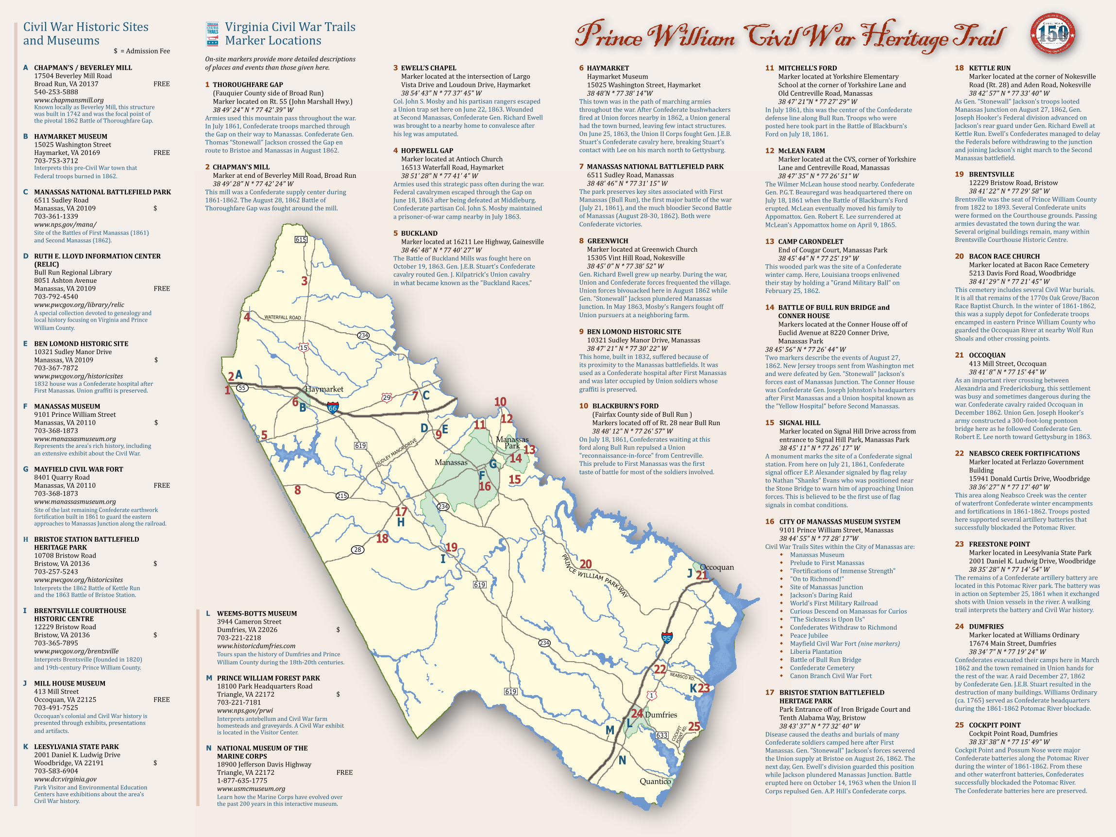
Be immersed in America's history, the sites, stories & personalities that forever changed our nation. The trail traverses more than 25 Civil War sites including battlefields, museums & historic towns.

TRANSCRIPT

Manassas

ManassasPark

Quantico

Dumfries

Occoquan

66

29

234

PRIN

CE WILLIAM PARKWAY

615

15

28

234

23495

1

215

619

619

SUDLEY MANOR DRIVE

COCK

PIT

POIN

T RD

.

633

Haymarket

11 12

1413

1516

10

F

9E

7 C

17H

18

8

5

6B1

3

2

4

19I 20

22

2524

23

21J

K

L

N

NEABSCO RD.

Map and brochure designed by H

eather Hem

brey 2009

D

55

WATERFALL ROAD

A

G

Civil War Historic Sites and Museums $ = Admission Fee

ACHAPMAN'S / BEVERLEY MILL 17504 Beverley Mill Road Broad Run, VA 20137 FREE 540-253-5888 www.chapmansmill.org Known locally as Beverley Mill, this structure was built in 1742 and was the focal point of the pivotal 1862 Battle of Thoroughfare Gap.

BHAYMARKET MUSEUM 15025 Washington Street Haymarket, VA 20169 FREE 703-753-3712 Interprets this pre-Civil War town that Federal troops burned in 1862.C MANASSAS NATIONAL BATTLEFIELD PARK 6511 Sudley Road Manassas, VA 20109 $ 703-361-1339 www.nps.gov/mana/ Site of the Battles of First Manassas (1861) and Second Manassas (1862).

DRUTH E. LLOYD INFORMATION CENTER (RELIC) Bull Run Regional Library 8051 Ashton Avenue Manassas, VA 20109 FREE 703-792-4540 www.pwcgov.org/library/relic A special collection devoted to genealogy and local history focusing on Virginia and Prince William County.

EBEN LOMOND HISTORIC SITE 10321 Sudley Manor Drive Manassas, VA 20109 $ 703-367-7872 www.pwcgov.org/historicsites 1832 house was a Confederate hospital after First Manassas. Union graffiti is preserved. FMANASSAS MUSEUM 9101 Prince William Street Manassas, VA 20110 $ 703-368-1873 www.manassasmuseum.org Represents the area's rich history, including an extensive exhibit about the Civil War. GMAYFIELD CIVIL WAR FORT 8401 Quarry Road Manassas, VA 20110 FREE 703-368-1873 www.manassasmuseum.org Site of the last remaining Confederate earthwork fortification built in 1861 to guard the eastern approaches to Manassas Junction along the railroad.H BRISTOE STATION BATTLEFIELD HERITAGE PARK 10708 Bristow Road Bristow, VA 20136 $ 703-257-5243 www.pwcgov.org/historicsites Interprets the 1862 Battle of Kettle Run and the 1863 Battle of Bristoe Station. IBRENTSVILLE COURTHOUSE HISTORIC CENTRE 12229 Bristow Road Bristow, VA 20136 $ 703-365-7895 www.pwcgov.org/brentsville Interprets Brentsville (founded in 1820) and 19th-century Prince William County.

JMILL HOUSE MUSEUM 413 Mill Street Occoquan, VA 22125 FREE 703-491-7525 Occoquan's colonial and Civil War history is presented through exhibits, presentations and artifacts.

KLEESYLVANIA STATE PARK 2001 Daniel K. Ludwig Drive Woodbridge, VA 22191 $ 703-583-6904 www.dcr.virginia.gov Park Visitor and Environmental Education Centers have exhibitions about the area's Civil War history.

LWEEMS-BOTTS MUSEUM 3944 Cameron Street Dumfries, VA 22026 $ 703-221-2218 www.historicdumfries.com Tours span the history of Dumfries and Prince William County during the 18th-20th centuries.

MPRINCE WILLIAM FOREST PARK 18100 Park Headquarters Road Triangle, VA 22172 $ 703-221-7181 www.nps.gov/prwi Interprets antebellum and Civil War farm homesteads and graveyards. A Civil War exhibit is located in the Visitor Center.

NNATIONAL MUSEUM OF THE MARINE CORPS 18900 Jefferson Davis Highway Triangle, VA 22172 FREE 1-877-635-1775 www.usmcmuseum.org Learn how the Marine Corps have evolved over the past 200 years in this interactive museum.

Virginia Civil War Trails Marker LocationsOn-site markers provide more detailed descriptions of places and events than those given here.

1 THOROUGHFARE GAP (Fauquier County side of Broad Run) Marker located on Rt. 55 (John Marshall Hwy.) 38 49' 24" N * 77 42' 39" WArmies used this mountain pass throughout the war. In July 1861, Confederate troops marched through the Gap on their way to Manassas. Confederate Gen. Thomas “Stonewall” Jackson crossed the Gap en route to Bristoe and Manassas in August 1862.

2 CHAPMAN'S MILL Marker at end of Beverley Mill Road, Broad Run 38 49' 28" N * 77 42' 24" WThis mill was a Confederate supply center during 1861-1862. The August 28, 1862 Battle of Thoroughfare Gap was fought around the mill.

3 EWELL'S CHAPEL Marker located at the intersection of Largo Vista Drive and Loudoun Drive, Haymarket 38 54' 43" N * 77 37' 45" W Col. John S. Mosby and his partisan rangers escaped a Union trap set here on June 22, 1863. Wounded at Second Manassas, Confederate Gen. Richard Ewell was brought to a nearby home to convalesce after his leg was amputated.

4 HOPEWELL GAP Marker located at Antioch Church 16513 Waterfall Road, Haymarket 38 51' 28" N * 77 41' 4" WArmies used this strategic pass often during the war. Federal cavalrymen escaped through the Gap on June 18, 1863 after being defeated at Middleburg. Confederate partisan Col. John S. Mosby maintained a prisoner-of-war camp nearby in July 1863.

5 BUCKLAND Marker located at 16211 Lee Highway, Gainesville 38 46' 48" N * 77 40' 27" WThe Battle of Buckland Mills was fought here on October 19, 1863. Gen. J.E.B. Stuart's Confederate cavalry routed Gen. J. Kilpatrick's Union cavalry in what became known as the "Buckland Races."

6 HAYMARKET Haymarket Museum 15025 Washington Street, Haymarket 38 48'N * 77 38' 14"WThis town was in the path of marching armies throughout the war. After Confederate bushwhackers fired at Union forces nearby in 1862, a Union general had the town burned, leaving few intact structures. On June 25, 1863, the Union II Corps fought Gen. J.E.B. Stuart's Confederate cavalry here, breaking Stuart's contact with Lee on his march north to Gettysburg.

7 MANASSAS NATIONAL BATTLEFIELD PARK 6511 Sudley Road, Manassas 38 48' 46" N * 77 31' 15" WThe park preserves key sites associated with First Manassas (Bull Run), the first major battle of the war (July 21, 1861), and the much bloodier Second Battle of Manassas (August 28-30, 1862). Both were Confederate victories.

8 GREENWICH Marker located at Greenwich Church 15305 Vint Hill Road, Nokesville 38 45' 0" N * 77 38' 52" WGen. Richard Ewell grew up nearby. During the war, Union and Confederate forces frequented the village. Union forces bivouacked here in August 1862 while Gen. "Stonewall" Jackson plundered Manassas Junction. In May 1863, Mosby's Rangers fought off Union pursuers at a neighboring farm.

9 BEN LOMOND HISTORIC SITE 10321 Sudley Manor Drive, Manassas 38 47' 21" N * 77 30' 22" WThis home, built in 1832, suffered because of its proximity to the Manassas battlefields. It was used as a Confederate hospital after First Manassas and was later occupied by Union soldiers whose graffiti is preserved.

10 BLACKBURN'S FORD (Fairfax County side of Bull Run ) Markers located off of Rt. 28 near Bull Run 38 48' 12" N * 77 26' 57" WOn July 18, 1861, Confederates waiting at this ford along Bull Run repulsed a Union "reconnaissance-in-force" from Centreville. This prelude to First Manassas was the first taste of battle for most of the soldiers involved.

11 MITCHELL'S FORD Marker located at Yorkshire Elementary School at the corner of Yorkshire Lane and Old Centreville Road, Manassas 38 47' 21"N * 77 27' 29" WIn July 1861, this was the center of the Confederate defense line along Bull Run. Troops who were posted here took part in the Battle of Blackburn's Ford on July 18, 1861.

12 McLEAN FARM Marker located at the CVS, corner of Yorkshire Lane and Centreville Road, Manassas 38 47' 35" N * 77 26' 51" WThe Wilmer McLean house stood nearby. Confederate Gen. P.G.T. Beauregard was headquartered there on July 18, 1861 when the Battle of Blackburn's Ford erupted. McLean eventually moved his family to Appomattox. Gen. Robert E. Lee surrendered at McLean's Appomattox home on April 9, 1865.

13 CAMP CARONDELET End of Cougar Court, Manassas Park 38 45' 44" N * 77 25' 19" WThis wooded park was the site of a Confederate winter camp. Here, Louisiana troops enlivened their stay by holding a "Grand Military Ball" on February 25, 1862.

14 BATTLE OF BULL RUN BRIDGE and CONNER HOUSE Markers located at the Conner House off of Euclid Avenue at 8220 Conner Drive, Manassas Park 38 45' 56" N * 77 26' 44" WTwo markers describe the events of August 27, 1862. New Jersey troops sent from Washington met and were defeated by Gen. "Stonewall" Jackson's forces east of Manassas Junction. The Conner House was Confederate Gen. Joseph Johnston's headquarters after First Manassas and a Union hospital known as the "Yellow Hospital" before Second Manassas.

15SIGNAL HILL Marker located on Signal Hill Drive across from entrance to Signal Hill Park, Manassas Park 38 45' 11" N * 77 26' 17" WA monument marks the site of a Confederate signal station. From here on July 21, 1861, Confederate signal officer E.P. Alexander signaled by flag relay to Nathan "Shanks" Evans who was positioned near the Stone Bridge to warn him of approaching Union forces. This is believed to be the first use of flag signals in combat conditions.

16 CITY OF MANASSAS MUSEUM SYSTEM 9101 Prince William Street, Manassas 38 44' 55" N * 77 28' 17"WCivil War Trails Sites within the City of Manassas are: w Manassas Museum w Prelude to First Manassas w "Fortifications of Immense Strength" w "On to Richmond!" w Site of Manassas Junction w Jackson's Daring Raid w World's First Military Railroad w Curious Descend on Manassas for Curios w "The Sickness is Upon Us" w Confederates Withdraw to Richmond w Peace Jubilee w Mayfield Civil War Fort (nine markers) w Liberia Plantation w Battle of Bull Run Bridge w Confederate Cemetery w Canon Branch Civil War Fort

17 BRISTOE STATION BATTLEFIELD HERITAGE PARK Park Entrance off of Iron Brigade Court and Tenth Alabama Way, Bristow 38 43' 37" N * 77 32' 40" WDisease caused the deaths and burials of many Confederate soldiers camped here after First Manassas. Gen. "Stonewall" Jackson's forces severed the Union supply at Bristoe on August 26, 1862. The next day, Gen. Ewell's division guarded this position while Jackson plundered Manassas Junction. Battle erupted here on October 14, 1963 when the Union II Corps repulsed Gen. A.P. Hill's Confederate corps.

18 KETTLE RUN Marker located at the corner of Nokesville Road (Rt. 28) and Aden Road, Nokesville 38 42' 57" N * 77 33' 40" WAs Gen. "Stonewall" Jackson's troops looted Manassas Junction on August 27, 1862, Gen. Joseph Hooker's Federal division advanced on Jackson's rear guard under Gen. Richard Ewell at Kettle Run. Ewell's Confederates managed to delay the Federals before withdrawing to the junction and joining Jackson's night march to the Second Manassas battlefield.

19 BRENTSVILLE 12229 Bristow Road, Bristow 38 41' 22" N * 77 29' 58" WBrentsville was the seat of Prince William County from 1822 to 1893. Several Confederate units were formed on the Courthouse grounds. Passing armies devastated the town during the war. Several original buildings remain, many within Brentsville Courthouse Historic Centre.

20 BACON RACE CHURCH Marker located at Bacon Race Cemetery 5213 Davis Ford Road, Woodbridge 38 41' 29" N * 77 21' 45" WThis cemetery includes several Civil War burials. It is all that remains of the 1770s Oak Grove/Bacon Race Baptist Church. In the winter of 1861-1862, this was a supply depot for Confederate troops encamped in eastern Prince William County who guarded the Occoquan River at nearby Wolf Run Shoals and other crossing points.

21 OCCOQUAN 413 Mill Street, Occoquan 38 41' 8" N * 77 15' 44" WAs an important river crossing between Alexandria and Fredericksburg, this settlement was busy and sometimes dangerous during the war. Confederate cavalry raided Occoquan in December 1862. Union Gen. Joseph Hooker's army constructed a 300-foot-long pontoon bridge here as he followed Confederate Gen. Robert E. Lee north toward Gettysburg in 1863.

22 NEABSCO CREEK FORTIFICATIONS Marker located at Ferlazzo Government Building 15941 Donald Curtis Drive, Woodbridge 38 36' 27" N * 77 17' 40" WThis area along Neabsco Creek was the center of waterfront Confederate winter encampments and fortifications in 1861-1862. Troops posted here supported several artillery batteries that successfully blockaded the Potomac River.

23FREESTONE POINT Marker located in Leesylvania State Park 2001 Daniel K. Ludwig Drive, Woodbridge 38 35' 28" N * 77 14' 54" WThe remains of a Confederate artillery battery are located in this Potomac River park. The battery was in action on September 25, 1861 when it exchanged shots with Union vessels in the river. A walking trail interprets the battery and Civil War history.

24 DUMFRIES Marker located at Williams Ordinary 17674 Main Street, Dumfries 38 34' 7" N * 77 19' 24" WConfederates evacuated their camps here in March 1862 and the town remained in Union hands for the rest of the war. A raid December 27, 1862 by Confederate Gen. J.E.B. Stuart resulted in the destruction of many buildings. Williams Ordinary (ca. 1765) served as Confederate headquarters during the 1861-1862 Potomac River blockade.

25 COCKPIT POINT Cockpit Point Road, Dumfries 38 33' 38" N * 77 15' 49" WCockpit Point and Possum Nose were major Confederate batteries along the Potomac River during the winter of 1861-1862. From these and other waterfront batteries, Confederates successfully blockaded the Potomac River. The Confederate batteries here are preserved.

M

619

Prince Will iam Civil War Heritage Trail