prineville lit - assessment of threats
TRANSCRIPT

Prineville LIT - Assessment of Threats
• PowerPoint slides are in the same order as threats listed in this table.
Threat Category Threat Survey
Ranking
Source and Layers used to Develop Assessment
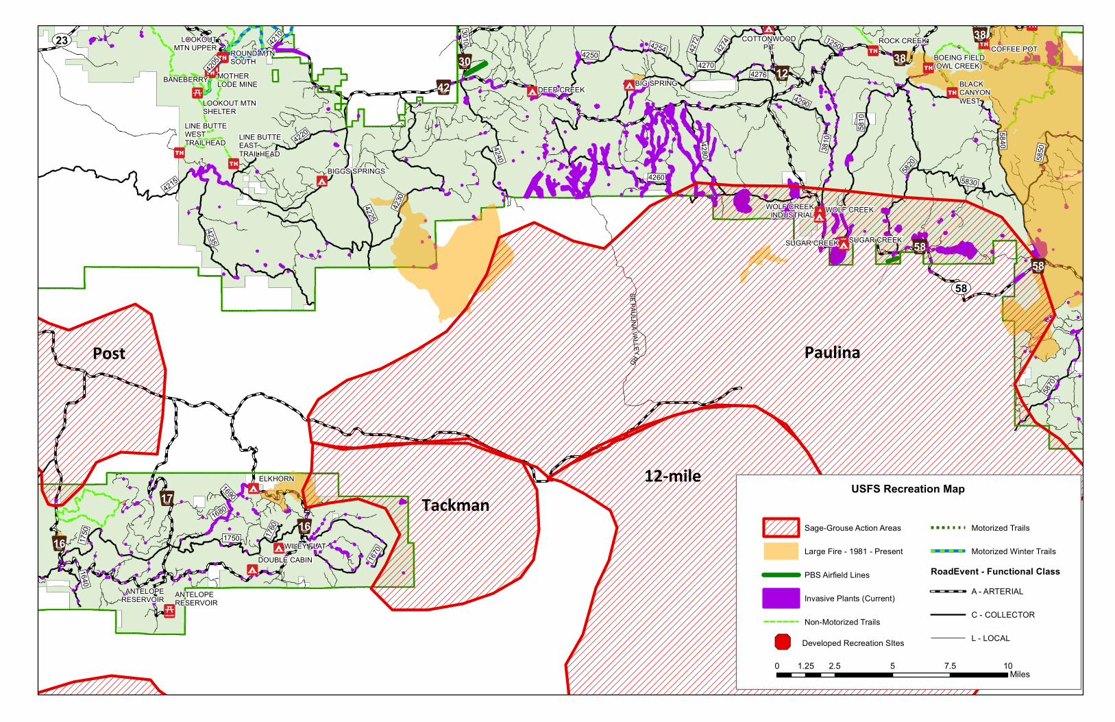
Development Recreation 3.7 BLM and USFS datasets
Development Land use conversion 3.2 National Land Cover Database – Development/Land Conversion
Development Human development 2.3* Landscape Planning Tool (LPT) – Existing Developments
Habitat Wildfire 4.3 LPT – Wildfire Perimeters
Habitat Juniper encroachment 4.1 Rangeland Analysis Platform version 2 (RAPv2) map summaries – Tree Cover
Habitat Mesic habitat 3.9 Sage Grouse Initiative (SGI) - Mesic Resources tool
Habitat Invasive annual grasses (IAG) 3.9 SageCon Invasives Initiative – Geographic Strategy
Habitat Loss of connectivity and small habitat patch size 3.3 LPT - Habitat Connectivity
Habitat Loss of grass and forb cover (and height) 3.3* LPT, RAPv2 – Perennial Grass and Forb Cover tool
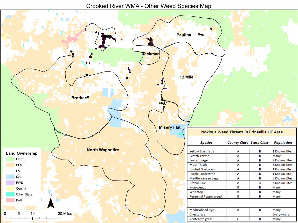
Habitat Other invasive plant species** 3.2 Crooked River WMA
Habitat Loss of sagebrush 3 LPT – Shrub Cover tool
Habitat Grazing 2.5 BLM and USFS datasets
Habitat Wild horses 1.8 BLM and USFS datasets
Population Predation 3.5 ODFW
Population West Nile virus** 2.8 USFWS
Population Hunting 2.1 ODFW
*multiple, similar threats consolidated; scores averaged
**waiting on assessments from partners
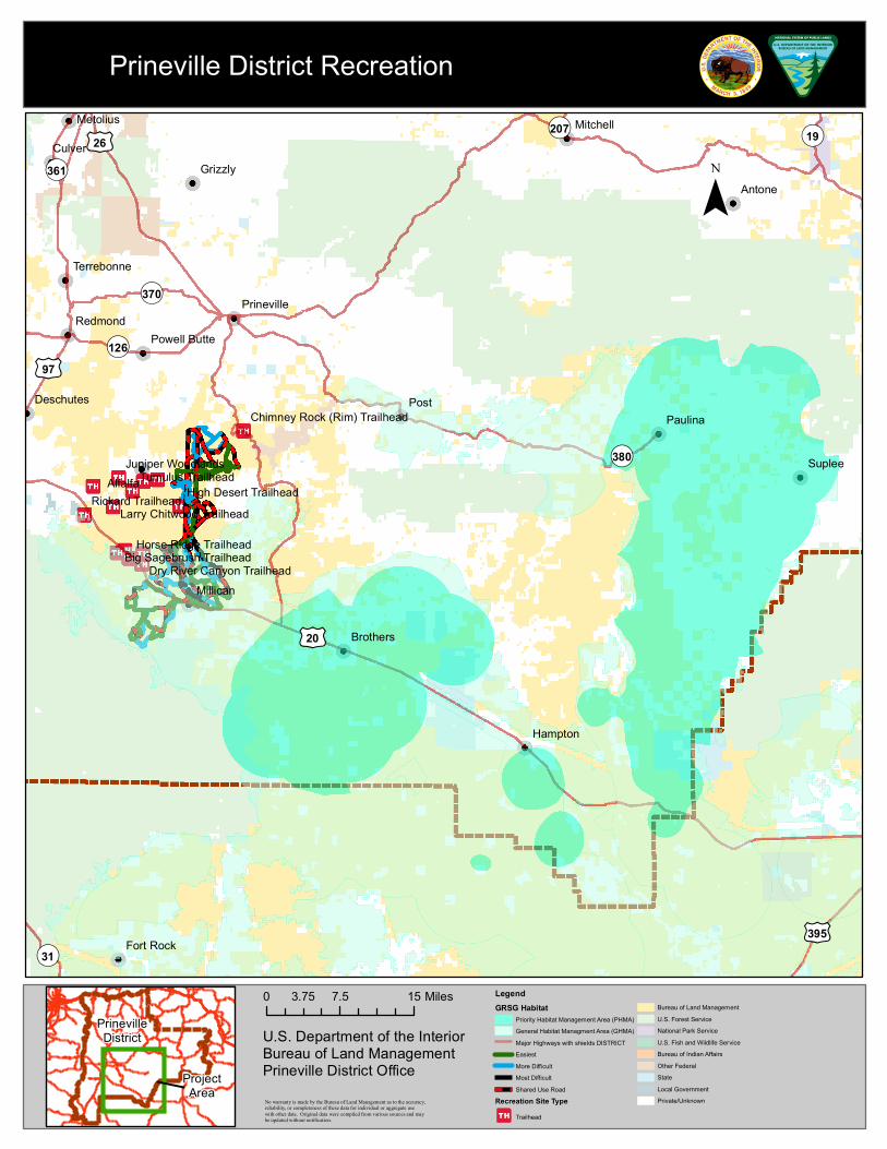
Juniper Woodlands
Rickard TrailheadTumulus Trailhead
Horse Ridge Trailhead
High Desert Trailhead
Big Sagebrush Trailhead
Larry Chitwood Trailhead
Dry River Canyon Trailhead
Chimney Rock (Rim) Trailhead
£¤20
£¤26
£¤395
£¤97
¬«370
¬«380
¬«126
¬«31
¬«19
¬«361
¬«207
Post
Suplee
Antone
Culver
Hampton
Paulina
Alfalfa
Redmond
Grizzly
Millican
Brothers
MitchellMetolius
Deschutes
Fort Rock
Prineville
Terrebonne
Powell Butte
PrinevilleDistrict
ProjectArea
LegendGRSG Habitat
Priority Habitat Management Area (PHMA)General Habitat Managment Area (GHMA)Major Highways with shields DISTRICTEasiestMore DifficultMost DifficultShared Use Road
Recreation Site TypeTrailhead
Bureau of Land ManagementU.S. Forest ServiceNational Park ServiceU.S. Fish and Wildlife ServiceBureau of Indian AffairsOther FederalStateLocal GovernmentPrivate/Unknown
¯
0 7.5 153.75 Miles
No warranty is made by the Bureau of Land Management as to the accuracy,reliability, or completeness of these data for individual or aggregate usewith other data. Original data were compiled from various sources and maybe updated without notification.
Prineville District Recreation
U.S. Department of the InteriorBureau of Land ManagementPrineville District Office

Juniper Woodlands
Rickard Trailhead
Tumulus Trailhead
Dry River TrailheadBear Creek Trailhead
Horse Ridge Trailhead
High Desert Trailhead
Big Sagebrush Trailhead
Reynolds Pond Trailhead
Flatiron Rock Trailhead Badlands Rock Trailhead
Larry Chitwood Trailhead
Dry River Canyon Trailhead
Chimney Rock (Rim) Trailhead
£¤20
¬«27
Alfalfa
Millican
PrinevilleDistrict
ProjectArea
LegendGRSG Habitat
Priority Habitat Management Area (PHMA)General Habitat Managment Area (GHMA)Major Highways with shields DISTRICTEasiestMore DifficultMost DifficultShared Use Road
Recreation Site TypeTrailhead
Bureau of Land ManagementU.S. Forest ServiceNational Park ServiceU.S. Fish and Wildlife ServiceBureau of Indian AffairsOther FederalStateLocal GovernmentPrivate/Unknown
¯
0 2.5 51.25 Miles
No warranty is made by the Bureau of Land Management as to the accuracy,reliability, or completeness of these data for individual or aggregate usewith other data. Original data were compiled from various sources and maybe updated without notification.
Prineville District Recreation
U.S. Department of the InteriorBureau of Land ManagementPrineville District Office

!̈!̈
!̈ !̈
!̈!̈!̈
!̈!̈!̈
!̈ !̈
!̈
!̈
!̈
!̈
!̈
!̈
!̈
China Hat
Groundhog Ohv
Pine Mountain
Camp I I (OhvTrailhead)
Rd 2510 (OhvTrailhead)
Rd 25 (OhvTrailhead)
ArnoldIce Cave
Boyd Cave
South Lava (OhvTrailhead)
Horse Butte
Cinder Hill
East Lake
SouthIce Cave
2127
22362235
1850
1825
2015
2268
2440
1819
1818
2269
2510
2230
1845
2233
2248
1830
2430
1849
1820
2259
1814
2274
1835
2240
1840
2310
1829
2438
2313
2320
2238
2312
2016
2017
2316
3145
2270
2325
2239
2435
2350
9710
2315
9:;25
9:;21
9:;22
9:;24
9:;18
9:;23
25
232016
18
2017
2015 £¤20
Non-Motorized TrailsMotorized TrailsMotorized WinterLanding Strip
!̈ Paragliding Sites
Sage-Grouse Action AreasInvasive Plants (Current)Large Fire - 1981-Present
Roads - OpenA - ARTERIALC - COLLECTORL - LOCAL
USFS Recreation Map
0 1.5 3 4.5 60.75Miles
' Developed Recreation SItesBrothers
N. Wagontire
UV58
UV23
1750
4274
4260
4205
1760
1750
1670
1680
5850
1690
3010
4225
4210
4272
5820
4276
4240
1640
4230
12504254
4290
4280
4250
5840
4215
5870
5830
4220
3810
4270
4235
5810
SEPAUL INA VALLEYRD
9:;589:;58
9:;17
9:;389:;38
9:;30
9:;16
9:;129:;42
9:;16
ROUND MTNSOUTH
BANEBERRY
LOOKOUTMTN UPPER
LOOKOUT MTNSHELTER
LINE BUTTEEASTTRAILHEAD
COTTONWOODPIT
BIG SPRINGDEEP CREEK
BIGGS SPRINGS
BOEING FIELD(OWL CREEK)
MOTHERLODE MINE
ROCK CREEK
SUGAR CREEK
BLACKCANYONWEST
WOLF CREEKWOLF CREEKINDUSTRIAL
ELKHORN
WILEY FLATDOUBLE CABIN
LINE BUTTEWESTTRAILHEAD
COFFEE POT
SUGAR CREEK
ANTELOPERESERVOIR
ANTELOPERESERVOIR
USFS Recreation Map
0 2.5 5 7.5 101.25Miles
Sage-Grouse Action Areas
Large Fire - 1981 - Present
PBS Airfield Lines
Invasive Plants (Current)
Non-Motorized Trails
Motorized Trails
Motorized Winter Trails
RoadEvent - Functional ClassA - ARTERIAL
C - COLLECTOR
L - LOCAL' Developed Recreation SItes
Paulina
12-mile
Tackman
Post

• Data available through the NLCD– Comparison of 2011 and 2016 datasets
• Development (Open space, low and medium density)
– 2011: 5,160 ac
– 2016: 5,029 ac
• Agriculture (Hay/Pasture & Cultivated Crops)
– 2011: 10,622 ac
– 2016: 8,931 ac
• Shrub/Scrub– 2011: 1,430,359 ac
– 2016: 1,384,725 ac
• Grassland/Herbaceous– 2011: 11,137 ac
– 2016: 53,208 ac
2011Development/Land Conversion
2016

2011 Development/Land Conversion
Paulina
12-mile
Misery Flat
Tackman
Post
N. Wagontire
Brothers

2016 Development/Land Conversion
Paulina
12-mile
Misery Flat
Tackman
Post
N. Wagontire
Brothers
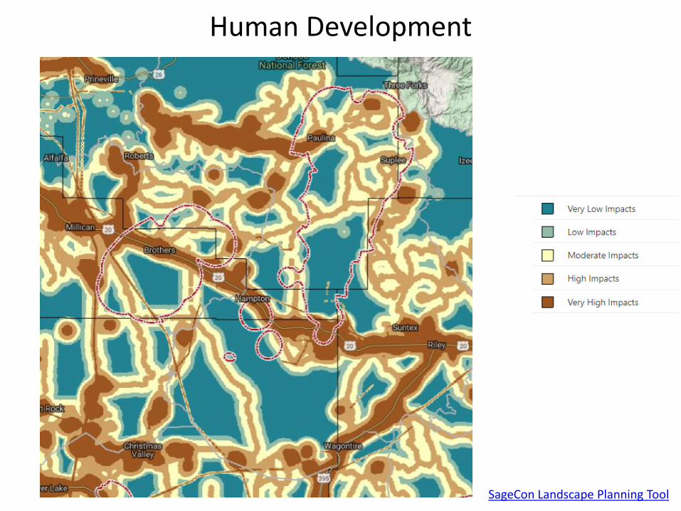
Human Development
SageCon Landscape Planning Tool
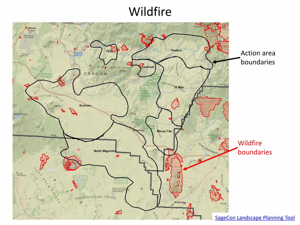
Wildfire
SageCon Landscape Planning Tool
Action area boundaries
Wildfire boundaries
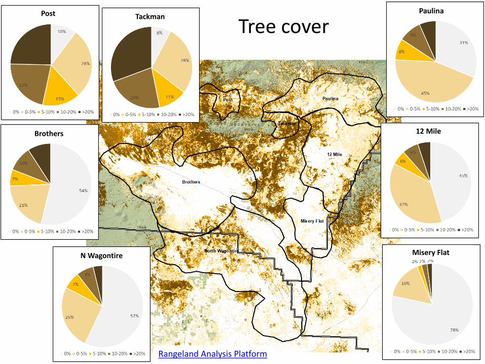
Tree cover
12 MileBrothers
Misery FlatN Wagontire
PaulinaPost Tackman
Rangeland Analysis Platform

Mesic Resources
SGI mesic resources map
Paulina
12-mile
Misery Flat
Tackman
Post
N. Wagontire
Brothers

Invasive annual grass strategy
12 MileBrothers
Misery FlatN Wagontire
PaulinaPost Tackman

Habitat Connectivity
Connectivity Barriers are locations within connectivity linkage zones that most disrupt connectivity, which can be used to identify habitat restoration opportunities to improve connectivity.
Connectivity Pinchpoints are areas where connectivity could be severed with the loss of a relatively small amount of habitat. Habitat loss or degradation within these areas can result in a disproportionate adverse effect on connectivity, and therefore these areas may be prioritized for habitat protection.
TNC Connectivity Report

Perennial grass & forb cover
12 MileBrothers
Misery FlatN Wagontire
PaulinaPost Tackman
Rangeland Analysis Platform
Brothers
12 Mile
North Wagontire
Paulina
Misery Flat
Post
Tackman
¯0 10 205 Miles
Crooked River WMA - Other Weed Species Map
Land OwnershipUSFSBLMPVDSLFWSCountyOther StateBoR

Shrub Cover(all shrubs, not just sagebrush)
12 Mile
Misery FlatN Wagontire
PaulinaPost Tackman
Rangeland Analysis Platform
Brothers
£¤20
£¤26
£¤395
£¤97
¬«370
¬«27
¬«380
¬«126
¬«31
¬«19
¬«361
¬«207
Post
Suplee
Antone
Culver
Hampton
Paulina
Alfalfa
Redmond
Grizzly
Millican
Brothers
MitchellMetolius
Deschutes
Fort Rock
Prineville
Terrebonne
Powell Butte
PrinevilleDistrict
ProjectArea
LegendAllotments & Pastures (State Office)
GRSG HabitatPriority Habitat Management Area (PHMA)General Habitat Managment Area (GHMA)Major Highways with shields DISTRICT
Bureau of Land ManagementU.S. Forest ServiceNational Park ServiceU.S. Fish and Wildlife ServiceBureau of Indian AffairsOther FederalStateLocal GovernmentPrivate/Unknown
¯
0 7.5 153.75 Miles
No warranty is made by the Bureau of Land Management as to the accuracy,reliability, or completeness of these data for individual or aggregate usewith other data. Original data were compiled from various sources and maybe updated without notification.
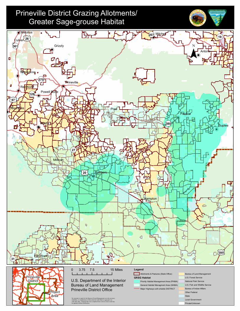
Prineville District Grazing Allotments/Greater Sage-grouse Habitat
U.S. Department of the InteriorBureau of Land ManagementPrineville District Office

£¤20
£¤26
£¤395
£¤97
¬«370
¬«27
¬«380
¬«126
¬«31
¬«19
¬«361
¬«207
Liggett Table
Warm Springs
Murderers Creek
Post
Suplee
Antone
Culver
Hampton
Paulina
Alfalfa
Redmond
Grizzly
Millican
Brothers
MitchellMetolius
Deschutes
Fort Rock
Prineville
Terrebonne
Powell Butte
PrinevilleDistrict
ProjectArea
LegendGRSG Habitat
Priority Habitat Management Area (PHMA)General Habitat Managment Area (GHMA)
Major Highways with shields DISTRICTBureau of Land ManagementU.S. Forest ServiceNational Park ServiceU.S. Fish and Wildlife ServiceBureau of Indian AffairsOther FederalStateLocal GovernmentPrivate/Unknown
¯
0 7.5 153.75 Miles
No warranty is made by the Bureau of Land Management as to the accuracy,reliability, or completeness of these data for individual or aggregate usewith other data. Original data were compiled from various sources and maybe updated without notification.
Prineville District Greater Sage-grouse/Herd Management Areas (HMAs)
U.S. Department of the InteriorBureau of Land ManagementPrineville District Office

¬«380
T19S R23E
T17S R22E
T19S R22E
T18S R23E
T19S R21E
T17S R21E T17S R23E
T18S R22ET18S R21E
T16S R21E T16S R22E T16S R23E
T17S R24E
T19S R20E
T18S R20E T18S R24E
T19S R24E
T17S R20E
T20S R23ET20S R22ET20S R21E
T16S R24ET16S R20E
T20S R20E T20S R24E
Liggett Table
Paulina
PrinevilleDistrict
ProjectArea
LegendGRSG Habitat
Priority Habitat Management Area (PHMA)General Habitat Managment Area (GHMA)Major Highways with shields DISTRICTArterial RoadCollector RoadLocal or Resource Road
Bureau of Land ManagementU.S. Forest ServiceNational Park ServiceU.S. Fish and Wildlife ServiceBureau of Indian AffairsOther FederalStateLocal GovernmentPrivate/Unknown
¯
0 2 41 Miles
No warranty is made by the Bureau of Land Management as to the accuracy,reliability, or completeness of these data for individual or aggregate usewith other data. Original data were compiled from various sources and maybe updated without notification.
Paulina/12 Mile/Misery Flat Priority Habitat Management Area (PHMA)/
Herd Management Areas (HMAs)
U.S. Department of the InteriorBureau of Land ManagementPrineville District Office
x
xxxxxxxxx
xxxxxx
xxx x x x x
xx
xx
xx xx
x x xx x
xx
x x x x x x x x x xxx
x
xxxxxx
x x x x xxxxxxx
x x x x x
xxxx
xx x xx
x xx xxxxxxxxx
x
xx
x
xx
x x xxx
xx
x x
xx
xxxxx x x x
xx x xx
x xx
xx
x x x
x x x x
xx x
xxx
xxxxxx
xx
x
xxx
x xxx
x
xx
x
x x xxx
x
xx x x xxxxxxxxxx x
xx
xx
xxxx xxx
xxxxxxxxxxxxx xx
xxxx
x xx xxxxxx
xx
x x xx x x x x
x
xxxx x x
x
xxx
x x x x x xxxxxxxx
x
xxxxxxx
xxx
x
xx
xx
xxxxxx
x x
xxxxx
xxx xx
xx
xx
xx
x x x
xxx x x x x x
xxxx
x x xx
xx
xx
x
x x x
xxx
x
xx
xx
xx
xxx x
xxx x x
xx
xx x x xx
xx
xxxx
x
xx
x x x x x x
xxx x x x x x x x x x
x x x
xx
xx
xx
xxx
xx
xx
x x x
x x x x x x x
xx
xx
x
xx
xx
xx x x x x x
x xx xx x xx xx
xx
x x xx
x x x x x x
x x x x
xxxxxxxxx
x
xx
xxx
x
x x x x x x
x xx x x x x x
x
xx
xx
xx
xx
xxx
xx x x
x x x x
xx x
x
x
xxxxxx x x x xx x xxx xx x xx
"#
#
"
#
!"
"
"
"#
"!
"
"
"
"
"
!"
"
#
'
'#
#
#
#
"
'
!
#
!
"
#
#
'
'
#
"
!
"
"
"
"
"
#
"
#
"#
" "
!
"
#
#!
'
#'
#
#
#
#
#
##
#
!!
##
#
!
#
#!
#
#
#
#
#
#
#
China Hat
Groundhog Ohv
Pine Mountain
Camp I I (OhvTrailhead)
Rd 2510 (OhvTrailhead)
Rd 25 (OhvTrailhead)
ArnoldIce Cave
Boyd Cave
South Lava (OhvTrailhead)
Cinder HillEast Lake
SouthIce Cave
£¤20
25
232016 2017
2015
9:;25
9:;21
9:;22
9:;18
9:;24
9:;232127
2236
1850
1825
2015
1816
2268
2440
1819
2269
2510
2230
1845
2233
2248
2235
1830
1849
2259
2274
1835
22401840
2310
1829
2313
2320
2238
2312
2016
1820
2017
2316
2270
2325
2239
1814
2350
2435
2315
Sage-Grouse Action Areasx x Fence linesRange Allotments
Roads - OpenA - ARTERIALC - COLLECTORL - LOCAL
Developed Water Points# Guzzler! Spring! Tank
' Trick Tank" Trough
Well
Sage-Grouse - USFS Range Improvements
0 2.5 51.25Miles
Brothers
N. Wagontire

xx
xx
x
x x x xxx x x x x
xx
xx
xx
xx
xx
x x x x
xx
xx
xxx
x
xx
xxx x x x x x x
xx
xx
x
x
x x xx
xxxxxxx
x xxx
x x x x x
xx
xx
x x xx
xx
xx
xx
x xx xx
x x
xx
xx x x x
x x x
x
xx
x x xx
x
xx
xxx x
x
x xx x x x
x
x xxx
x x x
xx xx xx x x xxx xxx x x x x x
xx
x
x x x
xx
xx
x xx xx xx x x x
xx xx x xxx
xx
x
xxxxxxx
xx x x x x x
xx
x
xx
xxxxxxxx
xxxxxxxxxxxxxxxxxxxxxxx
x x x x x x x
x x x x x
xxxx x
x
x
x xx
xx x x x x x x x x
x
x x x x x x xx
xx xx xx
x xx x
x
xx
x
x xx
x x xx x
x x x x xx
xxx
x
x xx x
xx
xx
xxx
x x x xx
xx x
x x x
x x xx
x xx
xx
xx
xx
x x x x x x
xx
xx
x
xx xxxx
xx
x
xx x
xxxx
x x x x
x
xx
xx
x x
x
x x xx x
xx
x xx
xx
xx
xx
xx
xx
x x
xxx
xx
xx
xx
xx
x x xxx
x
x xx
xx
xx
x xx
xx
xx
xxxx
x xx
xxx
x x x x x xx
xxxx
x
x x x x x x
x x x x x
xxxxxx
x
x x x
xx
xx
xx
xx
x
xx
x x x x x x
x
x
x x
x
xx x
xx
x
xx
x x x x
x
x
x
xx
xx
xx
xx
x
x xx
xx
xxxxxxxxx
xxxx
xx
xxxx
x x
x x x xxx
x xxx
x x x x x
xx
xx
xx
x
x
x x xx
xx
xx
x x x x
xxx
x xx
xx
xxx xxx
x
x
x x
x x x xx x x x xx
xx xxx x x
xx
xx
x xx x x xx x
x xx x x
xx
xx
xx
xx
x xx x xx x x xx
x xxx
xx x
xxx
xx
x
x xxx xxxxx xxxx
xx
xxx xxxx
x xx
xxx xx x x xxxxxx x x
xxxxx xxxx
xx
xx
xxx
x x xx
xxxxxxx x
x
x x xx
xx x xx x
xx x x
x x x x x x
x
x x x x xx x
x
x x
x
xx
xx
xx
x
xxx xx
xx
xx x x x x xxxxxxx
xx x
x x x xx
xx
x
x xxx
xx
x
xxxx x x x x x xx
xx
x
x
x x x
x x x x x x x
x x
x
xxxx x x x
x
x x x xx
x
x x
xxx x
x x xxx
x
x xx
x xx
xx
x
x
x x
x xx
x x x
x x
x
x
x x x x x xx x x x
x x x x x x x x
x
x
x
xx
xxx
xx
x
xx
xx
xx x x
x xxx
x
xx
xxx
xxxxx xxx
xxxxxx x
x x x
xx
xx xxx
xxxxx
xx x x
x
x x x
x x x
xxxxxxx x
x
x x x x x x xx
xxx
xx
xx x x xx x x x x x x xxx
xx
x x x x x x xx x x
x
x x x x x x xx x x x x xx x x x xxxx x x x
xx
xx x xxx
xx
xx x x
xxx
xx xx
x x
x
xxxxxxx
x x
xx
xxx
xxx x x x
xx
xx
x xx
xxx x
x
xxxx
xx x
xx
x x
x
xx
x xx
xxx
xxx
xx x xxx
xx
xx
xxxxxx x x xx x x
x x
x x x
x x x
x
xxxxxxxxxx
xxx x
x x
xx
x
xxxxxx
xxx
xx
xxx x
xx
x
xxxxxxxxx
x x xx x x x
xx
xx
xx
x xxxxx
x x
xx
x
xxxxx
x x x
x
xx x x
xxx x x x
x
x
xx
xxx
x
x x xx x
xx x x x x
xx
xxx x
xx
xxx
x x
x xx
x xxx
xx xxxx x
x
x
x
x x
xx
x x
x x x
x x xxx x x
xx
x x
x
x
xx
xx
x x
xxxxx
xx xx x xx
x xx
x
xxxxx xx x
x x
xxxxxx
x x x x
xx x x
xx
xxx x x x x
x
x
xxxxx x xxxx xx x xx
xx
xx
xx
x xx
xx x
x x x x x x x x x x
xx x
x
x
xx
xxx x
xx
xxxxxx x
x
xx
xx xx
xx
xxx
x
xxxxxxxxx
x
xxxxxxx x
x
x xx xx x xx xx xx xxx
x
x x x xx x
xxx
xx
UV58
UV23
1750
4260
1750
1670
1680
5850
4274
4225
3010
5820
4276
4272
4240
4230
12504254
4280
4250
5840
5870
4215
4220
3810
4270
4235
5810
230
550
011
204
561
300
012
279
150014
355
578
301
505
031
220
026
303
051
750
690
180
153
200
100
080
575
236109
151
280
220
020
806860
200
550
356
780
012
270
210
423
925 125
010
821
402
024
300
115
850
091
290
865
100
690
102
127
180
013
743
142
650
345
770
461
565
820
801
040
011
272
550
011
351
274
025
195
201
000
323
052
286
050
100
130
751319
020
106
658
600
600
568
790
401
021
350
657
206
302
131
262
301
351
855
160
662
010
520
030
500
023
920
680
206
152
030
150
480
102
163
252
090
120
300
600
201
122
600
799
110
730
730
204
263
651
645
260
300
658
015
010
080
366
557
295
200
430
918
560
802
011
140
202 481
210
750
250451
150
040
460
580
357
4 5 3
079
103
410
330328
431
013
790
202
660
350
100
659
154
050
122
150
011
168
104
210
163
460
214
200
060
310
064
400
740
110
300
050
141
675
100
360
141050
180
450
209
039
421
520
567
250
125
325
102
490
290
480
140
110
230
080016
564
805
102
203
355
67336
4
452665
184
105
190
302
600
U01
170
414
247
015
870
250
060
754
075
160
675
200
410
050
663
152
172
022
350
02 0
100112
150
115
663
921
865
659
113
230
150
020251
117
362
024
900
661
116
5 00
3 5 3
807
260
U01
300
201
130240
010
095
118
250
260
150
757
1 60
250
700
257
300
550
200
200
200
400
201
720
101
690
092
380
220
111
551
083
455
010
750
850
051
140
650
409
285
200
250
066
915
10123
0
706
554
120
450
080
100
500
552
400091
410
660
220
0 33
821
117
150
401
05 6
250
560
013
300
600
200
050
400
540
426 800100
360
600
350
401
310
906 820
180
200
435
2 50
250
8 60
913
050
500
200
475
050
440315
210
330
035
150
230
450
615
656
800
240
500
680
110
750
050300
090904
850
300
300324
400
200 601
700
040
775020
210
650
745
100
100
100 070
420
060
740357
500
800050
600
100
101
250
409
350
350
030
000
70035
5
100
100
562
200
741 030
100
652
030
200
651
400
600
800
150
430
150
140
500
100
050
050
900
200
150
500
300
650
400
200
300
350
100
9:;589:;58
9:;17
9:;389:;389:;38
9:;16
9:;30
9:;129:;42
9:;16
ROUNDMTN SOUTH
BANEBERRY
LOOKOUTMTN UPPER
LOOKOUT MTNSHELTER
KELSEY
LINE BUTTEEAST TRAILHEAD
COTTONWOODPIT
BIG SPRINGDEEP CREEK
BIGGS SPRINGS
BOEING FIELD(OWL CREEK)
MOTHERLODE MINE
ROCK CREEK
SUGARCREEK
BLACKCANYON
WEST
WOLFCREEK
WOLF CREEK INDUSTRIAL
ELKHORN
WILEY FLATDOUBLE CABIN
LINE BUTTEWEST TRAILHEAD
COFFEE POT
SUGAR CREEK
ANTELOPERESERVOIR
ANTELOPERESERVOIR
Sage-Grouse - USFS Range Improvements
0 2.5 5 7.5 101.25Miles
Sage-Grouse Action Areas
PBS Airfield Lines
ALLOTMENT
WILD HORSE & BURRO TERRITORY
x x x Fence
RoadEvent - Functional ClassA - ARTERIAL
C - COLLECTOR
L - LOCAL
' Developed Recreation SItes
Paulina
12-mile
Tackman
P o s t

Predation• Generally, research does not support predator (carnivore) removal for improving juvenile
or adult sage-grouse survival
– Conover and Roberts, 2017
• However, research suggests sage-grouse nest success decreases with increased raven densities
– GRSG nest success well below average at > 0.4 ravens/km2 (Coates et al. 2020)
– > 0.45 ravens/ km2 is the threshold where sage-grouse productivity falls below that required for population persistence (Coates and Delehanty 2010)
Coates, P. S., and D. J. Delehanty. 2010. Nest predation of greater sage-grouse in relation to microhabitat factors and predators. Journal of
Wildlife Management. 74:240–248.
Coates P. S., S. T. O’Neil, B.E. Brussee, M. A. Ricca, P. J. Jackson, J. B. Dinkins, K. B. Howe, A. M. Moser, L. J. Foster, and D. J. Delehanty. 2020.
Broad-scale impacts of an invasive native predator on a sensitive native prey species within the shifting avian community of the North
American Great Basin. Biological Conservation 243:108409.
Conover, M. R., and A. J. Roberts. 2017. Predators, Predator Removal, and Sage-Grouse: A Review. Journal of Wildlife Management 81:7–15.
• Raven surveys in the Brother’s PAC during 2018 yielded 0.385 ravens/km2
– Plan to conduct raven surveys in future years to continue monitoring raven densities
• waiting on 2019 results
Prineville LIT Area
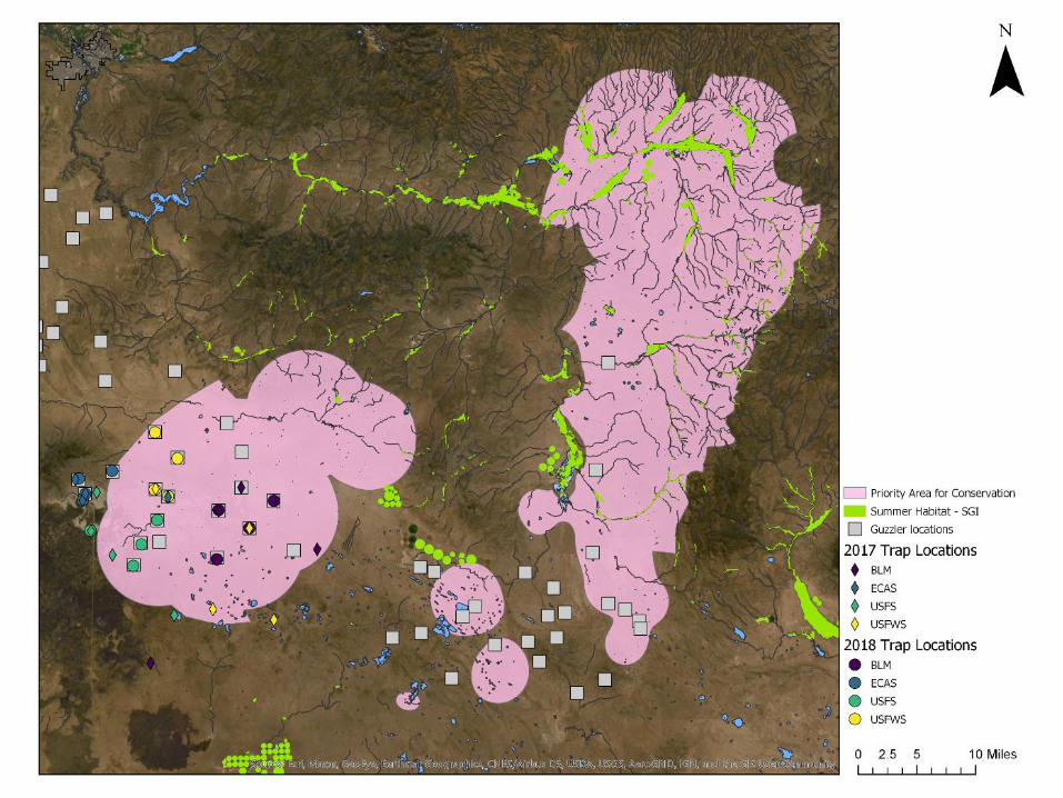

2017 2018
▪ Capture mosquitoes, test for West Nile virus (WNv), & assess sage-grouse use at guzzlers
▪ Trapping seasons for 2017, 2018, & 2020▪ 16 traps in 2017/2018, 4 traps in 2020▪ < 370 mosquitoes in 2017; < 800 mosquitoes in 2018▪ All WNv tests negative (2020 results forthcoming)
▪ Although not classified as summer habitat, sage-grouse still use areas where traps were deployed
▪ No traps deployed in Paulina/12-Mile PAC▪ Takeaways: hard to trap, hard to detect, low
probability that WNv is a stressor, but more information could be useful (paired between Brothers & Paulina)
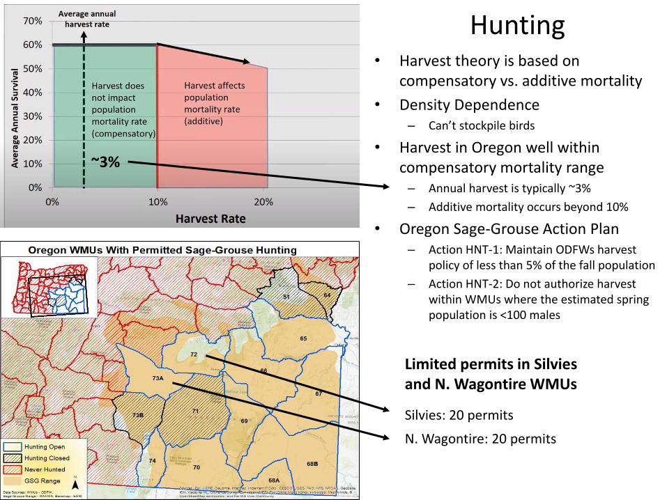
• Harvest theory is based on compensatory vs. additive mortality
• Density Dependence– Can’t stockpile birds
• Harvest in Oregon well within compensatory mortality range– Annual harvest is typically ~3%
– Additive mortality occurs beyond 10%
• Oregon Sage-Grouse Action Plan– Action HNT-1: Maintain ODFWs harvest
policy of less than 5% of the fall population
– Action HNT-2: Do not authorize harvest within WMUs where the estimated spring population is <100 males
Hunting
Silvies: 20 permits
N. Wagontire: 20 permits
Limited permits in Silviesand N. Wagontire WMUs
~3%