probabilistic seismic risk assessment for the metropolitan
TRANSCRIPT
Probabilistic Seismic Risk Assessment for the Metropolitan
Region of San Salvador (AMSS): Educational, Public Health and
Governmental Agencies
Cape Town, South Africa, July 2012

Ministry of the Environment and Natural Resources - Government of El Salvador
Seismic Risk Assessment for the AMSS
Exposure
Vulnerability
Risk Assessment
HAZARD SCENARIO
RISK DISASTER
Seismic Hazard
Site Effects
Exposure Data & Building
Characteristics
Expected EQ
Performance
Prospective Management
Reactive Management
Financial
Protection
Corrective Management
Risk
Management
1050
100 150
400
125 8
1500
944
315 No
. O
f D
eath
s
Human and
Economic Losses
0
1
0 1000 2000
Dam
age (
%)
Intensity (gal)
Regional Seismicity & Attenuation

Ministry of the Environment and Natural Resources - Government of El Salvador
SEISMIC HAZARD MAP – NATIONAL LEVEL
On the basis of the Project RESIS II
MICROZONATION
(PROXI)
SOURCE
Seismogenic source characteristics, Magnitude
ATTENUATION
Attenuation of intensity over distance
SITE EFFECTS
Amplitude and frequency content modification due to local site conditions
Seismic Hazard Assessment
Seismic ground motion at a site depends on

Ministry of the Environment and Natural Resources - Government of El Salvador
Seismic hazard is calculated
considering the sum of the
effects of all seismic
sources and the distance
between each source and
the site, for different
spectral ordinates
Seismic Hazard – National Level
Definition and characterization of the seismic sources (RESIS II)
Seismicity parameters for each seismic source (RESIS II)
Attenuation models (intensity at the site based on magnitude and distance)
Seismic Hazard Assessment
Seismic hazard map does not take into account the effects of the local
site conditions (site classification “rock”)
0
50
100
150
200
250
300
350
0 0.5 1 1.5 2
Sa
(g
al)
Periodo
ZH06 M6.6
CLI94 M6.6
PA 13.02.2001
Earthquake 13.02.2001 (PA)

Ministry of the Environment and Natural Resources - Government of El Salvador
TBJ Deposits, Centro de Gobierno, S.S.
Elastic Response Spectra from the 1966, 1989 and 1994 Seismic
Codes compared to the Elastic Response Spectra of the 1986
Earthquake in the East-West Direction (5% Damping)
Amplification due to Site Effects

Ministry of the Environment and Natural Resources - Government of El Salvador
Amplification due to Site Effects
MICROZONATION MAP PROXI
DYNAMIC RESPONSE OF SOIL DEPOSITS (ELASTIC)
Am
pli
fica
tion
ZONE II
ZONE V

Ministry of the Environment and Natural Resources - Government of El Salvador
Seismic Hazard Assessment

Ministry of the Environment and Natural Resources - Government of El Salvador
FIRST STEP: EDUCATION, PUBLIC HEALTH AND GOVERNMENT AGENCIES
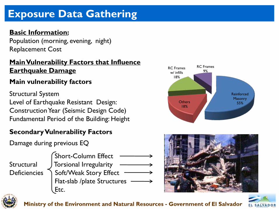
Exposure Data Gathering
0
500
1000
Gobierno Salud
Educación
18 42
197
19 42
987
Exposure Data Gathering for prioritized educational, public health and governmental
institutions: geographical location, population, replacement cost, and the building
characteristics considered to be strongly related to the structures capacity to resist
earthquake loads (1550 buildings in 257 institutions)
Government
148 (9%)
Healthcare
352 (23%)
Education
1050 (68%)
Individual Buildings
Institutions
Government Public Health
Education
Total (AMSS) Analyzed
Ministry of the Environment and Natural Resources - Government of El Salvador
Basic Information:
Population (morning, evening, night)
Replacement Cost
Main Vulnerability Factors that Influence
Earthquake Damage
Main vulnerability factors
Structural System
Level of Earthquake Resistant Design:
Construction Year (Seismic Design Code)
Fundamental Period of the Building: Height
Secondary Vulnerability Factors
Damage during previous EQ
Short-Column Effect
Structural Torsional Irregularity
Deficiencies Soft/Weak Story Effect
Flat-slab /plate Structures
Etc.
Exposure Data Gathering
Reinforced
Masonry
55% Others
18%
RC Frames
w/ infills
18%
RC Frames
9%

Ministry of the Environment and Natural Resources - Government of El Salvador
Exposure Data Gathering

Ministry of the Environment and Natural Resources - Government of El Salvador
Exposure Data Gathering
Lack of planning and haphazard growth
Mixture of construction materials
with different seismic performance
(lack of continuity and homogeneity)
– Structural Deficiencies
Difficulties in exposure data
gathering – extraordinary amount of
buildings per institution
1 Institution- 59 different buildings (71 total) Precarious Systems (3.7%)

Ministry of the Environment and Natural Resources - Government of El Salvador
Analytical Models
Experimental data (Taishin)
Vulnerability Assessment
Lower
Vulnerability
Definition of Vulnerability Curves
0
0.1
0.2
0.3
0.4
0.5
0.6
0.7
0.8
0.9
1
0 500 1000 1500 2000 2500
Dam
age
(fr
acti
on
f r
ep
lacem
en
t co
st)
Spectral Acceleration (gal)
PMR-2CM(2)
M2
MCSJ-2CM (2)
DUAL-2
MCCJ-2CM (2)
MACA-2CM
MASA-2CM(2)
0
500
1000
1500
2000
2500
0 0.5 1 1.5 2 2.5 3 3.5 4
0
100
200
300
400
500
600
0 0.5 1 1.5 2 2.5 3 3.5 4
0
500
1000
1500
2000
0 0.5 1 1.5 2 2.5 3 3.5 4
0
500
1000
1500
0 0.5 1 1.5 2 2.5 3 3.5 4
0
200
400
600
800
1000
0 0.5 1 1.5 2 2.5 3 3.5 4
0
200
400
600
800
1000
0 0.5 1 1.5 2 2.5 3 3.5 4
0
500
1000
1500
0 0.5 1 1.5 2 2.5 3 3.5 4
Vulnerability Curves Analytical Models
Calibration - observed damage

Ministry of the Environment and Natural Resources - Government of El Salvador
0
50
100
150
200
250
Pérdida
Pérdida Acumulada
Escenarios Sísmicos (T5000años)
Pér
did
a (1
06 U
S$)
0
25
50
75
100
Pér
did
a A
cum
ula
da (
10
9 U
S$)
Probabilistic Risk Assessment
Considering the contribution of all seismic scenarios and their
probability of occurrence, an annualized los on the order of USD$14.7
Millions, was estimated to cover only 257 institutions, 5.78% of the total
exposed value.
Losses Cumulative Losses
Earthquake Scenarios
Cum
ula
tive
Loss
es
Loss
es

Ministry of the Environment and Natural Resources - Government of El Salvador
Seismic Risk Assessment for the RMSS
Probabilistic modeling of Seismic Risk Scenarios for the AMSS, Educational, Public Health and
Governmental Institutions
LEGEND
Probabilistic Analysis
Annualized loss
(% Exposed Amount)
Probabilistic modeling of Seismic Risk Scenarios for the AMSS, Educational, Public Health and
Governmental Institutions
LEGEND
Probabilistic Analysis
Annualized loss
(1000 US)

Ministry of the Environment and Natural Resources - Government of El Salvador
Risk Management
Corrective
Management
Reactive
Management
Financial
Protection
Risk
Assessment
Prospective
Management
Risk Assessment to provide decision-making tools for risk reduction
Identification Detailed analyses for
critical possible reinforcing/
infrastructure retrofitting measures
Risk
Assessment
Corrective
Measures
Individual
Components
Hazard & Site Conditions Detailed
Construction practices Investigations
Vulnerability of Bldg. Types (eg. Microzonation)
Building Codes
Land-use Plans
Emergency
Preparedness
and Response
Risk Scenarios Response Plans
Attenuation & Site Effects Shakemaps & Real
Existing Infrastructure Time Loss Estimation
Risk &
Individual
Components
DISASTER PREVENTION DISASTER PREPAREDNESS

Ministry of the Environment and Natural Resources - Government of El Salvador
Risk Reduction Measures
Measure Ongoing Research Future Work Needed
HA
ZA
RD
AN
D R
ISK
AS
SE
SS
ME
NT
Instrumenta-
tion for Data
generation.
Hazard and
Risk
Assessment
Studies
Improvement of the Seismic
Network (PNRR, 2012; JICA, 2014)
Site effect investigation (AMSS)
PROXI for evaluation of seismic site
conditions and amplifications at a
national level (PGA)
Strong motion data base,
consultation and graphic
representation of SM parameters
Complete seismic risk assessment for
remaining AMSS educational institutions
Risk assessment of major cities.
Instrumentation of Important Buildings
(vulnerability assessment and structural
health monitoring)
Constant updated of Hazard Studies
MICROZONATION of the RMSS
CO
RR
EC
TIV
E &
PR
OS
PE
CT
IVE
M
GM
T
Seismic Risk
reduction
(reduce
current and
future
vulnerability)
Seismic Hazard and Risk
assessment for the AMSS,
educational, public health and
governmental agencies –
Presentation and publication of
results, investment plans for
prioritized critical infrastructure.
Land Use planning considering seismic
hazard (Microzonation)
Seismic code revision and update (MOP)
Public awareness program
Improve construction practices
Structural reinforcing/strengthening of
strategic infrastructure (portfolios)

Ministry of the Environment and Natural Resources - Government of El Salvador
Risk Reduction Measures
Measure Ongoing Research Future Work Needed
RE
AC
TIV
E M
AN
AG
EM
EN
T
Emergency
response:
identifying
most affected
areas to guide
assistance
Update of the seismic monitoring
center with a new software for
seismic data acquisition, data exchange
and automatic processing of EQ
recordings (preliminary locations and
magnitudes)
Improvement of the Seismic Network
(PNRR, 2012; JICA, 2014). Including
real time strong motion data
Correlation of instrumental seismic
intensity with strong motion
parameters
Shake Maps in terms of PGA (real
time strong motion records + models)
Shake Maps (real time strong
motion records + models) for
different spectral ordinates.
Response plans using specific
scenarios (DGPC)
(exposure and vulnerability data of
major cities)
Near real time damage and loss
estimations for emergency
response (exposure and
vulnerability data of major cities)

THANK YOU