proceedings of the 2nd national habitat assessment workshop
TRANSCRIPT
Proceedings of the 2nd
National
Habitat Assessment Workshop
Fisheries Science to Support
NOAA’s Habitat Blueprint
Hosted by the Northwest Fisheries Science Center, Office of
Science and Technology, and Office of Habitat Conservation
Edited by Lora M. Clarke
U.S. Department of Commerce
National Oceanic and Atmospheric Administration
National Marine Fisheries Service
NOAA Technical Memorandum NMFS-F/SPO-132
August 2013

Proceedings of the 2nd
National
Habitat Assessment Workshop
Fisheries Science to Support
NOAA’s Habitat Blueprint
Hosted by the Northwest Fisheries Science Center, Office of
Science and Technology, and Office of Habitat Conservation
Edited by Lora M. Clarke
NOAA Technical Memorandum NMFS-F/SPO-132
August 2013
U.S. Department of Commerce
Penny Pritzker, Secretary
National Oceanic and Atmospheric Administration
Kathryn D. Sullivan, Acting Administrator
National Marine Fisheries Service
Samuel D. Rauch III, Acting Assistant Administrator for Fisheries

Recommended citation:
Clarke, L.M. (ed.) 2013. Proceedings of the 2nd
National Habitat Assessment Workshop: Habitat
Science to Support NOAA’s Habitat Blueprint. U.S. Dept. of Commer., NOAA Technical Mem-
orandum NMFS-F/SPO-132, 89 p.
Copies of this report may be obtained from:
Stephen K. Brown, Ph.D.
Office of Science and Technology
National Marine Fisheries Service, NOAA
1315 East West Highway
Silver Spring, MD 20910
Or online at:
http://spo.nmfs.noaa.gov/tm/ or
http://www.st.nmfs.noaa.gov/ecosystems/habitat/workshops/index
iii
TABLE OF CONTENTS
Executive Summary ...............................................................................................................1
Introduction ............................................................................................................................4
Day 1:
Introductory Remarks and Keynote Presentation ..................................................................6
Remarks on the role of habitat science in fisheries management, Q&A ...................6
The Role of Science in the NOAA Habitat Blueprint................................................6
Northwest Regional Initiative ....................................................................................7
Keynote Presentations: Does our Habitat Paradigm Cross the Land-Sea
Boundary? ..................................................................................................................8
Prioritization of Stocks for Habitat Assessment ....................................................................11
Tools for Successful Habitat Assessment for Fisheries .........................................................13
Day 2:
Incorporating Habitat Information in Stock Assessments .....................................................17
Breakout Group 1: Incorporating Habitat Information in Stock Assessments
with a Focus on Groundfish .......................................................................................24
Breakout Group 2: Incorporating Habitat Information in Stock Assessments
with a Focus on Reef Fish and Untrawlable Habitats ................................................26
Breakout Group 3: Incorporating Habitat Information in Stock Assessments
with a Focus on Highly Migratory Species and Coastal Pelagic Species ..................29
Breakout Group 4: Incorporating Habitat Information in Stock Assessments
with a Focus on Estuarine and Diadromous Fish.......................................................34
Rethinking Essential Fish Habitat ..........................................................................................37
Breakout Group 1: Rethinking Essential Fish Habitat with a Focus on
Ecosystem-Based Fishery Management ....................................................................43
Breakout Group 2: Rethinking Essential Fish Habitat with a Focus on Habitat
And Stock Variability ................................................................................................47
Breakout Group 3: Rethinking Essential Fish Habitat with a Focus on Non-Fishing
Impacts .......................................................................................................................49
Breakout Group 4: Rethinking Essential Fish Habitat with a Focus on Climate
Change .......................................................................................................................53
Day 3:
Improving the Flow of Habitat Science Information to Management ...................................55
Breakout Group 1: Improving the Flow of Habitat Science Information to
Management ...............................................................................................................61
Breakout Group 2: Improving the Flow of Habitat Science Information to
Management ...............................................................................................................63
Breakout Group 3: Improving the Flow of Habitat Science Information to
Management ..............................................................................................................65
References ..............................................................................................................................68
Common Acronyms ...............................................................................................................69
iv
Appendix 1: Workshop Steering Committee .........................................................................70
Appendix 2: Workshop Agenda............................................................................................71
Appendix 3: List of Workshop Participants..........................................................................74
Appendix 4: Poster Abstracts................................................................................................76
Appendix 5: National Ocean Service Data Supportive of Fisheries Habitat Assessment ....85
Appendix 6: National Ocean Service Tools Supportive of Fisheries Habitat Assessment ...87
Appendix 7: National Ocean Service Technical Information Supportive of Fisheries
Habitat Assessment ................................................................................................................88
Appendix 8: National Ocean Service Data Access Nodes Supportive of Fisheries Habitat
Assessment .............................................................................................................................89

1
EXECUTIVE SUMMARY
The 2nd
National Habitat Assessment Work-
shop (NHAW) brought together nearly 75
scientists and managers from across the Na-
tion to focus on this year’s theme, “Fisheries
Science to Support NOAA’s Habitat Blue-
print.” Representatives from every National
Marine Fisheries Service Science Center and
Regional Office, as well as from the Office
of Science and Technology, Office of Habi-
tat Conservation, National Ocean Service,
and Oceanic and Atmospheric Research par-
ticipated. The workshop was instrumental
in developing recommendations to improve
the quality of NMFS habitat science needed
for improved stock assessments and essen-
tial fish habitat; encouraging increased
communication and collaboration between
scientists and managers; and developing
recommendations to improve information
transfer products that NMFS habitat manag-
ers can use to inform essential fish habitat
consultations and discussions with fishery
management councils.
Among other things, the Habitat Blueprint
provides a framework for NOAA to be more
effective in our goals of conserving habitat
for fisheries management, while moving fur-
ther toward ecosystem based management. One goal of the NOAA Habitat Blueprint is
to implement a systematic and strategic ap-
proach to habitat science in order to inform
effective decision making. Building on this
goal, and recommendations put forth during
the 1st NHAW and in the Habitat Assess-
ment Improvement Plan (HAIP), sessions
were developed on Prioritization of Stocks
for Habitat Assessments; Tools for Success-
ful Habitat Assessment for Fisheries; Incor-
porating Habitat Information in Stock As-
sessments; Rethinking Essential Fish Habi-
tat; and Improving the Flow of Habitat Sci-
ence Information to Management. Some of
these sessions were designed to provide up-
dates and increase the flow of information in
order to improve habitat science across the
Science Centers and Regional Offices, while
other sessions provided opportunities for
greater discussion and brainstorming
through smaller breakout groups followed
by report outs to the larger group. Summar-
ies of the recommendations from those ses-
sions are highlighted below:
Incorporating Habitat Information in
Stock Assessments
In this session, participants identified the
habitat science needs for stock assessments
and ways habitat information can contribute
to improving fisheries stock assessments by
reducing uncertainty in assessment data in-
puts or assessment model projections. A bet-
ter understanding of the specific short-to-
medium term needs will better enable those
working on habitat assessments to make data
available to the stock assessment community
in more meaningful ways.
Top Conclusions and Recommended Next
Steps:
Habitat studies are not currently provid-
ing much information that can be readily
incorporated in the stock assessment
process, but habitat data could substan-
tially improve assessments for many
stocks where basic stock data (catch,
abundance, life history) already exists.
Although fitting ecosystem data into
stock assessment models remains a chal-
lenge to be addressed, there are many
examples where habitat data is already
being used to inform the stock assess-
ment process.
Using habitat information to post-stratify
abundance surveys can accomplish the

2
same goals as redesigning surveys based
on habitat classifications, but offers
greater flexibility and can inform survey
design if necessary.
Studies of density dependence should be
conducted using a habitat context to ex-
amine the potential effects of habitat on
catchability and selectivity.
Increasing information on life history
bottlenecks and the timing of mortality
events relative to density dependent
compensation is a critical next step.
Rethinking Essential Fish Habitat
In this session, each region discussed the
opportunities and challenges associated with
designating essential fish habitat (EFH) and
using EFH designations to conduct mean-
ingful consultations. Currently these desig-
nations are difficult to review/revise and not
as helpful as they could be for NOAA to
conduct consultations. Participants dis-
cussed specific EFH needs, challenges, and
opportunities for moving forward.
Top Conclusions and Recommended Next
Steps:
NMFS scientists and managers should
prioritize habitat research based on habi-
tat productivity and threats to habitat
health and functionality, but more basic
habitat science research needs to be con-
ducted to ensure competent decisions
can be made.
EFH designations, and HAPC designa-
tions in particular, should incorporate
data that specifically addresses the con-
ditions critical to early life history stag-
es, with a special focus on productive
habitats that are most at risk from an-
thropogenic or climate-induced degrada-
tion.
Better mechanistic models should be de-
veloped to forecast responses under noel
and/or rapidly-changing habitat condi-
tions.
Non-fishing impacts to EFH are becom-
ing more prevalent. Proven conservation
measures that address common threats to
EFH from a variety of ocean and coastal
developments should be identified and
implemented through cooperative re-
gional efforts.
Research should be conducted to enable
EFH designations to include complex,
guild, or life-stage specific designations.
Support from leadership at the regional
and national levels is needed to make
any of these a reality.
Improving the Flow of Habitat Science
Information to Management
In this session, participants recommended
information transfer products that NMFS
habitat managers can use to inform EFH
consultations with federal action agencies
and EFH designation discussions with fish-
ery management councils. This was a fol-
low-up session to sessions held at the 1st Na-
tional Habitat Assessment Workshop in
2010 that focused on current processes and
strategies for providing incorporating habitat
science into management.
Top Conclusions and Recommended Next
Steps:
An inshore-offshore decision support
tool is needed to effectively help habitat
managers evaluate the impacts of man-
agement decisions effecting onshore
habitats on the productivity of offshore
fish populations
A small team of habitat managers and
ecosystem scientists should be formed to
further define and develop this tool and
outline next steps.
The recommendations from each of these
three sessions provide next steps for not on-

3
ly improving the quality of habitat science
needed for NMFS to effectively sustain ma-
rine fisheries and associated habitats, but
also to effectively communicate habitat sci-
ence to managers. Habitat science is an es-
sential aspect of ecosystem-based manage-
ment and a vital step to improving NOAA’s
stewardship of living marine resources.
4
INTRODUCTION
The National Marine Fisheries Service
(NMFS) held the agency’s second National
Habitat Assessment Workshop (NHAW) on
September 5-7, 2012. The event was orga-
nized by the NMFS Office of Science and
Technology and the Office of Habitat Con-
servation. It was hosted by the Northwest
Fisheries Science Center’s Montlake Labora-
tory in Seattle, Washington. The theme of
the workshop was: “Fisheries Science to
Support NOAA’s Habitat Blueprint.”
This workshop was a follow-up to the first
NHAW, which was held in St. Petersburg,
Florida in May 2010 (Blackhart 2010). That
first workshop was a major milestone in the
evolution of NMFS science programs, and
coincided with the publication of the agen-
cy’s Habitat Assessment Improvement Plan
(HAIP, NMFS 2010). The theme of this first
workshop was: “Habitat Science in Support
of Management,” and there was considerable
discussion among habitat scientists and man-
agers on how the HAIP could be implement-
ed. The workshop also included a joint ses-
sion with NMFS’11th
National Stock As-
sessment Workshop, which provided a forum
for discussions between habitat scientists and
stock assessment scientists. The primary
messages that came from these workshops
were the needs to: 1) improve communica-
tion between scientists and managers; 2) de-
velop a better understanding between habitat
and stock assessment scientists of how habi-
tat information can improve stock assess-
ments; and 3) prioritize habitat assessments
in each region to advance habitat science.
Coincidentally, the first workshop took place
during the Deepwater Horizon oil spill, and
the then NMFS Chief Science Advisor, Dr.
Steven Murawski, led a lively discussion of
this event.
The second NHAW provided the agency’s
habitat scientists and managers an opportuni-
ty to assess progress and consider new factors
that have emerged over the ensuing two years
and that are affecting National Oceanic and
Atmospheric Administration (NOAA) and
our habitat programs. The ongoing develop-
ment of NOAA’s Habitat Blueprint
(http://www.habitat.noaa.gov/
habitatblueprint/), which is a cross-NOAA
framework to improve habitat for fisheries,
marine life, and coastal communities, is a
major factor. Improving the quality and fo-
cus of NOAA’s habitat science is a vital as-
pect of the Blueprint, which provided the
theme for the second workshop.
The workshop was divided into several com-
ponents. Prior to the workshop, the Restora-
tion Center in the Northwest Region led a
field trip to several sites in western Washing-
ton that have been undergoing habitat resto-
ration to improve habitat function and eco-
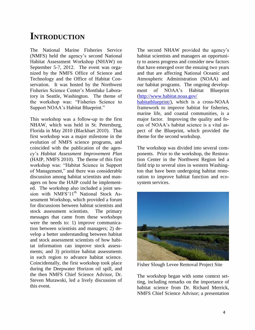
system services.
Fisher Slough Levee Removal Project Site
The workshop began with some context set-
ting, including remarks on the importance of
habitat science from Dr. Richard Merrick,
NMFS Chief Science Advisor; a presentation

5
on the Habitat Blueprint from Brian Pawlak,
Deputy Director of the NMFS Office of Hab-
itat Conservation; and a presentation on the
Blueprint’s Northwest Regional Initiative
from Will Stelle, Administrator of the NMFS
Northwest Region. The section of the work-
shop concluded with a keynote lecture from
the Northeast Fisheries Science Center’s Dr.
John Manderson, titled, “Can our habitat par-
adigm cross the land-sea boundary?”
The rest of the workshop consisted of five
working sessions.
1. Prioritization of Stocks for Habitat As-
sessments, which addressed progress and
lessons learned from the work done on
this topic as a follow-up to a key recom-
mendation in the HAIP and the first Na-
tional Habitat Assessment Workshop
(NMFS 2011).
2. Tools for Successful Habitat Assessment
for Fisheries, which addressed an array of
available assets for habitat science from
across NOAA line offices, use of the ME-
70 multi-beam echosounder that is de-
ployed on the FSV40 class NOAA ships,
and the Coastal and Marine Ecological
Classification Standard, which was re-
cently approved as a Federal Geographic
Data Committee standard for analyzing
and mapping habitat information.
3. Incorporating Habitat Information in
Stock Assessments, which focused on
how habitat information can contribute to
improving fisheries stock assessments by
reducing uncertainty in assessment data
inputs or assessment model projections.
4. Rethinking Essential Fish Habitat (EFH),
which addressed designation of EFH in
ecosystem-based fishery management
plans, in dynamic habitats (e.g., pelagic)
and changing climates, and non-fishery
impacts, such as ocean-based energy de-
velopment.
5. Improving the Flow of Habitat Science
Information to Management, which fo-
cused on success stories of scientific in-
formation or tools included in EFH and
Fish and Wildlife Coordination Act con-
sultations, and addressed issues that af-
fect many consultations that would bene-
fit from improved scientific information.
The second National Habitat Assessment
Workshop provided an excellent opportunity
for NMFS and other NOAA scientists and
managers to discuss their needs and issues of
common interest. The poster session and
numerous break-out groups enhanced this
communication by providing opportunities
for small-group and one-on-one discussions.
The workshop steering committee worked
hard to design a useful agenda that addressed
the key issues affecting NMFS’ habitat sci-
ence. Kirsten Larsen, Kristan Blackhart, and
Tali Vardi from the Office of Science and
Technology; Janine Harris from the Office of
Habitat Conservation; and Christine Holt
from the Northwest Fisheries Science Center
devoted considerable time and effort to
workshop organization and logistics, which
greatly contributed to its success. The agen-
cy has made progress since the first work-
shop in 2010, but many challenges remain.
Everyone who participated in the workshop
looks forward to the promise of the Habitat
Blueprint, and the opportunities it may pro-
vide for improving NOAA’s habitat science
and the contributions this can make to NO-
AA’s stewardship mission.
Stephen K. Brown, Ph.D.
NMFS Office of Science and Technology
Silver Spring, Maryland
6
DAY 1: INTRODUCTORY REMARKS AND KEYNOTE
PRESENTATION Remarks on the role of habitat science in
fisheries management, Q&A
Dr. Richard Merrick, Director of Scientific
Programs and Chief Science Advisor, NOAA
Fisheries
From Caribbean coral reefs to Arctic sea ice,
the United States is home to a wide range of
habitats that provide foraging, spawning, and
nursery grounds for our living marine re-
sources. Marine and coastal habitats are un-
der ever-increasing demands and face a
growing number of threats (i.e. sea level rise,
ocean acidification, coastal development)
across the Nation. Many of these areas pro-
vide essential habitats for our living marine
resources, yet our knowledge of how these
areas impact fisheries productivity and other
ecosystem services is lacking. In many cas-
es, we also lack information about the associ-
ation of marine species with various habitat
types. Such knowledge can be used to in-
form stock assessments and advance ecosys-
tem-based approaches to management. NO-
AA must gain a better understanding of the
relationship between species and their envi-
ronments to inform effective decision-
making and management of the Nation’s
fisheries. As a result, habitat science is a top
priority and we are working to raise aware-
ness and improve the funding outlook for
habitat science.
During the Q&A, participants asked questions
regarding various budget scenarios. The Of-
fice of Science and Technology will continue
to push for increased funds for habitat science.
In order to improve stock assessments, NOAA
must incorporate ecosystem parameters and
improve funding for habitat science. The rec-
ommendations and needs identified during
NHAW II will be an important part of that
process.
The Role of Science in the NOAA Habitat
Blueprint
Brian Pawlak, Deputy Director of NMFS Of-
fice of Habitat Conservation
The NOAA Habitat Blueprint is a forward-
looking framework for NOAA to think and act
strategically across programs and with partner
organizations to address the growing chal-
lenge of coastal and marine habitat loss and
degradation. The Blueprint is a framework for
moving toward ecosystem based management
to be more effective in our goals of conserving
habitat for fisheries management, protected
resources and coastal communities. We know
that we most likely will not see more re-
sources coming down the line in the near fu-
ture, and cannot wait for perfect science to
make ecosystem management decisions– we
can and are under the authority to work with
the best available information to make our
management decisions. Connections between
the science and management community un-
der the blueprint framework and through
workshops such as NHAW help us to work
together with our available resources to study
and manage our trust resources systematically.
The NOAA Habitat Blueprint was launched
due to widespread habitat loss and degrada-
tion and the recognition that NOAA’s current
habitat work alone is not enough to meet
these threats. The Blueprint is based around
four principles which guide our actions and
define how we do business:
Prioritize resources and activities across
NOAA to improve habitat conditions

7
Make decisions in an ecosystem context
and consider competing priorities
Foster and leverage partnerships
Improve delivery of habitat science to
facilitate decision-making
These principles are implemented through
three key approaches:
Establish long-term Habitat Focus Areas
Implement a systematic and strategic ap-
proach to habitat science; and
Strengthen policy and legislation
As a first step to affirm commitment to the
Blueprint and show short-term impact and
start implementing core elements on the three
key Blueprint approaches, NOAA launched
regional habitat initiatives across the country
in the fall of 2011. These regional initiatives
were designed to increase collaboration be-
tween NMFS regional offices and science
centers on habitat science and management
by bringing staff together on specific place-
based projects.
The habitat science approach of the Blueprint
builds on the regional initiatives and the
HAIP, which was completed in 2010, by
promoting increased linkages between habitat
scientists and managers on a national and re-
gional level. One goal of the habitat science
approach is to prioritize science activities to
fulfill habitat needs. The habitat assessment
prioritization process is being completed for
each region to rank fish stocks most in need
of habitat research. Other goals include inte-
grating science with management actions to
foster better decisions, coordinating and lev-
eraging efforts across NOAA, improving the
delivery of habitat science, and improving
communication and coordination in habitat
science. By holding the NHAW II, we are
together working toward these Blueprint sci-
ence goals. Through the presentations and
discussions at the NHAW, we hope to gener-
ate more ideas and activities that can
strengthen habitat science across the agency
in order to advance our habitat conservation
efforts
Northwest Regional Initiative Will Stelle, NOAA Regional Administrator
for the Northwest Region
Conserving and restoring aquatic habitats
important for marine fisheries and shellfish
species is a crucial aspect of NOAA Fisher-
ies’ mission in the Pacific northwest. The
Pacific northwest has lost much of its estua-
rine wetlands and riparian habitat and this has
had dramatic consequences for many fish
stocks. To address this issue, NMFS’s
Northwest Region is collaborating with ex-
ternal partners on an enhanced approach to
implement the Puget Sound Chinook Recov-
ery Plan and to protect and restore salmon
habitat throughout Puget Sound, the Colum-
bia basin, and across coastal Washington and
Oregon. Specifically, NOAA is prioritizing
resources and actions to address three key
factors limiting chinook salmon survival: es-
tuarine and nearshore habitats; floodplain
function and connectivity; and water quality.
NOAA is also working with other federal
agencies across this vast western coastal
landscape to address the operation of federal
dams, federal lands, and other federal activi-
ties that affect marine species that are listed
as endangered or threatened under the ESA.
This is why it is highly constructive that that
the regional offices and science center work
together on science needs to support the pro-
tection of endangered species and habitats of
particular concern. NOAA recognizes the
need to identify synergistic opportunity
where it is effective and efficient to over-
come these programmatic and institutional
challenges in moving the Blueprint forward.
During the Q&A, participants asked ques-
tions regarding ways to improve gaps and
uncertainty in habitat science for managed
8
fisheries species. The Northwest region con-
fronts these challenges by working with the
Science Centers to formulate scientifically
sound regulatory decisions, and evaluating
direct, indirect and cumulative risks to the
species and their habitats.
Keynote Presentation: Does our Habitat
Paradigm Cross the Land-Sea Boundary? Dr. John Manderson, Northeast Fisheries Sci-
ence Center
Ecosystem assessment and management in
the sea is holistic, based upon interdiscipli-
nary science that considers physical, chemi-
cal and biological processes, including feed-
backs with human ecological systems, that
structure and regulate marine ecosystems.
Space and time based tools for the manage-
ment of human activities in the sea need to be
informed by a regional scale habitat ecology
that reflects the dynamic realities of the
ocean. Current spatial management strate-
gies are based upon the patch-mosaic para-
digm of terrestrial landscape ecology modi-
fied to consider principles of dispersal ecolo-
gy, primarily for pelagic early life history
stages. This modification is not enough be-
cause fundamental differences in the role flu-
id properties and processes play in control-
ling ecological processes on land and in the
sea makes blanket application of paradigms
developed on land to the problems of ocean
management fundamentally flawed.
Seascapes are not landscapes
In 1984, Paul Risser and collegues (Risser et
al, 1984) summarized workshop deliberations
to develop a modern framework for the sci-
ence of landscape ecology using theoretical
and empirical underpinnings of a broad scale
spatially explicit ecology useful for terrestrial
resource management. Landscape ecology
rests primarily upon the patch mosaic para-
digm of habitat in which patches are defined
by sharp gradients in vegetation and geomor-
phology. Geography and geological process-
es, particularly soil development, that control
fundamental processes including primary
productivity are the foundations of landscape
classification. In terrestrial ecosystems, most
organisms and processes are decoupled from
the atmosphere by gravity and physiological
adaptation to extreme variations in atmos-
pheric properties, including temperature. As
a result, the primary features of terrestrial
habitats and ecosystems are physical struc-
tures created by landform and plant commu-
nities that can be modified by disturbance.
Community compositions are determined by
climate. However, the role of the atmospher-
ic fluid is of secondary importance and the
space-time scales of terrestrial ecosystems [~
velocity, 0.1 cm sec-1
] are orders of magni-
tude slower than the atmosphere [100 cm sec-
1] and approximately the same speed as soil
regeneration (Steele, 1991; Mamayev, 1996).
In contrast, the ocean is highly viscous and
has a density close to that of living tissues.
Most marine organisms are, therefore, nearly
buoyant in a fluid with dynamics that control
their motions and those of other important
particles including essential ecosystem build-
ing blocks. Since the basic processes of cel-
lular metabolism evolved in the sea, most
living tissues are nearly isosmotic with sea-
water. This contrasts starkly with terrestrial
organisms whose intracellular concentrations
of solutes and water are dramatically differ-
ent than the atmosphere. Finally the specific
heat capacity and thermal conductivity of
seawater are about four and twenty-three
times that of atmosphere by weight, respec-
tively. As a result, marine organisms experi-
ence much slower rates and ranges of tem-
perature change than do terrestrial organisms.
Temperature is tyrannical in the oceans
where oxygen required for endothermic heat
generation is limited and warm-blooded or-
ganisms are rare. It regulates critical rates
9
across all levels of ecological organization
from the cell to marine ecosystems.
Processes controlling primary productivity on
land and the sea are also fundamentally dif-
ferent. In the ocean, nutrients required by
plants constantly fall out of sunlit surface wa-
ters where photosynthesis is possible. As a
result, tiny, fast living plants with high sur-
face to volume ratios are entirely dependent
on the oceans “plumbing” to deliver nutrients
into the sunlit surface layers from sometimes
remote land or deep waters sources. Phyto-
plankton have fast population dynamics to
which other members of marine food webs
must respond. In contrast, primary productiv-
ity on land depends on slow, local nutrient
regeneration in soil at the interface with a
nearly transparent atmosphere where sunlight
is rarely in short supply. As a result, plants
at the base of terrestrial food webs are often
immobile, long lived, and have slow popula-
tion dynamics to which higher trophic levels
respond.
Due to the tight coupling of physiology,
movement of organisms and other critical
ecological processes to the oceans fluid, the
fluid is the primary driver that structures sea-
scapes and regulates seascape processes. As a
result, ecological processes in the ocean op-
erate at approximately the same space-time
scales (~velocities [~1 cm sec-1
]) as ocean
turbulence (Steele 1991, & Mamayev, 1996).
Bottom features are important to some ma-
rine organisms, however, these features are
frequently defined by fluid processes and
properties. The functional importance of bot-
tom features includes surfaces for concentrat-
ing advected materials; sites of energy acqui-
sition and/or conservation in the face of fluid
flows; and predation refugia in regions where
preference for water properties such as tem-
perature, salinity and oxygen are shared with
predators.
In summary, differences in the nature of the
ocean and atmospheric fluid and adaptations
of organisms to those fluids produce at least
two critical differences in the characteristics
of seascapes and landscapes. Firstly, habitats
in the sea have much faster spatial dynamics;
their locations, volumes and quality change
quickly at rates defined by the space-time
scales of organisms responses to properties
and processes of the oceans fluid which are
in surn driven by atmospheric and planetary
forcing. Secondly, because the ocean fluid is
so viscous, horizontal and vertical currents
driven by atmospheric and planetary forcing
transport essential habitat resources from
sometimes remote sources and concentrate
them in particular areas and times. In such
cases, habitats are not locations in space sup-
ported by local resources but nodes of net-
worked resources and processes which may
be derived from distant sources “upstream.”
For these reasons, relationships between hab-
itat dynamics and processes regulating popu-
lations, including density dependent process-
es, are fundamentally different in the sea and
on land. These differences in the nature of
habitat in the ocean and on land are in fact
responsible for the order of magnitude differ-
ences in changes in species distribution and
abundance in the sea and on land (~10 km
yr-1
vs ~ 1 km yr-1
) associated with recent
rapid changes in climate (Chueng et al.,
2009; Sorte et al., 2010).
Conclusion
Rapid changes in human demand and use pat-
terns of marine resources, combined with the
profound effects climate change is having on
species distributions and the structure of ma-
rine ecosystems, have made the development
of a regional scale seascape ecology reflect-
ing the dynamic realities of the ocean in-
creasingly urgent. The foundations of the
landscape ecology synthesis in the early
1980s rested on (1) developments in satellite
10
remote sensing that allowed researchers to
place fine scale ecological studies in broader
spatial contexts; (2) advances in ecological
theory that elucidated the role of dispersal
and connectivity in determining regional
community dynamics; and (3) the advent of
modern computing that allowed researchers
to store, analyze, and model large amounts of
spatially and temporally explicit data and ex-
plore relationships between the changing
landscape patterns and the processes poten-
tially causing them. The recent development
of operational ocean observing systems that
integrate assimilative hydrodynamic models,
and observations from remote sensing and
insitu platforms along with important ad-
vances in our understanding of micro to mac-
ro-ecological process in the sea have made
the time ripe for a similar synthesis and the
development of a robust science of seascape
ecology useful for the management of marine
ecosystems.
11
PRIORITIZATION OF STOCKS FOR HABITAT ASSESSMENT
Prioritizing Habitat Assessments
Stephen K. Brown, Office of Science and
Technology
The Marine Fisheries Habitat Assessment
Improvement Plan (HAIP) was developed
by a NMFS team to meet the habitat-related
mandates of the Magnuson-Stevens Act, and
was published in May 2010. The Plan fo-
cuses on the 230 Fish Stock Sustainability
Index (FSSI) stocks that comprise over 90%
of U.S. landings. The primary goals of the
HAIP are to:
Improve identification and impact as-
sessments of EFH;
Reduce habitat-related uncertainty in
stock assessments and facilitate a greater
number of advanced stock assessments.
To begin implementing the HAIP, a cross-
NMFS team was charged by NMFS leader-
ship to develop a prioritization process that
can be used to develop defensible priority
lists for habitat assessments in each NMFS
region. The final document was completed
in December 2011 (NMFS, 2011). Key fea-
tures are:
Stocks within a region are the units that
are prioritized;
Two types of criteria are applied sequen-
tially;
o Filter criteria to eliminate stocks
from further consideration
o Scorable criteria to determine the
ranking of the remaining stocks
Final ranks are binned into
high/medium/low priority; and
The end result is two priority regional
lists of stocks for habitat assessments:
o Stock assessments that will most
benefit from habitat assessments
o Stocks for which habitat assessments
will most advance EFH.
A pilot was recently conducted in the
Southwest Region, and the rest of the NMFS
regions will apply a refined process based
on this test case. Plans are to complete these
regional processes in time to inform the
Habitat Blueprint’s process for identifying
Blueprint Focus Areas.
Lessons Learned from Implementing the
Prioritization Process in the Southwest
Korie Schaeffer, Southwest Regional Office
The Southwest Region was chosen to pilot
the Habitat Assessment Prioritization Work-
ing Group process to prioritize managed
stocks based on the degree to which stock
assessments and EFH designations for each
stock would benefit from a habitat assess-
ment. A combination of key staff from the
Southwest Fisheries Science Center, South-
west Region, and Office of Science & Tech-
nology participated in the pilot process, in-
cluding participation in data gathering, sev-
eral conference calls, and a two day face-to-
face meeting. A total of 103 stocks were
considered for prioritization, including only
those stocks with significant catch in Cali-
fornia and salmon stocks spawning in Cali-
fornia. Staff relied on stock status, assess-
ment and survey summary information; EFH
sections of the Fishery Management Plans
(FMPs); Productivity-Susceptability Analy-
sis for groundfish; commercial landings and
ex-vessel revenue data; and expert opinion
to evaluate each stock against the three fil-
ters and eight scoring criteria. Scoring ru-
brics were modified for a number of criteria
to account for information gaps and improve
applicability to west coast species. The pro-
12
cess was complicated by economic and eco-
logical differences between stocks managed
under different FMPs, specifically, differ-
ences between salmon stocks with both ma-
rine and freshwater life stages, stocks that
are migratory and/or reside in the water col-
umn, and stocks that reside in marine, ben-
thic habitats. Final scores and high-
medium-low priority categories are still be-
ing evaluated. Preliminary scores indicate:
(1) a subset of salmon and rockfish stocks
would be high priority for habitat assess-
ment contribution to EFH designations, and
(2) a subset of salmon and rockfish stocks
and Pacific bluefin tuna would be high pri-
ority for habitat assessment contribution to
stock assessments.
Question and Answer Session
Leaders: Stephen Brown (S&T) and Korie
Schaeffer (SWRO)
During the Q&A, participants asked ques-
tions regarding factors that were considered
in the prioritization process. Climate change
is rapidly changing such things as habitat
availability and population dynamics and
NMFS needs to have foresight into which
stocks will be most affected and how this
can be incorporated into the prioritization
process. Climate change was discussed dur-
ing the Southwest Habitat Assessment Prior-
itization Working Group Process, but it was
difficult to determine which stocks would be
most affected. This may be easier in other
regions. Tribal priorities may also be an
important consideration in some regions.
It was also clarified that the results of each
regional prioritization process will be used
as a layer of information to help inform the
selection of the Habitat Blueprint Focus Ar-
eas. The prioritized list of stocks could be
integrated with specific areas to determine
high priority geographic areas.
13
TOOLS FOR SUCCESSFUL HABITAT ASSESSMENT FOR
FISHERIES
One of the guiding principles of the NOAA
Habitat Blueprint is to foster and leverage
partnerships. With decreasing budgets and
increasing pressures on habitat, institutions
must find methods and places where mis-
sions overlap, and combine resources to get
our respective and collective jobs done.
With this collaborative spirit in mind at the
2nd
NHAW, NMFS invited external speakers
to showcase data and methods to assist fish-
eries habitat science and management. Pre-
senters highlighted opportunistic data collec-
tion that helps refine trawlable bottom habi-
tat, a wealth of bathymetric and shoreline
data that can be accessed through geograph-
ic information systems (GIS) and web por-
tals, shipboard video capabilities in un-
known regions, and a new classification sys-
tem for all marine data.
NOS Products that Support Fisheries
Habitat Assessment
Mark Finkbeiner, Coastal Services Center,
National Ocean Service
Understanding fisheries habitat requires in-
formation from many aspects of the envi-
ronment. Although often developed for oth-
er purposes, many National Ocean Service
(NOS) products provide this kind of infor-
mation. These products include spatial data,
analysis tools, technical reports, real-time
conditional information and data access
points.
NOS collects spatial data to support mission
requirements and targeted stakeholders in
the areas of safe navigation, disaster re-
sponse, coastal and ocean stewardship, and
services to coastal states. These data are
intended to meet both local and national
needs.
Derived data, that is data which is the result
of some analysis or interpretation, include
shallow water benthic habitats, land cover,
National Estuarine Research Reserve moni-
toring data, bathymetry, shoreline character-
istics, and Integrated Ocean Observation
System (IOOS) products. Source data avail-
able from NOS include acoustic backscatter,
LIDAR intensity, and airborne imagery. In
addition, NOS provides several GIS tools to
support further analysis of source and de-
rived data.
NOS makes these data and products availa-
ble through several web portals such as the
Digital Coast, MarineCadastre, NOS Data
Explorer, and the National Geophysical Data
Center. Opportunities to collaborate with
NOS are available through such efforts as
the Integrated Ocean and Coastal Mapping
program and other venues. A handout de-
scribing the many products in more detail
and providing links for more information is
available in Appendices 5-8.
Seafloor Characterization for Trawlabil-
ity and Fish Habitat Using the Simrad
ME70 Multibeam Echosounder in the
Gulf of Alaska
Jodi Pirtle, University of New Hampshire
Groundfish that associate with rugged sea-
floor types are difficult to assess with bot-
tom-trawl sampling gear. Simrad ME70
multibeam echosounder (ME70) data and
video imagery were collected to characterize
trawlable and untrawlable areas and to ulti-
mately improve efforts to determine habitat-
specific groundfish biomass. We surveyed
areas of the Gulf of Alaska (GOA) (20-500
m depth) aboard the NOAA ship Oscar Dy-
son during 2011, from the Islands of Four
14
Mountains in the Aleutians to eastern Kodi-
ak Island. Additional ME70 data were col-
lected opportunistically during the winter
2012 acoustic trawl surveys. ME70 data
were collected continuously along the ship
trackline (1-20 nmi spacing) and at fine-
scale survey locations in 2011 with 100%
seafloor coverage (n = 21). Video data were
collected at fine-scale survey sites using a
drop camera (n = 47 stations). ME70 data
were matched to the spatial location of pre-
viously conducted AFSC bottom-trawl sur-
vey hauls (n = 582) and 2011 camera sta-
tions to discriminate between trawlable and
untrawlable seafloor types in the region of
overlap between the haul or camera path and
the ME70 data. Angle-dependent backscat-
ter strength, backscatter mosaics, and other
multibeam metrics were extracted from the
ME70 data at these locations. Haul locations
show separation in backscatter strength
based on performance, previously classified
as successful or unsuccessful due to gear
damage from contact with the seafloor. Suc-
cessful haul locations have values that corre-
spond to finer grainsize, or the lack of un-
trawlable features such as boulders and rock.
A similar pattern was observed for the cam-
era stations characterized as trawlable or un-
trawlable from video. The best descriptors
for seafloor trawlability will be identified
among multibeam metrics to map the pre-
dicted trawlability of the ME70 survey foot-
print. Continued opportunistic collection of
ME70 data during Oscar Dyson operations
will help refine existing classifications of
untrawlable and trawlable areas in the GOA.
Implementing CMECS--the Coastal and
Marine Ecological Classification Stand-
ard Garry Mayer, NMFS Office of Habitat Con-
servation, and Mark Finkbeiner, NOS
Coastal Services Center
In summer 2012, the Federal Geographic
Data Committee approved the Coastal and
Marine Ecological Classification Standard
(CMECS) as the first-ever, comprehensive
federal standard for classifying and describ-
ing coastal and marine ecosystems. CMECS
development was a multi-year partnership
led by NOAA with the U.S. Environmental
Protection Agency, the U.S. Geological Sur-
vey, and NatureServe. NOAA Fisheries was
a primary participant in these efforts.
CMECS offers a simple, standard frame-
work and common terminology for describ-
ing natural and human-influenced ecosys-
tems from the upper tidal reaches of estuar-
ies to the deepest portions of the ocean. The
standard is designed to meet the needs of
many users but has special relevance to fish-
eries-related research and management.
Practical fisheries-related applications in-
clude habitat assessments, especially de-
scriptions of new or under-studied marine
systems (e.g., deep-sea corals, the Arctic);
improving EFH designations; mapping,
planning and monitoring habitat restora-
tions; climate-effects studies and monitor-
ing; and regional governance. Specifically
with regard to EFH, CMECS offers an op-
portunity to apply common habitat termi-
nology and move towards a common format
and greater consistency among designations.
It provides a “platform” for adding relevant
data from non-fishery sources and the possi-
bility of more straightforward comparisons
of EFH designations across Fishery Man-
agement Councils and geographic regions,
within related taxa, and among unrelated but
ecologically analogous species.
CMECS is sensor-independent and can be
applied on scales ranging from local and re-
gional to national and beyond. It articulates
with other relevant FGDC standards and ac-
cepted classification approaches. Ecological
units classified using CMECS can be
mapped, compared, or otherwise analyzed
with existing, available methods. CMECS
accommodates biological, geological, chem-

15
ical, and physical data in a single structure
and facilitates data sharing, regional anal-
yses and integration across observation
methods and geographic scales. CMECS
includes provisions to update and improve
the standard as new information becomes
available.
Using Environmental Data to Predict the
Effects of Climate Change on Marine
Fisheries
David Foley, Southwest Fisheries Science
Center
A range of environmental data is needed to
predict the effects of climate change on ma-
rine fisheries. The goals of this talk are to
introduce readily available data sets, discuss
efforts to improve data, discuss integration
of environmental and biological data sets,
offer several examples, and discuss predic-
tions. Key data types include in situ data
(CTD, gliders, tagged organisms etc.), satel-
lite data (color, SST, height, and winds), and
models. Data is distributed across a range of
oceanic features important to living marine
resources, such as ocean fronts, boundaries,
edges, and mesoscale patterns. Satellites
enhance spatial and temporal coverage and
data help to resolve oceanic features at a va-
riety of scales. However, there are some
limitations to consider. For example, data is
often limited to the very surface of the ocean
and numerous factors need to be accounted
for in the measurements. The data also only
allow the derivation of basic oceanographic
parameters, and clouds present a problem
for all visible and infrared measurements.
To mitigate data lost due to clouds, compo-
site images can integrate across time on one
platform and can also integrate across sen-
sors and platforms (microwave and infra-
red). Sample applications include Google
earth, ArcGIS, MatLab, IDL, and R. To
choose the appropriate application it is im-
portant to balance needs for spatial resolu-
tion, spatial extent, temporal resolution,
temporal extent, missing data, and accuracy
of data.
OAR Science to Support NOAA Fisheries Craig Russell, Office of Ocean Exploration
and Research, OAR
The Office of Oceanic and Atmospheric Re-
search (OAR) provides the research founda-
tion for understanding the complex systems
that support our planet. Working in partner-
ship with other NOAA units, OAR provides
better forecasts, earlier warnings for natural
disasters and a greater understanding of the
Earth. Our role is to provide unbiased sci-
ence to better manage the environment, na-
tionally and globally. OAR activities occur
in seven research laboratories, four program
offices, Sea Grant programs, and several co-
operative institutes. These programs provide
technology, data, models, and findings to aid
NMFS habitat assessments. This presenta-
tion surveys select examples of OAR habitat
related science activities under five major
themes: Discover & Characterize; Advance
Technology; Observe, Research, Monitor &
Assess; Model & Forecast; Visualize &
Communicate. Example activities include:
Conducting interdisciplinary exploration
and high risk research to provide infor-
mation in unknown or poorly known re-
gions, scales and in all three dimensions
including the 4th
dimension – over time;
Design, deployment, and analysis of data
from fixed, buoy-based, vessel-based,
aircraft-based, drifting, autonomous, and
satellite observing systems in freshwater
and marine environments to provide
baseline and time-series ecosystem data;
Field and laboratory studies in benthic
ecology, lower food web process ecolo-
gy, fish biology and ecology, phyto-
plankton ecology, and sediment
transport with particular emphasis on in-
vasive species, harmful algal blooms,

16
and time-series measurements in fresh-
water and coastal ocean systems;
Developing and using earth system
models, satellite observations and eco-
logical forecasts to aid holistic under-
standing, simulations, prediction, and re-
lated management trade-off decisions;
Engaging stakeholders, the public and
students in collaborative, interactive, and
innovative research, outreach and educa-
tion, including making data easy to ac-
cess.
Proactively engaging OAR labs, programs,
and cooperative institutes will yield in-
creased awareness of habitat related OAR
activities and lead to collaborations with
OAR to benefit multiple programs and part-
ners.
17
DAY 2: INCORPORATING HABITAT INFORMATION IN STOCK
ASSESSMENTS
Session Organizer: Kristan Blackhart (S&T)
Rapporteur: Janine Harris (OHC)
Using habitat information to help inform and
improve the stock assessment process is a
major theme of the HAIP, and was also a
major discussion topic at the 1st NHAW held
in 2010. There, a joint session with the 11th
National Stock Assessment Workshop was
held with the intention of improving com-
munication and collaboration between the
stock assessment and habitat science com-
munities. During the first NHAW, partici-
pants came up with a number of recommen-
dations (see Blackhart 2010 for additional
details):
Habitat data should be integrated into
resource survey sampling design where
available to improve the precision and
efficiency of surveys.
NMFS should expand its capacity to col-
lect habitat information and develop a
comprehensive repository for existing
and new habitat information. The highest
priority to address is expanded habitat
mapping and classification.
Expanded collection of environmental
data should occur during existing re-
source surveys, and development and
implementation of advanced sampling
technologies should continue.
Cooperation and data sharing should be
pursued and existing partnerships
strengthened to make the best use of
available habitat information.
The accessibility of existing habitat data
should be improved to facilitate inclu-
sion in the stock assessment and man-
agement processes.
Progress has been and continues to be made
on some of these recommendations, but
Top Session Conclusions and Recommended Next Steps:
Habitat studies are not currently providing much information that can be readily in-
corporated in the stock assessment process, but habitat data could substantially im-
prove assessments for many stocks where basic stock data (catch, abundance, life his-
tory) already exists.
Although fitting ecosystem data into stock assessment models remains a challenge to
be addressed, there are many examples where habitat data is already being used to in-
form the stock assessment process.
Using habitat information to post-stratify abundance surveys can accomplish the same
goals as redesigning surveys based on habitat classifications, but offers greater flexi-
bility and can inform survey design if necessary.
Studies of density dependence should be conducted using a habitat context to examine
the potential effects of habitat on catchability and selectivity.
Increasing information on life history bottlenecks and the timing of mortality events
relative to density dependent compensation is a critical next step.
18
budget restrictions and other challenges
have limited implementation of others. This
emphasizes the need for continued collabo-
ration between the stock assessment and
habitat science communities to meet current
challenges.
The intent of this session was to focus on
exploring the habitat needs for stock as-
sessments and how habitat information can
contribute to improving fisheries stock as-
sessments by reducing uncertainty in as-
sessment data inputs or assessment model
projections. A better understanding of the
specific short-to-medium term habitat sci-
ence needs with respect to stock assessments
will better enable those working on habitat
assessments to make data available to the
stock assessment community in more mean-
ingful ways. The session began with several
presentations from invited stock assessment
scientists. These oral presentations are
summarized below.
What Assessment Gaps need Habitat In-
formation? Where Could Habitat-Specific
Life History Rates Fit?
Richard Methot, NMFS Science Advisor for
Stock Assessments
While it is generally understood that healthy
fish populations require healthy habitat, the
exact way in which fish depend upon habitat
and respond to changes in habitat is not
known. Thus, methods for fish stock as-
sessment have evolved to not depend upon
knowledge of the habitat linkages. This
leaves fish assessments vulnerable to error
by assuming constancy in factors that actual-
ly are changing.
There are four general categories of “soft
spots” in fish assessments that are amenable
to improvement through habitat-specific in-
vestigations:
1. Time series of survey trends may be too
short to have observed historical trends,
so it results in imprecise assessments.
Here, direct measure of absolute abun-
dance across the range of the stock (ad-
vanced tech surveys) or absolute fishing
mortality rate (quantitative tag-
recapture) are needed. Advanced tech
surveys with a habitat specific design
can be more precise and informative
than generalized surveys.
2. Fish distribute over space/habitat accord-
ing to age/size dependent preferences.
Sampling all with equal (or at least
known) probability is technically chal-
lenging. Studies of fish and fishery dis-
tribution across habitat types can im-
prove direct information on selectivity.
3. Vital rates change over time in response
to ecosystem, climate and habitat chang-
es. Changes in body growth can be
measured and easily accounted for, but
field measurement of contemporary nat-
ural mortality rate is typically impracti-
cal. Although expensive and difficult,
information on contemporary natural
mortality rates across the range of the
population can be obtained from exten-
sive tag-recapture studies and/or preda-
tor-prey studies. Localized studies of
natural mortality need to carefully ac-
count for fish movement.
4. The life stage in which the major com-
pensatory response occurs is assumed to
be during the larval-juvenile stage. This
is because reduction in the stock’s total
reproductive output by fishing does not
result in a proportional decline in the
number of recruits that appear in the
population months-years later. Some-
time during this life stage, compensation
for the reduced production of eggs is oc-
curring. Knowledge of the life stage(s)
at which this occurs, and the habitat in
which in occurs, is a first step towards
developing better prediction of the effect
19
of fishing and habitat loss on productivi-
ty of harvested fish populations.
The implications of untrawlable habitats on
bottom trawl surveys for West Coast
groundfishes
James Thorson, NWFSC
Bottom trawl sampling is used to estimate
trends in stock abundance for groundfishes
worldwide including Pacific rockfishes (Se-
bastes spp.). However, trawl sampling effi-
ciency varies spatially, and the distribution
of groundfish populations may change
among easy- and difficult-to-survey areas
over time. These concerns have prompted
interest in using underwater vehicles (UVs),
for which catchability is likely to decrease
less in rocky habitats. In this study, we use
simulation modeling to evaluate the abun-
dance trends arising from bottom trawl sam-
pling given density-dependent habitat selec-
tion and spatially-varying catchability. We
first demonstrate that relative abundance
indices in this case will generally be biased
measures of changes in population abun-
dance. We also propose and evaluate a
sampling design that combines data from
bottom trawl and UV gears. Combined
sampling has greater precision than UV
sampling, lower bias than bottom trawl
sampling, and is robust to moderately-
violated assumptions regarding sampling
strata or spatial catchability. We conclude
by recommending future research that could
test the assumptions under which combined
sampling is a feasible solution to spatially-
varying catchability.
Expansion of Oxygen Minimum Zones
may reduce available habitat for Tropical
Pelagic Fishes
Eric Prince, SEFSC
Climate model predictions and observations
reveal regional declines in oceanic dissolved
oxygen (DO), which are likely influenced by
global warming. Studies indicate on-going
DO depletion and vertical expansion of the
oxygen minimum zone (OMZ) in the tropi-
cal northeast Atlantic Ocean. OMZ shoaling
restricts the useable habitat of billfishes and
tunas to a narrow surface layer. We report a
decrease in the upper ocean layer exceeding
3.5 mL L-1
DO at a rate of ≤1 m yr-1
in the
tropical northeast Atlantic (0-25°N, 12-
30°W), amounting to an annual habitat loss
of ~5.95x10¹³
m3, or 15% for the period
1960-2010. Habitat compression was vali-
dated using electronic data from 47 blue
marlin. This phenomenon increases vulnera-
bility to surface fishing gears for billfishes
and tunas, and may be associated with a 10-
50% worldwide decline of pelagic predator
diversity10
. Further expansion of the Atlantic
OMZ along with overfishing may threaten
the sustainability of these valuable pelagic
fisheries and marine ecosystems.
Incorporating temperature-dependent
catchability in some Alaska flatfish stock
assessments
Thomas Wilderbuer, AFSC
Temporal patterns in bottom trawl survey
biomass estimates for flatfish species from
the eastern Bering Sea have led to investiga-
tions examining whether these estimates co-
vary with annual bottom water temperature.
These patterns in catchability cannot be ac-
counted for by the usual flatfish population
dynamics and seem to operate through
changes in the metabolism of the fish with
water temperature and how it relates to both
herding by the survey trawl gear sweep ca-
bles and availability to the trawl gear.
In the case of yellowfin sole, the variability
of survey abundance estimates are in part
due to the availability of yellowfin sole to
the survey area. Yellowfin sole are known
to undergo annual migrations from winter-
ing areas off the shelf-slope break to near

20
shore waters where they spawn throughout
the spring and summer months. Over the
past 15 years survey biomass estimates for
yellowfin sole have shown a positive corre-
lation with shelf bottom temperatures where
estimates have generally been lower during
cold years as the timing of the migration is
longer. For other species, it is the tempera-
ture-driven metabolic response to being
herded into the net path by the trawl sweep
lines (greater in warm years) that has an ef-
fect on survey catchability.
To better understand how water temperature
may affect the catchability of flatfish species
to the survey trawl, catchability was esti-
mated for each survey year in the stock as-
sessment model as a nonlinear function of
water temperature which responds to the
metabolic aspects of herding or distribution
(availability) and varies annually with bot-
tom water temperature. The result of incor-
porating bottom temperature to estimate an-
nual q resulted in a better fit to the survey
biomass time-series.
Summary
Each of these presentations gave insight into
the stock assessment process, outlined the
places in the process where it is most feasi-
ble to use habitat information to improve
stock assessments, and gave some specific
examples of how environmental data is al-
ready being used in stock assessments.
The session next moved into a ‘Question &
Answer’ panel to allow for group discussion
of the themes raised during the earlier
presentations. The discussion was facilitated
by Terra Lederhouse (OHC) and panel
members included Rick Hart (SEFSC),
Richard Methot (S&T), Eric Prince
(SEFSC), James Thorson (NWFSC), and
Tom Wilderbuer (AFSC). Discussion
themes included the habitat needs for stock
assessment, current work incorporating
habitat information in stock assessment, and
what is feasible to be done in the short-to-
medium term given current budget con-
straints.
Following the group discussion panel, par-
ticipants were split into breakout groups to
continue discussions on a smaller scale. The
four breakouts grouped participants based
on species/habitat expertise: 1) groundfish;
2) reef and untrawlable; 3) highly migratory
and coastal pelagic species; and 4) estuarine
and diadromous. Breakout groups were
tasked with discussing habitat science priori-
ty needs (with respect to stock assessment),
challenges, and opportunities for moving
forward based on the presentations and dia-
logue during the first half of the session.
Specifically, groups were given the follow-
ing trigger questions to address:
1. Are there specific life-history traits asso-
ciated with stocks where a habitat-
incorporated approach is likely to im-
prove estimates/reduce uncertainty?
How and where would this information
be incorporated? Two options are:
a. Improving the design and interpreta-
tion of fishery-independent surveys
to include catchability coefficients.
b. Providing vital rates, stock-recruit
functions, nursery function, or in-
formation on spatial and temporal
scales of animal movements, to in-
form stock assessment models.
2. Are there stocks for which a traditional
stock assessment approach is more ap-
propriate?
3. What are the biggest challenges you face
in terms of obtaining the habitat data you
need and using habitat data in stock as-
sessments? What are some solutions to
the challenges identified?
21
4. Do opportunities exist for habitat-related
collaboration or project development to
improve stock assessment?
After breakout discussions, groups reassem-
bled and each gave a short report on their
discussions and overall conclusions. The
session concluded with a short group discus-
sion following the breakout group reports. In
addition to registered NHAW participants,
stock assessment scientists local to the Seat-
tle area (i.e. NWFSC and AFSC) were invit-
ed to participate in this session. Summaries
from each of the breakout groups can be
found on pages 24-37.
Discussion of Habitat and Stock Assess-
ment
One of the main topics of discussion during
this session was where and how habitat in-
formation can be used in the stock assess-
ment process. Although basic stock assess-
ment data ‘needs’ and ‘wants’ do not in-
clude ecosystem data for many stocks, this
does not mean that habitat studies provide
no utility to the stock assessment process. In
fact, there were many places where habitat
information can and already is being utilized
to improve stock assessments.
“Use” in stock assessments has not been
well defined, although environmental infor-
mation is incorporated into assessments in a
number of ways already. In some places,
good oceanographic time series are available
and have been investigated for application to
assessments. However, the assessment
community needs to think in terms of mov-
ing away from environmental time series
towards more comprehensive data sets. The
next challenges will be developing new
methods for incorporating a wider spectrum
of ecosystem information into stock assess-
ment models. Although there is some cur-
rent modeling capacity, many models will
need to be upgraded or replaced in order to
take advantage of improved ecosystem data
as it becomes available. Additional biologi-
cal studies are also needed to improve un-
derstanding of how habitat factors affect ma-
rine populations.
This path requires buy-in from managers on
new methods as they are developed. Fisher-
ies managers are accustomed to traditional
assessment methods, so good communica-
tion is critical to improve understanding and
acceptance in the management process.
Improving Survey Precision and Calibration
An important area where improved habitat
information can contribute to the stock as-
sessment process is providing information
useful for improving calibration of fishery-
independent population surveys. A common
misconception is that comprehensive habitat
maps are necessary to improve surveys.
Such comprehensive maps are not necessari-
ly needed; bottom roughness estimates are
useful, but basic information on the propor-
tion of habitat types is an important first
step. However, making use of habitat type
information requires additional information
on habitat-specific densities to ensure proper
interpretation. Failure to account for density
dependent habitat selection, when present,
leads to biased abundance indices.
The needs for ‘habitat type’ information
vary by species. Survey scientists have been
using ‘habitat type’ thinking in survey de-
sign for decades by stratifying surveys by
depth. However, most current surveys are
multispecies and need to stay that way, so
there is not much room to include habitat
stratification (which will vary for each spe-
cies in a survey). Post-stratification of sur-
veys, using improved habitat information as
covariates in the analysis of survey, accom-
plishes the same goals as restratifying sur-
22
veys based on habitat. Model-based ap-
proaches to the incorporation of habitat in-
formation are more flexible than redesigning
surveys, and can also be more powerful.
Collection of habitat data concurrently dur-
ing existing abundance surveys is a good
approach to improving availability of habitat
information for stock assessment. This ap-
proach takes advantage of existing resources
and gives stock assessment scientists greater
input into the collection of data that is useful
to assessment. Such data collection can be
accomplished using a variety of traditional
and advanced sampling technologies, in-
cluding bottom sampling, ocean instrumen-
tation, and cameras, depending on need.
Catchability and Selectivitiy
A key assumption of stock assessment is
that the catch-per-unit-of-effort (CPUE) var-
ies proportionally with stock size (i.e. catch-
ability is constant). However, catchability
may change (increase or decrease) over time
due to habitat/environmental conditions and
density dependent population effects. Bot-
tom trawls and other commonly used survey
techniques are likely to be biased by spatial-
ly varied catchability resulting from density
dependent habitat selection and a spatial re-
distribution of abundance. A number of
methods are used to adjust catch rates to en-
sure that survey CPUE is proportional to
biomass despite changes in catchability, but
such techniques may be hindered by factors
associated with habitat degradation or loss
(including climate change). Studies of densi-
ty dependence are more valuable in a habitat
context, and additional studies focusing on
catchability are needed to enable assessment
scientists to separate catchability from habi-
tat-specific effects. It is possible to build
density dependent catchability into assess-
ment models. For example, several stocks of
flatfish in Alaska use environmental catcha-
bility modeling to account for changes in
fish behavior and distribution (and thus
survey availability) related to water
temperature.
Selectivity, or the ability to target and cap-
ture fish based on size (age), behavior, and
distribution, provides technical challenges to
field surveys and stock assessment. If not
properly accounted for, selectivity can be a
potential source of bias or error in stock as-
sessment. Accurate estimates of biomass (as
well as fishing mortality and population size
structure) require scientists to be able to
specify how vulnerable fish are to capture
by a particular gear at a particular age. Habi-
tat affects selectivity through changes to fish
behavior and distribution. For example, the
vertical habitat use (and availability to fish-
ing gear) of Atlantic blue marlin has
changed over time in response to growing
oxygen minimum zones and compression of
pelagic habitat. Habitat-fish distribution
studies can inform assessment models about
the degree of selectivity.
Early Life History
Information on early life histories is largely
lacking for many marine species. Although
fishery and survey data is often adequate to
measure annual recruitment fluctuations,
better information on early life history stag-
es and the recruitment process would allow
scientists to both understand patterns and
predict fluctuations. Initiating dedicated sur-
veys or collecting comprehensive data on
early life history stages may be cost-
prohibitive in many situations, but there are
several intermediate steps where habitat-
specific information could be useful. Deter-
mining the environmental parameters that
are correlated with recruitment is not a per-
fect approach, but cheaper and easier. Habi-
tat-specific investigations to determine the
life stage(s) most affected by density de-

23
pendence and sensitivity to environmental
fluctuations are also important. Such infor-
mation on life history bottlenecks and the
timing of mortality events relative to density
dependent compensation is a critical next
step. Because long-term trends in recruit-
ment are easily confounded by other as-
sessment aspects, habitat-specific infor-
mation on probable trends in natural mortali-
ty and carrying capacity are needed.

24
Breakout Group 1: Incorporating Habitat Information in Stock
Assessments with a Focus on Groundfish
Reporter: Matthew Eagleton (AKRO)
Facilitator: Terra Lederhouse (OHC)
Rapporteur: Jarad Makaiau (PIRO)
In this session, each breakout group was
asked to answer a number of questions on
how habitat information can contribute to
improving stock assessments by reducing
uncertainty in assessment data inputs or as-
sessment model projections. The goal for
this breakout group was to identify life his-
tory characteristics associated with ground-
fish stocks that could benefit from incorpo-
rating habitat information into the stock as-
sessment process, high priority habitat sci-
ence needs in relation to groundfish stock
assessments, and opportunities for collabo-
ration between the habitat and groundfish
stock assessment communities.
The group discussed specific life-history
traits associated with groundfish stocks
where a habitat-incorporated approach is
likely to improve estimates and reduce un-
certainties. The group agreed that for juve-
nile and adult age classes, information on
vital rates (e.g. natural mortality and
growth), habitat associations with easily
measured elements (e.g. abundance by sed-
iment types), and habitat-dependent densi-
ties would be necessary for stock assessment
scientists to effectively incorporate habitat
information into groundfish stock assess-
ments.
The group identified high priority science
needs that would improve stock assessment
approaches for groundfish and reduce uncer-
tainty. Species that are distributed within
habitat types that are difficult to survey (e.g.
rocky reefs) are often under-sampled by tra-
ditional survey methods. In the short term,
NOAA Fisheries could improve survey indi-
ces for these species (e.g. maps of trawlable
vs. un-trawlable areas for assessment sur-
Top Conclusions and Recommended Next Steps:
NOAA should incorporate information on juvenile and adult vital rates, habitat asso-
ciations, and habitat-dependent densities into groundfish stock assessments. NOAA
should also develop assessment methods that better account for juvenile life stages.
NOAA should improve survey indices for groundfish species that are generally un-
dersampled by existing survey methods due to their association with untrawlable
habitats.
In the long term, NOAA should develop precise assessment surveys across the full
range of habitats occupied by a species.
To improve the collection and sharing of habitat data, NOAA should better leverage
resources within NOAA and across organizations.
NOAA should announce ship deployment schedules earlier to improve planning and
increase opportunistic sampling.
NOAA should continue to implement the recommendations from the HAIP.
25
veys). In the long term, NOAA Fisheries
will need to develop precise assessment sur-
veys across the full range of habitats occu-
pied by a species. Another important step
towards improving stock assessments and
reducing uncertainty is improved representa-
tion of juvenile life stages in stock assess-
ment models. This will require 1) increased
data collection efforts and improved survey
methodologies to better measure information
for early life history stages; and 2) develop-
ment of assessment modeling methodologies
to incorporate improved juvenile stock data.
Stock assessment scientists identified a
number of challenges to obtaining necessary
habitat data. The cost of conducting habitat
research and collecting relevant data is often
prohibitive. Some solutions proposed by the
group included better leveraging of re-
sources within NOAA and across organiza-
tions. For example, NOAA could find op-
portunities to partner with other federal or
state agencies and with other industries,
making better use of data collected by other
organizations and looking for opportunities
to collect data collaboratively (i.e. platforms
of opportunity). NOAA Fisheries scientists
could also make better use of existing sur-
veys and ship time by collecting habitat data
concurrently, especially through use of ad-
vanced sampling technologies (e.g. acoustic
and optical self-automated sensing technol-
ogies). Current impediments towards full
utilization of ship time are the challenges
associated with survey planning – scientists
are often notified of ship deployment sched-
ules with insufficient time to plan for sur-
veys. Earlier notification of ship deployment
schedules will lead to improved survey
planning, allowing habitat and stock assess-
ment scientists to take full advantage of the
sampling opportunities afforded by each
cruise.
Another challenge the group identified is
data accessibility. NOAA Fisheries has a
backlog of collected data that has not been
analyzed or processed due to lack of staff
resources. Once analyzed and processed,
habitat data also needs to be made accessible
in a format that is usable to stock assessment
scientists. The breakout group proposed that
NOAA should partner more with academic
institutions and other scientific organizations
that can provide data analysis, processing,
and management for NOAA. Additionally,
NOAA Fisheries scientists often have diffi-
culty accessing existing federal datasets that
could contribute to improved stock assess-
ments. NOAA Fisheries habitat managers
could request this data during habitat consul-
tations so it can be incorporated into stock
assessments and be used to improve moni-
toring of federal projects.
26
Breakout Group 2: Incorporating Habitat Information in Stock
Assessments with a Focus on Reef Fish and Untrawlable Habitats
Reporter: David Stevenson (NERO)
Facilitator: Tali Vardi (S&T)
Rapporteur: Kimberly Clements (SERO)
This breakout group focused on how habitat
information can contribute to improving
fishery-independent surveys and stock as-
sessments by reducing uncertainty in as-
sessment data inputs or assessment model
projections. Specific habitat science priority
needs, challenges, and opportunities were
identified for reef fishes and fishes inhabit-
ing other untrawlable areas. Discussion fo-
cused on the bolded trigger questions below.
What type of habitat information could
be incorporated into stock assessments of
reef fish populations (or demersal conti-
nental shelf stocks that inhabit untraw-
lable habitats) to improve results and re-
duce uncertainty? How and where would
this information be incorporated? Is the
required information specific to certain
life history stages? Two options are:
a. Improving the design and interpreta-
tion of fishery-independent surveys to
include catchability coefficients.
b. Providing vital rates, stock-recruit
functions, nursery function, or infor-
mation on spatial and temporal scales
Top Conclusions and Recommended Next Steps:
Incorporation of habitat information into fishery-independent survey-generated
measures of abundance would improve their accuracy, particularly for species that
utilize rocky and coral reef habitats.
Survey-generated abundance indices could be improved, for example, by (1) pre-or
post-stratifying surveys to account for habitat variability and (2) including habitat
variables when standardizing survey data (e.g., CPUE estimates).
In order to properly translate index data from habitat-specific surveys, catchability
and selectivity of target species in different habitats and sampling gears need to be
better understood. For species that inhabit reefs and other untrawlable habitats, non-
trawl survey gears such as traps, longlines, and video cameras are required.
Large-scale stock assessments of species that occupy untrawlable habitats could be
improved by incorporating habitat-specific variables in assessment models. These
would include habitat-specific vital rates (e.g., growth and survival), recruitment, se-
lectivity, and catch composition.
As a first step in evaluating the effects of habitat variability on survey catch rates and
size/age composition, existing trawl survey data from a specific region should be ana-
lyzed using post-stratification methods.
A possible second step would be a pilot study with paired gears within an existing
survey protocol to determine gear catchability and test for correlations between catch
rates and habitat features. A long term solution is to design new surveys using sam-
pling equipment that is suited for use in complex habitats.
27
of animal movements, to inform stock
assessment models.
For shallow-water (<30 meters) reef envi-
ronments (e.g., Pacific islands), there is
good fishery-independent data derived from
diver surveys – visual counts, size estimates,
and related habitat data. Deep-water reefs
are more difficult to survey, but some pro-
gress has been made. In the Southeast and
Southwest regions, the Caribbean, and Gulf
of Mexico a variety of other survey methods
are used, including fish traps, longlines, and
remotely operated vehicles (ROVs). These
survey techniques have been designed to
specifically account for distinguishing char-
acteristics of reefs and reef fish species (e.g.,
segregation in habitat use by life history
stage, strong affinities for structure, highly
variable size and species composition be-
tween reefs). However, lack of infrastruc-
ture and/or inability to conduct such sam-
pling sometimes prevents the use of these
methodologies. In such cases, modeling can
be a reasonable alternative.
The group listed the parameters that are typ-
ically required in a “traditional” age or size-
structured assessment model and identified
which ones are more likely to be affected by
the unique nature of habitats utilized by reef
fishes (i.e., when more traditional stock as-
sessment models are applied to reef fish
populations, which parameters are most di-
rectly related to productivity and most likely
to affect model output and performance?).
The list included:
catch data (by age or size),
survey data,
biological data: size at age, maturity, sex
composition,
natural mortality rate,
gear selectivity, and
stock-recruit relationships.
Reef habitats are most likely to enhance
growth, survival, and reproductive success
by providing shelter and food for resident
fish and invertebrate populations and feed-
ing opportunities for non-resident species.
For species that utilize reef habitats at a par-
ticular life history stage or during a particu-
lar season, failure to account for the contri-
bution of reef habitats, or discrete patches of
hard-bottom habitat in continental shelf eco-
systems, to stock productivity can easily
lead to underestimates of stock size and op-
timum harvest rates, and a false understand-
ing of population dynamics.
In summary, for these two discussion ques-
tions, the working group reached the follow-
ing conclusions:
1. Habitat data could be used to stratify
fishery-independent survey effort (e.g.,
by allocating effort, proportionally or
according to habitat-specific variances in
abundance), or to post-stratify survey da-
ta.
2. Habitat data could be used to standardize
survey-generated measures of abundance
(e.g., CPUE estimates).
3. Habitat-specific vital rates could be in-
corporated into assessment models, alt-
hough habitat-specific information on vi-
tal rates is typically not well-known.
4. Stock assessment models capable of in-
corporating spatially explicit variances
in species-specific abundances and vital
rates are needed.
Are there stocks for which a traditional
stock assessment approach is more ap-
propriate?
More traditional stock assessment approach-
es may be more appropriate for temperate
continental shelf species that inhabit struc-
tured habitats at some life history stage or
time of year but otherwise occur in trawlable

28
habitats. For example, black sea bass (Cen-
tropristis striata) in the mid-Atlantic and
southeast Atlantic congregate over low-
profile reefs in the summer and fall and
move to the outer continental shelf in the
winter. Use of more traditional stock as-
sessment methods can work as long as vital
rates (growth, survival, etc.) are estimated
without bias and account for the ecological
role of reefs in enhancing stock productivity.
What are the biggest challenges to obtain-
ing habitat data and using habitat data in
stock assessments? What are some solu-
tions to the challenges identified?
Methods for assessing reef fish populations
are very different from traditional meth-
ods/models that rely on large scale (e.g, bot-
tom trawl) surveys. Reefs are often discrete,
complex habitats in close proximity, yet
they can have very different fish communi-
ties (sizes, species) because of strong affini-
ties of reef fishes to highly variable, struc-
tured habitats. Reef fishes segregate by life
history stage much more so than fishes in
continental shelf environments. Vital popu-
lation rates and life history traits vary from
reef to reef. Visual surveys are labor-
intensive and subject to bias in counts, spe-
cies identifications, and size estimates.
Catch rates in gears like traps have to be
standardized for effort (soak time). Addi-
tionally, catch rates have to be related to ef-
fective fishing area for extrapolation to pop-
ulation size estimates. Assessment of reef
fish populations probably requires a meta-
population approach.
Continental shelf species that inhabit un-
trawlable bottom are not well sampled using
traditional trawl survey methods. Collection
of habitat data and modification of existing
survey methods and data analyses could im-
prove assessments. In this context, there
was some discussion of gear selectivity and
catchability and their effects on survey de-
sign and results. For bottom trawl surveys
on the continental shelf, demersal fishes are
harder to catch in structured benthic habi-
tats. Other gear types (hook and line, long-
lines, traps) or survey methods (acoustics,
photos) may need to be used. Assessments
that rely on bottom trawl surveys could be
improved by collecting habitat data (e.g.,
acoustic backscatter data) and relating catch
data to habitat types in a post-stratification
data analysis. Reliable estimates of catcha-
bility in trawlable and untrawlable habitats,
and the amount of trawlable versus untraw-
lable area, would also be required.
Do opportunities exist for habitat-related
collaboration or project development to
improve stock assessment?
Several approaches were recommended for
continental shelf species that inhabit untraw-
lable bottom at some point during their life
history or during particular times of year (or
all the time). The short term (1 to 2 years),
and least costly solution, would be to add
habitat covariates into a General Linear
Model analysis of trawl survey data to iden-
tify correlations between catches and habitat
types. This could be done with previously
collected data in a post-stratification analy-
sis. A mid-term solution (~5 years) would
be to design and conduct a pilot study using
paired gears to determine gear catchability
within an existing survey protocol. Correla-
tions between catch rates and habitat fea-
tures also should be analyzed. A long term
solution (10 years) would be to design new
surveys using equipment that is better suited
to sample complex habitats and multiple life
stages. Surveys that are more habitat-
focused could be stratified by habitat type
(rather than just depth) and employ habitat-
specific gears and data collection methods
(e.g, acoustics).

29
Breakout Group 3: Incorporating Habitat Information in Stock
Assessments with a Focus on Highly Migratory Species and Coastal Pe-
lagic Species
Reporters: John Manderson (NEFSC), Eric Prince (SEFSC), and John Quinlan (SEFSC)
Facilitator: Kirsten Larsen (S&T)
Rapporteur: Lora Clarke (S&T)
Participants discussed how habitat infor-
mation can contribute to improving fisheries
stock assessments by reducing uncertainty in
assessment data inputs or assessment model
projections. Habitat science priorities, chal-
lenges, and opportunities moving forward
specific to highly migratory species (HMS)
and coastal pelagic species (CPS) were ad-
dressed. [Additional background, intro
needed?]. Discussion focused on the bolded
trigger questions below.
Are there specific life-history traits asso-
ciated with stocks where a habitat-
incorporated approach is likely to im-
prove estimates/reduce uncertainty? How
and where would this information be in-
corporated? Two options are:
a. Improving the design and interpreta-
tion of fishery-independent surveys to
include catchability coefficients.
b. Providing vital rates, stock-recruit
functions, nursery function, or infor-
mation on spatial and temporal scales
of animal movements, to inform stock
assessment models.
Differences in life history strategies seem to
require quite different considerations for
habitat requirements of HMS (i.e., tunas,
marlins) and CMS (i.e., squids, anchovies,
sardines, mackerels). Many HMS are inte-
grating environmental conditions on the
scales of oceanic basins. Their mobility and
observed foraging strategies (i.e., feeding on
organisms from in the deep scattering layer
to cannibalism and traveling to visit widely
Top Conclusions and Recommended Next Steps:
Formalize the process of habitat assessment (Ecosystem Assessment Divisions) as an
explicit part of the stock assessment process. This should be done at the Science
Center level. Most importantly, the process should include assembling the necessary
scientific expertise, (including Fisheries Science, Oceanography, and stock assess-
ment modeling) necessary to address ocean scale Ecosystem level processes.
Identify where and when limiting conditions occur in the habitats of these organisms
and focus science there to identify import processes, opportunities to refine surveys,
as well as methods for incorporation of impacts into the stock assessment process.
Bring the full capabilities of IOOS, remote sensing, modeling, and Climate Change
resources to bear on the problems of identifying important habitat and the dynamic
use of that habitat for these species. The focus should be on how this information
will be used in – or would be used to modify – the existing stock assessment ap-
proaches (which ranges from survey design to the provision of management advice).
30
separated seamounts in a serial manner)
suggest that HMS species can decouple their
dynamics – to some degree – from purely
local or even continental shelf scale habitat
processes. On the contrary, CPS, while also
exhibiting substantial movement patterns
and in cases broad dietary niches, appears to
be integrating processes on the scale of a
large marine ecosystem (i.e., the continental
shelf of a region). For these reasons and oth-
ers, generalization across these groups could
be problematic.
In many cases, including for some high pro-
file species such as bluefin tuna, fishery in-
dependent data are largely unavailable and
CPUE metrics from the fishery are used in
assessment models. Catchability coefficients
can indeed be modulated by environmental
processes such as seasonal changes in water
temperature that may result in range expan-
sion and contraction. Catchability may also
be modulated by long term directional
changes in the environment such as expan-
sion and shoaling of the Atlantic Oxygen
Minimum Zone (OMZ) or warming such as
that occurring in the Arctic. Such processes
underscore the concept that habitat is dy-
namic for HMS and CPS and that these pro-
cesses represent sources of uncertainty in
assessments. At the extreme, such processes
may result in fundamental shifts in basic re-
lationships such as mortality, spawning suc-
cess, stock-recruitment relationships, etc.
However, these processes also represent op-
portunities to develop more effective sur-
veys (based, for instance, on the concept of
the timing of minimum habitat volumes) or
to recast historical data (for instance, adjust-
ing CPUE indices for a directional process
such as that observed in the OMZ).
Another important consideration in the use
of fishery-dependent data is fisher behavior
as the environment changes or in response to
regulations. If fisher behavior is changing
(an example is the shift in the oceanic long-
line fleet in the Atlantic) assumed catchabil-
ity may be incorrect, and the CPUE indices
more uncertain or biased.
Because HMS (often top predators) and CPS
(some of which are in the middle of the food
web) are so ecologically important, addi-
tional information is clearly needed. For
some species (particularly HMS) tagging
efforts are providing pertinent information
on how these animals are using the envi-
ronment. For others, more limited infor-
mation is available. Overall, several strate-
gies were suggested to improve the collec-
tion of life history and habitat data for these
organisms:
Improve the understanding of how and
when habitat is constrained for these an-
imals and focus survey effort and vital
rate science there. For example, spawn-
ing aggregations and winter habitat may
be found in only limited areas. During
these times, surveys may be particularly
effective – and some NMFS surveys ac-
tually target these periods (spring larval
bluefin tuna survey).
Identify the locations and times when
ecological processes are operating in a
manner that may exert strong controls on
the population. For instance, if winter
habitat is constrained this may be a loca-
tion where predator-prey interactions are
amplified, or the time when animal con-
dition critical. Metrics derived from such
conditions may be exceptionally useful
in not only adding a time series directly
to the assessment process, but also in
perhaps designing surveys to augment
existing information streams.
Develop a better understanding of how
organism behavior effects survey gear
performance. For instance, if there is a
strong diel migration pattern that results
in invulnerability to survey gear, then
31
there may a reduction in the effective
number of ‘replicate samples’ in a given
survey strata.
Develop adaptive survey methodology
that integrates information from fishers,
integrated ocean observing systems, and
numerical modeling which all provide
information on the state of the ecosys-
tem.
Develop the ability to more synoptically
survey the full range of the organisms at
a particular time. This may not be entire-
ly possible with HMS, but could be pos-
sible with CPS. It may also require an
approach that varies from that of survey-
ing a large marine ecosystem region with
a single white boat over several weeks to
months. New technologies such a mid-
frequency acoustics, aerial LIDAR, etc
could be important sources of infor-
mation. Sampling for ‘cryptic’ life stages
in novel, but potentially likely, habitats
may be fruitful. Targeted pilot scale pro-
jects aimed at developing such surveys
would be beneficial.
Develop the capacity to more rapidly
collect vital rate information. Fisheries
are still generally using techniques that
have been deployed for many decades.
New technologies such as RNA:DNA,
mico- and nano-tomography and the like
may result in more efficient collection of
age, growth, reproduction, and condition
metrics for more specimens than can be
managed currently. A ‘modernization’ of
technology in this area is required.
Are there stocks for which a traditional
stock assessment approach is more ap-
propriate?
There appears to be several stocks for which
traditional approaches work (i.e., herring).
In other cases, base line fishery independent
data are limited and relatively simple as-
sessment processes are the only available
option. Generally, this condition was
viewed as a status quo situation and should
not at all be the end goal as more advanced
modeling frameworks (SS3 and beyond)
would arguably provide better information
for management.
What are the biggest challenges you face
in terms of obtaining the habitat data you
need and using habitat data in stock as-
sessments? What are some solutions to
the challenges identified?
The main barriers seem to be related to sup-
port, access to appropriate information, and
entry points into the assessment process for
habitat scientists. There are in some labs,
structural impediments in the form of sepa-
rations between assessment, survey, and
habitat scientists. Survey data are often dif-
ficult to access. Assessment scientists are
time limited due to an unrelenting need for
assessments. Surveys are inflexible and
there is often limited or no time available for
research and development. The assessment
process itself has a limited number of ways
that habitat data can be used. NOAA has
habitat data collection occurring across a
number of not very well connected places
(e.g., NOS, NMFS, NWS, OAR, etc). Every
Science Center should have something like
an ‘Ecosystem Assessment Division’ that is
a cross-center group which has as its core
mission overcoming these barriers, develop-
ing better survey and analysis approaches as
well as assessment models, and moving the
agency toward an ecosystem approach to
management. In some regions Integrated
Ecosystem Assessments are in development.
However, most of these efforts seem to be
oriented toward developing ecosystem mod-
els (Atlantis, Ecosim/Ecopath) and are not
fully engaged in an iterative process of that
focuses on how basic information is collect-
ed, analyzed, updated, and made useful for
the assessment process.
32
HMS and CPS present a number of chal-
lenges regarding defining habitat. For in-
stance, these organisms often have very
large ranges and are exceptionally mobile.
They often occupy habitats that are ephem-
eral and difficult to sample, and they are of-
ten able to avoid traditional survey technol-
ogies. Basic data are often
sparse/nonexistent for several life stages and
early life stages are often very short (eg.,
blue marlin). Furthermore, the prey base for
these species could be patchy in the pelagic
environment.
The group also identified several barriers to
using habitat data in stock assessments.
There are limited opportunities to fully eval-
uate survey data in concert with available
environmental data. This seems to be true
across the board and possibly the result of a
structural issue within NMFS owing to the
real or perceived separations between habi-
tat, assessment, and survey scientists. Addi-
tionally, there are limited opportunities to
effectively move habitat information into the
assessment process. Most contemporary as-
sessment models simple do not avail them-
selves to sophisticated treatments of the en-
vironment.
Some potential solutions include:
Revisiting the development of coupled
bio-physical modeling (perhaps as seen
in programs like South Atlantic Bight
Recruitment Experiment (SABRE),
Fisheries Oceanography Coordinated In-
vestigations (FOCI), and Global Ocean
Ecosystem Dynamics (GLOBEC) with
the explicit charge of linking those ap-
proaches to IOOS programs (which were
not in existence at the time) and transi-
tioning to improved survey interpretation
and design and improved assessments.
Beginning an explicit program to devel-
op ecosystem approaches:
o HMS are at the top of the foodweb
and CPS are often at the center, and
could thereby serve as focal species
for moving toward ecosystem as-
sessments.
o Habitat/environmental signals may
be amplified in these species and
they could therefore offer excellent
indices into how the system is func-
tioning (e.g., squid bycatch in the
northeast is now very high, presuma-
bly due to a warm winter and low
winter mortality – how might this
signal cascade through the
ecosystem?).
Develop a program to construct ‘next
generation’ assessment methods that are
not necessarily constrained by existing
methodology and approaches (e.g., Dr.
Elizabeth North at the University of
Maryland has a model that incorporates
volume in the Chesapeake Bay).
Develop program to include habitat as a
dynamic variable in survey design and
interpretation.
Do opportunities exist for habitat-related
collaboration or project development to
improve stock assessment?
There seems to be an improved understand-
ing among habitat scientists regarding how
habitat data can enter the assessment pro-
cess. OMZ consideration in assessment of
HMS species is a potential case study in
how this can be achieved. Recent projects
funded by S&T are additional examples of
how research is attempting to achieve the
goal of improving the assessment process
via more advanced considerations of habitat.
Additionally, the type and quality of habitat
information available is dramatically im-
proved when contrasted with previous dec-
ades and this presents tremendous oppor-
tunity to advance. For HMS and CPS, ad-
vances in satellite and IOOS capabilities, as

33
well as methods for handling and interpret-
ing data from these sources are very promis-
ing. But greater integration and availability
of these data for assessment scientists needs
to occur.
However, habitat science seems to be a low-
er priority than is traditional stock assess-
ment. This is exemplified by the fact that
habitat assessment prioritization was recent-
ly built from an assumption that it would be
driven by the assessment of individual fish
stocks, rather than from the perspective of
the importance of particular habitat compo-
nents to the overall ecosystem. Perhaps one
of the most effective mechanisms for mov-
ing forward would be for the Agency to set
up an initiative to facilitate advancements in
the habitat/assessment arena with consistent-
ly funded programs in each Center. Each of
these programs would be responsible for ad-
vancing the area locally, but would be at-
tached to a national group that shares infor-
mation sources, approaches, infrastructure,
etc.

34
Breakout Group 4: Incorporating Habitat Information in Stock
Assessments with a Focus on Estuarine and Diadromous Fish
Reporter: Tom Minello (SEFSC)
Facilitator: Steve Brown (S&T)
Rapporteur: Janine Harris (OHC)
This breakout group focused on how habitat
information can contribute to improving
fisheries stock assessments by reducing un-
certainty in assessment data inputs or as-
sessment model projections. Specific habi-
tat science priority needs, challenges, and
opportunities were identified for estuarine
and diadromous habitats. The discussion
focused on the trigger questions bolded
below.
Are there specific life-history traits asso-
ciated with stocks where a habitat-
incorporated approach is likely to im-
prove estimates/reduce uncertainty? How
and where would this information be in-
corporated?
Stock assessments for fishery species that
depend upon estuarine and coastal freshwa-
ter habitats are likely candidates for the in-
clusion of habitat characteristics because
estuarine and coastal habitats generally sup-
port juveniles of these species where growth
and mortality rates are often high. In addi-
tion, variability in habitat characteristics is
generally high in coastal areas compared
with more stable marine environments, and
much of this variability can be attributed to
anthropogenic impacts because of concen-
trated human populations and development.
Fishery species of particular interest in estu-
arine and coastal freshwater habitats include
salmon, penaeid shrimps, striped bass,
shad/herring, anchovies, sturgeon, menha-
den, summer flounder, starry flounder, red
drum, English sole, and American eels, and
these species often use many different habi-
tat types. Habitat characteristics that have
been shown to affect growth and mortality
include temperature, salinity, turbidity, dis-
solved oxygen, the presence of structure
(e.g., vegetation, biogenic reefs), and tidal
dynamics, and these characteristics are high-
ly variable in the coastal zone in both space
and time. Habitats and environmental condi-
tions also can affect larval recruitment to
estuaries and the ability of adults to reach
spawning sites (e.g., salmon).
A first step in determining the role of habi-
tats in population regulation is to develop a
Top Conclusions and Recommended Next Steps:
Life tables are needed for fishery species with more information about vital rates
and relationships between these rates and estuarine habitats.
Estuarine habitats are susceptible to modifications from human impacts including
climate change; protecting and restoring these habitats will require partnerships
within NOAA and among federal, state, and local agencies that influence land use
patterns.
Density dependence and carrying capacity are important concepts that affect the role
of habitats in population dynamics.
35
life table that summarizes the information
available for different life stages. These ta-
bles require estimates of stage durations and
of the variability in vital rates (i.e., growth,
mortality, and reproduction) for different life
stages. In general, rates of mortality (and
often growth) are highest in early life history
stages, and these stages often use habitats in
coastal areas. Opportunities for habitat-
related changes in these vital rates are likely
in the coastal zone as well, and we need
measurements of these potential changes.
These measurements should take into ac-
count characteristics of the water column
(e.g. water quality as habitat) as well as ben-
thic structure and habitat complexity. The
application of shallow water acoustic char-
acterization, fish sampling, IOOS integrated
coastal observations, ecological modeling
(such as Atlantis and Ecopath with Ecosim),
and CMECS standards are critical tools that
should be applied.
Habitats in estuaries and coastal areas are
subject to many anthropogenic changes that
have potential effects on fishery species.
Effects of climate change (e.g., sea level
rise, changing freshwater runoff, changes in
storm frequency and intensity) also may be
more pronounced in estuarine and coastal
habitats. The large and continuing move-
ment of human populations to the coast puts
increasing pressure on these fishery habitats.
It is critical for NOAA to work in close
partnership with state and local agencies en-
gaged in land use planning, as well as other
federal agencies and nongovernmental or-
ganizations to improve management practic-
es that benefit estuarine dependent fish spe-
cies, to help prevent habitat loss, and to
promote habitat restoration. Incorporating
habitat information into stock assessments
will greatly assist in documenting and mone-
tizing their fishery contribution and will
promote efforts to protect and restore habi-
tats. In addition, this work can be done at
much less cost than similar ecosystem based
studies requiring expensive ship time, which
is already in high demand.
Density dependence is an issue that needs to
be addressed in examining the role of habi-
tats on fishery production. Habitat-related
changes in natural mortality may have rela-
tively little impact on the productivity of a
fishery species if remaining individuals in a
population benefit from the loss of others in
the population. Such an effect from density
dependence can occur at different life stages
and should be considered in analyses of hab-
itat effects. Similarly, the carrying capacity
of the coastal environment is an important
consideration.
Parent stock versus recruit relationships
provide information about the potential utili-
ty of using habitat and environmental infor-
mation to improve a stock assessment. If
there is a tight stock-recruit relationship, the
inclusion of habitat related information into
the stock assessment may not be necessary.
When there is a poor relationship between
the parent stock and the number of recruits
to the fishery (see Figure 1 for brown shrimp
in the Gulf of Mexico), variability can be
due to 1) poor estimates of the parent stock
or number of recruits or to 2) the influence
of environmental and habitat effects on early
life history stages (i.e., the stages between
spawning and recruitment to the fishery).
Improved habitat information can be used to
assess gear efficiency, often responsible for
errors in estimating standing stocks. Shrimp
for example can burrow in the substrate and
avoid capture in trawls, the typical sampling
gear for these species. Many environmental
and habitat variables have been shown to
affect burrowing in shrimp, and these habitat
variables also can affect estimates of stock
abundance. Habitat related information on
growth and mortality in early life history
stages can provide insights into potential
effects on this stock-recruit relationship.
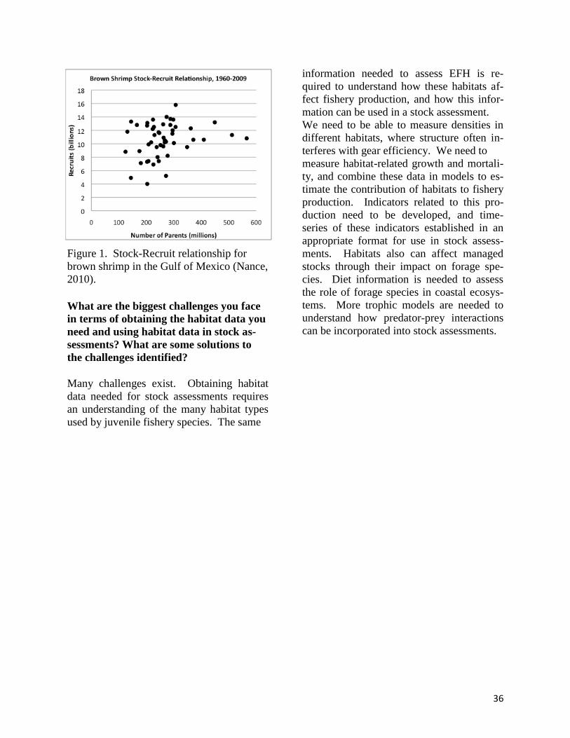
36
Figure 1. Stock-Recruit relationship for
brown shrimp in the Gulf of Mexico (Nance,
2010).
What are the biggest challenges you face
in terms of obtaining the habitat data you
need and using habitat data in stock as-
sessments? What are some solutions to
the challenges identified?
Many challenges exist. Obtaining habitat
data needed for stock assessments requires
an understanding of the many habitat types
used by juvenile fishery species. The same
information needed to assess EFH is re-
quired to understand how these habitats af-
fect fishery production, and how this infor-
mation can be used in a stock assessment.
We need to be able to measure densities in
different habitats, where structure often in-
terferes with gear efficiency. We need to
measure habitat-related growth and mortali-
ty, and combine these data in models to es-
timate the contribution of habitats to fishery
production. Indicators related to this pro-
duction need to be developed, and time-
series of these indicators established in an
appropriate format for use in stock assess-
ments. Habitats also can affect managed
stocks through their impact on forage spe-
cies. Diet information is needed to assess
the role of forage species in coastal ecosys-
tems. More trophic models are needed to
understand how predator-prey interactions
can be incorporated into stock assessments.
37
RETHINKING ESSENTIAL FISH HABITAT
Session Organizers: Michael Parke (PIFSC) and Waldo Wakefield (NWFSC)
In this session, each region discussed the
opportunities and challenges associated with
designating EFH and using EFH designa-
tions to conduct meaningful consultations.
Currently these designations are difficult to
review/revise and not as helpful as they
could be for NOAA to conduct consulta-
tions. As NMFS and the Fishery Manage-
ment Councils develop and adopt Ecosystem
Based Fisheries Management plans, as man-
agers and scientists designate EFH in dy-
namic habitats under climate change, and as
non-fishery impacts to habitats within EFH
become more commonplace and extensive,
scientists and managers need guidance to
improve both the EFH reviews and the des-
ignations. The presentations summarized
below highlighted EFH issues in broadly-
defined marine habitats for each region.
Rethinking Essential Fish Habitat:
Northeast Broad Continental Shelf David K. Stevenson (NERO)
Ever since the first EFH maps for 38 feder-
ally-managed species in the Northeast re-
gion were generated, they have been based
on level 2 relative abundance data (average
numbers per tow) derived from 60 years of
NEFSC spring and fall bottom trawl survey
data binned into ten minute squares of lati-
tude and longitude. More recent maps in-
clude state survey data and presence infor-
mation for the continental slope, beyond the
outer limit of the NEFSC surveys. Also, the
catch data on the shelf are conditioned by
preferred ranges of depth and average annu-
al bottom temperature. In the Northeast, the
Middle Atlantic and New England Fishery
Management Councils have followed the
Top Conclusions and Recommended Next Steps:
NMFS scientists and managers should prioritize habitat research based on habitat
productivity and threats to habitat health and functionality, but more basic habitat sci-
ence research needs to be conducted to ensure competent decisions can be made.
EFH designations and HAPC designations in particular, should incorporate data that
specifically addresses the conditions critical to early life history stages, with a special
focus on productive habitats that are most at risk from anthropogenic or climate-
induced degradation.
Better mechanistic models should be developed to forecast responses under novel
and/or rapidly-changing habitat conditions.
Non-fishing impacts to EFH are becoming more prevalent. Proven conservation
measures that address common threats to EFH from a variety of ocean and coastal de-
velopments should be identified and implemented through cooperative regional ef-
forts.
Research should be conducted to enable EFH designations to include complex, guild,
or life-stage specific designations.
Support from leadership at the regional and national levels is needed to make any of
these a reality.
38
advice provided in the EFH Final Rule and
defined EFH in a risk-averse manner, i.e.,
over fairly broad geographic areas. General-
ly speaking, single species and life stage
designations that are more habitat and area-
specific are preferable for EFH consultation
purposes, but in many cases (e.g., pelagic
species) this is not practicable. Broader
EFH designations that account for a wider
range of temporal or spatial variability may
be more “accurate”, but less useful for con-
sultation purposes than designations that fo-
cus on more normal or preferred ranges of
depth, temperature, etc.
Climate change and changes in population
size should be factored into future EFH des-
ignations in the Northeast region. The spa-
tial distributions of 24 out of 36 New Eng-
land and Mid-Atlantic stocks have shifted
northwards or into deeper water in recent
years in response to increasing seawater
temperatures. Changes in distribution can
easily be detected in the 60-year time series
of bottom trawl survey data, so one obvious
way to improve EFH designations in this
region is to analyze a shorter and more re-
cent time series of data rather than relying
on the full 60 years of data. Including habi-
tats or locations that have been used histori-
cally (e.g., at the southern limit of a species’
range), as recommended in the EFH Final
Rule, would no longer apply if this approach
were taken. Analysis of relative abundance
during periods of low and high population
size in the trawl survey time series would
reveal whether there are species that occupy
more preferred habitats when they are less
abundant. Accounting for these two factors
when identifying and describing EFH may
not be as easy as it sounds since climate
change (a long-term trend in distribution)
and population size changes (reversible,
shorter-term “pulses” in distribution) over-
lap temporally and will differentially affect
individual species and life stages. Habitat
modeling that incorporates a broader range
of habitat variables should also be evaluated
as a means for improving future designa-
tions.
Rethinking EFH for Bering Sea ground-
fish – using periodic reviews and basin-
scale modeling to refine and elevate the
designations
Bob McConnaughey (AFSC) and Matt Ea-
gleton (AKRO)
In 1996, Congress mandated NOAA Fisher-
ies to describe and identify EFH for all fed-
erally managed species in the nation’s Ex-
clusive Economic Zone. By legal definition,
EFH means those waters and substrate nec-
essary to fish for spawning, breeding, feed-
ing, or growth to maturity. Using the best
scientific information, FMPs must describe
and identify EFH in text that clearly states
the habitats or habitat types determined to be
EFH for each life stage of the managed spe-
cies. These descriptions should explain the
physical, biological, and chemical character-
istics of EFH and must also identify the spe-
cific geographic location or extent of habi-
tats described as EFH.
Designating EFH is particularly challenging
in the Alaska region, since 70% of the U.S.
continental shelf and more than 130 man-
aged species occur there. Similar to other
regions, useful environmental data are
scarce. Currently, the EFH for a particular
life stage of a managed species is defined as
the area encompassing 95% of that Alaska
population. This so-called general distribu-
tion is based on catch data from fishery-
independent surveys and fishery observer
reports where density data should reflect
habitat utilization, and the degree to which a
particular habitat is utilized is assumed to be
indicative of habitat quality. Where infor-
mation is insufficient and a suitable proxy
cannot be inferred, EFH is not described.
The Level-1 general distribution is used to
describe EFH for all stock conditions
39
whether or not higher levels of information
exist, because the available higher level data
are not sufficiently comprehensive to ac-
count for changes in stock distribution (and
thus habitat use) over time. At present, Lev-
el-1 EFH descriptions are available for 45%
of the 24 stocks x 5 life stages covered by
the 2012 FMP for Groundfish of the Bering
Sea – Aleutian Island Management Area. In
many of these cases, there is considerable
overlap in the geographic extents and the
habitat descriptions for the species. Clearly,
more refined designations would increase
the significance of EFH in the resource con-
servation and management process.
In practice, there are a variety of methods
that could be used to improve the EFH de-
scriptions for the Alaska region. Some rely
on purely geophysical characterizations but
these are overly simplistic and may ignore
significant factors such as temperature that
affect species distributions. Similarly, stand-
ardized habitat-classification schemes are
too restrictive in that they do not adequately
account for the continuous nature of envi-
ronmental variability or the associated con-
tinuous biological responses. In the eastern
Bering Sea (EBS), abundance estimates
from annual bottom trawl surveys are being
combined with synoptic environmental data
to develop basin-scale continuous-valued
habitat models for groundfish and benthic
invertebrates. The resulting Level-2 habitat
definitions are objective and have quantifia-
ble uncertainty. Predictions are possible and
useful performance metrics can be devel-
oped when considering new environmental
inputs. The models are developed with an
iterative process that first assembles existing
data to build 1st generation models. Promis-
ing new predictors are then evaluated in lim-
ited-scale pilot studies, followed by a direct
comparison of alternative sampling tools.
Finally, the most cost-effective tool is used
to map the new variable over the shelf and
the existing model for each species is updat-
ed to complete the iteration. As an example,
the ongoing FISHPAC project is systemati-
cally investigating whether the existing
habitat models for the full EBS continental
shelf can be improved with quantitative in-
formation about seafloor characteristics.
In general, the Alaska region “rethinks”
EFH on a continuing basis to ensure the
highest level of scientific information is be-
ing used. This includes the incorporation of
new analytical methods and a comprehen-
sive review every five years (see the 2010
review at http://www.fakr.noaa.gov/habitat/
efh/review.htm). Perhaps the single greatest
challenge today is to develop a working def-
inition of “essential” to identify the (neces-
sary) habitat required to support a sustaina-
ble fishery and the managed species’ contri-
bution to a healthy ecosystem. To this end,
close collaboration with stock assessment
specialists would almost certainly be pro-
ductive.
Rethinking Essential Fish Habitat (EFH)
for Pacific Islands Coral Reefs Robert Schroeder (PIRO)
In the US Pacific Islands Region, coral reef
ecosystems provide over 15,000 km2 of ben-
thic habitat for several hundred federal man-
agement unit species listed in the Fishery
Ecosystem Plans (FEPs) for American Sa-
moa, the Mariana Archipelago (Guam and
Commonwealth of the Northern Mariana
Islands), the Hawaii Archipelago, and the
Pacific Remote Island Areas (2010). The
FEPs embody an ecosystem approach to
management by including adaptive man-
agement that considers uncertainty. In addi-
tion to managing target taxa for sustainabil-
ity, conservation of other ecosystem compo-
nents, including EFH, is promoted.
Potential effects of climate change may im-
pact coral reef habitat primarily through
bleaching and ocean acidification, where
40
resulting loss of structural complexity can
reduce habitat essential to maintain reef fish
abundance and diversity. Other concerns
could be sea-level rise, shifts in major oce-
anic currents, and increased storms and
wave energy, resulting in increased coastal
erosion, and sedimentation and turbidity on
reefs.
In the Pacific Region, consultations to avoid
and minimize impacts to marine habitat im-
pacts, consistent with a number of mandates
(e.g., Magnuson-Stevens Fishery Conserva-
tion and Management Act, Fish and Wildlife
Conservation Act, Clean Water Act), focus
primarily on non-fishing impacts. These in-
clude cumulative effects of coastal devel-
opment (e.g., Guam military build-up), and
increasing offshore development (e.g.,
ocean-based energy [ocean thermal energy
conversion, wind], and offshore aquaculture
ventures).
EFH in the Pacific is defined broadly mainly
by depth contours, which is not always most
useful for consultations on impacts of feder-
al agency actions. More detailed data are
needed to inform EFH consultations from
studies such as those that: 1) characterize the
habitat/resources at local specific sites (vs.
general status/trends at the island level), 2)
determine the functionality of habitats (e.g.
value of soft sediment, movement of
eggs/larvae in water column), 3) character-
ize habitat response to the various impacts
(e.g. impacts to eggs/larvae, corals, algae
from discharge of cold/nutrient rich water
shallow, impact to corals from turbidi-
ty/sedimentation, changing coral growth
rates), and 4) better understanding the finer
scale habitat utilization patterns, including
determining spawning and nursery habitats
of key coral reef ecosystem species.
Current progress to resolve such data gaps,
while limited, includes: the Guam Habitat
Blueprint, which intends to provide a review
of the science and needs evaluation, analysis
of fish-habitat links, development of an At-
lantis Ecosystem Model (based on ecosys-
tem and trophic structures), and improving
the accuracy and defensibility of EFH con-
sultations. Other efforts include studies of
multi-ecosystem parameters of the reef to
improve understanding of reef resilience re-
lated to climate change in Saipan, Com-
monwealth of the Northern Marianas.
Southeast United States and Caribbean
Coral Reefs
Todd Kellison (SEFSC) and Jocelyn
Karazsia (SERO)
The NMFS Southeast Region is entrusted
with the conservation, management, and
protection of marine fishery resources in-
habiting federal waters off the southeastern
United States from North Carolina through
Texas and the U.S. Caribbean. The Region
works directly with three Fishery Manage-
ment Councils (Gulf of Mexico, South At-
lantic, and Caribbean) to implement Fishery
Management Plans for Corals and Coral
Reefs, as well as numerous fish species that
utilize coral reef habitats. The NMFS
Southeast Fishery Science Center (SEFSC)
performs surveys and multi-disciplinary re-
search to support these efforts, including (1)
acoustic mapping to determine the distribu-
tion of habitat types and (2) assessment of
relationships between fish and invertebrate
distributions and habitat characteristics.
Both the Region and the SEFSC have re-
sponsibilities for understanding and address-
ing non-fishing impacts to coral reef ecosys-
tems in the South Atlantic and Caribbean as
well. Through gaining a better understand-
ing of the distribution and types of coral reef
habitats, the support functions these habitats
provide to federally managed fisheries and
connected habitats, and the threats they face,
41
refinements can be made in designations for
EFH and HAPCs.
Refining EFH for Species of the Califor-
nia Current Ecosystem in a Dynamic
Landscape
Eric Chavez (SWRO) and Waldo Wakefield
(NWFSC)
EFH has been designated for fishes that are
managed under four FMPS in the California
Current Ecosystem (CCE). These FMPs
include Pacific Coast Salmon (Chinook, co-
ho, and pink salmon), Pacific Coast Ground-
fish (over 90 flatfishes, rockfishes, and other
groundfishes), Coastal Pelagic Species (Pa-
cific sardine, Pacific mackerel, northern an-
chovy, jack mackerel, market squid, and
krill), and Highly Migratory Species (sharks,
tunas, billfish, and dorado). Designating
and refining EFH effectively for these spe-
cies can be challenging due to a variety of
factors, including associations with dynamic
habitat features (e.g., temperature regimes),
habitat requirements in both fresh and ma-
rine waters, limited data for one or more life
history stages, uncertainty regarding effects
of environmental factors on productivity and
the ability to anticipate those effects, and
complex trophic interactions, such as preda-
tor-prey relationships among species man-
aged under different FMPs. In addition, the
ability to identify, and protect EFH from,
anthropogenic threats is becoming increas-
ingly important amid a growing human pop-
ulation, increased interest in marine hydro-
kinetic energy development, and climate
change. Climate change is a particularly
challenging threat given its potential for
causing drastic changes in the CCE and our
inability to predict what those changes may
be. Ecosystem based management (EBM)
could prove to be an effective tool for ad-
dressing these varied issues. The Pacific
Fishery Management Council recognizes the
importance of EBM and is developing a
fishery ecosystem plan. However, this pro-
cess is still in its early stages, and many of
the details on how the plan will be imple-
mented and incorporate EFH still need fur-
ther development.
West Coast Ecosystem Based Fishery
Management and Essential Fish Habitat
Strategies
Yvonne deReynier (NWRO)
Since 2009, the Pacific Fishery Management
Council (Council) has been engaged in par-
allel science and policy processes to develop
an FEP and to conduct required 5-year re-
views of EFH designations. The Council
anticipates sending out a public review draft
FEP in early 2013, and is tentatively sched-
uled to adopt a final FEP in March 2013. In
2015 and beyond, the FEP could spur a
more coordinated look at EFH across the
Council’s fishery management plans. A co-
ordinated, cross-species EFH review de-
pends largely on whether NOAA can ap-
proach the science and policy preparations
needed for EFH reviews as an ongoing dia-
logue, rather than as discreet events separat-
ed by 5 year increments.
NOAA has been developing science in sup-
port of ecosystem-based management
through looking at ecological relationships
that marine and estuarine species have with
each other and with the biophysical envi-
ronment. Applying the ecosystem approach
to our habitat science and management
would force us to think more about not just
the particular habitat needs of our managed
species, but also about how the habitat needs
of all of our species interact with each other.
At its simplest, ecosystem-based manage-
ment is just a different way of thinking
about the work that we are already doing. It
requires not only new approaches to science
and management, but also changes in agen-
cy culture. It requires, at all levels of the
42
agency, that we listen to each other, to our
colleagues in other agencies, and to the pub-
lic, and that we think about how the connections
between our work reflect the ecological connec-
tions between the resources we manage. Im-
proving communication and understanding
within and beyond NOAA can ultimately
help us to support our forward-thinking
Fishery Management Councils in all of their
work, including their EFH efforts.
Breakout Groups
After the presentations, participants broke
out into smaller groups to further discuss
specific EFH needs, challenges, and oppor-
tunities moving forward. Each group fo-
cused on one of four scenarios: ecosystem-
based fisheries management (EBFM), habi-
tat and stock size variability, variability due
to climate change, and non-fishing impacts.
Managers need guidelines on how to incor-
porate the growing list of variables and im-
pacts into EFH designations, and how EFH
reviews can be incorporated into an EBFM
framework. Though the effects of fishing on
EFH have been considered extensively, nat-
ural variability and non-fishing impacts (e.g.
offshore development, aquaculture, cumula-
tive shoreline development) have not. This
session was designed to identify the steps
necessary to improve the accuracy of EFH
designation in light of these challenges.

43
Breakout Group 1: Rethinking Essential Fish Habitat with a Focus on
Ecosystem-Based Fishery Management
Reporter: Pace Wilber (SERO)
Facilitator: Steve Brown (S&T)
Rapporteur: Terra Lederhouse (OHC)
Current statutes address the protection and
conservation of EFH. While the 1996 reau-
thorization of the Magnuson-Stevens Fish-
ery Conservation and Management Act
(MSA) is most closely identified with pro-
tection and conservation of EFH, protection
of habitats that are EFH is addressed by the
Federal Power Act (1920), Fish and Wildlife
Coordination Act (1934), Clean Water Act
(1972), Endangered Species Act (1973), Ex-
ecutive Order 11990 - Wetland Protection
(1977), Executive Order 13089 - Coral Reef
Protection (1998), and Coral Reef Conserva-
tion Act (2000), among others. So why is
the amount of habitat used by fishery spe-
cies still being lost (Stedman and Dahl 2008,
Dahl 2011)? Workshop participants agree
that broad EFH designations hamper the
protection and conservation of EFH. They
also agree that geographically focused EFH
designations based on strong scientific prin-
ciples will garner the support necessary to
reverse the loss of habitats essential to sup-
porting fisheries and providing other ecosys-
tem services necessary to sustain resilient
and thriving marine and coastal resources,
communities, and economies. Current EFH
regulations set the stage for a geographically
focused, scientifically justified EFH pro-
gram. The regulations identify four levels of
Top Conclusions and Recommended Next Steps:
Engage scientists from NMFS Science and Technology, Office of Habitat Conserva-
tion (e.g., NOAA Chesapeake Bay Office), NOAA science centers, and fishery
management councils for guidance on where habitat management can impact stock
status
Efforts to examine the ecology of early life stages of fishes should match the efforts
spent on adult fishes and begin by committing resources to understand the habitat
requirements and ecology of the life history stages of fishes that create “bottlenecks”
to the productivity of managed fish species
Develop EFH designations that focus more on habitat conditions that are truly es-
sential to species productivity, especially larval and early juvenile life stages that
utilize inshore habitats that are most at risk from environmental loss and degradation
Investigate opportunities for including risk management approaches in EFH desig-
nations and habitat management decisions
Develop protocols for determining the habitats most vulnerable to specific threats on
a local basis
Increase communication between biologists and hydrographers to determine how
technologies such as airborne LIDAR and multibeam sonar can be used to increase
knowledge of shallow water habitats and how multibeam echo sounders (e.g.,
ME70) can increase knowledge of coastal habitats.
44
EFH information: distribution data; habitat-
related densities; growth, reproduction, and
survival rates within habitats; and produc-
tion rates by habitat (50 CFR
600.815(a)(iii)(A)) and require EFH desig-
nations at the highest information level sup-
ported by the available scientific infor-
mation (50 CFR 600.815(a)(iii)(B)). In oth-
er words, EFH designations would ideally
focus upon locations where production is
high and fishes experience superior rates of
growth, survival, and reproduction, and re-
views of impacts to EFH from proposed pro-
jects would focus upon actions that diminish
these rates.
The report from this breakout group uses
two questions to summarize the discussions:
How can EFH designations and reviews
of proposed impacts to EFH be im-
proved?
What research is needed to improve EFH
reviews and designations?
These discussions included identification of
reasonable next steps, which was the third
item the group was asked to address. While
other breakout groups from the Rethinking
Essential Fish Habitat session also focused
on these questions, our group was tasked
with examining these questions from the
perspective of ecosystem-based fishery
management (EBFM). Our breakout group
did not begin by defining EBFM, but basic
principles outlined within NOAA’s 1999
report to Congress on ecosystem-based fish-
ery management were touched upon in the
discussion, namely habitat and species di-
versity are important to ecosystem function-
ing, multiple scales interact within and
among ecosystems, components of ecosys-
tems are linked, ecosystem boundaries are
open, and ecosystems change with time.
The majority of our discussion was in on
improving EFH designations and reviews by
focusing management efforts on the habitats
used by the early life stages of fishes.
How can reviews of proposed impacts to
EFH be improved?
The breakout group strongly believes NO-
AA should focus more attention upon habi-
tat requirements and ecology of the early life
stages of fishes. Traditional fishery man-
agement studies the ecology of adult fishes
and forecasts their abundance because, gen-
erally speaking, adults make up most of the
fishable population. Due mostly to passage
of the MSA in 1976, NOAA Fisheries has
made great strides in managing populations
of adult fishes by limiting fishing mortality.
A similar effort is needed for larval and ju-
venile fishes (especially young-of-the-year
juveniles) because these life stages are
where most habitat-related mortality occurs,
and where habitat management can have the
most positive effect.
Refined EFH designations for larval and ju-
venile fishes should focus on habitat condi-
tions that are truly essential to species
productivity. One way to focus habitat pro-
tection and restoration efforts would be to
designate areas with habitat mosaics (e.g.,
tidal creeks in close proximity to oyster bars,
intertidal mud flats, and salt marsh vegeta-
tion) that afford larval and juvenile fishes
with more opportunities to grow and survive
to adulthood as Habitat Areas of Particular
Concern (HAPCs). An additional approach
would base HAPC designations on groups of
species with similar habitat requirements
and geographic distributions, and this may
include using indicator species or life stages
as an efficient way to proceed. Further,
NOAA should use its broader authorities to
focus habitat protection measures on habitat
mosaics and multi-species HAPCs that are
strongly associated with other ecosystem
services in addition to serving as fish nurse-
ry areas. For example, while there is no
45
federal fishery management plan for Ameri-
can shad, its abundance in coastal waters
affects the value of EFH by contributing to
the amount of food present for federally
managed species. The Federal Power Act
affords NOAA Fisheries with one of its
stronger environmental authorities, and ex-
ercising this authority 100 or more miles
from the coast in support of ocean-river mi-
gratory fishes nonetheless affects the level
of support that EFH provides to species
managed under the Magnuson-Stevens Act.
The EFH 5-year reviews required by the
Magnuson-Stevens Act provide a means for
focusing attention upon habitat requirements
and ecology of the early life stages of fishes.
NOAA Fisheries leadership provided gen-
eral guidelines for accomplishing the initial
round of EFH 5-year reviews. Guidelines
for the next set of 5-year reviews should fo-
cus on using EBFM principles to identify
and bolster protection of fish nursery areas.
This goal should be set as early as possible
so that fishery management councils, NOAA
Fisheries regional offices, and NOAA's sci-
ence centers can obtain the resources needed
to make recommendations in 5-year reviews
that can be immediately used to augment
EFH designations.
As noted above, a specific point that should
be addressed for the next set of 5-year re-
views is the value to basing EFH designa-
tions on groups of species with similar habi-
tat requirements and geographic distribu-
tions regardless of whether the species are
grouped in the same fishery management
plan. Most multispecies fishery manage-
ment plans were set before the Magnuson-
Stevens Act included EFH provisions.
While the groupings may support fishery
management in the traditional sense, the
groupings may obscure shared dependencies
in habitat use. This approach would more
readily illustrate the value of particular habi-
tats as EFH that accumulates when multiple
fishery management plans are considered
concurrently.
Another specific suggestion made by the
group for identifying life history stages and
habitats that are most in need of protection
and/or restoration is to evaluate relative hab-
itat value by life stage using a rank ordering
approach that includes life stage sensitivity
(to habitat impacts), habitat rarity, and
threats to habitat as weighting factors. This
approach would probably work best for spe-
cies that rely on inshore habitats and for
which there is sufficient information to sup-
port scientifically defensible scoring. This
approach also could be part of the next cycle
of 5-year reviews.
What research is needed to improve EFH
reviews and designations?
The boundary between adopting a new re-
view process and researching a new review
process is not distinct because improving
reviews of proposed impacts to EFH grades
into improving the science that underlies
those reviews. This is especially true for the
next recommendation.
NOAA Fisheries should assess the value of
using risk management approaches for EFH
designations and reviews. This assessment
would include determining if use of risk
management approaches would require
changes to EFH regulations. Risk manage-
ment is the identification, assessment, and
prioritization of risks (defined as the effects
of uncertainty on environmental and project
objectives). The prioritization of risks is
followed by coordinated and economical
application of resources to minimize, moni-
tor, and control the probability or impact of
unfortunate events or to maximize the reali-
zation of opportunities. Risk management
has an extensive literature in fields similar to
habitat and fishery management. Breakout
group participants believe initial results
46
from EFH reviews that used risk manage-
ment principles are encouraging and NOAA
would benefit from an assessment of a
broader use of risk management approaches.
A first step to applying risk management
principles to EFH designations and reviews
would include quantifying the habitat avail-
able and assessing whether the amount of
habitat is limiting generally or under specific
environmental conditions (e.g., identifica-
tion of “bottlenecks”).
Regardless of whether NOAA Fisheries
broadly adopts risk management approaches
for EFH designations and reviews, addition-
al data are needed on historical, current, and
projected future conditions of habitats used
by larval and juvenile fish. Projected future
conditions should consider reasonable rates
of climate change and human population
growth. The central question for this re-
search should be identification of limiting
habitats or the environmental conditions un-
der which a habitat becomes limiting. For
example, the combination of salinity and
temperature optimal for growth of penaeid
shrimp may currently place larval shrimp in
the portion of estuary where sufficient salt
marsh is present to provide food and protec-
tion from predators. However, sea level rise
and climate change may move the envelope
of optimal salinity and temperature upriver
into portions of the estuary where less marsh
habitat is present placing a higher premium
on protecting the marsh in these upriver
areas.
NOAA Fisheries' future efforts to examine
the ecology of early life stages of fishes
should match the efforts spent on adult fish-
es. Several states and universities already
are examining inshore habitat-related growth
and mortality of fishes as well as conducting
general assessments of inshore populations,
habitats, and habitat threats. Mining these
data and collaborating on future research
efforts present opportunities to improve our
understanding of early life stages of fishes.
The workshop included presentations from
NOAA Oceans and Coasts and NOAA Re-
search on their research efforts and technol-
ogy transfer products that could inform EFH
designations and reviews, especially if ac-
cessibility to the data and products is im-
proved. Examples include monitoring of
physical conditions (such as Integrated
Ocean Observing Systems Regional Associ-
ations), habitat classification systems (such
as the CMECS), and habitat mapping and
modeling (such as the mapping of coral reef
habitats by the Center for Coastal Monitor-
ing and Assessment).

47
Breakout Group 2: Rethinking Essential Fish Habitat with a Focus on
Habitat and Stock Variability
Reporter: Waldo Wakefield (NWFSC)
Facilitator: Jaclyn Daly (SERO)
Rapporteur: Kimberly Clements (SERO)
This breakout group tackled a number of
questions regarding the opportunities and
challenges associated with designating EFH
and using EFH designations to conduct
meaningful consultations.
What are realistic expectations over the
short- to medium-term for refining EFH
designations?
The discussion began with a consideration
of what are realistic expectations over the
short- to medium-term for refining EFH des-
ignations. Rather than focusing on refining
designations some members of the group
took an alternative view that the current
broad approach to designation does not need
to be refined, and that broad designation al-
lows NMFS greater flexibility in developing
consultations. This broad approach runs
counter to an often voiced criticism that in
EFH designation, “everything is essential.”
As species-specific information on habitat
function continues to be limiting, HAPCs
remain a critical tool to prioritize EFH con-
sultations. Given the current funding and
staffing outlook, there was a consensus that
only minor changes would occur in the
knowledgebase on EFH for any given FMP.
Top Conclusions and Recommended Next Steps:
Science Centers should do more to work with managers to determine the highest-
priority habitats, in terms of conservation need, and the impacts most likely to affect
those habitats. Regions need to better communicate science needs to Centers, while
Centers need to better communicate their science to managers.
In some respects, the current broad approach to EFH designation does not need to be
refined, and broad designation allows NMFS greater flexibility in developing con-
sultations.
Our current understanding of potential impacts is limited by the amount of level-3
(growth, reproduction, or survival rates within habitats) and level-4 (production rates
by habitat) data.
Consider refining EFH designation to enable complex-, guild- or life-stage specific
designations.
HAPCs remain a critical tool to prioritize EFH consultations.
The integration of modeling with GIS tools, and emerging and associated internet-
based data catalogs and mappers, will facilitate consideration of spatial and temporal
variability in stocks and habitats.
Prioritize habitat research based EFH designation.

48
What are the main impediments to using
EFH for meaningful consultations?
The main impediments to using EFH for
meaningful consultations include the static
and somewhat vague language providing
guidance on the description, and identifica-
tion of EFH in FMPs, adverse impacts on
EFH, and actions to conserve and enhance
EFH - this is of particular concern for near-
shore consultations. In the future, having
more level 3 (growth, reproduction, or sur-
vival rates within habitats) and level 4 (pro-
duction rates by habitat) information will
improve the understanding of potential im-
pacts. In a changing, potentially more vari-
able environment, with a broad array of ex-
isting and emerging non-fishing impacts, it
will be important to maintain existing and
develop new partnerships with institutions
and agencies outside of NMFS. The breadth
of expertise and resources required to keep
pace with emerging habitat-related research
needs demands that NMFS continue to fos-
ter partnerships with other groups, both
within and outside of NOAA.
What science is needed to revise/refine
EFH designations to better meet the needs
of the management community?
The group recognized the basic need for in-
formation on habitat associations and habitat
use when discussing science in support of
revising or refining EFH designations to bet-
ter meet the needs of the management com-
munity. For example, how does a species
use the habitat being impacted - for shelter,
foraging, reproduction, etc. The group also
put a great deal of stock in GIS tools and
fishery modeling in developing a better un-
derstanding of how fishes use habitat both
spatially and temporally, especially in a
changing environment. GIS tools were also
highlighted for making EFH information
more accessible during 5-year reviews – es-
pecially when used in conjunction with In-
ternet-based data catalogs and mappers.
49
Breakout Session, Group 3: Rethinking Essential Fish Habitat with a
Focus on Non-Fishing Impacts
Reporter: John Stadler (NWRO)
Facilitator: Janine Harris (OHC)
Rapporteur: Kristan Blackhart (S&T)
In this session, each breakout group was
asked to answer a number of questions re-
garding the opportunities and challenges as-
sociated with EFH and using EFH designa-
tions to conduct meaningful consultations.
However, because the effects of non-fishing
activities on EFH are not directly related to
the designation of EFH, this breakout group
did not focus on the trigger questions. In-
stead, the group spent time discussing the
opportunities and challenges associated with
describing, in FMPs and elsewhere, the non-
fishing activities that may adversely affect
EFH and how those descriptions and associ-
ated conservation measures can be used to
improve consultations. Ultimately, collating
conservation measures for categories of non-
fishing impacts could reduce consultation
workload and increase the predictability of
the outcomes of consultations for the public
and federal action agencies.
The goal for this breakout group was to de-
velop 2 to 3 reasonable next steps for im-
proving descriptions of specific categories
of non-fishing activities that may adversely
affect EFH and the conservation measures
that can be recommended to avoid, mini-
mize, or otherwise offset those effects.
The non-fishing effects section of FMPs can
be utilized in subsequent EFH consultations
in several ways. The primary value of this
section is to provide guidance to Federal ac-
tion agencies and the public on how NOAA
Fisheries will analyze the effects of pro-
posed actions and the types of measures
likely to be recommended to avoid, mini-
mize, or mitigate those effects. When an ac-
tion is designed to account for these effects,
EFH is conserved and the post-application
EFH consultation workload is lessened. This
can be especially important in regions where
the EFH consultation workload puts severe
Top Conclusions and Recommended Next Steps:
Comprehensive, detailed, and up-to-date descriptions of non-fishing impacts to EFH
and associated conservation measures allow action agencies and applicants to improve
their actions and reduce consultation requirements.
Comprehensive descriptions of specific categories of non-fishing impacts to EFH and
applicable conservation measures should be developed cooperatively for all regions.
Support from leadership at the regional and national levels is needed.
Additional participation from Science Center staff in the development of the descrip-
tions of specific categories of non-fishing impacts and applicable conservation
measures would lend such efforts greater scientific credibility.
Documentation of the specific categories of non-fishing impacts and the applicable
conservation measures must be updated regularly to remain timely and should be
viewed as a “living document.”
50
demands on human resources and the re-
gions are forced to prioritize which consulta-
tions, or types of consultations, to work on.
Having a comprehensive, detailed, and up-
to-date description and associated conserva-
tion measures for activities that may ad-
versely affect EFH could be considered a
quasi-programmatic consultation that action
agencies and applicants can use to improve
their actions, thereby reducing the consulta-
tion workload. This could also improve the
prioritization process in the regions. Such a
compilation of descriptions and conservation
recommendations, including updates as nec-
essary, should be a top priority for all re-
gions.
Comprehensive descriptions of non-fishing
activities that may adversely affect EFH
have been developed by several regions. The
first was a 2003 cooperative effort by the
Southwest, Northwest, and Alaska Regions
(Hanson et al. 2003) that included non-
fishing activities in riverine, estuarine, and
coastal and marine environments. This effort
produced a stand-alone document that con-
tains generic descriptions and conservation
recommendations that were not targeted at a
specific FMP. It was subsequently incorpo-
rated, as written, by the Pacific Fisheries
Management Council as an appendix the
Pacific Coast Groundfish FMP. This docu-
ment was also incorporated into North Pacif-
ic Fishery Management Council FMPs, but
in a modified form to make it more regional-
ly-applicable. Since then, both the Northeast
and Alaska Regions have produced updated
and regionally-specific versions of the 2003
document.
The group discussed approaching this issue
from a national perspective and whether it
made sense to put together a comprehensive
description of the non-fishing effects to EFH
that would be applicable across all regions.
There was general consensus that if such a
document were developed, it would need to
be tailored to the specific needs of each re-
gion, much as the 2003 document was tai-
lored to the needs of the Alaska Region.
Opinions were varied over the utility of a
national effort with some members of the
group holding the position that inter-
regional differences in activities and habitat
types were sufficiently large to negate the
advantages of a national effort. Examples of
regional differences include: 1) agriculture
may have significant effect on EFH in some
regions, but not in others (e.g. Alaska); and
2) shallow, reef-forming corals are im-
portant habitats in some regions (e.g. South-
east, Pacific Islands) but not in others (e.g.
Northwest, Northeast).
Others recognized the regional differences,
but held the opinion that efficiencies could
be gained from such an effort because the
underlying effects and conservation recom-
mendations for many of the activities would
be widely applicable. For these activities, it
makes sense to cooperate across the regions
when developing those sections. Doing so
would ensure that the descriptions and con-
servation recommendations are based on the
same underlying data for all regions, even if
they vary for regional-specific reasons. For
other activities the regional differences
could negate any gains in efficiency. One
approach would be for each region to devel-
op or update their non-fishing effects docu-
ment individually, but commit to share their
products with other regions. An important
point regarding pursuing this as a national
effort – there will be a need for support from
NOAA Fisheries managers, at both the re-
gional and national levels, to ensure that the
required resources are made available to
support the effort.
Regardless of whether or not a national ef-
fort is pursued, the group thought that the
descriptions of the individual activities
51
should include a section that describes the
data and research needs. For many of these
non-fishing activities, the effects on aquatic
resources are not fully understood.
Another topic discussed by participants is
the extent of involvement from Science Cen-
ters. For the 2003 non-fishing activities doc-
ument produced by the Northwest, South-
west, and Alaska Regions, the descriptions
and conservation recommendations were
developed by Habitat Conservation Division
staff from the three Regions. While Science
Center staff reviewed much of this text, they
did not take an active role in its develop-
ment. One advantage of more active in-
volvement from Science Centers in future
development of similar documents would be
to improve the technical merit of the final
products and perhaps result in greater ac-
ceptance by action agencies and the public –
leading to better project design that can
eliminate the need for, or reduce the time
required to conduct, EFH consultations. Sci-
ence Center participants agreed with this
concept and also agreed to try to increase
their involvement in the process. However,
representation by Science Center staff was
limited in this breakout group so widespread
commitment was not possible. It should be
noted that greater cooperation between the
Regions and Centers is called for under the
Habitat Blueprint.
Greater technical merit could be also gained
by subjecting non-fishing impact descrip-
tions to peer- review, publishing documents
through the NOAA Technical Memo series,
or publishing through the American Fisher-
ies Society, which would lend the most cred-
ibility. However, it is important to bear in
mind the need to ensure that such peer re-
views or publications are done in a timely
manner so that NOAA Fisheries can meet
the timing of the EFH reviews and to ensure
that the information is still relevant and not
out of date. In addition, most members of
the group preferred to look at the descrip-
tions as a “living document” – one that
would allow NOAA experts to update the
descriptions and conservation measures as
new information became available.
While the group discussion was focused
primarily on the best means of developing
comprehensive, up-to-date descriptions and
conservation recommendations for activities
that may adversely affect EFH, we did dis-
cuss two other topics. The first regarded the
issue of invasive species (e.g. lionfishes and
invasive tunicates) and how to consider
them in the context of non-fishing impacts.
It was suggested that because the presence
of these species may impair normal habitat
functions and their presence can be mapped
(e.g. invasive tunicates that smother the ben-
thic community), it may make sense to in-
corporate the presence of some of these into
the EFH designation process. However,
some managers expressed the concern that
the ability to conserve EFH could be weak-
ened by such an approach. There was gen-
eral consensus that invasive species is a se-
rious concern, but there was no consensus
on how to address this issue. While the topic
of invasive species is incorporated into the
descriptions of other activities, the challenge
is that NOAA can address them only when
they are tied to a Federal action. Addressing
these issues more strongly in the non-fishing
activity descriptions can help but it does not
solve the problem.
The group briefly discussed efforts by the
Office of Habitat Conservation to develop a
new GIS tool for use in the Chesapeake Bay
that prioritizes key restoration and protec-
tion areas. The utility of such a tool for EFH
consultations was discussed. It has ancillary
benefits in that it can provide information to
be used in the development of EFH Conser-
vation Recommendations, but is generally
applicable at the site-specific scale. While
this tool has utility in EFH consultation pro-

52
cesses, it is currently limited to the Chesa-
peake Bay and would be difficult and costly
to expand it to a larger scale to make it more
broadly applicable.
53
Breakout Group 4: Rethinking Essential Fish Habitat with a Focus on
Climate Change
Reporter: John Manderson (NEFSC)
Facilitator: Tali Vardi (S&T)
Rapporteur: Lora Clarke (S&T)
This breakout group discussed opportunities
and challenges associated with designating
EFH and using EFH designations to conduct
meaningful consultations in the context of
climate change. Under the direction of the
facilitator, the group focused on the bolded
trigger questions below. Discussions cen-
tered on the requirement that mechanistic
understanding of species and community
rate responses (e.g. growth, mortality, re-
production, production) to habitat features
and changes in habitat features are required
in the face of climate change because organ-
isms are being exposed to novel habitat con-
ditions as a result of climate change. Mech-
anistic models are required for the forecast-
ing of novel states.
What are the impediments of including
climate change in EFH?
Dynamic climate driven pelagic habitat
properties and processes must be considered
in EFH if we are going to understand the
effects of climate change on marine habitats.
Many of these, including temperature, dis-
solved oxygen, pH, and circulation, are
driven by climate, and are fluid properties
and processes essential to forming habitats
in the sea.
EFH needs to evolve beyond merely cata-
loguing where animals are (level 1) and en-
vironmental characteristics organisms are
currently associated with (level 2) to a
mechanistic understanding of habitat effects
on vital rates and productive capacity (levels
3 & 4). Only this will allow for the devel-
opment of forecast models required. This
type of work is being done right now for
both terrestrial and marine species and eco-
systems (see Journals like Global Change
Biology). Setting this as a near term goal is
possible and not an overreach.
Top Conclusions and Recommended Next Steps:
Mechanistic models are needed to forecast responses under novel habitat conditions.
EFH needs to evolve to include a mechanistic understanding of habitat effects on vi-
tal rates and productive capacity.
We need to extend existing time series across warm and cold water regimes. Par-
ticular focus should be on maintaining annual time series, re-extending original spa-
tial coverage, and increasing temporal resolution (seasonal sampling) of monitoring
studies.
We need to develop sophisticated techniques for both downscaling global climate
models to forecast critical ocean habitat features and for upscaling process based
habitat studies of habitat effects on vital rates so we can extrapolate responses over
the broad space and time scales at which populations and ecosystems operate.
54
We must assess the vulnerability of regional
ecosystems, including the human communi-
ties that depend on them, to climate related
shifts in distributions of habitats, species and
species communities. Ecosystems and spe-
cies compositions are changing and are go-
ing to continue to change dramatically with
climate change. We must relinquish our
view that habitat, species distributions and
ecosystems are static in space and time in
the sea if we are to establish effective adap-
tive management strategies in the face of
climate change
What climate change science is needed to
inform EFH?
We need to monitor important ocean habitat
features that are driven by atmospheric forc-
ing at broad spatial scales and fine time
scales. Specifically, there is a need to ex-
tend or build upon existing time series that
cross warm and cold water regimes. Par-
ticular focus should be on maintaining annu-
al time series, re-extending original spatial
coverage, and increasing temporal resolution
(seasonal sampling) of monitoring studies.
This monitoring is essential if we are to de-
tect important but subtle changes in phenol-
ogy that will impact habitat suitability and
thus important species vital rates. Changes
in the timing and forcing of factors control-
ling production cycles may be critical in de-
termining whether there are matches or
mismatches between habitat conditions and
the life history event schedules of species.
Some of these essential climate driven habi-
tat features could now be cast relatively ac-
curately over broader spatial and finer time
scales than data collected using data assimi-
lative models.
We need to develop sophisticated techniques
for downscaling global climate models so as
to forecast critical ocean habitat features be-
yond just temperature. This includes circu-
lation patterns that control both population
and trophic connectivity, dissolved oxygen
concentrations, and primary and secondary
production. Similarly, we need to develop
methods to “upscale” process based habitat
studies of habitat effects on vital rates so we
can extrapolate responses over the broad
space and time scales at which populations
and ecosystems operate. This is essential for
developing an understanding of linkages of
individual species response (e.g., physiolo-
gy, behavior, survivorship) to that of climate
change, habitat dynamics, population dy-
namics, and ecosystem dynamics. Argua-
bly, the effects of climate change on popula-
tions and ecosystems may be best under-
stood through mechanisms of habitat dy-
namics.
Because climate change is producing novel
environmental conditions, mechanistic and
process based understanding of habitat ef-
fects on vital rates and productive capacity
are absolutely essential. Correlative, empir-
ical models will not accurately forecast re-
sponses under novel sets of habitat condi-
tions. Mechanistic models are required.
How can data be made available?
Internet and visualization tools can be used
to make data more available.
55
DAY 3: IMPROVING THE FLOW OF HABITAT SCIENCE
INFORMATION TO MANAGEMENT
Session Organizers: Pace Wilbur (SERO) and Korie Schaeffer (SWRO)
The goal of the session was to recommend
information transfer products that NMFS
habitat managers can use to inform EFH
consultations with federal action agencies
and EFH designation discussions with Fish-
ery Management Councils. This was a fol-
low-up session to sessions held at the 1st Na-
tional Habitat Assessment Workshop in
2010 that focused on current processes and
strategies for providing incorporating habitat
science into management. During the first
NHAW, participants came up with a number
of recommendations for improving the pro-
cess, including improved communication
and coordination between regional Science
Centers, Regional Offices, Restoration Cen-
ters, and NMFS Headquarters (See Black-
hart 2010).
To help facilitate improved communication
and coordination, this session specifically
focused on information transfer products
that can be used to improve the flow of sci-
entific information to management. The ses-
sion began with a presentation from each
region summarizing the manner in which
consultations currently utilize scientific in-
formation, successful examples of scientific
information or tools included in EFH or
FWCA consultations, and descriptions of
one or two habitat management issues that
affect many consultations and would benefit
greatly from the attention of NOAA scien-
tists.
Improving The Flow And Utility Of In-
formation From Science Centers To
Managers: Examples From The North-
east Region
Louis Chiarella (NERO)
Although our National discussions are fo-
cused on improving habitat science for man-
agement purposes it is first important to rec-
ognize our success. Since the implementa-
tion of the EFH requirements of the MSA in
1998, the Northeast Region has engaged in a
variety of activities to improve our under-
standing and management of fisheries habi-
tat.
These initial activities focused on providing
critical habitat and species information for
all the MSA managed species in the North-
east Region. The results were the EFH
Source Documents developed by the North-
east Fisheries Science Center which were
utilized in the identification and description
of EFH. More recent activities include de-
velopment of a deep sea coral predictive
model to assist us in the development of a
deep sea coral conservation strategy; a food
Top Conclusions and Recommended Next Steps:
An inshore-offshore decision support tool is needed to effectively help habitat manag-
ers evaluate the impacts of management decisions affecting onshore habitats on the
productivity of offshore fish populations
A small team of habitat managers and ecosystem scientists should be formed to fur-
ther define and develop this tool and outline next steps.

56
habitat study to better assist us in managing
anadromous fisheries through hydro dam
licensing activities; and the GIS mapping of
oceanographic and ecosystem parameters to
help us better understand potential resource
impacts from offshore energy development.
As with most of the science and manage-
ment issues within our organization we are
still faced with obstacles to more enhanced
collaborations. These include lack of dedi-
cated funding for habitat science, lack of
implementation of the strategic plan for hab-
itat science (Habitat Assessment Implemen-
tation Plan), and the inability to compete for
funding with the Stock Assessment Pro-
gram.
Three major areas where managers need bet-
ter habitat science include the areas of Off-
shore Energy Development and the assess-
ment of potential resource impacts from
these activities; general productivity issues
linking fish production to habitat variables;
and the economics of habitat protection as it
relates to costs and benefits to our resources
from various development activities.
Improving the Flow of Habitat Science
Information to Management in the
Southeast Region
Pace Wilber (SERO)
The NMFS Southeast Region works directly
with the Gulf of Mexico Fishery Manage-
ment Council (GMFMC), Caribbean Fishery
Management Council (CFMC), and South
Atlantic Fishery Management Council
(SAFMC) to protect, conserve, and restore
EFH. These Councils designated EFH
through comprehensive amendments to their
respective fishery management plans, and
these amendments are updated as new fish-
ery management plans are adopted (e.g.,
SAFMC’s fishery management plan for dol-
phin and wahoo) or new information became
available (e.g., SAFMC’s designations for
tilefish). The EFH amendments and sup-
porting National Environmental Policy Act
documentation are the chief reference mate-
rials for information about EFH in the re-
gion, although SAFMC supplemented these
materials in 2009 with Fishery Ecosystem
Plan of the South Atlantic Region. SAFMC,
GMFMC, and CFMC have completed their
5-year reviews of EFH designations as re-
quired by the Magnuson-Stevens Act. All
three Councils relied upon a contractor or
Council advisory panels to complete the re-
views. While SEFSC scientists were not
formally part of the 5-year review process,
SEFSC scientists contribute significantly to
the EFH programs primarily by examining
habitat-related growth and survival rates,
mapping distributions of deepwater corals,
and examining the early life history stages
of coral reef fishes. NOAA’s National Cen-
ters for Coastal and Ocean Science also con-
tributes significantly to the EFH program by
mapping seagrass, coral, and hardbottom
habitats and by developing mitigation plans
for impacts to seagrass habitat. New infor-
mation and tools that would enhance re-
views of proposed impacts to EFH include
quantifying the habitat and ecosystem ser-
vice linkages between inshore nursery areas
and offshore fisheries, identification of habi-
tat bottlenecks for fishery populations, and
refining time-of-year restrictions on con-
struction projects to optimize their use in
protecting the vulnerable, early life stages of
fishery species.
Improving the Flow of Habitat Science
Information to Management in the
Southwest Region
Korie Schaeffer (SWRO)
EFH provisions of the Magnuson Stevens
Fishery Conservation and Management Act
require that NMFS and Fishery Management
Councils designate EFH for all life history
57
stages of managed fishes and that Federal
agencies consult with NMFS regarding fed-
eral actions that may adversely affect EFH.
In California, EFH designations for 136 spe-
cies of groundfish, coastal pelagic, salmon-
ids, and highly migratory species encompass
the entire US Economic Exclusive Zone and
many of the coastal watersheds. While a
subset of managed fish species utilizes the
estuaries and nearshore marine areas for
some part of their life history, many are
found primarily in offshore marine areas.
EFH consultations are not distributed evenly
throughout designated EFH, but occur pri-
marily in coastal estuaries and nearshore
marine habitats, with hotspots in San Fran-
cisco Bay and Southern California. EFH
consultations often focus on urban, residen-
tial and agriculture development; transporta-
tion projects; and shoreline protection.
Southwest Region (SWR) staff conducts
consultations with the assumption that estu-
aries and nearshore marine areas provide
primary and secondary productivity for off-
shore areas, and therefore, have important
habitat function for managed species that
occur in these habitats as well as for those
species found in offshore habitats. NMFS
SWR staff primarily use the EFH sections of
Fishery Management Plans, scientific jour-
nal articles, and data generated by state and
regional partnerships and monitoring as
sources of information to conduct EFH con-
sultations. An ongoing issue of concern in
the SWR is the need to better understand the
link between estuaries and nearshore marine
areas and sustainability of offshore fish pop-
ulations. Other ongoing concerns include
cumulative impacts of small footprint pro-
jects, benthic community response to dis-
turbance, and the relative intensity and rela-
tionship of fishing impacts versus non-
fishing impacts to habitat.
Habitat Science Support for ESA and
EFH Consultations Northwest Region
Michael Tehan (NWRO)
In NMFS’ Northwest Region, the ESA list-
ing of over 20 species (evolutionary signifi-
cant units) of Pacific salmonids and rockfish
has resulted in considerable overlap in con-
sultations conducted under section 7 of the
ESA and the EFH provisions for managed
species under the MSA. Both ESA and EFH
consultations on actions that may affect fish
habitat are conducted primarily by the Habi-
tat Conservation Division. Both the ESA
and EFH regulations require use of the best
scientific data available. The NWRO has
forged strong working relationships with
several programs at the NWFSC and em-
ploys multiple strategies for integrating cut-
ting edge habitat science into its consultation
products. The NWRO looks for opportuni-
ties to collaborate with the NWFSC to de-
velop models, analytical frameworks, or
other science tools that are broadly applica-
ble to a host of situations. Examples of pre-
vious successes include the River Restora-
tion and Analysis Tool for analyzing stream
engineering, management and restoration
proposals, and science findings and recom-
mendations for protecting temperature and
large wood recruitment functions in riparian
thinning proposals. Among the many
emerging needs for science support for habi-
tat consultations include tools to assess the
effects of instream flow withdrawals, toxic
substances in water bodies, hydro acoustic
effects of pile driving, livestock grazing; as
well as the habitat requirements of newly
listed species such as the eulachon.
58
Improving the Flow of Habitat Science
Information to Management in the Alas-
ka Region
Matthew Eagleton (AKRO)
The Alaska Regional (AKR) Office of Habi-
tat Conservation Division (HCD) and Alas-
ka Fisheries Science Center (AFSC) devel-
oped a process to integrate habitat science
and fishery management in 2000. From the
onset of the MSA/EFH provisions, AKR
commits the majority of regionally-allocated
EFH funds to EFH-specific research. This
‘arrangement’ has evolved to become a sci-
entifically-driven RFP process. This process
ensures we do not lose focus on providing
the best science available in EFH descrip-
tions and analysis. Importantly, all EFH-
related discussions are vetted through FMP
stock assessment Plan Teams (Pacific Salm-
on species off AK is the exception, as no
plan team exists.).
The AKR process is not perfect, however,
and improvements are continually sought.
For example, the process struggles with the
amount of effort required to answer large-
scale regional questions given miniscule
funds – all the while managing multi-billion
dollars fisheries. Or more simply, to study
the most basic Alaska marine/coastal habitat
questions costs more than we are receive in
any given year. We are fortunate to have a
solid, historic fishery survey and observer-
based commercial data set. However, we
lack 1) scientific survey in all regions (near-
shore waters; estuaries; Arctic region); 2) a
complete region-wide bathymetric profile
(many areas rely on lead line surveys dated
early 1900’s); 3) a region-wide marine bot-
tom composite (benthic data is limited to
random surveys or large scale 10nm x10nm
grids); 4) early life history stage information
(~4 life stages x 60 species); 5) year-round
oceanic condition monitoring – all necessary
information to assess habitat.
EFH consultation for fishery activities oc-
curs continuously between HCD and Sus-
tainable Fisheries Division and North Pacif-
ic Fisheries Management Council
(NPFMC). EFH Conservation Areas, in-
cluding HAPCs, are drafted as needs are
brought out by our Council process or the 5-
year EFH review. EFH staff (John Olson)
participate in annual FMP SAFE reports and
consult on the Total Allowable Catch speci-
fications - the process which allows for a
sustainable fisheries.
EFH consultation for those activities other
than fishing is done by HCD staff in Juneau
and Anchorage. Science is integrated and
includes many sources of expertise outside
of NMFS. AFSC does not specifically have
a non-fishing effects program. A Habitat
Assessment and Marine Chemistry Division
exists at Auke Bay Lab and focuses on 1)
fate and effects from oil spills; 2) site-
specific intertidal habitat surveys. However,
oil spill effects are only one of several activ-
ities affecting EFH. Other actions include
major harbors, coastal roadways, human in-
frastructure, offshore marine mining, sea-
food and sewage wastes, and great circle
international trade transiting within sensi-
tive, pristine marine environments (Arctic;
Aleutian Islands). AKR HCD is expanding
EFH Programmatic Consultation agreements
to focus activity reviews towards only those
actions requiring NMFS expertise. As cli-
mates warm and change, AKR HCD faces
enormous work-related uncertainties.
Below is information on several processes
HCD uses with AFSC and NPFMC. Also
listed are a few sites specific to AKR EFH
Issues.
ASFC Research Priorities
The Habitat Ecological Processes Research
program oversees an annual EFH research
proposal process (~$450k). Research priori-
ties include Coastal areas facing develop-

59
ment; Characterize habitat utilization and
productivity; Sensitivity, impact and recov-
ery of disturbed benthic habitats; Validate
and improve habitat impacts model; and
Seafloor mapping. http://www.afsc.noaa.
gov/HEPR/efh.htm
NPFMC Research Priorities
The NPFMC, along with NMFS, maintains
a list of Immediate Concerns and Ongoing
Needs to better fishery management. Spe-
cific to habitat, the list includes Evaluating
HAPCs, Baseline conditions, Effects from
fisheries, Mapping, Habitat function, Effec-
tive monitoring techniques, and Ecosystem
indicators (http://www.fakr.noaa.gov/npfmc/
PDFdocments/MISC/ResearchPriorities712.
pdf).
EFH Consultation Tools
Fishery Interactions & Science Alaska
Essential Fish Habitat Research Plan
http://www.afsc.noaa.gov/HEPR/efh.htm
Evaluation of Fishing Activities that
May Adversely Affect Essential Fish
Habitat - Fujioka & Rose Model (Ap-
pendix B, 2005 EFH FEIS Alaska Re-
gion) http://www.fakr.noaa.gov/habitat/
seis/final/Volume_II/Appendix_B.pdf
Fishing Restrictions and EFH Conserva-
tion Areas (http://alaskafisheries.noaa.
gov/npfmc/conservation-issues/habitat-
protections.html)
Non-Fishery Interactions Research Pri-
orities developed with NPFMC
(http://www.fakr.noaa.gov/npfmc/PDFd
ocuments/MISC/ResearchPriorities712.
pdf)
NPFMC & AKR Non-fishing Consulta-
tion Process (http://www.fakr.noaa.gov/
npfmc/PDFdocuments/conservation_issu
es/EFH/BBRKC_EFH212.pdf)
Impacts to EFH from Non-fishing Activ-
ities in Alaska (http://www.fakr.noaa.
gov/habitat/efh/nonfishing/
impactstoefh112011.pdf)
Improving the Flow of Habitat Science to
Management in the Pacific Islands Region
Robert Schroeder (PIRO)
The scientific basis for EFH consultations in
the Pacific Islands Region relies initially on
the reviewer’s cumulative technical expertise
(e.g., standard best management practices for
coral reef conservation). We also base reviews
on in-water surveys by the applicant’s con-
sultants and by our own fish/habitat biolo-
gists, NOAA/GIS habitat maps, Google Earth,
locally relevant published literature, and Unit-
ed States Fish and Wildlife Service marine
habitat surveys.
One important scientific tool that supports
EFH consultations is a Habitat Equivalency
Analysis (HEA)-like modeling framework.
The model is used to estimate replacement of
ecological function associated with any una-
voidable marine habitat loss (coral reef, fish
habitat), consistent with the 2008 Mitigation
Rule. It attempts to quantify the lost habitat,
and its respective ecological functions and
services, and determine through calculation of
gain, an appropriate mitigation project that
will replace the function of the lost marine
habitat. Application of HEA-like modeling in
the Pacific typically considers unlike units
and uses a trade-off model for compensation.
Another scientific tool starting to be used in
the Pacific Islands is the Atlantis Ecosystem
Model. This comprehensive model considers
biophysical, economic, and social aspects of
the marine ecosystem to aid adaptive man-
agement planning. Impacts to the fish-habitat
60
ecosystem from coastal development, pollu-
tion, and fishing are evaluated. The Atlantis
Model integrates early ecosystem models,
such as ECOPATH and ECOSIM, based on
trophic biomass and flow trends. In the Pacif-
ic Islands, the current focus is on data collec-
tion, in partnership with PIFSC, at Guam
where an imminent military buildup is ex-
pected to have extensive impacts to the
coastal and marine ecosystem, particularly
EFH. Results should help us refine local EFH
and improve the effectiveness of specific hab-
itat consultations.
Related habitat data needs to improve man-
agement and EFH consultations include: 1)
data on important links between types of habi-
tat and management unit species (MUS) (e.g.,
species-habitat utilization patterns or require-
ments, spawning and nursery areas for key
species, coral distribution models that link
predictor variables with species presence); 2)
data to assess habitat specific functionality
(e.g., value of soft sediment); and 3) data on
responses of EFH (including MUS and their
prey) to the main site-specific impacts of
coastal projects (e.g., impact to corals from
turbidity/sedimentation).
Breakout Sessions
After the regional presentations, participants
broke out into three smaller groups to dis-
cuss and recommend possible information
transfer products. Groups were given a list
of possible sample products to help initiate
the discussion, but discussions were not lim-
ited to the examples provided. Participants
were asked to consider products that would
be applicable nationwide, but have a general
design that could be tailored to meet region-
specific needs. They were also asked to
consider the technical elements and general
format of the product, value to regional
habitat staff and interest from regional scien-
tists, and expected time of development and
resources needed. The expectation is the
NHAW endorsement will carry weight with-
in Science Centers and NOAA offices that
fund habitat work.
61
Breakout Group 1: Improving the Flow of Habitat Science Information
to Management
Reporter: Richard Hartman (SERO)
Facilitator: Tali Vardi (S&T)
Rapporteur: Lora Clarke (S&T)
After discussing the possible sample infor-
mation transfer products designated for dis-
cussion, the group decided to concentrate on
Onshore-Offshore Habitat Linkages. The
primary reason for that decision was a
strong need by those in the Habitat Program
to be able to link nearshore/onshore estua-
rine habitats and their fishery standing crops
with offshore production. Current stock as-
sessments provide fishery managers with
information about offshore adult populations
harvested by user groups, but very little is
known about linkages between onshore
populations and their habitats with that off-
shore harvest. Much of the focus of the
Habitat Program has historically been on
conservation and restoration of onshore im-
pacts. Most of the Habitat Programs habitat
protection opportunities are associated with
regulatory reviews of coastal and nearshore
development activities under a variety of
laws and regulations. The Habitat Program
could be more effective in convincing Fed-
eral action agencies to adopt protection
measures for onshore EFH if it could estab-
lish a more quantifiable connection between
offshore fish populations and onshore habi-
tat productivity. The Chesapeake Bay re-
gion also is interested in being able to evalu-
ate habitat impacts to some non-Federally
managed species.
It is important to:
Prioritize systems and habitats that sup-
port the greatest levels of marine fishery
production. For example, ten acres of
salt marsh in one basin may not be as
important to marine fishery production
as ten acres of salt marsh in an adjacent
estuary.
Develop a spatially explicit habitat-
based GIS map based on fishery models.
The models and GIS should incorporate
layers that include forage species, hy-
drodynamics, water quality, various life
stages of the species of concern, and
temporal scales.
Identify questions up front to make sure
models are sensitive to major changes.
It is thought that if the model can quanti-
fy impacts of major changes, it may be
possible to extrapolate those impacts to
smaller changes in the environment in a
fashion that would be legally defensible.
Communicate early in the process be-
tween habitat managers and model de-
velopers to ensure the questions to be
answered are being adequately addressed
by the model. At present, communica-
tion between managers and modelers is
inadequate.
Top Conclusions and Recommended Next Steps:
NMFS habitat protection efforts could be strengthened by developing a stronger con-
nection between offshore managed stocks and nearshore/onshore habitats where most
coastal development and regulated activities occur.
62
Identify a model that is sufficiently ro-
bust to fulfill the needs of the managers.
The ATLANTIS or ecopath/ecosym type
trophic models may be an example of a
model type that could be used as a basis
for regional models.
While it was believed that the overall
effort should be nationally supported, it
was recommended the model be region-
ally based. Given regional differences in
funding availability, it is important that
funding shortages in one area not hold
up the development of models in regions
having better funding levels. In addi-
tion, there are variations in regional
needs for these models and GIS
ouptputs. In some regions, Federal ac-
tion agencies such as the U.S. Army
Corps of Engineers (USACE) rarely
question recommendations provided by
NMFS. In other cases, action agencies
question and oppose NMFS recommen-
dations without a strong linkage between
regulated impacts and fishery produc-
tion.
It is thought by some that the GIS data
model could be developed first and, as more
information becomes available, it could be
connected to Integrated Ecosystem Assess-
ments in development around the nation.
Most models are dependent on a large
amount of data inputs. It is believed model
development and use would help identify
important data gaps for future research.
Those data gaps can be prioritized and when
filled, the models can be improved to in-
crease predictability and credibility and
lessen uncertainty.
It is believed there is poor communication
among many modelers working within NO-
AA, other federal and state agencies, and
academia developing layers and inputs that
would assist in this effort. NOAA should
attempt to improve communication with and
among modelers in an attempt to better uti-
lize existing information and data that could
be available.
63
Breakout Group 2: Improving the Flow of Habitat Science Information
to Management
Reporter: Korie Schaeffer (SWRO)
Facilitator: Korie Schaeffer (SWRO)
Rapporteur: Kimberly Clements (SERO)
The group discussed how best to inform
managers regarding the effects of activities
in nearshore areas to offshore fish popula-
tions. Three main information transfer
products were identified: (1) Estuarine Liv-
ing Marine Resources (ELMR) or ELMR-
like databases, (2) longterm, nearshore mon-
itoring, and (3) simulation modeling.
ELMR databases provide information on
species life stages occurring in coastal estu-
aries, and can be very useful in the short-
term to document what species are found in
the estuaries and when they are found there.
Information tables using ELMR databases
could help identify priority areas of interest
based on number of species life stages using
specific areas. Diet matrix tables could help
identify estuary species that are important
prey for offshore stocks. ELMR databases
will not, however, describe connections be-
tween impacts to inshore habitats and
productivity of offshore stocks. The infor-
mation also may be dated in many cases.
Improved or coordinated nearshore monitor-
ing would increase information regarding
the quality of nearshore habitat and use by
managed species. Monitoring should be de-
signed as fixed-site monitoring to represent
breadth of estuaries and nearshore habitats.
Some of this monitoring may already be im-
plemented by states or regional entities. A
standardized approach to monitoring would
allow us to develop and test hypotheses re-
garding impacts of human activities. This
effort would likely require new resources
and significant time to design, implement,
and accumulate data.
Simulation models could be developed that
are spatially explicit with habitat embedded
into the model. Models would simulate sen-
sitivity on a species-by-species basis (e.g.,
summer flounder), but could be developed
for representative species, or focused on
species that rank as high priority under the
Habitat Assessment Prioritization Working
Group process. A modeling effort could be
developed as a national framework modified
with regional inputs (e.g., habitat assessment
modeling framework). The effort could be
complete within 3 years, but would require a
working group with regional managers and
science center modelers. Other NOAA line
offices (e.g., NOS) should be involved in
model development and data compilation.
Nearshore monitoring discussed in (2) above
would help to evaluate and test simulation
models over time.
Top Conclusions and Recommended Next Steps:
A small working group should be formed to examine use of spatially explicit simula-
tion models embedded with habitat to improve management decisions.
A formal process is needed for communication between science center and habitat
managers in each region for EFH 5-year reviews in order to help managers with EFH
consultations.
64
The group agreed the idea of simulation
modeling is most promising, since it directly
addresses managers’ questions regarding
effects of human activities and could be
completed within a reasonably short time
frame (i.e., 3 years). The group recom-
mends this idea be further delineated by a
small working group and then brought to the
Science Board as a priority. This effort sup-
ports the NOAA Habitat Blueprint by im-
proving habitat science to support more effi-
cient and effective EFH consultations. This
effort also could lead into Integrated Ecosys-
tem Assessments and be coupled with eco-
nomic models.
The group also discussed the need for a for-
mal process for communication between
science center and habitat managers in each
region for EFH 5-year reviews in order to
help managers with EFH consultations.
65
Breakout Group 3: Improving the Flow of Habitat Science Information
to Management
Reporter: Steve Edmondson (SWRO)
Facilitator: Kirsten Larsen (S&T)
Rapporteur: Janine Harris (OHC)
There seemed to be broad consensus that
greater collaboration between centers and
regions would improve the delivery and ef-
ficacy of science. However, several partici-
pants noted, this message and conclusion is
often repeated without effective resolution
(déjà vue). There were also several caution-
ary comments regarding the dynamic ten-
sion between improving the applicability of
science center products in management de-
cision making and the need to protect the
integrity of the science (need to maintain
firewalls).
Participants discussed some of the challeng-
es associated with transferring science to
managers. Managers have limited time to
review science products. Accordingly, it is
not reasonable to expect managers to search
and read literature to first, interpret and de-
termine relevance and second to determine
how to integrate into decision making pro-
cess. On the other hand, Science Center sci-
entists intend to deliver information to man-
agers in a form they can use and desire man-
agers to incorporate latest science into man-
agement decisions. However, Centers are
often not aware of pending management ac-
tions or the scale or format necessary to be
useful in decision making.
There exists an inherent conflict in attempts
to “package science” so that it can be easily
assimilated into management decisions. For
instance, managers wish to better direct sci-
ence and specific questions addressed
through research. In this way research can
be better focused on specific management
decisions and results of research can be di-
rectly applied as explicit management rec-
ommendations. However, this approach is
inherently problematic. Blurring the line
between centers and regions can undermine
the credibility of the science product and
thus limit its value. Also, in some circum-
stances managers have been frustrated when
they believe centers “cross the line” and in-
terfere with or complicate management de-
cisions. Clearly, many issues could be re-
solved or avoided through better communi-
cations. A clear and systematic process for
information exchange would be useful. A
nationwide process for iteratively guiding
science and integrating into management
decisions does not exist. Rather, each re-
gion defines the way for science recommen-
dations to be developed by centers and de-
livered to managers.
A nationwide process to direct and deliver
science would greatly empower regional
managers who need to better understand the
Top Conclusions and Recommended Next Steps:
Need to provide regular forums to increase and improve communication and collab-
oration between scientists and managers.
A nationwide process to direct and deliver science would help managers make better
informed decisions.
66
relative value of habitats and the impact of
disturbance on populations of managed
stocks. However, regions often don’t have
the resources necessary to fund all their sci-
ence needs. This tension between funding
and need, calls for strategic thinking and
communications between Regions and Cen-
ters regarding the delivery of science to
managers.
Recommendations
Science papers should include manage-
ment recommendations
Define vehicle and systematic process to
deliver science to regions
Provide regular forum for Science Cen-
ter staff to discuss science with manag-
ers
Provide access to new work with ab-
stracts
Need to go beyond e-mails and create
forum for discussion
Regions need to better brief science cen-
ters on management concerns
Consider opportunities for region and
science center staff to collaborate on sci-
ence
Science center librarians should send
new papers with summaries to regions
Use media releases on papers and re-
search to make more accessible public
Liaison between science and managers
Systematic task based approach
Use electronic Annual Operating Plan
(eAOP) milestones to inform regions
about ongoing projects. This will require
re-formatting to make the information
more accessible to regions.
Stress greater regional office input
Define where in the process of setting
science priorities the regions get in-
volved
Involve senior management in science
communications
Desired Science Products
Work exclusion windows in Alaska
Historical ecology to better understand
management goals and ensure we are
managing for the right conditions
A geospatial decision support tool that
can query specific information needs
based upon location
o Need to make EFH Mapper more
useful and need to keep operating it
and updating it. Making EFH Map-
per national in scope has a higher
chance of funding than regional spe-
cific, but need to recognize some re-
gional tailoring
Science supporting cumulative impact
assessments would be very valuable
Legal determination for where to set
baseline for starting clock for threshold
measurement
Thresholds: examples (habitat area and
other biological parameters),
o Red drum complete most of their life
cycle in or near a marsh. If you are
targeting a specific amount of red
drum in the system, you will need to
identify how much marsh and tidal
creek are needed in the system to
support that target.
Group Discussion
After reconvening and hearing report outs
from each of the breakout groups, partici-
pants discussed which of the possible infor-
mation products would most meet manag-
ers’ needs and should therefore be consid-
ered the highest priority product. A com-
mon theme amongst the breakout groups
was the need for an advanced modeling ef-
fort. Habitat managers lack the necessary
tools to evaluate the effects of management
decisions (e.g. shore modification) impact-
ing onshore habitats on the productivity of
offshore fish populations. Current EFH
67
mapping tools are very limited and often
lack the necessary data to inform these deci-
sions. The group recommended that a pro-
cess model linking onshore and offshore
productivity be the highest priority decision
support tool. Such a tool could be adapted
at the regional level and would help to in-
form habitat management decisions.
Another recommended tool was a spatially-
explicit habitat based GIS map that can
show movement patterns of marine fishery
resources on varying temporal scales. This
would provide a tangible tool on which to
base discussions between scientists and
managers.
A small team comprised of both managers
and modelers will be assembled to further
develop and define a product. Having man-
agers on the team will help to ensure that
their needs are being met and modelers are
developing a useful tool. The team will be
mindful of existing models and products in
order not to duplicate other ongoing efforts
within NOAA. The Leadership Council
should be briefed on this priority recom-
mendation with an estimate of cost and time.
A one page description will be developed to
summarize the goal of this potential product
and identify a path forward.
68
REFERENCES
Blackhart, K. (ed.) 2010. Proceedings. 11th National Stock Assessment Workshop: Characteriza-
tion of scientific uncertainty in assessments to improve determination of acceptable biological
catches (ABCs); Joint Session of the National Stock and Habitat Assessment Workshops: Incor-
porating habitat information in stock assessments; and 1st National Habitat Assessment Work-
shop: Moving towards a national habitat science program. U.S. Dep. Commer., NOAA Tech.
Memo. NMFS-F/SPO-112, 153 p.
Chueng, W. W. L., Lam V. W. Y., Sarmiento J. L., Kearney K., Watso R., and Pauly D.
2009. Projecting global marine biodiversity impacts under climate change scenarios. Fish and
Fisheries 2-14.
Dahl, T.E. 2011. Status and trends of wetlands in the conterminous United States 2004 to 2009.
U.S. Department of the Interior, Fish and Wildlife Service, Washington, DC. 108 pp.
Mamayev O.I. 1996. On Space Time Scales of Oceanic and Atmospheric Processes. Oceanology
36(6): 731-734
Nance, J. M. 2010. Stock Assessment Report 2009, Gulf of Mexico Shrimp Fishery. Report to
the Gulf of Mexico Fishery Management Council 29 p.
NMFS. 2010. Marine fisheries habitat assessment improvement plan. Report of the N Habitat
Assessment Improvement Plan Team. U.S. Dep. Commer., NOAA Tech. Memo. NMFS-F/SPO-
108, 115 p.
NMFS. 2011. Habitat Assessment Prioritization. A Report by the Habitat Assessment Prioritiza-
tion Working Group. Internal report, NMFS White Paper. Office of Science and Technology,
NMFS, NOAA. Silver Spring, MD. 41 p.
Risser, P.G., Karr J.R., and Forman R. 1984. Landscape ecology: directions and approaches. Illi-
nois Natural History Survey Special Publication # 2. Champaign. 17pp.
Sorte, C. J. B., Williams S. L., and Carlton J. T. 2010. Marine range shifts and species introduc-
tions: comparative spread rates and community impacts. Global Ecology and Biogeography
19:303-316.
Stedman, S. and T.E. Dahl. 2008. NOAA, National Marine Fisheries Service, and U.S. Depart-
ment of the Interior, Fish and Wildlife Service. 36 pp.
Steele, J.H. 1991. Can ecological theory cross the land-sea boundary? Journal of Theoretical Bi-
ology 153:425-436
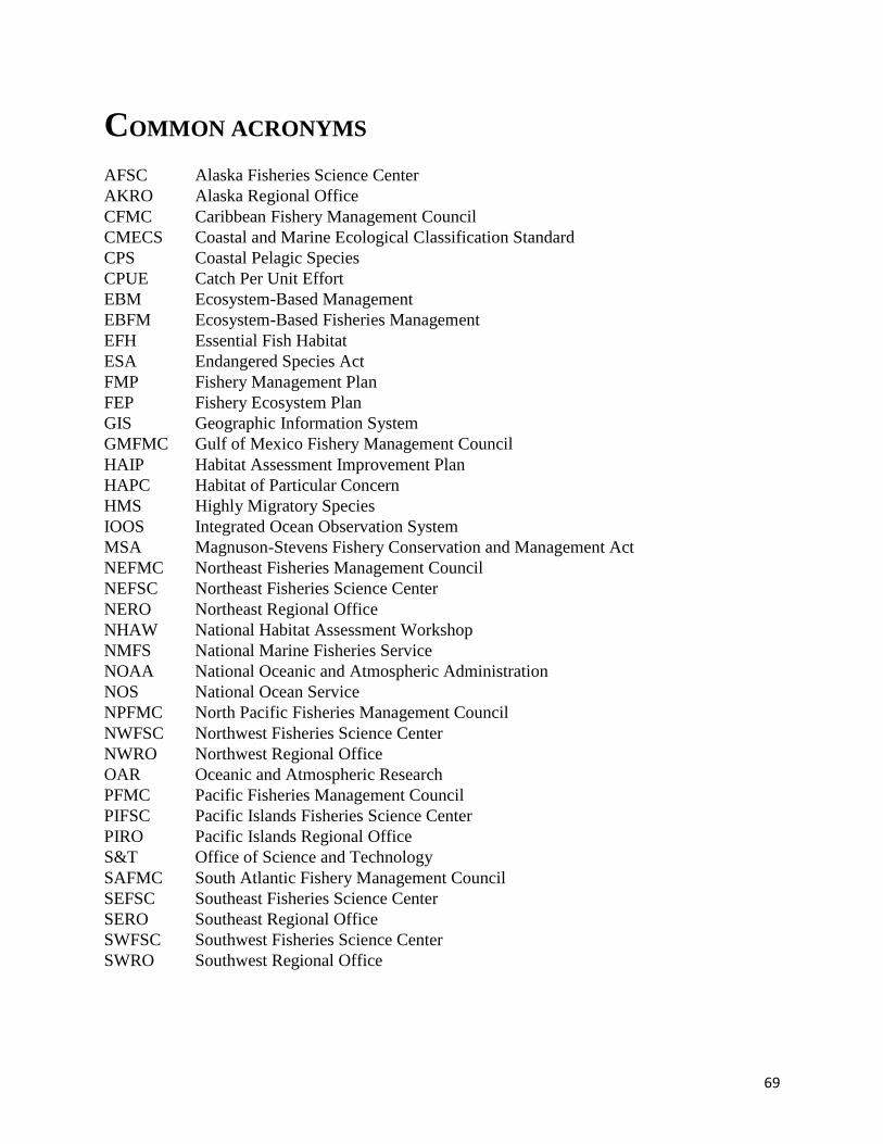
69
COMMON ACRONYMS
AFSC Alaska Fisheries Science Center
AKRO Alaska Regional Office
CFMC Caribbean Fishery Management Council
CMECS Coastal and Marine Ecological Classification Standard
CPS Coastal Pelagic Species
CPUE Catch Per Unit Effort
EBM Ecosystem-Based Management
EBFM Ecosystem-Based Fisheries Management
EFH Essential Fish Habitat
ESA Endangered Species Act
FMP Fishery Management Plan
FEP Fishery Ecosystem Plan
GIS Geographic Information System
GMFMC Gulf of Mexico Fishery Management Council
HAIP Habitat Assessment Improvement Plan
HAPC Habitat of Particular Concern
HMS Highly Migratory Species
IOOS Integrated Ocean Observation System
MSA Magnuson-Stevens Fishery Conservation and Management Act
NEFMC Northeast Fisheries Management Council
NEFSC Northeast Fisheries Science Center
NERO Northeast Regional Office
NHAW National Habitat Assessment Workshop
NMFS National Marine Fisheries Service
NOAA National Oceanic and Atmospheric Administration
NOS National Ocean Service
NPFMC North Pacific Fisheries Management Council
NWFSC Northwest Fisheries Science Center
NWRO Northwest Regional Office
OAR Oceanic and Atmospheric Research
PFMC Pacific Fisheries Management Council
PIFSC Pacific Islands Fisheries Science Center
PIRO Pacific Islands Regional Office
S&T Office of Science and Technology
SAFMC South Atlantic Fishery Management Council
SEFSC Southeast Fisheries Science Center
SERO Southeast Regional Office
SWFSC Southwest Fisheries Science Center
SWRO Southwest Regional Office

70
APPENDIX 1: WORKSHOP STEERING COMMITTEE
Kristan Blackhart, S&T
Stephen Brown, S&T
Matthew Eagleton, AKRO
Janine Harris, OHC
Kirsten Larsen, S&T
Michael Parke, PIFSC
Korie Schaeffer, SWRO
David Stevenson, NERO
Tali Vardi, S&T
Waldo Wakefield, NWFSC
Pace Wilbur, SERO

71
APPENDIX 2: WORKSHOP AGENDA
National Habitat Assessment Workshop:
Fisheries Science to Support NOAA’s Habitat Blueprint NWFSC Montlake Lab, Seattle, September 5-7, 2012
Tuesday, September 4
1:00 Restoration Project Field Trip
5:00-8:00 Registration, Silver Cloud Inn University Lobby
Wednesday, September 5
7:30 Registration, Montlake Lab
INTRODUCTORY SESSION
8:30 Introductory remarks, logistics (Stephen Brown)
8:40 Welcome (John Stein)
8:50 Remarks on the role of habitat science in fisheries management (Richard Merrick,
via video)
9:10 Q&A with Chief Scientist
9:40 The NOAA Habitat Blueprint (Brian Pawlak)
10:00 Northwest Regional Initiative (Will Stelle)
10:20 Break
10:40 Can our habitat paradigm cross the land-sea boundary? (John Manderson)
PRIORITIZATION OF STOCKS FOR HABITAT ASSESSMENT
11:10 Prioritizing habitat assessments (Stephen Brown)
11:30 Lessons learned from implementing the prioritization process in the southwest region
(Korie Schaeffer)
11:50 Question and answer session (Stephen Brown, Korie Schaeffer, Dale Sweetnam)
12:10 Lunch
TOOLS FOR SUCCESSFUL HABITAT ASSESSMENT FOR FISHERIES
13:30 NOS products that help habitat scientists achieve NMFS core mission (Mark Fink-
beiner)
14:00 Seafloor Characterization for Trawlability and Fish Habitat Using the Simrad ME70
Multibeam Echosounder in the Gulf of Alaska (Jodi Pirtle, UNH)
14:30 Implementing the Coastal and Marine Ecological Classification Standard (CMECS)
(Garry Mayer, Mark Finkbeiner)
15:00 Question and answer on CMECS implementation (Garry Mayer, Mark Finkbeiner)
15:30 Using environmental data to predict the effects of climate change on marine fisheries
(David Foley)

72
16:00 Availability of OAR products that can help habitat scientists achieve NMFS core
mission
(Craig Russell)
16:30 Adjourn
17:30-19:30 POSTER SESSION at Northcut Landing, 5001 25th Avenue NE (across from hotel)
Thursday, September 6
INCORPORATING HABITAT INFORMATION IN STOCK ASSESSMENTS
This session will focus on how habitat information can contribute to improving fisheries stock
assessments by reducing uncertainty in assessment data inputs or assessment model projections.
8:00 Introduction (Kristan Blackhart)
8:05 What assessment gaps need habitat information? Where could habitat-specific life
history rates fit? (Richard Methot)
8:35 The implications of untrawlable habitats on bottom trawl surveys for West Coast
groundfishes (James Thorson, Elizabeth Clarke, Ian Stewart, André Punt)
8:50 Expansion of oxygen minimum zones may reduce available habitat for tropical pe-
lagic fishes (Eric Prince)
9:05 Incorporating temperature-dependent catchability in some Alaska flatfish stock as-
sessments (Thomas Wilderbuer, Buck Stockhausen, Ingrid Spies)
9:20 Panel Discussion - (Richard Methot, James Thorson, Eric Prince, Thomas Wilder-
buer, Rick Hart)
10:20 Instructions for breakout session (Kristen Blackhart)
10:25 Break
10:45 Breakout Session
12:00 Reports from breakout sessions
12:30 Lunch
RETHINKING ESSENTIAL FISH HABITAT
For their broadly defined ecosystems, each region will present the challenges associated with the
changing nature of EFH given the move towards Ecosystem Based Fisheries Management
(EBFM) plans, the challenges associated with designating EFH in dynamic (e.g. pelagic) habitats
and under climate change, and the growing importance of non-fishery impacts to EFH (e.g. from
ocean-based energy development).
13:30 Introduction (Michael Parke, Waldo Wakefield)
13:35 Northeast broad continetnal shelf (David Stevenson, John Manderson)
Basin-scale models in Alaska’s broad continental shelf (Bob McConnaughey, Matt
Eagleton)
73
14:05 Pacific Islands coral reefs (Bob Schroeder, Michael Parke), Caribbean coral reefs
(Jocelyn Karazsia, Todd Kellison)
14:35 California current (Eric Chavez, John Stadler, Waldo Wakefield)
State of EBM in the context of EFH in the California current (Yvonne deReynier)
15:05 Instructions for breakout session (Michael Parke, Waldo Wakefield)
15:10 Break
15:30 Breakout Session
16:30 Reports from breakout sessions
17:00 Group discussion
17:30 Adjourn for the day
Friday, September 7
IMPROVING THE FLOW OF HABITAT SCIENCE INFORMATION TO MANAGEMENT
Each region will present the manner in which consultations currently utilize scientific infor-
mation, successful examples of scientific information or tools included in EFH or FWCA consul-
tations, and descriptions of one or two habitat management issues that affect many consultations
and would benefit greatly from NOAA scientist attention.
8:00 Introduction (Pace Wilber, Korie Schaeffer)
8:05 Northeast Region (Lou Chiarella)
8:15 Southeast Region (Pace Wilber)
8:25 Southwest Region (Korie Schaeffer)
8:35 Northwest Region (Michael Tehan)
8:45 Alaska Region (Matt Eagleton)
8:55 Pacific Islands Region (Bob Schroeder)
9:05 Instructions for breakout session (Pace Wilber, Korie Schaeffer)
9:10 Break
9:30 Breakout Session
10:30 Reports from breakout sessions
11:00 Group discussion on recommendations to endorse
11:30 Closing remarks on workshop (Stephen Brown)
12:00 Adjourn workshop
74
APPENDIX 3: LIST OF WORKSHOP PARTICIPANTS
Name Affiliation
Tim Beechie NWFSC
Laurel Ben AKFSC
Thomas Bigford OHC
Kristan Blackhart S&T
Christopher Boelke NERO
Raymond Boland PIFSC
Stephen Brown S&T
Eric Chavez SWRO
Lou Chiarella NERO
Lora Clarke S&T
Kimberly Clements SERO
Jason Cope NWFSC
Steve Copps NWRO
Sean Corson OHC
Russell Craig OAR-OER
Jaclyn Daly SERO
Gerry Davis PIRO
Yvonne de Reynier NWRO
Matthew Eagleton AKRO
Steve Edmondson SWRO
Mark Finkbeiner NOS-CSC
David Foley SF
Kurt Fresh NWFSC
Correigh Greene NWFSC
Melissa Haltuch NWFSC
Jeanne Hanson AKRO
Janine Harris OHC
Rick Hart SEFSC
Richard Hartman SERO
Ron Heintz AKFSC
Ron Hill SEFSC
Chris Jordan NWFSC
Jocelyn Karazsia SERO
Todd Kellison SEFSC
Kirsten Larsen S&T
Ben Laurel AKFSC
Terra Lederhouse OHC

75
Chris Long AKFSC
Jarad Makaiau PIRO
John Manderson NEFSC
Garry Mayer OHC
Bob McConnaughey AKFSC
Carey McGilliard AKFSC
Richard Methot S&T
Katharine Miller AKFSC
Tom Minello SEFSC
Martha Nizinski NEFSC
John Olson AKRO
Michael Parke PIFSC
Brian Pawlak OHC
George Pess NWFSC
Jodi Pirtle UNH
Eric Prince SEFSC
John Quinlan SEFSC
Phil Roni NWFSC
Craig Russel OAR-OER
Korie Schaeffer SWRO
Robert Schroeder PIRO
Linda Shaw AKRO
Ole Shelton NWFSC
John Stadler NWRO
Jennifer Steger OHC
Will Stelle NWRO
David Stevenson NERO
Kevin Stierhoff SWFSC
Rusty Swafford SERO
Dale Sweetnam SWFSC
Michael Tehan NWRO
James Thorson NWFSC
Tali Vardi S&T
Waldo Wakefield NWFSC
Pace Wilber SERO
Tom Wilderbuer AKFSC

76
APPENDIX 4: POSTER ABSTRACTS
A tidal creek restoration prioritization framework in the Charleston Harbor watershed
Jaclyn Daly1, Melanie Harris
2, Pace Wilber
1
1 Habitat Conservation Division, Southeast Region, Charleston, SC
2 Office of Habitat Conservation, Silver Spring, MD
In 2010, NOAA’s National Marine Fisheries Service (NMFS) launched its Habitat Blue-
print with the goal of implementing new habitat-based solutions to support healthy and produc-
tive ecosystems. With continued widespread loss and deterioration of coastal and marine habi-
tats, NOAA recognized the need to increase the sustainability and productivity of our fisheries
by focusing on protecting habitat and the coastal resources on which our communities de-
pend. Tidal creeks, in particular, serve important services - fishery production, water quality,
flood protection, and human health services – and, in the southeast, are designated as EFH under
the federal fishery management plans for penaeid shrimp and select snapper/grouper species. As
such, the Blueprint for NMFS' Southeast Region consists of a prioritized and spatially mapped
inventory of current and select historical tidal creek and salt marsh restoration opportunities in
the Charleston Harbor watershed, South Carolina. Sites in need of restoration were identified
from compiling existing habitat assessments, local partner knowledge, and GIS-based desktop
investigations. In total, we found opportunity to restore almost 5,000 acres of tidally-influences
wetland habitat. We then developed a model for prioritizing tidal creeks for restoration using the
following criteria: ecological value, acreage, creek order, nearby existing investments, and de-
gree of current impairment to rank sites. The prioritization framework will be used to develop
practical and ecologically meaningful mitigation and habitat restoration plans for large-scale
public works projects, NOAA Community-based Restoration Program, Atlantic Coast Fish Habi-
tat Partnership, Damage Assessment, Remediation and Restoration Program, or similar initia-
tives.
Evaluating the status of Puget Sound’s nearshore pelagic foodweb
Correigh Greene, Casimir Rice, Linda Rhodes, Brian Beckman, Joshua Chamberlin, Jason Hall,
Anne Baxter, and Sean Naman
Northwest Fisheries Science Center, Seattle, WA
The pelagic zone is a large and important component of Puget Sound’s ecosystem, but basic in-
formation is lacking on differences among oceanographic basins and the effects of anthropogenic
activities. This dearth of information complicates our ability to identify useful metrics to measure
the pelagic zone’s key characteristics determining ecological health. To address these issues, we
conducted a multi-trophic level assessment in six oceanographic basins within Puget Sound us-
ing a sampling scheme designed to detect both basin-wide differences and relationships between
pelagic ecosystem attributes and land use in catchments surrounding sites. We measured over 20
potential indicators of nearshore pelagic ecosystem health at 79 sites in six oceanographic basins
of Puget Sound. These metrics included measurements of abiotic conditions and nutrient availa-
77
bility, and abundance and diversity of phytoplankton, bacteria, zooplankton, jellyfish, and pelag-
ic fish species. In many taxa from lower to middle trophic levels, and for a comprehensive suite
of abiotic attributes, we observed strong seasonal and spatial structure. Furthermore, many of the
potential indicators we measured were sensitive to land use, with a general pattern that abiotic
and lower trophic patterns were most sensitive, and patterns in fish abundance and diversity were
the least sensitive. We found positive relationships between land use and jellyfish abundance, as
well as shifts of jellyfish diets to lower trophic levels in sites with greater land use. These find-
ings provide empirical support for the bifurcated foodweb hypothesis, which predicts that stress-
ors from development simplifies foodweb structure, leading to cascading effects on middle
trophic levels like planktivorous salmon and forage fish, and favoring jellyfish and other con-
sumers of microplankton. The strong spatial structure observed in our results indicates that dif-
ferent pelagic food webs exist across the system. Consequently, target conditions, current health
status, or both, cannot be uniform across greater Puget Sound.
Habitat Suitability Modeling for Deep-Sea Corals in the Northeast and Mid-Atlantic Re-
gions
Brian Kinlan1, Matthew Poti
1, Amy Drohan
2, Dave Packer
2, and Martha Nizinski
3
1NOAA National Ocean Service, NCCOS-CCMA-Biogeography Branch, Silver Spring, MD;
2NOAA National Marine Fisheries Service, Northeast Fisheries Science Center, James J. How-
ard Laboratory, Highlands, NJ; 3NOAA National Marine Fisheries Service, Northeast Fisheries Science Center, National Sys-
tematics Laboratory, Washington, DC
Deep-sea corals are a diverse and valuable resource, serving as important providers of habitat
structure for fishes and invertebrates. Because of their slow growth rates and vulnerability to bot-
tom disturbance, deep-sea coral ecosystems are of particular conservation concern. However,
because of the logistical difficulty and expense of deep-sea exploration, much less is known
about the distribution of deep-sea corals than their shallow-water counterparts. Predictive model-
ing of deep-sea coral habitat is essential to support conservation planning, planning of offshore
activities affecting the seafloor, and targeting areas for future mapping and exploration. In this
study we used the modeling technique known as Maximum Entropy (MaxEnt) to predict loca-
tions that may be suitable for corals based on presence-only records. We combined databases of
known deep-sea coral locations assembled by NOAA’s Northeast Fisheries Science Center
(NEFSC) and Deep-Sea Coral Research and Technology Program (DSCRTP) with environmen-
tal and oceanographic predictor variables to generate predictive models of deep-sea coral distri-
bution for the northeastern U.S. (Maine to North Carolina). Our results produced predictive habi-
tat suitability maps and model evaluation statistics for the three main orders of corals (Alcyo-
nacea (including Gorgonians and Non-gorgonians), Scleractinia, and Pennatulacea) found in the
U.S. Northeast region. Model evaluation statistics included Test AUC and permutation im-
portance. Test AUC was 0.8 for all three orders, highlighting the strong predictive power of the
model. Permutation importance indicated the top three predictor variables of suitable habitat.
These varied by order. Depth, slope (5km) and slope of slope (1500 m) were most important
predictors for Alcyonacea habitat; depth, annual bottom salinity, and gravel for Scleractinia; and
78
depth, annual bottom dissolved oxygen, and mean phi for Pennatulacea. This is the first regional
deep-sea coral predictive habitat model for the U.S. northeast/mid-Atlantic regions.
Cannibalism in red king crabs: Effects of habitat, predator interference, and predator size
on the functional response William Christopher Long, Jessica Popp, Laura Whitefleet-Smith, Katherine Swiney, Scott Van
Sant
Kodiak Laboratory, Resource Assessment and Conservation Engineering Division, Alaska Fish-
eries Science Center, National Marine Fisheries Service, NOAA
Red king crab (Paralithodes camtschaticus) juveniles are highly vulnerable to predation and
generally seek out habitats that minimize their predation risk. In this study we perform a series
of experiments to examine how habitat interacts with predator interference, predators reducing
foraging efficiency though interactions with each other, and predator size to determine the preda-
tor functional response, or the effect of prey density on predation rate, on juvenile red king crabs.
We used year-1 and year-2 red king crabs as predators and year-0 red king crab as prey. Trials
were run in mesocosms with either a bare sand bottom or with macroalgae mimic, whole bivalve
shells (shells), or crushed bivalve shells (shell hash) on top of sand at six prey densities. In the
first experiment year-1 predators exhibited a type II functional response in sand, shell hash, and
shell, and the predation rate was lower in shell than in shell hash or sand, but it did not differ be-
tween sand and shell hash. In the second experiment, year-1 predators exhibited minimal inter-
ference with each other at low prey densities. In the third experiment, year-1 predators exhibited
a type II functional response in sand and a type I in the macroalgae mimic, while year-2 preda-
tors exhibited a type I functional response in sand and a type III in macroalgae mimic. For both
sizes of predators predation was lower overall in the macroalgae mimic, though the difference in
foraging efficiency was much greater for the year-2 predators. This work demonstrates that the
functional response and predation risk for juvenile red king crabs varies with habitat, predator
density, and predator size. Further, it shows that complex, three dimensional habitats are critical
for the persistence of red king crab juveniles.
Northeast Regional Habitat Blueprint Initiative: Multibeam Mapping and Visual Survey
Efforts Increase Knowledge of Deep-sea Coral Distributions and Diversity in Northeast
Submarine Canyons
Martha Nizinski1, Jeremy Potter
2, Dave Packer
3, and Amy Drohan
3
1NOAA National Marine Fisheries Service, Northeast Fisheries Science Center, National Sys-
tematics Laboratory, Washington, DC;
2NOAA Office of Ocean Exploration and Research, Silver Spring, MD;
3NOAA National Marine Fisheries Service, Northeast Fisheries Science Center, James J. How-
ard Laboratory, Highlands, NJ
Submarine canyons on the northeast continental shelf and slope are diverse and unique habitats
that provide refuge for a variety of fauna. However, most canyons are poorly known, yet are of
great interest to federal and state management agencies. Because of the prohibitive costs and lo-

79
gistical difficulties of surveying these areas, the Atlantic Canyons Undersea Mapping Expedi-
tions (ACUMEN) partnership was designed to make efficient use of research ships’ resources,
allowing for effective and efficient data collection, and capitalizing on complementary capabili-
ties of NOAA assets to produce an integrated, coherent dataset. ACUMEN’s goals included field
efforts to support the NOAA Habitat Blueprint northeast regional initiative and NOAA Integrat-
ed Ocean and Coastal Mapping efforts, as well as sharing of data and data products across plat-
forms to guide and refine expedition plans in near real-time. Priority areas along the continental
shelf/slope from Virginia to Rhode Island were identified for exploration by NOAA and external
partners. Five expeditions, conducted between February-August 2012, focused on submarine
canyons, to gather baseline information to support science and management needs. The expedi-
tions highlighted the complementary capabilities of three NOAA ships: Okeanos Explorer, Fer-
dinand R. Hassler, and Henry B. Bigelow. The Hassler and Okeanos Explorer collected high-
resolution bathymetry data that was quickly processed into mapping products to inform the Bige-
low’s ground-truthing mission two weeks later. Scientists aboard Bigelow used these maps to
identify habitats where deep-sea corals were likely to occur. The Woods Hole Oceanographic
Institution’s towed camera system was used to image these sites. Scientists collected contempo-
rary, geo-referenced data on corals, validated a coral habitat suitability model, and identified cor-
al hotspots. These data increased our knowledge of coral diversity and distribution exponential-
ly. Results will direct future coral research planning efforts, guide regional Fishery Management
Councils in development of coral protection zones, and revise/refine habitat predictive models.
Examples of Elwha Dam Removal Restoration Monitoring
George R. Pess1, Michael McHenry
2, Jeff Duda
3 Roger Peters
4, Sam Brenkman
5, and Mara
Zimmerman6
1NOAA National Marine Fisheries Service, Northwest Fisheries Science Center, Seattle, WA
2 Lower Elwha Klallam Tribe
3United States Geological Survey
4United States Fish and Wildlife Service
5National Park Service
6WA Department of Fish and Wildlife
The purpose of evaluating the removal of the Elwha River dams is to determine if removal re-
sults in the establishment of self-sustaining salmon populations, and to identify the primary vari-
ables that influence salmon colonization success. With respect to both juvenile and adult salmon
we are evaluating distribution and abundance, habitat conditions, wild/hatchery interactions, and
ecosystem response.
80
Seafloor Characterization for Trawlability and Fish Habitat Using the Simrad ME70
Multibeam Echosounder in the Gulf of Alaska
Jodi L. Pirtle*1
, Thomas C. Weber1, Christopher D. Wilson
2, Christopher N. Rooper
2
1Center for Coastal and Ocean Mapping, University of New Hampshire, Durham, NH
2Alaska Fisheries Science Center, Seattle, WA
Groundfish that associate with rugged seafloor types are difficult to assess with bottom-trawl
sampling gear. Simrad ME70 multibeam echosounder (ME70) data and video imagery were col-
lected to characterize trawlable and untrawlable areas and to ultimately improve efforts to deter-
mine habitat-specific groundfish biomass. We surveyed areas of the Gulf of Alaska (GOA) (20-
500 m depth) aboard the NOAA ship Oscar Dyson during 2011, from the Islands of Four Moun-
tains in the Aleutians to eastern Kodiak Island. Additional ME70 data were collected opportunis-
tically during the winter 2012 acoustic trawl surveys. ME70 data were collected continuously
along the ship trackline (1-20 nmi spacing) and at fine-scale survey locations in 2011 with 100%
seafloor coverage (n = 21). Video data were collected at fine-scale survey sites using a drop
camera (n = 47 stations). ME70 data were matched to the spatial location of previously conduct-
ed AFSC bottom-trawl survey hauls (n = 582) and 2011 camera stations to discriminate between
trawlable and untrawlable seafloor types in the region of overlap between the haul or camera
path and the ME70 data. Angle-dependent backscatter strength, backscatter mosaics, and other
multibeam metrics were extracted from the ME70 data at these locations. Haul locations show
separation in backscatter strength based on performance, previously classified as successful or
unsuccessful due to gear damage from contact with the seafloor. Successful haul locations have
values that correspond to finer grainsize, or the lack of untrawlable features such as boulders and
rock. A similar pattern was observed for the camera stations characterized as trawlable or un-
trawlable from video. The best descriptors for seafloor trawlability will be identified among
multibeam metrics to map the predicted trawlability of the ME70 survey footprint. Continued
opportunistic collection of ME70 data during Oscar Dyson operations will help refine existing
classifications of untrawlable and trawlable areas in the GOA.
Tools and Strategies to Address Coastal Wetland Loss
Susan-Marie Stedman1, Nancy Laurson
2, Jennifer Linn
2, Arleen O’Donnell
3, Janine Harris
4,
MartinaMcPherson3, Emily Sheehan
5, Clay Miller
2 and Brittany Croll
6
1 National Oceanic and Atmospheric Administration (NOAA), Silver Spring, MD
2 Environmental Protection Agency (EPA), Washington D.C.
3 Eastern Research Group, Lexington, MA,
4 I.M. Systems Group, contractor to NOAA, Silver Spring, MD,
5 Oak Ridge Institute for Science and Education Fellow at EPA
6 EPA at the time of the study, now at NOAA, Silver Spring, MD
Wetlands in coastal areas are under pressure from numerous sources, both human (e.g., devel-
opment, shoreline hardening) and natural (e.g., storms, sea-level rise). A 2008 report on wetlands
in the coastal watersheds of the eastern United States concluded that between 1998 and 2004
more than 360,000 acres of wetlands in those watersheds were lost. To develop a better under-
81
stand of the underlying causes of this loss, the Environmental Protection Agency and NOAA co-
led a series of workshops in specific watersheds around the country, focusing on those where the
greatest amount of wetland loss was occurring. Although the locations were as diverse as Cape
Cod, Massachusetts and Mississippi Sound, Mississippi, a number of common themes emerged.
Population growth and development, sea-level rise, and the limitations of regulatory programs
(which can manifest as non-jurisdictional and/or unauthorized wetland losses) were identified as
common stressors. In the north Atlantic region, tidal restrictions, dams, and excess nutrients cre-
ate additional stress on aquatic systems. In the mid-Atlantic region, extensive shoreline armoring
alters habitat and creates the need for more shoreline armoring. In the south Atlantic region, ag-
riculture, silviculture, and significant alterations to hydrology compound the effects of develop-
ment. In the Gulf of Mexico region, substantial losses of estuarine wetlands are accompanied by
even greater losses of freshwater wetlands to development and silviculture.
To address these stressors, workshop participants identified tools and strategies that are currently
successful and could be applied more widely. These varied regionally but included low-impact
development, high-resolution mapping, watershed-based management, living shorelines, inter-
agency collaboration, and public outreach and education. The use of living shorelines (as op-
posed to hard armoring) was identified as an important strategy and future policy priority for ad-
dressing shoreline stabilization at multiple workshops. Educating and empowering local gov-
ernments was viewed as one way to address the limitations of federal and state wetland regulato-
ry programs and successful examples of this included the local conservation commissions of
Massachusetts and adoption of wetland minimum standards by counties in Florida. Unfortunate-
ly, although unauthorized and non-jurisdictional wetland loss was identified as a universal prob-
lem, very few successful approaches to address it currently exist. Future work through the Na-
tional Ocean Policy and the Interagency Coastal Wetlands Working Group will strive to fill this
need.
Northeast region habitat initiative: A partnership to develop a conservation strategy for
deep-sea corals
David Stevenson1 and Michelle Bachman
2
1 NERO, Gloucester, MA;
2 NEFMC, Newburyport, MA
The New England and Mid-Atlantic Fishery Management Councils, in collaboration with the
Northeast Regional Office and the Northeast Fisheries Science Center, are currently developing
management measures for protecting deep-sea corals (DSC) from the effects of existing and fu-
ture fishing activities using the discretionary authority of the Magnuson-Stevens Act. To date,
DSC management alternatives rely primarily on observations of DSC during surveys on the outer
continental shelf in the late 1970s and 1980s and on what is known or can be inferred about the
suitability of deep-sea canyons as habitats for DSC. Two types of DSC protection zones have
been identified for consideration: 1) a large area that extends from the edge of the continental
shelf out to the outer limit of the Exclusive Economic Zone, and 2) a number of smaller discrete
82
areas for 22 canyons, one area on the continental slope, four seamounts, and two areas in the
Gulf of Maine. Final action to protect DSC in the region is expected by the end of 2014.
Data to Support a Review of Essential Fish Habitat for Pacific Coast Groundfish
W. Waldo Wakefield1, Mary M. Yoklavich
2, Chris G. Romsos
3, Joseph J. Bizzarro
4, Curt E.
Whitmire2, Marlene Bellman
5
1Fishery Resource Analysis and Monitoring Division, Northwest Fisheries Science Center, Na-
tional Marine Fisheries Service, NOAA, Newport, OR, 97365
2Fisheries Ecology Division, Southwest Fisheries Science Center National Marine Fisheries
Service, NOAA, 110 Shaffer Rd., Santa Cruz, CA, 95060 3College of Earth, Ocean, and Atmospheric Sciences, Oregon State University, Corvallis, OR
97331-5503 4University of Washington, School of Aquatic and Fishery Sciences, Seattle, WA 98195-5020
5Fishery Resource Analysis and Monitoring Division, Northwest Fisheries Science Center, Na-
tional Marine Fisheries Service, NOAA, Seattle, WA 98112-2097
In this poster, we provide a summary of data used to support Phase I of a 5-year Review of EFH
for 91 species of groundfish off the Pacific Coast of the US. We highlight some of the key prod-
ucts developed for this review and are now available to the public. Initial EFH designations were
based on best available data developed from 2002 to 2005; NOAA’s National Marine Fisheries
Service (NMFS) approved these designations in May 2006. Beginning in 2010, the Pacific Fish-
eries Management Council (PFMC), Northwest and Southwest Fisheries Science Centers, and
the NMFS Regions initiated the first mandatory 5-year review for EFH provisions of the ground-
fish Fishery Management Plan. In Phase I of this process, we evaluated the extent of new infor-
mation available for the review and for potential modifications of current EFH designations.
Sources of information included published scientific literature and unpublished scientific reports;
solicitation of data from interested parties; and the review of previously unavailable or inaccessi-
ble data sets. Coast-wide maps were updated for (1) bathymetry and interpreted groundfish habi-
tat types; (2) the distribution and extent of groundfish fishing effort (as potential impact to EFH);
(3) the distribution and relative abundance of biogenic habitat (i.e., sponges and corals); and (4)
spatial management boundaries (as potential mitigation of impacts). This poster emphasizes ge-
ospatial datasets. Additional new information has been identified, e.g., habitat associations for
the 91 groundfish species, modeling efforts relevant to the determination and designation of
EFH, non-fishing activities that may affect EFH, and new information on prey species. This new
information, in the form of a written report and supporting Internet database, will be presented to
the PFMC, its advisory bodies, and the public, at the Council’s September 2012 meeting. Phase
II of the process will include a six month public review period and NMFS internal review. As
part of Phase II, the Council will solicit proposals to modify EFH and HAPC. This 5-year review
represents a major update of the groundfish habitat assessment for the California Current and
will have research and management applications well beyond satisfying the regulatory guidelines
associated with EFH.

83
Beaver Dam Failure and Abandonment: Complexity Lost?
Joseph Wheaton1, Sonya Welsh
1, Nick Bouwes
1 & Michael Pollock
2
1 College of Natural Resources, Utah State University, Logan, UT
2 NWFSC, Seattle, WA
Beavers (Castor canadensis) are frequently referred to as ‘ecosystem engineers’ because of the
profound influence their dams and associated networks of dens, side-channels and pools have on
the heterogeneity and complexity of the environments they occupy. Increasingly, beaver are be-
ing employed as a restoration agent, particularly in incised streams with homogenized habitat.
Beaver dams promote aggradation that is hoped can increase floodplain connectivity and channel
complexity. If actively colonized, a beaver dam complex might persist for decades or even centu-
ries. As part of their natural cycle, some dams may come and go, alternating between occupation
and abandonment, but eventually most are abandoned. However, when a dam is breached and
abandoned, are the restoration benefits sought from beaver (e.g., richer habitat, greater degree of
floodplain connectivity) lost? Beavers are starting to be used as restoration agents to promote bed
aggradation, reconnection of channels with their floodplains and improvement of physical habitat
complexity for fish. To rely on beavers to provide such passive restoration and ecosystem ser-
vices, a clear understanding of the cyclic nature of beaver pond evolution is necessary. This
poster shows one example of how channel complexity was not lost following a partial beaver
dam failure & abandonment. In fact, a geomorphic change detection analysis demonstrated that
the abandon beaver dam was a net sink for sediment accumulation following abandonment. On-
going monitoring of this and other abandon sites will be used to assess how general this result is
and how long it persists for. Eventually we hope to improve our theoretical understanding of the
cycle of beaver pond evolution and provide better information to help restoration practitioners
manage their expectations about the dynamic responses of such projects.
Southern California Bight Habitat Initiative: Characterizing Deep-water Demersal Com-
munities In and Out of MPAs
Mary Yoklavich1, Kevin Stierhoff
2, and Eric Chavez
3
1 SW Fisheries Science Center-NOAA Fisheries, Santa Cruz, CA;
2 SW Fisheries Science Center-
NOAA Fisheries, La Jolla, CA; 3
SW Regional Office-NOAA Fisheries, Long Beach, CA
NOAA Fisheries and its partners will evaluate change in biodiversity, abundance, and size com-
position of demersal fish stocks and their habitat following the closure of selected areas of the
Southern California Bight (SCB) to bottom-contact fishing gear. This study will enhance our un-
derstanding of the effectiveness of habitat conservation measures on rebuilding commercially
valuable fish stocks and on the demersal communities of which they are a part. This information
will help to tailor management measures that meet NOAA’s conservation mandates more effi-
ciently and with less economic impact. The results of the study will be provided to the Pacific
Fishery Management Council (PFMC), which will allow them to assess the appropriate ways to
successfully use fishing closures to rebuild fish stocks and associated habitats. Nationally, this
study will provide much-needed information on the response of demersal habitats and fish stocks
to the removal of fishing impacts to seafloor communities.

84
Incorporating environmental and habitat characteristics into the brown shrimp Farfan-
tepenaeus aztecus stock assessment for the northern Gulf of Mexico
Jennifer P. Leo1, 2
, Thomas J. Minello1, William E. Grant
2, Rick Hart
1, James Nance
1
1NOAA Fisheries, SEFC Galveston Laboratory, 4700 Avenue U, Galveston, TX 77551
2Texas A&M University, Department of Wildlife and Fisheries Sciences, Wildlife & Fisheries
Sciences, TAMU 2258, College Station, TX 77840
The economic value of the Gulf of Mexico shrimp fishery has fueled over 50 years of research
into the population dynamics of brown shrimp and the development of fishery production fore-
casting methods. Recently, emphasis has been placed on examining the mechanisms through
which habitats influence growth and survival of juveniles in estuarine nurseries. The estuaries in
the northern Gulf of Mexico associated with large shrimp populations are dominated by Spartina
salt marshes. However, production of sub-adults from different estuaries can vary widely by lo-
cation. Studies in Texas and Louisiana on juvenile brown shrimp have demonstrated that growth
and survival in estuarine nurseries depend upon temperature, salinity, and access to emergent
marsh vegetation. Modeling these highly dynamic variables and their interactions is a cognitively
and mathematically complex task. Several brown shrimp models have been described including
a spatial density model, individual based models, a bioenergetics model, and various correlative
models. Currently we are working on a model whose output can be used as input to the most re-
cent stock assessment model (Stock-Synthesis III) in an attempt to incorporate habitat data into
the assessment.
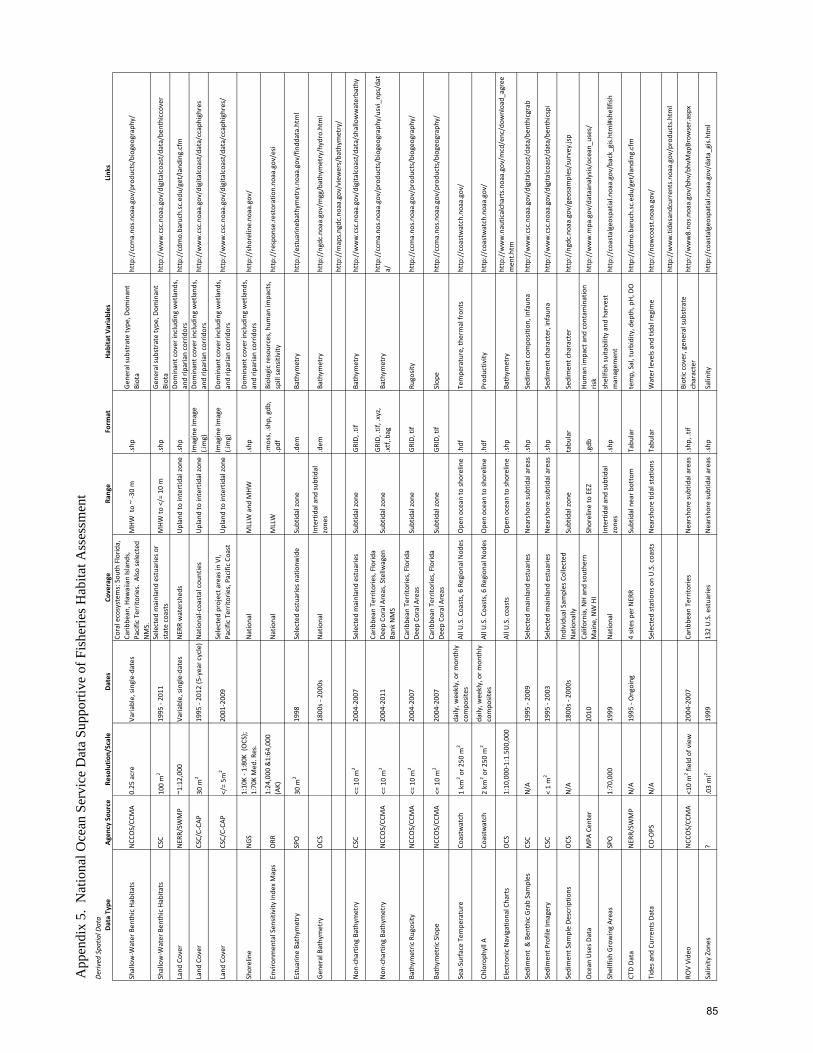
App
endi
x 5.
Nat
iona
l Oce
an S
ervi
ce D
ata
Supp
ortiv
e of
Fis
herie
s Hab
itat A
sses
smen
tDe
rived
Spa
tial D
ata
Data Type
Agen
cy Sou
rce
Resolutio
n/Scale
Dates
Coverage
Range
Form
atHab
itat V
ariables
Link
s
Shallow‐W
ater Ben
thic Habita
tsNCC
OS/CC
MA
0.25
acre
Varia
ble, single‐dates
Coral ecosystem
s: Sou
th Florid
a,
Carib
bean, H
awaiian Island
s,
Pacific Territories. A
lso se
lected
NMS.
MHW
to ~ ‐30 m
.shp
Gen
eral su
bstrate type
, Dom
inant
Biota
http://ccm
a.no
s.no
aa.gov/produ
cts/biogeo
graphy/
Shallow‐W
ater Ben
thic Habita
tsCSC
100 m
219
95 ‐ 20
11Selected
mainland estuaries o
r state coasts
MHW
to </= 10 m
.shp
Gen
eral su
bstrate type
, Dom
inant
Biota
http://w
ww.csc.noaa.gov/digitalcoast/data/be
nthiccover
Land
Cover
NER
R/SW
MP
~1:12,00
0Va
riable, single‐dates
NER
R watershed
sUpland to intertidal zo
ne.shp
Dominant cover includ
ing wetland
s,
and rip
arian corridors
http://cdm
o.baruch.sc.ed
u/get/land
ing.cfm
Land
Cover
CSC/C‐CA
P30
m2
1995
‐ 20
12 (5
‐year cycle)National‐coastal cou
nties
Upland to intertidal zo
neIm
agine Im
age
(.img)
Dominant cover includ
ing wetland
s,
and rip
arian corridors
http://w
ww.csc.noaa.gov/digitalcoast/data/ccaphighres
Land
Cover
CSC/C‐CA
P</= 5m
220
01‐200
9Selected
project areas in
VI,
Pacific Territories, Pacific Co
ast
Upland to intertidal zo
neIm
agine Im
age
(.img)
Dominant cover includ
ing wetland
s,
and rip
arian corridors
http://w
ww.csc.noaa.gov/digitalcoast/data/ccaphighres/
Shoreline
NGS
1:10
K ‐ 1
:80K
(OCS);
1:70
K Med
. Res.
National
MLLW and
MHW
.shp
Dominant cover includ
ing wetland
s,
and rip
arian corridors
http://sho
reline.no
aa.gov/
Environm
ental Sen
sitivity
Inde
x Maps
ORR
1:24
,000
&1:64
,000
(AK)
National
MLLW
.moss, .shp
, gdb
Biologic re
sources, hum
an im
pacts,
spill se
nsitivity
http://respo
nse.restoration.no
aa.gov/esi
Estuarine Ba
thym
etry
SPO
30 m
219
98Selected
estuarie
s nationw
ide
Subtidal zo
ne.dem
Bathym
etry
http://estuarin
ebathymetry.noaa.gov/fin
ddata.html
Gen
eral Bathymetry
OCS
1800
s ‐ 200
0sNational
Intertidal and
subtidal
zone
s.dem
Bathym
etry
http://ngdc.no
aa.gov/m
gg/bathymetry/hydro.htm
l
http://m
aps.ngdc.noaa.gov/view
ers/bathym
etry/
Non
‐charting Ba
thym
etry
CSC
<= 10 m
220
04‐200
7Selected
mainland estuaries
Subtidal zo
neGRID, .tif
Bathym
etry
http://w
ww.csc.noaa.gov/digitalcoast/data/shallowwaterbathy
Non
‐charting Ba
thym
etry
NCC
OS/CC
MA
<= 10 m
220
04‐201
1Carib
bean
Territories, Florid
a De
ep Coral Areas, Stellw
agen
Ba
nk NMS
Subtidal zo
neGRID, .tif, .xyz,
.xtf,.b
agBa
thym
etry
http://ccm
a.no
s.no
aa.gov/produ
cts/biogeo
graphy/usvi_np
s/dat
a/
Bathym
etric
Rugosity
NCC
OS/CC
MA
<= 10 m
220
04‐200
7Carib
bean
Territories, Florid
a De
ep Coral Areas
Subtidal zo
neGRID, tif
Rugosity
http://ccm
a.no
s.no
aa.gov/produ
cts/biogeo
graphy/
Bathym
etric
Slope
NCC
OS/CC
MA
<= 10 m
220
04‐200
7Carib
bean
Territories, Florid
a De
ep Coral Areas
Subtidal zo
neGRID, tif
Slop
ehttp://ccm
a.no
s.no
aa.gov/produ
cts/biogeo
graphy/
Sea‐Surface Tempe
rature
Coastw
atch
1 km
2 or 2
50 m
2daily, w
eekly, or m
onthly
compo
sites
All U
.S. Coasts, 6 Regional N
odes
Ope
n ocean to sh
oreline
.hdf
Tempe
rature, the
rmal fron
tshttp://coastwatch.noaa.gov/
Chloroph
yll A
Coastw
atch
2 km
2 or 2
50 m
2daily, w
eekly, or m
onthly
compo
sites
All U
.S. Coasts, 6 Regional N
odes
Ope
n ocean to sh
oreline
.hdf
Prod
uctiv
ityhttp://coastwatch.noaa.gov/
Electron
ic Navigational Charts
OCS
1:10
,000
‐1:1.500
,000
All U
.S. coasts
Ope
n ocean to sh
oreline
.shp
Bathym
etry
http://w
ww.nauticalcharts.noaa.gov/mcd/enc/dow
nload_
agree
men
t.htm
Sedimen
t & Ben
thic Grab Samples
CSC
N/A
1995
‐ 20
09Selected
mainland estuaries
Nearsho
re su
btidal areas
.shp
Sedimen
t com
position, infaun
ahttp://w
ww.csc.noaa.gov/digitalcoast/data/be
nthicgrab
Sedimen
t Profile Im
agery
CSC
< 1 m
219
95 ‐ 20
03Selected
mainland estuaries
Nearsho
re su
btidal areas
.shp
Sedimen
t character, infauna
http://w
ww.csc.noaa.gov/digitalcoast/data/be
nthicspi
Sedimen
t Sam
ple De
scrip
tions
OCS
N/A
1800
s ‐ 200
0sIndividu
al Sam
ples Collected
Nationally
Subtidal zo
netabu
lar
Sedimen
t character
http://ngdc.no
aa.gov/geo
samples/survey.jsp
Ocean
Uses D
ata
MPA
Cen
ter
2010
California, NH and southe
rn
Maine
, NW HI
Shoreline to EEZ
.gdb
Human
impact and
con
tamination
risk
http://w
ww.m
pa.gov/dataanalysis/ocean_u
ses/
Shellfish Growing Areas
SPO
1:70
,000
1999
National
Intertidal and
subtidal
zone
s.shp
shellfish su
itability and harvest
managem
ent
http://coastalgeospatia
l.noaa.gov/back_gis.html#shellfish
CTD Da
taNER
R/SW
MP
N/A
1995
‐ Ongoing
4 sites per NER
RSubtidal near b
ottom
Tabu
lar
temp, Sal, turbidity, dep
th, pH, DO
http://cdm
o.baruch.sc.ed
u/get/land
ing.cfm
Tide
s and
Currents D
ata
CO‐OPS
N/A
Selected
stations on U.S. coasts
Nearsho
re tidal statio
nsTabu
lar
Water levels and tid
al re
gime
http://now
coast.n
oaa.gov/
http://w
ww.tide
sand
curren
ts.noaa.gov/prod
ucts.htm
l
ROV Vide
oNCC
OS/CC
MA
<10 m
2 field of view
2004
‐200
7Carib
bean
Territories
Nearsho
re su
btidal areas
.shp
, .tif
Biotic cover, gen
eral su
bstrate
character
http://w
ww8.no
s.no
aa.gov/bhv/bhvMapBrow
ser.a
spx
Salinity
Zon
es?
.03 mi2
1999
132 U.S. estuarie
sNearsho
re su
btidal areas
.shp
Salinity
http://coastalgeospatia
l.noaa.gov/data_gis.html
85
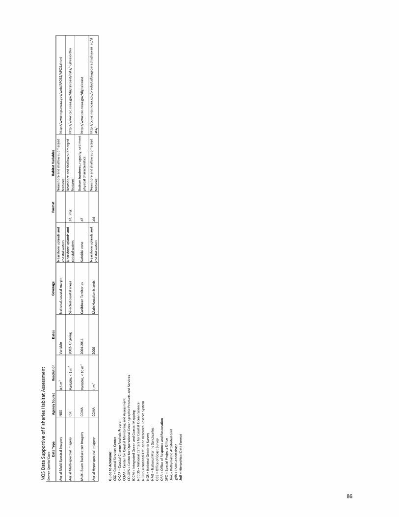
NOS Da
ta Sup
portive of Fish
eries H
abita
t Assessm
ent
Source Spa
tial D
ata
Data Type
Agen
cy Sou
rce
Resolutio
nDates
Coverage
Form
atHab
itat V
ariables
Aeria
l Multi‐Spectral Im
agery
NGS
0.5 m
2Va
riable
National, coastal m
argin
Nearsho
re uplands and
coastal w
aters
Nearsho
re and
shallow su
bmerged
features
http://w
ww.ngs.noaa.gov/web
/APO
S2/APO
S.shtm
l
Aeria
l Multi‐spectral Im
agery
CSC
Varia
ble, < 1 m
220
02‐ O
ngoing
Selected
coastal areas
Nearsho
re uplands and
coastal w
aters
.tif, .im
gNearsho
re and
shallow su
bmerged
features
http://w
ww.csc.noaa.gov/digitalcoast/data/highresortho
Multi‐Be
am Backscatter Im
agery
CCMA
Varia
ble, < 10 m
220
04‐201
1Carib
bean
Territories
Subtidal zo
ne.tif
Bottom
hardn
ess, ru
gosity, se
dimen
t ph
ysical characteristics
http://w
ww.csc.noaa.gov/digitalcoast
Aeria
l Hyperspectral Im
agery
CCMA
1 m
220
00Main Ha
waiian Island
sNearsho
re uplands and
coastal w
aters
.sid
Nearsho
re and
shallow su
bmerged
features
http://ccm
a.no
s.no
aa.gov/produ
cts/biogeo
graphy/haw
aii_cd/d
ata/
Guide
to Acron
yms:
CSC = Co
astal Services C
enter
C‐CA
P = Co
astal Change An
alysis Program
CCMA = Ce
nter fo
r Coastal M
onito
ring and Assessmen
tCO
‐OPS = Cen
ter for Ope
ratio
nal O
ceanograph
ic Produ
cts a
nd Services
IOCM
= Integrated
Ocean
and
Coastal M
apping
NCC
OS = National Cen
ters fo
r Coastal Ocean
Scien
ceNER
RS = National Estuarin
e Re
search Reserve System
NGS = National G
eode
tic Survey
NMS = National M
arine Sanctuaries
OCS
= Office of C
oast Survey
ORR
= Office of R
espo
nse and Re
storation
SPO = Spe
cial Projects O
ffice
.bag = Bathymetric
Attrib
uted
Grid
.gdb
= ESRI G
eodatabase
.hdf = Hierarchical D
ata Form
at
86

App
endi
x 6.
Nat
iona
l Oce
an S
ervi
ce T
ools
Sup
porti
ve o
f Fis
herie
s Hab
itat A
sses
smen
tFisheries A
ssessm
ent T
ools
Tool
Link
sNMFS Too
lbox
http://nft.nefsc.noaa.gov/
GIS Too
ls for E
cosystem
App
roache
s to Fisheries M
anagem
ent
http://ccm
a.no
s.no
aa.gov/pub
lications/TechM
emoN
CCOS75.pd
f
NCC
OS Overview of N
OS EFH Prod
ucts
http://ccm
a.no
s.no
aa.gov/produ
cts/biogeo
graphy/carib‐efh/produ
cts.aspx
NCC
OS Spatial A
nalysis
Too
lshttp://http://ccma.no
s.no
aa.gov/abo
ut/biogeograph
y/biogeo
_prod.aspx
Guide
to Acron
yms:
CSC = Co
astal Services C
enter
C‐CA
P = Co
astal Change An
alysis Program
CCMA = Ce
nter fo
r Coastal M
onito
ring and Assessmen
tCO
‐OPS = Cen
ter for Ope
ratio
nal O
ceanograph
ic Produ
cts a
nd Services
IOCM
= Integrated
Ocean
and
Coastal M
apping
NCC
OS = National Cen
ters fo
r Coastal Ocean
Scien
ceNER
RS = National Estuarin
e Re
search Reserve System
NGS = National G
eode
tic Survey
NMS = National M
arine Sanctuaries
OCS
= Office of C
oast Survey
ORR
= Office of R
espo
nse and Re
storation
SPO = Spe
cial Projects O
ffice
87
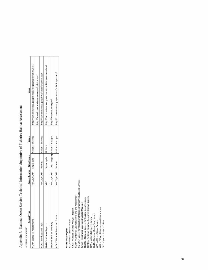
App
endi
x 7.
Nat
iona
l Oce
an S
ervi
ce T
echn
ical
Info
rmat
ion
Supp
ortiv
e of
Fis
herie
s Hab
itat A
sses
smen
tTechnical Information
Repo
rt Type
Agen
cy Sou
rce
Time Fram
eScop
eLink
s
CCMA Ecological Assessm
ents
NCC
OS/CC
MA
Single‐date
National in sc
ope
http://ccm
a.no
s.no
aa.gov/produ
cts/biogeo
graphy/cinms/data/
http://w
ww2.coastalsc
ience.no
aa.gov/pub
lications/
COAS
T Prod
ucts and
Too
lsNCC
OS/CC
MA
Vario
usNational in sc
ope
http://ccm
a.no
s.no
aa.gov/abo
ut/coast/produ
cts.aspx
NMS Co
ndition
al Rep
orts
NMS
5‐year cycle
All N
MS
http://sanctuarie
s.no
aa.gov/scien
ce/con
ditio
n/welcome.html
National Ben
thic Inventory
NCC
OS/CC
MA
1991
‐ on
goingNational in scop
ehttp://w
ww.nbi.noaa.gov/
COAS
T National Status a
nd Trend
sNCC
OS/CC
MA
Vario
usNational in scop
ehttp://ccm
a.no
s.no
aa.gov/stressors/pollutio
n/nsandt/
Guide
to Acron
yms:
CSC = Co
astal Services C
enter
C‐CA
P = Co
astal Change An
alysis Program
CCMA = Ce
nter fo
r Coastal M
onito
ring and Assessmen
tCO
‐OPS = Cen
ter for Ope
ratio
nal O
ceanograph
ic Produ
cts a
nd Services
IOCM
= Integrated
Ocean
and
Coastal M
apping
NCC
OS = National Cen
ters fo
r Coastal Ocean
Scien
ceNER
RS = National Estuarin
e Re
search Reserve System
NGS = National G
eode
tic Survey
NMS = National M
arine Sanctuaries
OCS
= Office of C
oast Survey
ORR
= Office of R
espo
nse and Re
storation
SPO = Spe
cial Projects O
ffice
88
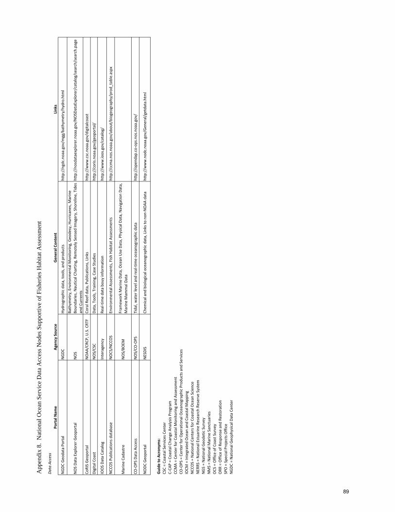
App
endi
x 8.
Nat
iona
l Oce
an S
ervi
ce D
ata
Acc
ess N
odes
Sup
porti
ve o
f Fis
herie
s Hab
itat A
sses
smen
tDa
ta Access
Portal Nam
eAg
ency Sou
rce
Gen
eral Con
tent
Link
s
NGDC
Geo
data Portal
NGDC
Hydrograph
ic data, to
ols, and
produ
cts
http://ngdc.no
aa.gov/m
gg/bathymetry/hydro.htm
l
NOS Da
ta Explorer G
eopo
rtal
NOS
Bathym
etry, Enviro
nmen
tal M
onito
ring, Geo
desy, H
urricanes, M
arine
Boun
darie
s, Nautical Charting, Rem
otely Sensed
Imagery, Sho
reline, Tides
and Cu
rren
tshttp://nosdataexplorer.noaa.gov/NOSD
ataExplorer/catalog/search/search.page
CoRIS Geo
portal
NOAA
/CRC
P, U.S. CRT
FCo
ral Reef d
ata, Pub
lications, Links
http://w
ww.csc.noaa.gov/digitalcoast
Digital Coast
NOS/CSC
Data, Too
ls, Training, Case Stud
ies
http://coris.no
aa.gov/geo
portal/
IOOS Da
ta Catalog
Interagency
Real‐tim
e data bou
y inform
ation
http://w
ww.ioos.gov/catalog/
NCC
OS Pu
blications database
NOCS/N
CCOS
Environm
ental A
ssessm
ents, Fish
Habita
t Assessm
ents
http://ccm
a.no
s.no
aa.gov/abo
ut/biogeograph
y/prod
_table.aspx
Marine Cadastre
NOS/BO
EMFram
ework Marine Da
ta, O
cean
Use Data, Physic
al Data, Navigation Da
ta,
Marine Mam
mal Data
CO‐OPS Data Access
NOS/CO
‐OPS
Tidal, water level and
real‐tim
e oceano
graphic data
http://ope
ndap.co‐op
s.no
s.no
aa.gov/
NODC
Geo
portal
NESDIS
Chem
ical and
biological oceanograph
ic data, Links to
non
‐NOAA
data
http://w
ww.nod
c.no
aa.gov/G
eneral/getdata.htm
l
Guide
to Acron
yms:
CSC = Co
astal Services C
enter
C‐CA
P = Co
astal Change An
alysis Program
CCMA = Ce
nter fo
r Coastal M
onito
ring and Assessmen
tCO
‐OPS = Cen
ter for Ope
ratio
nal O
ceanograph
ic Produ
cts a
nd Services
IOCM
= Integrated
Ocean
and
Coastal M
apping
NCC
OS = National Cen
ters fo
r Coastal Ocean
Scien
ceNER
RS = National Estuarin
e Re
search Reserve System
NGS = National G
eode
tic Survey
NMS = National M
arine Sanctuaries
OCS
= Office of C
oast Survey
ORR
= Office of R
espo
nse and Re
storation
SPO = Spe
cial Projects O
ffice
NGDC
= National G
eoph
ysical Data Ce
nter
89