product technical notes ezsurvtm
TRANSCRIPT

Product Technical Notes // june 2009
EZSurvTM
GNSS Post-Processing Software
OnPO
Z Pre
cisio
n Po
sitio
ning
is a
divis
ion
of V
GI So
lutio
ns. E
ZTag
CETM
and
EZFie
ld TM
are r
ecog
nize
d tra
dem
ark o
f VGI
Solu
tions
. EZS
urvTM
is a
regi
ster
ed tr
adem
ark o
f VGI
Solu
tions
. Al
l oth
er tr
adem
arks
are
regi
ster
ed o
r rec
ogni
zed
by th
eir r
espe
ctiv
e ow
ners
. Win
dow
s and
the W
indo
ws l
ogo
are
trade
mar
ks o
r reg
ister
ed tr
adem
arks
of M
icros
oft C
orpo
ratio
n
in th
e Un
ited
Stat
es a
nd/o
r oth
er co
untr
ies.
© 20
08 V
GI So
lutio
ns. A
ll rig
hts r
eser
ved.

EZSurvTM
GNSS Post-Processing Software
EZSurvTM is powered by OnPOZ Precision Positioning //© 2008 VGI Solutions. All Rights reserved. OnPOZ.com >> June 200902
EZSurvTM Post-Processor TO geT The besT OuT Of yOur gNss daTaeZSurvTM software is a complete solution designed by OnPOZ Precision Positioning to easily process raw GNSS data. It is an open solution that processes GPS as well as GLONASS signal. It provides all the flexibility you need by offering fully graphical (PlanView) and Windows Explorer types (ProjectManager) of user interfaces to accommodate your preferred way of working.
The software can also be adapted to the user’s profile by offering a choice of manual post-processing steps or using a single keystroke to do it all in one step. This technical overview presents some of the key features of EZSurvTM.
EZSurvTM facilitates the post-processing of GNSS files since it is fully compatible with multiple GNSS receivers. EZSurvTM uses GNSS manufacturer binary format allowing users to skip RINEX conversions.
EZSurvTM is fully compatible with OnPOZ Precision Positioning’s GNSS Driver for ArcPad, GNSS Control Panel, EZTagCETM and EZFieldTM field data acquisition software.
• Easy-to-usegraphicaluserinterface• ProjectManagerforeasydatahandling• Dataarchivingcapability• FullyautomatedBaseStationsearch
to post-process Rover data• Multiplemappingsystemsupports
EZSurvTM key feaTureS• RigorousNoiseReductionSystem(NRS)tosmoothnoisydata• Supportforallkindsofprocessingmodes• Singlekeystroketoautomaticallylaunchallprocessingsteps• Advancedqualitycontroltools• CompatiblewithmanyGNSSreceiversrawformat

EZSurvTM
GNSS Post-Processing Software
EZSurvTM is powered by OnPOZ Precision Positioning //© 2008 VGI Solutions. All Rights reserved. OnPOZ.com >> June 200903
Planning ToolsEZSurvTM’s Planner helps schedule your gNss data collection. Different types of visibility plots: sky plots, number of visible satellites, DOPs plots, etc., can be generated to help determine the most suitable times for your data collection. Site obstructions (e.g. buildings and trees) can also be input (using azimuth and elevation) at each of your survey sites to help generate more realistic visibility plots.
Easy Data ImportImporting your gNss datasets becomes a straightforward task since you can easily drag and drop your files into the observations window to quickly see their descriptions and attributes. To avoid long conversion processes, EZSurvTM directly supports raw binary formats from several manufacturers as well as the receiver independent exchange format (RINEX).
Coordinate SystemsEZSurvTM’s Mapping Systems tool provides complete coordinate-systems support. Over 62 standard datums and 22 standard ellipsoids are predefined. Additionally, you can create your own user-defined datums and ellipsoids. There are also over 12 different map projection templates, from which you can derive most mapping systems used in the world. The US State-Plane Coordinate System is fully supported, and local grids can be defined.
exTend your BaSe STaTion neTwork
To post-process your data, EZSurvTM uses smart technology to search the Internet for the best GNSS base station that fits your field data. This search is performed on a number of existing GNSS networks around the world. Using this feature, you do not have to worry about post-processing your data since it’s handled automatically with a single keystroke. All you need is an Internet connection. If you maintain your own GNSS network, it could be easily incorporated into the search through a LAN connection. Other networks can easily be integrated.
SUPPORTED GNSS DATA PROTOCOLS*rinex v2.10
Hemisphere GPS
navCom
novatel
Septentrio
Sirf
ublox* Protocols are added on a regular basis
EZSurvTM
GNSS Post-Processing Software
EZSurvTM is powered by OnPOZ Precision Positioning //© 2008 VGI Solutions. All Rights reserved. OnPOZ.com >> June 200904
PrecIse POINT-POsITIONINg MOdeObtaining good accuracy for a site can be hard to achieve if no established network is available to perform differential GNSS. EZSurvTM’s precise point-positioning mode gives you the ability to build your own network to an absolute accuracy better than 20 cm with a dual frequency receiver (50 cm with single frequency). To achieve such accuracy in point-positioning mode, precise orbits and clock files are used.
effIcIeNT daTa sMOOThINg fOr NOIsy daTaUrban canyon and dense forest canopy are tough environments in which GNSS is often needed. To obtain acceptable results in those extreme areas, EZSurvTM uses a Noise reduction system (Nrs) to optimize positioning accuracy. The NRS uses Doppler and phase observations to greatly reduce the noise affecting pseudorange measurements.
aMbIguITy sMOOThINgSome software allows you to use a backward process to get optimized solutions for your GNSS trajectories. EZSurvTM makes this task obsolete since a rigorous forward ambiguity smoothing process is used to do the same job with much less data management.
daTa INTerPOlaTION You don’t have to worry about your base station’s data rate since EZSurvTM can automatically perform a polynomial interpolation (up to 60 sec.) to fit the rate you’ve used in the field. Using EZSurvTM, you no longer have to interpolate your RINEX base station data.
effIcIeNT OuTlIer deTecTIONOne of the key steps in data processing is the detection of bad observations that can greatly affect the quality of your results. EZSurvTM has efficient algorithms to detect and remove noisy data and outliers so you always get optimized results.
auTOMaTIc aMbIguITy fIxINg PrOcessEZSurvTM relies on the well-known Lambda method to search and fix phase ambiguities, giving you a powerful tool to achieve centimeter accuracy surveys. It also has the advantage of automatically fixing solutions on the fly when your observation window is appropriate, without the need to use static sites (initialization).
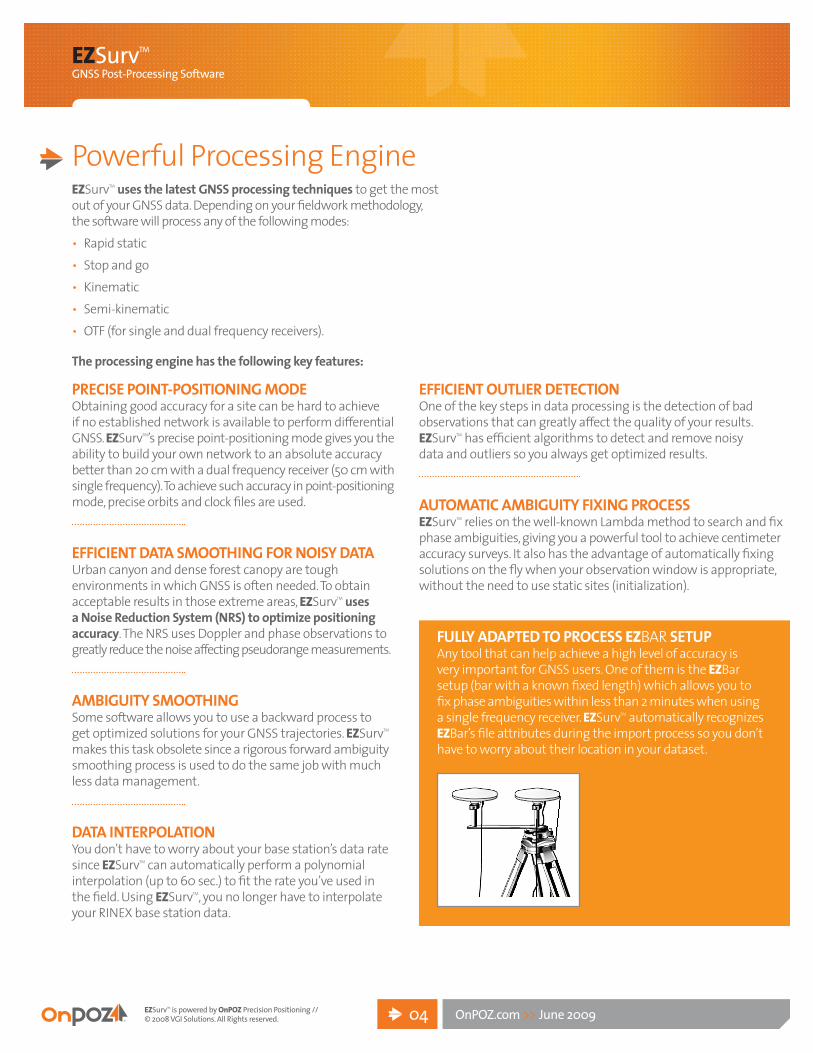
fully adaPTed TO PrOcess EZBAR seTuPAny tool that can help achieve a high level of accuracy is very important for GNSS users. One of them is the EZBarsetup (bar with a known fixed length) which allows you to fix phase ambiguities within less than 2 minutes when using a single frequency receiver. EZSurvTM automatically recognizes EZBar’sfileattributesduringtheimportprocesssoyoudon’thave to worry about their location in your dataset.
Powerful Processing EngineEZSurvTM uses the latest gNss processing techniques to get the most out of your GNSS data. Depending on your fieldwork methodology, the software will process any of the following modes:• Rapid static• Stop and go• Kinematic• Semi-kinematic• OTF (for single and dual frequency receivers).
The processing engine has the following key features:

EZSurvTM
GNSS Post-Processing Software
EZSurvTM is powered by OnPOZ Precision Positioning //© 2008 VGI Solutions. All Rights reserved. OnPOZ.com >> June 200905
EZSurvTM’s interface allows you to easily edit all site properties: name, coordinates, geoid undulation, height, time span, antenna model, antenna height, multiple occupations, etc. Rover (moving receiver) file properties such as antenna model and height, time span, site within a rover file, etc., as well as baseline and trajectory properties, can also be easily edited.
Accuracy TableEZSurvTM can process single or dual frequency data. The table below illustrates the accuracies that can be achieved in different modes of operation depending on the GNSS data.
1. Horizontal accuracy (HRMS). Requires 5-10 minutes of continuous tracking with at least 5 satellites and a PDOP better than 6. Multipath andionosphericeffectscanaffectfinalaccuracy.Basestationseparation may affect accuracy by about 5 ppm (depending on the quality of the base station data).
2. Horizontal accuracy (HRMS). Requires 15-20 minutes of continuous tracking with at least 5 satellites and a PDOP better than 6. Multipath andionosphericeffectscanaffectfinalaccuracy.Basestationseparation may affect accuracy by about 5ppm (depending on the quality of the base station data).
3. Horizontal baseline accuracy (HRMS). Requires 15-30 minutes of good data on a minimum of 4 satellites and a PDOP better than 6. Multipath and ionospheric effects can severely affect final accuracy. This horizontal accuracy usually translates into 1cm +/- 2 ppm.
4. Requires L1 frequency receiver that outputs quality code, Doppler and carrier phase observations along with reliable real-time cycle-slip detection.
5. EZFieldTM data collection software is designed to ease the semi-kinematic process. It allows you to easily initialize on an initialization bar or a known point.
6. Horizontal accuracy (HRMS). Requires 45 minutes of continuous trackingwithatleast5satellitesandaPDOPbetterthan6.Basestation must be within 10 km. Multipath and ionospheric effects can affect this accuracy. This horizontal accuracy usually translates into 2cm +/- 2 ppm.
7. Static results require only 10-15 minutes of data to achieve centimeter accuracy. This horizontal accuracy usually translates into 1cm +/- 1 ppm (with good dual frequency data).
8. OTF requires approximately 30 seconds of continuous tracking with at least 5 satellites and a PDOP better than 6. Multipath and ionospheric effects can affect final accuracy.
Advanced Quality Control ToolsEZSurvTM offers a number of tools to help analyze your final survey results. Graphical representations of phase or code residuals allow you to assess your baseline and trajectory results, and graphical tools help analyze cycle-slip occurrences in data. After processing, an analysis of common vectors is presented in a comprehensive report, and baselines that did not achieve the specified accuracy are flagged to isolate them for further analysis.
daTa ediTinG
ACCURACYreCeiver kineMaTiC STaTiC seMI KINeMaTIc oTf
Single frequency
submeter1, subfoot2
sub-centimeter3 centimeter4,5 centimeter6
dual frequency n/a sub-
centimeter7 n/a centimeter8

EZSurvTM
GNSS Post-Processing Software
EZSurvTM is powered by OnPOZ Precision Positioning //© 2008 VGI Solutions. All Rights reserved. OnPOZ.com >> June 200906
Loop Closure ToolsEZSurvTM allows you to analyze your baseline closure when you have redundant data. This helps you detect outliers in your dataset. Loops can be directly created in the plan view by selecting the required baselines, or they can be created within Project Manager.
FEATURES EZSurvTM VERSiON
LiTE L1 L1/L2
Submeter/subfoot • • •L1 static • •oTf L1 • •L1/L2 static •oTf L1/L2 •
neTwork adjuSTMenTEZSurvTM’s 3D network-adjustment tool allows you to choose between a fixed or weighted station type of adjustment that can be automatically or manually made in your baseline results. During manual adjustment, vectors can be included or excluded from your network with a simple mouse-click. After adjustment, a comprehensive report is generated showing all the adjusted parameters along with their statistical information. The plan view displays both point and baseline (relative error) ellipses and elevation error bars.
ConclusionAll members of an engineering project team require reliable survey results. EZSurvTM can help them without numerous settings. Our main focus is “easy-to-use” applications that provide optimum results.
EZsurvTM versIONs
Each version is available with full GNSS capability or GPS only.

Division of vgI solutions514 495.0018OnPOZ.com
Prin
ted
in C
anad
a