progress in understanding the structural geology, basin...
TRANSCRIPT

4Progress in Understanding theStructural Geology, Basin Evolution,and Tectonic History of the EasternNorth American Rift System
Roy W. Schlische
Five key developments have contributed signifi-cantly to our understanding of the structuralgeology, basin evolution, and tectonic history
of the eastern North American rift system:
1. Acquisition of new data. Over the past two de-cades, regional and local geologic mapping, drillingand coring, and seismic reflection profiling have in-creased vastly our structural and tectonic database. Itis now clear that these basins are predominantly half-graben, with generally synthetic intrabasinal faults andfault-perpendicular folds that in many cases are relatedto fault segmentation.
2. Role of preexisting structures. The rift system islocated within the Appalachian orogen, and thus theborder fault systems of the rift basins consist of reac-tivated structures. The attitude of the reactivated faultswith respect to the rift-related extension direction con-trolled the nature of the reactivation (dip-slip domi-nated versus strike-slip dominated), which affected theamount of basin subsidence and types of associatedstructures. The uniform dip direction of preexistingfaults over large areas accounts for the lack of half-graben polarity reversals within rift zones (e.g., theNewark–Gettysburg–Culpeper rift zone).
3. Application of fault-population studies. In the past10 years, considerable progress has been made in ourunderstanding of the geometry and scaling relation-ships of populations of normal fault systems. This in-formation is directly applicable to rift basin structuralgeology in that half-graben are large, normal fault–bounded basins. The most relevant features of normalfault systems to basin geometry are: (a) Displacementis greatest at or near the center of a normal fault anddecreases systematically to the fault tips; displacementalso decreases with distance perpendicular to the fault.(b) Normal fault systems are segmented, and many faultsegment boundaries are areas of (at least temporary)displacement deficits. (c) As displacement builds up ona normal fault, the fault increases in length. Conse-quently, rift basins consist of scoop-shaped depressionsthat grow longer, wider, and deeper through time. Insegmented border fault systems, the scoop-shaped sub-basins are separated by intrabasinal highs.
4. Integration of stratigraphy and structural geology.The sedimentary deposits of half-graben are influencedby basin geometry; consequently, stratigraphy can beused to infer aspects of basin evolution and structuralgeology. On a local scale, thickness variations of fixed-period Milankovitch cycles are particularly useful for

22 • Roy W. Schlische
assessing variations in basin subsidence and for deter-mining whether structures formed syndepositionally.On a regional scale, (a) the lack of Jurassic strata inthe southern basins likely indicates that they stoppedsubsiding before the northern basins did; (b) high ac-cumulation rates in Early Jurassic strata in the north-ern rift basins indicate accelerated basin subsidenceduring eastern North American magmatism; and(c) the presence of a tripartite stratigraphy (basal flu-vial unit, middle deep-water lacustrine unit, and uppershallow-lacustrine and fluvial unit) in most basins in-dicates that they share a similar evolutionary trend,most likely related to the infilling of basins growinglarger through time. All or parts of a tripartite stratig-raphy comprise unconformity-bounded sequences as-sociated with extensional pulses.
5. Recognition of inversion structures. Although post-rift contractional structures have long been recog-nized, recent work shows that the magnitude of post-rift shortening was greater than previously thoughtand that the initiation of shortening and basin inver-sion was diachronous. In particular, shortening inthe southern basins began after synrift deposition andbefore the eastern North America magmatic event(�202 Ma), whereas rifting and subsidence continuedin the northern basins. Inversion in the northern ba-sins occurred between early Middle Jurassic and EarlyCretaceous time. Postrift shortening is attributed toridge-push forces and to continental resistance to platemotion during the initiation of seafloor spreading,which itself was diachronous along the North Ameri-can margin.
�
Over the past three decades, interest in extensional ba-sins has been increasing steadily in both academia andindustry, and with good reason: the basins are the bestrecorders of the history of crustal extension. Exten-sional basins contain not only the structures formedduring extension but also the dateable strata influ-enced by those structures. In addition, extensional ba-sins are the sites of active hydrocarbon explorationand exploitation (e.g., Harding 1984; Lambiase andBosworth 1995).
Much of the research on extensional tectonics hasbeen conducted in regions where extension is currentlyactive or was recently active (e.g., Basin and Range,
Aegean Sea, Gulf of Suez, and East African rifts). Al-though it is possible to study extension-related earth-quakes or recent fault scarps in these basins, the ex-tensional basins themselves—those recorders of thehistory of extension—are buried by their youngest fill.Therefore, most of the record is not available for directobservation. Even worse, some extensional basins arecovered by hundreds of meters of water (e.g., NorthSea, Gulf of Suez, Aegean Sea, and East African riftlakes). Drilling and geophysical methods provide theonly (and commonly ambiguous) clues to unravelingthat much-sought-after extensional history.
Eastern North America provides an excellent op-portunity to examine the 40-million-year extensionalhistory of the early fragmentation of Pangea lockedwithin the basins containing the rocks of the early Me-sozoic Newark Supergroup (Froelich and Olsen 1984).The exposed basins are erosionally dissected, permit-ting much of the stratigraphic section to be scruti-nized. The largely nonmarine record of the exposedbasins means that sea level is not a factor in influencingdepositional patterns. However, the largely lacustrinestrata are commonly sensitive recorders of climatechange as well as potential hydrocarbon source rocks.In addition, these basins are related to continental sep-aration that led to the initiation of seafloor spreadingin the North Atlantic and are the synrift counterpartsto the postrift deposits of the U.S. continental margin,perhaps the most intensely studied and certainly thetype passive margin (Sheridan and Grow 1988).
Following an overview of points of contention,this chapter explores five key areas that have contrib-uted most to our understanding of the structural ge-ology, basin evolution, and tectonic history of the east-ern North American rift system in the past 15 years:(1) acquisition of new data, which have defined morespecifically the geometry of the basins themselves andthe geologic structures present within them; (2) rec-ognition of the role of preexisting structures, whichcan account for some of the first-order structural dif-ferences among the various basins; (3) application offault-population studies, which has provided a frame-work for a better understanding of a suite of normalfault–related structures; (4) integration of structuralgeology and stratigraphy, which has allowed us to datemany geologic structures as well as to make stridestoward unraveling the effects of tectonics, climate,and sediment supply on stratigraphic architecture; and

Structural Geology of the Eastern North American Rift System • 23
(5) recognition of inversion structures, which indicatethat the classical rift-drift models of passive marginevolution are overly simplistic.
This review focuses principally on the eastern NorthAmerican rift system, although many of the conceptsapply to other extensional settings. Lorenz (1988) pro-vides an excellent historical summary of research onthe Mesozoic basins, and Schlische (1990) gives a briefhistorical review focusing on the structural aspects ofthe rift system.
Points of ContentionConsiderable debate has centered around three ques-tions:
1. Is the large suite of structures contained in theeastern North American rift system attributableto a uniform stress field reactivating variably ori-ented Paleozoic structures or to a history ofchanging stress regimes?
2. Are the major structures bounding and con-tained within the basins syndepositional or post-depositional?
3. What are the causes of the major stratigraphictransitions (e.g., fluvial sedimentation to lacus-trine sedimentation) within the exposed basins?
In the following paragraphs, the various competing hy-potheses related to these three questions are outlined.Progress toward resolving these questions is then de-scribed in subsequent sections. The current status ofthese questions is summarized in the discussion sec-tion.
The extensional basins of the Newark Supergroupare host to a variety of structures, many of which gen-erally are not associated with continental extension.Structures include normal (e.g., Barrell 1915), strike-slip (e.g., Manspeizer 1980; de Boer and Clifton 1988),and thrust faults (e.g., Wise 1988); dikes (e.g., King1971) and joints (e.g., Wise 1982); and folds (e.g.,Wheeler 1939), some of which contain an axial planarcleavage (Lucas, Hull, and Manspeizer 1988). This as-sociation of structures has led some workers to con-clude that not all structures are related to rifting butreflect a historical sequence of changing stress regimes(Sanders 1963; Faill 1973, 1988; Swanson 1982; de Boerand Clifton 1988; de Boer et al. 1988; Wise 1988;
Manning and de Boer 1989). In this scenario, the nor-mal faults, joints, and dikes are related to early Me-sozoic extension, with the strike-slip faults and foldsrelated to postrift episodes of shearing and compres-sion. Other workers maintain that a large suite of thestructures can be explained as a consequence of a rela-tively uniform and protracted period of extension re-activating variously oriented preexisting structures,which then controlled the formation of new structures(Ratcliffe and Burton 1985; Schlische and Olsen 1988;Olsen, Schlische, and Gore 1989; Olsen and Schlische1990). A third group argues that the structures can beexplained as a consequence of a regional shear coupleacting on North America during the early Mesozoic(Manspeizer 1980, 1981, 1988; Manspeizer and Cous-miner 1988; Manspeizer et al. 1989). The latter twogroups do not discount the notion that postrift defor-mation affected the basins and their fill, but they alsoargue that many of the structures ascribed by the firstgroup to postrift deformation are in actuality synrift.
The timing of border faulting with respect to sedi-mentation has been controversial. One group main-tains that the basins initially formed as synformaldownwarps, with border faulting occurring late in thehistory of rifting (e.g., Faill 1973, 1988; de Boer andClifton 1988; de Boer et al. 1988; Root 1988, 1989).Others have followed Barrell’s (1915) line of thoughtand argued that border faulting was contemporane-ous with sedimentation (e.g., Sanders 1963; Ratcliffe1980; LeTourneau 1985; Nadon and Middleton 1985;LeTourneau and McDonald 1988; Schlische and Olsen1988; Olsen and Schlische 1990). Manspeizer (1988)suggested that basin-bounding faulting became activewhen sedimentation switched from fluvial to lacus-trine.
Although a wide variety of depositional environ-ments have been identified within Newark Supergroupbasins, two broad types predominate: fluvial and la-custrine (each has associated marginal facies). Changesfrom fluvial to lacustrine sedimentation typically havebeen interpreted to reflect a change in tectonic activity:the border fault moved, the basin deepened, and la-custrine sedimentation began (Manspeizer 1988; Man-speizer et al. 1989; Lambiase 1990). But Schlische andOlsen (1990) proposed that the simple infilling of abasin growing in size through time can also explainthe transition and its noncontemporaneity in uncon-nected basins.
24 • Roy W. Schlische
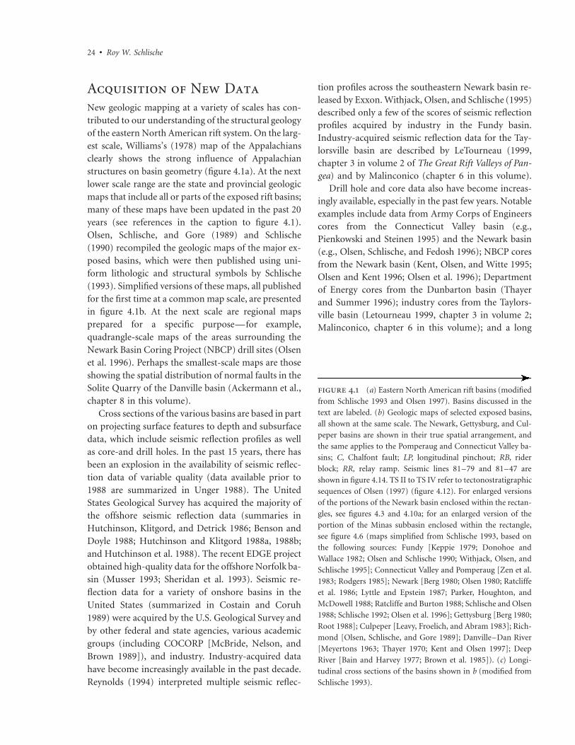
. (a) Eastern North American rift basins (modified
from Schlische 1993 and Olsen 1997). Basins discussed in the
text are labeled. (b) Geologic maps of selected exposed basins,
all shown at the same scale. The Newark, Gettysburg, and Cul-
peper basins are shown in their true spatial arrangement, and
the same applies to the Pomperaug and Connecticut Valley ba-
sins; C, Chalfont fault; LP, longitudinal pinchout; RB, rider
block; RR, relay ramp. Seismic lines 81–79 and 81–47 are
shown in figure 4.14. TS II to TS IV refer to tectonostratigraphic
sequences of Olsen (1997) (figure 4.12). For enlarged versions
of the portions of the Newark basin enclosed within the rectan-
gles, see figures 4.3 and 4.10a; for an enlarged version of the
portion of the Minas subbasin enclosed within the rectangle,
see figure 4.6 (maps simplified from Schlische 1993, based on
the following sources: Fundy [Keppie 1979; Donohoe and
Wallace 1982; Olsen and Schlische 1990; Withjack, Olsen, and
Schlische 1995]; Connecticut Valley and Pomperaug [Zen et al.
1983; Rodgers 1985]; Newark [Berg 1980; Olsen 1980; Ratcliffe
et al. 1986; Lyttle and Epstein 1987; Parker, Houghton, and
McDowell 1988; Ratcliffe and Burton 1988; Schlische and Olsen
1988; Schlische 1992; Olsen et al. 1996]; Gettysburg [Berg 1980;
Root 1988]; Culpeper [Leavy, Froelich, and Abram 1983]; Rich-
mond [Olsen, Schlische, and Gore 1989]; Danville–Dan River
[Meyertons 1963; Thayer 1970; Kent and Olsen 1997]; Deep
River [Bain and Harvey 1977; Brown et al. 1985]). (c) Longi-
tudinal cross sections of the basins shown in b (modified from
Schlische 1993).
Acquisition of New DataNew geologic mapping at a variety of scales has con-tributed to our understanding of the structural geologyof the eastern North American rift system. On the larg-est scale, Williams’s (1978) map of the Appalachiansclearly shows the strong influence of Appalachianstructures on basin geometry (figure 4.1a). At the nextlower scale range are the state and provincial geologicmaps that include all or parts of the exposed rift basins;many of these maps have been updated in the past 20years (see references in the caption to figure 4.1).Olsen, Schlische, and Gore (1989) and Schlische(1990) recompiled the geologic maps of the major ex-posed basins, which were then published using uni-form lithologic and structural symbols by Schlische(1993). Simplified versions of these maps, all publishedfor the first time at a common map scale, are presentedin figure 4.1b. At the next scale are regional mapsprepared for a specific purpose—for example,quadrangle-scale maps of the areas surrounding theNewark Basin Coring Project (NBCP) drill sites (Olsenet al. 1996). Perhaps the smallest-scale maps are thoseshowing the spatial distribution of normal faults in theSolite Quarry of the Danville basin (Ackermann et al.,chapter 8 in this volume).
Cross sections of the various basins are based in parton projecting surface features to depth and subsurfacedata, which include seismic reflection profiles as wellas core-and drill holes. In the past 15 years, there hasbeen an explosion in the availability of seismic reflec-tion data of variable quality (data available prior to1988 are summarized in Unger 1988). The UnitedStates Geological Survey has acquired the majority ofthe offshore seismic reflection data (summaries inHutchinson, Klitgord, and Detrick 1986; Benson andDoyle 1988; Hutchinson and Klitgord 1988a, 1988b;and Hutchinson et al. 1988). The recent EDGE projectobtained high-quality data for the offshore Norfolk ba-sin (Musser 1993; Sheridan et al. 1993). Seismic re-flection data for a variety of onshore basins in theUnited States (summarized in Costain and Coruh1989) were acquired by the U.S. Geological Survey andby other federal and state agencies, various academicgroups (including COCORP [McBride, Nelson, andBrown 1989]), and industry. Industry-acquired datahave become increasingly available in the past decade.Reynolds (1994) interpreted multiple seismic reflec-
tion profiles across the southeastern Newark basin re-leased by Exxon. Withjack, Olsen, and Schlische (1995)described only a few of the scores of seismic reflectionprofiles acquired by industry in the Fundy basin.Industry-acquired seismic reflection data for the Tay-lorsville basin are described by LeTourneau (1999,chapter 3 in volume 2 of The Great Rift Valleys of Pan-gea) and by Malinconico (chapter 6 in this volume).
Drill hole and core data also have become increas-ingly available, especially in the past few years. Notableexamples include data from Army Corps of Engineerscores from the Connecticut Valley basin (e.g.,Pienkowski and Steinen 1995) and the Newark basin(e.g., Olsen, Schlische, and Fedosh 1996); NBCP coresfrom the Newark basin (Kent, Olsen, and Witte 1995;Olsen and Kent 1996; Olsen et al. 1996); Departmentof Energy cores from the Dunbarton basin (Thayerand Summer 1996); industry cores from the Taylors-ville basin (Letourneau 1999, chapter 3 in volume 2;Malinconico, chapter 6 in this volume); and a long


26 • Roy W. Schlische
core obtained by the mining industry from the Fundybasin (Kent and Olsen 2000). The core data are mostrelevant in integrating stratigraphy with basin analysis,which is addressed later in the chapter.
Dating the activity of geologic structures requiresgood age control for the affected rock units. Age con-trol in the exposed Mesozoic basins traditionally hasbeen based on biostratigraphy (e.g., Cornet 1977;Cornet and Olsen 1985; Olsen, Schlische, and Gore1989). In recent years, a more robust chronostrati-graphic control has been achieved through isotopicdating of igneous rocks, cyclostratigraphy, and mag-netostratigraphy. The age of quartz-normative tholei-itic magmatism in basins from the Culpeper basin tothe north (hence referred to as the northern basins) is202 � 2 Ma (Sutter 1988; Dunning and Hodych 1990;Hodych and Dunning 1992); this age likely applies tothe entire eastern North American magmatic event,including subsurface lava flows in the southeasternUnited States and diabase dikes of various orientations(Olsen, Schlische, and Gore 1989; Ragland, Cummins,and Arthur 1992; Olsen, Schlische, and Fedosh 1996).Interbasinal correlations based on basalt geochemistryand cyclostratigraphy indicate that the duration of ex-trusive igneous activity in the Culpeper, Newark, Con-necticut Valley, and Fundy basins was less than 600,000years (Olsen, Schlische, and Fedosh 1996). Using theage of 202 Ma for the lava flows in the Newark basin,Olsen, Schlische, and Fedosh (1996) used core-basedcyclostratigraphy to apply absolute ages to the Newarkbasin stratigraphic section. Cyclostratigraphy also pro-vides data on accumulation rates (discussed in depthlater in the chapter) and constrains the ages of mag-netic polarity reversals for the Newark basin magneticpolarity section (Kent, Olsen, and Witte 1995). Kentand Olsen (1997) demonstrated that several correlativepolarity reversal boundaries are present in the Danvillebasin; LeTourneau (chapter 3 in volume 2) is devel-oping a magnetostratigraphy for the Taylorsville basin.Interbasinal paleomagnetic correlations with the New-ark basin section potentially provide excellent chrono-stratigraphic control even in strata lacking Milankovitchcycles.
Structural SynthesisThis review of the structural geology of the easternNorth American rift system is based mainly on map
views and longitudinal cross sections of the exposedbasins shown in figure 4.1b and c and on the transversecross sections presented in figure 4.2. Additionalinformation is available in the syntheses of Olsen,Schlische, and Gore (1989) and Schlische (1990, 1993)and in the references listed in the figure captions forthis chapter.
The majority of the rift basins in eastern NorthAmerica are half-graben, which are asymmetricalfault-bounded basins roughly triangular in cross sec-tion (figure 4.2). The more steeply inclined basin mar-gin consists of a network of predominantly normal-slip faults comprising the border fault system (BFS),which generally trends NNE to NE. The more gentlyinclined margin is known as the ramping margin andconsists of the contact between prerift and synriftrocks. This contact may be disrupted by intrabasinalfaults. Both the contact and the overlying synrift stratadip toward the BFS. The dip angle of the synrift stratacommonly steepens somewhat in proximity to theBFS; this geometry is known as reverse drag or rollover(e.g., Hamblin 1965; Gibbs 1983; Dula 1991; Xiao andSuppe 1992; Schlische 1995).
The BFSs are commonly segmented in plan view aswell as in cross section. The most common type ofplan-view segmentation consists of a number of faultsegments with a relay geometry, meaning that the in-dividual faults have the same strike as the fault system.Relay ramps are present between the overlapping faultsegments (figures 4.1b and 4.3a); these regions aremarked by the prerift-synrift contact that strikesobliquely with respect to the fault segments and thatdips in the general direction of the mutual footwall. Aless common type of BFS segmentation is best devel-oped in the Hartford subbasin. In this case, longerNNE-striking segments are connected by shorter NE-striking segments; the NE-striking segments are ori-ented similarly to intrabasinal faults. The relay rampstyle of segmentation is an example of soft linkage inthat faults transfer displacement from one segment toanother without being physically connected, at least inmap view; the Hartford subbasin style is an exampleof hard linkage in that the segments are physically con-nected (Walsh and Watterson 1991; Davison 1994).
In cross section, the BFS segmentation is expressedas a series of fault riders that bound rider blocks alongwhich the prerift-synrift contact progressively stepsdown (figures 4.2 and 4.3c). As a result, the deepest

.Tr
ansv
erse
cros
sse
ctio
ns
ofba
sin
ssh
own
infi
gure
4.1b
and
line
draw
ings
ofse
ism
icre
flec
tion
profi
les
acro
ssth
eL
ong
Isla
nd
and
Atl
anti
sba
sin
s.Fo
rlo
cati
on,
see
figu
re4.
1a.
(Cro
ssse
ctio
ns
mod
ified
from
Sch
lisch
e19
93,
base
don
the
follo
win
gad
diti
onal
sou
rces
:Fu
ndy
[Ols
enan
dSc
hlis
che
1990
];N
ewar
k[S
chlis
che
1992
];
Get
tysb
urg
[Roo
t19
88];
Cu
lpep
er[s
eism
icpr
ofile
inM
ansp
eize
ret
al.
1989
];D
eep
Riv
er[O
lsen
etal
.19
90].
Lin
edr
awin
gsre
inte
rpre
ted
from
Hu
tch
inso
net
al.
1986
)
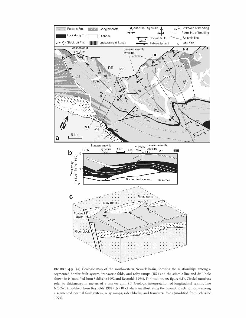
. (a) Geologic map of the southwestern Newark basin, showing the relationships among a
segmented border fault system, transverse folds, and relay ramps (RR) and the seismic line and drill hole
shown in b (modified from Schlische 1992 and Reynolds 1994). For location, see figure 4.1b. Circled numbers
refer to thicknesses in meters of a marker unit. (b) Geologic interpretation of longitudinal seismic line
NC 2–1 (modified from Reynolds 1994). (c) Block diagram illustrating the geometric relationships among
a segmented normal fault system, relay ramps, rider blocks, and transverse folds (modified from Schlische
1993).

Structural Geology of the Eastern North American Rift System • 29
part of the basin is shifted hingeward from the surfacetrace of the BFS. Faulting appears to have propagatedpreferentially into the footwall block (Schlische 1992,1993; Reynolds 1994). This progressive footwall incise-ment is most likely attributable to gravitational col-lapse of the uplifted footwall blocks (Gibbs 1984), par-ticularly in cases where the uplift rate exceeded theerosion rate. Footwall uplift for basin-bounding faults(e.g., Zandt and Owens 1980; King and Ellis 1990; An-ders and Schlische 1994) occurs in response to absoluteupward motion during fault displacement (e.g., Steinand Barrientos 1985), coupled with isostatic unloadingof the footwall blocks (Jackson and McKenzie 1983).The gravitational collapse process may have been aidedby preexisting fault structures in the footwall block (seethe next section). This model for footwall incisementcontrasts with the rolling hinge model (Buck 1988),which predicts hanging-wall incisement. As illustratedin figure 4.3, border fault segmentation, relay ramps,and rider blocks are related features.
The dip angle of border faults is quite variable (fig-ure 4.2), and the geometry of the border faults at depthis a matter of some controversy. Several workers haveinferred that border faults are moderately to stronglylistric, soling into detachments at midcrustal depths(e.g., Brown 1986; Bell, Karner, and Steckler 1988;Crespi 1988; de Boer and Clifton 1988; Hutchinson etal. 1988; Manspeizer 1988; Manspeizer and Cousminer1988; Ressetar and Taylor 1988; Root 1988, 1989;Manspeizer et al. 1989). In many instances, these in-ferences are based on reverse-drag or rollover stratalgeometries, which are not necessarily diagnostic of lis-tric faults (Shelton 1984; Barnett et al. 1987; Gibson,Walsh, and Watterson 1989), or on unmigrated seismicreflection profiles. Unger (1988) cautioned that un-migrated or time-migrated seismic reflection profilesover Mesozoic rift basins commonly display a pro-nounced kink where the basal unconformity intersectsthe fault trace; this kink comes about because thehigher seismic velocities recorded in basement rocksresult in a velocity pull-up from the true position ofthe border fault (see also Withjack and Drickman-Pollock 1984). Seismological studies (Stein andBarrientos 1985; Jackson 1987) indicate that most ac-tive normal faults dip at moderate to moderately steepangles and remain essentially planar to the base of theseismogenic crust. For these reasons, the cross sectionsshown in figure 4.2 depict listric faults only in cases
where there is good evidence of listricity based ondepth-migrated seismic reflection profiles.
The map view geometry of the basins falls into twoend-member types:
1. Simple basins—such as the Pomperaug, New-ark, Gettysburg, Culpeper, and Richmond ba-sins—are shaped somewhat like brazil nuts, withbasin width generally being greatest at or nearthe center of the basin and decreasing toward theends of the basin. Longitudinal sections reveal asynclinal or faulted synclinal geometry (figure4.1c); maximum basin depth occurs at or nearthe centers of the basins.
2. Composite basins—such as the ConnecticutValley, Danville, and Deep River basins—arecomposed of multiple subbasins; basin widthgenerally decreases at subbasin boundaries. Lon-gitudinal cross sections reveal relatively broadsynclinal subbasins separated by narrower anti-clinal features, referred to as intrabasinal highs(Anders and Schlische 1994; Schlische andAnders 1996). All subbasins exhibit a half-grabengeometry in transverse cross section. Individualhalf-graben within a composite basin all exhibitthe same polarity (dip direction of BFS).
Intrabasinal faults are overwhelmingly synthetic tothe BFS (figure 4.2), in part because this architecturedecreases the likelihood that the fault systems will crossat depth, allowing both fault systems to accommodatethe extension. In some instances, the intrabasinal faultsare oblique to the BFS, suggesting that the orientationof the BFS was controlled by a preexisting weakness,whereas the orientation of the intrabasinal faults—atleast in the synrift section—was controlled by the Me-sozoic state of stress. Antithetic faults, typically withfar less displacement than the synthetics, are also pres-ent, particularly along the hinged margin of the basin(figure 4.2); these faults appear to have formed to re-lieve the bending stresses associated with the regionaldip of the hanging wall toward the BFS (see models inGibbs 1984). The majority of the intrabasinal faultsgenerally strike in a NE direction and have significantdip-slip components. A notable exception is the Chal-font fault in the Newark basin (figure 4.1b, C), whichhas been proposed to be a major ESE-striking intra-basinal strike-slip fault; it formed as a transfer struc-

30 • Roy W. Schlische
. Early Jurassic age diabase dikes (thin black lines)
in northeastern North America. Rift basins are stippled; C, ex-
tent of Clubhouse Crossroads Basalt (Oh et al. 1995). Rosettes
indicate dike orientations (small tick marks indicate north) for
the following regions: i, maritime Canada, New England, and
New Jersey; ii, Pennsylvania, Maryland, and Virginia; iii, North
Carolina; and iv, South Carolina and Georgia. (Modified from
McHone 1988)
ture to accommodate differential extension within thebasin and formed subparallel to the extension direc-tion (Schlische and Olsen 1988). Diabase dikes gen-erally parallel the basin margin or are slightly obliqueto it in the northern basins but are perpendicular orhighly oblique to the basin margins in the southernbasins (figure 4.4). The significance of the dike trendsis discussed in the section on postrift deformation andbasin inversion.
Folds occur at a variety of scales in the Mesozoicrifts, are generally fault related, and can be classifiedas either transverse, with fold axis perpendicular toassociated fault, or longitudinal, with fold axis parallelto associated fault (Schlische 1995) (figure 4.5). In allthe rifts, the folds are preferentially expressed in thehanging-wall blocks. The largest-scale transverse foldsare the basin-scale synclines and subbasin-scale syn-clines separated by intrabasin highs (anticlines) (figure4.1c). Smaller transverse folds typically are associatedwith BFS segmentation at a scale smaller than the basinor subbasin scale (Schlische 1992) (figure 4.3a) as well
as with fault-line deflections (Wheeler 1939). Thesefolds decrease in amplitude away from the BFS and donot affect basin width (unlike the basin-scale orsubbasin-scale transverse folds). In the case of seg-mented BFSs, hanging-wall synclines occur at or nearthe centers of fault segments, whereas hanging-wall an-ticlines occur at segment boundaries (figure 4.3). Inthe case of fault-line deflections, synclines form at re-cesses and anticlines form at salients. Longitudinalfolds include rollover folds, reverse-drag folds, dragfolds (forced folds or fault-propagation folds), andinversion-related folds (figure 4.5).
The structural features described here apply tothose rift basins whose border faults underwent sig-nificant dip slip. As further explored in the next sec-tion, a different suite of structures developed in basinswhose border faults underwent significant strike slip.The nature of slip along the BFS (dip-slip dominatedor strike-slip dominated) is a function of the orienta-tion of synrift extension direction with respect to theorientation of reactivated faults.
Role of PreexistingStructuresEven a cursory examination of the distribution of earlyMesozoic basins (figure 4.1) shows that they parallelmany of the key structural elements of the Appalachianorogen (e.g., Williams 1978). It is thus no surprise thatworkers on the Mesozoic basins have long suggestedthat they were profoundly influenced by preexistingstructural controls (e.g., Lindholm 1978). For example,Swanson (1986) summarized the evidence that theborder faults of the Danville, Richmond, Taylorsville,Culpeper, Gettysburg, Newark, Connecticut Valley,and Fundy basins were inherited from the Paleozoicorogenies.
Ratcliffe and Burton (1985) presented a generalizedfault reactivation model that predicts the nature of slipand the relative amounts of throw on faults orientedat various angles to the extension direction. In caseswhere the preexisting zone of weakness is oriented per-pendicular to the extension direction, the fault is re-activated in pure dip-slip mode, and the amount ofthrow on the fault is maximized. In cases where thepreexisting zone of weakness is oriented parallel to theextension direction, the fault is reactivated in strike-

Structural Geology of the Eastern North American Rift System • 31
. Geometry, features, and classification (based on Schlische 1995) of fault-related
folds in rift basins. Illustration of fault-propagations folds (drag or forced folds) modified from
Walsh and Watterson (1987).

32 • Roy W. Schlische
slip mode, and the amount of throw is minimized. Ofcourse, these examples are only two end-member ex-tremes. Schlische and Olsen (1988) noted that theamount of throw is also strongly dependent on the dipangle of the fault, increasing as the dip angle increases,assuming all other factors are equal. After a brief di-gression on what is meant by extension direction andhow it can be constrained, I present two case studiesof the Ratcliffe–Burton model of fault reactivation.
Estimating the extension direction is not a trivialtask, and it is an undertaking made more difficultthrough an often ambiguous use of the term extensiondirection. When used strictly, extension refers to strain.When used in conjunction with rift basins, extensiondirection refers to the direction of maximum elonga-tion, most typically the direction of maximum hori-zontal elongation. The extension direction is parallelto the minimum principal stress direction (r3) only ifthe deformation is coaxial (e.g., pure shear) or infini-tesimal. SHmin refers to the horizontal minimum stressdirection. Most published estimates of the extensiondirection are actually estimates of r3 or SHmin.
Dikes form perpendicular to r3 (Anderson 1942)and are likely the most reliable paleostress indicatorsfor the eastern North American rift system (e.g.,McHone 1988; de Boer 1992). If all or most of thedikes in eastern North America were intruded at thesame time (�200 Ma), as now seems likely, then r3
was clearly oriented differently in the southern basinsthan in the northern basins (the significance of thisdifference is discussed later in the chapter). Stress di-rections also can be estimated using fault orientationand slip direction data (e.g., Angelier 1994). Thismethod is applied most often to very small faults,which are commonly difficult to date, although cross-cutting relationships and overprinting of slickensidesassist in establishing a relative chronology (e.g., deBoer and Clifton 1988; de Boer 1992). For the north-ern basins, the estimates of r3 based on small normalfaults are in good agreement with those based on thediabase dikes (de Boer and Clifton 1988; de Boer1992). Furthermore, the dikes and the majority ofintrabasinal faults are subparallel (Schlische 1993),indicating that the faults formed as predominantlynormal-slip faults during the synrift period. However,both the dikes and the intrabasinal normal faults arecommonly oblique to BFSs (figure 4.4), suggesting thattheir orientation is not a reliable indicator of r3.
Less widely available kinematic indicators includesediment-filled fissures in basalt and clastic dikes,which in the Fundy basin yield extension directionsthat are in agreement with diabase dikes (Schlische andAckermann 1995). These kinematic indicators are par-ticularly useful because they can be dated more accu-rately.
The first case study of the Ratcliffe–Burton modelinvolves the Newark–Gettysburg–Culpeper rift sys-tem, which exhibits the same curvature as that of thePennsylvania reentrant/New York promontory (ter-minology used in Williams 1978) (figure 4.1a). Theboundary faults of the Newark basin (Ratcliffe 1971,1980; Ratcliffe and Burton 1985; Ratcliffe et al. 1986),the Gettysburg basin (Root 1988, 1989), and the Cul-peper basin (Lindholm 1978; Volckmann and Newell1978) have been interpreted to be reactivated struc-tures. On the basis of the regional orientation of dia-base dikes (figure 4.4), intrabasinal normal faults, andthe ESE-striking Chalfont transfer fault, the extensiondirection, r3, is inferred to have been oriented WNW–ESE. The Ratcliffe–Burton model predicts predomi-nantly dip slip on the NNE-striking boundary faults ofthe Culpeper and Gettysburg basins and mostly dipslip along the generally NE-striking boundary faults ofthe Newark basin (figure 4.6). Indeed, all three basinsare half-graben (figure 4.2). In contrast, the E-strikingboundary fault of the Narrow Neck, connecting theNewark and Gettysburg basins, is predicted to have asignificant component of left-lateral strike slip. Indeed,the narrow width of the appropriately named NarrowNeck and the reduced stratigraphic thickness com-pared with that of the dip-slip–dominated basins areconsistent with reduced dip slip (especially reducedheave) along the BFS. Border fault geometry in theNarrow Neck consists of a mosaic of E-and NE-striking faults (figure 4.1b), the latter of which areprobably normal faults. The E-striking faults are likelyleft-lateral or left-oblique-slip faults based on the pre-dictions of the Ratcliffe–Burton model, the mappedleft-lateral strike-slip faults at the east end of the Nar-row Neck (Lucas, Hull, and Manspeizer 1988), and theWNW-plunging folds that intersect ESE-striking faultsat dihedral angles of 10 to 15� (McLaughlin 1963).Transverse folds are absent from the Narrow Neck.
The second case study focuses on the Fundy basin,which consists of three structurally distinct subbasins:the NE-trending Fundy and Chignecto subbasins and

Structural Geology of the Eastern North American Rift System • 33
. (a) Geologic map of the Five Islands region, northern part of Minas subbasin (modified from Olsen and Schlische
1990). For location, see figure 4.1b. Note the mosaic of dip-slip and strike-slip faults. Only synrift movement sense is shown on
faults. Because the pre-Jurassic stratigraphy of the Fundy basin is being revised (Olsen et al. 2000), the Wolfville and Blomidon
Formations are mapped as a single unit to avoid confusion between the old and new nomenclatures. (b) Geologic cross section
through Old Wife Point (for location, see a), illustrating localized reactivation of predominantly normal-slip fault zones (modified
from Withjack, Olsen, and Schlische 1995). Reverse faults at the northwestern end have associated drag folds and a considerable
component of strike-slip movement. White lines in basalt depict cooling joints. (c) Geologic cross section from Wasson Bluff to
Clarke Head (for location, see a) (modified from Withjack, Olsen, and Schlische 1995). The thickening of units toward the Clarke
Head fault zone indicates that it likely originated as a NW-dipping normal fault zone and was rotated and reactivated during inversion.
(d ) Summary of geologic evidence that the extension direction was oriented NW–SE during synrift phase. cWB and wWB refer to
central and western Wasson Bluff, where the orientations of sediment-filled fissures in the North Mountain Basalt (for location, see
a) were measured (Schlische and Ackermann 1995). (e) Equal-area projection, showing the attitude of faults with reverse separation
and associated right-oblique-slip faults from the northern margin of the Minas subbasin (from Withjack, Olsen, and Schlische 1995).
The shortening direction is normal to the mean strike of the faults.
the E-trending Minas subbasin (figure 4.1b). Theboundary faults of all subbasins are reactivated faults(Keppie 1982; Plint and van de Poll 1984; Mawer andWhite 1987; Withjack, Olsen, and Schlische 1995).Based on the attitude of the Shelburne dike, sediment-filled fissures in basalt, and clastic dikes in the Blom-idon Formation (Olsen and Schlische 1990; Schlischeand Ackermann 1995) (figure 4.6d), the extensiondirection, r3, was oriented NW–SE. The Ratcliffe–
Burton model therefore predicts predominantly syn-rift dip slip along the border faults of the Fundy andChignecto basins and synrift left-oblique slip along theboundary fault (Minas fault zone) of the Minas sub-basin. Olsen and Schlische (1990) verified this predic-tion by assembling data that showed that (1) the Fundyand Chignecto basins are half-graben, are wider, andcontain a much thicker stratigraphic section than theMinas subbasin; (2) the northern margin of the Minas

34 • Roy W. Schlische
subbasin is an extensional strike-slip duplex made upof a network of E-striking left-oblique-slip faults andNE-striking normal faults bounding a series of synde-positional graben and half-graben (figure 4.6a); and(3) dip-slip faulting and strike-slip faulting were coe-val. The fault pattern along the northern margin of theMinas subbasin is also remarkably similar to that pro-duced in clay models of oblique extension (Schlische,Withjack, and Eisenstadt in press). Schlische (1990)suggested that the Minas fault zone is linked physicallyto and transfers its displacement to the BFS of theFundy subbasin and thus marks the boundary betweenthe Fundy and Chignecto subbasins, a scenario largelyconfirmed by Withjack, Olsen, and Schlische (1995).
The Paleozoic fabric of eastern North America con-sists largely of generally NE-striking thrust faults andE-striking strike-slip faults (e.g., Arthaud and Matte1977). The NE-striking faults were reactivated as pri-marily dip-slip faults during Mesozoic extension andare associated with half-graben–type sedimentarybasins, segmented border faults, rider blocks, relayramps, and transverse folds. The E-striking faults werereactivated as left-oblique-slip faults during Mesozoicextension and are associated with complex mosaics ofdip-slip and strike-slip faults, an absence of transversefolds, and reduced basin width and depth comparedwith dip-slip–dominated basins. A large suite of quitedifferent structures therefore can form, depending onthe orientation of the reactivated fault with respect tothe extension direction (Olsen and Schlische 1990).
Fault reactivation likely accounts for the lack ofhalf-graben polarity reversals within the eastern NorthAmerican rift system. As noted earlier, individual half-graben units within composite basins (ConnecticutValley and Deep River basins) or rift basins within alarger rift zone (Newark–Gettysburg–Culpeper riftzone) do not alternate asymmetry along strike, as ischaracteristic of the East African rift system (Rosendahl1987). This notable difference stems from the locali-zation of North American basins along preexistingstructures that generally dip in the same direction overlarge areas (Burgess et al. 1988; Reynolds and Schlische1989). Adjacent half-graben in eastern North Americagenerally are not linked by accommodation zones,which are a common occurrence in East Africa (seealso Morley 1995). The larger number of accommo-dation zones in the East African rift system may berelated to the closer spacing of and more frequent
polarity reversals between adjacent half-graben in EastAfrica (Schlische 1993). Some type of accommodationstructure transferring displacement from one bound-ary fault to another is required between two oppositelydipping, closely overlapping BFS segments. Large-scalehard linkage structures are not required where half-graben are sufficiently widely spaced, border faultsdip in the same direction, and displacement goes tozero at the fault tips—a feature discussed in greaterdetail in the next section.
Application of Fault-Population StudiesThe past decade has experienced an explosion of re-search in fault-population studies (e.g., Cowie, Knipe,and Main 1996). In this section, I focus on those as-pects of fault-population studies most relevant to thestructural geology and basin evolution of rifts: fault-displacement geometry, length-displacement scaling,and fault segmentation. Additional aspects of this topicare explored in chapter 8 of this volume.
Features of Normal Faults
Fault displacement is greatest at or near the center ofblind, isolated faults (figure 4.7a) and decreases to zeroat the fault tips (Chapman, Lippard, and Martyn 1978;Muraoka and Kamata 1983; Barnett et al. 1987; Walshand Watterson 1987; Dawers, Anders, and Scholz1993) (figure 4.7b–d). For an initially horizontal sur-face, this displacement geometry results in a synclinalfold in the hanging-wall block (figure 4.7d) and in ananticlinal fold in the footwall block. For any givenpoint on the fault surface, displacement is greatest atthe fault surface and decreases away from the fault,resulting in a reverse-drag geometry in both the hang-ing wall and the footwall (Barnett et al. 1987) (figure4.7c). The reverse-drag geometry is in most instancesassociated with planar normal faults, and thus Barnettet al. (1987) and Gibson, Walsh, and Watterson (1989)cautioned that reverse drag does not necessarily indi-cate the presence of listric normal faults, as is com-monly assumed in many two-dimensional fault kine-matic models (e.g., Gibbs 1983; Dula 1991). Thedisplacement geometries described here are character-

Structural Geology of the Eastern North American Rift System • 35
. Geometric features of normal fault systems. (a) Block with five marker units containing a blind normal fault.
(b) “Transparent” version of block in a, showing the fault surface (shaded). The tip-line loop separates faulted rocks from
unfaulted rocks and corresponds to the zero-displacement contour. Displacement increases everywhere from the tip-line loop
toward the center of the fault. (c) Block diagram of the lower-right quarter of the block in a. The top surface of unit 3 is cut
by the fault. The distance between the footwall and hanging-wall cutoffs decreases toward the fault tip. In the vertical cross
section perpendicular to the fault, displacement at the fault surface decreases toward the tip. Displacement also decreases
away from the fault, producing reverse-drag folds in both the hanging-wall and footwall blocks. (d) Fault-surface projection
of the fault in b, showing the tip-line loop and the hanging-wall cutoffs of units 1 to 5. Along-strike variations in displacement
produce hanging-wall synclines (shown) and footwall anticlines (not shown), both of which are fault-displacement folds.
Parts c and d are at the same scale and are shown twice the size of a and b; no absolute scale is shown because these features
are scale invariant. (e) Changes in ground-surface elevation following the 1983 Borah Peak earthquake on the Lost River
normal fault, Idaho (epicenter marked by triangle) (modified from Barrientos, Stein, and Ward 1987). Black circles indicate
survey points; tick marks indicate parts of the fault that developed prominent scarps following the earthquake. Note the well-
developed reverse-drag geometry in section a-a�; b-b� shows a hanging-wall fault-displacement syncline. (f) Geologic map
(top) and displacement-distance plot (bottom) of a segmented fault system (inspired by data in Dawers and Anders 1995).
The shaded line reflects the summed displacement profile. Segments 2, 3, and 4 sum to a smooth profile, indicating that they
are linked kinematically. A displacement deficit is evident for segments 1 and 2, which are incompletely linked. No scale is
shown because these features are scale invariant.

36 • Roy W. Schlische
istic of normal faults over scales ranging from centi-meters to tens and hundreds of kilometers. A similardisplacement geometry results from single-slip seismicevents (Stein and Barrientos 1985) (figure 4.7e). Thefinite displacement geometry reflects the cumulativeeffect of multiple slip events (King, Stein, and Rundle1988).
It is generally agreed that there is a positive rela-tionship between maximum displacement, D, andfault length, L, of the form D � cLn, where c is re-lated to rock properties and n is the scaling exponent(e.g., Watterson 1986). Although the value of n hasbeen controversial in the literature (compare Walshand Watterson 1988; Marrett and Allmendinger1991; Cowie and Scholz 1992; Gillespie, Walsh, andWatterson 1992), high-quality data sets that span asufficient scale range indicate that n � 1; that is, therelationship between D and L is linear (e.g., Dawers,Anders, and Scholz 1993; Schlische et al. 1996; see alsoAckermann et al., chapter 8 in this volume). Thelength-displacement scaling relation indicates thatsmall faults with small displacements grow into largefaults with large displacements during successive slipevents.
Normal fault systems at a variety of scales com-monly are segmented (e.g., Larsen 1988; Jackson andWhite 1989; Peacock and Sanderson 1991; Gawthorpeand Hurst 1993; Anders and Schlische 1994; Fauldsand Varga 1998) (figure 4.7f). Segment boundariesmay be recognized by significant changes in faultstrike, fault overlaps and offsets, reduced displacement(especially in the hanging-wall block), and differencesin the age of faulting across the segment boundary(e.g., Zhang, Slemmons, and Mao 1991). Segmentedfaults typically are linked kinematically (Walsh andWatterson 1991): summing the displacements of in-dividual faults within the system results in a cumula-tive profile that resembles that of an isolated fault (e.g.,Trudgill and Cartwright 1994; Dawers and Anders1995), although displacement deficits may indicateregions of incomplete linkage (Dawers and Anders1995) (figure 4.7f). At least during the early stages ofkinematic linkage, relay ramps form between closelyspaced fault segments. These relay ramps may becomebreached during continued fault-segment propagation(Peacock and Sanderson 1991; Childs, Watterson, andWalsh 1995).
Effect on Basin Geometryand Associated Structures
Because half-graben basins are fault-bounded sedi-mentary basins, the displacement geometry associatedwith the faults and the evolution of the basin-bounding fault system strongly control basin geometry(e.g., Schlische 1991). The fault-and basin-growthmodels shown in figure 4.8 are based on the three-dimensional displacement field associated with normalfaults, the L-D scaling relation, and aspects of faultsegmentation. The simplest case consists of a basinbounded by single border fault (figure 4.8a). The basinitself is roughly scoop shaped. In longitudinal section,the basin has a synclinal geometry reflecting along-strike variations in fault displacement. In transversesection, the basin exhibits the classic half-graben mor-phology reflecting the reverse-drag geometry. The(uneroded) footwall block is a mirror image of thehanging-wall block, although the amplitude of the up-lift is commonly smaller. The basin grows in length,width, and depth through time as displacement ac-crues on the border fault.
Basins bounded by multiple fault segments are con-siderably more complex (figure 4.8b–d). All begin asisolated subbasins. For nonoverlapping synthetic faults(figure 4.8b, Case 1) and closely overlapping syntheticfaults (figure 4.8c, Case 2), the subbasins eventuallymerge. In the former case, the intrabasin high thatseparates the subbasins eventually subsides. In the lat-ter case, the intrabasin high persists because fault dis-placement is divided among multiple active-fault seg-ments that distribute basin subsidence (Anders andSchlische 1994) (see transverse cross sections in figure4.8c). For widely overlapping fault segments (figure4.8d, Case 3), the subbasins may never merge. TheConnecticut Valley basin is an example of a Case 1basin (figure 4.8b) in which faulting stopped prior tocomplete linkage. The Deep River basin consists ofboth Case 1 and Case 2 subbasins. All the other half-graben–type basins appear to be “simple” basinsbounded by a single border fault or by a fault thateffectively acts like a single fault, although it may becomposed of several geometric segments. The grossgeometry of these basins does not indicate whetherthey grew from a single border fault (figure 4.8a) orthrough the consolidation and complete merger of

Structural Geology of the Eastern North American Rift System • 37
. Evolution of extensional basins resulting from basin growth. Each panel shows three stages in the
evolution of an isolated basin or subbasin system. Normal faults are indicated by bar-and-ball symbols. The lower
diagram in each panel shows the longitudinal geometry of footwall uplift after each of the three stages. (a) Single fault
(thin lines represent contours of footwall uplift and hanging-wall subsidence; these lines are omitted for simplicity in
the other parts of this figure). (b) Nonoverlapping synthetic fault segments. (c) Closely spaced overlapping synthetic
fault segments. (d) Widely spaced overlapping synthetic fault segments. (Modified from Schlische 1995 and Schlische
and Anders 1996)

38 • Roy W. Schlische
subbasins (figure 4.8b). The currently segmented na-ture of many of the border faults suggests the latter.Stratal geometry in longitudinal section also may be ofhelp (cf. figure 4.8a and b, Stage 3).
Fault-displacement geometry, growth, and segmen-tation also account for nearly all the folds present inrift basins (Schlische 1995) (figure 4.5). The largest-scale transverse folds are the basin-scale synclines andsubbasin-scale synclines separated by anticlinal highs(figures 4.1c and 4.8). Other transverse folds are as-sociated with smaller-scale fault segmentation (figure4.3), with hanging-wall synclines forming in areas oflocally higher fault displacement (segment centers andrecesses), and with hanging-wall anticlines forming inareas of locally lower fault displacement (segmentboundaries and salients). Reverse-drag folds are lon-gitudinal folds that reflect the decrease in displacementaway from the fault surface. Drag folds are longitudinalfolds that form as a consequence of fault propagationinto the monoclinally flexed strata commonly sur-rounding the fault tips. These folds thus more properlyare called fault-propagation folds and commonly aresuperimposed on the much longer wavelength reverse-drag folds. The majority of these fault-propagationfolds formed during sedimentation and thus con-trolled thickness and facies distributions, which is thesubject of the next section.
Integration of Stratigraphywith Structural Geologyand Basin AnalysisThe first-order control on basin geometry is the de-formation field associated with the basin-boundingfault system. In turn, the architecture of the basin fillis strongly influenced by basin geometry. For example,as shown in figure 4.8, the basin fill thickens towardthe centers of subbasins; lacustrine facies would be ex-pected to deepen in a similar manner. These relation-ships suggest that the thickness and facies patterns inthe basin fill can be used to infer aspects of basin ge-ometry. Furthermore, they can be used to determinewhether or not faults (and folds) formed syndeposi-tionally. This section explores these topics as well asthe significance of vertical facies transitions for the tec-tonostratigraphic evolution of extensional basins.
Syndepositional Faulting and Folding
Evidence of syndepositional border faulting includes(1) alluvial-fan conglomerates deposited adjacent tothe border fault; (2) an increase in the thickness ofstrata in the hanging wall as the normal fault is ap-proached with thinning toward the fault in the footwall(assuming sedimentation within the footwall block);(3) evidence of growth (i.e., decreasing amounts offault displacement in younger rocks); and (4) a pro-gressive decrease in dip of younger strata (figure 4.9a).Syndepositional intrabasinal faulting is more difficultto assess. For example, as shown in figure 4.9a, stratathicken toward fault B in the hanging-wall block andthin toward fault B in the footwall block, but thesethickness changes are exclusively attributable to syn-depositional movement on the border fault. Fault A,on the contrary, is a syndepositional intrabasinal faultbecause there are dramatic changes in thickness of agiven unit across the fault, and thickening rates changeacross the intrabasinal fault. Schlische (1990, 1993) re-viewed the evidence for syndepositional border fault-ing in the major exposed rift basins. In this section, Ifocus on the evidence for syndepositional faulting andfolding in the Newark basin.
Conglomerates are present along virtually the entirelength of the BFS of the Newark basin and occur in allsedimentary formations; conglomerates are also in-ferred to be present adjacent to the BFS at depth onthe basis of reflection characteristics on the NORPACseismic line (Schlische 1992). Although the pattern ofstratal dip is complex as a result of intrabasinal fault-ing, transverse and longitudinal folding, and basin in-version, there are some structurally simple areas—forexample, the Delaware River region (Schlische 1992)(figure 4.8)—that exhibit decreasing dips in progres-sively younger strata.
The NBCP cores also provide information on re-gional variations in thickness and facies. The offsetcoring technique (Olsen et al. 1996) produced overlapsections for six pairs of stratigraphically adjacent cores(figure 4.10a); correlations are based on cyclostratig-raphy (Olsen et al. 1996) and magnetostratigraphy(Kent, Olsen, and Witte 1995). The overlap section ofthe Rutgers and Somerset cores, for example, showsthat equivalent units thicken by approximately 12%between the Rutgers and Somerset sites (figure 4.10b).

Structural Geology of the Eastern North American Rift System • 39
. (a) Features that can be used to infer syndepositional faulting. Intrabasinal fault
A is syndepositional; fault B is postdepositional. The border fault is syndepositional. (b) Highly
schematic diagram of the topography associated with the northern end of a basin-bounding
fault system. The stream patterns are based on data from the East African rifts (Cohen 1990).
For further discussion, see the text. The topographic contours are inspired by surface deflection
profiles measured by Gupta and Scholz (1998) on small normal faults from the Danville basin
(see also Schlische et al. 1996 and Ackermann et al., chapter 8 in this volume).
Furthermore, lacustrine facies are deeper in the Som-erset core than in the Rutgers core. All overlap sectionsare thicker in the core located closer to the center ofthe basin or to the BFS or to the Hopewell intrabasinalfault system. Syndepositional faulting is therefore the
most likely cause for these variations in thickness andfacies.
Stratigraphic intervals recovered in the NBCP coresmay also be correlated to outcrop sections (Silvestri1994, 1997; Olsen et al. 1996). For example, the Perkasie

. (a) Geologic map of the north-central Newark basin, showing the locations of the seven NBCP
drill sites: M, Martinsville; N, Nursery; P, Princeton; R, Rutgers; S, Somerset; T, Titusville; W, Weston. Arrows
indicate the amount of thickening between overlap sections of stratigraphically adjacent cores, based on corre-
lations in Olsen et al. (1996); DR, Delaware River outcrops equivalent to units in overlap section of the Nursery
and Titusville cores; F, Flemington fault; f, Ferndale folds; H, Hopewell fault; w, Watchung syncline. (b) Overlap
section of the Rutgers and Somerset cores, showing a pronounced increase in thickness and proportion of deeper-
water mudstones (gray and black units; for legend, see c) from Rutgers to Somerset. (based on data in Olsen et
al. 1996). (c) Basinwide correlation of the Perkasie Member, showing variations in thickness and facies (modified
from Olsen et al. 1996).

Structural Geology of the Eastern North American Rift System • 41
Member, which was recovered in the bottom of theRutgers core and in the top of the Titusville core, hasbeen correlated to outcrop sections that have beentraced for more than 125 km across the Newark basin(figure 4.10c). The units generally thicken toward thecenter of the basin (Rutgers core to Titusville core) andfrom the hinged margin toward the BFS (e.g., Titusvillecore to Milford section). The variations in thicknesssuggest that the Newark basin is a plunging synclinein longitudinal section; this configuration is consistentwith syndepositional BFS displacement being highestnear its center and decreasing toward its lateral ends(Schlische 1992). These interpretations also are sup-ported by the marked increase in thickness of theLockatong Formation toward the center of the basin(figure 4.1b).
Core-to-outcrop correlations provide constraintson the timing of activity of some of the intrabasinalfaults. Different thickening rates in different faultblocks led Schlische (1992) to conclude that the Hope-well and Flemington fault systems were syndeposition-ally active. In addition, Jones (1994) and Schlische(1995) showed that some transverse folds in the hang-ing walls of the Hopewell and Flemington fault systemswere syndepositionally active; if the folds are fault re-lated, then the intrabasinal fault systems were synde-positionally active.
By far the best evidence for syndepositional foldingalong the BFS comes from the southwestern part ofthe Newark basin. Outcrop, drill hole, and seismic re-flection data (Schlische 1992, 1995; Reynolds 1994)show that units thicken toward synclinal hinges andthin toward anticlinal hinges (figure 4.3a and b). Inaddition, the concordant diabase intrusions restrictedto the hinge of the Jacksonwald syncline (figure 4.3a)are interpreted as phacoliths (Manspeizer 1988;Schlische and Olsen 1988), which suggests that intru-sion occurred during or after at least some folding.Thus transverse folds from the scale of the Newarkbasin itself to the Jacksonwald syncline formed syn-depositionally. Geometrically similar transverse foldsin other basins also likely formed syndepositionally.
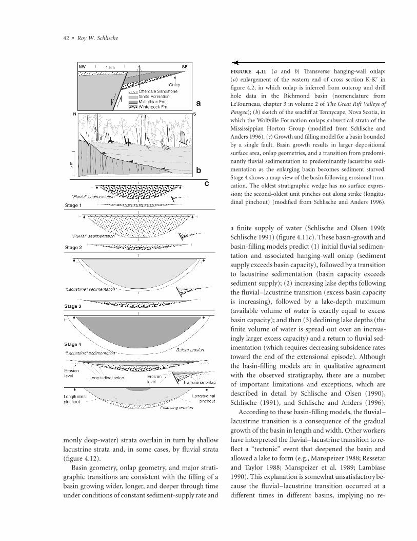
Onlap
Hanging-wall onlap refers to a stratal geometry inwhich progressively younger synrift strata progres-sively onlap prerift rocks of the hanging-wall block(Schlische and Olsen 1990; Schlische 1991). Transverse
onlap is observed in sections normal to the BFS,whereas longitudinal onlap is observed in sections par-allel to the BFS. Hanging-wall onlap is readily pro-duced in basin-growth models in which the basin iscompletely filled to its lowest outlet following each in-crement of extension (figure 4.11c, stage 4). Both typesof onlap should be readily observable on seismic lines(but see Morley 1999), but they are difficult to detectin map view. Longitudinal pinchout (figure 4.8) is amap-view manifestation of longitudinal onlap. Trans-verse onlap has been observed in outcrop in the Fundybasin (figure 4.11b) and on a transverse seismic lineacross the Newark basin, and it also has been inferredfrom drill hole data in the Richmond basin (figure4.11a) as well as on seismic lines across the Atlantis,Long Island, and Nantucket basins (Schlische and Ol-sen 1990) (figure 4.2). Longitudinal onlap has beeninferred from longitudinal pinchout in the Newarkand Danville basins (Schlische 1993) (figure 4.1b).Hanging-wall onlap is the primary stratigraphic evi-dence that the basins have grown wider and longerthrough time (Leeder and Gawthorpe 1987; Gibson,Walsh, and Watterson 1989; Schlische and Olsen 1990;Schlische 1991, 1993). Internal onlap refers to a stratalgeometry in which younger synrift strata onlap oldersynrift strata; this phenomenon is discussed later in thechapter in relation to tectonostratigraphic sequences(Olsen 1997).
Hanging-wall onlap has important implications forestimates of the age of the synrift deposits. Althoughthe rift basins of eastern North America are erosionallydissected, the oldest synrift deposits are not exposed atthe surface (figure 4.11c, stage 4). Thus age estimatesbased exclusively on surface outcrops understimate theage of the oldest synrift deposits.
Vertical Transitions and Basin-Filling Models
The typical Triassic stratigraphy (Olsen, Schlische, andGore 1989; Schlische and Olsen 1990; Olsen 1997)consists of a basal fluvial unit overlain by lacustrinestrata, with the deepest lakes occurring near the baseof the lacustrine succession and then generally shoalingupward (figure 4.12). In some basins, the shallow-water lacustrine deposits are capped by fluvial strata.This stratigraphic architecture is referred to as a tri-partite stratigraphy. In the northern basins, this Triassictripartite sequence is overlain by an Early Jurassic agepackage of lava flows and intercalated lacustrine (com-
42 • Roy W. Schlische
monly deep-water) strata overlain in turn by shallowlacustrine strata and, in some cases, by fluvial strata(figure 4.12).
Basin geometry, onlap geometry, and major strati-graphic transitions are consistent with the filling of abasin growing wider, longer, and deeper through timeunder conditions of constant sediment-supply rate and
a finite supply of water (Schlische and Olsen 1990;Schlische 1991) (figure 4.11c). These basin-growth andbasin-filling models predict (1) initial fluvial sedimen-tation and associated hanging-wall onlap (sedimentsupply exceeds basin capacity), followed by a transitionto lacustrine sedimentation (basin capacity exceedssediment supply); (2) increasing lake depths followingthe fluvial–lacustrine transition (excess basin capacityis increasing), followed by a lake-depth maximum(available volume of water is exactly equal to excessbasin capacity); and then (3) declining lake depths (thefinite volume of water is spread out over an increas-ingly larger excess capacity) and a return to fluvial sed-imentation (which requires decreasing subsidence ratestoward the end of the extensional episode). Althoughthe basin-filling models are in qualitative agreementwith the observed stratigraphy, there are a numberof important limitations and exceptions, which aredescribed in detail by Schlische and Olsen (1990),Schlische (1991), and Schlische and Anders (1996).
According to these basin-filling models, the fluvial–lacustrine transition is a consequence of the gradualgrowth of the basin in length and width. Other workershave interpreted the fluvial–lacustrine transition to re-flect a “tectonic” event that deepened the basin andallowed a lake to form (e.g., Manspeizer 1988; Ressetarand Taylor 1988; Manspeizer et al. 1989; Lambiase1990). This explanation is somewhat unsatisfactory be-cause the fluvial–lacustrine transition occurred at adifferent times in different basins, implying no re-
. (a and b) Transverse hanging-wall onlap:
(a) enlargement of the eastern end of cross section K-K� in
figure 4.2, in which onlap is inferred from outcrop and drill
hole data in the Richmond basin (nomenclature from
LeTourneau, chapter 3 in volume 2 of The Great Rift Valleys of
Pangea); (b) sketch of the seacliff at Tennycape, Nova Scotia, in
which the Wolfville Formation onlaps subvertical strata of the
Mississippian Horton Group (modified from Schlische and
Anders 1996). (c) Growth and filling model for a basin bounded
by a single fault. Basin growth results in larger depositional
surface area, onlap geometries, and a transition from predomi-
nantly fluvial sedimentation to predominantly lacustrine sedi-
mentation as the enlarging basin becomes sediment starved.
Stage 4 shows a map view of the basin following erosional trun-
cation. The oldest stratigraphic wedge has no surface expres-
sion; the second-oldest unit pinches out along strike (longitu-
dinal pinchout) (modified from Schlische and Anders 1996).

Structural Geology of the Eastern North American Rift System • 43
. Chrono-and lithostratigraphic framework of the exposed rift basins. TS I to TS IV are tectono-
stratigraphic sequences. (Simplified from Olsen 1997 and revised based on Olsen et al. 2000 and LeTourneau,
chapter 3 in volume 2)
gional tectonic control on sedimentation. Smoot(1991) hypothesized that reductions in fluvial gradi-ents and clogging of the outlets may contribute to thefluvial–lacustrine transition. This hypothesis predictsfluvial–lacustrine transitions of variable age and suc-cessfully accounts for a change from initial braided-stream deposits to meandering-stream deposits ob-served in the basal fluvial sequences of many exposedrift basins. Lambiase (1990) and Lambiase andBosworth (1995) related the fluvial–lacustrine transi-tion to a reduction in the number of intrabasinal faultblocks through time and to the development of aclosed basin bounded by the uplifted footwall blocks,the ramping margin of the basin, and high-relief ac-commodation zones (HRAZs) that are associated withantithetic overlapping normal faults. These models,however, have limited applicability to the eastern
North America rift system, which lacks the HRAZs.Gupta and Scholz (1998) described a model of fault-system evolution and rift-basin subsidence that pre-dicts an increase in local fault-displacement rates as aresult of strain localization and stress enhancement onoptimally located faults. This model, applied to terres-trial rift basins, is appealing because the fluvial–lacustrine transition need not occur at the same timethroughout an extending region and the local increasein displacement rate on a given fault is not associatedwith a change in the regional extension rate. Thismodel has yet to be applied formally to the easternNorth American rift system.
Basin-growth and basin-filling models also makespecific predictions about how accumulation ratesshould change through a vertical succession and withposition in the basin; these predictions then can be

44 • Roy W. Schlische
. Comparison of accumulation rate data derived from various basin-fill models
(a–c) and of cyclostratigraphically calibrated accumulation rate data from the Newark basin.
The various accumulation rate data sets were normalized by the maximum accumulation
rate in each data set to facilitate comparisons. The numbered curves in b and c were derived
from vertical drill holes through the basin shown in c (a, data for full graben from Schlische
and Olsen 1990 and for half-graben [depocenter and edgeward] from Schlische 1991;
b, constant strain rate and, c, constant fault-lengthening rate modified from Contreras,
Scholz, and King 1997). (d) NBCP data based on a composite reference section scaled to the
Rutgers core (Olsen et al. 1996; Olsen and Kent 1996).
compared with accumulation rate data derived fromcyclostratigraphy (thickness of the cycle divided by itsperiod). Using a full-graben basin growing wider anddeeper through time under conditions of constantsediment-supply rate, Schlische and Olsen (1990) de-termined that accumulation rates are equal to subsi-dence rates during fluvial sedimentation (figure 4.13a);during lacustrine sedimentation, accumulation ratesdecrease exponentially through time (figure 4.13a).The major shortcomings of this model—the full-graben geometry and lack of longitudinal basingrowth—were addressed by Schlische (1991), whoused a geometric half-graben basin-growth model(similar to that in figure 4.11c) under conditions ofconstant sediment-supply rate. Accumulation rates
(determined for a vertical drill hole through the synriftsection) generally increase rapidly and then decreasesomewhat more slowly (figure 4.13a). In addition, ac-cumulation rate curves vary with position in the basin.Contreras, Scholz, and King (1997) used a more so-phisticated numerical model of basin growth and sed-imentation incorporating self-similar faulting (n � 1),flexure, isostasy, and diffusion of erosion and sedi-mentation; they confirmed that accumulation ratecurves are sensitive to location within the basin as wellas to the temporal evolution of the BFS (constantstrain rate versus constant fault-lengthening rate) (fig-ure 4.13b and c).
At the time of the publication of Schlische andOlsen (1990), accumulation rate data for the Newark

Structural Geology of the Eastern North American Rift System • 45
basin were based solely on outcrops and appeared toconfirm the model’s predictions. However, the datawere derived from outcrops scattered throughout thebasin and were not corrected for spatial variations insubsidence rates. The NBCP has provided detailed ac-cumulation rate data, based on cyclostratigraphy, forthe individual cores containing lacustrine strata as wellas for a composite section, which was constructed byscaling individual cored sections to the Rutgers localityusing the thickening trends observed in the overlapsections (Olsen et al. 1996; Olsen and Kent 1996) (fig-ure 4.10a). Although there is considerable scatter inthe Triassic age section, which may reflect a climaticallydriven oscillation in sediment-supply rate (Silvestriand Schlische 1992), accumulation rates generally in-crease following the fluvial–lacustrine transition, reacha maximum in the lower Passaic Formation, decreasetoward the middle Passaic Formation, and then remainessentially constant through the uppermost PassaicFormation (figure 4.13d). The first three trends are inbroad agreement with the predictions of Schlische(1991) and with the constant strain rate models ofContreras, Scholz, and King (1997). However, neithermodel accounts for the fourth trend, which perhapsindicates that increases in sediment-supply rates offsetincreases in basin capacity as a result of basin growth.
A major deviation from the predictions of thebasin-filling models occurs in the Early Jurassic strata,which are characterized by markedly higher accumu-lation rates and deeper lake facies than the immedi-ately preceding stratigraphic section. Schlische andOlsen (1990) proposed that accelerated extensionresulted in asymmetric deepening, which caused sed-iments and water to “pond” in the basin depocenter,leading to higher accumulation rates and lake depths.This scenario predicts that the contact between the twosequences should be in part unconformable and bemarked by internal onlap. Such an unconformity hasbeen documented only in the Connecticut Valley basin(Cornet 1977; J. P. Smoot, personal communication,cited in Olsen 1997). The Early Jurassic sequence isalso associated with the emplacement of tholeiitic ba-salt flows. No doubt some of the marked increases inaccumulation rate and water depth can be attributedto the isostatic consequences of the loading of up toseveral hundred meters of basalt. However, increasesin lake depths (or the switch from fluvial to lacustrinesedimentation) preceded the igneous event in the
Fundy, Connecticut Valley, and Newark basins (Olsen1997) (figure 4.12). Thus the emplacement of the lavaflows was not the cause of the stratigraphic changesbut may have contributed to their magnitude. Perhapsthe increase in extension rate was partially responsiblefor triggering the igneous activity (Schlische 1990). Acase also can be made that a wetter climate resulted inmore water (and more sediment) entering the basins.At least in the Newark basin, sedimentary facies be-come somewhat wetter in the upper 3 km of the Pas-saic Formation (Smoot and Olsen 1994), but thesechanges are not nearly as extreme or abrupt as thoseoccurring between the latest Triassic and earliest Ju-rassic sequences. Tectonics was therefore responsiblefor the higher accumulation rates and deeper-waterfacies present in Early Jurassic age strata, although itis likely that accelerated faulting led to higher footwalluplift, resulting perhaps in increased orographic pre-cipitation (e.g., Manspeizer 1982).
The foregoing discussion highlights the utility of thebasin-filling models. These models can explain manyof the elements of the stratigraphic record in terms ofthe growth and filling of half-graben basins, but theyalso highlight notable departures from the baselineconditions, which are the result of tectonic or climaticevents. The Early Jurassic event discussed here is per-haps the most significant “anomaly.” Others includethe exclusively fluvial deposits in the Triassic sectionsof the Connecticut Valley, which are perhaps related toa larger than normal axial supply of sediment and/orto a lower basin subsidence rate, and the two deep-water lacustrine intervals in the Triassic section of theDanville basin (figure 4.12), which are as yet unex-plained.
Lambiase (1990) described the Newark basin as a“dual-cycle” basin in that it contains a Late Triassictripartite sequence overlain by an Early Jurassic se-quence produced as a result of tectonic rejuvenation.Olsen (1997) refined this concept and defined tecto-nostratigraphic sequences as packages of sedimentaryrock that compose all or part of a tripartite sequence.These tectonostratigraphic packages mostly likely arebounded by unconformities, which may be subtle inthe depocenters of the basins. The majority of the LateTriassic section in the exposed basins falls into Olsen’stectonostratigraphic sequence (TS) III; the Early Ju-rassic belongs to TS IV. TS I is a Permian age sequenceknown from only the Fundy and Argana (Morocco)
46 • Roy W. Schlische
basins (Olsen et al. 2000). In the Fundy basin, the TSI package may not be a synrift deposit (Olsen et al.2000). TS II deposits were deposited under consider-ably more humid conditions than TS I. The climaticmilieu changed from more humid to more arid goingfrom TS II to TS III. Well-developed angular uncon-formities between TS II and TS III are present in theRichmond-Taylorsville (LeTourneau, chapter 3 in vol-ume 2) and Fundy (Olsen et al. 2000) basins. TS I andTS II are poorly exposed because they are onlappedand overlapped by TS III. Interestingly, TS II and TSII preferentially outcrop in the Richmond-Taylorsvilleand Fundy basins, both of which appear to be morestrongly inverted than other Mesozoic rifts (see laterin chapter).
Extrabasinal Drainages
Thus far, our attention has focused on the first-ordereffect of basin geometry on thickness and facies pat-terns in the basin fill. The geometry of the upliftedfootwall block also influences sedimentation patterns.Based on the footwall displacement field and studiesof uplifted footwall blocks from areas of active exten-sional tectonics, the geometry of footwall uplift con-sists of narrow escarpment sloping toward the sedi-mentary basin and a wider flank sloping away fromthe basin (figure 4.9b). Consequently, drainages enter-ing the basin from the footwall are quite small anddeliver only limited quantities of sediment (Frostickand Reid 1987; Cohen 1990); most footwall rivers flowaway from the basin. Conversely, the hanging-wallblock slopes toward the basin, and the number ofstreams and their sediment loads entering the basinfrom the hanging-wall margin are substantially largerthan the direct footwall component (figure 4.9b). Themagnitude of the footwall uplift commonly reaches amaximum near the center of the fault system and ta-pers off to zero near the ends (e.g., Zandt and Owens1980; Anders and Schlische 1994). Therefore, streamsflowing down the flank of the uplift may swing aroundand enter the basin at its longitudinal ends (Cohen1990), contributing to an axial component of sedimenttransport (Lambiase 1990) (figure 4.9b). BFS segmentboundaries are commonly associated with footwall el-evation lows, especially during the early stages of faultlinkage (but see also Anders and Schlische 1994). Theselows may be exploited by streams flowing off the foot-wall block (Leeder and Gawthorpe 1987; Gawthorpe
and Hurst 1993), and thus relay ramps are sites of sig-nificant flux of coarse clastics into the basin (figure4.9b).
Sedimentologic data from the Newark basin gen-erally support these relationships. Conglomeratic de-posits along the BFS are relatively small and discontin-uous in map view. However, some of the largestdeposits are associated with relay ramps (figure 4.3a).Paleocurrent and provenance data indicate that mostsediment was sourced from the hanging-wall block orfrom the axial ends of the basin (Glaeser 1966; Allen1978; Oschudlak and Hubert 1988; Smoot 1991). Thesituation in the Hartford subbasin is considerablymore complex. The footwall block was the predomi-nant source of sediment during Triassic time (Hubertet al. 1978), perhaps because erosion could keep pacewith uplift during a period of low extension rate. Thishypothesis is to some extent supported by the exclu-sively fluvial deposits in the Hartford basin, in contrastto the Triassic seqences of all the other exposed basins.During the extrusive interval, when extension ratesand footwall uplift rates may have been higher, thehanging wall was the predominant source (Hubert etal. 1978), whereas the footwall served as the predom-inant source in the postextrusive interval (McInerny1993).
Regional Trends
Two regional trends have been noted for the easternNorth American rift system. The most obvious is theapparent increase in aridity of contemporary se-quences going from the southern basins to the north-ern basins (Olsen 1997). These trends reflect the pa-leogeography of the basins with respect to a zonalclimatic regime; that is, in Late Triassic time, the south-ern basins were located closer to the paleoequator thanthe northern basins were. The second regional trendconcerns the absence of TS IV deposits from the ex-posed southern basins. The absence of these depositscan be attributed to either nondeposition or erosionof Jurassic deposits. Thermal maturation indices andmodeling studies in the Taylorsville basin suggest thatthe former is more likely (Malinconico, chapter 6 inthis volume). As documented more fully in the nextsection, border faulting, basin subsidence, and synriftsedimentation ended prior to the Early Jurassic igne-ous episode in the southern basins (Withjack, Schlis-che, and Olsen 1998). This interpretation is bolstered

Structural Geology of the Eastern North American Rift System • 47
by widespread subsurface basalt flows in the south-eastern United States; these approximately 200 Ma lavaflows (Ragland 1991) are interpreted as postrift be-cause they are untilted and extend beyond the limitsof synrift basins (McBride, Nelson, and Brown 1989).
Postrift Deformationand Basin InversionA large suite of structures formed during NW–SE ex-tension; these include NE-striking normal faults, dia-base dikes, joints, and veins; NW-trending fault-displacement folds; some NE-trending reverse-dragand normal-drag folds; and E-striking left-obliquefaults. Many of these structures are associated withsyndeformational sedimentation. However, manystructures (especially reverse faults, associated folds,and faults exhibiting multiple slickenline orientations[e.g., de Boer and Clifton 1988]) cannot be attributedto NW–SE extension. Sanders (1963) was among thefirst to suggest that the stress regime changed after rift-ing and that reverse faults, strike-slip faults, and foldsformed during postrift (generally postdepositonal)deformation. Swanson (1982), de Boer and Clifton(1988), and de Boer (1992) proposed a period ofmargin-parallel “shift” between the rifting and driftingstages. Although some of the structures that Sandersand others attributed to postrift shortening have sub-sequently been shown to have formed during NW–SEsyndepositional extension, the general concept of post-rift deformation is viable. In recent years, a growingbody of evidence indicates that these structures aremore widespread and involve more shortening thanpreviously thought and that in some cases the basinsthemselves have undergone inversion (Withjack,Olsen, and Schlische 1995; Withjack, Schlische, andOlsen 1998).
Although there is some disagreement about the def-inition of the word inversion (Williams, Powell, andCooper 1989), it is generally agreed that inversion in-volves a reversal in deformation style: positive inver-sion involves extension (or transtension) followed bycompression (or transpression), whereas negative in-version involves compression (or transpression) fol-lowed by extension (or transtension). Basin inversionis positive inversion associated with the transformationof an area of subsidence to one of uplift. Classic basin-
inversion structures consist of anticlinal folds, reversefaults, and strike-slip faults associated with the reacti-vation of normal faults (Harding 1983; Bally 1984;Lowell 1995) (figure 4.5). These structures have a har-poon or an arrowhead geometry and commonly arereferred to as Sunda folds, based on the type localityin Indonesia (e.g., White and Wing 1978). Excellentreviews of basin inversion are given by Cooper andWilliams (1989), Coward (1994, 1996), and Buchananand Buchanan (1995). Basin inversion is one aspect ofpostrift deformation, which I define as any deformationpostdating the synrift stage. This section reviews thefeatures associated with postrift deformation, attemptsto constrain the age of formation of these features, andpresents a model for the tectonic evolution of easternNorth America, which consists of a rifting stage and adiachronous transition to a postrift stage involvingpostrift shortening and basin inversion as well as theinitiation of seafloor spreading.
Features Associated with PostriftShortening and Basin Inversion
The largest-scale structures associated with postriftshortening and basin inversion have been observed inthe Fundy basin (Withjack, Olsen, and Schlische 1995).Seismic reflection data indicate that the relativelyshallow-dipping border faults of the Fundy and Chig-necto subbasins, which experienced greater than 10 kmof normal slip, were reactivated as thrust faults (figure4.14c) with as much as 4 km of reverse slip, and theMinas fault zone experienced less than 8 km of right-oblique reverse slip. Anticlines and synclines formedduring reverse motion along the reactivated faults (fig-ure 4.14a–c). Synrift strata uniformly thicken towardthe associated faults and show no evidence of thinningon the crests of anticlines or of thickening in thetroughs of synclines (figure 4.14b). The folds are there-fore postdepositional structures. The folds generallytrend in a SW or WSW direction, parallel to the largeaxial syncline of the Fundy basin (figure 4.1a), whichis also thought to be related to basin inversion(Withjack, Olsen, and Schlische 1995). Basin inversionmay account for enigmatic structural relations at thejunction of the Fundy, Minas, and Chignecto subba-sins. Schlische’s (1990) kinematic model predicts lessextension in the Chignecto subbasin than in the Fundysubbasin, yet seismic data show the depths of the twosubbasins to be comparable. The BFS of the Fundy

48 • Roy W. Schlische
. (a) Line drawing of seismic line 81–47 from the Fundy basin. (b) Enlargement of the boxed area in a, showing the
thickening of units across a hinge of inversion-related anticline. (c) Line drawing of seismic line 81–79 from the Fundy basin,
showing anticline related to reverse reactivation of border fault. (d ) Line drawing and interpretation of seismic line across the
Emerald-Naskapi basin on the Scotian Shelf; BM, basement; PR, postrift strata; SR, synrift strata. For locations, see figure 4.1a and
b (a–d adapted from Withjack, Olsen, and Schlische 1995). (e) Reverse fault in the Newark basin, Edison, New Jersey. The main
fault and subsidiary faults (e.g., arrow) and fractures exhibit extensive bleaching. (f ) Cross section across the northern Richmond
basin (adapted from Shaler and Woodworth 1899). (g) Cross section through the Coastal Plain of Virginia (adapted from Prowell
1988). The equal-area net shows strikes of all mapped faults offsetting the Coastal Plain units.
basin apparently underwent larger reverse reactivationthan the BFS of the Chignecto subbasin (Withjack,Olsen, and Schlische 1995). Outcrop examples of in-version from the Minas subbasin include reverse-reactivated normal faults within a larger NE-strikingnormal fault zone (figure 4.6b); normal faults exhib-iting synrift growth that were rotated into a reverse-fault geometry (figure 4.6c); and en echelon folds as-sociated with right-oblique reverse reactivation of afault zone that underwent left-oblique normal move-ment during synrift faulting. All postrift structures inoutcrop are consistent with NW–SE shortening, a re-versal of the earlier synrift NW–SE extension (figure4.6d and e).
Reverse faults, conjugate strike-slip faults, and mi-
nor folds within the Connecticut Valley basin havebeen attributed to postrift compression, which isthought to have rotated from NE–SW to NW–SEthrough time (de Boer and Clifton 1988; Wise 1993).The Newark basin contains NE-striking reverse faultsassociated with extensive fluid flow (figure 4.14e) aswell as reverse-reactivated normal faults (Schlische1992). Shaler and Woodworth (1899) documentedbasement-involved reverse faults and associated foldswithin the synrift strata of the Richmond basin (figure4.14f). NE-striking reverse faults, NE-trending folds,and NNW-striking dikes mapped by Venkatakrishnanand Lutz (1988) are indicative of NNW–SSE short-ening. In the Danville basin, NE-striking reverse faultsare parallel to and occasionally deform small normal

Structural Geology of the Eastern North American Rift System • 49
faults (Ackermann et al., chapter 8 in this volume); theexceptionally narrow width of this basin with steeplydipping strata may also be a manifestation of postriftshortening (figure 4.2).
Compressional structures are not limited to the riftbasins. Generally, NE-striking reverse faults offset Cre-taceous and younger rocks of the Atlantic coastal plain(Prowell 1988) (figure 4.14g). Unlike the reverse andstrike-slip faults of the Fundy basin, these faults are notmineralized (Prowell 1988). Maximum separation is lessthan 80 m, much less than the minimum of 4 km ofreverse displacement associated with some faults in theFundy basin.
Age Relations
The Early Jurassic age eastern North American mag-matic event provides a temporal benchmark that in-dicates that rifting, basin subsidence, and initiation ofpostrift shortening and basin inversion began earlierin the south than in the north (Withjack, Schlische,and Olsen 1998). This conclusion is based on the fol-lowing lines of evidence:
1. Seismic data indicate that the NE-striking Cookefault in South Carolina underwent at least 140 m ofreverse displacement before the emplacement of EarlyJurassic basalt (Behrendt et al. 1981; Hamilton,Behrendt, and Ackermann 1983). NE-trending com-pressional structures in the Richmond basin are cutby Early Jurassic age NNW-trending diabase dikes(Venkatakrishnan and Lutz 1988), indicating thatshortening began prior to Early Jurassic time. In theFundy basin, the shortening postdates the earliest Ju-rassic age basalts and postextrusive deposits (Withjack,Olsen, and Schlische 1995); structural relations in thenearby Orpheus graben and Emerald-Naskapi basin(figures 4.1a and 4.14d) indicate that most of the in-version ended before or during Early Cretaceous timeand probably before or during early Middle Jurassictime (Withjack, Olsen, and Schlische 1995).
2. NW-striking diabase dikes are prevalent fromVirginia southward and are indistinguishable in agefrom the earliest Jurassic NE-striking dikes in north-eastern North America (McHone 1988; Ragland,Cummins, and Arthur 1992) (figure 4.4). Thus, twodifferent stress fields existed in eastern North Americaduring Early Jurassic time (McHone 1988): the south-ern one was characterized by NE–SW-oriented SHmin,
with SHmax (maximum horizontal stress) oriented NW–SE; the northern one was characterized by NW–SE-oriented SHmin. The southern stress field is incompati-ble with the NW–SE extension responsible for faultingand basin formation. Indeed, the NW-striking dikesare subperpendicular to and cut the NE-striking BFSsof the Deep River and Danville basins (figure 4.4).Thus the southern basins, subjected to SHmax orientedNW–SE, were no longer extending in earliest Jurassictime. At the same time, the northern basins, subjectedto SHmax oriented NE–SW, experienced accelerated ex-tension and subsidence (Olsen, Schlische, and Gore1989).
3. Cessation of extension prior to Early Jurassic timein the exposed southern basins is further suggested bythe absence of Jurassic sedimentary rocks (figure 4.12).In addition, untilted postrift, Early Jurassic age basalt(e.g., McBride, Nelson, and Brown 1989) overlies tiltedsynrift strata in the subsurface of South Carolina andGeorgia.
Tectonic Synthesis
Withjack, Schlische, and Olsen (1998) proposed thefollowing tectonic history for the evolution of the con-tinental margins of the central North Atlantic (figures4.15 and 4.16):
1. Supercontinental assembly was complete by Per-mian time (figure 4.15a). In Middle to Late Tri-assic time (figure 4.15b), all of eastern NorthAmerica underwent NW–SE extension, mani-fested primarily in the formation and filling ofhalf-graben basins. Olsen’s (1997) Triassic agetectonostratigraphic sequences suggest that theremay have been two Triassic extensional pulses(figure 4.16).
2. Prior to Early Jurassic time, the southern basinsstopped subsiding.
3. In earliest Jurassic time, the southern region ex-perienced NW–SE shortening, resulting in thedevelopment of small-scale reverse faults, folds,and possible basin inversion as well as the intru-sion of NW-striking diabase dikes (figure 4.15c).Coevally, the northern basins were actively ex-tending in a NW–SE direction, resulting in theintrusion of NE-striking dikes and acceleratedsubsidence, which was responsible for Olsen’s(1997) TS IV.

50 • Roy W. Schlische
. Simplified sketches showing the tectonic evolution of eastern North America (and northwestern Africa). For
further discussion, see the text. (Simplified from Withjack, Schlische, and Olsen 1998)
4. By Middle Jurassic time, all of eastern NorthAmerica was experiencing shortening, generallyoriented NW–SE, which resulted in the devel-opment of small-scale reverse faults, folds, andbasin inversion (figure 4.15d). This deforma-tional regime persisted locally into Cenozoictime (based on NE-striking reverse faults affect-ing Cretaceous and early Cenozoic age coastalplain units). The present-day deformational re-gime is associated with SHmax oriented NE–SW(Zoback 1992).
The cause of the inversion is not immediately ob-vious. On the northwestern European continentalmargin, where basin inversion is quite common andhas been studied for considerably longer than in east-ern North America, tectonic inversion (in contrast toregional exhumation, which may be caused by isostaticunloading or igneous underplating [Brodie and White1994; Coward 1994]) has been attributed to (1) trans-
pression along strike-slip faults, resulting from achange in stress regime (e.g., Glennie and Boegner1982); (2) the effects of the Alpine orogeny (e.g., Zieg-ler 1987, 1989; Roberts 1989); (3) the transition fromrifting to drifting in the North Atlantic (Chapman1989); (4) the interaction between the convergentsoutheastern plate boundary and the divergent north-western margin (Cartwright 1989); and (5) the effectsof ridge push and continental resistance to plate mo-tion (Boldreel and Andersen 1993; see also Dewey 1988and Bott 1992). Only mechanisms (3) and (5) are vi-able on a regional basis in eastern North America(Withjack, Olsen, and Schlische 1995; Withjack,Schlische, and Olsen 1998). The inferred NW–SEshortening direction is also compatible with the in-ferred early NW–SE spreading direction (Klitgord andSchouten 1986). However, the spreading direction inthe central North Atlantic has not remained constant(Klitgord and Schouten 1986) (figure 4.16), which mayexplain some of the variability in the orientations of

.
Sum
mar
yof
even
tsin
the
late
Pale
ozoi
can
dea
rly–
mid
dle
Mes
ozoi
ch
isto
ryof
east
ern
Nor
thA
mer
ica.
Shad
edar
eas
repr
esen
tre
lati
ve
and
qual
itat
ive
amou
nts
ofte
cton
ic,s
edim
enta
ry,a
nd
mag
mat
icac
tivi
ty,i
ncr
easi
ng
inm
agn
itu
deto
the
righ
t;n
oab
solu
tesc
ale
isim
plie
d.(N
um
eric
al
tim
esca
leba
sed
onO
lsen
,Sc
hlis
che,
and
Gor
e19
89,
asm
odifi
edin
Ols
en19
97.
Som
eda
tafr
omK
litgo
rdan
dSc
hou
ten
1986
;de
Boe
ret
al.1
988;
and
McH
one
1988
.U
pdat
efr
omO
lsen
,Sc
hlis
che,
and
Gor
e19
89,
base
dpr
inci
pally
onO
lsen
1997
;W
ith
jack
,Sc
hlis
che,
and
Ols
en19
98;
and
Ols
enet
al.
2000
).

52 • Roy W. Schlische
postrift structures reported in the Connecticut Valleybasin (de Boer and Clifton 1988). In addition, theNE–SW opening of the Labrador Sea may have re-sulted in NE–SW compression.
The tectonic model outlined here has the followingimplications:
1. The diachronous end of rifting and initiation ofpostrift shortening imply that the initiation of seafloorspreading itself was diachronous (Withjack, Schlische,and Olsen 1998) (figures 4.15 and 4.16). Seafloorspreading is hypothesized to have begun by Early Ju-rassic time in the area adjacent to the Carolina trough;seafloor spreading began by late Early Jurassic or Mid-dle Jurassic time in the region from the Baltimore Can-yon trough to southeastern Canada. This two-step ini-tiation of seafloor spreading for the central NorthAtlantic previously was unrecognized—not surprising,given that the magnetic anomaly record of the oldestoceanic crust is obscured by passive margin sediments(e.g., Klitgord, Hutchinson, and Schouten 1988),which themselves have been dated directly only in theGeorges Bank basin (e.g., Poag 1991).
2. Postrift deformation appears to have occurredclosely following the end of synrift sedimentation. Inbasins that experienced widespread inversion, upliftshortly followed the period of maximum burial.
3. The initiation of postrift deformation coincideswith the rift–drift transition. Basin inversion may thusbe in part responsible for the breakup unconformity(terminology from Falvey 1974). The nascent conti-nental margin may have been particularly susceptibleto postrift shortening during the initial stages of sea-floor spreading because lithospheric strength was low-est during the rift–drift transition as a result of exten-sional thinning and heating (e.g., Coward 1994).
4. Because the inferred direction of shortening(NW–SE) is parallel to the synrift extension directionand the inferred seafloor spreading direction, there isno need for a shift or shearing stage between the riftand drift stages (see also Klitgord, Hutchinson, andSchouten 1988).
DiscussionLet us now revisit the major points of contention out-lined at the beginning of this chapter. Contention (1)concerns whether the large suite of structures con-tained in the eastern North American rift system is
attributable either to a uniform stress field reactivatingvariably oriented Paleozoic structures (Ratcliffe–Burton model) or to a history of changing stress re-gimes. Both hypotheses are correct. Although it is truethat more and more structures are recognized as hav-ing formed during the synrift stage (including foldsand strike-slip faults), an important suite of structuresalso formed during postrift shortening and basin in-version, a process that appears to be an integral partof rifting and continental separation. Contention (2)concerns the timing of formation of structures withrespect to sedimentation (syndepositional versus post-depositional). Again, both hypotheses are correct butapply to different periods. For the most part, structures(especially border faults, some intrabasinal faults, andmany folds) that formed during the rifting phase aresyndepositional; all structures associated with postriftdeformation and basin inversion in the exposed basinsare postdepositional. Contention (3) is related to thecauses of the major stratigraphic transitions in the ex-posed basins. Once again, elements of both hypothesesare correct. Although some of the important strati-graphic transitions (especially those within tectono-stratigraphic sequences) are related to the infilling ofa basin growing in size through time, other transitions(those occurring between tectonostratigraphic se-quences) are likely related to tectonic and, in somecases, to climatic changes.
Although much progress has been made in char-acterizing the structural geology and interpreting thebasin evolution and tectonic development of the east-ern North American rift system, there are still a num-ber of unresolved issues:
1. The basin-growth models outlined in this chapterare based on models for the growth of newly formedfaults, yet the majority of the BFSs are reactivated Pa-leozoic faults. The size of the normally slipped part ofthe fault undoubtedly grows through time, but to whatextent does fault reactivation affect rates of fault andbasin growth and subbasin linkage? Is reactivation afactor in surpressing the degree of longitudinal onlap(for additional discussion, see Morley 1999)?
2. Why are transverse folds so poorly developed (oreven absent) in the footwall blocks of normal faults?In the case of border faults in which the footwall blockconsists of “basement,” the rocks may lack the sub-horizontal layering required to recognize the trans-

Structural Geology of the Eastern North American Rift System • 53
verse folds. Another possibility (applying to both BFSsand intrabasinal faults) is that the magnitude of foot-wall uplift may be up to 5.5 times less than hanging-wall displacement (Stein and Barrientos 1985), result-ing in along-strike displacement variations too subtleto detect.
3. What are the minor structures associated withfolds, and what controls their spatial distribution? Ofparticular interest is the pressure-solution cleavagepresent in parts of the Jacksonwald and Sassamanns-ville synclines in the southeastern Newark basin(Lucas, Hull, and Manspeizer 1988; Schlische 1992). Isthe cleavage related to postrift deformation or to lo-calized shortening in the inner arcs of units that buck-led independently during warping? In the latter case,extensional structures should form in the outer arcs.
4. Why do the transverse fault-displacement foldsrelated to small-scale BFS segmentation have no bas-inwide expression? One possibility is that the trans-verse folds are reflecting the near-fault displacementvariations on individual fault segments, whereas thegeometry of the basin reflects the overall displacementgeometry. (Anders and Schlische [1994] showed thatfootwall blocks of basin-bounding faults in the Basinand Range are not affected by fault segmentation,which may also explain why there are no transversefolds in the footwall blocks.) Another possibility is thatintrabasinal faults accommodate extension in areas ofdisplacement deficit on the BFS, which requires a cer-tain amount of “communication” among faults withinthe system (Cowie, Vanneste, and Sornette 1993).
5. How has postrift shortening modified fold ge-ometry? The Ferndale dome and basin folds (figure4.10a) and the Watchung syncline in the Newark basin(figure 4.10a; see also figure 4.2, section F–F�) are in-terference folds that combine elements of transverseand longitudinal folds. The transverse aspects are likelyrelated to along-strike variations in fault displacement.The longitudinal aspects may be related to fault-propagation (drag) folding or to basin inversion. Fold-ing should be syndepositional in the former case andpostdepositional in the latter.
6. What accounts for the anomalous distribution ofstrata in the Newark basin? Erosional truncation of astructurally simple basin results in a partial bull’s-eyepattern of stratigraphic units (figure 4.11c), with theyoungest units preserved adjacent to the BFS at thecenter of the basin. In the Newark basin, the youngest
units are preferentially preserved in the northeasternthird of the basin (figure 4.1b). Schlische and Olsen(1988) hypothesized that basin subsidence was greatestin the northeast because the BFS has the steepest dipin this region. However, the facies and thickness datafor Triassic strata do not support this contention. Oneviable possibility is that inversion preferentially af-fected the central and southwestern parts of the basinbecause the BFS dips less steeply and would be pref-erentially reactivated during compression. Anotherpossibility is that the depocenter shifted to the north-east in Early Jurassic time. Regional thickness and fa-cies trends for the Jurassic strata are much less wellknown than for the Triassic strata and are in need ofcloser examination.
7. What is the relationship between basin inversion/postrift shortening and fluid flow or igneous activity?The inversion in the southern basins is associated withthe Early Jurassic age magmatic event and the emplace-ment of seaward-dipping reflectors at the continent–ocean boundary (Withjack, Schlische, and Olsen 1998).The inversion in the northern basins is broadly contem-poraneous with an inferred hydrothermal event that re-set many isotopic clocks (Sutter 1988), that remagne-tized many rocks (Witte, Kent, and Olsen 1991), andthat may be related to the emplacement of seaward-dipping reflectors during the initiation of seafloorspreading along the northern segment of the centralNorth Atlantic margin (figure 4.16). Olsen, Schlische,and Gore (1989) and Schlische (1990) attributed thefluid flow to a period of accelerated normal faultingimmediately prior to breakup, but faulting duringpostrift deformation and inversion is also possible. Infact, the reverse fault shown in figure 4.14e exhibitsextensive hydrothermal alteration along the fault planeand subsidiary fractures. Interestingly, Sibson (1995)argued that high fluid pressures are required to reac-tivate normal faults that are not optimally oriented(i.e., those dipping steeper than 50�) and that fluidpressures increase during inversion as open subverticalfractures close during regional subhorizontal com-pression. The implications of these relationships forthermal maturity studies are as yet largely unexplored.
8. What is responsible for the N-trending setof dikes that intrude the southern basins and base-ment? Based on cross-cutting relations, these dikesare younger than the NW-striking set (Ragland,Cummins, and Arthur 1992) and may be related to the

54 • Roy W. Schlische
emplacement of offshore plutons (de Boer et al. 1988)(figure 4.4). They indicate that the shortening direc-tion shifted from NW–SE to N–S. However, the tec-tonic implications of this shift and the absolute agerelationships of the two dike sets remain to be fullyexplored (M. O. Withjack, personal communication1997).
9. What caused the extensional pulses thought to beresponsible for the tectonostratigraphic sequences?Was TS I deposited in a rift basin or a sag basin (Olsenet al. 2000)? Are any sequences related to extensionalcollapse following the cessation of continental conver-gence rather than extension associated with continen-tal fragmentation? Is the apparent marked increase inextension rate associated with the start of TS IV in anyway related to the cessation of rifting and initiation ofseafloor spreading in the south?
10. Although there is crude agreement between thepredictions of half-graben basin-filling models and ac-cumulation rate data from the Newark basin, moresophisticated models (that incorporate syndeposi-tional intrabasinal faults, variable sediment supplyrates, and sediment compaction) and more data onaccumulation rates from across the basin are requiredbefore we can make specific predictions about fault-displacement and basin-growth rates.
AcknowledgmentsMy views on the eastern North American rift systemand extensional tectonics benefited from discussionsand collaborations with the following colleagues: RolfAckermann, Mark Anders, Amy Clifton, Juan Con-treras, Patience Cowie, Nancye Dawers, Anu Gupta,Gregory Herman, Brian Jones, Marjorie Levy, Doug-lass Musser, Paul Olsen, David Reynolds, ChristopherScholz, Robert Sheridan, Neil Shubin, ShayMariaSilvestri, Martha Withjack, and Scott Young. I thankDon Monteverde and Richard Volkert for drawing myattention to the reverse fault shown in figure 4.14e. Myresearch has been supported generously by the Na-tional Science Foundation, the Rutgers University Re-search Council, Mobil Technology Company, theGeological Society of America, and Sigma Xi. I thankRolf Ackermann, Roger Buck, Amy Clifton, PeterLeTourneau, Diane Luken, Timothy Maguire, and es-pecially Martha Withjack for reviewing various ver-sions of the manuscript for this chapter.
Literature CitedAllen, J. F., Jr. 1978. Paleocurrent and facies analysis of
the Triassic Stockton Formation in western New Jer-sey. M.S. thesis, Rutgers University.
Anders, M. H., and R. W. Schlische. 1994. Overlappingfaults, intrabasin highs, and the growth of normalfaults. Journal of Geology 102:165–179.
Anderson, E. M. 1942. The Dynamics of Faulting and DykeFormation, with Applications to Britain. Edinburgh:Oliver and Boyd.
Angelier, J. 1994. Fault slip analysis and paleostress re-construction. In P. L. Hancock, ed., Continental De-formation, pp. 53–100. New York: Pergamon.
Arthaud, F., and P. Matte. 1977. Late Paleozoic strike-slipfaulting in southern Europe and northern Africa: Re-sult of right-lateral shear zone between the Appala-chians and the Urals. Geological Society of AmericaBulletin 88:1305–1320.
Bain, G. L., and B. W. Harvey. 1977. Field Guide to theGeology of the Durham Triassic Basin. Carolina Geo-logical Society Guidebook, no. 40. Durham, N.C.:Carolina Geological Society.
Bally, A. W. 1984. Tectogenese et sismique reflexion. Bul-letin de la Societe Geologique de France 24:279–285.
Barnett, J. A. M., J. Mortimer, J. H. Rippon, J. J. Walsh,and J. Watterson. 1987. Displacement geometry in thevolume containing a single normal fault. American As-sociation of Petroleum Geologists Bulletin 71:925–937.
Barrell, J. 1915. Central Connecticut in the Geologic Past.State Geological and Natural History Survey ofConnecticut Bulletin, no. 23. Hartford: State of Con-necticut.
Barrientos, S. E., R. S. Stein, and S. N. Ward. 1987. Com-parison of the 1959 Hebgen Lake, Montana, and the1983 Borah Peak, Idaho, earthquakes from geodeticobservations. Seismology Society of America Bulletin77:784–808.
Behrendt, J. C., R. M. Hamilton, H. D. Ackermann, andV. J. Henry. 1981. Cenozoic faulting in the vicinity ofthe Charleston, South Carolina, 1886 earthquake. Ge-ology 9:117–122.
Bell, R. E., G. D. Karner, and M. S. Steckler. 1988. De-tachments during extension: Application to the New-ark series basins. Tectonics 7:447–462.
Benson, R. N., and R. G. Doyle. 1988. Early Mesozoic riftbasins and the development of the United States mid-dle Atlantic continental margin. In W. Manspeizer,ed., Triassic–Jurassic Rifting: Continental Breakup andthe Origin of the Atlantic Ocean and the Passive Mar-

Structural Geology of the Eastern North American Rift System • 55
gins, pp. 99–127. Developments in Geotectonics,no. 22. Amsterdam: Elsevier.
Berg, T. M., comp. 1980. Geologic Map of Pennsylvania[scale 1:250,000]. Harrisburg: Commonwealth ofPennsylvania, Topographic and Geological Survey.
Boldreel, L. O., and M. S. Andersen. 1993. Late Paleoceneto Miocene compression in the Faero-Rockall area. InJ. R. Parker, ed., Petroleum Geology of Northwest Eu-rope, pp. 1025–1034. London: Geological Society.
Bott, M. H. P. 1992. The stress regime associated withcontinental breakup. In B. C. Storey, T. Alabaster, andR. J. Pankhurst, eds., Magmatism and the Causes ofContinental Breakup, pp. 125–136. Geological SocietySpecial Publication, no. 68. London: GeologicalSociety.
Brodie, J., and N. J. White. 1994. Sedimentary basin in-version caused by igneous underplating: NorthwestEuropean continental shelf. Geology 22:147–150.
Brown, D. E. 1986. The Bay of Fundy: Thin-skinned tec-tonics and resultant early Mesozoic sedimentation[abstract]. In Basins of Eastern Canada and WorldwideAnalogues, p. 29. Atlantic Geoscience Society Sympo-sium, August 13–15, 1986, Halifax, Nova Scotia.
Brown, P. M., and J. M. Parker III, comps. 1985. GeologicMap of North Carolina [scale 1:500,000]. Raleigh:North Carolina Department of Natural Resourcesand Community Development, Geological SurveySection.
Buchanan, J. G., and P. G. Buchanan, eds. 1995. BasinInversion. Geological Society Special Publication,no. 88. London: Geological Society.
Buck, W. R. 1988. Flexural rotation of normal faults. Tec-tonics 7:959–973.
Burgess, C. F., B. R. Rosendahl, S. Sander, C. A. Burgess,J. Lambiase, S. Derksen, and N. Meader. 1988. Thestructural and stratigraphic evolution of Lake Tangan-yika: A case study of continental rifting. In W.Manspeizer, ed., Triassic–Jurassic Rifting: ContinentalBreakup and the Origin of the Atlantic Ocean and thePassive Margins, pp. 859–881. Developments in Geo-tectonics, no. 22. Amsterdam: Elsevier.
Cartwright, J. A. 1989. The kinematics of inversion in theDanish Central Graben. In M. A. Cooper and G. D.Williams, eds., Inversion Tectonics, pp. 153–175. Geo-logical Society Special Publication, no. 44. London:Geological Society.
Chapman, G. R., S. J. Lippard, and J. E. Martyn. 1978.The stratigraphy and structure of the Kamasia Range,Kenya Rift Valley. Journal of the Geological Society ofLondon 135:265–281.
Chapman, T. J. 1989. The Permian to Cretaceous struc-tural evolution of the Western Approaches Basin(Melville sub-basin), UK. In M. A. Cooper and G. D.Williams, eds., Inversion Tectonics, pp. 177–200. Geo-logical Society Special Publication, no. 44. London:Geological Society.
Childs, C., J. Watterson, and J. J. Walsh. 1995. Fault over-lap zones within developing normal fault systems.Journal of the Geological Society of London 152:535–549.
Cohen, A. S. 1990. Tectono-stratigraphic model for sed-imentation in Lake Tanganyika, Africa. In B. J. Katz,ed., Lacustrine Basin Exploration: Case Studies andModern Analogues, pp. 137–150. American Associa-tion of Petroleum Geologists Memoir, vol. 50. Tulsa,Okla.: American Association of Petroleum Geologists.
Contreras, J., C. H. Scholz, and G. C. P. King. 1997. Amodel of rift basin evolution constrained by first orderstratigraphic observations. Journal of Geophysical Re-search 102:7673–7690.
Cooper, M. A., and G. D. Williams, eds. 1989. InversionTectonics. Geological Society Special Publication,no. 44. London: Geological Society.
Cornet, B. 1977. The palynostratigraphy and age of theNewark Supergroup. Ph.D. diss., Pennsylvania StateUniversity.
Cornet, B., and P. E. Olsen. 1985. A summary of the bio-stratigraphy of the Newark Supergroup of easternNorth America, with comments on early Mesozoicprovinciality. In R. Weber, ed., Simposio sobre floras delTriasico tardıo, su fitogeografıa y paleoecologıa: III Con-greso Latinoamericano de Paleontologıa, Mexico,pp. 67–81. Mexico City: Instituto de Geologıa, Uni-versidad Nacional Autonoma de Mexico.
Costain, J. K., and C. Coruh. 1989. Tectonic setting ofTriassic half-grabens in the Appalachians: Seismicdata, acquisition, processing, and results. In A. J.Tankard and H. R. Balkwill, eds., Extensional Tectonicsand Stratigraphy of the North Atlantic Margins,pp. 155–174. American Association of Petroleum Ge-ologists Memoir, vol. 46. Tulsa, Okla.: American As-sociation of Petroleum Geologists.
Coward, M. P. 1994. Inversion tectonics. In P. L. Han-cock, ed., Continental Deformation, pp. 289–304. NewYork: Pergamon.
Coward, M. P. 1996. Balancing sections through invertedbasins. In P. G. Buchanan and D. A. Nieuwland, eds.,Modern Developments in Structural Interpretation, Val-idation, and Modelling, pp. 51–77. Geological SocietySpecial Publication, no. 99. London: Geological Society.

56 • Roy W. Schlische
Cowie, P. A., R. Knipe, and I. G. Main. 1996. Introductionto Scaling Laws for Fault and Fracture Populations:Analyses and Applications. Special issue of Journal ofStructural Geology 18:v–xi.
Cowie, P. A., and C. H. Scholz. 1992. Physical explanationfor displacement-length relationship of faults using apost-yield fracture mechanics model. Journal of Struc-tural Geology 14:1133–1148.
Cowie, P. A., C. Vanneste, and D. Sornette. 1993. Statis-tical physics model for the spatiotemporal evolutionof faults. Journal of Geophysical Research 98:21809–21821.
Crespi, J. M. 1988. Using balanced cross sections to un-derstand early Mesozoic extensional faulting. In A. J.Froelich and G. R. Robinson Jr., eds., Studies of theEarly Mesozoic Basins of the Eastern United States,pp. 220–229. U.S. Geological Survey Bulletin, no.1776. Washington, D.C.: Government Printing Office.
Davison, I. 1994. Linked fault systems: Extensional,strike-slip, contractional. In P. L. Hancock, ed.,Continental Deformation, pp. 121–142. New York:Pergamon.
Dawers, N. H., and M. H. Anders. 1995. Displacement-length scaling and fault linkage. Journal of StructuralGeology 17:607–614.
Dawers, N. H., M. H. Anders, and C. H. Scholz. 1993.Growth of normal faults: Displacement-length scaling.Geology 21:1107–1110.
de Boer, J. Z. 1992. Stress configurations during andfollowing emplacement of ENA basalts in the northernAppalachians. In J. H. Puffer and P. C. Ragland,eds., Eastern North American Mesozoic Magmatism,pp. 361–378. Geological Society of America SpecialPaper, no. 268. Boulder, Colo.: Geological Society ofAmerica.
de Boer, J. Z., and A. E. Clifton [incorrectly printed as“Clifford”]. 1988. Mesozoic tectogenesis: Develop-ment and deformation of “Newark” rift zones in theAppalachians (with special emphasis on the Hartfordbasin, Connecticut). In W. Manspeizer, ed., Triassic–Jurassic Rifting: Continental Breakup and the Origin ofthe Atlantic Ocean and the Passive Margins, pp. 275–306. Developments in Geotectonics, no. 22. Amster-dam: Elsevier.
de Boer, J. Z., G. H. McHone, J. H. Puffer, P. C. Ragland,and D. Whittington. 1988. Mesozoic and Cenozoicmagmatism. In R. E. Sheridan and J. A. Grow, eds.,The Atlantic Continental Margin, pp. 217–241. Vol. I-2of The Geology of North America. Boulder, Colo.: Geo-logical Society of America.
Dewey, J. F. 1988. Lithospheric stress, deformation, andtectonic cycles: The disruption of Pangaea and the clo-sure of the Tethys. In M. G. Audley-Charles and A.Hallam, eds., Gondwana and Tethys, pp. 23–40. Geo-logical Society Special Publication, no. 37. London:Geological Society.
Donohoe, H. V., Jr., and P. I. Wallace. 1982. GeologicalMap of the Cobequid Highlands, Colchester, Cumber-land, and Pictou Counties, Nova Scotia [scale 1:50,000].Halifax: Nova Scotia Department of Mines and En-ergy.
Dula, W. F., Jr. 1991. Geometric models of listric normalfaults and rollover folds. American Association of Pe-troleum Geologists Bulletin 75:1609–1625.
Dunning, G. R., and J. D. Hodych. 1990. U-Pb zirconand baddeleyite age for the Palisade and Gettysburgsills of northeast United States: Implications for theage of the Triassic–Jurassic boundary. Geology 18:795–798.
Faill, R. T. 1973. Tectonic development of the TriassicNewark-Gettysburg basin in Pennsylvania. GeologicalSociety of America Bulletin 84:725–740.
Faill, R. T. 1988. Mesozoic tectonics of the Newark basin,as viewed from the Delaware River. In J. M. Huschand M. J. Hozik, eds., Geology of the Central NewarkBasin, Field Guide and Proceedings, pp. 19–41. FifthMeeting of the Geological Association of New Jersey.Lawrenceville: Geological Association of New Jersey.
Falvey, D. A. 1974. The development of continental mar-gins in plate tectonic theory. APEA Journal 14:95–106.
Faulds, J. E., and R. J. Varga. 1998. The role of accom-modation zones and transfer zones in the regional seg-mentation of extended terranes. In J. E. Faulds andJ. H. Stewart, eds., Accommodation Zones and TransferZones: The Regional Segmentation of the Basin andRange Province, pp. 1–45. Geological Society of Amer-ica Special Paper, no. 323. Boulder, Colo.: GeologicalSociety of America.
Froelich, A. J., and P. E. Olsen. 1984. Newark Supergroup:A revision of the Newark Group in eastern NorthAmerica. U.S. Geological Survey Bulletin 1537-A:55–58.
Frostick, L. E., and I. Reid. 1987. Tectonic control of des-ert sediments in rift basins ancient and modern. InL. Frostick and I. Reid, eds., Desert Sediments: Ancientand Modern, pp. 53–68. Geological Society SpecialPublication, no. 35. London: Geological Society.
Gawthorpe, R. L., and J. M. Hurst. 1993. Transfer zonesin extensional basins: Their structural style and influ-ence on drainage development and stratigraphy. Jour-nal of the Geological Society of London 150:1137–1152.

Structural Geology of the Eastern North American Rift System • 57
Gibbs, A. D. 1983. Balanced cross-section constructionfrom seismic sections in areas of extensional tectonics.Journal of Structural Geology 5:153–160.
Gibbs, A. D. 1984. Structural evolution of extensionalbasin margins. Journal of the Geological Society of Lon-don 141:609–620.
Gibson, J. R., J. J. Walsh, and J. Watterson. 1989. Mod-elling of bed contours and cross-sections adjacent toplanar normal faults. Journal of Structural Geology11:317–328.
Gillespie, P. A., J. J. Walsh, and J. Watterson. 1992. Lim-itations of dimension and displacement data from sin-gle faults and the consequences for data analysis andinterpretation. Journal of Structural Geology 14:1157–1172.
Glaeser, J. D. 1966. Provenance, Dispersal, and Deposi-tional Environments of Triassic Sediments in theNewark-Gettysburg Basin. Pennsylvania GeologicalSurvey Bulletin, 4th ser., no. G43. Harrisburg: Penn-sylvania Geological Survey.
Glennie, K. W., and P. L. E. Boegner. 1982. Sole Pit in-version tectonics. In L. V. Illing and G. D. Hobson,eds., Petroleum Geology of the Continental Shelf ofNorthwest Europe, pp. 110–120. London: Institute ofPetroleum Geology.
Gupta, S., P. A. Cowie, N. H. Dawers, and J. R. Underhill.1998. A mechanism to explain rift-basin subsidenceand stratigraphic patterns through fault-array evolu-tion. Geology 26:595–598.
Gupta, A., and C. H. Scholz. 1998. Utility of elastic mod-els in predicting fault displacement fields. Journal ofGeophysical Research 103:823–834.
Hamblin, W. K. 1965. Origin of “reverse drag” on thedownthrown sides of normal faults. Geological Societyof America Bulletin 76:1145–1164.
Hamilton, R. M., J. C. Behrendt, and H. D. Ackermann.
1983. Land multichannel seismic-reflection evidence
for tectonic features near Charleston, S.C. In G. S.
Gohn, ed., Studies Related to the Charleston, S.C.,
Earthquake of 1886: Tectonics and Seismicity, pp. I1–I18.
U.S. Geological Survey Professional Paper, no. 1313.
Washington, D.C.: Government Printing Office.
Harding, T. P. 1983. Structural inversion at Rambutan oil
field, south Sumatra basin. In A. W. Bally, ed., Seismic
Expression of Structural Styles, pp. 13–18. American
Association of Petroleum Geologists Studies in Geol-
ogy, no. 15, vol. 3. Tulsa, Okla.: American Association
of Petroleum Geologists.
Harding, T. P. 1984. Graben hydrocarbon occurrences
and structural style. Amercan Association of PetroleumGeologists Bulletin 68:333–362.
Hodych, J. P., and G. R. Dunning. 1992. Did the Mani-couagan impact trigger end-of-Triassic mass extinc-tion? Geology 20:51–54.
Hubert, J. F., A. A. Reed, W. L. Dowdall, and J. M. Gil-christ. 1978. Guide to the Mesozoic Redbeds of CentralConnecticut. State Geological and Natural History Sur-vey of Connecticut Guidebook, no. 4. Hartford: Con-necticut Department of Environmental Protection.
Hutchinson, D. R., and K. D. Klitgord. 1988a. Deep struc-ture of rift basins from the continental margin aroundNew England. In A. J. Froelich and G. R. Robinson Jr.,eds., Studies of the Early Mesozoic Basins of the EasternUnited States, pp. 211–219. U.S. Geological SurveyBulletin, no. 1776. Washington, D.C.: GovernmentPrinting Office.
Hutchinson, D. R., and K. D. Klitgord. 1988b. Evolutionof rift basins on the continental margin off southernNew England. In W. Manspeizer, ed., Triassic–JurassicRifting: Continental Breakup and the Origin of the At-lantic Ocean and the Passive Margins, pp. 81–98. De-velopments in Geotectonics, no. 22. Amsterdam: El-sevier.
Hutchinson, D. R., K. D. Klitgord, and R. S. Detrick.1986. Rift basins of the Long Island platform. Geolog-ical Society of America Bulletin 97:688–702.
Hutchinson, D. R., K. D. Klitgord, M. W. Lee, and A. M.Trehu. 1988. U.S. Geological Survey deep seismic re-flection profile across the Gulf of Maine. GeologicalSociety of America Bulletin 100:172–184.
Jackson, J. A. 1987. Active normal faulting and crustalextension. In M. P. Coward, J. F. Dewey, and P. L.Hancock, eds., Continental Extensional Tectonics,pp. 3–17. Geological Society Special Publication, no.
28. London: Geological Society.
Jackson, J. A., and D. McKenzie. 1983. The geometrical
evolution of normal fault systems. Journal of Structural
Geology 5:471–482.
Jackson, J. A., and N. J. White. 1989. Normal faulting in
the upper continental crust: Observations from re-
gions of active extension. Journal of Structural Geology
11:15–36.
Jones, B. D. 1994. Structure and stratigraphy of the Hope-
well fault block, New Jersey and Pennsylvania. M.S.
thesis, Rutgers University.
Kent, D. V., and P. E. Olsen. 1997. Paleomagnetism of
Upper Triassic continental sedimentary rocks from the
Dan River–Danville rift basin (eastern North Amer-

58 • Roy W. Schlische
ica). Geological Society of America Bulletin 109:366–377.
Kent, D. V., and P. E. Olsen. 2000. Paleomagnetism of theTriassic–Jurassic Blomidon Formation in the Fundybasin: Implications for early Mesozoic tropical climategradients. Earth and Planetary Science Letters 179:311–324.
Kent, D. V., P. E. Olsen, and W. K. Witte. 1995. Late Tri-assic–earliest Jurassic geomagnetic polarity sequenceand paleolatitudes from drill cores in the Newark riftbasin, eastern North America. Journal of GeophysicalResearch 100:14965–14998.
Keppie, J. D., comp. 1979. Geological Map of Nova Scotia[scale 1:500,000]. Halifax: Nova Scotia Department ofMines and Energy.
Keppie, J. D. 1982. The Minas geofracture. In P. St. Julienand J. Beland, eds., Major Structural Zones and Faultsof the Northern Appalachians, pp. 1–34. Geological As-sociation of Canada Special Paper, no. 24. Ottawa:Geological Association of Canada.
King, G., and M. Ellis. 1990. The origin of large localuplift in extensional regions. Nature 348:689–693.
King, G. C. P., R. S. Stein, and J. B. Rundle. 1988. Thegrowth of geological structures by repeated earth-quakes. 1. Conceptual framework. Journal of Geophys-ical Research 93:13307–13318.
King, P. B. 1971. Systematic pattern of Triassic dikes inthe Appalachian region, second report. U.S. GeologicalSurvey Professional Papers 750-D: 84–88.
Klitgord, K. D., D. R. Hutchinson, and H. Schouten.1988. U.S. Atlantic continental margin: Structural andtectonic framework. In R. E. Sheridan and J. A. Grow,eds., The Atlantic Continental Margin, pp. 19–55.Vol. I-2 of The Geology of North America. Boulder,Colo.: Geological Society of America.
Klitgord, K. D., and H. Schouten. 1986. Plate kinematicsof the central Atlantic. In P. R. Vogt and B. E. Tuch-olke, eds., The Western North Atlantic Region, pp. 351–378. Vol. M of The Geology of North America. Boulder,Colo.: Geological Society of America.
Lambiase, J. J. 1990. A model for tectonic control of la-custrine stratigraphic sequences in continental rift ba-sins. In B. J. Katz, ed., Lacustrine Exploration: CaseStudies and Modern Analogues, pp. 265–276. Ameri-can Association of Petroleum Geologists Memoir,vol. 50. Tulsa, Okla.: American Association of Petro-leum Geologists.
Lambiase, J. J., and W. Bosworth. 1995. Structural con-trols on sedimentation in continental rifts. In J. J.
Lambiase, ed., Hydrocarbon Habitat in Rift Basins,pp. 117–144. Geological Society Special Publication,no. 80. London: Geological Society.
Larsen, P-H. 1988. Relay structures in a Lower Permianbasement–involved extension system, East Greenland.Journal of Structural Geology 10:3–8.
Leavy, B. D., A. J. Froelich, and E. C. Abram. 1983. Bed-rock Map and Geotechnical Properties of Rocks of theCulpeper Basin and Vicinity, Virginia and Maryland[scale 1:125,000]. U.S. Geological Survey Map I-1313-C. Washington, D.C.: Government Printing Office.
Leeder, M. R., and R. L. Gawthorpe. 1987. Sedimentarymodels for extensional tilt-block/half-graben basins.In M. P. Coward, J. F. Dewey, and P. L. Hancock, eds.,Continental Extensional Tectonics, pp. 139–152. Geo-logical Society Special Publication, no. 28. London:Geological Society.
LeTourneau, P. M. 1985. Alluvial fan development in thelower Portland Formation, central Connecticut: Im-plications for tectonics and climate. In G. R. RobinsonJr. and A. J. Froelich, eds., Proceedings of the SecondU.S. Geological Survey Workshop on the Early MesozoicBasins of the Eastern United States, pp. 17–26. U.S.Geological Survey Circular, no. 946. Washington,D.C.: Government Printing Office.
LeTourneau, P. M. 1999. Depositional history and tec-tonic evolution of Late Triassic age rifts of the U.S.central Atlantic margin: Results of an integrated strati-graphic, structural, and paleomagnetic analysis of theTaylorsville and Richmond basins. Ph.D. diss., Colum-bia University.
LeTourneau, P. M., and N. G. McDonald. 1988. Faciesanalysis of Early Jurassic lacustrine sequences, Hart-ford basin, Connecticut and Massachusetts. GeologicalSociety of America, Abstracts with Programs 20:32.
Lindholm, R. C. 1978. Triassic–Jurassic faulting in east-ern North America: A model based on pre-Triassicstructures. Geology 6:365–368.
Lorenz, J. C. 1988. Triassic–Jurassic Rift Basin Sedimen-tology. New York: Van Nostrand Reinhold.
Lowell, J. D. 1995. Mechanics of basin inversion fromworldwide examples. In J. G. Buchanan and P. G. Bu-chanan, eds., Basin Inversion, pp. 39–57. GeologicalSociety Special Publication, no. 88. London: Geolog-ical Society.
Lucas, M., J. Hull, and W. Manspeizer. 1988. A foreland-type fold and related structures of the Newark rift ba-sin. In W. Manspeizer, ed., Triassic–Jurassic Rifting:Continental Breakup and the Origin of the Atlantic

Structural Geology of the Eastern North American Rift System • 59
Ocean and the Passive Margins, pp. 307–332. Devel-opments in Geotectonics, no. 22. Amsterdam: Elsevier.
Lyttle, P. T., and J. B. Epstein. 1987. Geologic Map of theNewark 1� � 2� Quadrangle, New Jersey, Pennsylvania,and New York [scale 1:250,000]. U.S. Geological Sur-vey Miscellaneous Investigation Series Map I-1715.Washington, D.C.: Government Printing Office.
Manning, A. H., and J. Z. de Boer. 1989. Deformation ofMesozoic dikes in New England. Geology 17:1016–1019.
Manspeizer, W. 1980. Rift tectonics inferred from vol-canic and clastic structures. In W. Manspeizer, ed.,Field Studies of New Jersey Geology and Guide to FieldTrips: 52nd Annual Meeting, New York State GeologicalAssociation, pp. 314–350. Newark, N.J.: Newark Col-lege of Arts and Sciences, Rutgers University.
Manspeizer, W. 1981. Early Mesozoic basins of the centralAtlantic passive margin. In A. W. Bally, ed., Geology ofPassive Continental Margins: History, Structure, andSedimentologic Record (with Special Emphasis on theAtlantic Margin), pp. 1–60. American Association ofPetroleum Geologists Education Course Note Series,no. 19, vol. 4. Tulsa, Okla.: American Association ofPetroleum Geologists.
Manspeizer, W. 1982. Triassic–Liassic basins and climateof the Atlantic passive margins. Geologische Rundschau73:895–917.
Manspeizer, W. 1988. Triassic–Jurassic rifting and open-ing of the Atlantic: An overview. In W. Manspeizer,ed., Triassic–Jurassic Rifting: Continental Breakup andthe Origin of the Atlantic Ocean and the Passive Mar-gins, pp. 41–79. Developments in Geotectonics,no. 22. Amsterdam: Elsevier.
Manspeizer, W., and H. L. Cousminer. 1988. Late Trias-sic–Early Jurassic synrift basins of the U.S. Atlanticmargin. In R. E. Sheridan and J. A. Grow, eds., TheAtlantic Continental Margin, pp. 197–216. Vol. I-2 ofThe Geology of North America. Boulder, Colo.: Geo-logical Society of America.
Manspeizer, W., J. Z. de Boer, J. K. Costain, A. J. Froelich,C. Coruh, P. E. Olsen, J. G. McHone, J. H. Puffer, andD. C. Prowell. 1989. Post-Paleozoic activity. In R. D.Hatcher Jr., W. A. Thomas, and G. W. Viele, eds., TheAppalachian-Oachita Orogen in the United States, pp.319–374. Vol. F-2 of The Geology of North America.Boulder, Colo.: Geological Society of America.
Marrett, R., and R. W. Allmendinger. 1991. Estimates ofstrain due to brittle faulting: Sampling of fault pop-ulations. Journal of Structural Geology 13:735–738.
Mawer, C. K., and J. C. White. 1987. Sense of displace-ment on the Cobequid-Chedabucto fault system,Nova Scotia, Canada. Canadian Journal of Earth Sci-ences 24:217–223.
McBride, J. H., K. D. Nelson, and L. D. Brown. 1989.Evidence and implications of an extensive early Me-sozoic rift basin and basalt/diabase sequence beneaththe southeast Coastal Plain. Geological Society of Amer-ica Bulletin 101:512–520.
McHone, J. G. 1988. Tectonic and paleostress patterns ofMesozoic intrusions in eastern North America. In W.Manspeizer, ed., Triassic–Jurassic Rifting: ContinentalBreakup and the Origin of the Atlantic Ocean and thePassive Margins, pp. 607–620. Developments in Geo-tectonics, no. 22. Amsterdam: Elsevier.
McInerny, D. P. 1993. Fluvial architecture and contrastingfluvial styles of the lower New Haven Arkose and mid–upper Portland Formation, early Mesozoic Hartfordbasin, central Connecticut. M.S. thesis, University ofMassachusetts.
McLaughlin, D. B. 1963. Newly recognized folding in theTriassic of Pennsylvania. Proceedings of the Pennsyl-vania Academy of Sciences 37:156–159.
Meyertons, C. T. 1963. Triassic Formations of the DanvilleBasin. Virginia Division of Mineral Resources Reportsof Investigations, vol. 6. Charlottesville: Virginia Di-vision of Mineral Resources.
Morley, C. K. 1995. Developments in the structural ge-ology of rifts over the last decade and their impact onhydrocarbon exploration. In J. J. Lambiase, ed., Hy-drocarbon Habitat in Rift Basins, pp. 1–32. GeologicalSociety Special Publication, no. 80. London: Geolog-ical Society.
Morley, C. K. 1999. Patterns of displacement along largenormal faults: Implications for basin evolution andfault propagation, based on examples from East Af-rica. American Association of Petroleum Geologists Bul-letin 83:613–634.
Muraoka, H., and H. Kamata. 1983. Displacement dis-tribution along minor fault trace. Journal of StructuralGeologists 5:483–495.
Musser, D. L. 1993. Structure, stratigraphy, and evolutionof the Norfolk rift basin. M.S. thesis, Rutgers Univer-sity.
Nadon, G. C., and G. V. Middleton. 1985. The stratig-raphy and sedimentology of the Fundy Group (Tri-assic) of the St. Martins area, New Brunswick. Cana-dian Journal of Earth Sciences 22:1183–1203.
Oh, J., J. A. Austin Jr., J. D. Phillips, M. F. Coffin, and

60 • Roy W. Schlische
P. L. Stoffa. 1995. Seaward-dipping reflectors offshorethe southeastern United States: Seismic evidence forextensive volcanism accompanying sequential forma-tion of the Carolina trough and Blake Plateau basin.Geology 23:9–12.
Olsen, P. E. 1980. Fossil great lakes of the Newark Su-pergroup in New Jersey. In W. Manspeizer, ed., FieldStudies of New Jersey Geology and Guide to Field Trips:52nd Annual Meeting, New York State Geological As-sociation, pp. 352–398. Newark, N.J.: Newark Collegeof Arts and Sciences, Rutgers University.
Olsen, P. E. 1997. Stratigraphic record of the early Me-sozoic breakup of Pangea in the Laurasia–Gondwanarift system. Annual Review of Earth and Planetary Sci-ence 25:337–401.
Olsen, P. E., A. J. Froelich, D. L. Daniels, J. P. Smoot, andP. J. W. Gore. 1990. Rift basins of early Mesozoic age.In J. W. Horton Jr. and V. A. Zullo, eds., The Geologyof the Carolinas: Carolina Geological Society 50th An-niversary Volume, pp. 142–170. Knoxville: Universityof Tennessee Press.
Olsen, P. E., and D. V. Kent. 1996. Milankovitch climateforcing in the tropics of Pangaea during the Late Tri-assic. Palaeogeography, Palaeoclimatology, Palaeoecol-ogy 122:1–26.
Olsen, P. E., D. V. Kent, B. Cornet, W. K. Witte, andR. W. Schlische. 1996. High-resolution stratigraphy ofthe Newark rift basin (early Mesozoic, eastern NorthAmerica). Geological Society of America Bulletin 108:40–77.
Olsen, P. E., D. V. Kent, S. J. Fowell, R. W. Schlische,M. O. Withjack, and P. M. LeTourneau. 2000. Impli-cations of a comparison of the stratigraphy and dep-ositional environments of the Argana (Morocco) andFundy (Nova Scotia, Canada) Permian–Jurassic ba-sins. In M. Oujidi and M. Et-Touhami, eds., Le Per-mien et le Trias du Maroc: Actes de la Premiere Reuniondu Groupe Marocain du Permien et du Trias, pp. 165–183. Oujda, Morocco: Hilal Impression.
Olsen, P. E., and R. W. Schlische. 1990. Transtensionalarm of the early Mesozoic Fundy rift basin: Penecon-temporaneous faulting and sedimentation. Geology18:695–698.
Olsen, P. E., R. W. Schlische, and M. S. Fedosh. 1996. 580ky duration of the Early Jurassic flood basalt event ineastern North America estimated using Milankovitchcyclostratigraphy. In M. Morales, ed., The ContinentalJurassic, pp. 11–22. Museum of Northern ArizonaBulletin, no. 60. Flagstaff: Museum of Northern Ari-zona.
Olsen, P. E., R. W. Schlische, and P. J. W. Gore, eds. 1989.Tectonic, Depositional, and Paleoecological History ofEarly Mesozoic Rift Basins, Eastern North America. In-ternational Geological Congress Field Trip T-351.Washington, D.C.: American Geophysical Union.
Oschchudlak, M. E., and J. F. Hubert. 1988. Petrology ofMesozoic sandstones in the Newark basin, centralNew Jersey and adjacent New York. In W. Manspeizer,ed., Triassic–Jurassic Rifting: Continental Breakup andthe Origin of the Atlantic Ocean and the Passive Mar-gins, pp. 333–352. Developments in Geotectonics,no. 22. Amsterdam: Elsevier.
Parker, R. A., H. F. Houghton, and R. C. McDowell. 1988.Stratigraphic framework and distribution of early Me-sozoic rocks of the northern Newark basin, New Jerseyand New York. In A. J. Froelich and G. R. RobinsonJr., eds., Studies of the Early Mesozoic Basins of the East-ern United States, pp. 31–39. U.S. Geological SurveyBulletin, no. 1776. Washington, D.C.: GovernmentPrinting Office.
Peacock, D. J. P., and D. J. Sanderson. 1991. Displace-ments, segment linkage, and relay ramps in normalfault zones. Journal of Structural Geology 13:721–733.
Pienkowski, A., and R. P. Steinen. 1995. Perennial lakecycles in the lower Portland Formation, Hartford, CT.Geological Society of America, Abstracts with Programs27:74.
Plint, A. G., and H. W. van de Poll. 1984. Structural andsedimentary history of the Quaco Head area, southernNew Brunswick. Canadian Journal of Earth Sciences21:753–761.
Poag, C. W. 1991. Rise and demise of the Bahama–GrandBanks gigaplatform, northern margin of the Jurassicproto-Atlantic seaway. Marine Geology 102:63–130.
Prowell, D. C. 1988. Cretaceous and Cenozoic tectonismon the Atlantic coastal margin. In R. E. Sheridan andJ. A. Grow, eds., The Atlantic Continental Margin,
pp. 557–564. Vol. I-2 of The Geology of North America.
Boulder, Colo.: Geological Society of America.
Ragland, P. C. 1991. Mesozoic igneous rocks. In J. W.
Horton Jr. and V. A. Zullo, eds., The Geology of the
Carolinas: Carolina Geological Society 50th Anniversary
Volume, pp. 171–190. Knoxville: University of Ten-
nessee Press.
Ragland, P. C., L. E. Cummins, and J. D. Arthur. 1992.
Compositional patterns for early Mesozoic diabases
from South Carolina to central Virginia. In J. H. Puffer
and P. C. Ragland, eds., Eastern North American Me-
sozoic Magmatism, pp. 301–331. Geological Society of

Structural Geology of the Eastern North American Rift System • 61
America Special Paper, no. 268. Boulder, Colo.: Geo-logical Society of America.
Ratcliffe, N. M. 1971. The Ramapo fault system in NewYork and adjacent New Jersey: A case of tectonic he-redity. Geological Society of America Bulletin 82:127–141.
Ratcliffe, N. M. 1980. Brittle faults (Ramapo fault) andphyllonitic ductile shear zones in the basement rocksof the Ramapo seismic zones, New York and New Jer-sey, and their relationship to current seismicity. In W.Manspeizer, ed., Field Studies of New Jersey Geologyand Guide to Field Trips: 52nd Annual Meeting, NewYork State Geological Association, pp. 278–311. New-ark, N.J.: Newark College of Arts and Sciences, RutgersUniversity.
Ratcliffe, N. M., and W. C. Burton. 1985. Fault reacti-vation models for the origin of the Newark basin andstudies related to U.S. eastern seismicity. In G. R.Robinson Jr. and A. J. Froelich, eds., Proceedings of theSecond U.S. Geological Survey Workshop on the EarlyMesozoic Basins of the Eastern United States, pp. 36–45. U.S. Geological Survey Circular, no. 946. Wash-ington, D.C.: Government Printing Office.
Ratcliffe, N. M., and W. C. Burton. 1988. Structural anal-ysis of the Furlong fault and the relationship of min-eralization to faulting and diabase intrusion, Newarkbasin, Pennsylvania. In A. J. Froelich and G. R.Robinson Jr., eds., Studies of the Early Mesozoic Basinsof the Eastern United States, pp. 176–193. U.S. Geo-logical Survey Bulletin, no. 1776. Washington, D.C.:Government Printing Office.
Ratcliffe, N. M., W. C. Burton, R. M. D’Angelo, and J. K.Costain. 1986. Low-angle extensional faulting, reacti-vated mylonites, and seismic reflection geometry ofthe Newark basin margin in eastern Pennsylvania. Ge-
ology 14:766–770.
Ressetar, R., and G. K. Taylor. 1988. Late Triassic depo-
sitional history of the Richmond and Taylorsville ba-
sins, eastern Virginia. In W. Manspeizer, ed., Triassic–
Jurassic Rifting: Continental Breakup and the Origin of
the Atlantic Ocean and the Passive Margins, pp. 423–
443. Developments in Geotectonics, no. 22. Amster-
dam: Elsevier.
Reynolds, D. J. 1994. Sedimentary basin evolution: Tec-
tonic and climatic interaction. Ph.D. diss., Columbia
University.
Reynolds, D. J., and R. W. Schlische. 1989. Comparative
studies of continental rift systems. Geological Society
of America, Abstracts with Programs 21:61.
Roberts, D. G. 1989. Basin inversion in and around theBritish Isles. In M. A. Cooper and G. D. Williams, eds.,Inversion Tectonics, pp. 131–150. Geological SocietySpecial Publication, no. 44. London: GeologicalSociety.
Rodgers, J. 1985. Bedrock Geological Map of Connecticut[scale 1:125,000]. Hartford: State Geological and Nat-ural History Survey of Connecticut, Connecticut De-partment of Environmental Protection.
Root, S. I. 1988. Structure and hydrocarbon potential ofthe Gettysburg basin, Pennsylvania and Maryland. InW. Manspeizer, ed., Triassic–Jurassic Rifting: Continen-tal Breakup and the Origin of the Atlantic Ocean andthe Passive Margins, pp. 353–367. Developments inGeotectonics, no. 22. Amsterdam: Elsevier.
Root, S. I. 1989. Basement control of structure in theGettysburg rift basin, Pennsylvania and Maryland.Tectonophysics 166:281–292.
Rosendahl, B. R. 1987. Architecture of continental riftswith special reference to East Africa. Annual Review ofEarth and Planetary Science 15:445–503.
Sanders, J. E. 1963. Late Triassic tectonic history of north-eastern United States. American Journal of Science261:501–524.
Schlische, R. W. 1990. Aspects of the structural and strati-graphic evolution of early Mesozoic rift basins of east-ern North America. Ph.D. diss., Columbia University.
Schlische, R. W. 1991. Half-graben basin filling models:New constraints on continental extensional basin evo-lution. Basin Research 3:123–141.
Schlische, R. W. 1992. Structural and stratigraphic de-velopment of the Newark extensional basin, easternNorth America: Implications for the growth of the ba-sin and its bounding structures. Geological Society ofAmerica Bulletin 104:1246–1263.
Schlische, R. W. 1993. Anatomy and evolution of the Tri-
assic–Jurassic continental rift system, eastern North
America. Tectonics 12:1026–1042.
Schlische, R. W. 1995. Geometry and origin of fault-
related folds in extensional settings. American Associ-
ation of Petroleum Geologists Bulletin 79:1661–1678.
Schlische, R. W., and R. V. Ackermann. 1995. Kinematic
significance of sediment-filled fissures in the North
Mountain Basalt, Fundy rift basin, Nova Scotia, Can-
ada. Journal of Structural Geology 17:987–996.
Schlische, R. W., and M. H. Anders. 1996. Stratigraphic
effects and tectonic implications of the growth of nor-
mal faults and extensional basins. In K. K. Beratan,
ed., Reconstructing the Structural History of Basin and

62 • Roy W. Schlische
Range Extension Using Sedimentology and Stratigraphy,pp. 183–203. Geological Society of America SpecialPaper, no. 303. Boulder, Colo.: Geological Society ofAmerica.
Schlische, R. W., and P. E. Olsen. 1988. Structural evo-lution of the Newark basin. In J. M. Husch and M. J.Hozik, eds., Geology of the Central Newark Basin, FieldGuide and Proceedings, pp. 43–65. Fifth Meeting ofthe Geological Association of New Jersey. Lawrence-ville: Geological Association of New Jersey.
Schlische, R. W., and P. E. Olsen. 1990. Quantitative fill-ing model for continental extensional basins with ap-plications to early Mesozoic rifts of eastern NorthAmerica. Journal of Geology 98:135–155.
Schlische, R. W., M. O. Withjack, and G. Eisenstadt. Inpress. An experimental study of the secondary defor-mation produced by oblique-slip normal faulting.American Association of Petroleum Geologists Bulletin 86.
Schlische, R. W., S. S. Young, R. V. Ackermann, and A.Gupta. 1996. Geometry and scaling relations of apopulation of very small rift-related normal faults. Ge-ology 24:683–686.
Shaler, N. S., and J. B. Woodworth. 1899. Geology of theRichmond basin, Virginia. In U.S. Geological Survey19th Annual Report, pp. 1246–1263. Washington,D.C.: Government Printing Office.
Shelton, J. W. 1984. Listric normal faults: An illustratedsummary. American Association of Petroleum GeologistsBulletin 68:801–815.
Sheridan, R. E., and J. A. Grow, eds. 1988. The AtlanticContinental Margin. Vol. I-2 of The Geology of NorthAmerica. Boulder, Colo.: Geological Society of America.
Sheridan, R. E., D. L. Musser, L. Glover III, M. Talwani,J. I. Ewing, W. S. Holbrook, G. M. Purdy, R. Hawman,and S. Smithson. 1993. Deep seismic reflection data
of EDGE U.S. mid-Atlantic continental-margin ex-
periment: Implications for Appalachian sutures and
Mesozoic rifting and magmatic underplating. Geology
21:563–567.
Sibson, R. H. 1995. Selective fault reactivation during ba-
sin inversion: Potential for fluid redistribution
through fault-valve action. In J. G. Buchanan and
P. G. Buchanan, eds., Basin Inversion, pp. 3–19. Geo-
logical Society Special Publication, no. 88. London:
Geological Society.
Silvestri, S. M. 1994. Facies analysis of Newark basin cores
and outcrops. Geological Society of America, Abstracts
with Programs 26:A-402.
Silvestri, S. M. 1997. Cycle correlation, thickening trends,
and facies changes of individual paleolake highstandsacross the Newark basin, New Jersey and Pennsylva-nia. Geological Society of America, Abstracts with Pro-grams 29:80.
Silvestri, S. M., and R. W. Schlische. 1992. Analysis ofNewark basin drill cores and outcrop section: Tectonicand climatic controls on lacustrine facies architectu.Geological Society of America, Abstracts with Programs24:76.
Smoot, J. P. 1991. Sedimentary facies and depositionalenvironments of early Mesozoic Newark Supergroupbasins, eastern North America. Palaeogeography, Pa-laeoclimatology, Palaeoecology 84:369–423.
Smoot, J. P., and P. E. Olsen. 1994. Climatic cycles assedimentary controls of rift basin lacustrine depositsin the early Mesozoic Newark basin based on contin-uous cores. In A. J. Lomando, B. C. Schrieber, andP. M. Harris, eds., Lacustrine Reservoirs and Deposi-tional Systems, pp. 201–237. Society of Economic Pa-leontologists and Mineralogists Core Workshop, no.19. Tulsa, Okla: Society of Economic Paleontogists andMineralogists.
Stein, R. S., and S. E. Barrientos. 1985. Planar high-anglefaulting in the basin and range: Geodetic analysis ofthe 1983 Borah Peak, Idaho, earthquake. Journal ofGeophysical Research 90:11355–11366.
Sutter, J. F. 1988. Innovative approaches to dating igneousevents in the early Mesozoic basins, eastern NorthAmerica. In A. J. Froelich and G. R. Robinson Jr., eds.,Studies of the Early Mesozoic Basins of the EasternUnited States, pp. 194–200. U.S. Geological SurveyBulletin, no. 1776. Washington, D.C.: GovernmentPrinting Office.
Swanson, M. T. 1982. Preliminary model for early trans-form history in central Atlantic rifting. Geology10:317–320.
Swanson, M. T. 1986. Preexisting fault control for Me-sozoic basin formation in eastern North America. Ge-ology 14:419–422.
Thayer, P. A. 1970. Stratigraphy and geology of Dan RiverTriassic basin, North Carolina. Southeastern Geology12:1–31.
Thayer, P. A., and N. S. Summer. 1996. Petrology anddiagenesis of Upper Triassic fluvial sandstones, sub-surface Dunbarton basin, S.C. In P. M. LeTourneauand P. E. Olsen, eds., Aspects of Triassic–Jurassic RiftBasin Geoscience: Abstracts, p. 53. State Geological andNatural History Survey of Connecticut MiscellaneousReports, no. 1. Hartford: Connecticut Department ofEnvironmental Protection.

Structural Geology of the Eastern North American Rift System • 63
Trudgill, B., and J. Cartwright. 1994. Relay ramp mor-phologies and normal fault linkages, Canyonlands Na-tional Park, Utah. Geological Society of America Bul-letin 106:1143–1157.
Unger, J. D. 1988. A simple technique for analysis andmigration of seismic reflection profiles from theMesozoic basins of eastern North America. In A. J.Froelich and G. R. Robinson Jr., eds., Studies of theEarly Mesozoic Basins of the Eastern United States,pp. 229–235. U.S. Geological Survey Bulletin,no. 1776. Washington, D.C.: Government PrintingOffice.
Venkatakrishnan, R., and R. Lutz. 1988. A kinematicmodel for the evolution of the Richmond Triassicbasin. In W. Manspeizer, ed., Triassic–Jurassic Rifting:Continental Breakup and the Origin of the AtlanticOcean and the Passive Margins, pp. 445–462. Devel-opments in Geotectonics, no. 22. Amsterdam: Elsevier.
Volckmann, R. P., and W. L. Newell. 1978. New infor-mation on the tectonic framework of the CulpeperTriassic–Jurassic basin. U.S. Geological Survey Profes-sional Papers 1100:51–52.
Walsh, J. J., and J. Watterson. 1987. Distributions of cu-mulative displacement and seismic slip on a singlenormal fault surface. Journal of Structural Geology9:1039–1046.
Walsh, J. J., and J. Watterson. 1988. Analysis of the rela-tionship between displacements and dimensions offaults. Journal of Structural Geology 10:239–247.
Walsh, J. J., and J. Watterson. 1991. Geometric and ki-nematic coherence and scale effects in normal faultsystems. In A. M. Roberts, G. Yielding, and B.Freeman, eds., The Geometry of Normal Faults,pp. 193–203. Geological Society Special Publication,no. 56. London: Geological Society.
Watterson, J. 1986. Fault dimensions, displacements, andgrowth. Pure and Applied Geophysics 124:365–373.
Wheeler, G. 1939. Triassic fault-line deflections and as-sociated warping. Journal of Geology 47:337–370.
White, J. M., and R. S. Wing. 1978. Structural develop-ment of the South China Sea with particular referenceto Indonesia. In Proceedings of the Seventh AnnualConvention of the Indonesian Petroleum Association,pp. 159–177. Jakarta: Indonesian Petroleum Associa-tion.
Williams, G. D., C. M. Powell, and M. A. Cooper. 1989.Geometry and kinematics of inversion tectonics. InM. A. Cooper and G. D. Williams, eds., Inversion Tec-tonics, pp. 3–15. Geological Society Special Publica-tion, no. 44. London: Geological Society.
Williams, H. 1978. Tectonic Lithofacies Map of the Appa-lachian Orogen [scale 1:1,000,000]. St. John’s: Me-morial University of Newfoundland.
Wise, D. U. 1982. New fault and fracture domains ofsouthwestern New England: Hints on localization ofthe Mesozoic basins. In O. C. Farquhar, ed., Geotech-nology in Massachusetts, pp. 447–453. Amherst: Uni-versity of Massachusetts Graduate School.
Wise, D. U. 1988. Mesozoic stress history of the upperConnecticut Valley at Turners Falls, Massachusetts. InW. A. Bothner, ed., Guidebook for Field Trips in South-western New Hampshire, Southeastern Vermont, andNorth-Central Massachusetts, pp. 351–372. New En-gland Intercollegiate Geological Conference, 80th An-nual Meeting. Durham: University of New Hamp-shire.
Wise, D. U. 1993. Dip domain method applied to theMesozoic Connecticut Valley rift basins. Tectonics11:1357–1368.
Withjack, M. O., and D. J. Drickman-Pollock. 1984. Syn-thetic seismic-reflection profiles and rift-related struc-tures: American Association of Petroleum GeologistsBulletin 68:1160–1178.
Withjack, M. O., P. E. Olsen, and R. W. Schlische. 1995.Tectonic evolution of the Fundy basin, Canada: Evi-dence of extension and shortening during passive-margin development. Tectonics 14:390–405.
Withjack, M. O., R. W. Schlische, and P. E. Olsen. 1998.Diachronous rifting, drifting, and inversion on thepassive margin of eastern North America: An analogfor other passive margins. American Association of Pe-troleum Geologists Bulletin 82:817–835.
Witte, W. K., D. V. Kent, and P. E. Olsen. 1991. Magne-tostratigraphy and paleomagnetic poles from Late Tri-assic–earliest Jurassic strata of the Newark basin. Geo-logical Society of America Bulletin 103:1648–1662.
Xiao, H., and J. Suppe. 1992. Origin of rollover. AmericanAssociation of Petroleum Geologists Bulletin 76:509–529.
Zandt, G., and T. J. Owens. 1980. Crustal flexure asso-ciated with normal faulting and implications for seis-micity along the Wasatch front, Utah. Seismology So-ciety of America Bulletin 70:1501–1520.
Zen, E., R. Goldsmith, N. M. Ratcliffe, P. Robinson, andR. S. Stanley. 1983. Bedrock Geologic Map of Massa-chusetts [scale 1:250,000]. Washington, D.C.: U.S.Geological Survey, Government Printing Office.
Zhang, P., D. B. Slemmons, and F. Mao. 1991. Geometricpattern, rupture termination, and fault segmentationof the Dixie Valley–Pleasant Valley active normal fault

64 • Roy W. Schlische
system, Nevada, U.S.A. Journal of Structural Geology13:165–176.
Ziegler, P. A. 1987. Compressional intraplate tectonics inthe Alpine foreland. Tectonophysics 137:389–420.
Ziegler, P. A. 1989. Geodynamic model for Alpine intra-plate compressional deformation in western and cen-
tral Europe. In M. A. Cooper and G. D. Williams, eds.,Inversion Tectonics, pp. 63–85. Geological Society Spe-cial Publication, no. 44. London: Geological Society.
Zoback, M. L. 1992. Stress field constraints on intraplateseismicity in eastern North America. Journal of Geo-physical Research 97:11761–11782.