project details – riverbed sand mining...
TRANSCRIPT
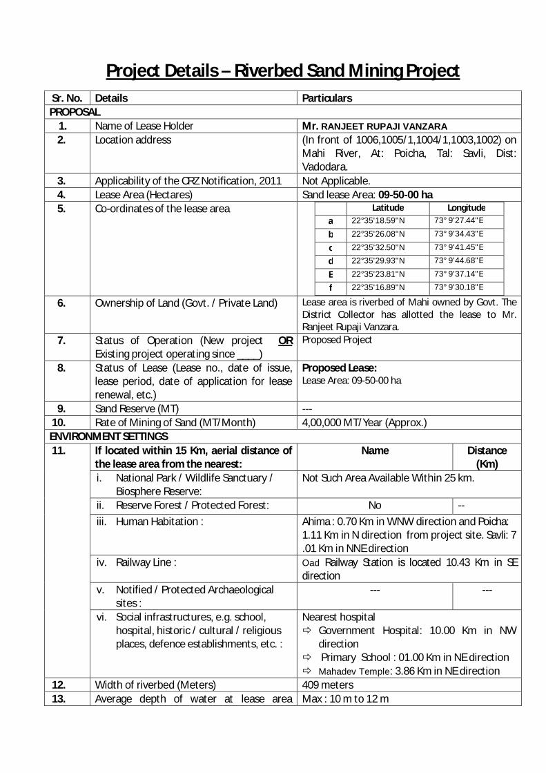
Project Details – Riverbed Sand Mining Project Sr. No. Details Particulars PROPOSAL
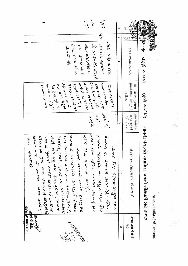
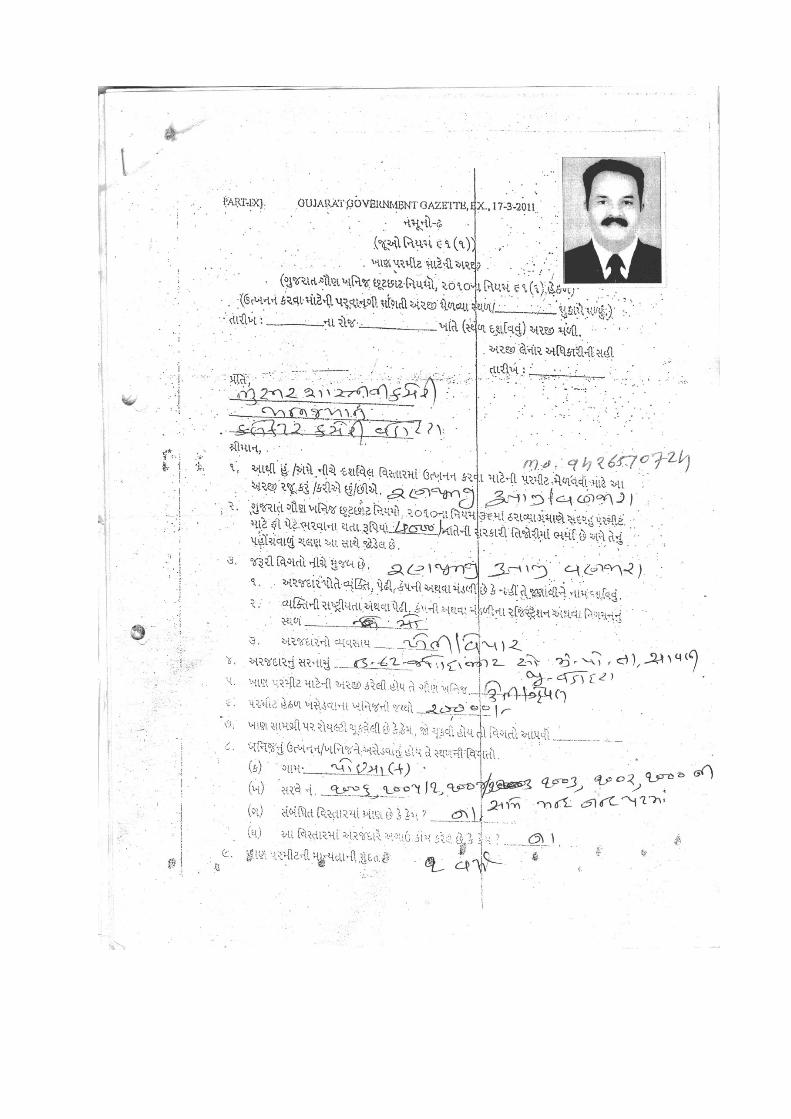
1. Name of Lease Holder Mr. RANJEET RUPAJI VANZARA 2. Location address (In front of 1006,1005/1,1004/1,1003,1002) on
Mahi River, At: Poicha, Tal: Savli, Dist: Vadodara.
3. Applicability of the CRZ Notification, 2011 Not Applicable. 4. Lease Area (Hectares) Sand lease Area: 09-50-00 ha 5. Co-ordinates of the lease area Latitude Longitude
a 22°35'18.59"N 73° 9'27.44"E
b 22°35'26.08"N 73° 9'34.43"E
c 22°35'32.50"N 73° 9'41.45"E
d 22°35'29.93"N 73° 9'44.68"E
E 22°35'23.81"N 73° 9'37.14"E
f 22°35'16.89"N 73° 9'30.18"E
6. Ownership of Land (Govt. / Private Land) Lease area is riverbed of Mahi owned by Govt. The District Collector has allotted the lease to Mr. Ranjeet Rupaji Vanzara.
7. Status of Operation (New project OR Existing project operating since ____)
Proposed Project
8. Status of Lease (Lease no., date of issue, lease period, date of application for lease renewal, etc.)
Proposed Lease: Lease Area: 09-50-00 ha
9. Sand Reserve (MT) --- 10. Rate of Mining of Sand (MT/Month) 4,00,000 MT/Year (Approx.) ENVIRONMENT SETTINGS 11. If located within 15 Km, aerial distance of
the lease area from the nearest: Name Distance
(Km) i. National Park / Wildlife Sanctuary /
Biosphere Reserve: Not Such Area Available Within 25 km.
ii. Reserve Forest / Protected Forest: No -- iii. Human Habitation : Ahima : 0.70 Km in WNW direction and Poicha:
1.11 Km in N direction from project site. Savli: 7 .01 Km in NNE direction
iv. Railway Line : Oad Railway Station is located 10.43 Km in SE direction
v. Notified / Protected Archaeological sites :
--- ---
vi. Social infrastructures, e.g. school, hospital, historic / cultural / religious places, defence establishments, etc. :
Nearest hospital Government Hospital: 10.00 Km in NW
direction Primary School : 01.00 Km in NE direction Mahadev Temple: 3.86 Km in NE direction
12. Width of riverbed (Meters) 409 meters 13. Average depth of water at lease area Max : 10 m to 12 m
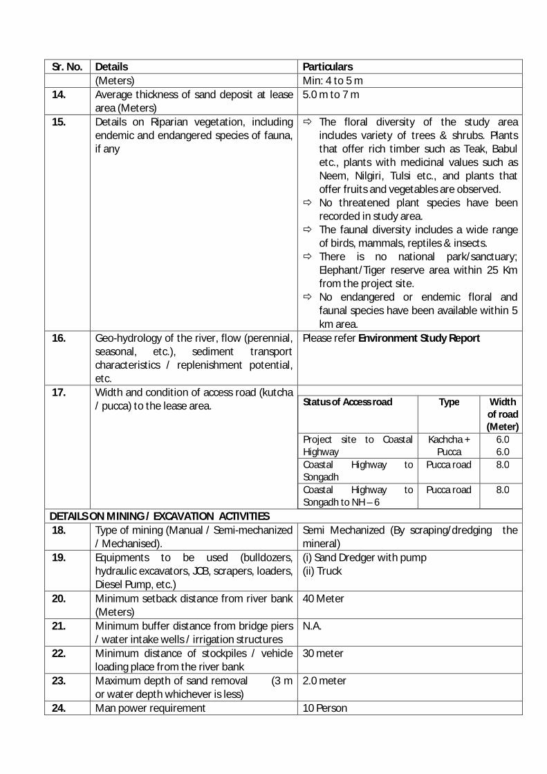
Sr. No. Details Particulars (Meters) Min: 4 to 5 m
14. Average thickness of sand deposit at lease area (Meters)
5.0 m to 7 m
15. Details on Riparian vegetation, including endemic and endangered species of fauna, if any
The floral diversity of the study area includes variety of trees & shrubs. Plants that offer rich timber such as Teak, Babul etc., plants with medicinal values such as Neem, Nilgiri, Tulsi etc., and plants that offer fruits and vegetables are observed.
No threatened plant species have been recorded in study area.
The faunal diversity includes a wide range of birds, mammals, reptiles & insects.
There is no national park/sanctuary; Elephant/Tiger reserve area within 25 Km from the project site.
No endangered or endemic floral and faunal species have been available within 5 km area.
16. Geo-hydrology of the river, flow (perennial, seasonal, etc.), sediment transport characteristics / replenishment potential, etc.
Please refer Environment Study Report
17. Width and condition of access road (kutcha / pucca) to the lease area.
Status of Access road Type Width of road (Meter)
Project site to Coastal Highway
Kachcha + Pucca
6.0 6.0
Coastal Highway to Songadh
Pucca road 8.0
Coastal Highway to Songadh to NH – 6
Pucca road 8.0
DETAILS ON MINING / EXCAVATION ACTIVITIES 18. Type of mining (Manual / Semi-mechanized
/ Mechanised). Semi Mechanized (By scraping/dredging the mineral)
19. Equipments to be used (bulldozers, hydraulic excavators, JCB, scrapers, loaders, Diesel Pump, etc.)
(i) Sand Dredger with pump (ii) Truck
20. Minimum setback distance from river bank (Meters)
40 Meter
21. Minimum buffer distance from bridge piers / water intake wells / irrigation structures
N.A.
22. Minimum distance of stockpiles / vehicle loading place from the river bank
30 meter
23. Maximum depth of sand removal (3 m or water depth whichever is less)
2.0 meter
24. Man power requirement 10 Person

Sr. No. Details Particulars 25. No. of working days in a year 90 Days (Arial.) 26. Time of working hours in a day 8:00 am to 6:00 pm ENVIRONMENTAL MANAGEMENT PLAN 27. Measures proposed for protection of
environmental attributes like riverbed, riparian vegetation, water, air, human health, etc.
Environment Study Report
28. Details on transportation route & measures proposed for control of fugitive emission during transportation
Status of Access road Type Width of road (Meter)
Project site to Coastal Highway
Kachcha + Pucca
6.0 6.0
Coastal Highway to Songadh
Pucca road 8.0
Coastal Highway to Songadh to NH – 6
Pucca road 8.0
29. Plan for tree plantation in riparian area / road sides in at least 20% of lease area, numbers & types of species and budgetary outlay for the same
Plan for tree plantation in riparian area/road sides:
Type of plants
No. of plants Area in hectares will be covered under plantation
I (M)
II (M)
III (M)
Neem, Palm, Coconut, etc… 40 40 40 00-20-00 ha
Total 120 00-20-00 ha
30. Plan for restoration / reclamation --- 31. Cluster Area As per MoEF notification our lease has not covered
under the cluster area, as per Geologist report.
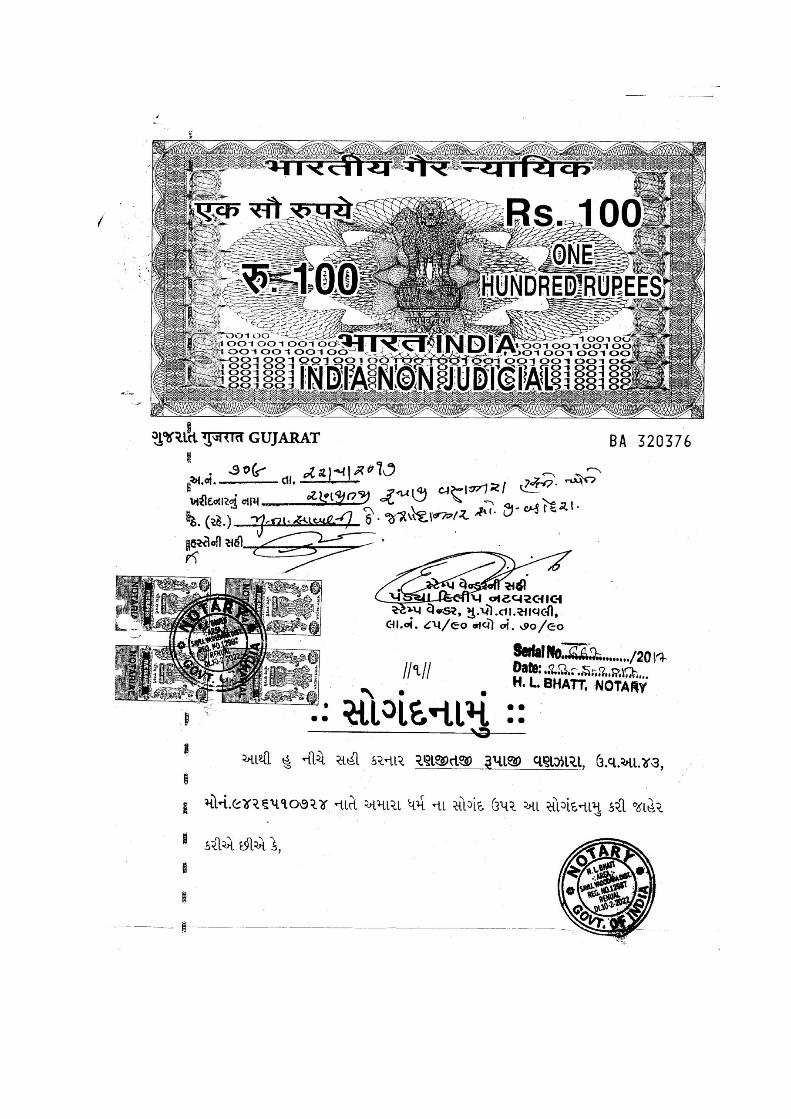
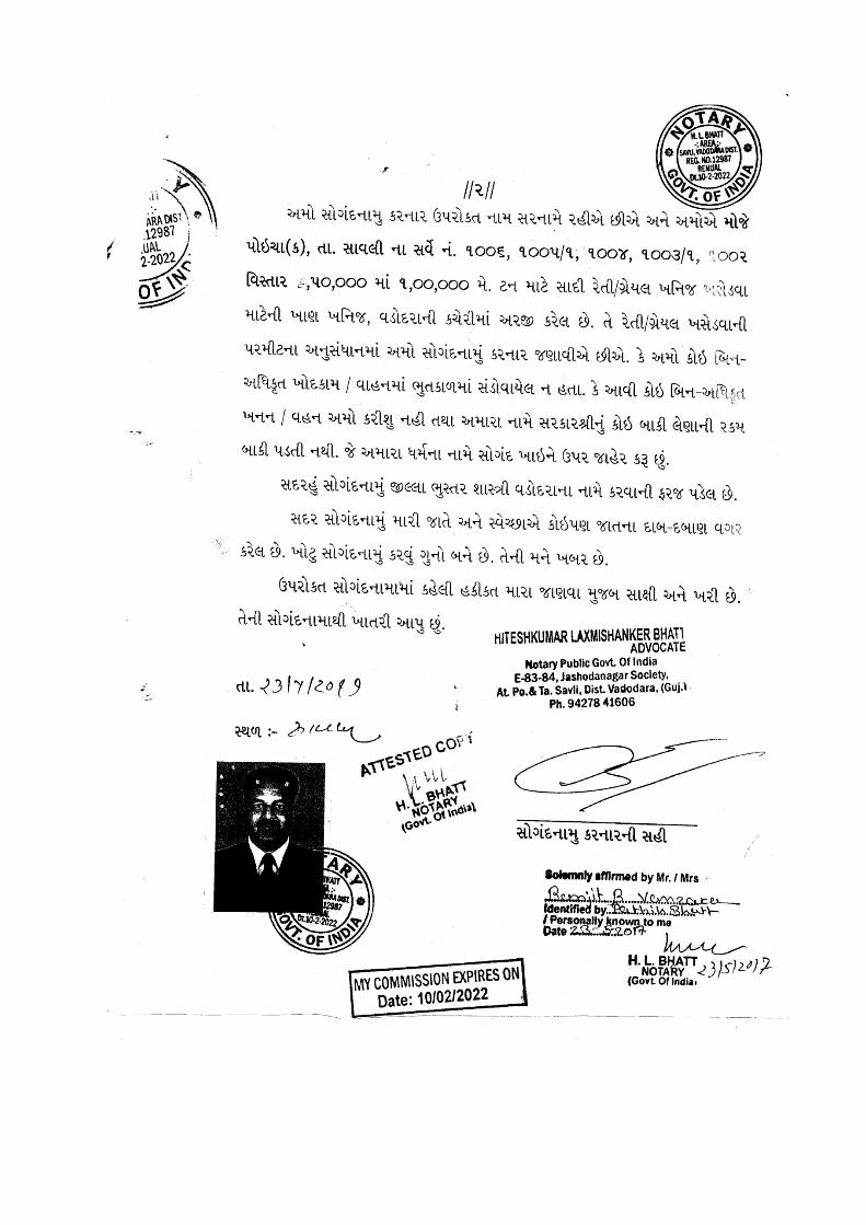
The Geologist,
As per site inspection of the lease Mr. RANJEET RUPAJI VANZARA it has been concluded that this lease not cover under the cluster area. And as per mining site inspection lease has been cover under the dry river bed. As per MoEF notification 01/07/2016 our lease has not covered under the cluster area, as per Geologist report.For,
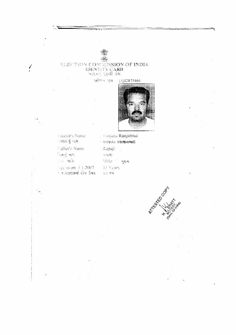
Ranjeet Rupaji Vanzara
Proprietor
ENVIRONMENT STUDY REPORT (RIVERBED SAND MINING PROJECT)
PROPOSAL
I Ranjeet Rupaji Vanzara have been extracting the sand (minor mineral) Infront of S.No.
1006, 1005/1, 1004/1, 1003, 1002 on river of Mahi at Poicha, Tal: Savli, Dist: Vadodara.
Lease area is river of Mahi owned by Government. We hold the lease on the name of Mr.
Ranjeet Rupaji Vanzara. We are applying to regularize the proposed Sand mining activity.
The mining area of the unit is 09-50-00 ha. Our sand lease area is not falling under CRZ area.
Therefore, project falls under category B (B2) of schedule 1(a), as per the EIA Notification,
September 2006. Therefore, it requires prior Environment Clearance.
Status of Operation & Status of Lease are summarized as under...
Proposed project.
Lease area: 09-50-00 ha (In front of S. No. 1006,1005/1,1004/1,1003,1002 on river of Mahi at
Poicha,
Tal: Savli, Dist: Vadodara.)
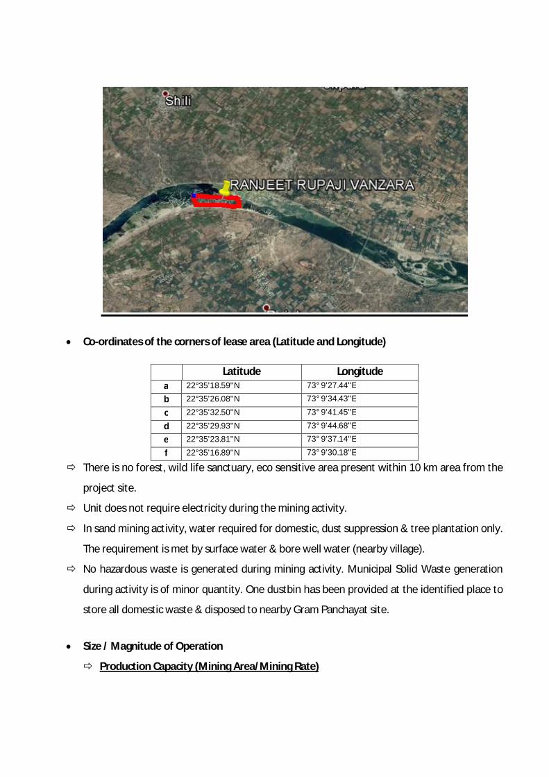
Co-ordinates of the corners of lease area (Latitude and Longitude)
Latitude Longitude a 22°35'18.59"N 73° 9'27.44"E
b 22°35'26.08"N 73° 9'34.43"E
c 22°35'32.50"N 73° 9'41.45"E
d 22°35'29.93"N 73° 9'44.68"E
e 22°35'23.81"N 73° 9'37.14"E
f 22°35'16.89"N 73° 9'30.18"E
There is no forest, wild life sanctuary, eco sensitive area present within 10 km area from the
project site.
Unit does not require electricity during the mining activity.
In sand mining activity, water required for domestic, dust suppression & tree plantation only.
The requirement is met by surface water & bore well water (nearby village).
No hazardous waste is generated during mining activity. Municipal Solid Waste generation
during activity is of minor quantity. One dustbin has been provided at the identified place to
store all domestic waste & disposed to nearby Gram Panchayat site.
Size / Magnitude of Operation
Production Capacity (Mining Area/Mining Rate)
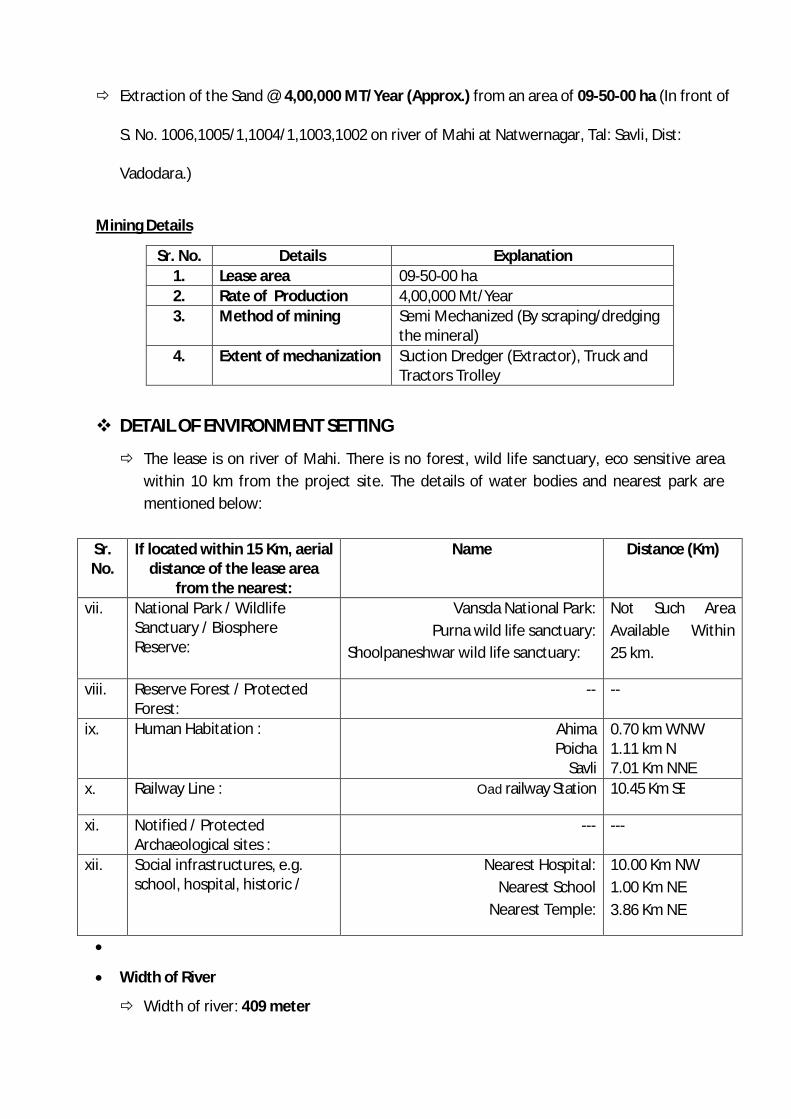
Extraction of the Sand @ 4,00,000 MT/Year (Approx.) from an area of 09-50-00 ha (In front of
S. No. 1006,1005/1,1004/1,1003,1002 on river of Mahi at Natwernagar, Tal: Savli, Dist:
Vadodara.)
Mining Details
Sr. No. Details Explanation 1. Lease area 09-50-00 ha 2. Rate of Production 4,00,000 Mt/Year 3. Method of mining Semi Mechanized (By scraping/dredging
the mineral) 4. Extent of mechanization Suction Dredger (Extractor), Truck and
Tractors Trolley
DETAIL OF ENVIRONMENT SETTING
The lease is on river of Mahi. There is no forest, wild life sanctuary, eco sensitive area within 10 km from the project site. The details of water bodies and nearest park are mentioned below:
Sr. No.
If located within 15 Km, aerial distance of the lease area
from the nearest:
Name Distance (Km)
vii. National Park / Wildlife Sanctuary / Biosphere Reserve:
Vansda National Park: Purna wild life sanctuary:
Shoolpaneshwar wild life sanctuary:
Not Such Area Available Within 25 km.
viii. Reserve Forest / Protected Forest:
-- --
ix. Human Habitation : Ahima Poicha
Savli
0.70 km WNW 1.11 km N 7.01 Km NNE
x. Railway Line : Oad railway Station 10.45 Km SE
xi. Notified / Protected Archaeological sites :
--- ---
xii. Social infrastructures, e.g. school, hospital, historic /
Nearest Hospital: Nearest School
Nearest Temple:
10.00 Km NW 1.00 Km NE 3.86 Km NE
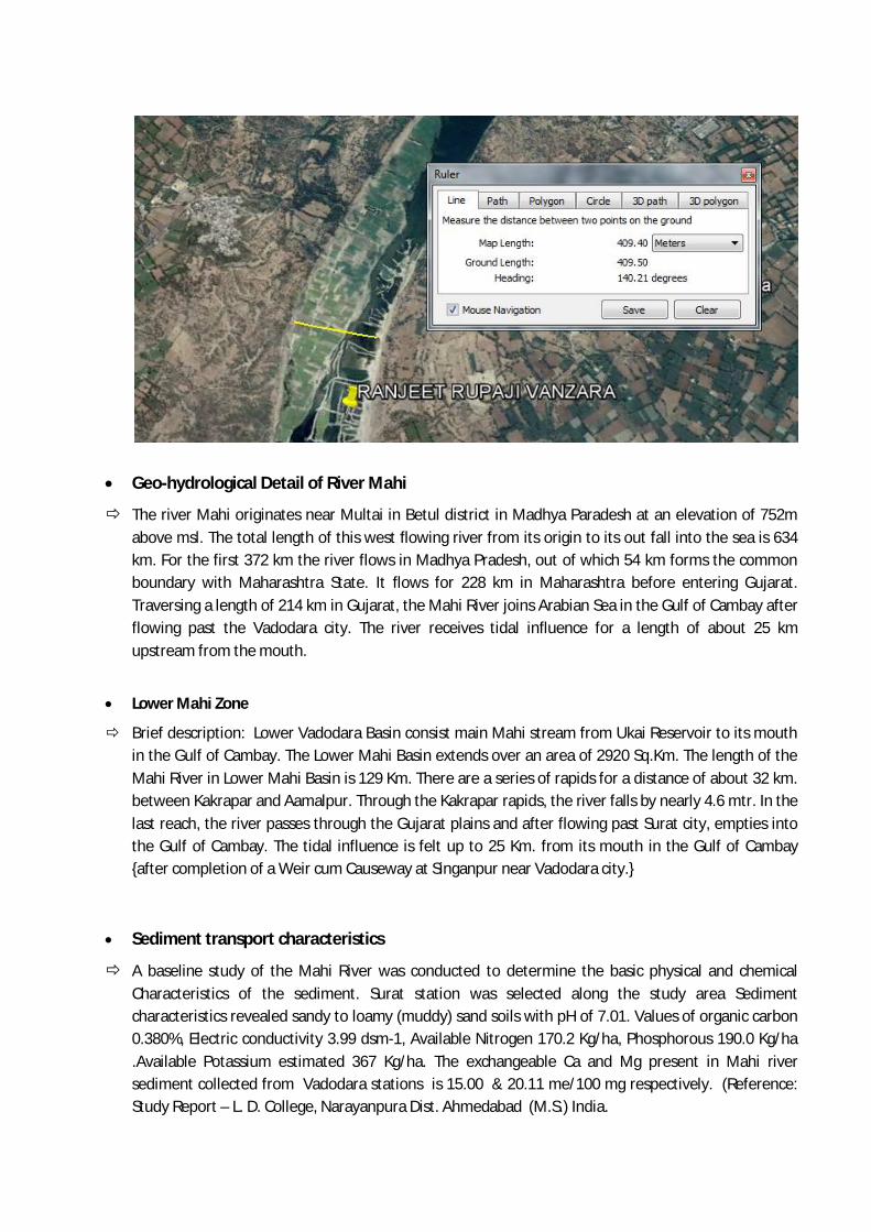
Width of River
Width of river: 409 meter
Geo-hydrological Detail of River Mahi
The river Mahi originates near Multai in Betul district in Madhya Paradesh at an elevation of 752m above msl. The total length of this west flowing river from its origin to its out fall into the sea is 634 km. For the first 372 km the river flows in Madhya Pradesh, out of which 54 km forms the common boundary with Maharashtra State. It flows for 228 km in Maharashtra before entering Gujarat. Traversing a length of 214 km in Gujarat, the Mahi River joins Arabian Sea in the Gulf of Cambay after flowing past the Vadodara city. The river receives tidal influence for a length of about 25 km upstream from the mouth.
Lower Mahi Zone
Brief description: Lower Vadodara Basin consist main Mahi stream from Ukai Reservoir to its mouth in the Gulf of Cambay. The Lower Mahi Basin extends over an area of 2920 Sq.Km. The length of the Mahi River in Lower Mahi Basin is 129 Km. There are a series of rapids for a distance of about 32 km. between Kakrapar and Aamalpur. Through the Kakrapar rapids, the river falls by nearly 4.6 mtr. In the last reach, the river passes through the Gujarat plains and after flowing past Surat city, empties into the Gulf of Cambay. The tidal influence is felt up to 25 Km. from its mouth in the Gulf of Cambay {after completion of a Weir cum Causeway at Singanpur near Vadodara city.}
Sediment transport characteristics
A baseline study of the Mahi River was conducted to determine the basic physical and chemical Characteristics of the sediment. Surat station was selected along the study area Sediment characteristics revealed sandy to loamy (muddy) sand soils with pH of 7.01. Values of organic carbon 0.380%, Electric conductivity 3.99 dsm-1, Available Nitrogen 170.2 Kg/ha, Phosphorous 190.0 Kg/ha .Available Potassium estimated 367 Kg/ha. The exchangeable Ca and Mg present in Mahi river sediment collected from Vadodara stations is 15.00 & 20.11 me/100 mg respectively. (Reference: Study Report – L. D. College, Narayanpura Dist. Ahmedabad (M.S.) India.
DETAILS ON MINING / EXCAVATION ACTIVITIES Method of Mining
Mining of the minerals is done by scraping/dredging the mineral from active channel or
Floodplain or terrace.
Mining of the minerals is done by scraping/dragging the mineral in ½ meter strip. Then the
mining is restricted up to 2 m depth only.
Average depth of water at lease area is: Max: 10.0 m to 12.0 m Min: 04.0 m to 06.0 m.
The Average thickness of sand deposit at lease area is: 4.0 meter.
Type of mining is: Semi Mechanized (By scraping/dredging the mineral)
Equipments used are: Sand Dredger with pump & Truck. Minimum setback distance from river bank is: 40 meter. Minimum distance of stockpiles / vehicle loading place from the river bank is: 30 meter
Man power requirement: 10 people
Average No. of working days in a year: 90 days
Time of working hours in a day is: 8:00 am to 6:00 pm
In-stream extraction of sand from below the water level of a stream generally causes more
changes to the natural hydrologic processes than limiting extraction to a reference point
above the water level.
Extracting sand from a large river or stream will generally create less impact than extracting
the same amount of material from a smaller river or stream.
The potential impacts of sand extraction are as under…
a) Bed degradation and consequent effects on channel and bank stability
b) Increased sediment loads, decreased water clarity;
c) Changes in channel morphology and disturbance of ecologically important roughness
elements in the river bed;
d) Ecological effects on bird nesting, fish migration, etc.
e) Modification of the riparian zone ﴾wet land) including bank erosion;
f) Discharges from equipment and refueling;
g) Reduction in groundwater elevations;
h) Impacts on structures and access;
i) Impacts on coastal processes.
Impact on Air Environment Sources: Fugitive emission occurs due to movement of vehicles on roads. The quantity of emissions
depends on various aspects like climatic conditions, moisture in the soil, speed of the vehicle, frequency of the vehicles etc.
The key air emissions from the project are dusting combustion of fuel from the transportation vehicles as well as material handling. The main air pollutants will be particulate matter, nitrogen dioxide and sulpher dioxide
The mined sand is transported to the sites through 10/16 MT Trucks. The loading operation is manual/ mechanical using material handling equipment. Impacts: Respiratory system can be damaged of workers/people living in nearby area due to dust
generation. Frequent movement of heavily loaded vehicles across the river banks not only imposes land
stability problems but also pollutes the river water through oil/gasoline spillage.
Impact of Noise Transportation vehicles used for the transportation of mineral are a source of Noise pollution
at the Mine site.
Impact on Land Use Pattern and Change of River Course The physical composition and stability of substrates are altered as a result of in-stream
mining and most of these physical effects may exacerbate sediment entrainment in the channel. Excess sediment is considered the greatest pollutant in water and constitutes one of the major environmental factors in the degradation of stream fisheries
If the mining is not carried out in a uniform manner then it will disturb the river flow/course in the terms of its uniformity. Unplanned mining activities can lead to river channel shifting as well as degradation of land, causing loss of properties and degradation of landscape. Some physical impacts are as under…
1) The undercutting and collapse of river banks, 2) The loss of adjacent land and/or structures, 3) Upstream erosion as a result of an increase in channel slope and changes in flow
velocity 4) Downstream erosion due to increased carrying capacity of the stream, downstream
changes in patterns of Deposition and changes in channel bed and habitat type.
5) Riverbed lowering 6) Changing the course of the riverbed
Impact on Water Environment Mining may cause lowering of riverbed level as well as river water level resulting in lowering
of groundwater table due to excessive extraction and draining out of groundwater from the adjacent areas. This may cause shortage of water for the vegetation and human settlements in the vicinity.
Indiscriminate sand mining from the rivers can lead to destruction of riparian vegetation which acts as resting and nesting grounds of many migratory birds.
The in stream fish wealth of the rivers may be decreased year after year consequent to unabated sand mining and subsequent habitat loss.
Extensive use of high power suction pumps for extraction of sand from the river has aggravated the salt water intrusion problems especially in the lowland river reaches
Effects directly related to extraction and to changes in geomorphology include increased sedimentation, turbidity, and bank full widths, higher stream temperatures, reduced dissolved oxygen, decreased wetted periods in riparian wetlands, and degraded riparian habitat.
Impact on Topography and Drainage Pattern Unplanned mining activities and stocking of unwanted material near the river bank can
affect the natural topography of the River bed. Mining pits are responsible for river channel shifting as well as degradation of land and landscape.
Impact on Soil No major impact on soil of the study area is envisaged due to mining activities as the
minerals are replenish able and get replenished every year. Impacts on Biological Environment Excessive sediment deposition for replenishment/ refilling of the pits affect turbidity,
prevent the penetration of the light required for photosynthesis of micro and macro flora which in turn reduces food availability for aquatic fauna. Increase in river gradient may cause excessive erosion causing adverse effect on the in stream habitats.
Riparian flora and fauna suffer seriously from riverbank slumping, channel incision, lowering of water table etc., as a result of the direct removal of vegetation along the river banks, bank undercutting and channel incision.
ENVIRONMENT MANAGEMENT PLAN AND MITIGATION MEASURES
Air Quality Management There will be emission from combustion of fuels from the transportation vehicles and
material handling. Besides this, to control the emissions further regular preventive maintenance of
equipments will be carried out on contractual basis. It shall be ensured that all transportation vehicles should carry a valid PUC certificate. Plantation will be carried out on approach roads & nearby vicinity of River bank. Regular water sprinkling on road will be carried out to avoid dustiness due to vehicular
transportation. Speed of the vehicles is maintained within the prescribed limits. Trucks are not be over loaded and should be maintained to the body level. Condition of all trucks will be well maintained Old age trucks will not be utilized;
Noise Management No other equipments except the Transportation vehicles and Excavator (as and when
required) for loading will be allowed. Noise generated by these equipments shall be intermittent and does not cause any impact.
All vehicles which create high noise will be avoided. Plantation will be carried out on approach roads & nearby vicinity of River bank. Proper maintenance of vehicles would be ensured. Mining activity will be restricted to day time only.
Management for Land Use Pattern Including Change of River Course The sediments will accumulate / replenish every year during rainy season. The minerals will be collected in a uniform way so that the river flow/course shall not get
disturbed. Scrapping/dredging of minerals shall be started from the centre towards the bank
periphery in ½ meter slice so that the river course does not get affected and a barrier of atleast 3 m will be left at both bank side for safety of banks.
Unused material including mineral or spillage (if any) will not be stocked on the banks side as it will hinder the flow of river in monsoon season.
Suitable mitigation measures will be adopted to avoid water logging. Water Quality Management No waste water will be generated from the mining activity of minerals as the project only
involves scraping of Sand from River bed. Mining will not intersect the Water level. Mining will be done well above the riverbed water table therefore impact on water
regime is not anticipated. Solid Waste Management No solid waste will be generated from the said mining operations.
Unused material including mineral or spillage (if any) will not be stocked on the banks side in river bed as it will hinder the flow of river in monsoon season.
Socio Economic Environment The deployed laborers will be from nearby villages.
Occupational Health & Safety Dust masks will be provided to the workers, working in the dust prone zones. Study will be conducted to identify, occupational health hazards if any. Workers will be informed and trained about occupational health hazards if identified. Any workers health related problem will be properly addressed. Adequate PPEs are provide to the workers during mining activity such as dust mask, ear
plug, life jacket, safety shoes, etc. Greenbelt Development and Plantation Programme As the lease area falls in river bed, plantation & green belt development is not possible
within the lease area. Unit has proposed to carry out plantation in the vicinity of river banks, along the
approach roads, around Govt. buildings, schools. The Local species will be planted as per the CPCB guidelines.
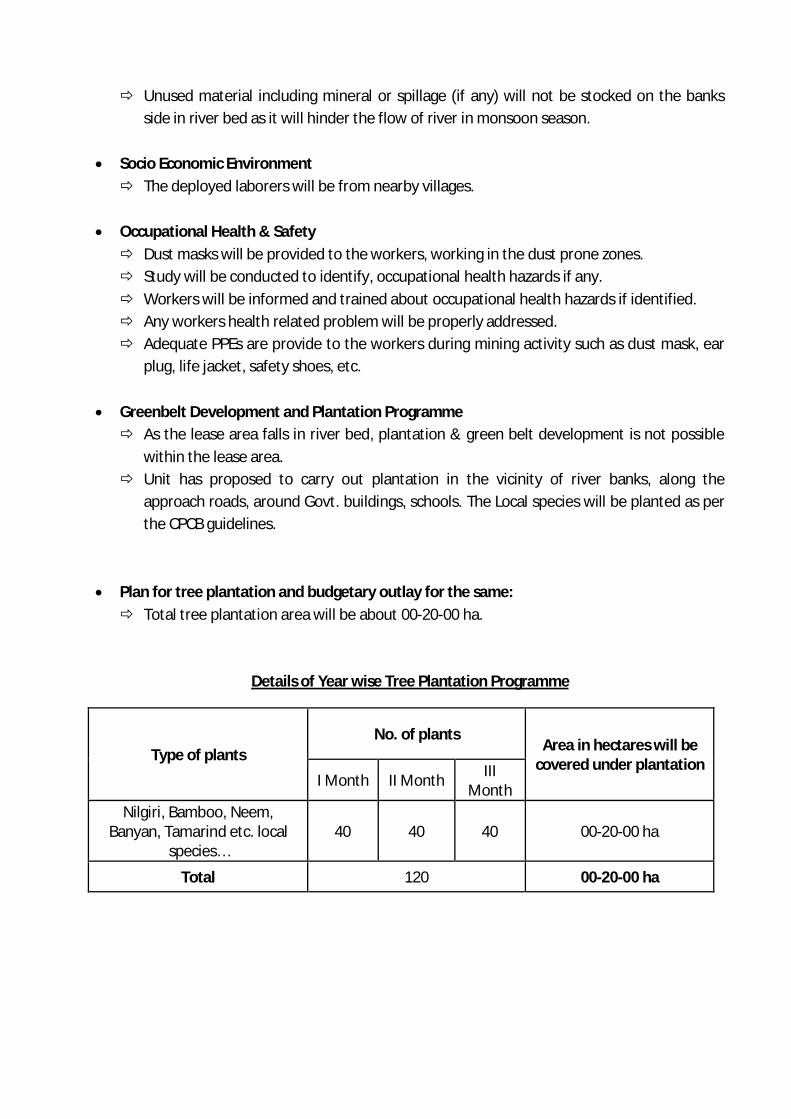
Plan for tree plantation and budgetary outlay for the same: Total tree plantation area will be about 00-20-00 ha.
Details of Year wise Tree Plantation Programme
Type of plants No. of plants
Area in hectares will be covered under plantation
I Month II Month III Month
Nilgiri, Bamboo, Neem, Banyan, Tamarind etc. local
species… 40 40 40 00-20-00 ha
Total 120 00-20-00 ha