project proposal ash lagoon expansion coronach, saskatchewan
TRANSCRIPT

Project ProposalAsh Lagoon ExpansionCoronach, Saskatchewan
Clifton Associates Ltd.engineering science technology
21 April 2008File R4091
Ministry of EnvironmentEnvironmental Assessment Branch4th Floor, 3211 Albert StreetRegina, SaskatchewanS4S 5W6
Mr. Randy SeguinDirector
Ash Lagoon ExpansionCoronach, SaskatchewanSaskPower
On behalf of SaskPower, we are pleased to submit a project proposal for expansion of the ashcontainment system at Coronach, Saskatchewan for your review.
We look forward to receiving project specific guidelines from you to assist in preparation ofthe Environmental Impact Assessment.
Greg F. Vogelsang, P.Eng., P.Geo.GFV/dsk
Ministry of Environment - 30 copiesSask Power - 3 copiesClifton Associates Ltd. - 2 copies
340 Maxwell CrescentRegina, Saskatchewan
Canada S4N 5Y5
Tel:306721.7611Fax: 306721.8128
IntroductionI. I Background1.2 SaskPower1.3 The Poplar River Generating Station
Need for Project and Alternatives2.1 Project Need
2.1.1 Base Load Demand2.1.2 Future Supply Options
2.2 Alternatives2.3 Preferred Alternative
Site Description3.1 Site Description
3.1.1 Poplar River Power Station History and Existing Operations3.1.2 Site Physical Characteristics3.1.3 Site Biophysical Characteristics
Project Description4.1 Existing Ash Disposal Methodology4.2 Future Requirements4.3 Placement Methodology
4.3.1 Ash Stacking Study4.3.2 Preferred Placement Methodology
Impacts Prediction and Mitigation5.1 Regional and Local Impacts
5.1.1 General5.1.2 Biophysical5.1.3 Water Resources5.1.4 Archaeology5.1.5 Noise and Air Emission5.1.6 Socio-Economics5.1.7 Cumulative Effects
5.2 Decommissioning and Reclamation
File R4091Page i

File R4091Page ii
List of FiguresFigure 1.1 Regional Site LocationFigure 1.2 Project Location
List of TablesTable 4.1 Ash Lagoon Fluid Elevations
File R4091Page I
SaskPower is proposing an expansion of the ash disposal system at its Poplar River thermal
power generating station located near Coronach, Saskatchewan. The current disposal
area / system is near capacity and must be expanded to accommodate ash from future
operations. Additional capacity is required to allow operations to continue for an additional
25 years.
This document satisfies the project description requirement for the proposed Ash Lagoon
Expansion project. The project description will be reviewed by the Saskatchewan Ministry of
Environment-Environmental Assessment Branch for preparation of Project Specific EIA
Guidelines and consideration under the Environmental Assessment Act.
SaskPower is a provincial Crown Corporation and is the principal electricity supplier in
Saskatchewan.
SaskPower generates more than 3,214 megawatts (MW) of electricity from its facilities,
which include three coal-fired, seven hydroelectric, four natural gas-fired and two wind
powered facilities.
SaskPower has an additional 454 MW of generating capacity available through long-term
purchase agreements from independent producers. This generating power, combined with
SaskPower owned facilities creates a total available capacity of approximately 3,668 MW.
SaskPower also has interconnected transmission lines at the Borders of Alberta, Manitoba and
North Dakota, and has access to these competitive markets to sell electricity for profit if the
opportunity exists, as well as to import power to meet demands in Saskatchewan.
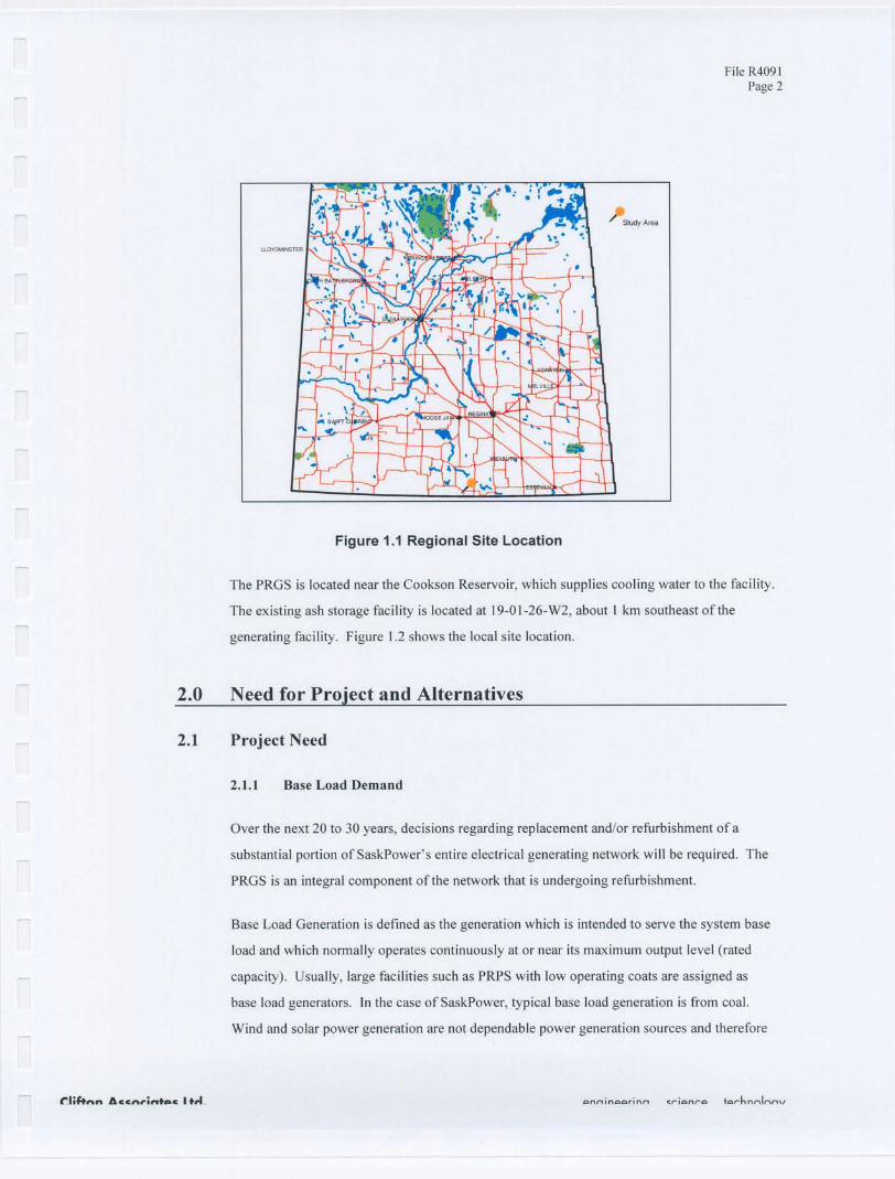
The Poplar River Power Station (PRGS) is a coal burning facility located about 5 km
southeast of Coronach, Saskatchewan (Figure 1.1). The facility currently generates about
572 MW of electricity for the Saskatchewan electrical grid. Unit #1 was commissioned in
1981 and generates 291 MW and Unit #2 was commissioned in 1983 and generates 281 MW.
File R4091Page 2
The PRGS is located near the Cookson Reservoir, which supplies cooling water to the facility.
The existing ash storage facility is located at 19-01-26-W2, about 1 km southeast of the
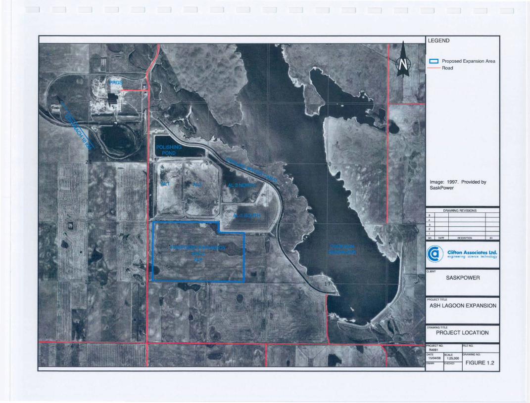
generating facility. Figure 1.2 shows the local site location.
2.0 Need for Project and Alternatives
Over the next 20 to 30 years, decisions regarding replacement and/or refurbishment of a
substantial portion of SaskPower's entire electrical generating network will be required. The
PRGS is an integral component of the network that is undergoing refurbishment.
Base Load Generation is defined as the generation which is intended to serve the system base
load and which normally operates continuously at or near its maximum output level (rated
capacity). Usually, large facilities such as PRPS with low operating coats are assigned as
base load generators. In the case of SaskPower, typical base load generation is from coal.
Wind and solar power generation are not dependable power generation sources and therefore
File R4091Page 3
cannot be considered base load sources. Because PRPS is a base load generator, its
refurbishment is an essential part of SaskPower's capacity to provide reliable and
environmentally responsible power for Saskatchewan.
SaskPower must maintain a diverse power generation mix in order to maximize reliability and
minimize risk. Supply options will be chosen that are environmentally and financially
responsible. Several sources of generation are being investigated to determine what will best
meet the province's future requirements. In the short term (to 2010), SaskPower expects to
meet new power production needs through its Green Power Portfolio, which utilizes sources
that do not increase SaskPower's greenhouse gas emissions. In the long term (beyond 20 I0),
SaskPower plans to refurbish and/or retire a substantial portion of its remaining facilities.
Current plans to refurbish PRGS will allow for its continued service until at least 2033.
Alternative options for additional ash disposal have been examined including the feasibility of
stacking ash onto the existing pile (15 m above levels allowed at that time), expanding the
existing storage lagoon, or creating a new lagoon facility. A review of technical studies has
demonstrated that stacking ash up to 15 m higher than the currently regulated elevation of
775 m is not feasible and neither is the construction of a separate ash lagoon cell in a new
location. The creation of a new lagoon is impractical since extensive infrastructure would be
required (piping, pumps, roads, etc.) and would result in a second, larger area of impact for
ash disposal. The technical review instead supported the concept of developing an additional
ash lagoon storage cell adjacent to the existing site. This was identified as the best option as it
was the most cost-effective, required the least amount of infrastructure development,
maximized use of existing facilities, was compliant with existing regulations, aligned well
with the facilities current operating permits and would reduce the overall environmental
impacts associated with creating a second area of ash disposal. Details on this option follow
in the next section.
Existing ash lagoons at the PRPS will herein be referred to as AL I,AL2, AL3S and AL3N for
lagoons #1, #2, #3 south and #3 north, respectively, (Figure 1.2).
File R4091Page 4
3.0 Site Description
PRPS is a thermal electric generating facility consisting of two units of 300 MW each. The
facility is located approximatley I0 kilometres southeast of the corporate limits of the Town of
Coronach, Saskatchewan.
PRPS has operated for 26 years and consists of two generators, each of which has a coal-fired
boiler, a steam turbine and an electrical generator.
The system was originally designed as an open loop system with water discharge into
Cookson Reservoir and Poplar River. The system was subsequently modified into a closed
loop system with water recirculation to the plant. The cooling water canal was constructed in
1978 and 1979. ALl and AL2 were constructed in September, 1981.
In 1982, additional water storage was needed. A compacted liner and a temporary cross dyke
were constructed to create AL3N. Plant modifications, a series of dry years with low
precipitation and high evaporation losses resulted in a significant decrease in water levels in
ALl and AL2. Consequently, AL3S and AL3N were not needed for ash disposal.
In about 1990, the elevation of the ash reached the original planned maximum elevation of
775 m. Subsequent studies examined the feasibility of surcharging ash above this level and a
study by Clifton Associates Ltd. (1991) recommended that the ash could be surcharged about
to metres above the perimeter till dyke. Operating permits were subsequently changed to
allow the higher elevation and ash was subsequently placed in the facility under the new
licensed elevation.
Clifton Associates Ltd. (1991) reports that numerous investigations have been completed in
the Coronach area for the ash lagoons, the power plant, Morrison Dam and regional
geological exploration.
File R4091Page 5
The regional geology of the Coronach area has been documented by Whitaker et. al. (1978)
and Whitaker (1974). The Ravenscrag Formation is the youngest bedrock unit in the
Coronach area. The formation is composed of interbedded sand, silt clay and lignite and has a
maximum thickness of approximately 90 m.
Empress Group sand and gravel deposits often occupy topographic lows on the bedrock
surface (Whitaker and Christiansen, 1972). The Empress Group is overlain by glacial till
ranging in thickness from 10 to 20 m. The till is subdivided into unoxidized and oxidized till.
The hydraulic conductivity of the oxidized till is greater than that of the unoxidized till.
Locally, Clifton Associates Ltd. (1991) describes the local geology and stratigraphy in detail
from test hole logs compiled as part of numerous investigations in the area. The study area
makes up part of the Coronach Till Plain, which is dissected by Girard Creek, the East Poplar
River and their tributaries. Surface topography drops south of the dam into a basinal feature
surrounded to the east and west by a high relief rolling till plain. Surface relief generally
slopes from the till upland towards the basin centre.
The Empress Group overlies the Ravenscrag Formation in most of the study area; however, it
was not found in test holes sampled 1.5 to 2 km east of the Poplar River. Glacial drift overlies
the Empress Group and Ravenscrag Formation. The lower and middle tills range in thickness
from 5 m to 20 m and are composed of a calcareous, silty clay matrix till containing sand
lenses, cobbles and boulders. The lower till is dark grey, unoxidized and is generally
unjointed at depth. The unoxidized till was found in most test holes and is basically a
continuous mappable stratum throughout the entire area. The overlying middle till is dark
grey-brown, oxidized and jointed with iron oxide staining on joint surfaces.
The youngest till in the area is commonly very thin or absent and may be separated from the
underlying till by a thin layer of sand or gravel or both.
Discontinuous stratified drift composed of silt, sand or gravel overlies the till in a
glacial-fluvial valley, which roughly follows the present day East Poplar River.
The sediments of the East Poplar River valley consist of interbedded and laminated clay, silt,
sand and gravel. Valley deposits are up to 60 m below the present day valley floor. This
suggests possible hydraulic connection between the Empress Group, the Hart seam and the
Coronach seam.

File R4091Page 6
Based on previous studies, the regional and local hydrogeological conditions are well
documented (Clifton Associates Ltd., 1991). The main units comprising the regional
hydrogeological conditions near the site are described below.
The two major coal seams present in the area are the Coronach and Hart seams. Both seams
are part of the Ravenscrag Formation and exhibit artesian pressures. These seams are regional
aquifers in the study area with variable permeability due to varying degrees of cracks and
fissures. The regional groundwater gradient is towards the south although local gradients are
directed towards Poplar River. These aquifers are recharged by precipitation on the uplands
and locally by the Cookson Reservoir. Discharge from the Hart and Coronach units occurs
into the East Poplar River valley fill sediments downstream of the reservoir and upwards to
surface of the depressed area immediately east of Highway No. 36.
Sand, silt and clay units of the Ravenscrag Formation form an aquitard separating the coal
seams and the Empress Group where the Empress Group is present. Thick isolated sand
layers present within the stratum are known to be local water sources. Flow through this
stratum is primarily vertical.
Sand and gravel of the Empress Group is a regional confined aquifer. In the uplands and
below the ash lagoons, the thickness of the Empress Group varies from about 2 m to 4 m.
Downstream of Morrison Dam, the Empress Group has infilled a structural depression in the
bedrock surface. The Empress Group aquifer is recharged regionally by surface infiltration in
the uplands, producing a regional gradient towards the south. The aquifer is recharged locally
by Cookson Reservoir and by the underlying coal seams downstream of the reservoir.
Discharge occurs into the valley fill sediments and upwards through the till and in surficial
depressed areas.
Glacial till consists of unoxidized lower till approximately 5 m in thickness and is relatively
unjointed and massive with a low hydraulic conductivity. The upper oxidized till has a silty
clay matrix with low primary hydraulic conductivity. The unoxidized till provides an aquitard
overlying the Empress Group. Flow direction through the till is primarily in a vertical
direction.
Valley fill sediments have been deposited into the eroded East Poplar River Valley. These
sediments are primarily sand, but also contain silty clay to coarse gravel. They are
hydraulically connected to the Empress Group and to the Cookson Reservoir. Recharge
occurs from the Empress Group and discharge occurs into the Poplar River.
File R4091Page 7
Any proposed expansion to the existing ash lagoons will occur on adjacent cropland, which is
currently farmed. Given the pre-disturbed nature of these lands, there is a negligible chance
that sensitive areas exist in terms of species and ecosystems (e.g. native prairie) at risk. The
only nearby waterbody is a small (likely ephemeral) stream on the quarter section where the
expansion would occur. This stream will be evaluated as part of the EIA; therefore, as
expansion occurs, there is little opportunity of encountering sensitive habitats, plants, wildlife
or aquatic species. A preliminary screening of the Saskatchewan Conservation Data Centre
showed no element occurrences at the proposed site (19-01-26- W2); however, if warranted,
field studies will be conducted in spring and summer 2008 to confirm the absence of sensitive
species. Because the expansion area is on farmland, there is low probability of intact heritage
sites within the cultivated zone).
4.0 Project Description
The PRPS began operations in 1980. Three ash lagoons (AL I,AL2 and AL3N) were
constructed along with a polishing pond.
Coal is fed into storage hoppers in the plant, pulverized, combined with air and blown into the
boiler combustion chamber where it is ignited. A by-product of the coal combustion process
is ash which is the non-combustible component of the coal. This ash is collected in several
places throughout the boiler and it is then disposed of via a closed loop, wet ash system. The
ash waste streams consist of bottom ash, economizer ash, pyrites and flyash. These flyash
products are transported by slurry pipeline to a lagoon system consisting of AL I,AL2 and
AL3S (AL3N has been used as a polishing pond).
Ash generated at the PRPS is transported to the existing ash lagoons as a slurry. The ash
lagoons layout is shown in Figure 1.2. The slurry is discharged from movable spigot points to
promote even ash surfaces. Once the ash settles, the decanted fluids flow by gravity to the
polishing pond and are then re-circulated to the power station via a separate pump system.
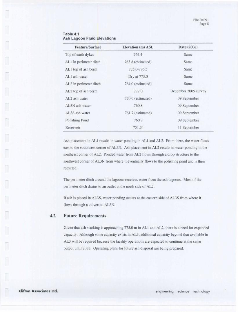
Lagoon fluid elevations taken during September and October, 2006 are provided by Wilson
(2006) and are shown in Table 4.1. Water surface elevations are from surveys. Top of dyke
and perimeter ash ditch fluid levels were taken from surveyed plans and sections.
File R4091Page 8
Table 4.1Ash Lagoon Fluid Elevations
Feature/Surface Elevation (m) ASL Date (2006)
Top of earth dykes 764.4 Same
ALl in perimeter ditch 763.8 (estimated) Same
AL I top of ash berm 775.0-776.5 Same
AL I ash water Dry at 773.0 Same
AL2 in perimeter ditch 764.0 (estimated) Same
AL2 top of ash berm 772.0 December 2005 survey
AL2 ash water 770.0 (estimated) 09 September
AL3N ash water 760.8 09 September
AL3S ash water 761.7 (estimated) 09 September
Polishing Pond 760.7 09 September
Reservoir 751.34 I I September
Ash placement in ALl results in water ponding in ALl and AL2. From there, the water flows
east to the southwest corner of AL3N. Ash placement in AL2 results in water ponding in the
southeast corner of AL2. Ponded water from AL2 flows through a drop structure to the
southwest corner of AL3N from where it eventually flows to the polishing pond and is then
recycled.
The perimeter ditch around the lagoons receives water from the ash lagoons. Most of the
perimeter ditch drains to an outlet at the north side of AL2.
If ash is placed in AL3S, water ponding occurs at the eastern side of AL3S from where it
flows through a culvert to AL3N.
Given that ash stacking is approaching 775.0 m in ALl and AL2, there is a need for expanded
capacity. Although some capacity exists in AL3, additional capacity beyond that available in
AL3 will be required because the facility operations are expected to continue at the same
output until 2033. Operating plans for future ash disposal are being prepared.
File R4091Page 9
Ash stacking is permitted to a regulatory level of 775.0 m ASL. An additional ash stacking
study completed in 2007 examined the feasibility of stacking the ash up to as much as
790.0 m which is 15 m higher than the currently regulated elevation. (WaterMark, 2008).
This report recommended that due to the physical properties of the ash and the potential effect
that additional stacking may have on perimeter dykes, ash stacking should not occur above
levels of about 775.0 m ASL
Detai.\ed engineering studies are currently underway to determine preferred design and
operations plan for an expanded ash lagoon system.
The preferred location for an additional lagoon is to the south of the existing lagoons. The
area provides adequate space for an additional lagoon and does not contain sensitive habitat.
5.0 Impacts Prediction and Mitigation
The PRGS has undergone several modifications since it was originally commissioned. The
facility Saskatchewan Ministry of Environment licenses the site. The existing permit has
extensive environmental monitoring requirements for surface water, wastewater, storm water,
groundwater and air emissions. Given the historical nature of operations and ongoing
environmental monitoring, environmental impacts associated with the proposed expansion are
expected to be minimal.
The EIS will contain a detailed evaluation of ash characteristics and potential impacts on the
environment that may result from the expanded facility.
Additional detailed information will be provided in the Environmental Impact Statement and
are summarized below.
File R4091Page 10
The expansion is proposed for immediately south of ALl. This area is currently agricultural
and as a result of the farming activities, likely has no biological species of concern.
Comprehensive information has been collected on surface and groundwater quality in the area
of the PRPS. Potential impacts to the local groundwater system will be completed as part of
the detailed design and presented in the Environmental Impact Statement.
The Heritage Branch of the Ministry of Culture, Youth and Recreation will be consulted to
assess what assessment, if any, will be required for heritage resource impacts on the proposed
site. Pre-screening results indicate a high potential for heritage resources in the area HRIA
will be conducted if warranted.
There will be no additional noise associated with the expanded facility. Additional noise may
be generated during construction activities; however, this will be short-lived in duration.
Some dust control may be required during operations to ensure that deposited ash does
become airborne during dry periods. A detailed operations plan will address dust
The socio-economic benefits of the project are substantial. The PRPS is expected to remain
in operation for at least an additional 25 years. Construction activities related to the
expansion will provide local employment opportunities to both contractor and local service
providers (motels, restaurants, etc.).
The expanded ash lagoon system will not cause an increase in outputs of any type. The
expansion will simply result in additional ash disposal within an expanded facility.
SaskPower has made significant progress in reducing plant emissions through equipment
File R4091Page II
upgrades and modernization efforts to reduce impacts. An assessment of potential cumulative
impacts will be presented in the EIS.
Current plans are for the continued operation of the PRPS until the year 2033. SaskPower
would commence decommissioning and reclamation of the site facilities at this time.
Plans will be included in the Environmental Impact Statement for long term management of
the existing ash lagoons and will outline necessary steps to decommission the site in an
environmentally appropriate manner, consistent with regulations.
As part of the approval process for an expansion to the ash lagoons, SaskPower will be
initiating a local consultation program. This program will include initial meetings with
elected representatives (RM Council, Coronach mayor and Town Council) to discuss the
preliminary concept of the expansion. An open house will subsequently be scheduled (likely
for June, 2008) to provide local residents with information on the proposed expansion and
gather local input. Concerns and questions generated by both sets of consultation will then be
addressed in the Environmental Impact Statement.
Clifton Associates Ltd., 1991. Hydrogeological Evaluation Ash Storage Lagoons Poplar River PowerStation. Prepared for SaskPower. File R930. May, 1991.
WaterMark Consulting Ltd., 2008. Ash Lagoon Surcharging Study Poplar River Power Station Coronach,Saskatchewan. Prepare for SaskPower. WM 228.
Whitaker, S.H. 1974. Geology and Groundwater Resources of the Willowbunch Area, 72-H/1OSaskatchewan. Saskatchewan Research Council Map No. 20.
Whitaker, S.H., Irvine, 1.A., and Broughton, PL. 1978. Coal Resources of Southern Saskatchewan: AModel for Evaluation Methodology. Prepared for the Geological Survey of Canada (Report 209)and Saskatchewan Research Council (Report 20).
Wilson Engineering Ltd. 2006. Ash Lagoons 2006 Annual Inspection Report Poplar River Power StationCoronach, Saskatchewan. Prepared for SaskPower. Project No. W 106.