property landowner received by office of zoning and
TRANSCRIPT

APPLICATION FOR A SPECIAL ADMINISTRATIVE PERMIT (SAP) For SPI, Beltline, LW, MR, MRC & NC Zoning Districts File No.: _______________ City of Atlanta, Office of Zoning and Development (404-330-6145)
APPLICANT (name) _____________________________________________________
ADDRESS __________________________________________________________________
PHONE NO. ______________________ EMAIL______________________________________
PROPERTY LANDOWNER________________________________________________
ADDRESS __________________________________________________________________
PHONE NO. ______________________ EMAIL ______________________________________
ADDRESS OF PROPERTY ______________________________________________
Land District ________ Land Lot _____________ Council District ________ NPU ________
Is property within the BeltLine Overlay District? Yes No Zoning Classification ______ _____________________________
Is Inclusionary Zoning applicable to this project? Yes No (See additional requirements below)
Submittal Checklist (See detailed checklist on page 2):
□ Project Summary: Provide cover letter describing new construction, alterations, repairs or other changes to the exterior of existing structures and/or the site. Requests for administrative variations must be accompanied by a written justification for each.
□ Property Survey: Submit two (2) copies. Lot consolidation, replatting or subdivision may be required prior to approval of SAP.
□ Site Plan (released for construction and sealed) and Building Elevations: a. Initial Submission: Four (4) Site plans & Two (2) Elevations; with two (2) more copies if DRI or NPU review is required. b. Other information: Copies of applicable Rezoning Legislation, Special Use Permit and any letters for Variance or Special
Exception. Note: additional plans or documents may be required at the discretion of the Office of Zoning and Development.
□ Property Owner Authorization: Submit required notarized owner consent per attached form.
□ Notice to Applicant: Submit attached form with signature and date.
□ Development Controls Specification Form
Fees (non-refundable): Payable to the “City of Atlanta” in the form of cash, credit card, personal or cashier check, or money order.
Additional Submittal Requirements (as applicable):
• Inclusionary Zoning: All new or conversion multifamily residential rental projects with 10 or more units in the Beltline Overlay District OR Westside neighborhoods of English Avenue, Vine City, Ashview Heights, or AUC must complete and submit the Inclusionary Zoning Certification Form with their application. Certification: https://www.atlantaga.gov/home/showdocument?id=33627
• Beltline, NC-2, NC-6, NC-10, NC-11, NC-12, & NC-14 Districts: Pre-application conference with Zoning and Development Staff is recommended prior to SAP submittal. To arrange such a meeting contact Facia Brown at 404-330-6636 or
[email protected]. INCLUDE EXTRA COPY OF SUBMITTAL PACKAGE for the required 21-day NPU review period as
detailed below. Submit (1) one application and (3) three sets of drawings, staff will make copies of the received SAP for you. ➢ Mail a copy of the submitted SAP application & drawings stamped received by the Office of Zoning and Development
to the NPU.
➢ Submit a copy of U.S. Postal Service Certificate of Mailing and notarized Affidavit of NPU Notification as soon as possible to complete the application submission and begin the SAP review period.
• Development Review Committee (DRC)*: Projects in the Beltline & SPIs 1, 9, 12, 15, 16, 17 districts may require DRC review.
• Development of Regional Impact (DRI) Study: Developments either over 500,000 s.f. or having greater than 600 residential units may require a DRI approval by GRTA and ARC. For full thresholds and rules contact GRTA and/or ARC.
➢ Initial submission: DRI Form 1 with the SAP application. Zoning and Development staff will then submit information to GRTA and ARC.
• Watershed Management (DWM) Requirements (Section 74-504(a)): Consultation meeting with DWM is REQUIRED for any site disturbance to determine applicable storm water work. Call 404-330-6249 or visit: www.atlantawatershed.org/greeninfrastructure
I HEREBY AUTHORIZE CITY STAFF TO INSPECT PREMISES OF ABOVE DESCRIBED PROPERTY. I HEREBY DEPOSE THAT ALL STATEMENTS HEREIN ATTACHED & SUBMITTED ARE TRUE TO THE BEST OF MY KNOWLEDGE AND BELIEF.
Date ___________________ Signature of Applicant _____________________________________________________
The City Code provides that Zoning and Development Director shall review each request for an SAP within 30 days of a filing of a completed* application. (Atlanta Code Chapter 16, Section 16-25). * Note: NPU/DRC notification and review, as applicable, are required to complete the SAP application.
(FOR OFFICE OF ZONING AND DEVELOPMENT OFFICE USE ONLY)
The above request for a Special Administrative Permit (SAP) was approved or denied on ____________________________
See attached Special Administrative Permit Approval Form(s) for detailed approval information.
__________________________________________________ _________________________________________________ Signed for Director, Office of Zoning & Development Staff Reviewer - Print Name
Applicants must appear in person to file an application. Applications by mail or courier will not be accepted.
DATE STAMP
RECEIVED BY
OFFICE OF ZONING
AND DEVELOPMENT
□ Developments < 50,000 sq.ft. of floor area: $500.
□ Developments ≥ 250,000 sq.ft. of floor area: $1,500.
□ Exterior demo, outdoor dining new/expansion, or non-expansion: $250.
□ Developments 50,000 to 250,000 sq.ft. of floor area: $1,000.
City of Atlanta Office of Zoning & Development
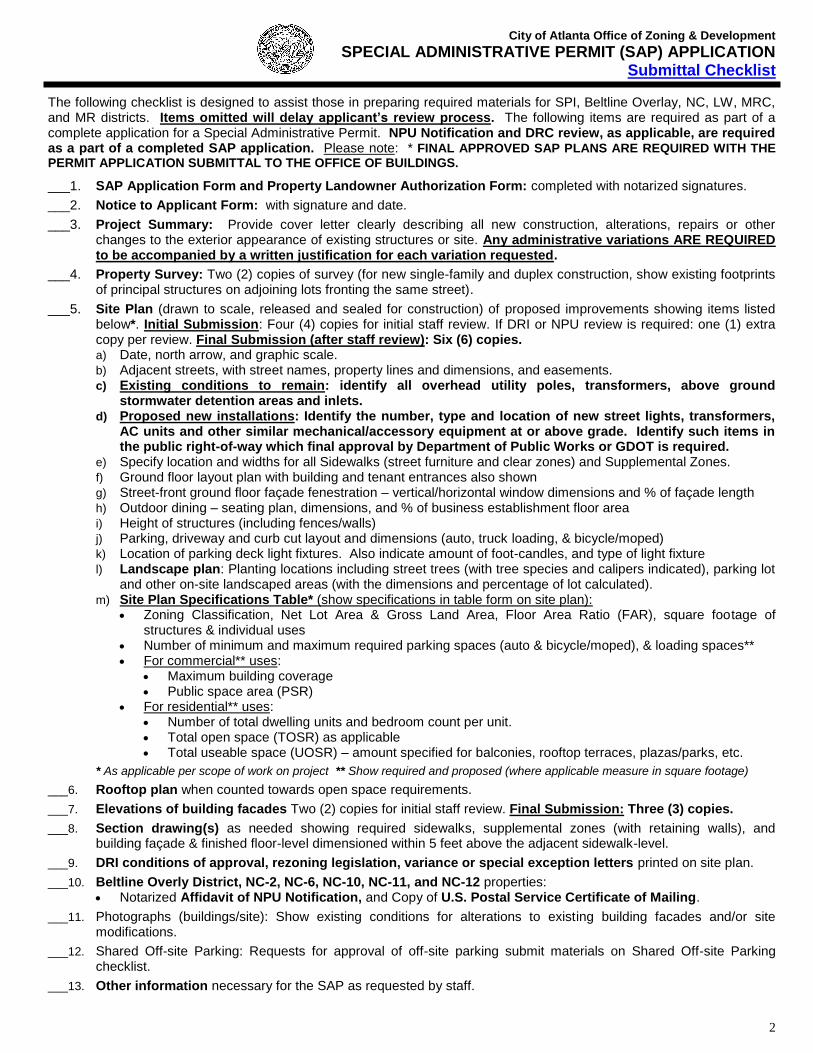
SPECIAL ADMINISTRATIVE PERMIT (SAP) APPLICATION Submittal Checklist
2
The following checklist is designed to assist those in preparing required materials for SPI, Beltline Overlay, NC, LW, MRC, and MR districts. Items omitted will delay applicant’s review process. The following items are required as part of a complete application for a Special Administrative Permit. NPU Notification and DRC review, as applicable, are required as a part of a completed SAP application. Please note: * FINAL APPROVED SAP PLANS ARE REQUIRED WITH THE PERMIT APPLICATION SUBMITTAL TO THE OFFICE OF BUILDINGS.
___1. SAP Application Form and Property Landowner Authorization Form: completed with notarized signatures.
___2. Notice to Applicant Form: with signature and date.
___3. Project Summary: Provide cover letter clearly describing all new construction, alterations, repairs or other changes to the exterior appearance of existing structures or site. Any administrative variations ARE REQUIRED to be accompanied by a written justification for each variation requested.
___4. Property Survey: Two (2) copies of survey (for new single-family and duplex construction, show existing footprints of principal structures on adjoining lots fronting the same street).
___5. Site Plan (drawn to scale, released and sealed for construction) of proposed improvements showing items listed below*. Initial Submission: Four (4) copies for initial staff review. If DRI or NPU review is required: one (1) extra copy per review. Final Submission (after staff review): Six (6) copies. a) Date, north arrow, and graphic scale. b) Adjacent streets, with street names, property lines and dimensions, and easements. c) Existing conditions to remain: identify all overhead utility poles, transformers, above ground
stormwater detention areas and inlets. d) Proposed new installations: Identify the number, type and location of new street lights, transformers,
AC units and other similar mechanical/accessory equipment at or above grade. Identify such items in the public right-of-way which final approval by Department of Public Works or GDOT is required.
e) Specify location and widths for all Sidewalks (street furniture and clear zones) and Supplemental Zones. f) Ground floor layout plan with building and tenant entrances also shown g) Street-front ground floor façade fenestration – vertical/horizontal window dimensions and % of façade length h) Outdoor dining – seating plan, dimensions, and % of business establishment floor area i) Height of structures (including fences/walls) j) Parking, driveway and curb cut layout and dimensions (auto, truck loading, & bicycle/moped) k) Location of parking deck light fixtures. Also indicate amount of foot-candles, and type of light fixture l) Landscape plan: Planting locations including street trees (with tree species and calipers indicated), parking lot
and other on-site landscaped areas (with the dimensions and percentage of lot calculated). m) Site Plan Specifications Table* (show specifications in table form on site plan):
• Zoning Classification, Net Lot Area & Gross Land Area, Floor Area Ratio (FAR), square footage of structures & individual uses
• Number of minimum and maximum required parking spaces (auto & bicycle/moped), & loading spaces** • For commercial** uses:
• Maximum building coverage • Public space area (PSR)
• For residential** uses: • Number of total dwelling units and bedroom count per unit. • Total open space (TOSR) as applicable • Total useable space (UOSR) – amount specified for balconies, rooftop terraces, plazas/parks, etc.
* As applicable per scope of work on project ** Show required and proposed (where applicable measure in square footage)
___6. Rooftop plan when counted towards open space requirements.
___7. Elevations of building facades Two (2) copies for initial staff review. Final Submission: Three (3) copies.
___8. Section drawing(s) as needed showing required sidewalks, supplemental zones (with retaining walls), and building façade & finished floor-level dimensioned within 5 feet above the adjacent sidewalk-level.
___9. DRI conditions of approval, rezoning legislation, variance or special exception letters printed on site plan.
___10. Beltline Overly District, NC-2, NC-6, NC-10, NC-11, and NC-12 properties: • Notarized Affidavit of NPU Notification, and Copy of U.S. Postal Service Certificate of Mailing.
___11. Photographs (buildings/site): Show existing conditions for alterations to existing building facades and/or site modifications.
___12. Shared Off-site Parking: Requests for approval of off-site parking submit materials on Shared Off-site Parking checklist.
___13. Other information necessary for the SAP as requested by staff.

City of Atlanta Office of Zoning & Development
SPECIAL ADMINISTRATIVE PERMIT (SAP) APPLICATION DEVELOPMENT/DESIGN REVIEW COMMITTEES (DRC)
In Beltline Overlay and Special Public Interest (SPI) Districts
Development / Design Review Committees (DRC) have been established as an advisory group for the purpose of providing to the Director of the Office of Zoning and Development formal comments on Special Administrative Permit (SAP) applications within the Beltline Overlay and particular SPI zoning districts. Applicants are required to make a presentation of their project to the applicable DRC committee. DRC review is required as part of a completed SAP application.
Each DRC shall consist of committee members representing the corresponding district stakeholders including: property
owner(s), business owner(s) or resident(s), and applicable neighborhood organization(s), among others.
The DRC convenes monthly (or as needed) to comment on SAP applications within a particular district. Each DRC shall
provide recommendations to the Office of Zoning and Development Staff and the applicant within 7 business days, unless
the applicant is requested to return to the applicable DRC and/or present to respective neighborhood organization(s), or
NPU. Application Submittal and Review Process
1) Pre-application meeting with Office of Zoning and Development staff. To arrange such a meeting contact Facia Brown at 404-330-6636 or [email protected].
2) Notify the applicable DRC contact (as listed above) to arrange placement on the next scheduled DRC meeting agenda.
DRC Submittal Requirements
1) Written summary of proposed scope of work (include applicable project information such as total square footage, # and breakout of residential units, and square footage of each commercial use, building height, parking and loading provided, etc.).
2) Identification of all administrative variations requested and written justification for each requested.
3) PDF Digital drawings (to-scale) of site plans and building elevations as applicable to the scope of work.
4) Photographs of the existing property.
5) Contact DRC representative to e-mail project information (prior to meeting) and confirm DRC meeting date and time.
6) At the DRC meeting:
a. Provide hardcopies of cover letter and drawings (in 11”x17” size) for distribution to each committee member.
b. Provide drawings on boards for project presentation to committee members or digital powerpoint presentation
(coordinate with DRC representative on the latter). Committee Review Responsibilities
1) Make recommendations on project concerning zoning requirements and administrative variations requested. 2) Make other design recommendations for consideration concerning an application. Note: these other recommendations
are not code requirements.
DRC Committees (established by City Council Resolution)
• SPI-1 Downtown (2007) • SPI-15 Lindbergh (2001) • Beltline Overlay (2015)
• SPI-9 Buckhead Village (2010) • SPI-16 Midtown (2001) • SPI-12 Buckhead/Lenox Stations (2012) • SPI-17 Piedmont Avenue (2001)
Meeting Dates and Locations
Downtown SPI-1 Midtown SPI-16 & Piedmont Avenue SPI-17 Meetings held the 4th Thursday morning monthly Meetings held the 2nd Tuesday evening monthly Central Atlanta Progress, 84 Walton Street NW, Suite 500 Midtown Alliance, 999 Peachtree Street NE, Suite 730 Contact Audrey Leous: [email protected] Contact Ginny Kennedy: [email protected] (404) 658-5911 (404) 892-4782
Buckhead Village SPI-9 & Buckhead/Lenox SPI-12 Beltline Overlay
Meeting held 1st Wednesday afternoon monthly Meeting held the 3rd Wednesday evening monthly
BATMA, 3340 Peachtree Road NE Atlanta Beltline Inc.
Tower Place Bld. 100, Suite 1515 100 Peachtree Street NW, Suite 2300
Contact Denise Starling: [email protected] Contact Lynnette Reid: [email protected] (404) 842-2680 (404) 477-3551 Lindbergh SPI-15: Meetings coordinated by City of Atlanta Zoning and Development Staff: (404) 330-6145.

City of Atlanta Office of Zoning & Development
SPECIAL ADMINISTRATIVE PERMIT (SAP) APPLICATION Notarized Authorization by Property Landowner
File # _____________________
(Required only if applicant is not the owner of the property subject to the application)
TYPE OF APPLICATION: Special Administrative Permit
I, _________________________________________SWEAR THAT I AM THE LANDOWNER
owner(s) name
OF THE PROPERTY LOCATED AT: ______________________________________________
___________________________________________________________________________________________
AS SHOWN IN THE RECORDS OF _________________________ COUNTY, GEORGIA WHICH IS
THE SUBJECT MATTER OF THE ATTACHED APPLICATION. I AUTHORIZE THE PERSON NAMED
BELOW TO ACT AS THE APPLICANT IN THE PURSUIT OF THIS APPLICATION.
NAME OF APPLICANT (PRINT CLEARLY):
___________________________________________________________________________________
___________________________________________________________________________________
ADDRESS: _________________________________________________________________________
___________________________________________________________________________________
TELEPHONE: ___________________________ EMAIL: ____________________________________
__________________________________ Signature of Property Landowner
__________________________________ Print Name of Property Landowner
Personally Appeared Before Me _________________________________________________ Who Swears That The Information Contained In this Authorization Is True and Correct To The Best of His or Her Knowledge and Belief.
_________________________________________ Signature of Notary Public
_________________________________________ Date

City of Atlanta Office of Zoning & Development
SPECIAL ADMINISTRATIVE PERMIT (SAP) AFFIDAVIT OF NPU NOTIFICATION
(*APPLICABLE ONLY FOR BELTLINE, NC-2, NC-6, NC-10, NC-11, NC-12 & NC-14 DISTRICT)
File # ___________________
This Affidavit form and a copy of the United States Postal Service Certificate of Mailing are required by owner and applicant of the property subject to the Special Administrative Permit application. Submit within FIVE (5) days of application submittal.
The Neighborhood Planning Unit (NPU) has TWENTY ONE (21) days from the date of the associated certificate of mailing to provide one (1) set of written comments to the Office of Zoning and Development prior to any SAP approval.
LOCATION OF SUBJECT PROPERTY:
Street Address(es):____________________________________________________________________________
Zoning Classifications Land District ____ Land Lot _____ Council District ___ NPU ___
APPLICANT:
Name: __________________________________________________________________________________
Company: __________________________________________________________________________________
Address: __________________________________________________________________________________
Telephone: _____________________________ Email: ______________________________________________
As the APPLICANT, I, ________________________________________swear and affirm that I have notified the NPU(s) to which this Special Administrative Permit (SAP) affects, and am aware of the applicable requirements of the City of Atlanta Zoning Ordinance Sections 16-36.004, 16-32J.002(1), 16-32K.002(1), and 16-32L.002(1).
NPU Contact Information
_______________________ ___________________ ________________________
Name of Contact Person(s) Phone Number(s) Email Address (es)
Adjacent NPU(s) Contact Information
_______________________ ___________________ ________________________
Name of Contact Person(s) Phone Number(s) Email Address (es)
(To be completed by Notary):
Personally Appeared Before Me this _________ day of
________________________________, 20_______.
Who Swears That the Information Contained In this Authorization Is True and Correct To the Best of His or Her Knowledge and Belief.
____________________________________ Signature of Notary Public
____________________________________ Date
(To be completed by Applicant & Staff):
____________________________________ Signature of Applicant
____________________________________ Printed Name of Applicant
_______________________________________ Office of Zoning & Development Staff
Signature of Staff only represents that the required notification to the NPU has been completed and does not indicate any position of the Office of Zoning and Development on the application.

City of Atlanta Office of Zoning & Development
SPECIAL ADMINISTRATIVE PERMIT (SAP) NPU Notification Form
(*APPLICABLE FOR BELTLINE ONLY)
File # ___________________
NPU Chairperson or Designee: Enclosed is a copy of a Special Administrative Permit (SAP) application for a property located within the Beltline Overlay Zoning District. As part of the SAP application, applicants are required to submit site plans and building elevations, as applicable to the scope of work, to the Office of Zoning & Development for approval prior to obtaining a building permit. Per Section 16-36.004 of the Beltline district regulations SAP approval is required for:
“All exterior demolition, new construction (including additions to existing buildings), expansions of outdoor dining or any construction which results in increased lot coverage, modification of the building footprint, or modification of building facades that alters the configuration of openings. “
In addition to the SAP submittal as specified above, per Section 16-36.004 the applicant is also required to send a full copy of the SAP application to the respective NPU chair or their designee, evidenced with a certificate of mailing, so that the NPU has an opportunity to review and provide written comments to the Office of Zoning and Development regarding an application prior to any SAP approval. Please note, where underlying regulations require Variance, Special Exception or Special Use Permit action, the SAP shall not be issued until the necessary approval has been obtained. The time period for NPU comment is 21 days from the date of the postage receipt. If the NPU has no comments, or feels they are unnecessary, the Office of Zoning & Development should receive such written notification as soon as possible within the 21-day period. Comments received after the designated review period cannot be considered in the Office’s project review or approval. The BeltLine Zoning Overlay District primarily has design requirements that prescribe parameters for site layout and building elevations. The district regulations do not address issues related to land use or density (building square footage or number of units) as these are addressed by the underlying zoning district regulations. Therefore, NPU review should primarily focus on the following items as addressed in the Beltline Zoning District including:
• Building placement • Building setbacks adjacent to streets (pertaining to minimum sidewalks and
supplemental zones widths), and transitional yards • Provision of sidewalks and street trees • Provision of parking, loading and bicycle spaces • Location of parking and driveways • Parking lot landscaping • Parking deck façade elevations • Building façade elevations related to entrances and windows • …and other BeltLine regulations
For questions, ask for a SAP staff member at 404-330-6145. Please send your written comments and or questions referencing the SAP case number and address to:
Applicant shall submit this form letter as the cover page to the package mailed to NPU chair or designee.

City of Atlanta Office of Zoning & Development
SPECIAL ADMINISTRATIVE PERMIT (SAP) APPLICATION Development Controls Specifications (Required)
File # _____________________
Developmental Controls forms are required to be completed by the applicant, and all applicable specifications should be shown on the site plan in chart form. Items omitted will delay the plan review process. Refer to City of Atlanta Zoning Code (Chapters 8, 19, and 28) for clarification.
Definitions and Methods of Calculation
• Net Lot Area (NLA) = length of property line X width of property line
• GLA for corner lots = (NLA) + [(street “A” right-of-way width ÷2) X (street “A” length of property line)] + [(street “B” right-of-way width ÷2) X (street “B” length of property line) + [(street “A” right-of-way width ÷2) X (street “B” right-of-way width ÷2)]
• GLA (with only one front yard adjacent to street) = (NLA) + [(street right-of-way width ÷2) X (length of front property line)]
• GLA may include half of the right-of-way (including streets, parks, lakes and cemeteries) up to 50 feet in width.
• GLA shall not be used for calculating FAR for properties within single-family or two-family-zoned subareas of SPI districts.
• Building Lot Coverage provided = (net lot area minus area of building footprint) ÷ (net lot area)
Lot Size (in square footage)
Gross Land Area (GLA)
Net Lot Area (NLA)
Floor Area Ratio (FAR) – as applicable. Check which used for residential: GLA, or NLA
Residential FAR Ratio
Residential Square Footage Non-Residential FAR Ratio
Non-Residential Square Footage
Base Allowed
Base Provided
Bonus Allowed
Bonus Provided
Bonus FAR Program (check bonus utilized if applicable)
Transit Station
Ground Floor Retail
Open Space and New Streets
Community Center Facilities
Workforce Housing
Residential Units Total Provided: _______________________
Number of Units Provided (without bonus)
Number of Bonus Units Provided (without workforce housing)
Number of Bonus Workforce Housing Units Provided (20% required)
Total Number of Units per Acre
Building Coverage or Lot Coverage (check applicable as required per zoning district)
Percentage (%) Square Footage
Max. Permitted
Provided
Fenestration (% of each street-fronting facade calculated separately, per district regulations)
Residential Façade Percentage (%) Non-residential Façade Percentage (%)
Local Street Arterial/Collector Beltline Corridor Local Street Arterial/Collector Beltline Corridor
Min. Required
Provided (specify for each street)

City of Atlanta Office of Zoning & Development
SPECIAL ADMINISTRATIVE PERMIT (SAP) APPLICATION Development Controls Specifications (Required)
File # _____________________
Residential Open Space Requirements (refer to Chapter 28 for clarification)
Definitions and Methods of Calculation
• LUI = Land Use Intensity Ratios Table (per Section 16-08 R-G District Regulations)
• TOSR are calculated only for residential developments. TOSR includes the total horizontal area of uncovered open space plus ½ of the total horizontal area of covered open space subject to the limitations in Section 16-28.010 (4). Covered total open space is the open space closed to the sky but having two clear unobstructed open or partially open (50% or more) sides.
o TOSR required = (LUI table) X (GLA). o TOSR provided = (GLA) – (area of building footprint) + (combined area of balconies and rooftop terraces).
• UOSR requirements are calculated using the residential FAR (of the corresponding net lot or GLA lot sized used to calculate FAR) for both residential and mixed-use developments. It does not include areas for vehicles. However, newly created on-street parking (outside of existing travel lanes) and new streets may be counted towards the UOSR calculations as specified in the district regulations.
o UOSR required = (LUI table) X (the corresponding lot size used to calculate FAR). o If GLA is used for USOR, than the amount provided shall be = (NLA) – (area of building footprint + surface area
of parking lots, and driveways) + (balconies, rooftop terraces, and landscaped areas on sidewalks within the adjacent right-of-way).
TOSR: Total Open Space Requirements for Residential Only Projects
(Not required in SPI-9, SPI-16, SPI-17, SPI-18, SPI-20, SPI-21, MRC, MR, or LW districts, or in mixed-use developments.)
Ratio Total Square Footage
Minimum Required
Provided
Square Footage breakout of UNCOVERED TOSR amount provided by the following:
GLA minus building square footage
Open exterior balconies (per Section 16-28 or district regs)
Roof area improved as recreation space
Square Footage breakout of COVERED TOSR amount provided by the following:
Areas closed to the sky (roof) but having two sides with a minimum of 50% open
UOSR: Usable Open Space Requirements for Residential and or Mixed-use Developments
(These are areas not counted towards Public Space Requirements)
Ratio Total Square Footage
Minimum Required
Provided
Square Footage Breakdown of UOSR amounts provided by the following:
Balconies
Rooftop Terraces
Landscaped Areas and Plazas
Portions of Sidewalks on Private Property
Portions of Landscaped Areas in Right-of-way adjacent to Property

City of Atlanta Office of Zoning & Development
SPECIAL ADMINISTRATIVE PERMIT (SAP) APPLICATION Development Controls Specifications (Required)
File # _____________________
Non-Residential Public Space Requirements (refer to Chapter 28 for clarification)
PSR: Public Space Requirements for Non-residential & Mixed-use Developments
(These are areas not counted towards UOSR)
Public Space provided = (square footage area of exterior space) + (square footage area of interior space)
Percentage (%) Total Square Footage
Minimum Required
Provided
Square Footage Breakdown of PSR amounts provided by the following:
EXTERIOR (accessible to general public such as landscaped areas, plazas, terraces, patios, observation decks, fountains, sidewalks, common areas, open recreational spaces, etc.)
INTERIOR (ground-level area accessible to the general public during normal business hours such as malls, galleries, atria, lobbies, concourses, plaza, walkways, fountains, landscape areas for public recreation, pedestrian seating, or eating and similar public amenities)
Parking and Loading Requirements (refer to district regulations and Chapter 28 for clarification)
Residential Unit Breakout
Number of Studios Number of 1 BR Number of 2 BR Number of 3 BR Number of 4 BR
On-site Parking Spaces
Residential Non-residential Uses
Minimum Required
Provided
Maximum Allowed
Bicycle Parking Spaces
Residential Non-residential Uses
Minimum Required
Provided
On-site Loading Spaces (see applicable zoning district requirements or Section 16-028.015)
Residential/Hotel Non-residential Uses (break out by use)
Minimum Required (specify for each use)
Provided (specify for each use)

City of Atlanta Office of Zoning & Development
SPECIAL ADMINISTRATIVE PERMIT (SAP) APPLICATION Notice to Applicant
File # _____________________
The applicant hereby acknowledges notification that in the process of design review in connection with the issuance of a Special Administrative Permit (SAP), the City of Atlanta Office of Zoning & Development (OZD) will only review such documents as are deemed necessary for the approval of a project concept in compliance with the district regulations set forth in the City of Atlanta Zoning Code. Such documents may include, without limitation, the elevations of the structures proposed and site plans specifying the arrangement of such structures and other features of the project, but generally will not include a full set of construction drawings. This level of review is for the purpose of determining compliance with those sections of the Zoning Code applying to the district where the project is located or to be located and to allow the applicant the flexibility to receive approval for a project concept without the requirement that a full set of construction drawings, that would otherwise be necessary to obtain a building permit, be prepared, presented and reviewed.
It is the applicant’s duty to ensure that all drawings or plans, that may be required for further permitting of the actual construction of the project, will result in a finished project that complies with the elevations, site plan and other plans on which the SAP was granted. The applicant is further notified that neither the Office of Buildings nor any of the other City of Atlanta agencies that review any other part of the overall project plans for compliance to building codes, zoning codes, the tree preservation, the riparian buffers ordinance, land disturbance regulations, drainage and sewer capacity or any other regulations in effect at the time of plan review have the authority to approve any changes to the exterior appearance of structures or site plans in a SAP.
It is the responsibility of the applicant to ensure that any changes required, requested, or allowed by any other City agency or any other agency reviewing the plans during any part of the building permit process will not alter the exterior appearance of any structure or cause the relocation, rearrangement and/or reorientation of any feature of the site plan. Therefore, it is important for the applicant to be aware that even changes which may be in compliance with other codes, including without limitation, an increase to the height of the structure, whether resulting from changes to the foundation plan or the grading plan of the site, alterations to the interior layout of the structure that affect the location or size of exterior doors or windows, or changes to the method of construction for any floor of a structure or the roof of any structure, may affect the exterior appearance in a manner which could cause the finished structure to be out of compliance with the elevations approved by the OZD.
The applicant is further put on notice that the location of any feature specified on the site plan is not to be changed from that location which is specified on the site plan approved by the OZD. This includes, without limitation, any such changes that might affect the setbacks of any structure, the orientation of structures or features on the lot, including, without limitation, accessory buildings, the location and size of driveways, walkways, fences, parking pads, parking spaces, loading zones and service areas. It shall be the responsibility of the applicant to ensure that any changes required by any agency reviewing plans for the project remain consistent with the site plan and elevations approved by the OZD
It shall be the responsibility of the applicant, not the OZD, to monitor any plan changes during the permitting of the project to be sure that such changes do not affect the elevations and site plan approved by the OZD at the time of issuance of the SAP.
It is also the responsibility of the applicant to ensure that any changes made on site during the construction of the project, regardless of whether such changes are approved by a City building inspector, or representative of another City agency as being in compliance with the building codes or other applicable codes, do not result in a change to the exterior appearance of a structure or in a change to the site plan. The City of Atlanta Zoning Ordinance provides a process under which changes to the elevations and site plan in a SAP may be approved, however such approval is not guaranteed and the applicant is hereby notified that such changes are based on the application of the district regulations and not on the fact that a hardship, financial or otherwise may result if such permission is not given. The duty to adequately monitor the construction of the project to ensure compliance to the approved SAP and or any other City permit shall at all times be on the applicant, who assumes all risk of loss, financial or otherwise, from enforcement actions that result from the failure to comply with the SAP or any other City permit.
The applicant acknowledges that relief from any stop work order or other enforcement action, whether resulting from action taken by the OZD staff, the Office of Buildings staff or by the staff of any other City agency, must be appealed within the time and in the manner provided by the City Code. The applicant further acknowledges that the decision to apply to the OZD for permission to alter the approved plans is not an appeal of a stop work order or other enforcement action. The applicant acknowledges that it is solely within their own discretion to choose a process to resolve any dispute arising from the interpretation of any ordinance, the issuance of a stop work order or any other enforcement action and that the resolution of any such matter shall be made in compliance with the City Code and other applicable laws. The applicant further acknowledges that no written or oral representation of any City officer, employee, agent or elected official can waive or modify the City Code.
_______________________________ __________________________________________ _________________ Applicant Printed Name Applicant Signature Date

City of Atlanta Office of Zoning & Development
SPECIAL ADMINISTRATIVE PERMIT (SAP) APPLICATION (*APPLICABLE ONLY FOR SHARED OFF-SITE PARKING ARRANGEMENTS)
File # _____________________
The Director of the Office of Zoning & Development or their designee may approve a shared off-site parking arrangement (on private property), as permitted by the corresponding zoning district, subject to the applicant providing all of the following documentation. Please check below each item submitted. Items omitted can and will delay applicant’s review process.
___1. Written summary describing the shared parking arrangement which shall identify: a) Subject property: the principal property address and the lessee’s name and contact information b) Off-site parking: the off-site property address and the lessor’s (property owner) name and contact information
___2. Written notarized consent of the property owners agreeing to the shared parking arrangement.
___3. Property owner verification: affidavits, deeds or other documents that verify current property ownership information of the property providing the off-site parking.
___4. Copies of valid notarized parking leases which shall include: a) The term of the lease and expiration date. Note: lapse of a required lease agreement may result in revocation of
building permits/business licenses. Renewed leases shall be filed with the Office of Zoning & Development. b) A list of all executed lease agreements for the off-site parking location which are current at the time that the
application is filed with the Office of Zoning & Development. For each agreement identify the tenant, the time frame, the number of parking spaces to be used, and the hours of operation during which the spaces are leased. If no agreements exist, submit affidavit from property owner stating to that affect.
___5. Site plans for all properties to be included in the shared parking arrangement. Said plans shall include the following: a) Drawn to-scale that indicates the location and the layout of the proposed parking spaces in relation to the lessor’s
property. b) Documentation of all tenants sharing the parking facility, including:
i. By type of use (i.e. retail, eating and drinking establishment, office, residential, etc.) and their individual tenant square footages to determine minimum parking requirements for each.
ii. Hours of operation of each tenant. c) Illustrative indication of how such shared off-site parking spaces shall be clearly marked and signed reserved during
the specified lessor’s hours.
Sample site plan with applicable information:
Please note the following requirements are also generally applicable:
• Compliance with the criteria of Section 16-25.002(3).
• Compliance with the parking lot landscape requirements of the applicable zoning district and Chapter 158-30.
• On-street parking in the public right-of-way is typically not counted towards a parking arrangement.
____________________________ __________________________________________ _______________ Applicant Printed Name Applicant Signature Date
Master Site Plan and Tenant Information
Site Plan of lessor
property including property lines.
Site Plan of lessee’s
property with parking layout and including property lines.
Chart with the following information: • Tenants by type of use
• Tenants square footages
• Tenants hours of operation
Key Plan showing both sites
Illustrative proposed signage or markings for spaces

City of Atlanta Office of Zoning & Development
SPECIAL ADMINISTRATIVE PERMIT (SAP) APPLICATION Chapter 158 Vegetation: Parking Land Scape Requirements*
* In SPIs 1, 9, 15, 16, 17, 18, 20, 21, 22, the Beltline Overlay District, and MR, LW, NC, MRC districts these requirements shall apply to all surface parking lots regardless of size. Refer to the zoning district regulations for any other requirements which may also be applicable, in addition to those in Chapter 158 (noted below). Section 158-30. Parking lot requirements. The owner of any surface parking lot that is being built and/or resurfaced, and that will have a total of 30 or more parking spaces, whether primary or accessory in use, and whether commercial or noncommercial, must present a plan to the city arborist for approval, indicating that the parking lot will meet the minimum barrier curb and landscaping requirements as follows: (1) Barrier curbs shall be installed around the perimeter of the parking lot and around landscaped areas that are required in this article, except
where the perimeter abuts an adjacent building or structure and at points of ingress and egress into the facility, so as to prevent encroachment of vehicles onto adjacent property, rights-of-way and landscaped areas.
(2) Barrier curbs shall be a minimum of six inches in height and a minimum of eight inches in width and permanent in nature. Barrier curbs shall be concrete or stone. Such curbs shall be securely installed and maintained in good condition.
(3) Where the end of a parking space abuts a landscaped area, barrier curbs may be placed in the parking space at a maximum of two feet from the end of the parking space. This two-foot wide area may have the pavement removed and be developed as part of the required landscaped area.
(4) Surface parking lots shall have a minimum landscaped area equal to at least 10% of the paved area within such lot. In no case shall a parking lot owner be required to provide landscaped areas that exceeds ten percent of the paved area. The director of the bureau of buildings, in consultation with the city arborist, shall have the authority to grant a variance from the requirements of this subsection if: the parking lot existed prior to 1977; and the director of the bureau of buildings finds that the applicant’s circumstances meet the requirements set forth in subsection 158-30(15); and the director of the bureau of buildings finds that it is impossible to achieve the minimum landscaping requirement. For surface parking lots with fewer than 30 spaces, this variance may reduce or completely eliminate the amount of landscaped area required. For surface parking lots with 30 or greater spaces, this variance may reduce the landscaping requirement, but in no event shall the parking lot be permitted to have landscaped area that is less than ten percent of the paved area.
(5) A minimum of one (1) tree per eight (8) parking spaces shall be included in the required landscaped areas. For the purpose of satisfying this requirement, existing trees that are two and one-half inches or more in caliper as measured at a height of 36 inches above ground level shall be considered to be equivalent to one or more newly planted trees on the basis of one tree for each two and one-half inches of caliper.
(6) In addition to trees, ground cover shall also be provided in order to protect tree roots and to prevent erosion. Ground cover shall consist of shrubs, liriope, pine bark mulch and other similar landscaping materials.
(7) Shrubs shall be maintained at a maximum height of two and one-half (2.5) feet, except where such shrubs are screening the parking surface from an adjacent residential use. (Minimum height of 2 feet is required in SPI, BL, LW, MR, NC, and MRC districts).
(8) If landscaped areas are in the interior of a parking lot they shall be a minimum of six (6) feet in width and six (6) feet in length with a minimum area of 36 square feet.
(9) Continuous landscaped buffer strips shall be constructed along sidewalks and public rights-of-way where surface parking lots are adjacent to such sidewalks or public rights-of-way except at points of ingress and egress into the facility. Such landscaped buffer strips shall be a minimum of five (5) feet in width and shall contain, in addition to ground cover, trees planted a maximum of 42 1/2 feet on center along the entire length.
(10) Newly planted trees shall be a minimum of two and one-half (2.5) inches in caliper as measured at a height six inches above ground level, shall be a minimum of ten feet in height, shall have a 40-foot minimum mature height and shall be drought-tolerant. Trees shall be planted at a minimum of 30 inches from any barrier curb so as to prevent injury to trees from vehicle bumpers.
(11) Where landscaped area is located adjacent to vehicle overhangs, the trees shall be planted in line with the side stripes between parking spaces in order to avoid injury to trees by vehicle bumpers.
(12) All landscaped areas, including trees located in the public right-of-way that are counted in the fulfillment of this requirement, shall be properly maintained in accordance with approved landscape plans. If a tree or any plant material dies, it shall be replaced within six months so as to meet all requirements of this section and to allow for planting in the appropriate planting season.
(13) If it is determined by the city arborist that implementation of these regulations will result in the loss of parking spaces in existing lots, the director of the bureau of traffic and transportation may increase the allowable percentage of compact car spaces from 25 percent up to 35 percent so as to minimize the loss of parking spaces, but only with the approval of the city arborist.
(14) Notwithstanding subsection (13) of this section, existing parking lots shall not be required to reduce the number of parking spaces by more than three percent as a result of implementing these landscaping regulations.
(15) Upon written application by any person subject to the provisions of this section, the director of the bureau of buildings is hereby authorized to grant administrative variances to the requirements of this section only upon making all of the following findings:
a) There are extraordinary and exceptional conditions pertaining to the particular piece of property in question because of its size, shape, topography, subsurface conditions, overhead structures or the existence of sufficient trees in the public right-of-way within ten feet of the property line.
b) Such conditions are peculiar to the particular piece of property involved; and c) Relief, if granted, would not cause substantial detriment to the public good or impair the purposes and intent of this article and of part 16 of
this Code.


City of AtlantaBicycle Rack Standards
All elements painted Tnemic Black or ‘CODA GREEN’ (color Pantone 5535)All elements painted Tnemic Black or CODA GREEN (color Pantone 5535)
Minimum required number as specified per zoning districtor per Section 16‐28.014(6)
1) Outdoor bike racks: securely attached to concretebase with a below grade mount and shall be:
a) Product: Saris Product Model 2112, or equivalent
b) Locations:• Furniture zone: shall be installed parallel to
the street within the street furniture zone aminimum of 36 inches from face of curb; or
• Supplemental zone: a minimum of 36 inchesf th b ildi f dfrom the building façade.
2) Covered bike racks: located near pedestrianentrances in the building/parking structure at nearestground floor. Other rack products allowed.
36"

Contact Rick White in the Public Works Department for detailed light specifications at 404‐330‐6501

. Sidewalk section
Street Lights and Street Tree Spacing & Alignment
.

City of AtlantaStreet Intersection/Signalized
Curb Cut DesigngStreet intersections and or driveway curb cutslocated at signalized intersections shall bedesigned with the following components:
1) Curb radius installed at street corners; and
Right-of-way line
1) Curb radius installed at street corners; and
2) Crosswalks/ADA ramps installed per CityStandards; and
3) A 2ft wide band of special pavers or stampedasphalt installed behind the crosswalk, onP
1
private property; and
4) Street nameplates installed in the sidewalkpavement parallel to the street curb; and
5) Street name signs installed with reflectiveletters and background on both sides Green
Pu
blic
Str
2
3 letters and background on both sides. Greenletters (at least 4 inches tall – upper case and3 inches tall – lower case) on whitebackground (at least 6 inches tall) with greenborder.
ree
t
3
4
4
Magnolia LaneP
V
T
5
Drawing for illustrative purposes

Special Administrative Permit (SAP) - Development Review Process
1. Pre-application conference with Office of
Zoning & Development (OZD). To arrange a
meeting contact Facia Brown at 404-330-6636 or
7. Office of Buildings Review Coordination
8. Office of Buildings Plan Approval &
Receipt of Building Permit
Fulton /DeKalb Co. Health Dept.
Site Development
Public Works: Traffic & Transportation
City Arborist
Fire Marshall
Permit Fees and Impact Fee Assessment
SPI & “QOL” (LW, NC, MR, MRC) Districts
3a. If BeltLine or NC districts 2, 6, 11, 12 or 14:
NPU review (up to 21 days)
2. SAP application submittal
4. Initial OZD Staff Review (up to 30 days)
3b. If Zoned BeltLine or SPI 1, 9, 12, 15, 16 ,17 :
Monthly Development/Design Review
Committee (DRC)
3c. As applicable: Development of Regional
Impact (DRI)
5. Updated plans submitted for Final
Review/Approval (repeat as necessary to meet
requirements.
6. Office of Zoning & Development SAP
Approval1a. If site disturbance: Consultation meeting
with Watershed Management: Call 404-330-
6249 or visit:
www.atlantawatershed.org/greeninfrastructure