property report - amazon s3s3.amazonaws.com/loa.data/inv/3231030/9 - 40 acres, 0 hwy 78... ·...
TRANSCRIPT

PROPERTY REPORT ADDRESS: 0 Highway 78, Ramona, CA 92065
DESCRIPTION: Incredible view property! Located high up on the hilltop, near the Golden Eagle
Thoroughbred Farm in eastern Ramona’s, Ballena Valley, spans this rare 40-acre view parcel. This
incredible view property has a 600 ft. water well, electricity nearby and paved access. With
breathtaking, panoramic views of Ramona’s rolling hills and equestrian landscape, this property is
a dream, as many of the major development hurdles have been crossed for building an incredible
home in the scenic hills of Ramona!
PRICE: $295,000.00
APN: 246-160-2000 MLS: 160027396
CONTACT: Donn Bree; [email protected]; www.DONN.com; 800-371-6669

40-ACRE VIEW PARCEL!
Located high up on the
hilltop, near the Golden Eagle
Thoroughbred Farm in
eastern Ramona’s, Ballena
Valley, spans this rare 40-acre view parcel. This incredible view property has a 600 ft. water well, electricity
nearby and paved access. With breathtaking, panoramic views of Ramona’s rolling hills and equestrian
landscape, this property is a dream, as many of the major development hurdles have been crossed for
building an incredible home in the scenic hills of Ramona! This property is conveniently located just off of
Hwy 78 via Slaughterhouse Road. Easy access, incredible views, well, nearby electricity—this rare property
is priced to sell!
RED HAWK REALTY Junction Hwy 78 & Hwy 79
Santa Ysabel, CA 92070
Www.DONN.com
We Know The Back Country!
CREB# 01109566
NMLS# 243741
BRE Lic.#: CAProvided By: Donn Bree 01078868 05/29/2016 10:02 AMCopyright 2001-2016 Sandicor, Inc. - Information is not guaranteed
Current Status:MLS #:Address:City,St: Zip:, Community:
Neighborhood:
Current Price:Original Price:Sold Price:
List Date:COE Date:Short Sale:Complex:
Age Restrictions:
Restrictions:
Directions:
Wtr Dist:School Dist:
Home Owner Fees:Other Fees:
CFD/Mello-Roos:Total Monthly Fees: Zoning:
Other Fee Type: Lot Size:Approx Lot SqFt:
Client Preferred 1
Assessors Parcel:
Approx # of Acres:
Boat Facilities:/
Assessments:Terms:
Parcel Map: Tentative Map:APN#2:APN#3:APN#4:
160027396
Ramona CA 92065Ramona
$295,000
5/19/2016
Virtual Tour
0.00
0.000
$295,000
246-160-20-00
40.0000
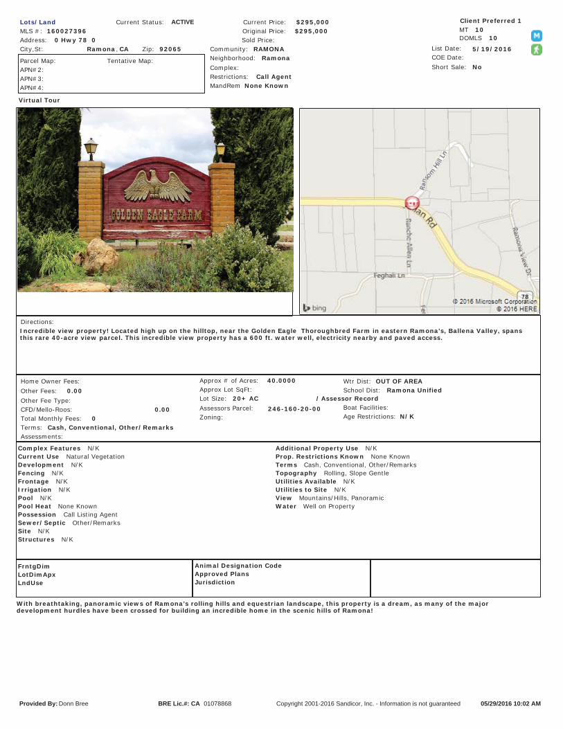
Incredible view property! Located high up on the hilltop, near the Golden Eagle Thoroughbred Farm in eastern Ramona’s, Ballena Valley, spansthis rare 40-acre view parcel. This incredible view property has a 600 ft. water well, electricity nearby and paved access.
With breathtaking, panoramic views of Ramona’s rolling hills and equestrian landscape, this property is a dream, as many of the majordevelopment hurdles have been crossed for building an incredible home in the scenic hills of Ramona!
0 Hwy 78 0RAMONA
No
OUT OF AREA
20+ AC Assessor Record
N/K
Call Agent
Ramona Unified
Cash, Conventional, Other/Remarks
Lots/Land ACTIVE
MandRem None Known
FrntgDimLotDimApxLndUse
Animal Designation CodeApproved PlansJurisdiction
Additional Property Use N/KProp. Restrictions Known None KnownTerms Cash, Conventional, Other/RemarksTopography Rolling, Slope GentleUtilities Available N/KUtilities to Site N/KView Mountains/Hills, PanoramicWater Well on Property
Complex Features N/KCurrent Use Natural VegetationDevelopment N/KFencing N/KFrontage N/KIrrigation N/KPool N/KPool Heat None KnownPossession Call Listing AgentSewer/Septic Other/RemarksSite N/KStructures N/K
MT 10DOMLS 10

Area Information: Known for
beautiful equestrian property and
famous horse ranches, beautiful
Ramona Valley, is an easy 45-minute drive from downtown
San Diego. Now becoming an up-n-coming wine region worthy
of a visit, Ramona now boasts the highest density of wineries in
San Diego County! Perhaps Ramona's greatest claim to fame
comes from Thoroughbred horse breeding. The Golden Eagle Farm in eastern Ramona's Ballena Valley was the
home of the famous racehorse, Best Pal, the second-place finisher of the 1991 Kentucky Derby.
Recreation & Lifestyle: Ramona is a relaxed, close-knit community with many recreational activities available in
the area: Wine tasting, helicopter rides, horseback riding at Ramona Grasslands Preserve, camping at Dos Picos
County Park, and for the hiking enthusiast, nearby trails are: Mt. Woodson, Cedar Creek Falls, Iron Mountain and
many more in the surrounding areas. For the animal fanatic, the San Diego Zoo Safari Park in the beautiful
San Pasqual Valley is just a short 18 minute drive from downtown Ramona! For those seeking an adrenaline rush,
just under an hour’s drive, is scenic Pauma Valley, home to La Jolla Zip Zoom Ziplines, believed to be California’s
longest zip line!
“We Know The Back Country!”

Disclaimer: This report is completed on a regional level with conservative data. The information provided is to be used as screening criteria only. All data is subject to review and may be verified through project site visits. This report may also include user generated static output from an internet mapping site. The information in this preliminary report may or may not be
accurate, current, or reliable and may need to be changed on the basis of a more specific review.
Report Run Date/Time: 5/16/2016 2:30:46 PMProject Manager:Land Development Manager:Project Record ID: Project Environmental Review (ER) ID:Assessor's Parcel Number(s): 2461602000Project Name:
2461602000General Information
USGS Quad Name/County Quad Number: Santa Ysabel/68Section/Township/Range: 35/12S/02ETax Rate Area: 65023Thomas Guide: 1134/0Site Address: 0 Highway 78 Ramona 92065
Parcel Size (acres): 40.00Board of Supervisors District: 2
Public Service and Utility Districts
Water/Irrigation District: None
Sewer District: NoneFire Agency: None
School District: Unified Ramona
1 of 5
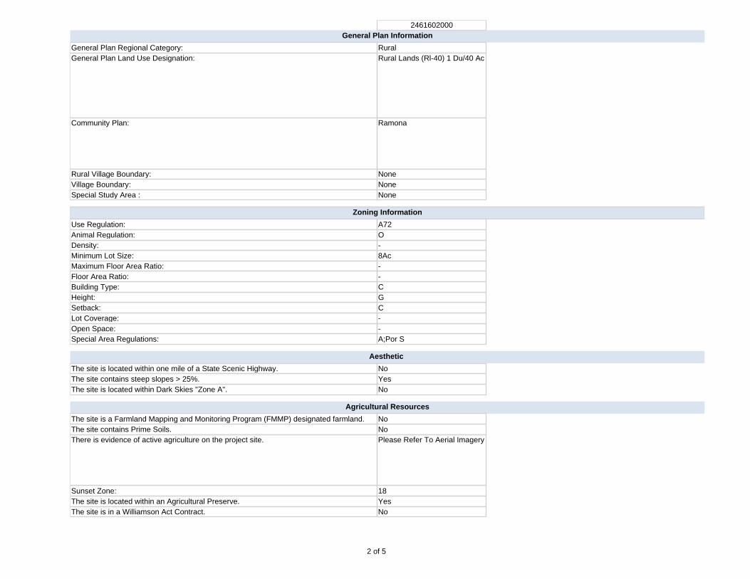
2461602000General Plan Information
General Plan Regional Category: RuralGeneral Plan Land Use Designation: Rural Lands (Rl-40) 1 Du/40 Ac
Community Plan: Ramona
Rural Village Boundary: NoneVillage Boundary: NoneSpecial Study Area : None
Zoning Information
Use Regulation: A72Animal Regulation: ODensity: -Minimum Lot Size: 8AcMaximum Floor Area Ratio: -Floor Area Ratio: -Building Type: CHeight: GSetback: CLot Coverage: -Open Space: -Special Area Regulations: A;Por S
Aesthetic
The site is located within one mile of a State Scenic Highway. NoThe site contains steep slopes > 25%. YesThe site is located within Dark Skies "Zone A". No
Agricultural Resources
The site is a Farmland Mapping and Monitoring Program (FMMP) designated farmland. NoThe site contains Prime Soils. NoThere is evidence of active agriculture on the project site. Please Refer To Aerial Imagery
Sunset Zone: 18The site is located within an Agricultural Preserve. YesThe site is in a Williamson Act Contract. No
2 of 5

2461602000Biological Resources
Eco-Region: Central Foothills
Vegetation Map 37000 Chaparral
The site may contain rare/listed plants and animals found in the Sensitive Species matrix. YesThe site is located within a Quino Checkerspot Butterfly Survey Area. YesThe site contains Wetlands. NoThe site is within one mile of Biological Easements. YesThe site is within one mile of Multiple Species Conservation Program (MSCP) Pre-Approved Mitigation Area (PAMA).
No (Draft: East)
The site is within MSCP Boundaries. No (Draft: East)The site is outside of MSCP and within 500 feet of:
Coastal Sage Scrub NoMaritime Succulent Scrub NoDiegan Coastal Sage Scrub YesInland Form (>1,000 ft. elevation) NoCoastal Sage - Chaparral Scrub NoFlat-Topped Buckwheat/Montane Buckwheat Scrub NoNone of the above No
The site is located within the North County Habitat Evaluation Map. If yes, list the Habitat Value.
No
The site is located within the Ramona Grassland area. NoThe site is located within three miles of a National Wildlife Refuge. If yes, list the name of the Refuge.
No
Cultural and Paleontological Resources (*always confirm with Cultural and Paleontology Specialists)
Geological Formation: Cretaceous Plutonic; Pre-Cretaceous Metasedimentary
Paleo Sensitivity: Marginal; ZeroPaleo Monitoring: Monitoring By
Grading/Excavation Contractor
Geology
Alquist-Priolo Zone: NoCounty Special Study Zone: NoQuaternary/Pre-Quaternary Fault: NoPotential Liquefaction Area: NoSoils Hydrologic Group: CThe site is located in a Landslide Susceptibility Area. If yes, list the Landslide Category. No
The site is located within a High Shrink Swell Zone (Expansive Soil). NoThe site is located within an area categorized as high or moderate potential for unique geologic features. If yes, name the unique geologic features.
Yes: Santa Ysabel
3 of 5

2461602000Mineral Resources
The site is located within a Mineral Resource Category. No Mrz (No Alluvium/No Mines)
Hazard Flooding
The site is located within a FEMA flood area. NoThe site is located within 1/2 mile from a FEMA flood area. NoThe site is located within a County Flood Plain area. NoThe site is located within 1/2 mile from a County Flood Plain area. NoThe site is located within a County Floodway. NoThe site is located within 1/2 mile from a County Floodway. NoThe site is located within a Dam Inundation Zone. No
Hazardous Materials
Schools are located within 1/4 mile of the project. NoThe site is located on or within 250 feet of the boundary of a parcel containing a historic waste disposal/burn site.
No
The site is located within one mile of a property that may contain military munitions (UXO-Unexploded Ordnance).
No
The site is located within 1000 feet of buried waste in a landfill. NoThe site is listed in the Hazardous Material Establishment Listing. If yes, list name, establishment number, and permit number.
No
The site is located within 2000 feet of a listing in DTSC's Site Mitigation and Brownfields Reuse Program Database ("CalSites" EnviroStor Database).
No
The site is listed on the Geotracker listing. NoThe site is listed on the Resource Conservation and Recovery Act Information (RCRAInfo) listing for hazardous waste handlers.
No
The site is listed in the EPA's Superfund CERCLIS database. NoThe site shows evidence that prior agriculture, industrial use, or a gas station or vehicle repair shop existed onsite.
Please Refer To Aerial Imagery
The site contains existing homes or other buildings constructed prior to 1980. Please Refer To Aerial Imagery
Airport Hazards
The site is located in a FAA Notification Zone. If yes, list the height restrictions. No
The site (or portion of the site) is located within an Airport Influence Area. If yes, list the name of the airport.
No
The site is located within an airport safety zone. If yes, list the zone number. NoThe site is located within an Airport Land Use Compatibility Plan Area (Z.O. Section 5250, "C" Designation).
No
The site is within one mile of a private airport. If yes, list the name of the airport. No
4 of 5

2461602000Hydrology and Water Quality
Hydrologic Unit: San DieguitoSub-basin: 905.45/BallenaThe site is tributary to an already impaired waterbody, as listed on the Clean Water Act Section 303(d) list? If yes, list the impaired waterbody.
Yes: Pacific Ocean Shoreline (San Dieguito Hu); San Dieguito River; Lake Hodges
The site is tributary to an Environmentally Sensitive Area. YesThe site is located in a Source Water Protection Area. Yes
Water Supply/Groundwater
The site is located outside (east) of the County Water Authority boundary. YesThe site is in Borrego Valley. NoThe project is groundwater dependent. YesAnnual rainfall: 18 To 21 Inches
Noise
The site is within noise contours. No
Fire Services
The site is located in an Urban-Wildland Interface Zone. YesFRA/LRA/SRA: Sra
Additional Information
The site is located within 150 feet of Mexican Border. NoThe site is located within a Resource Conservation Area. NoThe site is located in a Special Area. NoThere are existing or proposed trails on site or adjacent properties. NoThe site is located in an urbanized area as defined by the U.S. Census Bureau. NoThe population has a density of 1,000 per square mile or greater. NoThe site APN is listed in the GP Housing Element inventory. No
CEQA-Public Review Distribution Matrix
The site is located in the Desert. YesThe site is located east of the County Water Authority boundary. YesAll or a portion of the site is east of the Tecate Watershed Divide. NoThe site is located immediately adjacent to a State Highway or Freeway. NoThe site is located south of State Highway 78. NoThe site is located in the Coastal Zone requiring a Coastal Development Permit. NoThe site is located in the Sweetwater Basin. NoThe site is located within 2640 feet (1/2 mile) of the Cleveland National Forest. NoThere are State Parks that are located within 1/2 mile of the site, or may be substantially affected by the project. If yes, list the name of State Park(s).
No
5 of 5

SOIL DESCRIPTION CAP CLASS STORIE INDEX SHRINK/SWELL EROSION INDEX
CmE2 Cieneba rocky coarse sandy loam, 9 to 30 percent slopes , eroded 7s-8(19) 10 Low Severe 16
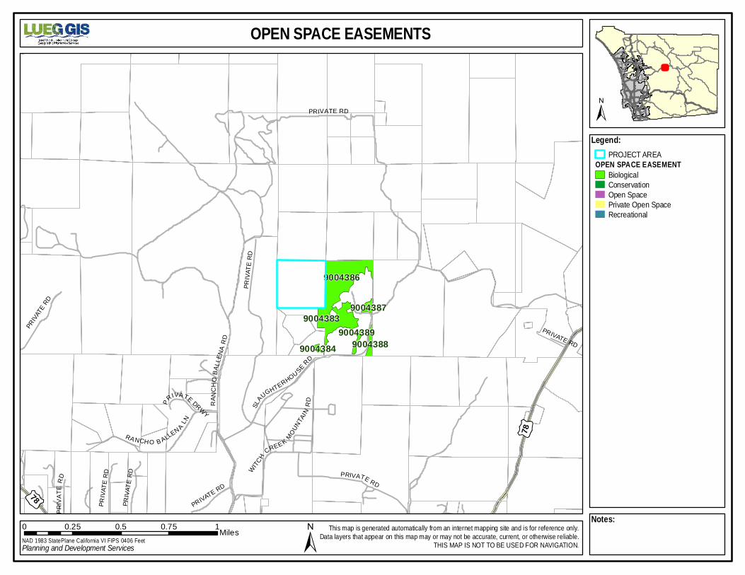
OPEN SPA CE EA SEMENTS
Leg en d:PROJECT AREA
O P E N S PA C E E A S E M E N TBiologicalConservationOpen SpacePrivate Open SpaceRecreational
Note s:0 0.25 0.5 0.75 1Miles£¤7
8
£¤78
90 04 3 86
90 04 3 83
90 04 3 88
90 04 3 87
90 04 3 8990 04 3 84
PR IV ATE RD
SLAUG HT E R HOU SE RD
RANC
H OBA
LLE N
AR D
R A N CH O B A LLEN A L N
WITCH CR E E K MOUNTA
INRDPR
IVA TE DRWY
PRIVA
TE R
D
PR IVATE RD
PRIVA
TE R
D
PR IVATE RD
PRIV
ATE
RD
PR IVATE RD
P RIV AT E R D
PRIVA
TE R
D
NAD 1 98 3 S ta te P lan e C alifo rnia V I FIPS 04 0 6 Fe etPlanning and Development Services
This m ap is generated automatica lly from an in ternet m apping site and is for reference on ly.Data layers that appear on this map m ay or may not be accurate, current, or o therwise re liab le .
THIS MAP IS NO T TO BE USE D F OR NAVIG ATIO N.
±
±


A72 GENERAL AGRICULTURAL USE REGULATIONS 2720 INTENT. The provisions of Section 2720 through Section 2729, inclusive, shall be known as the A72 General Agricultural Use Regulations. The A72 Use Regulations are intended to create and preserve areas for the raising of crops and animals. Processing of products produced or raised on the premises would be permitted as would certain commercial activities associated with crop and animal raising. Typically, the A72 Use Regulations would be applied to areas distant from large urban centers where the dust, odor, and noise of agricultural operations would not interfere with urban uses, and where urban development would not encroach on agricultural uses. 2722 PERMITTED USES. The following use types are permitted by the A72 Use Regulations:
a. Residential Use Types. Family Residential
b. Civic Use Types. Essential Services Fire Protection Services (see Section 6905) Law Enforcement Services (see Section 6905)
c. Agricultural Use Types. Horticulture (all types) Tree Crops Row and Field Crops Packing and Processing: Limited Packing and Processing: Wholesale Limited Winery
(Amended by Ord. No. 5508 (N.S.) adopted 5-16-79) (Amended by Ord. No. 6268 (N.S.) adopted 4-14-82) (Amended by Ord. No. 6654 (N.S.) adopted 9-21-83) (Amended by Ord. No. 6782 (N.S.) adopted 5-16-84) (Amended by Ord. No. 7741 (N.S.) effective 3-28-90 (Urg. Ord.)) (Amended by Ord. No. 9101 (N.S.) adopted 12-8-99) (Amended by Ord. No. 9422 (N.S.) adopted 1-9-02) 2723 PERMITTED USES SUBJECT TO LIMITATIONS. The following use types are permitted by the A72 Use Regulations subject to the applicable provisions of Section 2980. The number in quotes following the use type refers to the subsection of Section 2980 which applies.
a. Residential Use Types Mobile home Residential "18"
b. Commercial Use Types Animal Sales and Services: Veterinary (Large Animals) "6" Animal Sales and Services: Veterinary (Small Animals) "6" Cottage Industries "17" (see Section 6920) Recycling Collection Facility, Small "2" Recycling Processing Facility, Wood and Green Materials "3"
c. Agricultural Use Types Packing and Processing: Boutique Winery "22" (see Section 6910)
(Amended by Ord. No. 5508 (N.S.) adopted 5-16-79)

(Amended by Ord. No. 5652 (N.S.) adopted 11-21-79) (Amended by Ord. No. 5935 (N.S.) adopted 11-19-80) (Amended by Ord. No. 6783 (N.S.) adopted 5-16-84) (Amended by Ord. No. 6924 (N.S.) adopted 2-20-85) (Amended by Ord. No. 8058 (N.S.) adopted 4-15-92) (Amended by Ord. No. 9940 (N.S.) adopted 6-18-08) 2724 USES SUBJECT TO A MINOR USE PERMIT. The following use types are permitted by the A72 Use Regulations upon issuance of a Minor Use Permit.
a. Residential Use Types. Farm Labor Camps (See Section 6906); except that a Minor Use Pemiit shall not be required for a Farm Labor Camp for which a Use Permit is prohibited under Section 17021.5 or Section 17021.6 of the California Health and Safety Code.
b. Civic Use Types. Minor Impact Utilities Small Schools
(Amended by Ord. No. 5508 (N.S.) adopted 5-16-79) (Amended by Ord. No. 5935 (N.S.) adopted 11-19-80) (Amended by Ord. No. 6654 (N.S.) adopted 9-21-83) (Amended by Ord. No. 7741 (N.S.) effective 3-28-90 (Urg. Ord.)) (Amended by Ord. No. 7768 (N.S.) adopted 6-13-90) (Amended by Ord. No. 7964 (N.S.) adopted 8-14-91) (Amended by Ord. No. 8175 (N.S.) adopted 11-18-92) (Amended by Ord. No. 8271 (N.S.) adopted 6-30-93) (Amended by Ord. No. 9101 (N.S.) adopted 12-8-99) 2725 USES SUBJECT TO A MAJOR USE PERMIT. The following use types are permitted by the A72 Use Regulations upon issuance of a Major Use Permit.
a. Residential Use Types. Group Residential
b. Civic Use types. Administrative Services Ambulance Services Child Care Center Clinic Services Community Recreation Cultural Exhibits and Library Services Group Care Lodge, Fraternal and Library Services Major Impact Services and Utilities Parking Services Postal Services Religious Assembly
c. Commercial Use Types. Agricultural and Horticultural Sales (all types) Animal Sales and Services: Auctioning Explosive Storage (see Section 6904) Gasoline Sales

Participant Sports and Recreation: Outdoor Transient Habitation: Campground (see Section 6450) Transient Habitation: Resort (see Section 6400)
d. Agricultural Use Types. Agricultural Equipment Storage Animal Waste Processing (see Section 6902) Packing and Processing: Winery Packing and Processing: General Packing and Processing: Support
e. Extractive Use Types. Mining and Processing (see Section 6550)
(Amended by Ord. No. 5508 (N.S.) adopted 5-16-79) (Amended by Ord. No. 6543 (N.S.) adopted 3-2-83) (Amended by Ord. No. 6761 (N.S.) adopted 4-25-84) (Amended by Ord. No. 6782 (N.S.) adopted 5-16-84) (Amended by Ord. No. 6855 (N.S.) adopted 10-10-84) (Amended by Ord. No. 9690 (N.S.) adopted 12-15-04)