proposed nutrient criteria for nh’s estuaries
DESCRIPTION
Proposed Nutrient Criteria for NH’s Estuaries. Philip Trowbridge, P.E. NH Estuaries Project / NH DES November 17, 2008. Chronology. 2005: Orientation to the problem and possibilities for criteria 2006: NOAA assessment methods State of the Estuaries report - PowerPoint PPT PresentationTRANSCRIPT

Proposed Nutrient Criteria for NH’s Estuaries
Philip Trowbridge, P.E.
NH Estuaries Project / NH DES
November 17, 2008

Chronology
• 2005: Orientation to the problem and possibilities for criteria
• 2006: NOAA assessment methods State of the Estuaries report
• 2007: Analysis of grab sample data Loading-WQ model from EPA Antidegradation Light attenuation factors from buoy

Chronology (cont.)
• 2007: Nitrogen from Lamprey Watershed Normalized N loads compared to other estuaries
• 2008: Eelgrass assessment for 303d list Aggregate Kd relationships Kd, turbidity from hyperspectral data Macroalgae from hyperspectral data Historic N loads from watershed

Regulatory Authority
• Env-Wq 1703.14 • “Class B waters shall contain no
phosphorus or nitrogen in such concentrations that would impair any existing or designated uses, unless naturally occurring.”
• Relevant designated uses– Primary Contact Recreation (swimming)– Aquatic Life Use Support

Precedents from Other States
• Massachusetts Estuaries Project– Ambient [TN] typically 0.35-0.38 mg N/L for
the protection eelgrass
• Pensacola Bay– Ambient [TN] = 0.49 mg N/L to maintain
current (good) conditions

Methods
• Grab samples for water quality– Aggregation by assessment zone– Aggregation by trend station
• Grab samples for sediment quality– Aggregation by assessment zone
• Datasonde measurements of DO, turbidity• Buoy observations of Kd and clarity factors• Hyperspectral imagery for macroalgae,
eelgrass

NEWHAMPSHIRE
MAINE
Portsmouth HarborGreat Bay
Little Bay
Lower Piscataqua River
Spruce Creek
Upper Piscataqua RiverBellamy River
Oyster River
Salmon Falls River
Squamscott River
Cocheco River
Sagamore Creek
Winnicut River
Lamprey River
0 1 2 3 4 5 KilometersN
EW
S

#S
#S
#S
#S
#S
#S
#S
#S
#S#S
#S
#S
#S
#S
#S
#S #S
GRBCL
GRBAPGRBLR
GRBSQ
GRBGB
GRBOR
GRBCML
NH-0023A
NH-0025ANH-0029A
NH-0043A
NH-0045A
NH-0049A
NH-0057A
NH-0052A
NH-0058A NH-0062A
NEWHAMPSHIRE
MAINE
0 1 2 3 4 5 Kilometers
N
EW
S
Trend Monitoring Stations#S
Great Bay Estuary

Conceptual Model (following Bricker et al., 2007)
• Nutrient Concentrations– Total Nitrogen– Total Phosphorus
• Primary Indicators– Chlorophyll-a– Macroalgae
• Secondary Indicators– Benthic Invertebrates and Sediment Quality– Dissolved Oxygen– Eelgrass

Nutrient Concentrations
• Median values of TN and TP in different assessment zones
• Average concentrations at stations
• Limiting nutrient calculations

Median Nitrogen Concentrations in the GB Estuary
0.0
0.2
0.4
0.6
0.8
1.0
CO
CH
EC
OR
IVE
R
SQ
UA
MS
CO
TT
RIV
ER
SA
LMO
NF
ALL
S R
IVE
R
OY
ST
ER
RIV
ER
UP
PE
RP
ISC
AT
AQ
UA
RIV
ER
LAM
PR
EY
RIV
ER
BE
LLA
MY
RIV
ER
GR
EA
T B
AY
LIT
TLE
BA
Y
LOW
ER
PIS
CA
TA
QU
AR
IVE
R
PO
RT
SM
OU
TH
HA
RB
OR
mg
N/L
Range of TN thresholds used in other estuaries
(0.35-0.50 mg N/L)

[TN] = 0.244 mg N/Lin offshore GOMwaters

Median Phosphorus Concentrations in the GB Estuary
0.00
0.02
0.04
0.06
0.08
0.10
0.12
0.14
CO
CH
EC
OR
IVE
R
SQ
UA
MS
CO
TT
RIV
ER
SA
LMO
NF
ALL
S R
IVE
R
OY
ST
ER
RIV
ER
UP
PE
RP
ISC
AT
AQ
UA
RIV
ER
LAM
PR
EY
RIV
ER
BE
LLA
MY
RIV
ER
GR
EA
T B
AY
LIT
TLE
BA
Y
LOW
ER
PIS
CA
TA
QU
AR
IVE
RP
OR
TS
MO
UT
HH
AR
BO
R
mg
P/L


Ratio of Nitrogen to Phosphorus
10
15
20
25
30
35
0 5 10 15 20 25 30
Salinity (ppt)
N:P
Mo
lar
Rat
io
Summer
Other Seasons
Nitrogen limited
Phosphorus limited
Redfield Ratio
88% of the estuary has salinity >20 ppt

Seasonal Patterns of Total Nitrogen at Adams Point
0
0.1
0.2
0.3
0.4
0.5
0.6
1 2 3 4 5 6 7 8 9 10 11 12
Month
Ave
rag
e C
on
cen
trat
ion
(m
g N
/L)

Seasonal Patterns for Dissolved Inorganic Nitrogen
0
0.050.1
0.15
0.20.25
0.3
0.35
0.40.45
0.5
1 2 3 4 5 6 7 8 9 10 11 12
Month
Ave
rag
e C
on
cen
trat
ion
(mg
N/L
)
GRBCL (10 ppt) GRBAP (23 ppt) GRBCML (30 ppt)
Seasonal Patterns for Dissolved Orthophosphate
0
0.01
0.02
0.03
0.04
0.05
0.06
1 2 3 4 5 6 7 8 9 10 11 12
Month
Ave
rag
e C
on
cen
trat
ion
(mg
P/L
)
GRBCL (10 ppt) GRBAP (23 ppt) GRBCML (30 ppt)

Primary Indicators – Chlorophyll-a
• Median concentrations in each assessment zone
• Average concentrations at stations
• Seasonal patterns in different salinity regimes
• Relationship to TN
• Predicted TN threshold for primary contact recreation designated use

90th %ile Chlorophyll-a Concentrations in the Great Bay Estuary
0
5
10
15
20
CO
CH
EC
OR
IVE
R
SQ
UA
MS
CO
TT
RIV
ER
SA
LMO
NF
ALL
S R
IVE
R
OY
ST
ER
RIV
ER
UP
PE
RP
ISC
AT
AQ
UA
RIV
ER
LAM
PR
EY
RIV
ER
BE
LLA
MY
RIV
ER
GR
EA
T B
AY
LIT
TLE
BA
Y
LOW
ER
PIS
CA
TA
QU
AR
IVE
R
PO
RT
SM
OU
TH
HA
RB
OR
ug
/L


Seasonal Patterns of Chlorophyll-a
0
2
4
6
8
10
12
14
16
1 2 3 4 5 6 7 8 9 10 11 12
Month
Ave
rag
e C
on
cen
trat
ion
(u
g/L
)
GRBCL (10 ppt) GRBAP (23 ppt) GRBCML (30 ppt)

Chla = 24.5*TN - 3.5
R2 = 0.86, p<0.01
Chla = 28.5*DIN + 3.3
R2 = 0.45, p<0.05
0
5
10
15
20
0 0.2 0.4 0.6 0.8
Median Nitrogen (mg N/L)
90th
%il
e C
hlo
rop
hyl
l-a
(ug
/L)
TN
DIN
Each point w as calculated from >20 samples in a zone
Chl-a threshold for swimming use
Proposed TN threshold for
swim/boat use (0.67 mg N/L)

Primary Indicators - Macroalgae
• Eelgrass and macroalgae mapped using hyperspectral imagery from August 2007– 1381 acres of eelgrass in Great Bay– 136 acres of macroalgae in Great Bay
• Macroalgae covers 6% of areas formerly mapped as eelgrass in 1996
• Median [TN] in Great Bay = 0.42 mg N/L


Secondary Indicators – Benthos
• Benthic invertebrate IBI correlated with TN but really controlled by salinity
• Total Organic Carbon content >5% indicates organic enrichment
• TOC correlated with chlorophyll-a
• TN threshold of 0.67 mg N/L is protective of this endpoint.

B-IBI = -2.26*TN + 5.88
R2 = 0.64, p<0.053.5
4
4.5
5
5.5
0.2 0.3 0.4 0.5 0.6 0.7 0.8
Median TN (mg N/L)
Ave
rag
e B
-IB
I
B-IBI = 0.048*Sal + 3.95
R2 = 0.74, p<0.053.5
4.0
4.5
5.0
5.5
0 5 10 15 20 25 30 35
Average Salinity
Ave
rag
e B
-IB
I
0
20
40
60
80
100
0 1 2 3 4 5 6 7 8 9 10
TOC (%)
Sil
tCla
y (%
)
5% TOC ThresholdTOC = 0.12*Chla + 1.1
R2 = 0.57, p<0.05
0.5
1
1.5
2
2.5
3
3.5
0 5 10 15 20
90th %ile Chlorophyll-a (ug/L)
Ave
rag
e T
OC
(%
)

Secondary Indicators – DO
• Minimum DO concentrations at stations
• Relationship between DO and Chl-a– Chl-a threshold for DO
• Relationship between DO and TN for grab samples
• Relationship between DO and TN for datasonde measurements
• TN threshold for DO


DOmin = -3.1*Chla + 24.9
R2 = 0.67, p<0.050
2
4
6
8
10
12
14
16
3 4 5 6 7 8
90th %ile Chlorophyll-a Concentration (ug/L)
Min
imu
m D
isso
lved
Oxy
gen
(m
g/L
)
Each point was calculated from >20 samples from a trend station
Proposed Chl-a threshold to meet DO standardChl-a (yearly 90th %ile) = 6.4 ug/L
Chla-a (summer 90th %ile) = 10 ug/L

DOmin = -5.7*TN + 8.2
R2 = 0.70, p<0.05
3
4
5
6
7
8
0.2 0.3 0.4 0.5 0.6 0.7 0.8
Median Total Nitrogen (mg/L)
Min
imu
m D
isso
lved
Oxy
gen
(m
g/L
)
Each point was calculated from >20 samples from a trend station
Apparent threshold
(0.57 mg N/L)

GRBCML
3
4
5
6
7
8
9
6/1 6/15 6/29 7/13 7/27 8/10 8/24 9/7 9/21
Date
DO
Min
imu
m (
mg
/L)
2002
2003
2004
2005
2006
2007
Median TN = 0.29 mg N/L

GRBGB
3
4
5
6
7
8
9
6/1 6/15 6/29 7/13 7/27 8/10 8/24 9/7 9/21
Date
DO
Min
imu
m (
mg
/L)
2000
2001
2002
2003
2004
2005
2006
2007
Median TN = 0.39 mg N/L

GRBLR
3
4
5
6
7
8
9
6/1 6/15 6/29 7/13 7/27 8/10 8/24 9/7 9/21
Date
DO
Min
imu
m (
mg
/L)
2000
2001
2002
2003
2004
2005
2006
2007
Median TN = 0.45 mg N/L

GRBSFR
3
4
5
6
7
8
9
6/1 6/15 6/29 7/13 7/27 8/10 8/24 9/7 9/21
Date
DO
Min
imu
m (
mg
/L)
2002
2003
2004
2005
2006
2007
Median TN = 0.51 mg N/L

GRBOR
3
4
5
6
7
8
9
6/1 6/15 6/29 7/13 7/27 8/10 8/24 9/7 9/21
Date
DO
Min
imu
m (
mg
/L)
2002
2003
2004
2005
2006
2007
Median TN = 0.57 mg N/L

GRBSQ
3
4
5
6
7
8
9
6/1 6/15 6/29 7/13 7/27 8/10 8/24 9/7 9/21
Date
DO
Min
imu
m (
mg
/L)
2000
2001
2002
2003
2004
2005
2006
2007
Median TN = 0.74 mg N/L
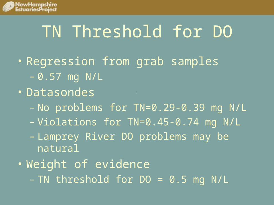
TN Threshold for DO
• Regression from grab samples– 0.57 mg N/L
• Datasondes– No problems for TN=0.29-0.39 mg N/L– Violations for TN=0.45-0.74 mg N/L– Lamprey River DO problems may be natural
• Weight of evidence– TN threshold for DO = 0.5 mg N/L

Secondary Indicators - Eelgrass
• Average water clarity (Kd) at stations
• Conceptual model from Koch (2001)– Threshold for water clarity for eelgrass
• Quantification of factors controlling Kd
• Relationship between turbidity and nitrogen
• Relationship between Kd and nitrogen– Threshold for TN for eelgrass


Conceptual Model (Koch, 2001)
Zmin = 1 meter for the Great Bay Estuary
Zmax should be >1 m below Zmin for viable eelgrass beds
CBP set 0.22 as the minimum value for Iz/Io for eelgrass

Predicted Presence/Absence of Eelgrass Based on Measured Kd
Kd
(m-1)
Zmax-Zmin (m)
Predicted Eelgrass
Locations
-3.6 to -1.7 <0 None SQM, LMP, OYS, CCH,
SFR
-1.0 0.5 Partial GB, LB, UPR
-0.6 to -0.5 ~2 Yes LPR, PH

Minimum Kd for Eelgrass Survival
• Zmin = 1 m• Zmax >=2 m• Iz/Io = 0.22• Using the equation
from Koch (2001), the minimum Kd would be 0.75 m-1
• Use this value as a threshold regardless of cause

Kd Regression Equation from Buoy
].[0784.0].[0101.0].[0188.02449.0)(
NAPCDOMChlD
PARK
o
d

Predicted Kd from
Hyperspectral Imagery

Cumulative Attenuation by Factors

0
0.5
1
1.5
2
2.5
Ave
rag
e P
art.
Org
anic
Car
bo
n
(mg
C/L
)
Measured POC POC from Chlorophyll-a
Approx. 20 times more POC than predicted
from chlorophyll-a

MeasuredPOC = 1.6*TN + 0.09
R2 = 0.56, p<0.01
Predicted from Chlorophyll-a
0
0.5
1
1.5
2
0.2 0.3 0.4 0.5 0.6 0.7 0.8
Median Total Nitrogen (mg N/L)
Med
ian
Par
t. O
rgan
ic C
arb
on
(m
g C
/L)

Turb = 14.8*POC - 1.5
R2 = 0.47, p<0.05
0
20
40
60
80
100
0 1 2 3 4 5
Part. Organic Carbon (mg C/L)
Dai
ly A
vera
ge
Tu
rbid
ity
(NT
U)
Turbidity values >100 and POC values >5 were excluded.

Turbidity = 33.5*TN - 8.5
R2 = 0.99, p<0.01
0
4
8
12
16
20
0.2 0.3 0.4 0.5 0.6 0.7 0.8
Median Total Nitrogen (mg/L)
Med
ian
Tu
rbid
ity
Each turbidity point is the median of >15,000 measurements
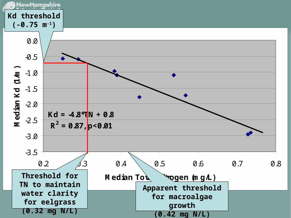
Kd = -4.8*TN + 0.8
R2 = 0.87, p<0.01
-3.5
-3.0
-2.5
-2.0
-1.5
-1.0
-0.5
0.0
0.2 0.3 0.4 0.5 0.6 0.7 0.8
Median Total Nitrogen (mg/L)
Med
ian
Kd
(1/
m)
Each point represents >7 daily average results from trend stations
Poor water clarity
Good water clarity
Kd threshold (-0.75 m-1)
Threshold for TN to maintain water
clarity for eelgrass(0.32 mg N/L)
Apparent threshold for macroalgae growth
(0.42 mg N/L)

Summary of Proposed Criteria

Comments Regarding Eelgrass Thresholds
• The goal is to meet this threshold in the tidal tributaries which will also ensure that water clarity is significantly better than the threshold in downstream reaches of the estuary.

Comments Regarding Eelgrass Thresholds (cont.)
• Additional research on the following topics is needed relative to this threshold:– Extent of historical or potential eelgrass
habitat in the tributaries to the Great Bay Estuary
– The deep edge depth (Zmax) of existing eelgrass beds in the Great Bay Estuary

Review and Approval Process
• Incorporate comments from TAC from this meeting and emails
• 30 day public comment period on revised document
• Distribute to WQSAC for approval
• Incorporate thresholds into CALM for 2010 listing cycle
• Add thresholds as criteria in Env-Wq 1700

Contact Information
Philip Trowbridge, P.E.State of New HampshireNew Hampshire
Estuaries Project &Dept. of Environmental
ServicesConcord, NHTel: 603.271.8872Philip.Trowbridge@des.
nh.gov