protected shoreland without obtaining a permit navigating ... meeting/2008/cspa... · navigating...
TRANSCRIPT

1
Navigating the New CSPA Navigating the New CSPA Permitting ProcessPermitting Process
RSA 483-B
October 8, 2008
483483--B:5B:5--b Permit Required; Exemption.b Permit Required; Exemption.
I. (a) No person shall commence construction, excavation, or filling activities within the protected shoreland without obtaining a permit from the department to ensure compliance with this chapter.
Exemptions by LawExemptions by Law
True agricultural activities
Timber harvesting conducted in accordance with RSA 227-J:9
Forestry for water supply maintenance
Impacts covered by a wetlands permit
Clarifying the “Wetlands Exemption”Clarifying the “Wetlands Exemption”This Exemption only covers the specific impactsauthorized by the Wetlands Permit.
Impacts that will occur outside of the jurisdiction of the Wetlands Act are not exempted from the permit requirement of the Shoreland Protection Act.
Projects that have impacts in both Wetlands jurisdiction and the Protected Shorelands beyond Wetlands jurisdiction will in fact need both permits.
Exemptions by RuleExemptions by Rule483-B:17 Rulemaking. The commissioner shall adopt rules, pursuant to RSA 541-A, relative to…
XI. Procedures and criteria for permitting under RSA 483-B:5-b, including permit by notification and the identification of those activities that may be conducted without obtaining a permit, all consistent with the provisions of this chapter.
Exemptions outlined in Rule Env-Wq 1406.04
Projects Considered VestedProjects Considered Vested
Rule Env-Wq 1406.03
• Building permit issued before January 1, 2008
• Subject of notice of local PB or ZBA prior to July 1, 2007
• Alteration of Terrain permit issued before July 1, 2008
• Foundation was constructed before July 1, 2008
• Owner has incurred substantial liability.

2
Maintenance and Modification of Existing Maintenance and Modification of Existing StructuresStructures Rules Env-Wq 1406.04(3) & (4)
Takes Focus off of Projects that do NOT:
Increase impervious surfaces
Involve excavation or fill
Increase septic loading
Involve the removal of vegetation
In Case of Emergency…In Case of Emergency…
In the course of a Natural Disaster:
1. Secure and stabilize the situation.
2. Notify DES of the work afterward (within 30 days).
3. If additional work is necessary, then file an application.
For Specific Details See Rule Env-Wq 1407.02.
In Case of Emergency…In Case of Emergency…If not an ACTUAL disaster, but a threat to public
safety, health, or the risk of significant property damage exists:
1. Notify DES in Writing of work that must be done to stabilize the situation.
2. Receive authorization from DES.
3. Do work as authorized.
4. Apply for a permit for any additional work necessary.
For Specific Details See Rule Env-Wq 1407.02.
Obtaining a permitObtaining a permit
Forms to be CompletedForms to be Completed• Application Form
• Application Worksheet
IF NEEDEDIF NEEDED
• Waiver Form
- NON CONFORMING STRUCTURES ONLY
- Redevelopment or expansion of footprint
• Variance Form
- New development
- Condominiums
Waiver Waiver vsvs VarianceVariance
Waivers are “project dependent”.
A waiver allows you to take an existing situation and improve itwithout requiring absolute compliance.
Variances are “lot dependent”.
A variance changes the standard of the law as it applies to a property only where a condition of the land itself would result in an unintended consequence of the law and the variance would not adversely affect abutters or violate the spirit and intent of the law.

3
RSA 483RSA 483--B:10 Nonconforming Lots of RecordB:10 Nonconforming Lots of Record
The CSPA cannot be used to render an otherwise buildable lot, unbuildable.
New construction requires neither waiver nor variance.
Where existing structures are present a waiver would be required.
Meeting Sub-surface requirements is first priority.
When is a stamped surveyed plan needed?When is a stamped surveyed plan needed?Surveyed plans are used for the purpose of verifying the square footage of the lot to calculate the impervious surface percentage.
Needed When:Needed When:
More than 15% of the lot will be covered by impervious surfaces.
AND
Impervious surfaces are being added.
A pre-existing surveyed plan may be used if available an “reasonably accurate”.
When Do I Need to Map Trees?When Do I Need to Map Trees?
There are 2 situations where trees need to be mapped.
1. Work will occur within the 50 ft Waterfront Buffer.
What needs to be shown:What needs to be shown:
• Only the 50 ft segments in which impacts will occur.
• All trees up to those needed to meet the 50 point (or proportional) requirement.
When Do I Need to Map Trees? (Cont.)When Do I Need to Map Trees? (Cont.)2. Project will result in more than 20 % impervious surface
cover.
What needs to be shownWhat needs to be shown:
• All trees up to those needed to meet the 50 point (or proportional) requirement.
If there are not sufficient trees to meet the 50 point requirement in any given segment, then a planting plan for the deficient segments meeting Part Env-Wq 1412 will be required.
Understanding the Woodland Buffer and Understanding the Woodland Buffer and Vegetation ProtectionVegetation Protection
Vegetated buffer consists of two parts:
Natural Woodland Buffer – All areas within 150 ft of the reference line.
Waterfront Buffer – Areas of the Natural Woodland Buffer within 50 ft of the reference line.
Invasive species are not protected. However, areas from which they are removed should be replanted and control with herbicides must be done by an applicator licensed by the Dept of Agriculture, Markets, and Foods.
Waterfront bufferWaterfront buffer• 0 – 50 ft of the reference line
• Ground cover to remain intact
• Ground cover includes duff layer, stumps, and rocks.
• Buffer divided into 50 ft x 50 ft segments
• 50 points worth of trees and saplings must be maintained in each segment in addition to ground cover.
•Undersized segments must have a proportional amount of points.
4
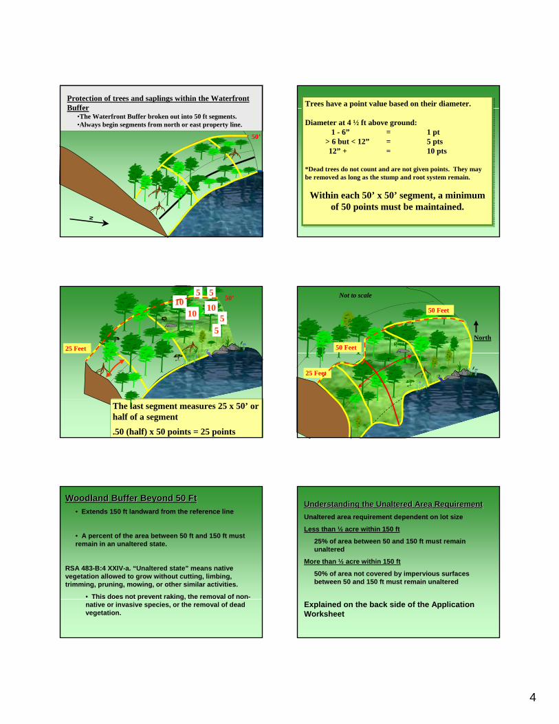
Protection of trees and saplings within the Waterfront Buffer
•The Waterfront Buffer broken out into 50 ft segments.•Always begin segments from north or east property line.
50’
N
Trees have a point value based on their diameter.
Diameter at 4 ½ ft above ground:1 - 6” = 1 pt
> 6 but < 12” = 5 pts12” + = 10 pts
*Dead trees do not count and are not given points. They may be removed as long as the stump and root system remain.
Within each 50’ x 50’ segment, a minimum of 50 points must be maintained.
50’5
55
5
101010
4, 6” trees, @ 5 pts.= 20 points3, 12”trees @ 10 pts = 30 points
Total 50 points
The last segment measures 25 x 50’ or half of a segment
.50 (half) x 50 points = 25 points
25 Feet
50 Feet
North
25 Feet
50 Feet
Not to scale
Woodland Buffer Beyond 50 FtWoodland Buffer Beyond 50 Ft• Extends 150 ft landward from the reference line
• A percent of the area between 50 ft and 150 ft must remain in an unaltered state.
RSA 483-B:4 XXIV-a. “Unaltered state” means native vegetation allowed to grow without cutting, limbing, trimming, pruning, mowing, or other similar activities.
• This does not prevent raking, the removal of non-native or invasive species, or the removal of dead vegetation.
Understanding the Unaltered Area RequirementUnderstanding the Unaltered Area RequirementUnaltered area requirement dependent on lot size
Less than ½ acre within 150 ft
25% of area between 50 and 150 ft must remain unaltered
More than ½ acre within 150 ft
50% of area not covered by impervious surfaces between 50 and 150 ft must remain unaltered
Explained on the back side of the Application Worksheet

5
½ acre example 1½ acre example 1
Reference line
50’
150’150’
250’
20’
UNALTERED
½ acre example 2½ acre example 2
Reference line
50’
150’150’
250’
20’UNALTERED
½ acre example 3½ acre example 3
Reference line
50’
150’150’
250’
20’UNALTERED
UNALTERED
Greater than ½ acre example 1Greater than ½ acre example 1
50’
150’150’
250’
20’
200 ft wide lotArea inside 150 ft buffer = 30,000 sq ftArea between 50 – 150 ft = 20,000 sq ftImpervious area = 12,000 sq ft(20,000 – 12,000)/2 = 4,000 sq ft to remain unaltered
Greater than ½ acre example 2Greater than ½ acre example 2
50’
150’150’
250’
20’
200 ft wide lotArea inside 150 ft buffer = 30,000 sq ftArea between 50 – 150 ft = 20,000 sq ftImpervious area = 10,000 sq ft(20,000 – 10,000)/2 = 5,000 sq ft to remain unaltered
Impervious surface limitsImpervious surface limitsImpervious surfaces may be located anywhere within the protected buffer. However the placement of certain structures is regulated.
Maximum allowable impervious area is 30 % of the area inside the protected shoreland.
Any project resulting in over 20% impervious coverage requires stormwater management and a healthy Waterfront Buffer that meets the minimum standards.

6
Structural setbacksStructural setbacks
20 feet – Accessory Structures Setback
Established by rule. See Part Env-Wq 1405
50 feet – Primary Building Setback
Established by law. See RSA 483-B:9, II
Examples of distributionExamples of distribution
Reference line
50’
150’150’
250’
20’
Links to Important Information
Finding the Shoreland Program PageGo to: www.des.nh.gov
At the bottom of the page under hot topics you will find link toShoreland.
Arlene Allen, Shoreland Protection Outreach Coordinator603-271-0862
Jay Aube, Shoreland Outreach Specialist603-271-2147
D. Forst, Shoreland Section Supervisor603-271-2147