providing a resilient timing and utc service using eloran
TRANSCRIPT

Providing a Resilient Timing and UTC Service
Using eLoran in the United States Gerard Offermans, Steve Bartlett, Charles Schue, UrsaNav, Inc.
BIOGRAPHIES
Dr. Gerard Offermans is Senior Research Scientist at
UrsaNav engaged in various R&D project work and
product development. He supports customers and
operations in the European, Middle East, and Africa
(EMEA) region from UrsaNav’s office in Belgium. Dr.
Offermans is one of the co-developers of the Eurofix data
channel concept deployed at Loran installations
worldwide. Dr. Offermans received his PhD, with honors,
and Master’s Degree in Electrical Engineering from the
Delft University of Technology.
Steve Bartlett joined UrsaNav in 2013 as Vice President of
Operations. He’s responsible for all aspects of business
operations including manufacturing, engineering, quality
control, program management, & project delivery. Steve
brings more than 20 years of engineering and
manufacturing business industry expertise to UrsaNav.
Prior to joining UrsaNav, Steve led worldwide teams at
both Autodesk & PTC focused on helping clients gain the
most value from their technology investments in product
lifecycle management & engineering solution software.
Charles Schue is founder and President of UrsaNav, Inc.
He champions providing Low Frequency Alternative
Positioning, Navigation, Time and Frequency, and Data
solutions for “sky-challenged” users. He holds Masters
Degrees in Electrical Engineering, Engineering
Management, and Business Administration. He is a Fellow
of the Royal Institute of Navigation.
ABSTRACT
Accurate timing and frequency is becoming increasingly
important in many applications that influence our daily life.
Fifteen out of sixteen sectors of the Critical Infrastructure
and Key Resources (CIKR) identified by the Department
of Homeland Security Department of Homeland Security
(DHS) Science and Technology Directorate (S&T) use
GPS for timing and for eleven it is deemed essential. More
and more systems are becoming solely dependent on GPS
or other Global Navigation Satellite System (GNSS) for
their precise position, timing, and frequency information,
especially as additional multi-constellation GNSS, i.e.
Galileo, Compass, and GLONASS, and Regional
Navigation Satellite Systems (RNSS) become fully
operational and “fill the world’s skies.” Along with the
explosive growth of systems and applications comes an
increasing awareness of GNSS vulnerabilities.
Interference, jamming and spoofing reduce availability and
reliability of all GNSS.
National Security Presidential Directive-39 (NSPD-39) of
2004 established implementation actions for the
development of a back-up system to GPS for positioning
and timing. In July 2015, a Congressional Hearing was
held to discuss the Federal Radionavigation Plan.
Chairman Duncan Hunter (R, CA) opened the hearing by
saying that the government had been studying the issue of
a backup for GPS for 11 years and that it was time for
action. Congressman Garamendi (D, CA) added that there
was “real time”, like what GPS and eLoran provide, and
"federal time" which is the model of comparison Congress
uses when trying to get a decision or something done. Both
Congressmen made it clear, quoting Dr. Brad Parkinson,
that there is a need for a back-up to GPS and that eLoran is
the prime candidate to do so. In June 2015, Congressman
LoBiondo (R, NJ) turned on the eLoran transmitter at the
former US Coast Guard Loran Support Unit site in
Wildwood, NJ, thereby initiating a Cooperative Research
and Development Agreement (CRADA) between the DHS
S&T, the Coast Guard, Exelis, and UrsaNav to demonstrate
eLoran’s capability to provide accurate time and frequency
over a wide area.
eLoran is a high power, Low Frequency (LF), ground wave
radio broadcast system, capable of providing 10-meter
positioning accuracy, Stratum-1 frequency distribution,
and Universal Time Coordinated (UTC) timing well within
one microsecond (µs) across very large areas (1,000 miles).
Application of differential corrections for timing further
improve the accuracy to better than 100 nanoseconds (ns).
eLoran is proven technology, well-established for
providing services very similar to those delivered by
GNSS, with characteristics and failure modes that are
complementary to GNSS.
This paper discusses the general concept of eLoran timing
and UTC distribution, and the current prototype service. It
further highlights plans to provide an initial four-station
CONUS-wide timing service, which can gradually be
expanded to provide increased coverage and redundancy
and deeper penetration into buildings. Additional stations
also enable positioning and navigation services.

INTRODUCTION
It is widely recognized that GPS, or more generally GNSS,
has become the primary means of obtaining Positioning,
Navigation, and Timing (PNT). GPS and other GNSS can
provide accurate frequency, and UTC to within 100 ns. An
increasing number of applications and services rely on
accurate timing and may become unavailable if GPS
reception is interrupted. Just like any prudent navigator
does not rely on a single source for positioning and
navigation information, relying on GPS as the sole means
of obtaining precise time for critical systems, without
having an alternative system or backup in place, is not
prudent or responsible, and can have severe operational
and economic impacts.
Besides the ability to obtain accurate time in the absence of
GPS, having an alternative source for accurate time to
determine when GPS is providing incorrect or misleading
data is also important. An alternate, comparable source of
accurate time also helps ensure GPS integrity and signal
authentication, and provides resilience for the timing user.
There are numerous applications and systems that require
accurate and precise time. The DHS S&T has identified
fifteen (15) Critical Infrastructure and Key Resource
sectors that use GPS for timing. For eleven (11) of the
sectors, GPS timing is deemed essential for successful
operation. [1] In recent years, it was assumed that any
GNSS outage would be extremely unlikely and, in any
event, of very short duration. This led to a strategy of
implementing holdover technology based on oscillators.
The predicted performance of this approach is summarized
in Table 1. Additionally, as seen in Table 2, the 2014 US
Federal Radionavigation Plan lists the timing user accuracy
requirements for the financial, energy transmission, and
telecommunications sectors as 1 µs.
Despite the overwhelming success of GPS as the leading
global PNT system, it has vulnerabilities. GPS
performance is degraded, or even interrupted, by natural
phenomena, such as solar flares, or unintentional or
intentional interference (e.g., jamming or spoofing
devices) [2,3]. These manmade interference events have
grown more frequent and more sophisticated as well. In
recent years, GPS has had to compete for spectrum with
emerging GNSS from other countries whose systems
broadcast in the same frequency bands. These systems also
contribute to the overall noise level at GPS frequencies.
Communications systems are also capable of competing
with GPS for spectrum, and communications technologies
continue to encroach on PNT satellite spectrum. [4].
Even without these threats, using GPS has other
challenges. In many cases, timing is needed inside
buildings or in areas with many sources of local
interference. GPS signals can be blocked or become
partially unavailable. Installing GPS antennas on the roof
of a building to get a clear view of the sky can add to
operational costs, and often incur leasing fees.
Alternatives to GPS for precise timing are limited. Other
GNSS systems suffer the same sort of vulnerability
problems as GPS, and current low frequency time
distribution systems such as WWVB, DCF77, and MSF
only provide several tens of microseconds to millisecond
timing accuracy. Systems that claim GPS “independence”
often actually contain a link to GPS signals at some point
in their architecture. LF systems, such as the Long Range
Navigation (Loran-C) and Enhanced Loran (eLoran), are
the only homogeneous, multi-modal, independent
alternative to GPS for providing very wide-area precise
time synchronization. [5]
In 2010, the General Lighthouse Authorities of the UK and
Ireland (GLA) followed the UK Treasury methods to
produce the GLA’s eLoran Business Case [6,7]. This
comprehensive document presented and analysed various
options for providing ‘Resilient PNT’ in UK and Irish
waters. It was clear that if the GLA chose to implement
eLoran, it could rationalize its physical Aids to Navigation
(AtoN) infrastructure, removing some lights and other
physical aids, and on balance actually reduce costs by
implementing eLoran. Indeed, compared to other possible
resilient PNT options, such as GNSS hardening, radar
absolute positioning, or increasing physical AtoN
provision, eLoran would have saved the GLA over £4M
per year over a nominal system lifespan of 10 years from
the introduction of e-Navigation services in 2018 to 2028.
So, the GLA opted to provide differential Loran services in
selected ports on the East coast of the UK, in what they
elected to call its Initial Operational Capability (IOC) [8].
The existing Loran-C services in North-West Europe (i.e.,
France, Germany, Norway, and Denmark) were phased out
at the end of 2015. Without this infrastructure, it was not
possible to provide eLoran Navigational coverage in the
UK waters in the short term. Instead of shutting down the
eLoran transmitter in Anthorn, Cumbria, the UK
government has decided to keep it in operation, as a single
eLoran transmitter, independently synchronized to UTC,
providing accurate UTC timing and data services to UK
users. Similar to the decision in the US in 2009, terminating
Loran-C service provides the foundation for repurposing
the infrastructure into an eLoran service. With the UK
leading the way, it is hoped that other European countries
will also upgrade their systems to eLoran. Discussions are
currently ongoing between government and industry to
determine the best method of moving ahead with eLoran in
Europe.
In the United States, UrsaNav entered into its second
CRADA with the DHS S&T and the USCG, this time also
including Exelis (nka Harris Corporation), to test eLoran

for time and frequency distribution, in anticipation of a
decision by the government to implement a non-GNSS
alternative to GPS for time and frequency users. This paper
provides test results of timing trials using the eLoran
transmission site technology located in Wildwood, NJ.
Table 1. CIKR Sector Oscillators and Holdover Times [1]
Table 2. 2014 Federal Radionavigation Plan Timing User Requirements
ELORAN FOR TIME AND FREQUENCY
eLoran is a high-power, low-frequency, long range
radionavigation system that provides similar Positioning,
Navigation, Time and Frequency services as GNSS, without the same failure modes as GNSS. It uses pulsed
signals at a center frequency of 100 kHz. The pulses are designed to allow the receiver to distinguish between the
ground wave and sky wave components in the received
composite signal. This way, the eLoran signals can be used over very long ranges without fading or uncertainty
in the time of arrival measurement related to sky waves.
eLoran, like its predecessor Loran-C, is the only Stratum-1 service alternative to GPS in the US.
The main differences between eLoran and Loran-C are
improved technology, additional functionality, and better
operational practices. These small improvements on the DOD-developed Loran-C system that turn it into eLoran
yield incredible improvements in PNT accuracy. eLoran
makes use of 21st century technology, thereby taking advantage of significantly improved timing and signal
tolerances, while also reducing size, weight, input power, and cooling. Each eLoran transmission is individually
synchronized to UTC, as opposed to System Area
Monitor control for Loran-C. Our typical design for UTC synchronization at transmitting sites includes a
combination of Local and Remote Time Scales. The Local
Time Scale consists of a disciplined ensemble of three cesium-based 5071A Primary Reference Standards
(PRS). The Remote Time Scale consists of one or more of the following inputs: Two-Way Satellite Time
Transfer, Two-Way Low-Frequency Time Transfer,
microwave, dedicated fiber, “hot clock”, or GNSS. The application of Additional Secondary Factor (ASF) data
bases and differential corrections enable the highest
possible positioning accuracy: less than 10 m for maritime applications, and better than 100 ns timing, with respect
to UTC. eLoran includes one or more low data rate, long
range, and robust data channels. Data from these Loran Data Channels (LDC) are broadcast as part of the
transmitted eLoran signal, and include navigation or timing related data (i.e., differential corrections and UTC
messages), system specific data (i.e., station ID and
health), user-defined data (e.g., as part of a “third-party” data channel service), and an almanac with system
configuration information.
An eLoran receiver measures the Time of Arrival (TOA) of
the eLoran signal:
TOA = TTOR – TTOT = PF + SF + ASF + ∆Rx (1) where: TOR - Time of Reception,
TOT - Time of Transmission,
PF - Primary Factor,
SF - Secondary Factor,
ASF - Additional Secondary Factor, and
∆Rx - Receiver and cable delays.
The PF accounts for propagation through air, SF for propagation over sea water, and ASFs for propagation over land and elevated terrain. The Primary and Secondary Factors are well defined delays and can be calculated as a function of distance. The Additional Secondary Factor delay is typically unknown at the time of installation, but may be modeled and/or measured.
ASF is the incremental TOA delay of the 100 kHz signal
resulting from propagation over heterogeneous signal
paths. Depending upon path length and conductivity, ASF
delay can be significant. There is both a spatial and a
temporal component to ASF. The RTCM Minimum
Performance Standards for eLoran specifies that ASF can
be considered to have two components: the nominal ASF,
and the local or grid ASF.
Nominal ASF is a coarse value for a region that is tens or
hundreds of square miles in area. The ASF values
significantly increase the absolute accuracy of eLoran
receivers by removing the majority of the spatial
component of ASF. When supporting the highest accuracy
applications, such as Harbor Entrance and Approach, finer
values are required with higher grid density. The fine ASF
grid is a grid of the local variations of ASF relative to the
nominal value and the grid spacing may be on the order of
hundreds of feet, depending upon the amount of ASF
variation.
In addition to very local ASF variations, there is a temporal
component resulting from such factors as weather (i.e.,
temperature and dew point), seasonal conductivity
changes, and diurnal influences. These temporal
components are removed through the use of differential
Loran (dLoran) corrections. The dLoran corrections can
also compensate for other slowly varying or common
errors from minor inaccuracies in PF and SF models, as
well as systemic errors.
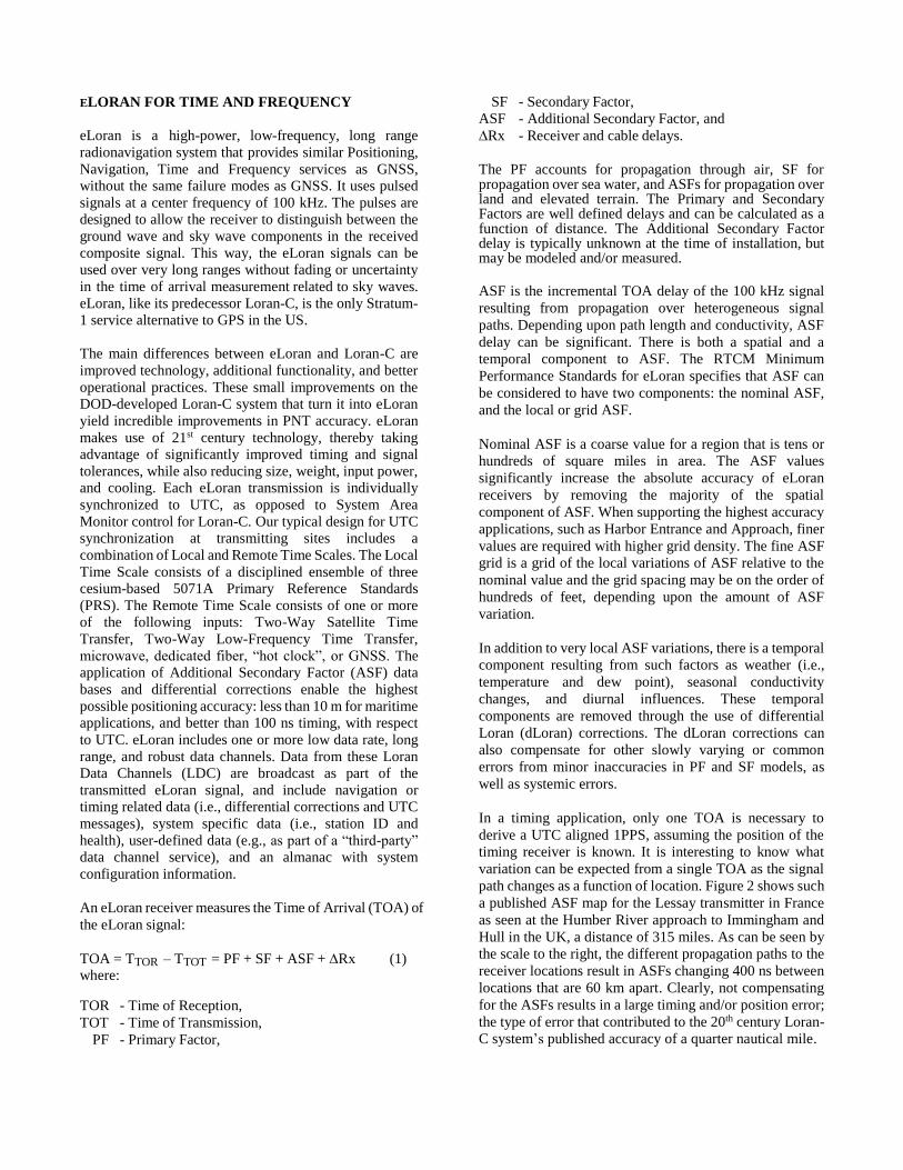
In a timing application, only one TOA is necessary to
derive a UTC aligned 1PPS, assuming the position of the
timing receiver is known. It is interesting to know what
variation can be expected from a single TOA as the signal
path changes as a function of location. Figure 2 shows such
a published ASF map for the Lessay transmitter in France
as seen at the Humber River approach to Immingham and
Hull in the UK, a distance of 315 miles. As can be seen by
the scale to the right, the different propagation paths to the
receiver locations result in ASFs changing 400 ns between
locations that are 60 km apart. Clearly, not compensating
for the ASFs results in a large timing and/or position error;
the type of error that contributed to the 20th century Loran-
C system’s published accuracy of a quarter nautical mile.
UrsaNav conducted earlier timing trials in the US in 2013
under a similar CRADA agreement with DHS S&T, and in
Europe in 2014, the results of which were presented in
previous PTTI papers [9,10]. These trials showed clear
correlation between time interval measurements of eLoran
derived UTC and an external UTC reference (e.g., GPS,
5071A PRS, USNO Master Clock), measured at different
locations separated several tens of miles. This gave rise to
the implementation of a differential UTC service providing
corrections from an eLoran Reference Station to users in
the vicinity.
Figure 1. Variation of Lessay (FR) ASF at Humber (UK)
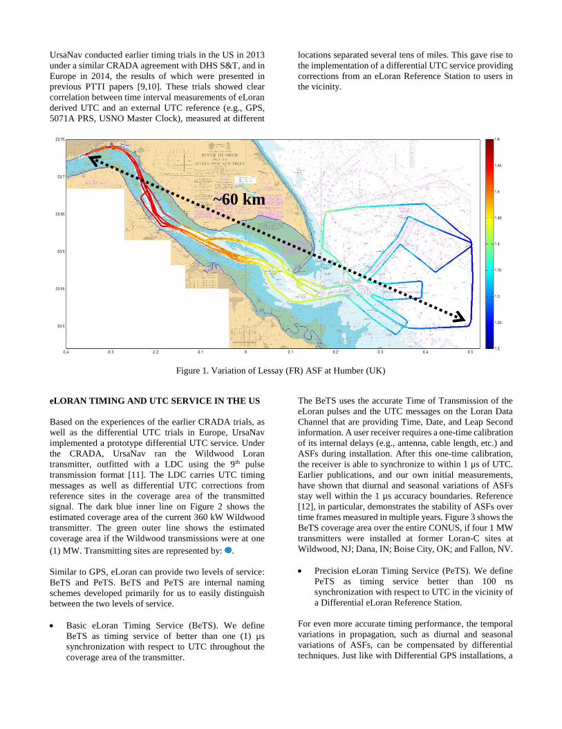
eLORAN TIMING AND UTC SERVICE IN THE US
Based on the experiences of the earlier CRADA trials, as
well as the differential UTC trials in Europe, UrsaNav
implemented a prototype differential UTC service. Under
the CRADA, UrsaNav ran the Wildwood Loran
transmitter, outfitted with a LDC using the 9th pulse
transmission format [11]. The LDC carries UTC timing
messages as well as differential UTC corrections from
reference sites in the coverage area of the transmitted
signal. The dark blue inner line on Figure 2 shows the
estimated coverage area of the current 360 kW Wildwood
transmitter. The green outer line shows the estimated
coverage area if the Wildwood transmissions were at one
(1) MW. Transmitting sites are represented by: .
Similar to GPS, eLoran can provide two levels of service:
BeTS and PeTS. BeTS and PeTS are internal naming
schemes developed primarily for us to easily distinguish
between the two levels of service.
Basic eLoran Timing Service (BeTS). We define
BeTS as timing service of better than one (1) µs
synchronization with respect to UTC throughout the
coverage area of the transmitter.
The BeTS uses the accurate Time of Transmission of the
eLoran pulses and the UTC messages on the Loran Data
Channel that are providing Time, Date, and Leap Second
information. A user receiver requires a one-time calibration
of its internal delays (e.g., antenna, cable length, etc.) and
ASFs during installation. After this one-time calibration,
the receiver is able to synchronize to within 1 µs of UTC.
Earlier publications, and our own initial measurements,
have shown that diurnal and seasonal variations of ASFs
stay well within the 1 µs accuracy boundaries. Reference
[12], in particular, demonstrates the stability of ASFs over
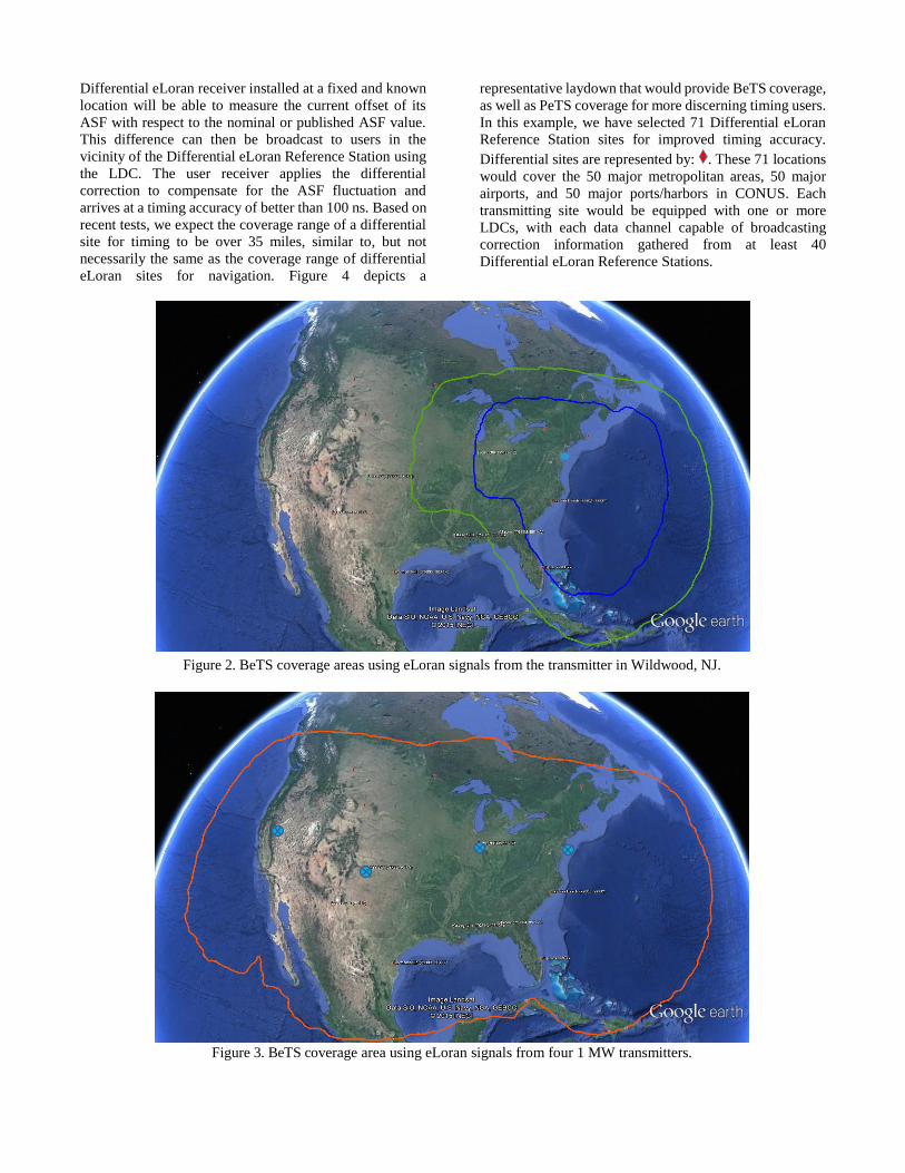
time frames measured in multiple years. Figure 3 shows the
BeTS coverage area over the entire CONUS, if four 1 MW
transmitters were installed at former Loran-C sites at
Wildwood, NJ; Dana, IN; Boise City, OK; and Fallon, NV.
Precision eLoran Timing Service (PeTS). We define
PeTS as timing service better than 100 ns
synchronization with respect to UTC in the vicinity of
a Differential eLoran Reference Station.
For even more accurate timing performance, the temporal
variations in propagation, such as diurnal and seasonal
variations of ASFs, can be compensated by differential
techniques. Just like with Differential GPS installations, a
~60 km
Differential eLoran receiver installed at a fixed and known
location will be able to measure the current offset of its
ASF with respect to the nominal or published ASF value.
This difference can then be broadcast to users in the
vicinity of the Differential eLoran Reference Station using
the LDC. The user receiver applies the differential
correction to compensate for the ASF fluctuation and
arrives at a timing accuracy of better than 100 ns. Based on
recent tests, we expect the coverage range of a differential
site for timing to be over 35 miles, similar to, but not
necessarily the same as the coverage range of differential
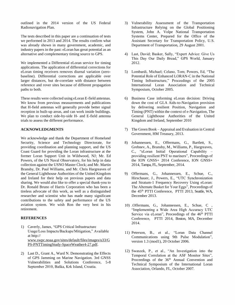
eLoran sites for navigation. Figure 4 depicts a
representative laydown that would provide BeTS coverage,
as well as PeTS coverage for more discerning timing users.
In this example, we have selected 71 Differential eLoran
Reference Station sites for improved timing accuracy.
Differential sites are represented by: . These 71 locations
would cover the 50 major metropolitan areas, 50 major
airports, and 50 major ports/harbors in CONUS. Each
transmitting site would be equipped with one or more
LDCs, with each data channel capable of broadcasting
correction information gathered from at least 40
Differential eLoran Reference Stations.
Figure 2. BeTS coverage areas using eLoran signals from the transmitter in Wildwood, NJ.
Figure 3. BeTS coverage area using eLoran signals from four 1 MW transmitters.

Figure 4. Representative higher accuracy (i.e., PeTS) locations within CONUS.
The data channels at each site will have sufficient spare
bandwidth available for additional services such as
Daylight Savings Time information or one way emergency
communications services.
TESTING eLORAN TIMING SERVICES
As mentioned before, our CRADA with the DHS S&T
allows us to use decommissioned Loran-C infrastructure to
test eLoran. In June 2015, Congressman Frank LoBiondo,
who is the local congressional representative for Southern
NJ, officially turned on the eLoran signal at Wildwood for
test purposes. We installed additional equipment to enable
remote monitoring and control, and to provide LDC
capability for the broadcast of differential corrections.
Figure 5. UN-155 Resilient PNT Receiver
We installed eLoran receivers at our Leesburg, VA, office;
at the US Naval Observatory (USNO) in Washington, DC,
where eLoran’ s timing output could be directly compared
with USNO’s Master Clock; at our North Billerica, MA,
office; at Franklin, MA, and at Bangor, ME. These sites
range in distance from 120 to 500 miles from the
Wildwood, NJ eLoran transmitter. The receivers were all
UrsaNav UN-152, stand-alone eLoran timing receivers, or
UN-155, Resilient PNT receivers (Figure 5). The UN-155
houses eLoran, GPS, and radiobeacon DGPS and has the
capability to take in external positioning inputs. To make
comparisons, all receivers need to have access to another
source of UTC. For simplicity, we chose either a
standalone GPS, a GPS-disciplined 5071A PRS, or the
USNO Master Clock for that purpose.
Figure 6 shows a block diagram of the test set-up we used
testing our differential UTC service. At our Differential
eLoran Reference Station sites in Billerica, MA, and
Leesburg, VA, we installed an eLoran timing receiver and
compared its 1PPS output against a PRS. The 1PPS Time
Interval Counter (TIC) measurements are collected for 10
minutes and a UTC correction is calculated, which is sent
over the internet to the eLoran transmitter in Wildwood,
NJ, where the correction is formatted and sent over the
LDC to the user receivers. At the same location, we
installed a second eLoran receiver that applies the received
UTC correction and adjusts its 1PPS output accordingly.
Its 1PPS output is then compared against the same PRS to
provide a zero-baseline (ZBL) reference output. All other
receiver sites had Rover Receiver set-ups, with either a
GPS, a PRS, or USNO’s Master Clock as its reference. The
PRS references were regularly compared to, or disciplined
by, GPS measurements to synchronize them to UTC and
remove any long-term drift.

Figure 6. eLoran Timing Test Block Diagram
BASIC ELORAN TIMING SERVICE
PERFORMANCE
The plot shown in Figure 7 is the Time Interval Counter
output of our eLoran timing receiver using the BeTS in
Bangor, ME, at more than 500 miles from the Wildwood
transmitter, and as compared against GPS. On the x-axis is
the time of the measurements, represented as dates in
December 2015. The major graduations are at 12:00 hours
UTC, corresponding to 07:00 AM EST. There is a clear
diurnal behavior present, which peaks at about 07:00 AM
EST, sunrise at Bangor. The mean offset from the UTC
reference, after the one-time installation calibration, is 49.7
ns, with a standard deviation of 68.6 ns. The maximum and
minimum deviation of 216 and -91 ns, respectively, stayed
well within the target accuracy of 1 µs for the BeTS over
the ten-day observation period.
The plot shown in Figure 8 is the Time Interval Counter
output of the eLoran timing receiver at USNO in
Washington, DC, at 120 miles from the Wildwood
transmitter. Here, the eLoran output is compared against
USNO’s Master Clock. The mean offset from UTC, after
the one-time installation calibration, is 22.9 ns, with a
standard deviation of 26.1 ns. The maximum and minimum
deviation of 147 and -90 ns, respectively, stayed well
within the target accuracy of 1 µs for the BeTS over the
twelve-day observation period. These measurements do
not show a distinct diurnal behavior, most probably
because the propagation path from transmitter to receiver
is short, thereby minimizing any ASF movement related to
the diurnal changes.

Figure 7. BeTS performance at Bangor, ME as compared to GPS.
Figure 8. BeTS performance at USNO, as compared to the USNO Master Clock.
PRECISE ELORAN TIMING SERVICE
PERFORMANCE
Figure 9 shows the timing performance of two eLoran
receivers compared against a GPS disciplined PRS in
Billerica, MA, 310 miles from the Wildwood transmitter.
The black line is from the receiver that is acting as the
Differential eLoran Reference Station. It measures the
timing difference between eLoran and the PRS and
calculates a differential correction based on a 10-minute
average. These measurements show the BeTS
performance. The mean offset is 166.7 ns, with a standard
deviation of 53.6 ns. The maximum and minimum of 299
and 56 ns, respectively, confirm the achievable target
accuracy of the BeTS service.
The blue line is for a receiver collocated at the same site as
the Differential eLoran Reference Station receiver, and
also compared against the same GPS disciplined PRS. In
this case, the receiver acts as a user receiver, applying the
differential corrections as received through the LDC.
Because the Reference and User are at the same location,
this measurement is called a zero-baseline (ZBL)
measurement. Clearly, the application of differential
corrections completely removes any temporal changes in
propagation delay. The remaining mean offset is 5.0 ns,
with a standard deviation of 4.4 ns, and maximum and
minimum of 36 and -31 ns, respectively.

Figure 9. BeTS (black) and PeTS (blue) performance at Billerica, MA, as compared to a GPS disciplined PRS.
Figure 10. PeTS (blue) performance at Franklin, MA, as compared to a PRS.
Figure 10 shows in blue the performance of a receiver in
Franklin, MA, 280 miles away from Wildwood. For
reference, the black line showing the BeTS performance of
the Billerica Reference station is shown too. The Franklin
receiver is configured as a user receiver applying
differential corrections originating from the Billerica
Reference Station, some 35 miles away. As expected, the
corrections become de-correlated with distance moving
away from the Reference Station, because of the
differences in propagation path for the signal from
transmitter to Reference and User receivers. The
magnitude of any differences depends largely upon the
terrain differences between the Reference Station and the
user receiver. Nevertheless, application of corrections will
improve the timing output, largely through compensating
for the mean seasonal, as well as part of the diurnal,
behavior
Application of corrections results in a mean offset of 1.2 ns
and a standard deviation of 45.2 ns. The maximum and
minimum of 96 and -106 ns, respectively, are close to the
target accuracy for the PeTS of 1 µs. At 20:00 hours UTC
on December 19th (see the red line), we configured the
receiver to no longer update the differential corrections.
Instead of the blue line being the mirror image of the black
in the first days, hinting towards overcompensation, the
blue line more or less follows the same trend as the black,
be it with a smaller amplitude. Further comparison and
correlation of data collected at the two sites will be done in
future trials to determine if we can confirm the relationship
between longer propagation path and larger diurnal swing.
CONCLUSIONS AND FURTHER WORK
This testing confirms that eLoran easily meets the
requirements for a one microsecond timing service as
outlined in the 2014 version of the US Federal
Radionavigation Plan.
The tests described in this paper are a continuation of tests
we performed in 2013 and 2014. The results confirm what
was already shown in many government, academic, and
industry papers in the past: eLoran has great potential as an
alternative and complementary timing source to GPS.
We implemented a Differential eLoran service for timing
applications. The application of differential corrections for
eLoran timing receivers removes diurnal variation (zero-
baseline). Differential corrections are applicable over
larger distances, but de-correlate with distance between
reference and rover sites because of different propagation
paths to both.
These results were collected using eLoran E-field antennas.
We know from previous measurements and publications
that H-field antennas will generally provide better signal
reception in built-up areas, and can work inside buildings.
We plan to conduct side-by-side H- and E-field antenna
trials to assess the different performance.
ACKNOWLEDGMENTS
We acknowledge and thank the Department of Homeland
Security, Science and Technology Directorate, for
providing coordination and planning support, and the US
Coast Guard for providing the Loran infrastructure at the
former Loran Support Unit in Wildwood, NJ; Mr. Ed
Powers, of the US Naval Observatory, for his help in data
collection against the USNO Master Clock; and Mr. Martin
Bransby, Dr. Paul Williams, and Mr. Chris Hargreaves of
the General Lighthouse Authorities of the United Kingdom
and Ireland for their help on previous papers and data
sharing. We would also like to offer a special thank-you to
Dr. Ronald Bruno of Harris Corporation who has been a
tireless advocate of this work, as well as a distinguished
researcher and scientist who has made many significant
contributions to the safety and performance of the US
aviation system. We wish Ron the very best in his
retirement.
REFERENCES
1) Caverly, James, “GPS Critical Infrastructure
Usage/Loss Impacts/Backups/Mitigation,” Available
at http://
www.swpc.noaa.gov/sites/default/files/images/u33/G
PS-PNTTimingStudy-SpaceWeather4-27.pdf.
2) Last D., Grant A., Ward N. Demonstrating the Effects
of GPS Jamming on Marine Navigation. 3rd GNSS
Vulnerabilities and Solutions Conference, 5-8
September 2010, Baška, Krk Island, Croatia.
3) Vulnerability Assessment of the Transportation
Infrastructure Relying on the Global Positioning
System, John A. Volpe National Transportation
Systems Center, Prepared for the Office of the
Assistant Secretary for Transportation Policy, U.S.
Department of Transportation, 29 August 2001.
4) Last, David; Basker, Sally, “Expert Advice: Give Us
This Day Our Daily Bread,” GPS World, January
2012.
5) Lombardi, Michael; Celano, Tom; Powers, Ed, “The
Potential Role of Enhanced LORAN-C in the National
Timing Infrastructure,” Proceedings of the 2005
International Loran Association and Technical
Symposium, October 2005.
6) Business Case informing eLoran decision: Driving
down the cost of GLA Aids-to-Navigation provision
by delivering resilient Position, Navigation and
Timing (PNT) within the context of e-Navigation, The
General Lighthouse Authorities of the United
Kingdom and Ireland, September 2010
7) The Green Book – Appraisal and Evaluation in Central
Government, HM Treasury, 2013.
8) Johannessen, E., Offermans, G., Bartlett, S.,
Grebnev, A., Bransby, M., Williams, P., Hargreaves,
C., “eLoran Initial Operational Capability –
providing resilient PNT to mariners”, Proceedings of
the ION GNSS+ 2014 Conference, ION GNSS+
2014, Tampa, FL, September, 2014.
9) Offermans, G., Johannessen, E., Schue, C.,
Hirschauer, J., Powers, E., “UTC Synchronization
and Stratum-1 Frequency Recovery Using eLoran:
The Alternate Basket for Your Eggs”, Proceedings of
the 45th PTTI Conference, PTTI 2013, Seattle, WA,
December 2013.
10) .Offermans, G., Johannessen, E., Schue, C ,
“Implementing a Wide Area High Accuracy UTC
Service via eLoran”, Proceedings of the 46th PTTI
Conference, PTTI 2014, Boston, MA, December
2014.
11) Peterson, B., et al., “Loran Data Channel
Communications using 9th Pulse Modulation”,
version 1.3 (mod1), 20 October 2006.
12) Swaszek, P., et al., “An Investigation into the
Temporal Correlation at the ASF Monitor Sites”,
Proceedings of the 36th Annual Convention and
Technical Symposium of the International Loran
Association, Orlando, FL, October 2007.