provincial government response to issues raised by the … · provincial government response to...
TRANSCRIPT

SEPTEMBER 2013
1
Appendix 4:
Provincial Government Response to
Issues raised by the CRT Local Governments’ Committee

SEPTEMBER 2013
2
Canadian Columbia Basin Dam & Reservoir Related Issues
The following is a list of the prevalent issues that were identified by Basin residents at the CRT 101 and 201 sessions in the fall/winter of 2011 and spring of 2012, as well as issues raised by the CRT Local Governments’ Committee. This list is an attempt by CRT Local Governments’ Committee and the Columbia Basin Trust to capture and summarize the most prevalent issues identified by Basin residents in these sessions. These issues are broken into two broad types:
1. Historical/footprint issues: These have not been within the scope of dam/reservoir management planning processes that have occurred to date, and may be considered outside the scope of the current CRT Review process. A separate process with the Province may be required to deal with these issues.
2. Current operations issues: These may be considered in scope of either the current CRT Review process or existing operational or planning processes (e.g. Water Use Plans, Non-Treaty Storage Agreement, Assured Operating Plans, Annual Plans).
Please note:
The order of this list does not reflect any prioritization.

SEPTEMBER 2013
3
Type of Issue
Issue Description Response
BASIN-WIDE
Current Operations
Flood control/management
During high water years and particularly during extreme high water years, close cooperation between all operators, including transboundary operators, is required to minimize flooding and damage. Consultation and communications with local governments and residents with local knowledge of the Columbia system should be part of transboundary cooperation. During high water years, reservoir levels need to be drawn down before snowmelt/heavy rains to hold inflows; this can conflict with water management for ecosystem needs.
During the Columbia-Kootenay high water events of 2012, BC Hydro worked very closely with the U.S. Army Corps of Engineers (Corps), Bonneville Power Administration, FortisBC, CPC, and other partners to minimize flooding damage throughout the basin and communicate current and forecast water conditions promptly and accurately to a broad base of stakeholders. For the first time ever, a surcharge, a water level above maximum normal level, of Koocanusa Reservoir was coordinated under the Columbia River Treaty, reducing peak discharges from the Libby Dam and thereby reducing the peak level of Kootenay Lake by 0.3 ft. From late June until late July 2012 (covering the period of peak river, lake, and reservoir levels for the entire region), BC Hydro sent out daily e-mail updates to known stakeholders, public officials, and First Nations. BC Hydro also held oral briefings for stakeholders via telephone conference calls. During the period of peak levels for Koocanusa Reservoir and Kootenay Lake, the Corps sent daily communications to BC Hydro, who forwarded these to its list of stakeholders; the Corps also held daily oral briefings during part of this time and Canadians were invited to participate. During and after the flood events, BC Hydro and the Corps received several compliments from regional district staff and basin residents for their communications throughout the flood event. For example, at a meeting of the Regional District of Central Kootenay on 18 October 2012 in Nelson, BC Hydro and the Corps held a “flood debrief” presentation for the RDCK directors and received a standing ovation from the directors for their prudent decision-making and strong communications work throughout the flood event. Given the success of these communications, BC Hydro is committed to ensuring this level of communication during similar events. Drafting the large reservoirs begins in the fall well before the first seasonal runoff forecast (available in early January). From January through April, the reservoir draft requirement for flood control is adjusted

SEPTEMBER 2013
4
based on updated seasonal runoff forecasts. During May through July, reservoir refill is managed to preserve necessary flood control space. The variability in weather and uncertainty in runoff forecasts can result in changes to planned and actual reservoir operations as runoff forecasts adjust to drier or wetter weather conditions. During this operation the protection of property and life is the highest priority in the system while considering other interests such as recreation and ecosystems.
Climate Change Impacts Projected impacts include earlier freshets, increased extreme precipitation events, more rain at low elevations and more snow at high elevations; longer periods of low flows and more frequent droughts. Increased frequency of flooding can be expected. These changes need to be incorporated into reservoir operations and any changes in operations need to be communicated to local governments and residents.
BC Hydro in cooperation with the Pacific Climate Impacts Consortium has developed climate change scenarios for the Columbia Basin. Information on the studies can be found here.
The climate change scenarios forecast slightly higher volumes on average, that are within the range of the variability seen in the historical dataset. To adjust to changes in flows over time, BC Hydro regularly updates the historical data set used in operations with the most recent information.
Involvement of local residents in reservoir management and dam operation discussions
There is no mechanism and process for knowledgeable local residents to provide input to reservoir management and dam operation discussions.
BC Hydro hosts annual Operations Update meetings in May and June in approximately ten communities throughout the Columbia-Kootenay region. These meetings are well advertised by BC Hydro and are held to provide information on the operations of Columbia River Treaty facilities in Canada and other facilities that are operated in a coordinated manner on the Columbia system; provide an update on BC Hydro activities; and listen to, and learn from, the concerns of stakeholders, First Nations and communities who have an interest in the operation of the Columbia River Treaty facilities and BC Hydro facilities in the Columbia-Kootenay region. In some communities, during years when water conditions have not been extreme, there has been limited interest from the public with very low attendance.
BC Hydro has recently had discussions with representatives of the Local Governments Committee about the format of BC Hydro’s Operations Update meetings. BC Hydro is interested in hearing suggestions of how to improve or what alternative mechanisms should be used in its

SEPTEMBER 2013
5
engagement with Basin residents.
BC Hydro has conducted public consultation on all planning level studies that influence operations over the last decade. This includes the Columbia and Duncan Water Use Plans, Revelstoke Unit 5, Mica Units 5 & 6, Revelstoke Unit 6, and the Non-Treaty Storage Agreement.
Basin residents’ understanding of BC Hydro operations and processes
Basin residents do not understand and are thus unsupportive of BC Hydro operations, in part because of inadequate communications about annual operating decisions, WUP implementation and WUP study results
BC Hydro provides the following communications to inform residents of our Columbia and Kootenay Basin operations and reservoir levels:
Reservoir level phone line with reservoir levels and river flows
Near real-time reservoir level information on bchydro.com
Regular reservoir updates with short term reservoir level
forecasts distributed weekly throughout the summer and bi-
weekly in the winter
Bi-annual Columbia operations summaries that explain CRT and other agreements, system and facility operations, and reservoir water level information.
Operational update meetings
Capital project specific consultation and communication and project status updates
Additional communications as needed to support community outreach and information – i.e. high water levels and flooding during 2012
All Water Use Plan study results, progress reports, and consultant reports are posted on bchydro.com. For the Columbia River Water Use Plan a newsletter is distributed each spring that summarizes progress to date, results, and planned work for the upcoming summer field seasons. Stakeholder engagement for Water Use Plan programs and projects vary by scope and level of interest. Local committees involving local government representatives, reservoir users, and not for profits advise on BC Hydro’s ongoing reservoir debris management programs for Kinbasket and Arrow Lakes Reservoir and also provided input into wildlife

SEPTEMBER 2013
6
enhancement physical works projects in the upper Arrow Lakes Reservoir drawdown zone. BC Hydro also held a series of community meetings to help guide boat ramp improvement projects.
BC Hydro is open to discussions with the Local Governments Committee on alternative engagement methods. If residents do not receive BC Hydro’s Water Use Plan newsletter or notices of upcoming meetings, and would like to be on the distribution list please contact Dayle Hopp at [email protected].
Trans-boundary River Governance
There are limited mechanisms for broader stakeholder and public involvement in transboundary river governance in the Columbia Basin. This includes discussion on key areas of interest like managing ecosystems and associated fish and wildlife in a comprehensive manner across the border. There is a need for more transboundary dialogue about how the system is managed and what can be done to improve its management for shared benefits to both nations.
British Columbia and its regional US counterparts are recognized leaders in North America in developing innovative mechanisms to facilitate transboundary cooperation on shared interests and concerns including natural resource management and environmental protection. Some examples of this cooperation include:
BC-Washington Environmental Cooperation Arrangement – trans-boundary agreement to assist British Columbia and Washington to promote and coordinate mutual efforts to ensure the protection, preservation and enhancement of shared environment.
BC-Idaho Environmental Cooperation Arrangement – trans-boundary agreement to assist British Columbia and Idaho to promote and coordinate mutual efforts to ensure the protection, preservation and enhancement of shared environment.
BC-Montana Environmental Cooperation Arrangement and MOU and Cooperation on Environmental Protection, Climate Action and Energy - trans-boundary agreement to assist British Columbia and Montana to promote and coordinate mutual efforts to ensure the protection, preservation and enhancement of shared environment, including invitation to each other’s state and federal agencies to participate in environmental assessments of proposed projects which may be considered to have potential transboundary impacts.
Great Northern Landscape Conservation Cooperative and North Pacific Landscape Conservation Cooperative – US Department of Interior initiatives co-chaired by senior British Columbia natural resource agency representatives (pursuant to implementation of BC-Montana MOU) to facilitate transboundary partnerships of federal and state/provincial agencies, First Nations and Tribes, and non-

SEPTEMBER 2013
7
governmental organizations to align and enact a regional response to landscape conservation, and share data, science, and capacity.
Pacific Coast Collaborative - a formal basis for cooperative action, a forum for leadership and information sharing, and a common voice on issues facing Pacific North America (BC, AK, WA, CA, OR ) by Premier and US State Governors and governments on the West Coast with priority on climate change and clean economy, regional transportation, innovation and emergency management.
Pacific Northwest Economic Region – public and private sector collaboration involving legislators and private sector representatives western Canadian provinces and territories and Northwest US states to promote greater regional collaboration; enhance regional competitiveness of the region in both domestic and international markets; enhance regional influence in Ottawa and Washington D.C. and achieve continued economic growth while maintaining the region’s natural resources.
In addition, the Columbia Basin Trust works with a variety of Federal, Provincial, State, First Nation and local governments to address transboundary water management issues and has an MOU with the Northwest Power and Conservation Council to collaborate on projects that promote an understanding and appreciation of the international Columbia River Basin.
COMMON TO MOST SUB-REGIONS
Historical/ Footprint
Loss of First Nations archaeology and culture
Archeological and important cultural sites and traditional use areas have been inundated by the reservoirs
The Reservoir Archeology Program (RAP) has been implemented to ensure the BC Hydro reservoirs operate in compliance with the Heritage Conservation Act through identification and management of archaeological resources within the critical eroding zone (drawdown zone and set back). The RAP is a long term program with specific programs for each individual reservoir. Initiation of the RAP in the Columbia was delayed slightly to allow for First Nations engagement and discussions regarding implementation of the program and development of a collaborative approach.
As part of the RAP, a program is developed for each reservoir that includes two phases: (1) archaeological inventory and development of an

SEPTEMBER 2013
8
archaeological management plan (AMP); and (2) implementation of the AMP. At the conclusion of each field season, BC Hydro and First Nations discuss the results and the direction of the program.
In 2013, there are four programs being implemented in the Columbia Region. Duncan Reservoir is currently in the third year of inventory and was the introductory study in the Columbia. Arrow Reservoir is also in the third year of inventory. The programs in Kinbasket and Whatshan Reservoirs will be initiated this spring. There is also a wind and wave erosion monitoring program for archaeological resources located in Arrow Lakes Reservoir and mid-Columbia River drawdown zones.
Koocanusa Reservoir is not covered by BC Hydro’s RAP program as the land was made available for flooding by the Province and there is no water or other licenses associated with the reservoir
BC Hydro is seeking to work collaboratively with First Nations on the Reservoir Archeology Program on how to find constructive solutions to improve identification and mitigation of reservoir effects on First Nations cultural and archeological sites.
Environmental impacts Inundation and loss of lakes, waterways, wetlands, floodplains and upland ecosystems lead to loss of habitats, particularly riparian and riverine habitats, and that loss has had negative impacts on fish, wildlife and important ecosystem functions such as biodiversity, productivity and connectivity. Local knowledge about these impacts should be incorporated into decisions about mitigation and rehabilitation through the Fish and Wildlife Compensation Program - Columbia and the Water Use Plans
To address issues of declining fish stocks and aquatic habitat, and consequently water management, as well as the relationship between fish, flood protection, recreation, other water uses and power generation at hydroelectric facilities, the Province initiated the requirement to develop Water Use Plans for BC Hydro water control structures. To date only BC Hydro has been directed to develop Water Use Plans, however, license holders may also voluntarily undertake water use planning.
The requirement to undertake these plans for BC Hydro comes as a condition of its water licences. Although the Koocanusa Reservoir extends into Canada, the actual control of water releases takes place in the United States at the Libby Dam, and is the responsibility of the U.S. Army Corps of Engineers. No licensing is required in Canada and therefore a Water Use Plan does not exist for the Canadian portion of the Koocanusa Reservoir. Furthermore, no Water Use Plan has been

SEPTEMBER 2013
9
(WUPs) on an ongoing basis. undertaken on Kootenay Lake or the lower Kootenay River, as flow regulation is provided by the Corra Linn Dam which is owned by FortisBC. Newly licensed facilities, such as the Arrow Lakes and Brilliant Expansion Project, have conditions related to flows, recreation and environmental mitigation equivalent to WUP conditions.
Operations at BC Hydro hydroelectric facilities in the Basin were reviewed by consultative committees that involved water licensees, government agencies, First Nations, key stakeholders, and the general public. The Water Use Plans resulting from this consultative process describe a set of operating rules for each facility that address the interests at stake while respecting legislative and other boundaries.
There is one Water Use Plan for the facilities along the main stem of the Columbia River, and one for the Duncan Dam. The water use planning consultative process for BC Hydro’s main stem Columbia River facilities was initiated in August 2000, completed in June 2004 and updated in 2007. Through public, First Nations and stakeholder consultation, a broad range of concerns has been identified including:
Flow management for various interests including navigation, recreation, fisheries, and flooding;
Habitat, nutrient, migration, stranding and other issues related to fish;
Waterfowl habitat;
Ongoing dust and debris concerns;
Ongoing reservoir access and access maintenance concerns;
Wetland protection;
Riparian and wildlife habitat; and
Heritage site protection.
A full review of the Columbia River Water Use Plan is recommended 13
years1 after implementation unless results of the monitoring program
1 Note: The Columbia WUP Review will occur in 2022 due to the sheer volume of studies under the Columbia WUP and the need to have all of these studies
approved by the Water Comptroller.

SEPTEMBER 2013
10
suggest an earlier review is appropriate or significant risks are identified
that could result in a recommendation to change operations. The
following is an inventory, with estimated related costs over 14 years (2008
to 2022), of the Water Use Plans and implementation actions that have
been developed for the Columbia River system:
Kinbasket Reservoir Fish & Wildlife Management Plan ($9.9M)
Kinbasket & Arrow Revegetation Reservoir Management Plan ($16.5M)
Kinbasket & Arrow Recreation Management Plan ($18.6 M)
Revelstoke Flow Management Plan ($8.8M)
White Sturgeon Management Plan ($35M)
Arrow Reservoir Operations Management Plan ($12.5M)
Arrow Reservoir Wildlife Management Plan ($3.8M)
Lower Columbia River Fish Management Plan ($9.8 M)
Heritage Management Plan ($600k) Total: $115.5M
The Duncan Dam Water Use Planning Project was initiated in August 2001 and completed in April 2004. The Consultative Committee Report and draft Water Use Plan was submitted to the Comptroller of Water Rights in March and October 2005, respectively. The Duncan Water Use Plan expenditures are planned to be $13.4 M over 10 years from 2008 to 2018.
The Columbia FWCP - Columbia (Partnership program – Province of BC Ministry of Environment, BC Hydro, Department of Fisheries and Oceans, First Nations and Public funded by BC Hydro) allocates funds (approximately $4.5 million indexed to inflation) yearly on projects aimed at improving fish, wildlife habitat and ecosystem function.
The FWCP – Columbia is overseen by a regional Board, including membership from local regional public (3) and First Nations members (2) as well as Provincial Government (2) and BC Hydro (2) representatives.

SEPTEMBER 2013
11
The Board oversees development of regional strategic plans, annual operating plans and associated expenditures, and facilitates public and First Nations engagement to gather local perspectives in support of decision-making.
The Columbia Basin Trust (CBT) also recently announced the creation of East Kootenay-Koocanusa Fish and Wildlife Program (KK-FWCP) with a $3 million commitment over five years to begin to mitigate some of the impacts in Canada resulting from the construction of the Libby Dam.
Economic and social impacts
Economic opportunity losses and social impacts (including recreation) associated with inundation of fertile, productive valley bottom land, poor transportation inter-connectivity within the region and to the Okanagan (e.g., due to ferries rather than bridges on Arrow Lakes Reservoir), and community displacements. Residents noted the lack of adequate financial compensation and local governments noted loss of potential tax revenue from properties that were inundated. Residents observe that BC Hydro views recreational and other development along the reservoirs as hindering their operations and therefore have not supported developments that could have enhanced the economies of affected communities.
There have been significant impacts and benefits as a result of the Columbia River Treaty in the Basin and the Province. These impacts and benefits were described in George Penfold’s report A Review of the Range of Impacts and Benefits of the Columbia River Treaty on Basin Communities, the Region and the Province.
In recognition of the impacts of the Columbia River Treaty the Province created the Columbia Basin Trust (CBT) in 1996. It was created to support the efforts by people in the Basin to create social, economic and environmental well-being in the Canadian portion of the Columbia River Basin. CBT was given $276 million over ten years to finance power project construction in partnership with Columbia Power Corporation, $45 million up front to be used as an endowment as well as $2 million per year from 1995 to 2010 for its operations.
The income from its share of the power projects is used for CBT’s Delivery of Benefits Program Funding. Since its inception, CBT has provided almost $90 million in program funding. Current levels of benefits are approximately $20 million per year. CBT’s revenues are expected to double by 2016/17. Some of the economic and social programs that are funded through CBT’s Delivery of Benefits include: an affordable rental housing initiative, a social grants program, a basin business advisors program, summer and school works programs and a training fee support program. For more information on how to access these programs please visit http://www.cbt.org/

SEPTEMBER 2013
12
With regards to other issues raised (such as transportation, financial compensation, etc) they are addressed where they are raised in specific sections of this document.
Impacts to forest industry
Loss of fertile valley bottom forest areas reduces the productive capacity of this sector and creation of reservoirs that have high cost and complex transportation systems around them increases costs, reducing the competitiveness of the forest sector
The Province recognizes that as a result of the Columbia River Treaty reservoirs there were impacts to the forestry industry. Valley bottom forestry land was lost with corresponding impacts to the annual allowable cut in some regions as well as reservoir fluctuations complicating log booming operations. However, industry in the Kootenay Region is very competitive and major capital improvements have been made at every significant mill in the region recently (in excess of $100 million dollars). Transportation networks have also improved at watering sites at Mica and along Arrow Lakes.
The current annual allowable cut in the Kootenay Region is approximately 4.5 million metres and the timber supply for most timber supply areas is stable. Unlike the central interior the Kootenay Region did not suffer pine beetle effects although it remains a risk to Kootenay Region forests.
The Ministry of Forests, Lands and Natural Resource Operations continues to advocate for a solid working forest land base to meet fibre needs now and for the future. The Ministry’s relationship with the forest sector is very healthy and productive. .

SEPTEMBER 2013
13
Type of Issue
Issue Description Response
COMMON TO MOST SUB-REGIONS (continued)
Historical/
Footprint
Impacts to agriculture Loss of productive agricultural land has left a small number of farming operations without the critical mass to sustain a local agriculture industry; expensive transportation is a further challenge and farmers noted lack of adequate financial compensation.
As a result of the Columbia River Treaty some agricultural land was flooded, particularly in the Arrow Lakes and Koocanusa regions. Since this time the Ministry of Agriculture has made several investments in local agricultural initiatives. These include:
RDCK Agriculture Plan.
RDEK – a land use inventory has been completed and the agriculture area plan is currently underway and should be completed later this year.
The agriculture water demand model is an ongoing project between the Ministry and local regional governments to anticipate future water needs of agriculture.
Tree fruit replant program funding has been on going in the Creston Valley the past 15 years.
Funding has been provided for local food initiatives such as the fall fairs.
Furthermore, there is currently a significant planning process underway between the Lower Kootenay Indian Band, Aboriginal Affairs and Northern Development Canada, the Regional District of Central Kootenay, Ministry of Forests, Lands and Natural Resource Operations and the Creston Valley Diking Districts to develop a Creston Valley Floodplain Management Plan. The aim of this plan is to set out a long term strategy for managing the diking infrastructure on the Kootenay River while balancing economic, environmental and social needs. This plan is nearing completion and the next step will involve issuing a final report by the end of summer 2013 followed by stakeholder meetings and consultation this fall.
The Columbia Basin Trust has also supported local agricultural initiatives including the Grassland and Rangeland Enhancement Fund in partnership

SEPTEMBER 2013
14
with the Kootenay Livestock Association, community and school greenhouses, farmer’s markets, on farm restoration work and other initiatives related to agriculture.
Impacts to transportation infrastructure
By inundating valley bottoms where road construction and maintenance is least expensive, the existing transportation infrastructure is more expensive to up-keep and inefficient leading to economic disincentives
Significant investments were made in highway infrastructure in the region during the period of Treaty construction. For example, in the Arrow Lakes area prior to dam construction the main highway system consisted of narrow, winding gravel roads. Of the 70 kilometres (kms) of road between Nakusp and Edgewood, only 3 kms were paved. The 50 kms of road between Nakusp and Galena Bay were built by Celgar for logging purposes and were transferred to the Ministry of Transportation and Infrastructure after dam construction commenced. This gravel road was extremely narrow with steep grades and curves and was suitable for only single lane traffic in many places. The ferry connecting Galena Bay and Arrowhead had a capacity of twelve cars. The 50 km road between Arrowhead and Revelstoke was unpaved except for the last 18 kms and included two ferry crossings.
A new highway system with 100 km per hour speed limit was built. The Ministry of Transportation and Infrastructure reconstructed the road north from Nakusp to Galena Bay and the 50 km stretch from Shelter Bay to Revelstoke was built to upgraded standards as well.
Before the Hugh L. Keenleyside Dam was constructed there were 200 km of low standard main road of which 32 kms were paved. This was replaced by 145 kms of high standard paved road and 32 kms of improved road.
In other reservoirs similar efforts were made to either re-route or upgrade highway infrastructure where it was impacted as a result of reservoirs being created.

SEPTEMBER 2013
15
Adequacy of taxation on existing BC Hydro infrastructure and reservoirs
The method of calculating grants or payments in lieu of taxes and the distribution of these funds to local governments does not match the impacts on affected areas; lack of mechanisms for taxation on reservoir areas and transmission lines is a revenue loss for local governments.
Grants-in-lieu of taxation paid by BC Hydro is an extremely complex area. Under government’s grants-in-lieu of taxation policy, BC Hydro pays three types of grants in lieu of taxes to local governments.
1. For each generation facility government determines which local government hosts the facility and which local government(s), including the host, are impacted by the facility. Government then allocates the total grant to be paid with respect to each generation facility on a 40/60 basis between the local government that hosts the facility and those local government(s) that are impacted by the facility. BC Hydro is directed to pay the grants by Order in Council (OIC). The current OIC number is 021/2013. The amount of the grants are calculated based on a formula that is not reflective of the tax that would be paid on the facilities if BC Hydro was taxable, but is instead based on the generating capacity of the facilities. As a result of a review of the grants-in-lieu policy, in 2007 government introduced a new method for calculating grants paid in respect of generating facilities. Total grants paid by BC Hydro doubled as a result of the change.
2. BC Hydro also pays a grant in the amount of 1 percent of revenue from electricity sales in the previous fiscal year from customers within the boundaries of a municipality (or rural area). This payment is deemed to be in lieu of taxes from exempt improvements such as transmission lines and substations.
3. BC Hydro also pays a ‘general’ grant that is equivalent to the previous year’s tax levy for general, local improvement and regional district purposes for all fee-owned land and for only those improvements that are not used in generation, transmission or distribution of electricity (i.e. taxes on offices, linerooms, etc).
Allocation of funds is typically regionally and organizationally specific. With regards to payments in lieu of taxes the Ministry of Community, Sport and Cultural Development (MCSCD) provides guidelines to regional districts with respect to how they may spend amounts received as grants-in-lieu of taxation. This includes that a grant must only be spent to
SEPTEMBER 2013
16
provide services for the service area in which a facility is located. It is the responsibility of recipient local governments to ensure they are in compliance with these guidelines.
Need for economic development support
Several communities along the Columbia view their struggles to create sustainable economies due in large part to the long-standing impacts of the dams and reservoir operations—for example, lack of adequate boat ramps and debris management limits tourism development. They identify the need for economic development support to overcome these impacts.
The Province of British Columbia supports community efforts to create and build sustainable local economies through such initiatives as the BC Jobs Plan. The Province has also heard through the review that some communities do not feel that the benefits of hydro operations in the Basin have been fairly distributed. There are a number of tools that the Province provides to support community and regional economic development. Recent examples of capacity building exercises include:
1. Economic Essentials for Local Leaders workshops were recently held in Castlegar, Kimberley and Revelstoke
2. Business Attraction Toolkit recently developed to support communities’ economic development
There is also a Ministry of Jobs, Tourism and Skills Training representative located in Cranbrook who can assist in finding support for economic development initiatives.
The Columbia Basin Trust Delivery of Benefits program also provides $20 million per year in support of social, economic and environmental initiatives in the Columbia River Basin. The Trust provides economic development support through a number of its programs that can be found here.
Potential funding sources for economic development initiatives include:
1. Southern Interior Development Initiative Trust: a $50 million fund established to stimulate economic development in the southern interior through the provision of grants and investment programs
2. Resort Municipality Initiative: $2.1 million per year is transferred to the 8 (of the 14) designated resort municipalities which are located in the Columbia River Basin to invest in tourism related infrastructure, amenities and programs enhancing the visitor experience.
3. Local government tax revenue: local host gaming revenues are available to Cranbrook, Castlegar and the Ktunaxa First Nation
4. Community gaming funds: funds may be available through the
SEPTEMBER 2013
17
Environment or Human Services categories. 5. RuralBC funding sources: a listing of 225 federal, provincial, nonprofit
funding grant sources. BC Hydro has a number of conditions as part of its Water License obligations, which include the construction of boat ramps and debris management on reservoirs. For more information on debris management please see p. 21 and for more information on boat ramps please see p. 45 (Arrow Reservoir) and p. 54 (Kinbasket Reservoir).
Loss of nutrients due to dams
Sediments settle behind dams and are not washed downstream as would naturally happen, resulting in downstream nutrient loss and impacts on ecosystem productivity
While there is a loss of nutrients from upstream reservoirs, Fish and Wildlife Compensation fertilization programs on Kootenay Lake and Arrow Lakes reservoir mitigate for loss of nutrients. The U.S. administers a fertilization program on the south arm of Kootenay Lake to mitigate for nutrient losses from the Libby Dam.
The annual budget for the Arrow Lakes program is $1.08 million, the North Arm of Kootenay Lake program is $910,000 and the South Arm program is $799,000.
A number of different components (e.g. phytoplankton growth, chemical analysis, kokanee, etc.) of the lake enrichment programs are monitored and evaluated on an annual basis. These reports are available here.
Current Operations
Benefit sharing
There are concerns about whether the Basin receives a fair share of the revenues from hydro power generation within the Basin, downstream power benefits and the Non-Treaty Storage Agreement (NTSA). Residents also express concerns about whether areas that are directly affected by the dams and reservoirs receive an equitable share of the benefits that do come to the region from payments in lieu of taxes,
There have been significant impacts and benefits as a result of the Columbia River Treaty in the Basin and the Province. These impacts and benefits were described in George Penfold’s report A Review of the Range of Impacts and Benefits of the Columbia River Treaty on Basin
Communities, the Region and the Province.
In recognition of the impacts of the Columbia River Treaty the Province created the Columbia Basin Trust (CBT) in 1996. It was created to support the efforts by people in the Basin to create social, economic and environmental well-being in the Canadian portion of the Columbia River Basin. CBT was given $276 million over ten years to finance power project construction in partnership with Columbia Power Corporation, $45 million

SEPTEMBER 2013
18
CBT and other sources. up front to be used as an endowment as well as $2 million per year from 1995 to 2010 for its operations.
One of CBT’s oldest funding programs is the Affected Areas Program which supports those communities most affected by Treaty dam construction. This program supports projects identified as priorities within individual communities.
The income from its share of the power projects is used for CBT’s Delivery of Benefits Program Funding. Since its inception, CBT has provided almost $90 million in program funding. Current levels of benefits are approximately $20 million per year. CBT’s revenues are expected to double by 2016/17.
Revenue from the sale of the Canadian Entitlement (which is owned by the Province) goes into the Consolidated Revenue Fund. This fund pays for provincial government services such as education, health care and transportation across the Province including the Kootenays.
Allocation of funds is typically regionally and organizationally specific. With regards to payments in lieu of taxes the Ministry of Community, Sport and Cultural Development (MCSCD) provides guidelines to regional districts with respect to how they may spend amounts received as grants-in-lieu of taxation. This includes that a grant must only be spent to provide services for the service area in which a facility is located. It is the responsibility of recipient local governments to ensure they are in compliance with these guidelines.
Notwithstanding the above, the CRT Review Team has heard from some of the communities most impacted that these communities have not proportionally benefited. The CRT Review team will explore with others how to address this perceived inequity.
Damage/loss of First Due to wind & wave erosion and pot- Please see response to Loss of First Nations archaeology and culture

SEPTEMBER 2013
19
Nations archeology hunting under historical/footprint (p. 7).
Impacts on First Nations traditional and current uses
Fluctuating water levels and erosion impacts hunting, gathering of plants and plant products and fishing
This topic is part of the consultation that the CRT Review team is undertaking with First Nations on potential impacts of the strategic decision of the future of the CRT on asserted aboriginal rights. The CRT Review team is committed to exploring with First Nations opportunities to address First Nations interests.
The Water Use Plan operations at the BC Hydro dams and the Fish and Wildlife Compensation Program have mitigated impacts to fish and wildlife habitat since dam construction, resulting in an increase in numbers of some species of fish and wildlife. Wetland development and restoration has improved riparian and wetland vegetation in the Basin. This work is ongoing.
Impacts to fish and wildlife species and other environmental values
Reservoir or river level fluctuations impact a wide range of environmental values in the system.
The Water Use Planning process was developed by the Province of British Columbia to address competing interests resulting from the control of water flows at hydro electric facilities. The process recognized the existence of operational impacts caused by the hydroelectric facilities in the Columbia basin balanced with the societal need for electrical energy.
The Columbia and Duncan Water Use Plans have ensured the implementation of BC Hydro hydroelectric facility management alternatives including revised flow regimes and physical works. These operational changes were developed by a Consultative Committee composed of federal and provincial environmental agencies, local government, the public, First Nations, and BC Hydro, and were consensus decisions. The changes are designed to help minimize or mitigate impacts to fish and wildlife and other environmental values. In addition to the operational changes, monitoring studies are underway to help determine if additional management alternatives should be implemented to further reduce impacts. A review of the Columbia Water Use Plan is scheduled for 2022.
BC Hydro is planning on undertaking a 5 year review of the Arrow soft

SEPTEMBER 2013
20
constraints in 2013 to evaluate the effectiveness of the Arrow soft constraints and report out on the results of the NTSA negotiation and how the outcome may affect the Arrow soft constraints.
The requirement to undertake Water Use Planning for BC Hydro comes as a condition of its water licences. Although the Koocanusa Reservoir extends into Canada, the actual control of water releases takes place in the United States at the Libby Dam, and is the responsibility of the U.S. Army Corps of Engineers. No licensing is required in Canada and therefore a Water Use Plan does not exist for the Canadian portion of the Koocanusa Reservoir. Furthermore, no Water Use Plan has been undertaken on Kootenay Lake or the lower Kootenay River, as flow regulation is provided by the Corra Linn Dam which is owned by FortisBC. Newly licensed facilities, such as the Arrow Lakes and Brilliant Expansion Project, have conditions related to flows, recreation and environmental mitigation equivalent to WUP conditions.
Boat access and recreation infrastructure
Perception that the Province and BC Hydro have not met their water licence obligations to provide this important infrastructure.
A recent study by the Columbia Basin Trust titled The Columbia River and Duncan Water Use Plans: A Comparison of Past and Present Commitments and Actions indicates that most activities under the Water Use Plans are on track to reach their stated objectives by their designated delivery dates.
BC Hydro funded and constructed numerous boat ramps on the Columbia and Duncan systems to fulfill the obligation to provide public access under its water licences soon after these facilities were constructed. Ownership of these ramps was then transferred to various provincial and local government agencies with mandates for recreation. Recently, to improve reservoir access and meet water use planning recreation objectives, BC Hydro has made or is working to improve a number of these boat ramps to meet current standards and has constructed several new boat ramps to improve reservoir access. Roads along reservoirs and rivers are owned and maintained by government agencies. Forest Service Roads provide access to some boat ramps; maintenance of these temporary roads is the responsibility of the Ministry of Forests, Lands and Natural Resource Operations and depends on resource use in the area.

SEPTEMBER 2013
21
Fluctuating reservoir levels: Impacts recreation/tourism, access
Reservoir or river level fluctuations impact a wide range of recreation/tourism values in the system (e.g. boating on reservoirs).
Recreation is one of many important interests that were evaluated during the Columbia and Duncan Water Use Plans. The Columbia-Kootenay reservoirs have multiple purposes and there are conflicting tradeoffs between the different interests. The purpose of the Water Use Plan process was to find consensus from stakeholders across the basin on an appropriate balance between these competing interests. That balance for recreation is different for each of the reservoirs.
For Duncan Reservoir, the target reservoir level is full-pool by Aug 10 and then 1 meter below full-pool by Labour Day. At Arrow Lakes Reservoir, the recreation soft constraint targets water levels between 437.4 m and 438.9 m (1435.0 ft and 1440.0 ft) from 24 May to 30 September. Kinbasket reservoir does not have target water levels although the preferred recreation range is generally in the top 30 m for boat access and the top 9 m for shore-based activities.
Debris management Floating debris, particularly after high water levels, create navigational hazards and cause property damage. Reservoirs across the Basin need annual intensive debris removal programs to eliminate hazards to support safe recreation/tourism use.
BC Hydro has a long term debris management program for Kinbasket, Arrow, Duncan and Koocanusa Reservoirs. The budget amounts have varied annually based on the amount of debris and water levels. Since 2008, the debris management programs for Arrow and Kinbasket Reservoirs are now approved by the Comptroller of Water Rights as a condition of BC Hydro’s water licenses.
Between 2008-2012, Water License Requirements spent over $250,000 on Arrow Lakes Reservoir debris collection/disposal. During the high water event in 2012 an additional $300,000 was added to help manage the debris. For Kinbasket Reservoir over $3 million was spend between 2008-2012, which resulted in approximately 310,700 cubic meters of woody debris being removed from the reservoir. An additional $400,000 was contributed in 2012 due to the high water.
The debris program on the Kinbasket and Arrow Lakes Reservoirs underwent a five year review in the winter of 2012/13 and the Comptroller of Water Rights has approved a new three year budget in
SEPTEMBER 2013
22
excess of $500,000 for Arrow Lakes Reservoir and in excess of $1 million for Kinbasket Reservoir. Additional funding is provided for years of high reservoir levels.
There is a formal Arrow Reservoir Debris Committee and two formal Kinbasket Reservoir Debris Committees (one in Valemount and one in Golden) that each meet at least once a year (generally in the spring) and have input into how the funds are allocated annually and help prioritize annual collection and disposal activities to best balance recreation and public safety needs.
The Golden Debris Committee has suggested that a shear boom be constructed across the mouth of the Columbia River near Kinbasket Lake Resort to help collect and funnel wood into the natural collection area. BC Hydro explored this idea approximately five years ago but it was not pursued due to liability and public safety concerns and potential issues under the Navigable Waters Act. The Golden committee is still interested in pursuing this option and BC Hydro has committed to look into it this year.
For Duncan Reservoir, three log booms are set up on the lake to capture debris; one at the south end by the intake to the dam, one approximately halfway up the lake by Howser Creek that spans the entire lake width, and one towards the north end at Cockle creek. The majority of debris from the larger creeks inflowing into Duncan are captured at the Cockle Creek Boom. Debris is collected at the booms and towed to a specific location where it is stockpiled on the shore. During the low water periods in March the material is piled and burning takes place in early May. Inspections of the booms and the removal of the material accumulated is done on a regular basis throughout the season. BC Hydro spends approximately $80,000 per year on debris management at Duncan; this cost does not include the construction and maintenance of the booms themselves.
Invasive aquatic species Is there a link between operations and While no specific link to operations of the BC Hydro facilities and invasive aquatic species has been established, the Ministry of Environment is

SEPTEMBER 2013
23
invasive aquatic species? working with BC Hydro and other utilities in the region to control transportation of aquatic invasive species through the Columbia Basin Rapid Response Plan. The Columbia Basin Rapid Response Plan is a partnership between Washington, Oregon, Idaho and Montana, the U.S. Fish and Wildlife Service and the Columbia River Inter-Tribal Fisheries Commission to protect the Columbia River basin from the spread of destructive zebra and quagga mussels which are largely transported in and on boats and boat trailers coming into British Columbia.
The Province of British Columbia is also evaluating concerns about northern pike colonization of the Columbia River (US/Canada Border to Keenleyside Reach) and taking action as required (such as allowing unlimited angler harvest).
Dust storms/Revegetation
At low reservoir/river levels, exposed areas are prone to wind scarification creating small particulate dust storms, which impact the health and quality of life of nearby residents, and deters visitors. More revegetation programs are required to reduce this. The current programs are reducing the dust issue, but more needs to be done.
Since 1987, BC Hydro has seeded significant portions of the Revelstoke Reach (Revelstoke to Shelter Bay) with fall rye for erosion control and dust abatement during low reservoir elevations prior to spring reservoir filling. On average, about 2500 acres were treated with fall rye seed each year depending on projected water levels, shifts in dust source locations, and the establishment of native vegetation on previously seeded areas. The fall rye treatment was suspended in 2009 as much of the area now regenerates naturally and the focus has switched to monitoring. The Arrow Lakes Reservoir Revegetation Program focuses on higher elevations in the reservoir with the goal of enhancing littoral productivity, wildlife habitat, protection of cultural heritage sites and aesthetic benefits. As yet, there is no fall rye program for the Kinbasket Reservoir, as fall rye is not expected to grow successfully at Kinbasket due to the colder climate and deeper drawdown zone. Similar to Arrow Reservoir, the Kinbasket Reservoir Revegetation Program, which started in 2008 and is ongoing which focuses on revegetation for other reasons in addition to dust control. As a result of the Non-Treaty Storage Agreement public discussions, BC Hydro funded the installation of additional dust monitoring equipment in Valemount. The Duncan Reservoir Water Use plan recommended a program to

SEPTEMBER 2013
24
monitor vegetation growth but not a revegetation program. Koocanusa Reservoir does not have a program.

SEPTEMBER 2013
25
Type of Issue
Issue Description Response
KOOTENAY RIVER SYSTEM
Current Operations
Lack of Basin input or influence in Libby operations
Libby Operations are based on US processes/decisions, with some coordination with BCH but this does not adequately address the full range of impacts of Libby operation in Canada both upstream and downstream of Libby.
Under the Columbia River Treaty, the US must coordinate with Canada on Libby’s operations (Article XII). This obligation continues whether the Treaty continues or is terminated. The Canadian and US Entities have an outstanding dispute on the interpretation of this coordination obligation, although currently the dispute has been set aside via the Libby Coordination Agreement. Canada continues to object to the Corps’ unilateral use of VarQ flood control curves at Libby; the CRT Operating Committee is currently discussing measures to resolve this dispute.
US Agencies (U.S. Army Corps of Engineers and the US Fish and Wildlife Service) hold annual joint meetings with BC Hydro in Canada to explain Libby operations and fisheries requirements. In recent years, communication has been enhanced during unique events (such as 2012) with regular communications with Region stakeholders. BC Hydro is committed to ensuring this level of communication continues into the future.
Through the CRT Review performance measures have been developed to make it possible to assess potential impacts and benefits on interests in Canada from different Libby operations. There may be opportunities to better balance Canadian interests; however, changes in operations could have a detrimental effect on fisheries in the U.S. The US operation of Libby Dam is highly constrained by U.S. fish operations that are required by U.S. federal law, and the U.S. is unlikely to agree to operations that have a detrimental impact on fisheries.
The Columbia Basin Trust (CBT) also recently announced the creation of East Kootenay-Koocanusa Fish and Wildlife Program (KK-FWCP) with a $3 million commitment over five years to begin to mitigate some of the impacts in Canada resulting from the construction of the Libby Dam.
SEPTEMBER 2013
26
The CRT Review Team has heard from Basin residents that local input into reservoir operations is a concern and BC Hydro would be open to discussing with stakeholders how to address this issue.
Responsibility for avoidable flood damage due to Libby operations
If Libby Dam operations caused flooding in Canada that could have been averted, it is not clear whether BC or U.S. agencies would be responsible for avoidable damages.
Libby Dam operations clearly reduce flood risk and damage within BC. For example, during the high water event of 2012, the combined operations of Duncan and Libby dams reduced the peak level of Kootenay Lake by 6.6 ft (with Libby responsible for more than half of this reduction).
Whether there are any common law remedies potentially available in the courts, if improper and unauthorized dam or reservoir operations were potentially responsible for causing damages or injuries, will depend on all the circumstances, including the facts and law related to the claim. In addition, there are dam safety requirements which must be met by dam owners in the province in respect of dams and related operations in the province.
Lack of Water Use Plan-like process on Kootenay River system
Need for a process that looks at operational impacts on a range of values with Canadian and US participation and considering all dams/reservoirs on the Kootenay River system (Koocanusa reservoir to Columbia confluence).
The jurisdictional roles and licensing on the Kootenay River/Lake system is different than the Columbia and Duncan facilities that have both had Water Use Planning processes completed by BC Hydro. BC Hydro does not hold the storage rights on Kootenay Lake (these are held by Fortis BC and Columbia Power/CBT) and the storage licence for Libby Reservoir is held in the U.S. and the dams on the Kootenay River are owned by various licensees.
The Comptroller of Water Rights decides whether a Water Use Plan is required for water licenses for major water control facilities in British Columbia. At this time the Comptroller of Water Rights is not aware of any water use conflicts or significant issues in relation to the operation of BC dams on the Kootenay River. No application for new water rights on the Kootenay River by dam owners has been received, and no licences are under review. The dominant issue appears to be water levels on Kootenay Lake, which are affected by the Columbia River Treaty and governed by the IJC Order. The Comptroller of Water Rights however is open to discussing with the CRT Local Government Committee the key issues, level of support for and sought after outcomes of a Water Use Plan process.

SEPTEMBER 2013
27
Koocanusa Reservoir upstream of Libby
Historical/ Footprint
Debris removal Debris removal program is funded an annual basis when a long term funding arrangement is needed at potentially higher levels
BC Hydro is responsible for debris removal on Koocanusa Reservoir and does have a long term debris management program for the reservoir. The annual budget is $90,000 for debris collection and removal plus an additional $40,000 to $50,000 every two years for disposal. In recent years with high reservoir levels such as in 2012, debris funding was increased as high reservoir levels mobilize debris on the shores of the reservoirs.
Lack of Fish and Wildlife Compensation Program
There is no water license issued by the province of BC on Koocanusa thus there has never been a Fish and Wildlife Compensation Program (FWCP) in that area; without monitoring it is difficult to know the status of ecosystems, fisheries, etc.
The Columbia Basin Trust (CBT) recently announced the creation of the East Kootenay-Koocanusa Fish and Wildlife Program (KK-FWCP) with a $3 million commitment over five years. The Province, BC Hydro and CBT have committed to look at on-going funding of this program beyond CBT’s initial investment.
The program will be implemented through the Columbia Fish and Wildlife Compensation Program. The FWCP uses multi-year strategic and action plans to guide annual investments and project selection. The FWCP has developed a planning framework for the creation of Strategic and Action Plans and has just finished a process to create these plans for other areas of the Columbia Basin.
A Kootenay-Koocanusa Watershed Action Plan will be developed to ensure there are defined goals and outcomes for the funds with a series of proposed activities aligned with those goals/outcomes as well as monitoring process to be used to evaluate the effectiveness of the investments.
The development of the Watershed Action plan will be guided by a Strategic Planning Working Group made up of representatives from CBT, the FWCP Board, provincial government agencies, First Nations, industry and representatives from community groups within the KK-FWCP geographic area and led by a local consultant.

SEPTEMBER 2013
28
Limited road access Limited road access on South East portion of reservoir (in BC) constrains economic development opportunities but protects against ecological damage
The Regional District of East Kootenay has recently released the Lake Koocanusa Official Community Plan (OCP). The OCP establishes a long-range vision for land use in the Lake Koocanusa area and the zoning bylaw regulates land development. Any new development would have to apply for new roads as it provides guidance with respect to land use objectives in that area.
Current Operations
Fluctuating reservoir levels impact agriculture, recreation and tourism
Agriculture and property are impacted at high water levels; water based recreation and tourism impacted at low levels.
As part of the Columbia River Treaty Review, the project team developed performance measures for Koocanusa Reservoir and the rest of the Kootenay system so that for the first time the impacts/benefits on interests in Canada from different operations at Libby can be assessed. Recreation is one of many important interests that were evaluated along with fisheries, wild life, and flooding issues.
A specific performance measure for agriculture surrounding Koocanusa Reservoir has not yet been developed; however, the project team would be interested in working with the Local Governments Committee to develop such a metric. There are tradeoffs between the different interests on Koocanusa Reservoir and with interests on Kootenay Lake and Kootenay River downstream in Canada.
There may be opportunities to better balance Canadian interests; however, any change in operations could have a detrimental effect on fisheries in the U.S. The US operation of Libby Dam is highly constrained by U.S. fish operations that are required by U.S. federal law, and the U.S. is unlikely to agree to operations that have a detrimental impact on fisheries.
Motorized recreation at low water levels
The extensive mudflats that exist when the reservoir is drawn down are accessed by ATV riders, creating dust that impacts the health and quality of life of nearby residents. A motorized use agreement is suggested to manage
A zoning plan for the area was developed over the last couple of years by the Regional District East Kootenay, the Ktunaxa First Nation and various government agencies; however, dispersed recreation use was not included in the plan.

SEPTEMBER 2013
29
this conflict. There may be a need for the Province, local government and the Ktunaxa First Nation to incorporate recreation use into the zoning plan for the area.
Libby downstream to Kootenay Lake
Current Operations
Diking infrastructure impacts from river level fluctuations
Past rapid river level fluctuations as a result of Libby Dam operations has weakened dikes in the Creston area. This situation, coupled with a lack of funding for dike maintenance, is resulting in dike erosion, creating flooding risk to agricultural lands.
During the Treaty Review public consultation sessions in May 2012 the concerns around the erosion of area dikes was raised by community members. Representatives of the diking and regional districts expressed concern that implementation of Variable Flood Control (VarQ FC) at Libby Dam had resulted in increased bank erosion along the Canadian portion of the Kootenay River.
In response to these concerns the Treaty Review Team contracted BGC Engineering to evaluate these concerns. This report can be found here.
The study concluded that “Up until 1992, operation of Libby Dam was driven primarily by flood control and power needs. Flow ramping or load following during the fall and winter months was a common practice, when the dam was operated to maximize hydroelectric power values. During load-following operations, it was not uncommon to observe daily fluctuations in water levels on the order of 0.5 to 1.0 m in the study reach. Similarly, daily fluctuations in average channel velocity on the order of 0.5 m/s also occurred.” These frequent and rapid changes in water levels increase the risk of slope failures on the dike slopes as saturated soils collapse or calve off into the river with the rapid drops in water levels.
Since the late 1990’s the dam has operated with restricted flow ramping procedures and there has been a considerable reduction in daily flow fluctuations. The BGC Engineering study shows that after 1999 the rapid water level fluctuations of the past have been eliminated and that it is not unrealistic to expect bank erosion rates to decrease in the future as long as flows from the Libby Dam continue to be managed for both fish habitat and bank erosion.
This expectation is consistent with observations by the US Army Corps of Engineers who have noted the levees along the River south of the border

SEPTEMBER 2013
30
are becoming stabilized by vegetation due to the curtailment of load following since the year 2000.
Since 2000, the Province has provided technical and financial assistance to the Diking Authorities to help reduce the risk of dike failures. Technical assistance has been provided by the Ministry of Forests, Lands and Natural Resource Operations Deputy Inspector of Dikes and financial assistance through various forms of the present day Flood Protection Assistance Program administered by Emergency Management BC. There have been approximately fifteen major dike repairs constructed at an estimated $5 million since 1999. These projects have resulted in the armouring of approximately 6 km of the most vulnerable river side dikes and have substantively reduced the risk of dike breach.
Furthermore, there is currently a significant planning process underway between the Lower Kootenay Indian Band, Aboriginal Affairs and Northern Development Canada, the Regional District of Central Kootenay, Ministry of Forests, Lands and Natural Resource Operations and the Creston Valley Diking Districts to develop a Creston Valley Floodplain Management Plan. The aim of this plan is to set out a long term strategy for managing the diking infrastructure on the Kootenay River while balancing economic, environmental and social needs. This plan is nearing completion and the next step will involve issuing a final report by the end of summer 2013 followed by stakeholder meetings and consultation this fall.
Management of Columbia Valley Wildlife Management Areas & existing/potential wetland areas outside the CVWMA
Past rapid river level fluctuations as a result of Libby Dam operations has weakened dikes in the Creston area. This situation, coupled with a lack of funding for dike maintenance, is resulting in erosion of dikes that protect CVWMA wetlands and wetlands adjacent to Kootenay River. Some of this diking was funded by the provincial and federal governments to
There is currently a significant planning process underway between the Lower Kootenay Indian Band, Aboriginal Affairs and Northern Development Canada, the Regional District of Central Kootenay, Ministry of Forests, Lands and Natural Resource Operations and the Creston Valley Diking Districts to develop a Creston Valley Floodplain Management Plan.
The aim of this plan is to set out a long term strategy for managing the diking infrastructure on the Kootenay River while balancing economic, environmental and social needs. This plan is nearing completion and the next step will involve issuing a final report by the end of summer 2013

SEPTEMBER 2013
31
create wetlands to mitigate the inundation of wetlands by the Duncan Dam. Their responsibility to continue to provide funds to support this mitigation is unclear.
followed by stakeholder meetings and consultation this fall.
Determining agencies and organizations that have the responsibility to support dike maintenance around the CVWMA is beyond the scope of the Columbia River Treaty Review.
Accretions and development in historical floodplain areas increase flood risk
Post dam development into the historical floodplain, approved by the provincial government and regional districts, with resultant increased flood risk to infrastructure – though reduced in frequency and scale compared to pre-Libby.
In regard to “accretion” we note that if a waterfront parcel has a legal boundary that is a “natural boundary” the location of that boundary may be affected by accretion or erosion. In this context the term “accretion” means those processes that the law recognizes as causing an outward movement of the natural boundary so that the area of the upland parcel is increased. This may occur either because new land has washed up along the water’s edge or because of the emergence of new land due to the retreat of the waters (the latter is sometimes referred to as “reliction” or “dereliction”). In both cases the law requires that the change occur gradually and at least somewhat naturally. These are generalities. Each situation must be investigated by the appropriate expert, a BC land surveyor, and in certain cases whether new land is lawful accretion or otherwise may be difficult to determine and may depend on issues of law, questions of fact, or both.
Since 1965 British Columbia land title legislation (now the Land Title Act) has included a provision whereby an owner of upland property may apply to have a plan of survey endorsed with a certificate that the plan depicts a lawfully accreted area. Prior to 2005 the minister responsible for Crown lands was responsible for these certifications. Currently this process is set out in section 94 of the Land Title Act and the certification is given by the Surveyor General. The website for the Land Title and Survey Authority contains information about the application procedure (http://www.ltsa.ca/). When the Province is advised that a private land owner has made application to the Surveyor General under this process it will consider the matter and advise of its position as to whether the area in question is lawful accretion.
Based on input from the Surveyor General Kootenay Lake presents a particular set of circumstances. The water level within the lake and the

SEPTEMBER 2013
32
flow of water to the lake have been affected by the lowering of Grohman Narrows at the exit of the lake in the 1930s and by the erection of the Duncan Dam in 1967 and the Libby Dam in 1972. Also, although the constriction at Grohman Narrows has no effect on the lake level at times of low water flow, it can act to increase the elevation of the water level at times of high water flow. BC Hydro is currently exploring the potential of dredging at Grohman Narrows to reduce this constriction.
Research has indicated that about 40% of the water flow into the lake is natural and the other 60% controlled by the Dams.
The minimum elevation of the water in Kootenay Lake has remained about constant since the 1930s. Since the Libby Dam became operational the average annual elevation range of the water in the lake has been about 4.9 metres. Prior to the dam becoming operational the range was about 7.5 metres. This has resulted in a “ring” of land around the lake that now supports upland vegetation and in which the soil has taken on upland characteristics.
Since the 1970s many dozens of applications have been made under the Land Title Act process described above relating to properties surrounding Kootenay Lake. In response to these applications and after careful review by the Surveyor General, many applications have been approved recognizing the portions of the “ring” relating to the properties in question as lawfully accreted areas. Any future applications would of course be considered on the basis of the particular circumstances of the property in question.
Ownership of land and the use of land are separate matters. If it was determined that all or part of a parcel of privately titled land is at an elevation so as to be within a floodplain or at risk to flooding the use of the land can be restricted by statute, regulation or bylaws.

SEPTEMBER 2013
33
Type of Issue
Issue Description Response
Duncan area
Historical/ footprint
No buy-back opportunities for expropriated lands
Unlike what occurred around Arrow Lakes, property owners were not provided an opportunity to buy-back properties that weren’t inundated
After the Arrow (Hugh Keenleyside) and Duncan dams were completed and the reservoirs filled, BC Hydro did resell the surplus land that was not needed for the reservoir or other infrastructure. At Arrow Lakes Reservoir, former Arrow waterfront owners had the opportunity to purchase the properties before the land was available to the general public for purchase. The properties were made available over a number of years in the late 1970s through 1980s. The surplus land around Duncan reservoir was also sold. Former owners could purchase the land but they did not have preferential access to the sales list ahead of the general public. The different approaches at the two reservoirs were due to the number of sites and general interest in the properties. At Duncan there were only 5 properties available for sale.
Current Operations
Accretions and development in historical floodplain areas increase flood risk
Post dam development into the historical floodplain, approved by the province and Regional Districts, with resultant increased flood risk to infrastructure – though reduced in frequency and scale compared to pre-dam.
For a response to this issue please see the response in the Libby downstream to Kootenay Lake section above which also applies to Duncan Area (p. 31).
Mosquito control Post-dam operations increases mosquito cycles, impacting local quality of life, heightening the risk of West Nile virus infections, and requiring more frequent and costly control by the regional district.
A monitoring and management plan was developed for Lower Duncan River as part of the Water License Requirements from the Water Use Plan. The primary objective of this program is to determine whether there are water management strategies and operating alternatives that could minimize potential impacts of mosquito production in the Duncan floodplain. The mosquito conditions are most likely better than they were pre dam.
A ten year monitoring program on the effect of operations and mosquito production is in year three. So far the results are inconclusive on links between operations and mosquito production.

SEPTEMBER 2013
34
Flooding of lands with agricultural potential
Frequent flooding of lands with high agricultural potential reduces the ability of the local area to strengthen food security.
Flooding was one of the interests evaluated as part of the Duncan Water Use Plan. The Duncan Reservoir is operated to reduce downstream river flows during the peak runoff period, thereby improving flood risk management and power production downstream in Canada and the U.S compared to pre-dam conditions. Under normal conditions, the target in the Water Use Plan is to keep flows in Duncan River below the bank-full threshold of 400 cubic meters per second (cms). However, this target cannot be achieved in all years as the reservoir is not large enough to capture all of the spring runoff. The information gathered during the Water Use Plan indicated that when Duncan River flows are between 450 - 500 cms before August 8 there is an increased risk that hay crops will not be able to be harvested. The flooding potential now is much lower than before Duncan Dam was built.
Addition of generating facilities at Duncan Dam
Adding generating facilities at Duncan would increase the payments in lieu of taxes that local governments receive, which could be used to better address impacts from the dam.
Over the past year, Columbia Power has reviewed options that BC Hydro previously considered regarding adding generation at Duncan Dam. Columbia Power also completed an initial review of adding generation at Duncan that involved a high-level engineering study conducted by SNC - Lavalin Inc. (SNC) which provided conceptual, high-level feasibility and constructability proposals. In parallel with the SNC engineering study, Columbia Power worked in collaboration with BC Hydro on initial economic scenarios to determine if moving forward would be feasible. Based on the positive results of the early economic modeling, an MOU was created and agreed to between BC Hydro and Columbia Power to continue looking at Duncan and other facilities. Columbia Power is currently undertaking pre-feasibility studies to better inform a decision on whether the project is economic. Currently work is ongoing under the MOU to examine other potential facilities as well for investment.
Environmental values Duncan operations have significant impacts on fish habitat and fish populations and wetland and riparian dependent wildlife; concerns about
Fisheries interests in both the reservoir and downstream in Duncan River were examined in the Duncan Water Use Plan. In some cases, such as burbot spawning in the reservoir, there was not enough information to make operational assessments. Ongoing Duncan monitoring studies are

SEPTEMBER 2013
35
how discharges impact kokanee & gerrard spawning
collecting data to fill the information gaps. In other cases, performance measures were developed to assess the benefits/impacts of different operating alternatives that were investigated such as nutrient retention, total gas pressure, fish stranding and spawning and rearing habitat for kokanee, whitefish, and gerrard rainbow trout. The target flows that were established for Duncan River were a major part of the discussion in the WUP to maintain fisheries interests. In addition, a stranding protocol was developed as part of the WUP implementation which assesses the risk of stranding and identifies mitigation measures. The Duncan WUP reviews is currently scheduled for 2020.
Erosion between dam and Kootenay Lake
Erosion of private land below Duncan dam. Not clear when and what flows create erosion?
Erosion was one of the interests evaluated as part of the Duncan Water Use Plan. A study was conducted to assess channel stability concluded that erosion was an ongoing process in the lower Duncan River which would continue regardless of Duncan dam operations (Miles and Associates, 2002). Duncan reservoir is already operated to reduce downstream peak flows. An assessment of erosion for protection of Argenta Slough provides a geomorphic assessment of the Duncan River. This study can be found here.
Kootenay Lake
Current Operations
Accretions and development in historical floodplain areas increase flood risk
Post dam development into the historical floodplain, approved by the provincial government and regional districts, with resultant increased flood risk to infrastructure – though reduced in frequency and scale compared to pre-Libby
For a response to this issue please see the response in the Libby downstream to Kootenay Lake section which also applies to Kootenay Lake (p. 31).
Grohman Narrows has limited outflow rates
Sand deposition at Grohman Narrows and in other areas on the West Arm limits how fast water can move out of Kootenay Lake, which can result in higher lake levels than would occur if the Narrows, in particular, was deepened. The possibility of dredging
In response to local government and community concerns, BC Hydro is exploring the potential removal of the constriction at Grohman Narrows. If viable, and approved, the improvements at Grohman Narrows would provide greater flood protection for Basin residents, improve the operating flexibility for the Kootenay Lake system and provide power benefits to downstream generating stations on the Kootenay River. This project may also result in generation benefits and improved flood

SEPTEMBER 2013
36
the Narrows is being explored. protection in the U.S.
The first phase of the project, which is underway and will run until October 2013, will look at the potential costs and benefits of the project and determine the feasibility of moving ahead with channel improvements at this time. From the results of the work completed to date and planned for the remainder of 2013, BC Hydro will determine whether the project will advance to a next phase of work in early 2014. The next phase of explorations would involve additional investigations, regulatory approvals and planning for the potential improvements. The additional investigations and planning could take up to two years, after which a decision could be made regarding whether or not to proceed.
BC Hydro will keep the public informed throughout the initial investigation of Grohman Narrows, and will share the results and next steps when as they are available.
IJC order The 1938 order addresses water flow management through the Corra Linn dam south of Nelson. It does not address the managed inflows from Duncan & Libby dams. Is the current IJC order relevant in today’s operational world?
Water levels in Kootenay Lake are regulated by the International Joint Commission (IJC) under the “Kootenay Lake Order.” The order governing storage in Kootenay Lake was issued in 1938 to West Kootenay Power and Light Company to operate Corra Linn dam, which regulates the lake levels. This order regulating minimum and maximum Kootenay Lake levels preceded the Columbia River Treaty by almost three decades.
This Order is now held and administrated by FortisBC, the current owner of Corra Linn Dam. FortisBC also holds the water licence for one-half of Kootenay Lake storage. The other half is held by Brilliant Power Corporation (a Columbia Power Corporation/Columbia Basin Trust joint venture that owns the Brilliant Dam).
The 1938 Order specifies upper operating limits for the elevations of Kootenay Lake throughout the year. The Columbia River Treaty requires that the U.S. operation of Libby Dam in Montana to be consistent with the International Kootenay Lake Order. The IJC formed the Kootenay Lake Board of Control to monitor adherence to the order and resolve any

SEPTEMBER 2013
37
problems relating to the order. Information on the Board can be found at this website: http://ijc.org/boards/iklbc/
The 1938 IJC Order on Kootenay Lake is largely focused on regulation of outflow, and with Duncan and Libby dams providing inflow regulation the need for the IJC Order may have decreased. .
Debris management In very high water years, floating debris damages lakefront properties and creates boating risks, although less that compared to before the Treaty.
Kootenay Lake is a natural lake and some woody debris (which has environmental benefits) is to be expected as in all lakes. The 1938 IJC Order manages the lake during freshet so that the water levels are less than they would have been under natural conditions. The operation of both Duncan and Libby Dams increases the ability to manage flood flows so that the peak levels are significantly below natural levels, which reduces debris mobilization.
Treaty and lake operations have therefore reduced the debris issue. This is in contrast to the Treaty reservoirs such as Arrow, Duncan and Kinbasket which flooded land (including trees) and created significant new debris issues which are now the subject of debris management programs.
Ferry navigation At very low lake levels the provincial ferry has grounded when entering the west arm - past dredging (25-35 years ago) minimized this; at very high lake levels the ferry has difficulties docking
It is true that the ferry MV Osprey 2000 has grounded at very low Kootenay Lake levels since she entered in service on the Kootenay route. A recent underwater survey shows some pitting and corrosion on the ferry’s bottom hull which is premature for a vessel of this age operating in fresh water. In addition, the four propulsors that protrude under the ferry’s hull are being damaged on a regular basis because they hit lake-bed sand deposits in the West Arm navigation channel.
It is forecasted that the ferry will be grounding more frequently as the navigation channel is shifting due to accumulation and movement of sand deposits. The Ministry of Transportation and Infrastructure is anticipating that dredging will be needed near Balfour in the area of the West Arm at Kootenay Lake in the near future.
The Ministry of Transportation and Infrastructure found no evidence of

SEPTEMBER 2013
38
the ferry having difficulties docking at very high Kootenay lake levels.
Aquatic ecosystems Concerns about fish getting smaller Generally the premier sport fish are healthy and abundant (Gerrard Rainbow and West Arm Kokanee). Healthy fish population levels are attributed to the Kootenay Lake enrichment program which has improved the overall lake productivity, and to the Meadow Creek Kokanee Spawning Channel which contributes to the Kokanee stock on a yearly basis. The Ministry of Forests, Lands and Natural Resource Operations reviews sport fishing management annually for optimal regulation.
Brilliant Pond
Current Operations
Fluctuating water levels Rapid, daily fluctuations in water levels impact riparian areas, safe use of and access to the reservoir, property values and recreational opportunities, as well as cause erosion. Residents suggest the following are needed: a WUP-like process, erosion control/management plan, invasive aquatic plant management plan, safe public boat and road access, and water navigation markers and policies.
The Brilliant Head Pond (Skattebo Reach Reservoir) is a functioning hydroelectric reservoir with limited storage capacity that allows flows to be shaped on a daily basis to meet the demands of power generation and environmental flow requirements through the Brilliant hydroelectric facility which is operated by the Brilliant Power Corporation (a joint venture of CPC and CBT).
The reservoir is operated within a range specified (1469-1479 feet) in the storage Water License issued in 1931. As such, rapid daily fluctuations are a necessity and on average range from .3-1.2 meters (1-4 ft). The operations on the Skattebo Reach Reservoir are independent of the Columbia River Treaty.
A Water Use Plan has not been ordered for the Kootenay River and would be legally complex, given the number of different reservoirs and hydro owners on the system that would have to be involved. Functionally, coordinated management of the Kootenay system has been delegated to BC Hydro under the Canal Plant Agreement (CPA). There is a CPA Operating Committee that can consider issues associated with Kootenay system operations raised by the Local Government’s Committee. Brilliant Expansion Power Corporation (a CPC/CBT Joint Venture) has committed to participate in Water Use Planning or other system-wide review processes, established under proper authority, that provides for equitable treatment and fair compensation of all parties as discussed generally in

SEPTEMBER 2013
39
Section 8.3 of the Project Approval Certificate Application Supplemental Volume.
Erosion and slumping are natural processes expected to take place around a reservoir. Brilliant Power Corporation either owns or has flood easements around the entire reservoir, except for some sections of Crown land. The purpose of having this land tenure is to allow the flooding and erosion that is a natural result of reservoir operation. In rare cases where the erosion and slumping has the potential to encroach upon private land, Brilliant Power Corporation has undertaken erosion control measures.
Aquatic invasive species are a significant concern to Columbia Power for their potential impact on its facilities. A risk assessment and response plan is being conducted on the Brilliant Expansion Generating Station. Columbia Power is a participant on the Aquatic Working Group of the Central Kootenay Invasive Plant Committee and is working with other members in managing the issue on a regional basis.
Brilliant Expansion Power Corporation has constructed a public boat launch in Glade which is maintained by the Regional District of Central Kootenay. Columbia Power is not aware of any navigation concerns on the reservoir that require navigational aids. Navigation policies are beyond the jurisdiction of Columbia Power and the Province, and should be discussed with Transport Canada.

SEPTEMBER 2013
40
Type of Issue
Issue Description Response
COLUMBIA MAINSTEM SYSTEM
Historical/ Footprint
Restoration of salmon If US migration impediments are addressed, facilitating fish passage for salmon spawning, egg incubation and juvenile rearing, including into historically accessible areas – Arrow Lakes (and tributaries), lower Kootenay River and Slocan Lake and Pend d’Oreille and Salmo rivers
The Province recognizes that the loss of salmon in the mainstem of the Upper Columbia is a result of the Grand Coulee Dam being constructed by the US in 1938, well prior to the Columbia River Treaty.
While the Province supports the goal of the return of salmon to the Upper Columbia Basin, passage at US facilities is a US responsibility that is not within the scope of the Columbia River Treaty, nor is it affected by the strategic decision on whether to continue or terminate the Treaty. This notwithstanding, fish passage considerations were included in the environmental assessment process for the certification of the Arrow Lakes Generating Station on the Columbia River and the Brilliant Dam Expansion on the Kootenay River. In the Columbia Water Use Plan it was recognized that, in the interim, management strategies for species with similar needs (e.g. large trout, kokanee) could be viewed as a surrogate for maintaining suitable salmon habitat for the future.
It should be noted that in Canada, transboundary salmon is a matter of federal jurisdiction under the mandate of the Canadian Department of Fisheries and Oceans.
Fish and Wildlife Compensation Program
Inadequate funding and concerns about the new model including no resident biology expertise and uncertainty about how the model works
Conservation and enhancement projects have not been interrupted since BC Hydro’s announcement on staffing reductions in October 2011, and BC Hydro remains committed to meeting its obligations to compensation for fish and wildlife impacted by construction of BC Hydro dams in the Columbia Basin. Qualified professional biologists continue to implement the projects as in years past. Following staffing reductions within BC Hydro that affected FWCP staff, work began to find a new model to continue delivering FWCP projects.

SEPTEMBER 2013
41
The Steering Committee (now Board) for FWCP Columbia conducted extensive stakeholder and First Nations engagement to seek input on the new delivery model and governance structure. Different options were evaluated. The new delivery model: i) provides greater independence and regional decision making ii)delivers the FWCP projects though a mix of mechanisms including having the Ministry of Forest, Lands and Natural Resource Operations deliver some core projects, iii)allows the FWCP to benefit from extensive in-kind support from the three program partners (BC Hydro, the Province and Fisheries and Oceans Canada) iv) provides for a designated level of funding allocated specifically for project applications from environmental groups, community organizations, stakeholders and First Nations. See http://www.fwcpcolumbia.ca/ for more information.
Keenleyside Downstream to US Border
Current Operations
Large fluctuations in river levels
Fluctuations caused by a combination of Kootenay and Columbia operations, with daily fluctuation from the Kootenay being most significant; impact of BCH operations is not understood by the public
Fluctuations in releases from Hugh Keenleyside Dam have been reduced with ramping rate protocols that were implemented in the 1990’s. Brilliant Dam, which is owned by a partnership between Columbia Basin Trust and Columbia Power Corporation, is used for daily load shaping so that flow releases from Brilliant Dam do fluctuate hourly. Functionally, coordinated management of the Kootenay system has been delegated to BC Hydro under the Canal Plant Agreement (CPA). There is a CPA Operating Committee that can consider issues associated with Kootenay system operations raised by the Local Government’s Committee.
BC Hydro hosts annual Operations Update meetings in May and June in approximately ten communities throughout the Columbia-Kootenay region. These meetings are well advertised by BC Hydro and are held to provide information on the operations of Columbia River Treaty facilities in Canada and other facilities that are operated in a coordinated manner on the Columbia system; provide an update on BC Hydro activities; and listen to, and learn from, the concerns of stakeholders, First Nations and communities who have an interest in the operation of the Columbia River Treaty facilities and BC Hydro facilities in the Columbia-Kootenay region. In some communities, during years when water conditions have not been extreme, there has been limited interest from the public with very low attendance.

SEPTEMBER 2013
42
Gyro beach erosion River level fluctuations & high water erode sands, requiring beach replacement approximately every 2 years
Peak flows in the Columbia River at Trail are now much lower than they were prior to the dams/reservoirs. The erosion of beach sand is related primarily to the magnitude of actual river flows, and less so to the magnitude of flow fluctuations. Therefore, the operation of upstream dams/reservoirs should generally reduce sand erosion.
Most flow fluctuations in the Columbia River at Trail result from the operation of the Kootenay River system power plants. (Arrow Reservoir discharges fluctuate less than those on the Kootenay River.) BC Hydro operates Kootenay Canal and directs the operation of the other Kootenay River power plants within parameters specified by the Canal Plant Agreement partners.
Flood impacts on community infrastructure
In high water years community infrastructure can be flooded including waste water and sewage trunklines, access roads and facilities as well as other areas in the Castlegar/Waldie Island/Trail area - though reduced in frequency and scale compared to pre-CRT
Onset of minor flooding issues is known to occur along the lower Columbia River (Castlegar and downstream) at discharges exceeding 180 kcfs; this flow is not expected to be exceeded under normal operations. The current Columbia River Treaty Flood Control Operating Plan notes that significant flooding impacts begin at 225 kcfs and major damages begin at 280 kcfs. Castlegar and Trail have experienced significant flood events in the past (e.g. 1948 and 1961). However, since construction of the Columbia River Treaty dams, the likelihood of flood events has been substantially reduced from historic levels. Since project construction, there have been at least three inflow years comparable to 1948 without any significant downstream impacts on Castlegar or Trail.
The recent peak flow of 215 kcfs, in July 2012, is the highest flow on record during the 40-year period (since 1973) with all upstream reservoirs operational. The 2012 peak flow event is consistent with the results of a flood-frequency study done by BC Hydro in the early 1980’s, in which the 30-year regulated peak flow for this site was estimated at 225 kcfs.
Throughout the high water conditions, BC Hydro managed the integrated system to minimize flood damage, and was able to significantly reduce the Columbia River flood peak at Trail by over 40 per cent through careful management of upstream reservoir storage and surcharging.

SEPTEMBER 2013
43
In British Columbia, local governments have the responsibility to ensure that infrastructure is sited appropriately and constructed and maintained to withstand potential flood damage, given a certain level of flood risk.
Accretions and development in historical floodplain areas increase flood risk
Post dam development into the historical floodplain, approved by the provincial government and regional districts, with resultant increased flood risk to infrastructure – though reduced in frequency and scale compared to pre- CRT
In regard to “accretion” we note that if a waterfront parcel has a legal boundary that is a “natural boundary” the location of that boundary may be affected by accretion or erosion. In this context the term “accretion” means those processes that the law recognizes as causing an outward movement of the natural boundary so that the area of the upland parcel is increased. This may occur either because new land has washed up along the water’s edge or because of the emergence of new land due to the retreat of the waters (the latter is sometimes referred to as “reliction” or “dereliction”). In both cases the law requires that the change occur gradually and at least somewhat naturally. These are generalities. Each situation must be investigated by the appropriate expert, a BC land surveyor, and in certain cases whether new land is lawful accretion or otherwise may be difficult to determine and may depend on issues of law, questions of fact, or both. Since 1965 British Columbia land title legislation (now the Land Title Act) has included a provision whereby an owner of upland property may apply to have a plan of survey endorsed with a certificate that the plan depicts a lawfully accreted area. Prior to 2005 the minister responsible for Crown lands was responsible for these certifications. Currently this process is set out in section 94 of the Land Title Act and the certification is given by the Surveyor General. The Web Site for the Land Title and Survey Authority contains information about the application procedure. When the Province is advised that an application is being considered by the Surveyor General it will consider the matter and advise of its position as to whether the area in question is lawful accretion. Ownership of land and the use of land are separate matters. If it was determined that all or part of a parcel of privately titled land is at an elevation so as to be within a floodplain or at risk to flooding the use of the land can be restricted by statute, regulation or bylaws.

SEPTEMBER 2013
44
Arrow Lakes
Historical/ Footprint
Ferries/fixed links Fixed links (bridges) promised when the dam was constructed have not been built and the ferries are considered inadequate for heavy traffic
At the time the Treaty was signed, fixed links were part of the original development plan in the Arrow Lakes region however this infrastructure was not built. The Ministry of Transportation and Infrastructure has evaluated the business case to support a fixed link crossing. The Ministry’s analysis determined that it is not economically feasible to pursue a fixed link crossing at this time.
On June 13, 2012 the Province announced the construction of a new inland ferry at Nakusp which is now underway. Beyond the immediate impact of local employment opportunities, the new ferry is expected to provide improved transportation service across the Upper Arrow Lake well into the future. The expected construction and operating costs associated with the new, larger ferry will be significantly below the collective costs required for roadways and a fixed link while providing a significant beneficial impact.
Current Operations
Fluctuating reservoir levels impact recreation, tourism, forestry
Shore and boat recreation/tourism, and log booming are limited at low levels, and water supply pipes can be damaged; marina infrastructure is impacted at high levels.
Recreation is one of many important interests that were evaluated as part of the Columbia Water Use Plan. Arrow Lakes Reservoir is used for multi-purposes and there are tradeoffs between the different interests. The purpose of the water use plan was to find an appropriate balance between these competing interests. At Arrow Lakes Reservoir, the soft constraint for recreation targets water levels between 437.4 m and 438.9 m (1435.0 ft and 1440.0 ft) from 24 May to 30 September.
BC Hydro is planning on undertaking a 5 year review of the Arrow soft constraints in 2013 to evaluate the effectiveness of the Arrow soft constraints and report out on the results of the NTSA negotiation and how the outcome may affect the Arrow soft constraints.
The primary concern related to commercial navigation in Arrow Lakes Reservoir is periods of low water levels (Jan 1- Apr 15) when transport of log rafts through the Narrows can be impeded when reservoir levels are below 1415 ft. BC Hydro maintains a minimum discharge of 10 kcfs year round from Hugh Keenleyside Dam to facilitate log transport operations

SEPTEMBER 2013
45
below the dam.
Boat ramps/ breakwaters
Properly designed ramps/breakwaters are needed to provide water access over a range of water levels; no safe overnight moorage at low water levels; WUP plans have not been fully implemented
BC Hydro constructed a new ramp at Burton, is constructing a new ramp at Anderson Point, and is making improvements to a number of existing boat ramps including Edgewood, Fauquier, and McDonald Creek Park. BC Hydro is also working to replace the Nakusp boat ramp. New and upgraded boat ramps meet current standards and designs were developed and discussed with community users and stakeholders to meet community needs. Planned boat ramp projects are expected to soon be complete, fulfilling WUP obligations.
Eagle Bay Recreation Site also has a user maintained boat launch and the Ministry of Forests, Lands and Natural Resource Operations is currently working with a campground operator to make this into a fee for service site in 2013.
Fisheries Flows and high water levels impact white sturgeon. Access to fall spawning habitats for kokanee and bull trout can be limited by low water levels. Productivity may be limited by low reservoir levels in spring; partially compensated by the nutrient restoration program delivered by the Fish and Wildlife Compensation Program, though there are questions about whether the program is effective. Residents note declining kokanee populations and fewer, smaller fish generally.
Sturgeon: – Columbia River White Sturgeon Management Plan is currently being implemented by BC Hydro in collaboration with the Ministry of Environment and the Department of Fisheries and Oceans. The Plan includes hatchery augmentation of juvenile sturgeon, with a tagging and monitoring program to evaluate aquaculture program effectiveness. The Water Use Plan monitoring studies are focused on sturgeon recruitment failure, and include substrate suitability, flow related effects, turbidity, predation and feeding.
Kokanee and Bull Trout fall spawning: – The soft constraint for the fall spawning is to maintain the reservoir elevations at 434 meters (1424 ft) from August 25 to November 15. Maintaining this level is not always possible. A multi-year monitoring study is underway (under the Water Use Plan) to better assess the potential reservoir level impacts. Spawning access is monitored annually, stream access problems are eligible for FWCP project funding and access issues have been addressed when necessary
Lake productivity/Lake enrichment: Both Arrow and Kootenay Lakes have nutrient enrichment programs. A number of different components (e.g.

SEPTEMBER 2013
46
phytoplankton growth, chemical analysis, kokanee, etc.) of the lake enrichment programs are monitored and evaluated on an annual basis. These reports are available here. The Kootenay Lake enrichment program is very successful at increasing lake productivity levels and improved fish production.
The Arrow Lakes enrichment program success depends on outflow levels and varies depending on severity of outflows (high outflows flush nutrients quicker – program is adaptive and is assessed each year). Arrow Lakes nutrient enrichment has increased the kokanee biomass in the Arrow Reservoir by 300% compared to pre-nutrient biomass levels. Results have varied from year to year and MFLNRO and FWCP biologists are investigating options for performance improvements and optimization. For example, kokanee numbers have dropped in the last few years and are of a smaller size due to competition for food. The program is adaptive, and nutrient levels will likely be revised to help increase the food sources and offset both size and overall fish numbers. Overall costs have not been considered high, based on the efficient implementation and success of the program.
Accretion and development in historical floodplain areas increase flood risk
Development in the historical floodplain, approved by the Province and regional districts, after construction of Hugh Keenleyside Dam has increased the flood risk to infrastructure. However, the flood risk has been greatly reduced in frequency and scale compared to the historical flood risk before the Treaty dams.
For a response to this issue please see the response in the Keenleyside Downstream to US Border section, which also applies to Arrow Lakes (p 43).
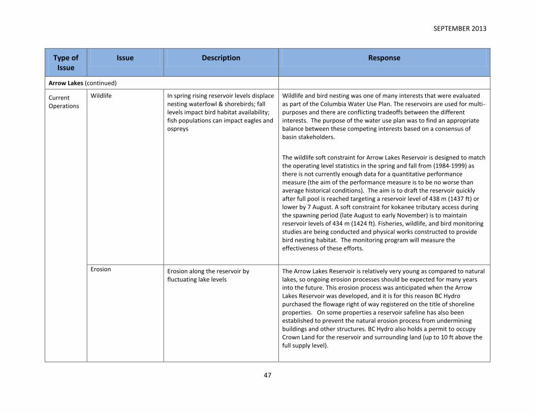
SEPTEMBER 2013
47
Type of Issue
Issue Description Response
Arrow Lakes (continued)
Current Operations
Wildlife In spring rising reservoir levels displace nesting waterfowl & shorebirds; fall levels impact bird habitat availability; fish populations can impact eagles and ospreys
Wildlife and bird nesting was one of many interests that were evaluated as part of the Columbia Water Use Plan. The reservoirs are used for multi-purposes and there are conflicting tradeoffs between the different interests. The purpose of the water use plan was to find an appropriate balance between these competing interests based on a consensus of basin stakeholders.
The wildlife soft constraint for Arrow Lakes Reservoir is designed to match the operating level statistics in the spring and fall from (1984-1999) as there is not currently enough data for a quantitative performance measure (the aim of the performance measure is to be no worse than average historical conditions). The aim is to draft the reservoir quickly after full pool is reached targeting a reservoir level of 438 m (1437 ft) or lower by 7 August. A soft constraint for kokanee tributary access during the spawning period (late August to early November) is to maintain reservoir levels of 434 m (1424 ft). Fisheries, wildlife, and bird monitoring studies are being conducted and physical works constructed to provide bird nesting habitat. The monitoring program will measure the effectiveness of these efforts.
Erosion Erosion along the reservoir by fluctuating lake levels
The Arrow Lakes Reservoir is relatively very young as compared to natural lakes, so ongoing erosion processes should be expected for many years into the future. This erosion process was anticipated when the Arrow Lakes Reservoir was developed, and it is for this reason BC Hydro purchased the flowage right of way registered on the title of shoreline properties. On some properties a reservoir safeline has also been established to prevent the natural erosion process from undermining buildings and other structures. BC Hydro also holds a permit to occupy Crown Land for the reservoir and surrounding land (up to 10 ft above the full supply level).

SEPTEMBER 2013
48
Erosion was one of many interests that were evaluated as part of the Columbia Water Use Plan. The reservoirs are used for multi-purposes and there are conflicting tradeoffs between the different interests. The purpose of the water use plan was to find an appropriate balance between these competing interests based on a consensus of basin stakeholders. The Water Use Plan recommended erosion monitoring studies that are currently being conducted. Erosion Monitoring on Arrow will be completed and results released in the fall of 2016.
Navigation safety Accidents (e.g. Arrow Park) due to changing water levels and boating hazards exposed at lower reservoir levels
Boating hazards exist in all rivers and lakes, including reservoirs. BC Hydro has a public safety management plan in place for its facilities and reservoirs that includes signage to inform the public of the hazard of upstream facilities and fluctuating water levels. BC Hydro has also installed floating booms close to key facilities to protect public safety. BCH also posts reservoir elevation data for its Columbia basin reservoirs here.
Highway infrastructure damage
Roads sinking and sloughing following very high reservoirs levels
The Ministry of Transportation and Infrastructure is constantly inspecting its infrastructure on a regular basis. This is done at two levels; 1) by maintenance contractors through their regular patrols and 2) by Ministry Area Managers doing quality assurance checks on the contractors.
The Ministry also responds to any reports of issues noted by the general public or by others that regularly drive our highways (police, trucking companies etc). If you see a problem on the highway that could be hazardous to other drivers, immediately report it to the Highway Maintenance Contractor in the area where the problem occurs. Please be ready to provide a clear description of the problem, and accurate location information. Please see this link for more information.
If the sloughing or sinking is minor, it is considered a routine maintenance activity for the maintenance contractors and they will add the defect into their maintenance plan and repair it as part of their regular maintenance activities (pavement patching, re-levelling the shoulder etc.)

SEPTEMBER 2013
49
If the sloughing is more considerable (major drop in the lane edge, settlement keeps reoccurring in the same place, minor sliding is reducing the shoulder or lane width etc) then this is considered over and above regular maintenance and the Ministry will enter into discussions with the maintenance contractor on potential repair options. At this time the Ministry will typically bring one of their own geotechnical engineers into the discussion to provide some expert advice and do any investigations and analysis if required. Once a solution is determined funding is then secured for the repair to commence.
Shelter Bay to Revelstoke dam
Current Operations
Fluctuating reservoir levels impact ecosystems and recreation
Lower reservoir levels are preferred to allow use of the drawdown zone for recreation and to reduce impacts on ecosystems and habitats. This conflicts with the preferences of residents lower in the reservoir for higher water levels for water-based recreation.
Arrow Lakes Reservoir is used for multi-purposes and there are tradeoffs between the different interests between the Shelter Bay to Revelstoke Dam reach and the Arrow Lakes Reservoir. The purpose of the water use plan was to find an appropriate balance between these competing interests and interests in the rest of the Columbia system. At Arrow Lakes Reservoir, the soft constraint for vegetation and wildlife targets are also indicative of recreation benefits in the Shelter Bay to Revelstoke Dam reach. The soft constraints seek to preserve the existing vegetation and inundation statistics over recent history (1984-1999). BC Hydro is planning on undertaking a 5 year review in 2013 to evaluate the effectiveness of the Arrow soft constraints and report out on the results of the NTSA negotiation and how the outcome may affect the Arrow soft constraints.
Wetland management & BCH land management
Arrow Lake and river fluctuations impact wetland conditions; extensive BCH lands should be actively managed for environmental values
Wildlife and bird nesting in the Revelstoke reach was one of many interests that were evaluated as part of the Columbia Water Use Plans. See response to Arrow wildlife.
Arrow Lakes Reservoir drawdown zone lands south of Revelstoke below the high water mark are a mix of land ownership (Crown, BC Hydro, Local government, and private) and no single agency has the authority to manage these lands.

SEPTEMBER 2013
50
Access conflicts on wetlands
Motorized and non-motorized recreation use conflicts
A Drawdown Zone Management Plan and Code of Conduct is in place to guide recreational use of these lands. The Plan was developed by local government, agencies, stakeholders, property owners, and recreational groups coordinated by BC Hydro.
Boat ramps/ breakwaters
WUP plans have not been fully implemented
BC Hydro developed a plan to improve the boat ramp at Centennial Park in Revelstoke as recommended by the Columbia River Water Use Plan. This project was cancelled by the Comptroller of Water Rights due to safety concerns. Alternative sites near the City of Revelstoke were explored but no feasible alternatives were found.
River navigation safety Markers are needed for safe navigation; dyke/weir suggested to increase water depths for boating; unsafe boat launch at Shelter Bay
Recreation is one of many important interests that were evaluated during the Columbia Water Use Plan. The area between Shelter Bay and Revelstoke Dam was identified as a hazardous area for boat recreation due to fluctuating water levels. Preliminary analysis of a dyke/weir to increase water depths for boating indicated such a structure would be extremely costly and infeasible. Rivers and their hazards are dynamic and inconsistent marking of hazards can reduce boater safety.
BC Hydro hired an engineering firm to complete an independent assessment of the Shelter Bay boat ramp in 2009. The study concluded that although parking is limited and minor repairs to the ramp and associated structures are required, the boat ramp is fully functional and provides 100% access during the summer boating period. This study is available here.
Fisheries Minimum flows required for rainbow trout, bull trout, sculpins, dace and possibly sturgeon
A minimum Revelstoke Dam discharge of 5,000 cubic feet per second was recommended by the Columbia River Water Use Plan and implemented in December 2010. Monitoring began prior to the start of the minimum flow to assess whether the minimum flow benefits invertebrate and fish populations Revelstoke Min flow results will be included as part of the Columbia WUP Review currently scheduled for 2022.
Mosquito control Increased costs to regional district in recent years when the reservoir levels
A mosquito monitoring study was conducted in 2009. It is not clear to what extent mosquito problems in the Revelstoke area are influenced by

SEPTEMBER 2013
51
remain high for longer periods in the summer
the reservoir levels. The results of the study are available here:
Municipal infrastructure damage
Roads sinking and sloughing following very high reservoir levels, at locations where the potential for damage was previously identified
BC Hydro assessed riverbank areas for instability prior to the construction of Hugh L. Keenleyside Dam. In the City of Revelstoke where historic pre-dam Columbia River flows resulted in serious erosion of riverbank , BC Hydro installed protective works to mitigate for increased water levels in that area. BC Hydro recently hired an engineering firm to complete a preliminary assessment of the condition of the protective works installed in this area and identify the primary factors influencing the bank stability in that area. The report indicates that there is no link to BC Hydro operations and the report has been shared with the City of Revelstoke in June 2013.
Lake Revelstoke – No issues have been raised
Kinbasket Reservoir
Historical/ Footprint
Impacts to forest industry
Especially high impacts on Golden due to lack of transportation infrastructure, loss of productive timber lands and high cost of maintaining the existing transportation network
The Province recognizes that the Kinbasket Reservoir changed how the forestry industry operated in the area. The Ministry of Forests, Lands and Natural Resource Operations continues to advocate for a solid working forest land base to meet fibre needs now and for the future. The Ministry’s relationship with the forest sector is very healthy and productive.
Water operations on the reservoir are difficult and complicated to undertake. However, the forestry sector has adapted with marine operations and strategic dewatering sites on the Kinbasket Reservoir. The Ministry recognizes that the cost of wood delivered from these sites to Revelstoke, Golden and Castlegar is higher than traditional land based operations.
Current Operations
Road infrastructure/reservoir access
Access to the reservoir restricted by current network of resource roads. Lack of maintenance budget and poor road network make roads impassable in some seasons. Access to a local hot
Currently, roads that provide access into Kinbasket reservoir are maintained by tenure holders when they are operating in the area. The Province is currently examining the issues associated with access to recreational sites on the Kinbasket Reservoir and plan to meet with local community leaders and stakeholders to discuss this issue.

SEPTEMBER 2013
52
springs has been discontinued.
Fish and Wildlife Compensation Program allocation
Lack of information on fish and wildlife values results in lack of allocation of FWCP funds to the Kinbasket region
BC Hydro and the FWCP have undertaken numerous studies in the Kinbasket area. Decisions regarding project implementation have historically been made based on a number of considerations including program priorities, technical feasibility, socio-economic benefits, public involvement and annual budgets. In general fisheries projects have focused around Arrow Lakes Reservoir and Kootenay Lake and the associated tributaries. While from a wildlife perspective projects have been widely dispersed across the basin (East and West), with generally more project activity in the southern portion of the Columbia Basin.
Over the past three years strategic guiding documents for the FWCP - Columbia have been developed. Specifically there is an overarching Basin Plan, followed by Action Plans (i.e. Riparian and Wetlands Action Plan, Small Lakes Action Plan, Large Lakes Action Plan, Species of Interest Action Plan, Upland/Dryland Action Plan) that identify specific actions (e.g. research and information acquisition, habitat based actions, monitoring and evaluation, etc.) and priorities. These plans are available at www.fwcp.ca.
The FWCP - Columbia board (comprised of representatives from the Provincial government, BC Hydro, First Nations, and the public) makes decisions on which projects receive funding. Each fall an annual work plan (including external application based projects) is developed for the Program. Following the initial screening process by the Program office, the annual work plan then undergoes technical review by either Wildlife Technical Committee or Fish Technical Committee. Finally the annual work plan is reviewed and endorsed (as applicable) by the regional FWCP - Columbia board and is implemented the following April.
Fisheries Habitat impacts on kokanee, bull trout & burbot
Reservoir habitat and stream habitat quality and accessibility is very good in Kinbasket and there is generally a low fish stranding potential due to steep reservoir banks
The streams feeding into the reservoir are generally accessible to

SEPTEMBER 2013
53
Kokanee, Bull trout and Burbot at low reservoir levels and the Reservoir tributaries still contain high quality fish habitat available upstream.
Kokanee are more abundant than before dam – the species is monitored on an annual basis and there are no concerns for population levels. Bull Trout and Burbot are also abundant and not threatened.
Fluctuating water levels limit recreation/tourism potential
Extensive drawdown zone with unsightly mudflats limits recreation and tourism development potential
Recreation is one of many interests that were evaluated as part of the Columbia Water Use Plan. The reservoirs are used for multi-purposes and there are conflicting tradeoffs between the different interests. The purpose of the water use plan was to find an appropriate balance between these competing interests. Kinbasket reservoir does not have target water levels although the preferred recreation range is generally in the top 30 m for boat access and top 9 m for shore based activities. In the WUP, alternatives that aimed to keep the reservoir higher for recreation benefits incurred costs of $16 million and $25 million per year in foregone power. Potential alternatives that affected the system’s firm energy capability would have additional costs as new generation would need to be built.
To date, there have been issues with the revegetation efforts including: site inundation during growing season due to reservoir operations; the management of woody debris has affected both site and soil characteristics; there were high rates of erosion at some sites; impacts from ATVs; site selection was not optimal partially due to limited opportunities for access; and planting methods (live stakes, plug seedlings, etc.) may have affected revegetation success in some sites. Once the 2013 Kinbasket Revegetation Program Monitoring Report is received there will be an evaluation of results to date and a review of the revegetation efforts.

SEPTEMBER 2013
54
Type of Issue
Issue Description
Kinbasket Reservoir (continued)
Current Operations
Weir Building weirs in the North and South of the Kinabasket to create areas with stable water levels for fisheries and recreation as well as a mechanism to deal with dust storms has been suggested.
During the Columbia River Treaty Review public consultations during May and June 2012, the Columbia River Treaty Review team were made aware of Valemount residents’ interest in maintaining a stable high water level in a small portion of the northwest end of the Kinbasket Reservoir, through the construction of a water retention structure (weir/dam).
BC Hydro agreed to investigate this potential structure at the “overview” level, without detailed geotechnical investigations and other costly engineering work. The purpose of the high-level estimate is to develop a range of possible construction costs which helped inform discussions with residents of Valemount. The estimated cost can be extrapolated and were used to help inform discussions with the residents of Golden who expressed an interest in a water retention structure (weir/dam) in the southeast end of Kinbasket Reservoir.
Total Project Cost, including loadings and reserves, are estimated to be roughly around $500 million dollars. The accuracy range of the estimate was not assessed, so the range of the estimate would have to exceed the standard overview range of +100% to -50%.
Study Conclusions: Valemount Dam
Dues to the high cost of the dam, the impracticality of power generation at the site and the potential impacts of the dam on other interests, the construction of a water retention structure (weir/dam) at the northwest end of the Kinbasket Reservoir does not appear to be viable. BC Hydro has no current plans to investigate the Valemount dam project further.
Study Conclusions: Extrapolation to Golden Dam
While no engineering analysis has been performed, a similar dam on the southeast end of the Kinbasket reservoir (the “Golden weir / dam”) is expected to be at least as large as the Valemount dam and likely much larger. The weir/dam would need to pass significantly higher flows, and would alter the operating regime of a larger area of land. For these

SEPTEMBER 2013
55
reasons, the Golden dam is expected to be more costly than the Valemount dam. BC Hydro has no current plans to investigate the potential Golden dam project further.
Boat ramps/ breakwaters
Properly designed ramps/breakwaters are needed to provide water access over a range of water levels; status of WUP plan implementation??
To benefit boat recreation in Kinbasket Reservoir, BC Hydro has made improvements to the Valemount Marina boat launch and constructed a new ramp at Bush Harbour (Bush Harbour completed June 2013). The boat ramps meet current standards and designs were developed and discussed with community users and stakeholders to meet community needs. All boat launches that were directed by the Water Comptroller on Kinbasket Reservoir are now complete.
Inadequate campgrounds
No provincial campground; recreation sites are not maintained
There are recreation sites on Kinbasket Reservoir managed by the Ministry of Forests, Lands and Natural Resource Operations including:
The Canoe Reach Marina – a substantial boat launch & mooring facility put in by BC Hydro and the Valemount Marina Association).
Horse Creek, Yellowjacket and Griffin Sawmill Recreation Sites all managed under partnership agreements with the Valemount Marina Association.
Sites north of Mica accessed by Highway 23 North - Sprague Bay and Potlach Creek (both user maintained) will be refreshed in 2013.
Sites accessed via B Road – Esplanade Bay, Bush Arm, Caribou Creek (all user maintained).
All recreation sites on Kinbasket Lake to Bush Arm were refreshed with new tables, maintenance work, and structure painting in 2012.
At this present time, BC Parks does not have any camping facilities on Kinbasket Reservoir however there are several protected areas near the Reservoir including:
Foster Arm Protected Area (1020 ha) is located on the western shoreline roughly half way up the reservoir.
Goosegrass Ecological Reserve (2185 ha) Cummins River Protected

SEPTEMBER 2013
56
Area and Cummins Lake Park (21728 ha) are located near the southern end of the reservoir on the west and east sides respectively.
The closest BC Parks’ campgrounds are found in Mount Robson Park to the north of the reservoir, and Martha Creek near Revelstoke to the south.
Financial
Non Treaty Storage Agreement
Concerns about how this water is managed and if it is not used to keep Kinabasket water levels higher to meet a range of Basin values, there are concerns over lack of allocation of NTSA revenue to address impacts on Basin values
Basin residents participated in the NTSA discussion process conducted in 2010-12 and had an opportunity to provide feedback on the alternatives being contemplated. The process lead to the revision of a number of the performance measures and installation of additional air monitoring equipment at Valemount to collect data about dust levels. Reservoir operations with the NTSA are consistent with the Columbia Water Use Plan and the water license that is held by BC Hydro. Financial benefits to BC Hydro from the NTSA are expected to be approximately $12 million per year which are used to keep rates low.
In recognition of the impacts of the Columbia River Treaty the Province created the Columbia Basin Trust (CBT) in 1996. It was created to support the efforts by people in the Basin to create social, economic and environmental well-being in the Canadian portion of the Columbia River Basin. CBT was given $276 million over ten years to finance power project construction in partnership with Columbia Power Corporation, $45 million up front to be used as an endowment as well as $2 million per year from 1995 to 2010 for its operations.
The income from its share of the power projects is used for CBT’s Delivery of Benefits Program Funding. Since its inception, CBT has provided almost $90 million in program funding. Current levels of benefits (approximately $18 million per year) are expected to continue until the completion of the Waneta Expansion Project at which time annual benefits are expected to double.
Payment in lieu of taxes BC Hydro makes a payment to CSRD in lieu of taxes; these funds are allocated to RD Areas that are not impacted by
Grants-in-lieu of taxation paid by BC Hydro is an extremely complex area. As a result of a review of the grants-in-lieu policy, in 2007 government introduced a new method for calculating grants paid in respect of

SEPTEMBER 2013
57
the Mica dam generating facilities. Total grants paid by BC Hydro doubled in respect of generating facilities as a result of the change.
Under government’s grants-in-lieu of taxation policy, BC Hydro pays grants to regional districts and municipalities based on its generation facilities. For each generation facility government determines which local government hosts the facility and which local government(s), including the host, are impacted by the facility. Government then allocates the total grant to be paid with respect to each generation facility on a 40/60 basis between the local government that hosts the facility and those local government(s) that are impacted by the facility. BC Hydro is directed to pay the grants by Order in Council (OIC). The current OIC number is 021/2013. The grants are calculated based on a formula that is not reflective of the tax that would be paid on the facilities if BC Hydro was taxable, but is instead based on the generating capacity of the facilities.
The Columbia-Shuswap Regional District receives a grant in respect of the following facilities: Mica, Revelstoke, Spillamacheen and Walter Hardman. With the exception of the grant paid in respect of the Walter Hardman facility (for which the regional district is the host and only impacted local government), the regional district shares the grants paid in respect of the other facilities with other local governments. Based on the formula, 92.79 per cent of the total grant paid to the Columbia-Shuswap Regional District is attributable to Mica, 6.02 per cent is attributable to Revelstoke, 0.19 per cent is attributable to Spillamacheen and 1.0 per cent is attributable to Walter Hardman.
The Ministry of Community, Sport and Cultural Development (MCSCD) provides guidelines to regional districts with respect to how they may spend amounts received as grants-in-lieu of taxation. This includes that a grant must only be spent to provide services for the service area in which a facility is located. MCSCD circular No. 10:14 (http://www.cscd.gov.bc.ca/lgd/infra/financial_circulars/cir1014.htm) outlines several options for managing grants-in-lieu of taxation.
Taxation of water stored in the reservoir
Water in Reservoirs could be viewed as an asset that generates revenue for
British Columbia’s Water Act assigns ownership of surface and ground water to the Crown, on behalf of the residents of the province. Authority

SEPTEMBER 2013
58
the Crown. Taxation of this asset is seen as a way to generate revenues that could be used to offset the impacts of the reservoir
to divert and/or use surface water (the granting of water rights) is obtained by licence or by an approval under the Water Act.
When a water licence is issued, annual water rentals are assessed. Water rentals at hydroelectric generating facilities are based on the size of the generating facility, the volume of storage and annual power output. Water rentals are paid into the Consolidated Revenue Fund which is used to provide provincial services, including water management responsibilities and provision of provincial services, including within the Columbia basin.