public 2018 access lands atlas - dnr.wi.gov · public access lands atlas of wisconsin, 2018 —...
TRANSCRIPT
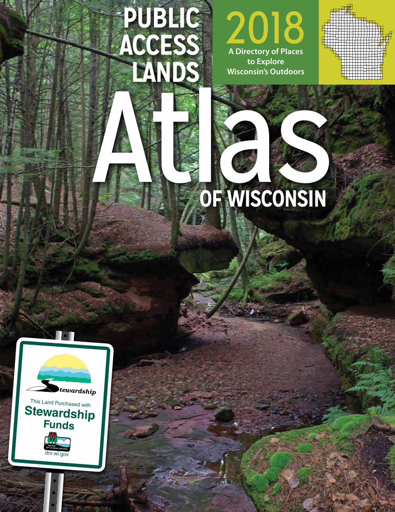
2018A Directory of Places
to ExploreWisconsin’s Outdoors
This Land Purchased withStewardship
Funds
dnr.wi.gov
AtlasPUBLICACCESSLANDS
OF WISCONSIN

From state natural areas to state trails, lake shores to rivers, Wisconsin has a wealth of public lands for your enjoyment. These are your public lands and available for you to connect with the outdoors.
If you are looking for a place to fish, hunt, or trap, this atlas will help you find public access opportunities to do so. If you are interested in wildlife watching, hiking, or skiing in the winter, the following pages will help direct you to prime places to enjoy these activities, and others, as well.
Public access to many of these properties has been made possible by the Knowles-Nelson Stewardship Program, providing places to play while also protecting water quality, habitat and natural areas since it was created by the Wisconsin Legislature in 1989.
I am proud to offer this extensive directory of 441 maps that help you find some of the best habitats and most beautiful areas that Wisconsin has to offer.
Take advantage of the information provided in this atlas and create new outdoor memories with friends and family.
Daniel L. Meyer DNR Secretary
Copyright © 2018 by Wisconsin Department of Natural Resources
PUB-LF-076 2018
ISBN 978-0-9912766-2-2
This publication complies with 2011 Wisconsin Act 95 and will be updated every two years in accordance with the law.
2018 Project Team: Jim Lemke, Ann Scott, Pam Foster Felt, Jennifer Gihring, Kathy Shubak, Jamie Touhill, Joe Klang, Andrew Savagian, Michelle Gary, Paul Holtan, Kaylin Helm
2016 Project Team: Pam Foster Felt, Doug Haag, Ann Scott, Kathy Shubak, Dan Schneider, Jamie Touhill, Kaylin Helm, Sawyer Briel
2014 Project Team: Pam Foster Felt, Doug Haag, Drew Hanson, Lavane Hessler, Cindy Hoffland, Steve Miller, John Pohlman, Mary Rose Teves
2014 Supporting Staff: Kathy Shubak, Tonya Duerst, Kaylin Helm, John Laedlein, Jeannie McCarville, Scott Moucka, Jennifer Pelej, Janel Pike, Ann Runyard, Jerry Sullivan, Kurt Thiede
Book design: by Union Street Design, LLC
Cover photo, Houghton Falls State Natural Area, Bayfield County. Purchased in part with a Knowles-Nelson Stewardship Grant. Photo by Thomas A. Meyer
The Wisconsin Department of Natural Resources provides equal opportunity in its employment, programs, services and functions under an Affirmative Action Plan.
If you have any questions, please write to Chief, Public Civil Rights Office of Civil Rights– U.S. Department of the Interior, 1849 C Street NW, Washington, D.C. 20240
This publication can be made available in alternative formats (large print, Braille, audio tape, etc) upon request.
Please call the Accessibility Coordinator at 608-267-7490.
A Directory of Places to Explore Wisconsin’s Outdoors — page 1
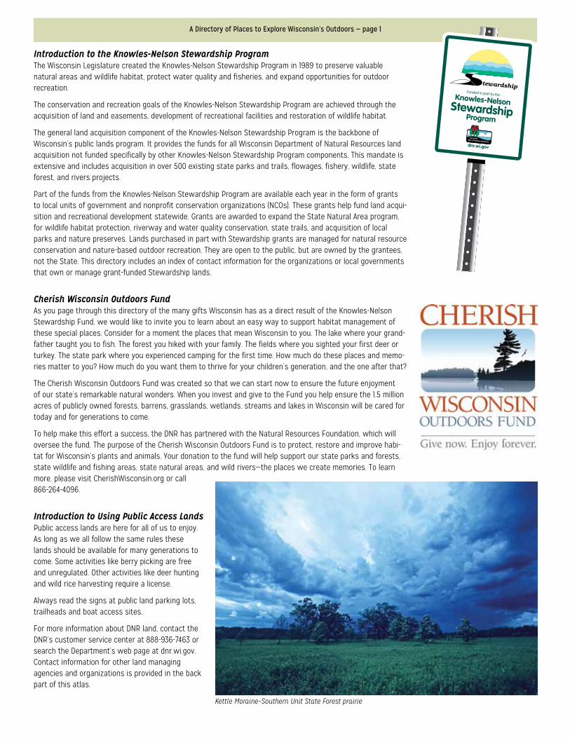
Introduction to the Knowles-Nelson Stewardship ProgramThe Wisconsin Legislature created the Knowles-Nelson Stewardship Program in 1989 to preserve valuable natural areas and wildlife habitat, protect water quality and fisheries, and expand opportunities for outdoor recreation.
The conservation and recreation goals of the Knowles-Nelson Stewardship Program are achieved through the acquisition of land and easements, development of recreational facilities and restoration of wildlife habitat.
The general land acquisition component of the Knowles-Nelson Stewardship Program is the backbone of Wisconsin’s public lands program. It provides the funds for all Wisconsin Department of Natural Resources land acquisition not funded specifically by other Knowles-Nelson Stewardship Program components. This mandate is extensive and includes acquisition in over 500 existing state parks and trails, flowages, fishery, wildlife, state forest, and rivers projects.
Part of the funds from the Knowles-Nelson Stewardship Program are available each year in the form of grants to local units of government and nonprofit conservation organizations (NCOs). These grants help fund land acqui-sition and recreational development statewide. Grants are awarded to expand the State Natural Area program, for wildlife habitat protection, riverway and water quality conservation, state trails, and acquisition of local parks and nature preserves. Lands purchased in part with Stewardship grants are managed for natural resource conservation and nature-based outdoor recreation. They are open to the public, but are owned by the grantees, not the State. This directory includes an index of contact information for the organizations or local governments that own or manage grant-funded Stewardship lands.
Cherish Wisconsin Outdoors FundAs you page through this directory of the many gifts Wisconsin has as a direct result of the Knowles-Nelson Stewardship Fund, we would like to invite you to learn about an easy way to support habitat management of these special places. Consider for a moment the places that mean Wisconsin to you. The lake where your grand-father taught you to fish. The forest you hiked with your family. The fields where you sighted your first deer or turkey. The state park where you experienced camping for the first time. How much do these places and memo-ries matter to you? How much do you want them to thrive for your children’s generation, and the one after that?
The Cherish Wisconsin Outdoors Fund was created so that we can start now to ensure the future enjoyment of our state’s remarkable natural wonders. When you invest and give to the Fund you help ensure the 1.5 million acres of publicly owned forests, barrens, grasslands, wetlands, streams and lakes in Wisconsin will be cared for today and for generations to come.
To help make this effort a success, the DNR has partnered with the Natural Resources Foundation, which will oversee the fund. The purpose of the Cherish Wisconsin Outdoors Fund is to protect, restore and improve habi-tat for Wisconsin’s plants and animals. Your donation to the fund will help support our state parks and forests, state wildlife and fishing areas, state natural areas, and wild rivers—the places we create memories. To learn more, please visit CherishWisconsin.org or call 866-264-4096.
Introduction to Using Public Access LandsPublic access lands are here for all of us to enjoy. As long as we all follow the same rules these lands should be available for many generations to come. Some activities like berry picking are free and unregulated. Other activities like deer hunting and wild rice harvesting require a license.
Always read the signs at public land parking lots, trailheads and boat access sites.
For more information about DNR land, contact the DNR’s customer service center at 888-936-7463 or search the Department’s web page at dnr.wi.gov. Contact information for other land managing agencies and organizations is provided in the back part of this atlas.
Kettle Moraine–Southern Unit State Forest prairie
Funded in part by theKnowles-NelsonStewardshipProgram
dnr.wi.gov
Public Access Lands Atlas of Wisconsin, 2018 — page 2
Using this Atlas
This atlas is designed to help you find public access lands in Wisconsin. The book consists of three sections: (1) introductory information, (2) 441 maps and (3) indexes and other supporting information. If you are looking for a specific DNR property, like Peninsula State Park, check the DNR Properties Index near the back of the book. The state index map that appears twice, on the back cover and just before the first PAL map, is another helpful tool for finding your special area of the state. Holding the maps so that the title “Public Access Lands” reads left to right will mean that north is at the top of the page. The scale of each of the maps is 1 : 105,000 or 1 inch equals about 1.6 miles.
Not shown on the maps are lands that are open to public access for only a period of some years, such as lands enrolled in the Managed Forest Law (MFL) or Voluntary Public Access (VPA) programs. Also not shown are private lands that are leased by the DNR. Certain public lands, such as local school forests, are not shown because there is no statewide spatial database for them.
Although all DNR properties are shown on the PAL maps, to keep them from being cluttered some lands are not labeled. In addition, State Natural Areas located within other properties (e.g. National Forest or State Wildlife Area) are not labeled.
Because many fishing-related ease-ments are only 66 feet wide, making them too small to appear on maps of this scale, their size is exaggerated by 400 feet so that they are visible on the maps. An artifact of this exaggeration is that the highlighted area may appear to extend into an area that is actually without public access. Users must also not assume that these areas are also open for hunting or other recreational activi-ties. In most cases, they are open for public fishing only. Always read and obey the signs posted at a property. If there is a question, contact the local property manager.
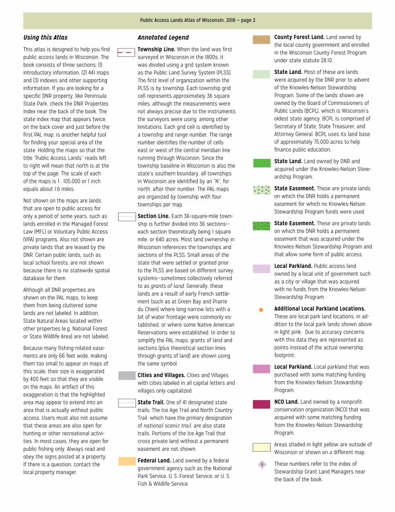
Annotated Legend
Township Line. When the land was first surveyed in Wisconsin in the 1800s, it was divided using a grid system known as the Public Land Survey System (PLSS). The first level of organization within the PLSS is by township. Each township grid cell represents approximately 36 square miles, although the measurements were not always precise due to the instruments the surveyors were using, among other limitations. Each grid cell is identified by a township and range number. The range number identifies the number of cells east or west of the central meridian line running through Wisconsin. Since the township baseline in Wisconsin is also the state’s southern boundary, all townships in Wisconsin are identified by an “N”, for north, after their number. The PAL maps are organized by township with four townships per map.
Section Line. Each 36-square-mile town-ship is further divided into 36 sections—each section theoretically being 1 square mile, or 640 acres. Most land ownership in Wisconsin references the townships and sections of the PLSS. Small areas of the state that were settled or granted prior to the PLSS are based on different survey systems—sometimes collectively referred to as grants of land. Generally, these lands are a result of early French settle-ment (such as at Green Bay and Prairie du Chien) where long narrow lots with a bit of water frontage were commonly es-tablished, or where some Native American Reservations were established. In order to simplify the PAL maps, grants of land and sections (plus theoretical section lines through grants of land) are shown using the same symbol.
Cities and Villages. Cities and Villages with cities labeled in all capital letters and villages only capitalized.
State Trail. One of 41 designated state trails. The Ice Age Trail and North Country Trail, which have the primary designation of national scenic trail, are also state trails. Portions of the Ice Age Trail that cross private land without a permanent easement are not shown.
Federal Land. Land owned by a federal government agency such as the National Park Service, U. S. Forest Service, or U. S. Fish & Wildlife Service
County Forest Land. Land owned by the local county government and enrolled in the Wisconsin County Forest Program under state statute 28.10.
State Land. Most of these are lands were acquired by the DNR prior to advent of the Knowles-Nelson Stewardship Program. Some of the lands shown are owned by the Board of Commissioners of Public Lands (BCPL), which is Wisconsin’s oldest state agency. BCPL is comprised of Secretary of State, State Treasurer, and Attorney General. BCPL uses its land base of approximately 75,000 acres to help finance public education.
State Land. Land owned by DNR and acquired under the Knowles-Nelson Stew-ardship Program.
State Easement. These are private lands on which the DNR holds a permanent easement for which no Knowles-Nelson Stewardship Program funds were used.
State Easement. These are private lands on which the DNR holds a permanent easement that was acquired under the Knowles-Nelson Stewardship Program and that allow some form of public access.
Local Parkland. Public access land owned by a local unit of government such as a city or village that was acquired with no funds from the Knowles-Nelson Stewardship Program.
Additional Local Parkland Locations. These are local park land locations, in ad-dition to the local park lands shown above in light pink. Due to accuracy concerns with this data they are represented as points instead of the actual ownership footprint.
Local Parkland. Local parkland that was purchased with some matching funding from the Knowles-Nelson Stewardship Program.
NCO Land. Land owned by a nonprofit conservation organization (NCO) that was acquired with some matching funding from the Knowles-Nelson Stewardship Program.
Areas shaded in light yellow are outside of Wisconsin or shown on a different map.
These numbers refer to the index of Stewardship Grant Land Managers near the back of the book.
9
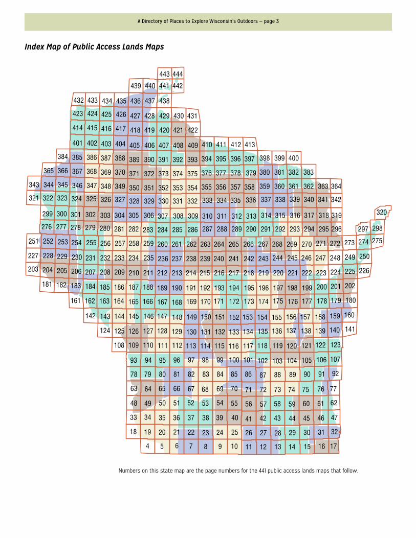
A Directory of Places to Explore Wisconsin’s Outdoors — page 3
Numbers on this state map are the page numbers for the 441 public access lands maps that follow.
Index Map of Public Access Lands Maps
443 444
442441440439
438437436435434433432
423
414
401 402 403 404 405 406 407 408 409 410 411 412 413
385384 386 387 388 389 390 391 392 393 394 395 396 397 398 399 400
367366365 368 369 370 371 372 373 374 375 376 377 378 379 380 381 382 383
346345344343 347 348 349 350 351 352 353 354 355 356 357 358 359 360 361 362 363 364
324323322321 325 326 327 328 329 330 331 332 333 334 335 336 337 338 339 340 341 342
301300299 302 303 304 305 306 307 308 309 310 311 312 313 314 315 316 317 318 319 320
278277276
251
227
203 204
181 182 183
161 162
142
124 125 126 127 128 129 130 131 132 133 134
108
93
78
63
48
33
18
4 5 6 7 8 9 10 11 12 13 14 15 16 17
19 20 21 22 23 24 25 26 27 28 29 30 31 32
49
34 35 36 37 38 39 40 41 42 43 44 45 46 47
50 51 52 53 54 55 56 57 58 59 60 61 62
64 65 66 67 68 69 70 71 72 73 74 75 76 77
79 80 81 82 83 84 85 86 87 88 89 90 91 92
94 95 96 97 98 99 100 101 102 103 104 105 106 107
109 110 111 112 113 114 115 116 117 118 119 120 121 122 123
143 144 145 146 147 148 149 150 151 152 153 154
135 136 137 138 139 140 141
155 156 157 158 159 160
163 164 165 166 167 168 169 170 171 173 174 175 176 177 178 179 180172
184 185 186 187 188 189 190 191 192 193 194 195 196 197 198 199 200 201 202
205 206 207 208 209 210 211 212 213 214 215 216 217 218 219 220 221 222 223 224 225 226
228 229 230 231 232 233 234 235 236 237 238 239 240 241 242 243 244 245 246 247 248 249 250
252 253 254 255 256 257 258 259 260 261 262 263 264 266 267 268 269 270 271 272 273 274 275265
279 280 281 282 283 284 285 286 287 288 289 290 291 292 293 294 295 296 297 298
415 416 417 418 419 420 421 422
424 425 426 427 428 429 430 431

A Directory of Places to Explore Wisconsin’s Outdoors — page 445
All DNR public access lands are shown on the maps but not all appear in this index. Easements are not included in this index.
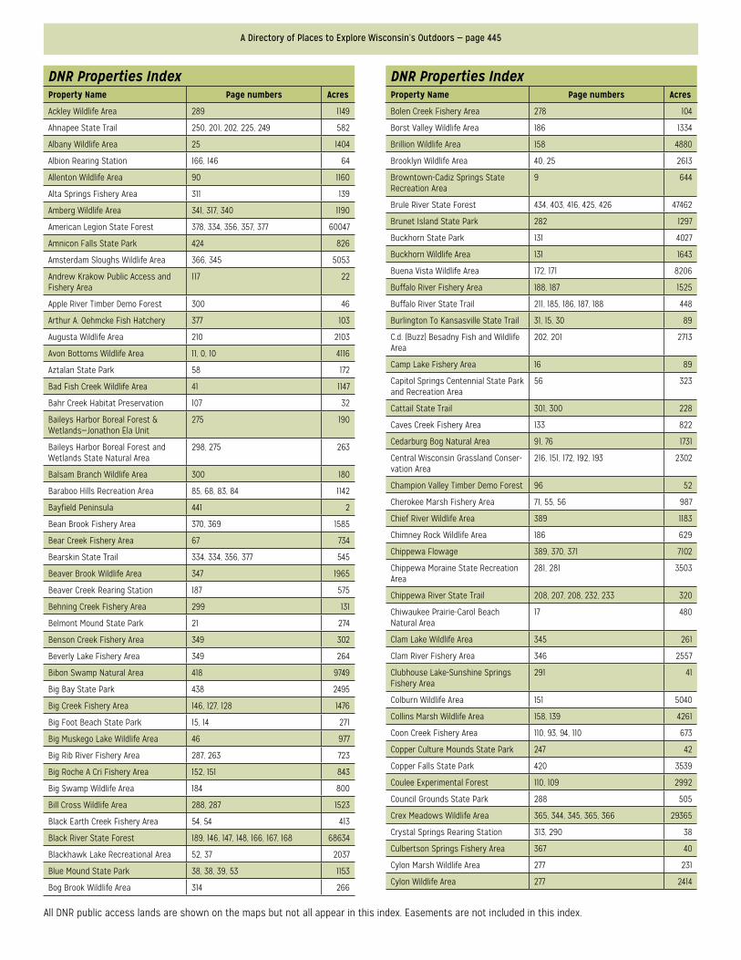
DNR Properties IndexProperty Name Page numbers Acres
Ackley Wildlife Area 289 1149
Ahnapee State Trail 250, 201, 202, 225, 249 582
Albany Wildlife Area 25 1404
Albion Rearing Station 166, 146 64
Allenton Wildlife Area 90 1160
Alta Springs Fishery Area 311 139
Amberg Wildlife Area 341, 317, 340 1190
American Legion State Forest 378, 334, 356, 357, 377 60047
Amnicon Falls State Park 424 826
Amsterdam Sloughs Wildlife Area 366, 345 5053
Andrew Krakow Public Access and Fishery Area
117 22
Apple River Timber Demo Forest 300 46
Arthur A. Oehmcke Fish Hatchery 377 103
Augusta Wildlife Area 210 2103
Avon Bottoms Wildlife Area 11, 0, 10 4116
Aztalan State Park 58 172
Bad Fish Creek Wildlife Area 41 1147
Bahr Creek Habitat Preservation 107 32
Baileys Harbor Boreal Forest & Wetlands—Jonathon Ela Unit
275 190
Baileys Harbor Boreal Forest and Wetlands State Natural Area
298, 275 263
Balsam Branch Wildlife Area 300 180
Baraboo Hills Recreation Area 85, 68, 83, 84 1142
Bayfield Peninsula 441 2
Bean Brook Fishery Area 370, 369 1585
Bear Creek Fishery Area 67 734
Bearskin State Trail 334, 334, 356, 377 545
Beaver Brook Wildlife Area 347 1965
Beaver Creek Rearing Station 187 575
Behning Creek Fishery Area 299 131
Belmont Mound State Park 21 274
Benson Creek Fishery Area 349 302
Beverly Lake Fishery Area 349 264
Bibon Swamp Natural Area 418 9749
Big Bay State Park 438 2495
Big Creek Fishery Area 146, 127, 128 1476
Big Foot Beach State Park 15, 14 271
Big Muskego Lake Wildlife Area 46 977
Big Rib River Fishery Area 287, 263 723
Big Roche A Cri Fishery Area 152, 151 843
Big Swamp Wildlife Area 184 800
Bill Cross Wildlife Area 288, 287 1523
Black Earth Creek Fishery Area 54, 54 413
Black River State Forest 189, 146, 147, 148, 166, 167, 168 68634
Blackhawk Lake Recreational Area 52, 37 2037
Blue Mound State Park 38, 38, 39, 53 1153
Bog Brook Wildlife Area 314 266
DNR Properties IndexProperty Name Page numbers Acres
Bolen Creek Fishery Area 278 104
Borst Valley Wildlife Area 186 1334
Brillion Wildlife Area 158 4880
Brooklyn Wildlife Area 40, 25 2613
Browntown-Cadiz Springs State Recreation Area
9 644
Brule River State Forest 434, 403, 416, 425, 426 47462
Brunet Island State Park 282 1297
Buckhorn State Park 131 4027
Buckhorn Wildlife Area 131 1643
Buena Vista Wildlife Area 172, 171 8206
Buffalo River Fishery Area 188, 187 1525
Buffalo River State Trail 211, 185, 186, 187, 188 448
Burlington To Kansasville State Trail 31, 15, 30 89
C.d. (Buzz) Besadny Fish and Wildlife Area
202, 201 2713
Camp Lake Fishery Area 16 89
Capitol Springs Centennial State Park and Recreation Area
56 323
Cattail State Trail 301, 300 228
Caves Creek Fishery Area 133 822
Cedarburg Bog Natural Area 91, 76 1731
Central Wisconsin Grassland Conser-vation Area
216, 151, 172, 192, 193 2302
Champion Valley Timber Demo Forest 96 52
Cherokee Marsh Fishery Area 71, 55, 56 987
Chief River Wildlife Area 389 1183
Chimney Rock Wildlife Area 186 629
Chippewa Flowage 389, 370, 371 7102
Chippewa Moraine State Recreation Area
281, 281 3503
Chippewa River State Trail 208, 207, 208, 232, 233 320
Chiwaukee Prairie-Carol Beach Natural Area
17 480
Clam Lake Wildlife Area 345 261
Clam River Fishery Area 346 2557
Clubhouse Lake-Sunshine Springs Fishery Area
291 41
Colburn Wildlife Area 151 5040
Collins Marsh Wildlife Area 158, 139 4261
Coon Creek Fishery Area 110, 93, 94, 110 673
Copper Culture Mounds State Park 247 42
Copper Falls State Park 420 3539
Coulee Experimental Forest 110, 109 2992
Council Grounds State Park 288 505
Crex Meadows Wildlife Area 365, 344, 345, 365, 366 29365
Crystal Springs Rearing Station 313, 290 38
Culbertson Springs Fishery Area 367 40
Cylon Marsh Wildlife Area 277 231
Cylon Wildlife Area 277 2414
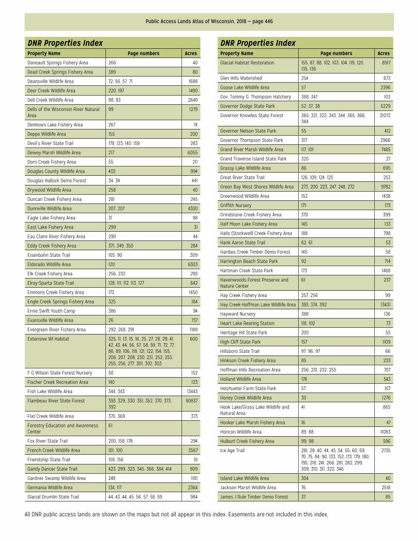
Public Access Lands Atlas of Wisconsin, 2018 — page 446
All DNR public access lands are shown on the maps but not all appear in this index. Easements are not included in this index.
DNR Properties IndexProperty Name Page numbers Acres
Daneault Springs Fishery Area 266 40
Dead Creek Springs Fishery Area 389 80
Deansville Wildlife Area 72, 56, 57, 71 1688
Deer Creek Wildlife Area 220, 197 1490
Dell Creek Wildlife Area 98, 83 2649
Dells of the Wisconsin River Natural Area
99 1279
Demlows Lake Fishery Area 267 74
Deppe Wildlife Area 155 200
Devil’s River State Trail 179, 123, 140, 159 283
Dewey Marsh Wildlife Area 217 6055
Dorn Creek Fishery Area 55 211
Douglas County Wildlife Area 402 994
Douglas Hallock Demo Forest 34, 34 441
Drywood Wildlife Area 258 40
Duncan Creek Fishery Area 281 245
Dunnville Wildlife Area 207, 207 4300
Eagle Lake Fishery Area 31 98
East Lake Fishery Area 299 31
Eau Claire River Fishery Area 290 44
Eddy Creek Fishery Area 371, 349, 350 284
Eisenbahn State Trail 105, 90 309
Eldorado Wildlife Area 120 6303
Elk Creek Fishery Area 256, 232 293
Elroy-Sparta State Trail 128, 111, 112, 113, 127 642
Emmons Creek Fishery Area 173 1450
Engle Creek Springs Fishery Area 325 184
Ernie Swift Youth Camp 386 94
Evansville Wildlife Area 26 737
Evergreen River Fishery Area 292, 268, 291 1189
Extensive Wl Habitat 325, 11, 13, 15, 16, 25, 27, 28, 29, 41, 42, 43, 44, 56, 57, 58, 59, 71, 72, 77, 86, 89, 106, 118, 121, 122, 154, 155, 206, 207, 208, 230, 231, 252, 253, 255, 256, 277, 301, 302, 303
600
F G Wilson State Forest Nursery 50 152
Fischer Creek Recreation Area 140 123
Fish Lake Wildlife Area 344, 343 13443
Flambeau River State Forest 393, 329, 330, 351, 352, 370, 373, 392
90837
Flat Creek Wildlife Area 370, 369 373
Forestry Education and Awareness Center
61
Fox River State Trail 200, 158, 178 294
French Creek Wildlife Area 101, 100 3567
Friendship State Trail 158, 156 10
Gandy Dancer State Trail 423, 299, 323, 345, 366, 384, 414 809
Gardner Swamp Wildlife Area 249 1181
Germania Wildlife Area 134, 117 2364
Glacial Drumlin State Trail 44, 43, 44, 45, 56, 57, 58, 59 984
DNR Properties IndexProperty Name Page numbers Acres
Glacial Habitat Restoration 155, 87, 88, 102, 103, 104, 119, 120, 135, 136
8917
Glen Hills Watershed 254 673
Goose Lake Wildlife Area 57 2396
Gov. Tommy G. Thompson Hatchery 368, 347 103
Governor Dodge State Park 52, 37, 38 5229
Governor Knowles State Forest 365, 321, 322, 343, 344, 365, 366, 384
21072
Governor Nelson State Park 55 412
Governor Thompson State Park 317 2966
Grand River Marsh Wildlife Area 117, 101 7485
Grand Traverse Island State Park 320 27
Grassy Lake Wildlife Area 86 695
Great River State Trail 126, 109, 124, 125 253
Green Bay West Shores Wildlife Area 273, 200, 223, 247, 248, 272 9782
Greenwood Wildlife Area 152 1438
Griffith Nursery 171 173
Grindstone Creek Fishery Area 370 399
Half Moon Lake Fishery Area 145 133
Halls (Stockwell) Creek Fishery Area 188 798
Hank Aaron State Trail 62, 61 53
Hardies Creek Timber Demo Forest 145 58
Harrington Beach State Park 92 714
Hartman Creek State Park 173 1468
Havenwoods Forest Preserve and Nature Center
61 237
Hay Creek Fishery Area 257, 256 99
Hay Creek-Hoffman Lake Wildlife Area 393, 374, 392 13431
Hayward Nursery 388 136
Heart Lake Rearing Station 118, 102 73
Heritage Hill State Park 200 55
High Cliff State Park 157 1109
Hillsboro State Trail 97, 96, 97 66
Hinkson Creek Fishery Area 85 233
Hoffman Hills Recreation Area 256, 231, 232, 255 707
Holland Wildlife Area 178 543
Holzhueter Farm State Park 57 107
Honey Creek Wildlife Area 30 1276
Hook Lake/Grass Lake Wildlife and Natural Area
41 865
Hooker Lake Marsh Fishery Area 16 47
Horicon Wildlife Area 89, 88 11083
Hulburt Creek Fishery Area 99, 98 596
Ice Age Trail 281, 28, 40, 44, 45, 54, 55, 60, 69, 70, 75, 84, 90, 133, 152, 173, 179, 180, 195, 218, 241, 266, 281, 282, 299, 309, 310, 311, 323, 346
2735
Island Lake Wildlife Area 304 40
Jackson Marsh Wildlife Area 76 2518
James J Rule Timber Demo Forest 37 85
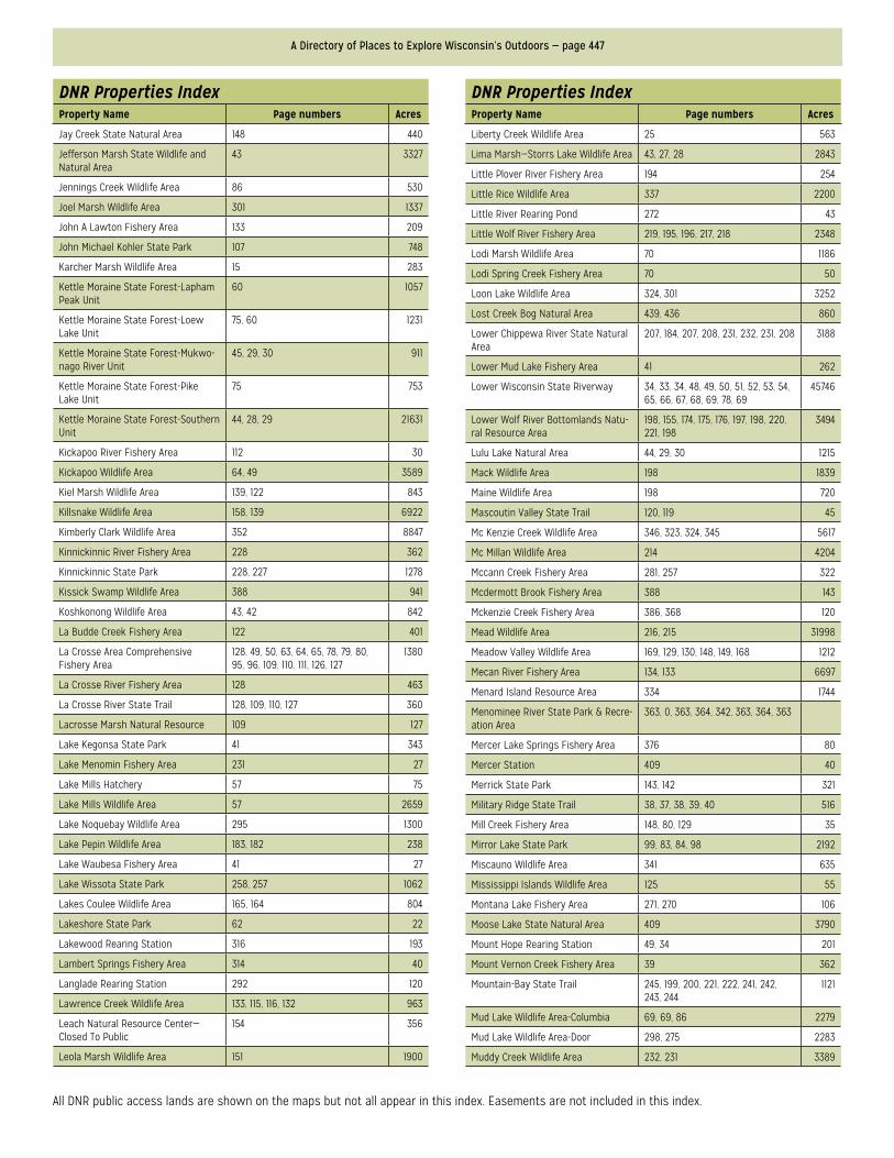
A Directory of Places to Explore Wisconsin’s Outdoors — page 447
All DNR public access lands are shown on the maps but not all appear in this index. Easements are not included in this index.
DNR Properties IndexProperty Name Page numbers Acres
Jay Creek State Natural Area 148 440
Jefferson Marsh State Wildlife and Natural Area
43 3327
Jennings Creek Wildlife Area 86 530
Joel Marsh Wildlife Area 301 1337
John A Lawton Fishery Area 133 209
John Michael Kohler State Park 107 748
Karcher Marsh Wildlife Area 15 283
Kettle Moraine State Forest-Lapham Peak Unit
60 1057
Kettle Moraine State Forest-Loew Lake Unit
75, 60 1231
Kettle Moraine State Forest-Mukwo-nago River Unit
45, 29, 30 911
Kettle Moraine State Forest-Pike Lake Unit
75 753
Kettle Moraine State Forest-Southern Unit
44, 28, 29 21631
Kickapoo River Fishery Area 112 30
Kickapoo Wildlife Area 64, 49 3589
Kiel Marsh Wildlife Area 139, 122 843
Killsnake Wildlife Area 158, 139 6922
Kimberly Clark Wildlife Area 352 8847
Kinnickinnic River Fishery Area 228 362
Kinnickinnic State Park 228, 227 1278
Kissick Swamp Wildlife Area 388 941
Koshkonong Wildlife Area 43, 42 842
La Budde Creek Fishery Area 122 401
La Crosse Area Comprehensive Fishery Area
128, 49, 50, 63, 64, 65, 78, 79, 80, 95, 96, 109, 110, 111, 126, 127
1380
La Crosse River Fishery Area 128 463
La Crosse River State Trail 128, 109, 110, 127 360
Lacrosse Marsh Natural Resource 109 127
Lake Kegonsa State Park 41 343
Lake Menomin Fishery Area 231 27
Lake Mills Hatchery 57 75
Lake Mills Wildlife Area 57 2659
Lake Noquebay Wildlife Area 295 1300
Lake Pepin Wildlife Area 183, 182 238
Lake Waubesa Fishery Area 41 27
Lake Wissota State Park 258, 257 1062
Lakes Coulee Wildlife Area 165, 164 804
Lakeshore State Park 62 22
Lakewood Rearing Station 316 193
Lambert Springs Fishery Area 314 40
Langlade Rearing Station 292 120
Lawrence Creek Wildlife Area 133, 115, 116, 132 963
Leach Natural Resource Center—Closed To Public
154 356
Leola Marsh Wildlife Area 151 1900
DNR Properties IndexProperty Name Page numbers Acres
Liberty Creek Wildlife Area 25 563
Lima Marsh—Storrs Lake Wildlife Area 43, 27, 28 2843
Little Plover River Fishery Area 194 254
Little Rice Wildlife Area 337 2200
Little River Rearing Pond 272 43
Little Wolf River Fishery Area 219, 195, 196, 217, 218 2348
Lodi Marsh Wildlife Area 70 1186
Lodi Spring Creek Fishery Area 70 50
Loon Lake Wildlife Area 324, 301 3252
Lost Creek Bog Natural Area 439, 436 860
Lower Chippewa River State Natural Area
207, 184, 207, 208, 231, 232, 231, 208 3188
Lower Mud Lake Fishery Area 41 262
Lower Wisconsin State Riverway 34, 33, 34, 48, 49, 50, 51, 52, 53, 54, 65, 66, 67, 68, 69, 78, 69
45746
Lower Wolf River Bottomlands Natu-ral Resource Area
198, 155, 174, 175, 176, 197, 198, 220, 221, 198
3494
Lulu Lake Natural Area 44, 29, 30 1215
Mack Wildlife Area 198 1839
Maine Wildlife Area 198 720
Mascoutin Valley State Trail 120, 119 45
Mc Kenzie Creek Wildlife Area 346, 323, 324, 345 5617
Mc Millan Wildlife Area 214 4204
Mccann Creek Fishery Area 281, 257 322
Mcdermott Brook Fishery Area 388 143
Mckenzie Creek Fishery Area 386, 368 120
Mead Wildlife Area 216, 215 31998
Meadow Valley Wildlife Area 169, 129, 130, 148, 149, 168 1212
Mecan River Fishery Area 134, 133 6697
Menard Island Resource Area 334 1744
Menominee River State Park & Recre-ation Area
363, 0, 363, 364, 342, 363, 364, 363
Mercer Lake Springs Fishery Area 376 80
Mercer Station 409 40
Merrick State Park 143, 142 321
Military Ridge State Trail 38, 37, 38, 39, 40 516
Mill Creek Fishery Area 148, 80, 129 35
Mirror Lake State Park 99, 83, 84, 98 2192
Miscauno Wildlife Area 341 635
Mississippi Islands Wildlife Area 125 55
Montana Lake Fishery Area 271, 270 106
Moose Lake State Natural Area 409 3790
Mount Hope Rearing Station 49, 34 201
Mount Vernon Creek Fishery Area 39 362
Mountain-Bay State Trail 245, 199, 200, 221, 222, 241, 242, 243, 244
1121
Mud Lake Wildlife Area-Columbia 69, 69, 86 2279
Mud Lake Wildlife Area-Door 298, 275 2283
Muddy Creek Wildlife Area 232, 231 3389
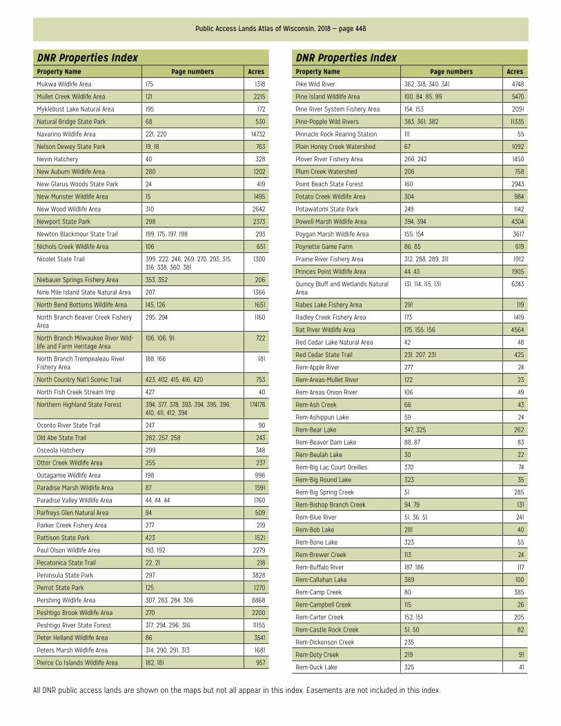
Public Access Lands Atlas of Wisconsin, 2018 — page 448
All DNR public access lands are shown on the maps but not all appear in this index. Easements are not included in this index.
DNR Properties IndexProperty Name Page numbers Acres
Mukwa Wildlife Area 175 1318
Mullet Creek Wildlife Area 121 2215
Myklebust Lake Natural Area 195 172
Natural Bridge State Park 68 530
Navarino Wildlife Area 221, 220 14732
Nelson Dewey State Park 19, 18 763
Nevin Hatchery 40 328
New Auburn Wildlife Area 280 1202
New Glarus Woods State Park 24 419
New Munster Wildlife Area 15 1495
New Wood Wildlife Area 310 2642
Newport State Park 298 2373
Newton Blackmour State Trail 199, 175, 197, 198 293
Nichols Creek Wildlife Area 106 651
Nicolet State Trail 399, 222, 246, 269, 270, 293, 315, 316, 338, 360, 381
1300
Niebauer Springs Fishery Area 353, 352 206
Nine Mile Island State Natural Area 207 1366
North Bend Bottoms Wildlife Area 145, 126 1651
North Branch Beaver Creek Fishery Area
295, 294 1160
North Branch Milwaukee River Wild-life and Farm Heritage Area
106, 106, 91 722
North Branch Trempealeau River Fishery Area
188, 166 181
North Country Nat’l Scenic Trail 423, 402, 415, 416, 420 753
North Fish Creek Stream Imp 427 40
Northern Highland State Forest 394, 377, 378, 393, 394, 395, 396, 410, 411, 412, 394
174178
Oconto River State Trail 247 90
Old Abe State Trail 282, 257, 258 243
Osceola Hatchery 299 348
Otter Creek Wildlife Area 255 237
Outagamie Wildlife Area 198 996
Paradise Marsh Wildlife Area 87 1591
Paradise Valley Wildlife Area 44, 44, 44 1760
Parfreys Glen Natural Area 84 509
Parker Creek Fishery Area 277 219
Pattison State Park 423 1521
Paul Olson Wildlife Area 193, 192 2279
Pecatonica State Trail 22, 21 218
Peninsula State Park 297 3828
Perrot State Park 125 1270
Pershing Wildlife Area 307, 283, 284, 306 8868
Peshtigo Brook Wildlife Area 270 2200
Peshtigo River State Forest 317, 294, 296, 316 11155
Peter Helland Wildlife Area 86 3541
Peters Marsh Wildlife Area 314, 290, 291, 313 1681
Pierce Co Islands Wildlife Area 182, 181 957
DNR Properties IndexProperty Name Page numbers Acres
Pike Wild River 362, 318, 340, 341 4748
Pine Island Wildlife Area 100, 84, 85, 99 5470
Pine River System Fishery Area 154, 153 2091
Pine-Popple Wild Rivers 383, 361, 382 11335
Pinnacle Rock Rearing Station 111 55
Plain Honey Creek Watershed 67 1092
Plover River Fishery Area 266, 242 1450
Plum Creek Watershed 206 758
Point Beach State Forest 160 2943
Potato Creek Wildlife Area 304 984
Potawatomi State Park 249 1142
Powell Marsh Wildlife Area 394, 394 4304
Poygan Marsh Wildlife Area 155, 154 3617
Poynette Game Farm 86, 85 619
Prairie River Fishery Area 312, 288, 289, 311 1912
Princes Point Wildlife Area 44, 43 1905
Quincy Bluff and Wetlands Natural Area
131, 114, 115, 131 6343
Rabes Lake Fishery Area 291 119
Radley Creek Fishery Area 173 1419
Rat River Wildlife Area 175, 155, 156 4564
Red Cedar Lake Natural Area 42 48
Red Cedar State Trail 231, 207, 231 425
Rem-Apple River 277 24
Rem-Areas-Mullet River 122 23
Rem-Areas-Onion River 106 49
Rem-Ash Creek 66 43
Rem-Ashippun Lake 59 24
Rem-Bear Lake 347, 325 262
Rem-Beaver Dam Lake 88, 87 83
Rem-Beulah Lake 30 22
Rem-Big Lac Court Oreilles 370 74
Rem-Big Round Lake 323 35
Rem-Big Spring Creek 51 285
Rem-Bishop Branch Creek 94, 79 131
Rem-Blue River 51, 36, 51 241
Rem-Bob Lake 281 40
Rem-Bone Lake 323 55
Rem-Brewer Creek 113 24
Rem-Buffalo River 187, 186 117
Rem-Callahan Lake 389 100
Rem-Camp Creek 80 385
Rem-Campbell Creek 115 26
Rem-Carter Creek 152, 151 205
Rem-Castle Rock Creek 51, 50 82
Rem-Dickenson Creek 235
Rem-Doty Creek 219 91
Rem-Duck Lake 325 41
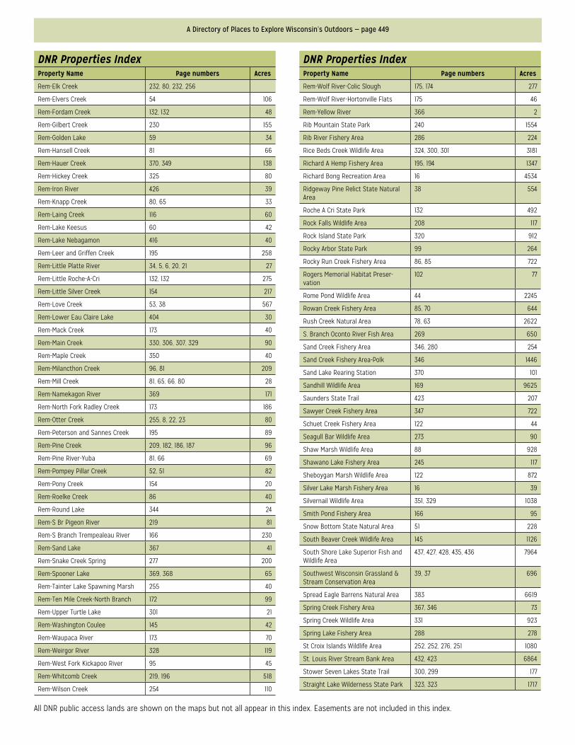
A Directory of Places to Explore Wisconsin’s Outdoors — page 449
All DNR public access lands are shown on the maps but not all appear in this index. Easements are not included in this index.
DNR Properties IndexProperty Name Page numbers Acres
Rem-Elk Creek 232, 80, 232, 256
Rem-Elvers Creek 54 106
Rem-Fordam Creek 132, 132 48
Rem-Gilbert Creek 230 155
Rem-Golden Lake 59 34
Rem-Hansell Creek 81 66
Rem-Hauer Creek 370, 349 138
Rem-Hickey Creek 325 80
Rem-Iron River 426 39
Rem-Knapp Creek 80, 65 33
Rem-Laing Creek 116 60
Rem-Lake Keesus 60 42
Rem-Lake Nebagamon 416 40
Rem-Leer and Griffen Creek 195 258
Rem-Little Platte River 34, 5, 6, 20, 21 27
Rem-Little Roche-A-Cri 132, 132 275
Rem-Little Silver Creek 154 217
Rem-Love Creek 53, 38 567
Rem-Lower Eau Claire Lake 404 30
Rem-Mack Creek 173 40
Rem-Main Creek 330, 306, 307, 329 90
Rem-Maple Creek 350 40
Rem-Milancthon Creek 96, 81 209
Rem-Mill Creek 81, 65, 66, 80 28
Rem-Namekagon River 369 171
Rem-North Fork Radley Creek 173 186
Rem-Otter Creek 255, 8, 22, 23 80
Rem-Peterson and Sannes Creek 195 89
Rem-Pine Creek 209, 182, 186, 187 96
Rem-Pine River-Yuba 81, 66 69
Rem-Pompey Pillar Creek 52, 51 82
Rem-Pony Creek 154 20
Rem-Roelke Creek 86 40
Rem-Round Lake 344 24
Rem-S Br Pigeon River 219 81
Rem-S Branch Trempealeau River 166 230
Rem-Sand Lake 367 41
Rem-Snake Creek Spring 277 200
Rem-Spooner Lake 369, 368 65
Rem-Tainter Lake Spawning Marsh 255 40
Rem-Ten Mile Creek-North Branch 172 99
Rem-Upper Turtle Lake 301 21
Rem-Washington Coulee 145 42
Rem-Waupaca River 173 70
Rem-Weirgor River 328 119
Rem-West Fork Kickapoo River 95 45
Rem-Whitcomb Creek 219, 196 518
Rem-Wilson Creek 254 110
DNR Properties IndexProperty Name Page numbers Acres
Rem-Wolf River-Colic Slough 175, 174 277
Rem-Wolf River-Hortonville Flats 175 46
Rem-Yellow River 366 2
Rib Mountain State Park 240 1554
Rib River Fishery Area 286 224
Rice Beds Creek Wildlife Area 324, 300, 301 3181
Richard A Hemp Fishery Area 195, 194 1347
Richard Bong Recreation Area 16 4534
Ridgeway Pine Relict State Natural Area
38 554
Roche A Cri State Park 132 492
Rock Falls Wildlife Area 208 117
Rock Island State Park 320 912
Rocky Arbor State Park 99 264
Rocky Run Creek Fishery Area 86, 85 722
Rogers Memorial Habitat Preser-vation
102 77
Rome Pond Wildlife Area 44 2245
Rowan Creek Fishery Area 85, 70 644
Rush Creek Natural Area 78, 63 2622
S. Branch Oconto River Fish Area 269 650
Sand Creek Fishery Area 346, 280 254
Sand Creek Fishery Area-Polk 346 1446
Sand Lake Rearing Station 370 101
Sandhill Wildlife Area 169 9625
Saunders State Trail 423 207
Sawyer Creek Fishery Area 347 722
Schuet Creek Fishery Area 122 44
Seagull Bar Wildlife Area 273 90
Shaw Marsh Wildlife Area 88 928
Shawano Lake Fishery Area 245 117
Sheboygan Marsh Wildlife Area 122 872
Silver Lake Marsh Fishery Area 16 39
Silvernail Wildlife Area 351, 329 1038
Smith Pond Fishery Area 166 95
Snow Bottom State Natural Area 51 228
South Beaver Creek Wildlife Area 145 1126
South Shore Lake Superior Fish and Wildlife Area
437, 427, 428, 435, 436 7964
Southwest Wisconsin Grassland & Stream Conservation Area
39, 37 696
Spread Eagle Barrens Natural Area 383 6619
Spring Creek Fishery Area 367, 346 73
Spring Creek Wildlife Area 331 923
Spring Lake Fishery Area 288 278
St Croix Islands Wildlife Area 252, 252, 276, 251 1080
St. Louis River Stream Bank Area 432, 423 6864
Stower Seven Lakes State Trail 300, 299 177
Straight Lake Wilderness State Park 323, 323 1717
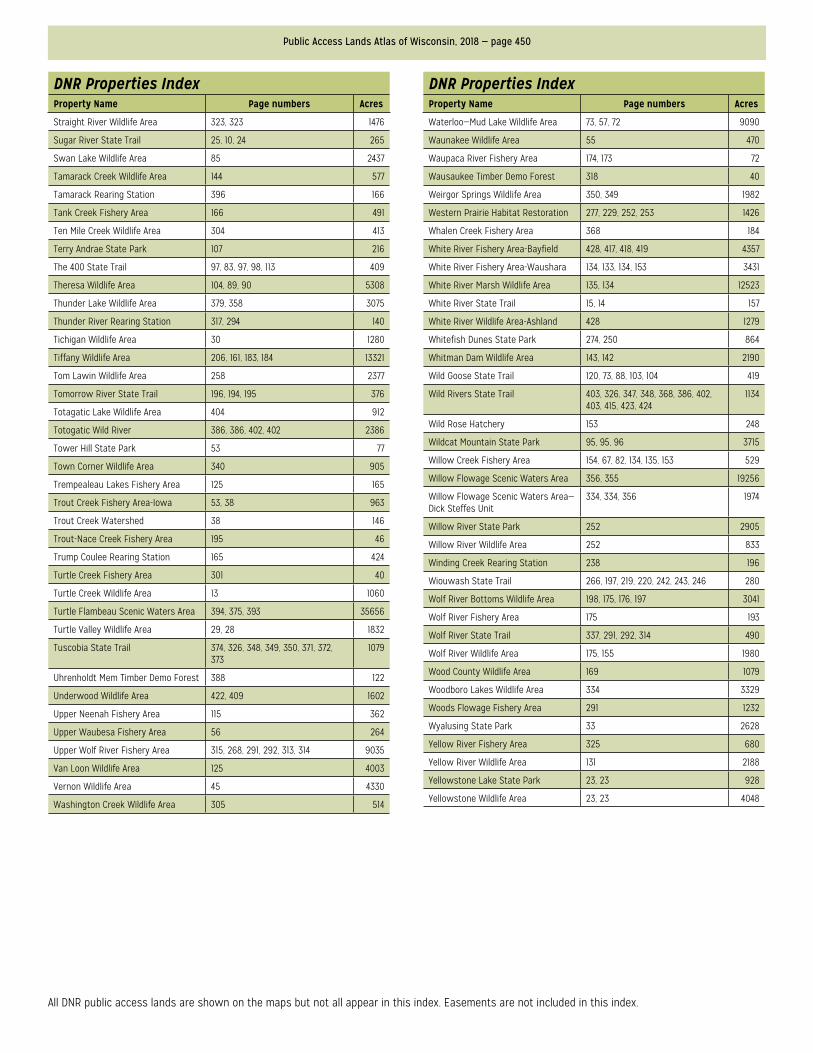
Public Access Lands Atlas of Wisconsin, 2018 — page 450
All DNR public access lands are shown on the maps but not all appear in this index. Easements are not included in this index.
DNR Properties IndexProperty Name Page numbers Acres
Straight River Wildlife Area 323, 323 1476
Sugar River State Trail 25, 10, 24 265
Swan Lake Wildlife Area 85 2437
Tamarack Creek Wildlife Area 144 577
Tamarack Rearing Station 396 166
Tank Creek Fishery Area 166 491
Ten Mile Creek Wildlife Area 304 413
Terry Andrae State Park 107 216
The 400 State Trail 97, 83, 97, 98, 113 409
Theresa Wildlife Area 104, 89, 90 5308
Thunder Lake Wildlife Area 379, 358 3075
Thunder River Rearing Station 317, 294 140
Tichigan Wildlife Area 30 1280
Tiffany Wildlife Area 206, 161, 183, 184 13321
Tom Lawin Wildlife Area 258 2377
Tomorrow River State Trail 196, 194, 195 376
Totagatic Lake Wildlife Area 404 912
Totogatic Wild River 386, 386, 402, 402 2386
Tower Hill State Park 53 77
Town Corner Wildlife Area 340 905
Trempealeau Lakes Fishery Area 125 165
Trout Creek Fishery Area-Iowa 53, 38 963
Trout Creek Watershed 38 146
Trout-Nace Creek Fishery Area 195 46
Trump Coulee Rearing Station 165 424
Turtle Creek Fishery Area 301 40
Turtle Creek Wildlife Area 13 1060
Turtle Flambeau Scenic Waters Area 394, 375, 393 35656
Turtle Valley Wildlife Area 29, 28 1832
Tuscobia State Trail 374, 326, 348, 349, 350, 371, 372, 373
1079
Uhrenholdt Mem Timber Demo Forest 388 122
Underwood Wildlife Area 422, 409 1602
Upper Neenah Fishery Area 115 362
Upper Waubesa Fishery Area 56 264
Upper Wolf River Fishery Area 315, 268, 291, 292, 313, 314 9035
Van Loon Wildlife Area 125 4003
Vernon Wildlife Area 45 4330
Washington Creek Wildlife Area 305 514
DNR Properties IndexProperty Name Page numbers Acres
Waterloo—Mud Lake Wildlife Area 73, 57, 72 9090
Waunakee Wildlife Area 55 470
Waupaca River Fishery Area 174, 173 72
Wausaukee Timber Demo Forest 318 40
Weirgor Springs Wildlife Area 350, 349 1982
Western Prairie Habitat Restoration 277, 229, 252, 253 1426
Whalen Creek Fishery Area 368 184
White River Fishery Area-Bayfield 428, 417, 418, 419 4357
White River Fishery Area-Waushara 134, 133, 134, 153 3431
White River Marsh Wildlife Area 135, 134 12523
White River State Trail 15, 14 157
White River Wildlife Area-Ashland 428 1279
Whitefish Dunes State Park 274, 250 864
Whitman Dam Wildlife Area 143, 142 2190
Wild Goose State Trail 120, 73, 88, 103, 104 419
Wild Rivers State Trail 403, 326, 347, 348, 368, 386, 402, 403, 415, 423, 424
1134
Wild Rose Hatchery 153 248
Wildcat Mountain State Park 95, 95, 96 3715
Willow Creek Fishery Area 154, 67, 82, 134, 135, 153 529
Willow Flowage Scenic Waters Area 356, 355 19256
Willow Flowage Scenic Waters Area—Dick Steffes Unit
334, 334, 356 1974
Willow River State Park 252 2905
Willow River Wildlife Area 252 833
Winding Creek Rearing Station 238 196
Wiouwash State Trail 266, 197, 219, 220, 242, 243, 246 280
Wolf River Bottoms Wildlife Area 198, 175, 176, 197 3041
Wolf River Fishery Area 175 193
Wolf River State Trail 337, 291, 292, 314 490
Wolf River Wildlife Area 175, 155 1980
Wood County Wildlife Area 169 1079
Woodboro Lakes Wildlife Area 334 3329
Woods Flowage Fishery Area 291 1232
Wyalusing State Park 33 2628
Yellow River Fishery Area 325 680
Yellow River Wildlife Area 131 2188
Yellowstone Lake State Park 23, 23 928
Yellowstone Wildlife Area 23, 23 4048
A Directory of Places to Explore Wisconsin’s Outdoors — page 451
Index of Stewardship Grant Land ManagersID Property Manager Website
1 Adams County http://www.co.adams.wi.gov/
2 Aldo Leopold Foundation, Inc http://www.aldoleopold.org/
3 Algoma, Town of http://www.townofalgoma.org/
4 Alliance of Dunn Co Consv and Sports Clubs Inc not available
5 Allouez, Village of http://www.villageofallouez.com/
6 Alvin, Town of http://www.townofalvin.com/page1.php
7 American Farmland Trust http://www.farmland.org/
8 Amery, City of http://www.amerywisconsin.org/
9 Appleton, City of http://www.appleton.org/
10 Archaeological Conservancy, The http://www.americanarchaeology.com/
11 Ashwaubenon, Village of http://www.ashwaubenon.com/
12 Avoca, Village of http://www.villageofavoca.com/
13 Baileys Harbor, Town of http://www.baileysharbor.com/
14 Baird Creek Preservation Foundation http://www.bairdcreek.org/
15 Balsam Lake, Village of http://www.balsamlakevillage.com/WP/
16 Baraboo Range Preservation Association, Inc http://www.baraboorange.org/
17 Baraboo, City of http://www.cityofbaraboo.com/
18 Barre, Town of http://www.co.la-crosse.wi.us/townofbarre/
19 Bass Lake, Town of http://www.basslakewi.gov/index.htm
20 Bayfield County http://www.bayfieldcounty.org/
21 Bayfield Regional Conservancy http://www.brcland.org/
22 Bayfield, Town of http://www.townofbayfield.com/
23 Bayview, Town of http://www.townofbayview.org/
24 Bell, Town of not available
25 Belleville, Village of http://www.bellevillewi.org/
26 Bellevue, Village of http://www.villageofbellevue.org/
27 Belmont, Village of http://www.belmontwi.com/
28 Beloit, City of http://www.ci.beloit.wi.us/
29 Beloit, Town of http://www.townofbeloit.org/
30 Berlin, City of http://www.cityofberlin.net
31 Black River Falls, City of http://www.blackriverfalls.com/
32 Brandon, Village of http://www.villageofbrandon.com/
33 Brookfield, City of http://www.ci.brookfield.wi.us/
34 Brookfield, Town of http://www.townofbrookfield.com/
35 Brown County http://www.co.brown.wi.us/
36 Brussels, Town of http://www.townofbrussels.com/
37 Buchanan, Town of http://www.townofbuchanan.org/
38 Burnett County http://www.burnettcounty.com/
39 Butte Des Morts Conservation Club, Inc http://www.bdmcc.org/
40 Caledonia Conservancy http://www.caledoniaconservancy.org/
41 Caledonia, Village of http://www.caledoniawi.com/
42 Calumet County http://www.co.calumet.wi.us/
43 Carpenter St Croix Valley Nature Center http://www.conservecedarlakes.org
44 Cazenovia, Village of http://www.co.richland.wi.us/cazenoviaVillage.html
45 Cedar Lakes Conservation Foundation http://www.clcfinfo.wordpress.com/
46 Cedarburg, City of http://www.ci.cedarburg.wi.us/
47 Center For Resilient Cities http://www.resilientcities.org/
48 Chippewa County http://www.co.chippewa.wi.us/
49 Chippewa County Land Conservancy, Inc http://www.chippewaconservancy.com/
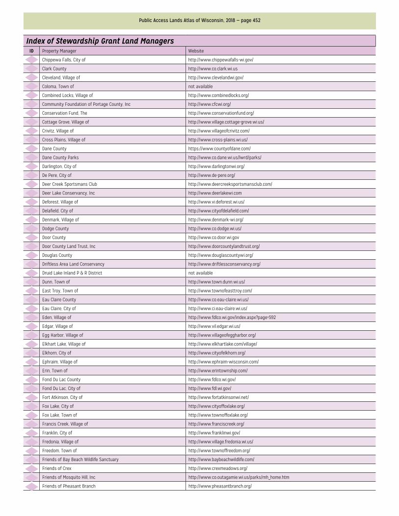
Public Access Lands Atlas of Wisconsin, 2018 — page 452
Index of Stewardship Grant Land ManagersID Property Manager Website
50 Chippewa Falls, City of http://www.chippewafalls-wi.gov/
51 Clark County http://www.co.clark.wi.us
52 Cleveland, Village of http://www.clevelandwi.gov/
53 Coloma, Town of not available
54 Combined Locks, Village of http://www.combinedlocks.org/
55 Community Foundation of Portage County, Inc http://www.cfcwi.org/
56 Conservation Fund, The http://www.conservationfund.org/
57 Cottage Grove, Village of http://www.village.cottage-grove.wi.us/
58 Crivitz, Village of http://www.villageofcrivitz.com/
59 Cross Plains, Village of http://www.cross-plains.wi.us/
60 Dane County https://www.countyofdane.com/
61 Dane County Parks http://www.co.dane.wi.us/lwrd/parks/
62 Darlington, City of http://www.darlingtonwi.org/
63 De Pere, City of http://www.de-pere.org/
64 Deer Creek Sportsmans Club http://www.deercreeksportsmansclub.com/
65 Deer Lake Conservancy, Inc http://www.deerlakewi.com
66 Deforest, Village of http://www.vi.deforest.wi.us/
67 Delafield, City of http://www.cityofdelafield.com/
68 Denmark, Village of http://www.denmark-wi.org/
69 Dodge County http://www.co.dodge.wi.us/
70 Door County http://www.co.door.wi.gov
71 Door County Land Trust, Inc http://www.doorcountylandtrust.org/
72 Douglas County http://www.douglascountywi.org/
73 Driftless Area Land Conservancy http://www.driftlessconservancy.org/
74 Druid Lake Inland P & R District not available
75 Dunn, Town of http://www.town.dunn.wi.us/
76 East Troy, Town of http://www.townofeasttroy.com/
77 Eau Claire County http://www.co.eau-claire.wi.us/
78 Eau Claire, City of http://www.ci.eau-claire.wi.us/
79 Eden, Village of http://www.fdlco.wi.gov/index.aspx?page=592
80 Edgar, Village of http://www.vil.edgar.wi.us/
81 Egg Harbor, Village of http://www.villageofeggharbor.org/
82 Elkhart Lake, Village of http://www.elkhartlake.com/village/
83 Elkhorn, City of http://www.cityofelkhorn.org/
84 Ephraim, Village of http://www.ephraim-wisconsin.com/
85 Erin, Town of http://www.erintownship.com/
86 Fond Du Lac County http://www.fdlco.wi.gov/
87 Fond Du Lac, City of http://www.fdl.wi.gov/
88 Fort Atkinson, City of http://www.fortatkinsonwi.net/
89 Fox Lake, City of http://www.cityoffoxlake.org/
90 Fox Lake, Town of http://www.townoffoxlake.org/
91 Francis Creek, Village of http://www.franciscreek.org/
92 Franklin, City of http://www.franklinwi.gov/
93 Fredonia, Village of http://www.village.fredonia.wi.us/
94 Freedom, Town of http://www.townoffreedom.org/
95 Friends of Bay Beach Wildlife Sanctuary http://www.baybeachwildlife.com/
96 Friends of Crex http://www.crexmeadows.org/
97 Friends of Mosquito Hill, Inc http://www.co.outagamie.wi.us/parks/mh_home.htm
98 Friends of Pheasant Branch http://www.pheasantbranch.org/
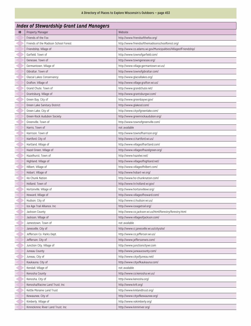
A Directory of Places to Explore Wisconsin’s Outdoors — page 453
Index of Stewardship Grant Land ManagersID Property Manager Website
99 Friends of the Fox http://www.friendsofthefox.org/
100 Friends of the Madison School Forest http://www.friendsofthemadisonschoolforest.org/
101 Friendship, Village of http://www.co.adams.wi.gov/Municipalities/VillageofFriendship/
102 Garfield, Town of http://www.townofgarfield.com/
103 Genesee, Town of http://www.towngenesee.org/
104 Germantown, Village of http://www.village.germantown.wi.us/
105 Gibraltar, Town of http://www.townofgibraltar.com/
106 Glacial Lakes Conservancy http://www.glaciallakes.org/
107 Grafton, Village of http://www.village.grafton.wi.us/
108 Grand Chute, Town of http://www.grandchute.net/
109 Grantsburg, Village of http://www.grantsburgwi.com/
110 Green Bay, City of http://www.greenbaywi.gov/
111 Green Lake Sanitary District http://www.glakesd.com/
112 Green Lake, City of http://www.cityofgreenlake.com/
113 Green-Rock Audubon Society http://www.greenrockaudubon.org/
114 Greenville, Town of http://www.townofgreenville.com/
115 Harris, Town of not available
116 Harrison, Town of http://www.townofharrison.org/
117 Hartford, City of http://www.ci.hartford.wi.us/
118 Hartland, Village of http://www.villageofhartland.com/
119 Hazel Green, Village of http://www.villageofhazelgreen.org/
120 Hazelhurst, Town of http://www.hazelwi.net/
121 Highland, Village of http://www.villageofhighland.net/
122 Hilbert, Village of http://www.villageofhilbert.com/
123 Hobart, Village of http://www.hobart-wi.org/
124 Ho-Chunk Nation http://www.ho-chunknation.com/
125 Holland, Town of http://www.tn.holland.wi.gov/
126 Hortonville, Village of http://www.hortonvillewi.org/
127 Howard, Village of http://www.villageofhoward.com/
128 Hudson, City of http://www.ci.hudson.wi.us/
129 Ice Age Trail Alliance, Inc http://www.iceagetrail.org/
130 Jackson County http://www.co.jackson.wi.us/html/forestry/forestry.html
131 Jackson, Village of http://www.villageofjackson.com/
132 Jamestown, Town of not available
133 Janesville, City of http://www.ci.janesville.wi.us/citysite/
134 Jefferson Co. Parks Dept. http://www.co.jefferson.wi.us/
135 Jefferson, City of http://www.jeffersonwis.com/
136 Junction City, Village of http://www.junctioncitywi.com
137 Juneau County http://www.juneaucounty.com/
138 Juneau, City of http://www.cityofjuneau.net/
139 Kaukauna, City of http://www.cityofkaukauna.com/
140 Kendall, Village of not available
141 Kenosha County http://www.co.kenosha.wi.us/
142 Kenosha, City of http://www.kenosha.org/
143 Kenosha/Racine Land Trust, Inc http://www.krlt.org/
144 Kettle Moraine Land Trust http://www.kmlandtrust.org/
145 Kewaunee, City of http://www.cityofkewaunee.org/
146 Kimberly, Village of http://www.vokimberly.org/
147 Kinnickinnic River Land Trust, Inc http://www.kinniriver.org/
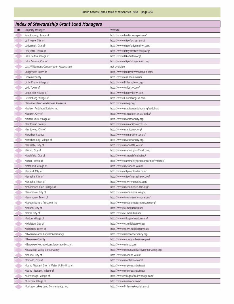
Public Access Lands Atlas of Wisconsin, 2018 — page 454
Index of Stewardship Grant Land ManagersID Property Manager Website
148 Koshkonong, Town of http://www.koshkonongwi.com/
149 La Crosse, City of http://www.cityoflacrosse.org/
150 Ladysmith, City of http://www.cityofladysmithwi.com/
151 Lafayette, Town of http://www.lafayettetownship.org/
152 Lake Delton, Village of http://www.lakedelton.org/
153 Lake Geneva, City of http://www.cityoflakegeneva.com/
154 Last Wilderness Conservation Association not available
155 Ledgeview, Town of http://www.ledgeviewwisconsin.com/
156 Lincoln County http://www.co.lincoln.wi.us/
157 Little Chute, Village of http://www.littlechutewi.org/
158 Lodi, Town of http://www.tn.lodi.wi.gov/
159 Loganville, Village of http://www.loganville-wi.com/
160 Luxemburg, Village of http://www.luxemburgusa.com/
161 Madeline Island Wilderness Preserve http://www.miwp.org/
162 Madison Audubon Society, Inc http://www.madisonaudubon.org/audubon/
163 Madison, City of http://www.ci.madison.wi.us/parks/
164 Maiden Rock, Village of http://www.marathoncity.org/
165 Manitowoc County http://www.co.manitowoc.wi.us/
166 Manitowoc, City of http://www.manitowoc.org/
167 Marathon County http://www.co.marathon.wi.us/
168 Marathon City, Village of http://www.marathoncity.org/
169 Marinette, City of http://www.marinette.wi.us/
170 Marion, City of http://www.marion.govoffice2.com/
171 Marshfield, City of http://www.ci.marshfield.wi.us/
172 Martell, Town of http://www.community.pressenter.net/~martell/
173 Mcfarland, Village of http://www.mcfarland.wi.us/
174 Medford, City of http://www.citymedfordwi.com/
175 Menasha, City of http://www.cityofmenasha-wi.gov/
176 Menasha, Town of http://www.town-menasha.com/
177 Menomonee Falls, Village of http://www.menomonee-falls.org/
178 Menomonie, City of http://www.menomonie-wi.gov/
179 Menomonie, Town of http://www.townofmenomonie.org/
180 Mequon Nature Preserve, Inc http://www.mequonnaturepreserve.org/
181 Mequon, City of http://www.ci.mequon.wi.us/
182 Merrill, City of http://www.ci.merrill.wi.us/
183 Merton, Village of http://www.villageofmerton.com/
184 Middleton, City of http://www.ci.middleton.wi.us/
185 Middleton, Town of http://www.town.middleton.wi.us/
186 Milwaukee Area Land Conservancy http://www.mkeconservancy.org/
187 Milwaukee County http://www.county.milwaukee.gov/
188 Milwaukee Metropolitan Sewerage District http://www.mmsd.com
189 Mississippi Valley Conservancy http://www.mississippivalleyconservancy.org/
190 Monona, City of http://www.monona.wi.us/
191 Montello, City of http://www.montellowi.com/
192 Mount Pleasant Storm Water Utility District http://www.mtpleasantwi.gov/
193 Mount Pleasant, Village of http://www.mtpleasantwi.gov/
194 Mukwonago, Village of http://www.villageofmukwonago.com/
195 Muscoda, Village of http://www.muscoda.com/
196 Muskego Lakes Land Conservancy, Inc http://www.littlemuskegolake.org/
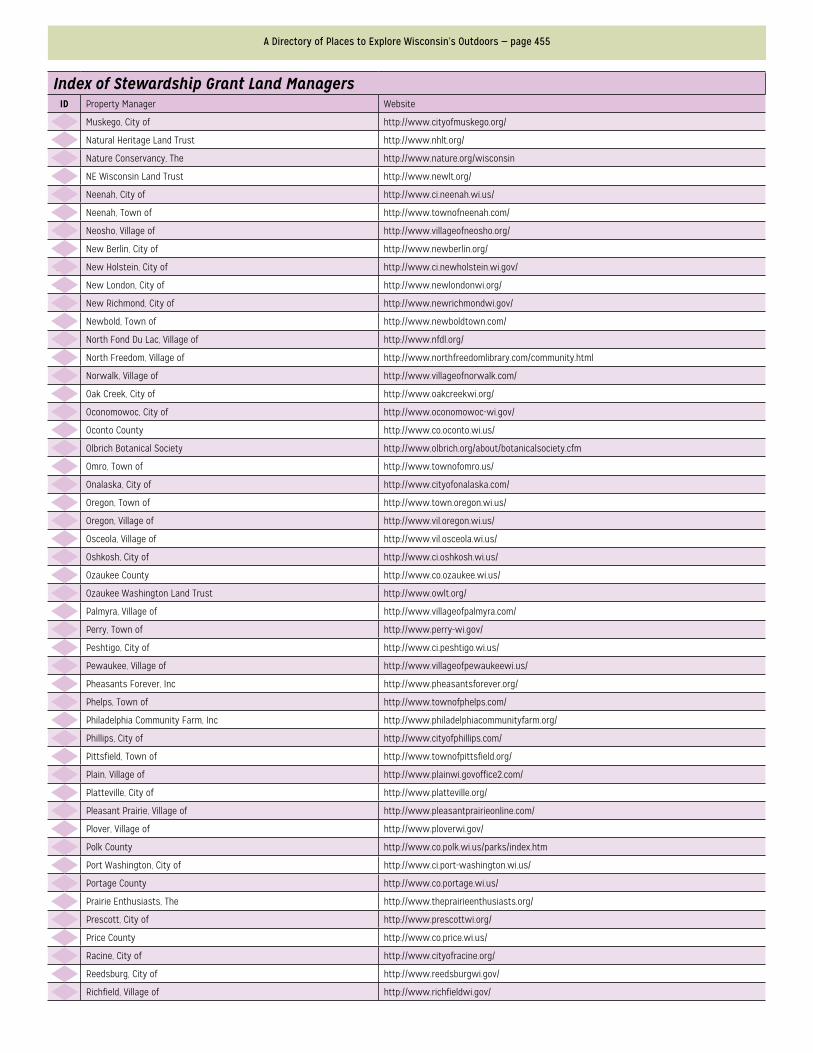
A Directory of Places to Explore Wisconsin’s Outdoors — page 455
Index of Stewardship Grant Land ManagersID Property Manager Website
197 Muskego, City of http://www.cityofmuskego.org/
198 Natural Heritage Land Trust http://www.nhlt.org/
199 Nature Conservancy, The http://www.nature.org/wisconsin
200 NE Wisconsin Land Trust http://www.newlt.org/
201 Neenah, City of http://www.ci.neenah.wi.us/
202 Neenah, Town of http://www.townofneenah.com/
203 Neosho, Village of http://www.villageofneosho.org/
204 New Berlin, City of http://www.newberlin.org/
205 New Holstein, City of http://www.ci.newholstein.wi.gov/
206 New London, City of http://www.newlondonwi.org/
207 New Richmond, City of http://www.newrichmondwi.gov/
208 Newbold, Town of http://www.newboldtown.com/
209 North Fond Du Lac, Village of http://www.nfdl.org/
210 North Freedom, Village of http://www.northfreedomlibrary.com/community.html
211 Norwalk, Village of http://www.villageofnorwalk.com/
212 Oak Creek, City of http://www.oakcreekwi.org/
213 Oconomowoc, City of http://www.oconomowoc-wi.gov/
214 Oconto County http://www.co.oconto.wi.us/
215 Olbrich Botanical Society http://www.olbrich.org/about/botanicalsociety.cfm
216 Omro, Town of http://www.townofomro.us/
217 Onalaska, City of http://www.cityofonalaska.com/
218 Oregon, Town of http://www.town.oregon.wi.us/
219 Oregon, Village of http://www.vil.oregon.wi.us/
220 Osceola, Village of http://www.vil.osceola.wi.us/
221 Oshkosh, City of http://www.ci.oshkosh.wi.us/
222 Ozaukee County http://www.co.ozaukee.wi.us/
223 Ozaukee Washington Land Trust http://www.owlt.org/
224 Palmyra, Village of http://www.villageofpalmyra.com/
225 Perry, Town of http://www.perry-wi.gov/
226 Peshtigo, City of http://www.ci.peshtigo.wi.us/
227 Pewaukee, Village of http://www.villageofpewaukeewi.us/
228 Pheasants Forever, Inc http://www.pheasantsforever.org/
229 Phelps, Town of http://www.townofphelps.com/
230 Philadelphia Community Farm, Inc http://www.philadelphiacommunityfarm.org/
231 Phillips, City of http://www.cityofphillips.com/
232 Pittsfield, Town of http://www.townofpittsfield.org/
233 Plain, Village of http://www.plainwi.govoffice2.com/
234 Platteville, City of http://www.platteville.org/
235 Pleasant Prairie, Village of http://www.pleasantprairieonline.com/
236 Plover, Village of http://www.ploverwi.gov/
237 Polk County http://www.co.polk.wi.us/parks/index.htm
238 Port Washington, City of http://www.ci.port-washington.wi.us/
239 Portage County http://www.co.portage.wi.us/
240 Prairie Enthusiasts, The http://www.theprairieenthusiasts.org/
241 Prescott, City of http://www.prescottwi.org/
242 Price County http://www.co.price.wi.us/
243 Racine, City of http://www.cityofracine.org/
244 Reedsburg, City of http://www.reedsburgwi.gov/
245 Richfield, Village of http://www.richfieldwi.gov/
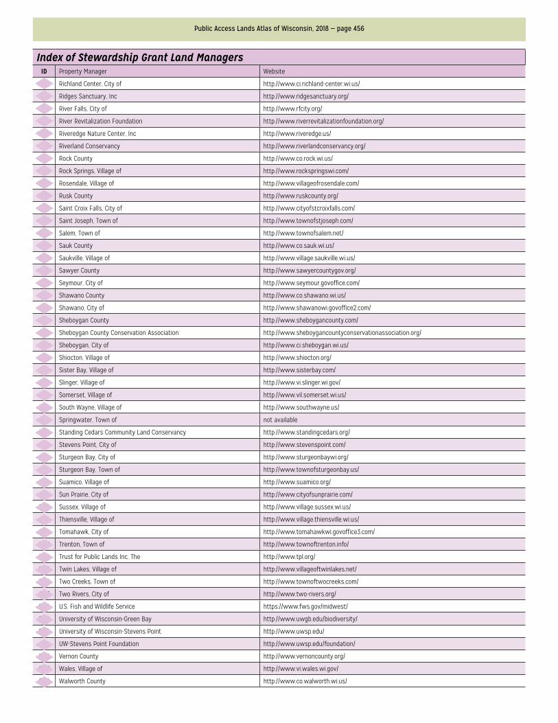
Public Access Lands Atlas of Wisconsin, 2018 — page 456
Index of Stewardship Grant Land ManagersID Property Manager Website
246 Richland Center, City of http://www.ci.richland-center.wi.us/
247 Ridges Sanctuary, Inc http://www.ridgesanctuary.org/
248 River Falls, City of http://www.rfcity.org/
249 River Revitalization Foundation http://www.riverrevitalizationfoundation.org/
250 Riveredge Nature Center, Inc http://www.riveredge.us/
251 Riverland Conservancy http://www.riverlandconservancy.org/
252 Rock County http://www.co.rock.wi.us/
253 Rock Springs, Village of http://www.rockspringswi.com/
254 Rosendale, Village of http://www.villageofrosendale.com/
255 Rusk County http://www.ruskcounty.org/
256 Saint Croix Falls, City of http://www.cityofstcroixfalls.com/
257 Saint Joseph, Town of http://www.townofstjoseph.com/
258 Salem, Town of http://www.townofsalem.net/
259 Sauk County http://www.co.sauk.wi.us/
260 Saukville, Village of http://www.village.saukville.wi.us/
261 Sawyer County http://www.sawyercountygov.org/
262 Seymour, City of http://www.seymour.govoffice.com/
263 Shawano County http://www.co.shawano.wi.us/
264 Shawano, City of http://www.shawanowi.govoffice2.com/
265 Sheboygan County http://www.sheboygancounty.com/
266 Sheboygan County Conservation Association http://www.sheboygancountyconservationassociation.org/
267 Sheboygan, City of http://www.ci.sheboygan.wi.us/
268 Shiocton, Village of http://www.shiocton.org/
269 Sister Bay, Village of http://www.sisterbay.com/
270 Slinger, Village of http://www.vi.slinger.wi.gov/
271 Somerset, Village of http://www.vil.somerset.wi.us/
272 South Wayne, Village of http://www.southwayne.us/
273 Springwater, Town of not available
274 Standing Cedars Community Land Conservancy http://www.standingcedars.org/
275 Stevens Point, City of http://www.stevenspoint.com/
276 Sturgeon Bay, City of http://www.sturgeonbaywi.org/
277 Sturgeon Bay, Town of http://www.townofsturgeonbay.us/
278 Suamico, Village of http://www.suamico.org/
279 Sun Prairie, City of http://www.cityofsunprairie.com/
280 Sussex, Village of http://www.village.sussex.wi.us/
281 Thiensville, Village of http://www.village.thiensville.wi.us/
282 Tomahawk, City of http://www.tomahawkwi.govoffice3.com/
283 Trenton, Town of http://www.townoftrenton.info/
284 Trust for Public Lands Inc, The http://www.tpl.org/
285 Twin Lakes, Village of http://www.villageoftwinlakes.net/
286 Two Creeks, Town of http://www.townoftwocreeks.com/
287 Two Rivers, City of http://www.two-rivers.org/
288 U.S. Fish and Wildlife Service https://www.fws.gov/midwest/
289 University of Wisconsin-Green Bay http://www.uwgb.edu/biodiversity/
290 University of Wisconsin-Stevens Point http://www.uwsp.edu/
291 UW-Stevens Point Foundation http://www.uwsp.edu/foundation/
292 Vernon County http://www.vernoncounty.org/
293 Wales, Village of http://www.vi.wales.wi.gov/
294 Walworth County http://www.co.walworth.wi.us/
A Directory of Places to Explore Wisconsin’s Outdoors — page 457
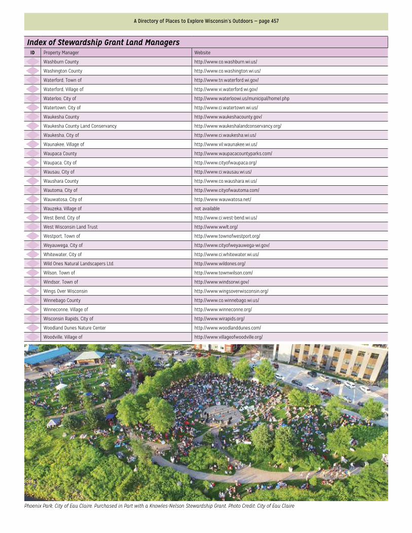
Phoenix Park, City of Eau Claire. Purchased in Part with a Knowles-Nelson Stewardship Grant. Photo Credit: City of Eau Claire
Index of Stewardship Grant Land ManagersID Property Manager Website
295 Washburn County http://www.co.washburn.wi.us/
296 Washington County http://www.co.washington.wi.us/
297 Waterford, Town of http://www.tn.waterford.wi.gov/
298 Waterford, Village of http://www.vi.waterford.wi.gov/
299 Waterloo, City of http://www.waterloowi.us/municipal/home1.php
300 Watertown, City of http://www.ci.watertown.wi.us/
301 Waukesha County http://www.waukeshacounty.gov/
302 Waukesha County Land Conservancy http://www.waukeshalandconservancy.org/
303 Waukesha, City of http://www.ci.waukesha.wi.us/
304 Waunakee, Village of http://www.vil.waunakee.wi.us/
305 Waupaca County http://www.waupacacountyparks.com/
306 Waupaca, City of http://www.cityofwaupaca.org/
307 Wausau, City of http://www.ci.wausau.wi.us/
308 Waushara County http://www.co.waushara.wi.us/
309 Wautoma, City of http://www.cityofwautoma.com/
310 Wauwatosa, City of http://www.wauwatosa.net/
311 Wauzeka, Village of not available
312 West Bend, City of http://www.ci.west-bend.wi.us/
313 West Wisconsin Land Trust http://www.wwlt.org/
314 Westport, Town of http://www.townofwestport.org/
315 Weyauwega, City of http://www.cityofweyauwega-wi.gov/
316 Whitewater, City of http://www.ci.whitewater.wi.us/
317 Wild Ones Natural Landscapers Ltd. http://www.wildones.org/
318 Wilson, Town of http://www.townwilson.com/
319 Windsor, Town of http://www.windsorwi.gov/
320 Wings Over Wisconsin http://www.wingsoverwisconsin.org/
321 Winnebago County http://www.co.winnebago.wi.us/
322 Winneconne, Village of http://www.winneconne.org/
323 Wisconsin Rapids, City of http://www.wirapids.org/
324 Woodland Dunes Nature Center http://www.woodlanddunes.com/
325 Woodville, Village of http://www.villageofwoodville.org/
Public Access Lands Atlas of Wisconsin, 2018 — page 458
Clear Lake Path
Peshtigo Flowage
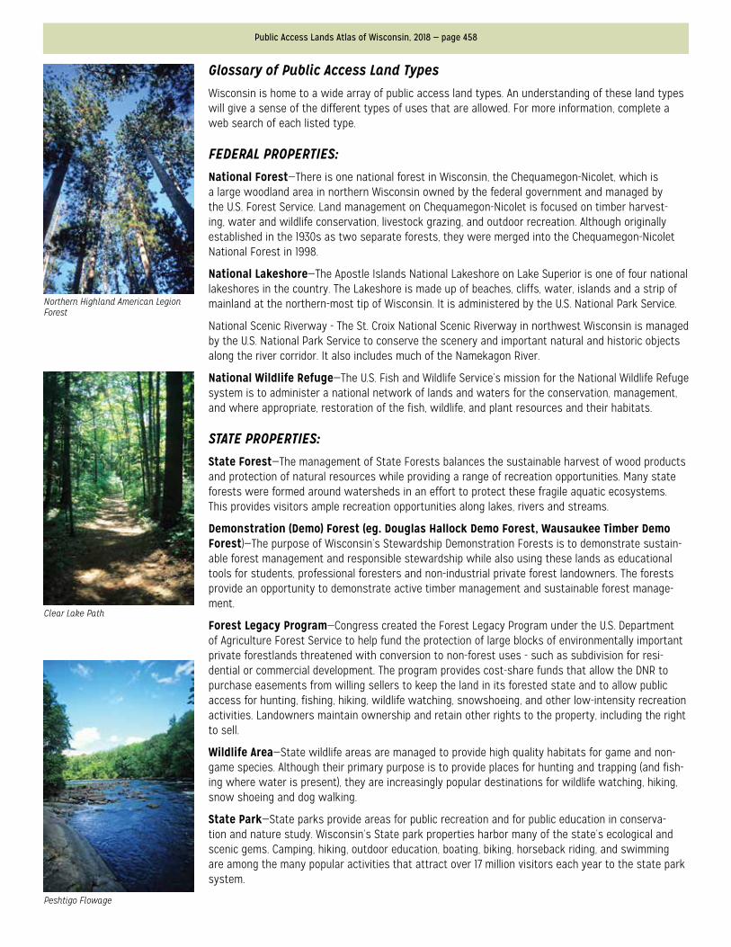
Northern Highland American Legion Forest
Glossary of Public Access Land TypesWisconsin is home to a wide array of public access land types. An understanding of these land types will give a sense of the different types of uses that are allowed. For more information, complete a web search of each listed type.
FEDERAL PROPERTIES:National Forest—There is one national forest in Wisconsin, the Chequamegon-Nicolet, which is a large woodland area in northern Wisconsin owned by the federal government and managed by the U.S. Forest Service. Land management on Chequamegon-Nicolet is focused on timber harvest-ing, water and wildlife conservation, livestock grazing, and outdoor recreation. Although originally established in the 1930s as two separate forests, they were merged into the Chequamegon-Nicolet National Forest in 1998.
National Lakeshore—The Apostle Islands National Lakeshore on Lake Superior is one of four national lakeshores in the country. The Lakeshore is made up of beaches, cliffs, water, islands and a strip of mainland at the northern-most tip of Wisconsin. It is administered by the U.S. National Park Service.
National Scenic Riverway - The St. Croix National Scenic Riverway in northwest Wisconsin is managed by the U.S. National Park Service to conserve the scenery and important natural and historic objects along the river corridor. It also includes much of the Namekagon River.
National Wildlife Refuge—The U.S. Fish and Wildlife Service’s mission for the National Wildlife Refuge system is to administer a national network of lands and waters for the conservation, management, and where appropriate, restoration of the fish, wildlife, and plant resources and their habitats.
STATE PROPERTIES:State Forest—The management of State Forests balances the sustainable harvest of wood products and protection of natural resources while providing a range of recreation opportunities. Many state forests were formed around watersheds in an effort to protect these fragile aquatic ecosystems. This provides visitors ample recreation opportunities along lakes, rivers and streams.
Demonstration (Demo) Forest (eg. Douglas Hallock Demo Forest, Wausaukee Timber Demo Forest)—The purpose of Wisconsin’s Stewardship Demonstration Forests is to demonstrate sustain-able forest management and responsible stewardship while also using these lands as educational tools for students, professional foresters and non-industrial private forest landowners. The forests provide an opportunity to demonstrate active timber management and sustainable forest manage-ment.
Forest Legacy Program—Congress created the Forest Legacy Program under the U.S. Department of Agriculture Forest Service to help fund the protection of large blocks of environmentally important private forestlands threatened with conversion to non-forest uses - such as subdivision for resi-dential or commercial development. The program provides cost-share funds that allow the DNR to purchase easements from willing sellers to keep the land in its forested state and to allow public access for hunting, fishing, hiking, wildlife watching, snowshoeing, and other low-intensity recreation activities. Landowners maintain ownership and retain other rights to the property, including the right to sell.
Wildlife Area—State wildlife areas are managed to provide high quality habitats for game and non-game species. Although their primary purpose is to provide places for hunting and trapping (and fish-ing where water is present), they are increasingly popular destinations for wildlife watching, hiking, snow shoeing and dog walking.
State Park—State parks provide areas for public recreation and for public education in conserva-tion and nature study. Wisconsin’s State park properties harbor many of the state’s ecological and scenic gems. Camping, hiking, outdoor education, boating, biking, horseback riding, and swimming are among the many popular activities that attract over 17 million visitors each year to the state park system.
A Directory of Places to Explore Wisconsin’s Outdoors — page 459
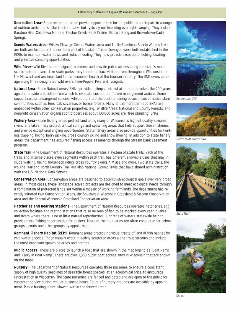
Aurora Lake SNA
Battle Bluff Prairie SNA
Canoe
State Trail
Recreation Area—State recreation areas provide opportunities for the public to participate in a range of outdoor activities, similar to state parks but typically not including overnight camping. They include Baraboo Hills, Chippewa Moraine, Fischer Creek, Sauk Prairie, Richard Bong and Browntown-Cadiz Springs.
Scenic Waters Area—Willow Flowage Scenic Waters Area and Turtle-Flambeau Scenic Waters Area are both are located in the northern part of the state. These flowages were both established in the 1920s to maintain water flows and reduce flooding. They now provide exceptional fishing, boating, and primitive camping opportunities.
Wild River—Wild Rivers are designed to protect and provide public access along the state’s most scenic, pristine rivers. Like state parks, they tend to attract visitors from throughout Wisconsin and the Midwest and are important to the economic health of the tourism industry. The DNR owns acre-age along three designated wild rivers: Pine-Popple, Pike and Totogatic.
Natural Area—State Natural Areas (SNAs) provide a glimpse into what the state looked like 200 years ago and provide a baseline from which to evaluate current and future management actions. Some support rare or endangered species, while others are the best remaining occurrences of native plant communities such as fens, oak savannas or boreal forests. Many of the more than 600 SNAs are embedded within other conservation properties (e.g., Wildlife Areas, National and County Forests, and nonprofit conservation organization properties), about 100,000 acres are “free standing” SNAs.
Fishery Area—State fishery areas protect land along many of Wisconsin’s highest quality streams, rivers, and lakes. They protect critical springs and spawning areas that help support these fisheries and provide exceptional angling opportunities. State fishery areas also provide opportunities for hunt-ing, trapping, hiking, berry picking, cross country skiing and snowshoeing. In addition to state fishery areas, the department has acquired fishing access easements through the Stream Bank Easement program.
State Trail—The Department of Natural Resources operates a system of state trails. Each of the trails, and in some places even segments within each trail, has different allowable uses that may in-clude walking, biking, horseback riding, cross country skiing, ATV use and more. Two state trails, the Ice Age Trail and North Country Trail, are also National Scenic Trails that have shared administration with the U.S. National Park Service.
Conservation Area—Conservation areas are designed to accomplish ecological goals over very broad areas. In most cases, these landscape-scaled projects are designed to meet ecological needs through a combination of protected lands set within a mosaic of working farmlands. The department has re-cently initiated two Conservation Areas, the Southwest Wisconsin Grassland & Stream Conservation Area and the Central Wisconsin Grassland Conservation Area.
Hatcheries and Rearing Stations—The Department of Natural Resources operates hatcheries, egg collection facilities and rearing stations that raise millions of fish to be stocked every year in lakes and rivers where there is no or little natural reproduction. Hundreds of waters statewide help to provide more fishing opportunities for anglers. Tours at the hatcheries are often conducted for school groups, scouts and other groups by appointment.
Remnant Fishery Habitat (REM)—Remnant areas protect individual tracts of land of fish habitat for cold water species. These usually occur in widely scattered areas along trout streams and include the most important spawning areas and springs.
Public Access—These are places to launch a boat that are shown in the map legend as “Boat Ramp” and “Carry-In Boat Ramp”. There are over 3,000 public boat access sites in Wisconsin that are shown on the maps.
Nursery—The Department of Natural Resources operates three nurseries to ensure a consistent supply of high quality seedlings of desirable forest species, at an economical price, to encourage reforestation in Wisconsin. The state nurseries are fenced and gated and are open to the public for customer service during regular business hours. Tours of nursery grounds are available by appoint-ment. Public hunting is not allowed within the fenced areas.
Public Access Lands Atlas of Wisconsin, 2018 — page 460
Autumn in the Woods
Trillium
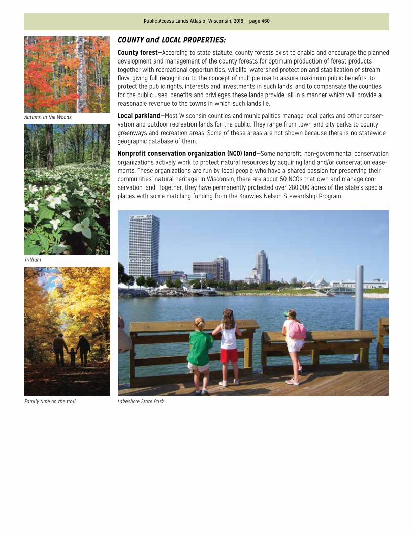
Family time on the trail Lakeshore State Park
COUNTY and LOCAL PROPERTIES:County forest—According to state statute, county forests exist to enable and encourage the planned development and management of the county forests for optimum production of forest products together with recreational opportunities, wildlife, watershed protection and stabilization of stream flow, giving full recognition to the concept of multiple-use to assure maximum public benefits; to protect the public rights, interests and investments in such lands; and to compensate the counties for the public uses, benefits and privileges these lands provide; all in a manner which will provide a reasonable revenue to the towns in which such lands lie.
Local parkland—Most Wisconsin counties and municipalities manage local parks and other conser-vation and outdoor recreation lands for the public. They range from town and city parks to county greenways and recreation areas. Some of these areas are not shown because there is no statewide geographic database of them.
Nonprofit conservation organization (NCO) land—Some nonprofit, non-governmental conservation organizations actively work to protect natural resources by acquiring land and/or conservation ease-ments. These organizations are run by local people who have a shared passion for preserving their communities’ natural heritage. In Wisconsin, there are about 50 NCOs that own and manage con-servation land. Together, they have permanently protected over 280,000 acres of the state’s special places with some matching funding from the Knowles-Nelson Stewardship Program.
A Directory of Places to Explore Wisconsin’s Outdoors — page 461
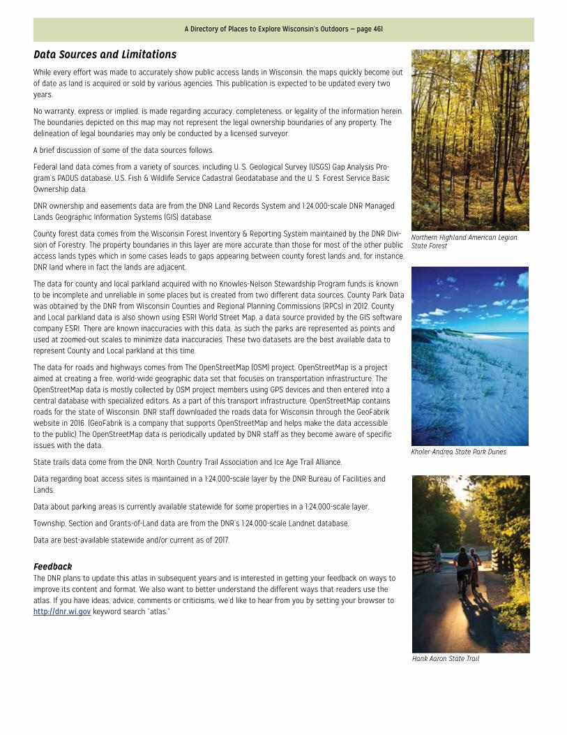
Northern Highland American Legion State Forest
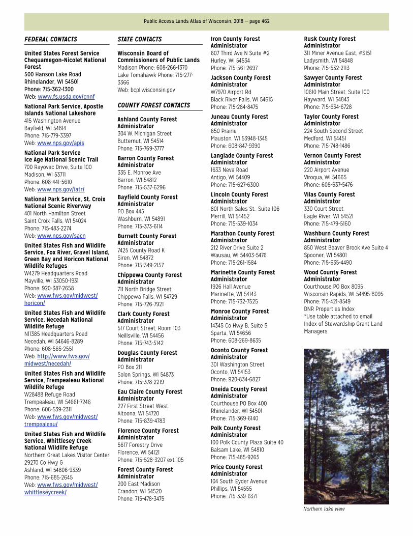
Kholer-Andrea State Park Dunes
Hank Aaron State Trail
Data Sources and LimitationsWhile every effort was made to accurately show public access lands in Wisconsin, the maps quickly become out of date as land is acquired or sold by various agencies. This publication is expected to be updated every two years.
No warranty, express or implied, is made regarding accuracy, completeness, or legality of the information herein. The boundaries depicted on this map may not represent the legal ownership boundaries of any property. The delineation of legal boundaries may only be conducted by a licensed surveyor.
A brief discussion of some of the data sources follows.
Federal land data comes from a variety of sources, including U. S. Geological Survey (USGS) Gap Analysis Pro-gram’s PADUS database, U.S. Fish & Wildlife Service Cadastral Geodatabase and the U. S. Forest Service Basic Ownership data.
DNR ownership and easements data are from the DNR Land Records System and 1:24,000-scale DNR Managed Lands Geographic Information Systems (GIS) database.
County forest data comes from the Wisconsin Forest Inventory & Reporting System maintained by the DNR Divi-sion of Forestry. The property boundaries in this layer are more accurate than those for most of the other public access lands types which in some cases leads to gaps appearing between county forest lands and, for instance, DNR land where in fact the lands are adjacent.
The data for county and local parkland acquired with no Knowles-Nelson Stewardship Program funds is known to be incomplete and unreliable in some places but is created from two different data sources. County Park Data was obtained by the DNR from Wisconsin Counties and Regional Planning Commissions (RPCs) in 2012. County and Local parkland data is also shown using ESRI World Street Map, a data source provided by the GIS software company ESRI. There are known inaccuracies with this data, as such the parks are represented as points and used at zoomed-out scales to minimize data inaccuracies. These two datasets are the best available data to represent County and Local parkland at this time.
The data for roads and highways comes from The OpenStreetMap (OSM) project. OpenStreetMap is a project aimed at creating a free, world-wide geographic data set that focuses on transportation infrastructure. The OpenStreetMap data is mostly collected by OSM project members using GPS devices and then entered into a central database with specialized editors. As a part of this transport infrastructure, OpenStreetMap contains roads for the state of Wisconsin. DNR staff downloaded the roads data for Wisconsin through the GeoFabrik website in 2016. (GeoFabrik is a company that supports OpenStreetMap and helps make the data accessible to the public) The OpenStreetMap data is periodically updated by DNR staff as they become aware of specific issues with the data.
State trails data come from the DNR, North Country Trail Association and Ice Age Trail Alliance.
Data regarding boat access sites is maintained in a 1:24,000-scale layer by the DNR Bureau of Facilities and Lands.
Data about parking areas is currently available statewide for some properties in a 1:24,000-scale layer.
Township, Section and Grants-of-Land data are from the DNR’s 1:24,000-scale Landnet database.
Data are best-available statewide and/or current as of 2017.
FeedbackThe DNR plans to update this atlas in subsequent years and is interested in getting your feedback on ways to improve its content and format. We also want to better understand the different ways that readers use the atlas. If you have ideas, advice, comments or criticisms, we’d like to hear from you by setting your browser to http://dnr.wi.gov keyword search “atlas.”
Public Access Lands Atlas of Wisconsin, 2018 — page 462
Northern lake view
FEDERAL CONTACTS
United States Forest Service Chequamegon–Nicolet National Forest500 Hanson Lake RoadRhinelander, WI 54501Phone: 715-362-1300Web: www.fs.usda.gov/cnnf
National Park Service, Apostle Islands National Lakeshore415 Washington AvenueBayfield, WI 54814Phone: 715-779-3397Web: www.nps.gov/apis
National Park Service Ice Age National Scenic Trail700 Rayovac Drive, Suite 100Madison, WI 53711Phone: 608-441-5610Web: www.nps.gov/iatr/
National Park Service, St. Croix National Scenic Riverway401 North Hamilton StreetSaint Croix Falls, WI 54024Phone: 715-483-2274Web: www.nps.gov/sacn
United States Fish and Wildlife Service, Fox River, Gravel Island, Green Bay and Horicon National Wildlife RefugesW4279 Headquarters RoadMayville, WI 53050-1931Phone: 920-387-2658Web: www.fws.gov/midwest/horicon/
United States Fish and Wildlife Service, Necedah National Wildlife RefugeN11385 Headquarters RoadNecedah, WI 54646-8289Phone: 608-565-2551Web: http://www.fws.gov/midwest/necedah/
United States Fish and Wildlife Service, Trempealeau National Wildlife RefugeW28488 Refuge RoadTrempealeau, WI 54661-7246Phone: 608-539-2311Web: www.fws.gov/midwest/trempealeau/
United States Fish and Wildlife Service, Whittlesey Creek National Wildlife RefugeNorthern Great Lakes Visitor Center29270 Co Hwy GAshland, WI 54806-9339Phone: 715-685-2645Web: www.fws.gov/midwest/whittleseycreek/
STATE CONTACTS
Wisconsin Board of Commissioners of Public LandsMadison Phone: 608-266-1370Lake Tomahawk Phone: 715-277-3366Web: bcpl.wisconsin.gov
COUNTY FOREST CONTACTS
Ashland County Forest Administrator304 W. Michigan StreetButternut, WI 54514Phone: 715-769-3777
Barron County Forest Administrator335 E. Monroe AveBarron, WI 54812Phone: 715-537-6296
Bayfield County Forest AdministratorPO Box 445Washburn, WI 54891Phone: 715-373-6114
Burnett County Forest Administrator7425 County Road KSiren, WI 54872Phone: 715-349-2157
Chippewa County Forest Administrator711 North Bridge StreetChippewa Falls, WI 54729Phone: 715-726-7921
Clark County Forest Administrator517 Court Street, Room 103Neillsville, WI 54456Phone: 715-743-5142
Douglas County Forest AdministratorPO Box 211Solon Springs, WI 54873Phone: 715-378-2219
Eau Claire County Forest Administrator227 First Street WestAltoona, WI 54720Phone: 715-839-4783
Florence County Forest Administrator5617 Forestry DriveFlorence, WI 54121Phone: 715-528-3207 ext 105
Forest County Forest Administrator200 East MadisonCrandon, WI 54520Phone: 715-478-3475
Iron County Forest Administrator607 Third Ave N Suite #2Hurley, WI 54534Phone: 715-561-2697
Jackson County Forest AdministratorW7970 Airport RdBlack River Falls, WI 54615Phone: 715-284-8475
Juneau County Forest Administrator650 PrairieMauston, WI 53948-1345Phone: 608-847-9390
Langlade County Forest Administrator1633 Neva RoadAntigo, WI 54409Phone: 715-627-6300
Lincoln County Forest Administrator801 North Sales St., Suite 106Merrill, WI 54452Phone: 715-539-1034
Marathon County Forest Administrator212 River Drive Suite 2Wausau, WI 54403-5476Phone: 715-261-1584
Marinette County Forest Administrator1926 Hall AvenueMarinette, WI 54143Phone: 715-732-7525
Monroe County Forest Administrator14345 Co Hwy B, Suite 5Sparta, WI 54656Phone: 608-269-8635
Oconto County Forest Administrator301 Washington StreetOconto, WI 54153Phone: 920-834-6827
Oneida County Forest AdministratorCourthouse PO Box 400Rhinelander, WI 54501Phone: 715-369-6140
Polk County Forest Administrator100 Polk County Plaza Suite 40Balsam Lake, WI 54810Phone: 715-485-9265
Price County Forest Administrator104 South Eyder AvenuePhillips, WI 54555Phone: 715-339-6371
Rusk County Forest Administrator311 Miner Avenue East, #S151Ladysmith, WI 54848Phone: 715-532-2113
Sawyer County Forest Administrator10610 Main Street, Suite 100Hayward, WI 54843Phone: 715-634-6728
Taylor County Forest Administrator224 South Second StreetMedford, WI 54451Phone: 715-748-1486
Vernon County Forest Administrator220 Airport AvenueViroqua, WI 54665Phone: 608-637-5476
Vilas County Forest Administrator330 Court StreetEagle River, WI 54521Phone: 715-479-5160
Washburn County Forest Administrator850 West Beaver Brook Ave Suite 4Spooner, WI 54801Phone: 715-635-4490
Wood County Forest AdministratorCourthouse PO Box 8095Wisconsin Rapids, WI 54495-8095Phone: 715-421-8549DNR Properties Index*Use table attached to emailIndex of Stewardship Grant Land Managers
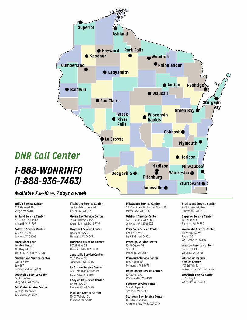
DNR Call Center1-888-WDNRINFO (1-888-936-7463)Available 7 am–10 pm, 7 days a week
Antigo Service Center223 Steinfest Rd.Antigo, WI 54409
Ashland Service Center2501 Golf Course Rd.Ashland, WI 54806
Baldwin Service Center890 Spruce St.Baldwin, WI 54002
Black River Falls Service Center910 Hwy 54 E Black River Falls, WI 54615
Cumberland Service Center1341 2nd Ave.Box 397Cumberland, WI 54829
Dodgeville Service Center1500 N Johns StDodgeville, WI 53533
Eau Claire Service Center1300 W ClairemontEau Claire, WI 54701
Fitchburg Service Center3911 Fish Hatchery RdFitchburg, WI 53711
Green Bay Service Center2984 Shawano Ave.Green Bay, WI 54313-6727
Hayward Service Center10220 St Hwy 27Hayward, WI 54843
Horicon Education CenterN7725 Hwy 28Horicon, WI 53032-1060
Janesville Service Center2514 Morse StJanesville, WI 53545
La Crosse Service Center3550 Mormon Coulee RdLa Crosse, WI 54601
Ladysmith Service CenterN4103 Hwy 27Ladysmith, WI 54848
Madison Service Center101 S Webster StMadison, WI 53703
Milwaukee Service Center2300 N Dr Martin Luther King Jr Dr,Milwaukee, WI 53212
Oshkosh Service Center625 E County Rd Y Ste 700Oshkosh, WI 54901-9731
Park Falls Service Center875 S 4th Ave,Park Falls, WI 54552
Peshtigo Service Center101 N Ogden RdSuite APeshtigo, WI 54157
Plymouth Service Center1155 Pilgrim Rd.Plymouth, WI 53073
Rhinelander Service Center107 Sutliff AveRhinelander, WI 54501
Spooner Service Center810 W Maple StSpooner, WI 54801
Sturgeon Bay Service Center110 S Neenah AveSturgeon Bay, WI 54235-2718
Sturtevant Service Center9531 Rayne Rd Ste 4Sturtevant, WI 53177
Superior Service Center1701 N. 4th St.Superior, WI 54880
Waukesha Service Center141 NW BarstowRoom 180Waukesha, WI 53188
Wausau Service Center5301 Rib Mt RdWausau, WI 54401
WIsconsin Rapids Service Center473 Griffith StWisconsin Rapids, WI 54494
Woodruff Service Center8770 Hwy JWoodruff, WI 54568
Spooner
LadysmithCumberland
Baldwin
Hayward
Ashland
Park Falls
Rhinelander
Woodruff
Wausau
WisconsinRapids
BlackRiverFalls
Antigo Peshtigo
SturgeonBay
Madison MilwaukeeWaukesha
Plymouth
Horicon
Oshkosh
Sturtevant
Green Bay
Eau Claire
La Crosse
DodgevilleFitchburg
Janesville
Superior
443 444
442441440439
438437436435434433432
423
414
401 402 403 404 405 406 407 408 409 410 411 412 413
385384 386 387 388 389 390 391 392 393 394 395 396 397 398 399 400
367366365 368 369 370 371 372 373 374 375 376 377 378 379 380 381 382 383
346345344343 347 348 349 350 351 352 353 354 355 356 357 358 359 360 361 362 363 364
324323322321 325 326 327 328 329 330 331 332 333 334 335 336 337 338 339 340 341 342
301300299 302 303 304 305 306 307 308 309 310 311 312 313 314 315 316 317 318 319 320
278277276
251
227
203 204
181 182 183
161 162
142
124 125 126 127 128 129 130 131 132 133 134
108
93
78
63
48
33
18
4 5 6 7 8 9 10 11 12 13 14 15 16 17
19 20 21 22 23 24 25 26 27 28 29 30 31 32
49
34 35 36 37 38 39 40 41 42 43 44 45 46 47
50 51 52 53 54 55 56 57 58 59 60 61 62
64 65 66 67 68 69 70 71 72 73 74 75 76 77
79 80 81 82 83 84 85 86 87 88 89 90 91 92
94 95 96 97 98 99 100 101 102 103 104 105 106 107
109 110 111 112 113 114 115 116 117 118 119 120 121 122 123
143 144 145 146 147 148 149 150 151 152 153 154
135 136 137 138 139 140 141
155 156 157 158 159 160
163 164 165 166 167 168 169 170 171 173 174 175 176 177 178 179 180172
184 185 186 187 188 189 190 191 192 193 194 195 196 197 198 199 200 201 202
205 206 207 208 209 210 211 212 213 214 215 216 217 218 219 220 221 222 223 224 225 226
228 229 230 231 232 233 234 235 236 237 238 239 240 241 242 243 244 245 246 247 248 249 250
252 253 254 255 256 257 258 259 260 261 262 263 264 266 267 268 269 270 271 272 273 274 275265
279 280 281 282 283 284 285 286 287 288 289 290 291 292 293 294 295 296 297 298
415 416 417 418 419 420 421 422
424 425 426 427 428 429 430 431
AtlasPUBLIC ACCESS LANDS
OF WISCONSIN
2766227809919
ISBN 978-0-9912766-2-290000 >
http://dnr.wi.gov/u/?q=89PUB-LF-076 2018
2766227809919
ISBN 978-0-9912766-2-290000 >