public agenda item no. 3.2 derbyshire county council … · 2017-12-11 · numbers 1986/9/2/5,...
TRANSCRIPT
Public
H:\H9\RP466.doc 1 9 January 2017
Agenda Item No. 3.2
DERBYSHIRE COUNTY COUNCIL
REGULATORY – PLANNING COMMITTEE
9 January 2017
Report of the Strategic Director – Economy, Transport and Communities 2 (i) INITIAL REVIEW OF MINERAL PLANNING PERMISSIONS CODE
NUMBERS 1986/9/2/5, 1986/9/2/8, CHA/1173/5, HPK/1181/1091, HPK/022937 AND HPK/030328 UNDER SCHEDULE 13 OF THE ENVIRONMENT ACT 1995: APPLICATION FOR APPROVAL OF NEW CONDITIONS; AND (ii) FIRST PERIODIC REVIEW OF THE 1946 INTERIM DEVELOPMENT ORDER (IDO) MINERAL PLANNING PERMISSION CODE NUMBER TQ/659A UNDER SCHEDULE 14 OF THE ENVIRONMENT ACT 1995: APPLICATION FOR APPROVAL OF NEW CONDITIONS AT TUNSTEAD QUARRY, TUNSTEAD, BUXTON APPLICANT: TARMAC LTD CODE NOS: R1/1197/11 and R1/0913/27
1.36.R and 1.36.R1 Introductory Summary New schemes of conditions have been submitted by Tarmac Ltd under the requirements of schedules 13 and 14 of the Environment Act 1995 to update planning controls on future operations at Tunstead Quarry, Tunstead, Buxton under planning permission code numbers TQ/659A (1946 Interim Development Order (IDO)), 1986/9/2/5, 1986/9/2/8, CHA/1173/5, HPK/1181/109, 1 HPK/022937 and HPK/030328. The schemes, together with an Environmental Statement (ES), provide details of the proposed working of the site, environmental protection, the form of restoration and the suggested planning conditions under which the site should be worked. I consider that certain changes to the submitted conditions are necessary and my recommendation relates to an amended schedule of conditions. I do not consider that the amended conditions would restrict the working rights of the applicant so as to provide any ground for a claim for compensation. As this is a Mineral Planning Permission review, the principle of the permission for the development is not under question. Valid planning permissions exist and, therefore, the main planning issues are whether:
• the submission as a whole, including operational and restoration proposals, meets the expectations of the relevant development plans for the area; and
Public
H:\H9\RP466.doc 2 9 January 2017
• the proposed planning conditions are sufficient to ensure that the development can be controlled, such that it does not cause unacceptable impacts upon local residents or the wider environment.
I have considered the application in light of the above and my conclusions are that, as a result of the submission of amended details and information, it meets both of these requirements. (1) Purpose of Report To enable the Committee to determine new schemes of conditions under the powers of the Environment Act 1995, to replace those of the original planning permissions, as well as those deemed approved in respect of the Initial Review of the 1946 IDO permission at Tunstead Quarry, and for the Committee to endorse the conclusion of the assessment work relating to the applications for the purposes of the Conservation of Habitats and Species Regulations 2010. (2) Information and Analysis Site and Surroundings Tunstead Quarry is located approximately 4 kilometres (km) to the east of Buxton and is one of the largest quarries in Britain, encompassing an area of over one square mile. The quarry produces a range of limestone products and has operated under planning controls since 1946, benefiting from several related permissions for the winning and working of minerals, and the disposal of mineral waste. In 1980, planning permission was granted by the Peak District National Park Authority (PDNPA) and by Derbyshire County Council (DCC) for the winning and working of minerals at Old Moor Quarry, which effectively formed an extension of Tunstead Quarry. The quarry complex contains two separate extraction areas – Tunstead Quarry and Old Moor Quarry. The two areas are separated by Great Rocks Dale, a dry valley within which runs a freight railway line, and are connected by a causeway bridge over the railway. Stone extracted from both areas is processed within Tunstead Quarry. The applications take the two areas as forming a single site and the applicant has submitted a single ES that covers them both. As well as the main TunsteadIOld Moor site, the application also includes related sites that are ancillary to the quarrying operation along Great Rocks Dale, these are Dove Holes Dale Quarry, Bold Venture Lagoon, and Buxton Central Quarry, all of which are mineral waste disposal sites; referred to by the applicant as the Tip Permissions. The overall operational area of the quarry, including ancillary areas, is over 340 hectares (ha). The combined operation at the site is one of the largest in the UK’s, with between 5 and 6 million tonnes of limestone being extracted from the site per year. The quarry was established in the 1920s to supply high purity industrial limestone for use within the chemical and other industries: the
Public
H:\H9\RP466.doc 3 9 January 2017
site is acknowledged to be of national strategic importance. The site also produces aggregates for the construction industry and cement. All mineral processing takes place within Tunstead Quarry. Products from the site are despatched by both road and rail, the split currently being around 50:50. The operational access to the site is from Waterswallows Road to the north of the quarry. Operations at the site are permitted to be carried out 24 hour a day throughout the year. However, the quarries are operated on a two shift basis; 0600 hours – 1400 hours and 1400 hours – 2200 hours Monday to Friday and 0600 hours – 1400 hours Saturday and Sunday with most activities being carried out during these periods. Approximately 2km to the east of the quarry is the large residential area of Fairfield in Buxton. Several farmsteads and small settlements lie within a kilometre of the site, most notably Blackwell Mill Cottages to the south, and Wormhill, Hargate Wall and Tunstead to the east. Dove Holes Dale Quarry is close to Dove Holes village, and Bold Venture Lagoon is close to the village of Peak Dale. A public right of way (PRoW) (Wormhill Footpath (FP) 19) passes through Tunstead Quarry north of the plant site, crosses the railway and skirts the northern soil storage area of Old Moor Quarry. A public bridleway (52) to the north-east of Tunstead Quarry begins adjacent to Buxton Bridge near the Quarry entrance and runs south-east towards Tunstead settlement and links to the Pennine Way. The Peak District National Park (PDNP) boundary runs through the site, on a rough north-south alignment, to the east of Great Rocks Dale. The majority of Old Moor Quarry lies within the PDNP. There are six International, European, or Nationally designated sites of nature conservation importance within 2km of the Site. The most notable of these are the Wye Valley Site of Special Scientific Interest (SSSI), Topley Pike SSSI, Deep Dale SSSI and Monk’s Dale SSSI, which are components of the Peak District Dales Special Area of Conservation (SAC). The River Wye which forms part of the Peak District Dales SAC is located to the south of the quarry. A number of non-statutory designated sites of nature conservation importance are located in close proximity, including within Tunstead Quarry and adjacent to Dove Holes Dale Mining Waste Operation. The Cow Low Scheduled Monument is located in the south of Tunstead Quarry within the planning permission boundary but outside of the permitted mineral extraction area. Procedures for the Review of Mineral Planning Permissions The Environment Act 1995 has required conditions attached to all ongoing mineral planning permissions to be reviewed and periodically updated to ensure they reflect modern best practice. For older permissions, these procedures involve an initial review and then periodic reviews to be carried out every 15 years thereafter, as set out in schedules 13 and 14 of the Act. Schedule 13 sets out the procedures for the initial review of old mineral planning permissions (or ‘ROMP’) and Schedule 14 sets out procedures for

Public
H:\H9\RP466.doc 4 9 January 2017
subsequent periodic reviews of mineral planning permissions (or ‘RoMP’). For the purpose of this report the applications made under schedules 13 and 14 of the Act shall be collectively referred to as ‘the mineral review applications’. A mineral review application is an application for determination of the planning conditions under which the remaining mineral development under the permission shall be carried out and results in the issue of a revised set of planning conditions with which the Operator of the quarry must comply. This process does not call into question whether or not the planning permissions should or should not have been granted. Planning History Planning permissions for the quarrying of limestone and associated activities at Tunstead Quarry were granted in 1946, 1951, 1980, 1985 and 1991. Two other planning permissions were granted in 1980 for an extension of the quarry operation at Tunstead into land at Old Moor, one by DCC covering land within its jurisdiction and a second by the PDNPA on the direction of the Secretary of State relating to a much larger tranche of land within the National Park. The relevant planning permissions are detailed below:
• 1946 Interim Development Order (IDO) TQ/659A – granted by the Secretary of State for the quarrying of limestone and associated activities. The Planning and Compensation Act 1991 (the 1991 Act) introduced new procedures for the review of conditions attached to IDO Consents. A new schedule of conditions relating to the IDO area within Derbyshire was deemed approved under the 1991 Act on 4 September 1993.
• Planning permission code nos. 1986/9/2/5 and 1986/9/2/8 – granted in
1951 for the winning and working of Limestone and disposal of mineral waste at Tunstead, Derbyshire.
• Planning permission code no. CHA/1173/5 - for the wining and working
of limestone at Old Moor granted by DCC in 1974 on the land that falls within the jurisdiction of the Council. A second application was also made at this time to the Peak Park Joint Planning Board (PPPB) for the much larger area of the Old Moor site to the east. The application was refused and an appeal was made against this decision. The appeal was allowed by the Inspector on behalf of the Secretary of State and planning permission was granted in 1980 for the working of the site within the National Park. A modification order was also made at this time to the 1973 permission granted by DCC on the recommendation of the Inspector to amend the planning conditions on the DCC permission to match those imposed on the appeal site.
Public
H:\H9\RP466.doc 5 9 January 2017
• Planning permission code no. HPK/1181/1091 - granted in 1982 to tip quarry waste and reinstate Central Quarry Buxton with amended working hours.
• Planning permission code no. HPK/022937 – granted in 1985 to tip quarry waste from Hindlow and Tunstead Quarries at Dove Holes Quarry, Buxton.
• Planning permission code no. HPK/030328 – granted in 1991 for the recovery of lime slurry from existing lime slurry lagoon and the installation of an underground pipeline at Bold Venture Lagoon.
An application was made in 1997 under Schedule 13 of the Environment Act 1995 (code no. R1/1197/11) for the initial review of an ‘active Phase 1’ site under ROMP procedures relating to the two 1951 permissions, the 1982, the 1985 and 1991 tip permissions and the 1980 Old Moor permission. However the determination of this ROMP was ‘stalled’ and deferred with the agreement of the applicant pending the submission of environmental information. A first periodic review application for an IDO permission would normally be expected to be made, 15 years after the date of deemed approval under the 1991 Act. However, with the IDO permission in this case, the situation is affected by the timing of the initial review of the closely related “active Phase 1” site, as referred to above. The applicant has, therefore, voluntarily submitted a RoMP application (code no. R1/0913/27) under Paragraph 6 of Schedule 14 of the Environment Act 1995 relating to the IDO permission, which enables a new set of conditions for this permission to be determined at the same time as the new conditions under the 1997 initial review application is determined. The single ES and a Supporting Statement has been provided by the applicant to accompany the voluntary RoMP application relating to the 1946 IDO permission and includes a schedule of proposed modern conditions to replace those conditions deemed to have been imposed under the initial review and to provide additional and updated information to accompany the initial ‘stalled’ ROMP application. This report therefore considers both of these applications. A further initial review application under Schedule 13 of the Act has been submitted to the PDNPA relating to the part of Old Moor Quarry that falls within its jurisdiction. The Submission Details The submission details the applicant’s proposals for the continuation of limestone extraction from both Tunstead and Old Moor Quarries, restoration proposals and afteruse of the site. The future working and restoration of the
Public
H:\H9\RP466.doc 6 9 January 2017
quarries would take place in three phases and in a similar manner to current site operations. The maximum total extraction of limestone from the combined Tunstead and Old Moor operation is limited to 10 million tonnes per annum. The combined limestone reserves within the two quarries are considered by the applicant to be sufficient for in excess of 30 years. The expiry date for the Tunstead Permissions is the 22 February 2042 and for the Old Moor permissions is 30 January 2040; limestone extraction is anticipated to continue until this time. Extraction commenced at the site in 1929 and has progressed laterally to its practical limits in all but the south-west and south-east corners of Tunstead Quarry. Some of the remaining reserve is located beneath the quarry plant and associated infrastructure. Since the early 1980s extraction in Tunstead has been carried out in tandem and coordinated with extraction from Old Moor, the two quarries being worked together to ensure a consistent flow of stone with the desired chemical and physical properties. A maximum working depth for Tunstead quarry of 240m Above Ordance Datum (AOD), with north and south sumps to collect and manage run-off water at 230m AOD and 235m AOD respectively, and a working depth for Old Moor quarry of 227m AOD have been proposed. The working scheme provided by the application indicates that the quarries would be worked in three stages, although no specific timelines have been provided for each stage as this will vary year on year due to the variability of the quarries output. All mineral processing would continue to take place within Tunstead Quarry with products being dispatched from the site by both road and rail. Stage 1 Development in Tunstead Quarry during this stage would be largely focused on the central and southern end of the quarry; extraction in the south-east corner would be completed. Extraction along the south-eastern section of the quarry would break through to the rail sidings level to facilitate the future development of additional rail infrastructure. In Old Moor Quarry, development would continue in a similar format to that currently followed, working faces would continue to be developed southwards along the western side of the quarry and then turning and working west to east. The northern end of the quarry would be advanced to its lateral limits. Three main levels of extraction are proposed working to depths of 300, 278 and 265m AOD, with all existing processing plant and infrastructure being retained. Stage 2 The development of Tunstead during this stage would continue in the southern end of the quarry. A sinking to 235m AOD would commence in order to start the creation of a large quarry sump area for the management and control of surface water run-off which would eventually form a permanent water feature within the restored quarry. Development would also move
Public
H:\H9\RP466.doc 7 9 January 2017
northwards opening out lower parts of the quarry around the cement plant and beyond to the northern end of the site to a level of 265m AOD. Old Moor Quarry would continue to be expanded to its final limits working in a similar manner to Stage 1, with the principal direction of working being west to east. Stage 3 During this stage, Tunstead Quarry would be worked to its extraction limits and to a level of 240m AOD across the whole quarry, including beneath the existing plant and infrastructure area. The two sumps would be created at a depth of 230m AOD and 235m AOD. Old Moor Quarry would be worked to its extraction limits and to a depth of 227m AOD. Restoration The submission provides comprehensive details for the progressive restoration of both quarries over the three stages of quarry development detailed above. The submission includes a restoration masterplan for the site and a restoration and aftercare strategy (RAS). The long term restoration strategy is to create a ‘limestone quarry farmland’ character. The stated aims of the RAS are, in summary, to enhance landscape character and biodiversity, to achieve visual integration and enhancement, to visually merge the peripheral areas of the quarry with adjacent areas, to ensure the efficient and optimal use of all available soil material and the delivery of long term benefits for biodiversity. The restoration of site would involve the use of a number of restoration techniques, such as the creation of roll-over slopes on some of the upper quarry faces, daleside features, quarry face infill and quarry bench placement, with grass and tree planting. The quarry floors would be restored to a matrix of landuse types from calcareous grassland that enables sheep grazing, together with wetland areas, woodland and drystone wall features. The restoration of the majority of either quarry cannot be completed until the cessation of extraction operations, thus allowing the quarry floor to be restored. However, the formation of peripheral restoration features such as roll-overs, quarry bench placement and quarry face infill, would be achievable on a progressive basis. Three restoration stages have been proposed, each covering an approximate 10 year period. The proposed afteruse for the quarries would be seasonally damp calcareous grassland and woodland designed to encourage the development of nature conservation and ecological interest. The afteruse is designed to be low intervention and the land would be used for sheep grazing. Restoration proposals have also been submitted for the ancillary areas of the Site (Buxton Central, Bold Venture lagoon, North Tip and Dove Holes Dale Mining Waste Operation).
Public
H:\H9\RP466.doc 8 9 January 2017
Environmental Statement The application is accompanied by an ES which includes a description of development, including the physical, land-use and production characteristics, a description of the scheme of development, and baseline information and technical reports prepared by specialist consultants relating to ecology and natural heritage, landscape and visual amenity, hydrology and hydrogeology, flood risk, traffic and transport, noise and vibration, air quality and dust, socio-economics, combined and cumulative effects and alternatives which assess the potential environmental impact of the scheme of development. The ES considers the environmental impact of the continuation of operations for both Tunstead and Old Moor Quarries, including ancillary areas. The Company has also submitted supplementary environmental information (SEI) to the ES in response to a formal request made by the Authority under Regulation 22 of the Town and Country Planning (Environmental Impact Assessment) Regulations 2011 and responding to comments made by consultees. The further information includes a supplementary hydrogeological report, a restoration and aftercare strategy, an Ecological Management Plan (EMP), substitute phasing and restoration plans, a woodland management scheme, a revised schedule of conditions and updates to other technical annexes and reports. Overall, the ES concludes it has assessed the likely significant effects of the scheme on the environment and has identified appropriate mitigation to eliminate, reduce or manage any adverse impacts and the submitted schedule of conditions constitute modern, up to date, firm and robust basis for controlling the on-going development of the quarries and delivering a staged restoration and associated biodiversity-based afteruse appropriate to the high quality landscape setting within which it sits. Consultations There have been five rounds of consultations on the mineral review applications. The first two rounds related to the original initial ROMP application in 1997, which was further consulted upon in 2004 following the submission of an ES. Following the submission of the first periodic RoMP application for the IDO consent, and the single ES and supporting statement to accompany both mineral review applications in 2013, further consultations were carried out and again in December 2014 and September 2016 following the submission of further information. The most recent consultee comments are summarised below relating to the consultations in 2013, 2014 and 2016. Local Member Councillor Bisknell (Buxton North and East) commented that she had not received any comments from residents and therefore had no comments on the applications.
Public
H:\H9\RP466.doc 9 9 January 2017
Local Member (Adjacent ward) Councillor Street (Chapel and Hope Valley) commented that she had not received any communications from constituents and the applications seem very comprehensive and acceptable. High Peak Borough Council Planning No response has been received to date. Environmental Health Officer (EHO) Has no observations in relation to the applications. Peak District National Park (PDNPA) An initial review application, including the ES, was also submitted to the PDNPA covering the part of Old Moor Quarry within its jurisdiction. The two planning authorities have therefore worked collaboratively on the determination of all three mineral review applications. Environment Agency The Agency in its initial response to the applications raised concerns about the proposals for ground water monitoring and the condition that had been put forward by the applicant in relation to groundwater monitoring. The Agency requested further clarification and information on a number of technical matters to ensure that there are appropriate levels of protection to controlled waters. The Agency also commented that the site is subject to an Environmental Permit regulated by the Environment Agency and that the Agency does not have a history of complaints for noise or dust, although it had been informed of a complaint made directly to Tarmac in December 2013. The Agency confirmed that it does not have a major concern regarding the proposal to include a condition that would permit night-time working and it should be noted that operation of the cement and lime kilns, and associated plant, have always been 24 hours, without giving rise to noise issues. The Agency also considered that the proposed planning conditions are suitable and appropriate from a biodiversity perspective but requested that consideration is given under condition to the appropriateness of lighting so as to minimise disturbance to foraging bats. Following the submission of further information in relation to groundwater, the Agency made a number of recommendations for conditions, including mitigation measures, to be imposed.
Public
H:\H9\RP466.doc 10 9 January 2017
Natural England Natural England has provided two consultation responses; a first, initial, response and a second following the submission of further environmental information. The main points that were raised are summarised below: Designated sites The site lies in close proximity to a European Wildlife Site (the Peak District Dales SAC), and therefore has the potential to affect its ecological interest. European wildlife sites are afforded protection under the Conservation of Habitats and Species Regulations 2010, as amended (the “Habitats Regulations‟). Natural England advised that the Authority, as the competent Authority under the provisions of the Habitats Regulations, should have regard for any potential impacts that a plan or project may have. If the Authority is not able to rule out the likelihood of significant effects, if there are uncertainties, or if information to clarify areas of concern cannot be easily requested by the Authority to form part of the formal proposal, an Appropriate Assessment should be undertaken in accordance with Regulations 61 and 62 of the Habitats Regulations. Natural England also made comments on the Habitat Regulations Assessment carried out by the applicant and the report that is included in the ES. Natural England welcomed the thoroughness of the assessment and confirmed that the Habitats Regulations Assessment (HRA) report addressed the relevant issues and draws robust conclusions. In relation to the SSSIs in close proximity to the site, Natural England is satisfied that there is not likely to be an adverse effect on these sites as a result of the continued operation of the quarry, on the basis that it is carried out in strict accordance with the details of this current submission and in particular the proposed conditions. Protected Species Natural England raised no objections to the scheme of development in relation to bats. With regard to Great Crested Newts (GCNs), Natural England, in its first response, requested further information so that the likely impact on GCN could be assessed. Following the submission of further information that included a GCN survey and Habitat Suitability Index, Natural England advised in its later response that all advice on protected species is now provided via its standing advice and that the Authority should apply this standing advice to these applications. Protected landscapes The development site lies immediately adjacent to the PDNP, and Natural England advised that consideration needs to be given to any potential impacts
Public
H:\H9\RP466.doc 11 9 January 2017
upon the National Park landscape and the purposes of its designation. Natural England did not wish to comment on this submission in relation to the potential landscape character or visual impacts. However, Natural England advised that this Authority seeks the views of landscape specialists within the National Park Authority. Biodiversity enhancements Natural England commented that the proposal provides significant opportunities to incorporate features into the working method and final restoration design which are beneficial to wildlife, which it hoped would be used to their full potential in the detailed Landscape and Ecological Management Plan (LEMP). Natural England further advised that the Authority do everything it could to maximise the potential presented by this current submission to secure measures to enhance the biodiversity. Restoration Strategy Natural England fully supported the principles underpinning the proposed Restoration Strategy. However, it commented that it is difficult to comment further than this, given that the detailed proposals are to be incorporated into the LEMP, to which a proposed condition refers. Natural England strongly recommended that detailed proposals be submitted as part of the LEMP which clearly identifies areas and extent for the creation of different habitat types. Other advice Natural England expected the Authority to assess and give consideration to other possible impacts on local sites (biodiversity and geodiversity), local landscape character and local or national biodiversity priority habitats and species. Derbyshire Wildlife Trust (Trust) In its initial response, the Trust raised concerns about the loss of UK Biodiverdsity Action Plan (BAP) habitat type ‘Lowland Calcareous Grassland’ and its recognition in the ES, the complete loss of a Local Wildlife Site (LWS) at the Dove Holes Dale Mine Waste Operation and argued that this should be considered as a major adverse impact as opposed to moderate adverse in the ES. The Trust was concerned about the impact the loss of grassland would have on rare plant species and on butterfly and invertebrate species. The Trust considers this LWS to be of very high value and is making a significant contribution to the maintenance of biodiversity in this part of Derbyshire. The Trust advised that its loss should be avoided at all costs. With regards to the restoration of the site, the Trust was of the view that the broad Restoration Strategy and plans presented do not appear to offer as much biodiversity mitigation/compensation and potential gain as they could. The Trust provided a number of examples of what they considered to be shortcomings in the scheme and concluded that, at present, the restoration
Public
H:\H9\RP466.doc 12 9 January 2017
proposals do not demonstrate that the biodiversity impacts identified would be mitigated and compensated at all of the sites to an acceptable level. The Trust also recommended that a number of further surveys were required in relation to GCN, Bats and a mitigation scheme for common lizard. Update surveys would also be required in due course for other species such as badger. A further response was received from the Trust following the submission of the SEI. The Trust welcomed the changes that had been made to the restoration scheme which, as now proposed, provides greater benefits for biodiversity through an increased emphasis on creation of species rich calcareous grassland and other habitats, and also the reduction the Mining Waste Operation that was going to impact upon the LWS at Dove Holes. The EMP and the RAS were considered to be acceptable but the Trust commented that, in its view, there is a need for a more detailed EMP that takes the strategic framework set out in the RAS and expands upon it to provide a clear set of management aims, prescriptions, timing of operations, and grazing periods and annual work schedules. The Trust also recommended conditions to ensure that the mitigation measures set out in the EMP are secured and also for a mitigation plan for common lizards. Historic England (formerly English Heritage) Historic England advised that the Cow Low (Tunstead Quarry) Scheduled Monument was designated under the 1979 Ancient Monuments and Archaeological Areas Act on 14 December 1992. The monument includes the above and below ground remains of a burial mound. Excavations in the nineteenth century revealed evidence of its construction and use in at least two distinct episodes, the Late Neolithic to early Bronze Age (circa 2400-1500BC) and 'Anglian' reuse around 700 AD. Historic England advised that further related archaeological remains may lie in the vicinity of the monument. Historic England commented that it has not so far been possible to establish how the consented scheme of extraction would interact with the monument and its setting, and its supposition is that the visible stand-off in the extant (old) quarry face, the extent and scale of mapping materials examined, and a general sense that damage would be avoided, appear to have led to these issues not being bottomed out and a sense that the remaining consented works might cause little additional harm. Historic England has examined the present situation of the monument and considers that work remains to be done to understand opportunities and constraints. A mechanism to secure appropriate detailing is not set in place,
Public
H:\H9\RP466.doc 13 9 January 2017
there appears to be a clear risk of harm to the significance of the monument and / or damage. Historic England acknowledge that this is a review process for an established consent, the principle of great weight set out in the National Planning Policy Framework (NPPF) Paragraph 132 with regard to the conservation of scheduled monuments and their setting and moreover, Paragraph 129 with regard to minimising conflict between development and the assets' conservation appear entirely relevant in establishing reasonable current environmental expectations. Historic England advise local planning authorities to identify and assess the particular significance of any heritage asset and its setting that may be affected by a proposal taking account of the available evidence and any necessary expertise. This assessment should be taken into account when considering the impact of a proposal on a heritage asset, to avoid or minimise conflict between the heritage asset’s conservation and any aspect of the proposal. Historic England considers that it would appear desirable to agree a condition to the consent requiring the submission and approval of specific detailing in respect of all extraction, access, associated works and restoration within the land lying between the scheduled monument boundary and the existing (old) quarry face. Restoration and, in particular, any planting or edge rolling in the vicinity of the monument, landscaping requirements should not be permitted to compromise the conservation of the scheduled monument in its setting. Its conservation needs should be prioritised over any general landscape restoration approach. Any works within the scheduled monument area itself would require Scheduled Monument Consent from the Secretary of State in addition to any consent the Mineral Planning Authority (MPA) may grant or have previously granted. Historic England has therefore recommended that an appropriate condition is attached to the existing planning consent for the submission and approval by the MPA of detailing for all extraction, access, associated works and restoration within the land lying between the scheduled monument boundary and the existing (old) quarry face. Network Rail (Mining) Raised no objection to the applications but recommended a number of conditions to be to be included in the updated schedule of conditions and informatives to be passed to the operator to ensure the safe operation of the site adjacent to the railway. The recommended conditions and informatives relate to blasting, extraction limits, drainage, use of plant and machinery and restoration.
Public
H:\H9\RP466.doc 14 9 January 2017
Severn Trent Water No objections. Western Power Commented that there is a 33kV overhead line in the vicinity of the site. Nestle Waters Commented that while the evidence presented suggests that the St Anne’s Spring is both hydrochemically and hydraulically distinct from the groundwater system at Tunstead Quarry, it should be included in the assessment, if only to discount it from further consideration. Otherwise, Nestle Waters has no significant objections to the proposals. Department for Communities and Local Government, Minerals Division (DCLG) and United Utilities Had no comments to make on the applications. Wormhill and Green Fairfield, Blackwell in the Peak, Peak Forest Parish Council’s and the Health and Safety Executive Were consulted but have yet to make a response. Publicity The initial Schedule 13 ROMP application (Code No. R1/1197/11) submitted in 1997 was advertised by press notice and by site notice in December 1997. Following the submission of RoMP application for the IDO consent, and the further and additional information to accompany the initial application, both applications were advertised by press notice (Buxton Advertiser) and by site notice with a request for observations by 31 October 2013. One representation was received as a result of the publicity, supporting the mineral permission review; however, the author commented that they would be against any expansion of the quarry beyond its present limits. Two further rounds of publicity were undertaken, as required under Regulation 22 of the Town and Country (Environmental Impact Assessment) Regulations 2011, following the submission of the additional and further information by press advert (Buxton Advertiser) and site notice with a request for observations by 6 February 2015 and 27 October 2016. No further representations were received. Planning Considerations It is for the applicant company, in the first place, to submit a scheme of conditions to the MPA for consideration, and for the MPA to determine whether the submitted conditions are acceptable, or should be modified or added to in light of the particular circumstances of the case and Government
Public
H:\H9\RP466.doc 15 9 January 2017
guidance set out in the National Planning Practice Guidance (NPPG). The MPA may not refuse a RoMP application for updated conditions but only approve conditions as submitted by the company or as modified by the MPA. Planning Policy I have assessed the mineral review applications against the relevant development plan policies which, in this instance, are in the Derby and Derbyshire Minerals Local Plan (DDMLP), the High Peak Local Plan (adopted April 2016) (HPLP). The NPPF and the NPPG are also material considerations. Members are reminded that the applications under consideration relate to the initial and first periodic review of old mineral permissions and mineral permissions which comprise a review and update of the conditions under which existing mineral permissions should operate. The determination of a mineral review application does not call into question the existence of the planning permission(s) and, whilst there are policies in the development plan which would directly relate to other applications for these sites, for example DDMLP Policy MP23: Crushed Rock for Aggregates, they are not directly applicable to this case. Since the prime purpose of the mineral review process is to put in place a scheme of modern up-to-date planning conditions, together with a modern scheme of working and restoration, the applications have been assessed against those planning policies relating to environmental considerations. In the context of these applications, the policies considered to be most pertinent, contained in the DDMLP, are: MP1: The Environmental Impact of Mineral Development. MP3: Measures to Reduce Environmental Impact. MP4: Interests of Acknowledged Environmental Importance. MP5: Transport. MP6: Nature Conservation – Mitigation Measures. MP7: Archaeology –Mitigation Measures. MP10: Reclamation and After-Use. The saved policies of the adopted DDMLP remain relevant and must be taken into account in the determination of this proposal. However, they should also be considered in the context of the NPPF. This sets out, at Paragraph 215, that the closer the policies of the DDMLP are to the policies of the NPPF, the greater the weight that may be given to these. It follows that where there are areas of inconsistency between the policies of the adopted DDMLP and the NPPF, the weight the policies of the adopted DDMLP should be afforded is reduced. Environmental Considerations MLP Policy MP1 states that “proposals for mineral development will be permitted provided that their impact on the environment is acceptable”. MLP
Public
H:\H9\RP466.doc 16 9 January 2017
Policy MP3 states that “proposals for mineral development will be permitted provided that any adverse effects on the environment can be eliminated or reduced to an acceptable level”, having particular regard to a number of factors including the measures which are proposed to minimise the environmental impact of proposals. Proposals for mineral working will therefore be allowed only where the adverse effects on the environment can be avoided or reduced to an acceptable level and this assessment is to made having regard to all the considerations listed in Policy MP1. In the context of these policies, the environmental effects of the development and the main points from the ES regarding the potential effects are therefore considered below. Visual and Landscape The ES considers the landscape and visual effects resulting from the ongoing extraction and restoration operations at the quarries and then sets out mitigation proposals where they are deemed to be necessary. In addition to policies MP1 and MP3, Policy MP4 of the DDMLP is also of relevance as it seeks to safeguard the environment and prevent irreparable or unacceptable damage to interests of acknowledged importance, such as valued landscapes. The policy does not permit proposals for mineral development where irreparable or unacceptable damage would result, and in respect of landscape, in particular where the development would be materially damaging to the inherent qualities of a special landscape area, or to areas prominent from within the Peak National Park, unless there is an overriding need for the mineral which cannot reasonably be met from alternative sources in less environmentally important areas, or where the development would cause unacceptable damage to an area of local landscape importance. The quarries are located within the White Peak National Character Area (NCA) and at a local level within the Plateau Pastures Landscape Character Type (LCT) as detailed in the Landscape Character of Derbyshire publication. This LCT is a gently rolling, upland limestone plateau characterised by nucleated limestone villages, dry-stone walls with a pastoral land–use and open expansive views. The Limestone Dales LCT also applies to Tunstead Quarry; a narrow, deeply incised landscape with steep slopes and extensive amounts of exposed rock. Wye Dale and Great Rocks Dale located within close proximity to the site, which are areas designated as Special Landscape Areas (SLAs) in the HPLP and the PDNP boundary is located to south and east of Tunstead and the majority of Old Moor falling within the PDNP. The Pennine Bridleway is another notable landscape designation that passes in close proximity of the quarries. The land within the quarries has been affected by mineral extraction activities and the landform has been significantly altered and, as such, is at odds with the landscape character of the area. The ongoing development of the quarries
Public
H:\H9\RP466.doc 17 9 January 2017
would continue to have an impact on the landscape, whilst Tunstead Quarry has reached its lateral extraction limits and its effects on landscape character would remain broadly unchanged, there remains approximately 33ha (3ha in Derbyshire and 30ha in the PDNP) of pasture land to be removed in Old Moor. The development would affect landscape character from an alteration of scale and through modification of natural features. In the long term, the restoration of the quarries, as well as the removal of the Cement Plant, is likely to provide significant beneficial effects, the restoration scheme is designed to complement the surrounding landscape. The ES concludes that the overall significance of effects are such that the future working would have only minor degradation of the current situation and the longer term effects would be notably beneficial and significant enhancement, the significance of effect relates to the changes that would occur to the landscape character, as well as those that relate to visual amenity. The ES considers the effect on visual amenity would be moderate to major (short term) adverse for Tunstead Quarry from two viewpoints (number 8 at Corbar Hill and 13 the Pennine Bridleway south of Chee Dale) in Stage 1 of the development but would be mitigated in subsequent Stages through restoration. Other adverse impacts considered to be of a minor or moderate significance are restricted to the Stage 1 of the development and would be mitigated through restoration in stages 1 and 2. As a result of the Landscape and Visual Impact Assessment (LVIA), some of the quarry development proposals have been modified to mitigate the highest level of potential visual impact, resulting in extraction being moderated and scope provided for the restoration of those areas as early as possible. It is acknowledged the quarry already exerts a significant impact in landscape and visual terms, and that there would be further impacts from the continued development of the quarries. However, I would agree with the conclusion of the ES that the future working would have only minor degradation of the current situation and I am satisfied that this would not be so significant so as to raise conflict with the requirements of policies MP1, MP3 and MP4 of the DDMLP. I am also of the view that the potential landscape and visual impacts associated with the development are capable of being controlled by the conditions. In the longer term there are benefits through the restoration of the quarries. There is currently no formerly approved restoration scheme for the site and the approval of the proposed restoration scheme as part of this RoMP review process would represent as significant improvement on the current situation.
Public
H:\H9\RP466.doc 18 9 January 2017
Hydrology, Hydrogeology and Flood Risk The site lies in close proximity to the River Wye, which forms part of the Peak District Dales SAC and the Wye Valley SSSI, and there is potential for the continued development of the quarries to impact the flow of ground water which supports both the River and various associated habitats. In particular, mineral working may reduce ground water levels, disturb natural drainage patterns, reduce the capacity of the flood plain, and pollute local water resources. Policy MP4 of the DDMLP includes water resources as an interest of acknowledged environmental importance and mineral development proposals, which seriously damage these interests, will not normally be acceptable, in particular where development would adversely affect the quality and quantity of water resources, water supply, land drainage or flood protection interests, or create water pollution problems. A hydrogeological investigation of the water environment has been undertaken in the vicinity of the site and a hydrology and hydrogeology assessment report is included in the ES. The main objective of the assessment was to develop and test a conceptual model of groundwater movement in order to evaluate the magnitude and significance of risks to the hydrological environment in the locality and to inform the design of mitigation measures, as required. Analysis of the data was used to design the scheme of development and, in particular, the maximum depths of working within the quarries. The ES concludes that the risk from the scheme to ground water flow and therefore the dependent designated habitats is negligible, and that measures can be adopted to mitigate and prevent adverse impact occurring. Flood risk at the site has also been assessed in the ES, taking account of the small changes in relation to surface water flow that are likely to occur, the potential impact upon flooding is considered to negligible. It has been acknowledged that the level of risk to the water environment, and notably to the flow of ground and surface water to the River Wye is of particular concern for the continuation of development of this site. There is potential for interruption of those flows as a result of deepening extraction in the quarries and, in particular, that of intersecting a major conduit, which has been identified as a potential risk to some of the areas of interest for which the SAC, and its constituent SSSIs have been designated. The applicant agreed a programme of site investigations with the Environment Agency and with Natural England within the limestone, around and beneath the quarries and I am satisfied that the impact of the continued development on water resources and on the SAC have been adequately assessed. The on-
Public
H:\H9\RP466.doc 19 9 January 2017
going monitoring of ground water flows is proposed and a condition has been put forward to secure such monitoring by the applicant. I am also satisfied that any potential source of pollution to the water environment would be adequately mitigated and can be controlled through planning conditions and through the sites environmental permit. The Environment Agency has been consulted on the proposals and has not objected but has made recommendations regarding the conditions put forward by the applicant relating to the management of surface water and the monitoring of ground water within the site. I note the comments of Nestle Waters about the assessment of St Anne’s Springs, located close to the centre of Buxton. The applicant has provided further information on the connectivity of the quarries to the Springs and I am satisfied that the continued working of the quarries is unlikely to impact on these water features. Overall, I am satisfied with the conclusions of the ES and that the requirements of this section of Policy MP4 are met. I have amended the applicant’s proposed conditions and included additional planning conditions where considered appropriate, taking into account the comments of the Environment Agency. Ecology, Natural Heritage and Designated Sites The continued development of the quarries has the potential to impact on the ecology of the site, natural heritage and designated sites. In addition to the requirements of DDMLP Policy MP1, Policy MP4 does not permit mineral development where irreparable or unacceptable damage would result to interests of acknowledged environmental importance, and in particular, where ‘development would adversely affect nature conservation interests of international or national importance including…special areas of conservation, sites of special scientific interest…and the habitats of protected species’ and ‘development would cause significant disturbance to other sites of importance for nature conservation’. There are six International, European or Nationally designated sites of nature conservation importance located within 2km of the site and a number of non-statutorily sites in the area including three that are located partly within the review site. There are also records of European protected species and other notable species within 2 km’s of the site that includes GCN’s, Bats, Water Voles in the River Wye, Badgers and Peregrine Falcon, in addition there are records of Derbyshire Red Data Book plants, other reptiles, butterflies and invertebrates species. The ES acknowledges the potential impacts on these features; a Phase 1 survey of habitats in and around the site was initially undertaken and was used to inform the scope of ecological surveys and to establish a baseline
Public
H:\H9\RP466.doc 20 9 January 2017
against which the scheme could be assessed. Particularly important to this site are the areas of ecological interest associated with the statutory and non-statutory designated sites, the most notable of which is the Peak District Dales SAC and associated SSSI’s recognised as being of European conservation value because of the presence of two Annex I habitats and an Annex II species. Of particular concern is the potential impact on the SAC from changes in hydrological conditions, however, detailed assessments indicate that the potential for hydrological impact on the River Wye and on the local water environment are anticipated to be insignificant. A large number of discernible habitats and plant assemblages were identified as part of the survey work carried out, together with a number of statutorily protected species. The impact on these habitats, plants and species, after the proposed mitigation, has been assessed in the ES as ranging from ‘not significant’ to ‘moderate/minor beneficial’. Mitigation proposals are largely based on the creation of compensatory habitat within the restored quarries, for which there is significant potential. The ES identifies that the full implementation of the permitted scheme of working at Dove Holes Dale Mining Waste Operation would result in the eventual loss of the LWS (HP169 Dove Holes Spoil Heaps), including the secondary calcareous grassland on the old tips and associated butterfly and invertebrate assemblages. This impact was considered to be ‘Significant Adverse’ at the District level. The final restoration scheme, approved under the existing permission, is to agriculture and therefore provides no opportunity to create alternative habitat in situ. However, in the wider site context, it is considered that there is significant potential for extensive areas of the habitat to be created. In response to concerns raised about the scheme and the loss of the LWS, an amended scheme for the Dove Holes Dale Mining Waste Operation has been proposed in the further information to the ES, which has regard to the existing calcareous grassland habitat underlying the LWS designation. The tipping area in the amended scheme has been significantly reduced in extent and overall height. The further information to the ES considers this would represent a significant reduction in overall scale and proportion compared to the permitted scheme and would offer substantial positive effects in terms of landscape, visual and ecological aspects. The amended scheme retains the LWS within the site and I am satisfied that the revised restoration plan at the Dove Holes Dale Mining Waste Operation is now acceptable. The ES concludes that provided the measures detailed are adhered to and regularly reviewed, the impacts on biodiversity and nature conservation can be minimised as far as practical and significant impacts on protected species avoided or mitigated. In the longer term, the scheme provides great potential for significant residual beneficial impacts to biodiversity and nature
Public
H:\H9\RP466.doc 21 9 January 2017
conservation. The overall impact of the development scheme would also be controlled through the adherence to ecological management protocols contained in the EMP submitted by the applicant and through adherence to protected species legislation. A number of ecological impacts have been identified from the continuation of development of the quarries; the most significant of these is the potential for impact of the SAC, however, the conclusion of the ES is that this impact would not be significant. Natural England has been consulted on the proposals and is satisfied that the applicant’s assessment of this impact draws robust conclusions. The Conservation (Natural Habitats, &c) Regulations 1994 transpose the European Union (EU) Directive on Natural Habitats, and Wild Fauna and Flora (92143lEEC) into national legislation and afford a high level of legal protection to a variety of species that are considered important at a European scale. The Regulations identify European Protected Species and various habitats of importance within the EU, with important sites being designated as SAC. Any proposed development that may have a significant effect on a SAC (either direct, indirect, temporary or permanent) should be assessed in relation to the site's 'conservation objectives', i.e. the reasons for which the site is designated. Under Regulation 48(1) of the 1994 Regulations, an "Appropriate Assessment" of the implications of the proposed development, in view of the site's conservation objectives, must be made in respect of any decision to be taken for any consent for a project (or a plan) or which either alone or in combination with other plans or projects would be likely to have a significant effect on a European Site, and is not directly connected with the management of the site for nature conservation. Whilst Natural England has confirmed that it is satisfied with the applicant’s Appropriate Assessment, it advised this Authority to have regard for any potential impacts that a plan or project may have and, if the Authority is not able to rule out the likelihood of significant effects, if there are uncertainties, or if information to clarify areas of concern cannot be easily requested, an Appropriate Assessment should be undertaken in accordance with Regulations 61 and 62 of the Habitats Regulations. Appendix 1 of this report sets out the Screening report that concludes that a full Habitats Appropriate Assessment is not required. The recommendation of this report follows the conclusion of the screening report. In conclusion, with the mitigation measures that are proposed and the conditions I am recommending, which include a requirement to submit an updated EMP, with species and habitat surveys every five years and conditions to protect breeding birds including Peregrine and to protect
Public
H:\H9\RP466.doc 22 9 January 2017
badgers, I am satisfied that the continued development of the quarries would accord with the aims of policies MP1, MP3 and MP4 of the DDMLP. Traffic and Transport The transport of minerals from quarries can potentially impact on local amenity, cause public safety concerns and environmental problems such as noise, vibration, and air pollution. Policy MP5 of the DDMLP permits the transport of minerals by road provided there is no feasible alternative which would be environmentally preferable, the access arrangements would be satisfactory and the highway network is adequate to accommodate the traffic generated, and it would not be detrimental to road safety or have an unacceptable impact on the environment. The ES assesses the impact of the development on transport and makes the following observations. The existing quarry activities have been established for many years and suitable access and agreed HGV routes to the quarry are in place. No changes to access or routeing are proposed. The existing safety record along the HGV route to the quarry from the A6 is good, and does not give any cause for concern. The two junctions to the site from the A6 have sufficient capacity to accommodate the maximum quarry traffic likely to be generated at maximum production for the next 10 years and beyond. The assessment established that the external rail infrastructure capacity is sufficient to absorb a significant number of additional freight movements from the site. The ES therefore considers the development to be acceptable in highway terms. The principle of the development is already established, as is the use of the local highway network via which approximately 50 percent of the quarry’s output is currently transported by road, the rest being dispatched by rail. The applicant has proposed a condition restricting annual extraction output from the site to 10 million tonnes. For these reasons, I do not consider it necessary to impose a condition restricting HGV movements and to do so may potentially have an impact on the economic viability of the site. The applicant has also proposed conditions relating to the site access and highway safety that would ensure that environmental impacts associated with the movement of HGVs, to and from the site (such as dust and the drag out of debris onto the highway), would be controlled. Furthermore, I am recommending conditions relating to the maintenance of the main site access and site access road. In relation to traffic and transport, I find the development proposals to be acceptable and accords with policies MP1, MP3, MP4 and MP5 of the DDMLP. Noise The ES assesses the potential impacts from noise on sensitive locations and a report of the assessment is included in the ES. Ambient noise surveys have
Public
H:\H9\RP466.doc 23 9 January 2017
been carried out at nine locations representative of the closest sensitive receptors in each direction from the site. Day, evening and night-time background noise measurements were taken at each receptor location and noise modelling has been used to predict noise levels at sensitive receptors, resulting from future operations at the site. The NPPG advises MPAs to aim to establish a noise limit, through a planning condition, at noise-sensitive properties that does not exceed the background noise level by more than 10dB (A). However, it is acknowledged that in some circumstances it will be difficult to not exceed the background level by 10dB (A) without imposing unreasonable burdens on the mineral operator. In such cases, noise from the operations should not exceed 55dB (A) LAeq during normal working hours (0700 hours -1900 hours) and during the evening period (1900 hours – 2200 hours). For operations during the period (2200 hours – 0700 hours), noise limits should not exceed 42 dB (A) LAeq. Where an operation may give rise to particularly noisy short term activities, an increased temporary daytime noise limit of up to 70 dB (A) can be applied to facilitate essential site preparation. Predicted noise levels are noted to remain within the derived noise limits of 55dB (A) LAeq (day and evening) and 42 dB (A) LAeq (night-time) at the majority of receptor locations, during each scenario. However, some exceedances are predicted at Top Cowlow Farm (evening and night-time), Meadow Farm (night-time) and Tunstead Cottages (evening and night-time) when works are ongoing at the closest approach. The primary cause of these exceedances are considered to relate to drilling and face dressing above the top bench of the quarry face outside of daytime hours. Soil and overburden stripping (and associated vehicle movements) before 07:00 hours at Manstock Tips, to the immediate north of Old Moor Quarry, is also predicted to result in night-time exceedances at Tunstead Cottages. In order to achieve the derived noise limits, mitigation measures would be required in these circumstances. The scheme of development includes a noise management and monitoring protocol to minimise the impact of noise generated from the site, which includes the ongoing monitoring of every blast and annual noise monitoring. It is also proposed to restrict drilling and face dressing activities to daytime hours (0700 hours to 1900 hours) and soil and overburden stripping not to occur during the night-time period. The conclusion of the ES is that with management and the addition of some restrictions on operating time for drilling and face dressing (restoration), on-going operations at the site can meet the proposed mineral review conditions in terms of noise limits and with Government Guidance. I consider that the overall noise impact assessment has been undertaken in accordance with an approved methodology. I am of the view that the proposed
Public
H:\H9\RP466.doc 24 9 January 2017
noise mitigation measures would be a significant improvement on existing noise controls at the site and that the amended schedule of conditions would provide adequate controls. I am therefore satisfied that noise is unlikely to have any significant effects upon sensitive receptors and can be adequately mitigated and controlled by conditions, in accordance with the requirements of policies MP1 and MP3 of DDMLP. Vibration The ES assesses the impact of blast vibration through a review of blast vibration monitoring records from four permanent automatic monitoring locations around the quarries. The records confirm that the levels of blast vibration are well below accepted guideline limits of 12 mms-1. The ES concludes that by continuing to apply best practice measures, which would include the ongoing monitoring of every blast, it would be demonstrated that future vibration levels would not exceed these limits. I am therefore satisfied that the proposed ground vibration limits would be sufficient to control the impacts of blasting on nearby receptors. Air Quality and Dust The ES assesses the potential dust and air quality issues with the scheme of development. The scheme does not propose any significant variation in the extent of operations or the methods of working from those currently permitted at the site and associated dust and air quality impacts are not therefore expected to significantly differ from those currently experienced at sensitive receptors. Dust deposition monitoring has been continuous at the site for the last 40 years and a significant reduction in total deposition rates has been recorded in the last 10 years. Air quality in the area around the site is considered to be of a good standard and there is no recent complaint history. The significance of likely effects due to dust arising from the site on sensitive receptors has been assessed to be ‘Not Significant’ at the habitats afforded statutory protection and of ‘Low Significance’ at residential properties. A ‘Significant effect’ is predicted in respect of Great Rocks Dale and on the PRoW within the Site. Overall, it is assessed that the impact of the scheme with mitigation measures, including the Dust Action and Management Plan, would be satisfactory in terms of dust and air quality. With such measures as the Dust Action and Management Plan in place, and with the mitigation measures for general quarry operations that are proposed, I am satisfied that dust from the operations can be adequately controlled with appropriate planning conditions and the ongoing regulation of the site via the Environmental Permit.
Public
H:\H9\RP466.doc 25 9 January 2017
Socio-Economic/Amenity An assessment of the potential socio-economic and amenity impacts of the scheme of development is included in the ES. It has been assessed that the scheme would continue to contribute positively to socio-economic and amenity through providing valuable raw materials to critical industries in the UK economy, providing valuable skilled local employment, fostering a distinct skill set and culture, and providing additional business and investment opportunities in cross sector and downstream industries. Other technical reports to the ES have assessed environmental and amenity impacts arising from the scheme and no additional amenity impact mitigation is considered to be required. Should production levels substantially increase above the current baseline, there would be potential for increased employment which would have a positive social benefit. Any substantial increase in production could be accommodated by the rail network and would benefit amenity. The value of the quarries as a local employment provider is noted and I find the conclusions of the assessment to be acceptable. Amenity impacts such noise, dust and traffic, have been considered above and requires no further consideration as part of this RoMP process. Combined and Cumulative Effects The ES considers the level of any potential impacts arising from specific subject areas such as landscape and visual considerations, traffic and transport, biodiversity, noise, vibration, air quality, and dust and community and socio economic/amenity, that may arise when combined together and those associated with any proposed major development with planning permission located within the vicinity of the site when combined with impacts from the scheme of development, would have a cumulative impact not otherwise considered. The impacts from specific subject areas range from short term moderate/ major (specific elements of ecology), to negligible and neutral, and in some cases, generally longer term, minor to significant beneficial (landscape visual). Except for the K2 cement kiln permission for Tunstead Quarry, which has been taken into account in the ES, no other unimplemented planning permissions have been recorded within the vicinity which could give rise to a cumulative impact when combined with that of the Scheme. Overall, the ES concludes that the level of cumulative and combined impacts as a result of the scheme is considered to be minor, with considerable potential in the long term for a beneficial combined impact. I find the conclusions of the ES to be acceptable.
Public
H:\H9\RP466.doc 26 9 January 2017
Alternatives Alternatives to the proposed development have also been considered in the ES. As permission to carry on the development already exists, the analysis of alternatives was restricted to the consideration of possible alternative ways of quarrying and restoration. The findings of the various environmental reports were taken into consideration as part of this process. The ES concludes the proposed scheme of development is an improvement on the alternative original maximum extraction scheme with smaller residual impacts. I would agree with these conclusions; the proposed scheme, in my view, does represent an improvement to the original schemes approved for the various planning permissions at the site. The proposed scheme provides benefits, such as ecological and in landscape terms, together with modern working practises and controls that will reduce the overall impact of quarrying. Other considerations In addition to those matters that are considered in the ES, I have also given consideration to the following: Archaeology and Cultural Heritage The Cow Low Scheduled Monument is located to the south of Tunstead Quarry and close to the sites permitted mineral extraction limits. The monument was scheduled in 1992 around 50 years after the first mineral planning permissions were granted, and would not have been a consideration at this time. The continuation of mineral extraction and restoration operations at the quarry has the potential to further impact on the monument and its setting. Historic England has expressed concern about further encroachment on the monument and its setting as Tunstead Quarry is extracted to its final limits in this area of the quarry. Historic England has therefore requested a condition, requiring detailed information relating to extraction, access, associated works and restoration operations, to be submitted and approved so as to minimise further impact of the Scheduled Monument. Having assessed the impact of the continuation of the mineral development at Tunstead Quarry on the Scheduled Monument and its setting, I am satisfied a satisfactory stand-off to the monument can be maintained to minimise any further impacts. I am also satisfied that the method of working and restoration, including protection measures, in the vicinity of the Scheduled Monument can be controlled through the imposition of conditions. There is further undisturbed land on the southern edge of Tunsetad Quarry and within Old Moor Quarry that is proposed to be excavated in the future. The applicant has suggested a condition to require the submission of a Written Scheme of Archaeological Investigation prior to any further soil stripping taking place at the site. I find the applicant’s suggested approach to be acceptable. Overall, subject to the recommended conditions, I am satisfied
Public
H:\H9\RP466.doc 27 9 January 2017
it would accord with Policy MP7: Archaeology – Mitigation Measures of the DDMLP. Geology There are no sites of geological or geomorphological importance that would be affected by the continued development of the site. Lighting Light pollution from the use of artificial lighting at the site has the potential to impact on residential amenity and on ecological interests. Whilst acknowledging this, I am satisfied that the current use of artificial lights at the site does not give rise to such impacts. However, the introduction of any additional lighting at the quarry could potentially do so. I therefore recommend a new condition that would require the prior approval of any new lighting at the site. Public Rights of Way There are a number of PROW in the vicinity of the quarries and some that cross or abut the site. Wormhill FP 19 crosses the northern section of Tunstead Quarry through the current plant area and has previously been diverted in 1938 and 1952. This footpath would require a further permanent diversion during the last phase of development when Tunstead Quarry is worked to its maximum extraction limits. It is proposed to divert the path northwards around a rollover slope that is proposed to be created as part of the sites restoration scheme. However, I am satisfied that the impact on the PROW would not be so significantly different from how they are currently affected by the development and the proposed further diversion would be acceptable. Soils and Impact on Agricultural Land There is agricultural land within Old Moor Quarry that is yet to be lost to the quarrying operations, the majority of which lies within the PDNPA boundary. The land is currently used as grazing land and the soil is classified under the Agricultural Land Classification (ALC) system as Grade 4 with some Grade 5, which is considered to be low grade (poor or very poor quality) agricultural land. The soils stripped from the land would, however, be stored onsite for use in restoration. Following the cessation of quarrying, the majority of the quarry floors are proposed to be restored to grassland that could be utilised for grazing. Overall, taking into account the amount of land that remains to be lost relative to that already lost, the low grade of the soils to be removed, and the restoration scheme that is proposed, I am satisfied that the impact of agricultural land from the continuation of quarrying at the site would not be so significant in the context of the development that has already taken place.
Public
H:\H9\RP466.doc 28 9 January 2017
Restoration and Aftercare DDMLP Policy MP10 states that proposals for mineral development will be permitted only where satisfactory provision has been made for the reclamation and afteruse of the site as soon as practicable. I am satisfied that the restoration concept and phasing scheme, as described in the information and analysis section of this report, that is designed to enhance landscape character and biodiversity in order to achieve visual integration and enhancement, provides a robust, progressive approach compared to what was previously proposed at the site. I am satisfied that the scheme can be adequately controlled by the conditions set out below and that would accord with Policy MP10 of the DDMLP. However, I am recommending the submission of detailed restoration proposals every two years to ensure that the site is progressively restored and the annual submission of a restoration and aftercare report detailing the progress that has been made. I am also recommending an annual aftercare meeting to be convened. Submitted Schedule of Conditions The company proposed 65 planning conditions for the Tunstead Quarry and 45 conditions for the Old Moor Quarry. I consider that the wording of these conditions needs amending in some cases and I have also added additional conditions where I consider further control is necessary. A total of 66 planning conditions for Tunstead Quarry and 57 for Old Moor Quarry are now proposed and these are set out in full at the end of this report. Amended Schedule of Conditions I have undertaken a detailed review and, where appropriate, redrafted the submitted conditions, having regard to the assessment of environmental effects anticipated in the submitted ES, including the site’s future development and restoration. The redrafted conditions are not fundamentally different from those the company sought, in terms of their scope. However, I have added a number of new conditions as a result of concerns raised by external consultees and the conclusions of the ES. Furthermore, in a number of instances, minor amendments to the wording of the conditions have been made to bring them in line with current environmental standards, there are also conditions proposed by the applicant that have not been included in this schedule where I have either amalgamated them in one condition or where I consider the requirements to be covered by other conditions. I have also not included conditions where not considered to be necessary. During the process of redrafting, I have discussed the proposed variations with Tarmac Ltd taking into account its views, together with those of the consultees. Referring to the topics and order of conditions in the Officer’s Recommendation below, the reasons for the more significant alterations are as follows:
Public
H:\H9\RP466.doc 29 9 January 2017
Site and Scope of Conditions (Condition 1) I have inserted a condition that sets out the relevant permissions and the area of land to which the revised schedule of conditions shall apply, and the date from which the conditions shall come into effect. Availability of Plans (Condition 4) I have added a condition requiring a copy of these conditions and all approved documents and plans to be kept at the site offices. Quarry Development (conditions 8, 9 and 10) I have inserted conditions setting out the approved working scheme for the quarries and a further requirement for the submission of a detailed quarry development plan every two years. I have also inserted a condition to require advance notification in writing to the MPA of the commencement and completion of operations in each phase of development and soil and overburden stripping operations. Archaeology and Protection of the Scheduled Monument (Old Moor Condition 13, Tunstead conditions 15, 16 and 17) I have amended the applicant’s proposed conditions for an Written Scheme of Archaeological Investigation in Old Moor and I have also added this condition for Tunstead as there are undisturbed areas within Tunstead that are to be stripped of soil. I have also added three further condtions for Tunstead requiring a detailed scheme of archaeological investigation specifically in relation to the Scheduled Monument site, a detailed scheme of working and protection measures, and a restoration methodology for the land in the vicinity of the Scheduled Monument. Soil Handling (Old Moor Condition 14, Tunstead conditions 18 and 19) I have amended the applicant’s proposed conditions to specifically require the storage of soils in a designated soil storage location and to ensure that the stored soils are managed in order to prevent the establishment of rank grassland. Restriction of Permitted Development Rights (Tunstead Condition 20) Whilst the applicant had proposed a condition for Old Moor Quarry to restrict the permitted development rights afforded to quarries under Article 3, Part 7 of Schedule 2 of the Town and Country Planning (General Permitted Development) Order 2015, no such restriction was proposed for the parts of the site covered by the Tunstead permissions. Whilst I accept that a large part of Tunstead Quarry void is already developed for processing plant and associated infrastructure, in the interest of preventing the sprawl of the plant area into other areas, such as areas that are now restored and in the interest of local amenity, Tarmac Ltd was invited to submit a plan of an area within the quarry where, in its view, permitted development rights should be retained and to exclude other areas. The applicant has submitted a plan which includes
Public
H:\H9\RP466.doc 30 9 January 2017
areas within Tunstead Quarry where there are existing plant, buildings, rail sidings and other infrastructures. I find the proposed permitted development area to be acceptable. Any new built development, plant and structures outside of this area would require the approved of the MPA. Plant and Machinery (Old Moor Condition 17, Tunstead conditions 21 and 22) Further to Condition 21, I have inserted a condition to the Tunstead schedule of conditions to require all existing buildings, plant and structures to be maintained. There are no permanent buildings, plant and structures currently within Old Moor; and another condition to both schedules to require the removal of all plant, structures, other installations, tanks, machinery and temporary buildings at such time as they are no longer required. Access and Protection of Highway (Tunstead conditions 24 and 25) I have inserted two conditions requiring the existing site access into Tunstead Quarry to be maintained and kept clear of any obstructions, and to prevent mud or other materials being taken from the site and deposited on the Highway. Railway Safety (Old Moor conditions 56 and 57, Tunstead conditions 27 and 28) I have inserted two conditions at the request of Network Rail which relate to the need to prevent quarry plant and machinery overhanging Network Rail Property for health and safety purposes. Hours of Operation (Tunstead Condition 29) I have amended the applicant’s proposed condition relating to the hours of operation for the waste tipping operations at Dove Holes Dale Quarry. The applicant originally proposed operational hours for this site of 0700 hours to 2200 hours on any day. Following discussions with Tarmac Ltd, I have reduced the operational hours to 0700 hours to 1900 hours Monday to Saturday and no working on Sundays or on a public or bank holiday to bring it more into line the operating hours for other ancillary areas outside of the main quarry, in the interest of local amenity. Drainage and Prevention of Pollution (Old Moor conditions 34, 35 and 36, Tunstead conditions 44, 45 and 46) I have inserted a condition designed to prevent the leakage of pollutants into watercourses. I have amended the applicant’s proposed condition relating to the monitoring of groundwater within the site to include monitoring of the two sumps in Tunstead Quarry at the same frequency as monitoring of the boreholes at the request of the Environment Agency, and to require the ground water monitoring data to be submitted to MPA every two years. I have also amended the applicant’s proposed condition relating to the preparation of a groundwater monitoring report to require its submission every two years as
Public
H:\H9\RP466.doc 31 9 January 2017
opposed to every five years in accordance with the advice from the Environment Agency. I have consulted with the applicant on the proposed changes and it is willing to provide a report every two years. Ecology Breeding Birds and Peregrine (Old Moor conditions 37 and 38, Tunstead conditions 47 and 48) I have inserted a condition to protect the nests of breeding birds during the bird nesting season and also a condition to protect any Peregrine Falcon found to be nesting on rock faces around the quarry. Badger (Old Moor Condition 39, Tunstead Condition 49) I have inserted this condition to reflect the recommendations made in the applicant’s confidential badger report and to ensure that any further mitigation measures are agreed as considered necessary. Restoration (Old Moor conditions 47, 48, 49 and 51, Tunstead conditions 59, 60 and 62) The applicant proposed a condition requiring a seed mix to be approved for the restored quarry floor. I have, however, amended and expanded this condition to also include details of the species mix that shall be applied to tree and shrub planting on the quarry floor. I have also inserted a further condition (48/60) that details the species mix for the planting on quarry infill faces. Condition 49 has been inserted to ensure that soils are replaced in a particular way so as to promote the restoration aim for Old Moor. The applicant proposed a condition relating to the submission of restoration and aftercare report; I have amended this Condition (51/62) to require its submission annually. Aftercare (Old Moor conditions 53, 54 and 55, Tunstead conditions 64, 65 and 66) The applicant proposed a single condition relating to the aftercare of the site, which requires any restored area of the site upon completion of restoration to be subject to a five year aftercare period. In addition to this requirement, I have inserted conditions to require the submission of an aftercare scheme for each restored area six months prior to its programmed completion, the replacement of any trees or shrubs that die or become damaged during this five year period and to convene an annual aftercare meeting at the site, in the interest of ensuring the successful establishment of the landscaping and reinstated land. Conclusions In conclusion, l consider that the current mineral review applications significantly improve the environmental controls currently in place at the site, particularly with regard to landscape and visual impacts, ecology, noise and hydrology and hydrogeology. I am satisfied that the scheme generally
Public
H:\H9\RP466.doc 32 9 January 2017
addresses the requirements and environmental parameters of the policies set out above and it accords with the development plan. The schedule of conditions in the Officer’s Recommendation has been agreed between the parties and would bring appropriate updates and much improved control over the environmental effects of the development, the method of working, landscaping, restoration and aftercare of the Tunstead/Old Moor Quarry sites in line with modern planning permissions and the requirements of consultees. Where conditions have been altered, I have borne in mind, in each case, the potential effect on working rights and the asset value of the site. In my opinion, the working rights of the land or mineral owner are not significantly affected. (3) Financial Considerations Review submissions do not attract a fee. There are potential compensation implications for an initial review and a periodic review of an active site. The Council may be liable to compensation for loss or damage attributable to the scheme if:
(i) it determines conditions which differ in any respect from those submitted
by the company; (ii) the effect of the alteration, compared with the conditions which applied
previously, is to restrict working rights at the site (other than through restoration and aftercare conditions); and
(iii) the restriction is such as to prejudice adversely and to an unreasonable degree the economic viability of operating the site or the asset value of the site.
Where provisos (i) and (ii) are satisfied, the Authority must issue a notice to say so, to identify the rights restricted and to say whether, in its opinion, the third (iii) proviso is satisfied or not. (4) Legal Considerations The mineral review applications fall to be determined by the County Council as Mineral Planning Authority under the provisions of Section 96 and Schedules 13 and 14 of the Environment Act 1995. I do not consider that there would be any disproportionate impacts on anyone's human rights under the European Convention on Human Rights as a result of this decision. (5) Environmental and Health Considerations As indicated in the report. In preparing this report the relevance of the following factors has been considered: prevention of crime and disorder, equality and diversity, human resources, property, social value and transport considerations.
Public
H:\H9\RP466.doc 33 9 January 2017
(6) Background Papers File 1.36.R and 1.36.R1 Application documents and accompanying Environmental Statement received from Lafarge Tarmac Limited dated 27 September 2015, as amended by further information and drawings submitted by cover of letters dated 27 December 2014,19 March 2015 and 24 August 2016. Memorandum from the Footpaths Officer dated 16 October 2013 and 11 February 2015. E-mail correspondence from the Environmental Health Officer dated 5 December 2013. Memoranda from the Highways Area Management Division dated 11 November 2013, 24 February and 28 April 2015. Letter from Network Rail dated 17 December 2013 and email correspondence dated 29 September and 2 October 2015. Letters from Derbyshire Wildlife Trust dated 4 December 2013, and 6 February 2015 and 18 Novmeber 2016. Letter from the Environment Agency dated 13 January 2014, 28 January, 16 April 2015 and 29 September 2016. Letters from Historic England (formerly English Heritage) dated 23 October 2013, 24 December 2014 and 17 October 2016. Letter from Natural England dated 14 November 2013, 28 January 2015 and 4 October 2016. Letter from Severn Trent Water Ltd dated 3 and 11 December 2013, 8 January 2015 and 3 November 2016. Letter from Buxton Mineral Water Company dated 9 December 2013. Email correspondence from DCLG dated 3 December 2013. Email correspondence from Western Power dated 2 December 2013. Email correspondence from United Utilities dated 9 October 2013. Email correspondence from Councillor Bisknell dated 2 December 2013. Email correspondence from Councillor Street dated 2 December 2013. (7) OFFICER’S RECOMMENDATIONS That the Committee resolves that: 7.1 The Screening report, set out in Appendix 1 to this report, be endorsed
as the conclusion of the assessment work relating to the application which is subject of the report (Code Nos: R1/1197/11 and R1/0913/27) for the purposes of the Conservation of Habitats and Species Regulations 2010.
7.2 The following sets of conditions be approved for the purposes of
paragraphs 9 and 10 of Schedule 13 and paragraphs 6 and 10 of Schedule 14 of the Environment Act 1995, as the new conditions for the Strategic Director – Economy, Transport and Communities to issue in respect of planning permissions 1946 Interim Development Order (IDO) TQ/659A, 1986/9/2/5, 1986/9/2/8, HPK/1181/1091 HPK/022937, HPK/030328 and CHA/1173/5, to replace the sets of conditions previously approved.
Public
H:\H9\RP466.doc 34 9 January 2017
Conditions for Tunstead Quarry Permission Code Nos: 1946 Interim Development Order (IDO) TQ/659A, 1986/9/2/5, 1986/9/2/8, HPK/1181/1091 HPK/022937 and HPK/030328 The Site and Scope of Conditions 1) These conditions shall apply to the whole of the area outlined in red on
drawing numbers T067/00057 Rev A (‘the Site’) to which the planning permissions 1946 IDO (TQ/659A), 1986/9/2/5, 1986/9/2/8, HPK/581/559, HPK/022937 and HPK/030328 (the ‘relevant permissions’) relate, and shall supersede all the conditions in those permissions with effect from the date which is six months from the date of this schedule, i.e from [specific date]. From that date, the development shall be undertaken only in accordance with these conditions.
Reason: To establish control over and the extent of the development and hence, to protect local amenity and to ensure that this determination is in accordance with Paragraph (7), Schedule 13 of the Environment Act 1995.
Approved Details 2) The development to which the relevant permissions relate shall only be
undertaken in accordance with the following documents and plans or as otherwise required by the conditions below:
• Drawing No. T67/020 Rev A – Planning Permission and
Landownership Boundary • Drawing No. T67/021 Rev A – Planning Permission and
Landownership Boundary • Drawing No. T67/023 – Site Layout and Features • Drawing No. T67/026 RevB – Quarry Development Plan Stage 1 • Drawing No. T67/027 Rev B – Quarry Development Plan Stage 2 • Drawing No. T67/028 – Quarry Development Plan Final • Drawing No. T67/029 – Illustrative Restoration Cross Sections • Drawing No. T67/030 Rev A – Tunstead/Old Moor Restoration
Stages 1 and 2 • Drawing No. T67/031 Rev B – Tunstead/Old Moor Quarry
Restoration Masterplan • Drawing No. T67/032 – “Manstock” Soil Storage Design • Drawing No. T67/033 Rev B – Buxton Central Restoration
Masterplan • Drawing No. T67/034 Rev A – North Tip Restoration Masterplan • Drawing No. T67/035 Rev A – Bold Venture Restoration Plan • Drawing No. T67/036 Rev A - Dove Holes Dale Mining Waste
Operation Restoration Masterplan
Public
H:\H9\RP466.doc 35 9 January 2017
• Drawing No. T67/038 – Noise Monitoring Locations • Drawing No. T67/039 – Dust Monitoring Locations • Drawing No. T67/040 – Vibration Monitoring Locations • Drawing No. T67/041 – Water Monitoring Locations • Drawing No. T67/042 – Surface Water Management • Drawing No. T67/074 – Extent of Permitted Development Rights in
Tunstead Quarry • Drawing No. T67 ENTRANCE 2015-05 • Drawing No. TN919-D36 – detailed review of working scheme within
close proximity to tumulus feature • Drawing No. T067/00093 – Tunstead Quarry - Soil Stripping
Locations • Figure S1 ‘Soil Stripping Locations’ • Planning Supporting Statement and Accompanying Appendices A to
K dated 31 August 2013 • Environmental Statement Volumes 1 to 5 dated August 2013, as
amended by: - Summary Statement of the Supplementary Environmental
Information Folder A dated December 2014 - Technical Annex D – Ecology and Natural Heritage Revised November 2014
• Supplementary Hydrogeological Report – letter dated 19 November 2014 from Hafern Water
• Restoration and Aftercare Strategy dated November 2014 (v5) • Habitat Loss and Gain Matrix • Woodland Management Scheme dated March 2015 • Ecological Management Plan dated December 2014 • Confidential Badger report dated August 2013 • Letter dated 19 March 2015 from Lafarge Tarmac Ltd • Drawing No. T67 TUNSTEAD ENTRANCE PLAN 2015- 05.
Reason: To apply appropriate control over the parameters of the development, including relevant mitigation controls to be observed, to protect local amenity.
Duration 3) Extraction of minerals from and the depositing of mineral waste at the
Site shall cease by 21 February 2042. The removal of all plant and machinery, all operations approved and restoration (other than aftercare) of the entire Site shall be completed by 31 December 2046.
Reason: To comply with Part 1 of Schedule 5 to the Town and Country Planning Act 1990 that requires all planning permissions for mineral working to be subject to a time limit condition.
Public
H:\H9\RP466.doc 36 9 January 2017
Availability of Plans 4) From the date that these conditions take effect until the completion of
the development, a copy of these conditions, including all plans, drawings and documents hereby approved, and any other plans, drawings or documents subsequently approved in accordance with these conditions, shall always be kept available at the Tunstead Quarry site offices for inspection during prescribed working hours.
Reason: To ensure that all necessary documentation for the purposes of monitoring and securing compliance with the planning permissions are available to site staff.
Extraction Limits 5) The winning and working of minerals at the Site shall not take place
outside of the area edged in orange on drawing number T067/028.
Reason: For the avoidance of doubt and to protect local amenity and the environment.
6) The amount of mineral to be extracted from the Site, together with any mineral extracted from Old Moor Quarry in pursuance of planning permission code no. CHA/1173/5 and the Secretary of State consent referenced APP/5172/A/74/9176, shall not exceed a combined total of 10 million tonnes in any calendar year. A record of annual amounts of mineral extracted will be kept by the operator and made available to the Mineral Planning Authority upon request.
Reason: To enable the Mineral Planning Authority to monitor the progress of the site and to protect local amenity.
7) No mineral extraction shall take place below 240m AOD, except to the extent that extraction working is necessary for the purpose of creating the two water management sump areas (to maximum depths of 230m AOD for the northern sump area and 235m AOD for the southern sump area).
Reason: To ensure control over the ongoing development and to protect local amenity and the environment.
Quarry Development 8) The winning and working of minerals and associated development at
the Site shall be carried out only in accordance with the working programme and phasing plans contained in drawings numbers T67/026 (Rev B), T67/027 (Rev B) and T67/028 submitted in support of application code nos. R1/0913/27 and R1/1197/11, except to the extent that they might be amended by these conditions.
Public
H:\H9\RP466.doc 37 9 January 2017
Reason: To ensure control over the ongoing development and restoration of the site and hence, to protect local amenity.
9) In addition to the provision of Condition 8 above, not later than 12
weeks from the date these conditions come into effect, and then again every two years from the date these conditions come into effect, the operator shall submit to the Mineral Planning Authority a detailed ‘Quarry Development Plan’. The Quarry Development Plan shall provide the following details:
• an updated topographical survey plan on an Ordnance Survey base
and at a scale in the range of 1:1250 to 1:5000, identifying the current position and level of each quarry face;
• faces to be worked during the forthcoming 2 year period; • anticipated mineral extraction levels and depths to be reached, and
details of the storage of overburden in the forthcoming 2 year period; • areas for the deposit of mineral waste in the forthcoming 2 year
period; • soil stripping to be carried out in the forthcoming 2 year period; • restoration to be carried out, including soil depths, in the forthcoming
2 year period; and • aftercare to be carried out in the forthcoming 2 year period.
Reason: To ensure control over the ongoing development and restoration of the Site and hence, to protect local amenity.
10) The following dates shall be notified in writing to the Mineral Planning
Authority no later than seven working days in advance:
• the stripping of soils or overburden within the Site; • the commencement of the winning and working of mineral within each
stripped area; and • the completion of winning and working of minerals within each
working area of the Site.
Reason: To ensure control over the on-going development of the site. 11) No operational activities associated with the permitted mineral
development shall take place in the areas shaded yellow on drawing no. T67/023 or within pond ‘A’ as identified on drawing no. T67/023.
Reason: To ensure control over the on-going development of the site and to protect local amenity and the environment.
12) There shall be no placement of quarry arisings (i.e. extracted mineral,
overburden, soils and any other mineral waste or waste from the
Public
H:\H9\RP466.doc 38 9 January 2017
processing plant) on either of those substantially restored areas of the site comprising the North Tip and Buxton Central as identified on drawing no. T67/023.
Reason: To protect local amenity and the environment and to secure the proper restoration of these areas of the quarry.
13) Bold Venture Lagoon (as identified on drawing no. T67/023) shall not
be used for any other purpose than as water balancing pond/discharge pond as part of the Site’s surface and process water management system.
Reason: To ensure control over the on-going development of the site and to protect local amenity and the environment.
14) Except for the temporary storage of plant and machinery, no operational
activity shall take place in Garners Quarry as shown shaded yellow on drawing number T067/023.
Reason: To ensure control over the on-going development of the site and to protect local amenity and the environment.
Archaeology and Protection of the Scheduled Monument 15) a) At least 8 weeks prior to the commencement of soil stripping
operations, a Written Scheme of Investigation for a programme of archaeological recording shall be submitted to the Mineral Planning Authority. No soil stripping shall commence until the Written Scheme of Investigation has been approved in writing by the Mineral Planning Authority. The scheme shall include: i) a programme of archaeological evaluation in the area hatched red
on drawing no. T067/00093DCCREV1 prior to soil stripping; ii) the programme and methodology of site investigation and recording; iii) the programme and provision to be made for post investigation
analysis and reporting; iv) provision to be made for publication and dissemination of the
analysis and records of the site investigation; v) provision to be made for archive deposition of the analysis and
nomination of a competent person or persons/organisation to undertake the works set out within the Written Scheme of Investigation.
b) No soil stripping shall take place other than in accordance with the Archaeological Written Scheme of Investigation approved under Condition 15 (a).
Public
H:\H9\RP466.doc 39 9 January 2017
c) Within a period of 12 weeks from completion of each phase of soil stripping, the archaeological site investigation and post investigation analysis and reporting shall have been completed in accordance with the programme set out in the Written Scheme of Investigation approved under Condition 15 (a) and the provision to be made for the publication and dissemination of results and archive deposition shall have been secured. Reason: To allow any items of archaeological interest that may be present at the site and in the vicinity of the Scheduled Monument to be documented prior to the stripping of soils
16) Prior to the commencement of soil stripping operations in the area
hatched red on drawing no T067/00093DCCREV1, a detailed scheme of working, including protection measures, for the area adjacent to the Scheduled Monument, shall be submitted to and approved in writing by the Mineral Planning Authority. The scheme shall include:
• the provision of a fenced stand-off to the Scheduled Monuments to
protect the tumulus during extraction operations; and • routes for movement of vehicles and machinery in the vicinity of the
Scheduled Monument during the development. The scheme shall be implemented as approved for the duration of the development.
Reason: To protect the Scheduled Monument from damage during the mineral extraction operations.
17) No construction work on rollover slope R-T4 and the permanent access
road around the Scheduled Monument, shall commence until a detailed restoration and construction methodology has been submitted to and approved in writing by the Mineral Planning Authority. The methodology shall include details of:
• the method of placement of restoration materials to create the
rollover slope; • access routes for vehicles and machinery to be used during the
construction of the rollover slope; • any proposed re-routing of the permanent access road shown on
drawing number T067/00093 and method of construction; • a cross section drawing of the rollover slope and the Scheduled
Monument showing the interface between the edge of the rollover slope and the land between the Scheduled Monument and the quarry edge;
Public
H:\H9\RP466.doc 40 9 January 2017
• the impact of any proposed re-routing the permanent access road on the woodland and dry stone walls;
• details of any gating and repairs to the dry stone walls; and • the landscape management method for the Scheduled Monument
area.
The development shall be carried out in accordance with the details as approved.
Reason: To protect the Scheduled Monument from damage during the restoration operations and to ensure an appropriate restoration of the area.
Soil Handling 18) Top soil and sub soils arising from future soil stripping operations shall
be stored separately and shall only be stored at the location shown on Figure S1 Soil Stripping and Storage Locations in Appendix G of the Supporting Statement.
Reason: In the interests of amenity and to ensure that the site can be restored as proposed.
19) Any stockpiles, or stored soils and overburden shall be left to naturally
vegetate with spot treatment of weeds in May and October, unless a seeding mix and treatment plan is submitted for the written approval of the Mineral Planning Authority.
Reason: To prevent the establishment rank grassland
Restriction of Permitted Development Rights 20) Notwithstanding the provisions of Article 3 and Part 17 of Schedule 2 of
the Town and Country Planning (General Permitted Development) Order 2015, except within the area shown on drawing number T67/074 entitled ‘Extent of Permitted Development Rights’, no fixed plant or machinery, buildings or structures in the nature of plant or machinery, and no mobile processing plant shall be placed or erected on the site except as existing or previously authorised or as required by this schedule of conditions without the prior written approval of the Mineral Planning Authority.
Reason: To protect local amenity.
Plant and Machinery 21) Any new plant and any replacement cladding on existing plant shall be
painted and/or clad using the colour BS18B25 (Merlin Grey) or BS10A05 (Goosewing Grey) or an alternative specific standard type of
Public
H:\H9\RP466.doc 41 9 January 2017
colour which has received the prior written approval of the Mineral Planning Authority.
Reason: To protect local amenity.
22) At such time as they are no longer required for the approved
development, all plant, structures, other installations, tanks, machinery and temporary buildings shall be dismantled and removed from site.
Reason: To protect local amenity.
Access and Protection of Highway 23) Except in emergencies to maintain safe operational practices and for
access to Bold Venture Lagoon and Dove Holes Dale Mining Waste Operation (as identified on drawing no.T67/23), the sole means of operational and HGV vehicular access to and from the Site shall be via the existing main access road off Waterswallows Road, as shown on drawing no. T67/023.
Access to Bold Venture Lagoon shall be via the existing access off Batham Gate Road.
Access to Dove Holes Dale Mining Waste Operation shall be via the
existing access off Longridge Lane.
Reason: In the interests of highway safety and local amenity. 24) The operational and HGV vehicular site access referred to in Condition
23 shall be maintained in accordance with drawing number T67 ENTRANCE 2015-05 for the duration of the development. The area of the site access in advance of the sightlines, as shown on this drawing, shall be kept clear of all obstructions and potential sources of obstruction to sight including any security fencing in excess of 1 metre in height above the adjoining carriageway and any vegetation in excess of 600mm in height above the adjoining carriageway.
Reason: In the interests of highway safety.
25) The surfacing of the site access road shall be maintained in a solid
bound material and repaired as necessary. The access and all permanently surfaced internal roads shall be kept clean and free of mud and other debris for the duration of the development. No mud or other material shall be taken from the Site and deposited onto any public highway. No vehicles in excess of 3 tonnes unladen shall enter or cross the public highway from any part of the Site without first using the existing or any new vehicle wheel, underside, carriage side and cab
Public
H:\H9\RP466.doc 42 9 January 2017
side washing facilities. Any such new facilities shall have received the prior written approval of the Mineral Planning Authority prior to their installation.
Reason: In the interests of highway safety and local amenity.
26) No HGVs carrying stone aggregates less than 150mm in size shall
leave the site unsheeted.
Reason: In the interests of highway safety and local amenity, and to mitigate a potential source of dust.
Railway Safety 27) All cranes or jibbed machines used in connection with the development
shall be positioned so as to ensure that the jib, or any suspended load, does not swing over railway infrastructure or within 3 metres of the nearest part of any rail of a railway track.
Reason: To maintain the safety of railway operations.
28) All cranes, machinery and constructional plant shall be so positioned
and operated so as to prevent the accidental entry onto railway property of such plant, or loads attached thereto, in the event of failure.
Reason: To maintain the safety of railway operations.
Hours of Operation 29) a) Except in emergencies to maintain safe operational practices, the
nature and circumstances of which shall be notified to the Mineral Planning Authority as soon as practicable. The following operations at the Site shall only be undertaken within the following hours:
• Soil and overburden stripping, and movement and placement of
soils: 0630 hours - 1800 hours Monday to Friday and 0700 hours -1300 hours on Saturdays. There shall be on soil stripping, movement or placement of soils on Sundays or on a public or a bank holiday.
• Blasting: 0900 hours - 1700 hours Monday to Friday and 0900 hours - 1300 on Saturdays. There shall be no blasting on Sundays or on a public or a bank Holiday.
b) No restoration operations at Buxton Central and Bold Venture Lagoon (as identified on drawing no.T67/023) shall take place outside the hours of 0700 hours – 1800 hours Monday to Friday and 0700 hours
Public
H:\H9\RP466.doc 43 9 January 2017
- 1300 hours on Saturdays. There shall be no working on Sundays or on a public or a bank holiday. c) No operations at Dove Holes Dale Quarry (as identified on drawing no.T67/20 Rev A) shall take place outside the hours of 0700 hours - 1900 hours Monday to Saturday. There shall be no such working on Sundays or on a public or a bank holiday.
Reason: In the interests of local amenity and to mitigate a potential
source of noise.
Noise 30) a) Subject to paragraph (b) to this condition, the received noise levels,
as measured at any residential property, shall not exceed 55 dB LAeq 1hour (free field) between 0700 hours to 1900 hours, and shall not exceed 42 dB LAeq 1hour (free field) at all other times.
b) During noisy short term activities at the site, (including such activities as ‘soil-stripping, the construction and removal of baffle mounds, soil storage mounds and spoil heaps, construction of new permanent landforms and aspects of site road construction and maintenance’ as referred to in the National Planning Practice Guidance or any successor document), the received noise level limits, as measured at any residential property, may exceed the limits set out in part (a) of this condition during the daytime only (0800 hours to 1800 hours) for periods not exceeding a total duration of 8 weeks in any period of 12 month period. During these periods, the received noise levels shall not exceed 70dB(A) LAeq 1hour free field at any residential property.
Reason: In the interests of local amenity and to enable the Mineral Planning Authority to control the noise generated by the development.
31) From the date that these conditions come into effect, the noise
management and monitoring procedures set out in Appendix H – Noise Management and Monitoring Protocol of the Supporting Statement shall be fully implemented and thereafter shall be complied with at all times for the remainder of the development.
Reason: In the interests of local amenity and to enable the Mineral Planning Authority to control the noise generated by the development.
32) The results of the noise monitoring survey undertaken in accordance
with Condition 31 above shall be submitted annually to the Mineral Planning Authority commencing one year from the date that these conditions come into effect.
Public
H:\H9\RP466.doc 44 9 January 2017
Reason: In the interests of local amenity and to enable the Mineral Planning Authority to control the noise generated by the development.
33) Silencers shall be fitted, used and maintained in accordance with
manufacturers’ instructions on all vehicles, plant and machinery used on the Site.
Reason: To control the impact of noise generated by the development in the interest of local amenity.
34) The reversing warning system on all vehicles associated with the
winning and working of minerals on the Site, shall be non-audible, ambient or low tone devices.
Reason: To control the impact of noise generated by the development in the interest of local amenity.
Lighting 35) No new permanent fixed lighting shall be erected or operated on the
Site, except in accordance with a scheme that has been submitted and approved in writing by the Mineral Planning Authority. The scheme shall then be implemented as approved.
Reason: To protect the amenity of the area and the habitats of bats.
Dust 36) All operations for the winning and working of minerals, restoration works
and ancillary operations at the Site shall be carried out in such a manner so as to minimise the generation of dust. Suitable dust prevention and control measures shall be implemented and maintained at all times during the carrying out of the approved development. At such times as any operation gives rise to visible levels of dust leaving the Site which cannot otherwise by controlled, that operation shall be temporarily suspended until such time as conditions improve or the operation can be effectively controlled.
Reason: In the interests of highway safety and local amenity, and to mitigate a potential source of dust.
37) From the date that these conditions come into effect, the dust
management and monitoring procedures set out in Appendix J - Dust Management and Monitoring Protocol of the Supporting Statement, shall be fully implemented and thereafter shall be complied with at all times for the remainder of the development.
Public
H:\H9\RP466.doc 45 9 January 2017
Reason: In the interests of local amenity, to ensure the control of dust from the site and to enable the Mineral Planning Authority to monitor the impacts of dust arising from the site.
38) The results of the monthly dust monitoring undertaken in accordance
with Condition 37 above shall be submitted to the Mineral Planning Authority on 31 January each year from the date that these conditions come into effect.
Reason: In the interests of local amenity, to ensure the control of dust from the site and to enable the Mineral Planning Authority to monitor the impacts of dust arising from the site.
39) Ground vibration from blasting operations at the Site:
i) at any residential property or sensitive property shall not exceed a peak particle velocity (ppv) of 6mm/sec in 95% of all blasts measured over any period of 6 months and no individual blast shall exceed a ppv of 12mm/sec;
ii) at the railway boundary shall not exceed ppv of 12 mm/sec.
Reason: To mitigate a potential source of vibration, protect the amenity of the area and maintain the integrity of the railway infrastructure.
40) From the date that these conditions come into effect, the mitigation and monitoring procedures set out in the Vibration Monitoring Protocol in Appendix I of the Supporting Statement, shall be fully implemented and shall be complied with at all times for the remainder of the development. The recording and monitoring of every blast design and every blast (including air overpressure) shall be carried out at the locations shown on plan T67/040.
Reason: To mitigate a potential source of vibration and protect the amenity of the area.
41) Blast monitoring results shall be retained for 5 years and shall be supplied to the Mineral Planning Authority within 14 days of a request being made.
Reason: To protect the amenity of the area.
42) A siren shall be sounded before the firing of each blast.
Reason: To protect the amenity of the area.
Public
H:\H9\RP466.doc 46 9 January 2017
Drainage and Prevention of Pollution 43) All surface water drainage and foul water drainage systems shall be
maintained in working order at all times. There shall be no direct discharge of foul or contaminated surface water from the site into either the groundwater or any surface waters.
Reason: In order to protect the environment and watercourses.
44) Any facilities for the storage of oils, fuels or chemicals shall be sited on impervious bases and surrounded by impervious bund walls. The volume of the bunded compound shall be at least equivalent to the capacity of the tank plus 10%. If there is multiple tankage, the compound shall be at least equivalent to the capacity of the largest tank, or the combined capacity of the interconnected tanks, plus 10%. All filling points, vents, gauges and sight glasses shall be located within the bund. The drainage system of the bund shall be sealed with no discharge to any watercourse, land or underground strata. Associated pipework shall be located above ground and protected from accidental damage. All filling points and tank overflow pipe outlets shall be detailed to discharge downwards into the bend.
Reason: In the interests of protecting the local hydrological and hydrogeological environments from potential pollution.
45) The monitoring of groundwater within the Site shall be carried out in
accordance with the Groundwater Monitoring Protocol, set out in Appendix K of the Supporting Statement and Plan T67/041. The monitoring of groundwater shall also include:
• Water level monitoring of the two sumps in Tunstead and Old Moor
Quarries at the same frequency as groundwater monitoring boreholes.
All ground water monitoring data, which is generated from the monitoring required by this condition, shall be submitted to the Mineral Planning Authority every two years from the date that these conditions take effect.
Reason: In order to protect the environment and watercourses.
46) A groundwater monitoring report shall be submitted to the Mineral Planning Authority every two years from the date these conditions take effect, which shall include:
• the presentation of all data and hydrographs;
Public
H:\H9\RP466.doc 47 9 January 2017
• comment on any changes to the monitoring system, including problems with boreholes and their means of rectification;
• comments upon trends, correlation to rainfall and any potential difficulties which the data indicates relating to water management and impacts upon the external water environment. Should any adverse impacts on the external water environment be identified, arising from operations at the Site, mitigation measures shall be proposed and submitted to the Mineral Planning Authority for written approval. These measures shall then be implemented as approved.
Reason: In order to protect the environment and watercourses.
Ecology 47) There shall be no clearance of trees, scrub, hedgerows or grassland
during the bird nesting season (i.e. March to August inclusive) in any year unless otherwise approved in writing by the Mineral Planning Authority.
Reason: To ensure that nesting birds are not disturbed on site as a result of the operations.
48) The operator shall:
i) prior to 15 March each year, in liaison with an appropriate ecological advisor, prepare and submit to the Mineral Planning Authority a plan showing the areas of rock-face to be worked over the next 12 month from 15 March;
ii) during the period 15 March – 30 April, allow the ecological advisor access to the site so as to enable it to observe any peregrines nesting in the site or in its vicinity;
iii) on or before 15 May each year, in liaison with the ecological advisor, identify and provide details to the Mineral Planning Authority of any safeguards required to be undertaken to ensure that working of those areas of rock face is in compliance with the protections now afforded to peregrines and their eggs and nests under the Wildlife and Countryside Act 1981, and is carried out in a manner that is designed to avoid harming any peregrines or peregrine nests and eggs; and
iv) carry out all working of the areas of rock face in conformity with all safeguards identified in any details provided in accordance with point (iii) above.
Reason: To ensure that the operator takes appropriate advice regarding the protection of peregrine falcons.
Public
H:\H9\RP466.doc 48 9 January 2017
49) A survey to ascertain the presence of badger and of any inhabited badger setts at the Site shall be undertaken annually from the date that these conditions come into effect. The survey shall cover areas of the site considered necessary by a qualified ecologist to protect the badger interest. A report of the findings of the survey and details of any further mitigation measures in addition to the measures that are already set out in the Confidential Badger Report dated August 2013, shall be submitted to the Mineral Planning Authority for written approval within one month of the survey date. Any mitigation measures that are approved shall then be implemented as approved.
Reason: To ensure that the development takes place without detriment to badgers and to monitor the population on the site.
50) The artificial badger sett shall only be constructed at the location shown at Ecological Management Plan Figure 2 (dated 06/14).
Reason: In order to avoid the loss of calcareous grassland.
51) Every 5 years from the date that these conditions come into effect, the
operator shall submit to the Mineral Planning Authority for its written approval:
i) an Ecological Management Report identifying the works
undertaken at the site over the previous 5 years including: • Species and habitat surveys • Species and habitat management and mitigation • Compensation habitat creation • Review of the techniques and specifications deployed in the
execution of such works and an assessment of their relative success
ii) the operator’s proposed Ecological Management Plan for each
subsequent 5 years.
Each Ecological Management Plan which is approved by the Mineral Planning Authority shall be fully implemented over the relevant 5 year period as approved.
Reason: In order to conserve and enhance ecology.
Landscaping and Tree Belts 52) All completed boundary landscaping and woodland areas, as detailed in
the Woodland Management Scheme dated March 2015 pages 31 to 36, shall be retained and maintained throughout the duration of the quarrying operations in accordance with the provisions of the Woodland
Public
H:\H9\RP466.doc 49 9 January 2017
Management Scheme dated March 2015, except as amended by conditions of this permission.
Reason: In order to ensure the continuing screening benefits of the landscaping and woodland.
53) An up-to-date report on the condition of the boundary landscaping and woodland areas, and an updated Woodland Management Scheme shall be submitted to the Mineral Planning Authority every five years from the date these conditions take effect for its written approval. The development thereafter shall be carried out in accordance with each successive updated Woodland Management scheme as approved.
Reason: In order to ensure the continuing screening benefits of the landscaping and woodland.
54) Tree planting in boundary landscaping and woodland areas, as detailed in the Woodland Management Scheme dated March 2015 pages 31 to 36, shall be maintained in accordance with the principles of good forestry and husbandry for the duration of the permission, and any shrubs or trees which die or become seriously diseased or are missing shall be replaced with plants of the same species or such alternatives species as may be approved by the Mineral Planning Authority (for the avoidance of doubt 100% replacement is required).
Reason: To secure the successful establishment of the landscaping of the Site.
Restoration 55) The Site shall be restored for use for agriculture and include features of
calcareous grassland, daleside rollover, grassland, open water and woodland in accordance with the scheme shown on drawing numbers T067/031 (Rev B), T67/033 (Rev B), T67/034 (Rev A), T67/035 (Rev A) and T67/036 (Rev A), subject to those amendments to the restoration that are provided by other conditions.
Reason: To secure the proper restoration of the Site.
56) The restoration of North Tip, as detailed on drawing number T67/034
(Rev A), and Bold Venture Lagoon, as detailed on drawing number T67/035 (Rev A), shall be completed within five years of the date that these conditions come into effect.
Reason: To ensure control over the ongoing development and restoration of the Site and hence, to protect local amenity.
Public
H:\H9\RP466.doc 50 9 January 2017
57) The restoration of Buxton Central, as detailed on drawing number T67/033 (Rev B), shall be completed within five years of the date that these conditions come into effect.
Reason: To ensure control over the ongoing development and restoration of the Site and hence, to protect local amenity.
58) Prior to the commencement of restoration in any part of the Site, the
operator shall give the Mineral Planning Authority no less than 28 days’ notice. The notice shall include:
• identification of the area of the site to be restored on a scaled plan; • the nature and source of restoration materials to be employed; • the depth of restoration material to be placed; • soil placement methods; • the expected duration of those restoration works; • planting details for that phase, to include species mixes, stock
numbers, sizes, planting specification and vermin protection; • the seed mixes and seeding rates to be employed in cultivation.
Reason: To ensure control over the ongoing development and
restoration of the Site and hence, to protect local amenity.
59) The quarry floor (as shown on drawing number T067/031 Rev B) shall be restored to:
i) A species rich pasture seeded with a seed mix that has been
submitted to and approved in writing by the Mineral Planning Authority.
ii) A tree and shrub planting species mix that shall be as detailed in the Restoration and Aftercare Strategy dated November 2014 (v5) at paragraph 3.4.69, i.e.
• 40% Sycamore (main canopy); • 20% Beech (main canopy); • 10% Rowan (sub canopy); • 5% Hawthorn (sub canopy); • 10% Hazel (sub canopy); • 5% Wild Privet (shrub canopy); • 5% Holly (shrub canopy); and • 5% Guelder Rose (shrub canopy).
Public
H:\H9\RP466.doc 51 9 January 2017
Reason: To ensure the restoration of the land and contribute to Biodiversity Action Plan) (BAP) habitat targets in order to enhance the National Park.
60) The Quarry faces infill planting species mix shall be as detailed in the Restoration and Aftercare Strategy dated November 2014 (v5) at Paragraph 3.4.71, i.e. • 30% Sycamore (main canopy); • 20% Field Maple (main canopy); • 10% Rowan (main canopy); • 5% Crab apple (sub canopy); • 5% Bird Cherry (sub canopy); • 5% Yew (shrub and sub canopy); • 5% Hawthorn (shrub canopy); • 10% Hazel (sub canopy); • 5% Goat Willow (shrub canopy); and • 5% Holly (sub canopy).
Reason: To secure the proper restoration of the land.
61) The Mineral Planning Authority shall be notified in writing of the
completion date of restoration in each area of the Site, as notified under Condition 58 above, within 1 month of such completion.
Reason: To ensure control over the ongoing development and to secure the proper restoration of the Site.
62) No later than 12 weeks from the date these conditions come into effect,
and then annually from the date these conditions come into effect, a Restoration and Aftercare report shall be submitted to and approved in writing by the Mineral Planning Authority. The report shall identify the works undertaken for the purpose of restoration and aftercare at the Site in the preceding year and include details of: • Quarry restoration works. • Habitat creation works. • Woodland management works. • Aftercare undertaken. • A review of techniques and specifications deployed in the execution
of such works and an assessment of the success of these. Reason: To ensure control over the ongoing development and restoration of the site and hence, to protect local amenity.
Public
H:\H9\RP466.doc 52 9 January 2017
Aftercare 63) On completion of restoration works at the Site or in each area, as
notified to the Mineral Planning Authority under Condition 61 above, the Site or phase shall be subject to a five year aftercare period. The aftercare period shall commence on the date of written confirmation from the Mineral Planning Authority that the land concerned has been satisfactorily restored.
Reason: To ensure that the land is brought into aftercare when it is
satisfactorily restored. 64) No later than 6 months prior to the programmed completion of
restoration of the Site or in any part of the Site as notified to the Mineral Planning Authority under Condition 58 above, an aftercare scheme or schemes shall be submitted to and approved in writing by the Mineral Planning Authority. The aftercare scheme/s shall have regard to the Restoration and Aftercare Strategy dated November 2014 and include details of:
i) secondary soil treatment (e.g. stone picking); ii) fertiliser applications (based on soil analysis); iii) weed control; iv) re-seeding areas of failure as necessary; v) habitat development; vi) watering and draining; vii) grazing management; viii) pond margins establishment; ix) wetland maintenance; x) phased management and maintenance of walling and fencing; and xi) the management of tree belts and woodland.
The scheme(s) shall be implemented as approved by the Mineral Planning Authority.
Reason: To ensure the aftercare of the reinstated land to the required standard in accordance with approved schemes and annual programmes.
65) For the first five years following implementation of restoration in each
area, planting shall be maintained in accordance with the principles of good forestry and husbandry, and any shrubs or trees which die or become seriously diseased or are missing shall each season following planting be replaced with plants of the same species or such alternatives species as may be approved by the Mineral Planning Authority (for the avoidance of doubt 100% replacement is required).
Public
H:\H9\RP466.doc 53 9 January 2017
Reason: To secure the successful establishment of the landscaping of the Site.
66) During September of each year, unless otherwise agreed in writing by
the Minerals Planning Authority, after the date that these conditions take effect until the cessation of the development, an annual aftercare meeting shall be convened between the site operator, representatives of the Mineral Planning Authority and any other interested party whose attendance is agreed by both the site operator and the Mineral Planning Authority to review the progress of the development of the Site and, in particular, any restoration and/or aftercare proposed to commence or be completed that year.
Reason: In the interests of establishing the adequate restoration of the site and to monitor aftercare performance.
Footnotes Hours of Operation 1) Except for the operations specified in Condition 29 which are subject to
restricted operational hours, all other operations associated with the winning and working of minerals, the secondary crushing, screening, processing, grading, external despatch and internal transfer of minerals, the operation of pumps, ancillary equipment and essential maintenance may be carried 24 hours a day throughout the year.
Environment Agency 2) The applicant’s attention is drawn the following comments from the
Environment Agency: • Nothing should be imported or deposited on the site other than strictly
uncontaminated, inert material. This helps to protect the groundwater quality in the area and the underlying Principal Aquifer.
• Consideration should be given to the potential to create a more varied
and undulating depth of water as part of the permanent water features associated with the Tunstead and Old Moor Quarry restoration plan. Doing so will enhance the biodiversity of such a large expanse of water and will complement the ephemeral ponds proposed for the Bold Venture Site.
Railway Safety 3) The applicant’s attention is drawn to the comments of Network Rail in its
letter dated 17 December 2013. The Authority advise the applicant to liaise directly with Network Rail regarding matters raised about drainage, blasting and a safe system of work.
Public
H:\H9\RP466.doc 54 9 January 2017
4) The construction in the site of any new soakaway or lagoon to provide a means of storm or surface water disposal or storage would constitute additional ancillary development. Having regard to Condition 20 in these conditions, the Authority would expect that an express application for planning permission would need to be submitted in respect of any such development. Although no such development has been referred to in connection with the application under Schedule 13 of the Environment Act 1995, which has preceded these conditions, Network Rail has indicated that it would object to any such development which was constructed within 10 metres of a railway boundary or at any point which could adversely affect the stability of Network Rail infrastructure.
5) Any planting of trees should be located at a distance in excess of their
mature height from railway property. Derailment of trains can occur where trees are blown down across railway tracks.
6) It is noted that the list of tree species to be planted, at conditions 59 and
60, includes Sycamore which have heavy leaf fall; it would be preferable if trees were not planted close to the railway. Shedding of foliage can present operational difficulties.
Conditions for Old Moor Quarry Permission Code No: CHA/1173/5 The Site and Scope of Conditions 1) These conditions shall apply to the whole of the remaining development
in the area shaded blue on drawing no. T067-00058 Rev A (‘the Site’) to which the planning permission CHA/1173/5 (the ‘relevant permission’) relates, and are due to supersede all the conditions to which this permission is subject, with effect from the date which is six months from the date of this schedule, i.e. from [specify date]. From that date, the development shall be undertaken only in accordance with these conditions.
Reason: To establish control over the extent of the development and hence, to protect local amenity, and in accordance with Paragraph 7, Schedule 13 of the Environment Act 1995.
Approved Details 2) The development to which the relevant permission relates shall only be
undertaken in accordance with the following documents and plans or as otherwise required by the conditions below:
• Drawing No. T67/20 - Planning Permission and Landownership
Boundary • Drawing No. T67/22 – Planning Permission and Landownership
Boundary
Public
H:\H9\RP466.doc 55 9 January 2017
• Drawing No. T67/023 – Site Layout and Features • Drawing No. T67/026 Rev B – Quarry Development Plan Stage 1 • Drawing No. T67/027 Rev B – Quarry Development Plan Stage 2 • Drawing No. T67/028 – Quarry Development Plan Final • Drawing No. T67/029 – Illustrative Restoration Cross Sections • Drawing No. T67/030 Rev A – Tunstead/Old Moor Restoration
Stages 1 and 2 • Drawing No. T67/031 Rev B – Tunstead/Old Moor Quarry
Restoration Masterplan • Drawing No. T67/032 – “Manstock” Soil Storage Design • Drawing No. T67/038 – Noise Monitoring Locations • Drawing No. T67/039 – Dust Monitoring Locations • Drawing No. T67/040 – Vibration Monitoring Locations • Drawing No. T67/041 – Water Monitoring Locations • Drawing No. T67/078 – Walling Stone Storage Plan • Planning Supporting Statement and Accompanying Appendices A to
K dated 31 August 2013 • Environmental Statement Volumes 1 to 5 dated August 2013, as
amended by: - Summary Statement of the Supplementary Environmental Information Folder A dated December 2014 - Technical Annex D – Ecology and Natural Heritage Revised November 2014
• Supplementary Hydrogeological Report – letter dated 19 November 2014 from Hafern Water
• Restoration and Aftercare Strategy dated November 2014 (v5) • Habitat Loss and Gain Matrix • Woodland Management Scheme dated March 2015 • Ecological Management Plan dated December 2014 • Confidential Badger report dated August 2013 • Letter dated 19 March 2015 from Lafarge Tarmac Ltd
Reason: To apply appropriate control over the parameters of the development, including relevant mitigation controls to be observed, to protect local amenity.
Duration 3) The extraction of minerals from and the depositing of mineral waste at
the Site shall cease by 31 January 2040. The removal of all plant and machinery and all other operations approved by the relevant permission and restoration (other than aftercare) of the Site shall be completed by 31 December 2046.
Reason: To comply with Part 1 of Schedule 5 to the Town and Country Planning Act 1990 that requires all planning permissions for mineral working to be subject to a time limit condition.
Public
H:\H9\RP466.doc 56 9 January 2017
Availability of Plans 4) From the date that these conditions take effect until the completion of
the development, a copy of these conditions, including all plans, drawings and documents hereby approved, and any other plans, drawings or documents subsequently approved in accordance with these conditions, shall always be kept available at the Tunstead Quarry site offices for inspection during prescribed working hours.
Reason: To ensure that all necessary documentation for the purposes of monitoring and securing compliance with the planning permissions are available to site staff.
Extraction limits 5) The winning and working of minerals at the Site shall not take place
outside of the area edged in orange on drawing number T067/028.
Reason: For the avoidance of doubt and to protect local amenity and the environment.
6) The amount of mineral to be extracted from the Site, together with any
mineral extracted from Tunstead Quarry in pursuance of planning permission code nos. 1946 IDO, 1986/9/2/5, 1986/9/2/8, HPK/581/559, HPK/022937 and HPK/030328, shall not exceed a combined total of 10 million tonnes in any calendar year. A record of annual amounts of mineral extracted will be kept by the operator and made available to the Mineral Planning Authority upon request.
Reason: To enable the Mineral Planning Authority to monitor the progress of the site and to protect local amenity.
7) No extraction of limestone shall take place below 227m AOD.
Reason: To ensure control over the ongoing development and to protect local amenity and the environment.
Quarry Development 8) a) The winning and working of minerals and associated development at
the Site shall be carried out only in accordance with the working programme and phasing plans contained in drawings numbers T67/026 (Rev B), T67/027 (Rev B) and T67/028, submitted in support of application code nos. R1/1197/11 and R1/0913/27, except to the extent that they might be amended by these conditions.
b) There shall be no soil stripping beyond the limit of soil stripping shown on drawing number T67/026 Rev B before 1 January 2024.
Public
H:\H9\RP466.doc 57 9 January 2017
Reason: To ensure control over the ongoing development and restoration of the site and hence, to protect local amenity.
9) In addition to the provision of Condition 8 above, not later than 12 weeks from the date these conditions come into effect, and then again every two years from the date that these conditions come into effect, the operator shall submit to the Mineral Planning Authority a detailed ‘Quarry Development Plan’. The Quarry Development Plan shall provide the following details: • an up-to-date topographical survey plan on an Ordnance Survey
base and at a scale in the range of 1:1250 to 1:5000, identifying the current position and level of each quarry face;
• faces to be worked during the forthcoming 2 year period; • anticipated mineral extraction levels and depths to be reached and
details of the storage of overburden in the forthcoming 2 year period; • areas for the deposit of mineral waste in the forthcoming 2 year
period; • soil stripping to be carried out in the forthcoming 2 year period; • restoration to be carried out, including soil depths, in the forthcoming
2 year period; and • aftercare to be carried out in the forthcoming 2 year period. Reason: To ensure control over the ongoing development and restoration of the Site and hence, to protect local amenity.
10) The following dates shall be notified in writing to the Mineral Planning
Authority no later than seven working days in advance:
• the stripping of soils or overburden within the Site; • the commencement of the winning and working of mineral within
each stripped area; and • the completion of winning and working of minerals within each
working area of the Site.
Reason: To ensure control over the on-going development of the site.
11) No crushing, grading, screening or other treatment or processing of minerals shall take place within the Site outlined in red on drawing no. T67-00058 Rev A.
Reason: To ensure control over the on-going development of the site.
12) Any walling stone arising from dry stone walls removed in the course of
the development shall be retained and either used directly for the
Public
H:\H9\RP466.doc 58 9 January 2017
creation of dry stone walls constructed during restoration works, or stored in the location shown on drawing number T67/078.
Reason: To ensure control over the on-going development of the site.
Archaeology and Soil Handling 13) (a) At least 8 weeks prior to the commencement of soil stripping
operations, a Written Scheme of Investigation for an archaeological watching brief shall be submitted to the Mineral Planning Authority. No soil stripping shall commence until the Written Scheme of Investigation has been approved in writing by the Mineral Planning Authority. The scheme shall include an assessment of significance and research questions; and:
i) the programme and methodology of site investigation and
recording; ii) the programme and provision to be made for post investigation
analysis and reporting; iii) provision to be made for publication and dissemination of the
analysis and records of the site investigation; iv) provision to be made for archive deposition of the analysis and
records of the site investigation; and v) nomination of a competent person or persons/organisation to
undertake the works set out within the Written Scheme of Investigation.
b) No soil stripping shall take place other than in accordance with the Archaeological Written Scheme of Investigation approved under Condition 13 (a).
c) Within a period of 12 weeks from completion of each phase of soil stripping, the archaeological site investigation and post investigation analysis and reporting shall have been completed in accordance with the programme set out in the Written Scheme of Investigation approved under Condition 13 (a) and the provision to be made for the publication and dissemination of results and archive deposition shall have been secured. Reason: To allow any items of archaeological interest that may be present at the site to be documented prior to the stripping of soils.
14) Top soil and sub soils arising from future soil stripping operations shall
be stored separately and shall only be stored at the location shown on plan T67/032.
Public
H:\H9\RP466.doc 59 9 January 2017
Reason: In the interests of amenity and to ensure that the site can be restored as proposed.
15) Any stockpiles, or stored soils and overburden shall be left to naturally
vegetate with spot treatment of weeds in May and October, unless a seeding mix and treatment plan is submitted for the written approval of the Mineral Planning Authority.
Reason: To prevent the establishment rank grassland.
Restriction of Permitted Development Rights 16) Notwithstanding the provisions of Article 3 and Part 17 of Schedule 2 of
the Town and Country Planning (General Permitted Development) Order 2015:
a) no fixed plant or machinery, buildings or structures in the nature of plant or machinery and no mobile processing plant shall be placed or erected on the Site after the date this permission comes into effect without the prior written approval of the Mineral Planning Authority. b) Other than for the final placement of mineral waste for the purposes of quarry restoration in accordance with the approved plans, no mineral waste shall be deposited outside those areas shown on drawing numbers T67/026 (Rev B), T67/027 (Rev B) and T67/028 without the prior written approval of the Mineral Planning Authority. Reason: To protect local amenity.
Plant and Machinery 17) At such time as they are no longer required for the approved
development, all plant, structures, other installations, tanks, machinery and temporary buildings shall be dismantled and removed from site.
Reason: To protect local amenity.
Access and Protection of Highway 18) The sole means of operational and HGV vehicular access to the Site
shall be from Tunstead Quarry via the existing causeway bridge shown on plan T67/023.
Reason: In the interests of highway safety and local amenity.
Hours of Operation 19) Except in emergencies to maintain safe operational practices, the
nature and circumstances of which shall be notified to the Mineral Planning Authority as soon as practicable, the following operations at the Site shall only be undertaken within the following hours:
Public
H:\H9\RP466.doc 60 9 January 2017
• Soil and overburden stripping, and movement and placement of soils: 0630 hours - 1800 hours Monday to Friday and 0700 hours - 1300 hours on Saturdays. There shall be no soil stripping, movement or placement of soils on Sundays or on a public or a bank holiday.
• Blasting: 0900 hours - 1700 hours Monday to Friday and 0900 hours - 1300 hours on Saturdays. There shall be no blasting on Sundays or on a public or a bank holiday.
Reason: In the interests of local amenity and to mitigate a potential source of noise.
Noise 20) a) Subject to paragraph (b) to this condition, the received noise levels
as measured at any residential property shall not exceed 55 dB LAeq 1hour (free field) between 0700 hours to 1900 hours, and shall not exceed 42 dB LAeq 1hour (free field) at all other times.
b) During noisy short term activities at the site, (including such activities as ‘soil-stripping, the construction and removal of baffle mounds, soil storage mounds and spoil heaps, construction of new permanent landforms and aspects of site road construction and maintenance’ as referred to in the National Planning Practice Guidance or any successor document), the received noise level limits, as measured at any residential property, may exceed the limits set out in part (a) of this condition during the daytime only (0800 hours to 1800 hours) for periods not exceeding a total duration of 8 weeks in any 12 month period. During these periods, the received noise levels shall not exceed 70dB(A) LAeq 1hour free field at any residential property.
Reason: In the interests of local amenity and to enable the Mineral Planning Authority to control the noise generated by the development.
21) From the date that these conditions come into effect, the noise
management and monitoring procedures set out in Appendix H – Noise Management and Monitoring Protocol of the Supporting Statement shall be fully implemented and thereafter they shall be complied with at all times for the remainder of the development.
Reason: In the interests of local amenity and to enable the Mineral Planning Authority to control the noise generated by the development.
22) The results of the noise monitoring survey undertaken in accordance
with Condition 21 above shall be submitted annually to the Mineral
Public
H:\H9\RP466.doc 61 9 January 2017
Planning Authority commencing one year from the date that these conditions come into effect.
Reason: In the interests of local amenity and to enable the Mineral Planning Authority to control the noise generated by the development.
23) Silencers shall be fitted, used and maintained in accordance with
manufacturers’ instructions on all vehicles, plant and machinery used on the Site.
Reason: To control the impact of noise generated by the development in the interest of local amenity.
24) The reversing warning system on all vehicles associated with the
winning and working of minerals on the Site, shall be non-audible, ambient or low tone devices.
Reason: To control the impact of noise generated by the development in the interest of local amenity.
Lighting 25) No new permanent fixed external lighting shall be erected or operated
on the Site, except in accordance with a scheme that has been submitted and approved in writing by the Mineral Planning Authority. The scheme shall then be implemented as approved.
Reason: To protect the amenity of the area and the habitats of bats.
Dust 26) All operations for the winning and working of minerals, restoration works
and ancillary operations at the Site shall be carried out in such a manner so as to minimise the generation of dust. Suitable dust prevention and control measures shall be implemented and maintained at all times during the carrying out of the approved development. At such times as any operation gives rise to visible levels of dust leaving the Site, which cannot otherwise be controlled, that operation shall be temporarily suspended until such time as conditions improve or the operation can be effectively controlled.
Reason: In the interests of highway safety and local amenity, and to mitigate a potential source of dust.
27) From the date that these conditions come into effect, the dust
management and monitoring procedures set out in Appendix J - Dust Management and Monitoring Protocol of the Supporting Statement,
Public
H:\H9\RP466.doc 62 9 January 2017
shall be fully implemented and thereafter they shall be complied with at all times for the remainder of the development.
Reason: In the interests of local amenity, to ensure the control of dust from the site and to enable the Mineral Planning Authority to monitor the impacts of dust arising from the site.
28) The results of monthly dust monitoring undertaken in accordance with
Condition 27 above, shall be submitted to the Mineral Planning Authority on 31 January each year from the date that these conditions come into effect.
Reason: In the interests of local amenity, to ensure the control of dust from the site and to enable the Mineral Planning Authority to monitor the impacts of dust arising from the site.
Ground Vibration 29) Ground vibration from blasting operations at the Site:
i) at any residential property or sensitive property shall not exceed a
peak particle velocity (ppv) of 6mm/sec in 95% of all blasts measured over any period of 6 months and no individual blast shall exceed a ppv of 12mm/sec;
ii) at the railway boundary shall not exceed ppv of 12 mm/sec.
Reason: To mitigate a potential source of vibration, protect the amenity of the area and maintain the integrity of the railway infrastructure.
30) From the date that these conditions come into effect, the mitigation and monitoring procedures set out in the Vibration Monitoring Protocol in Appendix I of the Supporting Statement, shall be fully implemented and they shall be complied with at all times for the remainder of the development. The recording and monitoring of every blast design and every blast (including air overpressure) shall be carried out at the locations shown on plan T67/040.
Reason: To mitigate a potential source of vibration and protect the amenity of the area.
31) Blast monitoring results shall be retained for 5 years and shall be supplied to the Mineral Planning Authority within 14 days of a request being made.
Reason: To protect the amenity of the area.
32) A siren shall be sounded before the firing of each blast.
Public
H:\H9\RP466.doc 63 9 January 2017
Reason: To protect the amenity of the area.
Drainage and Prevention of Pollution 33) All surface water drainage and foul water drainage systems shall be
maintained in working order at all times. There shall be no direct discharge of foul or contaminated surface water from the site into either the groundwater or any surface waters.
Reason: In order to protect the environment and watercourses.
34) Any facilities for the storage of oils, fuels or chemicals shall be sited on impervious bases and surrounded by impervious bund walls. The volume of the bunded compound shall be at least equivalent to the capacity of the tank plus 10%. If there is multiple tankage, the compound shall be at least equivalent to the capacity of the largest tank, or the combined capacity of the interconnected tanks, plus 10%. All filling points, vents, gauges and sight glasses shall be located within the bund. The drainage system of the bund shall be sealed with no discharge to any watercourse, land or underground strata. Associated pipework shall be located above ground and protected from accidental damage. All filling points and tank overflow pipe outlets shall be detailed to discharge downwards into the bend.
Reason: In the interests of protecting the local hydrological and hydrogeological environments from potential pollution.
35) The monitoring of groundwater within the Site shall be carried out in
accordance with the Groundwater Monitoring Protocol set out in Appendix K of the Supporting Statement and Plan T67/041. The monitoring of groundwater shall also include: • Water level monitoring of the two sumps in Tunstead and Old Moor
Quarries, at the same frequency as that specified in Protocol for groundwater monitoring boreholes i.e. monthly.
All ground water monitoring data, which is generated from the monitoring required by this condition, shall be submitted to the Mineral Planning Authority every two years from the date that these conditions take effect.
Reason: In order to protect the environment and watercourses.
36) A groundwater monitoring report shall be submitted to the Mineral Planning Authority every two years from the date these conditions take effect, which shall include: • The presentation of all data and hydrographs.
Public
H:\H9\RP466.doc 64 9 January 2017
• Comment on any changes to the monitoring system, including problems with boreholes and their means of rectification.
• Comments upon trends, correlation to rainfall and any potential difficulties which the data indicates relating to water management and impacts upon the external water environment. Should any adverse impacts on the external water environment be identified, arising from operations at the Site, mitigation measures shall be proposed and submitted to the Mineral Planning Authority for written approval. These measures shall then be implemented as approved.
Reason: In order to protect the environment and watercourses.
Ecology 37) There shall be no clearance of trees, scrub, hedgerows or grassland
during the bird nesting season (i.e. March to August inclusive) in any year unless otherwise approved in writing by the Mineral Planning Authority.
Reason: To ensure that nesting birds are not disturbed on site as a result of the operations.
38) The operator shall:
i) prior to 15 March each year, in liaison with an appropriate ecological advisor, prepare and submit to the Mineral Planning Authority a plan showing the areas of rock-face to be worked over the next 12 month from 15 March;
ii) during the period 15 March – 30 April allow the ecological advisor access to the site so as to enable it to observe any peregrines nesting in the site or in its vicinity;
iii) on or before 15 May each year, in liaison with the ecological advisor, identify and provide details to the Mineral Planning Authority of any safeguards required to be undertaken to ensure that working of those areas of rock face is in compliance with the protections now afforded to peregrines and their eggs and nests under the Wildlife and Countryside Act 1981, and is carried out in a manner that is designed to avoid harming any peregrines or peregrine nests and eggs; and
iv) carry out all working of the areas of rock face in conformity with all safeguards identified in any details provided in accordance with point (iii) above.
Reason: To ensure that the operator takes appropriate advice regarding the protection of peregrine falcons.
Public
H:\H9\RP466.doc 65 9 January 2017
39) A survey to ascertain the presence of badger and any inhabited badger setts at the Site shall be undertaken annually from the date that these conditions come into effect. The survey shall cover areas of the site considered necessary by a qualified ecologist to protect the badger interest. A report of the findings of the survey and details of any further mitigation measures in addition to the measures that are already set out in the Confidential Badger Report dated August 2013, shall be submitted to the Mineral Planning Authority for written approval within one month of the survey date. Any mitigation measures that are approved shall then be implemented as approved.
Reason: To ensure that the development takes place without detriment to badgers and to monitor the badger population on the site.
40) The artificial badger sett shall only be constructed at the location shown
at Ecological Management Plan Figure 2 (dated 06/14). Reason: This specific location is required in order to avoid the loss of
calcareous grassland. 41) Every 5 years from the date that these conditions come into effect the
operator shall submit to the Mineral Planning Authority for its written approval:
i) An Ecological Management Report identifying the works
undertaken at the site over the previous 5 years including:
• Species and habitat surveys • Species and habitat management and mitigation • Compensation habitat creation • Review of the techniques and specifications deployed in
the execution of such works and an assessment of their relative success
ii) The operator’s proposed Ecological Management Plan for each
subsequent 5 years. Each Ecological Management Plan, which is approved by the Mineral Planning Authority, shall be fully implemented over the relevant 5 year period as approved.
Reason: In order to conserve and enhance ecology.
Landscaping and Tree Belts 42) All completed boundary landscaping and woodland areas, as detailed in
the Woodland Management Scheme dated March 2015 pages 31 to 36,
Public
H:\H9\RP466.doc 66 9 January 2017
shall be retained and maintained throughout the duration of the quarrying operations in accordance with the provisions of the Woodland Management Scheme dated March 2015, except as amended by conditions of this permission.
Reason: In order to ensure the continuing screening benefits of the landscaping and woodland.
43) An up-to-date report on the condition of the boundary landscaping and woodland areas, and an updated Woodland Management Scheme shall be submitted to the Mineral Planning Authority every five years from the date these conditions take effect for its written approval. The development thereafter shall be carried out in accordance with each successive updated Woodland Management scheme as approved.
Reason: In order to ensure the continuing screening benefits of the landscaping and woodland.
44) Tree planting in boundary landscaping and woodland areas, as detailed
in the Woodland Management Scheme dated March 2015 pages 31 to 36, shall be maintained in accordance with the principles of good forestry and husbandry for the duration of the permission, and any shrubs or trees which die or become seriously diseased or are missing shall be replaced with plants of the same species or such alternatives species as may be approved by the Mineral Planning Authority (for the avoidance of doubt 100% replacement is required).
Reason: To secure the successful establishment of the landscaping of the Site.
Restoration 45) The Site shall be restored for use for agriculture and include features of
calcareous grassland, daleside rollover grassland, open water and woodland in accordance with the scheme shown on drawing no T067/031 Rev B, entitled Tunstead and Old Moor Quarries Restoration Plan, dated April 2013, subject to those amendments to the restoration that are provided by other conditions.
Reason: To secure the proper restoration of the Site.
46) Prior to the commencement of restoration in any part of the Site, the
operator shall give the Mineral Planning Authority no less than 28 days’ notice. The notice shall include:
• identification of the area to be restored on a scaled plan; • the nature and source of restoration materials to be employed;

Public
H:\H9\RP466.doc 67 9 January 2017
• the depth of restoration material to be placed; • soil placement methods; • the expected duration of those restoration works; • planting details for that phase, to include species mixes, stock
numbers, sizes, planting specification and vermin protection; and • the seed mixes and seeding rates to be employed in cultivation.
Reason: To ensure control over the ongoing development and restoration of the Site and hence, to protect local amenity.
47) The quarry floor (as shown on drawing number T067/031 Rev B) shall
be restored to: i) a species rich pasture seeded with a seed mix that has been
submitted to and approved in writing by the Mineral Planning Authority.
ii) a tree and shrub planting species mix that shall be as detailed in the Restoration and Aftercare Strategy dated November 2014 (v5) at paragraph 3.4.69, i.e.
• 40% Sycamore (main canopy); • 20% Beech (main canopy); • 10% Rowan (sub canopy); • 5% Hawthorn (sub canopy); • 10% Hazel (sub canopy); • 5% Wild Privet (shrub canopy); • 5% Holly (shrub canopy); and • 5% Guelder Rose (shrub canopy).
Reason: To ensure the restoration of the land and contribute to BAP habitat targets in order to enhance the National Park.
48) The Quarry faces infill planting species mix shall be as detailed in the Restoration and Aftercare Strategy dated November 2014 (v5) at paragraph 3.4.71,i.e.
• 30% Sycamore (main canopy); • 20% Field Maple (main canopy); • 10% Rowan (main canopy); • 5% Crab apple (sub canopy); • 5% Bird Cherry (sub canopy); • 5% Yew (shrub and sub canopy); • 5% Hawthorn (shrub canopy); • 10% Hazel (sub canopy); • 5% Goat Willow (shrub canopy); and
Public
H:\H9\RP466.doc 68 9 January 2017
• 5% Holly (sub canopy).
Reason: To secure the proper restoration of the land.
49) The soils placed on the quarry floor (as shown on plan T067/031 Rev B) for restoration shall be placed with topsoils first then subsoils as the final surface.
Reason: To secure the proper restoration of the land and to ensure the Site is restored to agriculture and contributes to BAP habitat targets in order to enhance the National Park.
50) The Mineral Planning Authority shall be notified in writing of the
completion date of restoration in each area of the Site, as notified under Condition 46 above, within 1 month of such completion.
Reason: To ensure control over the ongoing development and to secure the proper restoration of the Site.
51) No later than 12 weeks from the date these conditions come into effect,
and then annually from the date these conditions come into effect, a Restoration and Aftercare report shall submitted to and approved in writing by the Mineral Planning Authority. The report shall identify the works undertaken for the purpose of restoration and aftercare at the Site in the preceding year and include details of:
• Quarry restoration works. • Habitat creation works. • Woodland management works. • Aftercare undertaken. • A review of techniques and specifications deployed in the
execution of such works and an assessment of the success of these.
Reason: To ensure control over the ongoing development and restoration of the site and hence, to protect local amenity.
Aftercare 52) On completion of restoration works at the Site or in each area, as
notified to the Mineral Planning Authority under Condition 50 above, the Site or phase shall be subject to a five year aftercare period. The aftercare period shall commence on the date of written confirmation from the Mineral Planning Authority that the land concerned has been satisfactorily restored.
Public
H:\H9\RP466.doc 69 9 January 2017
Reason: To ensure that the land is brought into aftercare when it is satisfactorily restored.
53) No later than 6 months prior to the programmed completion of
restoration of the Site or in any part of the Site as notified to the Mineral Planning Authority under Condition 46 above, an aftercare scheme or schemes shall be submitted to and approved in writing by the Mineral Planning Authority. The aftercare scheme/s shall have regard to the Restoration and Aftercare Strategy dated November 2014 and include details of:
i) secondary soil treatment (e.g. stone picking); ii) fertiliser applications (based on soil analysis); iii) weed control; iv) re-seeding areas of failure as necessary; v) habitat development; vi) watering and draining; vii) grazing management; viii) pond margins establishment; ix) wetland maintenance; x) phased management and maintenance of walling and fencing;
and xi) the management of tree belts and woodland;
The scheme(s) shall be implemented as approved by the Mineral Planning Authority.
Reason: To ensure the aftercare of the reinstated land to the required standard in accordance with approved schemes and annual programmes.
54) For the first five years following implementation of restoration in each
area, planting shall be maintained in accordance with the principles of good forestry and husbandry, and any shrubs or trees which die or become seriously diseased or are missing shall, each season following planting, be replaced with plants of the same species or such alternatives species as may be approved by the Mineral Planning Authority (for the avoidance of doubt 100% replacement is required).
Reason: To secure the successful establishment of the landscaping of the Site.
55) During September of each year, unless otherwise agreed in writing by
the Minerals Planning Authority, after the date that these conditions take effect until the cessation of the development, an annual aftercare meeting shall be convened between the site operator, representatives
Public
H:\H9\RP466.doc 70 9 January 2017
of the Mineral Planning Authority and any other interested party whose attendance is agreed by both the site operator and the Mineral Planning Authority to review the progress of the development of the Site and, in particular, any restoration and/or aftercare proposed to commence or be completed that year.
Reason: In the interests of establishing the adequate restoration of the site and to monitor aftercare performance.
Railway Safety 56) All cranes or jibbed machines used in connection with the development
shall be positioned so as to ensure that the jib, or any suspended load, does not swing over railway infrastructure or within 3 metres of the nearest part of any rail of a railway track.
Reason: To maintain the safety of railway operations.
57) All cranes, machinery and constructional plant shall be so positioned
and operated so as to prevent the accidental entry onto railway property of such plant, or loads attached thereto, in the event of failure.
Reason: To maintain the safety of railway operations.
Footnotes Hours of Operation 1) Except for the operations specified in Condition 19, which are subject to
restricted operational hours, all other operations associated with the winning and working of minerals, the secondary crushing, screening, processing, grading, external despatch and internal transfer of minerals, the operation of pumps, ancillary equipment and essential maintenance may be carried 24 hours a day throughout the year.
Environment Agency 2) The applicant’s attention is drawn the following comments from the
Environment Agency:
• Nothing should be imported or deposited on the site other than strictly uncontaminated, inert material. This helps to protect the groundwater quality in the area and the underlying Principal Aquifer.
• Consideration should be given to the potential to create a more varied
and undulating depth of water as part of the permanent water features associated with the Tunstead and Old Moor Quarry restoration plan. Doing so will enhance the biodiversity of such a
Public
H:\H9\RP466.doc 71 9 January 2017
large expanse of water and will complement the ephemeral ponds proposed for the Bold Venture Site.
Railway Safety 3) The applicant’s attention is drawn to the comments of Network Rail in its
letter dated 17 December 2013. The Authority advise the applicant to liaise directly with Network Rail regarding matters raised about drainage, blasting and a safe system of work.
4) The construction in the site of any new soakaway or lagoon to provide a
means of storm or surface water disposal or storage would constitute additional ancillary development. Having regard to condition 16 in these conditions, the Authority would expect that an express application for planning permission would need to be submitted in respect of any such development. Although no such development has been referred to in connection with the application under Schedule 13 of the Environment Act 1995, which has preceded these conditions, Network Rail has indicated that it would object to any such development which was constructed within 10 metres of a railway boundary or at any point which could adversely affect the stability of Network Rail infrastructure.
5) Any planting of trees should be located at a distance in excess of their
mature height from railway property. Derailment of trains can occur where trees are blown down across railway tracks.
6) It is noted that the list of tree species to be planted, at conditions 47 and
48, includes Sycamore which have heavy leaf fall; it would be preferable if trees were not planted close to the railway. Shedding of foliage can present operational difficulties.
Mike Ashworth Strategic Director – Economy, Transport and Communities
Public
H:\H9\RP466.doc 72 9 January 2017
Appendix 1 – Habitat Regulations Habitat Regulation Assessment (HRA) Screening Matrix & Appropriate Assessment Statement Site, Application Description and Code Number: TUNSTEAD QUARRY, TUNSTEAD, NR BUXTON (i) INITIAL REVIEW OF MINERAL PLANNING PERMISSION UNDER SCHEDULE 13 OF THE ENVIRONMENT ACT 1995 FOR APPROVAL OF NEW CONDITIONS (R1/1197/11); AND (ii) FIRST PERIODIC REVIEW OF MINERAL PLANNING PERMISSION UNDER SCHEDULE 14 OF THE ENVIRONMENT ACT 1995 FOR APPROVAL OF NEW CONDITIONS (R1/0913/27) Table 1: Details of project or plan Name of plan or project
Initial review and first periodic review of old mineral permissions and mineral permissions at Tunstead Quarry.
Name and description of Natura 2000 site
The Peak District Dales Special Area of Conservation (SAC). This site covers approximately 2,326ha and incorporates three ecological Sites of Special Scientific Interest (SSSI); the Wye Valley, Topley Pike and Deep Dale, and Monks Dale. In addition there are two locations within the SAC (in Monks Dale and in Woo Dale) that are designated for Alkaline Fens and specifically for National Vegetation Classification (NVC) type M10 Carex dioica - Pinguicula vulgaris mire. A further spring-fed alkaline fen community exists in Chee Dale. The Wye Valley SSSI to the south extends eastwards for 15 km from approximately 1.5 km west of Tunstead. It is important for its daleside grasslands, geological and geomorphological interest and the range of important semi-natural woodland, scrub grassland and stream habitats. The Topley Pike & Deep Dale SSSI joins the Wye Valley SSSI some 600 m south of Tunstead and Old
Public
H:\H9\RP466.doc 73 9 January 2017
Moor and extends for some 3 km south. The SSSI incorporates Horseshoe Dale and Back Dale to the south. It is important for its limestone cliffs, screes and dale-sides which support grasslands and woodland. A seasonal stream is also present.
Description of the plan or project
Continuation of quarrying operations over the next 30 years and the subsequent restoration of the site.
Is the project or plan directly connected with or necessary to the management of the site (provide details)?
No. The proposal is not directly connected with or necessary to the management of the site.
Are there any other projects or plans that together with the project or plan being assessed could affect the site (provide details)?
There are a number of other large quarries in the area, Dove Holes, Ashwood Dale, Topley Pike and Cowdale which could cause similar impacts. In-combination impacts are considered below.
HRA Screening Statement: The Application Site Tunstead Quarry is located approximately 4 kilometres to the east of Buxton. The quarry comprises of two separate extraction areas – Tunstead Quarry and Old Moor Quarry. The two quarries are separated by Great Rocks Dale, a dry valley within which runs a freight railway line, and are connected by a causeway bridge over the railway. Stone extracted from both quarries is processed within Tunstead Quarry. The combined operation is one of the UK’s largest, extracting between 5 and 6 million tonnes of limestone per year. The quarry was established in the 1920s to supply high purity industrial limestone for use within the chemical and other industries, the site is acknowledged to be of national strategic importance. The site also produces aggregates for the construction industry, and cement. The overall operational area of the quarry, including ancillary areas is over 340 hectares. Planning Background Planning permissions for the quarrying of limestone and associated
Public
H:\H9\RP466.doc 74 9 January 2017
activities at Tunstead Quarry was granted in 1946 and further consents in 1951, 1980, 1985 and 1991. Two other planning permissions were granted in 1980 for an extension of the quarry operation at Tunstead into land at Old Moor, one by Derbyshire County Council covering land within its jurisdiction and a second by the Peak District National Park Authority (PDNPA) on the direction of the Secretary of State relating to a much larger tranche of land within the National Park. The Environment Act 1995 requires conditions attached to all mineral planning permissions to be periodically reviewed and updated to ensure they reflect modern best practice (known as the Review of Old Mineral Permissions, or ‘ROMP’ procedures). This procedure involves an initial review and then periodic reviews to be carried out every 15 years thereafter. The ROMP review procedures result in the issue of a revised schedule of planning conditions with which the Operator of the quarry must comply. The Proposal The scheme submitted comprises of a set of proposals for the continuation of extraction from the two quarries, together with proposals for the final restoration and after use of the site. The extraction proposals would see the quarries developed to their permitted boundaries, with defined working depths for each quarry. The submitted proposals also include restoration proposals for ancillary areas within the site (Buxton Central, Bold Venture lagoon, North Tip and Dove Holes Dale Mining Waste Operation). The scheme submitted is accompanied by an Environmental Statement (ES). The Natura 2000 site The quarry lies adjacent to the Wye Valley Site of Special Scientific Interest (SSSI), and in close proximity to Topley Pike and Deep Dale SSSI and Monk’s Dale SSSI which are components of the Peak District Dales SAC. The White Peak of Derbyshire and Staffordshire is one of the most important areas of carboniferous limestone in Britain. The limestone is cut by valleys, the “dales”, which both expose areas of high geological and geomorphologic interest and support a range of important semi-natural woodland, scrub, grassland and stream habitats. The main area of interest relevant to this assessment is the Peak District Dales SAC. This includes several linked dales which are designated SSSI’s. Habitat Regulations Risk Assessment Report. The proposal is not directly connected with or necessary to the
Public
H:\H9\RP466.doc 75 9 January 2017
management of the European Site. However, considering the location of the site, the proximity of the European Site and the scale and duration of the workings, there is significant potential for the proposals to adversely affect the nearby statutorily designated sites. There are two main impact pathways that require consideration, potential changes to hydrology and the impact of dust from the operations. The ES submitted with the applications includes detailed assessments on hydrology and hydrogeology and a dust risk assessment. The hydrological and hydrogeological investigations show that it is very unlikely that there would be any adverse effect on the groundwater or surface water resources of the area from the continuing operations at the site and therefor on any the sensitive features within the SAC. The magnitude of potential to impact upon water-supported ecology is assessed to be ‘negligible’ and the significance as ‘minor’. The dust risk assessment also concludes that no likely significant effect is expected on the features for which the SAC is designated as a result of dust. Significant dust deposition impacts are considered unlikely from continued working at the quarry and industry best practice measures would be followed to minimise dust creation and to suppress any that is generated. The applicant has undertaken a Habitats Regulations Risk Assessment, and produced a report on this. The purpose of the report was to identify any potential impacts on European Sites which might arise as a result of the proposals considered under this approval (the permission/conditions issued under the ROMP). The further purpose of the report was to provide the Authority with information to allow it to undertake a HRA, starting with a screening to determine whether the proposal required full Appropriate Assessment, and to provide Natural England (NE) with information on which they could advise the Authority whether an Appropriate Assessment was required. The scope of the applicant’s assessment was agreed in advance with Natural England. I have reviewed the Habitats Regulations Risk Assessment Report, and I am satisfied with the approach that has been taken and the conclusions drawn, that the continuing operation of the site is unlikely to cause a significant effect on the nearby European sites. NE has reviewed the same document and advises that it both accepts the assessment and the conclusions drawn. It comments that impacts on the SAC appear unlikely, and that, as a consequence, no Appropriate Assessment needs to be undertaken.
Public
H:\H9\RP466.doc 76 9 January 2017
Test 1: The Significance test The proposed project is not likely to have a significant effect on any European Designated Site, either alone or in-combination with other plans or projects. Appropriate Assessment Statement (If required): Not required. Test 2: The Integrity test Not required. Conclusions In view of the conclusions drawn in the applicants Habitats Regulations Risk Assessment and of the views of Natural England, I am satisfied that the continuing of operations at the site would not be likely to have a significant effect on the Peak District Dales SAC and no further HRA assessment (Stage 2: Appropriate Assessment) is considered to be necessary. Guidance on completing the HRA Screening Matrix The Habitat Regulation Assessment process Any plan or project with the potential to impact upon a European Designated Site (SAC, SPA or Ramsar) must legally be assessed under the Habitat Regulation Assessment (HRA) process. The HRA screening process essentially considers two tests: Test 1 The significance test Is the proposed plan or project either likely to have a significant effect on a European Designated Site either alone or in-combination? If the answer to test 1 ‘significance’ is ‘yes’ or ‘unknown’ then an Appropriate Assessment must be undertaken by the Local Planning Authority (known as the Competent Authority). Test 2 The integrity test In light of the conclusions of the Appropriate Assessment the Competent Authority may agree to the plan or project only having ascertained that it will not adversely effect the integrity of the European Site.
Public
H:\H9\RP466.doc 77 9 January 2017
Appropriate Assessment If during consideration of the ‘Significance’ test a likely significant effect is identified or a potential effect pathway between the proposal and the European Site is identified then further consideration is required. This further consideration is known as an Appropriate Assessment. The scale and scope of an Appropriate Assessment varies significantly depending upon the type of plan or project being assessed. The Competent Authority may need to seek additional information from planning applicants to allow an Appropriate Assessment of planning applications to be undertaken. When undertaking an Appropriate Assessment the Local Planning Authority must formally consult Natural England and must have regard to the representations of Natural England in making its decision. (In the presence of a Natural England objection on HRA grounds a planning permission cannot legally be granted until NE’s objection has been addressed and formally withdrawn). Habitat Regulation Assessment Conclusions A Local Planning Authority can only legally grant planning permission if it is established that the proposed plan or project will not adversely affect the integrity of the European Site. If it is not possible to establish this beyond reasonable scientific doubt then planning permission cannot legally be granted. Duty of the Mineral Planning Authority It is the duty of the planning case officer, the committee considering the application and the Mineral Planning Authority is a whole to:
1. Fully engage with the Habitats Regulation Assessment process; 2. To have regard to the response of Natural England; 3. To determine, beyond reasonable scientific doubt, the outcome of the
‘significance’ test and the ‘integrity’ test before making a planning decision;
4. To record the HRA decision in the planning officer’s site report and to discuss the application and record the discussion and its outcome in the minutes of any committee meeting at which the planning application is discussed.
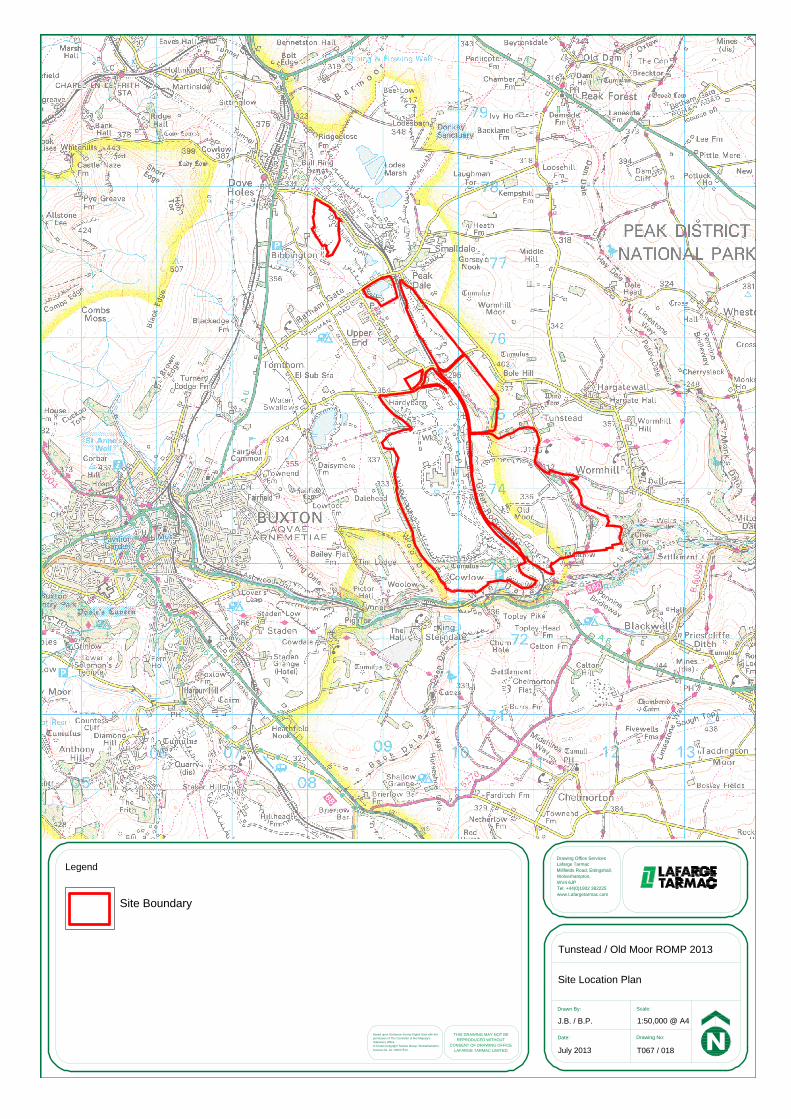
Drawing Office ServicesLafarge TarmacMillfields Road, Ettingshall,Wolverhampton,WV4 6JPTel. +44(0)1902 382225www.Lafargetarmac.com
THIS DRAWING MAY NOT BEREPRODUCED WITHOUT
CONSENT OF DRAWING OFFICELAFARGE TARMAC LIMITED
Legend
Drawn By: Scale:
Date: Drawing No:Based upon Ordnance Survey Digital Data with thepermission of The Controller of Her Majesty'sStationery Office.© Crown Copyright Tarmac Group, Wolverhampton,Licence No. AL 100017513 July 2013 T067 / 018
J.B. / B.P. 1:50,000 @ A4
Tunstead / Old Moor ROMP 2013
Site Location Plan
Site Boundary
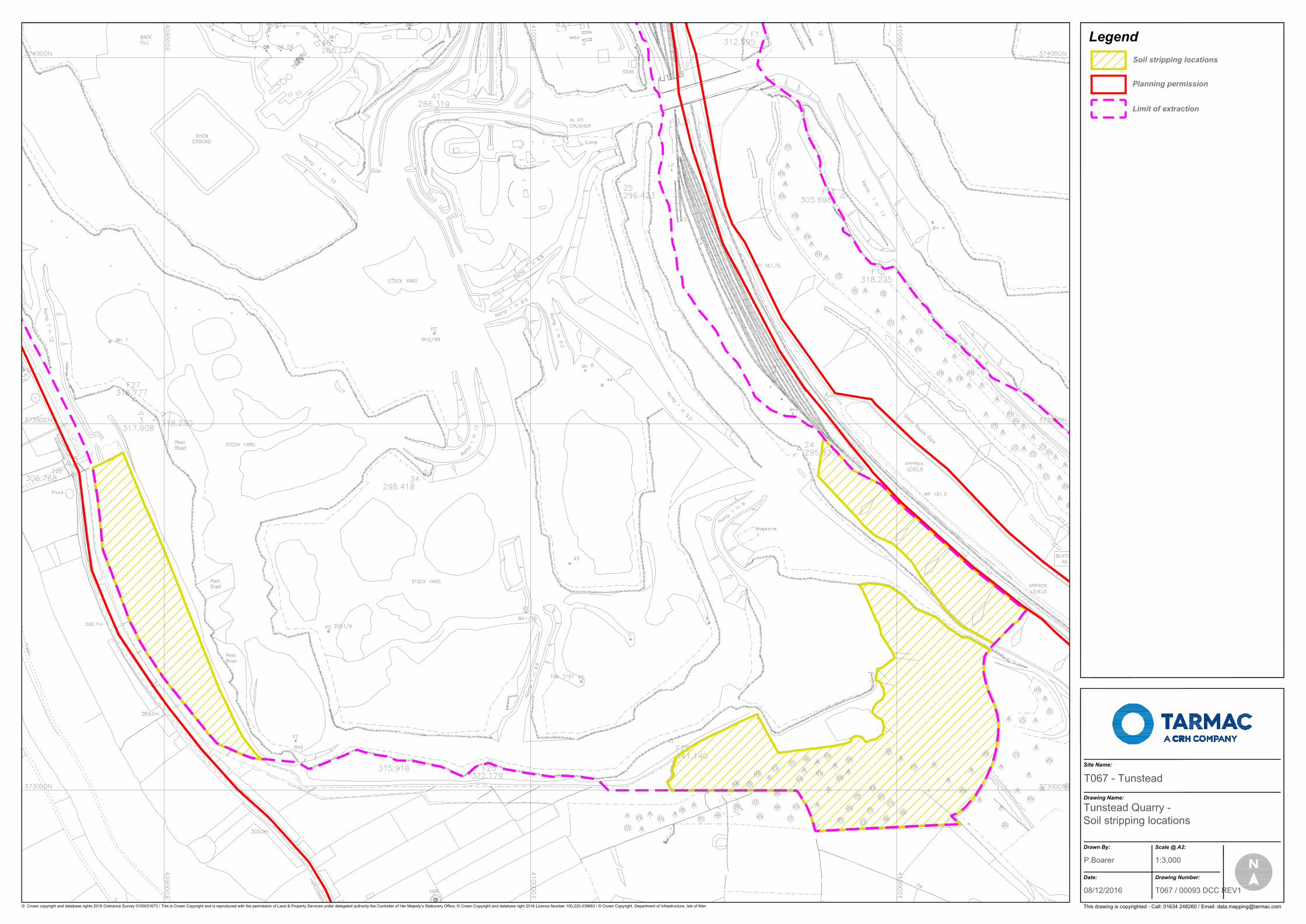
Soil stripping locations
This drawing is copyrighted - Call: 01634 248260 / Email: [email protected]
Date: Drawing Number:
Drawn By: Scale @ A2:
Drawing Name:
Site Name:
Legend
© Crown copyright and database rights 2016 Ordnance Survey 0100031673 / This is Crown Copyright and is reproduced with the permission of Land & Property Services under delegated authority the Controller of Her Majesty’s Stationery Office, © Crown Copyright and database right 2016 Licence Number 100,220-339663 / © Crown Copyright. Department of Infrastructure, Isle of Man
T067 - Tunstead
Tunstead Quarry -Soil stripping locations
P.Boarer 1:3,000
08/12/2016 T067 / 00093 DCC REV1
Planning permission
Limit of extraction