public comment sought on future of yuba … · public comment sought on future of yuba state park...
TRANSCRIPT

PUBLIC COMMENT SOUGHT ON FUTURE OF YUBA STATE PARK Utah State Parks and Recreation is developing a resource management plan (RMP) for Yuba State Park. The RMP will identify issues relating to public use, resource management, future
development at the park, and make recommendations to guide park managers for the next 10 years. The Yuba State Park planning meeting will be held Tuesday, June 5, 2007 at 7 p.m. in the Commission Chambers of the Juab County Courthouse, 160 N Main in Nephi, Utah. Park visitors and concerned citizens
are encouraged to assist in development of the plan by attending this meeting. State park planners will present the planning process and lead an exercise to identify and prioritize issues relating to the park. Members of the community, park visitors, and other interested parties are welcome and encouraged to attend. For additional information, please contact Shannon Peterson at (801) 538-7207. In compliance with the Americans with Disabilities Act, anyone needing special accommodations (including auxiliary communicative aids and services) should contact Wendy Griffith at (801) 538-7362 at least five working days before the meeting.
Kids' Fishing Month gets boost from pump prices
The high prices on gas pumps across the country don't have to siphon the life out of summer family fun, according to an organization that specializes in bringing families together through the recreation of fishing. Hooked On Fishing International (HOFI), the nation's largest organizer of community fishing events, has proclaimed June as National Kids' Fishing Month to kick off the summer vacation

season and to celebrate the rod and reel sport as a frequent and affordable way for families to spend quality time together without having to travel far.
"Virtually every community in America has dozens of fishable ponds, lakes, creeks and rivers within an hour's drive," said Daniel Johnson, HOFI president. "City and county park ponds often allow fishing during visitation hours and offer great places to catch sunfish and catfish."
It is community waters like these where most of HOFI's nearly 2,000 Wal-Mart Kids All-American Fishing (KAAF) derbies are held each year. Almost one-half of the events occur in the month of June. For families that have little or no fishing experience, the derbies provide an excellent opportunity for parents and kids to learn early in the summer season how and where to fish nearby.
Chances are good that a KAAF derby is already on the calendar just a short drive away. To find out, conduct a search using the Derby Locator at the organization's Web site: www.kids-fishing.com.
Local service or sportsmen's clubs typically host the KAAF events, so it is not unusual for acquaintances of the participants being the ones giving the expert fishing assistance and advice. Common, too, is for the seasoned anglers fishing alongside to also pitch in and help newcomers get started.
"Fishing is a social activity with no restrictions as to age, gender or race, and almost everyone shares in the success of a catch regardless of who makes it," Johnson said. "That's why the sport is the perfect all-family leisure time activity."
As for the "affordability" factor, Johnson elaborated that there isn't much of an investment necessary to get into fishing at the basic level. He said that fishing license requirements vary from state to state, but fees for a 12-month period typically cost less than just about any other kind of annual entertainment pass. Younger children usually don't even need a license, and senior adults are also often exempt or get discount privileges. Zebco, a well-known rod and reel manufacturer and longtime Kids All-American Fishing partner, makes a number of youth rod and reel combos that sell for under $20 per outfit. Hooks and sinkers cost only a few cents each. And coming up with the bait for an outing can be as simple as digging worms or catching grasshoppers - both of which can also be fun family activities. Then there's the cost of gasoline, but by staying close, even it isn't a big obstacle. Using the
Environmental Protection Agency's average national fuel economy of around 21 miles per gallon for the family vehicle, and staying within the hour's drive from home, the five gallons of gas or so burned is going to cost around $20. Not bad, especially when considered it is virtually impossible to take a family of five to a first-run movie for that kind of a price tag. So heed HOFI's advice for the summer of 2007 and take the family and friends on several nearby fishing outings as a fun and affordable alternative to that usual one extensive road trip vacation. To search for fishing waters close to home, either by county or zip code, visit TakeMeFishing.org and click on "Places to go." The KAAF derbies are made possible by the backing of marquee corporate partners Wal-Mart Stores Inc. and Zebco. The program receives additional support from some of the nation's top brands including Castrol, Coppertone, Eagle Claw, Fujifilm and Laker Fishing.
HOFI Inc., a Tulsa, Okla., company, is celebrating its 20th anniversary this year. Since its inception, more than eight million youngsters and their families have participated in the program at events held throughout all 50 states and at U.S. military bases as far away as England, Germany, South Korea, and Japan. For more information about KAAF derbies and other programs, visit www.kids-fishing.com.
Utah Athletic Foundation Announces U.S. Olympic Training Site Designation For Utah
Olympic Park And Utah Olympic Oval.
(Park City, UT) The Utah Athletic Foundation (UAF) is pleased to announce that both the Utah Olympic Park (UOP) and Utah Olympic Oval (UOO) have been designated as official U.S. Olympic Training Sites by the United States Olympic Committee (USOC). While both venues have served as training sites for numerous Olympic sports, this designation symbolizes the ever-growing partnership with the USOC. The new designations will allow the two facilities to further promote its ongoing sport development programs. Furthermore, the USOC and UAF have recently signed an operating agreement through the 2010 Winter Games that expands athlete training schedules and programs for the sports of Freestyle skiing, Nordic ski jumping, Speedskating, Bobsled, Skeleton, and Luge. Additionally, the Utah Athletic Foundation is excited to announce a new pricing structure for visitors to the Utah Olympic Park. Effective immediately, the Utah Olympic Park will offer free admission to the facility, with activities priced individually. Visitors to the Utah Olympic Park will now have the opportunity to visit the 2002 Winter Olympic and Alf Engen Ski Museums free of charge, in addition to watching elite and aspiring Olympic athletes train throughout the Park on the Nordic jumps, freestyle pool and Skeleton push track. Throughout the summer, families and visitors to the Utah Olympic Park can also participate in guided tours, 70 mile-per-hour bobsled rides, the World’s steepest zipline, the Quicksilver alpine

slide, freestyle aerial shows on Saturdays and a variety of sport camps for all ages and abilities, for an additional fee. For guests who want to experience it all, several combination packages are available, which include ziplines, alpine slide rides and bobsled rides ranging from $25 to $85. The UAF sees great potential to increase visitations, and ultimately exposure to the winter sports supported at the Utah Olympic Park by offering free admission to the public. “Ultimately, our goal will be to see an increase in our sport development programs and a healthy pipeline of athletes that will be the ultimate legacy of hosting a Winter Olympic Games in the State of Utah,” explains Colin Hilton, UAF’s President / CEO. The UAF continually strives to effectively and prudently utilize the earnings from the 2002 Winter Olympics endowment for the purposes of promoting a legacy of Olympic Winter Games sports. These operating and facility upkeep subsidies have allowed the UAF to keep user fees and public offerings at affordable rates. For more information please visit www.olyparks.com or call 435-658-4200. SAGEBRUSH GALLERY FEATURES ARTISTS JOSEPH VENUS AND SHARON
LINDE Sevier - The Sagebrush Gallery at Fremont Indian State Park and Museum displays the artwork of award-winning painter Joseph S. Venus and woodcarving artist Sharon Linde from June 2 through July 28. The public is invited to meet the artists at a reception June 2 from 2 to 5 p.m. Refreshments will be served, a drawing will be held, and the artists' work will be available for sale. Venus is known for his realistic paintings of the Fremont Indian culture, Utah's Ice Age, North American wildlife, mountain men and Native Americans. This past January, Venus released his first book, "The Art of Joseph S. Venus," which has been printed in a limited edition of 200. This 108-page book, dedicated to his late wife Shirley Ann Clark Venus, features 90 color reproductions with text that describes his inspiration. The book will be available for purchase during the show. "Creating this book was one of the most difficult, yet rewarding, tasks of my life," stated Venus. In addition to the book, Venus has created five educational coloring books based on his original paintings. A coloring contest will be held throughout the show based on one of his original paintings and is sponsored by the Shirley Venus Memorial Art Fund. The coloring contest is divided into age categories: 5 to 6, 7 to 9, and 10 to 12. Entries are due by July 27at noon. A $20 cash prize and ribbon will be awarded in each age category. The Shirley Venus Memorial Art Funds are used to "encourage budding artists to develop their

talents in honor of how Shirley encouraged Joe to pursue a career in art." Sharon Linde, a resident of Annabella, is a self-taught woodcarver. She moved to Sevier County in 2001 with her husband David Linde. She helped organize and has held various offices in the first woodcarving club in Utah from 1982 to 2001. She also served as the organizing president of Artworks of Sevier County. Linde has presented her work in 24 events and shows, and is currently showing at the Staples Art Center in Elsinore and at Big Rock Candy Mountain. She has won various awards and has been published in several woodcarving magazines and newspapers. "I feel much satisfaction in the process of gathering wood, whether it is locating wood to purchase or scouring the earth for burls, twisted limbs or pieces for bases. It is my desire that each carved piece verifies the beauty of wood, as well as my ability to present nature itself," stated Linde. Fremont Indian State Park and Museum is located 21 miles south of Richfield on I-70. The visitor center is open daily from 9 a.m. to 5 p.m. For more information, please call (435) 527-4631.
UTAH STATE PARKS LAUNCH AND WATER CONDITIONS All Utah state parks are open for the season. Camping, pavilion, and boat slip reservations are available by calling (801) 322-3770 or 1-800-322-3770 from outside the Salt Lake area. Utah State Parks reports launch ramp and water conditions for Tuesday, May 29, 2007: Bear Lake State Park Marina: Launch ramp open, 42 degrees Deer Creek State Park: Launch ramp open, 60 degrees East Canyon State Park: Launch ramp open, 59 degrees Wide Hollow at Escalante State Park: Launch ramp open, 60 degrees Great Salt Lake State Marina: Launch ramp open, 64 degrees Gunlock State Park: Launch ramp open, 65 degrees Huntington State Park: Launch ramp CLOSED, 52 degrees Hyrum Lake State Park: Launch ramp open, 63 degrees Jordanelle State Park: Launch ramp open, 45 degrees Millsite State Park: Launch ramp open, 44 degrees Otter Creek State Park: Launch ramp open, 62 degrees

Palisade State Park: Launch ramp open, 48 degrees Piute State Park: Launch ramp open, 64 degrees Quail Creek State Park: Launch ramp open, 70 degrees Red Fleet State Park: Launch ramp open, 64 degrees Rockport State Park: Launch ramp open, 60 degrees Sand Hollow State Park: Launch ramp open, 67 degrees Scofield State Park: Launch ramp open, 42 degrees Starvation State Park: Launch ramp open, 64 degrees Steinaker State Park: Launch ramp open, 58 degrees Utah Lake State Park: Launch ramp open, 66 degrees Willard Bay State Park: North Marina launch ramp open, 63 degrees Yuba State Park: Launch ramp open, 63 degrees DEBRIS, WATER HAZARDS REPORTED AT JORDANELLE STATE PARK Jordanelle State Park managers urge caution for boaters as runoff has flushed branches and other natural debris into the reservoir. Boaters are advised to keep a proper lookout for potential hazards. All campgrounds and day-use facilities at Jordanelle State Park are open for the season. Rock Cliff Nature Center, which is located on the southeast side of Jordanelle Reservoir, offers walk-in campsites and weekly nature programs for the entire family.
FIRE RESTRICTIONS
AT ANTELOPE ISLAND
STATE PARK Effective immediately, open fires are prohibited at Antelope Island State Park. Visitors may continue to use charcoal and propane for cooking with extreme caution. Fire restrictions will continue throughout summer and fall. COLLAGE ART
EXHIBIT AT ANTELOPE
ISLAND STATE PARK
ART GALLERY From June 2 through July 31, artist Debbie Goodman displays paper collage art at the Antelope Island State Park Visitor Center Art Gallery. The exhibit features a colorful display of Utah birds and wildlife. Passionate about wildlife conservation, Goodman donates proceeds from her

artwork sales to wildlife and humane organizations. The Antelope Island State Park Visitor Center is open 9 a.m. to 6 p.m. daily. For more information, please call Ashley Hill at (801) 725-9263 or [email protected] . UTAH STATE PARKS MARKS NATIONAL TRAILS DAY Help build, clear, or hike your favorite state park trail as part of National Trails Day Saturday, June 2. Volunteers are needed to help Antelope Island State Park staff remove materials from the newly graded section of the White Rock Bay Trail. Work begins at 10 a.m. Volunteers should wear long sleeved shirt, long pants, a hat, and should also bring sunscreen, water, and insect repellent. Please bring shovels and rakes if you have them. Volunteers are encouraged to RSVP by June 1 by calling (801) 773-2941. At 9 p.m. the Antelope Island State Park naturalist leads a full moon hike to Beacon Knob. This hike is eight miles long at moderate difficulty. Bring water, sturdy shoes, bug spray, headlamp or flashlight, snack, and a sense of adventure. Reservations are required; please call (801) 721-9569. The Mountain Trails Foundation will work on Historic Union Pacific Rail Trail State Park from 9 a.m. to noon. Meet at 9 a.m. for coffee and bagels at White Pine Touring in Park City. Then, bike or ride to Wanship for fencing and weedcloth work with lunch at noon by the Spring Chicken Inn at the Wanship Trailhead. For more information, please visit
http://www.mountaintrails.org or call (435) 649-6839. Volunteers are also needed at 9 a.m. to work on the Lakeview Trail at Rockport State Park. Volunteers will be pulling the downhill berm off the trail, cutting the trail backslope, and smoothing the trail. Volunteers should meet at the park maintenance building. Wasatch Mountain State Park is working on
the Dutch Hollow Trail system from 9 a.m. to 4 p.m. At 9 a.m. participants will hike approximately one mile to the Heber Valley Overlook and help install a new interpretive sign. Volunteers should bring gloves. At 4 p.m. participants will hike along the trails of Wasatch Mountain State Park. Bring snacks, water, and wear sturdy hiking shoes. For more information on National Trails Day events, visit http://www.americanhiking.org .

Utah Wildlife Board Meeting
June 7, 2007, 9:00 A.M. Utah Museum of Natural History 496 East Main, Vernal, UT
AGENDA
Thursday, June 7, 2007
1. Approval of Agenda ACTION – Dr. Jim Bowns, Chairman
2. Approval of Minutes ACTION – Dr. Bowns 3. Old Business/Action Log CONTINGENT – Dick Diamond, Vice-Chair
4. DWR Update INFORMATION – Jim Karpowitz, DWR Director 5. Panguitch Lake INFORMATIONAL - Dr. Bowns, Wildlife Board Chairman 6. Aquatic Proposals INFORMATIONAL - Roger Wilson, Wildlife Program Coordinator 7. Senate Bill 161 – Multiple Rule Amendments ACTION - Staci Coons, Rules, RAC and Wildlife Board Coordinator 8. Mandatory Harvest Reporting Proposal R657-42 ACTION -Judi Tutorow, Wildlife Licensing Coordinator 9. Use of Division Lands R657-28 ACTION
- Stephen Hansen, Wildlife Program Manager 10. Adjudicative Proceedings R657-26 ACTION -Michal Fowlks, Law Enforcement Chief 11. Walk–In Access Rule R657-56 ACTION -Boyde Blackwell, Private Lands/Public Wildlife Coordinator 12. 2007 Northern Region Youth Pheasant Hunt Location ACTION -Dean Mitchell, Wildlife Program Manager 13. Northern Region Least Chub & Spotted Frog Reintroductions ACTION
- Craig Schaugaard, Wildlife Program Manager

-continued-
14. Southern Region Proposed Native Trout Projects ACTION
- Michael Ottenbacher, Wildlife Program Manager 15. Strategic Plan and DVD ACTION
– Jim Karpowitz, DWR Director 16. Other Business CONTINGENT
– Dr. Bowns
In compliance with the Americans with Disabilities Act - Persons needing special
accommodations (including auxiliary communicative aids and services) for this meeting,
should contact Staci Coons at 801-538-4718, giving her at least five working days notice.
SUPER SHERPAS RETURN TO SALT LAKE CITY AFTER SETTING WORLD-
RECORD ON MOUNT EVEREST
Salt Lake City, UT – On Wednesday, May 30th, local members of the SuperSherpas team will return to Salt Lake City, Utah after a successful summit of the world’s highest mountain, Mount Everest. Apa & Lhakpa Sherpa, both now Salt Lake residents, led an all-Sherpa expedition to raise awareness of the rarely told story of their people. In doing so, Apa Sherpa also set a new world record with his 17th summit of Mount Everest. Lhakpa Sherpa continues to hold the world record for the fastest summit of the mountain, at just under 11 hours. Lhakpa will be accompanied by his three children, who will now reside in Salt Lake City, Utah, after receiving US Consulate approval through the generosity of a U.S. sponsor. Jerry Mika, Base Camp Manager, will be with the group as well, after working with the team for the past six weeks at Basecamp and throughout Nepal. All media are invited to cover the SuperSherpas’ arrival at the Salt Lake International Airport. The group will arrive on Southwest Flight #548 at 9:35am on Wednesday, May 30th. Airport officials have approved the Southwest baggage claim area at Terminal 1 for interviews, following their arrival. Additional photos and video will be available through media contact Katie Eldridge at the airport. Live interview requests can be made by contacting [email protected] or by calling 435-640-2554. In addition to setting a new world record, the team conducted breakthrough medical research with the help of TOSH and University of Utah’s Medical Department. The SuperSherpas Expedition was documented through a professional high-definition camera crew. The footage will be used in an upcoming film, revealing the untold story of the lives of the people indigenous to the Himalya, the Sherpas.
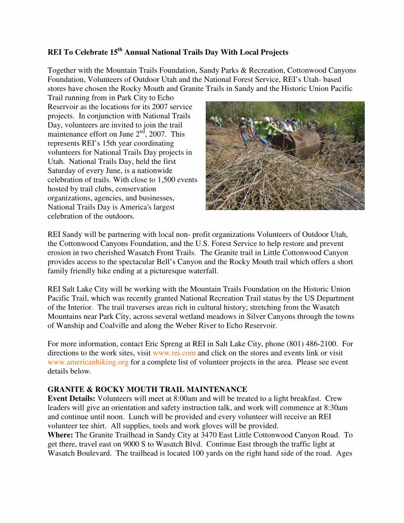
REI To Celebrate 15th
Annual National Trails Day With Local Projects
Together with the Mountain Trails Foundation, Sandy Parks & Recreation, Cottonwood Canyons Foundation, Volunteers of Outdoor Utah and the National Forest Service, REI’s Utah- based stores have chosen the Rocky Mouth and Granite Trails in Sandy and the Historic Union Pacific Trail running from in Park City to Echo Reservoir as the locations for its 2007 service projects. In conjunction with National Trails Day, volunteers are invited to join the trail maintenance effort on June 2nd, 2007. This represents REI’s 15th year coordinating volunteers for National Trails Day projects in Utah. National Trails Day, held the first Saturday of every June, is a nationwide celebration of trails. With close to 1,500 events hosted by trail clubs, conservation organizations, agencies, and businesses, National Trails Day is America's largest celebration of the outdoors. REI Sandy will be partnering with local non- profit organizations Volunteers of Outdoor Utah, the Cottonwood Canyons Foundation, and the U.S. Forest Service to help restore and prevent erosion in two cherished Wasatch Front Trails. The Granite trail in Little Cottonwood Canyon provides access to the spectacular Bell’s Canyon and the Rocky Mouth trail which offers a short family friendly hike ending at a picturesque waterfall. REI Salt Lake City will be working with the Mountain Trails Foundation on the Historic Union Pacific Trail, which was recently granted National Recreation Trail status by the US Department of the Interior. The trail traverses areas rich in cultural history; stretching from the Wasatch Mountains near Park City, across several wetland meadows in Silver Canyons through the towns of Wanship and Coalville and along the Weber River to Echo Reservoir. For more information, contact Eric Spreng at REI in Salt Lake City, phone (801) 486-2100. For directions to the work sites, visit www.rei.com and click on the stores and events link or visit www.americanhiking.org for a complete list of volunteer projects in the area. Please see event details below. GRANITE & ROCKY MOUTH TRAIL MAINTENANCE Event Details: Volunteers will meet at 8:00am and will be treated to a light breakfast. Crew leaders will give an orientation and safety instruction talk, and work will commence at 8:30am and continue until noon. Lunch will be provided and every volunteer will receive an REI volunteer tee shirt. All supplies, tools and work gloves will be provided. Where: The Granite Trailhead in Sandy City at 3470 East Little Cottonwood Canyon Road. To get there, travel east on 9000 S to Wasatch Blvd. Continue East through the traffic light at Wasatch Boulevard. The trailhead is located 100 yards on the right hand side of the road. Ages

sixteen or over please. Time: Saturday, June 2nd, 8:00a.m. On site coordinator: Kristen Kenley (801) 725-8220 Web site: www.rei.com/trailsday Advance Registration: Required- please call REI Sandy at (801) 501-0850 for details or email [email protected] WORKIN’ ON THE RAIL TRAIL Event Details: Park City. Join us at 9am for Starbuck’s coffee, bagels, and a special presentation commemorating the Historic Union Pacific Rail Trail. Participants are then invited to bike a thirteen- mile stretch of the trail to Wanship, or meet the work party there via driving.
Mountain Trails Foundation will provide tools for weeding and fence work at the Wanship trailhead. A full lunch from the Spring Chicken Inn will be served at 12:30. All participants will receive a unique event Tee shirt. All ages welcome! Where: Meet
at the Trailhead at Rail Central White Pine Touring on Bonanza. To get there, take 1-80 to Kimball Junction, 22 to Kearns Blvd, turn right on Bonanza. The Wanship Trailhead can be reached by taking I-80 to the Wanship Exit. Follow the signs from there. When: Saturday, June 2nd, 9:00am On site coordinator: Eric Spreng (801) 703-1584 Web site: www.rei.com/trailsday or www.mountaintrails.org Advance Registration: Not Required About REI:
Community service has been an REI core value for more than six decades. Since REI employees also play and volunteer in the communities in which it conducts business, REI maintains a tradition of annual store service projects, bringing together employees, members and volunteers from a variety of organizations to improve local outdoor resources. In 2006, through service projects, event sponsorships, and grant support, REI effectively inspired 169,015 volunteers who

collectively donated 900,767 hours working on trails, waterways, parks, and public lands throughout the country. REI (Recreational Equipment, Inc.), founded in 1938 as a consumer co-op by a group of Pacific Northwest mountaineers, is a national multi-channel retailer of quality outdoor products. REI sells all of the top outdoor brands, including its own line of award-winning gear and apparel. While anyone may join or shop at REI, members pay a one-time $15 fee and receive a share in the company’s profits through an annual patronage refund based on their purchases. A portion of REI’s profits is set aside each year for support of conservation, outdoor recreation and environmental stewardship causes, with more than $9 million since 1976, to such efforts around the country. In addition to REI’s Salt Lake and Sandy stores, REI operates 92 retail stores in 24 states; two online stores – www.REI.com and www.REI-OUTLET.com – and an adventure travel company; REI Adventures.
FISHING REPORT FOR SOUTHEASTERN UTAH
GENERAL Fishing success was spotty over the Memorial Day weekend, primarily due to
blustery weather. If you didn’t get a chance to dip a line, mark your calendar for Free
Fishing Day on Saturday, June 9th.
On that day, you don’t need a license to fish! Check
the proclamation though, because all other rules apply.
ABAJO MOUNTAINS No recent report. BENCHES POND Fishing was generally good for both carry-over and freshly planted trout. The best bait was a nightcrawler. BOULGERS RESERVOIR Fishing was best in deep water closer to the dam. Nightcrawlers were the ticket. CLEVELAND RESERVOIR Fishing success was good with green or orange sparkle PowerBait. The best technique was floating it off the bottom with leader and a slip sinker. Cutthroats averaged about 1.5 lbs. Most rainbows were 9-10 inch planters. DUCK FORK RESERVOIR No report. ELECTRIC LAKE Fishing was hit-and-miss over the weekend. Anglers on the north end used a variety of baits with variable success. Wind and choppy water seemed to be a determining factor. Boaters had better success than bank anglers, trolling with silver spoons. Wooly buggers or leeches continue to produce trout for fly fishermen. FAIRVIEW LAKES No report on fishing success. FERRON RESERVOIR No report. GIGLIOTTI POND Try a fly and clear bubble, attached with 3 feet of leader. An olive wooly bugger has been effective. It’s best to fish before sunup or after sundown. Baitcasters have done reasonably well with salmon eggs and worms. GOOSEBERRY RESERVOIR Ken Jones of Orem reported excellent fishing with an inflated nightcrawler, fished just off the bottom in the deepest water you can find. Tom Ogden fished from a tube on Sunday for 1.5 hours and caught 3 cutts and 6 rainbows. All ranged between 11-14 inches. Tom used a size 10 olive wooly bugger, fished close to the shoreline. GRASSY LAKE Fishing has been good with nightcrawlers or Jake’s Spin-a-Lures. HUNTINGTON CREEK Tom Ogden has traditionally had the best luck with a beadhead Montana, beadhead prince nymph or ugly pattern in sizes 10-12.

HUNTINGTON NORTH STATE PARK The water is extremely low, leaving the boat ramp high and dry. Very little fishing pressure. Slow fishing conditions. HUNTINGTON RESERVOIR (also known as MAMMOTH RESERVOIR) The secret of success, according to Ken Jones, is fishing very early in the morning. He prefers fishing an inflated nightcrawler, just off the bottom. Two weeks ago, the best technique involved “swimming” a straight nightcrawler on 3 feet of leader in front of a full bubble. A soft plastic bait that imitates a small trout or minnow has also been very effective. Kastmasters in a variety of colors and patterns have been catching tigers. As of June 7, using motorboats with 10 horsepower or more will be prohibited. This reservoir has special regulations. All cutthroat trout must be immediately released. JOES VALLEY RESERVOIR Fishing ranged from slow to fair over the Memorial Day weekend. Most of the anglers were targeting trophy splake, following the catch of an 11 pounder on Mother’s Day weekend. Special regulations apply at this reservoir. The limit is two fish. Only one may be over 22 inches. All trout from 15-22 inches must be immediately released. LAKE POWELL Visit http://www.wayneswords.com for the fishing report, provided by Wayne Gustaveson, DWR project leader. LASAL MOUNTAINS Conservation Officer Casey McVay says that most LaSal Mountain lakes have been stocked or hold carry-over fish. He reported good fishing at Don’s, Medicine, Beaver, and Dark Canyon. Hidden Lake continues to be the top fish producer. Casey indicated that a small spinner seems to work best. Oowah and Warner lakes are now accessible LOWER FISH CREEK Fishing success was sporadic, ranging from slow to good. Below the dam, Dale Hamilton of Orem recommended a caddis fly or hare’s ear. One angler creeled a
number of trout with pop gear and worm beneath the spillway. Tom Ogden suggests a beadhead Montana, beadhead prince nymph or ugly pattern in sizes 10-12. Below the dam, rainbows, browns and tiger trout range between 8-12 inches. The road from Highway 6 to lower Fish Creek is open. On the DWR easement, nymphs have been effective for 12-16 inch brown trout. MILLER FLAT Over the weekend, success varied from day to day. Most anglers used traditional baits. MILLSITE RESERVOIR No recent report. PETES HOLE Fishing success has been sporadic. Neighboring Academy Mill Reservoir has been good for small brook trout with Jake’s Spin-a-Lures. POTTER’S PONDS Success has been variable. Both ponds were freshly stocked last week. SCOFIELD RESERVOIR Wind cut into fishing action last weekend. Aquatics Manager Paul Birdsey reported that anglers trolling silver flatfish or Rapalas under 3-4 colors of leaded

line had the best success. Tom Ogden fished Saturday, Sunday and Monday from a float tube. He had best success with dark-colored wooly buggers and leeches in size 8, fished on the bottom in 10-12 feet of water. Tom’s catch was split between rainbows and tiger trout. Many were about 17 inches long. One rainbow was 21 inches and weighed more than 3 lbs. In general, creeled rainbow trout average 18 inches. One year-old tigers are 11-12 inches and two year-olds get up to 18 inches. Attention anglers! Please do not use live fish as bait—this practice is illegal across the state and causes serious damage to a fishery. During the annual gillnetting survey last week, DWR biologists netted 53 chubs. This is alarming, since chubs have ruined many fisheries in Utah, including Joes Valley Reservoir, Strawberry Reservoir and others. Anglers can avoid a potential tragedy by using only dead minnows as bait. WRIGLEY SPRINGS RESERVOIR No recent report. WILLOW RESERVOIR The U.S. Forest gate has been opened. No report on fishing success. If you’d like to see reports of waters around the state, visit the following Division website: http://www.wildlife.utah.gov/fishing/reports.php SAWS Editorial: Fast-tracking "roadless" and "wilderness"
May 27, 2007 The words “roadless” and “wilderness” should be of utmost concern to all those whose recreational pursuits include snowmobiling and other activities that require motorized access to public/federal land. Knowing their meanings will help readers understand my concerns as stated in this article. “…there shall be no temporary road, no use of motor vehicles, motorized equipment or motorboats, no landing of aircraft, no other form of mechanical transport, and no structure or installation within any such area.” – The Wilderness Act of 1964. Many elected officials in America’s western states have cast a pall over the 110th Congress, which is ominous to those supporting multiple-use of our national forests. Many voters don’t yet know how forests must be properly managed. Responsible reduction of both disease and catastrophic fire hazards makes healthy American public timber land abundantly available for recreation and harvesting of this vitally needed renewable resource. The Forest Service was created under the auspices of the U.S. Department of Agriculture to be a land management agency. The lockdown of our national forests by fast-tracking “roadless” and “wilderness” designation blows an ill wind upon these lands. Land management does not occur in roadless and wilderness areas. At this rate (roadless and wilderness designation), the Forest Service will soon be obsolete: There is no need for a land management agency without any land available to manage. However, another federal agency would be created to deal with the massive forest fires, so there would be no savings to the taxpayers.

Here are but a few of the current bills impacting public access in western states currently offering snowmobiling opportunities on public land: Multiple State anti-access bills:
Roadless bills – Two bills to “protect” 58.5 million acres of so-called roadless national forests across the United States were recently re-introduced in the U.S. House and Senate by WA Rep. Jay Inslee and WA Sen. Maria Cantwell. Northern Rockies Ecosystem Protection Act (H.R. 1975). This bill would designate 20.5 Million acres as wilderness in the states of ID, MT, OR, WA and WA. This bill would put in place the American component of the “Yellowstone to Yukon” portion of “The Wildlands Project.” State-specific wilderness bills:
AK: Udall-Eisenhower Arctic Wilderness Act (H.R. 39). The Udall-Eisenhower Arctic Wilderness Act would designate 1.5 million-acres of wilderness. CA: California Wild Heritage Act of 2007 (H.R. 860/S.493). The California Wild Heritage Act of 2007 would designate over 2.4 million acres of wilderness. ID: Central Idaho Economic Development and Recreation Act (H.R. 222). This bill would designate more than 300,000 acres in Idaho’s Boulder-White Clouds Mountains as wilderness. ID: Owyhee Initiative Implementation Act (S. 802). This legislation would permanently put off-limits 517,000 acres as wilderness. OR: Lewis and Clark Mount Hood Wilderness Act of 2007 (S. 647). This bill would designate nearly 129,000 acres on Mount Hood and in the Columbia River Gorge as wilderness. WA: Wild Sky Wilderness Act of 2007 (H.R. 886/S. 520). This bill would close 106,000 acres in Washington State’s Mt. Baker-Snoqualmie National Forest by designation as wilderness. 95.8 Million acres are already under wilderness designation in these ten states, with 53.7 more acres designated as “roadless.” Note: The Forest Service currently manages 34.8 million acres of wilderness across the United States.
AK – 57.5 million acres of wilderness. 14.8 million acres Roadless. CA – 14.1 million acres of wilderness. 4.4 million acres Roadless.
CO – 3.4 million acres of wilderness. 4.4 million acres Roadless.
ID – 4.0 million acres of wilderness. 9.3 million acres Roadless.
OR – 2.3 million acres of wilderness. Nearly 2 million acres Roadless. MT – 3.4 million acres of wilderness. 6.4 million acres Roadless.
NV – 2.9 million acres of wilderness. 3.2 million acres Roadless.
UT – 0.8 million acres of wilderness. 4.0 million acres Roadless.

WA - 4.3 million acres of wilderness. 2.0 million acres Roadless.
WY – 3.1 million acres of wilderness. 3.2 million acres Roadless.
Current pending legislation, “public-private partnerships” that effectively bind federal policy to whatever “green” organizations deem, and the new Forest Service plan revisions recommending enormous amounts of acreage for new wilderness – which go hand-in-hand with closing more public land – all attempt to move 53.7 million “roadless” acres from the right column to the left column. The more forestland that is locked up and left unmanaged, the more forests will degrade and die from disease and bug infestations. These “protected forests” are on a fast track to conflagration. “Endangered species” lose the optimum habitat for which the claim is made that virtually all forests and federal land are needed, when the entire landscape is sterilized by FIRE. In just the past six years, 49 million acres have burned nationwide according to the National Interagency Fire Center. Most of this acreage is either Forest Service or otherwise federal land. “Five former Forest Service chiefs recently told Congress those soaring costs are affecting
everything from campground maintenance to research on national forest lands”. As stated in the linked article, “at one time, the Forest Service depended on the funds it took in from its timber
sale program to keep its checkbook in the black.” That is no longer the case. And of course the other inferior alternative is to just let the fires burn. There are very limited options for fighting fires within wilderness areas and the best available option – fighting these fires by air – is very expensive as mentioned above. You certainly will not see any bulldozed fires lines around wilderness forest fires or fire control access roads. It seems far cheaper, short-term, to harvest timber in third-world countries with very few or no environmental laws and ship the timber to America to support our huge demand. Over the long-term, however, stripping other countries’ trees and other resources simply spits upon the “sustainable” sales pitch being used by global corporate magnates. By that time, those in control of our forests intend to have their way back here at home, with no rural property owning voices to warn us. Timber growth and harvest, recreation in rural parts of America and the responsibility for our own backyards means utilizing our own resources. This benefits everyone – except those with a vested interest in outsourcing American labor and production in favor of exploitative “cheap labor” and “cheap products.” Dave Hurwitz Snowmobile Alliance of Western States Additional research and editorial assistance provided by Julie Kay Smithson [email protected] Julie’s website: http://www.propertyrightsresearch.org
Copyright 2007, Snowmobile Alliance of Western States. All Rights Reserved. Permission is granted to distribute this information, in whole or in part, as long as Snowmobile Alliance of Western States (SAWS) is acknowledged as the source. If you are not yet a member of SAWS, and would like receive our emails, please sign up on our web site today. SAWS is Free to join! http://www.snowmobile-alliance.org Reference information: It is important to know the difference between “roadless” and “wilderness.” Roadless – An area in a national forest or national grassland that 1) is larger than 5,000 acres or, if smaller, contiguous to a designated Wilderness or primitive area, or lies east of the 100th Meridian and therefore under the jurisdiction of the Eastern Wilderness Act, and 2) do not contain improved roads maintained for travel by standard passenger-type vehicles, and 3) has been inventoried by the Forest Service for possible inclusion in the Wilderness Preservation System. – Appendix H (Biological Assessment and Evaluation for Revised Land and Resource Management Plans and Associated Oil and Gas Leasing Decisions) http://www.fs.fed.us/ngp/final/pdf_feis/Appendix_H.pdf 2. For the purpose of the wilderness review program, this refers to the absence of roads, which have been improved and maintained by mechanical means, to ensure relatively regular and continuous use. A way maintained solely by the passage of vehicles does not constitute a road. Words and phrases used in the above definition of "roadless" are defined as follows: 1. Improved and maintained: Actions taken physically by man to keep the road open to vehicular traffic. "Improved" does not necessarily mean formal construction. "Maintained" does not necessarily mean annual maintenance. 2. Mechanical means: Use of hand or power machinery or tools. 3. Relatively regular and continuous use: Vehicular use, which has occurred and will continue to occur, on a relatively regular basis. Examples are: Access roads for equipment to maintain a stock water tank or other established water sources; access roads to maintained recreation sites or facilities; or access roads to mining claims. (DOI/BLM) http://www.ut.blm.gov/utahwilderness/imp/impglossary.htm 3. Refers to the absence of roads constructed and maintained by mechanical means. – McGregor Range Draft Resource Management Plan Amendment and Environmental Impact Statement, Prepared for United States Department of the Interior Bureau of Land Management, Las Cruces (New Mexico) Field Office, January 2005. http://www.nm.blm.gov/lcfo/mcgregor/docs/Draft%20RMPA_EIS_01_05_low.pdf (DOI/BLM) Glossary (Pages 259-268 of 282) Wilderness – An area of undeveloped Federal land retaining its primeval character and influence, without permanent improvement or human habitation, that is protected and managed so as to preserve its natural conditions and that (1) generally appears to have been affected primarily by the forces of nature, with the imprint of man’s work substantially unnoticeable; (2) has outstanding opportunities for solitude or a primitive and unconfined type of recreation; (3) has at least 5,000 acres of land or is of sufficient size as to make practicable its preservation and use in an unimpaired condition; and (4) may also contain ecological, geological, or other features

of scientific, educational, scenic, or historical value. – Draft Environmental Impact Statement, Pit 14 Coal Lease-by-Application, DOI/BLM http://www.wy.blm.gov/nepa/rsfodocs/pit14/DEIS/09chap5-ref-glos.pdf (pages 15-18 of 18) 2. Those areas protected by the provisions of the 1964 Wilderness Act. These areas are characterized by a lack of human interference in natural processes. http://www.nps.gov/yose/planning/sfbridge/ch4.htm 3. A designated area defined in the Wilderness Act of 1964 in the following way: A wilderness, in contrast with those areas where man and his own works dominate the landscape, is hereby recognized as an area where the earth and its community of life are untrammeled by man, where man himself is a visitor who does not remain. An area of wilderness is further defined to mean in this Act an area of undeveloped federal land retaining its primeval character and influence, without permanent improvements or human habitation, which is protected and managed so as to preserve its natural conditions and which: (a) generally appears to have been affected primarily by the forces of nature, with the imprints of man’s work substantially unnoticed; (b) has outstanding opportunities for solitude or a primitive and unconfined type of recreation; (c) has at least five thousand acres of land or is of sufficient size as to make practicable its preservation and use in an unimpaired condition; and (d) may also contain ecological, geological, or other features of scientific, educational, scenic, or historical value. – KIPZ – Kootenai and Idaho Panhandle National Forests http://www.fs.fed.us/kipz/documents/reference/glossary.shtml 4. The definition contained in Section 2(c) of the Wilderness Act of 1964 (78 Stat. 891). (See Appendix B for its full text.) (DOI/BLM) http://www.ut.blm.gov/utahwilderness/imp/impglossary.htm 5. Areas designated by Congressional action under the 1964 Wilderness Act or subsequent Acts. Wilderness is defined as undeveloped federal land retaining its primeval character and influence without permanent improvements or human habitation. Wilderness areas are protected and managed to preserve their natural conditions, which generally appear to be affected primarily by the forces of nature, with the imprint of human activity substantially unnoticeable. Wilderness areas have outstanding opportunities for solitude or for a primitive and confined type of recreation. They include at least 5,000 acres or are of sufficient size to make practical their preservation, enjoyment and use in an unimpaired condition; they may contain features of scientific, educational, scenic or historic value as well as ecologic and geologic interest. – Appendix H (Biological Assessment and Evaluation for Revised Land and Resource Management Plans and Associated Oil and Gas Leasing Decisions) http://www.fs.fed.us/ngp/final/pdf_feis/Appendix_H.pdf and The Forest Ecosystem Management Assessment Team (FEMAT) http://pnwin.nbii.gov/nwfp/FEMAT/ Chapter 9 Glossary http://pnwin.nbii.gov/nwfp/FEMAT/Chapter_9.htm 6. All lands included in the National Wilderness Preservation System by public law; generally defined as undeveloped Federal land retaining its primeval character and influence without permanent improvements or human habitation. – Bureau of Land Management "This glossary defines terms used by the Forest Service and Bureau of Land Management to explain natural resource concepts and management activities specific to this final environmental impact statement and proposed plan amendment." http://www.mt.blm.gov/ea/ohv/Glossary.pdf (Page 7/199 of 7 pages; 68 KB)
Blue Moon over North America 05.30.2007
+ Play Audio | + Download Audio | + Email to a friend | + Join mailing list

May 30, 2007: At 9:04 pm Eastern Daylight Time on May 31st, the full moon over North America will turn blue.
Not really. But it will be the second full moon of May and, according to folklore, that makes it a Blue Moon.
Above: The first full moon of May 2007, photographed May 2nd by Tony Wilder of Wisconsin. May's second full Moon on May 31st will probably look as gray as this one, although according to folklore, it is "blue."
If you told a person in Shakespeare's day that something happens "once in a Blue Moon" they would attach no astronomical meaning to the statement. Blue moon simply meant rare or absurd, like making a date for "the Twelfth of Never."
But "meaning is a slippery substance," writes Philip Hiscock of the Dept. of Folklore, Memorial University of Newfoundland. "The phrase 'Blue Moon' has been around a long time, well over 400 years, and during that time its meaning has shifted."
The modern definition sprang up in the 1940s. In those days the Maine Farmer's Almanac offered a definition of Blue Moon so convoluted even professional astronomers struggled to understand it. It involved factors such as ecclesiastical dates of Easter and Lent, tropical years, and the timing of seasons according to the dynamical mean sun. Aiming to explain blue moons to the layman, Sky & Telescope published an article in 1946 entitled "Once in a Blue Moon." The author James Hugh Pruett (1886-1955) cited the 1937 Maine almanac and opined that the "second [full moon] in a month, so I interpret it, is called Blue Moon."
This was not correct, but at least it could be understood. And thus the modern Blue Moon was born. A detailed account of the story may be found here.
Surveying the last four centuries of literature and folklore, "I have counted six different meanings which have been carried by the term," recounts Hiscock. In song, for instance,

Blue Moons are a symbol of loneliness; when love conquers all, the Blue Moon turns gold. (See old Elvis records for more information.) "This makes discussion of the term a little complicated," he says.
One complication is that the Moon can turn genuinely blue, as shown in this photo taken by Tom King of Watauga, Texas:
Above: A blue Moon photographed in October 2003 by Tom King of Watauga, Texas. "Here is a picture from a different night provided as a sanity check to assure you that my moon shots do not always have this blue hue," says King.
"I had never paid any real attention to the term 'Blue Moon' until one October evening in 2003," he recalls. "I had my telescope set up in the backyard and the moon began rising in the east with a strange blue tint I had not seen before."
The cause of the blue was probably tiny droplets of water in the air. "The air was damp and heavy with moisture," notes King. When water droplets are about 1 micron (one millionth of a meter) in diameter, they strongly scatter red and green light while allowing other colors to pass. A white moonbeam passing through such a misty cloud turns blue.
Clouds of ice crystals, fine-grained sand, volcanic ash or smoke from forest fires can have the same effect. "The key," notes atmospheric optics expert Les Cowley, "is that the airborne particles should all be of very similar size, a micron or so in diameter." Only then do they scatter the correct wavelengths of moonlight and act as a blue filter.
There are other reasons for blue Moons, he notes. "Our eyes have automatic 'white balances' just like digital cameras. Go outdoors from a cozy cabin lit by an oil lamp (yellow light) and the Moon will appear blue until your eyes adjust."
What kind of Blue Moon will you see this week? There's only one way to find out!
SEND THIS STORY TO A FRIEND

Author: Dr. Tony Phillips | Production Editor: Dr. Tony Phillips | Credit: Science@NASA
More to the story...
What about Europe? Because of time zones, this week's full Moon occurs over Europe on June 1st rather than May 31st. In Europe, therefore, it is the month of June which has two full Moons, and a Blue Moon on June 30th. In North America, May has two full Moons and a Blue moon on May 31st.
A note of irony: Blue moons that really exist are wildly unpredictable. Who can say when a volcano will spew perfectly-proportioned ash into the stratosphere? Or when a Texas mist of micron-sized water droplets will waft in front of the rising moon?
The absurd blue moons of folklore, on the other hand, no longer take anyone by surprise. Full moons are separated by 29.5 day intervals--the moon's synodic period. By counting out synodic intervals, and checking to see when a pair of full moons falls into a single 30- or 31-day month, we can easily and precisely figure out when the next blue moon is due: Dec. 31, 2009. Mark your calendar.
"This new blue moon has a kind of technical meaning which most of the earlier ones lacked," notes Hiscock. "Perhaps as a result it will last a whole lot longer."
Folklore of the Blue Moon -- by Philip Hiscock of the Dept. of Folklore, Memorial University of Newfoundland
Blue Moons and Lavender Suns -- (Alaska Science Forum)
What's a Blue Moon? According to the editors of Sky & Telescope, the definition of "blue moon" as the second full Moon in a month is a mistake.
NASA's future: The Vision for Space Exploration
Sign up for EXPRESS SCIENCE
NEWS delivery
SAWS ACTION ALERT:
Yellowstone National Park / Grand Teton National Park
Winter Use Plans DEIS
Comment Deadline: June 5th, 2007
For your convenience, comments may be submitted using the online form found here: Winter Use Plans DEIS comment link or http://parkplanning.nps.gov/commentForm.cfm?parkID=111&projectID=12047&documentId=18456

Part of the form includes an option for identifying organization membership. SAWS hopes that you will write ‘SAWS’ or ‘Snowmobile Alliance of Western States’ in the organization field, and check the ‘Member’ box. You may also mail comments. Be sure to include your name and address if mailing a copy of your letter to: Winter Use Planning Team P.O. Box 168 Yellowstone National Park, WY 82190 Previous SAWS Alerts concerning Yellowstone Nationals Park (YNP) & Grand Teton Nationals Park (GTNP) can be found here: Winter Use and EIS – 2005 Temporary Winter Use EA – 2004 If you would like to read the plan documents, the latest Winter Use Plans for Yellowstone and Grand Teton National Parks can be found here: http://parkplanning.nps.gov/document.cfm?parkId=111&projectId=12047&documentID=18456 SAWS supports Alternative 4! The current winter plan DEIS contains six alternatives. We are not going to discuss Alternatives 2 and 3 because they are too restrictive; nor Alternative 6 because it adds expenses to an already cash-strapped national park system. Alternative 1, the preferred alternative, continues the current winter plan which allows 720 snowmobiles into YNP and 140 snowmobiles into GTNP daily. SAWS sees two problems with the current plan. First, all snowmobile trips into YNP require commercial guides. While commercial guiding has all but eliminated speeding and wildlife harassment on the YNP trail system, there is still no option for responsible individuals and groups to enjoy the scenic wonders of the park at their own pace. The other problem concerns the closure of Sylvan Pass at the East Gate of YNP to snowmobiles beginning in 2008-2009 while keeping it open to backcountry skiing & snowshoeing. The National Park Service cites avalanche concerns as justification for this closure, but continuing to allow snow coaches to shuttle backcountry skiing & snowshoeing enthusiasts between the East Gate and Sylvan Pass contradicts this concern. Winter travel on Sylvan Pass, no matter what means are used, will continue to require avalanche control as long as there is a human presence. More importantly, the snowmobile closure at the East Gate will severely affect the local winter economy of Cody, Wyoming. Alternative 5 allows 540 daily snowmobile trips into YNP and 140 into GTNP. While these numbers fall below those of the preferred alternative, there are allowances for unguided and non-

commercial guided trips, and it does not close Sylvan Pass to snowmobiles. It includes a seasonal entry limit of 27,540 snowmobile trips over an 85 day season. Alternative 4 allows 1,025 daily snowmobile trips into YNP and 250 into GTNP. These numbers are the maximum daily trips allowed in the parks by the Winter Use Plan DEIS. There are allowances for 255 unguided trips and non-commercial guided trips into YNP, and the alternative does not close Sylvan Pass to snowmobiles. It is by far the least restrictive alternative in the plan. Most importantly, it addresses the concerns of those visitors that were excluded from the park due to the guiding restrictions in the temporary plan and included in the preferred alternative. No responsible individual should be excluded from enjoying the scenic and unique qualities of this amazing winter place. SAWS encourages snowmobilers to support Alternative 4. All snowmobiles that enter YNP must meet improved Best Available Technology (BAT) requirements for sound and emission controls. The park has sufficiently addressed the noise and air pollution issues that prompted the temporary closure to snowmobiling in 2004. Any unguided travel in YNP requires that visitors attend a short presentation on safety, etiquette, park impact, wildlife interaction and other regulations. For most of us, these topics are nothing more than a review of our practices used no matter where and when we are snowmobiling. Most importantly, Yellowstone in the winter can be enjoyed by anyone that wishes to experience it. Please be sure to personalize your comment letter and include first hand experiences of how your family has enjoyed the park in the past if you have previously traveled through the park. Do not send numerous copies of identical form letters with the only difference being the name signed at the bottom. They are of little to no value and all of these identical letters will most likely be treated as one comment by the park service. Thank you all for your interest in and dedication to protecting YOUR right to ride. Scott. Snowmobile Alliance of Western States Protecting the right to ride for the owners of 303,604 registered snowmobiles (2005) in the western United States. Copyright © 2007 Snowmobile Alliance of Western States. All Rights Reserved. Permission is granted to distribute this information in whole or in part, as long as Snowmobile Alliance of Western States (SAWS) is acknowledged as the source. If you are not yet a member of SAWS and you would like receive these alerts, please sign up on our web site at: http://www.snowmobile-alliance.org. SAWS is free to join!
Volunteers Needed for Fly Casting Instruction

The Utah Rivers Council needs volunteers to teach basic fly casting at its annual Paddle Days Festival. 3-4 instructors are needed each day. You can volunteer for one day or both. Volunteers receive free admission.
When: Saturday June 2, 2007 9am to 5pm
Sunday June 3, 2007 9am to 4pm
Where: Little Dell Reservoir. Located up Parleys Canyon
How to volunteer: Contact Jim DeMoux
801-298-0124 home 801-550-4266 cell [email protected]
Instructions:
Check in at the registration booth
Bring a couple of rods. Keep in mind the participants will largely be novice casters. Don’t risk your favorite Sage XP.
Bring some brightly colored flies with the hook cut off
Plan to arrive 30 minutes before the event begins
Bring a lawn chair and sunscreen
Food and water are available for purchase, but you are welcome to bring your own
Coordinators:
Saturday—Jim DeMoux Sunday—Mickey Anderson