publication no. 18-03-073 eyes over puget sound · personal stories . p. 3 our washington...
TRANSCRIPT

Surface Conditions Report, July 16, 2018
Eyes Over Puget SoundPublication No. 18-03-073
Up-to-date observations of water quality conditions in Puget Sound and coastal bays Start here
Summary Stories Diving & critters Climate & streams Combined factors Marine water Aerial photos Info
Critter of the month: Size matters…

Personal stories p. 3 Our Washington Conservation Corps Intern shares her many perspectives on Puget Sound.
Climate & Streams p. 6River flows have generally been declining, with stream gages reporting at normal or below normal levels. Precipitation levels are also below normal with abundant sunshine and warm temperatures.
Testing an infrared camera p. 10We’ve documented surface water temperatures above 15 °C from uncorrected infrared camera images. These warmer waters increase the risk of harmful algal blooms if toxin-producing species are present. Contact us if you would like to see these thermal images continued.
Aerial photography p. 15Extensive red-brown blooms in Bellingham and Samish Bays, as well as in East Sound, Marrowstone Island, Liberty Bay, and finger inlets in South Sound. Large rafts of macroalgae in South Sound and Central Sound, particularly in Carr Inlet, Commencement Bay, and Port Madison. LO
NG
-TER
M
MA
RIN
E M
ON
ITO
RIN
G
UN
IT
Editorial assistance provided by: Suzan Pool, Allison Brownlee, and Carol Maloy
Summary conditions at a glance
Skip Albertson
Dr. ChristopherKrembs (Editor)
Tyler BurksJim Shedd
Summary Stories Diving & critters Climate & streams Combined factors Marine water Aerial photos Info
Juhi LaFuente
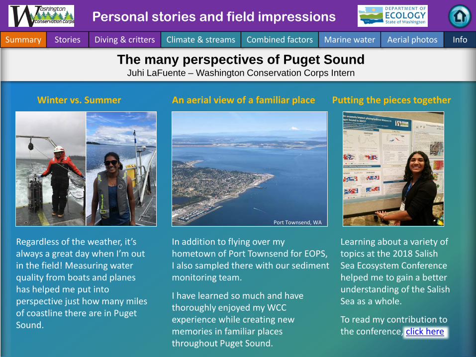
Personal Field Impression Personal stories and field impressions
Summary Stories Diving & critters Climate & streams Combined factors Marine water Aerial photos Info
An aerial view of a familiar place Winter vs. Summer
Regardless of the weather, it’s always a great day when I’m out in the field! Measuring water quality from boats and planes has helped me put into perspective just how many miles of coastline there are in Puget Sound.
In addition to flying over my hometown of Port Townsend for EOPS, I also sampled there with our sediment monitoring team.
I have learned so much and have thoroughly enjoyed my WCC experience while creating new memories in familiar places throughout Puget Sound.
Port Townsend, WA
Putting the pieces together
The many perspectives of Puget SoundJuhi LaFuente – Washington Conservation Corps Intern
Learning about a variety of topics at the 2018 Salish Sea Ecosystem Conference helped me to gain a better understanding of the Salish Sea as a whole.
To read my contribution to the conference, click here.
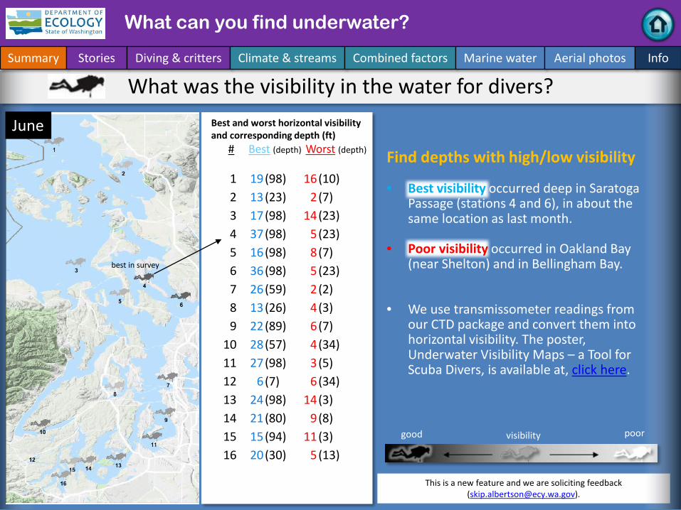
Best and worst horizontal visibilityand corresponding depth (ft)
# Best (depth) Worst (depth)
This is a new feature and we are soliciting feedback ([email protected]).
good poorvisibility
What was the visibility in the water for divers?
What can you find underwater?
Summary Stories Diving & critters Climate & streams Combined factors Marine water Aerial photos Info
June
best in survey
Find depths with high/low visibility
• Best visibility occurred deep in Saratoga Passage (stations 4 and 6), in about the same location as last month.
• Poor visibility occurred in Oakland Bay (near Shelton) and in Bellingham Bay.
• We use transmissometer readings from our CTD package and convert them into horizontal visibility. The poster, Underwater Visibility Maps – a Tool for Scuba Divers, is available at, click here.
1 19(98) 16(10)2 13(23) 2(7)3 17(98) 14(23)4 37(98) 5(23)5 16(98) 8(7)6 36(98) 5(23)7 26(59) 2(2)8 13(26) 4(3)9 22(89) 6(7)
10 28(57) 4(34)11 27(98) 3(5)12 6(7) 6(34)13 24(98) 14(3)14 21(80) 9(8)15 15(94) 11(3)16 20(30) 5(13)

New Baseline Biomass DataTo examine links between
environmental stressors and benthic organisms, we added biomass and size
classification to our monitoring program - a first for a large scale, long-term
Puget Sound study.Dany Burgess & Angela Eagleston Marine Sediment Monitoring Team
To date, we’ve weighed and measured almost 7,000 individual critters!
Some individuals in the “x-large” size class were larger than the literature range for the species. Is
this just natural variability? Or, could organic enrichment or other habitat characteristics be
responsible for the extra large size?
Size Matters – Biomass and Size Classification
What can you find underwater?
Summary Stories Diving & critters Climate & streams Combined factors Marine water Aerial photos Info
“small”
“large”
Why is this guy so big?
“x-large”
Listen to Eyes Under Puget Sound… Adult Scalibregma, a polychaete in Bellingham Bay, varies dramatically in size.
Find out more about this new project, including preliminary results, in our latest blog and recent poster publication.

Current Streamflow Conditions as of 7/18/2018
Current conditions: Click here
Select Puget Sound Streamflow Trends
USGS WaterWatch: Click here
Skagit River near Mt. Vernon(12200500)
Snohomish River near Monroe(12150800)
Puyallup River at Puyallup(12101500)
How much water flows into coastal marine waters?
Tyler Burks, Jim Shedd
Air temperatures have been above normal, while precipitation has been well below normal, so far in July. These conditions, coupled with minimal snowmelt runoff, have resulted in generally less than normal freshwater inputs to Puget Sound. Nearly all stream gages are reporting normal or below-normal flows (map, right). Most flows reporting as normal are below the 50th percentile, especially in south Puget Sound (charts, left).
Summary Stories Diving & critters Climate & streams Combined factors Marine water Aerial photos Info

The maps on the top show higher probability of below normal precipitation in the NW. The maps on the bottom show a higher probability of higher temperatures in the NW, click here.
Climatologists predicted drier and warmer conditions this summer. The maps below show the temperature and precipitation predictions for the Pacific Northwest. They also show what we experienced from the start of summer through mid-July. So far, climatologists’ predictions have proven true.
July 2018 July-Aug-Sep 2018
Prec
ipita
tion
Tem
pera
ture
How much water flows into coastal marine waters?
Summary Stories Diving & critters Climate & streams Combined factors Marine water Aerial photos Info
Climate Prediction Center, NOAA
Precipitation ranges from less than 25% to about 70% of normal so far this summer in the Puget Sound Basin.
Average temperatures range from 2 to 4 °F higher than normal so far this summer in the Puget Sound Basin.
Western Regional Climate Center

Climate influences: How well is Puget Sound exchanging its water?
The Fraser River is the major driver of estuarine circulation and water exchange with the ocean.Fraser River flows have rapidly fallen and the snowpack in BC is below normal (Basin Snow Water Index).
Historically, peaks of coastal upwelling and the freshet are in sync. This year the freshet is early and strong?
NPG
O (x10)
PDO
/Upw
ellin
g In
dex
How do ocean boundary conditions affect the quality of water we exchange with the ocean? Past years’ warm water is gone (PDO),upwelling is neutral (Upwelling Index anomaly), and surface productivity along the coast is lower (NPGO).
Pacific Decadal Oscillation Index (PDO, temperature, explanation). Upwelling Index (anomalies) (Upwelling, low oxygen, explanation). North Pacific Gyre Oscillation Index (NPGO, productivity, explanation).
Three-year running average of PDO, Upwelling, and NPGO indices
Summary Stories Diving & critters Climate & streams Combined factors Marine water Aerial photos Info
Higher than normalLower than normalExpected
Fraser River
-25
-15
-5
5
15
25
-1.5
-1
-0.5
0
0.5
1
1.5
1945 1950 1955 1960 1965 1970 1975 1980 1985 1990 1995 2000 2005 2010 2015

What’s the story of influences affecting water quality?
higher No datalowerexpected
*Upwelling/downwelling Anomalies (PFEL)PDO = Pacific Decadal OscillationNPGO = North Pacific Gyre OscillationENSO = El Niño Southern Oscillation
Climate and natural influences include weather, river flows, and the adjacent ocean conditions that affect our marine waters. This graphic provides context for interpreting Puget Sound marine conditions. All data are from public sources: weather from UW GRAYSKIES; river flows from USGS and Environment Canada; indices from NOAA, UW (PDO), and E. Di Lorenzo (NPGO).
Summary Stories Diving & critters Climate & streams Combined factors Marine water Aerial photos Info
June Summary:
Air temperatures have generally been above normal since May.
Precipitation levels have been below normal since May.
Sunshine levels have been above normal (low cloud cover).
River flows have been much lower in June than in May, and this below-normal condition increases to the north.
Upwelling has been near normal, but lower than in May. ENSO is slightly positive, indicating the end of La Niña.

Summary Stories Diving & critters Climate & streams Combined factors Marine water Aerial photos Info
A. Nisqually River delta (South Sound) B. Swinomish Channel (Whidbey Basin)
Migrating juvenile fish face a
complex thermal habitat in
estuaries. Rivers provide a cool
refuge on mudflats during
sunny days.
The same picture with a
regular camera does not reveal
much of the thermal
complexity and flows of cooler
river water.
McAllister Creek
Pull and Be Damned Point
Nisqually National Wildlife Refuge
Skagit River
Disclaimer: IR images are not corrected for sky condition, humidity, air temperature, emissivity, and subject distance.
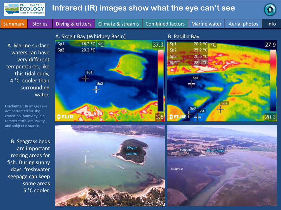
Did you know: Infrared (IR) images show what the eye can’t see
Swinomish Channel
Summary Stories Diving & critters Climate & streams Combined factors Marine water Aerial photos Info
A. Skagit Bay (Whidbey Basin) B. Padilla BayA. Marine surface
waters can have very different
temperatures, like this tidal eddy,
4 °C cooler than surrounding
water.
B. Seagrass beds are important
rearing areas for fish. During sunny
days, freshwater seepage can keep
some areas5 °C cooler.
7-16-2018
seepageHope Island Bay View
Disclaimer: IR images are not corrected for sky condition, humidity, air temperature, emissivity, and subject distance.
Infrared (IR) images show what the eye can’t see
eddy
seagrass

Summary Stories Diving & critters Climate & streams Combined factors Marine water Aerial photos Info
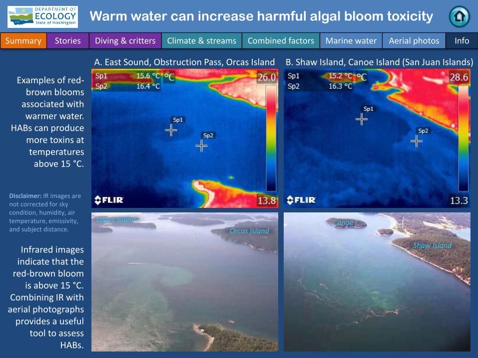
Warm water can increase harmful algal bloom toxicity
A. Hale Passage, Lummi Island (looking south) B. Hale Passage, Lummi Island (looking north)
Often algae blooms in red-brown are
associated with warmer water. Harmful algae
blooms (HABs) can produce more
toxins above 15 °C.
Infrared images reveal that the
red-brown bloom is 1 to 2 °C above
15 °C.
Portage Island Lummi Island
Lummi Island
Gooseberry Point
Disclaimer: IR images are not corrected for sky condition, humidity, air temperature, emissivity, and subject distance.
Warm water can increase harmful algal bloom toxicity
Summary Stories Diving & critters Climate & streams Combined factors Marine water Aerial photos Info
A. East Sound, Obstruction Pass, Orcas Island B. Shaw Island, Canoe Island (San Juan Islands)
Examples of red-brown blooms
associated with warmer water.
HABs can produce more toxins at temperatures
above 15 °C.
Infrared images indicate that the
red-brown bloom is above 15 °C.
Combining IR with aerial photographs
provides a useful tool to assess
HABs.
Orcas IslandLopez Island
Shaw Island
Canoe I.
Disclaimer: IR images are not corrected for sky condition, humidity, air temperature, emissivity, and subject distance.
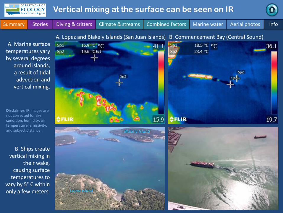
Vertical mixing at the surface can be seen on IR
Summary Stories Diving & critters Climate & streams Combined factors Marine water Aerial photos Info
A. Lopez and Blakely Islands (San Juan Islands) B. Commencement Bay (Central Sound)
B. Ships create vertical mixing in
their wake, causing surface
temperatures to vary by 5° C within only a few meters.
A. Marine surface temperatures vary by several degrees
around islands, a result of tidal advection and
vertical mixing.
Lopez Island
Blakely Island
Disclaimer: IR images are not corrected for sky condition, humidity, air temperature, emissivity, and subject distance.
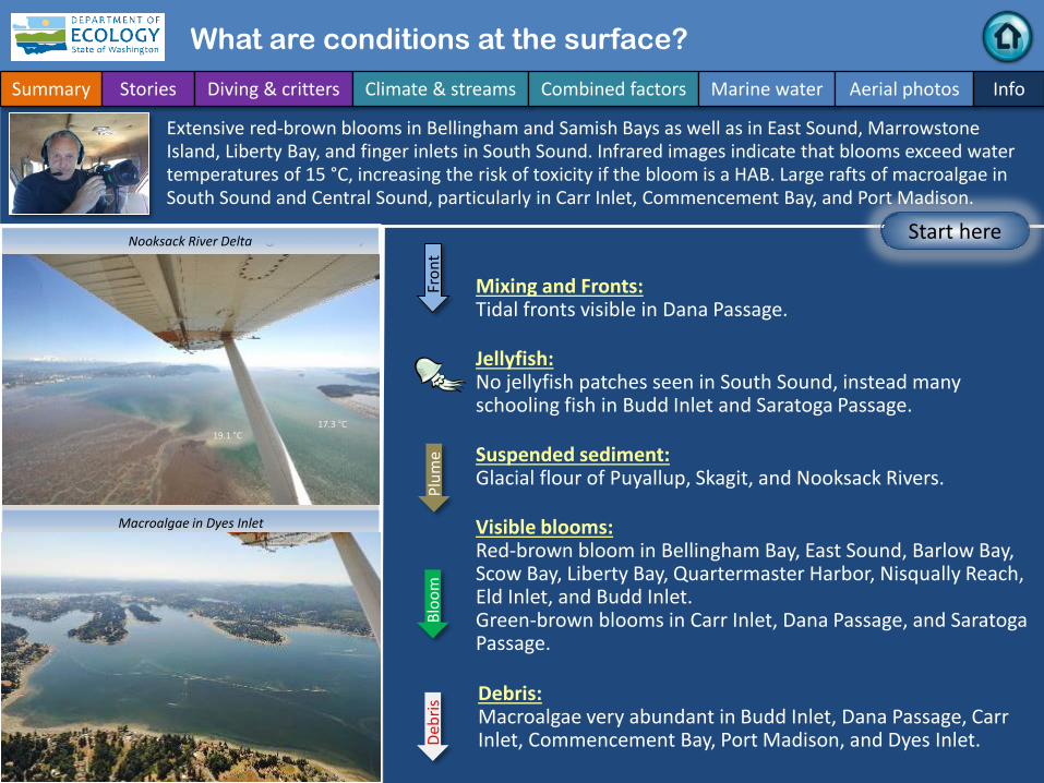
What are conditions at the surface?
Start here
Bloo
mDe
bris
Fron
tPl
ume
Narrow Hammersley Inlet connecting Oakland Bay
Mixing and Fronts:Tidal fronts visible in Dana Passage.
Debris:Macroalgae very abundant in Budd Inlet, Dana Passage, Carr Inlet, Commencement Bay, Port Madison, and Dyes Inlet.
Visible blooms:Red-brown bloom in Bellingham Bay, East Sound, Barlow Bay, Scow Bay, Liberty Bay, Quartermaster Harbor, Nisqually Reach, Eld Inlet, and Budd Inlet.Green-brown blooms in Carr Inlet, Dana Passage, and Saratoga Passage.
Jellyfish:No jellyfish patches seen in South Sound, instead many schooling fish in Budd Inlet and Saratoga Passage.
Suspended sediment:Glacial flour of Puyallup, Skagit, and Nooksack Rivers.
Extensive red-brown blooms in Bellingham and Samish Bays as well as in East Sound, MarrowstoneIsland, Liberty Bay, and finger inlets in South Sound. Infrared images indicate that blooms exceed water temperatures of 15 °C, increasing the risk of toxicity if the bloom is a HAB. Large rafts of macroalgae in South Sound and Central Sound, particularly in Carr Inlet, Commencement Bay, and Port Madison.
Summary Stories Diving & critters Climate & streams Combined factors Marine water Aerial photos Info
Nooksack River Delta
Macroalgae in Dyes Inlet
17.3 °C19.1 °C

Strait of Juan de Fuca
San Juan Islands
Main Basin
Hood Canal
Whidbey Basin
Excellent visibility.
Flight Information:
Aerial photographyand navigation guide
Flight routes
3
South Sound
Tide data from July 16, 2018 (Seattle):Height (ft) High/Low
2:53 AM 5.31 L 7:21 AM 10.29 H 2:03 PM -1.9 L 9:12 PM 12.49 H
Summary Stories Diving & critters Climate & streams Combined factors Marine water Aerial photos Info
16
17
19
20
5
8
10
4
6
14
18
9
2
1
7
11
1213
15
Padilla Bay
22
2123
24
25
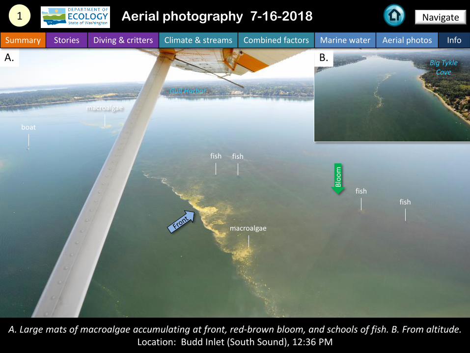
A. Large mats of macroalgae accumulating at front, red-brown bloom, and schools of fish. B. From altitude. Location: Budd Inlet (South Sound), 12:36 PM
fish
A. B.
1 Aerial photography 7-16-2018 Navigate
Summary Stories Diving & critters Climate & streams Combined factors Marine water Aerial photos Info
Gull Harbor
Big TykleCove
fish
fish
fish
boat
macroalgae
macroalgae
Bloo
m
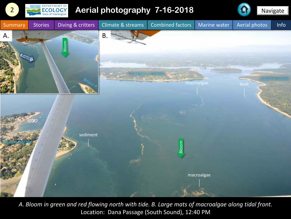
A. Bloom in green and red flowing north with tide. B. Large mats of macroalgae along tidal front. Location: Dana Passage (South Sound), 12:40 PM
A. B.
2 Navigate
Summary Stories Diving & critters Climate & streams Combined factors Marine water Aerial photos Info
Aerial photography 7-16-2018
macroalgae
sediment
boatmacroalgae
Steamboat IslandSquaxin Island
Boston Harbor
Bloo
m
Bloo
m
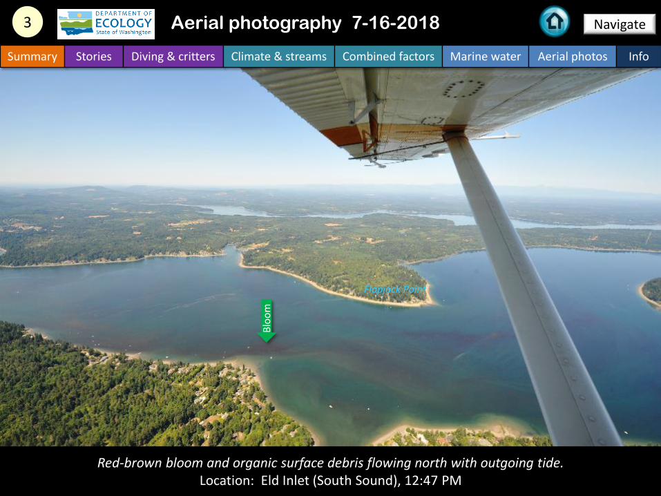
Red-brown bloom and organic surface debris flowing north with outgoing tide.Location: Eld Inlet (South Sound), 12:47 PM
3 Navigate
Summary Stories Diving & critters Climate & streams Combined factors Marine water Aerial photos Info
Aerial photography 7-16-2018
Flapjack Point
Bloo
m

Water on and over mudflats during ebb tide (A) and low tide (B) vary considerably in temperature (C). Location: Nisqually River Delta (South Sound), 3:28 PM
Nisqually R.
16.5 °C18.1 °C
A. B. C.
4 Navigate
Summary Stories Diving & critters Climate & streams Combined factors Marine water Aerial photos Info
Aerial photography 7-16-2018
12:58 PM 3:28 PM
McAllister C.
McAllister C.

Large mats of macroalgae accumulating at tidal front at entrance to Pitt Passage.Location: Carr inlet (South Sound), 1:03 PM
5 Navigate
Summary Stories Diving & critters Climate & streams Combined factors Marine water Aerial photos Info
Aerial photography 7-16-2018
McNeil Island
macroalgae
macroalgae
boat
Bloo
m
Front
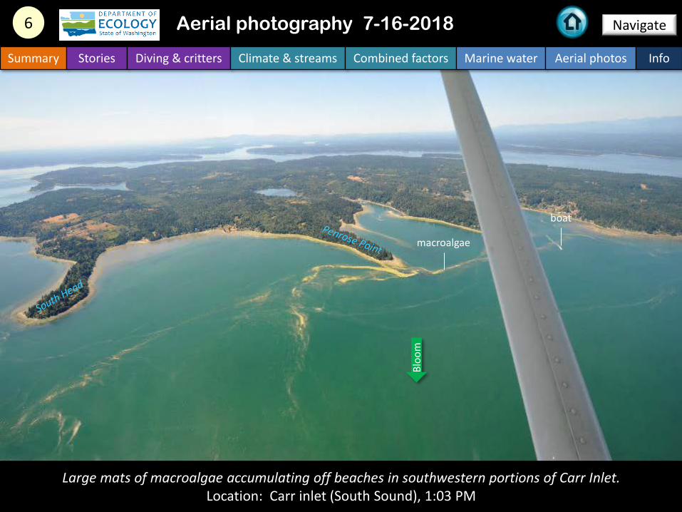
Large mats of macroalgae accumulating off beaches in southwestern portions of Carr Inlet.Location: Carr inlet (South Sound), 1:03 PM
6 Navigate
Summary Stories Diving & critters Climate & streams Combined factors Marine water Aerial photos Info
Aerial photography 7-16-2018
macroalgae
boat
Bloo
m

7 Navigate
Summary Stories Diving & critters Climate & streams Combined factors Marine water Aerial photos Info
Aerial photography 7-16-2018
Red-brown bloom in warm water of 18 °C leaving with outgoing tide.Location: Liberty Bay (Central Basin), 1:25 PM
Keyport
Bloo
m 18.3 °C
16.5 °C
boat
Lemolo

A. Sediment-rich water from the South Fork Skagit River flowing over the mudflats, B. Entering Skagit Bay.Location: Skagit Bay (Whidbey Basin), 1:51PM
Whidbey Island
Camano I.
A. B.
8 Navigate
Summary Stories Diving & critters Climate & streams Combined factors Marine water Aerial photos Info
Aerial photography 7-16-2018
Plum
e

Seagrass beds of different colors in Padilla Bay. Southern extent of red-brown bloom in Bellingham Bay.Location: Padilla Bay (North Sound), 1:59 PM
9 Navigate
Summary Stories Diving & critters Climate & streams Combined factors Marine water Aerial photos Info
Aerial photography 7-16-2018
Anacortes
21.8 °C
19.2 °CHat Island
GuemesIsland
boat
ship
Bloo
m
Plum
e
seagrass seagrass

Red-brown bloom extending in long ribbons from Samish Bay into Padilla Bay.Location: Samish Island (North Sound), 2:01 PM
10 Navigate
Summary Stories Diving & critters Climate & streams Combined factors Marine water Aerial photos Info
Aerial photography 7-16-2018
17.0 °C
16.1 °C
Samish Island
shipBl
oom

Large and very patchy red-brown bloom.Location: Samish Island (North Sound), 2:03 PM
Navigate11
Summary Stories Diving & critters Climate & streams Combined factors Marine water Aerial photos Info
Aerial photography 7-16-2018
ship
Samish R.
Bloo
m

Navigate
Large and very patchy red-brown bloom appearing to be comprised of different species.Location: Samish Island (North Sound), 2:04 PM
12
Summary Stories Diving & critters Climate & streams Combined factors Marine water Aerial photos Info
Aerial photography 7-16-2018
Samish Island
Samish R.
Bloo
m
Mount Baker

Navigate
Large and very patchy red-brown bloom at transition from Samish River to Bellingham Bay.Location: Bellingham Bay (North Sound), 2:04 PM
13
Summary Stories Diving & critters Climate & streams Combined factors Marine water Aerial photos Info
Aerial photography 7-16-2018
ship
boat
Bloo
m

Red-brown bloom of two colors entering Hale Passage from the north.Location: Lummi Island (North Sound), 2:14 PM
Navigate14
Summary Stories Diving & critters Climate & streams Combined factors Marine water Aerial photos Info
Aerial photography 7-16-2018
15.2 °C
17.1 °C
Lummi Island
Gooseberry Point
boat
Bloo
m

Red-brown bloom of two colors entering Bellingham Bay via Hale Passage.Location: Lummi Island (North Sound), 2:14 PM
Navigate15
Summary Stories Diving & critters Climate & streams Combined factors Marine water Aerial photos Info
Aerial photography 7-16-2018
15.5 °C
16.2 °C
Portage IslandLummi Island
boat
Bloo
m

Red-brown bloom in East Sound mixing with cooler sediment-rich water entering via Obstruction Pass.Location: Orcas Island (North Sound), 2:20 PM
Navigate16
Summary Stories Diving & critters Climate & streams Combined factors Marine water Aerial photos Info
Aerial photography 7-16-2018
15.6 °C
16.4 °C
15.2 °C
16.3 °C
boat
Orca Island
Lopez Island
Obstruction Island
BlakelyIsland
Bloo
m
Bloo
m
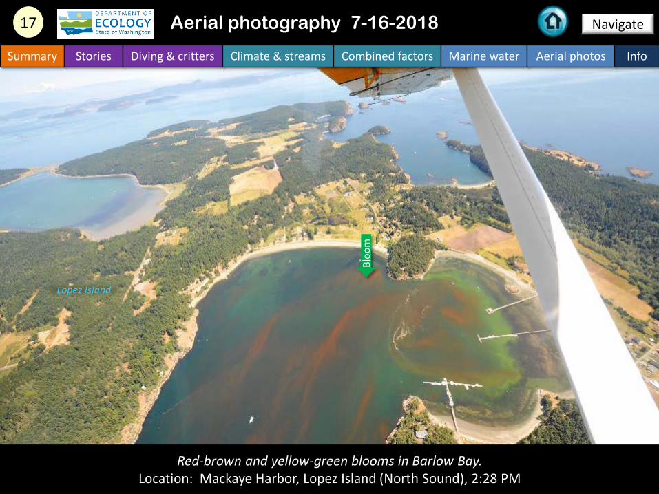
Red-brown and yellow-green blooms in Barlow Bay.Location: Mackaye Harbor, Lopez Island (North Sound), 2:28 PM
Navigate17
Summary Stories Diving & critters Climate & streams Combined factors Marine water Aerial photos Info
Aerial photography 7-16-2018
Lopez Island
Bloo
m
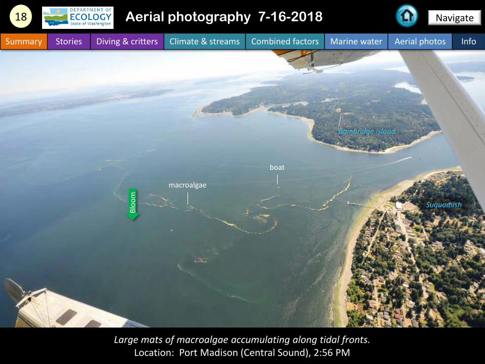
Large mats of macroalgae accumulating along tidal fronts.Location: Port Madison (Central Sound), 2:56 PM
Navigate18
Summary Stories Diving & critters Climate & streams Combined factors Marine water Aerial photos Info
Aerial photography 7-16-2018
Bainbridge Island
Suquamish
boat
Bloo
m
macroalgae

Large mats of macroalgae accumulating along edges of Puyallup River plume.Location: East of Maury Island (Central Sound), 3:09 PM
Navigate19
Summary Stories Diving & critters Climate & streams Combined factors Marine water Aerial photos Info
Aerial photography 7-16-2018
Maury Island
boat
barge
macroalgae
Plum
e
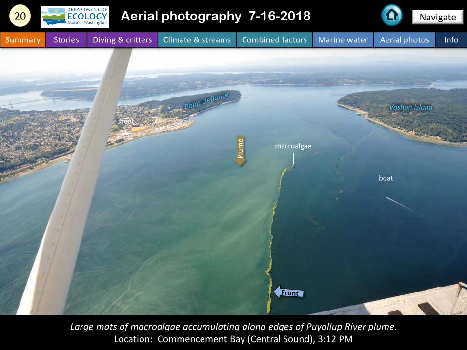
Large mats of macroalgae accumulating along edges of Puyallup River plume.Location: Commencement Bay (Central Sound), 3:12 PM
Navigate20
Summary Stories Diving & critters Climate & streams Combined factors Marine water Aerial photos Info
Aerial photography 7-16-2018
Vashon Island
boat
boat
macroalgae
Plum
e
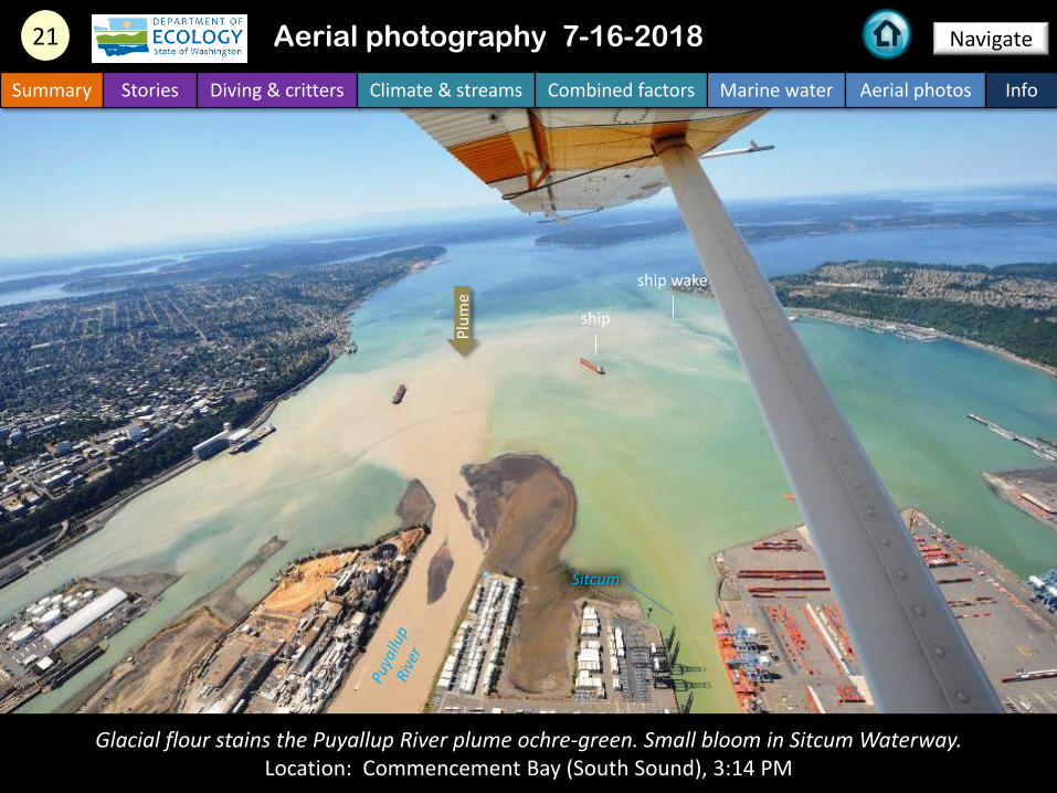
Glacial flour stains the Puyallup River plume ochre-green. Small bloom in Sitcum Waterway.Location: Commencement Bay (South Sound), 3:14 PM
Navigate21
Summary Stories Diving & critters Climate & streams Combined factors Marine water Aerial photos Info
Aerial photography 7-16-2018
ship
Sitcum
ship wake
Plum
e
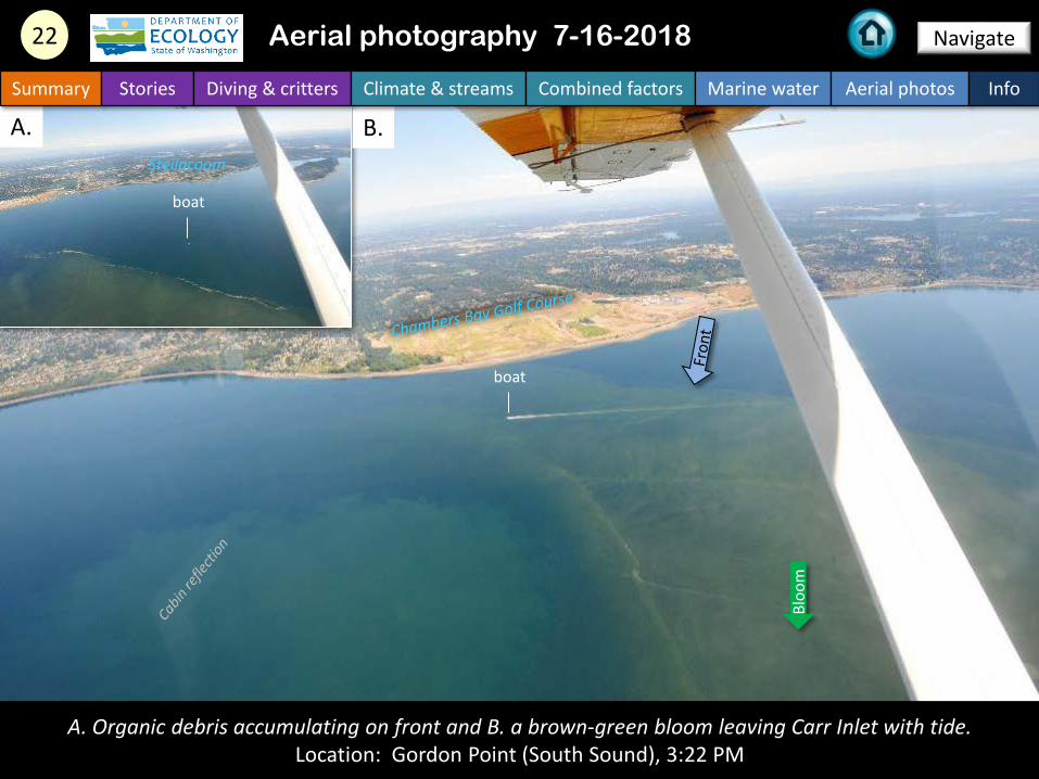
A. Organic debris accumulating on front and B. a brown-green bloom leaving Carr Inlet with tide. Location: Gordon Point (South Sound), 3:22 PM
A. B.
Navigate22
Summary Stories Diving & critters Climate & streams Combined factors Marine water Aerial photos Info
Aerial photography 7-16-2018
boat
boat
Steilacoom
Bloo
m

Mats of macroalgae east of Anderson Island.Location: Anderson Island (South Sound), 3:24 PM
Navigate23
Summary Stories Diving & critters Climate & streams Combined factors Marine water Aerial photos Info
Aerial photography 7-16-2018
boat
ferry
Anderson Island
macroalgae
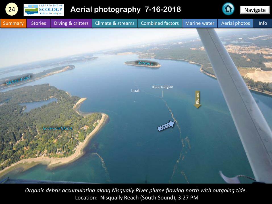
Organic debris accumulating along Nisqually River plume flowing north with outgoing tide.Location: Nisqually Reach (South Sound), 3:27 PM
Navigate24
Summary Stories Diving & critters Climate & streams Combined factors Marine water Aerial photos Info
Aerial photography 7-16-2018
Anderson Island
boatmacroalgae
Plum
e
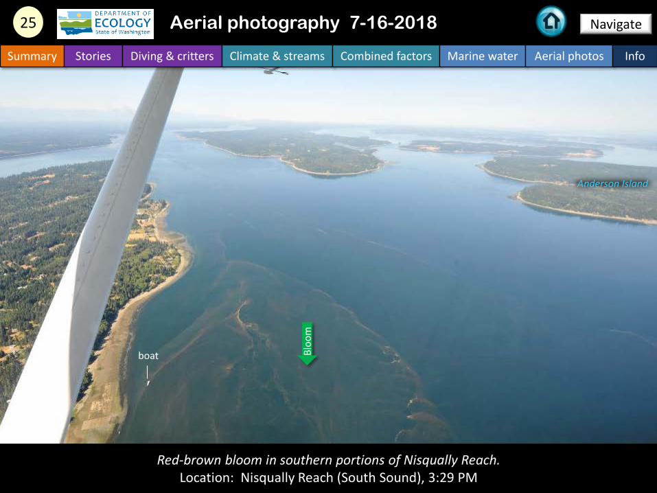
Red-brown bloom in southern portions of Nisqually Reach. Location: Nisqually Reach (South Sound), 3:29 PM
Bloo
m
Navigate25
Summary Stories Diving & critters Climate & streams Combined factors Marine water Aerial photos Info
Aerial photography 7-16-2018
Anderson Island
boat

Find past editions of EOPS with images on last pagesSummary Stories Diving & critters Climate & streams Combined factors Marine water Aerial photos Info
We have published 75 editions!
Recommended Citation (example from August 2017): Washington State Department of Ecology. 2017. Eyes Over Puget Sound, Surface Conditions Report, August 28, 2017. Ecology Publication No. 17-03-072.https://fortress.wa.gov/ecy/publications/documents/1703072.pdf
Find all previous Eyes Over Puget Sound editions at the end of this document.
Contact: Dr. Christopher Krembs,
[email protected] Monitoring Unit
Environmental Assessment Program
WA Department of Ecology
You may subscribe or unsubscribe to the Eyes Over Puget Sound email listserv by
going to:
http://listserv.ecology.wa.gov/scripts/wa-ECOLOGY.exe?A0=ECOLOGY-
EYES-OVER-PUGET-SOUND
Many thanks to our business partners: Shannon Point Marine Lab (WWU), Swantown
Marina, Kenmore Air, and Integral Consulting for the loan of the infrared camera.

July_16_2018, Publication No. 18-03-073
June_28_2018, Publication No. 18-03-072
May_22_2018, Publication No. 18-03-025
April_19_2018, Publication No. 18-03-071
Winter_2018, Publication No. 18-03-070
October_31_2017, Publication No. 17-03-073
August_28_2017, Publication No. 17-03-072
July_24_2017, Publication No. 17-03-071
June_6_2017, Publication No. 17-03-070
December_31_2016, Publication No. 16-03-079
November_22_2016, Publication No. 16-03-078
September_26_2016, Publication No. 16-03-077
August_24_2016, Publication No. 16-03-076
July_20_2016, Publication No. 16-03-075
June_27_2016, Publication No. 16-03-074
May_2_2016, Publication No. 16-03-073
April_6_2016, Publication No. 16-03-072
March_16_2016, Publication No. 16-03-071
February_8_2016, Publication No. 16-03-070
December_30_2015, Publication No. 15-03-080

December_14_2015, Publication No. 15-03-079
October_6_2015, Publication No. 15-03-078
September_21_2015, Publication No. 15-03-077
August_8_2015, Publication No. 15-03-076
July_6_2015, Publication No. 15-03-075
June_8_2015, Publication No. 15-03-074
April_29_2015, Publication No. 15-03-073
March_24_2015, Publication No. 15-03-072
February_17_2015, Publication No. 15-03-071
January_28_2015, Publication No. 15-03-070
December_30_2014, Publication No. 14-03-080
November_17_2014, Publication No. 14-03-079
October_29_2014, Publication No. 14-03-078
September_16_2014, Publication No. 14-03-077
August_18_2014, Publication No. 14-03-076
July_28_2014, Publication No. 14-03-075
June_23_2014, Publication No. 14-03-074
May_12_2014, Publication No. 14-03-073
April_21_2014, Publication No. 14-03-072
March_24_2014, Publication No. 14-03-071

February_4_2014, Publication No. 14-03-070
December_31_2013, Publication No. 13-03-081
November_21_2013, Publication No. 13-03-080
October_28_2013, Publication No. 13-03-079
September_11_2013, Publication No. 13-03-078
August_21_2013, Publication No. 13-03-077
July_15_2013, Publication No. 13-03-076
June_17_2013, Publication No. 13-03-075
May_20_2013, Publication No. 13-03-074
April_8_2013, Publication No. 13-03-073
Mar_25_2013, Publication No. 13-03-072
February_26_2013, Publication No. 13-03-071
January_15_2013, Publication No. 13-03-070
December_13_2012, Publication No. 12-03-081
November_8_2012, Publication No. 12-03-080
October_8_2012, Publication No. 12-03-079
September_11_2012, Publication No. 12-03-078
August_27_2012, Publication No. 12-03-077
July_31_2012, Publication No. 12-03-076
June_12_2012, Publication No. 12-03-075
May_14_2012, Publication No. 12-03-074
April_23_2012, Publication No. 12-03-073
March_19_2012, Publication No. 12-03-072
February_27_2012, Publication No. 12-03-071
January_30_2012, Publication No. 12-03-070
December_5_2011, Publication No. 11-03-082
November_15_2011, Publication No. 11-03-081
October_17_2011, Publication No. 11-03-080
September_12_2011, Publication No. 11-03-079
August_8_2011, Publication No. 11-03-078
July_6_2011, Publication No. 11-03-077
June_20_2011, Publication No. 11-03-076
June_6_2011, Publication No. 11-03-075
May_4_2011, Publication No. 11-03-074
April_27_2011, Publication No. 11-03-073

