putnam county west virginia - west virginia university · access to surrounding urbanized areas for...
TRANSCRIPT

Bridging To The Future
Community Plan – 2014
Putnam County West Virginia


Produced by:
John A. Butterworth, Planner Office of Planning and Infrastructure
Putnam County Courthouse 12093 Winfield Road
Winfield, West Virginia 25213 (304) 586-0237
Special Thanks:
Regional Intergovernmental Council Putnam County Assessor
Putnam County Commission Putnam County Planning Commission Putnam County Development Authority Putnam County Chamber of Commerce
Putnam County Parks and Recreation Commission Putnam County Historical Landmarks Committee
Hoge House Committee WVU College of Law Land Use Clinic
Michael John Dougherty, PhD, WVU Extension Service
Tom Hankins, AICP, Planning Commissioner David Powell, Planning Commissioner
Wayne Bennett, Planning Commissioner John Dill, Planning Commissioner
Joseph Haynes, County Commissioner Stephen Andes, County Commissioner Andy Skidmore, County Commissioner
Brian Donat, County Manager Jennifer Karr, County Attorney
Sandy Mellert, Director Office of Planning and Infrastructure


Preface: Introduction…………………………... i Chapter 1: General Community Profile………… 1 Chapter 2: Land Use……………………………... 11 Chapter 3: High Priorities…….………………..... - Economic Activity…………….. 41 - Transportation………………… 53 - Housing………………………... 65 Chapter 4: Priorities…...…………………………. - Infrastructure………………….. 77 - Recreation……….………........ 87 - Historic Preservation…………. 93 - Public Services……………….. 99 Chapter 5: Findings & Conclusion.……………... 105
Contents


i
A. OVERVIEW
In 2004 the West Virginia State Legislature adopted Section 8(A) of West Virginia State Code providing a needed update to the ability of local governments to implement and administer land use and land planning ordinances. This plan lays out future goals including timeline, actions to accomplish each, financial recommendations and integration with regional planning initiatives. Requirements of state code include discussions of: Land Use, Housing, Transportation, Infrastructure, Public Services, Rural Issues, Recreation, Economic Development, Community Design, Preferred Development Areas, Redevelopment, Financing, and Historic Preservation. Each will be discussed in this plan. In order to provide for the orderly and efficient development of land this legislation stipulates that a comprehensive plan be adopted to provide guidance for land-use decision-making and direction for policies and initiatives in all areas of the county. A comprehensive plan incorporates the diverse visions of residents, commerce, and industry into a common initiative.
The policy guidance provided by this comprehensive plan applies to all Putnam County ordinances but specifically the amendment and enforcement of the Zoning Ordinance for the Zoned Unincorporated Areas of Putnam County, West Virginia. Further, this document is intended to give a clear and consistent vision by which the Putnam County Planning Commission and its governing body, the Putnam County Commission, make decisions on land use and development questions.
This plan presents a narrative of the current conditions of Putnam County. This narrative showcases both the areas in which Putnam County has excelled and issues that could be improved upon. The plan provides guidance for decision-
Preface

ii
making by highlighting community goals. Each section offers actions for achieving the community vision.
B. MISSION STATEMENT
This Comprehensive Plan is a tool to help facilitate the achievement of the community goal of:
Continuing the Vision of improving Quality of Life to make Putnam County a better place to Live,
Work, and Play. C. LOCATION
Putnam County is located in central West Virginia along the Interstate 64 corridor. A newly completed section of U.S. Route 35 has further expanded an already good transportation infrastructure and now provides easier access to western cities such as Dayton and Cincinnati. The Kanawha River bisects the county providing water transportation access.
The county is flanked by the metropolitan areas of Charleston and Huntington. The majority of Putnam County is included in the Metropolitan Statistical Area of Charleston.
iii
Portions of Hurricane and Teays Valley are included in the Metropolitan Statistical Area of Huntington. This convenient location and short commutes to the larger cities has led to the residential growth of the Teays Valley area over the past several decades. The central area of the county owes its gently rolling terrain to the ancient Teays River system and glacial forces. This terrain is not typical in the region and has provided Putnam County a competitive advantage for growth and development.
Areas outside of Teays Valley and the Interstate 64 corridor are rural and have experienced much slower growth. The rural character is a point of great pride among many residents. Areas north of the Kanawha River and south of U.S. Route 60 are similar in their geography to surrounding counties with pronounced ridge-tops and valleys. The rural nature of these areas combined with the relative ease of access to surrounding urbanized areas for employment, shopping, and recreation places them in high demand for individuals and families seeking the best of both worlds.
D. PROCESS
The planning process for this document was focused on receiving and incorporating public input. During the 48 month progression from inception to adoption of this plan the Planning Commission held 8 visioning workshops, 9 Comprehensive Plan Committee meetings, 8 Public Comment sessions, and 2 formal Public Hearings prior to adoption. Each of these meetings was open to the public in order to maintain complete transparency throughout the process. Additionally, Planning Commission staff conducted numerous stakeholder meetings with organizations and individuals interested in the future of Putnam County.
The Comprehensive Planning Committee discussed each issue in this Plan as they relate to the future of the county. The Committee analyzed the public input and used this as a

iv
blueprint for constructing each goal and its corresponding action in the Plan.
The study area includes all of Putnam County including the municipal jurisdictions that use the Putnam County Planning Commission as their designated planning commission, currently the Towns of Buffalo, Bancroft, and Poca. This plan pays special attention to the zoned, unincorporated areas of Putnam County offering specific goals and actions that pertain to the land-use and development of this area. Areas of focus are identified throughout the plan that speaks directly to challenges and opportunities specific to each identified geographic area or jurisdiction.
E. HISTORY OF PLANNING IN PUTNAM COUNTY Planning has a long history in Putnam County. The Putnam
County Planning Commission was first organized in the 1960’s when high growth first began in the Teays Valley area. With growth came a need to ensure that new development harmonized and blended with its surroundings and protected the character of the community.
Early attempts to make subdivision of land and development
more orderly included adoption of subdivision regulations. The first local ordinance for this purpose was adopted around 1990. The current subdivision regulations have been amended at times to provide greater safety to citizens and ease to developers.
In 1991 Putnam County developed a Comprehensive Plan to
guide the development and growth of the county through its greatest period of growth to date. This document provided a look at the conditions of the time and forecast the potential victories and pitfalls that lay ahead. This Comprehensive Plan similarly identifies possibilities and offers guidance for improving the quality of life for county residents.

v
In 1996 the Putnam County Commission adopted the first version of the Zoning Ordinance for the Zoned Unincorporated Areas of Putnam County, West Virginia. This set of local laws was based on the public desires for the growth and development for what was termed at the time to be the “High-Growth Areas” of Putnam County. This set of regulations set down basic parameters for protecting residential neighborhoods from encroachment from commerce and industry while maximizing the growth of business in areas most suited for those endeavors. The adoption of this ordinance included the adoption of the county’s first Zoning Map for the High-Growth Area. In 2001, with funding from the Federal Highway Administration, the county undertook a comprehensive study of the corridor surrounding the proposed location of the relocated U.S. Route 35. This planning process included public hearings in which residents were very vocal in expressing their desire to maintain the rural character of the corridor. This U.S. 35 Corridor Management Plan was adopted as the basis for the amendment of the local zoning code. In 2003 the Zoning Ordinance for the Zoned Unincorporated Areas of Putnam County, West Virginia and the official Zoning Map were amended to reflect the recommendations and goals of the U.S. 35 Corridor Management Plan. The Zoning Ordinance for the Zoned Unincorporated Areas of Putnam County, West Virginia has been amended numerous times as the conditions in the county have changed.

vi

1
A. OVERVIEW
This section presents a wide range of statistical data for Putnam County to illustrate overall trends. The data is derived from a variety of sources including the United States Census Bureau, the Bureau of Labor Statistics, the Putnam County Assessor, the Putnam County Office of Planning and Infrastructure, the Putnam County Development Authority and the West Virginia Geographic Information System Technical Center.
B. SOCIO-ECONOMIC & DEMOGRAPHIC DATA
Putnam County is one of the fastest growing communities in the West Virginia. As can be seen in Table 1.1, during the 10 year period between 1990 and 2000 the County grew by 8,754 individuals. This is a growth in population of more than 20%. This high rate of growth has been primarily concentrated in Teays Valley along the Interstate 64 corridor. In a national climate of retracting housing markets and many Appalachian communities facing the loss of residents, Putnam County has had continued population growth of 7.5% from 2000 to 2008. Growth has stabilized with a 1.1% increase in population from 2008 to 2010.
The population is nearly exactly split by gender. As shown in Table 1.2, nearly 98 percent of residents identifying
POPULATION
1990 Census 42,835
2000 Census 51,589
ACS 2005-2007 54,440
ACS 2006-2008 54,902
2010 Census 55,486
(US Census Bureau, Census and American Community Survey)
Table 1.1
RACE & AGE
White 97.8%
Black 1.3%
All Other Races < 1.0%
Median Age 40.9 years
(US Census Bureau, Census and American Community Survey)
Table 1.2
Chapter 1 General County Profile

2
as white, 1.3% black, and less than 1% of all other races. The median age of Putnam County residents is 40.9 years. Approximately a quarter of the population is age 19 or younger while about 20.8% is age 60 or older. Population growth has occurred in urban areas, but Putnam County has a strong rural heritage and this has led to continued desire for housing in rural areas. As can be seen in Table 1.3, roughly 64% of the population lives in an urban setting while about 35% live in rural areas. This allows for a wide range of housing options within the County. Even the most rural areas are within a manageable commuting distance to essential services and employment centers. Growth has trended toward urban development and population growth with roughly a 5 percentage point shift from 2000 to 2010.
The county has an average of 2.5 individuals per household. As is illustrated in Table 1.4, out of a total of 21,981 households roughly a third have children under the age of 18. Fourteen percent of households have children under 18 and only one parent present. Overall, roughly one quarter of households are considered non-family or individuals living alone. Housing demand has remained strong and broad-based in large part because of the family-friendly living conditions created by award-winning schools and easy access to employment.
HOUSEHOLDS BY TYPE
Total households 21,981 100%
Family households 16,176 73.6%
With own children under 18 years
6,685 30.4%
Married-couple 13,108 59.6%
Single Parent, family
3,068 14.0%
Non-family households
5,805 26.4%
(US Census Bureau, Census 2010)
Table 1.4
POPULATION BY URBAN & RURAL
2010 Census 55,486
Urban 35,631
Rural 19,855
(US Census Bureau, Census 2010)
Table 1.3

3
Eighty-eight percent of residents drive to work alone. This is more than 10 percentage points greater than the national average highlighting the fact that Putnam County residents are highly automobile dependent for transportation.
The road network within and nearby Putnam County allows for ease in automobile transport. As shown in Table 1.4, the mean time commuting to work in Putnam County is 25 minutes; about average compared to the nation as a
whole. Residents using public transportation are less than 1% while those walking to work represent slightly less than 1%. Easy access to employment is due in large part to the excellent vehicular transportation network within Putnam County. Of the 26,268 residents over the age of 16 more than 95% commute to work with nearly 88% by automobile. The workforce of Putnam County is strong and diverse. Management and Professional occupations represent the largest group with more than 35% of employed population.
OCCUPATION
Civilian employed population 16 years
and over 25,088 100%
Management, professional, and
related occupations 9,592 38.2%
Service occupations 3,570 14.2%
Sales and office occupations
6,375 25.4%
Construction, extraction,
maintenance and repair occupations
2,983 11.9%
Production, transportation, and
material moving occupations
2,568 10.2%
(US Census Bureau, American Community Survey 2007-2011)
Table 1.6
COMMUTING TO WORK
Workers 16 years and over
26,268 100%
Car, truck, or van- drove alone
21,684 87.7%
Car, truck, or van- carpooled
1,703 6.9%
Public transportation (excluding taxicab)
21 0.1%
Walked 197 0.8%
Other means 68 0.3%
Worked at home 1,044 4.2%
Mean travel time to work (minutes)
25.0 -
(US Census Bureau, American Community Survey 2007-2011)
Table 1.5
4
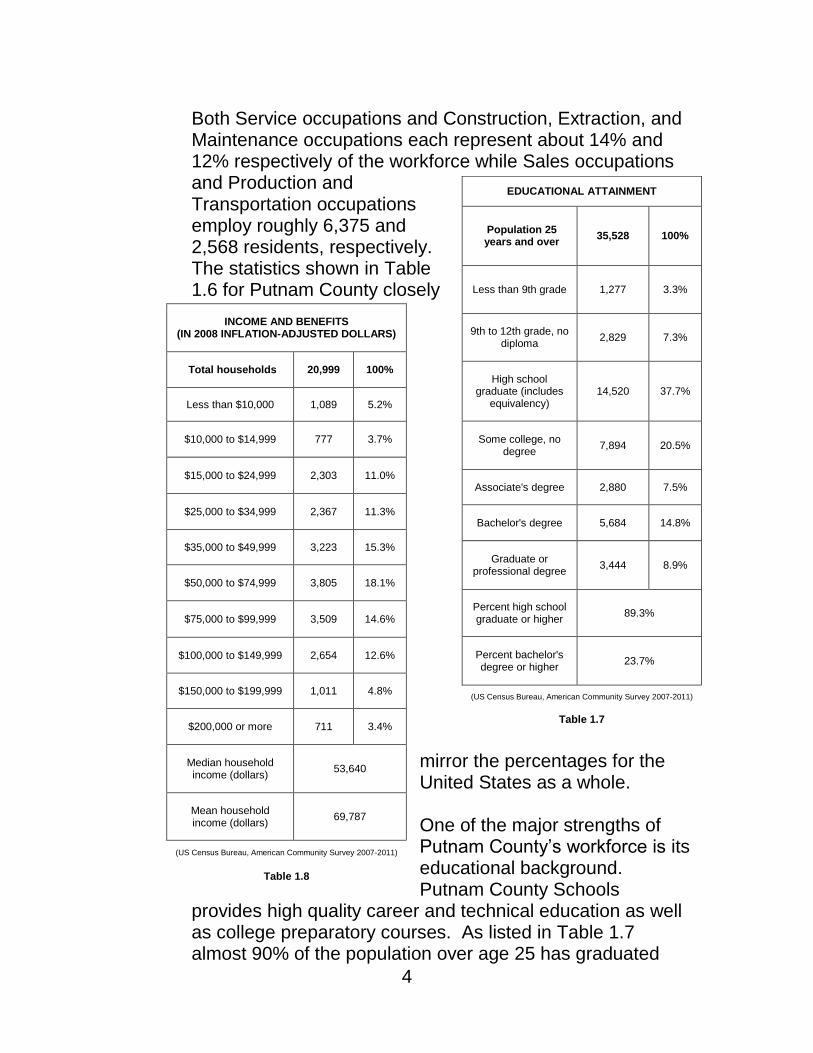
Both Service occupations and Construction, Extraction, and Maintenance occupations each represent about 14% and 12% respectively of the workforce while Sales occupations and Production and Transportation occupations employ roughly 6,375 and 2,568 residents, respectively. The statistics shown in Table 1.6 for Putnam County closely
mirror the percentages for the United States as a whole.
One of the major strengths of Putnam County’s workforce is its educational background. Putnam County Schools
provides high quality career and technical education as well as college preparatory courses. As listed in Table 1.7 almost 90% of the population over age 25 has graduated
EDUCATIONAL ATTAINMENT
Population 25 years and over
35,528 100%
Less than 9th grade 1,277 3.3%
9th to 12th grade, no diploma
2,829 7.3%
High school graduate (includes
equivalency) 14,520 37.7%
Some college, no degree
7,894 20.5%
Associate's degree 2,880 7.5%
Bachelor's degree 5,684 14.8%
Graduate or professional degree
3,444 8.9%
Percent high school graduate or higher
89.3%
Percent bachelor's degree or higher
23.7%
(US Census Bureau, American Community Survey 2007-2011)
Table 1.7
INCOME AND BENEFITS (IN 2008 INFLATION-ADJUSTED DOLLARS)
Total households 20,999 100%
Less than $10,000 1,089 5.2%
$10,000 to $14,999 777 3.7%
$15,000 to $24,999 2,303 11.0%
$25,000 to $34,999 2,367 11.3%
$35,000 to $49,999 3,223 15.3%
$50,000 to $74,999 3,805 18.1%
$75,000 to $99,999 3,509 14.6%
$100,000 to $149,999 2,654 12.6%
$150,000 to $199,999 1,011 4.8%
$200,000 or more 711 3.4%
Median household income (dollars)
53,640
Mean household income (dollars)
69,787
(US Census Bureau, American Community Survey 2007-2011)
Table 1.8

5
from secondary school or an equivalent. The educational attainment for Putnam County is much higher than the state average. About 22% of residents have at least a bachelor’s degree and 8.3% a graduate or professional degree. This highly educated workforce continues to be a driving force in the economic vitality of the county.
Household income is a good indicator of the overall economic health of a county. Putnam County has a median household income of $53,640, as shown in Table 1.8. This represents slightly more than the national median and ranks some 25% more than the median household income statewide. Nearly 50% of households earn between $35,000 and $99,999 annually. This high percentage of middle-income households translates to strong buying power for the retail market. About 20% of households earn less than $25,000. According to Census Bureau statistics a significant portion of the population is considered to be in poverty. Statewide 17.8% of residents are in poverty as compared to 9.8% within Putnam County. Despite the county’s high median household income, about 7.5% of families are below the poverty threshold. Of families that have children under the age of 18, 12% are in poverty. This number spikes to 43% when considering female householders with no husband present and children under the age of five. Clearly many residents are struggling with poverty. Nevertheless, a smaller percentage of Putnam County residents experience poverty than West Virginians as a whole.
YEAR STRUCTURE BUILT
Total housing units 23,327 100%
Built 2005 or later 688 2.9%
Built 2000 to 2004 1,655 7.1%
Built 1990 to 1999 6,258 26.8%
Built 1980 to 1989 4,270 18.3%
Built 1970 to 1979 4,145 17.8%
Built 1960 to 1969 2,004 8.6%
Built 1950 to 1959 1,816 7.8%
Built 1940 to 1949 934 4.0%
Built 1939 or earlier 1,557 6.7%
( US Census Bureau, American Community Survey 2007-2011)
Table 1.9
6
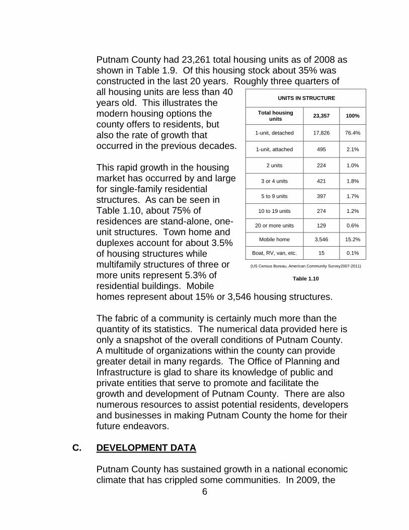
Putnam County had 23,261 total housing units as of 2008 as shown in Table 1.9. Of this housing stock about 35% was constructed in the last 20 years. Roughly three quarters of all housing units are less than 40 years old. This illustrates the modern housing options the county offers to residents, but also the rate of growth that occurred in the previous decades.
This rapid growth in the housing market has occurred by and large for single-family residential structures. As can be seen in Table 1.10, about 75% of residences are stand-alone, one-unit structures. Town home and duplexes account for about 3.5% of housing structures while multifamily structures of three or more units represent 5.3% of residential buildings. Mobile homes represent about 15% or 3,546 housing structures.
The fabric of a community is certainly much more than the quantity of its statistics. The numerical data provided here is only a snapshot of the overall conditions of Putnam County. A multitude of organizations within the county can provide greater detail in many regards. The Office of Planning and Infrastructure is glad to share its knowledge of public and private entities that serve to promote and facilitate the growth and development of Putnam County. There are also numerous resources to assist potential residents, developers and businesses in making Putnam County the home for their future endeavors.
C. DEVELOPMENT DATA
Putnam County has sustained growth in a national economic climate that has crippled some communities. In 2009, the
UNITS IN STRUCTURE
Total housing units
23,357 100%
1-unit, detached 17,826 76.4%
1-unit, attached 495 2.1%
2 units 224 1.0%
3 or 4 units 421 1.8%
5 to 9 units 397 1.7%
10 to 19 units 274 1.2%
20 or more units 129 0.6%
Mobile home 3,546 15.2%
Boat, RV, van, etc. 15 0.1%
(US Census Bureau, American Community Survey2007-2011)
Table 1.10
7
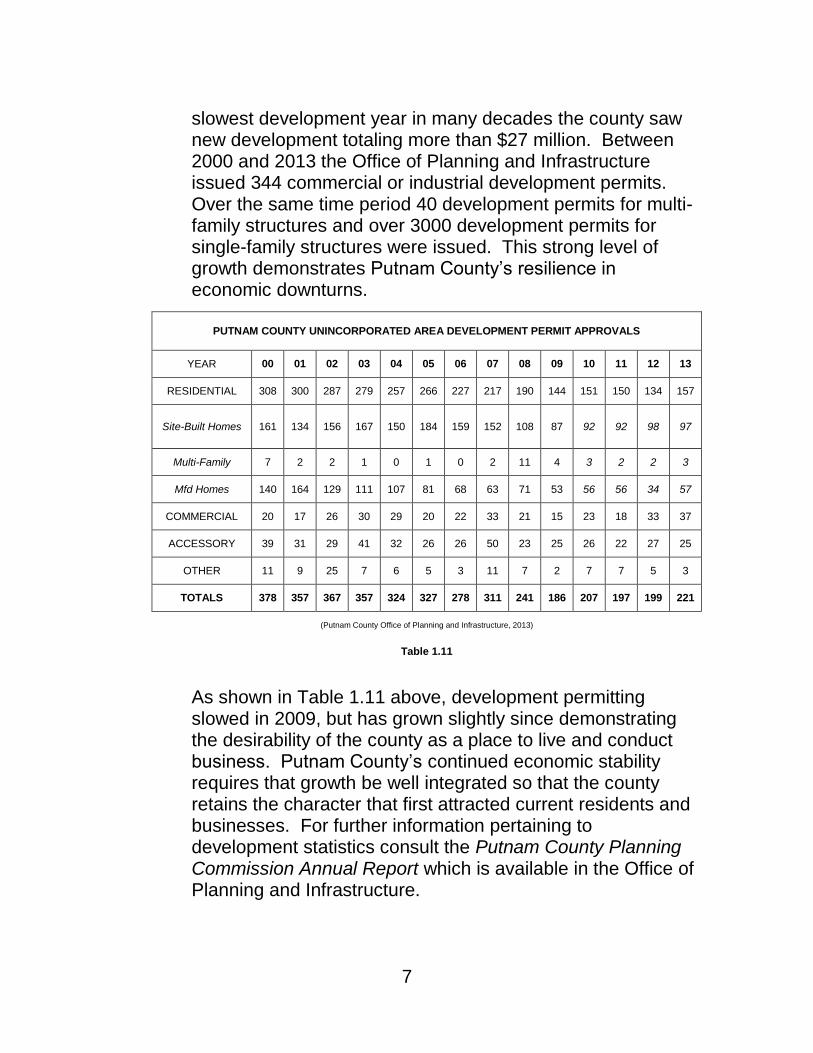
slowest development year in many decades the county saw new development totaling more than $27 million. Between 2000 and 2013 the Office of Planning and Infrastructure issued 344 commercial or industrial development permits. Over the same time period 40 development permits for multi-family structures and over 3000 development permits for single-family structures were issued. This strong level of growth demonstrates Putnam County’s resilience in economic downturns.
As shown in Table 1.11 above, development permitting slowed in 2009, but has grown slightly since demonstrating the desirability of the county as a place to live and conduct business. Putnam County’s continued economic stability requires that growth be well integrated so that the county retains the character that first attracted current residents and businesses. For further information pertaining to development statistics consult the Putnam County Planning Commission Annual Report which is available in the Office of Planning and Infrastructure.
PUTNAM COUNTY UNINCORPORATED AREA DEVELOPMENT PERMIT APPROVALS
YEAR 00 01 02 03 04 05 06 07 08 09 10 11 12 13
RESIDENTIAL 308 300 287 279 257 266 227 217 190 144 151 150 134 157
Site-Built Homes 161 134 156 167 150 184 159 152 108 87 92 92 98 97
Multi-Family 7 2 2 1 0 1 0 2 11 4 3 2 2 3
Mfd Homes 140 164 129 111 107 81 68 63 71 53 56 56 34 57
COMMERCIAL 20 17 26 30 29 20 22 33 21 15 23 18 33 37
ACCESSORY 39 31 29 41 32 26 26 50 23 25 26 22 27 25
OTHER 11 9 25 7 6 5 3 11 7 2 7 7 5 3
TOTALS 378 357 367 357 324 327 278 311 241 186 207 197 199 221
(Putnam County Office of Planning and Infrastructure, 2013)
Table 1.11

8
D. APPLICABLE LOCAL LAWS The Zoning Ordinance for the Zoned Unincorporated Area of Putnam County, West Virginia, adopted on May 13, 2003, has land use jurisdiction for properties within this designated area. The county adopted these land use controls and development standards have been incorporated in order to preserve property values and quality of life. Development standards include property line setback, lighting, parking, solid waste, stormwater quantity, and density requirements. Site planning review is available from county staff at all times to give guidance on development potential of properties under applicable zoning rules and other local standards.
Other applicable local laws include a FEMA compliant Floodplain Management Ordinance which spells out standards for development in flood prone areas. This ordinance provides site plan review authority and assures that development in floodplains cause no adverse impact to the development itself or surrounding properties. Human health, safety and welfare is of paramount importance in areas of significant flood risk. Safe and resilient habitable structures, no matter their relationship to a flooding risk, are the ultimate goal of this local law.
The county also reviews commercial site plans outside of the Zoned Unincorporated areas for sediment and erosion control, highway access and basic stormwater impact among other criteria. This review is provided for under the county’s Improvement Location Permit Ordinance.
An Adults Only Establishment Location Ordinance and a Salvage Yard Permit Ordinance provide development and location standards for adult establishments and salvage yards. A Dilapidated and Abandoned Ordinance grants authority to the county to compel property owners of dilapidated and abandoned structure to secure the structure as not to cause a safety or health hazard.

9
Figure 1.1 – Putnam County Zoning Map

10

11
A. OVERVIEW This section of the Comprehensive Plan identifies the current land use circumstances and evaluates how the policies and initiatives can be bolstered or augmented to further the overall goals of the community. There are three basic land use categories that can be used to discuss specific conditions, goals and actions for particular areas within the county. These are Rural, High Growth and Municipal. Each of these different areas faces unique challenges and opportunities. Putnam County is a rapidly growing county that has seen substantial expansion of residential land uses. Rapid home-building dominated growth from roughly 1980 to 2007. This trend has slowed as the national economy has experienced a decline in the housing market. Due to this contraction a growing awareness has emerged that housing has outpaced commercial and industrial growth within all areas of the county. The creation of commercial and industrial development is a key to helping county residents also be employed within the county. Land use varies widely throughout the county. Several municipal jurisdictions are outside the scope of this plan because they have invoked local land use authority under the state enabling legislation specifically the City of Winfield, the Town of Eleanor, the City of Hurricane and the City of Nitro. Rural areas make up the largest portion of the county with residential, agricultural and commercial/industrial uses occurring sporadically. High growth areas cluster around the highway access. Industrial development tends to cluster on the Kanawha River as barge and rail access is best in this area. Putnam County’s great variety of land use reflects its varied and strong economy.
Chapter 2 Land Use

12
Rural areas have no such rules in place to dictate community design standards. Municipalities have very established community character.
B. RURAL AREAS: CURRENT CONDITIONS
Rural areas make up a majority of the land area within Putnam County. As a general rule areas north of the Kanawha River, excluding municipal areas, and south of U.S. Route 60 are rural in nature along with the Fraziers Bottom area. Rural areas are typically located further from highway access points, but vast areas of rural land have been opened to highway access along the U.S. Route 35 corridor after its relocation in early 2009. This area is described in greater detail in the U.S. 35 Corridor Management Plan: Planning for Prosperity in Appalachia, Plan Report, 2002. Rural land use in Putnam County is varied, but generally is residential or agricultural in nature. This is true of areas south of U.S. Route 60 (Figure 2.1). Large tracts of land are forested or otherwise in natural condition. On the north side of the Kanawha River some ridge top land is utilized for pastures or hay fields. This concentration of use highlights the livestock production common in this area (Figure 2.3). Residential development in rural areas is almost entirely single-family dwelling units. Residential uses tend to be clustered along main transportation routes such as State Route 34 North and U.S. Route 60, becoming sparser on secondary roadways. Residences in rural areas are typically situated on larger tracts of land giving these areas much lower population density than the Interstate 64 corridor or Kanawha River Valley. Commercial development in rural areas tends to be on a smaller scale with a focus on enterprises that are part of or supplement agricultural uses. Some rural areas lack access to all utilities that are necessary for commercial land uses. Lack of water infrastructure can be a limiting factor for the development of many enterprises as well as residences.

13
Also, lack of access to broadband internet has slowed or prevented the growth of some residential, educational, and commercial land uses. Expansion in this high-speed internet network in recent years has diminished but not removed this roadblock. There has been a disconnect between infrastructure and utility improvements in rural areas of Putnam County. Some areas have seen the improvement of certain infrastructure or utilities while others have remained unavailable or at lower capacity.

Figure 2.1 – Land Cover Southern Putnam County
As can be seen in Figure 2.1 and Figure 2.3, the vast majority of land within Putnam County is deciduous forest land. In the southern portion of the County low intensity residential development and agriculture are dominant.
(U.S. Geological Survey, National Land Cover Database, 2006)

Figure 2.2 – Land Use Southern Putnam County
(Putnam County Assessor, 2013)

Figure 2.3 – Land Cover Northern Putnam County
In the areas north of the Kanawha River large amounts of land are used as pasture or hay field, low intensity residential development and low intensity commercial or industrial land uses. These commercial or industrial uses are often agriculturally based.
(U.S. Geological Survey, National Land Cover Database, 2006)

Figure 2.4 – Land Use Northern Putnam County
(Putnam County Assessor, 2013)

18
D. RURAL AREAS: PRIORITIES Residents of rural areas cite the privacy that this area affords as a primary attraction for taking up and maintaining their residence. There is a desire to preserve the rural character of more sparsely developed areas. Rural areas in Putnam County provide the privacy that is desirable while still having commutable drives to essential services, employment and entertainment. Many residents of rural areas favor this style of development in contrast to that of the more highly developed areas. Retaining this style of land use is essential. Promoting low density development will ensure that transportation and utility networks will not become overly taxed and ensure the preservation of the overall character and nature of these areas is retained. Roads in rural areas, while less heavily traveled than those in higher growth areas, provide essential access for property owners and public safety officials. Roads with enhanced safety features and routine maintenance will ensure this access. Roads are essential, but ought to be accompanied by balanced growth in availability of utilities.
E. RURAL AREAS: GOALS AND ACTIONS
1) SHORT-RANGE GOAL:
Increase and improve the access to basic utility infrastructure for rural lands including water and high-speed internet in order to supplement current land uses and promote compatible growth.
ACTIONS:
- Coordinate with public service utilities to expand utility networks in rural areas.
- Seek external sources of funding for utility expansions. - Prioritize new projects in order to expand utility access
for the greatest number of customers.

19
FINANCE:
Grant funding can be sought from the West Virginia Broadband Development Council. Financial partnerships with service providers, land developers and the county should be leveraged to finance expansion and improvement.
2) MEDIUM-RANGE GOAL:
Improve roadways in rural areas to ensure public safety and ease of access.
ACTIONS:
- Seek external sources of funding for road improvements.
- Lobby for roadway repair for deteriorated or potentially dangerous roads.
- Lobby for roadway improvements to include increased vehicular safety features.
FINANCE:
Roadway funding is almost exclusively administered by the West Virginia Division of Highways. Working in conjunction with Division of Highways is essential to ensuring that funding for roadway projects in Putnam County are properly funded. Engaged participation from county officials in planning efforts of regional planning partners is key to making sure funding is allocated to the maintenance and improvement county roadways.
3) LONG-RANGE GOAL:
Preserve the rural character of Putnam County.
ACTIONS:
- Foster low-density development in rural areas by setting policies and revising ordinance to keep rural areas rural.

20
- Promote the development and redevelopment of lands already in more highly developed areas.
- Encourage the development of land uses that blend with current character of the county’s rural nature.
FINANCE:
Achieving this goal involves adjusting and innovating applicable land development ordinances. Changes can be studied, evaluated and implemented by the county staff in the Office of Planning and Infrastructure. Reallocation of staffing time may be necessary to focus of assessment activities. Outside financing, if needed, can be sought through grant funding focusing on rural preservation.
F. HIGH GROWTH AREAS: CURRENT CONDITIONS
High growth areas of Putnam County have experienced sustained development over the last thirty years. High growth first began as residential suburbanization, but has evolved to include solid commercial and industrial land use growth. Further growth in all land uses, as well as increased density of medium and high intensity developed areas will increase the economic prosperity of the county across the board. The Teays Valley area is located along the Interstate 64 corridor from the St. Albans exit ramp to the corporate limits of the City of Hurricane (Figures 2.5 & 2.6). This swath of land is uncharacteristically flat for the region and therefore in high demand for development.
The major thoroughfare, State Route 34, is primarily lined with commercial development including professional services, retail, restaurants and medical services. CAMC Teays Valley Hospital serves as an anchor land use for many associated medical services in the area. Major shopping center complexes are located in the area surrounding the intersection of State Route 34 and Interstate 64. Also in this area is the Putnam Business Park serving as home to many commercial office buildings.

21
Residential land use in the Teays Valley area is primarily single-family residential units including detached structures and multi-unit structures. Some of these developments include amenities, but private recreational open space is not widely present. Single-family subdivision developments have been almost entirely developed in a Euclidian or single-use style. Mixed-use developments are not common. Commercial developments are often organized as multi-tenant structures, but less often incorporate mixed commercial uses and almost never residential uses. Commercial uses in this area are utilized by residents from both inside and outside the high growth areas and attract customers from the county at large. Other areas that have grown at a moderate rate or show the potential for high rates of growth include the land surrounding the intersection of State Route 34 and U.S. Route 35 and the area surrounding the intersection of Teays Valley Road (CR 33). These areas are described in greater detail in the U.S. 35 Corridor Management Plan: Planning for Prosperity in Appalachia, Plan Report, 2002.
G. HIGH GROWTH AREAS: PRIORITIES
The high growth area of Putnam County has experienced steady growth, but this growth has been disjointed. Physical and visual flow between different developments is lacking. Specifically, medium to high intensity land uses concentrated in the high growth area have very little interconnectivity between developments. Congestion of roadway infrastructure is also intensified when large-scale, low-intensity developments are served by only one ingress and egress point. Interconnectivity of a development should be encouraged to facilitate local travel, as well as to increase access for public safety officials. This disjointed nature also applies to the overall aesthetic appeal of the community. Many developments are compartmentalized within themselves. This not only impedes

22
the ability of people to move from one development to another, but showcases a haphazard and piecemeal appearance. Community identity, design and aesthetics ought to be promoted with new development.
Community design is essential to retaining the character of Putnam County. Development and redevelopment is the best opportunity to alleviate inconsistencies in community design. Site plan review and land use controls are means to remedy development styles that are not consistent with community character. Land use standards mean consistent site planning allowing for sufficient open space, property line setbacks and appropriate density among other development traits. High-growth areas in the county utilize these standards to ensure that development fits with the suburban/rural community character.
Making sure future development is consistent with these high development standards is a priority. Adoption of architectural standards as part of local law is not desired. Smart site planning standards that reflect the desire to have a safe, comfortable and healthy community is a top priority. Evaluation of development standards to test the results that they yield is necessary to determine which contribute to improving community design, which are innocuous to community design and which are producing results counter to this goal.
Community design priorities include, but are not limited to:
- Maximizing density where infrastructure can support it - Reducing density where rural land uses and design are
predominant - Reducing impacts from neighboring development
through effective site planning - Prioritizing space for people to walk and recreate in
developments, enhancing the clean and healthy appearance of neighborhoods
- Preserving historical structures and places that demonstrate and exemplify the history of Putnam County

23
- Encouraging commercial development that reflects the high standards of living the Putnam County enjoys
- Development of public spaces that serve as gathering spaces for the community.
These priorities are wide-ranging because the community design character of the county varies equally widely from highly developed suburban areas to cities and from towns to the very rural. Community Design and Land Use are linked in Putnam County, especially in high-growth areas that have land use standards in place.
Putnam County has demonstrated its appeal as a desirable place to seek residence. Activities that serve as pastimes for residents are essential to maintaining a vibrant community. With high levels of growth comes an increased demand to develop land to the most profitable use. In order to ensure the continued profitability of development and desirability of residence in Putnam County, recreational open space must always be present. Setting aside open space for recreation facilities is essential.

Figure 2.5 – Land Cover Teays Valley
As can be seen in Figure 2.5, the areas along the Interstate 64 corridor are highly developed. The highest intensity land uses tend to cluster around the intersection of Interstate 64 and State Route 34.
(US Geological Survey, National Land Cover Database, 2006)

Figure 2.6 – Land Use Teays Valley
(Putnam County Assessor, 2013)

26
H. HIGH GROWTH AREAS: GOALS AND ACTIONS
1) SHORT-RANGE GOAL:
Increase the amount of developed and undeveloped recreational open space in high growth areas.
ACTIONS:
- Increase availability of recreational open space land uses through expansion of county park lands and programs.
- Promote development that incorporates the reservation of open space as an amenity for the community.
- Partner with local outdoor recreation, health, and wellness organizations in order to promote open space creation, preservation and use.
FINANCE:
Funding new recreation space and programming at public facilities can be achieved by making strategic investments from current recreation funding. Grant opportunities focusing on healthy activity promotion may provide further funding for special projects.
Achieving this goal involves, in part, adjusting and innovating applicable land development ordinances. Changes can be studied, evaluated and implemented by the county staff in the Office of Planning and Infrastructure. Reallocation of staffing time may be necessary to focus of assessment activities.
2) MEDIUM-RANGE GOAL:
Increase and improve interconnectivity of current land uses and new developments for reduced traffic impact, increased public safety and to foster continuity of place.

27
ACTIONS:
- Coordinate with developers and West Virginia Division of Highways to increase interconnectivity between developments and decrease overall curb cuts on major thoroughfares.
- Investigate the feasibility of revising zoning ordinances and subdivision regulations to promote interconnectivity.
- Facilitate the efforts of homeowner and business owner associations and property owners to increase interconnectivity of land uses.
FINANCE:
Achieving this goal involves, in part, adjusting and innovating applicable land development ordinances. Changes can be studied, evaluated and implemented by the county staff in the Office of Planning and Infrastructure. Reallocation of staffing time may be necessary to focus of assessment activities.
Further financing could be secured with the use of tax increment financing for inter-connection projects that go beyond local and state standards.
3) LONG-RANGE GOAL:
Increase residential, commercial and industrial land uses in high growth areas.
ACTIONS:
- Foster medium and high-density development in high growth areas by setting policies and revising zoning ordinance and subdivision regulations to ensure development is compatible with the character and welfare of the community.
- Promote the redevelopment of lands in high growth areas.
- Encourage the growth of mixed use development that incorporates residential and commercial uses.

28
FINANCE:
Promoting the development of underdeveloped areas can be achieved as part of the mission of economic development professionals, specifically the Putnam County Development Authority. Staffing time can be focused as needed.
Achieving this goal involves, in part, adjusting and innovating applicable land development ordinances to provide incentive to develop underdeveloped sites. Changes can be studied, evaluated and implemented by the county staff in the Office of Planning and Infrastructure. Reallocation of staffing time may be necessary to focus of assessment activities.
Further financing could be secured with the use of tax increment financing for redevelopment and building to optimized density as defined in applicable land use rules.
I. MUNICIPAL AREAS: CURRENT CONDITIONS
The towns of Bancroft, Buffalo, and Poca have elected to appoint the Putnam County Planning Commission to serve as the designated planning commission for their respective jurisdictions. Each town has specific land use conditions and, therefore, specific and differing opportunities. TOWN OF BANCROFT The Town of Bancroft is a compact and established community that consists of predominantly residential land uses located in central Putnam County in the Kanawha River Valley. The major thoroughfare, State Route 62, runs parallel to the Kanawha River with the majority of the town falling between this roadway and the river. Residential uses are
BANCROFT DEMOGRAPHIC DATA
Population 593
Male / Female 67.5% / 32.5%
Housing Units 256
Area 96 Acres
Median Household Income $34,655
(US Census Bureau, American Community Survey)
Table 2.1

29
primarily low-intensity, single-family units. Commercial uses within the town are typically locally owned and operated. Figure 2.8 illustrates land uses within the jurisdiction. The town’s location near the Kanawha River means managing floodplain development is a priority. Portions of the Town of Bancroft are within the Special Flood Hazard Area as defined by FEMA Flood Insurance Rate Maps. For this reason extra documentation for development is required under the Town of Bancroft Floodplain Management Program Ordinance for areas within the floodplain. TOWN OF BUFFALO The Town of Buffalo is located in northwestern Putnam County in the Kanawha River Valley. The major thoroughfare is State Route 62 which bisects the town.
Residential uses include mostly single-family uses and to a lesser degree multi-family development that includes both mobile home parks and apartment-style structures. Commercial land uses in the town are primarily locally owned retail and dining establishments. The town is also home to an elementary and high school. Located just outside of the city limits is a large scale manufacturing facility. The town is the oldest in the county and boasts a rich history including archeological sites and an historic town square.
The Town of Buffalo has a significant portion of its area located within the Special Flood Hazard Area as defined by FEMA Flood Insurance Rate Maps. For this reason extra documentation for development is required under the Town of Buffalo Floodplain Management Program Ordinance for areas
BUFFALO DEMOGRAPHIC DATA
Population 1,236
Male / Female 50.4% / 49.6%
Housing Units 568
Area 1056 Acres
Median Household Income $45,368
(US Census Bureau, American Community Survey)
Table 2.2
30
within the floodplain. The Town of Buffalo reviews other aspects of development such as sewer availability and manufactured home placement.
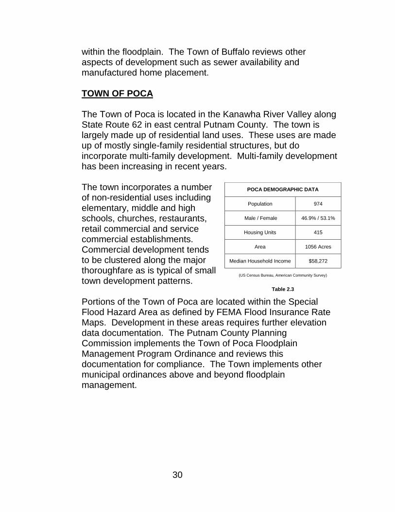
TOWN OF POCA The Town of Poca is located in the Kanawha River Valley along State Route 62 in east central Putnam County. The town is largely made up of residential land uses. These uses are made up of mostly single-family residential structures, but do incorporate multi-family development. Multi-family development has been increasing in recent years. The town incorporates a number of non-residential uses including elementary, middle and high schools, churches, restaurants, retail commercial and service commercial establishments. Commercial development tends to be clustered along the major thoroughfare as is typical of small town development patterns. Portions of the Town of Poca are located within the Special Flood Hazard Area as defined by FEMA Flood Insurance Rate Maps. Development in these areas requires further elevation data documentation. The Putnam County Planning Commission implements the Town of Poca Floodplain Management Program Ordinance and reviews this documentation for compliance. The Town implements other municipal ordinances above and beyond floodplain management.
POCA DEMOGRAPHIC DATA
Population 974
Male / Female 46.9% / 53.1%
Housing Units 415
Area 1056 Acres
Median Household Income $58,272
(US Census Bureau, American Community Survey)
Table 2.3

Figure 2.7 – Land Cover Town of Bancroft
As can be seen in Figure 2.7, the area in and around the Town of Bancroft is primarily low-intensity development. The developed land uses tend to be concentrated in the Kanawha River valley area.
(US Geological Survey, National Land Cover Database, 2006)
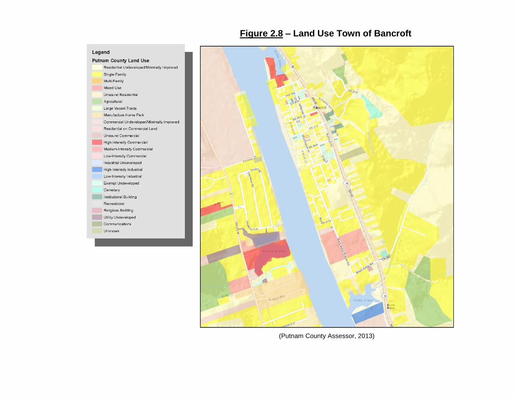
Figure 2.8 – Land Use Town of Bancroft
(Putnam County Assessor, 2013)

33
J. MUNICIPAL AREAS: PRIORITIES
Residents of each municipality express overall satisfaction with the land use characteristics of their community. Each community attracts and retains residents because of the ease of access to local goods and services, but also because of the close-knit neighborhood development pattern that provides the opportunity for moderately priced housing and social interaction for children and adults alike. This land use pattern is consistent throughout each jurisdiction.
New residential development is desirable. Growth of multi-family development for both young people and the elderly is essential. Current multi-family structures are in high demand. This demand and subsequent scarcity has caused prices to increase and made independent living more difficult for some residents. Affordable housing options in the general geographic area, but specifically within the Towns of Bancroft, Buffalo, and Poca are vital to ensuring that residents who are just starting out or who are living on fixed income have options for housing. Commercial development is very desirable and should be encouraged but should also minimize any interference with residential uses through proper placement and mitigation of disturbance. Commercial development can often create greater amounts of impervious area than residential development. Mitigation of storm water runoff to prevent damage to downstream property is encouraged. Continued participation in and compliance with the National Flood Insurance Program will maintain disaster relief eligibility and availability of affordable flood insurance coverage for residents and businesses of each municipal jurisdiction. Development located in flood prone areas must comply with the respective floodplain management ordinances.
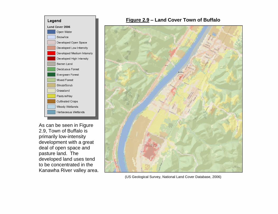
Figure 2.9 – Land Cover Town of Buffalo
As can be seen in Figure 2.9, Town of Buffalo is primarily low-intensity development with a great deal of open space and pasture land. The developed land uses tend to be concentrated in the Kanawha River valley area.
(US Geological Survey, National Land Cover Database, 2006)

(Putnam County Assessor, 2013)
Figure 2.10 – Land Use Town of Buffalo

36
K. MUNICIPAL AREAS: GOALS AND ACTIONS
1) SHORT-RANGE GOAL:
Ensure proposed land uses are compatible with flood-prone areas.
ACTIONS:
- Consistently implement the floodplain management ordinance for each jurisdiction.
- Limit floodplain development to those uses that are reasonably safe from loss due to flood.
- Investigate the feasibility of implementing a program that designates open space and undeveloped recreation reservations for areas prone to flooding.
FINANCE:
The Office of Planning and Infrastructure provides floodplain development permit review to Buffalo, Poca and Bancroft. Permit fees offset associated engineering review costs. Staff time is allocated free of charge to the municipal entities. Funding for flood hazard mitigation and flood preparedness can be sought through the West Virginia Department of Homeland Security on a project by project basis.
2) MEDIUM-RANGE GOAL:
Maintain the small town character of municipal areas.
ACTIONS:
- Utilize municipal ordinances to ensure the compatibility of development with the current land use characteristics.
- Investigate the feasibility of revising municipal ordinances and subdivision regulations to enhance the small town character of municipal areas.

Figure 2.11 – Land Cover Town of Poca
(US Geological Survey, National Land Cover Database, 2006)

Figure 2.12 – Land Use Town of Poca
(Putnam County Assessor, 2013)
39
FINANCE:
Technical assistance from public entities in the state including West Virginia University Extension Service and the West Virginia University School of Law Land Use Clinic can assist in development and revision of local ordinances intended to protect community quality and character. Funding to support these efforts should be minimal and could be appropriated for special projects as need arises.
3) LONG-RANGE GOAL:
Increase affordable single and multi-family residential land uses in municipal areas.
ACTIONS:
- Foster low and medium-density residential development in municipal areas by setting policies and amending rules to ensure the compatibility of development to the character and welfare of the community.
- Promote the development of multi-family land uses by allowing for the redevelopment of outdated or vacant single-family structures.
- Encourage the growth of mixed-use development that incorporates residential and compatible commercial uses.
FINANCE:
Achieving this goal involves, in part, adjusting and incentivizing applicable land development rules and municipal taxation. Changes can be studied, evaluated and implemented by town council members with technical assistance entities such as West Virginia University Extension Service and the West Virginia University School of Law Land Use Clinic. Reallocation of staffing time may be necessary to focus of assessment activities.

40
Further financing could be leveraged by the use of tax increment financing in order to incentivize affordable housing options.
Figure 2.13 – Future Land Use Map
(Putnam County Assessor, 2013)

41
ECONOMIC ACTIVITY A. OVERVIEW
Putnam County has a vibrant economy that is well diversified. Because the county has superior transportation resources, prime location and a high standard of living it has seen sustained growth of population, commerce and industry. The future vitality of Putnam County depends wholly on the ability of residents to earn a living wage and support their families. Putnam County has seen economic growth in large part because it has out paced its local and regional neighbors in population growth. The Putnam County Economic Development Authority, Inc. (PCDA) is a non-profit, quasi-public organization tasked with encouraging expansion of economic opportunities within Putnam County. This organization has worked to establish 13 business parks within the county, serves as a marketing liaison to prospective business and works to promote expansion of the industrial and commercial establishments that already call Putnam County home. This organization has a fifty-year track record of putting Putnam County out in front of development trends and working to bring a diverse mixture of investment and employment. The PCDA regularly produces a Strategic Development Strategy that evaluates and identifies the current state of economic development in the county and provides an outlook for the next five years regarding opportunities for economic growth. This section of the plan borrows from the expertise and vision of this Strategic Development Strategy and focus group meetings conducted with the Board of the PCDA. This current Strategic Development Strategy can be accessed by contacting the Putnam County Development Authority.
Chapter 3 High Priorities
42
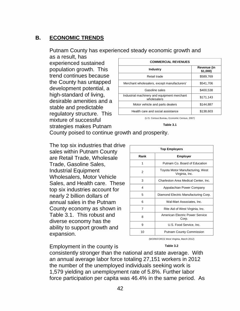
B. ECONOMIC TRENDS
Putnam County has experienced steady economic growth and as a result, has experienced sustained population growth. This trend continues because the County has untapped development potential, a high-standard of living, desirable amenities and a stable and predictable regulatory structure. This mixture of successful strategies makes Putnam County poised to continue growth and prosperity. The top six industries that drive sales within Putnam County are Retail Trade, Wholesale Trade, Gasoline Sales, Industrial Equipment Wholesalers, Motor Vehicle Sales, and Health care. These top six industries account for nearly 2 billion dollars of annual sales in the Putnam County economy as shown in Table 3.1. This robust and diverse economy has the ability to support growth and expansion.
Employment in the county is consistently stronger than the national and state average. With an annual average labor force totaling 27,151 workers in 2012 the number of the unemployed individuals seeking work is 1,579 yielding an unemployment rate of 5.8%. Further labor force participation per capita was 46.4% in the same period. As
COMMERCIAL REVENUES
Industry Revenue (in
$1,000)
Retail trade $589,769
Merchant wholesalers, except manufacturers' $541,706
Gasoline sales $400,538
Industrial machinery and equipment merchant wholesalers
$171,143
Motor vehicle and parts dealers $144,887
Health care and social assistance $138,603
(U.S. Census Bureau, Economic Census, 2007)
Table 3.1
Top Employers
Rank Employer
1 Putnam Co. Board of Education
2 Toyota Motor Manufacturing, West
Virginia, Inc.
3 Charleston Area Medical Center, Inc.
4 Appalachian Power Company
5 Diamond Electric Manufacturing Corp.
6 Wal-Mart Associates, Inc.
7 Rite Aid of West Virginia, Inc.
8 American Electric Power Service
Corp.
9 U.S. Food Service, Inc.
10 Putnam County Commission
(WORKFORCE West Virginia, March 2012)
Table 3.2

43
can be seen in Table 3.3, data show Putnam County weathering the economic downturn comparatively well in comparison to the state and nation. Calendar year 2013 has seen continued decrease in the unemployment rate to below five percent.
The Putnam County Office of Planning and Infrastructure has been tracking development permitting trends since 1990. Development growth and new construction has been strong in Putnam County throughout the previous two decades. Sustained growth of the housing stock and the commercial base has contributed to the economic well-being of current residents and made Putnam County a desirable area for families relocating from surrounding areas. The county experienced a significant building boom in the late 1990’s with sharp increases in construction of single-family housing and commercial structures. This increased construction activity was sustained for several building seasons. As is shown in Table 3.4, construction trends have cooled since their peak in 1998, but have slowed in such a way that avoided the bursting “bubble” that many communities around the country have experienced in the housing sector. This has translated to a very stable rate of construction development despite the overall trend of economic downturn elsewhere. As with other areas of major housing development, Putnam County stands to see expanded growth in construction with acceleration in the market occurring when the current
UNEMPLOYMENT RATE
Year Rate
2002 5.0 %
2003 5.0 %
2004 4.6 %
2005 4.3 %
2006 3.8%
2007 3.4 %
2008 3.2 %
2009 6.0 %
2010 7.1 %
2011 6.9 %
2012 5.8%
2013 (preliminary) 4.8%
(Bureau of Labor Statistics, Local Area Unemployment Statistics, 2002 – 2013)
Table 3.3
44
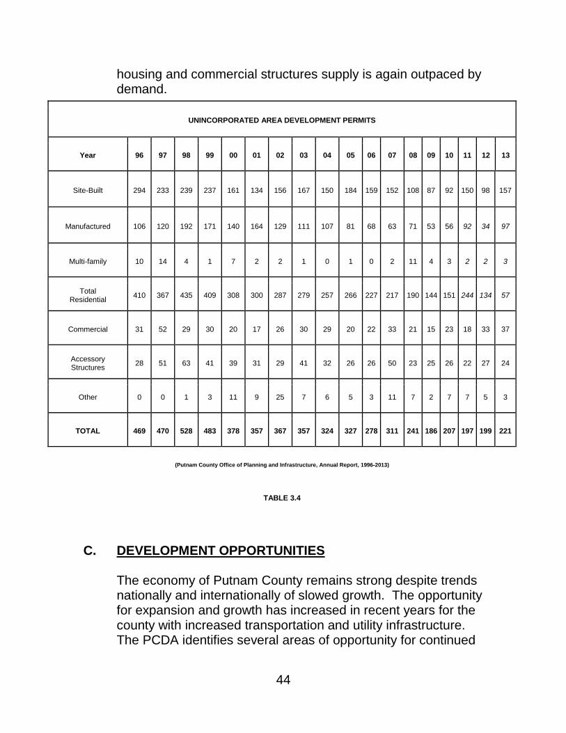
housing and commercial structures supply is again outpaced by demand.
C. DEVELOPMENT OPPORTUNITIES
The economy of Putnam County remains strong despite trends nationally and internationally of slowed growth. The opportunity for expansion and growth has increased in recent years for the county with increased transportation and utility infrastructure. The PCDA identifies several areas of opportunity for continued
UNINCORPORATED AREA DEVELOPMENT PERMITS
Year 96 97 98 99 00 01 02 03 04 05 06 07 08 09 10 11 12 13
Site-Built 294 233 239 237 161 134 156 167 150 184 159 152 108 87 92 150 98 157
Manufactured 106 120 192 171 140 164 129 111 107 81 68 63 71 53 56 92 34 97
Multi-family 10 14 4 1 7 2 2 1 0 1 0 2 11 4 3 2 2 3
Total Residential
410 367 435 409 308 300 287 279 257 266 227 217 190 144 151 244 134 57
Commercial 31 52 29 30 20 17 26 30 29 20 22 33 21 15 23 18 33 37
Accessory Structures
28 51 63 41 39 31 29 41 32 26 26 50 23 25 26 22 27 24
Other 0 0 1 3 11 9 25 7 6 5 3 11 7 2 7 7 5 3
TOTAL 469 470 528 483 378 357 367 357 324 327 278 311 241 186 207 197 199 221
(Putnam County Office of Planning and Infrastructure, Annual Report, 1996-2013)
TABLE 3.4
45
growth. These items are identified and expounded in further detail within the Strategic Development Strategy: - Highway Opportunities: U.S. Route 35, while largely
completed within Putnam County remains to be completely upgraded between the Buffalo Bridge interchange near Buffalo and nearly to Henderson. The upgraded 4-lane roadway has provided much improved access to a large swath of Putnam County. Areas along the roadway and in the vicinity of the Crooked Creek Road interchange of U.S. Route 35 and Interstate 64 present vast opportunity for future development. The Putnam Business Park, the newest business park development undertaken by PCDA, is located along the new U.S. Route 35 providing an excellent location for industrial and manufacturing growth.
- Water and Sewer Opportunities: Putnam County has placed
a focus on working diligently to expand and improve access to water and sewer services for households and commerce. The availability of these essential utilities can be the linchpin for transforming potentially viable development sites into growth for the county.
- Industrial Development Opportunities: Attracting new
investment in Putnam County is essential and a primary goal of the PCDA’s efforts. This, coupled with the Business Retention and Expansion program, translates to a holistic approach to growth. The success of new investment depends on the success of people already working hard in Putnam County. Opportunities for expansion and new growth exists within established business parks, primarily in the Putnam Business Park in Frazier’s Bottom. Development sites in a variety of sizes are available immediately with the areas for further expansion in the future.
Further development opportunities exist in all corners of Putnam County. Those areas that have superior vehicular access and utility service are, by default, more attractive for development. The construction of the new exit ramp and
46
interchange located at the intersection of the terminus of U.S. Route 35 and Interstate 64 provides much improved access to a large area the county.
D. PRIORITIES Economic Development priorities center around the concept of maintaining the standard of living that the residents of Putnam County enjoy. A large contributor to this high standard of living has been the availability of moderately priced housing for residents. A substantial portion of single-family housing growth in the county in the past 15-years has been in upper price ranges for the region. While Putnam County is proud of its growth in this area there has been slower growth in the availability of moderately priced housing options that are essential options for low and moderate wage-earners. This is especially true for young families. Stable economic growth depends on providing opportunities for both low and high wage-earners: those that are just starting out and those that are ending their careers and transitioning to well-deserved retirement. The county does not want to face a future where moderate wage-earners are “priced out” of the housing market. Expanding the opportunities for increased growth in moderately priced housing options will contribute to the increased livability of the county, but will also serve to expand the economic growth of the home building and land development sectors. This does present challenges when affordability is considered. Areas that have greater utility and transportation access will, by default, be valued higher in the market. This higher land cost translates directly to the home-buyer or commercial tenant. So, affordability affects development costs and, in turn, costs for consumers. In the case of promoting continued economic growth by promoting availability of moderately priced housing options there is a fine line to walk between maximized utility and transportation access and cost.

47
Putnam County has a superior transportation network, but this network is always in need of further improvement. Numerous areas experience congestion which reduces the flow and movement of people and goods. Regular review of the county’s transportation infrastructure as it supports economic vitality is essential to maintaining Putnam County’s edge in this regard. Support of transportation planning efforts by the Regional Intergovernmental Council, the designated Metropolitan Planning Organization, will ensure that continued improvement of the transportation network allows growth of housing and commerce in Putnam County. As with transportation infrastructure, utility infrastructure is essential to continued economic growth. Heavy investment in water and sewer resources has occurred in the past several decades. Utility service in the high-growth areas is available and affordable. Expansion of this utility network can now grow as demand requires. The cost to benefit ratio of future expansion is essential in determining the areas expanded service. This will ensure that new investments wisely spend public funds by creating the greatest economic impact for the continued prosperity of the county. Areas of preferred development are those where these factors converge. The highest and best use of lands must be evaluated by the impact any such development will have on the infrastructure that supports the development. Maximizing growth in areas where superior transportation and utility infrastructure or capacity currently exists is a priority. Putnam County has experienced healthy grown in the past twenty years because development has clustered around available infrastructure. Sprawl from these developed areas is likely given market pressures. Development shall be focuses in areas that have prime location, infrastructure service and roadway access. When possible, redevelopment of underdeveloped sites is preferred.
Preferred Development Areas include, but are not limited to:

48
- Areas of Teays Valley on the north and south sides of State Route 34 between the intersection of Teays Valley Road (CR 33) to the municipal limits of the City of Hurricane. This area has many undeveloped or underdeveloped sites. Many sites are currently developed as single-family structures that are no longer the highest and best use for an area that is now largely commercial along the State Route 34 corridor. This area has appropriate population and traffic volume density to support commercial development on a larger scale than in currently present. Recent development in the area supports this priority as many vacant or underdeveloped sites have transitions to higher-intensity commercial uses.
- Areas surrounding the intersection of U.S. Route 35 and Hurricane Creek Road (CR 19). The completion of this portion of U.S. Route 35 has opened many new areas to transportation access. This area is presently vacant or lightly developed. The surrounding land has superior roadway access. Traffic safety is a concern at the intersection as it is presently not signalized. The vast majority of the U.S. Route 35 corridor is not appropriate for commercial development as has been expressed by members of the public. Preserving the rural character of the corridor is a priority that can be accomplished by creating nodes of higher-intensity development around this and other intersections on the roadway namely the Buffalo Bridge intersection and the Johnston Drive (CR 35/29) Intersection.
- Areas surrounding the intersection of Interstate 64 Exit 40 and U.S. Route 35. With the installation of Exit 40 and its connection to U.S. Route 35 a large area has been exposed to superior transportation access. Future completion of a frontage road connecting this area to Liberty Park Drive will further increase access. This area has a prime location for regional commercial development as it conveys local and distance travelers. Areas east of this area along Teays Valley Road (CR 33) are well suited for residential development with great access to sewer service.

49
- Areas surrounding the intersection of U.S. Route 35 and State Route 34. This area has potential to serve as a node along the U.S. Route 35 corridor thereby preserving the rural character of the corridor as a whole. This area can support large scale commercial development.
E. GOALS AND ACTIONS
1) SHORT-RAGE GOAL:
Utilize resources to market the county as a prime location for commerce and investment.
ACTIONS:
- Conduct outreach to the state, nation, and world through the work of the Putnam County Development Authority.
- Conduct “Meet the County” meetings with prospective businesses that include economic development, utility, development permitting, and elected officials.
FINANCE:
Accomplishment of this goal entails focusing the efforts of county staff from a variety of disciplines on taking part coordinated promotion of the county. Primary work is already part of the mission of the Putnam County Development Authority. Staffing time can be focused on continued promotion of county assets and advantages. Outside funding for expanded promotion and marketing can be sought through the West Virginia Development Office and collaboration with local public and private entities to leverage community support.
2) MEDIUM-RANGE GOAL:
Promote the development of moderately priced and affordable housing options in order to keep pace with growth in higher-cost housing to maintain economic prosperity.

50
ACTIONS:
- Evaluate the feasibility of changes to regulations that create incentives to develop moderately priced housing, perhaps by utilizing the planned unit development process.
- Identify and promote sources of funding that promote the development of affordable housing options.
- Encourage utility expansion and availability where low and moderately price housing options are feasible.
FINANCE:
Promotion of affordable housing is the mission of many community groups that work to develop and advocate on the issue. Partnering with these groups is essential in identifying areas of need, means to achieve the goal and sources of funding. Partnerships can be forged between advocacy groups and private developer to leverage private investment in conjunction with public funding allocated to affordable housing development. The county should develop, foster and support a partnership of this type to leverage funding that is outside the scope of the county budget.
Achieving this goal involves, in part, adjusting and innovating applicable land development ordinances. Changes can be studied, evaluated and implemented by the county staff in the Office of Planning and Infrastructure. Reallocation of staffing time may be necessary to focus of assessment activities.
3) LONG-RANGE GOAL:
Promote the continued growth of commerce and industry within Putnam County.
ACTIONS:
- Foster existing businesses and encourage growth through engagement with civic organizations such as the Chamber of Commerce and resources available from the Development Authority.

51
- Ensure the availability of developable lands through projects such as further expansion of the Putnam Business Park and other public and private projects.
- Support the growth of small and large business alike by continually evaluating and streamlining the approval processes and development criteria while protecting the well-being of current residents and business.
FINANCE:
The advocacy of the Putnam County Chamber of Commerce is self funding with the buy-in of the local business community. Leveraging this buy-in to make the business community the ambassador to prospective business is important. The Chamber of Commerce should coordinate these efforts. The advocacy that this and other business organizations provide is essential to continued success in promoting growth of existing commerce. Regular conferencing between the business community and county officials will allow for each group to readily understand the position and challenges of the other. Reallocation of staffing time may be necessary to focus of promotion activities
Promotion of the county as a prime location for investment is supported by the Putnam County Development Authority. Funded staff initiatives work to achieve this goal presently and expanded efforts in the future can be financed by grant applications for business development promotion.
Achieving this goal involves, in part, adjusting and innovating applicable land development ordinances. Changes can be studied, evaluated and implemented by the county staff in the Office of Planning and Infrastructure. Reallocation of staffing time may be necessary to focus of assessment activities.

52
53
TRANSPORTATION A. OVERVIEW
Transportation is fundamental to the movement of people for enterprise, conveying goods and material for commerce, and travel for recreation and everyday life. In the same way that technology like the Internet has facilitated communication of ideas across the globe so has the interstate highway system facilitated the easy movement of people and goods. Economic prosperity and freedom of movement are inherently tied to speedy and efficient transportation networks linking our regions and cities.
Putnam County is at the hub of several major transportation networks. One interstate passes directly through the county while two others are within 15 miles drive. The county is also the origin of U.S. Route 35 providing access to points west in northwestern Ohio and central Illinois. Interstate 64 bisects the county providing access east to Richmond, Norfolk, and Virginia Beach and west to Louisville, Evansville, and St. Louis. Interstate 79 travels from Charleston to Erie and provides easy access to Morgantown and Pittsburgh. Interstate 77 provides direct access to Cleveland to the north and Charlotte and Columbia to the south. This highway network places Putnam County within a one-half day’s drive of Indianapolis, Pittsburgh, Cleveland, Dayton, Richmond, Charlotte, Nashville, Louisville, and the Washington, DC metro areas. This is an advantage to businesses depending on the commercial shipping industry for regional and national delivery. If location is the key to a successful endeavor, then Putnam County is optimal in this regard. Given these circumstances, it is no surprise that Putnam County is a major area of population and economic activity. Support for transportation planning efforts is provided by Regional Intergovernmental Council and KYOVA Interstate Planning Commission, the designated Metropolitan Planning

54
Organizations for Putnam County. Until 2013, the Regional Intergovernmental Council provided all technical assistance and economic planning for a four county region including Kanawha, Boone, Clay, and Putnam counties. After the 2010 Decennial Census was complete portions of Hurricane and Teays Valley were included in the Huntington Urbanized Area. Future transportation planning efforts will be handled by RIC with Congestion Management Planning handled jointly with KYOVA. Developed in 2014, the RIC Long Range Transportation Plan (LRTP) provides accurate and up-to-date transportation planning for Kanawha and Putnam counties. Putnam County continues to supports this planning initiative and the goals and objectives expressed within this long range planning document. This planning process was conducted with input and support from many Putnam County officials. The Regional Intergovernmental Council continues the planning efforts for long-range transportation planning by updating its Long Range Transportation Plan. Planning for the 2019 updated plan should begin again in 2017. The LRTP is the primary source for the transportation vision and goals for Putnam County and should be utilized as such in informing long-range transportation planning and development decision-making.
B. CURRENT CONDITIONS
The transportation network in Putnam County is multifaceted. The Kanawha River which nearly bisects the county provides excellent river transportation options. The United States Army Corps of Engineers maintains a 300-foot wide navigatable channel on the Kanawha River. The lock and dam at Winfield provides access from the Ohio River upstream. This lock location has an 11 barge capacity allowing easy transit of large payloads. This lock and dam facility also incorporates a hydro-electric power station. The county has no FAA approved airport facilities, but is in close proximity to Charleston’s Yeager Airport which provides

55
daily commercial air travel service as well as private air travel. Only slightly farther away is the Huntington Tri-state Airport with a similar complement of services. Yeager Airport boarded 272,901 passengers in calendar year 2012 while Tri-state Airport boarded 105,548. Yeager Airport ranks in the top 162 busiest airfields nationally. There are three helipads in the county. One is located adjacent to the Teays Valley Business Park complex in central Teays Valley. There is also a helipad located at the CAMC Teays Valley Hospital complex. The other helipad is located along State Route 817 just outside of Morgan’s Landing unincorporated and is operated by HealthNet Aeromedical Services for air ambulance service. The county is also served by regional bus service provided jointly by the Kanawha Valley Regional Transit Authority and the Tri-state Transit Authority. The iT Ride Smart bus line provides daily round-trip service from Charleston to Huntington and vice versa. The bus service provides one stop in Putnam County at the Crooked Creek Interchange of Interstate 64 and the U.S. Route 35 Park and Ride facility. The daily service provides free WiFi internet access and news papers to cater to business commuters. Rail service in Putnam County consists of freight service along two routes. CSX operates a freight railroad line that runs roughly parallel to Interstate 64 and also provides access to the John Amos Power Station in Morgan’s Landing. The second railroad line travels along the northern bank of the Kanawha River Valley. Amtrak passenger rail service from Chicago to Washington, D.C. and beyond to New York City utilizes the CSX line, but no stops are provided in Putnam County. Amtrak maintains depot stops nearby in Charleston and Huntington. The interstate highway system represents a major transportation resource for Putnam County. Interstate 64 incorporates five exit ramps within the county serving the City of Nitro, St. Albans and its general vicinity, Scott Depot including the U.S. Route 35 interchange, the Teays Valley area at the

56
intersection with State Route 34, and the City of Hurricane in order of sequence westbound. The interchange with U.S. Route 35 was completed in 2008 providing increased access to the Scott Depot area. With the new interchange, the area can expect increased commercial growth, especially in the areas adjacent to the interchange.
Improvement of the U.S. Route 35 corridor is currently incomplete. The final section from the Buffalo Bridge interchange extending into Mason County is currently in the design and right-of-way acquisition phase. Funding for this section of upgrading is currently on the Transportation Improvement Program. Local north-to-south traffic is primarily served by State Route 34 which extends from the northeastern county boundary with Jackson County to the southern county line near Hamlin. This route is primarily a two-lane highway widened to three lanes in the more highly developed area of Teays Valley. The recent widening of State Route 34 has helped with traffic congestion in this more highly developed area. The State Route 34 crossing of the Kanawha River at Winfield provides an essential north-south link within the county. This bridge was completely refurbished in 2010 including complete redecking of the roadway surface. There are two other crossing points for the Kanawha River in Putnam County. The western crossing connects State Route 62 at Buffalo to State Route 817 and U.S. Route 35. The eastern crossing connects Nitro to St. Albans via Interstate 64. Interstate 64 incorporates an on-ramp / off-ramp at each end of the bridge. While Interstate 64 is used by local and through motorists another significant east-to-west transportation corridor is U.S. Route 60 which connects St. Albans in Kanawha County with Culloden in Cabell County. This roadway is primarily a two-lane highway.
The most heavily traveled roadway is Interstate 64 with major commercial and commuter traffic making it one of the highest

57
traveled roads in the state. As can be seen in Table 3.5 below, vehicular traffic along the Interstate 64 corridor is robust and represents an opportunity for commercial and residential development alike. The data of Table 3.6 does not identify counts for the newly completed interchange and exit with US Route 35. As can be seen from Table 3.5 the development of this new interchange has diverted substantial numbers of vehicles away from the former U.S. Route 35 right-of-way to the new limited access highway. This new interchange has already seen increased residential and commercial development owing to the new ease of interstate access.
The relocation of U.S. Route 35 to Scott Depot removed the biggest traffic bottleneck in the county. The new interchange with a flyover ramp for southbound traffic allowed the heavy truck traffic to move easily onto Interstate 64 without congesting the highly residential areas around and the Teays Valley area. The Regional Intergovernmental Council has also recently produced a study of the pedestrian and bicycle transportation networks and usage within Putnam County. This study incorporates a great deal of data pertaining to the utilization of the current non-automobile transportation facilities and the opportunities for further development of this style of transportation network. The project proposed, goals stated and actions recommended by this study are supported, affirmed and adopted by this planning
I-64 Traffic Count Data 2012
Exit Vehicle Count
Western County Line 32,000
Exit 34 – CR 19 Hurricane 36,500
Exit 39 – WV 34 Winfield 42,500
Exit 40 – US 35 Scott Depot 56,000
Exit 44 – WV 817 St. Albans 57,000
Exit 45 – WV 25 Nitro 56,000
Eastern County Line
(WV Department of Transportation, 2012)
Table 3.5
I-64 Traffic Count Data 2008
Exit Vehicle Count
Western County Line 36,000
Exit 34 – CR 19 Hurricane 36,500
Exit 39 – WV 34 Winfield 54,500
Exit 44 – WV 817 St. Albans 61,500
Exit 45 – WV 25 Nitro 63,500
Eastern County Line
(WV Department of Transportation, 2008)
Table 3.6

58
effort. This study may be accessed by the RIC website http://www.wvregion3.org
C. FUTURE PROJECTS
The Regional Intergovernmental Council presently provides Putnam County with transportation planning expertise and services. In coming years planning congestion management planning will be shared by KYOVA Interstate Planning Commission and RIC as a portion of Hurricane and Teays Valley is now within their planning area. RIC serves as the county’s Metropolitan Planning Organization and developes the long-term transportation strategy for the county that is currently under implementation. The planning process for an updated Long Range Transportation study and plan is complete through 2019. Some of the projects listed in the Long Range Transportation Plan are within municipal jurisdictions to which this comprehensive plan does not apply, but these projects have an impact on the surrounding unincorporated areas and are thereby important to identify. The future operational and design improvement projects as identified in the Metro Mobility 2040 are:
- Completion of U.S. Route 35 from the Buffalo Bridge to the Putnam/Mason county line and beyond to Point Pleasant.
- Widen State Route 817 from the Winfield Bridge to Winfield High School to three lanes with a center turn lane.
- Widen Interstate 64 from State Route 34 to the Cow Creek Road (CR 40) overpass to 6 lanes.
- Improvements in the Hurricane Area: Construct right turn stacking lanes in front of
Hurricane Middle and High School. Develop a right‐in/right‐out connector road
between Hurricane Creek Road (CR 19) and Washington Avenue via Davis Court.
- Improvements in the Teays Valley Area:
59
Widen Teays Valley Rd. (CR 33) to 3 lanes between State Route 34 and U.S. Route 35 in areas where two lanes currently exist.
Construct left turn lanes eastbound onto Rocky Step Road (CR 29) and Bills Creek Road (CR 44).
Add a signal and left turn lanes in both directions on Teays Valley Road (CR 33 at Scott Lane (CR 46/2)
Realign Friendship Lane to create an intersection with Rolling Meadows Road.
Construct an exclusive southbound right-turn lane intersection with Rolling Meadows Road.
Construct an exclusive southbound right-turn lane on WV Route 817 at its intersection with Teays Valley Road.
WV Route 34 from Teays Valley Road (CR 33) split to Hurricane Creek Road: use access management to improve mobility and safety.
Teays Valley Road (CR 33) from State Route 817 to State Route 34: use access management to improve mobility and safety.
- State Route 817 from Planters Road to State Route 34 at the Winfield Bridge: use access management to improve mobility and safety.
- Hurricane Creek Road (CR 19) from Teays Valley Road to Interstate 64: use access management to improve mobility and safety.
Roadway widening and improvement projects include the following as identified in the RIC 2040 Long Range Transportation Plan:
- Interstate 64 from State Route 34 to the Cabell County line: widening to six lanes.
- Interstate 64 from State Route 25 (First Avenue) to U.S. Route 35 interchange: widen to six lanes and replace Nitro Bridge.

60
- State Route 25 (First Avenue) from Interstate 64 to State Route 62: widen to three lanes with a two-way left-turn lane, and use access management to improve mobility and safety.
- State Route 62 from State Route 25 (First Avenue) to Heizer Creek Road (CR 27): widen to three lanes with a two-way left-turn lane, and use access management to improve mobility and safety.
New roadway construction projects include the following as identified in the RIC 2040 Long Range Transportation Plan:
- Construction of U.S. Route 35 from the Buffalo Bridge interchange to the Mason County line: construction of a four-lane, median-divided highway.
Further detail on each of these projects is included in the RIC 2040 Long Range Transportation Plan: Chapter 4, Highway Element. While the section of U.S. Route 35 from its intersection with Interstate 64 to the Buffalo Bridge interchange is complete Division of Highways is in the process of finding funding sources to complete the roadway from Point Pleasant to the Buffalo Bridge interchange. The project has been placed on the short-range Transportation Improvement Program list. Currently there is also a sub-area transportation study being that has been completed by URS Corporation under contract from the Regional Intergovernmental Council for the Teays Valley area. The report and results of this sub-area study are awaiting adoption.

61
D. GOALS AND ACTIONS
1) SHORT-RANGE GOAL:
Foster a continued close working relationship with Division of Highways for remedying instances of disrepair and unsafe road conditions.
ACTIONS:
- Continue bimonthly Transportation Committee meetings with Division of Highways.
- Integrate members of the Transportation Committee into long range transportation planning efforts.
- Name citizen representatives to enhance input and communication to the Transportation Committee and to planning efforts by RIC.
FINANCE:
The efforts needed to achieve this goal do not require direct funding. Allocation of time from county staff and elected officials for meetings is necessary, but volunteers are essential to efficient communication between county residents and Division of Highways staff.
2) MEDIUM-RANGE GOAL:
Encourage property development and transportation networks growth concurrently to mitigate stress and congestion of roadways.
ACTIONS:
- Promote the use of Traffic Impact Studies for development of significant impact.
- Continue to make roadway improvements illuminated in Traffic Impact Studies a condition of development permit or subdivision approval.

62
- Work closely with Division of Highways to communicate and remedy transportation challenges raised by proposed development.
FINANCE:
Achieving this goal involves, in part, making sure applicable land development ordinances consistently require approval and study by Division of Highways. Any necessary changes can be studied, evaluated and implemented by the county staff in the Office of Planning and Infrastructure. Reallocation of staffing time may be necessary to focus of assessment activities.
Coordination with Division of Highways to advocate for and require proper roadway improvement for new development can be undertaken by county officials.
3) MEDIUM-RANGE GOAL:
Support and implement the goals described in the RIC Bicycle and Pedestrian Plan.
ACTIONS:
- Promote the development of roadways with Complete Street amenities for pedestrians and cyclists.
- Investigate grant opportunities for development of inter-modal transportation amenities including pedestrian and bicycle amenities.
- Investigate the feasibility of augmenting current zoning and subdivision regulations to support and encourage complete streets and inter-modal transportation design.
FINANCE:
In part, the efforts needed to achieve this goal do not require direct funding. Allocation of time by county staff and elected officials to advocate to Division of Highways for roadway improvements to benefit bicycle and pedestrian access is needed.

63
Grant fund that focuses on healthy communities and alternative transportation can be sought to supplement the efforts of Division of Highways.
4) LONG-RANGE GOAL:
Promote the overall growth and maintenance of the transportation system of Putnam County.
ACTIONS:
- Lobby for increased roadway funding from Division of Highways and the Federal Highways Administration.
- Identify areas of opportunity for growth of the transportation network that would provide for the most beneficial and compatible growth for Putnam County.
- Work with RIC to promote the long-range transportation planning efforts of the county and the region.
FINANCE:
The efforts needed to achieve this goal do not require direct funding. Allocation of time from county staff and elected officials for meeting with and lobbying for roadway improvements is necessary to efficiently communicate with Division of Highways. County officials support regional transportation planning and must continue to do so.

64
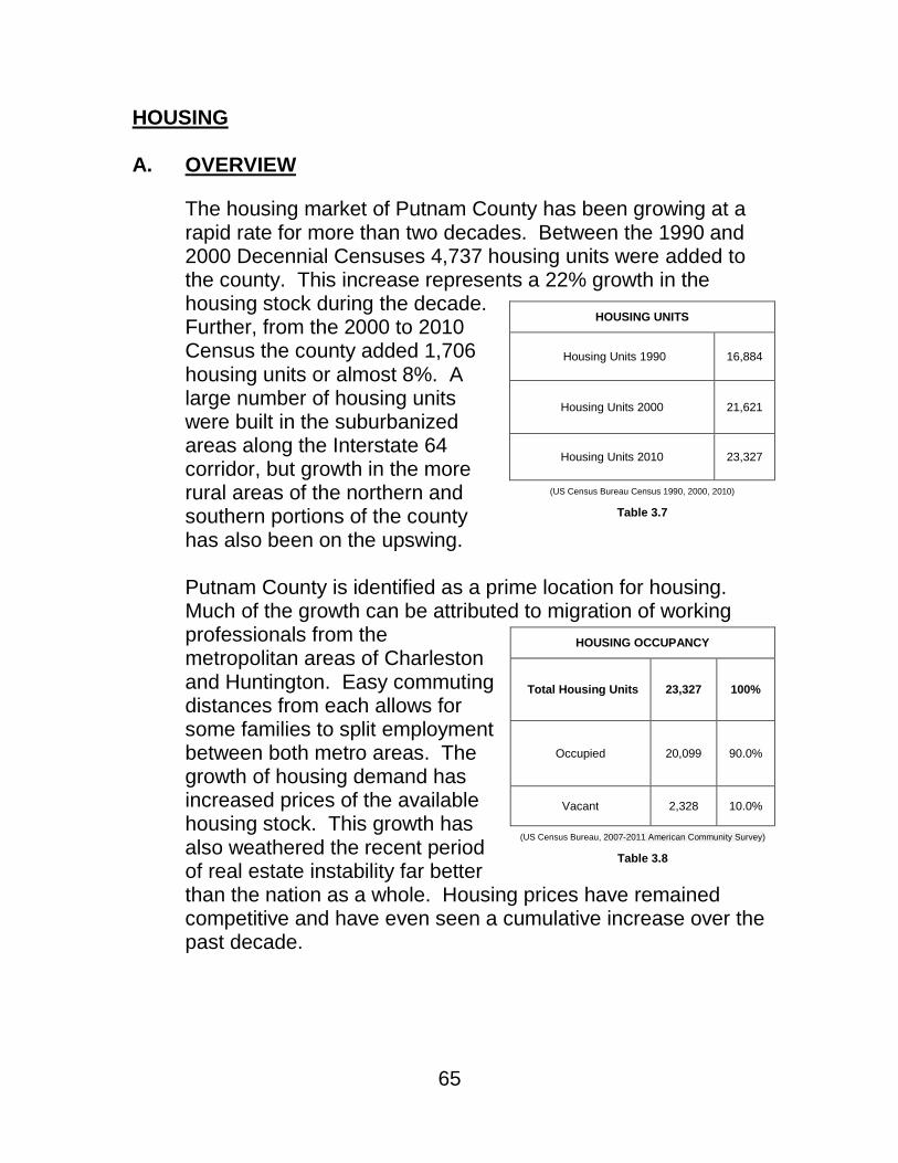
65
HOUSING A. OVERVIEW
The housing market of Putnam County has been growing at a rapid rate for more than two decades. Between the 1990 and 2000 Decennial Censuses 4,737 housing units were added to the county. This increase represents a 22% growth in the housing stock during the decade. Further, from the 2000 to 2010 Census the county added 1,706 housing units or almost 8%. A large number of housing units were built in the suburbanized areas along the Interstate 64 corridor, but growth in the more rural areas of the northern and southern portions of the county has also been on the upswing. Putnam County is identified as a prime location for housing. Much of the growth can be attributed to migration of working professionals from the metropolitan areas of Charleston and Huntington. Easy commuting distances from each allows for some families to split employment between both metro areas. The growth of housing demand has increased prices of the available housing stock. This growth has also weathered the recent period of real estate instability far better than the nation as a whole. Housing prices have remained competitive and have even seen a cumulative increase over the past decade.
HOUSING UNITS
Housing Units 1990 16,884
Housing Units 2000 21,621
Housing Units 2010 23,327
(US Census Bureau Census 1990, 2000, 2010)
Table 3.7
HOUSING OCCUPANCY
Total Housing Units 23,327 100%
Occupied 20,099 90.0%
Vacant 2,328 10.0%
(US Census Bureau, 2007-2011 American Community Survey)
Table 3.8

66
B. CURRENT CONDITIONS The housing market in Putnam County has been sustained by strong demand for single-family homes. About 9 in every 10 housing units in the county are occupied. This low vacancy rate indicates the continued desirability of housing options in the area. Continuing desirability of housing in Putnam County is indicated not only by those who take up residence in the county, but also those who have maintained it. As shown in Table 3.9, 47 percent of homeowners moved into their home since the year 2000. Furthermore, three
quarters of homeowners have moved into their current residence in the last 24 years. The strong housing growth of Putnam County combined with high occupancy rates of housing units and a vigorous real estate market has created an environment that encourages continued growth of housing.
This growth rate has slowed slightly in recent years as the nation as a whole has experienced decreased rates of home-buying. Development projects in Putnam County have
YEAR HOUSEHOLDER MOVED INTO UNIT
Occupied Housing Units
20,999 100%
Moved in 2005 of Later 5,615 26.7%
Moved in 2000 to 2004 4,349 20.7%
Moved in 1990 to 1999 5,689 27.1%
Moved in 1980 to 1989 2,257 10.7%
Moved in 1970 to 1979 1,832 8.7%
Moved in 1969 or Earlier
1,257 6.0%
(US Census Bureau, American Community Survey2007-20011)
Table 3.9
UNITS IN STRUCTURE
Total housing units
23,357 100%
1-unit, detached 17,826 76.4%
1-unit, attached 495 2.1%
2 units 224 1.0%
3 or 4 units 421 1.8%
5 to 9 units 397 1.7%
10 to 19 units 274 1.2%
20 or more units 129 0.6%
Mobile home 3,546 15.2%
Boat, RV, van, etc. 15 0.1%
(US Census Bureau, American Community Survey 2007-2011)
Table 3.10

67
reluctantly followed the current of nationwide market fluctuations, but remain poised to rebound when demand for housing again increases. Housing units in Putnam County are overwhelmingly single-family,
detached structures. If single unit, detached housing structures and mobile homes are considered together they make up more than 90% of all housing units in the county. Multifamily housing units are much less prevalent and make up less than 10% of the total housing stock. Mobile homes account for roughly 15% of the housing stock. While building permit applications for single-family, site built structures has slowed in recent years, permit applications for mobile homes have largely remained steady.
These characteristics make the housing options available in Putnam County very attractive to households with families especially those raising children. An area in need of improvement stems from the fact that single-unit, detached structures can sometimes be too costly for young people, elders, those with a disability or families with a single income raising children to afford. Increased housing options for individuals that cannot afford more highly priced units is essential to maintaining Putnam County’s reputation as a prime housing location. Housing cost is an important indicator of value in terms of overall cost of living for residents and those considering taking up residence within Putnam County. The Selected Monthly
GROSS RENT
Putnam County, Median (dollars) 668
United States, Median (dollars) 871
(US Census Bureau, American Community Survey 2007-2011)
Table 3.11
VALUE
Owner-Occupied
Units 18,084 100%
Less the $50,000
2,187 12.1%
$50,000 to $99,999
3,641 20.1%
$100,000 to $149,999
3,996 22.1%
$150,000 to $199,999
3,433 19.0%
$200,000 to $299,999
3,191 17.6%
$300,000 to $499,999
1,325 7.3%
$500,000 to $999,999
293 1.6%
$1,000,000 or more
18 0.1%
Median (dollars)
140,800
(US Census Bureau, American Community Survey 2007-2011)
Table 3.12

68
Owner Cost (SMOC) is defined as the total of all payments for mortgage or other debt instrument, property insurance, real property taxes, fundamental utilities and condominium, home-owner or lot fees. This index gives an objective view of the overall costs associated with housing for a particular jurisdiction. For housing units that have a mortgage, Putnam County boasts a SMOC that is 30% less than the national median. The figure is proportional for those housing units without a mortgage. As can be seen in Table 3.11, gross rent in Putnam County is similarly about 25% lower than the national median. Despite these positive figures there are a significant percentage of residents that spend more than 30% of their household income on housing costs. For those homeowners with a mortgage, about 1 out of 5 spends more than 30% of household income on housing. For those who rent, 2 out of 5 spend greater than 30% of household income on gross rent. Clearly, affordability of housing is a struggle for some residents. Home values can be indicative of the strength of the housing market. About a third of homes in the county are valued at less than $100,000 while about 59% of homes are valued in the moderate range between $100,000 and $299,999. The median home value of $140,800 is about 25% less than the nation median home value. Overall decreased cost of living allows for an enriched standard of living for County residents. Affordable housing costs have contributed to a healthy climate for business and industry in Putnam County. This also translates to a competitive advantage in promoting Putnam County as a good location for new commerce and industry.

69
Figure 3.1 – Land Value Per Acre
Figure 3.2 – Land Value per Acre
(Putnam County Assessor, 2013)

70
Figure 3.2 – Structure Value
(Putnam County Assessor, 2013)

71
C. PRIORITIES Maintaining Putnam County’s reputation as a desirable housing market in the region is essential. Continuing and enriching the level of public services, community amenities, infrastructure, utilities and schools that have built this reputation will ensure this reputation is preserved. Building upon this reputation means preservation but also growing opportunities for increased housing options for a county population that is facing demographic and market shift. County residents express a deep need for increased housing options that are more moderately priced. Housing development that has been the driving force behind much of the growth the county has experienced is cited as more costly than average families or individuals can afford. Many newly developed housing units have catered to new residents moving into the county. A significant percentage of these new residents tend to be well-paid professional families raising children. This increased demand for larger and sometimes more luxurious housing has driven up both size and cost of homes. While this growth has certainly been a positive force for the county, development of more moderately priced housing options is essential to ensuring that residents of all income levels have an opportunity to find a safe and healthy living environment. Residents also identified the need for housing that provides greater options for aging populations. There is great need for the development of housing that incorporates not only affordability but also the opportunities for increased care, should it become necessary. Assisted living style housing has seen a great deal of growth in other areas of the country, but is lacking in Putnam County. The state’s policy requiring a certificate of need has been identified as the major stumbling block to this sort of housing development. Demographic shifts, including a statewide aging population, indicates that demand for housing options of this type will be increasing. More affordable housing is also a need for young individuals and families that are working toward becoming economically

72
established. Starter homes are in high demand and are not being developed as quickly as their larger and more luxurious counterparts. Also, more affordable rental options are needed in more highly developed areas. Rental housing is in very short supply in rural areas such as Buffalo and other areas north of the Kanawha River. Fostering this type of development means ensuring that basic water and sewage service is made widely available since it is essential to maintaining the affordability of multi-family housing units. Housing is in the most demand and most valuable to a community when it is near the employment, goods and services that residents need. Ease of access can be improved not only by clustering development and fostering mixed-use development, but also by ensuring that housing developments connect well to their surrounding land uses. Cul-de-sac style development has yielded a preponderance of housing options that require the use of an automobile for transportation. This can be frustrating for residents when a car trip is required even for a quick errand, but also excludes those who cannot operate a car from having freedom of movement within the community. The young, elderly and disabled can find themselves faced with few or no options to seek out their basic needs without the assistance of another person for transportation. Increasing the interconnectivity of housing developments to their surrounding land uses is a priority.
D. GOALS AND ACTIONS
1) SHORT-RANGE GOAL:
Promote the interconnectivity of housing development to surrounding land uses.
ACTIONS:
- Evaluate the feasibility of and implement regulations that create incentives for new housing development to connect to surrounding land uses.
73
- Identify and promote methods for existing housing developments to increase interconnectivity through multimodal transportation options.
FINANCE:
Achieving this goal involves, in part, adjusting and innovating applicable land development ordinances. Changes can be studied, evaluated and implemented by the county staff in the Office of Planning and Infrastructure. Creation of incentive based rules to increase interconnectivity, especially non-motorized connections is important. Private investment should be leveraged as a means to increase interconnection. Reallocation of staffing time may be necessary to focus of study, assessment and amendment of rules.
Further financing could be secured with the use of tax increment financing for inter-connection projects that go beyond local and state standards.
2) MEDIUM-RANGE GOAL:
Promote the development of moderately priced and affordable housing options in order to keep pace with growth in higher cost housing development.
ACTIONS:
- Evaluate the feasibility of and implement regulations that create incentives to develop moderately priced housing perhaps by utilizing the planned unit development.
- Identify and promote sources of funding that promote the development of affordable housing options.
- Encourage utility expansion and availability that allows for the profitable construction of low and moderately price housing options.

74
FINANCE:
Promotion of affordable housing is the mission of many community groups that work to develop and advocate on the issue. Partnering with these groups is essential in identifying areas of need, means to achieve the goal and sources of funding. Partnerships can be forged between advocacy groups and private developer to leverage private investment in conjunction with public funding allocated to affordable housing development. The county should develop, foster and support a partnership of this type to leverage funding that is outside the scope of the county budget.
Achieving this goal involves, in part, adjusting and innovating applicable land development ordinances. Changes can be studied, evaluated and implemented by the county staff in the Office of Planning and Infrastructure. Reallocation of staffing time may be necessary to focus of assessment activities.
3) LONG-RANGE GOAL:
Promote the continued reputation of Putnam County as a superior place to live.
ACTIONS:
- Continue to evaluate the development and subdivision process to identify and remedy roadblocks to continued, high-quality growth.
- Evaluate the feasibility of and implement regulations that create incentives to rehabilitate or redevelop unsafe or obsolete housing.
- Support the work of community groups such as homeowner’s associations and businesses such as realty agencies in their efforts to maintain established housing developments and market neighborhoods and communities.

75
FINANCE:
Promotion of the county as a desirable place to make a home is in the interest of individual home owner who are building value in their home investment and also in the interest of the development and real estate community. County officials should network regularly with these citizens to understand challenges and opportunities to promoting housing in the county. These efforts do not need funding support as they initiative can be an undertaking of existing county staff and resources.
Further, achieving this goal involves, in part, adjusting and innovating applicable land development ordinances in order that they remain current in fostering housing that is safe, healthy and desirable for prospective residents. Changes can be studied, evaluated and implemented by the county staff in the Office of Planning and Infrastructure. Reallocation of staffing time may be necessary to focus of assessment activities.

76

77
INFRASTRUCTURE
A. OVERVIEW
Putnam County is committed to providing the best standard of living to its citizens. Often the most fundamental factors in providing basic living necessities is the ability to have water and sewage disposal service to one’s home. In the last several decades much progress has been made in expanding the utility network to provide essential services to residents. More work remains to be done in rural areas in order that all residents have access to basic services. Putnam Public Service District and West Virginia American Water have been major partners in extending service networks throughout the county. Recent expansion projects have been undertaken to improve the water service network. There are areas that have no water service and limited access to ground water. Not only is this a challenge to individuals living in these areas it also is a public safety concern for fire service protection. Water supply to underserved areas remains a priority. Technology is a driver of the modern economy and growth of business development. Success is very much dependent on our ability to reach the world from the desktop. Broadband internet access provides this link. Putnam County has very good broadband access in most developed areas. Wireless and wired connections are widely available for homes and enterprise. As in many communities, access to modern communication networks can be the dividing line between opportunity for growth and a static economy. Growing broadband penetration is an investment in the future prosperity of the county and will become even more essential in years to come.
Chapter 4 Priorities

78
B. WATER: CURRENT CONDITIONS
Water expansion has been a major effort for the major water suppliers to the unincorporated areas of Putnam County and county government. A consistent, safe and affordable water supply is essential to daily life, but also development and growth. The County Commission has worked hand in hand with the Putnam Public Service District and the West Virginia American Water Company to prioritize water projects for consideration and implementation. The evaluation of projects hopes to balance customer need with cost-benefit analysis for the expansion. The County Commission actively seeks grant opportunities to defer costs of expansion for water projects with other portions funded by the utility provider. A temporary surcharge for ratepayers also helps defer costs. Presently there are 25 water expansion projects being evaluated. Of these 25 projects 2 are currently designed while the remaining 23 need further feasibility, engineering or financial study. The designed projects are those to be completed on Manila Creek Road and Allison Hill Road. These two designed projects include the installation of over 12,000 linear feet of new water service line. Currently, these two projects are waiting for additional funding. Six of the 25 projects have not received enough commitments from projected customer for water service and therefore are not being considered at this time. Regular re-evaluation of projects is considered before County Commission. Petitions can be made to the County Commission office for reconsideration.

79
Water Projects
Project Name Description Homes Served
Cost per Home Status
Manila Creek Road 9,700 lf 8” & 3,350 lf 6: pipe 38 $15,764 Surveyed – Minimal Response
Allison Hill Road 1,200 lf 6” &870 lf 2” pipe 8 $17,038 Designed – Awaiting Funding
Laywell Branch/Sycamore Road
3,600 lf 6: & 915 lf 2” pipe 9 $18,957 Surveyed – Minimal Response
Turkey Creek 6,450 lf 8”, 4,530 lf 6’” &
2,465 lf 2” pipe 26 $22,161
Not Interested at time of previous project
Clymer Creek Road 7,175 lf 8” & 565 lf 2” pipe 15 $23,282 Not Interested at time of previous
project
Harvey Creek Road 8,050 lf 6” & 1,150 lf 2” pipe 13 $26,590 Surveyed – Minimal Response
Whitten Ridge Road 760 lf 2”pipe 1 $28,545 Awaiting Contribution by Mason
County PSD
Manila Ridge 30,100 lf 8”, 3,360 lf 6” &
4,440 lf 2” pipe 56 $29,205 Designed – Awaiting Funding
Jim Ridge – Phase II 31,200 lf 8”, 2,010 lf 6” &
1,350 lf 2” pipe 71 $30,417 Awaiting Future Funding
Bear Branch Road 6,200 lf 6” pipe 8 $31,329 Possible Add-alternate to Manila
Ridge Project
Custer Ridge Road 14,200 lf 8”, 2,010 lf 6” &
1,350 lf 2” pipe 24 $32,191
Trace Fork/Mud River 9,300 lf 8” 7,870 lf 6” & 1,748
lf 2” pipe 23 $33,307 Revision Pending
Coleman Creek Road 4,400lf 6” & 1,780 lf 2” pipe 7 $33,652 Upgrade required before expansion
Sigmon Fork 5,780 lf 8” & 2,400 lf 2” pipe 9 $36,294 Further Study Required - GPS
Bowles Ridge Road 12,900 lf 6” pipe 14 $36,603 Reevaluating in conjunction with Fishers Ridge/Jim Ridge Projects
Painters Fork Road 12,530 lf 8” & 1,500 lf 2” pipe 16 $37,390 Surveyed – Minimal Response
Evergreen Road 12,590 lf 8”, 1,560 lf 6” &
2,500 lf 2” pipe 26 $38,265
Spanish Oak Road 2,420 lf 6” & 850 lf 2” pipe 3 $39,123
Fishers Ridge – Phase III 19,360 lf 8”, 1,560 lf 6” &
2,500 lf 2” pipe 36 $42,607 Tank & Booster Station Required
Washington Hill Road 12,820 lf 6” & 3,400 lf 2” pipe 12 $46,260
Fairview Road 16,020 lf 8”, 6,400 lf 6” &
2,740 lf 2” pipe 20 $50,666
Sovine Road/Sheppard Hollow
7,775 lf 6” & 1,535 lf 2” pipe 8 $54,924 Booster Station Sized for Future
Tank
Tuckers Branch 3,470 lf 8” pipe 3 $55,658
Pumpkin Vine Road 9,425 lf 8” & 880 lf 2” pipe 5 $83,243 Low Pressure, Booster May Be
Required
Midway Road 4,540 lf 6” & 870 lf 2” pipe 2 $90,200 Revised to connect to Steele Ridge
Road Line
(Putnam County Commission, Water Main Expansion Requests, Feasibility Report, 2011, updated 2012, Prepared by Terradon Corporation)
Table 4.1

80
Figure 4.1 – Water Project Locations

81
C. BROADBAND: CURRENT CONDITIONS
Broadband internet service is essential to a modern economy and helps connect communities to the outside world. This is a driver of education, business, entertainment and prosperity. The lack of access in rural areas is sometimes called the “digital divide” between the past and the future. Broadband access helps level the playing field between rural and non-rural communities. Just as universal access for telephone service in rural communities was made a national priority in the 1930’s as a way to foster growth, interconnection and public safety, so is broadband access today. Connecting rural areas to the most modern communications networks makes sure that all county residents have access to the outside world. While Putnam County ranks highly in broadband access there are still many areas that are not connected. Roughly 14% of the population lacks access to wireline high-speed internet. This is not uncharacteristic of a county in a rural state and region, but is more than 4 times higher than the national level. Compared to other counties in the state, Putnam County ranks 15th in the percent of the population with wireline broadband access. Expanding the network to reach those without access is essential. Wireless broadband service is very good in Putnam County. Less than 1% of the population does not have access to wireless broadband. High-speed wireless communications is becoming as fundamental to today’s business as wireline access. While wireless access has become more common with the rise of mobile, internet-enabled devices wireline coverage still serves as the backbone of enterprise with higher reliability and transmission speed. At present all public schools, libraries and major healthcare facilities in the county are connected to broadband service. These anchor institutions often help drive access in rural areas.

82
Figure 4.2 – Wired Broadband Coverage

83
Increasing access and speed at these anchors will help drive expansion in rural areas and highly-developed areas alike. Research by the Department of Agriculture and Department of Commerce, Economic Development Administration supports that wages, jobs and businesses grow faster in communities that make investment in broadband infrastructure. Rural communities are especially affected by these investments and reap benefits directly from investment and increased connectivity. Rural areas can connect directly to worldwide markets, marketing, and commerce. This level of connectivity is often a requirement for large enterprises, but small businesses grow and succeed on this essential infrastructure. Connectivity serves as a lifeline to small businesses, allowing them to be more effective and successful. Developed areas within Putnam County’s central corridor are well served by high-speed access. Most areas that have existing high-speed service have wireline download speeds in excess of 25 megabits per second. This high level of service tends to be concentrated along highway corridors and in the most densely populated areas. Speed levels decrease proportionally as customer density and distance from service infrastructure. While high service speeds are currently at acceptable levels in most areas, keeping up with technological improvement and demand is essential to simply maintaining a competitive position. In order to build a vibrant local economy Putnam County must ensure that the level of service is always advancing. Competition in the provider market will help continue to push increases in level of service. Presently there are four wireline broadband providers in Putnam County. This ranks third in the state for access to multiple wireline high-speed service providers.
Median Broadband Download Speed
Home 4.6 mbps
Small Business 8.2 mbps
Mobile 1.8 mbps
(National Telecommunications and Information Administration, Federal Communications Commission, National Broadband
Map, 2014)
Table 4.2

84
Figure 4.3 – Broadband Download Speed

85
D. GOALS AND ACTIONS
1) SHORT-RANGE GOAL: Promote continued expansion of broadband internet services to underserved areas and increase transmission speeds in all areas.
ACTIONS:
- Seek grant opportunities from the West Virginia Deployment Council for expansion in under-served areas.
- Support efforts of Regional Intergovernmental Council in broadband planning and development.
- Support lobbying efforts to increase connectivity and broadband infrastructure investment.
FINANCE:
Funding for broadband expansion is available from the West Virginia Broadband Development Council. Application grants contributing to improvements in scope and service of broadband should be sought by County Commission.
Advocating for and leveraging private investment from service providers should be undertaken by county officials. These efforts can be conducted through Regional Intergovernmental Council.
2) MEDIUM-RANGE GOAL: Expand water service to underserved, developed areas of Putnam County.
ACTIONS:
- Continue strong relationships with water utility providers to secure funding and technical assistance for expansion.

86
- Actively pursue available grant funding from federal, state and private sources.
- Develop public information tools for potential water customers to explain costs of expansion and how this relates to their share in expansion cost.
FINANCE:
County Commission consistently pursues grant funding for expansion of water service. Financing is often a combination of utility funds, grant funds and service fees. This arrangement has been very effective in expansion of service. Continuing this course is recommended.

87
RECREATION
A. OVERVIEW Putnam County has built its reputation of being a desirable place to live partly on providing opportunities for recreation that are not found elsewhere in the area and region. Healthy activity is a major factor in enriching the lives of residents through not only physical fitness, but also in emotional well-being. Investing in recreation enriches the health of our young people and community as a whole. It increases the value of housing and helps workers be more productive. Opportunities for recreation in Putnam County have a great deal of variety. Differing ages, physical abilities and interests require a well balanced mixture of activities. The Putnam County Parks and Recreation Commission (PCPRC) is responsible for managing the public recreational facilities operated by the county. The PCPRC has placed an emphasis on offering a wide array of ways to have fun and be physically active. This variety is part of the reason that residents often cite recreational opportunities as a major factor in their satisfaction with living in Putnam County. Recreation activities also attract many visitors each year. There is no better way to showcase a community and its assets.
B. CURRENT CONDITIONS Putnam County Parks and Recreation Commission currently has three park sites; Valley Park, the Hometown Roadside Park and the Walter Nature Preserve that serve the community. The Putnam County Park is transitioning management from the Parks and Recreation Commission to the Town of Eleanor. Each park varies greatly in its level of development and offered activities. The flagship developed park is Valley Park located centrally along State Route 34 in Hurricane. This large suburban park provides multiple outdoor opportunities including more than

88
4 miles of walking trails, stocked fishing ponds, picnicking pavilions and fenced dog park. Areas for team sports are also well developed including youth oriented baseball and softball fields, tennis courts, beach volley ball courts and soccer fields. Other activities include a seasonal synthetic ice rink and 18-hole miniature golf course. Valley Park also has a large community center with 3,600 square feet of meeting space and commercial kitchen. The Commons, a newer community space, includes a large main multi-purpose room, classroom space, and other break-out space along with kitchen facilities. Facilities are well maintained and provide a central location for events. A major attraction at Valley Park is the Waves of Fun Water Park. This facility was constructed in 1981 to serve the county and region. The facility has been upgraded in recent years to include new waterslides and other attractions. The wave pool is in excess of a half-million gallons and can accommodate 600 swimmers serving more than 2,500 guests at a time. This attraction brings in visitors from the tri-state region during summer months for a taste of the beach in West Virginia. Valley Park hosts the annual Civil War Days each spring attracting reenactors and spectators alike. This large-scale event showcases Civil War history including local battle reenactment, appearances by prominent historical figures of the period, period camping and craft, music, dance and food. Begun in 1998, this event draws attendance from around the country. Valley Park was also recently expanded to more than 65 acres. The new expansion includes pavilion space, multipurpose fields, water features and new maintenance facilities. Precious few large tracts of land are available for recreation space in the highly developed areas of Putnam County. This acquisition and expansion serves to preserve this area for the enjoyment of future residents.

89
The Putnam County Park is located in the small town of Eleanor. This facility has more than 200 acres of recreational space. The park features a swimming pool, basket ball courts, baseball fields, playground facilities and picnic shelters. Boasting more than 10 miles of hiking and mountain biking trails, this park has hosted sanctioned West Virginia Mountain Bike Association competitions. The park is also adjacent to the Putnam County Gun Club offering shooting sport ranges to members and guests. Serving as the regular home of the Putnam County Fair, each summer thousands of visitors converge on Putnam County Park for livestock shows, concerts, motor sports competitions, amusement rides, and other festivities. Facilities for the fair include livestock barns, an exhibition arena and an outdoor amphitheater. The management of this park is in the process of being transferred to the Town of Eleanor. The Hometown Roadside Park consists of two acres of picnic and recreational space outside of the town of Hometown. This facility includes a variety of playground equipment, picnic shelters, and interpretive historical markers. Ongoing projects include the establishment of the Esther & Norman Walter Nature Park. This roughly 30-acre facility, located in rural northern Putnam County, will be geared toward providing a natural setting for wildlife viewing, walking, and education. The donated area for this park is being prepared for opening to the public in the near future. Municipalities offer a wide range of parks and recreation opportunities to county residents as well. The City of Hurricane has a city park that has a water play “sprayground” along with a skate park among other amenities. The City of Winfield and Town of Buffalo maintain youth ball fields and other park amenities.

90
Private recreational opportunities are also widely available in the county. There are three golf courses in the county: Sleepy Hollow Golf Club is located centrally in Teays Valley, Meadowland Golf Club located outside Winfield and Scarlet Oaks Golf Course located outside of Poca. Winfield Riding Club maintains horse stables just outside of Winfield. The FMC Sportsman’s Club maintains a large, private outdoor recreational facility including camping, fishing, shooting ranges, hunting, playgrounds, swimming and picnic shelters. The YMCA has a centrally located facility located of Teays Valley Road (CR 33) in Scott Depot. This facility has a fitness center, pool, indoor courts and recreations space and childcare facilities. The YMCA also operates Camp High-Tor for youth presenting a wide range of educational and entertaining programming.
Recreational investments in many communities center on organized team sports. This is a major driver of many recreation programs in Putnam County and is very important for young people. Rising in popularity for adult residents are activities that tend to be more casual and less organized. This type of opportunity is essential in helping residents find physically active pastimes that both met their interests, but also can be flexible and diverse enough to be part of their everyday lives. Expanding opportunities for daily physical activity, both outdoors and indoors is important to promoting healthy lifestyles.
C. GOALS AND ACTIONS
1) SHORT-RANGE GOAL:
Evaluate and implement casual recreation initiatives that promote daily physical activity.
91
ACTIONS:
- Develop recreation programming that involves residents in non-competitive, casual physical activities including biking and walking trails.
- Support recreational activity clubs for adults as well as young people.
- Develop or alter facilities to accommodate any identified shifts in recreational habits and patterns away from organized team sports and toward casual recreation.
FINANCE:
Special funding outside of existing parks and recreation budgeting is not needed to tailor programming and recreation activities to the needs of the community. Staff time can be diverted as needed to offer new or altered activity offerings with existing facilities. Special funding for special events or new activity initiatives can be appropriated as identified on a cost-benefit ratio in providing healthy, enjoyable activity for the community. Grant funding may be sought for facility improvement to bolster community participation in healthy recreation activities.
2) LONG-RANGE GOAL:
Increase public and private recreational facilities and opportunities for county residents.
ACTIONS:
- Direct Putnam County Parks and Recreation Commission to compile a needs and use assessment of current facilities and offer plans for expanding current facilities and activities.
- Partner with municipal and private entities to collaborate on new projects and the repurposing of current facilities.
92
- Evaluate and alter development standards to promote open and recreational space in new development.
FINANCE:
Special funding outside of existing parks and recreation budgeting is not needed for evaluation of current uses and needs of the community. Staff time can be diverted as needed to compile and evaluate needs and solutions. Special funding of identified projects can be appropriated as identified on a cost-benefit ratio in providing healthy, enjoyable activity for the community. Grant funding may be sought for improvement projects to bolster community participation in healthy recreation activities.
Achieving this goal involves, in part, adjusting and innovating applicable land development ordinances. Changes can be studied, evaluated and implemented by the county staff in the Office of Planning and Infrastructure. Reallocation of staffing time may be necessary to focus of assessment activities.

93
HISTORIC PRESERVATION
A. OVERVIEW Putnam County has a rich historical tradition dating back to long before modern settlement. The earliest known people in the county settled near Buffalo in the Late Archaic Period (3000 – 1000 BCE) as evidenced by discovery of a unique style of arrow and spearhead tips found only in this area. The Buffalo Archeological site, a National Historic Register Site, where these artifacts were found was partially excavated in the mid-1960’s by the West Virginia Geologic and Economic Survey. This study revealed at least four different settlements on the site from between 1000 BCE and 1600 CE The excavation unearthed only 15% of the site yet still found 562 burial sites and tens of thousands of artifacts. Modern settlement began with early exploration of the Kanawha River Valley. Early settlements include Hurricane Bridge first established around 1815 and so named for its location of the James River and Kanawha Turnpike crossing of Hurricane Creek. The Commonwealth of Virginia, recognizing the transportation significance of the river took steps to improve travel by blasting of the Red House Shoals that allowed the first steamboat to travel from the Ohio River to Charleston around 1820. Reliable steamboat travel would take nearly another 80 years to be established with lock and dam improvements completed in 1898. Putnam County was established on March 11, 1848 by act of the General Assembly of Virginia. The area that is now Putnam County was severed from portions of Kanawha, Cabell and Mason counties. Named for Revolutionary War General Israel Putnam the county was home to 5,366 residents which included 632 enslaved persons in 1850. The Civil War was divisive to the nation as a whole and Putnam County was not immune. With roughly 400 men joining each the Union and Confederate forces, tensions

94
were very high at the time. This produced street fighting in Winfield on October 26, 1864 resulting in the death of Captain Philip Thurmond who was aligned with the Confederate forces. Captain Thurmond was buried in an unmarked grave nearby in Winfield and his grave was relocated to the historic Hoge House complex in 2010. Significant battles of the war were fought in Putnam County including the battles of Scary Creek and Hurricane Bridge. The Civil War brought about statehood for West Virginia with final proclamation of admission to the Union by President Lincoln on June 20, 1863. Following the War, Putnam County remained largely a traditional agricultural economy until the beginning of commercialized coal mining began just before the turn of the 20th century. Five major mines were established employing more than 1,000 men by 1907. This industry largely dissipated with the outbreak of World War I and the shift to large-scale manufacturing in the city of Nitro. Putnam County remained very rural and largely divided by the Kanawha River until the construction of the Winfield Toll Bridge in 1957. This interconnection replaced the intermittent ferry service crossing between Red House and Winfield. The construction of Interstate 64 in the 1960’s increased access to uncharacteristically flat land in the Teays Valley and Hurricane areas. Suburban neighborhoods have dominated the development patterns since with Putnam County serving as a bedroom community for adjacent Charleston, and to a lesser extent, Huntington. Historic Preservation is a top goal of many residents. The Historic Landmarks Committee works to identify, assess and protect historical assets in Putnam County. These assessments are conducted by request from property owners or other interested parties. Members of the committee, which include local historians and preservationists, make site visits and research the historical significance of sites and structures throughout the county. Once sites and structures are assessed the committee can work to secure funding for preservation efforts. The

95
committee seeks grants and other financial assistance from federal, state and local sources including the West Virginia Division of Culture and History, the Putnam County Commission, and the City of Winfield among others. This group also works to maintain all historic place markers located around the county with assistance from community service workers. The Hoge House Committee was created specifically to preserve the home of Putnam County’s first judge James W. Hoge. The home, built in 1838, was relocated to avoid demolition to its present location on the Putnam County Courthouse complex. The relocation placed the home within sight of its original location keeping it close to the historic Hoge family cemetery and slave cemetery on the property. The preservation of the home also included pieces of furniture and other belongings of the Hoge family. The structure is now partially restored and under renovation.
B. PRIORITIES
The Historic Landmarks Committee and the Hoge House Committee are invested in preserving the history of Putnam County by making it available and accessible to residents and visitors alike. The Historic Landmarks Committee specifically seeks to continue to identify and assess sites and structures of significance throughout the county. This process takes time and deliberation from a host of volunteers committed to the same goals. Working to increase public awareness of this committee’s work is essential in making preservation of our history a priority to all residents. Resources for preservation are limited so prioritization of projects and initiatives should focus on the most significant and historically unique places, people, and events in the county. The Hoge House Committee is focused specifically on the preservation of the Hoge House and the history surrounding this structure. Judge Hoge, the Hoge family, war veterans

96
like Captain Thurmond killed in Winfield during Civil War fighting, enslaved people living and laboring in Putnam County – these are the stories that can be told with more accuracy and effect when this historic home is preserved for future generations. Renovations are still under progress with further improvements needed to plumbing, roofing and heating before the structure can function as a historical center. The goal of opening the Hoge House as a historical site is to give a backdrop for history to come alive, especially to students. Plans for the site include walking trails to both the Hoge family cemetery and slave cemetery, period furnishings and household items from the Hoge family and others, interpretive exhibits for the native peoples, modern settlement, the Civil War and coal mining history. Exhibits of farm equipment, wagons and other items are also planned. Making history come alive for young people is the most significant goal of this effort. The Hoge House will serve as a place to tell the story of Putnam County. Renovation of the Hoge House is already helping to drive heritage tourism in Putnam County. The Rivers to Ridges Heritage Trail initiative is aimed at identifying scenic byways as an attraction to visitors interested in local history. This effort has created the Mary Ingles Trail Excursion Loop which runs from Nitro to Buffalo along both sides of the Kanawha River Valley. One of the many historical stops is the Hoge House. These efforts combined with the Civil War Days held annually at Valley Park and other historically themed events are making Putnam County a destination for history buffs. Historic Preservation pays dividends to residents and visitors alike.
C. GOALS AND ACTIONS
1) SHORT-RANGE GOAL:
Open the Hoge House as a historical center for the education of residents and visitor.

97
ACTIONS:
- Seek further funding sources to complete renovation of the structure to modern standards while maintaining historical accuracy.
- Develop plans for exhibits, storytelling and interpretive tools for Putnam County history to be located at the Hoge House.
- Partner with public and private schools to make available the historical resources of the Hoge House especially in conjunction with other history themed events like the Civil War Days.
FINANCE:
Work on this historic preservation project has, thus far, been grant funded through historic preservation focused awards and funding from County Commission and the City of Winfield. Continued pursuit of these funds is necessary to complete the project. Pursuit of funds from grantors by County Commission and appropriations from County Commission and the City of Winfield must be undertaken by the Historic Landmarks Committee. Support for grant writing can be provided by County Commission.
2) LONG-RANGE GOAL:
Indentify and preserve historic resources in Putnam County through efforts of the Historic Landmarks Committee.
ACTIONS:
- Implement standard assessment tools to measure the historical significance and value of site and structures.

98
- Actively pursue funding from federal, state, local and private sources for preservation efforts.
- Develop public awareness materials to both promote identified places of historical significance and how individuals can help identify unrecognized places.
FINANCE:
The work of the Historic Landmarks Committee on assessment and identification of historic assets is conducted by community volunteers. Supporting volunteer efforts may be necessary by county officials for record keeping and administration. Continued partnering is necessary. Once assets are identified seeking funding for preservation from grantors, local governments and private sources must be undertaken. Support for grant writing can be provided by County Commission.
99
PUBLIC SERVICES
A. OVERVIEW Putnam County provides a high level of essential public services to residents through emergency dispatching, emergency medical services, law enforcement and protection and emergency preparedness. The Office of Emergency Services provides 911 dispatching service for the entire county including municipal jurisdictions. This service is run from a new, high-tech public safety building built specifically to this purpose. From this hub the Office of Emergency Services can mobilize five full-time advanced life support units with medic stations located in Winfield, Buffalo, Poca, Hurricane and Teays Valley. Three other units can be staffed in case of emergency or special circumstances. These units incorporate the highest level of life-saving technology for pre-hospital care. The dispersal of medic stations throughout the county allows for prompt response to emergency calls. The average response time is 10 minutes county-wide. Emergency preparedness planning is headed by the Office of Emergency Services as well. This agency has implemented an All Hazards Mitigation Plan to put in place procedures on how to respond to differing natural and man-made disasters. Methodical response to extreme weather events, flooding and hazardous material accidents to ensure public safety is maintained. Protecting life and property to the fullest extent possible is the goal of having emergency preparedness plans in place. Dispatching also mobilizes the Putnam County Sherriff’s Department for law enforcement purposes. The Sheriff has thirty-two uniformed law enforcement officers, four detectives within a crime unit, four officers within a drug unit, six staff focusing on home confinement enforcement and four staff process servers. The 2012 crime rates in Putnam County are a third lower than the national levels for violent crimes
100
being 284.75 violent crimes per one hundred thousand residents’ verses 386.90 nationally. When considering property crimes the county’s rate is approximately 25% lower than the national rate. The national property crime rate is more than 2,850 per one hundred thousand residents, Putnam County’s being 762. Putnam County is comparably very safe for both residents and their property. Several municipalities have law enforcement officers on duty to supplement county-wide patrols. Fire service is provided in the unincorporated areas of Putnam County by volunteer fire departments. Fire stations are located around the county with locations in Buffalo, State Route 34 near Confidence in northern Putnam County, Eleanor, Bancroft, Poca, Teays Valley and Hurricane. The Hurricane station is supplemented by two paid emergency medical staff. Fire service in the county is funded by the Putnam County Fire Service Board which is tasked with collecting a fire service fee. The fee, initially instituted in the 1980’s was raised for the first time in 2012 by 50% for most property owners. This increase in funding was necessary as increases in operating and equipment costs have risen dramatically over the past 30 years. Hundreds of volunteers serve the Putnam County community by contributing their specialized skills for fire, rescue and emergency response. The Putnam County Board of Health works to maintain sanitary conditions and fight disease. The Health Department is responsible for food service inspections of all institutions and businesses to ensure cleanliness and proper sanitation practices. Recent reorganization of the department has shifted staffing and office location, but service to the community has been continuous. Current services are offered through contract with the Kanawha-Charleston Health Department. Clinical services include a range of immunizations and other medical services. In addition to food service inspections, environmental services include individual sewage disposal approval and inspection,
101
recreational facilities inspections including swimming pools and spas, private water supply inspection and housing safety inspection including hospitals and daycares. The Health Department also works with national partners like the Centers for Disease Control and Prevention to assess and control infectious diseases.
B. PRIORITIES Maintaining the highest level of public safety is essential to maintaining the high standard of living residents have come to expect. Continually matching services to the community need will allow for limited resources to be used in the most efficient manner possible. Service levels are currently acceptable and should be grown in proportion to their demand. Technology is constantly changing and has a disproportionate impact on how essential emergency medical, law and fire service is provided. Often levels of service can be increased or enhanced by new technologies and in some instances cost savings can be achieved. Consistent, dependable funding for service providers allows these individuals to focus on protecting the life and property of the county and not on fundraising or budgeting. Fiscal constraint is always necessary, but focused investment can yield greater public safety by allowing first responders do their jobs without distraction. Finding ways to tie funding and expense levels to adjusted automatic increases to revenue would achieve this.
C. GOALS AND ACTIONS
1) SHORT-RANGE GOAL:
Provide dependable and predictable funding for fire protection services that maintains proportion to expenses.

102
ACTIONS:
- Direct the Fire Service Board to study and present fire service fee funding styles of other jurisdictions including those that provide for automatic increases tied to inflation or other measures of growth.
- Create public information devices proposing alternative funding models and gauge public preference.
- Adopt policies to include funding increases and future alterations to fire service fee schedules.
- Implement an automatic, proportional fee increase mechanism for fire service fees.
FINANCE:
Funding of this goal can be handled within the current scope of the Fire Service Boards capacity to evaluate funding methods. Nominal funding would be needed to distribute public information materials in Fire Service Board billing mailings and can be appropriated out of operating budgets.
2) LONG-RANGE GOAL:
Maintain consistent levels of public service protections in law enforcement, fire, emergency medical and preparedness.
ACTIONS:
- Commission each agency to provide reporting on current levels of service and effectiveness at protecting the public safety.
- Match levels of funding and staffing to needs assessment completed by each agency.

103
- Adopt the new technology that has been tested and proven to increase safety for residents and reduce costs for agencies.
FINANCE:
Ongoing funding for public safety services is a major focus of county budgeting. Maintaining fiscal constraint during the appropriating process is well established. Implementing detailed reporting for each agency to demonstrate effectiveness of funding will strengthen service to the public and public safety. Utilizing grant funding for special projects to support public safety service delivery is always ongoing and should continue. Support for grant writing can be provided by County Commission.

104
105
A. FINDINGS & CONCLUSION Development of this plan has brought to light a whole host of opportunities and challenges that face Putnam County. The description of these opportunities and challenges within this document is an attempt at condensing a number of very complex issues into a functional guide to inform decision-making. Future decisions made by the Putnam County Commission, its appointee boards and commissions and agencies should consider the goals and actions explained here. This planning process has identified a host of opportunities and challenges for Putnam County. Responding to them requires strategies that are consistent with desires of county residents and thus provide for the following. 1) Protection of residents’ health, safety and welfare. 2) Fiscal policies that anticipate, evaluate and account for
changing circumstances. 3) Application of reasonable and effective development
standards to mitigate negative impacts of continued development so that quality of life is maintained or improved.
4) Consistent economic growth that enhances the quality of life for residents.
5) An efficient and affordable transportation network that meets residents’ needs.
6) Affordable and safe housing options for all residents. 7) Appropriate and cost-effective infrastructure supports
desired living standards and encourages economic growth.
8) Ample and diverse recreation opportunities. 9) Preservation of the historical resources of Putnam County
for the benefit of residents and to encourage tourism.
Chapter 5 Findings & Conclusion

106
As the Putnam County Commission, its appointee boards, commissions and agencies make decisions they should be consistent with the goals described in this document and summarized here: LAND USE GOALS:
Rural - Increase and improve access to basic utility
infrastructure including water and high-speed internet
- Improve roadways to ensure public safety and ease of access
- Preserve the rural character of Putnam County
High Growth Areas - Increase the amount of developed and
undeveloped recreational open space. - Increase and improve the connectivity of
current uses and new developments to reduce traffic, increase public safety, and foster a sense of place.
- Increase residential, commercial, and industrial uses.
Municipal - Require uses compatible with flood zoning
requirements. - Maintain character of the towns. - Increase affordable single and multifamily
housing ECONOMIC ACTIVITY GOALS:
- Support the Putnam County Development Authority in its efforts to market Putnam County as a prime location for commerce and investment.
- Develop affordable housing that keeps pace with growth in higher cost housing.
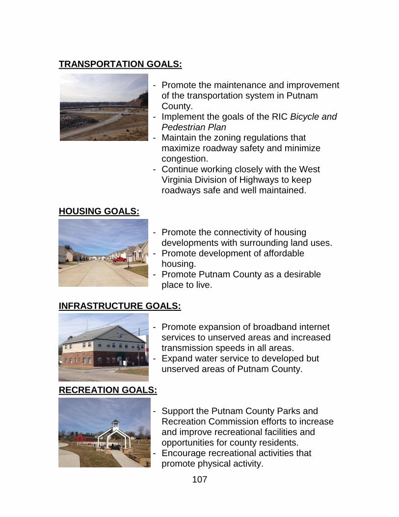
107
TRANSPORTATION GOALS:
- Promote the maintenance and improvement of the transportation system in Putnam County.
- Implement the goals of the RIC Bicycle and Pedestrian Plan
- Maintain the zoning regulations that maximize roadway safety and minimize congestion.
- Continue working closely with the West Virginia Division of Highways to keep roadways safe and well maintained.
HOUSING GOALS:
- Promote the connectivity of housing developments with surrounding land uses.
- Promote development of affordable housing.
- Promote Putnam County as a desirable place to live.
INFRASTRUCTURE GOALS:
- Promote expansion of broadband internet services to unserved areas and increased transmission speeds in all areas.
- Expand water service to developed but unserved areas of Putnam County.
RECREATION GOALS:
- Support the Putnam County Parks and Recreation Commission efforts to increase and improve recreational facilities and opportunities for county residents.
- Encourage recreational activities that promote physical activity.
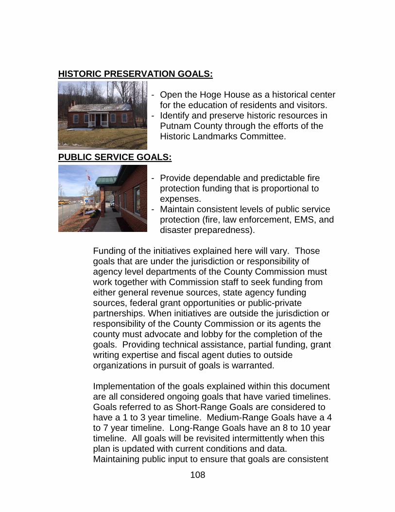
108
HISTORIC PRESERVATION GOALS:
- Open the Hoge House as a historical center for the education of residents and visitors.
- Identify and preserve historic resources in Putnam County through the efforts of the Historic Landmarks Committee.
PUBLIC SERVICE GOALS:
- Provide dependable and predictable fire protection funding that is proportional to expenses.
- Maintain consistent levels of public service protection (fire, law enforcement, EMS, and disaster preparedness).
Funding of the initiatives explained here will vary. Those goals that are under the jurisdiction or responsibility of agency level departments of the County Commission must work together with Commission staff to seek funding from either general revenue sources, state agency funding sources, federal grant opportunities or public-private partnerships. When initiatives are outside the jurisdiction or responsibility of the County Commission or its agents the county must advocate and lobby for the completion of the goals. Providing technical assistance, partial funding, grant writing expertise and fiscal agent duties to outside organizations in pursuit of goals is warranted. Implementation of the goals explained within this document are all considered ongoing goals that have varied timelines. Goals referred to as Short-Range Goals are considered to have a 1 to 3 year timeline. Medium-Range Goals have a 4 to 7 year timeline. Long-Range Goals have an 8 to 10 year timeline. All goals will be revisited intermittently when this plan is updated with current conditions and data. Maintaining public input to ensure that goals are consistent

109
with community priorities is essential. This process of evaluation, revision and renewal should occur five years from its implementation so that goals and priorities will continue to be relevant.
GOALS SUMMARY & TIMELINE
PRIORITY GOAL TIMELINE
LAND USE
RURAL: Increase and improve the access to basic utility infrastructure for rural lands including water and high-speed internet in order to supplement
current land uses and promote compatible growth.
Short-Range: 1 to 3 Years
RURAL:
Improve roadways in rural areas to ensure public safety and ease of access.
Medium-Range: 4 to 7 Years
RURAL:
Preserve the rural character of Putnam County. Long-Range: 8 to 10 Years
HIGH GROWTH AREAS:
Increase the amount of developed and undeveloped recreational open space in high growth areas.
Short-Range: 1 to 3 Years
HIGH GROWTH AREAS: Increase and improve interconnectivity of current land uses and new developments for reduced traffic impact, increased public safety, and
to foster continuity of place.
Medium-Range: 4 to 7 Years
HIGH GROWTH AREAS:
Increase residential, commercial and industrial land uses in high growth areas.
Long-Range: 8 to 10 Years
MUNICIPAL:
Ensure proposed land uses are compatible with flood-prone areas. Short-Range: 1 to 3 Years
MUNICIPAL:
Maintain the small town character of municipal areas. Medium-Range: 4 to 7 Years
MUNICIPAL:
Increase affordable single and multi-family residential land uses in municipal areas.
Long-Range: 8 to 10 Years
ECONOMIC ACTIVITY
Utilize resources to market the County as a prime location for
commerce and investment. Short-Range: 1 to 3 Years
Promote the development of moderately priced and affordable
housing options in order to keep pace with growth in higher-cost housing to maintain economic prosperity.
Medium-Range: 4 to 7 Years
Promote the continued growth of commerce and industry within
Putnam County. Long-Range: 8 to 10 Years

110
GOALS SUMMARY & TIMELINE CONTINUED
PRIORITY GOAL TIMELINE
TRANSPORTATION
Foster a continued close working relationship with Division of
Highways for remedying instances of disrepair and unsafe road conditions.
Short-Range: 1 to 3 Years
Encourage property development and transportation networks growth
concurrently to mitigate stress and congestion of roadways. Medium-Range: 4 to 7 Years
Support and implement the goals described in the RIC Bicycle and
Pedestrian Plan. Medium-Range: 4 to 7 Years
Promote the overall growth and maintenance of the transportation
system of Putnam County. Long-Range: 8 to 10 Years
HOUSING
Promote the interconnectivity of housing development to surrounding
land uses. Short-Range: 1 to 3 Years
Promote the development of moderately priced and affordable
housing options in order to keep pace with growth in higher cost housing development.
Medium-Range: 4 to 7 Years
Promote the continued reputation of Putnam County as a superior
place to live. Long-Range: 8 to 10 Years
INFRASTRUCTURE
Promote continued expansion of broadband internet services to
underserved areas and increase transmission speeds in all areas. Short-Range: 1 to 3 Years
Expand water service to underserved, developed areas of Putnam
County. Medium-Range: 4 to 7 Years
RECREATION .
Evaluate and implement casual recreation initiatives that promote
daily physical activity. Short-Range: 1 to 3 Years
Increase public and private recreational facilities and opportunities for
county residents. Long-Range: 8 to 10 Years

111
GOALS SUMMARY & TIMELINE CONTINUED
PRIORITY GOAL TIMELINE
HISTORIC PRESERVATION
Open the Hoge House as a historical center for the education of
residents and visitor. Short-Range: 1 to 3 Years
Indentify and preserve historic resources in Putnam County through
efforts of the Historic Landmarks Committee. Long-Range: 8 to 10 Years
PUBLIC SERVICES
Provide dependable and predictable funding for fire protection
services that maintains proportion to expenses. Short-Range: 1 to 3 Years
Maintain consistent levels of public service protections in law
enforcement, fire, emergency medical and preparedness. Long-Range: 8 to 10 Years
Table 5.1