pyrmont peninsula place strategy · 500-1,000m. 2 >1,000m. 2. legend. 4 peninsula analysis. 93 /...
TRANSCRIPT

Pyrmont Peninsula Place Strategy
014942
Prepared for NSW Department of Planning, Industry & Environment
Hassell July 2020
Volume I | Project Analysis
PART D
59 PYRMONT PENINSULA PLACE STRATEGY | PROJECT ANALYSIS
4 Peninsula Analysis
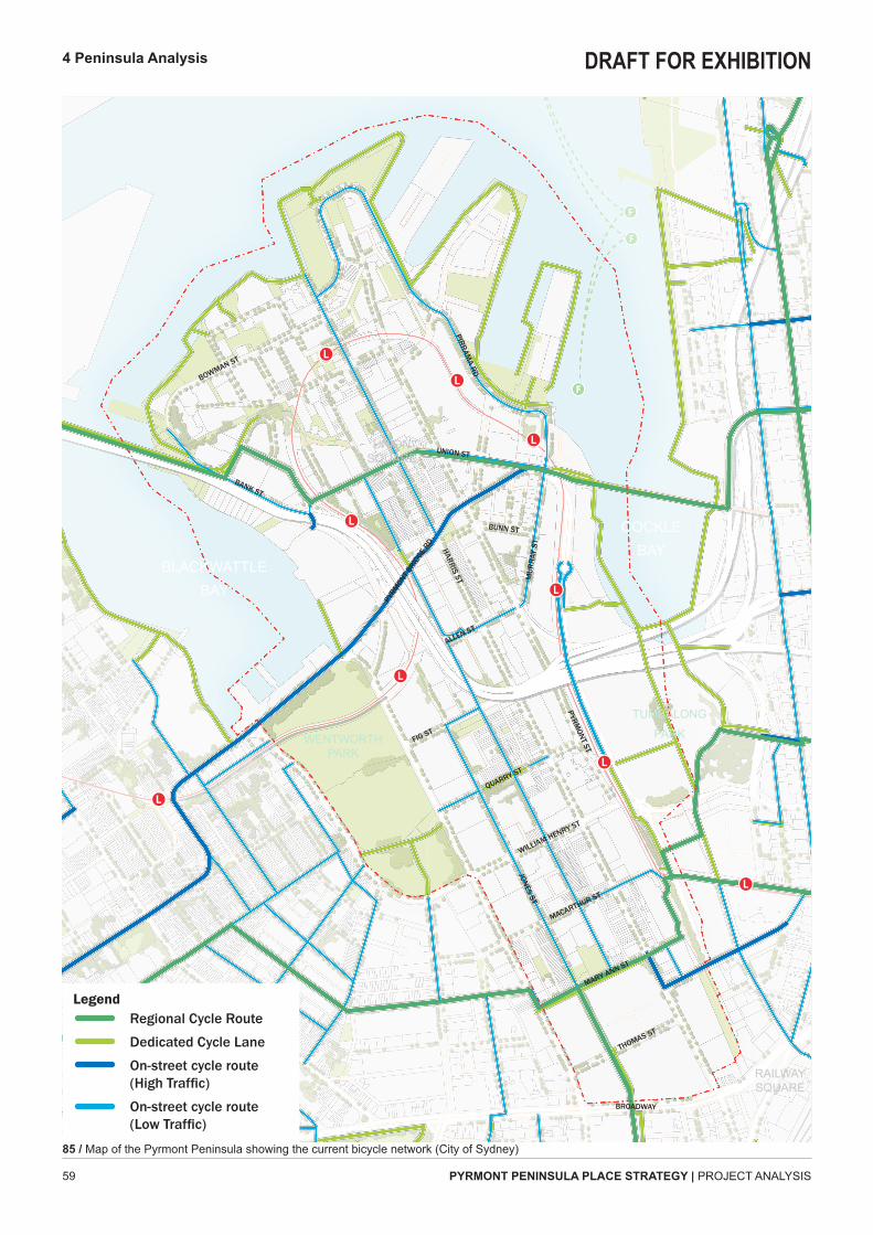
85 / Map of the Pyrmont Peninsula showing the current bicycle network (City of Sydney)
MARY ANN ST
THOMAS ST
BROADWAY
MACARTHUR ST
WILLIAM HENRY ST
QUARRY ST
ALLEN ST
HARRIS ST
BUNN ST
BANK ST
UNION ST
PYRM
ONT BRID
GE RD
BOWMAN ST
PIRRAMA RD
JONES ST
PYRMONT ST
MUR
RAY
ST
FIG ST
BLACKWATTLEBAY
WENTWORTH PARK
TUMBALONGPARK
RAILWAY SQUARE
UNION SQUARE
COCKLEBAY
LegendRegional Cycle Route
Dedicated Cycle Lane
On-street cycle route (High Traffic)
On-street cycle route (Low Traffic)
DRAFT FOR EXHIBITION

PYRMONT PENINSULA PLACE STRATEGY | PROJECT ANALYSIS60
4.12 Built heritage
C69 ULTIMO
C52 PYRMONT
C67 HARRIS ST
Pyrmont Peninsula has a significant number of heritage items that are diverse in typology and period of construction.There are three heritage conservation zones are closely aligned with areas of increased activity and in particular provide the identity for experience of Union Square. The zones are:
Æ C52 'Pyrmont' Æ C67 'Harris St' Æ C69 'Ultimo'
The Sydney LEP 2012 identifies 146 heritage items, this includes a number of state heritage items including:
Æ Pyrmont Bridge. Æ Former Pyrmont Post Office (146-148 Harris Street).
Æ Railyard and Victualling Warehouses A, B and C including the interiors, wharf and sea wall (38-42 Pirrama Road).
Æ Former Ultimo Post Office (494 Harris Street).
Æ Electrical Substation (41 Mountain Street).
Æ Glebe Island Bridge.These sites will inform future built form opportunities and areas of uplift and will require appropriate treatment for potential adaptation or interface in any design scenarios.
The area dates from one of the key period of layers for the development of Pyrmont as a direct result of subdivision of the Harris and Macarthur Estates. It is a good example of a mid to late Victorian working class community consisting of both residential and commercial buildings which are largely intact and make a positive contribution to the streetscape.
The area represents and demonstrates two of the key period layers for the development of Ultimo/Pyrmont as a direct result of the Harris & Macarthur Estates, and later Federation industrial development. It is a good example of mid to late Victorian residential and commercial development with Federation era industrial infill development.
The Ultimo Heritage Conservation Area area dates from one of the key period layers for the development of Ultimo/Pyrmont as a direct result of the Harris and Macarthur Estate subdivisions. It contains good examples of mid Victorian residential, commercial and institutional development.
4 Peninsula Analysis
86 / Images of heritage listed fabric and associated text from the heritage listing description for conservation zones within the Peninsula, Google Street View 2019.
DRAFT FOR EXHIBITION

61 PYRMONT PENINSULA PLACE STRATEGY | PROJECT ANALYSIS
C69 ULTIMO
C52 PYRMONT
C67 HARRIS ST
Conservation Zone
Heritage Item
Heritage Legend
4 Peninsula Analysis
87 / Map of the Pyrmont Peninsula showing heritage listed items and heritage conservations zones (NSW Department of Planning, Industry and Environment)
MARY ANN ST
THOMAS ST
BROADWAY
MACARTHUR ST
WILLIAM HENRY ST
QUARRY ST
ALLEN ST
HARRIS ST
BUNN ST
BANK ST
UNION ST
PYRM
ONT BRID
GE RD
BOWMAN ST
PIRRAMA RD
JONES ST
PYRMONT ST
MUR
RAY
ST
FIG ST
BLACKWATTLEBAY
WENTWORTH PARK
TUMBALONGPARK
RAILWAY SQUARE
UNION SQUARE
COCKLEBAY
DRAFT FOR EXHIBITION

PYRMONT PENINSULA PLACE STRATEGY | PROJECT ANALYSIS62
4.13 Employment density
Whilst it is the second densest residential precincts statistical area 2 of NSW, Pyrmont provides significant employment with the City Plan 2036 noting approximately 7% of all jobs within the LGA.Employment density across the peninsula is generally reflective of the land use and lot size. Larger lots and those lots located near the CBD or within the education precinct provide a greater intensity of employment and within a larger building typology.The former industrial warehouses are a unique asset for the area housing a significant concentration of small businesses from a variety of employment sectors.The lower intensity employment and finer grain lot size around Union Square and Harris Street provide retail and services which contribute to the activity and character of the peninsula.
3. SOUTHERN EMPLOYMENT CLUSTER
2. CENTRAL EMPLOYMENT CLUSTER
1. NORTHERN EMPLOYMENT CLUSTER
4 Peninsula Analysis
88 / Aerial view of the northern employment cluster within the peninsula, Nearmap 2020
89 / Aerial view of the central employment cluster within the peninsula, Nearmap 2020
90 / Aerial view of the southern employment cluster within the peninsula, Nearmap 2020
DRAFT FOR EXHIBITION

63 PYRMONT PENINSULA PLACE STRATEGY | PROJECT ANALYSIS
0-300 Jobs per Ha
300-600 Jobs per Ha
600-900 Jobs per Ha
900-1,200 Jobs per Ha
1,200-2,000 Jobs per Ha
2,000-4,000 Jobs per Ha
More than 4,000 Jobs per Ha
Employment Density Legend
1. NORTHERN EMPLOYMENT CLUSTER
2. CENTRAL EMPLOYMENT CLUSTER
3. SOUTHERN EMPLOYMENT CLUSTER
4 Peninsula Analysis
91 / Map of the Pyrmont Peninsula showing employment density by block (City of Sydney, Floor Space and Employment Survey 2017)
MARY ANN ST
THOMAS ST
BROADWAY
MACARTHUR ST
WILLIAM HENRY ST
QUARRY ST
ALLEN ST
HARRIS ST
BUNN ST
BANK ST
UNION ST
PYRM
ONT BRID
GE RD
BOWMAN ST
PIRRAMA RD
JONES ST
PYRMONT ST
MUR
RAY
ST
FIG ST
BLACKWATTLEBAY
WENTWORTH PARK
TUMBALONGPARK
RAILWAY SQUARE
UNION SQUARE
COCKLEBAY
DRAFT FOR EXHIBITION

PYRMONT PENINSULA PLACE STRATEGY | PROJECT ANALYSIS64
4.14 Lot size
The street grid of the peninsula was largely established by 1887 with the current pattern reflecting a consistent distribution of large lots around the edge interfacing with sites of historical industry, transport and logistics infrastructure and the waters edge.The ridge has maintained a substantial number of finer grain residential subdivisions which are focused on the heritage conservation areas.It is the perimeter of the peninsula where sites are larger and retained in single ownership that initially indicate greatest potential for transformative change in the future.
4 Peninsula Analysis
92 / View looking over Pyrmont Peninsula towards Sydney CBD showing a variety of building typologies on varying lot sizes, City of Sydney 2019
DRAFT FOR EXHIBITION

65 PYRMONT PENINSULA PLACE STRATEGY | PROJECT ANALYSIS
<50m2
50-100m2
100-500m2
500-1,000m2
>1,000m2
Legend
4 Peninsula Analysis
93 / Map of the Pyrmont Peninsula showing the size of individual lots (NSW Department of Planning, Industry and Environment)
MARY ANN ST
THOMAS ST
BROADWAY
MACARTHUR ST
WILLIAM HENRY ST
QUARRY ST
ALLEN ST
HARRIS ST
BUNN ST
BANK ST
UNION ST
PYRM
ONT BRID
GE RD
BOWMAN ST
PIRRAMA RD
JONES ST
PYRMONT ST
MUR
RAY
ST
FIG ST
BLACKWATTLEBAY
WENTWORTH PARK
TUMBALONGPARK
RAILWAY SQUARE
UNION SQUARE
COCKLEBAY
DRAFT FOR EXHIBITION

PYRMONT PENINSULA PLACE STRATEGY | PROJECT ANALYSIS66
4.15 Employment clusters
The industry clusters across the peninsula and the size of businesses accommodated reflects the anchors of the CBD to the north and UTS/TAFE in the south and creative industries occupying former warehouse buildings along Wattle Street.There is a clear north/south differentiation which is driven by a combination of land use, lot size and lack of connectivity.The exception to this is the heritage industrial buildings along Wattle Street which house a diverse range of generally small businesses from across the spectrum of employment sectors.The challenge exists to create a more consistent distribution of small and medium entities between these anchors to drive the innovation economy.
4 Peninsula Analysis
94 / Images of commercial buildings within the peninsula that house significant numbers of employees and a diverse range of businesses, Google Street View 2019
ABC ULTIMOUTS BUILDING 10330-370 WATTLE STREET
52-72 UNION STREET 80 GIPPS ST
80 PYRMONT STSTAR CASINO
8-14 WHARF CR 1 DARLING ISLAND RD 48 PIRRAMA RD
DRAFT FOR EXHIBITION

67 PYRMONT PENINSULA PLACE STRATEGY | PROJECT ANALYSIS
Arts
Retail
Financial Services
Professional Services
Information Media
Health
Education
Employment Sector Density Legend
EMPLOYMENT CLUSTERS
4 Peninsula Analysis
Figure number
95 / Map of the Pyrmont Peninsula showing employment clusters by industry (City of Sydney, Floor Space and Employment Survey 2017)
ABC ULTIMO
UTS BUILDING 10
330-370 WATTLE STREET
52-72 UNION STREET
80 GIPPS ST
80 PYRMONT ST
STAR CASINO
1 DARLING ISLAND RD
48 PIRRAMA RD
8-14 WHARF CR
Arts
Retail
Financial Services
Professional Services
Information Media
Health
Education
LegendMARY ANN ST
THOMAS ST
BROADWAY
MACARTHUR ST
WILLIAM HENRY ST
QUARRY ST
ALLEN ST
HARRIS ST
BUNN ST
BANK ST
UNION ST
PYRM
ONT BRID
GE RD
BOWMAN ST
PIRRAMA RD
JONES ST
PYRMONT ST
MUR
RAY
ST
FIG ST
BLACKWATTLEBAY
WENTWORTH PARK
TUMBALONGPARK
RAILWAY SQUARE
UNION SQUARE
COCKLEBAY
DRAFT FOR EXHIBITION

PYRMONT PENINSULA PLACE STRATEGY | PROJECT ANALYSIS68
4.16 Residential density
Pyrmont-Ultimo SA2's population density makes it the second densest residential neighbourhood in Sydney after, behind Potts Point-Woolloomooloo SA2.Residential densities across the peninsula reflect the development stages with higher density areas being constructed since 1990 in new multi-residential towers and large warehouse building conversions located along the edges and focused on Jacksons Landing in the North and Pyrmont Bridge Road in the centre.The lower density ridge reflects the heritage listed terraces with a significant number of long-term residents.
3. SOUTHERN RESIDENTIAL CLUSTER
2. CENTRAL RESIDENTIAL CLUSTER
1. NORTHERN RESIDENTIAL CLUSTER
4 Peninsula Analysis
96 / Aerial view of the northern residential cluster within the peninsula, Nearmap 2020
97 / Aerial view of the central residential cluster within the peninsula, Nearmap 2020
98 / Aerial view of the southern residential cluster within the peninsula, Nearmap 2020
DRAFT FOR EXHIBITION

69 PYRMONT PENINSULA PLACE STRATEGY | PROJECT ANALYSIS
Less than 80 people per Ha
80 – 150 people per Ha
150 – 200 people per Ha
200 – 250 people per Ha
250 – 500 people per Ha
500 – 800 people per Ha
More than 800 people per Ha
Population Density Legend
4 Peninsula Analysis
1. NORTHERN RESIDENTIAL CLUSTER
2. CENTRAL RESIDENTIAL CLUSTER
3. SOUTHERN RESIDENTIAL CLUSTER
99 / Map of the Pyrmont Peninsula showing residential population density by block (Australian Bureau of Statistics 2016)
MARY ANN ST
THOMAS ST
BROADWAY
MACARTHUR ST
WILLIAM HENRY ST
QUARRY ST
ALLEN ST
HARRIS ST
BUNN ST
BANK ST
UNION ST
PYRM
ONT BRID
GE RD
BOWMAN ST
PIRRAMA RD
JONES ST
PYRMONT ST
MUR
RAY
ST
FIG ST
BLACKWATTLEBAY
WENTWORTH PARK
TUMBALONGPARK
RAILWAY SQUARE
UNION SQUARE
COCKLEBAY
DRAFT FOR EXHIBITION

PYRMONT PENINSULA PLACE STRATEGY | PROJECT ANALYSIS70
4.17 Building typologies
TERRACE / TOWNHOUSE
LOW RISE WALK UP
COMMERCIAL
MID-RISE APARTMENT / SHOPFRONT
HIGH RISE APARTMENT
WAREHOUSE
As a CBD fringe area, the built fabric of Pyrmont Peninsula displays exceptional diversity reflective of it's historical development as well as the changing nature of industry and employment over time.In undertaking future renewal, the challenge will be to retain and extend this diversity such that amalgamations and redevelopments do not result in impermeable and generic outcomes that detract from the vibrancy and urbanity of the peninsula.
4 Peninsula Analysis
WAREHOUSE HOTEL TOWER
100 / Images of building typologies within the peninsula, Google Street View 2019
DRAFT FOR EXHIBITION

71 PYRMONT PENINSULA PLACE STRATEGY | PROJECT ANALYSIS
Terrace / Townhouse
Low Rise Walk Up
Shopfront
Mid Rise Apartment
High Rise Apartment
Commercial Low-Mid Density
Commercial High Density
Warehouse
Large format (public)
Building Typologies
4 Peninsula Analysis
101 / Map of the Pyrmont Peninsula showing building typologies (Hassell)
MARY ANN ST
THOMAS ST
BROADWAY
MACARTHUR ST
WILLIAM HENRY ST
QUARRY ST
ALLEN ST
HARRIS ST
BUNN ST
BANK ST
UNION ST
PYRM
ONT BRID
GE RD
BOWMAN ST
PIRRAMA RD
JONES ST
PYRMONT ST
MUR
RAY
ST
FIG ST
BLACKWATTLEBAY
WENTWORTH PARK
TUMBALONGPARK
RAILWAY SQUARE
UNION SQUARE
COCKLEBAY
DRAFT FOR EXHIBITION

PYRMONT PENINSULA PLACE STRATEGY | PROJECT ANALYSIS72
4.18 Barriers and boundaries
The City of Sydney identifies 4 localities under the DCP for the peninsula however, the urban form is interrupted by changes in land use, arterial roads and topography.There is a distinct change in character north of Pyrmont Bridge Road to a active, leafy residential focused precinct that has limited regional traffic, high quality and substantial open space and built form.South of Pyrmont Bridge Road, the transport function of Harris Street takes precedence leading to an east and west condition that is further fragmented according to land use with pockets of quiet residential lands around Fig Street Park bordered by large format inactive commercial lots.The eastern edge, nestled along the valley floor is a mixture of public, tourism and professional services buildings which speak to the CBD in their global appeal and economic contribution. The steep topography along Darling Drive and Pirrama Road combine with The Star to limit interaction between the CBD and ridge of Pyrmont Peninsula.The character shifts once more south of William Henry Street with apartment buildings that have removed the finer grain terrace experience and a steady transition to the metropolitan anchors of TAFE, UTS and the Powerhouse Museum.
The diverse historic building stock is to be protected and adaptively re-used. New development is to respect, and not mimic these buildings and their setting. New development is to maintain street legibility and provide useable pedestrian and bike links through and within the neighbourhood.
Ultimo is to continue its existing mixed-use character comprising residential, cultural, retail and commercial uses. The historic low scale housing and large scale historical and industrial buildings are to be protected.
A strong physical definition of streets and public spaces by buildings is a predominant characteristic of the area and is to be maintained.
Pyrmont’s mixed use character is to be maintained. The area is to function as a combined living and working precinct while protecting historic buildings and topography. The striking cliff faces are important to remain as exposed landmarks visible from within the area and from the Harbour.
Sydney DCP 2012 - December 2012 2.12-1
LOCALITY STATEMENTSSection 2
2.12Ultimo/Pyrmont
2.12.1 Pyrmont Point
This locality includes the foreshore areas of the peninsula and is bounded by Union Street, Pyrmont Street, John Street, Jones Street, Miller Street and the harbour foreshore.
Pyrmont’s mixed use character is to be maintained. The area is to function as a combined living and working precinct while protecting historic buildings and topography. The striking cliff faces are important to remain as exposed landmarks visible from within the area and from the Harbour. Views of Central Sydney and surrounding suburbs from the public domain are to be maintained. Active ground oor uses such as shops and cafés and restaurants are encouraged.
Principles
(a) Development must achieve and satisfy the outcomes expressed in the character statement and supporting principles.
(b) Retain the dramatic topography created by excavated sandstone cliffs visible from the public domain.
(c) Conserve views and vistas within and beyond the neighbourhood, particularly from the public domain.
(d) Maintain the distinctive character created by the built form on the central ridge and the water front edges.
(e) Provide active ground oor uses in locations and maintain the high quality and amenity of the public domain.
(f) Historical buildings are to be retained and adaptively reused.
(g) Continue the mix of small scale retail and café uses with large scale commercial uses in certain areas.
(h) Encourage café and restaurants to offer street dining where footpath width permits.
Harris Street
Pirrama Road
Bowman Street
Pyrmont StreetBank Street
Lime Street
Shelley Street
Union Street
John Street
Mur
ray
Stre
et
Point Street
Western Distributor
Miller Street
Refinery Drive
Bulwara Road
Saunders StreetM
ount Street
Bunn Street
Dar
ling
Isla
nd R
oad
(Priv
ate)
Herbert St reet
Mill Street
Paternoster Row
Jones Street
Jones B
ay R
oad
Tambua Street
Harvey Street
Edward Lane
Cross Street
Bank Street
U
Sydney DCP 2012 - December 2012 2.12-2
LOCALITY STATEMENTSSection 2
2.12.2 Pyrmont
This locality is bounded by Fig Street to the south, Harris Street, Allen Street and Murray Street to the east and Union Street, Pyrmont Street and John Street to the north. The neighbourhood is bounded to the east by John Street in the north and the foreshore and Wattle Street in the south.
A strong physical de nition of streets and public spaces by buildings is a predominant characteristic of the area and is to be maintained. New development is to align with the street, address the street and respond to the detail and character of existing historic buildings. A high quality public domain is encouraged with awnings and easily identi able building entrances seen from the street. Driveways are to be minimised and located to not con ict with pedestrians.
Principles
(a) Development must achieve and satisfy the outcomes expressed in the character statement and supporting principles.
(b) Development is to respond to and complement heritage items and contributory buildings within heritage conservation areas, including streetscapes and lanes.
(c) Maintain views and vistas from the public domain to the harbour, Central Sydney and surrounding areas.
(d) De ne and enhance the amenity of the public domain with awnings and buildings that align and address the street.
(e) Retain historical low scale housing and large scale industrial buildings.
(f) Use compatible materials including sandstone (where sustainable) and face brick.
(g) Encourage café and restaurant street dining where footpath width permits.
(h) Adaptively re-use historical buildings providing a mix of land uses in the distinctive built forms.
Harris Street
Pyrmont Street
Darling Drive
Bank Street
Bridge Road
Ferry
Roa
d
Mur
ray
Stre
et
Fig Street
Sussex Street
Pyrm
ont B
ridge
Roa
d
Wattle Street
Western Distributor
Cook Street
Forsyth Street
Union Street
John Street
Taylor Street
Bowman Street
Day StreetMiller Street
Ada Place
Pirrama Road
Jones Street
Lime Street
Allen Street
Avon Street
Quarry Street
Glebe Point Road
Saunders Street
Bulwara Road
Mount Street
Cadigal Avenue
Experiment Street
Shelley Street
Bunn Street
Paternoster Row
Charlton Way
Whe
at R
oad
(Priv
ate)
Wat
tle C
resc
ent
Avona Avenue
Edward Lane
Ada Place
Dar
ling
Driv
e
Ada Place
Bank Street
Day Street
Bulwara Road
U
Sydney DCP 2012 - December 2012 2.12-3
LOCALITY STATEMENTSSection 2
2.12.3 Ultimo
This locality is bounded by Mary Ann Street, Harris Street and Ultimo Road to the south, Darling Drive, William Henry Street and Harris Street to the east, Fig Street to the north and Wattle Street to the west.
Ultimo is to continue its existing mixed-use character comprising residential, cultural, retail and commercial uses. The historic low scale housing and large scale historical and industrial buildings are to be protected. Changes to the built form are to respect the scale and character in the vicinity including street scale, proportions and rhythms of existing buildings and materials. Streets and public spaces will feature strong linear edges.
New development is to provide street legibility and improved pedestrian amenity by aligning buildings with the street, entries that address the footway and awnings where required. Ground oor uses that create a lively streetscape and street surveillance are to be provided in locations shown on the Active street frontages map. Sites are to provide improved pedestrian and bike links.
Principles
(a) Development must achieve and satisfy the outcomes expressed in the character statement and supporting principles.
(b) Development is to respond to and complement heritage items and contributory buildings within heritage conservation areas, including streetscapes and lanes.
(c) Encourage street legibility and orientation by retaining street vistas and district views from the public domain.
(d) The height of buildings are to respect and complement existing buildings that contribute to the areas character in terms of scale, elevation detail and proportions and materials.
(e) Development is to address the street and have easily identi able building entries and create a high quality public domain including awnings in locations shown on the Active street frontages map.
(f) Encourage café and restaurants to offer street dining where footpath width permits.
(g) Adaptively re-use historical buildings providing a mix of land uses in the distinctive built forms.
(h) Improve pedestrian and bike connections through sites between Darling Harbour, the proposed extension of the Ultimo Pedestrian Network, Central Sydney, Wentworth Park and Blackwattle Bay.
Harris Street
Wattle Street
Jones Street
Bulwara Road
Geo
rge
Stre
et
Glebe Street
Sussex Street
Mitche
ll Stre
et
Pier Street
Ultimo Road
Quay Street
Bay Street
Broughton Street
Fig StreetBridge Road
St Johns Road
Darling Drive
Quarry Street
Wentworth Park Road
Cow
per S
treet
Hackett Street
Mary Ann Street
Pyrmont Street
William Henry Street
Bellevue Street
Har
bour
Stre
et
T hom
as S
treet
Campbell Street
Darling Street
Hay Street
Macarthur Street
Kelly Street
Darghan Street
Phillip Street
Norto
n St
reet
Ada Place
Kent Street
Crown StreetQueen Street
Liverpool Street
Mckee Street
Pitt Stre
et
Systrum Street
Railway Street
Dixon Street
Colbourne Avenue
Little Hay Street
Henry Avenue
Valentine Street
Kirk Street
Stirl
ing
Stre
et
James Street
Factory Street
Geo
rge
Stre
et
Pier Street
Pier Street
U
Sydney DCP 2012 - December 2012 2.12-4
LOCALITY STATEMENTSSection 2
2.12.4 Student Precinct
This locality is bounded by the former goods rail line to the east, Ultimo Road and Mary Ann Street to the north and Wattle Street to the west. Broadway provides a clear boundary to the south.
The neighbourhood’s distinctive character comprising predominantly institutional and commercial buildings is to be maintained. Suitable mixed-uses are to serve the student and working population and create a lively and active interface with the street and Ultimo Pedestrian Network.
The diverse historic building stock is to be protected and adaptively re-used. New development is to respect, and not mimic these buildings and their setting. New development is to maintain street legibility and provide useable pedestrian and bike links through and within the neighbourhood. Driveways are to be minimised and located so as not to con ict with pedestrians.
Principles
(a) Development must achieve and satisfy the outcomes expressed in the character statement and supporting principles.
(b) Provide high quality design solutions to the UTS tower and its Broadway frontage.
(c) Articulate buildings along Broadway to reduce bulk with openings, pedestrian connections, modulations and material quality.
(d) The height of buildings is to respond to the established building height and scale including the elevation detail.
(e) Protect heritage buildings and encourage adaptive re-use.
(f) Development is to align and address the street and have easily identi able building entries.
(g) Activate the ground oor with student shopfront facilities and retail.
(h) Provide east-west connections between Harris Street and Bijou Lane to improve pedestrian and bike connectivity with railway square and the Ultimo Pedestrian Network.
(i) Provide passive surveillance with active frontages on the Ultimo Pedestrian Network ensuring pedestrian activity at street level.
(j) Provide pedestrian and bike connections through sites between Harris Street and Jones Street, and Broadway and Jones Street.
Broadway
Jones Street
Wattle Street
Harris Street
Quay Street
Ultimo Road
Mountain Street
Mary Ann Street
Geo
rge
Stre
et
Thomas Street
Kelly Street
Lee
Stre
et
Smail Street
Bay Street
Railway S
quare
Macarthur Street
Mckee Street
Pitt Stre
et
Regent StreetKnox Street Grafton Street
Bulwara RoadHackett Street
Valentine Street
Darling Drive
Little Regent Street
Dwyer Street
Wattle Place
St Barnabas Street
Thomas Street
Broadway
Geo
rge
Stre
et
Railway
Squ
are Pitt S
treet
U
4 Peninsula Analysis
102 / Extract of City of Sydney DCP 2012 character areas within the peninsula.
DRAFT FOR EXHIBITION

73 PYRMONT PENINSULA PLACE STRATEGY | PROJECT ANALYSIS
HARRIS STREET.
DARLING HARBOUR
POWERHOUSE MUSEUM PRECINCT
PIRAMA PARK.
SYDNEY FISH MARKETS.
WENTWORTH PARK.
UTS
MARY ANN ST
THOMAS ST
BROADWAY
MACARTHUR ST
WILLIAM HENRY ST
QUARRY ST
ALLEN ST
HARRIS ST
BUNN ST
BANK ST
UNION ST
PYRM
ONT BRID
GE RD
BOWMAN ST
PIRRAMA RD
JONES ST
PYRMONT ST
MUR
RAY
ST
FIG ST
RAILWAY SQUARE
UNION SQUARE
TAFE ULTIMO
4 Peninsula Analysis
Existing Barrier/Boundary
Population serving retail
Night time precinct
Public open space
Regional destination
Education
Legend
103 / Map of the Pyrmont Peninsula showing current character areas and distinct barriers and boundaries between areas within the precinct (Hassell)
STAR CASINO
DRAFT FOR EXHIBITION

PYRMONT PENINSULA PLACE STRATEGY | PROJECT ANALYSIS74
104 / Watermark: Aerial view of the peninsula with Sydney CBD in the background, NSW Department of Planning, Industry and Environment.
DRAFT FOR EXHIBITION

75 PYRMONT PENINSULA PLACE STRATEGY | PROJECT ANALYSIS
5Next Steps
DRAFT FOR EXHIBITION
PYRMONT PENINSULA PLACE STRATEGY | PROJECT ANALYSIS76
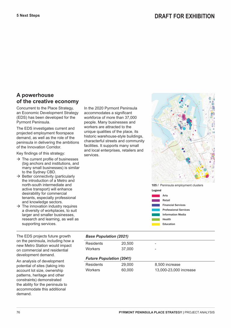
A powerhouse of the creative economyConcurrent to the Place Strategy, an Economic Development Strategy (EDS) has been developed for the Pyrmont Peninsula. The EDS investigates current and projected employment floorspace demand, as well as the role of the peninsula in delivering the ambitions of the Innovation Corridor. Key findings of this strategy:
Æ The current profile of businesses (big anchors and institutions, and many small businesses) is similar to the Sydney CBD.
Æ Better connectivity (particularly the introduction of a Metro and north-south intermediate and active transport) will enhance desirability for commercial tenants, especially professional and knowledge sectors.
Æ The innovation industry requires a diversity of workplaces, to suit larger and smaller businesses, research and learning, as well as supporting services.
In the 2020 Pyrmont Peninsula accommodates a significant workforce of more than 37,000 people. Many businesses and workers are attracted to the unique qualities of the place, its historic warehouse-style buildings, characterful streets and community facilities. It supports many small and local enterprises, retailers and services.
Base Population (2021)
ResidentsWorkers
20,50037,000
--
Future Population (2041) ResidentsWorkers
29,00060,000
8,500 increase13,000-23,000 increase
The EDS projects future growth on the peninsula, including how a new Metro Station would impact on commercial and residential development demand. An analysis of development potential of sites (taking into account lot size, ownership patterns, heritage and other constraints) demonstrated the ability for the peninsula to accommodate this additional demand.
5 Next Steps
Arts
Retail
Financial Services
Professional Services
Information Media
Health
Education
Legend
105 / Peninsula employment clusters
DRAFT FOR EXHIBITION

77 PYRMONT PENINSULA PLACE STRATEGY | PROJECT ANALYSIS
Central Station
Sydney Airport
Sydney City Centre
INNOVATION
Harris Street
TECHNOLOGY
CREATIVE
Tumbalong ParkWentworth Park
Blackwattle Bay
Rozelle Bay Cockle B
ay
RESEARCHLEARNING
The Bays Precinct
A connector of people and placesWhile Pyrmont Peninsula has the capacity to deliver this development demand, it also plays an equally critical role as a connecting place. Located between Sydney's historic city centre and the emergent Bays Precinct, and adjacent to the fast-evolving Central Station area – the peninsula will have a unique role in linking and supporting these hubs of the Eastern Harbour City.Its incredible natural setting, heritage streets and spaces, set it apart from others – and these are the elements that are key to the future success:
Æ Retaining local character and activity – a contrast to the new and old commercial centres that will occupy the peninsula;
Æ Embracing, defining and connecting to the water and parklands that sit around its edges.
Æ Reinforcing and celebrating its special streets, spaces and neighbourhoods.
Æ Balancing regional and local connectivity.
Æ Developing the social infrastructure of the future the spaces, housing, resources and systems that will make this one of Sydney's most sustainable places.
5 Next Steps
106 / Diagrammatic representation of strategic location of Pyrmont Peninsula in connecting the innovation corridor anchors
105 / Peninsula employment clusters
DRAFT FOR EXHIBITION

PYRMONT PENINSULA PLACE STRATEGY | PROJECT ANALYSIS78
5 Next Steps
From an analysis of the complex, layered nature of the Pyrmont Peninsula, five unique characteristics of this place have been identified. These characteristics reveal some of the challenges and opportunities the peninsula faces over coming decades, and informs the key elements of the Strategic Framework.
The natural setting of this place is quintessentially Sydney, a city of rocky peninsulas and bay parks, of close connection to water. And with a deeper recognition of millennia of occupation, of connection to and care for country. The dynamic topography and natural systems of the peninsula are fundamental to its character, historic development and urban structure - but also create barriers to movement.
The Opportunities Æ Expand and enhance the public domain - accessible, engaging and restorative places for everyone
Æ Improve access to and engagement with the harbour
Æ Restore damaged ecologies especially at the water edge
Æ Reinforce and enhance viewlines along streets to the water
Sydney's original industrial heartland, the peninsula has always housed a diverse, dynamic community ... from factory workers and green ban activists to tech workers and international students. It is a place of social inclusion, community hubs and cultural destinations, an innovator in the provision of worker housing, new industries and great public places.
The Opportunities Æ Retain a diversity of affordable, high quality homes and workplaces
Æ Protect existing community spaces and facilities
Æ Engage the community in the planning, design and care for places
A peninsula landform, a true Sydney setting
1 2
Socially inclusive, a dynamic community
107 / Pirrama Park, City of Sydney 108 / Pyrmont Markets in Metcalfe Park
DRAFT FOR EXHIBITION

79 PYRMONT PENINSULA PLACE STRATEGY | PROJECT ANALYSIS
5 Next Steps
The Pyrmont Peninsula has a constellation of different neighbourhoods, streets and spaces. It has a rich layering of industrial, commercial, residential heritage - a built fabric that is diverse and delightful. From the terrace house to warehouse, the peninsula is packed with great buildings that attract workers and residents alike.
The Opportunities Æ Consider ways to express the Aboriginal story of this place
Æ Reinforce the unique character and qualities of each neighbourhood
Æ Regenerate historic ridgeline villages to retain diversity, affordability and local character
Æ Support economic diversity, including reuse of warehouse and industrial buildings
This has long been a place of change and transformation - from landscape to farmland, working harbour and production hub, to today's thriving urban community. The peninsula has adapted to social and economic change: its people, its buildings and spaces are resilient. It is a place of social and economic innovation, Sydney's creative heartland.
The Opportunities Æ Renew larger sites to create workplaces for the innovation and creative economies
Æ Ensure development protects public amenity and delivers community outcomes, including new spaces and connections
Æ Deliver peninsula-wide sustainability outcomes including "net-zero" demonstration projects
The peninsula has always been considered "city fringe", a place bisected and often overwhelmed by regional road, rail and industrial infrastructure. It is well positioned, but some places (including big attractors like the fishmarkets and museums) can be difficult to get to, with limited public transport and many disconnected movement paths. The peninsula community choose to walk and cycle most places. The Opportunities
Æ Investigate opportunities for new transport connections such as Metro, light rail and cycleways
Æ Ensure streets are green, walkable, enjoyable spaces
Æ Explore ways to overcome barriers of topography, roads and rail lines
3 4 5
Heritage layers, authentic places
Adaptation and innovation
Close to everything, not well connected
109/ Aspire (light sculpture), Warren Langley 110/ Union Street Square, Real Estate View 111/ Dr Chau Chak Wing, UTS
DRAFT FOR EXHIBITION
