quality of drinking water in thailand; leveraging...
TRANSCRIPT

Quality of Drinking Water in Thailand; Leveraging Contaminant Warning Systems for
Operations Benefits, or Environmental Water Security
1
Mr.Vichian UdomratanasilpaDeputy Governor (Technical Affairs)
Provincial Waterworks Authority ,PWA.

Contents1. What is Water Quality 2. Standards for surface water3. Water Source Quality Management4. System of following up and monitoring PWA’s data water
in the production system (By PWA’s branches)Monitoring water quality of water sources at the site
Telemetering system SCADA system5. System of following up data water from other agencies’
raw water monitoring stations6. Benefits of Warning systems
2
Quality of Drinking Water in Thailand; Leveraging Contaminant Warning Systems for Operations
Benefits, or Environmental Water Security

What is Water Quality??
Toxic Pollutants acute and chronic
Non-toxic Pollutantse.g., sediment, nutrients
Physical parameterse.g., temp, pH, color,odour, suspended solids
SyntheticsPesticides, antibiotics, industrial compounds, etc.
Fish and benthic macroinvertebrate communities
Algae and aquatic plants
The quality of the water resource
ChemicalPhysical Biological
3
1

Safe Drinking Water
Safe Water Characteristics• Free of Pathogenic organisms• Clear• Tasteless and colorless• Low in concentrations of toxic compounds• No interaction with transmission pipes/fitting & storage containers
The definition of safe drinking water according to the WHO Guidelines is “does not represent any significant risk to health over the lifetime of consumption, including different sensitivities that may occur between life stages.”
4
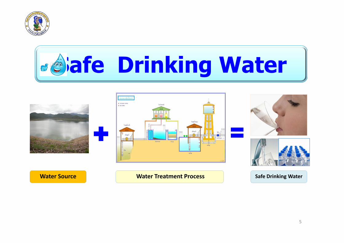
Safe Drinking Water
5
Water Source Water Treatment Process Safe Drinking Water

Standards for surface
water
Notification of the National
Environmental Board, No. 8,
B.E. 2537 (1994)
To control and maintain the quality of water sources to be suitable for various uses (Multi Purposes) and that the standards are applicable to all these uses .To conserve resources and the natural environment, with regard to the health and safety of human life and animals in the water. 6
2

Surface Water Quality Standards
Parameter1/ Units Standard Value for Class2/
Class1 Class2 Class3 Class4 Class5
1. Colour,Odour and Taste - n n’ n’ n’ -
2. Temperature C° n n’ n’ n’ -
3. pH - n 5-9 5-9 5-9 -
4. Dissolved Oxygen (DO)2/ mg/l n 6.0 4.0 2.0 -
5. BOD (5 days, 20°C) mg/l n 1.5 2.0 4.0 -
6. Total Coliform Bacteria MPN/100 ml n 5,000 20,000 - -
7. Fecal Coliform Bateria MPN/100
mln 1,000 4,000 - -
8. NO3 -N mg/l n 5.0 -
9. NH3 -N mg/l n 0.5 -
10.Phenols mg/l n 0.005 -
11.Copper (Cu) mg/l n 0.1 -
12.Nickle (Ni ) mg/l n 0.1 -
13.Manganese (Mn) mg/l n 1.0 -
14.Zinc (Zn) mg/l n 1.0 - 7

Surface Water Quality Standards
Parameter1/ Units Standard Value for Class2/
Class1 Class2 Class3 Class4 Class5
15.Cadmium (Cd) mg/l n 0.005*
0.05**
-
16.Chromium Hexavalent mg/l n 0.05 -
17.Lead (Pb) mg/l n 0.05 -
18.Total Mercury (Total Hg) mg/l n 0.002 -
19.Arsenic (As) mg/l n 0.01 -
20.Cyanide (Cyanide) mg/l n 0.005 -
21.Radioactivity
- Alpha
- Beta
Becqurel/l n 0.1
1.0
-
22.Total Organochlorine Pesticides mg/l n 0.05 -
23.DDT μg/l n 1.0 -
24.Alpha-BHC μg/l n 0.02 -
25.Dieldrin μg/l n 0.1 -
26.Aldrin μg/l n 0.1 -
27.Heptachlor & Heptachlorepoxide μg/l n 0.2 -
28.Endrin μg/l n None -8

Classification and Objectives
Classification Objectives/Condition and Beneficial Usage
Class 1 Extra clean fresh surface water resources used for :
(1) conservation ,not necessary to pass through water treatment process
requires only ordinary process for pathogenic destruction
(2) ecosystem conservation where basic organisms can breed naturally
Class 2 Very clean fresh surface water resources used for :
(1) consumption which requires ordinary water treatment process before
use
(2) aquatic organism of conservation
(3) fisheries
(4) recreation 9
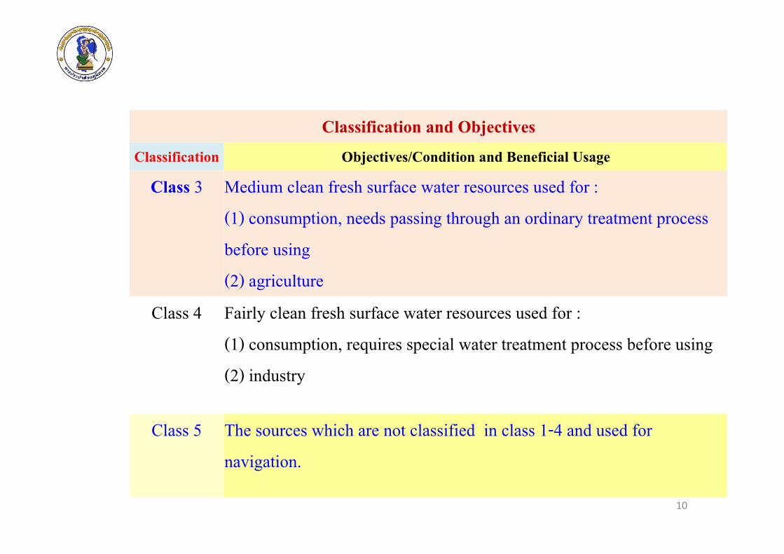
Classification and Objectives
Classification Objectives/Condition and Beneficial Usage
Class 3 Medium clean fresh surface water resources used for :
(1) consumption, needs passing through an ordinary treatment process
before using
(2) agriculture
Class 4 Fairly clean fresh surface water resources used for :
(1) consumption, requires special water treatment process before using
(2) industry
Class 5 The sources which are not classified in class 1-4 and used for
navigation.
10

Efficient Management : Quantity ,Quality and Time
• Have Data (Quantity & Quality)
• Have plans for management and prevention, and also action plans. (current & future plan, including during the crisis)
Leveraging Contaminant Warning Systems for Operations Benefits, or Environmental Work Security
11
Water Source quality management3

Plans for management & protection of water sources
Define area for raw water source conservationfor MWA (By Law)
MWA’s raw water sources : Chao Phraya river in Pathumthani prov. & Maeklong riverin Kanchanaburi prov.
1979 Raw water conservation in the northern area of Bangkok 1992 Raw Water conservation in the western area of Bangkok
12

Monitoring systemMonitoring system
‐ Using fish Monitoring : Puntius Gonionotus
Using biology alert system
On‐lines Measurement - install above Intake
- with Automation Control
Water Source Quality Management
Community network
13
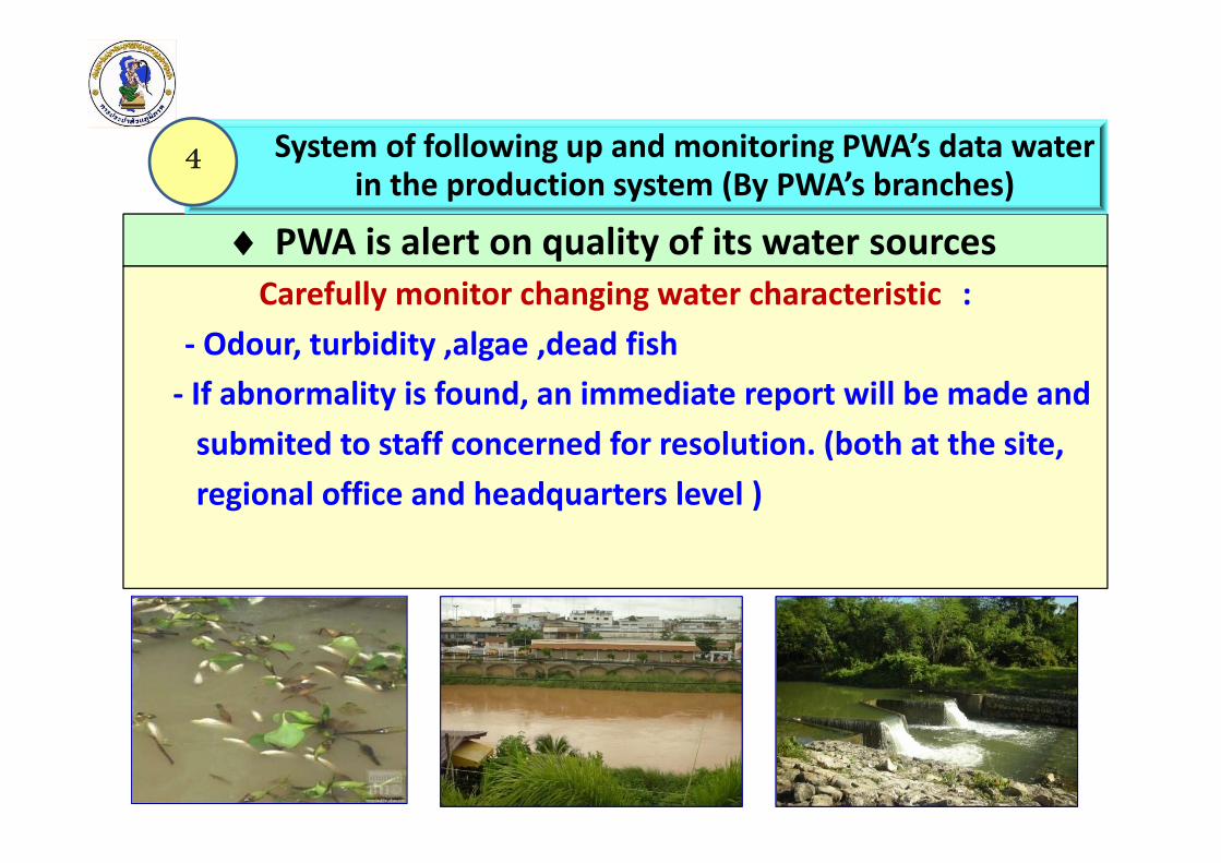
PWA is alert on quality of its water sourcesCarefully monitor changing water characteristic :
‐ Odour, turbidity ,algae ,dead fish‐ If abnormality is found, an immediate report will be made and submited to staff concerned for resolution. (both at the site, regional office and headquarters level )
14
System of following up and monitoring PWA’s data waterin the production system (By PWA’s branches)
4

PWA’s monitoring system at its branch offices
15

PWA’s internalcoordinationamong variousbranches onwater qualitydata.(such as PWA’s branches using 16
Water quality control at PWA’s branch offices
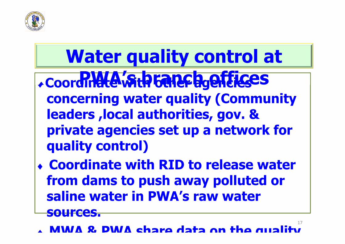
Coordinate with other agencies concerning water quality (Community leaders ,local authorities, gov. & private agencies set up a network for quality control)
Coordinate with RID to release water from dams to push away polluted or saline water in PWA’s raw water sources.
MWA & PWA share data on the quality17
Water quality control at PWA’s branch offices

Via PWA’s branches’ website
Via PWA’s network (of other agencies )
Follow up data on water Quantity & quality from PWA’s raw water monitoring stations
18

An automatic system sending water data to
PWA’s branches & headquarters
Main components :‐ Remote Terminal
Unit‐ Communication‐ Master Station
Early Warning System : Telemetering
19
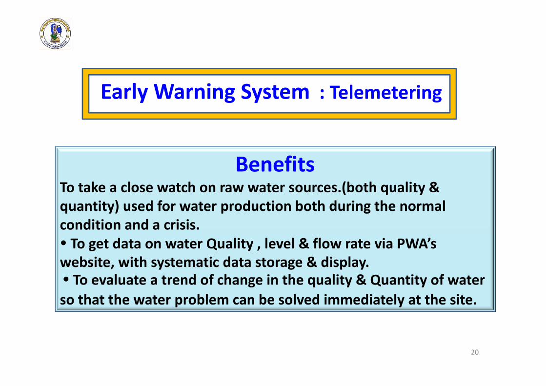
BenefitsTo take a close watch on raw water sources.(both quality & quantity) used for water production both during the normal condition and a crisis. To get data on water Quality , level & flow rate via PWA’s website, with systematic data storage & display. To evaluate a trend of change in the quality & Quantity of water so that the water problem can be solved immediately at the site.
20
Early Warning System : Telemetering

System of following up water data from otheragencies’ raw water monitoring stations
21
5
Ministry of Natural Resources
and Environment
Ministry of Agriculture and Cooperatives Ministry of Industry
Ministry of Energy Ministry of Interior
PCD DWRRIDDIW
MWA PWAEGAT

22
Other agencies using telemetering systems
Royal Irrigation Department Department of Water Resources
Department of industrial Works
Electricity Generating Authority Thailand
Pollution Control Department, Regional office Environment
Metropolitan Waterworks Authority

PWA’s water monitoring Stations
23

24
Map of PWA’s raw water monitoring station
30 stations across the country
(normally located in the area with
problems of water & quality)
In 2012
In 2013
In 2014

25
Locations of PWA’s monitoring stations
Khon Kaen WaterworksChi River
Ubon RatchathaniWaterworksMun River
Phichit WaterworksNan River

26
Bang Kha WaterworksPrawet Bureerom canal
Angthong WaterworksChao Phraya River
Suphanburi WaterworksTha Chin River
Locations of PWA’s monitoring stations (Continued)
Krabi WaterworksKrabi Yai canal
Hat Yai WaterworksU‐Tapao canal

27
Locations of PWA’s monitoring stations (Continued)
Maha sarakhamWaterworksChi River
SakonNakhonWaterworks
Han swamp
Muk dahanWaterworksMekong River
Chiang RaiWaterworksKok River
Mae Sot WaterworksMoei River
PhachniburiWaterworksPhrachi River
Ban Pong Waterworks
Maeklong River
Ban ta khunWaterworks
Phum duang canal

28
The Overall systems of raw watermonitoring stations
1. Monitoring quantity of
water
2. Monitoring quality of water
3.Communication sytem
5. Warning system for
water quality surveillance
4. Monitoring result report

29
Water Quality Monitoring Systems
1. Monitoring with instrument(Physical & Chemical)
2. Fish Monitoring (Toxicity)

30
Raw Water Quality Monitoring Systems (Continued)
Fish Monitoring (Toxicity)
‐ Fish aged 3 Months‐ Body length less than 3 cmwith 100 fishes
Evaluation the toxicity of water
‐Monitor the movement of fish , 24 hours with CCTV
31
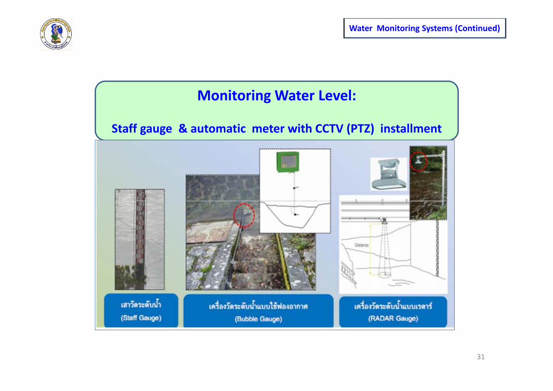
Monitoring Water Level:
Staff gauge & automatic meter with CCTV (PTZ) installment
Water Monitoring Systems (Continued)

32
Water Monitoring Systems (Continued)
Monitoring Water Float:The machine may be permanently install or mobile

33
Water Monitoring Systems (Continued)
Monitoring result report system

34
Warning system for water quality surveillance
signal Condition to surveillance
Signal Crisis (danger)
2.Sending a short message to the operator & others
1. Emergency sound signal
Water Monitoring Systems (Continued)

Linking water quality data fromMonitoring Station
35
In 2014 PWA has a Plan to link its 30 monitoring stations with PWA Headquaters Linking water quality & other agencies in order to share water data with them concerning water source conservation , including giving a warning of natural disaster.
Water Monitoring Systems (Continued)

36
Linking water quality from :Monitoring Station SCADA System PWA’s Automation tap water quality monitoring Tools
Type Number
Monitoring Station 30
SCADA System 22
Automation tap water quality monitoring Tools
13

37
Linking raw water quality from : Monitoring Station/ SCADA System/ PWA’s Automation tap water quality monitoring Tools
Get the water sample from the production system through analysis of water quality , continuously for 24 hours
Key Parameters : pH ,turbidity , chlorine
Automation tap water quality monitoring Tools

38
Linking raw water quality from : Monitoring Station/ SCADA System/ PWA’s Automation tap water quality monitoring Tools
SCADA System (Supervisory Control and Data Acquisition)
SCADA is a system that compiles data from various sources and send the data to a control center for analysis & processing by a computer while analytical result can be sent to control the perform of tools in the systems, including displaying the perform status of those tool major component.

Reporting system for SCADAHua Hin Substation, Pranburi WWk.
39
Can Control production & Distribution system from center. Can monitor steps of production & distribution all the time. Can analyse the system & give a warning. Can record & retrieved data. Keep a close watch all raw water quality/tap water and keep awarning 24 hours.Others

40
Reporting system for SCADA Hua Hin Substation , Pranburi WWk. (coninued)

On December 4, 2008Thailand Environment Day
Ministry of InteriorMinistry of Industry
Ministry of Agriculture and Cooperatives
Ministry of Natural Resources and Environment
Had To resolved to cooperate
on protection & solution of waterquality in the critical river basin
Data linking among government agency

Objective of resolution
To cooperation preserving water sources retrieve the quality of water in the main water sources of the country, which are now degraded, in order to come back a normalstandard, in order to preserve ecological system of thosewater sources & the people ‘s way of life near the river.
42
Data linking among government agency

Map of river Basin
in Thailand
(25 river Basins)
43

5 critical river basins in Thailand
Chao Phraya basin
Tha chin river basin
Bang pa kong basin
Lumtakong basin
Songkhla lake basin
44
Province in the target area
Chao Phraya basin Tha Chin BasinBangpaKong Basin
LamtakongBasin
Songkhla lake Basin
( BangpaKong riverPrachinburi river
Nakhonnayok river )
1.Nakhon Sawan 1. Chai Nat (some area)
1. Prachin Buri Nakhon Ratchasima
1. Nakhon Si Thammarat
2. Chai Nat (some area)
2. Suphan Buri 2. Nakhon nayok 2. Phatthalung
3.Sing Buri 3. Nakhon Pathom
3. Chachoengsao 3.Songkhla
4.Lop Buri 4. Samut Sakhon4. Chon Buri
5.Ang Thong6.Phra Nakhon Si Ayutthaya7. Sraaburi8. Pathum Thani9. Nonthaburi10. Bangkok11. Samutprakan

45
Waterworks under
Regional office10
1. Lat Yao
2. Tha tako
3. Nakhon sawan
4. Phayuhakiri
5. Chainat
Waterworks under
Regional office2
6. Bangrachan
7. Singburi
8. Wisetchaichan
9. Angthong
10. Phakhai
11. Sana
12. Banmi
13. Lopburi
14. Ayutthaya
15. Pathum thani
16. Rangsit
1
234
5
6 712
1398
1011
14
15 16
List of PWA Waterworks at Chao Phraya river Basin

Department of Water Resources(DWR)
Location of other agencies’ monitoring stations & Telemetering ‐ Chao Phraya river basin ‐
Royal Irrigation Department (RID)
Pollution Control Department(PCD)
46

Map of Monitoring stations- Chao Phraya river basin only -
47
PWA
PCD
REO
DWR
RID

9 Waterworks 1. DoembangNangbuat2. Danchang3. SriPrachan4. Laokhwan5. Suphan Buri6. U‐Thong7. Shumphan8. Omnoi9. Samut Sakhon
สัญลักษณ
48
List of PWA Waterworks at Tha Chin river Basin
12
4 3
65
7
98

Water quality monitoring stationsPCD & EOR 1‐16( 59 stations )
49

Website showing water Quality from monitoring station
PCD & EOR(http://58.137.231.37/wqm/GGW/)
Parameter measurement: pH , DO , EC , Salinity , temperature with Levels and water quality

Telemetering system for water Quantity & Quality : DWR
96 stations
( 32 stations : Monitoring water quality )
Telemetry Mekong‐Chi‐Mun Basin50 stations
13 stations : water quality monitoring
Telemetry Songkhla Lake Basin11 stations
7 stations :water quality monitoring
Telemetry Chao Phraya basin15 stations
5 stations :water quality monitoring

Website showing water Quality from monitoring station , DWR
(http://mekhala.dwr.go.th/main/)
52

Water Quantity : water (river cross section) / rainfall with level of warningWater Quality : pH / DO / EC / temperature with level of warning
Website showing water Quality from monitoring station DWR
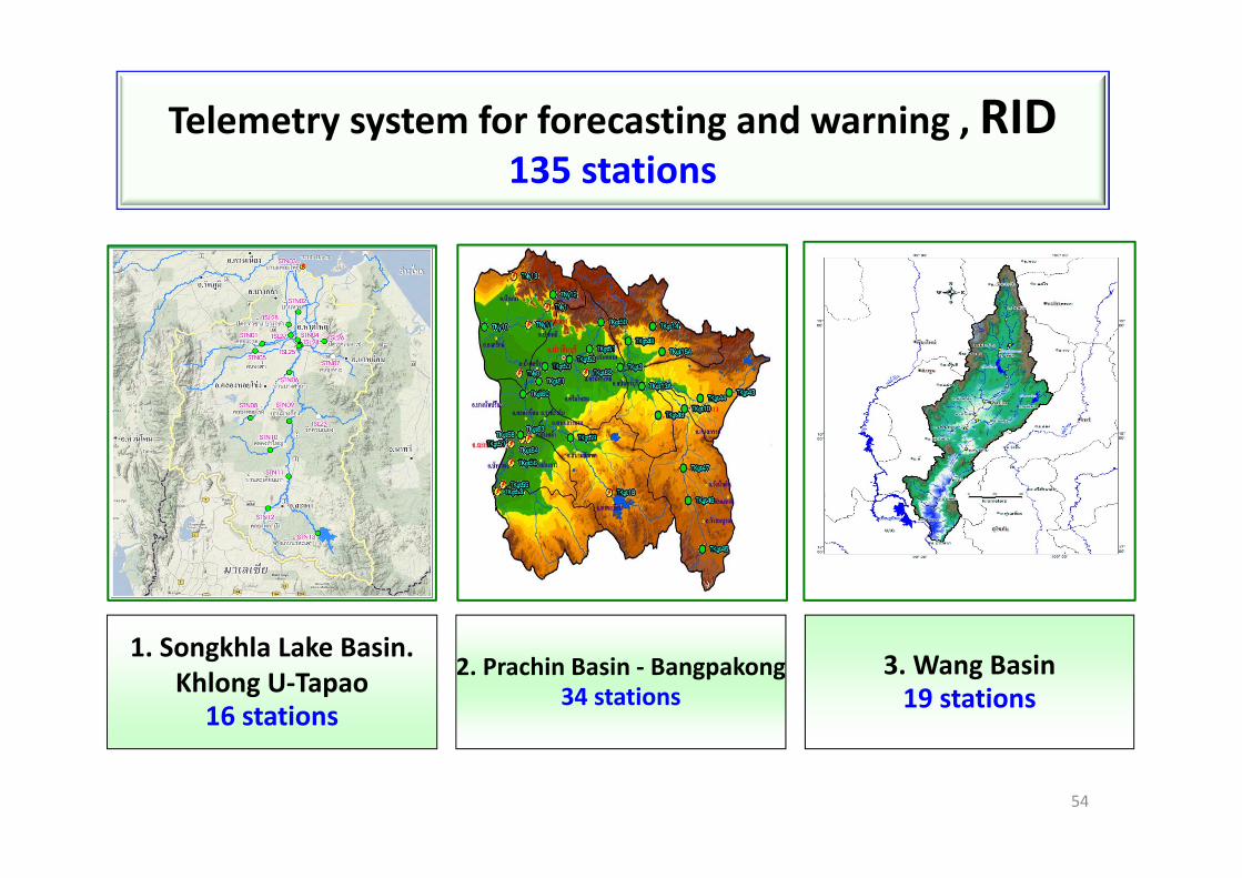
Telemetry system for forecasting and warning , RID135 stations
1. Songkhla Lake Basin.Khlong U‐Tapao
16 stations
2. Prachin Basin ‐ Bangpakong34 stations
3. Wang Basin19 stations
54

4. Chao Phraya river basin54 stations
6.Ping river basin 7. Yom river basin 8. Lam Pao river basin 9. Tha Chin river basin 10. Chanthaburi river basin 11. Pak Panang river Basin 12. Lower Mekong river basin
Implementation not complete, No detailed station. ‐‐‐
5. Thataphao river Basin12 stations
55
Telemetry system for forecasting and warning , RID135 stations

Website showing water Quality from monitoring station , RID
(http://www.rid.go.th/2009/index.php?option=com_weblinks&view=category
&id=14:2009-04-19-06-50-15)
56

Water Quantity : Rainfall (hourly and daily) / water (current, maximum and minimum)water flow : river cross section with level of warning (only some place)
Project implemented in the first phase Project implemented in the Later phase
57
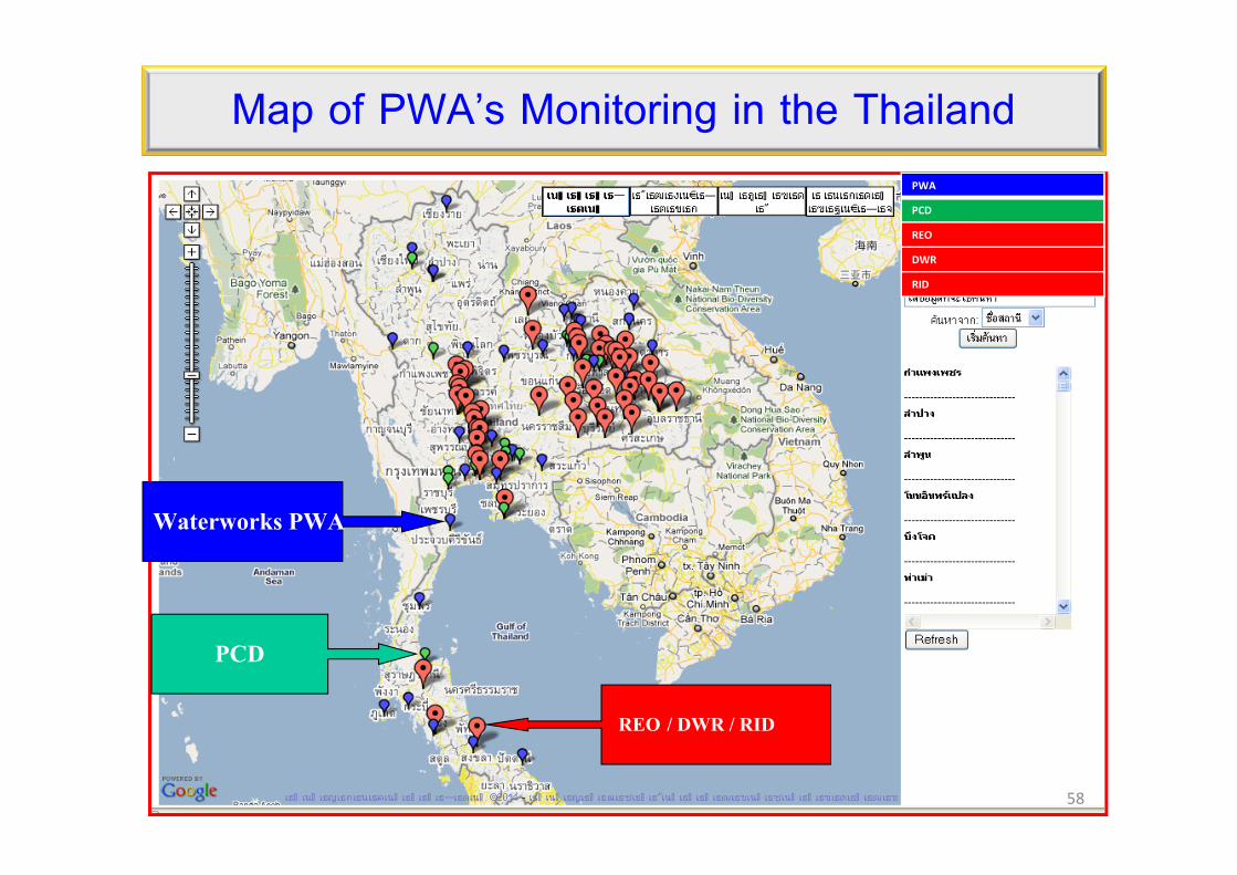
PCD
REO / DWR / RID
Waterworks PWA
58
PWA
PCD
REO
DWR
RID
Map of PWA’s Monitoring in the Thailand

59
Water quality monitoring stations of other agenciesAgencies Under the agency Basin with monitoring
station number
Pollution Control Department
Ministry of Natural Resources and Environment
all rivers 58
Department of Water Resources
Chao Phraya basin 15Songkhla lake Basin 11Mekong Basin 11Mun‐Chi Basin 39Yom‐Nan Basin 119BangpaKong Basin 20
total 195
Department of industrial works Ministry of Industry Tha Chin Basin 5
Royal Irrigation Department Ministry of Agriculture and Cooperatives
Chao Phraya basin 54Prachinburi‐BangpaKong Basin 34Pakkphanang Basin 16Pakkphanang lower Basin 17Songkhla lake Basin 50Thataphao Basin 12Wang Basin 19Yom Basin 25Khlong U‐taphao Basin 19Ping Upper Basin 38Phetchaburi Basin 17Pasak Basin 12Chanthaburi Basin 11Sakae krang Basin 12Mae klong Basin 16Total 352
Agencies’ Website

Via other agencies ’website
Benefits of the follow up water Quantity & Quality Data
Coordinate with other agencies concerning water quality : PWA MWA PCD RID ,etc
60
6

61
Benefits of the follow up water Quality Data
Boat carrying sugar capsized in the Chao Phraya Riverin Ayutthaya in 2011
EXAMPLE

Water Quality at that time Staff of PCD MWA RID PWA ,etc. visited the site to examine water quality there. Follow up the mass of polluted water from Ayuddhaya to Samutprakarn province (where water runs into the gulf of Thailand) to check water quality from day 1‐6 (distant of 150 kms.) Examination revealed significant reduction of Oxygen in the river, causing the death of tons of fish in the Chao Phraya river.
62
Boat carrying brown sugar capsized in the Chao Phraya River

Places affected by accident‐ distance from capsized scene
150 km.30 กม.
24 กม.
17 กม.40 กม.
42 กม.
63
2,400 tons of brown sugar sank to the bottom of the river
Boat carrying brown sugar capsized in the Chao Phraya River

Change of oxygen amount in the River
Table showing minimum DO from day 1‐7
64
Monitoring station
Distance from the capsize
scene
Distance from the gulf ofThailand
Before the accident After the accident
30‐5‐2011 31‐5‐2011 1‐6‐2011 2‐6‐2011 3‐6‐2011 4‐6‐2011 5‐6‐2011
Bang barnAyutthaya
North 3 km. 156 km. 5.0 4.8 4.1 3.8 3.7 3.6 3.6
Bang SaiAyutthaya
South 30 km. 123 km. 4.1 4.3 0.2 0.1 2.1 3.7 3.3
MWA: Intake raw water
South 54 km. 99 km. 3.0 3.0 3.0 0.6 0.3 1.5 2.8
PakkredNonthaburi
South 71 km. 82 km. 2.8 2.7 3.1 3.1 0.1 0.4 2.0
BangkokBridge
South 111 km. 42 km. 1.6 1.5 1.5 1.5 0 0.2
Boat carrying brown sugar capsized in the Chao Phraya River

DO at the Bang Sai Station, Ayutthaya
กอนเกิดเหตุ
หลังเกิดเหตุ
31/5/54 17.00 น.1/6/54 13.00 น.
3/6/54 04.30 น.กอนเกิดเหตุ
หลังเกิดเหตุ
31/5/54 17.00 น.1/6/2011 13.00 น.
3/6/2011 04.30 น.
65
Boat carrying brown sugar capsized in the Chao Phraya River

DO at the Samlae Station, Raw water pump MWA
Before the accident31/5/54 17.00 น.
2/6/2011 17.30 น. 4/6/2011 8.30 น.
After the accident
66
Boat carrying brown sugar capsized in the Chao Phraya River

DO at Pakkred Nontaburi Station
31/5/54 17.00 น.3/6/2011 5.30 น. 4/6/2011 17.30 น.
67
Before the accident
After the accident
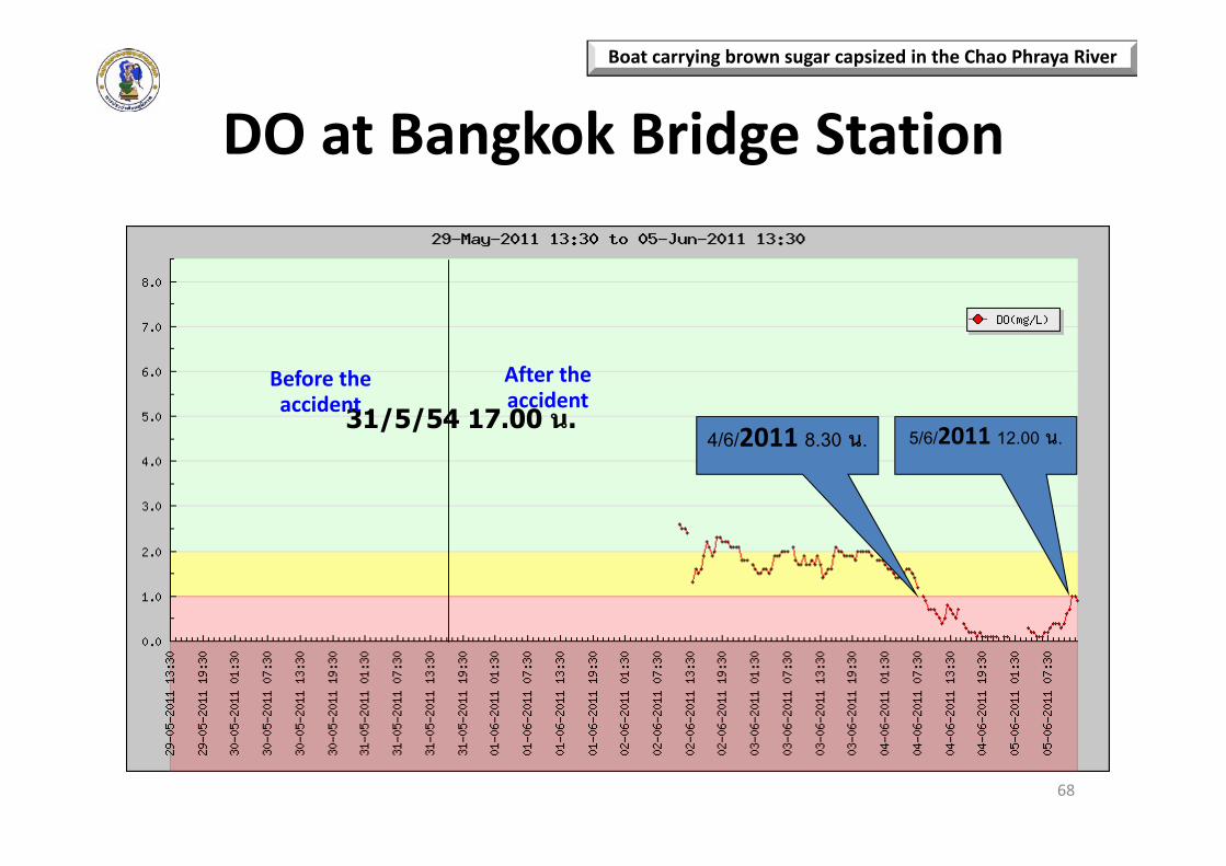
DO at Bangkok Bridge Station
31/5/54 17.00 น.4/6/2011 8.30 น. 5/6/2011 12.00 น.
68
Boat carrying brown sugar capsized in the Chao Phraya River
Before the accident
After the accident

Places affected by the accident
The capsize
scen
eAy
utthaya
Thakaron
gTemple
Phan
anchoe
ngTemple
Bang
Pa‐in D
istrict
Bridge over the
Cha
oPh
raya river.
Highw
ay 347
Choe
nglane
Temple
Water qua
lity mon
itorin
g stations
(Ban
gSai)
BangsaiPW
A WWk.
Raw water Pum
pPathum
than
iWater sup
ply compa
nyRa
w water Pum
pSamlaeMWA
Distancefrom capsize scene (Km.)
0 0.2 4 18 23 26 26.5 33 50 50.569
Boat carrying brown sugar capsized in the Chao Phraya River

Measures for Resolutions during Accident Shipping company (boat’s owners) tried to pump sinking sugar from
bottom of the river (10 tons in 3 days) RID released water from Chao Phraya dam to push away polluted water into
the sea (at Samoutprakarn) Government agencies concerned regularly report on the quality of water in
the river to people
70
Boat carrying brown sugar capsized in the Chao Phraya River

Measures for Resolutions during Accident (continued) PWA check up water quality at accident scene PWA check up water quality at its Bangsai productionand prepare to solve the problem (Aerator, ChemicalFeeder Chemicals)
PTW. Company Limited Surveillance to monitor thewater quality MWA has raw water pumped from the canal water to spare for raw water ,prepared Aerator , chemicalsand also monitored river water quality continuously
71

72
Safe Drinking Water

73