quantifying sand provenance and erosion (marsyandi river ... · quantifying sand provenance and...
TRANSCRIPT
tters 258 (2007) 500–515www.elsevier.com/locate/epsl
Earth and Planetary Science Le
Quantifying sand provenance and erosion(Marsyandi River, Nepal Himalaya)
Eduardo Garzanti a,⁎, Giovanni Vezzoli a,1, Sergio Andò a,1, Jérôme Lavé b,2,Mikaël Attal b,2, Christian France-Lanord c,3, Peter DeCelles d,4
a Laboratorio di Petrografia del Sedimentario, Dipartimento di Scienze Geologiche e Geotecnologie,Università di Milano-Bicocca, 20126 Milano, Italy
b Laboratoire de Géodynamique des Chaînes Alpines, UMR CNRS 5025, BP53, 38041 Grenoble Cedex 09, Francec CRPG-CNRS, 15, rue Notre Dame des Pauvres, 54501 Vandoeuvre-lès-Nancy, France
d Department of Geosciences, University of Arizona, Tucson, AZ 85721, USA
Received 5 February 2007; received in revised form 28 March 2007; accepted 2 April 2007
Available onl
Editor: M.L.Delaney
ine 11 April 2007
Abstract
We use petrographic and mineralogical data on modern sediments to investigate erosion patterns in the Marsyandi basin of thecentral Himalaya, a privileged natural laboratory in which a series of multidisciplinary geomorphological, sedimentological,geochemical and geochronological studies have been recently carried out to unravel the interrelationships between tectonic, climaticand sedimentary processes in high-relief orogenic belts. Although relative erosion patterns are effectively constrained by analyses ofreplicate samples along six successive tracts of the Marsyandi River, uncertainties are caused by potential compositional variationbetween the monsoon and post-monsoon season. Estimates of erosion rates are significantly affected by poor knowledge of totalsediment flux through the basin.
Our results support focused erosion of the southern, tectonically-lower part of the Greater Himalaya in the hangingwall of theMCTZone, where the summer monsoon reaches its peak intensity (up to 5 m/a), and sediment yields and erosion rates reach 14,100±3400 t/km2 and 5.1±1.2 mm/a. Erosion rates sharply decrease southward in low-relief Lesser Himalayan units (1.6±0.6 mm/a), and alsoprogressively decrease northwards in the high-altitude, tectonically-upper part of theGreater Himalaya, where rainfall decreases rapidlyto b2 m/a. Even areas of extreme topography such as the Manaslu Granite are characterized by relatively low erosion rates (2.4±0.9 mm/a), because precipitations become too scarce to feed significant ice flux and glacial activity. Monsoonal rainfall decreasesfurther to b0.5 m/a in the Tethys Himalayan zone farther north, where erosion rates are∼ 1 mm/a. Coupling between erosion and peakmonsoonal rainfall along the southern front of the Greater Himalaya is consistent with both channel-flow models of tectonic extrusion
⁎ Corresponding author. Tel.: +39 2 64482088; fax: +139 2 64484273.E-mail addresses: [email protected] (E. Garzanti), [email protected] (G. Vezzoli), [email protected] (S. Andò),
[email protected] (J. Lavé), [email protected] (M. Attal), [email protected] (C. France-Lanord), [email protected](P. DeCelles).1 Tel.: +39 2 64482088; fax: +139 2 64484273.2 Now at Institute of Earth Science, School of GeoSciences, University of Edinburgh, West Mains Road, Edinburgh EH9 3JW, Scotland. Tel.: +33
0476635919; fax: +33 0476514058.3 Tel.: +33 383 594220: fax: +33 383 511798.4 Tel.: +1 520 6214910: fax: +1 520 6212672.
0012-821X/$ - see front matter © 2007 Elsevier B.V. All rights reserved.doi:10.1016/j.epsl.2007.04.010
501E. Garzanti et al. / Earth and Planetary Science Letters 258 (2007) 500–515
and tectonic uplift above a mid-crustal ramp. Altitude and relief are not the principal factors controlling erosion, and the central Nepaleight-thousanders may be viewed as topographic anomalies in cold desert climate at the southern edge of the Tibetan rain shadow.© 2007 Elsevier B.V. All rights reserved.
Keywords: modern sands; bulk petrography; sediment budgets; erosion rates; monsoon season; Tethys Himalaya; Greater Himalaya; LesserHimalaya; collision orogens
1. Introduction
The traditional view that tectonic processes createtopographic relief, which in turn controls precipitationdistribution, fluvial discharge, erosion patterns andsediment evacuation has been recently challenged bythe apparently more extravagant idea that the oppositemay be true as well, and that climatically-driven erosionat the Earth's surface can govern tectonic deformation, ina feedback loop that finally induces even metamorphismand melting in the deep crust [1–4]. To improve on ourcurrent understanding of how mountain ranges areuplifted and worn away, we must detangle first the com-plex interplay between tectonic, climatic, and geomor-phological processes [5–7], and clarify if, why, and howorogenic systems evolve towards an equilibrium betweenendogenous and exogenous geological forces [8,9]. Inorder to shed light on this actively debated conundrum[10–12], coupled geodynamic-erosion models can betested against comprehensive data-sets collected in activesettings such as the Himalayan Range, where abruptgradients in precipitation, erosion, and deformationproduce signals that rise well above the noise of naturalsystems [13–15].
In recent years, the Marsyandi catchment in centralNepal has become a privileged natural laboratory inwhich to investigate the relative impact of climatic andtectonic processes on erosion in high-relief orogenicbelts. In order to quantify patterns of erosion at differentspatial and temporal scales, a network of meteorologicalstations were installed [16–18], digital topography andgeomorphological analyses were carried out [19 20],and water and sediment chemistry [21–24] as well assediment-transport and gravel bedload were studied[25,26]. Several geochronological techniques on bed-rock and sediments, including zircon and apatite fission-track and (U–Th)/He analyses [14,27,28], cosmogenicradionuclides [20,29,30], Ar/Ar on detrital muscovite[31–33], and U/Pb on detrital zircons [34,35] were alsoapplied.
In spite of such extensive multidisciplinary studies,detailed bulk petrography and heavy-mineral informa-tion on sand-sized sediments was lacking so far. More-over, rates and patterns of erosion inferred from these
different techniques diverge widely. Whereas a majorityof studies support focused erosion of the Greater Hima-laya [13,14,21], recent analyses suggested insteaderosion rates up to three-times faster in the upper LesserHimalaya [34,35]. The reasons for such discrepanciesmust be investigated to improve on our understanding ofthe orogenic processes active in the Nepal Himalaya.
In this study we carry out high-resolution petrograph-ic and heavy-mineral analyses on 36 modern sandscollected in the Marsyandi catchment, and assess therelative abundance of every detrital species in eachtributary or trunk river tract. This data base allows us toquantify the relative contributions from each tributaryand geological unit to the overall Marsyandi load, andthus to evaluate sediment yields and erosion patterns indistinct parts of its basin. The calculated denudation ratescan be compared with patterns of tectonic uplift andmonsoonal precipitation, in order to investigate possiblecoupling between erosion and climatic or tectonicprocesses. Detailed quantitative data on bulk sedimentcomposition also represent a fundamental pre-requisiteto compare, correctly interpret, and integrate the variouspieces of information achieved by applying differentgeochronological or geochemical techniques on singlemineral grains (e.g., fission-tracks on detrital apatites,Ar/Ar on detrital muscovites, U/Pb on detrital zircons),and thus to obtain more accurate quantitative provenanceestimates from which more robust sediment yields anderosion rates can be calculated.
2. The Marsyandi Basin
The Marsyandi (∼ 170 km long; basin area∼ 4750 km2) is one of the major branches of theNarayani/Sapt Gandaki, in turn one of the majorHimalayan tributaries of the River Ganga (Fig. 1).Sourced in Tethys Himalayan sedimentary rocks northof the Annapurna massif (8091 m a.s.l.), it carves steep-walled gorges across Greater Himalayan crystalline rockssouthwest of Manaslu peak (8125 m a.s.l.), and finallyflows in a broader valley across Lesser Himalayanmetasediments, characterized by much lower relief andgentler hillslopes, to eventually join the Trisuli River atTribeni Ghat (218 m a.s.l.).

Fig. 1. Geological sketch map of the Marsyandi basin [37]. Isograds (mineral abbreviations as in Fig. 4) and sampled rivers are indicated (numbereddots= trunk river; black dots=major tributaries; grey dots=small tributaries). STDS=South Tibetan Detachment System (Phu Detachment);CD=Chame Detachment; MCT=Main Central Thrust; MBT=Main Boundary Thrust; MFT=Main Frontal Thrust. Geology of Nepal and location ofcross-section (AA′) illustrated in Fig. 7 are shown in inset.
502 E. Garzanti et al. / Earth and Planetary Science Letters 258 (2007) 500–515
503E. Garzanti et al. / Earth and Planetary Science Letters 258 (2007) 500–515
Precipitation in the Nepal Himalaya is markedlyconcentrated during the summer monsoon season (80–98% between May and October), when a low-pressurecell forms on the Tibetan Plateau and humid air massesgenerated in the Bay of Bengal move counterclockwisetoward the northwest and deliver heavy rainfall whencolliding with the southern Himalayan front [17].Because of the major orographic barrier represented bythe Greater Himalaya, striking rainfall variations occurperpendicular to the range. Precipitation averages 1.6m/ain the Lesser Himalaya, but abruptly increases as themonsoon impinges on the southern Greater Himalayaslopes, where maximum rainfall occurs at ∼ 3000 melevation (up to 5 m/a [14,18,25]). Farther north at higheraltitudes precipitation decreases rapidly to b2 m/a in theGreater Himalaya and to b0.5 m/a in the dry TethysHimalaya [16,18,19], where extensive moisture penetra-tion along major river valleys only occurs duringexceptional monsoon years. Such a strong topographiccontrol on precipitation distribution can profoundlyaffect river discharge, erosional processes, and sedimentfluxes [36].
2.1. Geological outline
Extensively exposed in the Marsyandi basin are allthree major Himalayan tectonic units: a) the TethysHimalayan sedimentary succession, delimited at the baseby the South Tibetan Detachment System; b) the GreaterHimalayan amphibolite-facies gneisses, delimited at thebase by the Main Central Thrust; and, c) the lower-grademetasediments of the Lesser Himalaya, delimited at thebase by the Main Boundary Thrust [37,38]).
The Tethys Himalayan succession includes thickcarbonates, overlain by Ordovician quartzites andcalcschists, Silurian graptolite-bearing slates, Devoniancarbonates and mudrocks, Carboniferous-Permian cal-carenites, quartzose sandstones and shales, and finally bymostly carbonate Triassic–Jurassic strata exposed alongthe watershed [39]. Himalayan deformation and meta-morphism decreases upward from amphibolite-facies inthe Annapurna marbles, possibly representing equiva-lents of ?Cambrian Tethyan carbonates comprised be-tween the Chame Detachment at the base and the PhuDetachment at the top [38,40], to anchizonal conditionsin Mesozoic strata [41].
The Greater Himalaya is a metamorphic stack in-cluding, from base to top [37]: i) paragneisses increasingeastward in thickness from ∼ 2 km to N10 km(“Formation I”); ii) ∼ 3 km-thick gneisses withcalcsilicate minerals (diopsidic/salitic clinopyroxene,blue-green amphibole locally destabilized into biotite,
epidote, titanite; “Formation II”), and; iii) ∼ 300 m-thickorthogneisses representing metamorphosed Lower Paleo-zoic granites (“Formation III”). Metamorphic gradeincreases upward, from kyanite-rich micaschists withzoned epidote above the MCT to metapelites/metapsam-mites with fibrolitic sillimanite in the upper part of“Formation I”, where calcsilicate layers become moreabundant. Migmatitic zones rich in K-feldspar increaseupward, and finally the Miocene Manaslu leucogranite isfound at the top of the Greater Himalaya (23–19Ma [42]).
The Lesser Himalaya consists of mostly unfossilifer-ous metasediments exposed in a broad anticlinorium,with much stronger deformation in the northern limbwhere Tertiary metamorphism reaches lower amphibo-lite facies (kyanite zone) [37]. The stratigraphicallylower part, exposed in the lower Marsyandi basin, con-sists of very-low to low grade quartzites and phyllites(Kuncha Group), with local metarhyolites, metagrani-toids or alkaline metasyenites. The upper part includescommonly dolomitic metacarbonates alternating withschists and quartzites (Nawakot Group). Amphibolitesoccur in both Groups [37].
3. Bulk petrography and heavy minerals
Thirty-six, mostly fine- to medium-grained sandsamples were collected on active bars of the MarsyandiRiver and its major tributaries during several fieldcampaigns from 1993 to 2005. Bedload samples fromminor tributaries draining specific source areas were alsostudied to identify the signatures of each structuraldomain (“first-order sampling scale” of [43]). In eachsample, 400 points were counted by the Gazzi–Dickinson method in thin section [44] and 200–250transparent heavyminerals were counted on grainmounts[complete database provided in Appendices A1 and A2.
A detailed classification scheme allowed us to collectquantitative information on metamorphic rank of rockfragments (MI index [45]). Thin sections were stainedwith alizarine red to distinguish calcite from dolomite.Heavy minerals were separated in sodium metatungstate(density 2.9 g/cm3), using the 63–250 μm fractiontreated with acetic acid and sodium ditionite.
3.1. Sands from distinct geological domains
Streams draining Tethys Himalayan strata carryabundant sedimentary (limestone, shale, dolostone) andvery-low-grade metasedimentary (slate, phyllite, meta-carbonate) grains, with minor quartz and rare feldspars(Fig. 2A). Heavy minerals include a few recycledultrastable grains (zircon, tourmaline, rutile) and low-
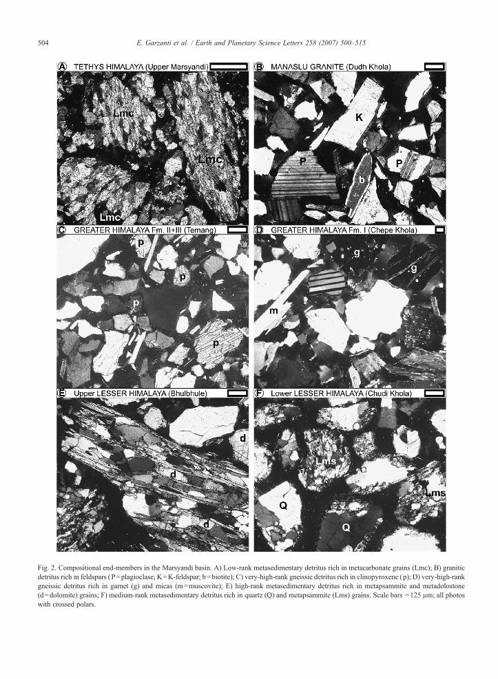
Fig. 2. Compositional end-members in the Marsyandi basin. A) Low-rank metasedimentary detritus rich in metacarbonate grains (Lmc); B) graniticdetritus rich in feldspars (P=plagioclase; K=K-feldspar; b=biotite); C) very-high-rank gneissic detritus rich in clinopyroxene (p); D) very-high-rankgneissic detritus rich in garnet (g) and micas (m=muscovite); E) high-rank metasedimentary detritus rich in metapsammite and metadolostone(d=dolomite) grains; F) medium-rank metasedimentary detritus rich in quartz (Q) and metapsammite (Lms) grains. Scale bars =125 μm; all photoswith crossed polars.
504 E. Garzanti et al. / Earth and Planetary Science Letters 258 (2007) 500–515
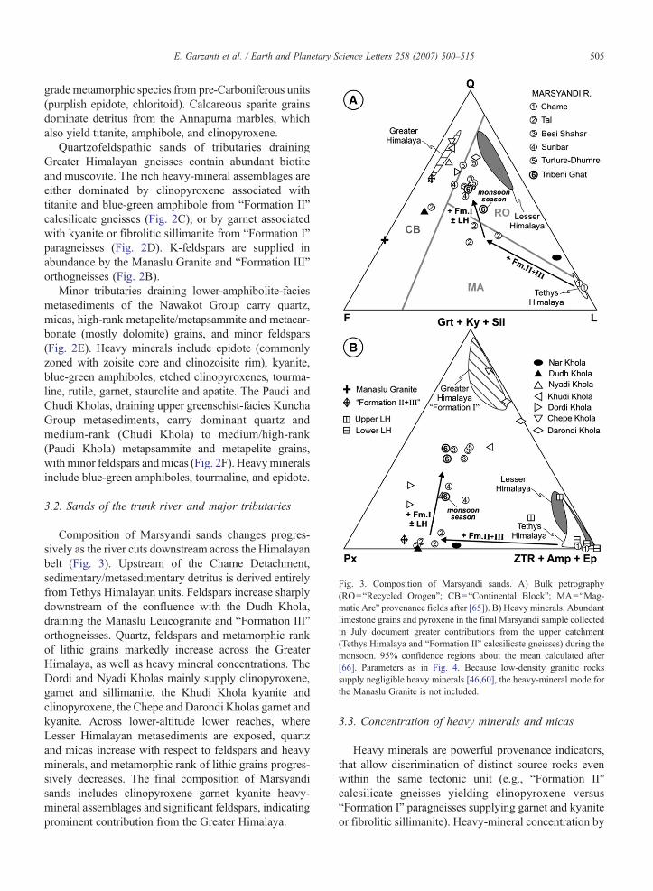
Fig. 3. Composition of Marsyandi sands. A) Bulk petrography(RO=“Recycled Orogen”; CB=“Continental Block”; MA=“Mag-matic Arc” provenance fields after [65]). B) Heavy minerals. Abundantlimestone grains and pyroxene in the final Marsyandi sample collectedin July document greater contributions from the upper catchment(Tethys Himalaya and “Formation II” calcsilicate gneisses) during themonsoon. 95% confidence regions about the mean calculated after[66]. Parameters as in Fig. 4. Because low-density granitic rockssupply negligible heavy minerals [46,60], the heavy-mineral mode forthe Manaslu Granite is not included.
505E. Garzanti et al. / Earth and Planetary Science Letters 258 (2007) 500–515
grade metamorphic species from pre-Carboniferous units(purplish epidote, chloritoid). Calcareous sparite grainsdominate detritus from the Annapurna marbles, whichalso yield titanite, amphibole, and clinopyroxene.
Quartzofeldspathic sands of tributaries drainingGreater Himalayan gneisses contain abundant biotiteand muscovite. The rich heavy-mineral assemblages areeither dominated by clinopyroxene associated withtitanite and blue-green amphibole from “Formation II”calcsilicate gneisses (Fig. 2C), or by garnet associatedwith kyanite or fibrolitic sillimanite from “Formation I”paragneisses (Fig. 2D). K-feldspars are supplied inabundance by the Manaslu Granite and “Formation III”orthogneisses (Fig. 2B).
Minor tributaries draining lower-amphibolite-faciesmetasediments of the Nawakot Group carry quartz,micas, high-rank metapelite/metapsammite and metacar-bonate (mostly dolomite) grains, and minor feldspars(Fig. 2E). Heavy minerals include epidote (commonlyzoned with zoisite core and clinozoisite rim), kyanite,blue-green amphiboles, etched clinopyroxenes, tourma-line, rutile, garnet, staurolite and apatite. The Paudi andChudi Kholas, draining upper greenschist-facies KunchaGroup metasediments, carry dominant quartz andmedium-rank (Chudi Khola) to medium/high-rank(Paudi Khola) metapsammite and metapelite grains,withminor feldspars andmicas (Fig. 2F). Heavymineralsinclude blue-green amphiboles, tourmaline, and epidote.
3.2. Sands of the trunk river and major tributaries
Composition of Marsyandi sands changes progres-sively as the river cuts downstream across the Himalayanbelt (Fig. 3). Upstream of the Chame Detachment,sedimentary/metasedimentary detritus is derived entirelyfrom Tethys Himalayan units. Feldspars increase sharplydownstream of the confluence with the Dudh Khola,draining the Manaslu Leucogranite and “Formation III”orthogneisses. Quartz, feldspars and metamorphic rankof lithic grains markedly increase across the GreaterHimalaya, as well as heavy mineral concentrations. TheDordi and Nyadi Kholas mainly supply clinopyroxene,garnet and sillimanite, the Khudi Khola kyanite andclinopyroxene, the Chepe andDarondi Kholas garnet andkyanite. Across lower-altitude lower reaches, whereLesser Himalayan metasediments are exposed, quartzand micas increase with respect to feldspars and heavyminerals, and metamorphic rank of lithic grains progres-sively decreases. The final composition of Marsyandisands includes clinopyroxene–garnet–kyanite heavy-mineral assemblages and significant feldspars, indicatingprominent contribution from the Greater Himalaya.
3.3. Concentration of heavy minerals and micas
Heavy minerals are powerful provenance indicators,that allow discrimination of distinct source rocks evenwithin the same tectonic unit (e.g., “Formation II”calcsilicate gneisses yielding clinopyroxene versus“Formation I” paragneisses supplying garnet and kyaniteor fibrolitic sillimanite). Heavy-mineral concentration by
506 E. Garzanti et al. / Earth and Planetary Science Letters 258 (2007) 500–515
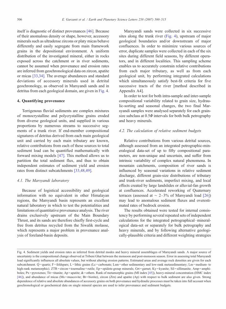
itself is diagnostic of distinct provenances [46]. Becauseof their anomalous density or shape, however, accessoryminerals such as ultradense zircons or platy micas behavedifferently and easily segregate from main frameworkgrains in the depositional environment. A uniformdistribution of the investigated mineral, either in rocksexposed across the catchment or in river sediments,cannot be assumed when provenance and erosion ratesare inferred from geochronological data on zircon, apatiteor micas [33,34]. The average abundances and standarddeviations of accessory minerals used in detritalgeochronology, as observed in Marsyandi sands and indetritus from each geological domain, are given in Fig. 4.
4. Quantifying provenance
Terrigenous fluvial sediments are complex mixturesof monocrystalline and polycrystalline grains erodedfrom diverse geological units, and supplied in variousproportions by numerous streams to successive seg-ments of a trunk river. If end-member compositionalsignatures of detritus derived from each main geologicalunit and carried by each main tributary are known,relative contributions from each of these sources to totalsediment load can be quantified mathematically withforward mixing models [47]. This method allows us topartition the total sediment flux, and thus to obtainindependent estimates of sediment yield and erosionrates from distinct subcatchments [33,48,49].
4.1. The Marsyandi laboratory
Because of logistical accessibility and geologicalinformation with no equivalent in other Himalayanregions, the Marsyandi basin represents an excellentnatural laboratory in which to test the potentialities andlimitations of quantitative provenance analysis. The riverdrains exclusively upstream of the Main BoundaryThrust, and its sands are therefore chiefly first-cycle andfree from detritus recycled from the Siwalik molasse,which represents a major problem in provenance anal-ysis of foreland-basin deposits.
Fig. 4. Sediment yields and erosion rates as inferred from detrital modes anuncertainty is the compositional change observed at Tribeni Ghat between theload significantly influences all absolute values, but without altering erosionsubcatchment. Q=quartz; F=feldspars; L= lithic grains (Lc=carbonate; Lsmhigh-rank metamorphic). ZTR=zircon+ tourmaline+rutile; Ep=epidote-groboles; Px=pyroxenes; Tit= titanite; Ap=apatite; &=others. Rank of metamo[46]), and abundance of micas (Ms=muscovite; Bt=biotite), zircon (Zrn) adependence of relative and absolute abundances of accessory grains on both pgeochronological or geochemical data on single mineral species are used to
Marsyandi sands were collected in six successivesites along the trunk river (Fig. 4), upstream of majorgeological boundaries and/or downstream of majorconfluences. In order to minimize various sources oferror, duplicate samples were collected in each of the sixsites during different field seasons, by different opera-tors, and in different localities. This sampling schemeenables us to accurately constrain relative contributionsfrom each major tributary, as well as from eachgeological unit, by performing integrated calculationswhich simultaneously satisfy best-fit criteria for fivesuccessive tracts of the river [method described inAppendix A4].
In order to test for both intra-sample and inter-samplecompositional variability related to grain size, hydrau-lic-sorting and seasonal changes, the two final Mar-syandi samples were analysed separately for each grain-size subclass at 0.5Φ intervals for both bulk petrographyand heavy minerals.
4.2. The calculation of relative sediment budgets
Relative contributions from various detrital sources,although assessed from an integrated petrographic-min-eralogical data-set of up to fifty compositional para-meters, are non-unique and uncertain, and suffer fromintrinsic variability of complex natural phenomena. Inmountain catchments, composition of river sands isinfluenced by seasonal variations in relative sedimentdischarge, different grain-size distributions of tributaryand trunk-river sediments, imperfect mixing, and localeffects created by large landslides or alluvial-fan growthat confluences. Accelerated reworking of Quaternaryterraces (assessed at ∼ 2–3% of Marsyandi load [26])may lead to anomalous sediment fluxes and overesti-mated rates of bedrock erosion.
The results obtained were tested for internal consis-tency by performing several repeated sets of independentcalculations for the integrated petrographical–mineral-ogical data-set or separately for bulk petrography andheavy minerals, and by following alternative geologi-cally-plausible criteria and different weighting strategies
d heavy mineral assemblages of Marsyandi sands. A major source ofmonsoon and post-monsoon season. Error in assessing total Marsyandipatterns. Estimated areas and average rock densities are given for each=other sedimentary and low-rank metasedimentary; Lm=medium- toup minerals; Grt=garnet; Ky=kyanite; Sil=sillimanite; Amp=amphi-rphic grains (MI index [45]), heavy-mineral concentration (HMC indexnd apatite (Ap) with respect to bulk sediment are also given. Strongrovenance and hydraulic processes must be taken into full account wheninfer provenance and sediment budgets.
507E. Garzanti et al. / Earth and Planetary Science Letters 258 (2007) 500–515
[49]. The standard deviation of the results obtained withthis trial-and-error approach is believed to provide anempirical estimate of the uncertainty associated with theaverage values.
It must be kept in mind that results based on bedloadsands may not be applicable to the mud fraction carried insuspension (∼ 60% of total Marsyandi load [21,26]).Also, quantitative provenance analysis may be biased by
508 E. Garzanti et al. / Earth and Planetary Science Letters 258 (2007) 500–515
selective physical or chemical destruction of non-durableand unstable grains, seasonal changes in sedimenttransport, and hydraulic segregation of grains withdifferent size, density and shape [50,51].
4.3. Uncertainties caused by destruction of unstablegrains
Because of limited storage times and rapid transportfrom source to basin [20], and because physical com-minution is held to have little effect on detritalmodes [52],sediment composition in high-relief mountain catchmentsis generally assumed to faithfully reflect themineralogy ofparent rocks even in monsoonal climates [53].
In order to verify the incidence of chemical weathering,we quantitatively analysed dissolution features shown bydetrital grains with different chemical stabilities [54]. Thelargemajority of heavyminerals throughout theMarsyandicatchment are fresh or only slightly altered. Only 9±4%ofdetrital pyroxenes and 3±2% of detrital amphiboles areetched, a comparable amount show incipient corrosion,and very few (mostly pyroxene) show skeletal featuresindicative of extensive dissolution. An exception isrepresented by small tributaries draining “Formation I”or the Nawakot Group in the middle Marsyandi valley,which contain a few deeply etched clinopyroxene grainsprobably derived from altered Quaternary terraces.Epidote, staurolite, garnet, titanite, or apatite occasionalyshow incipient corrosion, but never extensive dissolutionfeatures. Selective destruction of unstable silicate grains(including plagioclase) can thus be considered negligible.
Experimental results on Marsyandi gravel bedloadshowed that abrasion rates may vary by up to two ordersof magnitude for various pebble lithologies (lowest forquartzite, low for granite and “Fm. II” calcsilicate gneiss,intermediate for “Fm. I” paragneiss, marble and Kunchametasandstone, high for sandstone and schist), and selec-tive destruction of non-durable lithologies is suggested bydownstream decrease of sandstone, limestone and schist,with parallel increase of gneiss and quartzite [26]. Theseeffects, however, are difficult to separate from down-stream dilution by supply from tributaries and hillslopes,and cannot be directly extrapolated to sand-sized detritus.The type and amount of sand grains produced (byabrasion of gravel) and destroyed (ground into mud)during sediment transport remain unconstrained.
If partial destruction of soluble carbonate or non-durableshale/slate grains (representing 53±6% and 27±14% ofTethys Himalaya-derived detritus, respectively) takesplaces during transport, the Tethys Himalayan contributionwould be underestimated. Decrease of Tethys Himalayan-derived unstable grains, however, is seen to abruptly take
place immediately downstream of the Dudh Khola con-fluence, chiefly reflecting rapid dilution, and again acrossthe middle part of the basin, chiefly reflecting dilution from“Formation I”-derived carbonate-free gneissic detritus. Inlower reaches, the dolomite/calcite ratio increases becausedolostone grains are supplied by the Nawakot Group,whereas limestone grains continue to decrease, againreflecting dilution rather than dissolution [21].
Our calculations do not show a systematic deficiencyin calcareous grains in lower Marsyandi reaches, wefailed to obtain improved fits by modeling variousdegrees of carbonate dissolution, and our results do notchange significantly if carbonate and shale/slate grainsare neglected (and other parameters recalculated to100%), suggesting that selective destruction of unstablegrains does not represent a major source of error. In fact,dissolution of carbonate grains is unlikely to take placeduring fluvial transport because Marsyandi waters aresaturated with respect to calcite [21]. Chemistry of riverwaters nevertheless indicates that carbonate dissolutionis an extensive process [22–24], and that erosion ratesfor carbonate-rich units (e.g. Tethys Himalaya) areslightly underestimated if chemical erosion is not takeninto account (∼ 0.05 mm/a for the Marsyandi catchment[21]). Chemical erosion is held to be an order ofmagnitude less for silicate rocks (∼ 0.005 mm/a for theMarsyandi catchment [21]), and thus negligible.
4.4. Uncertainties caused by grain size and sorting
Significant uncertainties in provenance calculationsare potentially caused by grain-size fractionation andhydraulic processes, such as concentration of heavyminerals in placer deposits or of platy micas in low-energy subenvironments [54]. In Marsyandi samples,strong hydraulic control is indicated locally by nearlyone-order-of-magnitude variability in the mica/heavy-mineral ratio, and by heavy-mineral concentrationsricher than any upper-crustal source rock can yield[46].
The two final Marsyandi samples, analysed sepa-rately at 0.5Φ intervals, display intra-sample composi-tional variability associated with grain density andshape [55]. Heavy minerals are concentrated in the finetail, whereas relative abundances of platy micas andfibrous sillimanite increase in the coarse tail. Althoughpartly related to grain-size and hydraulic-sorting effects(e.g., Greater Himalayan contributions would be over-estimated for placer deposits, the Greater Himalayabeing the dominant source of heavy minerals), inter-sample variability is principally ascribed to seasonalchanges in sediment transport.
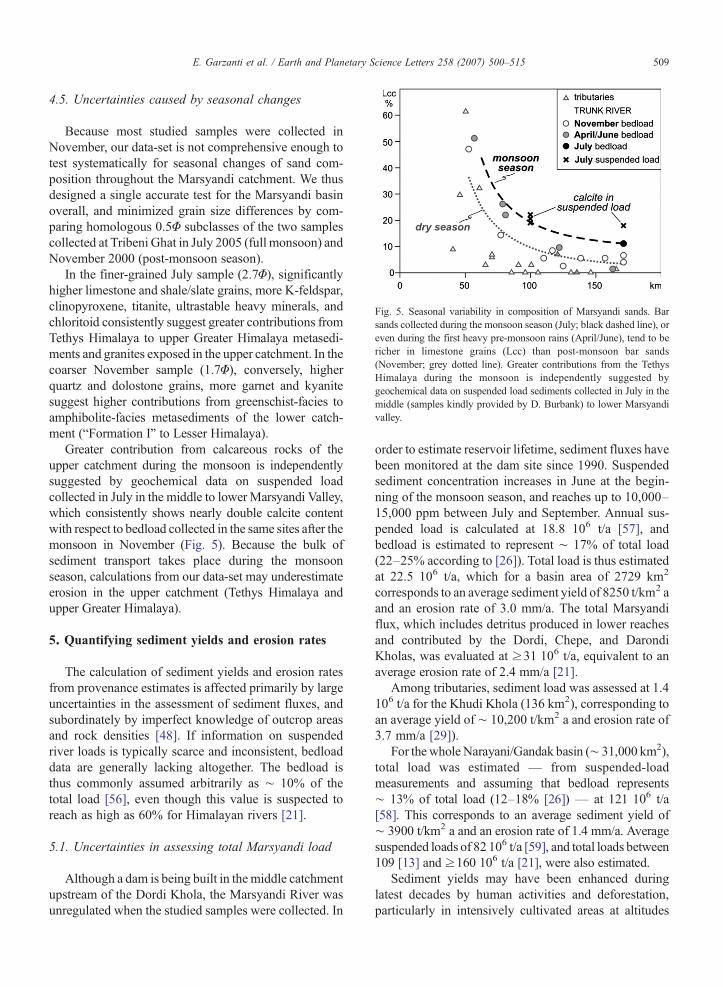
Fig. 5. Seasonal variability in composition of Marsyandi sands. Barsands collected during the monsoon season (July; black dashed line), oreven during the first heavy pre-monsoon rains (April/June), tend to bericher in limestone grains (Lcc) than post-monsoon bar sands(November; grey dotted line). Greater contributions from the TethysHimalaya during the monsoon is independently suggested bygeochemical data on suspended load sediments collected in July in themiddle (samples kindly provided by D. Burbank) to lower Marsyandivalley.
509E. Garzanti et al. / Earth and Planetary Science Letters 258 (2007) 500–515
4.5. Uncertainties caused by seasonal changes
Because most studied samples were collected inNovember, our data-set is not comprehensive enough totest systematically for seasonal changes of sand com-position throughout the Marsyandi catchment. We thusdesigned a single accurate test for the Marsyandi basinoverall, and minimized grain size differences by com-paring homologous 0.5Φ subclasses of the two samplescollected at Tribeni Ghat in July 2005 (full monsoon) andNovember 2000 (post-monsoon season).
In the finer-grained July sample (2.7Φ), significantlyhigher limestone and shale/slate grains, more K-feldspar,clinopyroxene, titanite, ultrastable heavy minerals, andchloritoid consistently suggest greater contributions fromTethys Himalaya to upper Greater Himalaya metasedi-ments and granites exposed in the upper catchment. In thecoarser November sample (1.7Φ), conversely, higherquartz and dolostone grains, more garnet and kyanitesuggest higher contributions from greenschist-facies toamphibolite-facies metasediments of the lower catch-ment (“Formation I” to Lesser Himalaya).
Greater contribution from calcareous rocks of theupper catchment during the monsoon is independentlysuggested by geochemical data on suspended loadcollected in July in the middle to lower Marsyandi Valley,which consistently shows nearly double calcite contentwith respect to bedload collected in the same sites after themonsoon in November (Fig. 5). Because the bulk ofsediment transport takes place during the monsoonseason, calculations from our data-set may underestimateerosion in the upper catchment (Tethys Himalaya andupper Greater Himalaya).
5. Quantifying sediment yields and erosion rates
The calculation of sediment yields and erosion ratesfrom provenance estimates is affected primarily by largeuncertainties in the assessment of sediment fluxes, andsubordinately by imperfect knowledge of outcrop areasand rock densities [48]. If information on suspendedriver loads is typically scarce and inconsistent, bedloaddata are generally lacking altogether. The bedload isthus commonly assumed arbitrarily as ∼ 10% of thetotal load [56], even though this value is suspected toreach as high as 60% for Himalayan rivers [21].
5.1. Uncertainties in assessing total Marsyandi load
Although a dam is being built in the middle catchmentupstream of the Dordi Khola, the Marsyandi River wasunregulated when the studied samples were collected. In
order to estimate reservoir lifetime, sediment fluxes havebeen monitored at the dam site since 1990. Suspendedsediment concentration increases in June at the begin-ning of the monsoon season, and reaches up to 10,000–15,000 ppm between July and September. Annual sus-pended load is calculated at 18.8 106 t/a [57], andbedload is estimated to represent ∼ 17% of total load(22–25% according to [26]). Total load is thus estimatedat 22.5 106 t/a, which for a basin area of 2729 km2
corresponds to an average sediment yield of 8250 t/km2 aand an erosion rate of 3.0 mm/a. The total Marsyandiflux, which includes detritus produced in lower reachesand contributed by the Dordi, Chepe, and DarondiKholas, was evaluated at ≥31 106 t/a, equivalent to anaverage erosion rate of 2.4 mm/a [21].
Among tributaries, sediment load was assessed at 1.4106 t/a for the Khudi Khola (136 km2), corresponding toan average yield of ∼ 10,200 t/km2 a and erosion rate of3.7 mm/a [29]).
For the wholeNarayani/Gandak basin (∼ 31,000 km2),total load was estimated — from suspended-loadmeasurements and assuming that bedload represents∼ 13% of total load (12–18% [26]) — at 121 106 t/a[58]. This corresponds to an average sediment yield of∼ 3900 t/km2 a and an erosion rate of 1.4 mm/a. Averagesuspended loads of 82 106 t/a [59], and total loads between109 [13] and ≥160 106 t/a [21], were also estimated.
Sediment yields may have been enhanced duringlatest decades by human activities and deforestation,particularly in intensively cultivated areas at altitudes

Fig. 6. Estimated contributions from distinct geological units to thetotal Marsyandi load. Relative supply from the Tethys Himalaya isestimated to be greater during the monsoon season (black dashedlines), whereas supply from the lower Greater Himalaya is prominentin the dry season (grey dotted lines). Inset shows limited contributionfrom the Manaslu Granite exposed at extreme elevations in the DudhKhola catchment, as documented by rapid dilution of U content intrunk river sediments (bulk-sediment U concentrations measured atSARM-CNRS Nancy by ICP-MS [complete data-set provided inAppendix A3]). Areas and average rock densities are given for eachtectonic unit. TH=Tethys Himalaya; UGH=upper Greater Himalaya(“Formation II+ III”); LGH=lower Greater Himalaya (“Formation I”);ULH=upper Lesser Himalaya (Nawakot Group); LLH=lower LesserHimalaya (Kuncha Group).
510 E. Garzanti et al. / Earth and Planetary Science Letters 258 (2007) 500–515
below 2000 m a.s.l. [18,57]. Based on availableinformation [21,57], we assume here a total Marsyandisediment load of 30±5 106 t/a (corresponding to anaverage erosion rate of 2.3±0.4 mm/a). This assumptionmarkedly influences the absolute values of sedimentyields and erosion for each Marsyandi subcatchmentgiven in the following paragraphs, but it does not altererosion patterns.
5.2. Uncertainties in assessing outcrop areas
Beside problems caused by different projections oftopographic or geological maps, or by local ambiguitiesin the definition of drainage divides, discrepancies mayresult from different geological interpretations [34]. Wechose to adhere here to the 1:200,000 geological map byColchen et al. [37], which is based on extensive field-work, supplemented by exhaustive lithological descrip-tions, and far more detailed than maps available for mostother Himalayan regions. In recent years, distinct tectonicboundaries were identified at the top of the GreaterHimalayan nappe stack (Phu and Chame Detachments[38]). The outcrop area between these two detachmentslargely consists of Annapurna marbles, which we choseto consider jointly with Tethys Himalaya sedimentaryunits principally because these higher-grade metamor-phic rocks also supply detritus dominated by carbonaterock fragments.
A thornier problem is revealed by pyroxene-rich sandscarried by major tributaries in the middle Marsyandi basin(Dordi and Nyadi Kholas). This indicates a much moresignificant contribution from “Formation II”-type calcsi-licate gneisses than indicated by the only sporadicexposures of such rocks displayed along the southwesternflank of the Himal Chuli [37]. More detailed geologicalinformation on this area would help us greatly to moreprecisely assess erosion rates across the Greater Himalaya.
Outcrop areas for each subcatchment and tectonicunit are given in Figs. 4 and 6.
5.3. Uncertainties in assessing rock densities
The average density of each major geological unitexposed in the catchment can be assessed not only bysporadic data in the literature [20] but also directly fromthe integrated petrographical–mineralogical composi-tion of detritus derived entirely from each single unit(SRD index [46]). In spite of local hydraulic-sortingeffects, errors turn out to be ≤1% for most non-porousmetamorphic and plutonic source rocks [60]. Uncertain-ties in assessing rock densities in the Marsyandi basinare therefore small, and only cause minor errors in the
conversion of sediment yields into erosion rates. Rockdensities for each subcatchment and tectonic unit aregiven in Figs. 4 and 6.
6. Sediment budgets
Estimates reported here are obtained by consideringthe complete sample set. The largest uncertainty isassociated with seasonal and/or grain-size changes insediment composition. Maximum contributions from theTethys Himalaya and upper Greater Himalaya, or fromthe lower Greater Himalaya and Lesser Himalaya, arecalculated if true composition of Marsyandi load cor-responds to our finer-grained monsoon sample, or to ourcoarser-grained post-monsoon sample, respectively(Fig. 6).
6.1. Relative contributions from distinct subcatchments
Our calculations indicate that 29±12% of theMarsyandi load is produced in the upper half of thecatchment (Tethys Himalaya and upper Greater Hima-laya). TheDudhKhola, draining theManasluGranite andupper Greater Himalaya units, contributes more sedimentthan the upper Marsyandi and Nar Khola, draining amuchwider area within the TethysHimalaya (Fig. 4). The
511E. Garzanti et al. / Earth and Planetary Science Letters 258 (2007) 500–515
tributaries of the middle Marsyandi basin (Nyadi, Khudi,Dordi, Chepe Kholas), draining largely “Formation I”and subordinately the Lesser Himalaya, contribute 54±10% of total Marsyandi flux. The remaining 17±4% issupplied in the lower part of the catchment by theDarondiKhola and minor tributaries draining Lesser Himalayanunits (Paudi, Chudi Kholas).
Sediment yields and erosion rates are thus muchlower in the upper Marsyandi and Nar Khola catchmentsthan in the Dudh Khola catchment (Fig. 4). Maximumyields are assessed for the Nyadi, Khudi, Dordi andChepe basins, whereas lower erosion values characterizethe Darondi basin and rivers draining only the LesserHimalaya.
6.2. Sediment yields and erosion rates for distinctgeological domains
Several series of independent calculations from ourintegrated petrographic-mineralogical data-set indicatethat Tethys Himalayan units (including Annapurnametacarbonates) provide 13±5% of the Marsyandibedload, Greater Himalayan units 68±3% (6±2%from Manaslu Granite; 12±2% from “Formations II+III”; 49±4% from “Formation I”) and Lesser Himalayanunits 20±2% (6±1% from the Nawakot Group and 14±3% from the Kuncha Group) (Fig. 6). Relative contribu-tions from each geological domain were assessed bothdirectly by end-member calculations for the totalMarsyandi basin, or indirectly by partitioning theestimated flux of each major tributary. This was doneboth according to end-member calculations or propor-tionally to areal exposures within each catchment. In theNyadi and Dordi basins, all Greater Himalaya-deriveddetritus has been ascribed to “Formation I” as indicatedin the map [37], even though sand composition provesthat “Formation II”-type calsilicate gneisses are exten-sively eroded along the southwestern flank of the HimalChuli. Otherwise, we would have been forced to assignan arbitrary area to “Formation II” in the Nyadi andDordi catchments, in order not to overestimate erosionrates for this unit.
The contribution from the Manaslu Granite was cal-culated by assuming that, in such rapidly erodedmountainareas of extreme relief and arid climate, granite-deriveddetritusmaintains the same composition as the parent rock(quartz 32%, plagioclase 37%, K-feldspar 21%, musco-vite 7%, biotite 3% [37]). With such end-member mode,composition ofDudhKhola sand indicates that almost halfof it originates from the granite and the remaining halffrom “Formation II” calsilicate gneisses, with minorcontribution from the Annapurna marbles.
Partitioning of a Marsyandi sediment flux of 30±5106 t/a according to these provenance estimates (and todrained areas and rock densities given in Fig. 6) impliessediment yields of 2500±1300 t/km2 and erosion ratesof 0.9±0.5 mm/a for Tethys Himalayan units, 11,600±2800 t/km2 a and 4.2±1.0 mm/a for the GreaterHimalaya (6300±2500 t/km2 and 2.4±0.9 mm/a forthe Manaslu Granite; 8700±3000 t/km2 and 3.1±1.1 mm/a for “Formations II+ III”; 14100±3400 t/km2
and 5.1±1.2 mm/a for “Formation I”), and 4300±1500 t/km2 and 1.6±0.6 mm/a for the Lesser Himalaya(4600±1600 t/km2 and 1.7±0.6 mm/a for the NawakotGroup; 4100±1800 t/km2 and 1.5±0.7 mm/a for theKuncha Group).
6.3. Discrepancies with estimates obtained by differentmethods
Our calculations suggest that the Greater Himalaya iseroding much faster than the Tethys and Lesser Hima-laya, at rates that compare well with previous estimates(=2–5 mm/a [13,14,29]). We infer that sediment yieldsdecrease northward, although zircon and apatite fission-track data failed to document erosion gradients across theGreater Himalaya [14,19,28]. This discrepancy may beascribed to different scales of observation, because ourdata reflect short-term erosion, whereas apatite fission-tracks record erosion at the N100,000 a scale [14].Alternatively, erosion patterns across the Greater Hima-laya may be more homogeneous than we calculated.Composition of the fine-grained final Marsyandi Julysample suggests in fact that rapid erosion of the uppercatchmentmay take place when large storms penetrate farnorth during the peak of the summermonsoon.Moreover,we did not consider the mud fraction carried insuspension, where detritus from the upper catchmentmay be concentrated as a result of longer high-energytransport across steep mountain reaches.
Our estimates are markedly higher than long-term,catchment-averaged estimates deduced by modelling ofdetrital muscovite 40Ar/39Ar data (=1mm/a for Dudh andNyadi catchments [32]; ∼ 2 mm/a for Nyadi, Khudi,Dordi, Chepe and Darondi catchments [33]). The dis-crepancy may stem again from different time-scales ofobservation [27], or from faulty assumptions underlyingthe usage of detrital muscovite 40Ar/39Ar data as a proxyfor erosion rates [61].
Our results are in disagreement also with Amidon et al.[34,35]. By dating detrital zircon inMarsyandi sands, theyobserved that Greater Himalayan units provide 4 to8 times more zircon grains than Lesser Himalayan unitsbut, after correcting for different concentrations of zircon

Fig. 7. Relationships between geology, topography, climate, anderosion in the Nepal Himalaya. Erosion rates calculated from our data-set (colour boxes in upper panel: TH=Tethys Himalaya; MG=Ma-naslu Granite; UGH=upper Greater Himalaya; LGH=lower GreaterHimalaya; LH=Lesser Himalaya) are highest in the lower GreaterHimalaya, where rainfall is most intense, and decrease progressivelynorthward towards arid Tibet in spite of extreme topographic elevationand relief. Our estimates compare remarkably well with incision ratesdeduced from shear-stress calculations along major Central Nepalrivers (Kali Gandaki to Sun Kosi [13]; confidence domains shown bygrey shades), and with mean landscape denudation calculated bynumerical model of [64] (shown by dashed yellow line). Dataprojected along a N18°E profile (see inset of Fig. 1 for location),orthogonally to main Himalayan structures.
512 E. Garzanti et al. / Earth and Planetary Science Letters 258 (2007) 500–515
in Greater and Lesser Himalayan detritus, sediment yieldand erosion rates resulted to be ∼ 3 times more in thenorthernmost Lesser Himalaya than in the GreaterHimalaya [34,35]. Although our data confirm that GreaterHimalayan units shedmore zircon than Lesser Himalayanunits (Fig. 4), errors may be easily introduced by over-correction, because the concentration of ultradense zircongrains may vary locally by an order of magnitude or morebecause of hydraulic-sorting and grain-size effects.
6.4. Erosion patterns across the Himalayan belt
Our calculations suggest that the tectonically-lower“Formation I”, exposed at lower altitudes along monsoon-drenched southern slopes, is eroding faster than thestructurally-higher “Formations II+III”, exposed at higheraltitudes and in drier climatic conditions to the north(Fig. 7). Erosion rates decrease further for the ManasluGranite, which occupies the extreme-altitude and highly-glaciated northern half of the catchment but contributesless detritus to the Dudh Khola than “Formation II”gneisses exposed less widely to the south. Minimum ratesare reached for the Tethys Himalaya, exposed at 4000–6000 m a.s.l. in the arid north.
Spatial correlation with precipitation gradients sug-gests that climate exerts a strong control over erosionrates across the Nepal Himalaya [30]. Focused erosionmay be driven by tectonic uplift of theMCT hangingwallrelated with either out-of-sequence thrusting [10] orpassive transport above a mid-crustal ramp [13], whichin turn may reflect positive feedback between uplift andmonsoonal rainfall [3,11].
Relatively low sediment yields inferred for the high-reliefManaslu region suggest that extreme topography haslittle effect on erosion in the absence of significantprecipitation. Beside lithology (leucogranites, massivemetacarbonates), dry climate may represent a key factor toexplain the location of Nepalese eight-thousanders, allstraddling the boundary between the Tethys and GreaterHimalaya at the southern border of the Tibetan rainshadow [19]. Flux of snow and ice is virtually non-existentabove 6200–6300 m a.s.l., and hence glacial erosion isinefficient [62]. High peaks (Manaslu, Annapurna,Dhaulagiri) may thus be viewed as topographic anomaliesdetermined by rock strength [63], which surface processesare not intense enough to remove.
7. Conclusions
Sediment composition can be used to define erosionpatterns across mountain catchments and subcatchments[49,53]. The Marsyandi basin of Central Nepal, locatedbetween two peaks above 8000 m a.s.l. and perhaps themost geologically and geomorphologically-studied ofthe Himalaya [14], is an excellent area to test thepotentialities and limitations of the method.
Specific mineralogical tracers in detritus from theTethys Himalaya (lithic sands rich in carbonate andlow-rank metasedimentary grains), Manaslu Granite(feldspathoquartzose sands), “Formation II” (gneisssands with clinopyroxene), “Formation I” (gneiss sandswith garnet and kyanite or fibrolitic sillimanite), and
513E. Garzanti et al. / Earth and Planetary Science Letters 258 (2007) 500–515
Lesser Himalaya (quartzose sands with medium-rankmetasedimentary and locally dolostone grains) allowedus to assess relative contributions from each tectonicunit to the Marsyandi load. If the latter is held to be 30±5 106 t/a, relative estimates can be easily converted intosediment yields and erosion rates.
Our calculations lend support to focused erosion of thetectonically-lower, southern part of the Greater Himalayain the hangingwall of the MCT Zone (“Formation I”),where annual rainfall reaches 5 m/a and sediment yieldsand erosion rates 14100±3400 t/km2 and 5.1±1.2 mm/a[14,30]. Erosion rates are markedly lower for LesserHimalayan units to the south, where monsoonal rainfalldecreases and relief is low. They progressively decreasealso in the upper Greater Himalaya to the north in spite ofextreme topography, because precipitation is too scarce tofeed significant ice flux and glacial activity [18,62].
Erosion patterns, therefore, are not controlled directlyby altitude and relief. Rather, erosion is coupled with peakmonsoon rains along the southern front of the GreaterHimalaya, suggesting that erosion and precipitation maybe spatially associatedwith active tectonic uplift [10,11], ina feedback loop which is compatible with both “channel-flow type” tectonic extrusion of Greater Himalayanmetamorphic rocks [3] and tectonic uplift above a mid-crustal ramp [13,64] (Fig. 7). Thus, our data cannot resolvethe elusive “chicken-and-egg” nature of tectonic–climaticcoupling [8]: does rainfall promote focused erosion andcrustal exhumation, or is orographic precipitation triggeredby tectonically-generated topography?
In both cases, the Nepalese eight-thousanders in thisregionmay be viewed as topographic anomalies created byrock strength, active uplift, and limited erosion in colddesert climate at the southern edge of the Tibetan rainshadow.
Acknowledgments
The paper benefited from careful reviews by RayIngersoll, Hilmar vonEynatten, and an anonymous review-er, and from discussions with Laurent Godin, BrunoLombardo, Yani Najman, Franco Rolfo, and Igor Villa.Two sampling campaigns greatly benefited from logisticsupport by Tank Ojha and “Himalayan Experience”, andfrom financial support of the National Science FoundationContinental Dynamic Program (grant ERA-99-09647).
Appendix A. Supplementary data
Supplementary data associated with this article canbe found, in the online version, at doi:10.1016/j.epsl.2007.04.010.
References
[1] J.P. Avouac, E.B. Burov, Erosion as a driving mechanism ofintracontinental mountain growth, J. Geophys. Res. 101 (1996)17747–17769.
[2] S.D. Willett, Orogeny and orography: the effects of erosion onthe structure of mountain belts, J. Geophys. Res., Solid Earth 104(1999) 28957–28981.
[3] C. Beaumont, R.A. Jamieson, M.H. Nguyen, B. Lee, Himalayantectonics explained by extrusion of a low-viscosity crustalchannel coupled to focused surface denudation, Nature 414(2001) 738–742.
[4] P.K. Zeitler, A.S. Meltzer, P.O. Koons, D. Craw, B. Hallet, C.P.Chamberlain, W.S.F. Kidd, S.K. Park, L. Seeber, M. Bishop, J.Shroder, Erosion, Himalayan geodynamics, and the geomor-phology of metamorphism, GSA Today 11 (2001) 4–9.
[5] D.R. Montgomery, G. Balco, S.D. Willett, Climate, tectonics,and the morphology of the Andes, Geology (2001) 579–582.
[6] S.J. Dadson, N. Hovius, H. Chen, W.B. Dade, M-L. Hsieh, S.D.Willett, J-C. Hu, M-J. Horng, M-C. Chen, C.P. Stark, D. Lague,J.-.C. Lin, Links between erosion, runoff variability andseismicity in the Taiwan orogen, Nature 426 (2003) 648–651.
[7] P.W. Reiners, T.A. Ehlers, S.G. Mitchell, D.R. Montgomery,Coupled spatial variations in precipitation and long-term erosionrates across the Washington Cascades, Nature 426 (2003)645–647.
[8] P. Molnar, Nature, nurture and landscape, Nature 426 (2003)612–614.
[9] K.X. Whipple, B.J. Meade, Orogen response to changes inclimatic and tectonic forcing, Earth Planet. Sci. Lett. 243 (2006)218–228.
[10] K.V. Hodges, C. Wobus, K. Ruhl, T. Schildgen, K. Whipple,Quaternary deformation, river steepening, and heavy precipita-tion at the front of the Higher Himalayan ranges, Earth Planet.Sci. Lett. 220 (2004) 379–389.
[11] C. Wobus, A. Heimsath, K. Whipple, K. Hodges, Active out-of-sequence thrust faulting in the central Nepalese Himalaya, Nature434 (2005) 1008–1011.
[12] D.W. Burbank, Cracking the Himalaya, Nature 434 (2005)963–964.
[13] J. Lavé, J.P. Avouac, Fluvial incision and tectonic uplift acrossthe Himalayas of central Nepal, J. Geophys. Res. 106 (2001)26561–26591.
[14] D.W. Burbank, A.E. Blythe, J. Putkonen, B. Pratt-Sitaula, E.Gabet, M. Oskin, A. Barros, T.P. Ojha, Decoupling of erosionand precipitation in the Himalayas, Nature 426 (2003) 652–655.
[15] C.W. Wobus, K.V. Hodges, K.X. Whipple, Has focuseddenudation sustained active thrusting at the Himalayan topo-graphic front? Geology 31 (2003) 861–864.
[16] A.P. Barros, M. Joshi, J. Putkonen, D.W. Burbank, A study of the1999 monsoon rainfall in central Nepal using TRMM productsand rain gauge observations, Geophys. Res. Lett. 27 (2000)3683–3686.
[17] T.J. Lang, A.P. Barros, An investigation of the onsets of the 1999and 2000 monsoons in central Nepal, Mon. Weather Rev. 130(2002) 1299–1316.
[18] J.K. Putkonen, Continuous snow and rain data at 500 to 4400 maltitude near Annapurna, Nepal, 1999–2001, Arct. Antarct. Alp.Res. 36 (2004) 244–248.
[19] E.J. Gabet, B.A. Pratt-Sitaula, D.W. Burbank, Climatic controlson hillslope angle and relief in the Himalayas, Geology 32 (2004)629–632.
514 E. Garzanti et al. / Earth and Planetary Science Letters 258 (2007) 500–515
[20] B. Pratt-Sitaula, D.W. Burbank, A.M. Heimsath, T. Ojha,Landscape disequilibrium on 1000–10,000 year scales, Mar-syandi River, Nepal, central Himalaya, Geomorphology 58(2004) 223–241.
[21] A. Galy. 1999. Étude géochimique de l' érosion actuelle de lachaîne himalayenne, Thèse de Doctorat, CRPG Nancy, 464.
[22] A. Galy, C. France-Lanord, Weathering processes in the Ganges–Brahmaputra basin and the riverine alkalinity budget, Chem.Geol. 159 (1999) 31–60.
[23] A. Galy, C. France-Lanord, L.A. Derry, The strontium isotopicbudget of Himalayan Rivers in Nepal and Bangladesh, Geochim.Cosmochim. Acta 63 (1999) 1905–1925.
[24] E.T. Tipper, M.J. Bickle, A. Galy, A.J. West, C. Pomiès, H.J.Chapman, The short term climatic sensitivity of carbonate andsilicate weathering fluxes: insight from seasonal variations in riverchemistry, Geochim. Cosmochim. Acta 70 (2006) 2737–2754.
[25] E.J. Gabet, D.W. Burbank, J.K. Putkonen, B.A. Pratt-Sitaula, T.Ojha, Rainfall thresholds for landsliding in the Himalayas ofNepal, Geomorphology 63 (2004) 131–143.
[26] M. Attal, J. Lavé, Changes of bedload characteristics along theMarsyandi River (central Nepal): implications for understandinghillslope sediment supply, sediment load evolution along fluvialnetworks, and denudation in active orogenic belts, Geol. Soc.Am., Spec. Pap. 398 (2006) 143–171.
[27] K.W. Huntington, A.E. Blythe, K.V. Hodges, Climate change andLate Pliocene acceleration of erosion in the Himalaya, EarthPlanet. Sci. Lett. 252 (2006) 107–118.
[28] A.E. Blythe, D.W. Burbank, A. Carter, K.L. Schmidt, J. Putkonen,Plio-Quaternary exhumation history of the central NepaleseHimalaya: 1. Apatite and zircon fission-track and apatite (U/Th)/He analyses, Tectonics (in press), doi:10.1029/2006TC001990.
[29] N.A. Niemi, M. Oskin, D.W. Burbank, A.M. Heimsath, E.J.Gabet, Effects of bedrock landslides on cosmogenicallydetermined erosion rates, Earth Planet. Sci. Lett. 237 (2005)480–498.
[30] A.M. Heimsath, C. Wobus, Erosion rates and processes acrosstwo trans-Himalayan transects in central Nepal, AGU FallMeeting 12/2004, 2004, Abstract.
[31] I.D. Brewer, D.W. Burbank, K.V. Hodges, Modelling detritalcooling-age populations: insights from two Himalayan catch-ments, Basin Res. 15 (2003) 305–320.
[32] K.W. Ruhl, K.V. Hodges, The use of detrital mineral cooling agesto evaluate steady state assumptions in active orogens: anexample from the central Nepalese Himalaya, Tectonics 24(2005) TC4015.
[33] I.D. Brewer, D.W. Burbank, K.V. Hodges, Downstreamdevelopment of a detrital cooling-age signal: insights from40Ar/39Ar muscovite thermochronology in the Nepalese Hima-laya, Geol. Soc. Am., Spec. Pap. 398 (2006) 321–338.
[34] W.H. Amidon, D.W. Burbank, G.E. Gehrels, Construction ofdetrital mineral populations: insights from mixing of U–Pbzircon ages in Himalayan rivers, Basin Res. 17 (2005) 463–485.
[35] W.H. Amidon, D.W. Burbank, G.E. Gehrels, U–Pb zircon agesas a sediment mixing tracer in the Nepal Himalaya, Earth Planet.Sci. Lett. 235 (2005) 244–260.
[36] B. Bookhagen, R.C. Thiede, M.R. Strecker, Abnormal monsoonyears and their control on erosion and sediment flux in the high,arid northwest Himalaya, Earth Planet. Sci. Lett. 231 (2005)131–146.
[37] M. Colchen, P. Le Fort, A. Pêcher, Annapurna, Manaslu, GaneshHimal (with 1:200.000 geological map), Paris, Éditions duCNRS, 1986, 136 pp.
[38] L. Godin, T. Gleeson, M.P. Searle, T.D. Ullrich, R.R. Parrish,Locking of southward extrusion in favour of rapid crustal-scalebuckling of the Greater Himalayan sequence, Nar valley, centralNepal, in: R. Law, M.P. Searle, L. Godin (Eds.), Channel flow,ductile extrusion and exhumation in continental collision zones,Geol. Soc. London Spec. Publ., vol. 268, 2006, pp. 269–292.
[39] E. Garzanti, Stratigraphy and sedimentary history of the NepalTethys Himalayan passive margin, J. Asian Earth Sci. 17 (1999)805–827.
[40] C. Schneider, L. Masch, The metamorphism of the Tibetan Seriesfrom the Manang area, Marsyandi Valley, Central Nepal, in: P.J.Treloar, M.P. Searle (Eds.), Himalayan tectonics, Geol. Soc.London, Spec. Publ., vol. 74, 1993, pp. 357–374.
[41] E. Garzanti, M. Gorza, L. Martellini, A. Nicora, Transition fromdiagenesis to metamorphism in the Paleozoic to Mesozoicsuccession of the Dolpo-Manang Synclinorium and ThakkholaGraben (Nepal Tethys Himalaya), Eclogae Geol. Helv. 87 (1994)613–632.
[42] T.M. Harrison, M. Grove, K.D. McKeegan, C.D. Coath, O.M.Lovera, P. Le Fort, Origin and episodic emplacement of theManaslu intrusive complex, J. Petrol. 40 (1999) 3–19.
[43] R.V. Ingersoll, Actualistic sandstone petrofacies: discriminatingmodern and ancient source rocks, Geology 18 (1990) 733–736.
[44] R.V. Ingersoll, T.F. Bullard, R.L. Ford, J.P. Grimm, J.D. Pickle,S.W. Sares, The effect of grain size on detrital modes: a test of theGazzi–Dickinson point-counting method, J. Sediment. Petrol. 54(1984) 103–116.
[45] E. Garzanti, G. Vezzoli, A classification of metamorphic grains insands based on their composition and grade, J. Sediment. Res. 73(2003) 830–837.
[46] E. Garzanti, S. Andò, Heavymineral concentration inmodern sands:implications for provenance interpretation, in: M.Mange, D.Wright(Eds.), Heavy Minerals in Use, Developments in SedimentologySeries, vol. 58, Elsevier, Amsterdam, 2007, pp. 567–598.
[47] G.J. Weltje, End-member modelling of compositional data:numerical–statistical algorithms for solving the explicit mixingproblem, J. Math. Geol. 29 (1997) 503–549.
[48] G. Einsele, M. Hinderer, Terrestrial sediment yield and thelifetimes of reservoirs, lakes, and larger basins, Geol. Rundsch.86 (1997) 288–310.
[49] E. Garzanti, G. Vezzoli, P. Paparella, P.D. Clift, Petrology ofIndus River sands: a key to interpret erosion history of theWestern Himalayan Syntaxis, Earth Planet. Sci. Lett. 229 (2005)287–302.
[50] M.J. Johnsson, The system controlling the composition of clasticsediments, in: M.J. Johnsson, A. Basu (Eds.), Processescontrolling the composition of clastic sediments, Geol. Soc.Am. Spec. Pap., vol. 284, 1993, pp. 1–19.
[51] G.J. Weltje, H. Von Eynatten, Quantitative provenance analysisof sediments: review and outlook, Sediment. Geol. 171 (2004)1–11.
[52] H.W. Nesbitt, G.M. Young, Petrogenesis of sediments in theabsence of chemical weathering: effects of abrasion and sortingon bulk composition and mineralogy, Sedimentology 43 (1996)341–358.
[53] E. Garzanti, G. Vezzoli, S. Andò, C. France-Lanord, S.K. Singh,G. Foster, Sand petrology and focused erosion in collisionorogens: the Brahmaputra case, Earth Planet. Sci. Lett. 220(2004) 157–174.
[54] A.C. Morton, C.R. Hallsworth, Processes controlling the compo-sition of heavy mineral assemblages in sandstones, Sediment.Geol. 124 (1999) 3–29.
515E. Garzanti et al. / Earth and Planetary Science Letters 258 (2007) 500–515
[55] G. Rittenhouse, Transportation and deposition of heavy minerals,Geol. Soc. Amer. bull. 54 (1943) 1725–1780.
[56] M.A. Summerfield, N.J. Hulton, Natural controls of fluvialdenudation rates in major world drainage basins, J. Geophys.Res. 99 (1994) 13871–13883.
[57] His Majesty's Government (HMG) of Nepal, Middle MarsyandiHydroelectric Project, Nepal Electr. Author., August 1994.
[58] His Majesty's Government (HMG) of Nepal, Feasibility study onSapt Gandaki hydroelectric power development project, NepalElectr. Author., April 1982.
[59] R. Sinha, P.F. Friend, River systems and their sediment flux,Indo-Gangetic plains, Northern Bihar, India, Sedimentology 41(1994) 825–845.
[60] E. Garzanti, S. Ando', G. Vezzoli, The continental crust as asource of sand (Southern Alps cross-section, Northern Italy), J.Geol. 114 (2006) 533–554.
[61] I.M. Villa, From nanometer to megameter: isotopes, atomic-scaleprocesses, and continent-scale tectonic models, Lithos 87 (2006)155–173.
[62] J.T. Harper, N.F. Humphrey, High altitude Himalayan climateinferred from glacial ice flux, Geophys. Res. Lett. 30 (2003) 14,1764, doi:10.1029/2003GL017329.
[63] N. Brozovic, D.W. Burbank, A.J. Meigs, Climatic limits onlandscape development in the Northwest Himalaya, Science 276(1997) 571–574.
[64] V. Godard, R. Cattin, J. Lavé, Numerical modeling of mountainbuilding: interplay between erosion law and crustal rheology,Geophys. Res. Lett. 31 (2004) L23607, doi:10.1029/2004GL021006.
[65] W.R. Dickinson, Interpreting provenance relations from detritalmodes of sandstones, in: G.G. Zuffa (Ed.), Provenance of arenites,ASI Series, vol. 148, Reidel, Dordrecht, 1985, pp. 333–361.
[66] G.J. Weltje, Quantitative analysis of detrital modes: statisticallyrigorous confidence methods in ternary diagrams and their use insedimentary petrology, Earth Sci. Rev. 57 (2002) 211–253.