quantitative biological baseline surveys of shelf rocky
TRANSCRIPT

Quantitative biological baseline surveys of shelf rocky reef biota in Commonwealth MPAs off Tasmania
P r e l i m i n a r y F i n a l R e p o r t to the Department of the Environment, Water, Heritage and the Arts
Neville Barrett1, Tara Anderson2, Brendan Brooke2, Cameron Bucannon2, Matt McArthur2, Ian Atkinson2, Scott Nichol2, Stefan Williams3, Justin Hulls1, Graham Edgar1, Nicole Hill1, Jan Seiler1 and Colin Buxton1 1. Tasmanian Aquaculture and Fisheries Institute, University of Tasmania, 2. Geosciences Australia, 3.University of Sydney June 2009


Table of Contents Introduction ................................................................................................. 1
Methods ....................................................................................................... 2
Multibeam mapping of target areas ........................................................................... 2
Single beam mapping ................................................................................................. 3
Biological Data ........................................................................................... 4
Towed video ............................................................................................................... 4
Autonomous Underwater Vehicle (AUV) ................................................................... 5
Remote Operated video (ROV) .................................................................................. 5
Baited underwater video (BUV)................................................................................. 5
Results ......................................................................................................... 6
Video tows ................................................................................................................ 13
AUV deployment ...................................................................................................... 18
Discussion ................................................................................................. 22
Acknowledgements ................................................................................... 24

Introduction
Quantitative biological baseline surveys of shelf rocky reef biota in Commonwealth MPAs – Preliminary Final Report P a g e | 1
Introduction
In many cases, due to planning time constraints and budgets, MPAs are declared without a detailed inventory of the biological assemblages they are intended to protect. As management plans are developed subsequent to protection, the need arises to understand the actual biological resources that are to be managed, and to understand the risks to these resources that might need to be managed through time to ensure the MPAs are performing the role they are intended for. In addition, MPAs have a key role as reference areas for biodiversity management and conservation. If well protected MPAs through time develop significantly higher biodiversity, they can inform us of the extent that human activities are altering marine systems. This information can inform ecosystem based management of human activities more generally throughout Australia’s coastal waters, leading to effective management of biodiversity, not only within MPAs but of the entire coastal system. At the single species level, particular for fished species, MPAs with a high level of protection can provide vital information on their natural population structure and inform us of the extent that they have been influenced by extractive activities. This is particularly the case where little historical information is available on unfished stock levels, and the resulting information can lead to significant improvements in fishery management that flow back to more sustainable fisheries and ecosystems. In this project we aimed to provide an initial quantitative description of the biota associated with shelf rocky reefs within the newly created Commonwealth MPAs off Tasmania’s east and south coast. Rocky reefs within shelf waters are a relatively rare habitat within eastern Tasmanian waters yet are often subject to fishing pressure via rock lobster and scalefish fisheries, both commercial and recreational. The rarer nature of reef habitat here makes the description of this habitat and its biota a priority action for developing management plans and prioritising actions such as policing. The overall outcomes are an increased understanding of the shelf reef assets of the new MPAs, and improved information on which to base management plans and actions. While delays have occurred in response to equipment development, the necessity to progress in a step-wise program (mapping first) and a serious vessel grounding, the project is close to completion with respect to the funding and facilitation of fieldwork, and further analysis of the data obtained will be analysed within the CERF Marine Biodiversity Hub research framework over the next 12 months. This report provides a preliminary overview of the work completed by the end of May 2009, and the remaining work anticipated to be completed by the end of the contract in June 2009.
Methods
Quantitative biological baseline surveys of shelf rocky reef biota in Commonwealth MPAs – Preliminary Final Report P a g e | 2
Methods
Multibeam mapping of target areas To allow for adequate future targeting of sampling methods used to describe the biota of shelf areas of Commonwealth MPAs adjacent to Tasmania, it was first necessary to develop detailed maps. While basic mapping could have been undertaken using single beam sonar to identify broad scale presence or absence of habitat types (such as reef) and their depth distribution, an opportunity to use multibeam methods became available during the course of this project and initial mapping plans were refocussed to utilise this opportunity. As part of CERF Hub research, a Konsberg EM3002 Multibeam sonar was fitted to R.V. Challenger and deployed over a three-week period in waters adjacent to eastern and south-eastern Tasmania. The multibeam unit is owned and operated by Geosciences Australia and they act as the repository for all raw data collected by the multibeam unit. During the cruise, approximately five days of sea-time were allocated for undertaking multibeam and towed video surveys of selected target areas within the Freycinet and Huon MPAs. The target areas were chosen on the basis of including areas of rocky reef habitat that act as future research sites for biological studies, and some sediment habitat to further our knowledge of the range of habitats available within shelf waters of these MPAs. They also included areas of adjacent habitat outside the MPA boundaries that may be effective control sites for use in long-term studies of the effectiveness of the MPA management arrangements. In addition, for the Freycinet MPA, there was a focus on obtaining representative reef coverage in both the recreational use zone and the multiple use zone. Initial targeting of areas was based on advice from experienced local commercial fishermen with respect to the availability of “hard” bottom in these areas, including bottom on which they caught stripey trumpeter and rock lobster. In the case of the Freycinet MPA, out initial main target area centred around the zone boundary was found to be almost entirely soft sediment based on interpretation of the bathymetry, and the survey was therefore extended further to the north and south to pick up other areas suggested by the fishermen to be hard bottom. For the Huon MPA, most of the area surveyed was clearly hard bottom. The maps reproduced in this report are a coarse resolution representation of the data produced due to presentation limitations, and are only an indication of the type of information collected over the study areas. At the depths surveyed, the raw data provides an indication of depth and location at approximately a 1 metre resolution per data point. Each of these is matched with a backscatter value that can be further used for habitat differentiation but backscatter results have not yet been processed and are not presented here. The bathymetric maps produced here, are currently included for completeness of this report only as they have yet to be cleaned for pitch and roll artefacts in the data (seen for examples as fine ripples in the vessel tracks). Once the data has been fully post-processed the final product will have much of these removed. These maps are a basic field product produced by Geosciences Australia staff to assist in planning the biological survey phase. Final maps of these areas will become available from Geosciences Australia once the raw data has been fully cleaned of artefacts. Dr Brendan Brooke is a point of contact at Geosciences Australia for enquiries regarding map products from this cruise.

Methods
Quantitative biological baseline surveys of shelf rocky reef biota in Commonwealth MPAs – Preliminary Final Report P a g e | 3
Single beam mapping While our primary mapping focus was on multibeam given the far greater information content, an opportunity arose to gather preliminary habitat distribution data on shelf areas within the Flinders MPA as part of Australian Maritime College student training cruises in this region in late 2008. The AMC sounder and GPS outputs during these cruises were logged for later post analysis using Echoview software (from SonarData) that allows the full sounder depth and backscatter imagery to be viewed by an operator to subjectively identify the substrate type (primarily hard or soft substrate) at each position and depth along the vessel track. While the AMC cruise was not primarily focussed on mapping, some time was spent tracking across areas of the shelf within the Freycinet MPA that were clearly rocky reef. Due to staffing constraints this data has yet to be fully analysed with respect to habitat distribution and this task remains to be completed in late June. Despite the delay in analysis, the current results provide sufficient information to reliably plan the location of future studies of the biological resources of rocky reefs in the area, and to strategically target any future multibeam mapping opportunities that may arise in the future.

Biological Data
Quantitative biological baseline surveys of shelf rocky reef biota in Commonwealth MPAs – Preliminary Final Report P a g e | 4
Biological Data
Towed video The primary source of biological data collected to date has been through video tows conducted by Geosciences Australia and TAFI using a Geosciences Australia owned video system. The video tows were undertaken as part of the combined multibeam mapping and video surveys described in the multibeam mapping section. Locations of the video tows are shown in Figs 7 and 8 and Geosciences Australia reference information for these video tows is given in Table 1. Table 1. Video tows undertaken as part of video surveys within the Freycinet and Huon MPAs off eastern Tasmania. The location of each tow is shown in Figs 7 & 8. Video output matching these locations is included on the DVD’s provided with this report.
Geosciences Australia Survey Code Video code Region Survey description GA0315 STN19CAM22 Freycinet Across deepest bedforms GA0315 STN20CAM23 Freycinet Across deepest bedforms GA0315 STN21CAM24 Freycinet Across deep bedforms GA0315 STN22CAM25 Freycinet Across deep bedforms GA0315 STN25CAM32 Freycinet Southern bedforms, tow to north GA0315 STN25CAM33 Freycinet Southern bedforms, tow to west GA0315 STN26CAM34 Freycinet Sand flats GA0315 STN27CAM35 Freycinet Sand flats GA0315 STN36CAM47 Friars south Southern edge of reef, tow south GA0315 STN37CAM48 Friars south Southern edge of reef, tow south GA0315 STN38CAM49 Friars south Eastern edge of reef tow east GA0315 STN39CAM50 Friars south Northern edge of reef tow north
Each video tow attempted to cross significant geological features including the depth extent of the reef areas surveyed and extending into adjacent sediments to fully describe the range of habitat characteristics in the area and to provide an indication of the species or species groupings associated with these. Typical individual video tows were approximately 1 km in length, with the video being towed at between 1-2 m above the seabed to maximise resolution of biological features. Due to the inherent difficulties involved in towing video at this depth across often complex substrates, the video was often outside of this range. The precise location of the video was tracked using a USBL acoustic tracking system so that all video output could be accurately matched back to physical features identified by the previous multibeam mapping of each location. The video was both recorded for subsequent post-processing, and analysed in real time. The real time analysis was undertaken by Geosciences Australia and TAFI staff, using a methodology developed by Tara Anderson of Geosciences Australia. In this methodology, the video is analysed in 15 second blocks or whenever major transitions occur. Distinct physical habitat features (e.g. reef, reef complexity, sediment, sediment features), significant biological cover (kelp, sponges, and their relative densities), and the presence of conspicuous species (fish, invertebrates and algae) are recorded. This data is then immediately available for presentation and
Biological Data
Quantitative biological baseline surveys of shelf rocky reef biota in Commonwealth MPAs – Preliminary Final Report P a g e | 5
analysis within a spatial (GIS) context. Real time analysis was undertaken for all video obtained during this study. The video has yet to be post-processed, but it is intended that this will be undertaken later in the year using a standard analysis method developed by the Australian Institute of Marine Science (AIMS) so that data is directly comparable with video analysis undertaken across Australia. Dr Tara Anderson from Geosciences Australia is the primary contact regarding enquires about the video surveys and subsequent analysis and presentation of this data.
Autonomous Underwater Vehicle (AUV) As the project developed, a core component of the study was to focus on the deployment of an AUV within one or both of the Huon and Freycinet MPAs. The AUV offered the ability to gather high resolution stereo photographic imagery of the seabed. The AUV has the capability of covering up to ten km of the seabed each day of deployment, taking continuous overlapping stereo imagery in a 2-3 m wide swathe. This imagery can be stitched into a 3-dimensional mosaic for immediate viewing of the overall habitats and assemblages in an area, or the individual high resolution photo images can be used to quantify the habitat type and presence and percentage cover of the biological component of the seabed. In the testing and trial phase of the project the AUV performed very well in defining the seabed adjacent to the Tasman Peninsula on reef and sediment systems typical of shelf areas of the SE MPAs. Unfortunately while the R.V. Challenger was on station at Wineglass Bay in March 2009, ready to survey the Freycinet MPA over the following three days, the vessel ran aground. A broken anchor shackle resulted in the vessel drifting onto rocks during the night, damaging the rudder beyond use and destroying a transducer/acoustic modem necessary for operation of the AUV. Delays in obtaining a new transducer have resulted in the re-scheduling of this deployment for mid-June 2009.
Remote Operated video (ROV) An initial part of this project proposal was to utilise a ROV owned by TAFI. However, to undertake this task effectively we needed to be able to accurately track the position of the ROV and therefore fitted it with a USBL tracking system. Unfortunately the ROV manufacturer wired the USBL system incorrectly, resulting in it being destroyed and we are still awaiting its repair. This issue resulted in us focussing on use of the towed video and AUV as the primary survey techniques instead.
Baited underwater video (BUV) Another initial component of this project was to utilise BUV’s as a non-intrusive way of documenting fish fauna within the MPAs. However, the Ph.D. student involved with the project decided to focus on utilising a stereo BUV system rather than a basic one, so that fish sizes could be estimated accurately in addition to fish abundance. This has resulted in delays in deploying this equipment while it was being constructed. It is now in full operation and we anticipate undertaking a series of BUV deployments within the Freycinet MPA during the upcoming AUV deployment in mid-June.

Results
Quantitative biological baseline surveys of shelf rocky reef biota in Commonwealth MPAs – Preliminary Final Report P a g e | 6
Results
The multibeam mapping program in both the Freycinet and Huon MPAs resulted in identification and mapping of suitable reef habitats for subsequent biological research on reef associated species. In the Huon case, this was matched by the mapping of very similar habitat in adjacent waters that can be used for selection of suitable control location by which changes resulting from MPA protection may be compared. The broad area map (Fig 1) gives an overview of the total area mapped during the CERF Hub cruise to the area. The area mapped includes deep coastal reefs associated with small islands (“the Friars”) adjacent to SE Bruny Island, these reefs extend some distance offshore before grading to an extensive sand region that rises to a plateau further offshore. This plateau continues offshore into the northern region of the Bruny MPA as an extensive area of offshore reef, a significant habitat feature and one atypical of eastern Tasmanian waters where much of the shelf appears to be soft sediments. Examination of the multibeam topography shown in the finer scale map (Fig. 2) indicates that the reef mapped within the MPA and adjacent water to the north, is not only extensive, but also moderately complex structurally. Mapping within the Freycinet MPA initially proved to be more difficult, as initial information on reef location was incorrect (but only with respect to distance from shore) resulting in detailed mapping of the central recreational area/multiple use area zone boundary that turned out to be primarily soft sediment (Fig 4). Subsequent position information resulted in broader areas being mapped within the MPA in addition to control locations inshore of the MPA boundary. The broad area map (Fig. 3) shows an extensive offshore extent of reef extending into deep water adjacent to “the Nuggets” small islands off Freycinet Peninsula. This reef extends approximately 1 km out from the islands before changing to soft sediments (sand) that extend approximately 10 km further offshore before meeting low profile reef within the MPA. A closer examination of this reef in both the multiple use zone (Fig. 5) and the recreational use zone (Fig. 6) indicates that it is both very low profile and has a distinct linear feature running north-south. The depth in this area (approximately 100 m), and the continuous linear features, suggest that this is an ancient submerged coastline. It is likely that this feature extends along the coast for much of the length of the MPA. This includes the area east of Fig. 4, presumably the location the commercial fishermen originally suggested (with under-estimation of the distance from shore), and the area running from southern Friendly Beaches, northward to at least the township of Bicheno. Several commercial fishermen indicated there was fairly continuous reef at this distance offshore in that region. The maps presented here are preliminary field products of Geosciences Australia, they are of raw unprocessed data and are presented here only for the purposes of reporting progress within the project. For updated maps, prior to provision of the final report contact Dr Brendan Brooke at Geosciences Australia. As detailed in the methods, an additional opportunistic single beam acoustic survey was undertaken on parts of the shelf region of the Flinders MPA. While this survey clearly identified significant areas of reef habitat that could be readily targeted for future multibeam mapping and biological studies, the results have yet to be analysed to a stage ready for presentation.

Results
Quantitative biological baseline surveys of shelf rocky reef biota in Commonwealth MPAs – Preliminary Final Report P a g e | 7
Figure 1. Regional view of multibeam sonar bathymetry for the Huon MPA and adjacent waters. The black line represents the MPA northern and western boundary.

Results
Quantitative biological baseline surveys of shelf rocky reef biota in Commonwealth MPAs – Preliminary Final Report P a g e | 8
Figure 2. Multibeam sonar bathymetry for the Huon MPA and adjacent waters. The black line represents the northern boundary of the MPA.

Results
Quantitative biological baseline surveys of shelf rocky reef biota in Commonwealth MPAs – Preliminary Final Report P a g e | 9
Figure 3. Distribution of mapping units within the Freycinet MPA. Finer scale details within the MPA are shown in Figs 4, 5 and 6.

Results
Quantitative biological baseline surveys of shelf rocky reef biota in Commonwealth MPAs – Preliminary Final Report P a g e | 10
Figure 4. Detailed multibeam sonar bathymetry image of the central survey area covering the multiple use zone and recreational use only zone boundary of the Freycinet MPA, and adjacent reference locations inshore of the boundary.

Results
Quantitative biological baseline surveys of shelf rocky reef biota in Commonwealth MPAs – Preliminary Final Report P a g e | 11
Figure 5. Detailed multibeam sonar bathymetry image of the northern survey area within the multiple-use zone of the Freycinet MPA.

Results
Quantitative biological baseline surveys of shelf rocky reef biota in Commonwealth MPAs – Preliminary Final Report P a g e | 12
Figure 6. Detailed multibeam sonar bathymetry image of the southern survey area within the recreational use only zone of the Freycinet MPA.
Results
Quantitative biological baseline surveys of shelf rocky reef biota in Commonwealth MPAs – Preliminary Final Report P a g e | 13
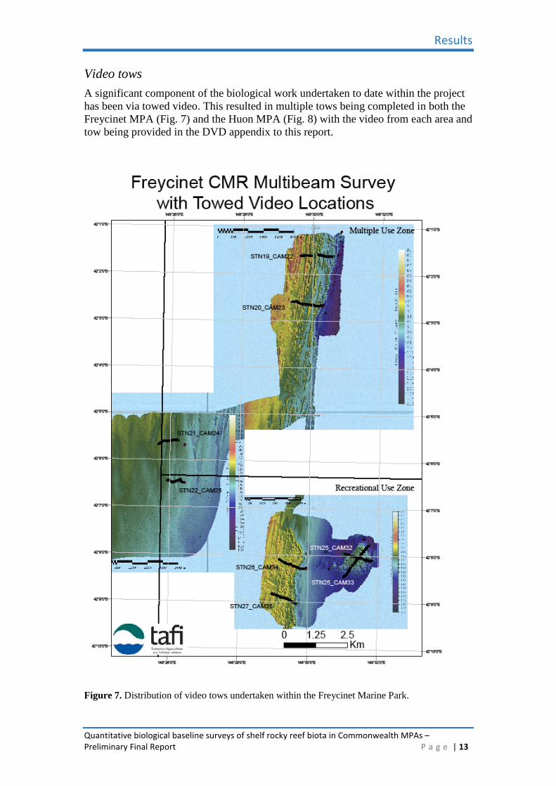
Video tows A significant component of the biological work undertaken to date within the project has been via towed video. This resulted in multiple tows being completed in both the Freycinet MPA (Fig. 7) and the Huon MPA (Fig. 8) with the video from each area and tow being provided in the DVD appendix to this report.
Figure 7. Distribution of video tows undertaken within the Freycinet Marine Park.

Results
Quantitative biological baseline surveys of shelf rocky reef biota in Commonwealth MPAs – Preliminary Final Report P a g e | 14
Figure 8. Distribution of video tows undertaken within the Huon MPA (south of black line) and matching control tows in similar habitat in adjacent waters.

Results
Quantitative biological baseline surveys of shelf rocky reef biota in Commonwealth MPAs – Preliminary Final Report P a g e | 15
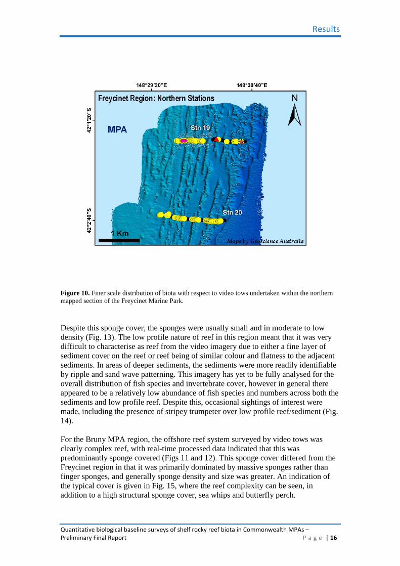
Real time logging (by Geosciences Australia staff) of the physical and biological attributes identified from the video resulted in a detailed database of the distribution of these over the length of the video tow and the ability to relate this back to the underlying map data. An indication of the visual GIS based presentation is given in Figs 9-12. For the Freycinet region, the offshore reef system was characterised by the presence of fairly continuous sponge cover, with finger sponges being common, and massive sponges less so (Figs 9-10).
Figure 9. Broad scale distribution of biota with respect to video tows undertaken in the Freycinet Marine Park and at adjacent reference locations. The Freycinet MPA tows were poorly characterized with respect to underlying substrate as low-lying bedrock was difficult to differentiate from sediments. However, a plot of sponge taxa gives some discrimination between reefal habitat (low densities of inverts such as sponges) versus non-reef (these taxa are absent). Green circles are moderate cover of kelp, yellow circles=occurrence of finger sponges, red triangles=occurrence of Massive sponges, blue dotted line the edge of the Commonwealth MPA, light blue regions = MPA.
Results
Quantitative biological baseline surveys of shelf rocky reef biota in Commonwealth MPAs – Preliminary Final Report P a g e | 16
Figure 10. Finer scale distribution of biota with respect to video tows undertaken within the northern mapped section of the Freycinet Marine Park. Despite this sponge cover, the sponges were usually small and in moderate to low density (Fig. 13). The low profile nature of reef in this region meant that it was very difficult to characterise as reef from the video imagery due to either a fine layer of sediment cover on the reef or reef being of similar colour and flatness to the adjacent sediments. In areas of deeper sediments, the sediments were more readily identifiable by ripple and sand wave patterning. This imagery has yet to be fully analysed for the overall distribution of fish species and invertebrate cover, however in general there appeared to be a relatively low abundance of fish species and numbers across both the sediments and low profile reef. Despite this, occasional sightings of interest were made, including the presence of stripey trumpeter over low profile reef/sediment (Fig. 14). For the Bruny MPA region, the offshore reef system surveyed by video tows was clearly complex reef, with real-time processed data indicated that this was predominantly sponge covered (Figs 11 and 12). This sponge cover differed from the Freycinet region in that it was primarily dominated by massive sponges rather than finger sponges, and generally sponge density and size was greater. An indication of the typical cover is given in Fig. 15, where the reef complexity can be seen, in addition to a high structural sponge cover, sea whips and butterfly perch.
Results
Quantitative biological baseline surveys of shelf rocky reef biota in Commonwealth MPAs – Preliminary Final Report P a g e | 17
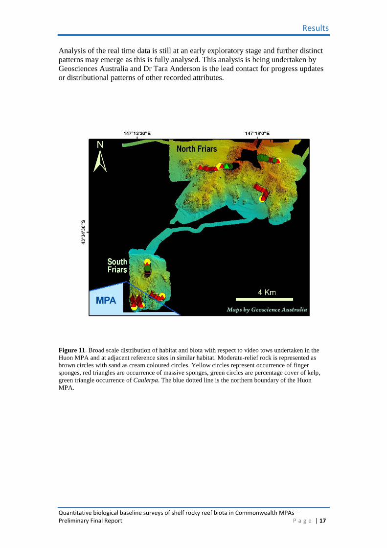
Analysis of the real time data is still at an early exploratory stage and further distinct patterns may emerge as this is fully analysed. This analysis is being undertaken by Geosciences Australia and Dr Tara Anderson is the lead contact for progress updates or distributional patterns of other recorded attributes.
Figure 11. Broad scale distribution of habitat and biota with respect to video tows undertaken in the Huon MPA and at adjacent reference sites in similar habitat. Moderate-relief rock is represented as brown circles with sand as cream coloured circles. Yellow circles represent occurrence of finger sponges, red triangles are occurrence of massive sponges, green circles are percentage cover of kelp, green triangle occurrence of Caulerpa. The blue dotted line is the northern boundary of the Huon MPA.
Results
Quantitative biological baseline surveys of shelf rocky reef biota in Commonwealth MPAs – Preliminary Final Report P a g e | 18
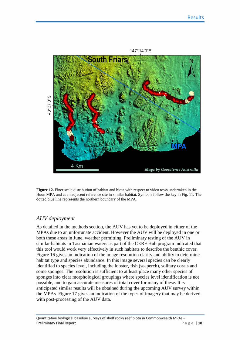
Figure 12. Finer scale distribution of habitat and biota with respect to video tows undertaken in the Huon MPA and at an adjacent reference site in similar habitat. Symbols follow the key in Fig. 11. The dotted blue line represents the northern boundary of the MPA.
AUV deployment As detailed in the methods section, the AUV has yet to be deployed in either of the MPAs due to an unfortunate accident. However the AUV will be deployed in one or both these areas in June, weather permitting. Preliminary testing of the AUV in similar habitats in Tasmanian waters as part of the CERF Hub program indicated that this tool would work very effectively in such habitats to describe the benthic cover. Figure 16 gives an indication of the image resolution clarity and ability to determine habitat type and species abundance. In this image several species can be clearly identified to species level, including the lobster, fish (seaperch), solitary corals and some sponges. The resolution is sufficient to at least place many other species of sponges into clear morphological groupings where species level identification is not possible, and to gain accurate measures of total cover for many of these. It is anticipated similar results will be obtained during the upcoming AUV survey within the MPAs. Figure 17 gives an indication of the types of imagery that may be derived with post-processing of the AUV data.

Results
Quantitative biological baseline surveys of shelf rocky reef biota in Commonwealth MPAs – Preliminary Final Report P a g e | 19
Figure 13. Low lying sponge cover on low profile, sediment covered reef in the Freycinet MPA.
Figure 14. Stripey trumpeter (latris lineata) on low profile reef/sediment within the Freycinet MPA.

Results
Quantitative biological baseline surveys of shelf rocky reef biota in Commonwealth MPAs – Preliminary Final Report P a g e | 20
Figure 15. Image of typical seabed features on deep reef habitat within the northern shelf section of the
Bruny MPA.
Figure 16. AUV image taken on 80 m deep reef adjacent to the Tasman Peninsula.

Results
Quantitative biological baseline surveys of shelf rocky reef biota in Commonwealth MPAs – Preliminary Final Report P a g e | 21
Figure 17. Composite mosaic of AUV derived images from deployment on reef at 60 m depth adjacent to the Tasman Peninsula.

Discussion
Quantitative biological baseline surveys of shelf rocky reef biota in Commonwealth MPAs – Preliminary Final Report P a g e | 22
Discussion
While the unfortunate grounding of R.V. Challenger provided a significant setback to our efforts to complete fieldwork on this project within agreed timeframe milestones, the proposed AUV and BUV deployment in June should see the full field component completed by the end of June 2009. As the output of both the AUV and BUVs is primarily video and visual, results should have an immediate impact with respect to our understanding of the nature of the habitat features within the MPAs examined, and the biota that is associated with them. This data, in addition to the video already collected, will then be examined in more detail over subsequent 12 months within the CERF Marine Biodiversity Hub framework, and updates on significant developments on the description of the biota with Commonwealth MPAs will be given to DEWHA as they occur. The work completed to date has provided a necessary and very informative first step in this process, with completion of very high quality broad area multibeam maps of the selected study sites and surrounding areas, including potential control areas that might share similar habitats and assemblages. The mapping was undertaken at an approximate resolution of one “ping” (with depth and backscatter estimate) per 1 m2, providing the potential to produce very high resolution maps of the area if necessary. The maps presented here are initial field maps produced from unprocessed raw data, yet they indicate clear habitat features in each of the MPA areas surveyed. In the Huon MPA region, the research area mapped within the northern section of the MPA was moderately complex reef that covered an extensive area of the shelf in the region. The reef in the MPA was matched by reef of similar nature and extent in waters adjacent to the MPA, providing effective control habitats for future studies that examine changes in the MPA relative to unprotected locations. Prior to the mapping it was not clear if this reef system was a continuous section extending seaward from “The Friars” on the Bruny Island coast, however, we have now shown there is a significant sediment area separating these systems. Previous multibeam mapping by F.R.V. Southern Surveyor for Dr Alan Williams (CSIRO) within a more southern section of the shelf of this MPA, also detected an extensive area of reef, suggesting that reef habitat forms a very significant component of the shelf habitats within this region. We know from general fishing patterns and shelf based fisheries research, that shelf reef is far rarer in Tasmanian waters to the north of this area (with the exception of isolated patches near Tasman Island), and therefore the reef within the MPA probably represents the northern extent of what is a major shelf habitat feature extending into much of southern Tasmania. Within the Freycinet MPA, reef habitat appears to be only a minor component of shelf habitats, with the remaining areas being primarily sediments. The reef that is present is far less complex than that found within the Huon MPA or areas mapped off the Tasman Peninsula at similar depths in related studies. The Freycinet reef is primarily a very low profile linear feature running for many kilometres along the length of the MPA. While only a small section of this was mapped overall, advice from fishermen suggests this extends northwards to at least Bicheno, and possibly represents an ancient drowned coastline. The reef was generally of such low profile that it was predominantly sediment covered and was therefore poorly characterised as reef from real-time analysis of the towed video data. Despite this, the reef was evident as higher densities of sponges and occasional reef associated fish fauna such as stripey trumpeter.

Discussion
Quantitative biological baseline surveys of shelf rocky reef biota in Commonwealth MPAs – Preliminary Final Report P a g e | 23
The towed video analysis certainly indicates that there are significant differences between the complexity of the Freycinet and Huon MPA reefs, and this is matched by similar differences in the associated biota. Generally the Huon MPA reefs had higher sponge density, larger sponges, more diversity of other invertebrate species such as seawhips, and a larger variety and total abundance of fish species. By comparison with the AUV data derived during trials off the Tasman Peninsula, it appears the AUV may provide a significant improvement in resolution of the benthic faunal cover of these habitats, although less information on the epi-benthic fish fauna. This comparison can be formally made after the upcoming AUV deployment, and, along with data from the planned BUV deployments, will be investigated further as part of a CERF Hub PhD project by Jan Seiler at UTas comparing the effectiveness and complimentary nature of a range of non-intrusive video based techniques for describing and quantifying shelf reef biodiversity. All of the data collected during this study will be examined within the wider framework of the CERF Marine Biodiversity Hub, particularly with respect to the effectiveness of multibeam sonar as an appropriate surrogate tool for differentiating habitat variation on shelf systems. In return, the completed analysis should further inform our understanding of the biota on reefs within the Freycinet and Bruny MPAs, and how this might vary spatially. The quantitative estimates of species abundances will act as a reliable baseline for assessing changes within these areas into the future.

Acknowledgements
Quantitative biological baseline surveys of shelf rocky reef biota in Commonwealth MPAs – Preliminary Final Report P a g e | 24
Acknowledgements
We would like to thank the Department of the Environment, Water, Heritage and the Arts, and in particular Ms Susan Campbell, for funding to allow CERF Hub research to be extended from coastal waters into the new CMR network. We also thank TAFI and the Tasmanian Government for providing vessel support, IMOS for providing the AUV facility (despite the vessel grounding preventing its eventual use), and the crew of RV Challenger for supporting the research at sea.


Contact: Neville Barrett
Tasmanian Aquaculture and Fisheries Institute University of Tasmania
email | [email protected]