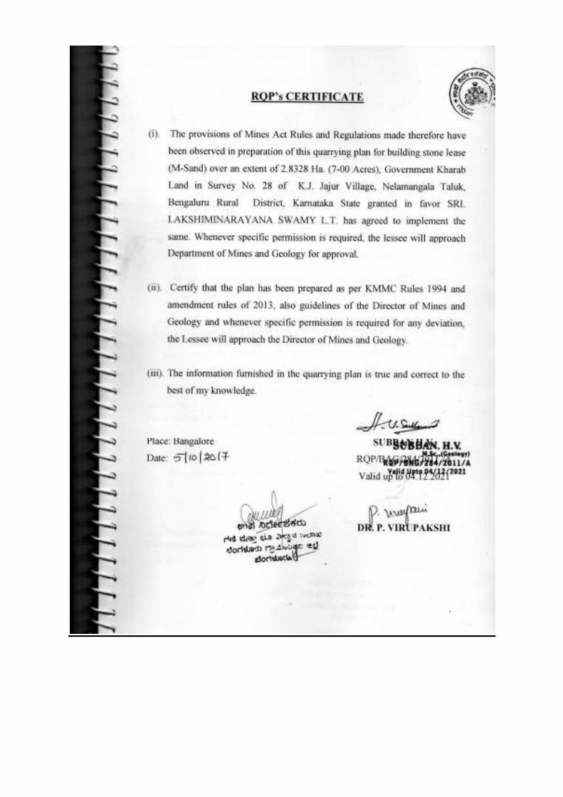
quarrying plan and progressive closure plan for...
TRANSCRIPT
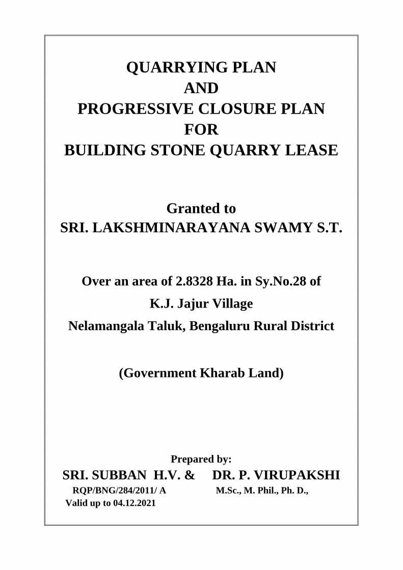
QUARRYING PLAN
AND PROGRESSIVE CLOSURE PLAN
FOR BUILDING STONE QUARRY LEASE
Granted to SRI. LAKSHMINARAYANA SWAMY S.T.
Over an area of 2.8328 Ha. in Sy.No.28 of
K.J. Jajur Village
Nelamangala Taluk, Bengaluru Rural District
(Government Kharab Land)
Prepared by: SRI. SUBBAN H.V. & DR. P. VIRUPAKSHI
RQP/BNG/284/2011/ A M.Sc., M. Phil., Ph. D., Valid up to 04.12.2021


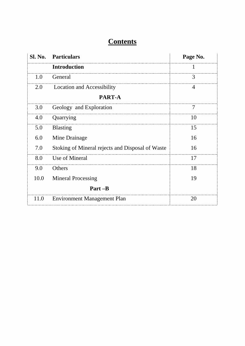
Contents
Sl. No. Particulars Page No.
Intro duction 1
1.0 General 3
2.0 Location and Accessibility 4
PART-A
3.0 Geology and Exploration 7
4.0 Quarrying 10
5.0 Blasting 15
6.0 Mine Drainage 16
7.0 Stoking of Mineral rejects and Disposal of Waste 16
8.0 Use of Mineral 17
9.0 Others 18
10.0 Mineral Processing 19
Part –B
11.0 Environment Management Plan 20
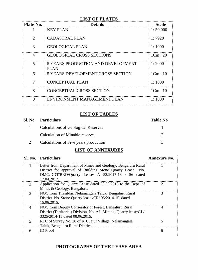
LIST OF PLATES Plate No. Details Scale
1 KEY PLAN 1: 50,000
2 CADASTRAL PLAN 1: 7920
3 GEOLOGICAL PLAN 1: 1000
4 GEOLOGICAL CROSS SECTIONS 1Cm : 20
5 5 YEARS PRODUCTION AND DEVELOPMENT PLAN
1: 2000
6 5 YEARS DEVELOPMENT CROSS SECTION 1Cm : 10
7 CONCEPTUAL PLAN 1: 1000
8 CONCEPTUAL CROSS SECTION 1Cm : 10
9 ENVIRONMENT MANAGEMENT PLAN 1: 1000
LIST OF TABLES
Sl. No. Particulars Table No
1 Calculations of Geological Reserves 1
Calculation of Minable reserves 2
2 Calculations of Five years production 3
LIST OF ANNEXURES
Sl. No. Particulars Annexure No.
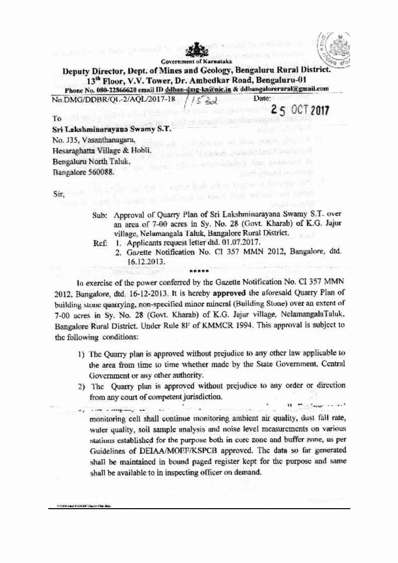
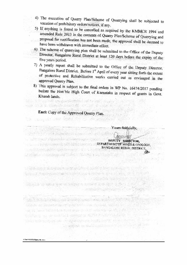
1 Letter from Department of Mines and Geology, Bengaluru Rural District for approval of Building Stone Quarry Lease No. DMG/DDT/BRD/Quarry Lease/ A 52/2017-18 / 56 dated 17.04.2017.
1
2 Application for Quarry Lease dated 08.08.2013 to the Dept. of Mines & Geology, Bangalore.
2
3 NOC from Thasildar, Nelamangala Taluk, Bengaluru Rural District No. Stone Quarry lease /CR/ 05:2014-15 dated 15.06.2015.
3
4 NOC from Deputy Conserator of Forest, Bengaluru Rural District (Territorial) Division, No. A3: Mining: Quarry lease:GL/ 3325/2014-15 dated 08.06.2015.
4
5 RTC of Survey No. 28 of K.J. Jajur Village, Nelamangala Taluk, Bengaluru Rural District.
5
6 ID Proof 6
PHOTOGRAPHS OF THE LEASE AREA
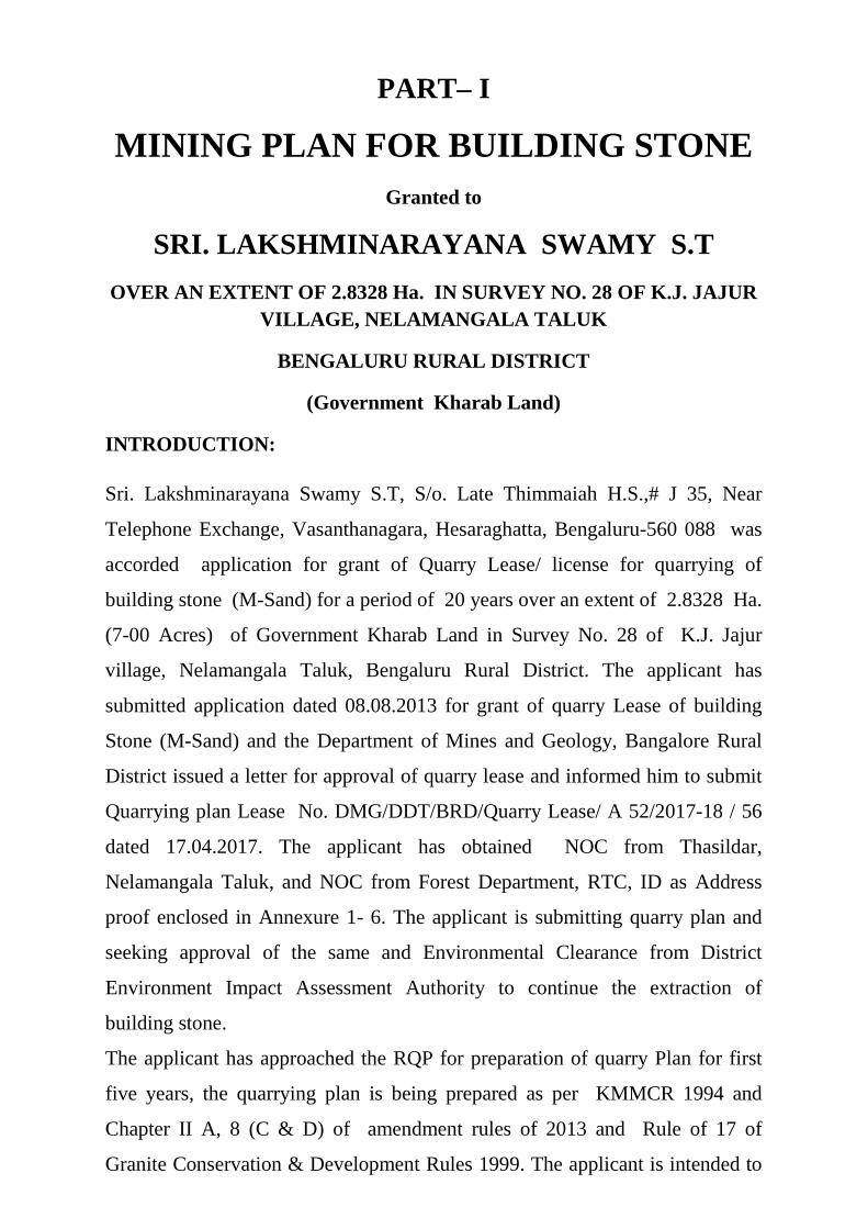
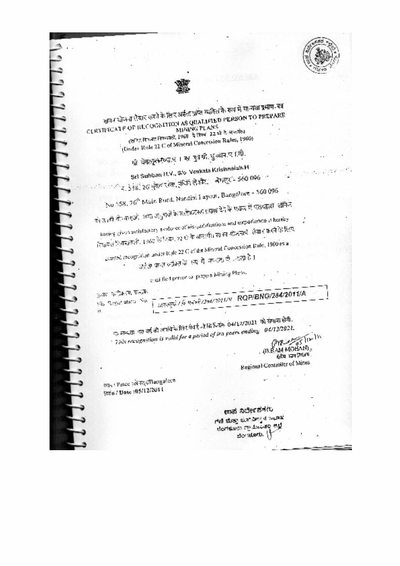
PART– I
MINING PLAN FOR BUILDING STONE Granted to
SRI. LAKSHMINARAYANA SWAMY S.T
OVER AN EXTENT OF 2.8328 Ha. IN SURVEY NO. 28 OF K.J. JAJUR VILLAGE, NELAMANGALA TALUK
BENGALURU RURAL DISTRICT
(Government Kharab Land)
INTRODUCTION:
Sri. Lakshminarayana Swamy S.T, S/o. Late Thimmaiah H.S.,# J 35, Near
Telephone Exchange, Vasanthanagara, Hesaraghatta, Bengaluru-560 088 was
accorded application for grant of Quarry Lease/ license for quarrying of
building stone (M-Sand) for a period of 20 years over an extent of 2.8328 Ha.
(7-00 Acres) of Government Kharab Land in Survey No. 28 of K.J. Jajur
village, Nelamangala Taluk, Bengaluru Rural District. The applicant has
submitted application dated 08.08.2013 for grant of quarry Lease of building
Stone (M-Sand) and the Department of Mines and Geology, Bangalore Rural
District issued a letter for approval of quarry lease and informed him to submit
Quarrying plan Lease No. DMG/DDT/BRD/Quarry Lease/ A 52/2017-18 / 56
dated 17.04.2017. The applicant has obtained NOC from Thasildar,
Nelamangala Taluk, and NOC from Forest Department, RTC, ID as Address
proof enclosed in Annexure 1- 6. The applicant is submitting quarry plan and
seeking approval of the same and Environmental Clearance from District
Environment Impact Assessment Authority to continue the extraction of
building stone.
The applicant has approached the RQP for preparation of quarry Plan for first
five years, the quarrying plan is being prepared as per KMMCR 1994 and
Chapter II A, 8 (C & D) of amendment rules of 2013 and Rule of 17 of
Granite Conservation & Development Rules 1999. The applicant is intended to
supply the building material to the domestic and construction purposes to the
surrounding areas of, Dabaspet, Tumkur, Nelamangala and Bengaluru City
areas.
The area is found to have prominent exposure of Granitic Gneiss exposures
suitable for building stone material covering the lease area. Detailed study of
the area has been done by the RQP along with applicant to assess the quality
and quantity of the building material available in the area. The exposure of
building material i.e granitic gneiss in the area indicates the persistence of
deposit to the depth. In view of the proposed development and production of
building stone, the applicant intend to go for production of 131843 Tons per
annum by carrying out medium scale of quarrying by engaging both manual
and machineries i.e. semi-mechanized open cast method. The quarrying plan is
prepared for the quarry area through systematic mining, with an aim to ensure
systematic development, production and conservation of building stone deposit
with eco-friendly quarry operations and providing employment to the local
people as per Rule 8 O and protection of environment in accordance with 8 Q of
KMMCR, 1994 and amendment Act of 2013. The applicant is submitting this
quarry plan for a period of first five years and revival of production as pre-
requisite to getting approval from the Departments to proceed with quarrying.
The quarry area is moderately sloping surface towards north with few surface
boulders on top followed by sheetrock; the area has to be worked by semi-
mechanized open cast method. The quarry plan is prepared with specific aims
as given below:
1. To minimize the environmental degradation due to quarrying.
2. Conserve and maximum utilization of reserves by minimizing the
wastage.
3. Planned dumping and storage of waste.
4. Conservation and utilization of the top soil, if any in the area to be
worked.
5. The quarrying operations will be conducted by semi-mechanized method
using controlled blasting to extract the building stone in the quarry.
1.0 GENERAL:
The applicant is supplying building stone (M-Sand) and other building
material to the surrounding area is having good business experience.
a. Name and address of the applicant
: Sri. Lakshminarayana Swamy S.T S/o. Late Thimmaiah H.S. # J 35, Near Telephone Exchange Vasantha Nagara, Hesaraghatta Bangalore -560 088 Ph: 9141566775
b. Status of the applicant : Individual
c. Minerals/ Which are occurring in the area and which intends to mine: Granitic Gneiss - Building stone.
d. Period for which the quarry lease is proposed to be applied: The period proposed for quarry Lease of 20 Years
e. Name and address of
RQP SRI. SUBBAN H.V.
RQP/BNG/284/2011/A # 58, 26th Main Behind BHEL Colony Nandini Layout Bengaluru- 560 096 Phone: +91 916137429 DR. P. VIRUPAKSHI M/s. Spoorthy Services No. 273, 8th Main BCC Layout, Chandra Layout Vijayanagara, Bengaluru-560040 Ph: +91 9986749095
f. Reference No. and Date of consent letter from the State Govt. :
The Deputy Director, Department of Mines & Geology, Bangalore
Rural District was issued a letter for approval of quarry lease and
informed him to submit Quarrying plan Lease No.
DMG/DDT/BRD/Quarry Lease/ A 52/2017-18 / 56 dated 17.04.2017
(Annexure-1).
2.0 LOCATION AND ACCESSIBILITY:
Details of the Area (with Location Map)
Details of the Area (with location map)
a. District and State
: Tumakuru District Karnataka State
Taluk : Tumakuru
Village : K.J. Jajur
Survey. No : 28
Lease Area (Acres) : 2.8328 Ha. ( 7-00 Acres)
b. Whether the area is recorded to be in the forest (Please specify whether protected, reserved etc.) : No
c. Ownership occupancy : Government Kharab Land
d. Existence of public road/ railway line, if any nearby & approximate distance:
The area is situated at 1.60 Km. North West of K.J. Jajur Village,
about 1.50 Km. West of Makenahalli village, about 1.7 Km. east of
Dhanayakanapura village, the lease area is connected to earthen road
from Dabespet-Koratagere Satate Highway to K.J. Jajur- villages. The
area lies 7.5 Km North West of Dabespet Town which is Hobli
Headquarter. The area is connected to Village Road connected to
Dabespet-Koratagers SH and K.J. Jajur villages. The lease area is
located 27.00 Km West of Nalamangala Town and 55.00 Km West of
Bangalore City which is District headquarter where all the welfare
amenities are available.
The nearest railway station is Hirehalli at a distance of 4.20 Km. The
nearest airport is Bangalore International Airport which is 80 Kms. The
quarry/ lease area can be reached through village road connecting to
K.J. Jajur Village to Dabespet-Koratagere SH in all seasons. The lease
area is surrounded by waste lands and agricultural fields. Power
connections are available at K.J. Jajur Village to quarry area.
Telecommunication facility is available at Jajur, Dabespet and
Tumakuru Town. Dispensary is located at Narsipura and Dabespet
town which are 6.2 and 7.50 Km Dabespet town.
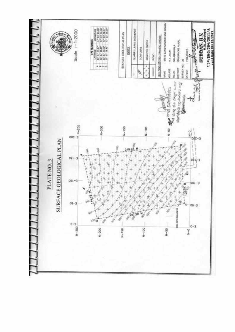
e. Toposheet No. with Latitude and Longitude: The quarry area falls part of Survey of India Topo Sheet No. 57 G/ 3 of 1:50, 000 Scale (Plate No.1)
GPS Readings (Datum: WGS 84)
Point No. Latitude Longitude
A N 130 17’ 25.87” E 770 13’ 33.39” B N 130 17’ 18.89” E 770 13’ 32.00” C N 130 17’ 20.00” E 770 13’ 28.32” D N 130 17’ 26.42” E 770 13’ 29.29”

f. Land use Pattern (Forest, Agricultural, Grazing and Barren etc.):
The quarrying area is Government Kharab land. It is rocky mound and
underlined by sheet rock as visible in the surface quarry workings and open pits
earlier by the local people for their day to day needs.
The present Land Use pattern of the quarry Area is as follows
Sl. No. Land use Category Present Land Use
(Ha.) 1 Quarry workings - 2 Waste dumps - 3 Roads -
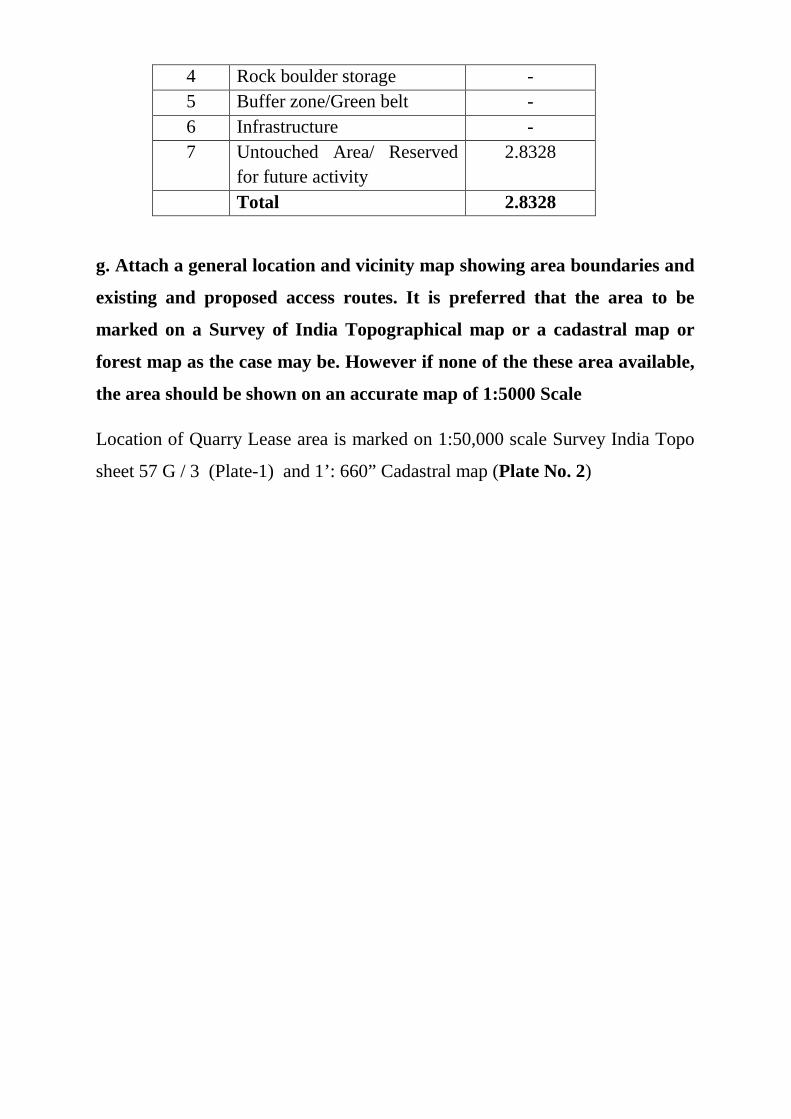
4 Rock boulder storage - 5 Buffer zone/Green belt - 6 Infrastructure - 7 Untouched Area/ Reserved
for future activity 2.8328
Total 2.8328
g. Attach a general location and vicinity map showing area boundaries and
existing and proposed access routes. It is preferred that the area to be
marked on a Survey of India Topographical map or a cadastral map or
forest map as the case may be. However if none of the these area available,
the area should be shown on an accurate map of 1:5000 Scale
Location of Quarry Lease area is marked on 1:50,000 scale Survey India Topo
sheet 57 G / 3 (Plate-1) and 1’: 660” Cadastral map (Plate No. 2)

PART-A
3.0 GEOLOGY AND EXPLORATION:
a. Briefly describe the topography and general geology and local / mine
geology of the mineral deposit including drainage pattern:
Topography: Nelamangala Taluk of Bengaluru Rural District coming
under western slopes covered by famous Peninsular Gneiss and Granites.
The topography of the area consists of massive gneisses and ground
sloping towards south. The altitude of the area is 920 to 944 Meters
above sea level. The general slope of the area is towards south.
Topography is both structurally and lithologically controlled. The quarry
area is moderately sloping terrain towards south with Granitic/ gneissic
rock exposures trending North- South direction. The area drains towards
south flows in to nala further flows east and joins Shimsha river which is
tributary of River Cauvery.
General Geology: Stratigraphycally the Peninsular gneisses belong to
older group belongs to Dharwar Super group. The gneisses are most
widespread lithological unit in Karnataka State is poly phase granite. The
gneissic rock exposed in the form of mounds they are medium grained,
banded in nature with major feldspar and quartz bands. The gneissic
exposures are massive and exhibiting strike and sheet joints, the sheet
joints are filled with 1.5 to 3.00 meters thick soil. The soil cover exists at
the lower side of the area with an average thickness of 3.00 meters.
Local Mine Geology: The area forms part of rocks formed as peninsular
gneisses and other adjoining with Granites. The lease area is moderately
sloping towards south, at the lower part covered by soil to a depth of 3.75
meters. The area is located at an altitude of 920 to 944 meters MSL. The
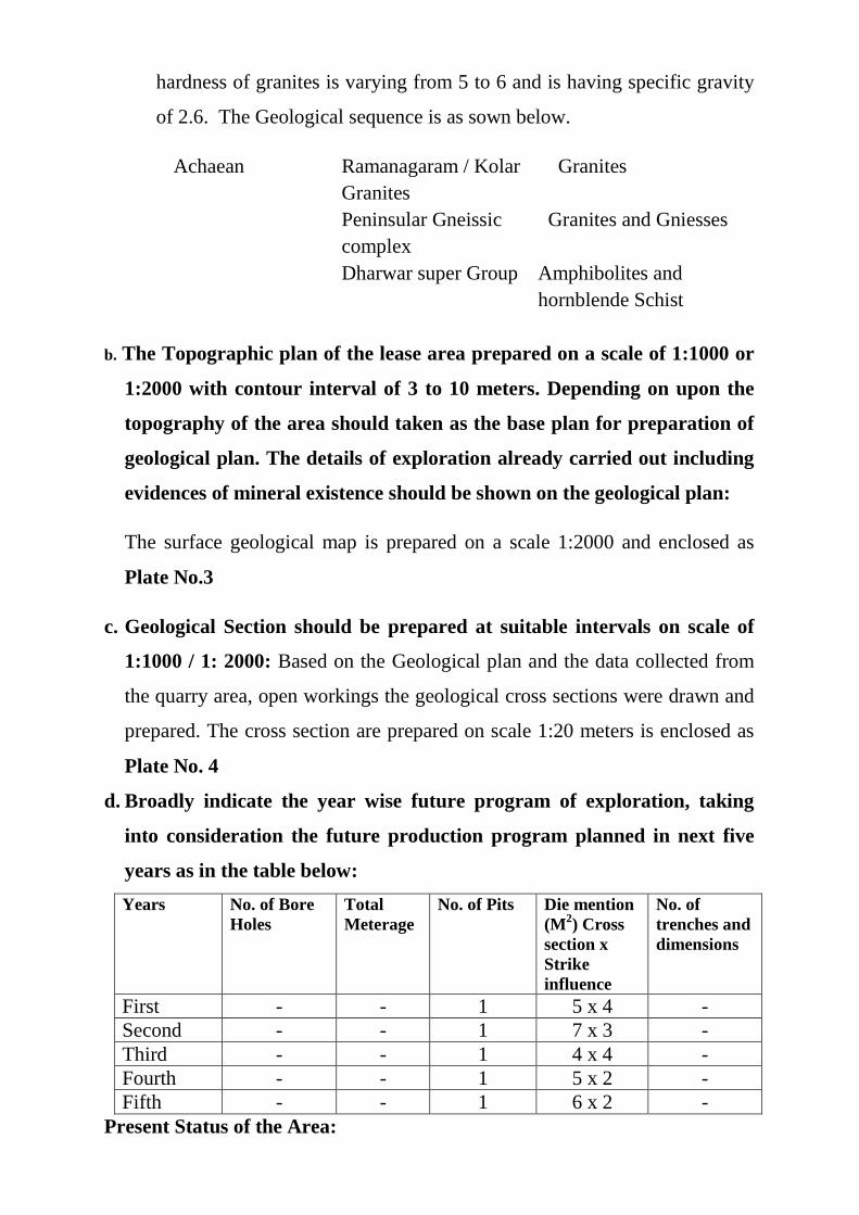
hardness of granites is varying from 5 to 6 and is having specific gravity
of 2.6. The Geological sequence is as sown below.
Achaean Ramanagaram / Kolar Granites
Granites
Peninsular Gneissic complex
Granites and Gniesses
Dharwar super Group Amphibolites and hornblende Schist
b. The Topographic plan of the lease area prepared on a scale of 1:1000 or
1:2000 with contour interval of 3 to 10 meters. Depending on upon the
topography of the area should taken as the base plan for preparation of
geological plan. The details of exploration already carried out including
evidences of mineral existence should be shown on the geological plan:
The surface geological map is prepared on a scale 1:2000 and enclosed as
Plate No.3
c. Geological Section should be prepared at suitable intervals on scale of
1:1000 / 1: 2000: Based on the Geological plan and the data collected from
the quarry area, open workings the geological cross sections were drawn and
prepared. The cross section are prepared on scale 1:20 meters is enclosed as
Plate No. 4
d. Broadly indicate the year wise future program of exploration, taking
into consideration the future production program planned in next five
years as in the table below:
Years No. of Bore Holes
Total Meterage
No. of Pits Die mention (M2) Cross section x Strike influence
No. of trenches and dimensions
First - - 1 5 x 4 - Second - - 1 7 x 3 - Third - - 1 4 x 4 - Fourth - - 1 5 x 2 - Fifth - - 1 6 x 2 -
Present Status of the Area:

The proposed quarry area is renewal quarry. The quarry will be worked from
southern portion of the area shown in the quarry plan Plate No. 3. The soil
mixed with boulders present at the northernmost portion of the lease area.
Since the area is moderately sloping surface, the little soil cover will be
removed which is present on the surface of the granitic rock. A part of the
camp services also established near the lease area at applicant own land.
e. Reserves-Indicate geological and recoverable reserves and grade, duly
supported by standard method of estimation and calculations along with
required sections (give split of various categories i.e proved, probable,
and possible) Indicate cut-off grade. Availability of resource should also
be indicated for the entire leasehold.
Based on the study and survey carried out and the geological plan has been
prepared along with the size and shape of reserves in the quarry location. The
reserves have been calculated for 2.8328 Ha. of the notified area by using the
standard norms.
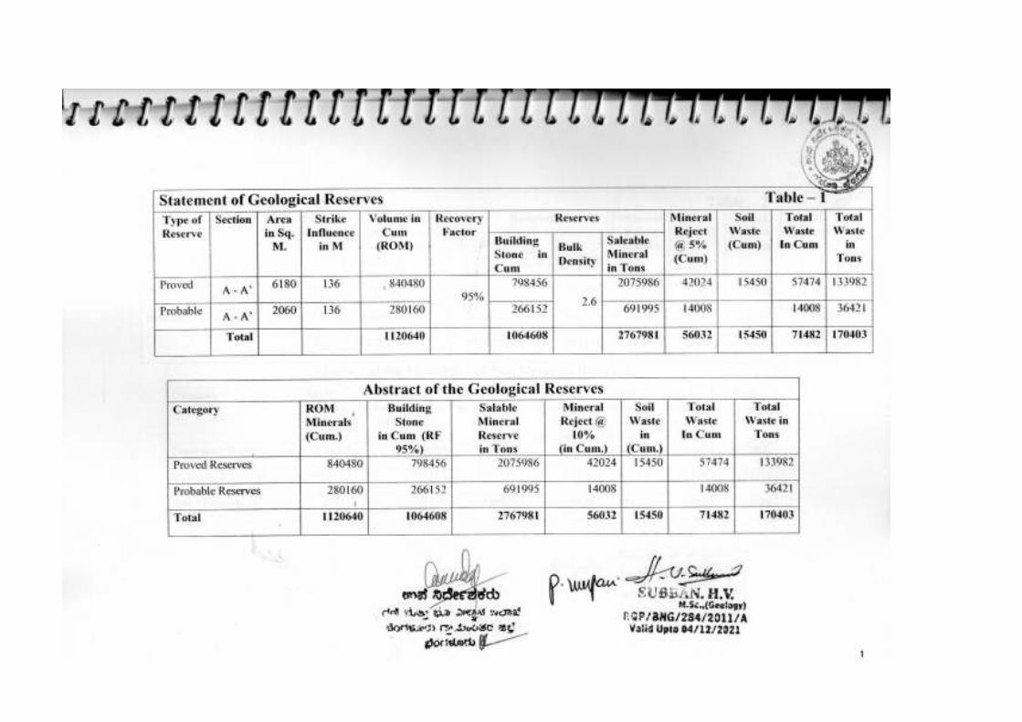
The reserves have been estimated in two categories 1). Proved and 2).Probable
(See Table-1,2 and 3).
(i). Proved Reserves: The reserves have been estimated up to a depth of 40
meters where massive sheet rock exists. The recovery percentage is 95% and
the mineral reject is 5%.
(ii). Probable Reserves: The reserves have been estimated from the sheet rock
to a depth of 10 meters below the proved formation depth and the mineral
recovery and reject is same as above.
The detail of Geological reserves for the lease area is given below.
Category of
reserves
Section
Mineral in Cum (ROM)
Recovery
Factor
Building stone in Cum.
Bulk density
Salable Mineral in Tons
Mineral Waste in
Cum. (@5%)
Soil Waste
in Cum.
Proved A – A’ 840480 798456 2075986 42024 15450
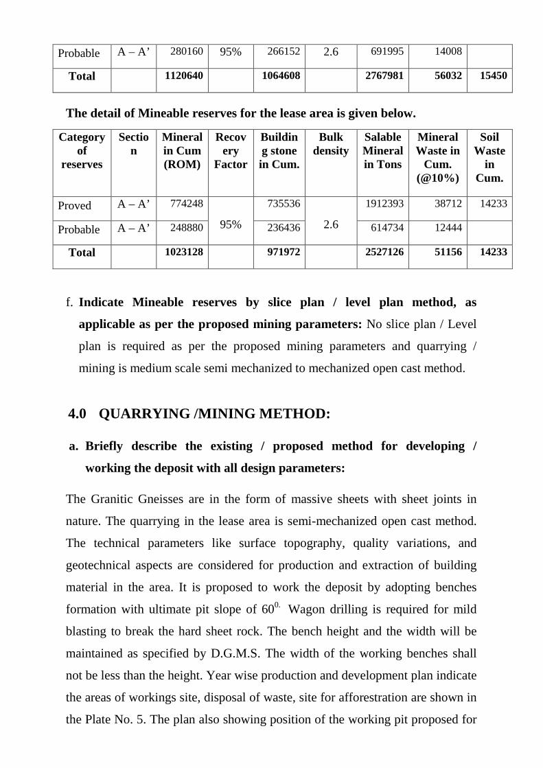
Probable A – A’ 280160 95% 266152 2.6 691995 14008
Total 1120640 1064608 2767981 56032 15450
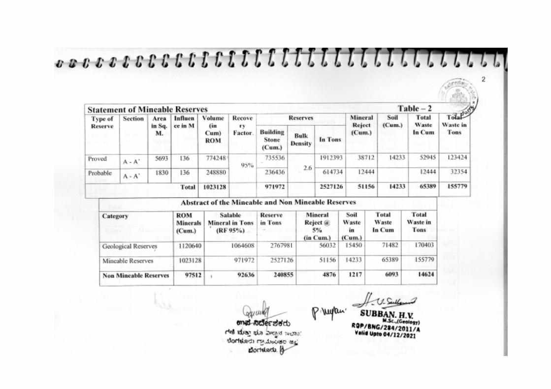
The detail of Mineable reserves for the lease area is given below.
Category of
reserves
Section
Mineral in Cum (ROM)
Recovery
Factor
Building stone in Cum.
Bulk density
Salable Mineral in Tons
Mineral Waste in
Cum. (@10%)
Soil Waste
in Cum.
Proved A – A’ 774248
95%
735536
2.6
1912393 38712 14233
Probable A – A’ 248880 236436 614734 12444
Total 1023128 971972 2527126 51156 14233
f. Indicate Mineable reserves by slice plan / level plan method, as
applicable as per the proposed mining parameters: No slice plan / Level
plan is required as per the proposed mining parameters and quarrying /
mining is medium scale semi mechanized to mechanized open cast method.
4.0 QUARRYING /MINING METHOD:
a. Briefly describe the existing / proposed method for developing /
working the deposit with all design parameters:
The Granitic Gneisses are in the form of massive sheets with sheet joints in
nature. The quarrying in the lease area is semi-mechanized open cast method.
The technical parameters like surface topography, quality variations, and
geotechnical aspects are considered for production and extraction of building
material in the area. It is proposed to work the deposit by adopting benches
formation with ultimate pit slope of 600. Wagon drilling is required for mild
blasting to break the hard sheet rock. The bench height and the width will be
maintained as specified by D.G.M.S. The width of the working benches shall
not be less than the height. Year wise production and development plan indicate
the areas of workings site, disposal of waste, site for afforestration are shown in
the Plate No. 5. The plan also showing position of the working pit proposed for
extension etc. due care has to be taken to maintain and advancing the benches
for production. The ground water problem does not arise the existing and
proposed levels is much above ground water table.
b. Indicate quantum of development and tonnage and grade of production
pit wise as in table below:
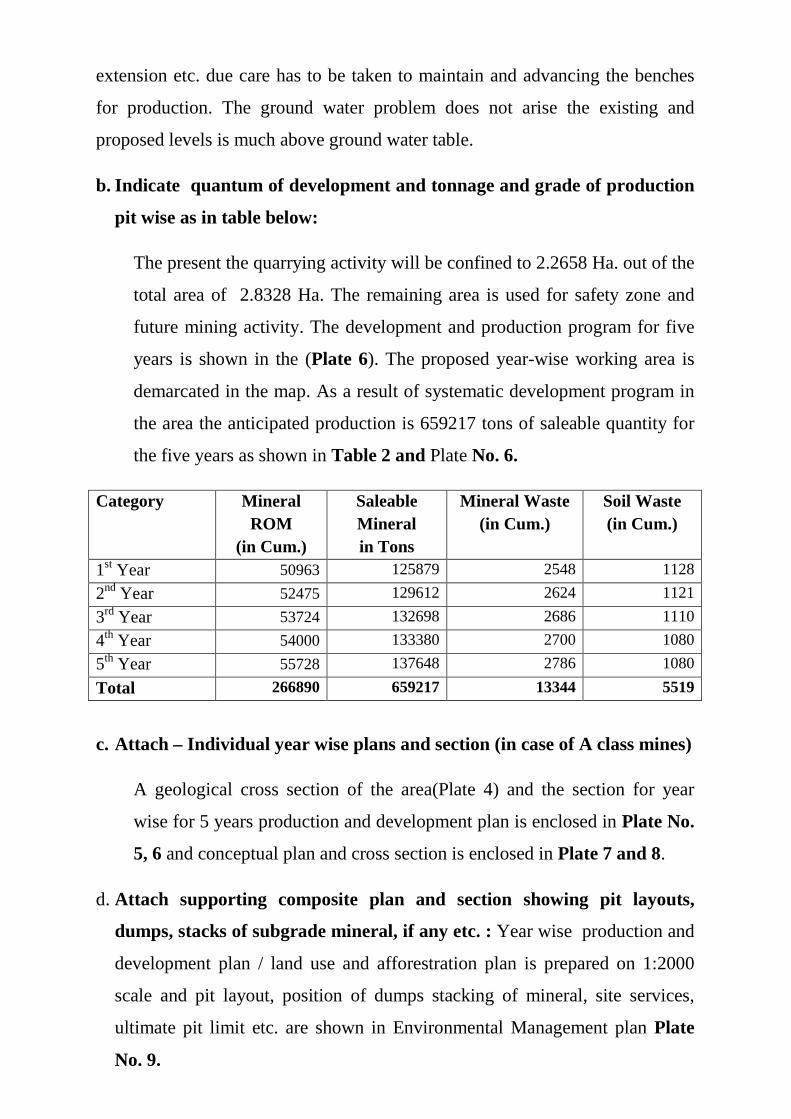
The present the quarrying activity will be confined to 2.2658 Ha. out of the
total area of 2.8328 Ha. The remaining area is used for safety zone and
future mining activity. The development and production program for five
years is shown in the (Plate 6). The proposed year-wise working area is
demarcated in the map. As a result of systematic development program in
the area the anticipated production is 659217 tons of saleable quantity for
the five years as shown in Table 2 and Plate No. 6.
Category Mineral ROM
(in Cum.)
Saleable Mineral in Tons
Mineral Waste (in Cum.)
Soil Waste (in Cum.)
1st Year 50963 125879 2548 1128
2nd Year 52475 129612 2624 1121
3rd Year 53724 132698 2686 1110
4th Year 54000 133380 2700 1080
5th Year 55728 137648 2786 1080
Total 266890 659217 13344 5519
c. Attach – Individual year wise plans and section (in case of A class mines)
A geological cross section of the area(Plate 4) and the section for year
wise for 5 years production and development plan is enclosed in Plate No.
5, 6 and conceptual plan and cross section is enclosed in Plate 7 and 8.
d. Attach supporting composite plan and section showing pit layouts,
dumps, stacks of subgrade mineral, if any etc. : Year wise production and
development plan / land use and afforestration plan is prepared on 1:2000
scale and pit layout, position of dumps stacking of mineral, site services,
ultimate pit limit etc. are shown in Environmental Management plan Plate
No. 9.
e. Indicate proposed rate of production when the mine is fully developed,
and the expected life of the mine and the year from which effected:
(i). Proposed rate of production when the mine is fully developed: It is
proposed to produce an average 131843 tons / annum when the quarry is fully
developed
(ii). Mineable reserves: Though the reserves are quite attractive, the mineable
reserves will be reduced due to formation of benches towards boundary line,
this can be solved by having suitable arrangements with adjacent land owner for
full exploitation of the reserves, meanwhile the reserves have been blocked in
7.5 meters safety barrier below the ground level.
Total Mineable reserves:
Total Geological Reserves - Mineable reserves= Non Mineable Reserves
(in Cum).
1120640 – 1023128 = 87512 Cum.
(iii) Anticipated life of the Mine: the quantities of mineable reserves estimated
are total reserves minus non mineable reserves and already extracted,
considered as (economical) marketable reserves. The mineable reserves of
2527126 Tons are available in the lease area. The average annual production is
131843 Tons and thus the life of the mine is 20 years.
f. Attach a note furnishing a conceptual mining plan for the entire
lease period (for “B” category mines) and up to the life of the (for
“A” category mines) based on the geological, mining and
environmental considerations: The Granitic gneiss as building stone
deposit in the quarry area is envisaged to be worked by forming mining
benches of 6 meters height from the ground level and the width shall me
more than the height of the benches with a general pit slope of 60o. The
ultimate pit limit is marked as shown on the quarry Closure Plan (Plate-
9). However, when the granitic gneiss deposit is proved to full depth, the
closure plan will be modified. The quarrying is proposed to be taken with
the full capacity of development and production of on an average of
about 131843 Tons per annum, during the proposed closure plan period.
Any modifications in the in the quantity of production will be intimated
to Department of Mines and Geology. The mined out pits after extraction
of the building material, will be reclaimed by suitable reclamation and
afforestration techniques and also by back filling the pits by the
overburden. The design and layout of the quarry benches is shown on the
above referred plan. During the closure plan period, the anticipated
production for the next 5 years period shall be 659217 Tons.
g. Open Cast Mines:
(i). Describe briefly giving salient features of the mode of working
(mechanized, semi-mechanized, manual): The extraction of building
material proposed to be worked by semi-mechanized method of working.
In view of the prepared quarry plan production of building stone material,
it is planned to operate by deploying machineries for development and
production, the separation of building stone material based on physical
parameters manually with conventional tools like crowbars, hammers,
pickaxe etc. and mechanically using drilling equipment’s, tippers will be
used for quarrying work. The parameters will thus the bench height of
about 3 m and width is more than height of bench and jackhammer
drilling carried with dust proof drilling machineries. As proposed above,
the development of latest mechanization plays a very important role in
the development quarry and production program. The quarrying
operation in notified area planned to be of open cast and semi-
mechanized. The recovery of building stone is generally high i.e. more
than 95%. It requires machinery for increased production.
(ii) Describe briefly the layout of the mine workings, the layout of the
faces and sites for disposal of overburden/ waste: A reference to the
plan enclosed under 4 (b) and 4 (d) will suffice: During the plan period
the development and production will be carried out as shown in the 5
years production and development plan Plate 5. The quarrying is done

manually and semi-mechanized (open cast method). During the
development and production program for the plan period it is proposed to
produce 659217 tons of saleable quantity.
Years Pit Nos.
Overburden
ROM in Cum
Saleable quantity in Tons (ROM x (bulk density 2.6) RF 95%
Mineral Reject(@5%)+Soil in Tons
Over burden/ waste ratio
1st - - 50963 125879 8429 1: 0.05000
2nd - - 52475 129612 8616 1: 0.05000
3rd - - 53724 132698 8760 1: 0.05000
4th - - 54000 133380 8748 1: 0.05000
5th - - 55728 137648 8973 1: 0.05000
Total 266890 659217 43526 1:0.05000
h. Underground mines: Not Applicable
(i) Extent of Mechanization
Describe briefly including the calculations for adequacy and
type of machinery and equipment proposed to be used in
different mining operations:
1. The quarrying will be worked with semi-mechanized method
by deploying following machinery and manpower.
Sl. No. Name of the Machinery Nos.
1 Excavator 210 Capacity 1 No.
2 Air Compressor (Atlas Cop)/
Tractor mounted compressor
2 No.
3 Jack Hammer 2No.
4 Tippers 2 Nos.
The transportation will be made by own / hired trucks to the dispatching points.
2. Drilling Machine: Drilling will be done by compressor operated
jack-hammer drills.
3. Loading Equipment: Loading of the building stone material will
be done mechanically by tippers of 10 ton capacity and transported

from the quarry to the required site. The rejected material will be
dumped separately. All other safety measures were observed as per
D.G.M.S. specifications.
4. Haluage and Transport: Hauling and transportation will be done
by using excavators, cranes, tippers etc. The waste and the other
overburden will be transported to the waste dumping yard by using
trucks / tippers.
i. Transport from the mine head to the destination:
Describe briefly the transport system (Please specify). The material
extracted will be transported by trucks to the crushing point and also
needs of the local people. The mode of transport will be road. The
transportation is by tippers/ trucks depending on the requirement.
5.0 BLASTING: A mild blasting will be done for the purpose of removing
weathered rock and over burden for this purpose whenever it is required
the services of the licensed blasting agencies will be engaged.
a. Broadly blasting parameters like charge per hole, blasting pattern
charge per delay, maximum number of holes blasted in a round
manner and sequence of firing, etc: Since the quarrying is going to be
operate manually, jackhammer drilling will be used for the holes will be
fired with ordinary detonators and safety fuse.
The parameters for blasting:
Diameter of the hole : 32 mm
Depth : 1.5 m
Spacing : 0.9 m
Burden : 0.6 m
Charge per hole : 3 cartridge of 104 gm each
= 0.42 Kg.
Yield of the explosive : Spacing x Burden x depth Explosive in Kg Charge
: 0.9 x 0.6 x 1.5 x 2.6
0.42
: 5 Tons of ROM
Storage of explosives: Authorized explosive dealers as per the
requirement will supply the explosive material as and when required.
6.0 MINE DRAINAGE:
The area receives an average rainfall of 879 mm. There are no water canals in
the area. The quarry area receives only less rainfall with moderate slope
towards south. The collection of water even during the rainy season is
negligible and remains dry in the rest of the year. The hydro geological
investigation of the bore well drilled in the nearby vicinity indicated that the
ground water strikes at depth of 75 meters which is 850 meters MSL. The
ultimate pit level is 916 meters including soil cover and the ground level
expected to be above 850 M MSL which is above water table. No water is
likely to be encountered during the course of quarrying.
7.0 STACKING OF MINERAL REJECTS AND DISPOSAL OF
WASTE:
a). Indicate briefly the nature & quantity of top soil, overburden / waste
and mineral rejects likely to be generated during the next five years:
The average generation is during the proposed quarrying will be shown in
the below.
Year Top Soil (in Cum)
Over Burden / Waste
Mineral Reject (In Cum.)
1st 1128 - 2548
2nd 1121 - 2624
3rd 1110 - 2686
4th 1080 - 2700

5th 1080 - 2786
Total 5519 - 13344
b).Land chosen for disposal of waste with proposed Justification: The place
selected for dumping of top soil, overburden and waste material will be
dumped away from the working area. The site selected for disposal by
following the rules 18 (3) of GC & DR 1999. The area selected is as shown
in 5 years production and development plan Plate 5.
c). Attach Note indicating the manner of disposal and configuration
sequence of buildup of dumps along with the proposals for the stacking
of sub grade ore, to be indicated item wise: The area selected for dump is a
near/ along the buffer area, when the step wise dumping will be carried out
for a maximum height of 12 m with 280 dump slope. Proper terracing will
be done along dump slopes to provide better slope stability. The mineral
reject likely to be generated is about 52338 Cum. is being used as
replacement of sand. The location of waste dump yard, mineral stock yard,
afforestration etc. are shown in the Environment Management plan Plate 9.
8.0 USE OF MINERAL:
a).Describe briefly the end use of mineral (Sale to intermediatery parties,
captive consumption, export, industrial use: The granite produced from the
quarry will be used for building stone, road metal, different grades of jelly for
road and construction purposes. Major produce will be utilized for ready mix
concrete industry.
b). Indicate physical and chemical specifications stipulated by buyers: The
raw material as well as finished granite different sizes demanded by the buyers
as per their requirement.
c). Give details incase blending of different grades of ores is being practiced
or is to be practiced at the mine to meet specifications stipulated by users:
Not Applicable
9.0 OTHERS
Describe briefly the following:
a. Site Services: The following services are located in a separate area
demarcated.
1. Quarry Office room/First Aid room
2. Canteen
3. Drinking water
4. Rest Shelter
5. Toilets
All other required site services are proposed and fulfilled during the first five
Year plan period.
Employment potential: Manpower chart of the building stone Quarry:
Sl. No. Description No. of Posts
1 Manager/ Supervisor 1
2 Operator 2
3 Tipper Drivers 2
4 Drillers 2
5 Skilled Labors 3
6 Clerk-cum Typist 1
7 Security 1
Total 12
10.0 MINERAL PROCESSING:
a. If the processing / beneficiation of the ore or minerals mined is planned
to be conducted on site or adjacent to the extraction area, briefly
describe the nature of the processing / beneficiation. This should
indicate size and grade of feed material and concentrate (finished
marketable predicted), recovery rate.
b. Explain the disposal method for tailings or waste from the processing
plant (quantity and quality of tailings proposed to be discharged, size

and capacity of tailing pond, toxic effects of such tailings, if any with
proves adopted to neutralize any such effect before their disposal and
dealing of excess water from the tailing dam)
c. A flow sheet or schematic diagram of the processing procedure should
be attached.
d. Specify quantity and type of chemicals to be used in the processing
plant.
e. Specify quantity and type of chemicals to be stored on site / plant.
f. Indicate quantity (Cum./ per day ) of water required for mining and
processing and sources of supply of water. Disposal of water and extent of
recycling.
As there is no beneficiation or processing plant is required for this
quarrying, hence the above said item in the Sl. No. 10 are not
applicable.
PART-B
11.0 ENVIRONMENTAL MANAGEMENT PLAN
a. Base line Information:
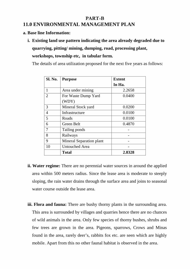
i. Existing land use pattern indicating the area already degraded due to
quarrying, pitting/ mining, dumping, road, processing plant,
workshops, township etc, in tabular form.
The details of area utilization proposed for the next five years as follows:
Sl. No. Purpose Extent In Ha.
1 Area under mining 2.2658 2 For Waste Dump Yard
(WDY) 0.0400
3 Mineral Stock yard 0.0200 4 Infrastructure 0.0100 5 Roads 0.0100 6 Green Belt 0.4870 7 Tailing ponds - 8 Railways - 9 Mineral Separation plant - 10 Untouched Area -
Total 2.8328
ii. Water regime: There are no perennial water sources in around the applied
area within 500 meters radius. Since the lease area is moderate to steeply
sloping, the rain water drains through the surface area and joins to seasonal
water course outside the lease area.
iii. Flora and fauna: There are bushy thorny plants in the surrounding area.
This area is surrounded by villages and quarries hence there are no chances
of wild animals in the area. Only few species of thorny bushes, shrubs and
few trees are grown in the area. Pigeons, sparrows, Crows and Minas
found in the area, rarely deer’s, rabbits fox etc. are seen which are highly
mobile. Apart from this no other faunal habitat is observed in the area.
iv. Quality of Ambient Air, Noise level and Water: The quality of air and
water has not been studied in the area or around the area. Presently there
are no quarries surrounding this area under quarrying operations and there
are no other industries. As there are no other activities, generation of dust
/noise at present is within the limits prescribed by CPCB.
v. Climatic conditions: The area has a tropical climate. The peak summer
will be in the month of April and May, highest temperature will be about
390 C will be during this season and the lowest temperature was recorded
of about 140 C during the months of November and December. During
previous years the rainfall in this area was recorded about 745 mm.
iv. Human Settlements: The area is situated at 1.60 Km. North West of K.J.
Jajur Village, about 1.50 Km. West of Makenahalli village, about 1.7 Km.
east of Dhanayakanapura village, the lease area is connected to earthen
road from Dabespet-Koratagere Satate Highway to K.J. Jajur- villages.
The area lies 7.5 Km North West of Dabespet Town which is Hobli
Headquarter. The area is connected to Village Road connected to
Dabespet-Koratagers SH and K.J. Jajur villages.
vii. Public Buildings, places of Worship and Monument: There are no
public Buildings, places of Monuments within or nearby the area.
viii. Does area (partly or fully) fall under notified area under water
(prevention and control of pollution) Act. 1974: Yes the applied area
falls under Water Act 1974. The applicant will take up necessary
precautions for control of pollution of water sources.
(b). ATTACH AN ENVIRON MENTAL IMPACT ASSESSMENT
STATEMENT DESCRIBING THE IMPACT OF MINING AND
BENEFICATION ON ENVIRONMENT ON THE FOLLOWING OVEER
THE NEXT 5 YEARS.
i. Land area indicating the area likely to be degraded due to
quarrying / pitting, dumping, roads, workshops, townships etc.,
Sl. No Purpose Extent in Ha.
1 1st 5 years surface area 2.2658
2 For waste dump yard 0.0400
3 Mineral Stock Yard 0.0200
4 Infrastructure 0.0100
5 Roads 0.0100
6 Green belt 0.4870
7 Untouched Area -
Total 2.8328
ii. Air Quality: The mining operations will be by the manual method. The
workforce will expose to the air is due to dust which gets air borne due
to vehicular movements and dumping only.
iii. Water Quality: During rainy season silt is likely to get mixed with rain
water and flow to the seasonal nala flowing through the area. There are
no toxic elements discharges into the drains from the mining operations.
iv. Noise level: The area is more than 150 M. from the village roads where
the traffic is very low. The mining digging and traffic are the causes of
increasing noise level.
v. Water regime: As the area is a raising ground, there is no danger
envisaged to water regime by this quarry area.

vi. Socio Economics: The main occupation of the surrounding people is
agriculture and allied activities, the mining activity in this belt will
benefit to the local people both directly and indirectly. The direct
beneficiaries will be those who get employed in the quarry as skilled
and un-skilled workers. The indirect beneficiaries will be those who
open small business to sell goods required by the residents whose “per
capita” income will be enhance by the mining activity, and thereby their
purchasing power. In the long run a lot of social goods is expected in the
comparatively backward area when the inhabitant will be sent their
children to school.
vii. Historical Monuments: There are no historical monuments in or
around the area and hence there will be no impact due to mining.
Because of small scale mining there will be no effect.
C. ATTACH AN ENVIRONMENT MANAGEMENT PLAN
(SUPPORTED BY APPROPRIATE PLANS AND SECTIONS)
DEFINING THE TIME BOUND ACTION PROPOSED TO BE TAKEN
WITH SEQUENCE AND TIMING IN THE FOLLOWING AREAS (OR
DIAGRAMS SHOULD BE USED)
i. Temporary storage and utilization of top soil: The soil generated is
mixed with pebbles etc. can be used for road maintenance. The soil useful
for agriculture, afforestration, trenches, whenever excavated will be
stored separately in the yard identified within the lease hold to height of
maximum of 0.06 M to keep their microbial activities safe.
ii. Year wise proposal for reclamation of land affected by mining
activities during the 1st to 5 years: No reclamation is proposed in this
plan period because the mining will be continued further depths from
present pit bottom.
iii. Program of afforestration. Year wise for the initial five years: It is
proposed to develop a green belt in proportion of the non-mineralized
area and 7.5 m. buffer zone of the lease boundary. In addition, the place
around the haul road and backfilling area shall have plantation at the
conceptual period. Every year it is proposed to carry out afforestation
over 0.097 Ha. by planting 250 saplings per annum around the quarry
area. The species chosen for green belt are fast growing good canopy and
dense leaf density, eco-friendly commercial/ species and some
ornamental plants to give good aesthetic.
iv. Stabilization and Vegetation of dumps: There is no generation of
overburden / waste in the proposal plan period. Hence, there is no need of
stabilization of the dumps.
v. Measures to control erosion/ sedimentation of water courses: There is
no surface erosion in the subject area because the surface area is exposed
by the granite.
vi. Treatment and disposal of water from mine: Since there are no mine
waters or ground waters, the proposal of pumping out or any sort of
treatment and disposal of water from the quarry does not arise.
vii. Measures for minimizing adverse effects on water regime: No adverse
effects are anticipated on water regime.
viii. Protective measures from ground vibrations / air blast caused by
blasting: There will be drilling and blasting is proposed in this area.
ix. Measures for protecting historical monuments and rehabilitation of
human settlements: There are no historical monuments are located close
by and hence need for protection does not arise.
x. Socioeconomic benefits arising out of mining: Few labors will get
employment and the state Government and Village Panchayath will get
royalty due to mining activity.
FISCAL ESTIMATE:

The details of investment for procuring the equipment for successful
environmental parameters and implementation of control measures recurring
and non-recurring are presented in the below table.
Environmental protection Investment Cost
Sl. No. Activity Recurring cost/ annum
in Rs.
Non Recurring
Cost 1 Afforestration works 5,00,000.00 2 Dust control and suppression 1,00,000.00 3 Environmental Monitoring 1,00,000.00 4 CSR Activities 3,00,000.00 5 Health insurance 2,00,000.00 6 Fencing 4,00,000.00 7 Miscellaneous 1,00,000.00 Total Estimate 12,00,000.00 5,00,000.00
Total cost 17,00,000.00
PROGRESSIVE MINE CLOSURE PLAN
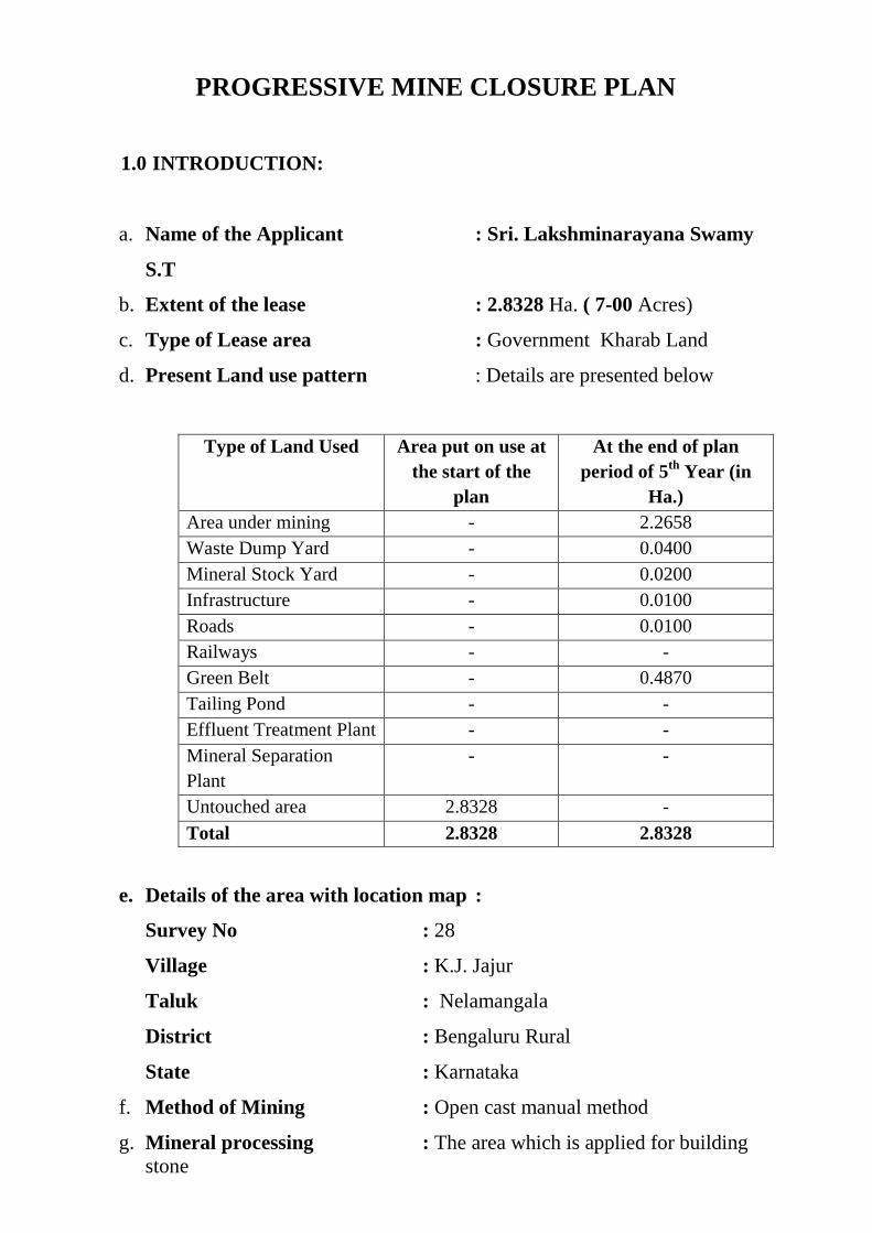
1.0 INTRODUCTION:
a. Name of the Applicant : Sri. Lakshminarayana Swamy
S.T
b. Extent of the lease : 2.8328 Ha. ( 7-00 Acres)
c. Type of Lease area : Government Kharab Land
d. Present Land use pattern : Details are presented below
Type of Land Used Area put on use at the start of the
plan
At the end of plan period of 5th Year (in
Ha.) Area under mining - 2.2658 Waste Dump Yard - 0.0400 Mineral Stock Yard - 0.0200 Infrastructure - 0.0100 Roads - 0.0100 Railways - - Green Belt - 0.4870 Tailing Pond - - Effluent Treatment Plant - - Mineral Separation Plant
- -
Untouched area 2.8328 -
Total 2.8328 2.8328
e. Details of the area with location map :
Survey No : 28
Village : K.J. Jajur
Taluk : Nelamangala
District : Bengaluru Rural
State : Karnataka
f. Method of Mining : Open cast manual method
g. Mineral processing : The area which is applied for building stone
and the granite material will be extracted in the shape of regular /irregular small boulders for the required size.
1.1 Reasons for closure: The area is under progress of quarrying and hence
regarding closure of mine is not applicable in the present context.
However the mine may be closed due to exhaust of mineral, decretive
from the statutory organization or court.
1.2 Statutory Obligations: The Progressive quarry plan is prepared as per
the directives of draft guidelines of Minor Mineral Conservation and
Development Rules 2010 as a component of the quarrying plan. The lease
will abide by the terms and conditions imposed in the lease deed, comply
with the statutory directions of the State Department of Mines and
Geology, DGMS, MOEF and Forest Department and other State / Central
Govt. agencies from time to time for small scale mining operations.
1.3 Closure plan preparation:
a. Name and Address of Applicant: Sri. Lakshminarayana Swamy S.T
S/o. Late Thimmaiah H.S. # J 35, Near Telephone Exchange Vasantha Nagara, Hesaraghatta Bangalore -560 088 Ph: 9141566775
b. Name of the recognized : SRI. SUBBAN H.V &
Qualified Person DR. P. VIRUPAKSHI
a. Name of the executing Agency : SRI. LAKSHMINARAYANA SWAMY S.T
2.0 MINE DESCRIPTION
Please refer Para 4 a Page no. 10
3.0 RESERVES: Please refer para No. 3 e (i) (ii) (iii) page No. 9 to 10
3.1 Mining Method: Please refer para No. 4 (b) page No. 12 to 14.
3.2 Mineral beneficiation: There is no mineral beneficiation. Man power will
be used for producing material. The question of tailing from the tailing
ponds does not arise. Only the material removed from the quarry will be
transported from the quarry to the respective stock yard, destination.
3.3 Review of Implementation of Mining Plan/ Scheme including five years
progressive closure Plan up to the final closure of the mine: The
various proposals made in the approved mining plan for the 5 years
period has been carried out to avoid environmental problems in the area.
3.4 Abstract of the proposals for Protecting of Environment:
Temporary storage and Utilization of Top soil: The soil generated is
mixed with pebbles etc., can be used for road maintenance. The soil useful
for agriculture, afforestration and trenches, whenever excavated will be
stored separately in the yard identified within the leasehold to a height of
Maximum 0.5 M to keep their microbial activities safe.
3.5 Quarrying and allied activities: As per the proposed production and
development plan for plan period area for quarrying 2.2658 Ha, Mineral
storage area is 0.02 Ha. The Green belt around the lease area is about
0.4870 Ha.
3.6 Year wise proposal for Reclamation: Since Granite deposits are likely to
continue, concurrent reclamation is not feasible and after working pits are
exhausted, than concurrent backfilling will be proposed. The mined out
areas as shown in the relevant year wise production and development plans
will be not matured enough for reclamation. Hence, the backfilling on
worked out pits for reclamation program is not envisaged presently.
Suitable afforestration technique will be adopted for reclamation after
winning of the mineral. Proper fencing will be provided all round in order
to prevent accidental falling of animals and human trespassing in to the
working areas.
3.7 Afforestration program: It is proposed to develop a green belt in portion
of the non-mineralized area and 7.5 M buffer zone of the lease boundary.
In addition, the place around haul road and backfilling area shall have
plantation at the conceptual period. Every year it is proposed to carryout
afforestration over 0.097` Ha. For planting 250 saplings per annum. The
species chosen from green belt are fast growing with good canopy and
dense leaf density, eco-friendly commercial species and some ornamental
plants to give good aesthetic look are shown on Environment Management
Plan Plate No.9.
3.8 Stabilization of dumps: There is no generation of overburden / waste in the
proposal plan period. Hence, no need of stabilization of the dumps.
Measures to control erosion / sedimentation of water courses: There is no
surface erosion in the lease area because; the surface area is exposed by
the granite.
Treatment and disposal of water from mine: Since there is no mine water
or ground water, the proposal of pumping out or any sort of treatment and
disposal of water from the quarry does not arise.
Measures for minimizing adverse effects on water regime: No adverse
effects are anticipated on water regime.
Measures for protecting historical monuments and for rehabilitation of the
habitat: There are no historical monuments are located close by and hence
need of protection does not arise.
4.0 CLOSURE PLAN:
4.1 Mined – Out Land:
Reclamation of the area will not be considered during the planned period
of 5 years program. In view of the above, reclamation proposed concurrent
to mining and at the end of 5 years without complete extraction of ore
available in the area becomes violation of MCDR. As such the program of
reclamation of mine is not envisaged at this stage.
After complete extraction of estimated reserves the reclamation of area of
land affected by mining activities will be taken up in order to restore to its
original use to the possible extent. The reclamation measures proposed
will be back filling in phased program wherever it is necessary. The deep
pits after completion of mining which could be serving as water ponds will
not be considered for backfilling and will be left as it is after taking
necessary landscaping and providing protective measures in the aspects of
safety by consuming retention wall all along the lease boundary.
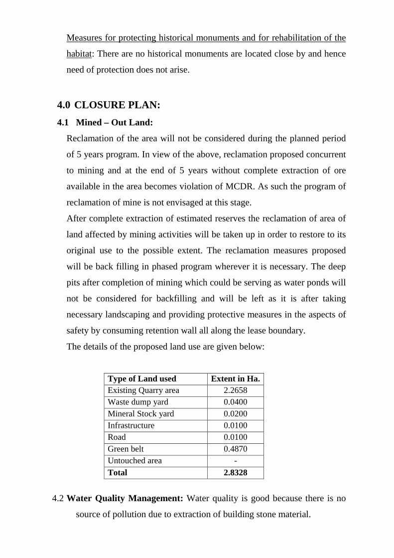
The details of the proposed land use are given below:
Type of Land used Extent in Ha. Existing Quarry area 2.2658 Waste dump yard 0.0400 Mineral Stock yard 0.0200 Infrastructure 0.0100 Road 0.0100 Green belt 0.4870 Untouched area -
Total 2.8328
4.2 Water Quality Management: Water quality is good because there is no
source of pollution due to extraction of building stone material.
4.3 Air Quality Management: Dust generated by this quarry activity is quite
less. The major source of air pollution is due to Wagon Drill drilling
activity and loading of overburden / waste. The management of air
quality shall be by suppression of dust by water sprinkling on haulage
roads and wet drilling methods. Also in the vicinity of the area no major
industries are seen and the deposit is worked on very small scale.
4.4 Noise Level and vibration: No deep drilling and blasting activity
involved in quarrying operations. Only small diameter Wagon drilling is
proposed for wire saw cutting. Protective ear muffs, nose masks and
hand glows, safety shoes etc. are provided to reduce the effect of sound /
noise and vibrations for the drill operations.
4.5 Waste Management: The generation of waste material is very less from
the quarry and the same is utilized for afforestration / backfilling.
4.6 Top Soil Management: The soil likely to be generated will be pebbly soil.
This will be heaped in a maximum height of 0.6 M and used in
afforestration trenches. Grass will be planted to arrest erosion due to
wind action.
4.7 Infrastructure: The applicant will construct temporary structure required
to be maintained under statutory obligations which can be removed once
the work is completed. The approach road to the mine will be made and
will be maintained to meet the requirements of transportation. These are
required for utilization till the end of lease period.
4.8 Disposal of quarrying machinery: There is no proposal of disposal of
mining machineries during the present plan period.
5.0 SAFETY AND SECURITY:
The applicant will follow prevailing Mines Act., Karnataka Mines Minerals
Concession Rules & Regulations etc., as well as other directions given to
him time to time by the Directorate General of Mines safety. The applicant
will securely fence the excavated area by barbed wire of 1.5 M height to
prevent the free access and unauthorized people to the quarrying area. The
applicant will appoint security persons to ensure to prevent unauthorized
entry on weekly off days and during the time of discontinuation of
quarrying operation.
6.0 DISASTER MANAGEMENT AND RISK ASSESSMENT:
All the safety measures during the quarrying will be taken as per the norms
of DGM’s. Safety of the men and machine are most important during this
quarrying activity. No danger to public life and property arises as only
trucks ply from quarry site through public road. There are no water
impoundments at higher levels or at lower contours.
7.0 CARE AND MAINTENANCE DUE TO TEMPORARY
DISCONTINUANCE:
The requisite care and maintenance procedures shall be followed during
temporary discontinuance of the quarry. The notice of temporary
discontinuance in prescribe forms shall be submitted to the appropriate
authorities concerned in this regard with details of protection measures
being taken up. Security of the working areas fencing and suitable display
boards shall be put up during the temporary period of discontinuance.
8.0 ECONOMIC REPERCUSSIONS OF CLOSURE OF MINE
AND MAN POWER RETRECHMENTS:
8.1 Number of local residents employed in the mine, status of the
continuation family occupation and scope of joining the occupation
back: The locals employed are about 50%. Those who are directly
employed, they are basically from agriculture back ground, they will be
put back to their original occupation. Necessary counseling will be
taken care.
8.2 Compensation given to be given to the employee connecting with
sustenance of him and their family members: Compensation as
provided in the statue will be given, at the time of final mine / quarry
closure to the eligible persons.
8.3 Satellite occupations connected to the quarrying industry-number
of persons engaged therein-continuation of such business after
quarry closes: Most of the satellite occupations are not fully depending
up on the quarrying activity or closure of mines and the quarrying
operations is small scale. So the occupations like workshops hotel and
tea shops will not affect continuance their business.
8.4 Continued engagement of employees in the rehabilitated status of
mining lease area and any other remnant activities: Security and
essential service to the people will continue to be employed for purely
shorter term / temporary basis, where operations are discontinued for
longer period, it is not continue with employment and so there will be
reduced to minimum, counseling will be extended for their
rehabilitation.
8.5 Envisaged repercussions on the expectation of the society around
due to closure of the mine / quarry: There will be effect on their
economy, communication, transportation to some extent, but still these
difficulties will be manageable to large extent. The details will be given
in the final mine / quarry closure plan.
9.0 ABANDONMENT / REHABILITATION COST AND
COST ESTIMATION:
The cost based estimation on the activities required for implementing the
protective and rehabilitation measures including their maintenance and
monitoring program.
10.0 TIME SCHEDULE FOR ABANDONMENT:

The present plan prepared is a progressive quarry / Mine Closure Plan
indicating the reclamation and rehabilitation measures being taken up
simultaneously with the quarrying operations. No abandonment of
quarrying activities is envisaged. The man power and other resources for
implementing the protective and rehabilitation measures will be dealt in
detail in the quarry closure plan to be prepared for approval before
abandonment of the quarry. The details of afforestration inside and outside
the quarrying lease area, reclamation and rehabilitation, environmental
monitoring details, machinery performance and socioeconomic impact of
quarrying shall be regularly monitored and furnished to DMG records of the
same shall also be maintained.


LIST OF PLATES


LIST OF TABLES

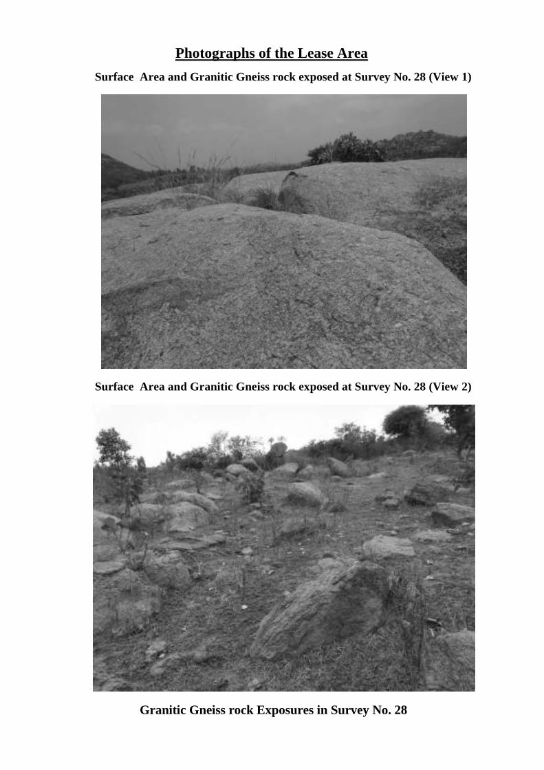
Photographs of the Lease Area
Surface Area and Granitic Gneiss rock exposed at Survey No. 28 (View 1)
Surface Area and Granitic Gneiss rock exposed at Survey No. 28 (View 2)
Granitic Gneiss rock Exposures in Survey No. 28
