quarrying plan - environmentclearance.nic.in · the term “granite” is derived from latin word...
TRANSCRIPT

APPLIED QUARRY LEASE
MAKAPUR PINK GRANITE QUARRY
(Submitted under Rule 8F & 8H(1) of KMMC (Amendment) Rule, 2013)
Private Patta Land Situated in Part of Survey No. 6/*/1 of
Makapur Village, Lingasugur Taluk, Raichur Dist.,
Karnataka State.
Semi-Mechanized Method
For the Period of Five Years
PROGRESSIVE QUARRY CLOSURE PLAN
IncludingQUARRYING PLAN
for
Extent: 4-05 Acres (1.6693 Ha.)
APPLICANT:SRI. MALLANAGOUDA
S/O. BASAVAREDDY#85, Makapur, Lingasugur Taluk,
Raichur Dist.,
Prepared by:
iGeosis Rocks & Minerals Consultancy
Geological, Survey,Mine Planning, Environmental Services
Address: Door. No. 293/4, Plot No. 30, 2nd Floor, NanjundeshwaraComplex, 5th Cross, Canal Road, Basaveshwara Badavane, Hosapete-583201, Ballari District, Karnataka State.
Cell: +91 9449515667, Email: [email protected]
Private Patta Land Situated in Part of Survey No. 6/*/1 of
Makapur Village, Lingasugur Taluk, Raichur Dist.,
Karnataka State.
Semi-Mechanized Method

9.0 Certificate / Undertakings / Consents
A. CONSENT LETTER / UNDERTAKING / CERIFICATE FROM THE
APPLICANT
1) The Quarrying plan in respect of ‘Makapur Pink Granite Quarry’ of Sri.
Mallanagouda S/o. Basavareddy over an area of 4-05 Acres, in Survey No.
6/*/1, Makapur Village, Lingasugur Taluk & Raichur District of Karnataka
State, under rule 8F KMMC (Amendment) Rule, 2013 has been prepared by
RQP Sri. Muli Babu Reddy & Geologist Sri. Chaluvamurthy, T.S.
This is to request the Senior Geologist, Department of Mines & Geology, Raichur
to make any further correspondence regarding any correction of the Quarrying
Plan with the said recognized person at his address below:-
Name: Sri. Muli Babu Reddy Sri. Chaluvamurthy, T.S.Regn.No:
RQP/BNG/180/2003A M.Sc, M.Phil., (Geo)Geologist
Address: iGeosis Rocks & Minerals ConsultancyNanjundeshwara Complex, Plot No. 30, 2nd Floor,Canal Road, Basaveshwara Badavane, 5th Cross,Hosapete-583201, Ballari District, Karnataka State.
We hereby undertake that all modifications/ updating as made in the said
Quarrying Plan by the Recognized Person are deemed to have been made with
the knowledge and consent and shall be acceptable on us and binding in all
respects.
Continued....

2) This is to certify that the Progressive Quarry Closure Plan of ‘Makapur Pink
Granite Quarry’ of Sri. Mallanagouda S/o. Basavareddy, over an area of 4-
05 Acres complies with all statutory rules, regulations, orders made by the
Central or State Government, Statutory Organizations, Court etc. which have
been taken into consideration and wherever any specific permission is
required the lessee will approach the concerned authorities.
The information furnished in the Progressive Quarry Closure Plan is true and
correct to the best of our knowledge and records.
3) “The provisions of Mines Act, Rules and Regulations made there under have
been observed in the Scheme of quarrying plan over an area of 4-05 Acres in
Survey No. 6/*/1, Makapur Village, Lingasugur Taluk & Raichur District of
Karnataka State, belongs to “Makapur Pink Granite Quarry” of Sri.
Mallanagouda S/o. Basavareddy and where specified permissions are
required, the lessee will approach the D.G.M.S. Further, standards prescribed
by D.G.M.S. in respect of Miners health will be strictly implemented”.
Mallanagouda
S/o. Basavareddy
Applicant
Place: MakapurDate: 07.10.2017

CERTIFICATE FROM RQP
The provisions of the Karnataka Minor Mineral Concession and Rules,
1994, Amendment Rule 2013 & 2016, have been observed in the
preparation of the Quarrying plan of “Makapur Pink Granite Quarry” of Sri.
Mallanagouda S/o. Basavareddy over an area of 4-05 Acres, in Survey No.
6/*/1, Makapur Village, Lingasugur Taluk & Raichur District of Karnataka State,
and wherever specific permissions are required, the applicant/lessee will
approach the concerned authorities of the Department of Mines & Geology.
The information furnished in the Quarrying plan is true and correct to the best
of our knowledge.
Muli Babu ReddyRQP/BNG/180/2003/A
Chaluvamurthy, T.S.M.Sc, M.Phil., (Geo)
Geologist
Place: Hosapete
Date: 07.10.2017
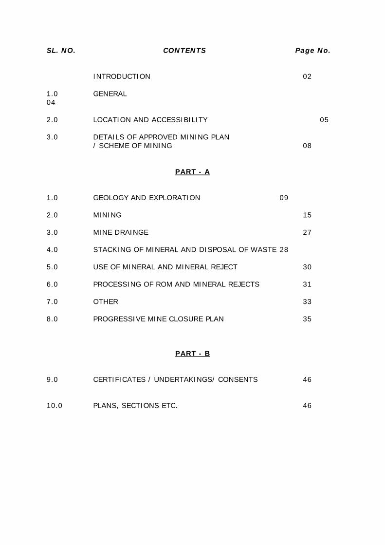
SL. NO. CONTENTS Page No.
INTRODUCTION 02
1.0 GENERAL04
2.0 LOCATION AND ACCESSIBILITY 05
3.0 DETAILS OF APPROVED MINING PLAN/ SCHEME OF MINING 08
PART - A
1.0 GEOLOGY AND EXPLORATION 09
2.0 MINING 15
3.0 MINE DRAINGE 27
4.0 STACKING OF MINERAL AND DISPOSAL OF WASTE 28
5.0 USE OF MINERAL AND MINERAL REJECT 30
6.0 PROCESSING OF ROM AND MINERAL REJECTS 31
7.0 OTHER 33
8.0 PROGRESSIVE MINE CLOSURE PLAN 35
PART - B
9.0 CERTIFICATES / UNDERTAKINGS/ CONSENTS 46
10.0 PLANS, SECTIONS ETC. 46

LIST OF ANNEXURES
Sl No. Particulars Annexure
No.
1 Copy of RTC I
2 Copy of AQL II
3 Copy of Notice III
4 Copy of NOC from the Deputy Commissioner IV
5 Copy of NOC from the Assistant Commissioner V
6 Copy of Tashildar NOC VI
7 Copy of Forest NOC VII
8 Copy of Non Agriculture Purposes VIII
9 ID & Address Proof of Lessee IX
10 RQP Certificate X
11 Calculations of Resource & Reserves XI
12 Year wise Production & Development Calculations XII
13 Declaration by the Applicant XIII
14 Photographs of the Applied Lease XIV
LIST OF PLATES
Sl. No Particulars Plate no Scale
1 Key Plan 1 1:50,000
2 Lease Sketch 2 1’’= 660’
3 Surface-Geological Plan With Cross Sections 3 1:1,000
4 Production & Development Plan & Sections 4 1:1,000
5 Waste Dump Management Plan 4A 1:1,000
6 Conceptual Plan & Sections 5 1:1,000
7 Environment Plan 6 1: 5,000
8 Environment Management Plan 7 1:1,000
8 Progressive Quarry Closure Plan 8 1:1,000

1 | P a g e
QUARRYING PLANIncluding Progressive Quarry Closure Plan of
Makapur Pink Granite Quarry ofSri. Mallanagouda S/o. Basavareddy
Prepared Under 8F of KMMC (Amendment) Rule, 2013
Amendment Rule 2 (m-3) of KMMC Rule 2013 states that Quarrying Plan /Scheme of Quarrying shall be prepared accordance with guidelines and formatissued by Indian Bureau of Mines. Accordingly, Quarrying Plan includingProgressive Quarry Closure Plan has been prepared as per guideline issued byIndian Bureau of Mines in 2014 of latest universal format for Mining PlanIncluding Progressive Mining Closure Plan is as followed.
ABSTRACT:
The term “Granite” is derived from Latin word “Granum” meaning “grain”because of its granular nature. India is well known since time immemorial for itsbuilding and dimensional/ornamental stones. Granite occupies a prominent placeamong dimensional stones on account of its hardness, durability, capability totake mirror polish and fascinating colours. As such the use of granite hasincreased many folds as dimensional and decorative stone all over the world andthis has created a good export market for Indian Granite.
Granite is the commonest of all the igneous rocks. It is a super-saturatedor over saturated granular plutonic rock. It was formed from magma whichcooled very slowly. It is often exposed to view by erosion of upper layers of rock.It forms most of the larger intrusive bodies, the batholiths. Granite andgranodiorite are estimated to have a combined bulk many times more than thatof all other plutonic rocks (Blyth, 1952). Granite is one of the best amongigneous rocks to be used as the structural stone, because of its goodappearance, its hardness and resistance to weathering. Granite is very tough.High grade granite will sustain a crushing load of about 1,054.5 kgs/sq.cm(15,000 pounds/sq.in) (Kessler et al, 1940). Granite is also the one with thecoarsest grains. It has great resistance to weathering. The average specificgravity of granite is 2.67.

2 | P a g e
INTRODUCTION:
Sri. Mallanagouda S/o. Basavareddy has applied for Quarry Lease of‘Makapur Pink Granite Quarry’ to win Pink Granite in Private Patta Land (theRTC is enclosed as Annexure-I) at Survey No. 6/*/1, Makapur Village,Lingasugur Taluk & Raichur District, over an extent of 4-05 Acres. The locationof the quarry lease area is shown on Key Plan enclosed as Plate No.1 andapplied Sketch enclosed as Plate No.2.
initially application, Form-AQL filled for the grant the office of DepartmentMines & Geology Raichur (Kindly Ref: Copy of AQL is enclosed as Annexure-II), after the examination and processing the application has required underKMMC, 1994 had issued a notice regarding obtain approval of Quarrying Planfrom Dept. of Mines and Geology and accord Environmental Clearance from theDEIAA Raichur through vide letter no. ಗಭೂಇ: : : :ಕಗಪ:2017-
18/1551 dated 21.09.2017, enclosed as Annexure-III.
In virtue of Notification grant, the “No Objection Certificate” obtained fromthe Deputy Commissioner, Assistant Commissioner, Tahsildar & ForestDepartment NOC’s are enclosed as Annexure- IV, V, VI & VII respectively.
The application for land conversion for Non Agriculture purpose wassubmitted to the Deputy Commissioner of Raichur, after processing theapplication the Office of the Dy. Commissioner, had ordered for land conversionfor Non agriculture purpose vide letter no. ಸ0ಕ0 / /E-12161/2016-17
& ಸ0.ಕ0/ /155/2008-09 dated 19.01.2009 are enclosed as Annexure-
VIII.
Now the Quarrying Plan including Progressive Quarry Closure Plan isprepared under the rule 8F & 8H (1) of KMMC (Amendment) Rule, 2013 forproposed maximum production capacity of 1,570 Cum /annum and isbeing submitted for approval.

3 | P a g e
The information and technical details are as furnished by theapplicant/lessee. The quality and specifications of the minor mineral forestimation of reserves and preparation of this Plan is as per the information ofapplicant/lessee and the Recognized Qualified Person (RQP) will not beresponsible if any changes in the data, updation/alteration of the data by theapplicant/lessee subsequent to the site visit and preparation of this plan. Thecorrectness of the Quarry boundaries are confirmed by the applicant/lessee andthe Recognized Qualified Person (RQP) is not responsible for fixing of boundariesor survey carried out by the applicant/lessee. The latitude & longitude details ofthe lease boundaries are ascertained by the applicant.
The applicant has no other leases held except above said quarry leasebeing applied.
SlNo.
LeaseReferenceno. & date
Area inAcres.
PostalAddress/Locati
on
Type ofMineral
Status ofapproval ofMining Plan
Date ofExecutionand Dt. Of
expiry
Remarks
1 AQL 4-05 Village :MakapurTaluk:
LingasugurDist: Raichur
PinkGranite
Quarryingplan is
submittedfor approval.
AQL Quarryingplan is
submittedfor
approval.

4 | P a g e
1.0 GENERAL:
a) Name of applicant /Lessee/ Rule 45 registration no:
Sri. Mallanagouda,
Present Address Permanent AddressSri. MallanagoudaS/o. Basavareddy,#85, Makapur, Lingasugur Taluk,Raichur Dist.,Karnataka State, 584125.Mobile No. : +91 9972365098.
Sri. MallanagoudaS/o. Basavareddy,#85, Makapur, Lingasugur Taluk,Raichur Dist.,Karnataka State, 584125.Mobile No. : +91 9972365098.
Identity and address proof of the lessee is enclosed as Annexure-IX.
b) Status of applicant/Lessee:
Private individual
c) Mineral(s) which is / are included in the prospecting license (ForFresh grant):
Not applicable
d) Mineral(s) which is / are included in the letter of intent / leasedeed:
Pink Granite.
e) Mineral(s) which the applicant / lessee intends to mine:
Pink Granite
f) Name of Recognised Person under rule 22C of MCR, 1960 or aPerson employer under clause (c) of Sub rule (1) of rule 42 of MCDR,1988(Applicable for Scheme of Mining only) preparing Mining Plan:
Name: Sri. Mulibabu Reddy Sri. Chaluvamurthy, T.S.M.Sc, M.Phil., (Geo)
GeologistRegn. No: RQP/BNG/180/2003/A
It is Valid up to : 19.06.2023The RQP certificate is enclosed as Annexure- X
Address: iGeosis Rocks & Minerals Consultancy
Nanjundeshwara Complex, Plot No. 30, 2nd Floor, 5th Cross,Canal Road, Basaveshwara Badavane, Hosapete-583201,Ballari District, Karnataka.
Mobile No: +91 9686046667Email: [email protected]

5 | P a g e
LOCATION AND ACCESSIBILITY:
a) Lease Details (Existing Mine):
Name of mine/quarry : ‘Makapur Pink Granite Quarry’
Lat/long of any boundary point:
The Quarry Lease area lies between co ordinates of N 15° 55' 24.48" to N 15° 55'30.70" and E 76° 22' 14.33" to E 76° 22'19.39"
Date of grant of lease: it’s an applied Quarry Lease.
Period/Expiry Date: it’s an applied Quarry Lease.
Name of lease holder : Sri. Mallanagouda,
Postal Address : Sri. Mallanagouda,S/o. Basavareddy,#85, Makapur, Lingasugur Taluk,Raichur Dist.,Karnataka State, 584125.Mobile No. : +91 9972365098.
b) Details of applied /lease area with location map (fresh area /mine):
Forest Area in Ha. Non-forest Area (Ha.)Reserve Forest -- 1. Waste Land --State Forest -- 2. Grazing Land --
-- 3. Agriculture Land --
--4. Other specify(Private
Patta Land RTC isenclosed as Annexure-I)
1.6693 Ha.(4-05 Acres)
Total -- -- --
Total lease area/ applied area : 1.6693 Ha (4-05 Acres).
Whether the area falls under Coastal Regulation Zone (CRZ)? If yes,details thereof:
No.

6 | P a g e
Existence of Public Road/Railway Line, if any nearby and approximatedistance:
Nearest Village: The quarry lease area lies towards North of Makapurvillage at a distance of 0.4 km approximately (distances are aerialdistance). This quarry lease area approachable by all weather road/up tolease. Makapur is having the School facilities for primary education.
Taluk Head Quarter: Lingasugur is the Taluk Head quarter at a distanceof about 30 Kms NE.
District Head Quarter: Raichur is District Head quarter at a distance ofabout 109 Kms E directions where higher education and medical facilitiesare available.
Nearest State High: The nearest State High way (SH-129 Kushtagi toMudgal) is located at distance of 0.4 km S of AQL area.
Nearest National Highway: The nearest National Highway (NH-13) ofSolapur - Mangalore is situated at 22 km W of QL area.
Nearest Railway: The nearest Rail head on Broad-guage is Koppal is atdistance of 67 kms SW.
Nearest Harbour: The nearest Harbour Belikere (Karwar) is at a distanceof 270 kms W.
Nearest Airport: The nearest airport is at Hubbali at a distance 150 kmsW.
Bridge Over Streams, River Nallah, Railway Line & Road:
The Bridge over Road/Nallah is located at 0.6km in S of applied lease.
Nearest Tank: The nearest Nallah is Hire or Maski Halla which is locatedat the distance 0.65 km S of lease.
Toposheet No. with Latitute & Longitude of all Corner BoundaryPoint/Pillar:
The Quarrying lease area lies on survey of India Top sheet No. 57A/5. Thelocation details, i.e., Latitude and Longitude of the Lease Boundary pillars aregiven below.

7 | P a g e
Co-ordinates are quarry lease corner are furnished below.
BOUNDARYPILLAR
LATITUDE LONGITUDE
A N15055’24.62’ E76022’18.34”B N15055’29.70’ E76022’14.33”C N15055’30.70’ E76022’18.69”D N15055’24.48’ E76022’19.39”
Datum : WGS 84
c) Attach a general location map showing area and access route. It ispreferred that the area be marked on a survey of India topographicalmap or a cadastral map or forest map as the case may be. However, ifnone of these are available, the area may be shown on an administrativemap.
The area is marked on Survey of India topographical map showing thelocation of the area and access route. General location map is enclosed as PlateNo. 1.

8 | P a g e
2.1 DETAILS OF APPROVED MINING PLAN/ SCHEME OF MINING :
2.2 Details of last modifications if any (for the previous approvedperiod) of approved QP/SOQ, indicating date of approval, reason formodification:
Nil
2.3 Date and reference of earlier approved MP/SOM:
Nil (Not applicable since it is a fresh applied quarry lease.)
2.4 Give review of earlier approved proposal (if any) in respect ofexploration, excavation, reclamation etc.
2.5 Exploration :
2.6 Excavation:
2.7 Mine Development:
2.8 Reclamation and Rehabilitation:
2.9 Give status of compliance of violations pointed out by DMG:
2.10 Indicate and give details of any suspension /closure/ prohibitoryorder issued by any Government agency under any rule or Court of law:
2.11 In case the MP/SOM is submitted under rules 9 and 10 of theMCDR’88 or under rule 22(6) of the MCR’1960 for approval ofmodification, specify reason and justification for modification underthese rules:
Al the above paragraphs are not applicable, as the area is applied for fresh grant

9 | P a g e
P A R T - A
1.0 GEOLOGY AND EXPLORATION:
a) Briefly describe the topography, drainage pattern, vegetation,climate, rainfall data of the area applied/mining lease area:
Topography:
The topograpghy of the quarry area is a flat & Plain land. The highestpoint in the area is 568m above M.S.L and the lowest elevation is about 546 mabove M.S.L. There are no streams or nallhas flowing in the lease area. Drainagepattern is denritic to sub dentritic in nature in the buffer zone.
Drainage Pattern:
There are no surface water sources within core zone. The drainage patternof the area is sub-dentritic in nature. During monsoon the rain water is drainedthrough the natural valley on the Western Slope.
Vegetation:
The vegetation occurring in the surrounding area belongs to southerntropical dry deciduous forests. The area falls under mixed deciduous subclassification.
Climate & Rainfall:
The region is characterized by hot and humid climate. Summer monthsare hot reaching a maximum temperature of 45.00C in the month of May. Theminimum temperature recorded in winter months is 17.70C. The rain fall iscontributed by southwest monsoon and the annual rain fall is around 564mm.
b) Brief description of Regional Geology with reference to location oflease/applied area:
Regional Geology:
The Dharwar Craton is one of classical and well studied Archean granitegreenstone terrains of the world and is principally composed of low k-tonalitic totrondhjemitic gneisses (peninsular gneiss) with infolded supracrustral (SargurGroup) and capped by younger series of volcano sedimentary sequences(Dharwar super group). Clac-alkaline granites form the latest Archean magmaticevent in the craton. The pronounced N-S elongation of regional grain in thecraton is one of the most important and conspicuous feature.

10 | P a g e
Dharwar supergroup with profound unconformity, rocks of Dharwarsupergroup in WDC are divided into lower Bababudan and upper Chitradurgagroups (Radhkrishna and Vaidynadhan, 1997) and exposed in two large beltsthat may be called as super belts viz., (1) Bababudan-Western Ghats-Shimogaand (2) Chitradurga-Gadaga ( Ramakrishanan and Vaidyanadhan, 2008).
Local geology:
The quarry lease area represents the Northern intrusion of ArcheanClosepet Granitic and gneissic terrain. During field studies about 10m of out cropwas observed in the adjacent quarry lease area which is signifying presence ofpotential Pink granite and gneiss rock in the plain area. There are no majorstructural deformations such as shear zone or fault zone noticed within thequarry lease area as it is small area. Irregular fractures and joints were noticedwithin the outcrop of the Pink granite gneiss rock. The rock is exhibiting themedium grained granular texture. There is soil cover observed in the lease area.
c) Detailed description of geology of the lease area such as shapeand size of the mineral/ore deposit, disposition various litho-unitsindicating structural features in any etc.
Geology of the Quarrying/Mining Area:
The quarry lease area is composed of granite of about 25% and remainingabout 75% is of defective blocks of granite. The granites, medium to finegrained igneous rock of even texture and pale in color, composed chiefly ofquartz, Plagioclase and feldspars. It usually contains small quantities of mica orhornblende, and minor accessory minerals may be present. Depending on thefeldspar present, granite may be, darkgray or light. It is commonly believed tohave solidified from molten rock (called magma) under potential origins but itmust intrude other. Most granite intrusions are emplaced at depth within thecrust, usually greater than 1.5 kilometre and upto 50km depth within thickcontinental crust. The granite and soil cover in the rock units as exposed in thequarry lease area can be made out from the map (Ref: Plate No. 3)
(d) (i) Name of prospecting/exploration agency:
There is no prospecting agency, exploration will be carried out by lesseeby engaging private consultant.

11 | P a g e
e) Details of prospecting/exploration already carried out:
(i) Number of pits and trenches indicating dimensions, spacing etcalong and across the strike/foliation with reference to geological plan.
It is suggested to clear the waste rock present on the surface of thedeposit in trail pits.
(ii) Number of boreholes indicating type (Core/RC/DTH), diameter,spacing, inclination, Collar level, depth etc with standard boreholes logsduly marking on geological plan/sections:
The granite rock is massive & huge its continuity. Hence Exploration is notrequired
(iii) Details of sample analysis indicating type of sample (surface/sub-surface from pits/trenches/boreholes etc) complete chemical analysisfor entire strata for all radicals may be undertaken for selected samplesfrom a NABL accredited Laboratory or Government laboratory orequivalent. Entire mineralized area may be analyzed meter wise with10% of check samples. (At least for 10% of total sample may beanalyzed in accordance to BIS and reports from NABL accredited/othergovernment laboratory). Entire bore hole samples are analyzed :
No drilling activity was carried out, as the deposit is vast and igneousformation and well exposed in the lease area as well as in the adjacent leases.
f) The surface plan of the lease area may be prepared on a scale of 1:1000 or 1: 2000 with contour interval of maximum of 10m dependingupon the topography and size of the area duly marked by grid linesshowing all features indicating under Rule 28(1)(a) of MCDR 1988:
Surface plan of the lease area is prepared on a scale of 1:1000 andenclosed as Plate No.3.
g) For preparation of geological plan, surface plan prepared on ascale of 1: 1000 or 1: 2000 scale specified under para 1.0 (f) of Part A ofthe format may be taken as the base plan. The details of explorationalready carried out along with supporting data for existence of mineral.Locations proposed exploration, various litho units along with structuralfeatures, mineralized/ore zone with grade variation if any may bemarked on the geological plan along with other features indicatingunder Rule 28(1)(b) of MCDR 1988:

12 | P a g e
The surface plan prepared on 1:1000 scale is taken as the base plan. TheGeological plan is prepared after conducting field study. Bench wise, area wisebehavior of the ore body and other geological parameters were considered forpreparation of Geological Plan. The details of exploration already carried outalong with supporting data for existence of mineral. Various litho units alongwith structural features, mineralized/ore zone are marked on the Geological Planand enclosed as Plate No.3.
h) Geological sections may be prepared on natural scale of geologicalplan at suitable interval across the lease area from boundary toboundary:
Geological sections of the lease area are prepared on 1: 1000 scales at aninterval of 85m.
i) Broadly indicate the future program of exploration with duejustification (duly marking on Geological plan year wise location indifferent colours ) taking into consideration the future tentativeexcavation program planned in next five years as in table below:-
So far mining in the lease area was carried out. Surface and Geologicalmapping has been carried out and Granite is well exposed laterally and depthwise. Hence, no further exploration is proposed.
J) Reserves and Resources as per UNFC with respect to the thresholdvalue notified by IBM may be furnished in a tabular form as givenbelow: (Area explored under different level of exploration may bemarked on the geological plan and UNFC code for area considered fordifferent categories of reserve/resources estimation may also bemarked on geological cross sections). Submit a feasibility/pre-feasibilitystudy report along with financial analysis for economic viability of thedeposit as specified under the UNFC field guidelines may beincorporated.
The following parameters for reserve estimations of the Pink graniteDeposit:
1. The entire quarry lease block is geologically mapped. The exposeddimensions of the granite bodies have been measured.2. The influence along the strike, for each has been taken as half thedistance from the cross section on one side up to the demarked limit of the Pinkgranite/ore zone on the other side. The shape, size, depth extension of the pinkgranite body as inferred in the cross section have been considered for reserveestimation.

13 | P a g e
3. The limiting reserves based on adjacent quarry existing outcrops of PinkGranite boulders and sheet maximum height (dimension) and from existingoutcrops edge (surrounding working quarry) of general ground level 540m RL istaken as mineable reserves, which taken reference from adjacent quarry leasearea., Basis being the indications observed in the surrounding area outcrops ofPink granite.1. For the Pink granite, a reserves is calculated on the basis of the outcropsof granite boulders sheets maximum height (dimensions). The conventionalmethods the total sectional area in square meters, influence in meters andrecovery factor (quantity=A X influence X recovery factor). The Pink graniterecovery is about 25%, waste (voids, defected materials) is about 75%.2. RF (Recovery factor) the recovery factor o f 75% is considered as theQuarry developmental works are to be taken up for exposing the Granitedeposit and based on nearby working quarries. The recovery factors is 25% forPink granite per cubic meter3. The cut-off blocks has been considered as follows: - the cut off blocksconsider for Pink granite is 0.3 m3 blocks and above.
Summary of category-wise Resources & Reserves of Pink granite are furnished inbelow table.
Category Pink Granite( Quantity in Cub m)
Mineable Reserves (A) 59,705Blocked Resource (B) 53,110Geological Resources (A+B) 1,12,815
The detailed calculation of Reserves & Resource is enclosed as Annexure- XI.
e) Furnish detailed calculation of reserves/resources section wise(When the mine is fully mechanized and deposit is of complex naturewith variation of size, shape of mineralized zones, grade due tointrusion within ore zone etc, an attempt may be made to estimatereserve/resources may be estimated by level plan method, asapplicable, as per the proposed mining parameters.
Of the above Geological resources of 1,12,815 cum, only 59,705 cum ofreserves can be exploited /mineable, while the balance of 53,110 cum ofresource is getting blocked which cannot be mined due to the boundary andpractical constraints. Hence for all practical purpose (for production and futureplanning) only Mineable reserves are considered.
14 | P a g e
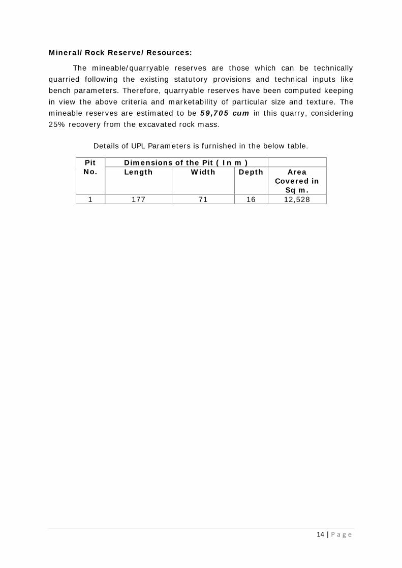
Mineral/Rock Reserve/Resources:
The mineable/quarryable reserves are those which can be technicallyquarried following the existing statutory provisions and technical inputs likebench parameters. Therefore, quarryable reserves have been computed keepingin view the above criteria and marketability of particular size and texture. Themineable reserves are estimated to be 59,705 cum in this quarry, considering25% recovery from the excavated rock mass.
Details of UPL Parameters is furnished in the below table.
PitNo.
Dimensions of the Pit ( In m )Length Width Depth Area
Covered inSq m.
1 177 71 16 12,528

15 | P a g e
2.0 MINING
A. OPEN CAST MINING:
a) Briefly describe the existing as well as proposed method forexcavation with all design parameters indicating on plans / sections:
Pink Granite quarry work in the subject Lease area is applied quarrylease. The proposed method of working during the present Period is by SemiMechanized opencast quarrying. Considering the technical parameters Likesurface topography, quality variations, geotechnical aspects, required rate ofproduction as available resources etc, it is proposed to work this deposit byadopting 3 m bench height & width of 3m with an ultimate pit slope of 450
only. Jack Hammer drilling is required a there is no requirement of blasting forquarrying of the blocks. The benches height and the width will be maintained asspecified by DGMS.
The width of the working benches shall not be less than the height. TheQuarry layout plan indicates the workings, and development etc, as shown inPlate No. 4. The Plan showing the position of workings, proposed extensions,bench parameters, pit configuration at the end of Plan Period is indicated inquarry layout plan as shown in Plate No. 4.
There is one proposed pit and the dimension of the same are mentioned below:
PitNo.
Dimensions of the proposed Pit ( Inm )
Length Width AvgDepth
AreaCovered in
Sq m.1 97 47 11 4,559
In the above pit there are six benches proposed.

16 | P a g e
b) Indicate Year-wise tentative Excavation in Cubic Meters indicatingdevelopment, ROM, pit wise as in table below.
I. Insitu Tentative Excavation:
Details of insitu tentative excavations of Pink Granite.
Year Pitno.
TotalTentative
Excavation(Cum)
TotalSoil
(Cum)
OB/SB/IB
(Cum)
ROM (Cum) MineralReject
ROM/WasteRatio
PinkGranite@ 25%(Cum)
Waste(Voids &defectiveMaterials)
@ 75%(Cum)
1 2 3 4 5 6 7 8 9I Year 1 6,518 0 542 1,494 4,482 -- 1 3.36II Year 1 10,220 0 4,050 1,543 4,628 -- 1 5.63III Year 1 12,872 361 6,260 1,563 4,688 -- 1 7.24IV Year 1 8,843 826 1,799 1,554 4,663 -- 1 4.69V Year 1 9,420 1145 1,997 1,570 4,709 -- 1 5.00Total 47,872 2,332 14,648 7,723 23,169 -- 1 5.20
The year wise proposed production & development calculations are enclosed asAnnexure-XII.
Proposed parameters of the working benches:
The primary blocks size should be around 10m x 6m x 2m to 6m x 2m x2m. The primary block will be observed carefully on six faces for defects, shapeand size. Later it will be cut in to secondary blocks with the help of jackhammerdrilling and wedge cutting to various size of 3x2x2m to 1.6 x 1.2x0.8mdepending on primary block size. While cutting primary blocks some under sizeblocks or defective material or shapeless block will generate. This type ofunmarketable material will be treated as waste and this waste materialwill be shifted to dump yard with the help of excavator and tippers.The secondary blocks will be shifted to stockyard by tippers and thenthese blocks will be dressed to perfect sizes before transportation tomarket. The undulating faces of secondary blocks will be dressed with thehelp of jackhammer drilling and wedge cutting.
Due care will be taken in designing the benches by straightening &advancing the benches for effective and economical operation o f the quarry.Since the ground water table is much below and the rainfall is not veryhigh during monsoon, drainage of water inside the pit will not poseproblem.

17 | P a g e
Thus as discussed above, the system of working shall be:
(1) By formation of benches.(2) Such benches in granite and overburden including weathered granite shallbe formed separately and kept sufficiently in advance so that their workingdoes not interfere with the working of the granite.
Loading and Hauling: Loading of the Pink Granite blocks/mineral will be donemechanically to tippers of 10-16 tones capacity and transported from thequarry to the Stack yard and mineral rejection/waste will also be handledmechanically. The rejects/waste will be dumped separately. Proposed rejectiondump is away from the working pit. In the quarry lease, the road will bemaintained with 1 in 16 gradients. Sufficient number of bunds and parapetwalls will be made all along the quarry haulage roads wherever necessary inorder to maintain safe working conditions. The likely production of recoverablePink granite would be 1,570 Cum per annum.
II. Dump re handling (for the purpose of recovery of mineral):
There is top soil within applied quarry lease area same is required to rehandle the top soil stack for the purpose of afforestation/plantation in this lease.The waste dump materials like Voids & defective Materials and other will be usedfor the produce aggregated and M-Sand after obtaining necessary/requiredpermission from the concerned Department.
c) Enclose Individual year wise development plan and sections showingpit layouts, dumps, stacks of mineral reject, if any etc, in case of ‘A’category mines. Composite Development plans showing pit layouts,dumps, stack of mineral reject, if any, etc. and year wise sections incase of ‘B’ category mines.
Individual year-wise plans and sections showing workings of developmentand production as pit lay out and year wise sections are enclosed (Ref. PlateNo. 5).
a) Describe briefly giving salient features of the proposed method ofworking indicating Category of mine:
The method of working is open cast semi mechanized method. Excavationby drilling, cracking by using Expansive Mortar chemical technique, loading ofPink granite & waste will be done by machinery. The height of the benches shallbe 3.00 m and working bench width will be maintained more than that of theheight. The road gradient of 1 in 16 will be maintained as per MMR 1961.
18 | P a g e
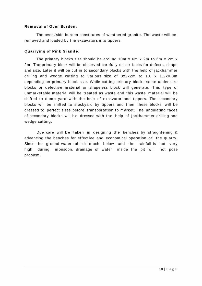
Removal of Over Burden:
The over /side burden constitutes of weathered granite. The waste will beremoved and loaded by the excavators into tippers.
Quarrying of Pink Granite:
The primary blocks size should be around 10m x 6m x 2m to 6m x 2m x2m. The primary block will be observed carefully on six faces for defects, shapeand size. Later it will be cut in to secondary blocks with the help of jackhammerdrilling and wedge cutting to various size of 3x2x2m to 1.6 x 1.2x0.8mdepending on primary block size. While cutting primary blocks some under sizeblocks or defective material or shapeless block will generate. This type ofunmarketable material will be treated as waste and this waste material will beshifted to dump yard with the help of excavator and tippers. The secondaryblocks will be shifted to stockyard by tippers and then these blocks will bedressed to perfect sizes before transportation to market. The undulating facesof secondary blocks will be dressed with the help of jackhammer drilling andwedge cutting.
Due care will be taken in designing the benches by straightening &advancing the benches for effective and economical operation o f the quarry.Since the ground water table is much below and the rainfall is not veryhigh during monsoon, drainage of water inside the pit will not poseproblem.

19 | P a g e
b) Describe briefly the layout of mine workings, pit road layout, thelayout of faces and sites for disposal of overburden/waste along withground preparation prior to disposal of waste, reject etc. A reference tothe plans and sections may be given. UPL or ultimate size of the pit is tobe shown for identification of the suitable dumping site.
Year wise production and development details are given in the tables below.
Pink GraniteYear Sections No’s of
BenchesRLs Location Face
AdvancementArea inGuntasLatitude Longitude
I Year A-A’ 2 551mRLto
546mRL
N1760964to N
1760998
E 646822 toE 646859
All direction 0-07
II Year A-A’ 3 556mRLto
546mRL
N 1760991to N
1761020
E 646810 toE 646857
All direction 0-07
III Year A-A’ 4 563mRLto
549mRL
N 1761010to N
1761043
E 646796 toE 646856
All direction 0-12
IV Year A-A’ 4 564mRLto
552mRL
N 1761030to N
1761055
E 646790 toE 646855
All direction 0-07
V Year A-A’ 3 565mRLto
555mRL
N1761041to N
1761066
E 646783 toE 646855
All direction 0-07
Pink Granite will be worked separately in existing pit on Sections A-A’, byforming 6 benches from 565m RL to 546m RL. The movement of benches will bein all directions. The dimension of the pit will be 97m in length and 47m inwidth. The road gradient will be maintained at 1 in 16 and width will bemaintained at 3.0m -4.0m. The location of workings proposed is mentioned inabove table as shown on proposed development and production plan. Thegeneration of waste from this mine will be used for making bund in 7.5m safetyzone with height of 1.5m subsequently stabilized with afforestation.

20 | P a g e
f) Conceptual Mine planning up to the end of lease period takingin to consideration the present available reserves and resourcesdescribing the excavation, recovery of ROM, Disposal of waste,backfilling of voids, reclamation and rehabilitation showing on a planwith few relevant sections.
The entire strike length of the deposit of the Pink granite bodies isexposed and the quarry is envisaged to be worked forming benches of 3mtsheight (depending upon the size of the blocks that can be recovered) and widthshall be more than the height of the bench with a general pit slope of 450. Theultimate pit limit is marked as shown on the geological plan. However, when thePink granite deposit is proved to its full depth, the conceptual plan will be dullymodified. The entire strike length of the deposit of the Pink granite bodies isexposed and the quarry is envisaged to be worked forming benches of 3mtsheight (depending upon the size of the blocks that can be recovered) and widthshall be more than the height of the bench with a general pit slope of 450. Theultimate pit limit is marked as shown on the geological plan. However, when thePink granite deposit is proved to its full depth, the conceptual plan will be dulymodified.
The Quarrying is proposed to be taken up with the maximum capacity ofabout 1,570 Cubic meters of Pink granite per annum during the proposed Planperiod. The area will be reclaimed by suitable engineering and afforestationtechniques and also by back filling of the pits by the overburden. Thesuccessive advancement of the pit at the end is depicted in the ConceptualPlan vide Plate No.7. The design & layout of the mine benches is shown onthe above referred relevant plan. The details of production and developmentquantities are furnished in the below table.
Block of 5 Years Productionin cum
CumulativeArea underquarrying in
Acres
Developmentin cum
CumulativeArea under
development inAcres
Plan Period 7,723 1-04 40,149 2-001st 5 Year 7,723 2-26 40,149 2-002nd 5 Year 7,723 2-26 40,149 2-003rd 5 Year 7,723 2-26 40,149 2-004th 5 Year 7,723 2-26 40,149 2-005th Year 7,723 2-26 8,116 2-00Conceptual Period 13,368 2-26 8,116 2-00
Total 59,705 2-26 216,978 2-00
The likely generation of waste such as top soil, waste with voids & defectswill be dumped separately in the proposed waste dump location and later onutilized for backfilling of the area. The maximum build up height of the dump

21 | P a g e
during the conceptual period will be about 5m having 280 as natural angle ofrepose. The dumped material shall also be utilized for back filling o f theworked out pits during the post mining as shown on Plate No. 4.
The exploration results obtained during the present plan period and thedata generated by working the mineral deposit will be taken into considerationand accordingly exploration program if required will be finalized for re-assessment of the mineral reserves at the end of the fifth year as there areenough reserves till the end of the fifth year which will be helpful to carry outproduction during the first block of five year period. The result of the samewill also be thus helpful for further modification of the Conceptual plan. Theguidelines of State Government i.e. DMG will be followed during the conceptualperiod in respect of Granite Conservation & Environmental Management Plan.
The dump shall be suitably stabilized and the slope shall have contourtrenches of 1 m interval where species of plants shall be planted toconsolidate the dump. On the dump terraces plantation activity could becarried on. Similarly, on subsequent quarrying, area available on the top of thefirst stage of dumping, if required second and third stage dumps shall bedeveloped. Thus reclamation of the static dumps shall be taken up concurrentto the quarrying operations in a phased manner.
It is always borne in mind to bring back near natural shape to the areaand its economic value is elevated. It is further ensured that, there is positivecontribution to the environment and socio -economic development of the region.
(i) Anticipated life of mine/quarry:(a) Estimated Mineable Reserves : 59,705 Cum(Proved & Probable reserves of Pink Granite)(b) Expected rate of production/annum : 1,570 Cum(c) Anticipated life of mine : ~ 38.02 years say 39 year
(iii) Mine Development (ultimate pit limit) optimum exploitation andutilization of minerals:
The entire lease area is mineralized. The production capacity of about1,570 Cum/annum for EC. Considering the current exploration data andgeology, pit layout is designed. The bench height will be maintained at 3 metersand width shall be maintained more than this (3m) with bench slope of 450 tothe horizontal. Mine pit is designed with ultimate pit slope angle of 450 withrespect to horizontal.

22 | P a g e
Details of UPL Parameters
Pit Dimension (m) Bench Movement SectionsLength Width Depth
177 71 16
Widening the present pit bymoving towards N, S, E and W.
About 9 benches will beformed.
A-A’
The ultimate pit limit is demarcated on the Geological Plan and Cross Sectionsand enclosed as Plate No. 4.
During the proposed plan period, it is proposed to dump waste outside thelease area which covers area of 2-00 acres. During the conceptual period about2-00 Acres area will be used to dump the waste. By keeping 5.0m dump heightfurther step dumping will be practiced.
(iv) Disposal of Waste :
Waste generated during the plan period will be 40,149 Cum which will bedumped in the 2-00 Acres area, which is located outside the lease area anddumped systematically one stages of 5m height. Slopes of dumps will be lessthan 37 degrees. The waste rock consists of waste, voids, defects and weatheredGranite. During the entire life of the mine about 2,16,978 cum of waste is likelyto be generated.
(v) Reclamation and rehabilitation measures:
No reclamation and rehabilitation in this scheme period as no pits ordumps will be matured. During post mining all the pits will be converted to waterreservoirs and dumps will be stabilized and afforested.
However, engineering works as well as plantation are proposed as part ofenvironment protection measures are;
Environment protection measures:
Plan Period Proposed Engineering Works:
Year Items Numbers Dimension
Plan Period Toe walls 1 RW- 480m x1 m x 1mGarland drains 1 GD1 - 485m x 1m x 1m

23 | P a g e
Plan and conceptual Period Plantation to be carried out:
Period AreaGuntas
PlantsNos.
Location Species SurvivalRate
Plan 1-00 1200280*
Safety zone area, dumpslope and along road side
(5mx5m) & whereverpossible
Localspecies
60%
Conceptual -- 200
Total 1-00 1680 -- -- --Note: * Along the approach road side.
(vi) Land use pattern:
The land use pattern of existing, proposed plan period and conceptualplan land use is tabulated below:
Thus in brief, the Conceptual Mining Plan of said mines envisages amethodical & conscientious approach to mine development. Subsequent to theworking till conceptual stage, the entire disturbed area due to mining activitieswill be reclaimed and rehablitated with an envisaged post mining land use. Thedetails of envisaged post mining land use is given in below table and a planshowing the post mining land use is enclosed as Plate No. 5&7.
Land Use in Acres & Guntas
Particulars Existing LandUse
Proposed planperiod
ConceptualPeriod
Area of excavation 0-30 1-04 2-24Overburden dump 0-22 0-22 --Road 0-16 0-16 0-16Top Soil Storage -- 0-02 0-02Granite Block storage -- 0-03 0-03Safety Zone Area/green belt -- 1-00 1-00Area for Future Use 2-17 0-38 --
Total 4-05 4-05 4-05

24 | P a g e
ix) Extent of Mechanization:
Describe briefly with calculation of adequacy and type of machinery andequipment proposed to be used in different activities of drilling, materialhandling in development and stope, hauling, hoisting to surfacetransportation and any other operation.
As proposed above, the extent of mechanization involves deployment ofmachinery in the quarry. It is envisaged to deploy excavator, Jack hammerdrills/dust proof drilling machinery, compressor, cranes, wheel loader/ JCB,optima wire saw cutting along with 10 to 30 tonnes capacity tippers fortransport of Pink Granite blocks &waste from the pit to the Stock yardestablished within the lease. Jack hammers drilling 3 Nos and Atlas CopcoCompressor -2 nos, wire saw machine-1 nos and tippers – 2nos.
Adequacy of quarrying machinery:
Loading Equipments:Pink GraniteTotal quantity to be handled /annum : 9,420 cum(Including over burden for Granite)Quantity to be handled/day (300days) : 32 cum/dayEffective working hours per shift : 7 hours in a shiftAverage handling required /hour : 5 cumQuantity can be handled by excavator per shift : 5-10 cum/hourWorking shift per day : 1 shift/dayHence, No. of excavators required : 1 hydraulic excavator(1.2m3) +
01 Spare excavator)
Haulage:Total quantity to be handled/annum to yard/ dumps : 11,309cum/annumQuantity to be handled/day (300days) : 38 cum/dayNo. of effective hours working hours (per shift 8 hours) : 7 hoursCapacity of dumpers : 14 cum (Tata)Distance from pit to dump : 300 mts to 500mtrsTime taken per trip : 30 minutesQuantity hauled by dumper/hour (0.5 km to dump) : 6 cum/hourQuantity handled/tipper/day : 224 cum/dayHence, no. of tippers required : 1 noNo. of spare tippers (with 80% availability) : 1 noTherefore total no. of tippers required is : 2 Nos
25 | P a g e
(1) Drilling Machines
Type Nos. Dia ofHole(mm)
Size/capacity Make MotivePower
H.P.
Compressor 2 -- 440 cfm, 12bar
AtlasCopo
Diesel 180
JackHammer
3 33 250 cfm -- -- --
(2) Loading Equipments:
Type Nos Bucketcapacityin cum
Make Motivepower
H.P.
Excavator 2 -- TATA Diesel 180Wire Saw 1 -- Optima/stone
steck wiresaw
Electrical --
Crane 1 30 tonnes Indital Diesel --Burner (stonecutting on heatprocess)
1 -- -- -- --
JCB 1 0.25 cum -- -- 100
(3) Haulage and Transport Equipments
(a) Haulage within the mining leasehold
Type Nos Size/capacity Make Motivepower
H.P.
Tipper 2 10 & 30 tons Tata &Terex
Diesel 100 &1025
Water Tanker 1 12,000 lts Tata Diesel 100Tractor 1 4 tons Mahindra Diesel --Jeep 1 -- Mahindra Diesel --
(b) Transport from mine head to the destination describe thetransport system (please specify)
The Pink granite will be transported by hired trucks. The destinations willbe as per the buyer’s requirements/industries. The mode of transport will be byroad. The transport is by Tata tippers and Leyland trucks depending on theavailability in the market.

26 | P a g e
4. BLASTING
There is no blasting involved. The jack hammer drilling is required forcutting of blocks only by wire saw and lifting by cranes.
a) Broad blasting parameters like charge per hole, blasting pattern,charge per dealy, maximum number of holes blasted in a round, mannerand sequence of firing, etc.Drilling:
Total estimated quantity requiring (30%) : 9,420 cum/annumPink Granite Blocks & Waste (300 working days) : 32 cum/dayDrill hole dia : 28-33mmSpacing of holes for wire saw cutting : 3 (length) x 2.0(width) x 2.0(height) in mtrs
Free face:
Pink granite of wire saw cutting blocks : 12cubic meters
Above proposed productions target to achieve the minimum wire saw cuttingand jackhammer drilling require horizontal two holes, vertical offset holes twono's for free face. Thus 2 jackhammer drill holes are required for wide wedgemethod of cuttings & drilling ho le s required 30-34hole with depth per hole is0.70metres.
Wire saw holes to be drilled/day (horizontal): length 3m x No’s of Hole 6 =18mtrsWire saw holes to be drilled/day (Offset Vertical): length 2m x No’s of Hole 6 =12mtrsWide wedge holes to be drilled/day: 34 x 2 (wire saw cutting) = 68 holesWide wedge meterage/day : 102 x 0.70 = 71.4 meters / dayHence, total meterage: 101.40 metersCapacity of drill/hr in strata : 5-10 meteres/hr
Therefore Compressor IR-450/500 or Perforavgirodrill-200 & 6 Jack Hammer drillwill meet the requirement and one spare jack hammer drill.
Blasting & Explosives: No proposal for blasting proposed quarrying planperiod.
B. UNDER GROUND MINING:
Not applicable

27 | P a g e
3.0 MINE DRAINAGE:
a) Minimum and maximum depth of water table based onobservations from nearby wells and water bodies:
Ground Water table in the area is 80m depth from general ground level.
a. Indicate maximum and minimum depth of Workings:
Depth of proposed workings from 565m RL to 546m RL i.e. 9.0m
b. Quantity and quality of water likely to be encountered, thepumping arrangements and places where the mine water is finallyproposed to be discharged
Not Applicable
c. Describe regional and local drainage pattern. Also indicate annualrainfall, catchments area, and likely quantity of rain water to flowthrough the lease area, arrangement for arresting solid waste off etc.
There are no surface water sources with-in the core zone. The drainagepattern of the area is sub-dendritic in nature. During monsoon the rain water isdrained through the natural valleys on the Western slope.
The region is characterized by hot and humid climate. Summer monthsare hot reaching a maximum temperature of 45.00C in the month of May. Theminimum temperature recorded in winter months is 17.70C. The rain fall iscontributed by southwest monsoon and the annual rain fall is around 564mm.

28 | P a g e
4.0 STACKING OF MINERAL REJECT / SUB GRADE MATERIAL ANDDISPOSAL OF WASTE
a) Indicate briefly the nature and quantity of top soil, overburden /waste and Mineral Reject to be disposed off.
Details of top soil and waste are furnished as below.
Year TopSoil
(Cum)
Top Soil (Cum) Mineral rejects /waste(voids &Defects) (cum)
OB/SB/IB
(Cum)-- -- Reuse/spreading Storage Backfilling Storage --
I Year 0 0 -- -- 4,482 542II Year 0 0 -- -- 4,628 4,050III Year 361 361 -- -- 4,688 6,260IV Year 826 826 -- -- 4,663 1,799V Year 1145 1145 -- -- 4,709 1,997Total 2,332 2,332 -- -- 23,169 14,648
The waste material to be handled is mainly removal of side burden in theform of intercalated waste and there is no top soil is generated which will bestocked in safety zone area & used for plantation purposes only.
The physical characteristics of wastes are;
Top Soil: It is mainly friable material, reddish brown in color having fine graintexture and having good water holding capacity available in the quarrysurrounding.
Intercalated: Weathered medium hard material with reddish to pink color.`
b) The proposed dumping ground within the lease area be proved forpresence or absence of mineral and be outside the UPL unlesssimultaneous backfilling is proposed or purely temporary dumping for ashort period is proposed in mineralized area with technical constraints &justification.
The waste generated will be disposed off in the area earmarked fordumping. The area selected for dumping is 2-00 Acres, the same areaearmarked for life of the mine. (Pls see Waste Dump Management Plan PlateNo. 4A).

29 | P a g e
Calculation of Waste Dump AreaTotal available area fordumping
2-00 acres (8,094 Sqm) Dump area located west ofapplied quarry lease
Waste generated next 5years of Plan Period
40,149 Cum --
Dump Height 5.0 mtrs --Calculation Area x Dump Height --
= 8094 Sqm x 5.0 mtrs --= 40,470 Cum --
d) Attach a note indicating the manner of disposal of waste,configuration and sequence of year wise build up of dumps along withthe proposals for protective measures.
The area selected for dumping is plain land, where dumping will becarried out for a maximum height of 5mtrs with 28° dump slope. Properterracing will be done along dump slopes to provide better slope stability. Thetotal waste likely to be generated for quarrying of Pink Granite over a periodof 5 years is about 40,149 Cubic meters of waste (voids and defectedmaterial/blocks and OB) is generated. The waste (voids and defectedmaterial/blocks)/overburden produced will be stored separately for future useand the overburden/waste generated during quarrying operations will bedumped in the spoil banks earmarked specifically for this purpose. Theseyards is moderately sloping hard and barren land easily access road outsidelease boundary.
Environment protection measures:
Year Wise Proposed Engineering Works
Year Numbers Items Dimension Items DimensionI Year 1
Toe walls
RW1- 96m x1 m x 1m
Garlanddrains
GD1 - 97m x 1m x 1mII Year 1 RW2- 96m x1 m x 1m GD2 - 97m x 1m x 1mIII Year 1 RW3- 96m x1 m x 1m GD3 - 97m x 1m x 1mIV Year 1 RW4- 96m x1 m x 1m GD4 - 97m x 1m x 1mV Year 1 RW5- 96m x1 m x 1m GD5 - 97m x 1m x 1mTotal RW- 480m x1 m x 1m GD - 485m x 1m x 1m
Details of Year wise plantation.
Year AreaGuntas
Within Lease area Out Side Lease area Survival
ratePlantsNos.
Location PlantsNos.
Location
I Year 0-08 240
7.5m Safety Zone
56Along the approach
road(5m x 5m)
60%II Year 0-08 240 56III Year 0-08 240 56IV Year 0-08 240 56V Year 0-08 240 56Total 1-00 1200 -- 280 -- --
30 | P a g e
Afforestation: Each year, about 1-00 Acre with 240 will be planted in safetyzone and during first year about 280 saplings shall be planted along theapproach and next successive years 50 plants will use to gap filling with localspecies like Hebevu, Kadu Badami, Neem, Rain tree and other fruit bearing andflowering local species. During the entire plan period about 1-00 Acre area willbe covered by plantation with 1,586 saplings.
5.0 USE OF MINERAL AND MINERAL REJECT
The following are to be furnished in the interest of mineral conservation.
a) Describe briefly the requirement of end-use industry specifically interms of physical and chemical composition.
Nature and occurrence of Pink Granite in this mine is suitable forornamental stone for buildings, Hospitals, Hotels as decorative stone.
b) Give brief requirement of intermediate industries involved inupgragation of mineral before its end-use.
Intermediate industries are not involved except cutting and polishing.
c) Give detailed requirements for other industries, captiveconsumption, export, associated industrial use etc.
The ornamental stone produced will be sold locally or exported.
d) Give details of processes adopted to upgrade the ROM to suit theuser requirements.
The ornamental stone produced will be cut and polished before supplyingto the local buyers and export.
31 | P a g e
6.0 PROCESSING OF ROM AND MINERAL REJECT
a. If processing / beneficiation of the ROM or Mineral Reject isplanned to be conducted, briefly describe nature of processing/beneficiation. This may indicate size and grade of feed materialand concentrate (finished marketable product), recovery etc.
b. Give a material balance chart with a flow sheet or schematicdiagram of the processing procedure indicating feed, product,recovery, and its grade at each stage of processing.
c. Explain the disposal method for tailings or reject from theprocessing plant.
d. Quantity and quality of tailings /reject proposed to be disposed,size and capacity of tailing pond, toxic effect of such tailings, ifany, with process adopted to neutralize any such effect beforetheir disposal and dealing of excess water from the tailings dam.
e. Specify quantity and type of chemicals if any to be used in theprocessing plant.
f. Specify quantity and type of chemicals to be stored on site / plant.
All the above paragraphs are not applicable as there is no any sort ofbeneficiation, up gradation of the mineral. But for the physical specification.The physical specification are mentioned above.

32 | P a g e
g. Indicate quantity (cum per day) of water required for mining andprocessing and sources of supply of water, disposal of water andextent of recycling. Water balance chart may be given.
Water required for dust suppression, green belt/afforestation development &domestic purpose, the requirement will meet through the bore well,applicant/lessee intends to drill ground water bore well at the quarry lease. Therequirement of water is as mentioned in below table.
Sl No. Particulars1 Total No of Employees 22 Nos.2 Domestic water requirement 0.8 KLD3 Length of approach road 0.7 Km
4Water requirement for dustsuppression @ 6 KLD/Km
4.2 KLD
5 Total Saplings Proposed 520 Nos.
6Water Requirement for plantation @5 lpd/ sapling
2.6 KLD
7Total water requirement(2+4+6)
9.6 KLD

33 | P a g e
7.0 OTHER
A) Site services:
The above said quarry area falls in the survey No’s 6/*/1of Makapurvillage, Lingasugur Taluk, Raichur District, Karnataka state, where it extendsover an area of 4-05 acres
The said area lies towards west of Makapur village at a distance of 0.4kms (Distances are aerial distance). This lease area is approachable by allweather road /s up to the lease.
Lingasugur is the taluk head quarter which is at a distance of 30 km andRaichur is the district head quarter which is at a distance of 109km where all theinfrastructural facilities are available. The nearest Karwar is at a distance of 270km and airport is Hubli is at 150 km. The nearest railhead on Broad- Gauge isKoppal is at a distance of 67 km.
The said area falls under survey of India’s topo map No. 57A/5 thegeographical co ordinates of the quarry area is given below
Latitude N 15° 55' 24.48" to N 15° 55' 30.70"Longitude E 76° 22' 14.33" to E 76° 22'19.39"
The said are is marked on the key plan showing the location andsurrounding features up to 5.0 kms radius is enclosed as Plate No. 1. The leasesketch submitted to DMG is enclosed as Plate No.2. However the Latitude andLongitude so recorded is depicted on the Surface-Geological Plan enclosed asPlate No. 3.

34 | P a g e
a) Employment potential :
The maximum production to be handled per year will be 1,570 cum perannum. The number of working day for the mine is 300 days. Therefore, thedaily average production shall be 1,570/300 = 6 cum per day. About 22 personswill get direct employment opportunities due to proposed mining activity.
Details of Manpower Requirement
SL No Designation Employee inNo.
Qualification
01 Mining Engineer cumManager 01 Mining Engineer / Competent Survey
Certificate.02 Geologist 01(Part time) M.Sc., Geology
03 Surveyor 01(Part time Diploma in survey/ CompetentSurvey Certificate.
04 Forman 01 Diploma in Mining / ForemanCertificate.
05 Mine Mate 01 Mate certificate06 Mine Supervisor 01 Semi Skilled07 Mechanical Engineer 01 DME/ BE08 Office clerk 01 S.S.L.C Skilled09 Office assistant 01 Unskilled10 Helpers 02 Semi Skilled
11 Labour for Production ofwork 3 Unskilled
12 Labours for Productionwork 3 Highly skilled
13 Labour for Quarrying About 5 --Total 22 --

35 | P a g e
8.0 PROGRESSIVE MINE/QUARRY CLOSURE PLANPREPARED UNDER RULE 8 H(1) of KMMC (amendment) RULE, 2013.
8.1 Environment Base line information: Attach a note on the status ofbaseline information with regard to the following.
- Existing land use pattern indicating the area already degraded dueto mining, roads, processing plant, workshop, township etc in a tabularform.
Some of the area in the buffer zone is covered under private lands. Thebuffer zone up to 5kms from the mining lease comprises 11 villages. The landuse pattern of the buffer zone indicates that, waste land and other miningleases. The details of buffer zone are given in the Key Plan which is enclosed asPlate No. 1.
Neighboring agricultural land is suitable for cultivation only during rainy season.
The method of mining is opencast method of working with drilling and cuttingwith earth moving machinery in the area. Baseline information of this mininglease area is furnished below.
Details present land use pattern is furnished in the below table.
Land use in Acres & GuntasSI. No. Head Existing Land
Use1 Area Excavated 0-302 Waste Dump 0-223 Road 0-163 Area for future use 2-17
Grand Total 4-05
-Water Regime, Quality of Air, Ambient Noise Level, Flora, ClimateConditions:
(i) Water regime
No rivers or nallah pass through the area. One seasonal Hire or Maski Nlocated at the distance of 0.65 km from the lease. The quarrying activity will beconcentrated on the plain ground. There are no perennial streams or nallahs.The water course is only seasonal and observed in monsoon season only. Themonsoon water gets drained off through the natural valleys.
(ii) Quality of air :
The air quality good since production and development is in smallquantity. Water spraying on transport roads will be carried-out periodically.

36 | P a g e
(iii) Ambient noise level:
The noise generation and its impact on environment is negligible sincethere is no blasting and deployment of machinery is also in small quantity.
The ground water quality will not have any impact due to mining in thislease since there is no discharge of effluents. During rainy season surface waterpollution will be controlled by forming drainage channels and construction ofretaining walls all along the toe of the dump.
(iv) Flora and Fauna
Core Zone:
In core zone only plantation such as neelgiri and small bushes areobserved.
Buffer Zone:
Some important local species are observed in the buffer zone such asAccasia, Neem and thorny bushes.
Fauna:
Some of the animals seen occasionally in buffer zone are wild bears,jackals, panthers, foxes, mongoose, rat and porcupine. The bird species arewhite eagle, koel, owl, common bee eater, dove, sparrow Howk, house cow etc.,the reptils found are also common variety like viper, krait, monitor lizard, toadchameleon etc., the insects are honey bee, grass hopper, wasp, termites,scorpion, spider etc. the fauna species are common varieties without having anyendangered species. The lease area does not have any hiding place for wild lifeand hence they are not spotted in the buffer zone area.
(v) Climatic conditions:
The climatic of this district, is marked by hot summer months, low rainfalland a pleasant monsoon season. The region is characterized by hot and humidclimate. Summer months are hot reaching a maximum temperature of 45.00C inthe month of May. The minimum temperature recorded in winter months is17.70C. The rain fall is contributed by southwest monsoon and the annual rainfall is around 564mm.
The relative humidity is high during monsoon season ranging from 70% to75% and remains low in the rest of the year, particularly in summer months.Winds are generally moderate during summer and strong during rainy season. Inthe Southwest monsoon period the winds blow mainly from a southwesterly or

37 | P a g e
westerly direction. In the rest of the year the winds are predominately fromNortheast and Southwest.
-Human settlements
There is no human settlement within the quarry lease area. Workmen andstaff will come from the villages outside the leasehold. So there is nodisplacement involved. There are 6 villages within 5kms radius, those distance,direction from the area along with population are tabulated below. The nearesthabitation is at Jakkarmadugu village, which is situated at a distance of about2.9 km. The same also indicated on key plan enclosed as Plate No.1.
Totally, there are seven villages within the radius of 5.0 kms the details ofthe distance, direction & Population from the Q.L area are given below. Thesame also indicated on key plan enclosed as Plate No.1.
-Public buildings, places of worship and monuments
No public buildings, PWD roads and no places of worship exist within theleasehold or in near vicinity. However local temples/places of worship arelocated in the buffer zone villages. The nearest village is Makapur at the distance0.4 km South from lease
-Indicating any sanctuary is located in the vicinity of leasehold
There is no sanctuary in 5km radius shown on Key Plan is enclosed as PlateNo.1

38 | P a g e
8.2 Impact Assessment: Attach an Environmental Impact AssessmentStatement describing the impact of mining and beneficiation onenvironment on the following:
i. Land area indicating the area likely to be degraded due to quarrying,dumping, roads, workshop, processing plant, tailing pond/dam,township etc.
The area as such falls on a plain ground and with gentle slope. The totallease area under mining and allied activities is 4-00 Acres. The land scope of theplain area has been degraded due to mining activities and resulting to changesin topography, land use pattern, drainage pattern, top soil composition by runofffrom overburden dumps etc.
The present & proposed land use during the balance plan period is as follows.
Land Use in Acres & Guntas
Particulars Existing LandUse
Proposed planperiod
ConceptualPeriod
Area of excavation 0-30 1-04 2-24Overburden dump 0-22 0-22 --Road 0-16 0-16 0-16Top Soil Storage -- 0-02 0-02Granite Block storage -- 0-03 0-03Safety Zone Area/green belt -- 1-00 1-00Area for Future Use 2-17 0-38 --
Total 4-05 4-05 4-05
Subsequent to the Conceptual stage, this quarry will be used for variousactivities as per the mine closure plan, as a part of closure the activities such aswater pond, back filling and etc, the details of the land use of post mine closureis given below:
Sl.No
Type of activist Extentin area
Post mining land use ofdegraded land
1 Area underquarrying
3-05 Part of worked out pit will beconserved by water harvesting &
remaining will be backfilled2 Green belt 1-00 Retained as Green belt
Total 4-05
ii. Air quality
The impacts on air environment from a quarrying activity depend onvarious factors like production capacity, machinery deployed, control measuresadopted, operation & maintenance of various equipments and vehicles. Apartfrom these, there are other activities associated viz., transportation of ore andwaste, stocking facilities & dump management within the quarry lease area. Theair quality of the mining area is also affected due to following reasons like

39 | P a g e
drilling, cracking and transportation of the ornamental stone and operation ofdiesel based equipments. To know the impacts of quality of air the parametersuch as Suspended Particulate Matter (SPM), Sulphur Dioxide (SO2) Oxides ofNitrogen (NOx) and Carbon monoxide (CO) monitoring is being carried outthrough consultant having NABL accredited agencies.
However may be the impact, to reduce the same, following mitigative measuresare adopted.
• Frequent sprinkling of water on the haulage road to prevent dust emissiondue to the movement of machinery and vehicles.
• Excavation operations will be suspended during the period of strong wind.• Grading and proper Maintenance of Haulage/approach Roads• Vehicles shall comply with the prescribed emission norms• Proper preventive maintenance to reduce emissions• Unnecessary idling of the vehicles & machinery will be completely avoided.• Regular Monitoring of Ambient Air Quality• Provision of Dust Masks to all Employees Working in the Quarry Area
iii. Water quality
Due to the mining activities such as loading, haulage and etc., there willbe impact on the surface water. However there are no any surface water bodieswithin the lease area, hence impact within the lease area. Due to this activity,there will impact on the surface water bodies which are outside the lease area byway of surface water bodies which are outside the lease area by way of surfacerun off / wash off such as water courses, nallahs near by quarry.
During the monsoon, there will be an impact in the form of surface runoff,wash off where the material will be transported to the local water bodies. Andalso there will be an impact on the ground water due to mining activities.
Excepting during monsoon months, no water shall be discharged from quarry.The rain water shall be diverted to its natural course.
Following protective measures will be adopted to maintain the water quality:
Garland drains are cut all along the benches prior to the monsoon to avertthe water into the pit.
The water that would be encountered in the project is rainwater. The water course due to rain shall be diverted away from the working by
digging the garland drain. However, granite rock is not toxic and hencethere shall not be any chemical hazards effect
No mine working will touch the ground water.

40 | P a g e
Further sufficient gully checks shall be provided to check any silt flowingalong with the surface run-off.
Plantation of fast growing deep rooted plant species
iv. Noise level
Due to the mining activities such as loading, drilling, haulage and etc.,there will be disturbance in the ambient noise levels. The people nearby quarrywill be affected. More over the quarry is remote and where there is no cluster ofhuman settlements but for few scattered houses.
Since the quarry is semi-mechanized, the noise pollution is mainly due tothe quarrying machinery and movement of trucks and drilling and blastingactivities. There will be impact in surrounding area due to the noise generation.
To reduce the impact on the noise following measures will be adopted:
• Rotation of workers to minimize exposure time• Provision of earmuffs to workers exposed to high noise areas• Use of jack hammer drilling, delivery of compressed air at optimal
pressure• The equipment & machines will be maintained properly. Particular
attention will be given to the silencers and mufflers.• Unnecessary idling of the vehicles and mining equipment will be avoided.• Limiting time exposure of workers to excessive noise.• Speed of the trucks entering or existing quarry will be limited to moderate
speed 25kmph to prevent undue noise from empty trucks.• Planting of trees along roads to acts as acoustic barriers in buffer zone.
v. Vibration levels (due to blasting)
There is no blasting proposed in this quarry. Only drilling & cracking byExpansive Mortar Chemical method will be used. Hence noise and vibration dueblasting is nil. Hence there is no disturbance for Fauna
vi. Water regime
There are no any perennial water courses within the leasehold area.Couple of water courses falls outside the quarry area where the rain waterpasses through this course and gets confluence with the adjacent water bodiessuch as tanks, ponds and etc, the drainage pattern in this area is dendritic innature.

41 | P a g e
Water resources in this area are Ground water and rainwater. The areareceives moderate rain fall of 564 mm annually on an average. Raichur district isone of the draught districts in the state of Karnataka. The water table in thisarea is beyond feet 80 m, in the surrounding bore wells. The bottom mostquarry working is likely to touch 546 m above MSL, where quarry operation isnot going to touch the general ground water table.
During the monsoon, there will be an impact in the form of fluctuation ofthe ground water table, which is negligible, surface run off, wash off where thematerial will be transported to the local water bodies. To avoid these followingprotective measures will be taken up.
1. Before onset of monsoon, drains are cut along toe of the quarry faces todivert the surface run off.
2. Garland drain is provided at the quarry top to regulate monsoon waterand direct the same to the settling ponds/ quarry pit to contain the quarrywash off and to avoid the same joining to the adjoining surface waterbodies / water courses. It also helps to avert eventual collapses anddamages to the quarry faces.
vii. Acid mine drainage: Not applicable as acid rains will not rain.
viii. Surface subsidence: No surface subsidence is expected as the strata arehard.
ix) Socio-economics
Quarrying sites are generally remote and under developed. Standard ofliving of people in such areas is normally low; therefore due to industrial activitylike Quarrying, people residing in the nearby villages within the buffer zone areto be benefited by direct and indirect employment opportunities created by theQuarrying activities. People are also beneficiaries for the facilities developed dueto Quarrying activity.
Applicant/Lessee shall provide required Medical facility to all theemployees at the quarry such as first aid, regular check up, ambulance etc. Inaddition lessee also provides the medical checkup camps to the local villagers,supply of drinking water, and contribution of funds for social and culturalprogram me.
Quarrying activity contributes towards economic up-liftment by way of jobopportunities in the region. Hence there will be an increase in quality of life in

42 | P a g e
the area. Quarrying activity will also boost the ancillary industries, business andmarket establishments.
Due to the Quarrying activity, no significant adverse changes arevisualized in the traditional way of life of the people residing in the villages in thebuffer zone. Further people residing in the nearby villages are benefited by thedirect and indirect employment opportunities created by the Quarrying activities.The budgetary provision for Environment Management Plan in the costestimation.
ix. Historical monuments etc.
No historical monuments etc. are located in the vicinity and hence thereshall not be any effect.
8.3 Progressive reclamation Plan:
To mitigate the impact and ameliorate the condition, describe year wisesteps proposed for phased restoration, reclamation of already/to bedegraded in respect of following items separately for 5 years period.
8.3.1. Mined-Out Land:
Ornamental stone is existing in below subsurface and will not exhaustduring the plan period. The area proposed to be put to use during plan andconceptual period is as follows.
Land Use in Acres & Guntas
Particulars Existing LandUse
Proposed planperiod
ConceptualPeriod
Area of excavation 0-30 1-04 2-24Overburden dump 0-22 0-22 --Road 0-16 0-16 0-16Top Soil Storage -- 0-02 0-02Granite Block storage -- 0-03 0-03Safety Zone Area/green belt -- 1-00 1-00Area for Future Use 2-17 0-38 --
Total 4-05 4-05 4-05
8.3.2. Topsoil Management: The topsoil available at the site and itsutilization may be described.
There is top soil is generation in the lease area generated which will bestacked separately and utilized for plantation work in green belt formation in7.5m safety zone and all along the road.

43 | P a g e
8.3.3 Tailings Dam Management: The steps to be taken for protectionand stability of tailing material and its utilization, periodic de-siltingmeasures to prevent water pollution from tailing etc, arrangement forsurplus water overflow along with detail design, structural stabilitystudies, the embankment seepage loss into the receiving environmentand ground water contaminant if any may be described.
Not applicable, as no tailing dam is proposed.
8.3.4 Acid mine drainage, if any and its mitigative measures.
Not applicable.
8.3.5 Surface subsidence mitigation measures through backfilling ofmine voids or by any other means and its monitoring mechanism.
The present Plan prepared is a Progressive Quarry Closure Planindicating the reclamation & rehabilitation measures being taken upsimultaneously with the quarrying operations. No abandonment of quarryingactivities is envisaged. The manpower and other resources for implementingthe protective & rehabilitation measures will be dealt in detail in theQuarry closure plan to be prepared for approval before abandonment of thequarry. The details of afforestation inside and outside the quarrying lease area,reclamation and rehabilitation, environmental monitoring details, machineryperformance and socio-economic impact of quarrying shall be regularlyMonitored and furnished to DMG. Records of the same shall also bemaintained.
The reclamation & rehabilitation measures i.e., plantation, construction ofrubble wall/retaining Wall, Gully checks and etc.,
8.4 Disaster management and Risk Assessment: This may deal withaction plan for high risk accidents like landslides, subsidence flood,inundation in underground mines, fire, seismic activities, tailing damfailure etc. and emergency plan proposed for quick evacuation,ameliorative measures to be taken etc. The capability of lessee to meetsuch eventualities and the assistance to be required from the localauthority may also be described.
The disaster and the risk may occur due to natural calamity such as earthquake, land slide, collapse and etc. However in such cases, the emergencyservices required for help like Police Station, Fire Station, Hospital, Ambulanceservices and their contact numbers will be made available with the MinesManager. The nearest city is Lingasugur at a distance of 30 km.

44 | P a g e
Name: Sri. Mallanagouda,Address: S/o. Basavareddy,
#85, Makapur, Lingasugur Taluk,Raichur Dist.,Karnataka State, 584125.Mobile No. : +91 9972365098.
8.5 Care and maintenance during temporary discontinuance: Anemergency plan proposed for the situation of temporary discontinuancedue to court order or due to statutory requirements or any otherunforeseen circumstances may indicate measures of care, maintenanceand monitoring of status of discontinued mining operations expected tore-open in near future.
If temporary discontinuance happens due to certain unforeseen situationlike strike, lockout or any order passed by the government, court etc, fencingwill be provided for pits and the security guards will be deployed for watch andward of the mine. Social security will be provided to all employees. Payments asper the statute will be made to all the employees and medical and other requiredfacilities will also be provided.
Cost Estimation:
The estimate of cost based activities required for implementing theprotective & rehabilitation measures including their maintenance & monitoringprogram are depicted in the statement furnished below. Budgetary provision forenvironmental management plan is as follows.
SlNo.
Activity ProposedQuantity
Unit Price(in Rs.)
Capital Cost(Rs.)
RecurringCost/Yr. in (Rs)
1Afforestation/ Green beltdevelopment
296 Saplings/yr
250/ sapling -- 74,000
2 Construction of Gully Plugs 2 Nos 20,000/Unit 40,000 --
3
Barbed Wire Fencing565 mtrs 250/m 1,41,000 --
i) Barbed Wire fenceii) Poles (for every 2mdistance)
282 Nos 300/Pole 85,000 --
iii) Concrete and lime forfilling pits
282 Nos 900/Cum 2,54,000 --
4Water for Drinking, Dustsuppression & Plantation
9.6KLD 300/trip -- 2,70,000
5 Environmental Monitoring Half Yearly -- -- 70,0006 CSR Activities Annual -- -- 1,50,0007 Miscellaneous costs Annual -- -- 1,00,000
Total 5,20,000 6,64,000

45 | P a g e
8.6 Financial Assurance:
Area for the Financial Assurance is calculated as per 8L of KMMC(Amendment) Rule, 2013 till the end of the ensuing Quarrying Plan Period andthe details of land use considered is shown in a prescribed format issued by IBMas per the circular No. 4/2006 and the same is furnished below.
SI.No.
Type of land Areaput onuse at
start ofPlan
Additional
requirement
duringPlan
period
Total Areaconsidered
as fullyreclaimed &rehabilitate
d
Netconsidere
d forcalculatio
n
A B C=(A+B) D E=(C-D)1 Area under mining 0-30 1-04 1-04 -- 1-042 Over burden Dump 0-22 0-22 0-22 -- 0-223 Road 0-16 0-16 0-16 0-164 Top Soil Storage -- 0-02 0-02 0-025 Granite Block
Storage/Stock-- 0-03 0-03 -- 0-03
6 Green belt/Safety -- 1-00 1-00 -- 1-007 Other Area Undisturbed 2-17 0-38 0-38 -- 0-38
Total 4-05 4-05 4-05 -- 4-05
Progressive Quarry Closure Plan showing the land use is enclosed as Plate No.8.
The total area under utilization till the end ofthe Scheme period of Financial assurance @Rs. 10,000/-per acre
: 4-00 Acres
4-05 Acres x Rs. 10,000/- per acre : Rs. 40,250/-
The financial assurance being the sum of Rs. Forty Thousand Two Fifty only.
The financial assurance for the above said amount will be submitted in the formof Fixed Deposit from and Scheduled Bank, when once we receive the vattedfrom your department.
46 | P a g e
P A R T - B
9.0 Certificates / Undertakings/ Consents (As detailed below)
Certificate duly signed by lessee is enclosed.
10.0 PLANS, SECTIONS ETC.
The required plans and sections are prepared and enclosed herewith and specificreferences are made in the relevant chapter as applicable.
Muli Babu ReddyRQP/BNG/180/2003/A
Chaluvamurthy, T.S.M.Sc, M.Phil., (Geo)
Geologist