queen anne elementary · we suggest students work through them in the following order: 1. queen...
TRANSCRIPT

QUEEN ANNE
ELEMENTARY
Teacher
Guide
CONTENTS Stormwater in the Schoolyard – Lesson 3
Local Stormwater Systems – Lesson 5
Stormwater in Our Community – Lesson 6
How to Use This Guide This guide supports the Community Waters Science Unit Teacher
Manual with information, maps, and images specific to your school
and neighborhood. It is written for teachers; its goal is to provide a
better understanding of what is happening with stormwater in and
around your school. The points of interest and walking field trip
route are suggestions and should be adapted as desired.
If you have any questions about these maps, accompanying
lessons, or stormwater around your school, contact IslandWood
staff at [email protected].

Teacher Guide Queen Anne Elementary
Feb-18
Stormwater in the Schoolyard– Lesson 3
This map and points of interest (photos and info) can be used to guide your class’ exploration of the
schoolyard. You will find the student worksheet for this lesson following the teacher guide version.
Please use the extra space on the pages to add your own notes and questions! ☺
E
F
D
C B
A
DOWNHILL
DOWNHILL
G

Teacher Guide Queen Anne Elementary
Feb-18
A. Storm Drain:
This one seems in a bit of disrepair. Is it
still functioning properly? If not, what is
happening that could have negative
effects?
B. Dumpsters, and nearby storm drain:
Have students consider the possibility of
trash from the dumpsters mixing with
stormwater or getting into the drains.
Do you think it matters that the dumpsters
are this close to the drain? Why or why
not?
C. Downspout:
Unlike the downspouts on the main
buildings, the ones on the portables flow
straight onto the ground. Have students
observed this before? Does it cause any
large puddles or other problems?

Teacher Guide Queen Anne Elementary
Feb-18
E. Garden:
How do the gardens help with stormwater,
or not? What would be different if they were
not there? Consider that vegetation
slows stormwater by helping it soak into the
ground and holding soil in place with its
roots. However, anything that is put in the
garden or on the plants may be washed off—
including chemicals or fertilizers, if they are
used. Presumably, school gardens have few
or no chemicals.
F, G. Storm Drains (various deisgns):
There are several drains in the schoolyard with different styles. How many different designs can
you find? Is one more effective than the other? Why might they be different? Try pouring some
water onto each one and watch what happens. Which one seems to work the best?
D. Sloped roof and pervious ground:
Consider how the rain interacts with this
roof. Where does the water run off and
what happens then? What would be
different if the ground underneath was
paved?

Mapping Your Schoolyard – Queen Anne
Name: ________________ Date: _________
Include on your map: • Symbols from the Key including flow of
water, surfaces, and storm drains.
• Partially pervious surfaces can be shown
with less dots.
• Label locations of litter, pollution and
places where puddles form.
• Sketch any specific stormwater
problems you see or are aware of.
• Sketch larger plants and bushes.
Map Key
Add your own symbol here!
Storm
Drain
Direction of
water flow

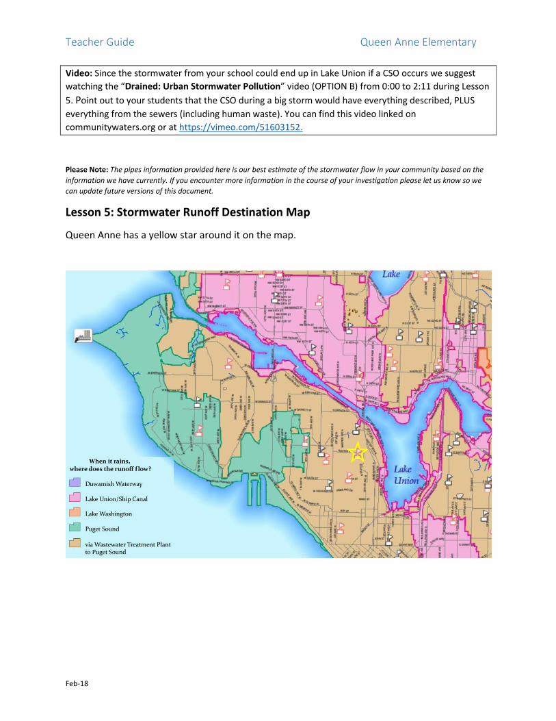
Local Stormwater Systems – Lesson 5
Teacher Overview
What happens with the Stormwater Pipes around your school?
• The storm drains (blue dots) at your school enter
combined wastewater and stormwater pipes (green lines
ending in orange lines).
• Some of the combined pipes flow north while others head
east but they all end up entering a large treatment plant
pipe (red) that flows north alongside Lake Union.
Where does your stormwater runoff end up?
• Combined wastewater and stormwater in the treatment plant pipe (red) is
pumped to the West Point Sewage Treatment Plant where it is treated before
entering Puget Sound offshore from Discovery Park.
• In extreme weather events, the large amounts of stormwater entering the
system can cause a combined sewer overflow (CSO) in which the stormwater
mixed with sewage dumps
directly into Lake Union at Galer
Street, near West Ewing Mini
Park or Salmon Bay (yellow
circles on map).
• The stormwater in your area that
falls along the shores or
overflows with wastewater into
Lake Union travels over time through Salmon Bay and the Chittenden Locks to the Puget Sound.
• The map on the next page shows where the runoff from different parts of the city ends up.
Student Maps for Lesson 5
Color maps have been created for use with your students (provided and/ or available on
communitywaters.org). We suggest students work through them in the following order:
1. Queen Anne Elementary Storm Drains Map – This map helps students see that the storm drains
connect to the combined stormwater and wastewater pipes.
2. Queen Anne Neighborhood Combined Pipes Map – The students can follow the arrows on the
combined pipes on this map until they merge with the red treatment plant pipe.
3. Treatment Plant Pipes and Overflows Map – This map shows where the combined stormwater and
wastewater ends up and places it could end up overflowing along the way.
Teacher Guide Queen Anne Elementary
Feb-18
Video: Since the stormwater from your school could end up in Lake Union if a CSO occurs we suggest
watching the “Drained: Urban Stormwater Pollution” video (OPTION B) from 0:00 to 2:11 during Lesson
5. Point out to your students that the CSO during a big storm would have everything described, PLUS
everything from the sewers (including human waste). You can find this video linked on
communitywaters.org or at https://vimeo.com/51603152.
Please Note: The pipes information provided here is our best estimate of the stormwater flow in your community based on the
information we have currently. If you encounter more information in the course of your investigation please let us know so we
can update future versions of this document.
Lesson 5: Stormwater Runoff Destination Map
Queen Anne has a yellow star around it on the map.

Teacher Guide Queen Anne Elementary
Feb-18
Stormwater in Our Community – Lesson 6
Please use this map and points of interest as suggestions for your walking field trip, recognizing there
may be other things of importance to note in other areas. It may be useful to bring the stormwater pipes
map with you for reference. Questions posed are intended to be posed to students as desired.
Suggested Route: Exit front of school, turn right on Boston Street. Cross to opposite corner (both
Bigelow Ave N and Boston St). Continue on Boston St to end of block, then turn left on 5th Ave N. At the
end of the block, cross the street to the overlook. After observing the view, continue up Lynn St for two
blocks, then turn left on 4th Ave N to continue back to school. (Alternatively, if kids are tired or you are
short on time, take Bigelow Ave N south back to Boston St.)
C
B
D E
A
DOWNHILL
F

Teacher Guide Queen Anne Elementary
Feb-18
Points of Interest
A. Storm Drains in street:
Storm Drains move water into underground pipes
to take it somewhere else. Anything that gets
carried into the drain may end up in a local
stream, lake, or Puget Sound. Why do you think
the drain was built in this location? Where does
water come from that goes into this drain? Why
might it have been placed in this place? Is the
drain working properly? What is in the drain?
C. Storm Drain:
Here’s another! Look across the street to see
where the water might be going….
B. Rock wall:
Rock walls are sometimes built to hold sloped
ground in place, and if they are planted, plant
roots help hold soil together rather than washing
away. Can students recognize these strategies
here?

Teacher Guide Queen Anne Elementary
Feb-18
F. Street with little tree cover:
Compare the earlier blocks to this one,
which is at one of the most uphill points in
the neighborhood. How might the lack of
large trees here affect the stormwater on
this street?
E. Large Tree:
On the corner of Lynn and Bigelow is a tree that is
bigger than most in the neighborhood. You could
discuss the ways that trees intercept rainwater, and
hold soil in place with their extensive root system.
D. Overlook:
From here, one can see the lay of the land below Queen Anne. Lake Union, the Ship Canal, Gas
Works Park, Portage Bay, and the I-5 Bridge are all visible. This is an excellent opportunity for
students to visualize the landscape at a wide scale and think about how water would flow on it. If
you have completed Lesson 11 with students, they should know that in the Queen Anne
neighborhood, storm and sewer water actually are both directed into the same pipes and diverted
to West Point Treatment Plant. This may be too complicated to bring up on this trip, but you can
talk about what would happen to water here if there were no pipe system.
Do any of the students swim in Lake Union? How might what gets into stormwater at your school
affect the bodies of water you are looking at?