queenstown lakes flood management strategy with appendix c
TRANSCRIPT

Learning to Live with Flooding:
A Flood Risk Management Strategy for the communities of
Lakes Wakatipu and Wanaka

Flood Risk Management Strategy October 2006
2
Contents
Foreword 4
Key Terms 5
Executive Summary 6
1.0 Introduction 8
2.0 Background 8
3.0 Scope 9
3.1 Geographical 9
3.2 Strategy Horizon 11
3.3 Risk Scope 11
4.0 Context 12
4.1 Meteorological Setting 12
4.2 Hydrological Setting 16
4.3 Community Setting 19
4.4 Legislative Context 21
5.0 Principles 24
6.0 Strategic Elements 25
6.1 Understanding Natural River and Catchment Processes 25
6.2 Understanding Infrastructural Flood Risk 27
6.3 Flood Sensitive Urban Planning 28
6.4 Flood Sensitive Design 31
6.5 Enhancing Individual Capacity to Manage Flood Risk 32
6.6 Robust Warning, Prediction and Communications Systems 33
6.7 Timely Flood Emergency Response 33

Flood Risk Management Strategy October 2006
3
6.8 Comprehensive Base Data and Information 35
6.9 Investigation of Appropriate Physical Works 36
7.0 Operating Plan 39
7.1 Roles Overview 39
7.2 Readiness 40
7.3 Response 41
7.4 Recovery 42
8.0 References 43
9.0 Appendices 45
Appendix A: Flood Mitigation Strategy Project Brief 46
Appendix B: Action Plan 53
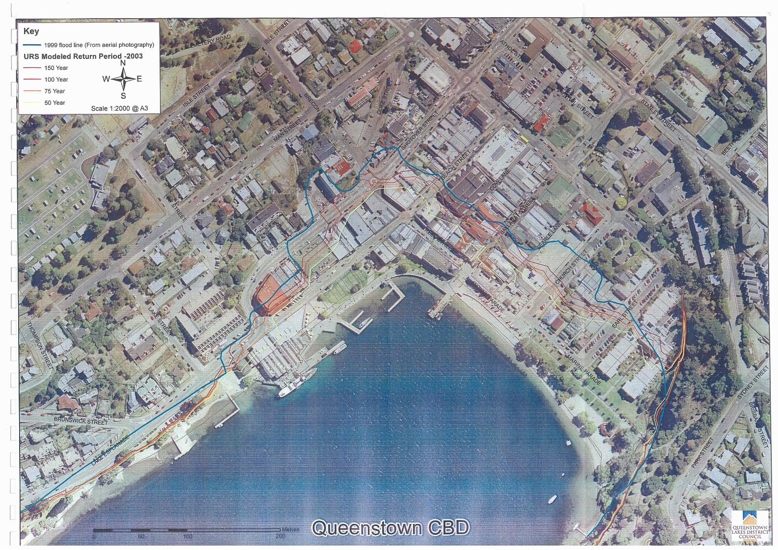
Appendix C: Flood Inundation Maps: 57
C1 Queenstown CBD 58
C2 Wanaka CBD 59
C3 Kingston 60
C4 Glenorchy 61

Flood Risk Management Strategy October 2006
4
Foreword Flooding has been an issue in the Queenstown Lakes District since European settlement in the 1850s. In the last 150 years significant floods have occurred in 1878, 1924, 1994, 1995 and most recently and dramatically in 1999 when severe flooding in Wanaka and the Wakatipu communities of Queenstown, Glenorchy, and Kingston caused extensive damage. This impacted not only the local, but regional and national economies.
Numerous theories on how to manage flooding have been proposed over the years. Many of these have focused on reducing in-flood lake levels rather than management of the community’s exposure to these risks. This focus reflected a historical belief that flooding could be controlled through physical measures and did not fully recognise that the flood risk faced is a consequence of the way in which society has chosen to occupy the lake shores.
Such reliance on physical works has been further challenged by the complexity of the natural setting that makes certainty or confidence in modelled conclusions, for both the subject communities and those further downstream, elusive. The vulnerability of downstream communities to worsened flooding due to measures undertaken to benefit upstream residents has been identified as a key constraint to integrated flood management of Lakes Wakatipu and Wanaka.
Previous investigations have further highlighted the high value the Wanaka and Wakatipu communities and visiting tourists place on the amenity provided by existing lake levels. This suggests any flood risk management options involving a reduction in levels to increase lake storage capacity will face strong resistance. Regulations such as the Kawarau River Conservation Order act to protect this amenity value and the pristine nature of the local environment, further limiting the ease and extent of physical works possible.
In light of the above constraints, Queenstown Lakes District Council (QLDC) and Otago Regional Council (ORC) have jointly developed this Flood Risk Management Strategy to help the community manage its exposure to flood risk rather than try and avoid or limit these risks through engineered alteration of the physical environment. This attempt to learn to live with flooding at a strategic, local, and individual level is the key tenet of the Strategy.
Management and mitigation of the risks and effects associated with flooding is an ongoing and ever-changing task and feedback and comment on this Strategy and the various initiatives outlined within it is welcomed.
Clive Geddes Stephen Cairns Queenstown Lakes District Mayor Chairman Otago Regional Council

Flood Risk Management Strategy October 2006
5
Key Terms
Antecedent conditions: the meteorological / hydrological conditions existing prior to the onset of a flood event. Aggradation: the build up of water-borne sediment. Flood risk: the likelihood and consequence of a flood event occurring.
Flood risk management: the management through a variety of means of the known flood risk. For the purposes of this document the term flood risk management is considered analogous to the term flood risk mitigation.
Flood Risk Management Strategy: otherwise referred to as ‘the Strategy’, comprises the actions and underlying principles and commitments set out in this document.
Hazard: a source of potential harm or a situation with potential to cause loss.
Lifelines: a generic term for the numerous networks servicing a community, including roads, energy systems and water, sewerage, and telecommunications utilities etc.
Residual risk: the risk remaining after the implementation or undertaking of risk management measures. Superdesign event/s: rainfall or flood event/s exceeding the design capacity of the subject structure.

Flood Risk Management Strategy October 2006
6
Executive Summary Flooding of Lake’s Wanaka and Wakatipu is a natural process primarily caused by the large discrepancy in the inflow and outflow capacity of each lake.
Development of the high value lakefront land has occurred within the natural range of both lakes, leading to heightening of the flood risk posed to the human communities of the area. In the last 150 years, significant floods have occurred in 1878, 1924, 1994, 1995 and 1999. The 1999 flood was the most severe and second most severe flood ever experienced by the communities of Lake Wakatipu and Wanaka respectively, causing the closure of lakefront businesses for up to three weeks and resulting in $56 million lost revenue and commercial damage costs in Queenstown alone.
In response to this inherent risk, Otago Regional Council (ORC) and Queenstown Lakes District Council (QLDC) have jointly proposed the following Flood Risk Management Strategy to manage the communities exposure to flooding risk and equip Wanaka, and the Wakatipu communities of Queenstown, Glenorchy and Kingston to understand and learn to live with flooding. Numerous theories on how to manage flooding have been proposed over the years. Many of these, such as the QLDC application for works in the Kawarau River, focused on the reduction of in-flood lake levels rather than management of the risks and effects associated with such an occurrence. This focus reflected a historical belief that flooding could be controlled through physical measures and did not fully recognise that the flooding risk is a consequence of the way in which society has chosen to develop and occupy the lake shores.
Such thinking has been challenged by the complexity of the natural setting that makes certainty or confidence in modelled conclusions for both the subject communities, and those further downstream, elusive. Indeed, the vulnerability of downstream communities to worsened flooding due to measures undertaken to benefit residents upstream has been identified as a key constraint governing flood management of Lakes Wakatipu and Wanaka.
In light of the above, and the complex natural and social setting (outlined in greater detail in Section 4), QLDC and ORC propose to manage the impacts and risks of flooding rather than try and avoid or limit them through engineered alteration of the physical environment. This approach, to learn to live with flooding at a strategic, local, and individual level is a key principle of both councils’ strategic, joint approach to flooding. This and the other guiding principles (refer Section 5) draw heavily on the Draft New Zealand Flood Protocol. To action these Principles, and thus provide integrated flood risk management, both councils commit to work co-operatively and openly to:
• Improve the understanding of natural river and catchment processes that
influence the flood hazard of the Wakatipu and Wanaka communities and the potential impacts of climate change on these processes. During 2006/2007 the ORC will undertake further investigations of the effect of the Shotover delta on the Lake Wakatipu flood hazard so that the delta can be appropriately managed. The ORC will also monitor and report on long-term trends in climate and lake levels on an ongoing basis. Glenorchy and its

Flood Risk Management Strategy October 2006
7
environs have a complex hazard setting and during 2006/2007 the ORC will investigate the significance of these hazards.
• Develop and maintain robust warning, prediction, communications and
response and recovery systems internally, with each other and with the wider community to manage flood events from their onset through to clean up and restoration of services in a reliable and efficient manner. ORC will maintain a flood warning system with appropriate levels of redundancy and will issue flood warnings to QLDC in accordance with agreed protocols. QLDC will relay flood warnings to its community and maintain appropriate systems for doing so. QLDC will engage with its community, including utility service providers and emergency services, to ensure that, collectively and individually, they are all adequately prepared to respond to and recover from flood events in a timely and orderly fashion.
• Enhance individual and community capacity to manage their flooding risk
through the development and distribution of best practice design and flood response guidelines. QLDC will undertake this through a process of engagement with the community and relevant stakeholders.
• Define and articulate roles and responsibilities amongst individuals,
communities, and councils through clear statements of accountability in this document and appropriate policies, objectives and targets in Long Term Council Community Plans.
• Provide timely and appropriate base data, information and technical advice to
assist in relevant flood warnings and focus flood management measures.
• Incorporate flood awareness and risk management planning into all urban design and development initiatives. QLDC will enforce the minimum building floor levels specified in the Proposed District Plan, and, where the effect on amenity and mobility is not adverse, will encourage developers to adopt higher levels. QLDC will encourage flood proof building design and construction.
• Manage risks (including superdesign and residual risks) posed to and by
utilities infrastructure and services during a flood event. QLDC will design and construct all new and replaced utility infrastructure in a manner that allows its continued functioning during, and rapid recovery after, a flood. QLDC will also work with utility service providers to encourage them to do likewise with their infrastructure.
• Initiate, where significant residual risk remains, appropriate capital and
maintenance works to reduce the impact of flood events and enable expedient restoration of council services. ORC will investigate the feasibility of training and vegetation control works on the Shotover delta to minimise increases in the existing flood hazard. QLDC will incorporate appropriate works into asset planning programmes and develop a land use management plan for the Shotover Delta with input from ORC regarding flood hazard.
• Work together on an ongoing, regular basis to review and update this
Strategy and the associated initiatives.

Flood Risk Management Strategy October 2006
8
1.0 Introduction Flooding of Lake’s Wanaka and Wakatipu is a primarily natural process that to a large extent cannot be physically controlled. In response to this inherent risk, Otago Regional Council (ORC) and Queenstown Lakes District Council (QLDC) have proposed the following joint Flood Risk Management Strategy (‘the Strategy’) to help Wanaka and the Lake Wakatipu communities of Queenstown, Glenorchy and Kingston manage their flood risk and equip them to learn to live with the impacts of flooding, whilst not exacerbating flooding risk elsewhere in the Clutha Catchment. In short the Strategy has been proposed to:
• Equip the community to understand, and live with, the effects of flooding. • To guide the style and form of land use development and redevelopment in a
manner that ensures flooding risks do not increase and that over time the existing risks are reduced.
• Provide a clear statement of responsibilities and accountabilities both
internally within the ORC and QLDC, and externally in the community with regards to managing flooding risk.
• To record the approach that ORC and QLDC will jointly take to help the
Wanaka and Wakatipu communities manage their flood risk.
• To support and guide the planning and implementation of flood risk and flood event management measures and programmes (e.g. hazard investigations, infrastructure asset management etc).
Effective flood management will require the integration and implementation of a raft of measures; planning, structural, procedural and strategic. Accordingly, the Strategy advises actioning of a number of initiatives focusing on education, awareness, communication and structural measures. The various initiatives derived from these commitments are detailed more fully in Section 6. Some initiatives apply to all of the communities considered in this Strategy, while others address specific localised concerns or issues for the subject communities or riverine systems. The principles underpinning these initiatives are discussed in Section 5 and the context within which flood risk is to be managed is provided in Section 4.
2.0 Background Residential and commercial development within the natural floodable margins of Lakes Wakatipu and Wanaka means that flooding is inevitable for a number of residents and retailers living and operating in Queenstown, Glenorchy, Kingston and Wanaka. Historical attempts to address this risk through physical works have proved unsuccessful, most notably QLDC’s application for resource consent to undertake work to increase the capacity of the Kawarau River channel. Accordingly, the chief executive officers (CEO’s) of both councils submitted a joint report to QLDC and ORC in 2005 recommending the development of a Flood Mitigation Strategy (FMS).
Flood Risk Management Strategy October 2006
9
The decision of both councils was to release funding for a FMS project to be undertaken jointly by both councils, facilitated by an external consultant. The brief covered assessment of a number of flood mitigation options for the subject communities of Queenstown, Wanaka, Glenorchy and Kingston. The FMS project was undertaken from September 2005 till September 2006 resulting in the actioning of a number of initiatives and the development of this overarching Strategy document. The Strategy has developed an ongoing programme of work to be undertaken jointly and individually by QLDC and ORC. The brief for the FMS project, submitted in 2005, is attached as Appendix A.
3.0 Scope
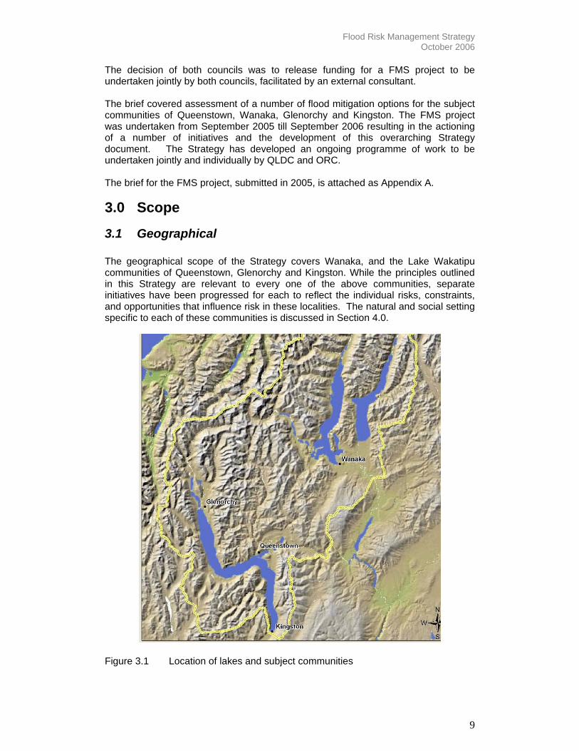
3.1 Geographical The geographical scope of the Strategy covers Wanaka, and the Lake Wakatipu communities of Queenstown, Glenorchy and Kingston. While the principles outlined in this Strategy are relevant to every one of the above communities, separate initiatives have been progressed for each to reflect the individual risks, constraints, and opportunities that influence risk in these localities. The natural and social setting specific to each of these communities is discussed in Section 4.0.
Figure 3.1 Location of lakes and subject communities

Flood Risk Management Strategy October 2006
10
Due to the distinct and significant array of risks faced by Glenorchy (refer Section 4.3.3) a targeted Hazards Assessment will be undertaken by the ORC from which appropriate flood risk management measures will be developed. Details of the actioning of this assessment are attached in the Action Plan, Appendix B.
Figure 3.2 Clutha River catchment

Flood Risk Management Strategy October 2006
11
3.2 Strategy Horizon The Strategy is a living document and has been developed with the expectation it will evolve in response to new information on hazard and risk, the needs of the community, the capacity of the respective councils, and the nature of the flood risk faced.
Accordingly, this Strategy will be reviewed three yearly as a joint ORC, QLDC exercise involving the utilities mangers (or equivalent) and CEOs of the respective councils. Such review is proposed to monitor the effectiveness of the Strategy; the workability of the principles, relevance of the identified issues and success of the initiatives actioned.
3.3 Risk Scope This document addresses the flood hazard faced by each of the four communities with a particular focus on the risks and impacts associated with high lake levels. It is recognised that severe weather events leading to lake level rise are likely to cause a range of risks such as riverine flooding, sediment mobilisation, river avulsion, and land instability such as the Frankton landslip as occurred at the time of the 1999 flood. In addition, earthquakes or tectonic activity associated with the Alpine Fault and other local fault systems, while not weather activated, are also active in the Wakatipu basin. However, while numerous other natural hazards exist, this Strategy addresses flood risk primarily associated with high lake levels.

Flood Risk Management Strategy October 2006
12
308
308.5
309
309.5
310
310.5
311
Stag
e m
1-Aug-2006 11-Aug 21-Aug 31-Aug 10-Sep 20-Sep
A
A
A Lake Wakatipu at Willow Place Stage mB0
100
200
300
400
500
600
B
B
B Dart at The Hillocks Flow m3/s
C0
2
4
6
8
10
12
C C
C Dart Rainfall at Paradise Rainfall mm/ hr (Total=327.5)
4.0 Context The special characteristics of the natural and social setting that shape the flood hazard for Lakes Wanaka and Wakatipu are as follows:
4.1 Meteorological Setting Lake Wakatipu and Lake Wanaka are located immediately to the east of the Southern Alps within the Queenstown Lakes District. Particularly during spring and summer, north-westerly fronts moving over the southern part of the South Island cause heavy rainfall in the district. Occasionally one of these fronts will stall and remain stationary over the Alps for several days or more causing sustained, heavy rainfall in the lake catchments.
A single front does not usually raise ‘normal’ lake levels sufficiently to flood, rather it is a succession of fronts, as described above, occurring without sufficient time for the lakes to recede that cause cumulative increases in lake level. This phenomenon is depicted in Figure 4.1.
Figure 4.1 A succession of inflow events causing the level of Lake Wakatipu to trend upwards over several weeks
The effect of these frontal rain bands can be compounded by the added runoff from snowmelt. The flood hazard for the communities based around Lakes Wanaka and Wakatipu is therefore not just due to the occurrence of a single, large inflow event but is governed by a number of factors including timing between rainfall events and antecedent conditions of snow fall and lake level.
The numerous potential ways in which these causal factors can combine makes the assessment of maximum possible lake level and flood duration difficult, with a high
Lake level (m)
Hourly rainfall (mm)
Inflow (cumecs)

Flood Risk Management Strategy October 2006
13
degree of uncertainty in assessed values. This applies equally to the determination of values for planning purposes (e.g. establishing appropriate floor levels for buildings to avoid inundation) and for operational purposes (e.g. forecasting during a flood event).
4.1.1 Climate Change The effects of climate change further exacerbate the flood hazard faced by the communities surrounding the shores of Lakes Wanaka and Wakatipu. Rainfall records for Queenstown, Makarora and Whataroa (West Coast) show a trend for annual rainfall to be increasing over time (Figures 4.2, 4.3, 4.4).
0
200
400
600
800
1000
1200
1400
1890 1900 1910 1920 1930 1940 1950 1960 1970 1980 1990 2000
Year
Ann
ual r
ainf
all t
otal
(mm
)
Annual rainfall (mm)10 year moving average
Figure 4.2 Queenstown annual rainfall totals 1890 - 2005
Figure 4.3 Makarora annual rainfall totals 1925 - 2005

Flood Risk Management Strategy October 2006
14
2000
2500
3000
3500
4000
4500
5000
5500
1950
1952
1954
1956
1958
1960
1962
1964
1966
1968
1970
1972
1974
1976
1978
1980
1982
1984
1986
1988
1990
1992
1994
1996
1998
2000
2002
2004
Year
Rai
nfal
l (m
m)
Annual rainfall (mm) -10 year moving average
Figure 4.4 Whataroa annual rainfall totals 1949 - 2005
Research undertaken for ORC (Mojzisek, 2006) indicates an increasing trend in total precipitation, number of rain days, daily rainfall intensity and the amount of rainfall falling on very wet days for that part of Central Otago which includes Lakes Wanaka and Wakatipu. Mojzisek notes that trends in precipitation extremes are more pronounced during the second half of the 20th century as opposed to the period from 1901 to 1950 and that an unprecedented, high number of potential flood-producing events have occurred in Queenstown between 1991 and 2003. At all timescales analysed in the study, the western part of Central Otago which includes Lakes Wanaka and Wakatipu, was found to be growing significantly wetter.
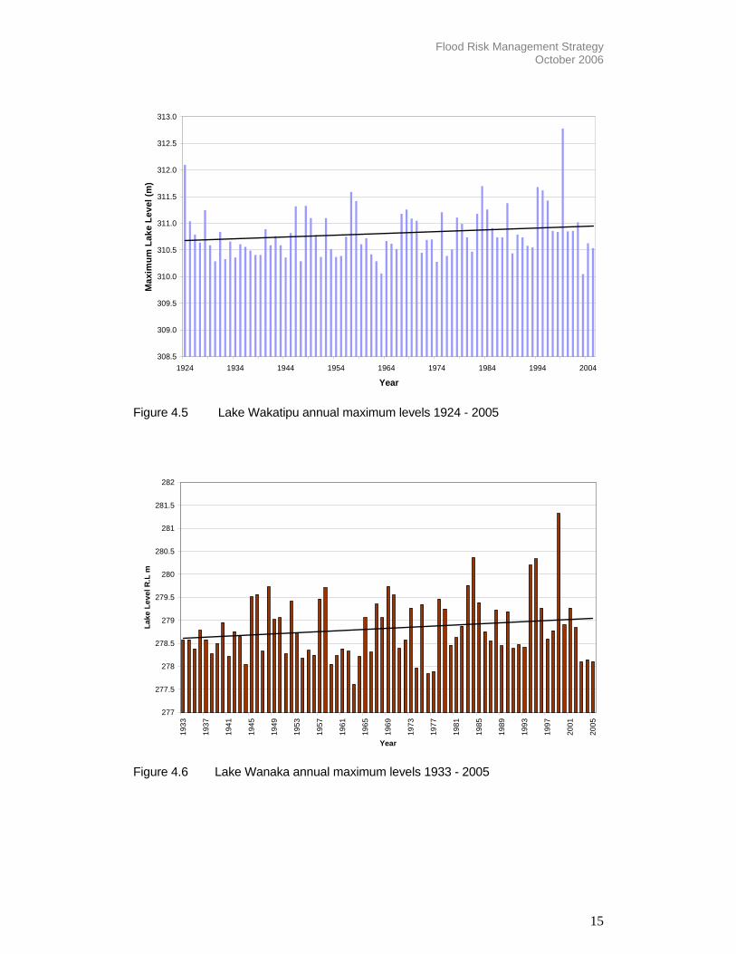
Records of lake level for both lakes show that the annual maximum level of each lake has been increasing (Figures 4.5 and 4.6). For Lake Wakatipu, the annual maximum level has increased by approximately 0.3 metres in the 80 years of daily record and for Lake Wanaka the annual maximum level has increased by approximately 0.5 metres in the 70 years of daily record. This implies that the hazard associated with lake level is increasing.
Flood Risk Management Strategy October 2006
15
308.5
309.0
309.5
310.0
310.5
311.0
311.5
312.0
312.5
313.0
1924 1934 1944 1954 1964 1974 1984 1994 2004
Year
Max
imum
Lak
e Le
vel (
m)
Figure 4.5 Lake Wakatipu annual maximum levels 1924 - 2005
277
277.5
278
278.5
279
279.5
280
280.5
281
281.5
282
1933
1937
1941
1945
1949
1953
1957
1961
1965
1969
1973
1977
1981
1985
1989
1993
1997
2001
2005
Year
Lake
Lev
el R
.L m
Figure 4.6 Lake Wanaka annual maximum levels 1933 - 2005

Flood Risk Management Strategy October 2006
16
4.2 Hydrological Setting
4.2.1 Lake Wakatipu Lake Wakatipu has a catchment of 3,067 km2, fed in the main by the Rees and Dart Rivers, with a combined catchment of 1,044 km2 (Figure 3.2). Other tributaries include the Buckler Burn, Horne Creek, and the Lochy, Von and Greenstone Rivers. The lake has a single outlet – the Kawarau River, a tributary of the Clutha River. The Shotover River delta is located at the confluence of the Shotover and Kawarau Rivers, approximately 3.5 km downstream of the outlet of Lake Wakatipu and the Kawarau Falls Bridge (Figure 4.7). The Shotover River and its delta influence the duration and level of flooding in Lake Wakatipu through the transport of both water and sediment to the Kawarau River.
The main cause of high lake levels in Lake Wakatipu is the natural imbalance between the capacity of the lake outlet (Kawarau River) and the magnitude of inflows during heavy rainfall events. For example, rainfall and snowmelt associated with the November 1999 flood produced a peak inflow of approximately 4,000 cubic metres per second compared to a peak outflow of approximately 800 cubic metres per second (Figure 4.8).
Lake outflow is further impeded by flood flows in the Shotover River due to the perpendicular configuration of the confluence of the Kawarau and Shotover Rivers (Figure 4.7). Flows out of Lake Wakatipu are effectively dammed for a period until the flows in the Shotover River recede. Occasionally there is minor backflow into Lake Wakatipu although the volume of water entering the lake at the Frankton Gates is very small compared with the volume from the lake catchment.
Figure 4.7 Shotover River delta with Kawarau River in foreground (flowing left to
right)

Flood Risk Management Strategy October 2006
17
Figure 4.8 Behaviour of Lake Wakatipu during the November 1999 flood. Note that lake outflow (green line) reduces whilst the Shotover River (brown line) is in flood and does not increase appreciably until the Shotover River flow has diminished. Also, the inflow to the lake (blue line) is many times greater than the outflow from the lake (green line). Due to the highly erodible nature of its catchment, the Shotover River carries a huge volume of sediment; between 1.6 and 2 million m3 annually. This sediment is delivered through the upper incised reaches of the Shotover and is deposited on either the delta or in the Kawarau River. Sediment deposited in the Kawarau River reduces the cross sectional area of the channel and raises the bed level, decreasing the river’s capacity. As the Kawarau River is Lake Wakatipu’s sole outlet, this reduction in conveyance capacity can significantly increase the flood hazard, extending the duration of high lake levels until such time as flows erode this sediment, an action that may take weeks or even months (Figure 4.8). Figure 4.9 shows the difference in level between Lake Wakatipu and the Kawarau River immediately downstream of the Kawarau Falls. It can be seen that the difference in level is decreasing over time, implying that the outflow capacity of the lake is reducing. Investigations into increasing the outflow capacity of the Kawarau River as a means of reducing flood levels for Lake Wakatipu have highlighted the potential adverse effect on downstream communities within the Clutha River catchment. Furthermore, any permanent physical measures to increase outflow are likely to result in a sustained reduction in ‘normal’ lake levels in order to provide any significant increase in storage capacity of the lake. Historical investigations into this form of flood mitigation have highlighted the significant recreational and amenity value provided under existing lake levels and the reticence of the community to forgo these values, particularly when modelling cannot provide high levels of confidence in the success of the proposed measures.

Flood Risk Management Strategy October 2006
18
-200
0
200
400
600
800
1000
1200
1400
1600
1800
2000
1961 1967 1972 1978 1983 1988 1994 1999 2005
Date
Diff
eren
ce in
wat
er le
vel (
mm
)
Difference in water level (mm) 180 day moving average Linear (difference in water level)
Figure 4.9 Difference in level between Lake Wakatipu and Kawarau River
downstream of Kawarau Falls. Hydraulic modelling undertaken for the ORC in 2004 / 2005 shows that if the main channel of the Shotover River occupies the true-left (eastern) side of the delta, sediment deposited in the Kawarau Channel is located as far downstream as possible and hence has the least adverse effect on Lake Wakatipu levels (Barnett MacMurray et al, 2006). The modelling also showed that the channel probably occupied this position during the 1999 flood and therefore the flood impact could have been greater had the channel occupied the true-right (western) side of the delta. Section 6.1.2 details the further modelling that will be undertaken to develop understanding of the delta and to establish whether feasible steps can be taken to reduce the likelihood of the current situation becoming worse. Potential management options with regard to sediment buffering and confinement of the Shotover River’s dominant channel will be examined.
4.2.2 Lake Wanaka Lake Wanaka has a total catchment area of 2628 km2 and is fed in the main by the Matukituki and Makarora Rivers. Like Lake Wakatipu, Lake Wanaka is drained by a single outlet, the Clutha River, which is joined some way downstream by the Hawea River, which drains Lake Hawea. While the Clutha River is without the capacity issues faced by the Kawarau, there is concern that its interaction with the Hawea River may exacerbate flood levels in Albert Town.
If high flow out of Lake Wanaka coincides with high flows from the Hawea River, groundwater and floodwater levels in the lower parts of Albert Town can be raised and cause additional surface flooding. Contact Energy Ltd use best endeavours to hold water discharges from Lake Hawea to a minimum during flood events from Lake Hawea. However, Contact Energy Ltd must operate the Lake Hawea releases in accord with a dam safety protocol and will release water into the Hawea River if the safety protocol dictates. This coincidence of high river flows is unlikely to arise unless
Flood Risk Management Strategy October 2006
19
the water levels in Lake Hawea are high and available storage may be inadequate to safely retain flood inflows. 4.2.3 Slow Rate of Lake Level Rise Despite having large catchments, both Lake Wanaka and Lake Wakatipu rise relatively slowly, even when inflows to each lake are high, due to their large surface areas (Figure 4.8). This characteristic of the lakes in which the lake surface rises slowly and in response to particular weather conditions means that the development of a flood event can be reliably monitored and the affected community’s afforded long-lead times; typically several days, in which to prepare for inundation. Section 6 describes improvements that will be made to existing flood monitoring, warning and response procedures which capitalise on this beneficial characteristic of both lakes.
4.3 Community Setting Significant parts of all four lakeside communities addressed in this Strategy have been developed on land that lies within the natural ranges of the surfaces of the two lakes.
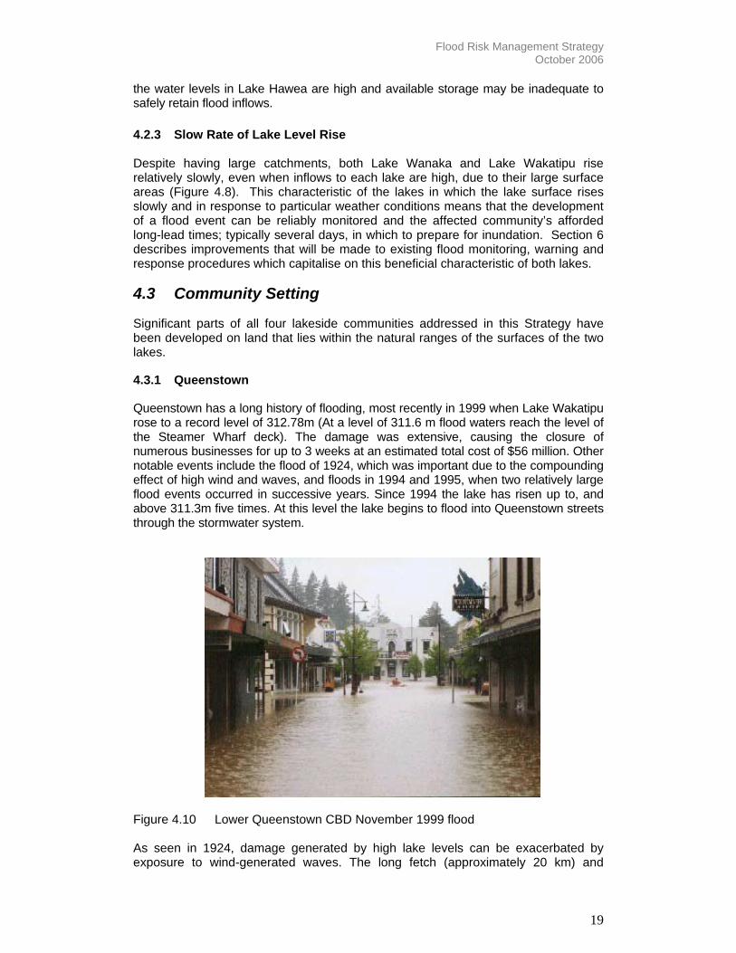
4.3.1 Queenstown Queenstown has a long history of flooding, most recently in 1999 when Lake Wakatipu rose to a record level of 312.78m (At a level of 311.6 m flood waters reach the level of the Steamer Wharf deck). The damage was extensive, causing the closure of numerous businesses for up to 3 weeks at an estimated total cost of $56 million. Other notable events include the flood of 1924, which was important due to the compounding effect of high wind and waves, and floods in 1994 and 1995, when two relatively large flood events occurred in successive years. Since 1994 the lake has risen up to, and above 311.3m five times. At this level the lake begins to flood into Queenstown streets through the stormwater system.
Figure 4.10 Lower Queenstown CBD November 1999 flood As seen in 1924, damage generated by high lake levels can be exacerbated by exposure to wind-generated waves. The long fetch (approximately 20 km) and
Flood Risk Management Strategy October 2006
20
significant depths of Lake Wakatipu, even within Queenstown Bay, lessen the occurrance of wave shoaling which would otherwise limit the height of the waves reaching the shoreline. Further, when the lake level is high the shoreline is located further inland, amongst the roads and buildings of the CBD. Waves will therefore break and run up within the CBD itself, potentially causing damage over and above that arising from inundation due to high lake levels. The Queenstown CBD is exposed to additional flood hazard from surface flow from flooding of Horne Creek. Horne Creek is a relatively small source of Lake Wakatipu that forms the primary conveyance channel of stormwater flows from the urban Queenstown catchment. The CBD has developed around and over the waterway such that the channel is highly constrained. There is a risk of channel blockage during floods due to woody debris sourced from the steep, heavily wooded catchment, the relatively small waterway area and numerous culvert and bridge crossings that act as potential hydraulic restrictions. Superdesign events will flow along streets damaging property and posing a danger to pedestrians. Horne Creek has a small, steep catchment and unlike the situation with lake flooding, flood warning is not a practical or reliable method of managing the hazard. For this reason no warning system currently exists nor is proposed. Existing measures to manage flood hazard associated with Horne Creek include the detention dam and debris trap at the confluence with Brewery Creek and the utilization of the sports ground as a detention area. The effectiveness of these measures has been reviewed as described in Section 6 and proposals developed to ensure their effective management and maintenance.
4.3.2 Glenorchy The township of Glenorchy and its environs have a complex hazard setting, being exposed not only to inundation from high lake levels but also water and debris flows from the Buckler Burn and Bible Stream and in the wider area, steep hill streams such as Precipice Creek. Furthermore, the road to Glenorchy along the edge of the lake is susceptible to slippages and washouts during severe weather events, potentially resulting in a loss of access and consequently, isolation for not only Glenorchy but the outlying communities of Kinloch and Paradise. Monitoring undertaken by the ORC indicates that the delta of the Rees River is aggrading and advancing toward Glenorchy. As the bed of the Rees River is already very high in relation to surrounding land, even minor further aggradation poses significant risk. The Buckler Burn located at the southern extent of the Township, drains a steep catchment with high debris load covering an area of approximately 54 km2. In its lower reaches, it has formed a steep debris fan between the Queenstown-Glenorchy road bridge and Lake Wakatipu. Part of Glenorchy is constructed on this debris fan and is therefore susceptible to flooding from this source especially as the bed can aggrade during floods and potentially shift its channel into Glenorchy. The Bible Stream drains a very small (1 km2) catchment northeast of Glenorchy Township. A channel extending from the toe of the hills to Rees Valley Road has not been designed nor engineered for flood protection (Opus, 2004) and thus the risk posed by this infrastructure is not known. Due to the complexity and scope of the risk faced, Glenorchy will be the subject of a targeted Hazards Assessment by the ORC. Details of the actioning of this assessment are attached in the Action Plan, Appendix B. ORC and QLDC will work

Flood Risk Management Strategy October 2006
21
together to develop specific flood risk management initiatives for Glenorchy following the results of this study.
4.3.3 Kingston
Kingston is a small, primarily residential settlement located at the southern tip of Lake Wakatipu. With its large lakefront reserve area and generous set back of properties from the lake, effects of the 1999 flood were limited to inundation of 20 vacant and 10 occupied homes and impacts on the local tavern and railway station which had sections of track washed out.
Due to its proximity to Queenstown, Kingston has faced strong development pressure in the previous decade. Proposals for more expansive and intensive development are currently before council and offer the opportunity to ensure flood risk is mitigated through flood sensitive design and appropriate land use. Flood risk is currently managed solely through minimum floor height requirements in QLDC’s proposed District Plan. Further urban planning measures proposed to manage flood risk are described in Section 6.3.
4.3.4 Wanaka
Wanaka has a long history of flooding, most significantly in 1878 when the lake rose to a record level of 281.76m (Ardmore Road level is typically 280.0m). The flood of 1999 was the second highest in 122 years of record and reached a peak height of 281.32m, causing the inundation of numerous CBD businesses.
As for the Queenstown CBD, damage generated by high lake levels can be exacerbated by exposure to wind-generated waves and transported debris. Measures undertaken in Wanaka during the November 1999 flood included the erection of chicken wire fencing along the lakefront reserve to capture wave borne debris and protect CBD businesses. Sections of the Wanaka CBD are exposed to additional flood hazard from surface flow from the overtopping of Bullock Creek. Bullock Creek is a small, spring source of Lake Wanaka forming the primary conveyance channel of stormwater flows from the eastern urban catchment. The channel is largely open and unconstrained and thus the risk of blockage or hydraulic constriction is limited. For this reason no specific flood risk management measures are proposed for Bullock Creek.
Figure 4.11 Lake Wanaka in flood, November 1999

Flood Risk Management Strategy October 2006
22
4.4 Legislative Context The manner and degree to which the flood risk of the Wakatipu and Wanaka communities can be managed by QLDC, ORC, and the community is influenced by the obligations, powers, and restrictions set out in various statutes. This ‘legislative context’ within which the Strategy is defined and operated is outlined below. 4.4.1 Responsibilities for Managing Flooding Risk Under the Resource Management Act 1991 (RMA) the ORC, as a regional council, has the function of controlling land use for the purpose of (amongst other things) the avoidance or mitigation of natural hazards. QLDC as a territorial authority has a complementary function of the control of any actual or potential effects of the use, development, or protection of land, including for the purpose of the avoidance or mitigation of natural hazards. The management of flood risk is therefore a joint responsibility of QLDC and ORC and is not predicated on physical works alone. Given that the ORC and QLDC as consent authorities have duties to consider hazards as part of making decisions on land use and resource consent applications there is an expectation that applicants will consider these matters when developing flood prone areas such as the shoreline of lakes Wakatipu and Wanaka. The community therefore has an important role to play in shaping how hazards are managed. The Soil Conservation and Rivers Control Act 1941 (SCRC Act) assigns the ORC as successor to the Otago Catchment Board1 with the function to minimise and prevent damage … by floods and erosion. The Act provides the ORC with certain powers to achieve its function under the Act (typically related to implementation of physical works) but does not require the ORC to exercise these powers. This is a policy matter for the ORC to decide in consultation with the community. No legislation confers on ORC or QLDC the exclusive power or right for managing flood risk, whether through works or services. Individuals are empowered to initiate their own measures provided they operate within the legislative framework. Individuals are allowed to develop and promote scheme proposals, to apply for and hold the necessary resource consents and to privately fund works and services should they wish to do so. 4.4.2 Opportunities and Constraints for Councils and Community
The law provides for a range of methods which both councils and the community can use to manage flood risk. These methods do not just relate to physical works, but also to planning, information and emergency preparedness and response. These can only be implemented after taking into consideration environmental effects (under the RMA) and funding considerations (under the Local Government Act (LGA). The latter includes consideration of the distribution of benefits between the community as a whole, any identifiable part of the community, and individuals.
The law provides both opportunities as well as constraints on what is feasible for councils and community to implement in a particular setting. These are outlined as follows:
1 The Local Government (Otago Region) Reorganisation Order 1989. Gazette 1989 (p2408) assigned the powers and authority of the former Otago Catchment Board to the Otago Regional Council.

Flood Risk Management Strategy October 2006
23
• The duty of both QLDC and ORC to gather information, including information
on natural hazards (RMA), make such information publicly available and provide information upon request, including information on natural hazards (Local Government Official Information and Meetings Act (LGOIM Act).
• The obligations of QLDC as a territorial authority regarding land use planning and the role it plays in influencing and guiding community development through District Plans (RMA). The Act requires that all persons exercising functions and powers under the Act shall have particular regard to the effects of climate change amongst other things.
• The matters to be considered by QLDC when taking decisions on planning for land use and proposals to subdivide land (RMA) and building development (Building Act) which influence community exposure to natural hazards. The RMA places restrictions on use and subdivision of land.
• Controls on activities, including structural measures that affect flooding risk, and the requirement to consider effects on the environment (RMA). This applies irrespective of whether such measures are undertaken by QLDC, ORC or the community. The RMA places restrictions on certain uses of beds of lakes and rivers.
• The joint responsibilities and obligations of QLDC and ORC regarding planning, preparing and responding to natural hazard events individually, together and with other agencies through the Civil Defence Emergency Management Act (CDEM Act).
• The obligations of QLDC as a lifeline utility provider (CDEM Act) arising from its ownership and operation of community water supply and sewage collection and treatment systems. This is additional to QLDC’s other emergency preparedness and response responsibilities listed above.
• The obligations of lifeline utility operators, in addition to QLDC, regarding emergency preparedness, response and recovery planning (CDEM Act).
• The powers of the ORC to undertake works and services where appropriate to manage flooding risk (SCRC Act).
• The protection of amenity values provided by the Kawarau Conservation Order, foreshore management plans, and other community policies.
4.4.3 Discussion The legislation relating to the management of flood risk gives ORC and QLDC various powers and responsibilities at strategic and operational levels. Both councils can achieve their respective statutory functions through a variety of complementary methods including regulation, education and awareness, and works and services. The legislation provides for the avoidance of new or additional risks as well as reduction of existing risks. There are however constraints on what can practically be achieved through consideration of environmental effects and funding mechanisms. The legislation provides for a high degree of community participation, which helps shape the form the flood risk mitigation takes. This is supported by the obligation of

Flood Risk Management Strategy October 2006
24
both QLDC and ORC to make relevant information available to the community to enable informed decision-making by the community. This allows a high degree of community input to the management of flood risk at planning and implementation stages.
Flood Risk Management Strategy October 2006
25
5.0 Principles The core of the Strategy is a framework through which QLDC and ORC will approach flood risk management of Lakes Wakatipu and Wanaka, specifically the communities of Queenstown, Wanaka, Glenorchy and Kingston and their environs. This framework has drawn extensively from the Draft New Zealand Protocol: Managing Flood Risk (December 2005) and centres on the following key principles:
• Assisting the community in learning to live with flooding. This principle is based on awareness of the inherent residual risk and underpinned by the understanding that flooding in Lakes Wanaka and Wakatipu is a largely natural process that can be managed but not avoided.
• Flood risk mitigation and management of the impacts of flooding on people
and property is the individual responsibility of all members of the community.
• Recognition of the need to understand the underlying natural systems and processes when developing any management or mitigation strategies.
• Lakes Wanaka and Wakatipu and their subject communities sit within a wider
catchment and riverine system, the primary linkage of which is the Clutha River. Any attempts at flood mitigation are not to exacerbate or negatively impact on the wider catchment or downstream communities.
• Commitment to a long-term sustainable and strategic approach to flood risk
management that responds to changes to the nature and extent of the risk and the level and type of protection desired by the community.
• Appropriate forms and levels of protection determined by the nature of the
risk, the community’s desired level and cost of response (both social and economic) and the wider context of natural and social systems.
• Commitment to progressing only those flood risk mitigation measures that
show cost benefit to council, the community and direct beneficiaries.
• Community involvement and ownership, recognising that any workable approach to flooding mitigation must be community endorsed not just at the outset but throughout its’ lifecycle.
• Recognition and treatment of residual risk to ensure the entire risk spectrum
is addressed for any flood risk management options considered. This principle recognises that whatever event is planned for, there will be a larger, ‘superdesign’ event. It is this risk that must be recognised and managed.
• A commitment by both councils to work together to manage flood risk and
impacts.

Flood Risk Management Strategy October 2006
26
6.0 Strategic Elements Derived from the principles outlined above, the Strategy contains the following key elements reflecting both councils’ holistic approach to flood risk management. These are:
• Understanding natural river and catchment processes and the potential impacts of climate change on these processes.
• Identifying and quantifying risks (including residual risks) posed to and by
Council infrastructure and services.
• Flood sensitive urban design and the incorporation of flood awareness and risk mitigation into all relevant council activities such as community plans, building consents, infrastructure planning etc.
• Enhancing individual capacity to manage flood risk through education and
awareness.
• Robust warning, prediction, communications and response systems developed and actively managed.
• Providing timely and appropriate base data, information and best practice
guidance.
• Commissioning of appropriate capital and maintenance works where the residual flood risk is significant.
• Defining and articulating roles and responsibilities amongst individual,
communities, and councils. In line with the principles outlined in Section 5, each of these areas of engagement have been refined for the four communities of Queenstown, Glenorchy, Kingston and Wanaka and their environs to result in appropriate, community backed flood risk mitigation. Details of the various initiatives derived from these foci, including their scope and projected dates of completion are provided in the Action Plan attached as Appendix B.
6.1 Understanding Natural River and Catchment Processes Developing appropriate and sustainable flood risk management measures requires a sound understanding of the natural context in which the risk and its solutions will be acted out. To this end, ORC and QLDC have actioned the following studies to build the body of knowledge on the flood risk in the following localities and guide the specific flood risk management measures developed.
6.1.1 Glenorchy Natural Hazards Assessment As noted earlier, Glenorchy and its environs have a complex hazard setting. Any strategy that seeks to reduce the existing risk to Glenorchy Township and its environs must be based on an understanding of the significance of each of the various hazards and the degree to which they can be mitigated. Glenorchy will

Flood Risk Management Strategy October 2006
27
therefore be the subject of a comprehensive natural hazards risk assessment to be undertaken by the ORC in 2006 / 2007. The assessment will consider current and future risks associated with seismic hazard, avulsion of the Rees River delta, avulsion and debris flows in the Buckler Burn, breakout of The Bible Stream and the risks associated with high lake levels.
6.1.2 Shotover Delta Management Plan As noted in Section 4, the behaviour of the Shotover delta influences flood hazard of Lake Wakatipu. The modelling undertaken by the ORC in 2004 / 2005 indicated that the delta provides a buffering effect, so that peak sediment flows are deposited within the Shotover delta before reaching the Kawarau River channel. This is a desirable characteristic that should be preserved, or where possible enhanced, as the deposition of sediment in the Kawarau channel decreases the conveyance capacity of the river, consequently increasing the duration and level of flooding in Lake Wakatipu.
Figure 6.1: Physical model of Shotover River delta
However, the modelling further showed that depending on the path taken by the main Shotover flow on the delta, the benign buffering effect may not always occur, and large amounts of sediment may be deposited in the Kawarau River channel during a flood. This would impact adversely on Wakatipu flood hazard by reducing the conveyance capacity of the Kawarau River and consequently extending the duration of high lake levels. Further, avulsion of the Shotover River to the true right or western side of the delta, during flood events is not desirable and maintaining the channel on the true left will minimise the risk of increased flood levels in Lake Wakatipu given the same inflow conditions.
There are several potential options for achieving alignment of the Shotover channel on the true left of its delta, including physical training works of varying types, management of gravel extraction activities, removal of some of the willow islands and restricting development along the delta margins. The willow islands that have become established on the Shotover delta influence the sediment storage and transport characteristics of the river; vegetation tends to lead to a reduction in velocity of the water and a corresponding reduction in its ability to convey sediment, which is then deposited. The islands are continuing to grow, and the response of the system to their removal is currently unknown. The response will depend on the nature of the sediment bound up by the islands and the size and location of willow removal/control.

Flood Risk Management Strategy October 2006
28
There is pressure to further develop the margins of the delta. Occupying of the delta margins will lead to a reduction in the sediment storage capability of the delta and such developments would be at risk of inundation during periods of high flow and would further face erosion bought about by channel avulsion. However QLDC and ORC acknowledge the importance of several public projects proposed for the true right of the delta. Therefore QLDC and ORC are committed to managing further encroachment onto the delta to maximise existing storage capacity and help achieve a preferred alignment for the Shotover River channel whilst allowing for appropriate, flood sensitive land use and development.
Commercial gravel extraction operations offer an option for partially managing the delta. The consented and potentially consented gravel take, accounts for approximately 20% of the total annual sediment load of the Shotover River, however the actual extracted volume is in the order of 10% of the total annual sediment load. It is therefore important not to rely too heavily on gravel extraction for long term river management.
Further modelling of options for training works to keep the channel on the true-left of the delta is underway. The modelling will also seek to obtain a better understanding of the trade-offs between confining the flow to a dominant channel and allowing floodwaters to occupy the maximum possible area on the delta. This information will be used to support the development of a management plan for the delta which will seek to manage existing, and reduce future impacts on the Lake Wakatipu flood levels.
6.2 Understanding Infrastructural Flood Risk To facilitate timely, focused flood response and recovery, both Councils recognise the need to understand the flood risk posed not only by the natural, but by the structural or built environment. Accordingly QLDC and ORC have undertaken the following studies to identify and quantify the risk posed by existing Council infrastructure. Actions derived from the studies are discussed in Section 6.9 Investigation of Appropriate Physical Works.
6.2.1 Central Business District (CBD) Utilities Infrastructure Assessment of the resilience, under various flood events, of the telecommunications, potable water, sewerage, and power utilities servicing the Queenstown and Wanaka CBDs was commissioned in late 2005 as part of the Flood Risk Management Strategy project. The scope of the study covered purely that utility infrastructure located within, and servicing the Queenstown and Wanaka CBDs. However, it is recognised that utilities infrastructure located within the floodable areas of both CBDs also services businesses and residences outside of that floodable area. Consequently, high lake levels may therefore indirectly affect the community beyond the inundated area. The assessment was undertaken with the primary aim of strengthening QLDC’s understanding of the risk of failure or malfunction of its utilities infrastructure and the effect such failure would have on the CBD and wider community.
This work confirmed that some of this infrastructure is vulnerable to flooding largely because it had been installed within the flood plain and has been constructed or designed in such as way as to be vulnerable to inundation. This apparent lack of consideration of the local flood hazard has strengthened QLDC’s resolve to continue to engage with utility service providers to monitor the condition of their utility and service infrastructure, develop appropriate emergency response procedures, identify

Flood Risk Management Strategy October 2006
29
suitable capital and maintenance works, and plan for future technical studies to ensure risks are understood and where possible, mitigated.
Potential mitigation measures identified in the report will be incorporated in capital expenditure and maintenance budgets as appropriate and the greater understanding of utilities services risk afforded by the report will provide a framework for the management of CBD utilities services and infrastructure provision.
6.2.2 Horne Creek Historical flooding from both Horne Creek and its main tributary, Brewery Creek, has resulted in a number of flood protection measures being proposed and implemented over the past 40 years.
Both councils recognise that the appropriate management of both the conveyance and flood protection functions of the creek is dependant on understanding of the nature, and extent of the flood risk specific to the Horne Creek catchment. To this end, a flood risk study was undertaken for Horne Creek as part of the Flood Risk Management Strategy project. The study was essentially a review of the current level of flood risk from the creek in respect of the existing flood protection scheme elements and included assessment of current management and maintenance procedures.
ORC and QLDC will utilise the results from this study to improve maintenance and management of the creek and its flood protection measures to maximise the flood protection benefit and mitigate the creation of any further risks through inappropriate development along or within the creek margins and floodplain. Specific initiatives derived from the study are outlined in the Action Plan, attached as Appendix B.
6.3 Flood Sensitive Urban Planning Guided by a sound understanding of the flood risk associated with both natural and engineered systems, ORC and QLDC are committed to implementing flood sensitive urban planning to manage and where possible, avoid those risks. A key means of actioning this is through the sensible application of the following legislation:
6.3.1 Section 71 of the Building Act (1991) The provisions outlined in Section 71 (formerly section 36) date from the 1970’s when local authorities were prohibited from granting building permits for land that was subject to slippage, subsidence, inundation, erosion etc. QLDC policy with regards the provisions outlined in Section 71 are that a person may ”accept the risk” associated with their land and build provided that:
• Their decision to ‘accept the risk’ is thoroughly disclosed to potential future purchasers. This requires that the risk is specifically recorded on the property’s Certificate of Title. This is the document that is almost universally referred to in property transactions;
• That the Local Authority is absolved from any civil litigation arising from the issue of that Building Consents;
• That the building itself won’t worsen the problem of slippage, subsidence, inundation, erosion etc.
• That the building work will comply with the Building Code. For more information on QLDC’s position on use of the Building Act refer QLDC Report for Agenda Item (March 2000).

Flood Risk Management Strategy October 2006
30
6.3.2 Section 106 of the Resource Management Act (1991)
QLDC currently utilises this section of the Act in the resource consent process to manage development of flood prone land. As greater understanding of the scope and extent of flood risk faced by the subject communities is gained through studies and technical assessments commissioned as part of the Flood Risk Management Strategy project, this awareness will be incorporated to best manage risk associated with development of hazard prone sites.
6.3.3 QLDC Partially Operative District Plan (2001) The following table lays out the rules relating to the flood mitigation in all settlements on Lake Wakatipu. 9.2.5.1(ix) Townships
Flood Risk in townships: Min floor level 312.8 masl for Kinloch, Glenorchy, and Kingston (with explanatory note), and 449.2 Otago Datum at Hawea. Page 9/10
9.2.5.2(ii) Townships
Different height rule for Glenorchy to compensate for the above rule. Page 9/12
10.6.5.1(viii) Town Centre
Queenstown town centre. Min floor level of 312.0 masl. Page 10/24 (Buildings greater than 20m2 gross floor area)
7.5.5.1 and 7.5.6.1 Residential areas
RL 312.0m above sea level (412.0m Otago Datum) at Queenstown and Frankton.
For all settlements, QLDC will continue to use the District Plan to ensure risk mitigation through the setting of minimum floor levels. This is not considered as a solitary means of flood management but does recognise that raising of buildings and services does significantly reduce the risk associated with inundation during a flood event. However, while the minimum floor levels set in the District Plan are based on the observed, historical maximum lake levels, the maximum possible levels are not known and the historical levels must be regarded as a lower bound on the true, maximum possible levels. Thus while buildings with floor levels that meet the District Plan requirement are less likely to be flooded than those with lower floor levels owners and occupiers must still expect and plan for inundation. Queenstown The District Plan specifies a minimum floor height in the Queenstown Town Centre of 312.0 metres above sea level (masl). Leveraging off this rule, and the desire of all parties to avoid a Section 71 certificate (under the Building Act), QLDC rigorously negotiates with developers to achieve the following during the resource consent process: • All services to be located above potential flood levels; • Where practicable, floor heights be raised to 312.8masl; • Flood proofing measures to limit water ingress into buildings;

Flood Risk Management Strategy October 2006
31
• Flood sensitive design such as: o Use of concrete floors where possible; o Waterproof or easily replaceable fittings and materials; o Moveable shelving and other similar arrangements for rapid removal of stock.
Glenorchy A variation to QLDC’s proposed District Plan has already been implemented to raise the minimum floor heights for new buildings in Glenorchy to 312.8masl. This provision is now fully operative. The setting of minimum floor heights is not seen, in itself, an adequate means of mitigation due to the dynamic, as well as static nature of the flood risk. As such, the following additional urban planning measures are proposed: • Maintain the current low density of development within the existing urban
boundary; • Localise recreational development on flood prone land (eg: Use of peninsula
reserve for the golf course and pony club) and focus subdivision in areas of lower flood risk;
• Focus commercial and industrial development away from high risk areas such as Bible Stream, Buckler Burn and foreshore;
• Support the location of the industrial centre on the Buckler Burn hill site as recorded in the Glenorchy Community Plan.
Kingston A variation to QLDC’s proposed District Plan has already been implemented to raise the minimum floor heights for new buildings in Kingston to 312.8masl. This provision is now fully operative and QLDC will continue to require any new buildings to meet this requirement. QLDC is further committed to including flood risk planning into urban design initiatives and zoning alterations as a means of reducing existing and limiting future, flood risk. This initiative is anticipated to result in reducing subdivision of existing sections within the flood plain and focusing commercial and industrial development in lower risk areas well above the flood level. Wanaka District Plan rules for Wanaka require all buildings with floor areas greater than 20m2 be constructed (or relocated) with a minimum ground floor level of 281.9masl. This ground floor minimum includes 1.3 metres to allow for wave action where necessary. This minimum floor level (incorporating wave height allowance) is approximately 150mm higher than the maximum recorded flood level of 281.76masl. Enforcement of this rule has resulted in newer development to the western end of Ardmore Street being raised almost a metre above the exiting ground level. While this reduces the risk of inundation substantially over that risk faced by older, lower buildings, the visual and amenity impacts are significant, thus highlighting the need to balance this form of flood risk management with urban design concerns.

Flood Risk Management Strategy October 2006
32
6.3.4 Raising of District Plan Minimum Floor Levels One approach to flood risk management considered as part of the Strategy was the raising of minimum floor levels specified in the QLDC District Plan. The infrastructural and amenity issues associated with raising of floor levels have been particularly visible in the case of recent development along the Wanaka waterfront. These buildings, raised almost one metre above the surrounding ground level have significant visual impact and no less an impact on access and mobility. Similarly, redevelopment of buildings in the lower Queenstown CBD to incorporate higher floor levels has necessitated significant works to be undertaken on the adjoining streetscape, negatively impacting mobility through the creation of an undulating footpath surface. Considering the above, the inevitability of superdesign conditions occurring, and the lack of knowledge of maximum possible lake level and duration, further raising floor heights specified in the District Plan is not seen as a valid means of reducing flood risk. Implementation of flood sensitive design is seen as a viable alternative to a District Plan change requiring the retrospective or current raising of floor heights.
6.4 Flood Sensitive Design Significant parts of all four lakeside communities have been developed on land that lies within the natural ranges of the surfaces of the two lakes. As such, flooding is inevitable, and buildings must have the durability to withstand inundation by contaminated water for extended periods. While many commercial building owners, particularly within Queenstown CBD, have already taken steps of their own accord to make their buildings able to withstand inundation, the challenge is to make such flood proofing measures wide spread, a task hindered by the fact that flooding can occur relatively infrequently and therefore the exposure to flood risk might be relatively short for any particular property owner or occupier due to the temporary nature of many building fit outs (i.e. as their occupation changes when leases expire). In response, QLDC has developed a set of guidelines to disseminate local knowledge gained from past floods with regards to durable building design and fit out, such as the installation of movable shelving shown below (Figure 6.1).

Flood Risk Management Strategy October 2006
33
Figure 6.1: Movable shelving and hard flooring
6.4.1 Flood Sensitive Design Guidelines A key aim for ORC and QLDC is educating the retail, development and building communities on flood sensitive design and raising awareness of it as a means of reducing flood damage and shortening recovery times. Wilkinson’s Pharmacy, Pog Mahones, Eichardts and the BONZ and True Grit buildings are all excellent examples of how flood sensitive design can be integrated into existing buildings. QLDC guidelines on flood sensitive design aim to encourage initiatives such as movable storage, use of hard flooring and raising of electrical sockets. The guidelines will be made available for community comment and input to create discussion and raise awareness of flood risk management through good design.
6.5 Enhancing Individual Capacity to Manage Flood Risk Management of flood risk is the individual responsibility of all members of the community. Thus enhancing individual capacity to prepare and respond to floods is a key tool proposed in this Strategy to lessen the impacts of flooding on people and property and learn to live with flooding. To achieve this, both Councils are committed to an annual program of flood risk education and awareness. This will comprise updating of best practice flood response and design guidelines (discussed above) and dissemination of those guidelines through the community by way of mail drops and public workshops and community forums. Creation of the guidelines will itself comprise a number of workshops to allow incorporation of public knowledge and generate discussion and awareness of flooding.
Flood Risk Management Strategy October 2006
34
Regular updating of the QLDC website with the flood response and preparedness information will be undertaken and a targeted campaign prior to the flood season (annually in spring) will be designed to act as a reminder to the public of the need to maintain flood preparedness plans and measures.
6.6 Robust Warning, Prediction and Communication Timely and relevant flood warning can be considered one of the primary means of increasing the preparedness of the community and thus reducing the economic and social impact of a flood event. Successful application of any flood warning system is determined to a large degree by the underlying prediction and communication systems and the strength of relationship between the affected agencies. To this end, ORC and QLDC have actioned the following initiatives:
6.6.1 Annual Flood Communication Workshops To facilitate increased cohesion in the dissemination of meaningful information prior to, during and after a flood event, a flood communication workshop made up of the flood management teams from both councils was undertaken in March 2006. Identified as a key means of achieving the Strategy initiatives of improving flood warning and communication systems, the flood communication workshops will occur annually in the spring prior to the flood season and will act as a means of preparing the relevant staff, confirming communication protocols, reaffirming roles and responsibilities, raising flood awareness and improving overall event response.
6.6.2 Review of ORC Flood Procedures Manual The ORC Flood Procedures Manual specifies the warning, communication and response procedures followed by ORC during a flood event. This manual was reviewed in late 2005, early 2006 by QLDC as part of the Flood Risk Management Strategy Project’s initiative of improving inter-council communication and flood warning systems. The ORC Flood Procedures Manual will continue to form the basis of all ORC operating and communication procedures during a flood. As a controlled document, it undergoes review and updating annually, with the most recent copy distributed to the relevant territorial local authorities, including QLDC and relevant contractors.
6.6.3 Review of ORC Flood Modelling Process
Internal review of ORC flood monitoring and prediction systems was undertaken in late 2005, early 2006. Results from this analysis were verified externally, providing confidence in the existing warning and prediction systems. ORC will utilise the review results to guide improvement to its existing flood warning, prediction and modelling systems and will continue to review its monitoring and prediction systems to ensure their robustness and inbuilt redundancy.
6.7 Timely Flood Emergency Response ORC and QLDC recognise that flooding cannot be avoided and therefore rapid, relevant emergency response procedures are a necessary tool in the management of flood risk. Accordingly, QLDC and ORC are committed to working together with the

Flood Risk Management Strategy October 2006
35
community to develop and action timely and efficient emergency response during a flood event.
Figure 6.2 Sandbagging Wanaka Township November 1999 flood
6.7.1 QLDC Emergency Flood Response Due to their proximity, Queenstown and Wanaka are affected by the same weather system and thus flooding will usually impact the lakeside communities of both lakes simultaneously. This has implications for the management of incident response and recovery as there will be competing demands for resources. To address this risk, QLDC has recently undertaken a review of its internal response procedures and related documentation for the communities of Queenstown and Wanaka. Once completed the revised flood emergency response document protocol will be made available for viewing on the QLDC website. This document will be reviewed annually and will form the procedural document by which QLDC will operate during a flood event.
6.7.2 Community Emergency Flood Response Education regarding the inherent local flood risk is a key means of preparing the community to respond to, and recover from floods. The popularity of Queenstown as a tourist destination and its resultant population transience makes flood response education even more imperative. In response, QLDC has developed a set of guidelines highlighting the inherent local flood risk and outlining appropriate measures to prepare for, and respond to, a flood event. These two guidelines address the specific communities of Queenstown (specifically the CBD area) and Glenorchy. Queenstown CBD Flood Response Guidelines The Queenstown CBD response guidelines titled “What to do in a flood in the Queenstown CBD” outlines the appropriate actions to take in the event of a flood and provide information on the steps taken by QLDC to respond to a flood event in the Queenstown CBD. Extensive community consultation has been undertaken in
Flood Risk Management Strategy October 2006
36
developing the guidelines, particularly with emergency service providers. The guidelines will further act to raise awareness of flooding and will be disseminated amongst the CBD community and reviewed and reissued on a regular basis. Glenorchy Flood Response Guidelines While there is generally a high level of awareness regarding flooding due to the long term nature of Glenorchy’s resident population, tourism and recent development has meant an influx of residents with limited local flood experience. In response, and in line with the Strategy emphasis on raising public awareness and building individual capacity to prepare for, and respond to flood events, QLDC, in conjunction with ORC, have developed a set of guidelines on flood response for the residential community of Glenorchy. These guidelines will be made widely available in the community and provide a forum for discussing appropriate risk prevention and response measures. They will be regularly updated to reflect changes in best practice. 6.7.3 Restoration of Utilities Services The ability of the community to recover quickly after a flood relies on the restoration of essential services. Effective and timely restoration of services following a flood is critically dependant on both the response capabilities and cooperation of utility service providers and the physical characteristics of the infrastructure (i.e. nature of the repairs required).
Efficient restoration of utilities services thus relies on utilities service providers to ensure the infrastructure they construct or replace in the future is done so in a manner that recognizes that it will at some time be submerged for extended periods and as such must be able to be repaired or replaced quickly after a flood. Accordingly, QLDC will require all new utility infrastructure to be “floodable” ie: designed and constructed in a manner that allows its continued operation during, and rapid return to service after a flood. QLDC will further work with utility service providers, emergency services and other stakeholders through the Lifelines project (see attached Action Plan, Appendix B) to maintain a flood emergency response and recovery plan for Wakatipu / Wanaka that addresses restoration of utilities services and will ensure the emergency response plans of utility service providers adequately cater for flood events.
6.8 Comprehensive Base Data and Information Effective flood warning and response systems require reliable and accurate base data and information. The availability of up-to-date, comprehensive information on flood risk also helps to raise awareness of flooding and build the capacity of the community and individuals to prepare for, and respond to flood risk.
6.8.1 Hazards Register QLDC and ORC are committed to maintaining and further developing their existing hazards registers to ensure flood risk information is readily accessible to internal staff and the community. While the hazards registers exist to provide information on all hazards and are effectively a register of risk based information obtained from a number of sources and through a range of processes, they clearly notes areas of flood risk. This allows these risks to be thoroughly canvassed in Land Information Memorandums and when assessing applications for subdivision, land use, and building consents.
Flood Risk Management Strategy October 2006
37
6.8.2 Land Information Memorandums Land Information Memorandums (LIMs) and Property Information Memorandums (PIMs) are governed by Section 31 of the Building Act and Section 44A of the Local Government Official Information and Meetings Act.
LIM’s and PIM’s provide a historical record of the known incidents or issues which affect a property throughout its life such as inundation due to flooding. They contain all council information known on a site and are readily available to any enquirer who approaches the Council for that information. LIM’s are not mandatory and property conveyances do regularly happen without a LIM being obtained. PIM’s are a mandatory component of a building consent application. As a result of this framework, prospective purchasers and existing owners considering development are on notice of any risks associated with the site. Copies of these documents remain on the building file. In maintaining a relevant and robust Hazards Register, QLDC ensures potential purchasers who request a LIM will be made aware of the issues that may affect the property and the consenting body can be more efficient and effective in encouraging applicants to avoid or mitigate known risks. Furthermore, Council’s own liability is mitigated if the flood risks associated with a property are clearly documented and readily available. Again, as with the Hazards Register the LIM process is one of sharing available information rather than interpreting risk.
6.9 Investigation of Appropriate Physical Works While the above elements are a significant means of equipping and enhancing the community’s ability to manage flood risk, this strategy acknowledges the need to undertake physical capital and maintenance works where the residual flood risk is significant. Aided by improved understanding of the wider context of natural and social systems, appropriate forms and levels of protection can be determined and physical works actioned. This section describes such works, investigated and considered as part of the FMS.
6.9.1 Investigation of Demountable / Removable Flood Barriers One component of the Strategy project was to investigate the use of temporary flood barriers as a means of flood protection for the CBDs of Queenstown and Wanaka. Temporary barriers deployed immediately prior to floods, would avoid the long term adverse aesthetic and amenity impacts associated with permanent barriers along the highly visible and valuable lakefront arena. Use of barriers was not considered for the residential communities of Glenorchy or Kingston.
Building on previous desktop investigations of seepage at Queenstown (SKM 2000), and a review by MWH (2003), a risk based approach to decision making, supported by technical information, was adopted.
Literature review of existing information both written and web-based revealed the limited state of knowledge regarding removable or demountable flood barriers, particularly in lake-side applications. The review revealed little to no guidance on acceptable risk or evaluation of critical performance issues. Literature tended to be supplier based and certification and testing protocols for proprietary barriers in UK and USA made a number of assumptions contrary to application in Queenstown and Wanaka eg: low wave heights, river rather than lake applications, low seepage values.

Flood Risk Management Strategy October 2006
38
The risk identification process recognised that potential locations for such a barrier are not just limited to the lake-front but may be possible further inland, along roadways within the CBD. In either location, the risk identification process highlighted the following constraints and issues:
• Deficiencies in existing lake level prediction systems causing inopportune barrier deployment.
• Uncertainty regarding expected performance. Certain features are critical to
success, such as integrity of the cut off wall and surface apron but can not be pre-tested.
• Uncertainty regarding pumping requirements for surface water flows or superdesign conditions.
• Uncertainty regarding performance under superdesign event.
• Vulnerability to damage, puncture and vandalism, for both the barrier and any associated apron structure.
• Damage due to wave action.
• Risk of negligible cost benefit.
• Space constraints for barrier and apron erection and operation.
• Difficulty achieving effective seal of subsurface stormwater and wastewater pipes running below the barrier.
Following the risk identification process, geotechnical analysis of the subsurface conditions at Queenstown and Wanaka was undertaken by Tonkin and Taylor Ltd. This investigation highlighted the significant range and extent of geotechnical risk associated with deployment of flood barriers, both their temporary surface and permanent subsurface components, particularly the adverse effects on ambient groundwater conditions.
These risks can only be adequately assessed if a detailed design is developed based on comprehensive geotechnical site investigations. This would involve significant cost to be shared by relatively few direct beneficiaries and even then the true performance of the barrier would not be known until such time as it is deployed in a real flood situation.
The investigation flagged further concerns including uncertainty regarding performance under a superdesign event, and the ability of a barrier to withstand high lake levels and waves over an extended period, possibly for several weeks. Issues regarding responsibility for decisions on barrier deployment are also of concern as the true maximum possible lake level is not known. Even during a flood, the ultimate (peak) lake level can not be predicted with certainty, making decisions on whether and when to deploy a barrier difficult.
Due to the above risks, businesses in the area protected by the barrier (including a wide buffer zone maintained to allow for the wave surge arising from sudden catastrophic collapse) would not be allowed to trade and members of the public and property owners would be excluded. Re-entry to the protected area would only be allowed once the lake receded to normal levels. In this circumstance any barrier would then be solely providing building protection and facilitating reduced recovery time. However, as this can be achieved to a large extent through flood proofing or flood sensitive design, the cost benefit of a flood barrier, particularly in light of the associated risks is considered marginal.

Flood Risk Management Strategy October 2006
39
On that basis, demountable and temporary flood barriers are not being considered further for Queenstown or Wanaka.
6.9.2 Wave Mitigation Measures Wave action during a flood increases the lateral extent of inundation and can damage property through direct impact or the impact of accumulated debris. It is proposed to address this residual risk through the investigation of measures to attenuate waves and trap wave-borne debris. Details regarding the actioning of this investigation are included in the attached Action Plan, Appendix B.
Flood Risk Management Strategy October 2006
40
7.0 Operating Plan This section outlines and defines the roles and responsibilities of QLDC, ORC and community in reducing risks and impacts associated with flooding. It is hoped that by operating in the framework outlined in this Strategy, QLDC, ORC and the community will work collaboratively to ensure that no significant new risks are created and existing risks progressively reduced through appropriate planning and readiness, efficient and timely flood response and rapid flood recovery.
7.1 Roles Overview
7.1.1 QLDC QLDC is responsible for managing land use in the district to ensure new development avoids or mitigates the existing flood risk and does not exacerbate the flood hazard to the surrounding community. Under the CDEM Act, QLDC is a lifeline utility operator and as such, during and after a flood event, QLDC is responsible for ensuring community safety and protection, and reinstatement of council infrastructure. It is not responsible for the protection of private businesses or homes but will utilise its resources to provide help where possible. Council’s immediate priority, and the priority of council’s contractors, is public safety and the protection of council utility services. To fulfil this role QLDC has available to it the physical and social resources of its contractors and local emergency services.
7.1.2 ORC The ORC’s role is to reduce the impact of flooding through hazard identification and providing information about the likelihood of a flood event occurring. ORC monitors and maintains a network of rain and river flow gauges throughout the wider Otago region, analysing incipient information to provide predictions of flood events. Responding to flood risk arising from future development (predominantly as advised by QLDC through RMA processes) ORC is further responsible for the ongoing investigation, evaluation, consultation and (where justified, consented and funded) the implementation of flood mitigation measures (including flood protection works) arising from the existing flood risk.
ORC provides assistance during a flood event in the form of monitoring of levels and surveying of areas of inundation.
7.1.3 The Community
The community is responsible primarily for ensuring their own safety, the protection of any dependants and property, reducing their potential for loss, maintaining readiness, and responding appropriately during a flood event. This requires awareness of both the greater flood hazard and their specific risk exposure and adoption of practices and measures to manage this risk. The resources available to an individual or community may differ at any one time; however there is an expectation on behalf of QLDC that should a flood event occur, individuals will contribute to the relief effort through the sharing of any available resources such as earth moving machinery, helicopters, food, and blankets. It is recorded that instances of such community based response were many and varied during the 1999 flood event.

Flood Risk Management Strategy October 2006
41

Flood Risk Management Strategy October 2006
42
7.2 Readiness
7.2.1 QLDC • Liaise with ORC in land use planning and Structure Plan development and
review to ensure the consideration of natural hazard issues. • Consult with ORC regarding proposals for land subdivision in potentially
hazardous areas.
• Annually review community flood response and design guidelines in conjunction with Queenstown and Wanaka Chambers of Commerce and ORC.
• Maintain and annually update contact details of Flood Emergency Response
Protocol (QLDC) and Flood Procedures Manual (ORC).
• Encourage flood sensitive design through the Resource and Building Consent process and the continued availability and updating of the flood sensitive design guidelines.
• Promote land use that avoids creating significant new risks through provision
of the District Plan and land subdivision process. • Require all new utility infrastructure to be “floodable” and designed and
constructed in a manner that allows it to be rapidly returned to service after a flood.
• Monitor the condition of council utility service infrastructure to ensure risks are
understood and where possible, mitigated. • Assist utility service providers to develop asset replacement / renewal
programmes which address flood resilience of their infrastructure. • Encourage all new and refurbished buildings to be “floodable” and designed
and constructed in a manner that allows them to be rapidly returned to service after a flood.
• Work with utility service providers, emergency services and other
stakeholders to maintain flood emergency response and recovery plans. • Undertake annual publicity campaign comprising reminders to potentially
affected persons regarding flood risk.
7.2.2 ORC • Maintain a flood warning system for Wakatipu / Wanaka communities and
advise QLDC of high lake levels in a timely manner in accordance with the communication protocols set out in the ORC Flood Procedures Manual.

Flood Risk Management Strategy October 2006
43
• Regularly review and audit flood warning and prediction systems to ensure reliability, relevance, and in-built redundancy.
• Maintain a publicly accessible natural hazards database (register) holding all
known current information on natural hazards for the Queenstown Lakes District.
• Annually review the (ORC) Flood Procedures Manual. • Annually convene a flood communication workshop prior to flood season
comprising ORC flood managers and equivalent QLDC counterparts. • Seek to manage the Shotover delta such that the flooding risk of Lake
Wakatipu and downstream communities does not increase. • Continue to undertake targeted research to improve the understanding of how
future climate change might increase the flooding hazard of Lake Wakatipu and Wanaka communities.
• Consult with QLDC regarding hazard information needs and incorporate
those needs into hazard investigation programmes.
7.2.3 Community • Design and construct all new and refurbished infrastructure (buildings, utilities
services, etc) in a manner that allows them to be rapidly returned to service following a flood event.
• Prepare evacuation and flood contingency plans and undertake staff training
in accordance with QLDC best practice. • Undertake necessary discussions with insurance providers.
7.3 Response
7.3.1 QLDC • Management of the flood event and involved agencies through a CIMS
structure in accordance with the Emergency Flood Response Protocol (QLDC), Flood Procedures Manual (ORC) and operating plans agreed with other stakeholders, utility operators and emergency services.
• Management of any hazards or risks associated with flood event eg:
landslides, sewerage contamination etc. • Ensure clear communication with ORC as per the Flood Procedures Manual. • Disseminate flood warnings to its communities as required, and communicate
relevant river flow and lake level information during flood events.

Flood Risk Management Strategy October 2006
44
7.3.2 ORC • Provision of comprehensive, reliable, and relevant flood information to QLDC. • Technical support with regards to flood forecasting. • Ensure clear communication with QLDC as per the Flood Procedures Manual.
7.3.3 Community • Undertake appropriate flood response in accordance with QLDC Emergency
Flood Response Protocol.
7.4 Recovery
7.4.1 QLDC • Timely restoration of council infrastructure and services.
• Management of clean up operations.
• Oversight of repair and restoration works to ensure flood sensitive design and
resilient materials are used in refurbishment. • Manage event recovery and co-ordinate the return to service of lifeline
utilities.
7.4.2 ORC • Provision of maximum flood level, lake outflow, and inflow data from the
preceding flood event to facilitate event analysis.
• Provision of river level and flow data for incoming and downstream rivers.
7.4.3 Community
• Clean up of private dwellings and business premises.
• Negotiation and management of insurance claims.
Flood Risk Management Strategy October 2006
45
8.0 References
Barnett and MacMurray Ltd, Canterprise Ltd, Lincoln University and Hunziker, Zarn and Partner AG (2006) "Kawarau and Shotover Rivers Sedimentation Investigation", Prepared for Otago Regional Council.
Draft New Zealand Protocol: Managing Flood Risk (December 2005)
Duncan Field, Report for Agenda Item (March 2000) Queenstown Lakes District Council
Forsyth et al. (2004) “Queenstown Floods Revisited – The planning responses to the 1999 Queenstown Floods: Changes made to planning for natural hazards in Queenstown”. Institute of Geological & Nuclear Sciences Limited, Lower Hutt.
Joint Hearing Panel (Rainey, W.B., Collins, D.W. & Mosley, M.P.) (2003) “Decision of Joint Hearing Panel – Application by Queenstown Lakes District Council for Consents Relating To Flood Remedial Works at Kawarau Falls Bridge and the Rastus Burn and Owen Creek Gravel Bars”
Mojzisek Jan (2006), “Precipitation Variability in Southern New Zealand” PhD Thesis submitted to University of Otago
MWH Ltd (August 2006) “Assessment of Flooding Risk to Utilities Queenstown CBD”
MWH Ltd (August 2006) “Assessment of Flooding Risk to Utilities Wanaka CBD”
Montgomery Watson (2000) “Flood Remedial Works at Smith’s Falls, Kawarau River”
MWH Ltd (2003) "Queenstown Flood Protection Wall - Peer Review", Prepared for Otago Regional Council.
Opus (2004) “Wakatipu Floodbank Stability Survey, Queenstown and Glenorchy”. Opus/Otago Regional Council, Dunedin.
Otago Catchment Board (1985) “Horne Creek Flood Protection Scheme Proposal”. Otago Catchment Board, Dunedin.
Otago Regional Council/Queenstown Lakes District Council (1996) “An Assessment of Possibilities to Reduce Flooding by Lake Wakatipu”. Otago Regional Council & Queenstown Lakes District Council, Dunedin.

Flood Risk Management Strategy October 2006
46
Otago Regional Council (2005) Flood Procedures Manual.
Otago Regional Council (2000b) “Clutha River Catchment November 1999 Flood Report” ISBN 1-877265-01-2
Otago Regional Council (2000c) “Clutha River Catchment – Updated Flood Frequency Analyses Following the November 1999 Flood Event” ISBN 1-877265-02-0. Otago Regional Council, Dunedin.
Otago Regional Council (2000d) “A Review of Proposals to Lower Flood Levels in Lake Wakatipu”. Otago Regional Council, Dunedin.
Otago Regional Council (2001) “The Climate of Otago- Patterns of Variations and Change”. Otago Regional Council/ National Institute of Water and Atmospheric Research, Dunedin.
Otago Regional Council (2003a) “Regional Plan: Water”. Otago Regional Council, Dunedin.
Otago Regional Council (2003b) “Rees River Sedimentation Investigation”. Otago Regional Council, Dunedin.
Queenstown Lakes District Council (1993) “Queenstown Lakes District Issues and Options”. Queenstown Lakes District Council, Queenstown.
Riley Consultants (2000a) “Assessment of Flood Reduction options for Lake Wakatipu”. Riley Consultants Limited, Auckland.
Riley Consultants (2002) “Queenstown Flood Mitigation – Hydraulic Effects of Sill Lowering, Channel Improvements and Smith’s Falls Widening (reissued)”. Riley Consultants Limited, Auckland.
Sinclair Knight Merz (2000) “Flood Protection Wall- Geotechnical Investigation” Final Report Version 2. Sinclair Knight Merz, Auckland.
Tonkin and Taylor Ltd (June 2006) “Queenstown and Wanaka Temporary Flood Barriers Geotechnical Assessment”.
URS Ltd (2003) “Flood Return Period Analysis for Lake Wakatipu and Wanaka” Prepared for Queenstown Lakes District Council.
47
9.0 Appendices
Appendix A: Flood Mitigation Strategy Project Brief
Appendix B: Action Plan
Appendix C: Flood Inundation Maps:
C1 Queenstown CBD
C2 Wanaka CBD
C3 Kingston
C4 Glenorchy

48
Appendix A: Flood Mitigation Strategy Project Brief

49
QUEENSTOWN LAKES DISTRICT COUNCIL
FOR MEETING OF 29 APRIL 2005
REPORT FOR AGENDA ITEM:
Submitted by: CEO, ORC CEO, QLDC REPORT DATED: FLOOD MITIGATION PURPOSE This joint report to the Queenstown Lakes District Council (QLDC) and Otago Regional Council (ORC) proposes a means of moving forward on flood mitigation measures. It proposes the appointment of a suitable short term position to prepare and oversee a project plan for initiatives which will mitigate the effects of high lake levels. CONFIDENTIALITY There would be grounds, under the LGOIMA, to conduct the discussion of this item with the public and media excluded. Notably, the ground under Section 7(2)(f)(i) of the Act which provides for the free and frank exchange of views between officers and elected members in the course of their duties. Given the very strong public interest in this issue, and the period to reach this point, it is considered more appropriate to hold the discussion of this paper in open meeting. ATTACHMENTS & REFERENCES Attention is drawn to the extensive library of materials that has now been developed regarding prior flood events, potential strategy alternatives, constraints on action, etc. including the following (which except for the first one are available to the reader upon request): a) Appendix 1, which is a schematic of the key components of a strategy on
dealing with flood mitigation. b) The 1996 joint report to the two authorities on the flood events of 1994 and
1995. c) The ORC’s draft 2004 report, entitled “Lake Wakatipu Flood Mitigation
Options……” d) The final report of the Clutha Solutions Coordinator dated June 2000 entitled
“The Project Seeking Practicable Solutions For Clutha River System Flooding” e) The reports of the ORC following the 1999 flood event. f) The preliminary proposal prepared by Montgomery Watson into a flood
protection wall for the Queenstown CBD. g) The report of the joint commissioners into the 2003/04 consent applications by
the QLDC for flood mitigation works in the bed of the Kawarau River (and the extensive evidence given by various parties in those proceedings).

50
h) The triennial agreement between the local authorities of Otago which records flood mitigation as a matter of joint priority.
Discussion Since the 1999 flood event a number of important initiatives have been put in place. The QLDC also initiated a major consent application for physical works in the bed of the Kawarau River which, while it was declined by the commissioners, provided a number of clear parameters that will need to be satisfied by any solution adopted. Notably these parameters include: a) The need for hydrological modelling that is substantially in excess of anything
currently available (or achievable at a reasonable cost); b) The need for downstream communities and commercial interests to receive
assurances (to the point where they could be considered ‘guarantees’) that no flood mitigation measures on the Kawarau River will aggravate flood events occurring in those communities at the same time;
c) The expectations of the Queenstown community about lake levels necessary to preserve amenity values.
d) The requirements of legislation, including the Kawarau River Conservation Order.
Given the above, we as the respective Chief Executive’s of the two authorities believe it is fair to say: a) Some progress has been made at addressing some aspects of the flood
problems in Queenstown. b) That progress is substantially less than those in affected areas, and to a lesser
extent the wider community, consider adequate. c) While the event of 1999 remains a ‘1 in 150 year event’, there are indications
that, due to factors such as climate change, the likelihood and severity of further high lake levels may be increasing.
d) The planning and evidential impediments currently facing projects to alter river dynamics, or lake outflows or levels, are prohibitive. The current long term investigation being conducted by Canterbury University for the ORC may offer some insights that develop that view, but only somewhat.
e) Thos who receive the benefits of flood mitigation measures will be required to bear the largest proportion of the costs of those works. Affordability will be a major consideration.
The most important conclusion we have reached however is that we have both, unsuccessfully, sought to manage this important project within our existing structure and resources. Reflection on the scope and complexity of other key projects before senior officers of both councils illustrates why this has occurred. While the recent report describes what has been done, it does not identify a clear set of priorities which could take matters forward. For that reason we have agreed that further work on this report is not a priority. Two steps need to be taken right now to get flood mitigation solutions moving: a) A set of ‘do-able’ initiatives need to be identified and pursued through a clear
project plan; b) That plan needs to be developed and monitored by a suitable professional with
the time to do it justice.
51
Before we proceed to generally describe the projects, and the project management structure, we should repeat prior warnings that whatever is done will not eliminate the risk of high lake levels and consequent flooding. At best any measures will reduce the impacts of these events on public and private property when they occur. The Potential Initiatives The attached schematic illustrates the components of any strategy. The key components will relate to: a) The extent to which individuals, businesses, utilities, and the Council (as an
owner of assets in flooded areas) must practise ‘self-help’. Examples include:
i. Individual plans for flood evacuation and business continuity during flood events.
ii. Fit-out and structural steps that can be taken in individual buildings to exclude flood water or promote recovery after the event (concrete floors, services from ceiling, etc.).
iii. Dealing with potential environmental contaminants (e.g. grease traps, toilets, etc).
iv. Included here the both the highly valuable early flood warning programme operated by the ORC and LCS and the possibility that the Councils could produce flood preparedness and response guidelines for individuals at risk.
These initiatives will tend to impact on tenants rather than landlords.
b) The extent to which the QLDC, through infrastructure design and operation, can
mitigate the impact of flood events.
Examples include: i. Changes that allow sewerage flows to be excluded from flood affected
areas; ii. Mitigating storm-water mains as a source of backflow; iii. Including flood mitigation in design considerations for new projects (e.g.
raising street heights in suitable locations or heights of waterfront public reserves);
iv. Relocating or flood proofing key infrastructure (e.g. pumping stations). c) The extent to which the Resource Management Act, the Building Act, and
bylaws, can be used to mitigate flood effects. Examples include:
i. Steps already taken to impose minimum floor heights in Kingston and Glenorchy;
ii. Use of section 36 of the Building Act to require more stringent flood mitigation measures of buildings at the time of redevelopment or extension;
iii. The development and circulation of informative building guidelines to support the above steps.

52
Because they impact on the structure of the building, these initiatives will particularly reach building owners. This is primarily a QLDC function as it involves powers only a territorial authority has access to.
The one part of the planning process which rests primarily with the ORC concerns controlling subdivision and development in areas prone to flood events. The ORC has unique knowledge of catchment issues which will require them to provide more information about these hazards earlier. The Council can then plan for these hazards, e.g. Stoney Creek, in a more integrated way. Such advice will be an important contribution to initiatives like the Wanaka Structure Plan.
d) Physical Mitigation Works.
Examples appear limited to: i. Consideration of the efficacy of a permanent or occasional flood barrier
around portions of the CBD, possibly in association with private initiatives;
ii. Individualised flood protection projects, e.g. Glenorchy. iii. Issues of Horne Creek.
Expertise in hydrology and the relevant engineering make this a function for the ORC to pursue.
e) Public Information
The ORC now has extensive modelling and predictive tools available to it. This includes being able to use weather forecasts to predict lake levels at the end of rain events. The continuing development to this tool, and its value in giving early warning to those likely to be affected, is essential.
f) Long Term Opportunities.
Examples include: i. Continuing development of the Shotover delta model in association with
the University of Canterbury; ii. Funding solutions in the event of future floods.
Seen as a part of the project lead by the ORC.
g) Special Cases
Unfortunately none of the above will deal effectively with every eventuality. Examples needing special treatment on a case by case basis include: i. The Steamer Wharf building; ii. The Young property; iii. The Gardens ‘Park Royal’; iv. The Bathhouse.

53
The Project Management Structure The project management structure involves: a) The appointment of a suitably qualified individual (hydrology / waterways
engineering) on a fixed term contract to:
i. Develop each of the initiatives to the point where they can be described clearly in a project plan;
ii. Ensure that collectively the initiatives represent an integrated response to flood mitigation;
iii. Cost the activities involved and negotiate with the respective Chief Executives for the allocation of resources to see them completed;
iv. Maintain communication with stakeholders both in the community, along the Clutha River catchment, and within Government agencies;
v. Ensure that projects included in the strategy can be economically, environmentally and technically justified to the necessary standards;
vi. Ensure that planning processes are thoroughly and comprehensively satisfied.
b) The work of the project manager will be jointly supervised by the General
Manager Utilities and the [ORC equivalent]; c) The appointee will be located in Queenstown; d) The project manager will report quarterly to the respective councils. Options In our view the options for flood mitigation, and the impediments to each, have been extensively canvassed over a considerable period. They are limited to steps which: a) Require parties to take individual responsibility for their own flood protection.
Currently many parties are already doing so. b) Attempt to lower the lake (either at the time of flooding or well prior to the event).
The result is capacity to absorb water before flood levels are reached. This was the thinking behind the QLDC’s unsuccessful resource consent applications.
c) Seek to ‘raise to town’. Proposals to raise floor levels beyond a certain point in the CBD have met strong resistance and cause considerable practical difficulties.
d) Build flood walls. There are several examples of these. What is needed now is to reduce the most viable of the options to practical steps. Financial Implications There are two sets of financial implications: a) The appointment of a project manager will require provision to be made by each
Council for that role. A figure of $50,000 each in the 2005/06 annual plan appears reasonable;
b) The 2006/07 - 2016/17 long term council community plan will need to contain detailed costings of the works agreed upon. This therefore sets the project timeframe for the work of the project manager.

54
Consultation Most of the available initiatives, once settled on, will require some form of public consultation. In most cases that will take the form of publicly notified resource consent applications or changes to the District Plan or other regional statutory documents. Consultation is also provided for in the respective LTCCPs. Queenstown and Wanaka The brief calls for the work to be carried out for both the Wakatipu Basin and the Wanaka area. Recommendations It is recommended that the Councils’ jointly: a) Receive this report; b) Confirm that the type of initiatives discussed in this report are a suitable basis for
priority attention; c) authorise the respective Chief Executives to finalise a brief for a project manager
and retain a suitable individual; d) Make provision for this exercise in the annual plan for 2005/06.

55
Appendix B: Action Plan
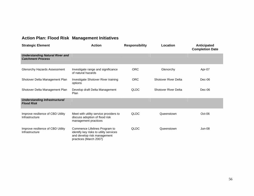
56
Action Plan: Flood Risk Management Initiatives Strategic Element Action Responsibility Location Anticipated
Completion Date
Understanding Natural River and Catchment Process
Glenorchy Hazards Assessment
Investigate range and significance of natural hazards
ORC
Glenorchy
Apr-07
Shotover Delta Management Plan Investigate Shotover River training options
ORC Shotover River Delta Dec-06
Shotover Delta Management Plan Develop draft Delta Management Plan
QLDC Shotover River Delta Dec-06
Understanding Infrastructural Flood Risk
Improve resilience of CBD Utility Infrastructure
Meet with utility service providers to discuss adoption of flood risk management practices
QLDC
Queenstown
Oct-06
Improve resilience of CBD Utility Infrastructure
Commence Lifelines Program to identify key risks to utility services and develop risk management practices (March 2007)
QLDC Queenstown Jun-08

57
Management of Horne Creek Convene joint Council meeting with contractor to develop appropriate maintenance and management plan to manage residual risk
QLDC Queenstown Oct-06
Management of Horne Creek Convene joint Council meeting to develop an agreed protocol to manage development along creek boundaries
ORC Queenstown Mar-07
Flood Sensitive Urban Planning
Management of residual risk
Investigate flood risk management measures for public toilet facilities in foreshore reserves
QLDC
Glenorchy and Kingston
Nov-06
Management of residual risk
Investigate rezoning of foreshore land as public (reserve) land
QLDC
Glenorchy and Kingston
Jun-07
Equip the Community to Manage Flood Risk
Education and Awareness
Undertake a public flood awareness and education campaign
QLDC
District-wide
Nov-06 and ongoing
Flood Sensitive Urban Design
Flood Sensitive Design Guidelines
Development of CBD design guidelines
QLDC
Queenstown and Wanaka
CBDs
Nov-06

58
Robust Warning, Prediction and Communication Systems
Improvements to ORC Flood Monitoring Systems
Install additional rain gauge at headwaters of Lake Wakatipu
ORC
District-wide
Mar-08
Improvements to ORC Flood Monitoring Systems
Implement snow pack monitoring at Albert Burn site
ORC District-wide Mar-08
Improvements to ORC Flood Monitoring Systems
Replace / back up satellite link to Albert Burn and Cascade Hut rain gauges
ORC District-wide Mar-08
Improvements to ORC / QLDC Flood Communications
Convene annual flood communication workshop
ORC District-wide Following appointment of QLDC Emergency Manager
Timely Flood Emergency Response
Reduce time taken for service restoration
Work with utility service providers to implement findings of infrastructure resilience study into flood response procedures
QLDC
Queenstown and Wanaka
CBDs
Nov-06
QLDC Emergency Flood Response Finalise QLDC Emergency Flood Response Procedures
QLDC Region - wide Nov-06

59
Comprehensive Base Data and Information
Wave Height Analysis
Investigation of possible wave heights during flood events
ORC
Lakes Wakatipu and
Wanaka
Apr-07
Reliable Flood Height Information Investigation of 1999 flood levels and review of flood level maps as required
QLDC Kingston Nov-06
Appropriate Physical Works
Review of Horne Creek Capacity and Flood Protection Works
Development of an agreed operation and maintenance plan between ORC and QLDC
ORC
Queenstown CBD
Dec-06
Improve resilience of CBD Utility Infrastructure
Extension of Queenstown CBD sewer bypass line
QLDC Queenstown CBD Jun-08
Wave Mitigation Measures Investigate means of protecting buildings from risk associated with wave impact and debris
ORC /QLDC Queenstown and Wanaka CBDs
Jun-07
Review of Joint Flood Risk Management Strategy
Review of Strategy
Review, revision, and re-issue of Joint Flood Risk Management Strategy and assessment of work taken to date on associated initiative.
ORC /QLDC
District-wide
Oct-09
60
Appendix C: Flood Inundation Maps:
C1 Queenstown CBD
C2 Wanaka CBD
C3 Kingston
C4 Glenorchy
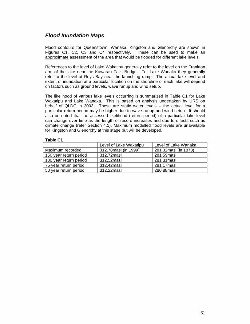
61
Flood Inundation Maps Flood contours for Queenstown, Wanaka, Kingston and Glenorchy are shown in Figures C1, C2, C3 and C4 respectively. These can be used to make an approximate assessment of the area that would be flooded for different lake levels. References to the level of Lake Wakatipu generally refer to the level on the Frankton arm of the lake near the Kawarau Falls Bridge. For Lake Wanaka they generally refer to the level at Roys Bay near the launching ramp. The actual lake level and extent of inundation at a particular location on the shoreline of each lake will depend on factors such as ground levels, wave runup and wind setup. The likelihood of various lake levels occurring is summarized in Table C1 for Lake Wakatipu and Lake Wanaka. This is based on analysis undertaken by URS on behalf of QLDC in 2003. These are static water levels – the actual level for a particular return period may be higher due to wave runup and wind setup. It should also be noted that the assessed likelihood (return period) of a particular lake level can change over time as the length of record increases and due to effects such as climate change (refer Section 4.1). Maximum modelled flood levels are unavailable for Kingston and Glenorchy at this stage but will be developed. Table C1 Level of Lake Wakatipu Level of Lake Wanaka Maximum recorded 312.78masl (in 1999) 281.32masl (in 1878) 150 year return period 312.72masl 281.59masl 100 year return period 312.52masl 281.31masl 75 year return period 312.42masl 281.17masl 50 year return period 312.22masl 280.88masl