quicksilver deposits of the mazatzal … in mazat2al range, ariz. 113 traverses the flat desert...
TRANSCRIPT

QUICKSILVER DEPOSITS OF THE MAZATZAL RANGE,ARIZONA.
By F. L. RANSOME.
FIELD WORK.
The examination on which the following notes are based was made in October and November, 1914, and occupied in all about 10 days. Particular acknowledgment is due to Mr. E. H. Bowman and Mr. William Reynolds, of Phoenix, for information and personal guidance and for considerate hospitality of a quality rare even among those friends of the geologist, the western prospectors. A part of the examination \yas made in company with Mr. W. Spencer Hutchinson, mining engineer, of Boston, who came a few days after my arrival, to investigate for his clients the possibility of mining these deposits. To him and to his associate, Mr. J. V. N. Dorr, of New York, I am indebted for a manuscript copy of their report, with permission to make such use of the data it contains, particularly of the assays, as should be deemed appropriate.
SITUATION AND MODES OF ACCESS.
The Mazatzal Range is a prominent well-defined mountain ridge in central Arizona (see fig. 6), with a trend a little west of north and a length of about 40 miles. It lies between Verde River on the west and Tonto Creek on the east, both streams flowing southward into Salt River. At the north end of the range is North Peak, which has an altitude of about 7,600 feet. Near the south end, the mountain known as Four Peaks, a noted landmark throughout a large area in central Arizona, attains an elevation of 7,645 feet. From North Peak to Salt River the crest of the range has been made the boundary line between Gila County on the east and Maricopa County on the west.
The Mazatzal Range is one of many n ountain ridges of approxi mately rectilinear plan, all nearly parallel in trend, that characterize the belt of rugged country bordering the Arizona Plateau along its southwest side. North Peak is 15 miles south of and in full view of the great Mogollon escarpment, which in this part of Arizona marks imposingly the edge of that plateau. The entire range is in the Tonto National Forest.
ill

112 CONTRIBUTIONS TO ECONOMIC GEOLOGY, 1915, PART I.
The quicksilver deposits about to be described occur in a strip of country about 6 miles long that extends northeastward across the Mazatzal Range in the vicinity of Pine Butte, 11 miles south of North Peak. Mount Ord, one of the prominent and well-known peaks of the range, is a little less than 6 miles south of the quicksilver belt.
All the claims are in the Sunflower mining district and most of them lie in the northwest corner of the Roosevelt quadrangle, of which a topographic map on the scale of 1:125,000 (approximately 2
MARTCOPA CO \
FINAL " CO \0
FIGURE C. Outline sketch map of the Mazatzal Range and surrounding region in central Arizona.
miles to the inch) has been issued by the Geological Survey. Some of them, however, extend into the Verde quadrangle, of which the best map obtainable is a very unsatisfactory reconnaissance sheet published in 1885 on the scale of 1:250,000 (nearly 4 miles to the inch).
Sunflower camp, near which most of the development work on the west slope of the range has been done, is at an elevation of about 4,350 feet, ,on the west fork of Sycamore Creek, a tributary of the Verde which enters that stream opposite old Fort McDowell. The camp is about 70 miles from Phoenix by road and trail. The road

QUICKSILVER IN MAZAT2AL RANGE, ARIZ. 113
traverses the flat desert country north of Salt River and crosses the southern end of the McDowell Mountains to Fort McDowell. Here the Verde is forded and the road continues up the generally dry bed of Sycamore Creek. At the forks of the creek, about 4 miles north of the Sunflower ranch, the road ends and the remaining 3 miles of the journey must be traversed by trail. The road is rough at the best, and at the time of visit, hi October, 1914, much of it was impassable for heavy wagons. Freighting from Phoenix or Mesa to the Sunflower camp was reported to cost from $40 to $50 a ton.
Bowman's camp, about a mile northwest of Sunflower camp and about 800 feet higher, is reached by a steep rough trail. Martin's camp, on the east fork of Sycamore Creek, is about 2 miles north east of Sunflower camp, in a straight line. It is most easily reached by trail from the forks of Sycamore Creek. About half a mile north west of Martin's camp is Bowman & Reynolds's Maricopa camp.
The claims in Gila County, on the east slope of the range, are most readily accessible from Tonto Creek, along which an auto mobile stage line runs with daily service between Roosevelt and Payson. Connections are made at Roosevelt for Globe and Phoenix. From Hardt's ranch, about 5 miles south of Deer Creek, a trail goes west over a local divide to Gold Creek and up that creek to Reynold's camp, near its head. The distance from Phoenix to Roosevelt is about 75 miles; from Roosevelt to Hardt's ranch 37 miles, and from the ranch to Reynolds's camp 5 miles.
Most of these prospects on the east side of the range are on slopes that drain into Gold Creek, a stream that flows eastward and joins Tonto Creek about half a mile above the mouth of Gun Creek. Some claims, however, nearly due east of Pine Butte, are on the side of a ridge that drains to Cane Creek, a tributary of Slate Creek which in turn flows into the Tonto about 2£ miles south of Gun Creek.
The quicksilver belt is all in rough, mountainous country ranging in elevation from 4,000 to 6,000 feet. The slopes are steep and the streams flow in narrow ravines. Water is not plentiful, but enough could probably be obtained from springs and by pumping from the larger stream bottoms to suffice for metallurgical operations on a small scale. Pines and cypresses are fairly abundant on some of the ridges, and oaks, sycamores, and other deciduous trees flourish along the watercourses. Firewood delivered at the furnace of the Sun flower Cinnabar Mining Co. costs $4 a cord.
HISTORY.
Cinnabar was discovered in the Sunflower district in October, 1911, by E. H. Bowman, of Phoenix, while prospecting for gold. He lo cated the Native, Packover, Titanic, Jasper, Go By, and lone claims.

114 CONTRIBUTIONS TO ECONOMIC GEOLOGY, 1915, PAET I.
These were purchased for $10,000 by the Sunflower Cinnabar Mining Co., organized in February, 1913, and capitalized at $1,000,000. The company acquired nine other claims in addition to those purchased from Bowman. In September, 1913, a 10-retort furnace was com pleted by the company. At the time of visit 2 flasks of quicksilver had been shipped and about 3 flasks were in hand.
Other claims were located soon after Bowman's discovery, but the Gila County deposits were not found until the spring of 1914.
GENERAL GEOLOGY.
The geology of the Mazatzal Range is not yet known in detail. At the south end of the range the Paleozoic era is represented by the same formations (see fig. 7) that occur in the Globe and Ray quad rangles, 1 and a typical section of these rocks from the pre-Cambrian granite to the Carboniferous limestone is well displayed in the canyon of Salt River near the Roosevelt dam. Four Peaks is composed in part of a medium-grained gneissic quartz-mica diorite, presumably pre-Cambrian.. Between Four Peaks and Mount Ord the range, as seen from the valleys, appears to consist principally of pre-Cambrian granitic rocks. The prevailing rock along Sycamore Creek on the west side of the range is a rather coarse porphyritic granite similar to granite known to be of pre-Cambrian age in other localities in Arizona.
As may be seen in the steep sides of many flat-topped buttes ancl ridges, this granite is overlain by coarse granitic detritus, beds of tuff, and a capping of lava, generally basalt. Some dark dikes, presum ably basalt, cut through the arkose and tuff. All these rocks are probably of Tertiary age.
On the north slope of Mount Ord the granite is succeeded by a belt of schistose and slaty rocks which crosses the range obliquely with a northeast-southwest trend. As exposed in the Mazatzal Range this belt has a width roughly estimated at 5 miles. To the northeast, where it crosses Tonto Basin and extends past the north end of the Sierra Anc"ha, the.area of schistose rocks is probably at least 15 miles wide.
The descriptions of A. B. Reagan 2 and his rough reconnaissance map are not altogether clear on this point, but the belt of schistose rocks, irregularly overlapped in places by younger formations, appears to extend eastward across the upper parts of Cherry, Canyon, and Cibicu creeks, beyond which it probably passes under the horizontal beds of the Arizona Plateau. Toward the southwest the schists are exposed for only a mile or two beyond Sycamore Creek, passing in that
1 Ransome, F. L., The Paleozoic section of the Ray quadrangle, Adz.: Washington Acad. Sci. Jour., vol. 5, pp. 380-388,1915.
2 Geology of the Fort Apache region in Arizona: Am. Geologist, vol. 32, pp. 265-308, 1903.

QUICKSILVER IIST MAZATZAL RANGE, ARIZ. 115
^?PSil
^X | "- / | Xj' - ^ 1
r / - s i - ' x _ '\ \ / ^ i ^\ ,
'{$* *-*"»*'/,90^/^\\# \\
* // * 1 \\ = || =s
n~" ""^n
1 1
1
l I-S-H H-i i ii i i i
"l" "'SIL111!! ^
- 1 . i JL i _L -L i -L"
n
Gila conglomerate L/NCO/VFO/?M/Tr
'Dacite flow
Whitetail conglomerate- UNCONFORMITY
Andesite tuff and breccia
- UNCONFORMITY
Tornado limestone,1,000 + feet
Martin limestone, 325 feet
Troy quartzite, 400cfeet
Mescal limestone with flow ofbasalt on top, 250 feet
Dripping Spring quartzite, 450 feet
/Barnes conglomerate, 15-20 feetPioneer shale, 150 feet
\Scanlan conglomerate, 1-15 feet
Pinal schist and granitic rocks
EARLY QUATERNARY ?
TERTIARY?
CRETACEOUS?
CARBONIFEROUS
DEVONIAN
CAMBRIAN?
PRE-CAMBRIAN
FIGURE 7. Generalized columnar section of the region adjacent to Ray, Ariz.

1.1.6 CONTRIBUTIONS [10 ECONOMIC GEOLOGY, 1915, PABT I.
direction beneath Tertiary lavas. The southeast boundary of the schist belt crosses Sycamore Creek near where the stream forks, about 4 miles north of the Sunflower ranch. The line swings across the northern slope of Mount Ord, between the granitic summit of that peak and Slate Creek, crosses Tonto Creek near the mouth of Gun Creek and passes through Delshay Basin, near the north end of the Sierra Ancha. The northwest boundary crosses the Mazatzal Range just south of the rugged quartzite masses of Mazatzal Peak, Deer v Creek, which heads on the south side of the peak, being chiefly in \ schist. It passes across Tonto Basin a mile or two south of Payson.
This belt of schist", lying between areas where most of the funda- ' mental rock is pre-Cambrian granite, appears to coincide with a ridge or barrier of considerable importance in Paleozoic time. South east of it the Paleozoic section is, in general, that of the Globe-Ray region. Northwest of it the section corresponds in its major features to the Grand Canyon sequence. The existence of such a ridge east of the region here described in what he interprets as Algonkian time has been suggested by Reagan. 1 He does not, however, appear to have recognized the coincidence of this ridge with a line of division between Paleozoic sections of different character! These differences it is hoped to bring out more fully and clearly in another paper. It must suffice to state here that they relate chiefly to what are sup posed to be the Cambrian strata, the Tonto group on the north of the schist belt being very different from'the Apache group on the south of that belt.
Associated with the schists and slates in the Mazatzal Range and at the north end of the Sierra Ancha are great masses of quartzite, accompanied by some conglomerate and shale. These rocks are clearly older than the Apache and Tonto groups (Cambrian). They make up Mazatzal Peak and apparently most of the northern part of the Mazatzal Range. They are present on the north side of Delshay Basin, much folded and faulted and unconformably over lain by the nearly horizontal Paleozoic beds of the Apache group. At Natural Bridge, also, on Pine Creek, 11 miles north of North Peak, uptilted hard conglomerate and quartzite rest on granite and are unconformably overlain by the horizontal Paleozoic beds. The older rocks in places project as hills through the Cambrian sandstone into the overlying Devonian (?) limestone. This conglomerate and quartzite are probably the same as the pre-Cambrian conglomerate and quartzite of the Mazatzal Range.
Some of the quartzite beds of the Mazatzal Range are infolded with the schists and are possibly an integral part of the schist series. The larger bodies of quartzite, however, such as that of Mazatzal Peak,
i Op. cit., p. 277,
QUICKSILVER IN MAZATZAL RANGE, ARIZ. 117
are associated with beds of conglomerate that contain flakes of schist showing that the quartzite, while pre-Cambrian, is distinctly younger than the schist. Whether the pre-Cambrian quartzites of this region are all or only in part younger than the schist can be determined only by detailed work.
The volcanic rocks under which the schist passes at its southwest end have a thickness of about 1,000 feet on Saddle Mountain. At the base is a soft brown tuff, andesitic or basaltic, with many schist fragments. This appeared to be from 50 to 60 feet thick. It is overlain by light-gray fine-grained andesitic tuff of approximately the same thickness. Above this lies about 200 feet of coarse andes itic tuff-breccia, the fragments being mostly a light-gray horn- blende-biotite andesite. This is succeeded by about 300 feet of andesitic flow breccia, which appears to pass upward without recog nizable plane of demarcation into a somewhat porous pink lava which, although resembling the dacite of the Globe-Ray region, proved on microscopic examination to be a fresh hornblende andesite with glassy ground- mass. This flow or part of the flow is at least 400 feet thick and forms the top of the mountain.
GEOLOGIC RELATIONS OF THE QUICKSILVER DEPOSITS.
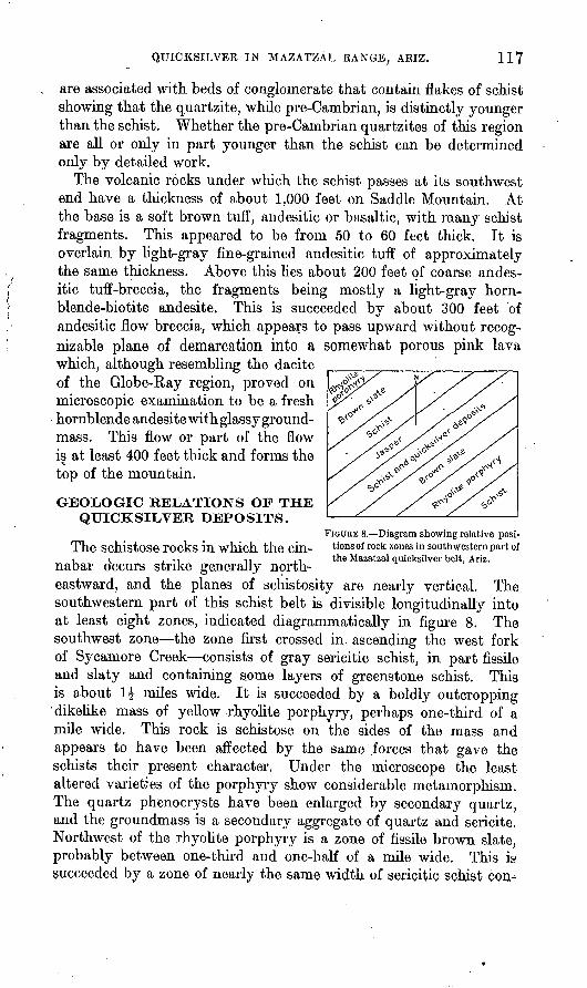
FIGURE 8. Diagram showing relative posi-The Schistose rocks in which the GUI- tionsof rock zones in southwestern part of i < . ., 11 .-, the Mazatzal quicksilver belt. Ariz.nabar occurs strike generally north
eastward, and the planes of schistosity are nearly vertical. The southwestern part of this schist belt is divisible longitudinally into at least eight zones, indicated diagrammatically in figure 8. The southwest zone the zone first crossed in ascending the west fork of Sycamore Creek consists of gray sericitic schist, in part fissile and slaty and containing some layers of greenstone schist. This is about 1£ miles wide. It is succeeded by a boldly outcropping 'dikelike mass of yellow rhyolite porphyry, perhaps one-third of a mile wide. This rock is schistose on the sides of the mass and appears to have been affected by the same forces that gave the schists their present character. Under the microscope the least altered varieties of the porphyry show considerable metamorphism. The quartz phenocrysts have been enlarged by secondary quartz, and the groundmass is a secondary aggregate of quartz and sericite. Northwest of the rhyolite porphyry is a zone of fissile brown slate, probably between one-third and one-half of a mile wide. This is succeeded by a zone of nearly the same width of sericitic schist
118 CONTRIBUTIONS TO ECONOMIC GEOLOGY, 1915, PART I.
taining here and there layers of squeezed conglomerate, of slate, of interlaminated hematite and jasper, of limestone, and of greenstone schist. This is the zone in which most of the cinnabar deposits in Maricopa County have been found. Northwest of it is a zone of a very conspicuous rock consisting of thin layers of yellowish dolomitic limestone and bright red jasper. The layers are considerably con torted and the brittle jasper in particular appears to have been broken and displaced by movement in the mass, so that in places the limestone is crowded with red fragments. This rock is hard and resistant and forms prominent outcrops. The zone, however, is irregular in width and apparently is discontinuous. Northwest of the jasper zone is a zone of schist which, although similar to that on the southeast side of the jasper, appears to contain a larger propor tion of squeezed grits and conglomerates. The pebbles are in part flaky and suggest derivation from older schists. A second zone of brown slate lies northwest of this schist and this is succeeded by a second zone of rhyolite porphyry.
It will thus be seen that in the southwestern part of the quick silver belt the distribution of the rocks is such as to suggest that the jasper zone occupies the axis of a compressed syncline or anticline. Toward the northeast, on the east slope of the Mazatzal Range, the symmetrical arrangement of the rock zones is less evident.
The rhyolite porphyry which is so prominent on the west fork of Sycamore Creek, near the Sunflower camp, was not seen on the east fork. At the place where the porphyry might be expected that stream cuts through at least 40 feet of coarse conglomerate, which contains pebbles of slate and red jasper and seems to be part of the schist series. South of the conglomerate, and also seemingly involved in the schist complex, is a considerable body of reddish altered igneous rock, apparently rhyolite. North of the conglomerate is the first zone of brown slate and then the second schist zone. The brown- slate zone continues northeastward through the saddle just north of Pine Butte, on the crest of the Mazatzal Range, and is said to die out on Deer Creek, on the east slope of that range. The top of Pine Butte is rhyolite porphyry.
In Gila County, east of Pine Butte, the quicksilver deposits appear to occur in the southeast schist zone, the one crossed first in ascending Sycamore Creek, and therefore not the same zone as that containing the deposit on the west fork of Sycamore Creek.
Just west of Reynolds's camp, near the head of Gold Creek, is a mass, several hundred feet wide, of very fine grained reddish-brown rock, which was supposed in the field to be a dike in the schist. It is not schistose and may therefore be later than the general metamor- phism recorded by the schists. Nevertheless the microscope shows

QUICKSILVER IN MAZATZAL RANGE, ARIZ. 119/
considerable alteration. The groundmass retains no recognizable igneous texture and is traversed by a network of microscopic vein- lets of sericite. The rock is apparently an altered rhyolite, and its felsitic character suggests that it may be extrusive.
Small dikes of diorite porphyry appear to be fairly abundant in schists along Gold Creek and on the ridge separating Gold Creek from Hardt Creek, the next stream to the north.
GENERAL CHARACTER OF THE DEPOSITS.
The quicksilver deposits of the Sunflower district are lodes, which in general conform to the lamination of the schist in which they lie. In the southwestern part of the quicksilver belt three approxi mately parallel lodes are recognized. These are from 300 to 500 feet apart. The middle or Packover lode appears to be the longest and the best metallized and is the one on which nearly all development work has been done.
The lodes consist of veinlets, films, and specks of cinnabar in schist and as a rule have no definite walls. Associated with the cinnabar, particularly in the larger veinlets, is.more or less gangue. The usual gangue-forming minerals below the zone of oxidation are calcite; a buff ferruginous carbonate, probably of variable composition, which leaves a residue of limonite on weathering; and quartz. Some barite is reported by Mr. Bowman. Sulphides other than cinnabar are rare within the veinlets, although small crystals of pyrite closely asso ciated with flecks of cinnabar are fairly abundant in some of the schist near veinlets. A very little chalcopyrite was noted. In some ore taken from the Tatum group by Mr. Reynolds and received since the field examination was made, specularite occurs in small aggre gates of glistening scales associated with cinnabar in a quartz and ferruginous carbonate gangue. In ore taken from a cut in the Pack- over lode on the Packover claim are a few minute specks of a bright- gray metallic mineral, which, as tested by W. T. Schaller, of the Geo logical Survey, gave off no sublimate in a closed tube and no reaction for copper. It is therefore probably not tetrahedrite. Neither does it appear to be stibnite. The quantity obtained was too small to per mit identification of the mineral. - Globules of native quicksilver occur with some, of the cinnabar.
Most of the veinlets or stringers lie in the cleavage planes of the schist and range from mere films to veins 6 inches thick. Stringers over an inch thick are exceptional. In some places stringers cut across the schistosity. As a rule the veinlets interleaved with the schist are not individually persistent for more than a few feet; they thin out and are succeeded by others. Many of the stringers that cut across the schists are very irregular in course and width. The abun-

120 CONTRIBUTIONS TO ECONOMIC GEOLOGY, 1915, PART I.
dance of the cinnabar veinlets and the total width of the metallized zone vary greatly from place to place. At one surface exposure of the Packover lode on the Go By claim the schist for a width of at least 75 feet contains little veinlets of cinnabar and gangue, all less than 3 inches wide and most of them less than 1 inch wide. This zone of veinlets is not bounded by definite walls, and the schists probably contain some cinnabar outside of the 75-foot belt. At this locality Mr. Hutchinson, by careful prospecting and counting, established the existence of 17 veinlets in a width of 9 feet. The aggregate thickness of these veinlets was estimated by him at 15 inches. Another count 50 feet away on the same lode gave substantially the same result. Besides occurring in the veinlets the cinnabar, particularly near the veinlets, is disseminated as specks and small irregular blotches through the schist.
A sample taken by Mr. Hutchinson at the locality just indicated, by making two cuts across the 9-foot zone and rejecting so far as pos sible the barren schist between the stringers, yielded on assay 3.60 per cent of quicksilver. That is, the result represents approximately the contents of an aggregate width of 15 inches of stringers out of a total width of 9 feet of lode. It may be estimated roughly from the foregoing data that a continuous sample across the 9 feet, might assay from 0.5 to 1 per cent of quicksilver.
Although the individual veinlets are not persistent, the Packover lode as a whole is traceable with reasonable certainty for at least 3 miles. It is. not continuously exposed for that distance, but its presence is indicated by the occurrence of cinnabar here and there along its outcrop.
As a rule the cinnabar lodes do not crop out conspicuously. The course of the lode if recognizable at all as a topographic feature is more commonly marked by a slight depression than by a ridge or projection. Under the influence of weathering the carbonate gangue is dissolved, leaving behind a spongy residue of limonite and quartz. The cinnabar, though fragile, is chemically very stable, and where originally present in the lode may generally be found in the oxidized material at the surface. No evidence was obtained that indicated any considerable solution of the cinnabar or any downward enrich ment of the lodes.
CLAIMS AND MINING DEVELOPMENT.
As already noted, the quicksilver deposits occur partly in the schist zone lying between the jasper zone on the northwest and a brown-slate zone on the southeast (see fig. 8) and partly in the south east schist zone. The line of deposits between the jasper and brown slate may conveniently be referred to as the Maricopa County belt. That lying southeast of it may be designated the Gila County belt.

QUICKSILVER IN MAZATZAL RANGE, ARIZ. 121
The claims along the Maricopa County belt were grouped at the time of visit as follows, the enumeration being from southwest to northeast:
Mining claims in Maricopa County belt.^
Owner. Number of claims.
1546
1468
Length along celt
in feet.
1,500400
4,5003,0003,0004,5003,0004,500
24,400
Overlapping at its southwest end the foregoing line of claims is the line of claims on the Gila County belt. At its southwest end, in Maricopa County, is the L and N group of six or seven claims be longing to Christopher Martin and others. The total length of this group along the belt was not definitely ascertained but is understood to be five claim lengths, or 7,500 feet. On this understanding the holdings along the Gila County belt are as follows:
Mining claims in Gila County belt.
Owner.
C. Martin and others (L ai Bowman & Reynolds (Gil
Number of claims.
7(?) 14
1
Length along oelt
in feet.
7,500(?) 16,500 1,500
25,500
Whether there is an interval between the claims of Martin and those of Bowman & Reynolds was not learned.
The claims of Bowman & Reynolds, enumerated in order along the lode from southwest to northeast, beginning southeast of Pine Mountain, are as follows: Mercury Sulphide No. 3, Bernice No. 1, Mercury Sulphide No. 1, Mercury Sulphide No. 2, North Star No. 1, North Star No. 2, Northern Light No. 1, and Mercury Sulphide Nos. 4, 5, 6, and. 7. The end line between North Star No. 1 and North Star No. 2 lies along the bed of Gold Creek.
On the Martin, Raymer, & Hayden group and the Hayden & Allison group no development work has yet been attempted.
On the Sunflower group (fig. 9) two tunnels have been run nearly west under the Go By claim from the slope above the west fork of Sycamore Creek. The upper or No. 2 tunnel (fig. 10) is from 250 to
10427° Bull. 620 10 9

122 CONTRIBUTIONS TO ECONOMIC GEOLOGY, 1915, PART I.
300 feet above the creek. It is a crosscut about 150 feet long. From the end of the crosscut a drift of about the same length has been run southwestward on the Packover lode. A drift about 100 feet long run from the north side of the crosscut is apparently not on the lode. The No. 4 tunnel is about 100 feet lower. This also is a crosscut and runs in the same direction as the upper tunnel. It is about 500 feet long and cuts the lode about 390 feet from the portal. A drift 50 to 60 feet long has been run on this lode, supposed to be the
i.opo 2,0pp FEET
FIGURE 9. Sketch plan of the claims of the Sunflower Cinnabar Mining Co.'s group, Maricopa County,Ariz.
Packover. Northeast of these tunnels a small open cut has been made on the Sunnyside claim and some cinnabar has been obtained from what is considered a continuation of the Packover lode.
On the Tatum group two tunnels have been run. The lower, re ported to be at an altitude of about 4,900 feet, was not visited. It was said to be between 200 and 300 feet in length but had not at that time reached the lode. The upper tunnel, about 150 feet higher up the same hill, was about 235 feet long at the time of visit. It runs

QUICKSILVER IN MAZATZAL RANGE, ARIZ. 123
S. 33° E. and crosscuts the schists, which here dip 60°-70° SE., whereas the prevailing dip in the district is to the northwest.
On the Maricopa group a crosscut tunnel at an elevation of about 4,900' feet has been run northwestward to cut a lode that outcrops about 2,000 feet higher up the hill, on the Lost Packer No. 8 claim. The length of this tunnel was not recorded at the time of visit but was probably between 200 and 300 feet. It had not reached the lode.
FIGURE 10. Sketch plan of upper or No. 2 tunnel of the Sunflower workings, Maricopa County, Ariz.
Northeast of the Maricopa group the only workings on the quick silver deposits at the time of visit were merely such shallow cuts and pits as fulfilled the requirements of the assessment provision of the mining law.
DESCRIPTIVE DETAILS.
The two tunnels of the Sunflower Cinnabar Mining Co. were both run so as to cut the Packover lode beneath a section of its outcrop where little or no cinnabar has been found. The lode where cut by the tunnel appears to have a width of about 12 inches, and the prin cipal stringer, which is nearly 6 inches in maximum width, consists of buff ferruginous carbonate, white calcite, quartz, and cinnabar. An assay of ̂ a sample taken across a width of 7 inches of the lode at this point yielded Mr. Hutchinson 1.25 per cent of quicksilver. Of three samples taken by him from this tunnel the richest, repre senting a width of 5 inches, gave 3 per cent of quicksilver, indicating roughly, at the present high price (quotations in June, 1915, taken for convenience at $75 a flask of 75 pounds), $80 ore.
124 CONTRIBUTIONS TO ECONOMIC GEOLOGY, 1915, PART I.
A few feet north of the crosscut the vein disappears. It is appar ently cut off obliquely by a fault, but the displacement is probably not great. South of the crosscut the vein has been followed for about 100 feet" to a point where the drift leaves the vein, which passes into the footwall.
The lode as seen in the lower tunnel is of the same general character as in the upper tunnel. For a part of its course at least it follows a layer of squeezed limestone in the schist. This layer is cut by irregular stringers of quartz and white calcite carrying more or less cinnabar. In places also paper-thin seams of cinnabar without gangue are fairly abundant in the schist. In the schist exposed in the crosscut tunnel a little cinnabar was noted for at least 50 feet west of the main drift. Here as elsewhere the lateral limits of the lode are indefinite.
A sample representing a width of 3 feet across the best part of the lode as exposed in the lower tunnel gave, according to Mr. Hutchinson, a little less than 2 per cent of quicksilver.
On the Sunnyside claim, about a thousand feet north of the tunnels, the Sunflower Cinnabar Mining Co. was obtaining ore for its retorts at the tune of visit from a small open cut. Here was exposed 'a veinlet, measuring 3 inches in its widest part, of cinnabar and limonite lying in the planes of lamination of the schist. The veinlet was exposed with nearly maximum width at the northeast end of the cut and had been followed to a point where it pinched out to the south west, in a distance of 6 feet. This is probably the largest and richest single veinlet seen. Mr. Hutchinson's report shows that it contains 38.2 per cent quicksilver, roughly $860 ore at present prices, but a 2-foot sample across the lode, with the stringer omitted, gave only 0.7 per cent, corresponding to $14 ore.
The upper tunnel of the Tatum group on the Lost Packer No. 1 claim cuts a stringer of ferruginous carbonate, quartz, and cinnabar 96 feet from its portal. A sample from this stringer, which, as exposed in the tunnel, is from 1 to 3 inches wide, carried 2.7 per cent of quicksilver, according to Mr. Hutchinson. At 150 feet from the portal the tunnel passes through a fairly strong gouge lying in the planes of schistosity and another similar gouge was noted about 195 feet from the portal. No cinnabar was seen in connection with these gouge-filled fissures. Since the tunnel was visited it has been reported that some cinnabar has been found in the "Tatum tunnel" about 115 feet from the portal. It is not clear whether the account received refers to the upper or lower tunnel. A small sample of this material sent to the Geological Survey by Dr. Burt Ogburn, of Phoenix, shows small veinlets of ferruginous brown carbonate, calcite, and quartz carrying cinnabar and little nests of specular hematite. As the material includes considerable limonite, it may perhaps have come from the upper tunnel or from some new opening.

QUICKSILVER IN MAZATZAL RANGE, ARIZ. 125
On the Lost Packer No. 8 claim, of the Maricopa group, there is a strong outcrop, fully 2 feet wide, of quartz and silicified schist carrying a little cinnabar. The lode has the usual northeast- southwest strike and dips about 80° NW. It outcrops along the hillside at an elevation of about 5,100 feet and at the time of visit had not been cut by the crosscut tunnel, 200 feet lower. The quartzite outcrop is apparently local, the course of the lode being indicated elsewhere by a soft rusty zone in'the schist. The belt of schist in which this lode occurs is the same as that which constitutes the country rock of the Sunflower Cinnabar Mining Co.'s deposits. It contains some lenses of limestone near the Maricopa tunnel.
On the L and N group some rich stringers of quartz, and cinnabar up to an inch in width had been exposed at the time of visit by
" shallow prospecting pits, and a furnace with one retort was being built. 1 This lode lies southeast of the Maricopa lode, being separated from it by the southeast belt of brown slate and by a belt of con glomerate which in this part of the district appears to occupy the same position with relation to the other rock belts that the rhyolite porphyry does near the Sunflower camp.
On the Bowman & Reynolds Gila County group the most south westerly opening at the tune of visit was a small cut on the Bernice No. 1 claim. The country rock here is a gray-brown granular schist which retains, distinct indications of an original clastic structure and is apparently a metamorphosed sandstone or grit. The cinnabar occurs with quartz in small stringers, the widest measuring 1 inch, and in rather sparsely dispersed small specks through the adjacent rock. A sample taken by Mr. Hutchinson across 2 feet of what appeared to be the most promising part of the lode gave him 1.4 per cent of quicksilver, equivalent to $28 ore. A dark dike of altered basaltic rock runs parallel with the lode a few feet to the northwest, following the structure of the schist.
About 800 feet northeast of the above cut, on the. same lode and near the crest of the ridge between Cane and Gold creeks, a small shaft, 8 or 10 feet deep, has been sunk on the Sulphide No. 1 claim. The shaft disclosed some cinnabar, but none of the material can rank as ore.
On the Northern Light No. 1 claim a prospect cut exposes a veinlet of quartz, limonite, and cinnabar, in places as much as 6 inches wide. Mr. Hutchinson's sample of this stringer gave 1.1 per cent of quick silver. Another sample from the same stringer, where from 1 to 3 inches wide, gave 2 per cent of quicksilver, and a sample across 4 feet of schist adjacent to the stringer gave a trace.
i Two flasks are reported to have been shipped In March, 1915.

126 CONTRIBUTIONS TO ECONOMIC GEOLOGY, 1915, PART I.
On the Mercury Sulphide No. 5 the lode shows the same general character as on the claims to the southwest. A sample taken by Mr. Hutchinson across a width, of 11 inches of croppings just above the location cut gave 3.3 per cent of quicksilver, corresponding to $66 ore.
OTHER DEPOSITS NEAR THE QUICKSILVER LODES.
North of Bowman's camp, in the area of schist lying northwest of the jasper belt, a prospect pit on ground belonging to Mr. Bowman shows arsenopyrite and a little vanadinite. Still farther north, in McFarlane Gulch, considerable prospecting has been done in the same schists on claims reported to belong to the Mormon Mining Co. Most of the work has been done on a nearly vertical vein striking north 55° east, or approximately parallel with the schist. A short tunnel has been run on this vein, but most of the development apparently was accomplished by a shaft, now caved, which was sunk near the creek. The vein as exposed near the surface is in some places 7 inches wide and consists of quartz, pyrite, possibly arsenopyrite, and bournonite. The remains of a small arrastre and some heaps of imperfectly roasted ore show that an attempt was made to work the vein for gold, possibly on the supposition that the bournonite was a gold telluride. A little galena was noted with the bournonite.
ORIGIN.
As regards the problem of the origin of the Mazatzal quicksilver deposits, the ascertainable geologic facts are not illuminating. The conditions, under which quicksilver deposits occur the world over have established fairly well a genetic connection between them and vol- canic activity. Owing to their mobility in solution, moreover, theconstituents of such ores are, in accordance with theory and actual experience, deposited nearer the surface than most sulphide ores. Consequently, although the Mazatzal ores are in pre-Cambrian schist, it is not probable that they were formed in pre-Cambrian time. That supposition would imply that they were deep-seated portions of deposits from which the upper parts had been removed by prolonged erosion. All that is known of quicksilver deposits suggests that they do not form at depths so great as would be demanded by the suppo sition that the Mazatzal deposits are pre-Cambrian. It is more likely that the ore constituents were introduced at a much later time, when the surface as a whole did not differ by many hundreds of feet of eroded material from that of to-day. It is a reasonable conjecture that the cinnabar found its way into the schists in Tertiary time and that its deposition was merely one phase of the volcanic activity of that period. The deposits, however, are not obviously connected

QUICKSILVER IN MAZATZAL BANGE, ATRIZ. 127
with any particular igneous rock, and the question whether they are most closely related to the basaltic or andesitic lavas of the region must, for the present at least, remain unanswered.
ECONOMIC POSSIBILITIES.
Not enough mining work has been done at the time of visit to deter mine whether the quicksilver deposits of the Sunflower district are susceptible of profitable exploitation. The geologic facts of occur rence and the sampling by Mr. Hutchinson indicate that the parts of the lodes of minable dimensions now exposed to view carry no more than 3 to 4 per cent of quicksilver at the most, although exceptional stringers here or there which might be sorted out from the broken ore are of much higher grade. To obtain a 3 or 4 per cent product that is, $60 to $80 ore at present prices considerable sorting would have to be done, with rejection of three-fourths or more of the rock broken. The chances for obtaining considerable quantities of 2 per Cent or $40 ore with only moderate sorting appear to be good.
When it is remembered that the New Idria mine 1 in California, the largest producer of quicksilver in the United States, has for some years been making substantial profits on ore from which 0.5 to 1 per cent of quicksilver is won, it is evident that the Mazatzal deposits have considerable promise. Although costs are probably lower in California than in Arizona the situation of the New Idria mine is com parable with that of the Arizona deposits in that the mine has a 60- mile wagon haul to the nearest railway. Mr. Hutchinson's sampling, while thoroughly reliable, was only preliminary to possible work and was rendered difficult by the lack of development. Before the deposits can be appraised at their probable value additional sampling will be necessary. This sampling should be directed particularly to the estimation of the probable available quantity of ore of the mini mum grade that can be profitably worked without sorting. To what width, for example, can a lode be mined as a whole to get a 1 to 2 per cent ore and how much of such ore can reasonably be considered available ?
Facts that promise well for future exploitation are the undoubted persistence of the lodes for long distances over the surface and the lack of any evidence of decrease of tenor with increase in depth. Too little has been done to prove that the lodes continue downward with out diminution in quicksilver content, and it is generally recognized that quicksilver ores as a rule are not deposited at as great depth as some other ores. Lindgren 2 states /that no quicksilver deposit has been worked to a depth of 2,000 feet below its outcrop. On the
i U. S. Geol. Survey Mineral Resources, 1911, pt. 1, pp. 902-903, 1912. * Lindgren, Waldemar, Mineral deposits, p. 472,1913.
128 CONTRIBUTIONS TO ECONOMIC GEOLOGY, 1915, PART I.
other hand, the work already done on these deposits gives no founda tion for a belief that the cinnabar is less abundant at moderate depth than near the surface.
The small. quantity of quicksilver thus far produced has been obtained by simply retorting the ore as mined, enough lime being produced from the gangue to effect reduction to the metallic state. It was evident, however, at the time of visit that considerable quick silver was being lost through the crudity of the operations. More efficient modes of treatment will have to be employed if the deposits are to be worked profitably for any length of time.
The present transportation facilities are very poor and any plan for profitably working these deposits will have to reckon with the long wagon haul to Phoenix, Mesa, or Globe.
It should be remembered that the conversions of assay percentage into value per ton as given in this paper are based on the present abnormally high price of quicksilver. They should be reduced by a third or half to correspond to a probable normal market price.