quiet zone 2007 final report - city of bellingham
TRANSCRIPT
FINAL
CITY OF BELLINGHAM QUIET ZONE REPORT
September 2007

City of Bellingham - Quiet Zone Report - Final September 2007
TABLE OF CONTENTS Executive Summary ............................................................................................................ 4
Introduction ......................................................................................................................... 6
Organization of this Report ............................................................................................. 6
Quiet Zones ......................................................................................................................... 7
Supplemental Safety Measures (SSMs) .......................................................................... 7
Alternative Safety Measures (ASM) ............................................................................... 9
SS Ms vs. AS Ms .............................................................................................................. 9
Alternative to Quiet Zones: Train Horn Noise Reduction .............................................. 9
Initiating a Quiet Zone .................................................................................................. 10
Existing Conditions ........................................................................................................... 12
Fairhaven Study Area ................................................................................................... 12 0
Harris A venue Crossing ................................................................................................ 12
Alaskan Ferry Access Road (6th Street) Crossing ........................................................ 13
Port of Bellingham (Private) Crossing .......................................................................... 14
Bayview Drive Crossing ............................................................................................... 14
Boulevard Park Pedestrian Crossing ............................................................................. 15
Bellingham Waterfront Study Area .............................................................................. 16
Pine/Wharf Street Crossing ........................................................................................... 16
Cornwall A venue Crossing ........................................................................................... 17
Beal Memorial Road Crossing ...................................................................................... 18
Laurel Street Crossing ................................................................................................... 18
Central Avenue Crossing .............................................................................................. 19
C Street Crossing .......................................................................................................... 20
F Street Crossing ........................................................................................................... 20
Future BNSF Track Alignment.. ................................................................................... 21
Quiet Zone Strategies ........................................................................................................ 22
The Fairhaven Quiet Zone ............................................................................................ 22
The Waterfront Quiet Zone ........................................................................................... 26
Pine/Wharf St. ............................................................................................................... 26
Cornwall A venue/Beal-Memorial Road ....................................................................... 26
- 1 -

City of Bellingham - Quiet Zone Report - Final September 2007
Laurel Street. ................................................................................................................. 27
Central Avenue Crossing .............................................................................................. 27
C Street Crossing .......................................................................................................... 27
F Street Crossing ........................................................................................................... 27
The Bayview Drive Quiet Zone Alternative ..................................................................... 30
Figures
Figure 1 - Four-Quadrant Gate System 8 Figure 2 - Two-Quadrant Gate System 8 Figure 3 - Sound envelopes of a wayside horn and a train-mounted horn,
Courtesy Railroad Controls Limited 10 Figure 4 - Harris Avenue crossing facing east with Amtrak Station in background 13 Figure 5 - Alaska Ferry crossing facing south toward Harris Avenue 13 Figure 6 - Private (Port) crossing to boat yard, facing east 14 Figure 7 - Private crossing facing west toward boat docks 14 Figure 8 - Bayview Drive facing north, showing entrance to Boulevard Park 15 Figure 9 - Boulevard Park Pedestrian path facing west. Pedestrian crossing
crosses tracks to the right of the stop sign shown 16 Figure 10 - Pine/Wharf Street facing south. Pine/Wharf turns up the hill
to the east toward State Street 17 Figure 11 - Cornwall Avenue facing west. Port facilities located north of
the crossing 17 Figure 12 - Beal-Memorial Road facing north. Guard gate to the Pott facilities
is shown in the background 18 Figure 13 - Laurel Street crossing facing west. BNSF approaches the crossing
while train activates the warning devices 19 Figure 14-Central Avenue facing west. Port facilities are shown in the
background across from the Roeder Avenue/Central Avenue intersection 19 Figure 15 - "C" Street facing west. Port facilities are shown located west
of the Roeder A venue/C Street intersection 20 Figure 16 - "F" Street facing west. Port facilities are shown in background,
west of Roeder Avenue/F Street intersection 21
Tables
Table 1 - Fairhaven Quiet Zone - Alternative Comparison Table Table 2 - Waterfront Quiet Zone -Alternative Comparison Table
- 2 -
25 28

City of Bellingham - Quiet Zone Report - Final September 2007
Appendices
Appendix A - Local Agency Funding Guidelines
Appendix B - BNSF Principles for Handling Requests for new Quiet Zones.
Appendix C - Vicinity Map Showing Limits of Quiet Zones
Appendix D - FRA Calculator Risk Index the Fairhaven Study Area (Baseline and Alternatives)
Appendix E - FRA Calculator Risk Index for the Waterfront Study Area (Baseline and Alternatives)
Appendix F - BNSF Preferred Rail Relocation Plan
Appendix G- Fairhaven Quiet Zone Alternatives I through 3 and cost estimates
Appendix H (Hl thru H6) - Fairhaven Quiet Zone Crossing Plans
Appendix I - Waterfront Quiet Zone Alternatives I through 5 and cost estimates
Appendix J (Jl thru Jll)- Waterfront Quiet Zone Crossing Plans
Appendix K - Bayview Drive Quiet Zone Alternative and estimate
Appendix L - Quiet Zone Timeline
- 3 -
City of Bellingham - Quiet Zone Report - Final September 2007
Executive Summary
The Department of Transportation, through the Federal Railroad Administration, issued a final rule, dated August 17, 2006, on the Use of Locomotive Horns at Highway-Rail Grade crossings. The train horn rule details the requirement for sounding the train horn at at-grade crossings and what remedies are available to silence the train horn while crossing at-grade crossings.
This report introduces the concept of quiet zones, and explains the rationale for the Federal Railroad Administration (FRA) policy with respect to approval of quiet zones. The report continues with a description of existing conditions at the at-grade railroad crossings within the project study area.
Each crossing was then evaluated for various quiet zone alternatives by applying a variety of Supplemental Safety Measmes (SSMs). The use ofa way-side horn (not considered an SSM under the train horn rule) was also evaluated.
In the report we divided up the crossings into three individual quiet zones, the Fairhaven Quiet Zone the Waterfront Quiet Zone and the Bayview Drive Quiet Zone. The table below identifies the range in costs in the establishment of a quiet zone.
Quiet Zones Evaluated for cost
Quiet Zone Min. Cost Max Cost
Fairhaven Quiet Zone $ 1,283,000 $ 2,032,000
Waterfront Quiet Zone $ 1,389,000 $ 3,523,000
Total Quiet Zone Costs $ 2,672,000 $ 5,555,000
Bayview Drive Quiet Zone* $ 364,000
*The Bayview Drive Quiet Zone is considered an interim Fairhaven Quiet Zone not figured into the total
We did not apply all of the SSM alternatives to all of the crossings. SSMs that were not considered or evaluated in this report were (I) one-way streets, and (2) grade separations (overpasses or underpasses).
This report has provided estimated costs for each of the evaluated alternatives. The estimated costs associated with implementing the Fairhaven Quiet Zone ranged from $1,283,000 to $ 2,032,000. The estimated costs associated with implementing the Waterfront Quiet Zone ranges from$ 1,389,000 to$ 3,523,000. The estimated cost associated with implementing the Bayview Drive Quiet Zone was $ 364,000. The higher cost estimates were reflective of the SSM alternative selected. The installation of four-
4

City of Bellingham - Quiet Zone Report - Final September 2007
quadrant gates, for example, cost more than the installation of median barriers, or the closure of the at-grade crossing(s).
All costs associated with the quiet zone will be the City's responsibility. In addition to construction costs, the BNSF will determine and invoice the City an anuual maintenance fee for the additional lights and gates installed at the at-grade crossing. Maintenance expense is estimated at$ 5,500 per crossing, per year.
The time associated in implementing a quiet zone to the time a quiet zone is constructed and the train stops blowing its horn through the crossings within the quiet zone is approximately 18 months.
Implementing a quiet zone will not guarantee that the train will stop blowing it's horn at all times and in all situations. A quiet zone will only reduce the train horn noise. It is required by federal law that the train must blow it's horn when (1) there is an apparent safety concern determined by the locomotive engineer, such as a trespasser crossing or walking along the tracks; (2) The train horn must be blown for the presence of railroad workers; and (3) The train must blow his horn prior to moving, such as when the train is in a rail yard or a train waiting for the passing of a train.
In the City of Bellingham where the waterfront is an important asset and provides many fornlS of recreational opportunities, there is the opportunity for pedestrians to trespass across the railroad tracks to gain access to the waterfront. Not all pedestrians use the Taylor Street pedestrian overpass or the Bayview Drive at-grade crossing to access the Boulevard Park area waterfront. There have been many instances where the train horn is blown for trespassers in this area.
The Quiet Zone will not prevent the sounding of the train horn when the train travels through the tunuel at Clark's Point in South Bellingham. Trespassing at the Clark's Point tum1el happens often and the train will continue to blow it's horn when necessary.
5

City of Bellingham - Quiet Zone Report - Final September 2007
Introduction HDR Engineering has prepared this report to document the findings of a study to investigate the possibility ofreducing railroad-related noise in Bellingham, Washington. The investigation focused on implementation of a "quiet zone," as well as other strategies that would reduce train horn noise.
Organization of this Report This report first introduces the concept of quiet zones, and explains the rationale for the Federal Railroad Administration (FRA) policy with respect to approval of quiet zones. The report continues with a description of existing conditions near the at-grade railroad crossings within the project study area.
From the evaluation of the existing conditions of each crossing, each crossing it is then evaluated for various quiet zone alternatives by applying a variety of Supplemental Safety Measures (SS Ms). The use of a way-side horn (not considered an SSM under the train horn rule) is also evaluated.
The crossings along the Waterfront from Harris Avenue to F Street were divided into two separate qniet zones: the Fairhaven Quiet Zone and the Waterfront Quiet Zone. The report reviews three alternatives that were evaluated and estimated for the Fairhaven Quiet Zone and five alternatives that were evaluated and estimated for the Waterfront Quiet Zone. Investigations revealed that within the Fairhaven Quiet Zone there was an opportunity to pursue an interim, less expensive quiet zone, identified as the Bayview Drive Quiet Zone. A brief discussion of which concludes the report.
6

City of Bellingham - Quiet Zone Report - Final September 2007
Quiet Zones The FRA has issued a revised final ruling regarding the use of train horns at public roadway-rail at-grade crossings nationwide. The ruling took effect September 18, 2006 and replaces the current mixture of state and local laws governing the use oflocomotive horns at such crossings. This federal ruling also details the procedure by which a quiet zone maybe established.
The object of a quiet zone is to replace the train horn with a system of devices that are considered by the FRA to effectively compensate for the absence of the warning provided by the locomotive horn. The FRA rates the effectiveness of a proposed quiet zone, and ultimately approves the zone, through a comparison of risk scores before and after implementation of specified alternative devices. These risk scores are obtained using the FRA's web-based Quiet Zone Calculator. I The calculator contains the stored crossing data for every public crossing in the nation, including each crossing's individually determined baseline level of risk, termed the Risk Index With Horns (RIWH). The existing base score for the Bellingham quiet zones being considered can be found in Appendices B and C.
To secure FRA approval, the risk index after quiet zone improvements are implemented must be less than the base case RIWH. The calculator allows investigators to input the calculated value of quiet zone improvements into individual crossings; the tool will return a comparative risk value and an assessment of the potential for approval of proposed quiet zone improvement measures.
However, it remains the locomotive crew's prerogative to sound a train horn whenever the crew perceives a situation that requires it, such as the presence of a pedestrian on the tracks, or workers and equipment within 25 feet of the tracks. In order to reduce the use of train horns at crossings, a quiet zone strategy must provide physical barriers to prevent motorists from entering an at-grade crossing when trains approach and occupy a crossing. The FRA regulations stipulate that engineering solutions !mown as SSMs, intended to increase the relative safety at each crossing, must be installed prior to the inauguration of a quiet zone.
Supplemental Safety Measures (SSMs) Typical SSMs that would be appropriate for the study area identified include the following:
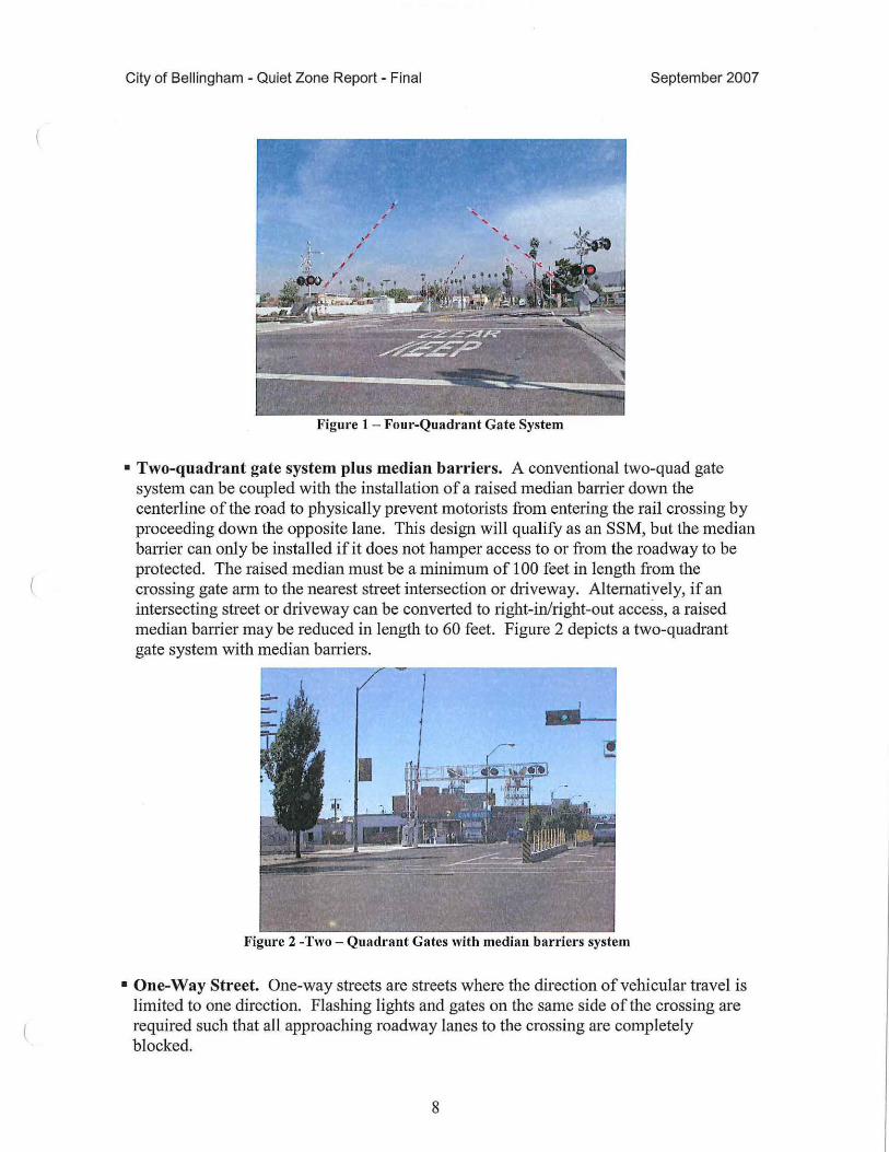
• Four-quadrant gate system. A four-quadrant gate system prevents motorists from entering the rail crossing from any travel lane, even if the motorist attempts to proceed around gates by using the oncoming travel lane. A typical four-quad gate system includes safety measures to provide an escape route for motorists inside the crossing when the crossing signals are activated. Figure 1 depicts a typical four-quad gate installation.
7
City of Bellingham - Quiet Zone Report - Final September 2007
Figure 1 - Four-Quadrant Gate System
• Two-quadrant gate system plus median barriers. A conventional two-quad gate system can be coupled with the installation of a raised median barrier down the centerline of the road to physically prevent motorists from entering the rail crossing by proceeding down the opposite lane. This design will qualify as an SSM, but the median barrier can only be installed if it does not hamper access to or from the roadway to be protected. The raised median must be a minimum of 100 feet in length from the crossing gate arm to the nearest street intersection or driveway. Alternatively, if an intersecting street or driveway can be converted to light-in/right-out access, a raised median barrier may be reduced in length to 60 feet. Figure 2 depicts a two-quadrant gate system with median baniers.
Figure 2 -Two - Quadrant Gates with median barriers system
• One-Way Street. One-way streets are streets where the direction of vehicular travel is limited to one direction. Flashing lights and gates on the same side of the crossing are required such that all approaching roadway lanes to the crossing are completely blocked.
8

City of Bellingham - Quiet Zone Report - Final September 2007
• Crossing Closure. The most effective SSM is to close the at-grade crossing. This eliminates the crossing conflict between motorists and trains. Closures can be permanent or temporary. For example, a crossing could be closed nightly at 10 p.m. until 6:00 a.m. the next morning. This would have the effect of silencing train horns during the nighttime closure hours, though trains would still sound horns during other hours.
Alternative Safety Measures (ASM) Potential ASMs are listed below. However, as mentioned previously, ASMs require an added level of inspection and review before a quiet zone can be initiated, and they trigger a requirement for ongoing verification.
• Modified SSMs. Modified SSMs as defined in the Train Horn Rule as a modification of the SSMs that are listed in the rule as SSMs. Examples of modified SSMs would include median barriers shorter than 60 feet, and three quadrant gates with median barriers. Modified SSMs will be treated under the rule as an ASM and will require the City to monitor the effectiveness using a method of inspection of the modified SSM. The City must provide data or analysis supporting the modification to the SSM.
• Photo Enforcement. An existing two-gate crossing can be equipped with camera enforcement systems that record vehicles violating the crossing signals. This system is accompanied by a public education effort combined with a law enforcement component. Photo enforcement has not been a common quiet zone tool to date.
SSMs vs. ASMs The Alternative Safety Measures described above do offer another tool the City could consider for implementation, but these are not recommended for a number of reasons. First, ASMs must be monitored and verified on a yearly basis. Second, at anytime, either due to a train/vehicular accident or to an increase in the crossing's Risk Index, the FRA may require the upgrade of an ASM to the SSM standard. In that event, the city would have three years to comply. Thus, implementing ASMs poses a risk of uncertainty, and can ultimately cost the City more than an SSM treatment at a given crossing. The simplest and most effective way to implement a quiet zone, generally, is implement SSMs.
Alternative to Quiet Zones: Train Horn Noise Reduction A second approach to addressing the City of Bellingham' s noise concerns would be to reduce train horn noise levels, rather than eliminating noise entirely through the establishment of a quiet zone at one or more crossings.
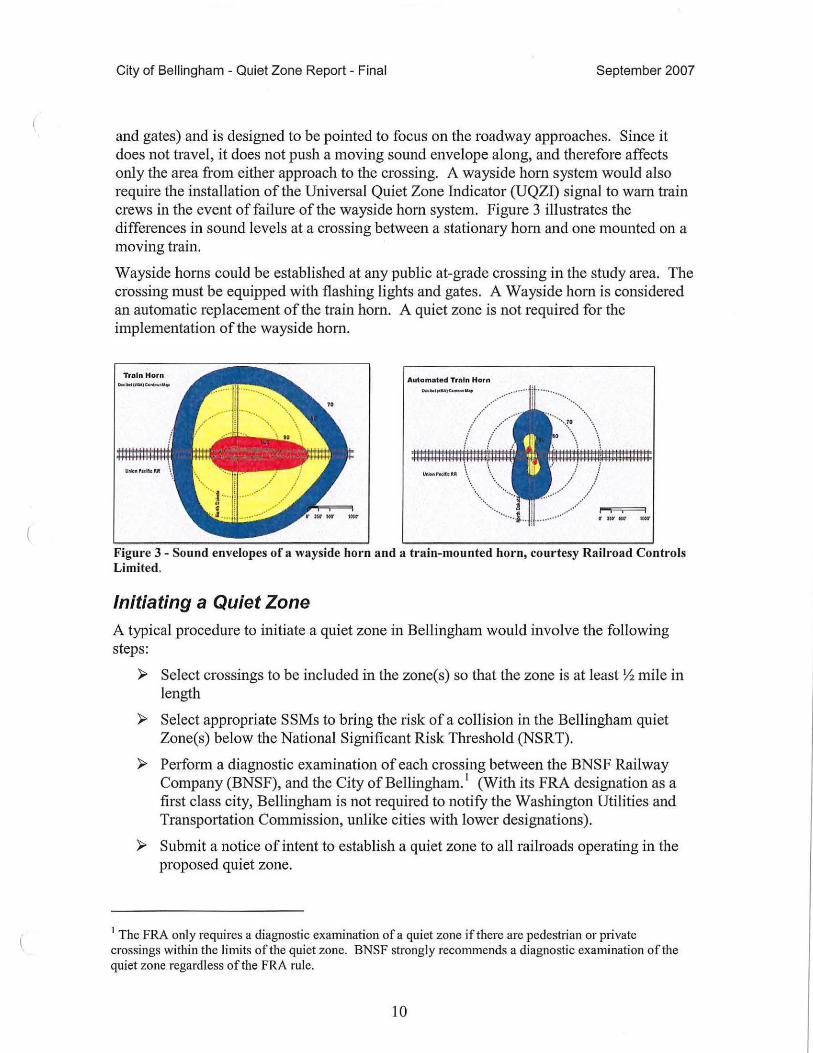
Wayside (Stationary) vs. Locomotive Horn. In the standard case, a moving locomotive must start blowing the horn Y. mile from the crossing and continue sounding the horn through the crossing. The locomotive pushes a sound envelope along the tracks as it approaches the crossing, affecting all receptors within the vicinity. One method to reduce the noise attendant to this traditional safety protocol is to install wayside horns at the crossing. The wayside horn is permanently attached to the active warning devices (lights
9
City of Bellingham - Quiet Zone Report - Final September 2007
and gates) and is designed to be pointed to focus on the roadway approaches. Since it does not travel, it does not push a moving sound envelope along, and therefore affects only the area from either approach to the crossing. A wayside horn system would also require the installation of the Universal Quiet Zone Indicator (UQZI) signal to warn train crews in the event of failure of the wayside horn system. Figure 3 illustrates the differences in sound levels at a crossing between a stationary horn and one mounted on a moving train.
Wayside horns could be established at any public at-grade crossing in the study area. The crossing must be equipped with flashing lights and gates. A Wayside horn is considered an automatic replacement of the train horn. A quiet zone is not required for the implementation of the wayside horn.
Autom• t• d Trnln Horn
.... ·•··············· .... \
.....
\ ............ \
... \ .
t"'"I I I
Figure 3 - Sound envelopes of a wayside horn and a train-mounted horn, courtesy Railroad Controls Limited.
Initiating a Quiet Zone A typical procedure to initiate a quiet zone in Bellingham would involve the following steps:
)> Select crossings to be included in the zone(s) so that the zone is at least Yi mile in length
)> Select appropriate SSMs to bring the risk of a collision in the Bellingham quiet Zone(s) below the National Significant Risk Tlrreshold (NSRT).
)> Perform a diagnostic examination of each crossing between the BNSF Railway Company (BNSF), and the City ofBellingham. 1 (With its FRA designation as a first class city, Bellingham is not required to notify the Washington Utilities and Transportation Commission, unlike cities with lower designations).
)> Submit a notice of intent to establish a quiet zone to all railroads operating in the proposed quiet zone.
1 The FRA only requires a diagnostic examination ofa quiet zone if there are pedestrian or private crossings within the limits of the quiet zone. BNSF strongly recommends a diagnostic examination of the quiet zone regardless of the FRA rule.
10
City of Bellingham - Quiet Zone Report - Final September 2007
>- Procure project funding. Local Agency Funding Guidelines (dated 3-25-2004) are shown in Appendix A.
>- Install SSM devices.
>- Submit notification of the creation of a quiet zone and silence train horns.
Additional procedures required by BNSF for the handling of quiet zones are shown in Appendix B.
11

City of Bellingham - Quiet Zone Report - Final September 2007
Existing Conditions BNSF has a single track mainline through the City of Bellingham. There are a number of industrial spur and siding tracks located within the Waterfront and Fairhaven quiet zones which are identified on the Vicinity Map. The Vicinity Map is shown in Appendix C. BNSF operates eight through freight trains, eight local freight trains and four Amtrak trains for an average of 20 trains per day through the City of Bellingham.
Fairhaven Study Area Appendix C identifies the limits of the Fairhaven Study area and is shown on a BNSF track chart. The Fairhaven quiet zone includes five at grade crossings described below. Appendix D is a chart identifying the total risk factor of the existing condition of the Fairhaven Quiet Zone.
Because the FRA calculator does not recognize private or pedestrian crossings, the Port crossing, the Boulevard Park pedestrian crossing and the Bayview Drive at grade crossing are not listed in the calculator. Currently, the FRA inventory identifies the Bayview Drive crossing as a private crossing.
Harris A venue Crossing Location: RR milepost 93.35, DOT# 084798U
Harris Avenue is a two-lane east-west roadway crossing two BNSF tracks--one mainline track and one siding track. The crossing skew of the roadway to the tracks is between 30 and 60 degrees. In the northwest quadrant of the crossing there is a driveway accessing the Ferry Terminal. In the southwest quadrant of the crossing there is a driveway accessing the Marine Park. There are no driveways in the immediate vicinity east of the crossing. The posted speed limit is 25 mph. This crossing experiences traffic volumes of 1,500 annual average daily traffic (AADT) of which five percent are trucks.
The railroad crossing is made of rubber. The warning devices at the Harris A venue crossing consist of two flashing light traffic control devices with two gates and a bell. There is also a flashing light and gate to the approach of Harris A venue from the Marine Terminal (Alaskan Ferry). The mainline track is controlled by constant warning time devices, while the siding is controlled with motion sensing devices. The train speeds at this crossing are 35 mph for freight trains and 40 mph for passenger trains. The crossing is adjacent to the Amtrak Station. (See figure 4) ..
12
(
City of Bellingham - Quiet Zone Report - Final
Figure 4 - Harris Avenue crossing facing east with Amtrak Station in background.
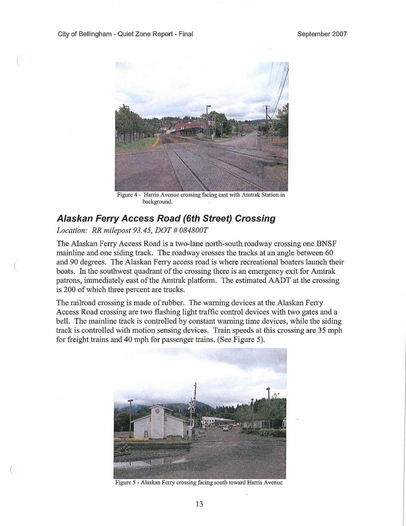
Alaskan Ferry Access Road (6th Street) Crossing Location: RR milepost 93.45, DOT# 084800T
September 2007
The Alaskan Ferry Access Road is a two-lane north-south roadway crossing one BNSF mainline and one siding track. The roadway crosses the tracks at an angle between 60 and 90 degrees. The Alaskan Ferry access road is where recreational boaters launch their boats. In the southwest quadrant of the crossing there is an emergency exit for Amtrak patrons, immediately east of the Amtrak platfo1m. The estimated AADT at the crossing is 200 of which three percent are trucks.
The railroad crossing is made of rubber. The warning devices at the Alaskan Ferry Access Road crossing are two flashing light traffic control devices with two gates and a bell. The mainline track is controlled by constant warning time devices, while the siding track is controlled with motion sensing devices. Train speeds at this crossing are 35 mph for freight trains and 40 mph for passenger trains. (See Figure 5).
Figure 5 - Alaskan Ferry crossing facing south toward Harris Avenue
13
City of Bellingham - Quiet Zone Report - Final
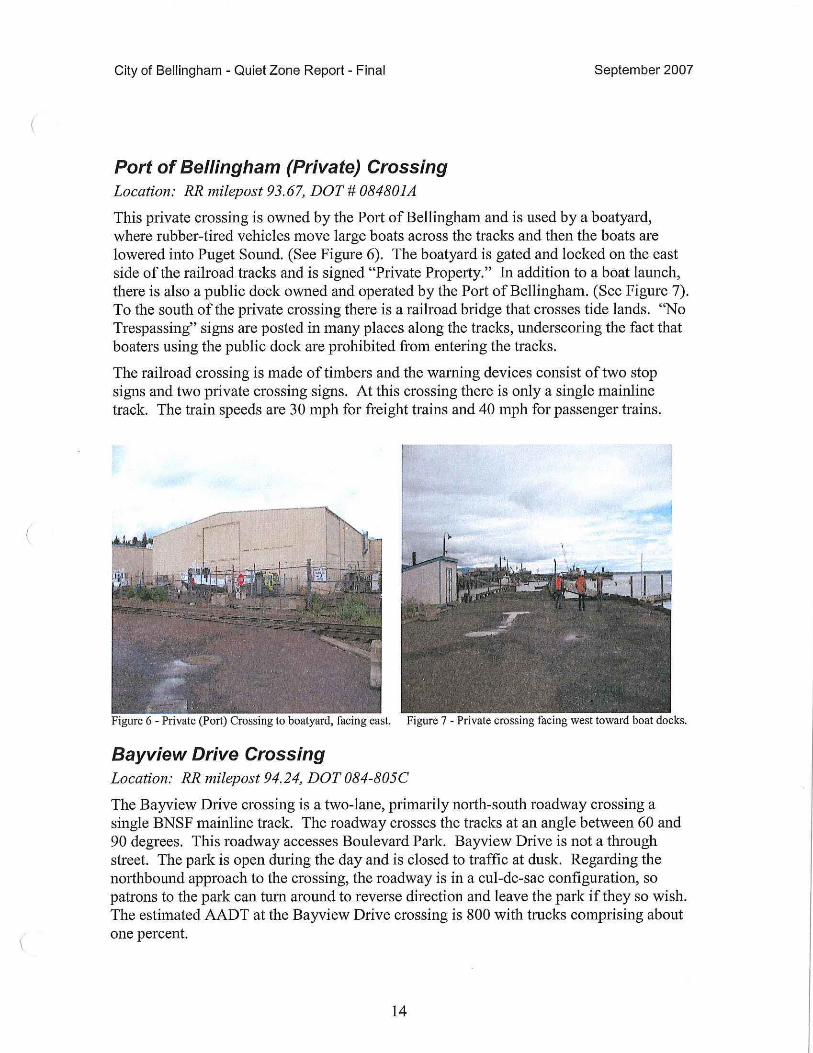
Port of Bellingham (Private) Crossing Location: RR milepost 93.67, DOT# 084801A
September 2007
This private crossing is owned by the Port of Bellingham and is used by a boatyard, where rubber-tired vehicles move large boats across the tracks and then the boats are lowered into Puget Sound. (See Figure 6). The boatyard is gated and locked on the east side of the railroad tracks and is signed "Private Property." In addition to a boat launch, there is also a public dock owned and operated by the Port of Bellingham. (See Figure 7). To the south of the private crossing there is a railroad biidge that crosses tide lands. "No Trespassing" signs are posted in many places along the tracks, undersc01ing the fact that boaters using the public dock are prohibited from entering the tracks.
The railroad crossing is made of timbers and the warning devices consist of two stop signs and two private crossing signs. At this crossing there is only a single mainline track. The train speeds are 30 mph for freight trains and 40 mph for passenger trains.
Figure 6 - Private (Port) Crossing to boatyard, facing east. Figure 7 - Private crossing facing west toward boat docks.
Bayview Drive Crossing Location: RR milepost 94.24, DOT 084-805C
The Bayview Drive crossing is a two-lane, primarily north-south roadway crossing a single BNSF mainline track. The roadway crosses the tracks at an angle between 60 and 90 degrees. This roadway accesses Boulevard Park. Bayview Drive is not a through street. The park is open during the day and is closed to traffic at dusk. Regarding the n01ihbound approach to the crossing, the roadway is in a cul-de-sac configuration, so patrons to the park can tum around to reverse direction and leave the park if they so wish. The estimated AADT at the Bayview Drive crossing is 800 with trucks comprising about one percent.
14
City of Bellingham - Quiet Zone Report - Final September 2007
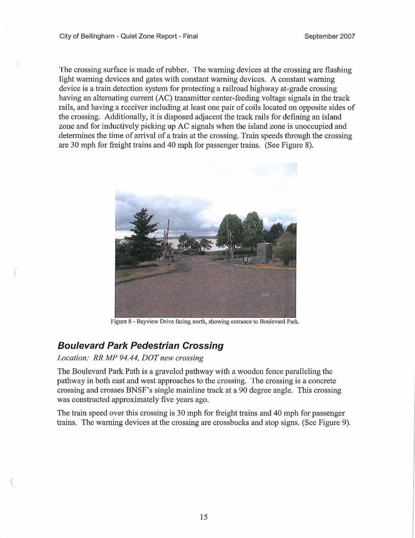
The crossing surface is made of rubber. The warning devices at the crossing are flashing light warning devices and gates with constant warning devices. A constant warning device is a train detection system for protecting a railroad highway at-grade crossing having an alternating current (AC) transmitter center-feeding voltage signals in the track rails, and having a receiver including at least one pair of coils located on opposite sides of the crossing. Additionally, it is disposed adjacent the track rails for defining an island zone and for inductively picking up AC signals when the island zone is unoccupied and determines the time of arrival of a train at the crossing. Train speeds through the crossing are 30 mph for freight trains and 40 mph for passenger trains. (See Figure 8).
Figure 8 - Bayview Drive facing north, showing entrance to Boulevard Park.
Boulevard Park Pedestrian Crossing Location: RR. MP 94. 44, DOT new crossing
The Boulevard Park Path is a graveled pathway with a wooden fence paralleling the pathway in both east and west approaches to the crossing. The crossing is a concrete crossing and crosses BNSF's single mainline track at a 90 degree angle. This crossing was constructed approximately five years ago.
The train speed over this crossing is 30 mph for freight trains and 40 mph for passenger trains. The warning devices at the crossing are crossbucks and stop signs. (See Figure 9).
15

City of Bellingham - Quiet Zone Report - Final September 2007
Figure 9 - Boulevard Park Pedestrian path facing west. Pedestrian crossing crosses tracks to the right of the stop sign shown.
Bellingham Waterfront Study Area The Waterfront quiet zone includes seven at-grade crossings as described below. Appendix C identifies the limits of the Waterfront Study area and is shown on a BNSF track chart. Appendix E is a cha1t identifying the total risk factor of the existing condition of the Bellingham Waterfront Study Area.
Because the FRA calculator does not recognize public crossings without signals, a "signal" place holder was given to the C Street crossing, which currently has crossbucks.
Pine/Wharf Street Crossing Location: RR milepost 96.24, DOT# 396920W
Pine/Wharf Street is a two-lane roadway approximately in a north-south direction. Pine/Wharf Street descends on a downward grade from State Street to the railroad tracks in a northwest direction. Pine/Wharf Street crosses the tracks between 60 and 90 degrees. There is a commercial business in the northwest quadrant of the crossing, creating sight restrictions with respect to trains approaching the crossing from the south. The AADT of this crossing is 1,300 per day at a posted speed of 25 mph.
The Pine/Wharf Street crossing surface consists of rnbber on the mainline track and asphalt on the spur track. The spur track is used by Amtrak for storage of the train it operates between Bellingham and Vancouver B.C. The active warning device at the crossing is flashing lights with gates. The mainline track in the Pine/Wharf Street crossing is controlled by constant warning time devices and the spur track is controlled by motion sensing devices. Train speeds are 30 mph for freight trains and 40 mph for passenger trains. (See Figure 10).
16
City of Bellingham - Quiet Zone Report - Final
.._ _ _ _ __ ., ... J ___ _..... ___ _
Figure I 0 - Pine/Wharf Street facing south. Pine/Wharf turns up the hill to the east toward State Street
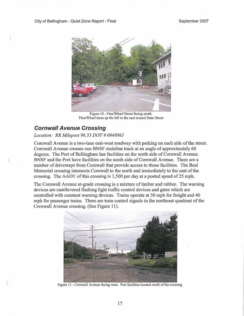
Cornwall Avenue Crossing Location: RR Milepost 96.33 DOT# 084806J
September 2007
Cornwall Avenue is a two-lane east-west roadway with parking on each side of the street. Cornwall A venue crosses one BNSF mainline track at an angle of approximately 60 degrees. The Port of Bellingham has facilities on the north side of Cornwall Avenue. BNSF and the Port have facilities on the south side of Cornwall A venue. There are a number of driveways from Cornwall that provide access to those facilities. The Beal Memorial crossing intersects Cornwall to the north and immediately to the east of the crossing. The AADT of this crossing is 1,500 per day at a posted speed of 25 mph.
The Cornwall Avenue at-grade crossing is a mixture of timber and rubber. The warning devices are cantilevered flashing light traffic control devices and gates which are controlled with constant warning devices. Trains operate at 30 mph for freight and 40 mph for passenger trains. There are train control signals in the northeast quadrant of the Cornwall A venue crossing. (See Figure 11 ).
Figure 11 - Cornwall Avenue facing west. Port facilities located north of the crossing.
17
City of Bellingham - Quiet Zone Report - Final
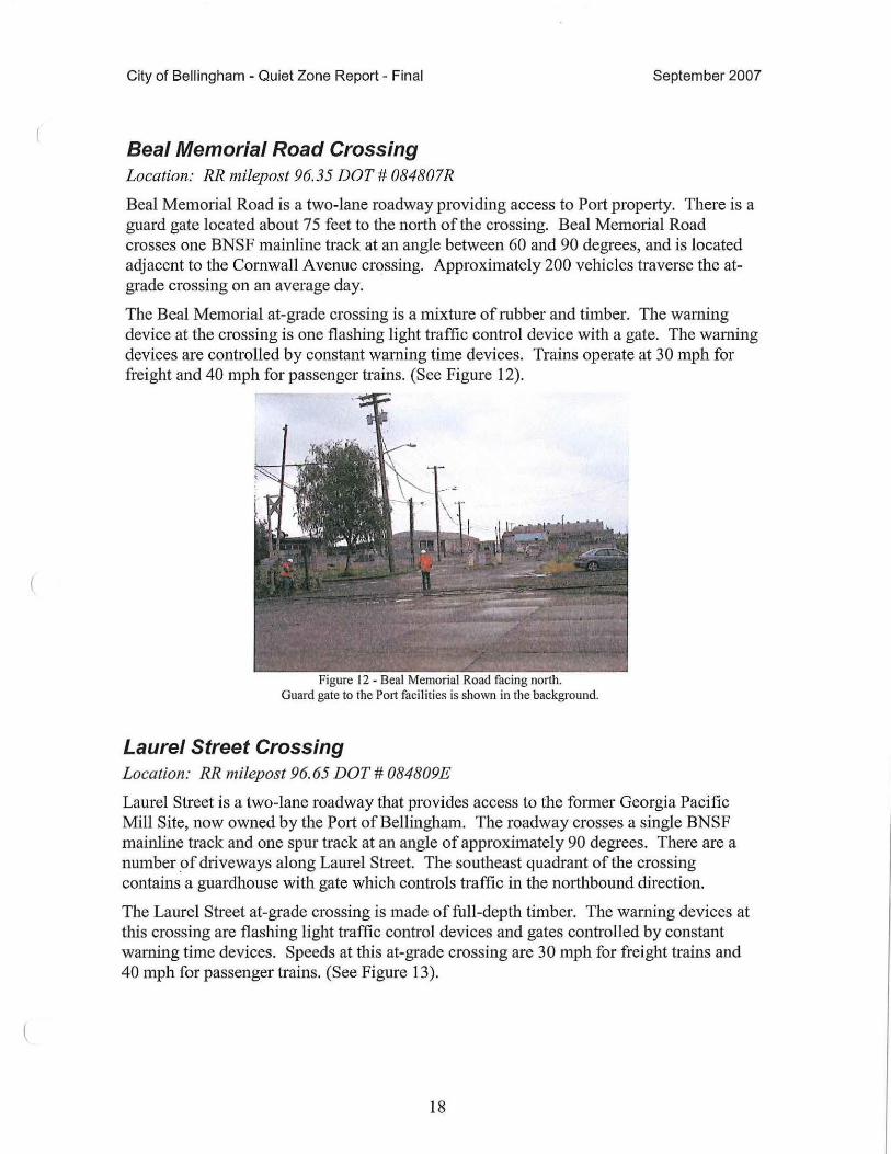
Beal Memorial Road Crossing Location: RR niilepost 96.35 DOT# 084807R
September 2007
Beal Memorial Road is a two-lane roadway providing access to Pmt property. There is a guard gate located about 75 feet to the north of the crossing. Beal Memorial Road crosses one BNSF mainline track at an angle between 60 and 90 degrees, and is located adjacent to the Cornwall Avenue crossing. Approximately 200 vehicles traverse the atgrade crossing on an average day.
The Beal Memorial at-grade crossing is a mixture of rubber and timber. The warning device at the crossing is one flashing light traffic control device with a gate. The warning devices are controlled by constant warning time devices. Trains operate at 30 mph for freight and 40 mph for passenger trains. (See Figure 12).
Figure 12 - Beal Memorial Road facing north. Guard gate to the Port facilities is shown in the background.
Laurel Street Crossing Location: RR milepost 96.65 DOT# 084809E
Laurel Street is a two-lane roadway that provides access to the former Georgia Pacific Mill Site, now owned by the Port of Bellingham. The roadway crosses a single BNSF mainline track and one spur track at an angle of approximately 90 degrees. There are a number _of driveways along Laurel Street. The southeast quadrant of the crossing contains a guardhouse with gate which controls traffic in the northbound direction.
The Laurel Street at-grade crossing is made of full-depth timber. The warning devices at this crossing are flashing light traffic control devices and gates controlled by constant warning time devices. Speeds at this at-grade crossing are 30 mph for freight trains and 40 mph for passenger trains. (See Figure 13).
18
City of Bellingham - Quiet Zone Report - Final
Figure I 3 - Laurel Street crossing facing west. BNSF approaches the crossing while train activates the warning devices.
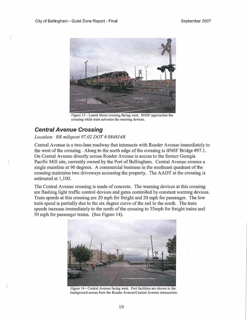
Central Avenue Crossing Location: RR milepost 97.02 DOT # 084814B
September 2007
Central Avenue is a two-lane roadway that intersects with Roeder Avenue inunediately to the west of the crossing. Along to the n01th edge of the crossing is BNSF Bridge #97 .1. On Central Avenue directly across Roeder Avenue is access to the former Georgia Pacific Mill site, currently owned by the Port of Bellingham. Central A venue crosses a single mainline at 90 degrees. A commercial business in the southeast quadrant of the crossing maintains two driveways accessing the property. The AADT at the crossing is estimated at 1, 100.
The Central A venue crossing is made of concrete. The warning devices at this crossing are flashing light traffic control devices and gates controlled by constant warning devices. Train speeds at this crossing are 20 mph for freight and 20 mph for passenger. The low train speed is partially due to the six degree curve of the rail to the south. The train speeds increase immediately to the north of the crossing to 35mph for freight trains and 50 mph for passenger trains. (See Figure 14).
Figure I 4 - Central Avenue facing west. Port facilities are shown in the background across rrom the Roeder Avenue/Central Avenue intersection.
19
City of Bellingham - Quiet Zone Report - Final September 2007
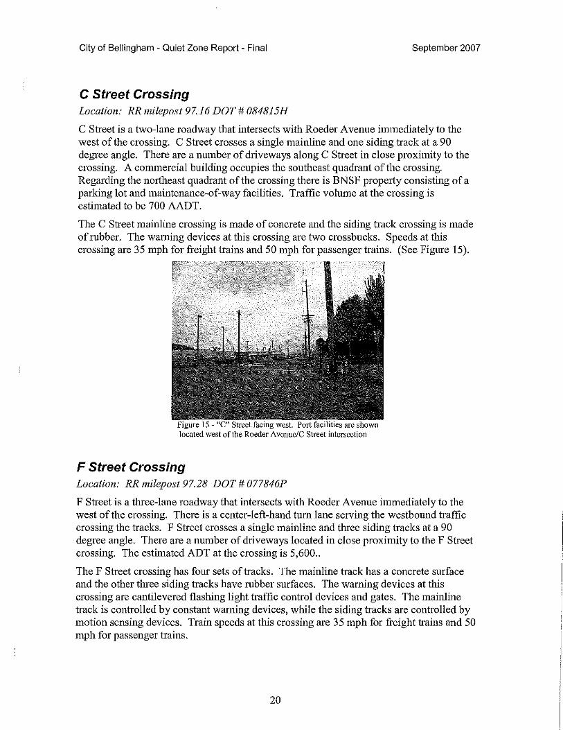
C Street Crossing Location: RR milepost 97.16 DOT# 084815H
C Street is a two-lane roadway that intersects with Roeder Avenue immediately to the west of the crossing. C Street crosses a single mainline and one siding track at a 90 degree angle. There are a number of driveways along C Street in close proximity to the crossing. A commercial building occupies the southeast quadrant of the crossing. Regarding the northeast quadrant of the crossing there is BNSF property consisting of a parking lot and maintenance-of-way facilities. Traffic volume at the crossing is estimated to be 700 AADT.
The C Street mainline crossing is made of concrete and the siding track crossing is made of rubber. The warning devices at this crossing are two cross bucks. Speeds at this crossing are 35 mph for freight trains and 50 mph for passenger trains. (See Figure 15).
Figure 15 - "C" Street facing west. Port facilities are shown located west of the Roeder Avenuc/C Street intersection
F Street Crossing Location: RR milepost 97.28 DOT# 077846P
F Street is a three-lane roadway that intersects with Roeder Avenue immediately to the west of the crossing. There is a center-left-hand tum lane serving the westbound traffic crossing the tracks. F Street crosses a single mainline and three siding tracks at a 90 degree angle. There are a number of driveways located in close proximity to the F Street crossing. The estimated ADT at the crossing is 5,600 ..
The F Street crossing has fom sets of tracks. The mainline track has a concrete surface and the other three siding tracks have rubber surfaces. The warning devices at this crossing are cantilevered flashing light traffic control devices and gates. The mainline track is controlled by constant warning devices, while the siding tracks are controlled by motion sensing devices. Train speeds at this crossing are 35 mph for freight trains and 50 mph for passenger trains.
20
City of Bellingham - Quiet Zone Report - Final
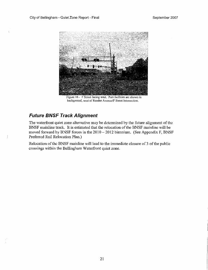
Figure 16 - F Street facing west. Port facilities are shown in background, west of Roeder Avenue/F Street intersection.
Future BNSF Track Alignment
September 2007
The waterfront quiet zone alternative may be determined by the future alignment of the BNSF mainline track. It is estimated that the relocation of the BNSF mainline will be moved forward by BNSF forces in the 2010 - 2012 biennium. (See Appendix F, BNSF Preferred Rail Relocation Plan.)
Relocation of the BNSF mainline will lead to the immediate closure of3 of the public crossings within the Bellingham Waterfront quiet zone.
21
City of Bellingham - Quiet Zone Report - Final September 2007
Quiet Zone Strategies The two study areas constitute two separate and different neighborhoods. The Waterfront neighborhood constitutes light industrial, commercial, retail and light residential. The Fairhaven neighborhood constitutes residential, recreational, light industrial, and a community with historical significance, known as "Fairhaven." The Fairhaven community has a number of shops, restaurants and hotels that attracts tourists and other visitors to the city. Western Washington University's campus is adjacent the study area. In light of the two different neighborhoods it is necessary to consider each neighborhood as an independent quiet zone. This document will refer to the two zones as the Waterfront Quiet Zone and the Fairhaven Quiet Zone.
Because there may be some significant changes to the Bellingham Waterfront (i.e. rail realignment), the Waterfront Quiet Zone will be studied and evaluated in both the present condition and the future condition. The Waterfront Quiet Zone is broken down into 5 different alternatives. The Fairhaven Quiet Zone is broken down into 3 different alternatives.
It is also necessary to be stated that although the quiet zone will silence train horns for the purposes of the crossings, it may not eliminate train horn noise entirely. Railroad crews are still required to sound the horn in several instances, including emergency situations, at the initiation of train movement, and when approaching workers and equipment engaged in maintaining the railroad's tracks and other facilities.
At the Bayview Drive at-grade crossing, the Central Avenue at-grade crossing, and the "C" Street at-grade crossing (alternative 1) there are existing sidewalks or it is proposed to construct sidewalks behind the lights and gates. To provide the added warning device for pedestrians there have been agencies that have required the construction of pedestrian gates. Pedestrian gates are additional gates that are installed to the existing gate mast and provide warning to pedestrians of an approaching train. This report did not include the addition of pedestrian gates at the crossings mentioned. If the city wishes to pursue pedestrian gates the added cost is approximately$ 15,000 per crossing.
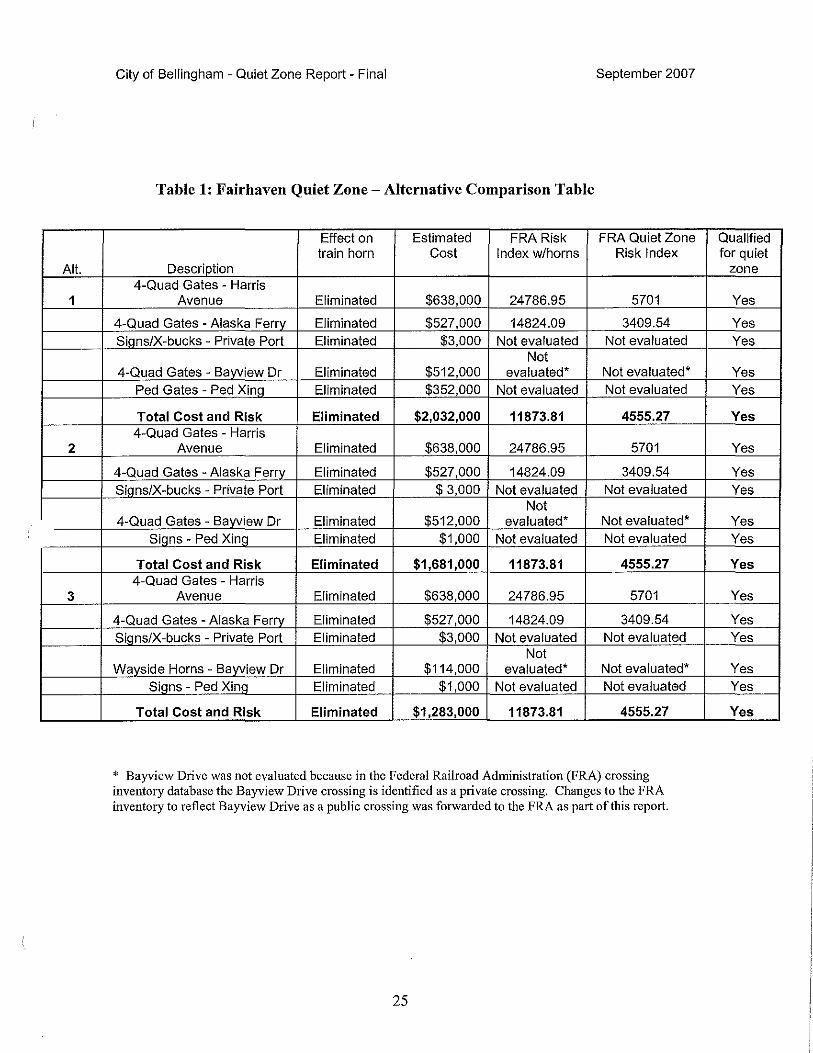
The Fairhaven Quiet Zone The Fairhaven quiet zone will be 1. 75 miles in length (railroad milepost 93 to 94. 75) with five crossings within the zone. Each of the five crossings is evaluated for the application of SSMs that would be an FRA acceptable replacement for the train horn. Three different alternatives have been evaluated for the Fairhaven Quiet Zone. The three alternatives along with estimates are listed in Appendix G. Comparison of each alternative can be found in Table 1 of this report.
Harris Avenue
Harris Avenue is a well traveled urban street (6,000 AADT). The crossing gives access to the Port of Bellingham, the Waterfront Park, and provides access to the Alaskan Way Ferry Terminal. Harris Avenue is the only access to and from the Waterfront Park and
22

City of Bellingham - Quiet Zone Report - Final September 2007
Port of Bellingham facilities, therefore closure of the crossing is not feasible and will not be considered.
There are a number of driveways in the vicinity near the crossing. The two driveways west of the crossing are located closer than the minimum of 60' allowed by the Quiet Zone Rule in the establishment ofSSMs. Any variation of the rule would be considered an ASM. The only solution using SSMs is a four-quadrant gate system.
In order to provide for a four-quadrant gate system, there are some minor street improvements that will be necessary such as extending the curb in the northwest quadrant of the at-grade crossing. Extending the curb is required for the installation of an additional signal gate. (See design plans, Figure HI in Appendix H.)
Alaska Ferry Access Road (61h Street)
The Alaskan Ferry Access Road, otherwise known as 6th Street accesses the Alaskan Ferry Terminal and also provides access to a public boat launch. The estimated vehicle count is 200 AADT. Closure of the Alaskan Ferry Access Road crossing is not feasible because the Alaskan Ferry Access Road is the only access to the public boat launch and to the Alaskan Ferry Dock. The Bellingham Amtrak Station is located in the southwest quadrant of the crossing. At the end of the Amtrak Station platform there is a pedestrian walkway accessing the Alaskan Ferry Access Road. The pedestrian walkway is signed as an emergency exit. The southbound approach to the crossing is in a T-intersection design. Therefore the southbound approach to the Alaskan Ferry Access Road crossing does not lend itself to the use of median barriers. Four-quadrant gates are the only feasible alternative in implementing a quiet zone at this crossing. (See design plans, Figure H2 in Appendix H.)
Private (Port of Bellingham) crossing
This private crossing is primarily used for the launching oflarge commercial and privately owned vessels into the waters of Puget Sound. In addition to the boat launch there is a public dock where recreational vessels may dock. There is no legal avenue for a recreational boater to walk from a boat, when docked here, to any public property or public facilities, such as a restaurant, or grocery store. The only access from the dock is to trespass along BNSF right of way, or cross the railroad bridge south of the crossing.
The minimum requirement for a quiet zone to be established at a private crossing is a "No Train Homs at Crossing" sign, a stop sign, and crossbucks (X-bucks). According to the train horn rule, a private crossing will require a diagnostic review by BNSF and City staff.
A diagnostic review may determine that more significant upgrades to the warning devices be warranted. BNSF may have concerns with the public boat dock that is an attachment to the private crossing, and may want additional warning devices, such as additional locked gates between the public boat dock and BNSF right of way. BNSF policy concerning Quiet Zones can be found in Appendix B. Such improvement would be the responsibility and expense of the Port of Bellingham. (See design plans, Figure H3 in Appendix H.)
23
City of Bellingham - Quiet Zone Report - Final September 2007
Bayview Drive
Bayview Drive is not a through street. Bayview Drive is the public access to Boulevard Park. The AADT is estimated at 200 vehicles. The northbound approach to the crossing is designed to be used both as an access point to the park and a designated place to tum around in case of mistaken entry or if a motorist drives into the park after dusk. The northbound approach is designed like a cul-de-sac. Bayview Drive is the only access to Boulevard Park, therefore the closing this crossing is not feasible. Because of the close proximity to off street parking and the close proximity to the cul-de-sac design in the northbound approach to the crossing the installation of median barriers is not feasible. The only SSM option that is feasible is the installation of four-quadrant gates. The other option, which is not considered an SSM, but is acceptable within the quiet zone, is the installation of a way-side horn. (See design plans for four-quadrant gates, Figure H4, and wayside signals, Figure H5, in Appendix H.)
As discussed earlier, the way-side horn is directional specific and is a one for one replacement with the train horn. It eliminates the approach horn to the crossing, which reduces the train horn noise considerably. Crossings with the way-side horn are not calculated when determining the Risk Index.
Boulevard Park is closed at dusk and there is a gate provided in the northbound approach to the crossing. The train horn rule considers a night time closure of the Bayview Drive crossing to be an SSM by itself. Therefore the city, if it wishes, could proceed with requesting a night time quiet zone at the Bayview Drive crossing as a stand alone quiet zone. Later in this report, a night time closure quiet zone will be detailed.
Boulevard Park Pedestrian Crossing
The Boulevard Park pedestrian crossing is a pathway that accesses Boulevard Park from State Street located above the bluff to the south of the crossing.
The minimum requirement for a quiet zone to be established at a pedestrian crossing is a "No Train Horns at Crossing" sign, a stop sign and crossbucks (X-bucks). Currently there are X-bucks and stop signs at this crossing. According to the train horn rule, a pedestrian crossing will require a diagnostic review by BNSF and City staff.
A diagnostic review may determine that a more significant upgrade to the warning devices is warranted. BNSF may have concerns with the pedestrian access across its mainline tracks. Additional warning devices may be requested by BNSF, such as pedestrian gates and flashing lights. (See design plans, Figure H6 in Appendix H.)
24
Alt.
1
2
3
City of Bellingham - Quiet Zone Report - Final September 2007
Table 1: Fairhaven Quiet Zone -Alternative Comparison Table
Effect on Estimated FRA Risk FRA Quiet Zone train horn Cost Index w/horns Risk Index
Description 4-Quad Gates - Harris
Avenue Eliminated $638,000 24786.95 5701
4-Quad Gates - Alaska Ferrv Eliminated $527,000 14824.09 3409.54 Sians/X-bucks - Private Port Eliminated $3,000 Not evaluated Not evaluated
Not 4-Quad Gates - Bayview Dr Eliminated $512,000 evaluated* Not evaluated*
Ped Gates - Ped Xina Eliminated $352,000 Not evaluated Not evaluated
Total Cost and Risk Eliminated $2,032,000 11873.81 4555.27 4-Quad Gates - Harris
Avenue Eliminated $638,000 24786.95 5701
4-Quad Gates - Alaska Ferry Eliminated $527,000 14824.09 3409.54 Sians/X-bucks - Private Port Eliminated $ 3,000 Not evaluated Not evaluated
Not 4-Quad Gates - Bawiew Dr Eliminated $512,000 evaluated* Not evaluated*
Siqns - Ped Xinri Eliminated $1,000 Not evaluated Not evaluated
Total Cost and Risk Eliminated $1,681,000 11873.81 4555.27 4-Quad Gates - Harris
Avenue Eliminated $638,000 24786.95 5701
4-Quad Gates - Alaska Ferrv Eliminated $527,000 14824.09 3409.54 Sians/X-bucks - Private Port Eliminated $3,000 Not evaluated Not evaluated
Not Wayside Horns - Bayview Dr Eliminated $114,000 evaluated* Not evaluated*
Sians - Ped Xinri Eliminated $1,000 Not evaluated Not evaluated
Total Cost and Risk Eliminated $1,283,000 11873.81 4555.27
* Bayview Drive was not evaluated because in the Federal Railroad Administration (FRA) crossing inventory database the Bayview Drive crossing is identified as a private crossing. Changes to the FRA inventory to reflect Bayview Drive as a public crossing was forwarded to the FRA as part of this report.
25
Qualified for quiet
zone
Yes
Yes Yes
Yes Yes
Yes
Yes
Yes Yes
Yes Yes
Yes
Yes
Yes Yes
Yes Yes
Yes
City of Bellingham - Quiet Zone Report - Final September 2007
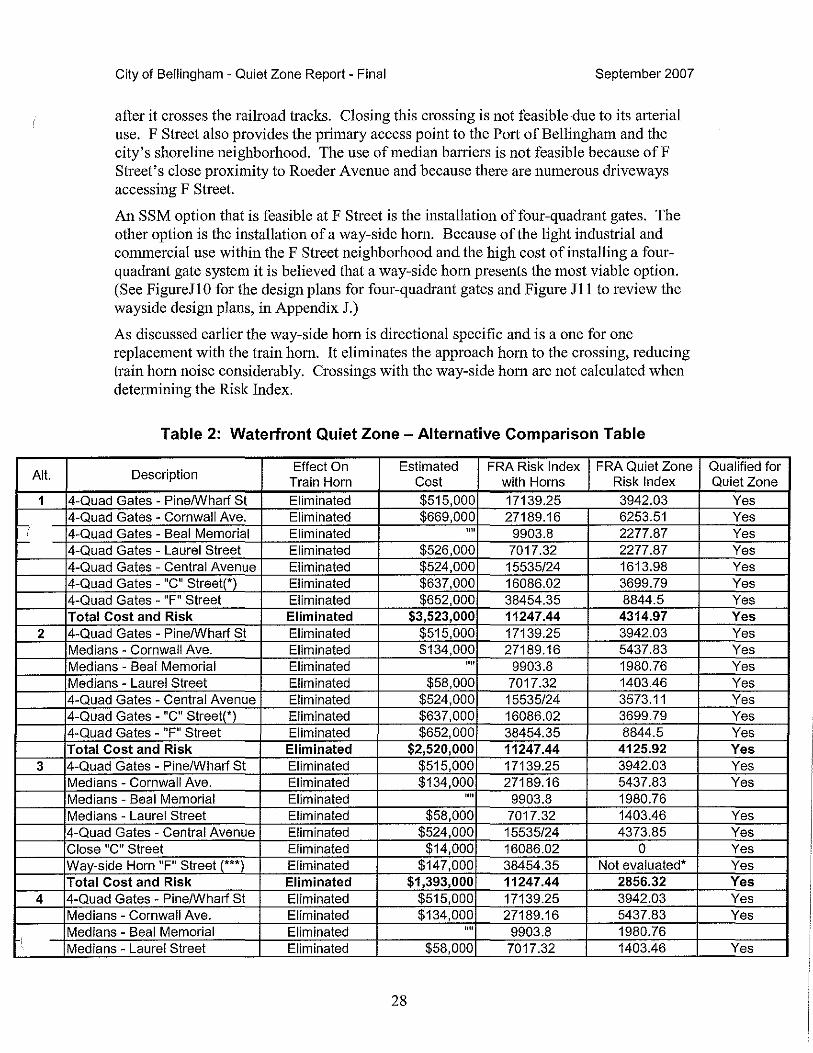
The Waterfront Quiet Zone The Waterfront quiet zone is 2.07 miles in length (Railroad MP 94.75 to MP 97.82, there is no milepost 95) with seven crossings within the zone .. Each of the seven crossings will be evaluated for the application of SSMs that would be an FRA acceptable replacement for the train horn. Five different alternatives have been evaluated for the Waterfront Quiet Zone. The five alternatives can be found in Appendix J. The five alternatives are compared in Table 2 of this report and detailed cost estimates can be reviewed in Appendix I.
Pine/Wharf St. Pine/Wharf Street is a well traveled urban street with an AADT of 300. Pine/Wharf Street accesses Bellingham' s waterfront where its primary use is industrial and maritime. The northwest quadrant of the crossing contains an office building with street parking on both sides of Pine/Wharf Street. The adjacent street parking precludes the implementation of median barriers as an SSM; therefore the only SSM that is feasible at the Pine/Wharf Street crossing would be four-quadrant gates. The Pine/Wharf Street crossing is the only access to the Waterfront from South Bellingham. Closing this crossing would create an unnecessary inconvenience to the traveling public, therefore the closure of the Pine/Wharf Street crossing is unacceptable. The geographical configuration of Pine/Wharf Street would lend itself well for the construction of an overpass, and goes along well with the closing of the crossing, if funds were available. (See design plans, Figure JI in Appendix J.)
Cornwall Avenue/Beal-Memorial Road This report considers the Cornwall Avenue and Beal-Memorial Road crossing as one continuous crossing. The AADT on Cornwall Avenue is estimated at 1,500 vehicles and there is a AADT of200 vehicles at the Beal-Memorial Road crossing. Cornwall Avenue is an east-west street that has numerous driveways intersecting the roadway. Beal Memorial Road provides access to the Port of Bellingham. There is a guard gate accessing the Port property north of the Beal-Memorial/Cornwall intersection. BealMemorial Road is the only access trucks have to the Port ofBellingham's dock facilities and Cornwall Avenue is a well traveled roadway that provides the only access to the Port of Bellingham offices and to other businesses along the waterfront, therefore it is not feasible to close either Cornwall Avenue or the Beal Memorial Road crossing ..
With additional curbing and traffic circulation changes, construction of median barriers is a viable alternative. The use of four-quadrant gates provides the City with another feasible SSM option. (See four-quadrant gate system plans, Figure J2, and design plans for median barriers, Figure J3 in Appendix J.)
26
City of Bellingham - Quiet Zone Report - Final September 2007
Laurel Street The AADT across the Laurel Street crossing is estimated at 100 vehicles. Laurel Street is a north-south street with numerous driveways intersecting the roadway. Laurel Street provides access to the former Georgia-Pacific site, now owned and operated by the Port of Bellingham. There is a guard gate accessing the Port property north of the Laurel Street/Cornwall Avenue intersection.
Laurel Street may become the primaiy access to the future Bellingham Waterfront Development project, making the closure of Laurel Street crossing infeasible.
With additional curbing and traffic circulation changes, construction of median barriers is a viable alternative. Another SSM option that is feasible is four-quadrant gates. (See four-quadrant gate system plans, Figure L4, and design plans for median barriers, Figure J5 in Appendix J.)
Central Avenue Crossing Central Avenue has a AADT of 1,100. Central Avenue is an east-west street that intersects Roeder Avenue innnediately after crossing the railroad tracks. Directly across from Roeder A venue Central A venue accesses the former Georgia Pacific site. Central Avenue is a minor arterial urban street and closing this crossing is not feasible. Due to nearby driveways and the close proximity to Roeder Avenue, the installation of median barriers is not feasible. One SSM option that is feasible at the Central Avenue crossing is the installation of four-quadrant gates. (See four-quadrant system design plans, Figure J6 in Appendix J.)
C Street Crossing The C Street crossing is an east-west street that intersects with Roeder Avenue immediately after it crosses the railroad tracks. The AADT of the C Street crossing is 700. C Street extends across Roeder Avenue accessing Port of Bellingham property.
There are three possible options for addressing C Street. The first option is the installation of four-quadrant gates and lights. Currently there are only X-bucks and stop signs at the crossing so a complete four-quadrant gate installation would be required. (See design plans, Figure J7 in Appendix J.)
The second option is closing the C Street crossing. With relatively low traffic volumes and close proximity to the F Street and the Central A venue crossing, the C Street crossing could be closed. (See he design plans for the closure of the C Street crossing, Figure J8 in Appendix J.)
A third option the city may consider is to change the C Street crossing to a pedestrian crossing. The pedestrian crossing would require the installation of pedestrian gates and lights. (See pedestrian crossing design plans, Figure J9 in Appendix J.)
F Street Crossing F Street is an urban arterial street that has an AADT of 5,600 vehicles. The street is oriented in an east-west direction. F Street intersects with Roeder Avenue innnediately
27
Alt.
1
-: -
2
3
4
'
City of Bellingham - Quiet Zone Report - Final September 2007
after it crosses the railroad tracks. Closing this crossing is not feasible due to its arterial use. F Street also provides the primary access point to the Port of Bellingham and the city's shoreline neighborhood. The use of median barriers is not feasible because of F Street's close proximity to Roeder Avenue and because there are numerous driveways accessing F Street.
An SSM option that is feasible at F Street is the installation of four-quadrant gates. The other option is the installation of a way-side horn. Because of the light industrial and commercial use within the F Street neighborhood and the high cost of installing a fourquadrant gate system it is believed that a way-side horn presents the most viable option. (See FigureJl 0 for the design plans for four-quadrant gates and Figure Jl 1 to review the wayside design plans, in Appendix J.)
As discussed earlier the way-side horn is directional specific and is a one for one replacement with the train horn. It eliminates the approach horn to the crossing, reducing train horn noise considerably. Crossings with the way-side horn are not calculated when determining the Risk Index.
Table 2: Waterfront Quiet Zone - Alternative Comparison Table
Description Effect On Estimated FRA Risk Index FRA Quiet Zone
Train Horn Cost with Horns Risk Index
4-Quad Gates - Pine/Wharf St Eliminated $515,000 17139.25 3942.03 4-Quad Gates - Cornwall Ave. Eliminated $669,000 27189.16 6253.51 4-Quad Gates - Beal Memorial Eliminated 1111 9903.8 2277.87 4-Quad Gates - Laurel Street Eliminated $526,000 7017.32 2277.87 4-Quad Gates - Central Avenue Eliminated $524,000 15535/24 1613.98 4-Quad Gates - "C" Street(*) Eliminated $637,000 16086.02 3699.79 4-Quad Gates - "F" Street Eliminated $652,000 38454.35 8844.5 Total Cost and Risk Eliminated $3,523,000 11247.44 4314.97 4-Quad Gates - Pine/Wharf St Eliminated $515,000 17139.25 3942.03 Medians - Cornwall Ave. Eliminated $134,000 27189.16 5437.83 Medians - Beal Memorial Eliminated 1111 9903.8 1980.76 Medians - Laurel Street Eliminated $58,000 7017.32 1403.46 4-Quad Gates - Central Avenue Eliminated $524,000 15535/24 3573.11 4-Quad Gates - "C" Street(') Eliminated $637,000 16086.02 3699.79 4-Quad Gates - "F" Street Eliminated $652,000 38454.35 8844.5 Total Cost and Risk Eliminated $2,520,000 11247.44 4125.92 4-Quad Gates - Pine/Wharf St Eliminated $515,000 17139.25 3942.03 Medians - Cornwall Ave. Eliminated $134,000 27189.16 5437.83 Medians - Beal Memorial Eliminated rm 9903.8 1980.76 Medians - Laurel Street Eliminated $58,000 7017.32 1403.46 4-Quad Gates - Central Avenue Eliminated $524,000 15535/24 4373.85 Close "C" Street Eliminated $14,000 16086.02 0 Way-side Horn "F" Street (***) Eliminated $147,000 38454.35 Not evaluated* Total Cost and Risk Eliminated $1,393,000 11247.44 2856.32 4-Quad Gates - Pine/Wharf St Eliminated $515,000 17139.25 3942.03 Medians - Cornwall Ave. Eliminated $134,000 27189.16 5437.83 Medians - Beal Memorial Eliminated rm 9903.8 1980.76 Medians - Laurel Street Eliminated $58,000 7017.32 1403.46
28
Qualified for Quiet Zone
Yes Yes Yes Yes Yes Yes Yes Yes Yes Yes Yes Yes Yes Yes Yes Yes Yes Yes
Yes Yes Yes Yes Yes Yes Yes
Yes

~,
'
5
City of Bellingham - Quiet Zone Report - Final September 2007
4-Quad Gates - Central Avenue Eliminated $524,000 15535/24 3573.11 Pedestrian Qates - "C" Street( .. Eliminated $371,000 16086.02 Not evaluated 4-Quad Gates - "F" Street Eliminated $652,000 38454.35 8844.5 Total Cost and Risk Eliminated $2,255,000 11247.44 4196.95 4-Quad Gates - Pine/Wharf St Eliminated $515,000 17139.25 4789.13**** Closed others) - Cornwall Ave. Eliminated $0 27189.16 0 Closed others) - Beal Memorial Eliminated $0 9903.8 0 Closed others) - Laurel Street Eliminated $0 7017.32 0 4-Quad Gates - Central Avenue Eliminated $524,000 15535.24 4836.98**** Closed - "C" Street (*) Eliminated $14,000 16086.02 0 4-Quad Gates - "F" Street Eliminated $652,000 38454.35 8973.4**** Total Cost and Risk Eliminated $1,705,000 11247.44 2657.07
(*) C Street does not currently have gates. Gates were added as a place holder for the FRA Calculator to work. (**) C Street as a pedestrian crossing is not evaluated because pedestrian crossings are not evaluated in determining a quiet zone. (***)Wayside Horns are a one for one replacement for the train horn. Wayside Horns are not a quiet zone requirement therefore is not evaluated in determining a quiet zone. (****) Closing Cornwall, Beal-Memorial, Laurel and the C Street crossing displaced the current ADT from these crossings to the adjoining crossings of Pine, Central and F Streets
29
Yes Yes Yes Yes Yes Yes Yes Yes Yes Yes Yes Yes

City of Bellingham - Quiet Zone Report - Final September 2007
The Bayview Drive Quiet Zone Alternative Both the Waterfront and the Fairhaven quiet zones are constructible, but at great expense to the City of Bellingham. An alternative that provides near-term relief at an affordable ptice is to establish an interim quiet zone. The City of Bellingham may wish to consider such an option, which would cover a portion of the Fairhaven Quiet Zone with a high number ofresidential receptors. (See Appendix C.)
The Bayview Dtive quiet zone would be one mile in length. The crossings within the Bayview Drive quiet zone parameters include the private Port of Bellingham crossing, located at railroad milepost 93.67, the Bayview Drive crossing, located at railroad milepost 94.24, and the Boulevard Park Pedesttian crossing, located at railroad milepost 94.44. The quiet zone would extend a quarter mile south of the private crossing and a quarter mile north of the Boulevard Park Pedesttian crossing, from railroad milepost 94 to 96. (Milepost 95 does not exist on the railroad.) Cost estimates for the Bayview Drive quiet zone alternative can be found in Appendix K. Total cost estimate for the Bayview Dtive alternative is $ 364,000.
The Bayview Drive crossing proposed would be a nighttime quiet zone. Nighttime quiet zones are considered an SSM according to the train horn rule. SSMs do not require annual reviews. An example of a nighttime quiet zone would be a quiet zone requiting train horns to be silenced from I 0 p.m. to 8 a.m. Currently, the Bayview Dtive crossing is closed beginning at dusk and is re-opened at dawn by a hand thrown gate.
The private (Port) crossing would require informational signs, stop signs and X-buck signs. The Boulevard Park pedestrian crossing will require the normal information signs, stop signs and X-bucks; however, it will likely require flashing lights and gates.
Ptivate and pedestrian crossings within a quiet zone must be reviewed by both the City and the railroad through the diagnostic process. As referenced earlier in this report, BNSF guidelines for quiet zones can be found in Appendix B. The railroad may request additional safety measures for the quiet zone to be acceptable. The City may not agree with BNSF's position on the proposed quiet zone and may wish to pursue the quiet zone according to its own plans, policies and objectives. If the City chooses to pursue a quiet zone without BNSF's approval, it would be required to indemnify the railroad of any liability at the crossing.
30
City of Bellingham - Quiet Zone Report - Final September 2007
Quiet Zone Construction Timeline The construction of a quiet zone begins with the city submitting a letter of intent to BNSF, with copies to WSDOT and the Federal Railroad Administration (FRA). The BNSF would than fotward a request to the city for a diagnostic review of the quiet zone. A diagnostic review is an on-site meeting ofBNSF, the City, WSDOT and FRA officials that have the expertise in determining the appropriate SSM for each crossing within the quiet zone. After the diagnostic review by all of the parties concerned, the BNSF, the State and the FRA has 60 days to respond to the city's intent to proceed with a quiet zone. After the city has received comments, the City will determine whether or not to proceed with the quiet zone. If the answer is yes, than the quiet zone is moved forward. BNSF will prepare construction cost estimates for its work and the City will prepare construction cost estimates for its work. BNSF and the City will than enter into a construction and maintenance agreement for the quiet zone and is executed between the City and BNSF. BNSF will prepare the agreement. The BNSF procures the necessary warning devices. The quiet zone is constructed and the written notice to the FRA and BNSF for the implementation of the quiet zone is given. The time line to construct a quiet zone is approximately 18 months. The estimated tirneline is shown in Appendix L.
31