r. pedersen - a survey for ahipwrecks, submerged settlements and seafaring technology in bahrain -...
TRANSCRIPT
SHIPWRECKS AROUND THE WORLD: REVELATIONS OF THE PAST156A survey for shipwrecks, submergedsettlements and seafaring technologyin BahrainRalph K Pedersen, Institute of Nautical Archaeology, USA
In 1993, the Institute of Nautical Archaeology (INA) began a 10 week survey in the
waters of the Persian Gulf at Bahrain (Pedersen, 1993). The project examined various
areas off the northern coast of Bahrain for evidence of shipwrecks and other underwater
sites using the traditional archaeological diving methodologies of search and survey. As
part of the project, local fishermen and pearl divers were interviewed for their knowledge
of sailing conditions and lore. Additionally, sport divers of the local British expatriate
community associated with the Bahrain Petroleum Company (BAPCO) were interviewed.
One shipwreck was found, potentially promising archaeological sites located, intriguing
rumours and stories concerning the sea were revealed, and other possibilities for future
archaeological research came to light in this ancient land where seafaring has been integral
to life for thousands of years. Bahrain sits off the western coast of the Persian Gulf, about
halfway along its length1
. The island of Bahrain is small, measuring just 16 km across,
and from a broad northern coast it stretches south 48 km to end in a low sandy point. The
highest point on the island is 134 m high. Bahrain actually consists of thirty three islands,
most of which are uninhabited, sandy bars barely protruding above the water. The island
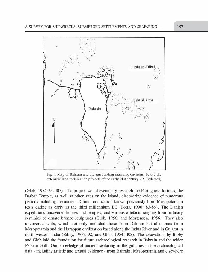
group is dominated by three large islands: Bahrain proper, Sitra, and Muharraq (Fig. 1).
It is these islands that have been the subject of settlement and civilization for millennia.
Bahrain Island is unusual for the gulf, particularly its desiccated western coasts. Here,
fresh water occurs in abundance, flowing from subterranean springs both on land and
under the sea. The underground freshwater supply actually accounts for the name of the
island, which means ‘two seas’, the salty one above and the sweet one below the island.
The presence of sweet water has made parts of the island a lush garden, producing dates
and other produce that has attracted seafarers down through the ages in their quest for
trade and need for replenishment. Drinkable water was the fuel of ancient sailing vessels
- without it the crew could survive only a few days before perishing. Thus, Bahrain with
its dependable and copious water, conveniently located halfway between Mesopotamia
and the Strait of Hormuz with the open sea beyond, organically grew into a maritime
centre and a kingdom in its own right. The rich pearling grounds around the island only
added to its wealth and importance. It is this commerce and activity that gives Bahrain its
importance for nautical archaeological research.
Early evidence of seafaring
In 1953, a Danish expedition under the leadership of Geoffrey Bibby and P. V. Glob
conducted the first major post-World War II archaeological investigations in Bahrain
8
A SURVEY FOR SHIPWRECKS, SUBMERGED SETTLEMENTS AND SEAFARING ... 157
(Glob, 1954: 92-105). The project would eventually research the Portuguese fortress, the
Barbar Temple, as well as other sites on the island, discovering evidence of numerous
periods including the ancient Dilmun civilization known previously from Mesopotamian
texts dating as early as the third millennium BC (Potts, 1990: 83-89). The Danish
expeditions uncovered houses and temples, and various artefacts ranging from ordinary
ceramics to ornate bronze sculptures (Glob, 1956; and Mortensen, 1956). They also
uncovered seals, which not only included those from Dilmun but also ones from
Mesopotamia and the Harappan civilization based along the Indus River and in Gujarat in
north-western India (Bibby, 1966: 92; and Glob, 1954: 103). The excavations by Bibby
and Glob laid the foundation for future archaeological research in Bahrain and the wider
Persian Gulf. Our knowledge of ancient seafaring in the gulf lies in the archaeological
data - including artistic and textual evidence - from Bahrain, Mesopotamia and elsewhere
Fig. 1 Map of Bahrain and the surrounding maritime environs, before the
extensive land reclamation projects of the early 21st century. (R. Pedersen)
SHIPWRECKS AROUND THE WORLD: REVELATIONS OF THE PAST158
(Agius, 2008: 39). Various texts from Mesopotamia mention Dilmun as a place of bountiful
water and a virtual paradise on earth. It is here that Utnaphistim, the Babylonian Noah,
was settled by the gods after the Great Flood as a reward for building the ark and saving
mankind (Glob, 1954: 102; Kovacs, 1989; and Pedersen, 2005). His ark was built in the
traditional method of the Indian Ocean world, that is, by stitching the wooden hull members
together with cordage (Pedersen, 2004a; 2005). This account in the Standard Version of
the Epic of Gilgamesh is our only description of boat building from ancient Mesopotamian
sources. Most likely, the ships of Dilmun, and other lands along the route reaching India
were constructed with this method, which continued through the period of Medieval Arab
seafaring into the twentieth century. It can still be found today in India in Karnataka,
Kerala, and elsewhere (McGrail et al., 2003: 120, 167; Pedersen, 2004b; and Vosmer,
1997). The boat builders of the Indian Ocean world were conservative in their technology,
passing down to the succeeding generations not only boat designs, but the boats themselves.
Among the Arabs of the Persian Gulf, where boats could last a century and design changes
were slow, there is ‘reason to believe that similar boats have sailed the same waters for
over a thousand years’ (Le Baron Bowen Jr., 1949a: 22; Swamy, 1999: 125; and Pedersen,
2003: 17). The ships of the ancient Persian Gulf transported a wide range of goods to and
from Mesopotamia and onward to the Indus Valley and the points between. Wood from
India, along with copper from Oman, and numerous other goods from Mesopotamia and
elsewhere were all transported on ships (Agius, 2008: 39-44; Glob, 1954: 104; Pedersen,
1993; Potts, 1990: 90-92). Bahrain, with its water supply and optimal position along the
gulf, thrived from the sea traffic that came its way, serving as a middleman as well as
producing in abundance the much coveted pearl (Agius, 2008: 71; Glob, 1954: 103).
Generally, where there are boats, there are those lost under the sea, and traces of them or
their cargoes should remain. Thus, Bahrain is an ideal place to search for ancient
shipwrecks.
The Survey: Underwater and elsewhere
INA’s 1993 survey concentrated investigations off the north coast and north-western corner
of Bahrain Island (Fig. 2). A planned investigation of a submerged jetty consisting of
black pebbles located off the western side of the island was not possible due to the
structure’s proximity to a secure compound. Investigation of the island’s eastern coast
was also not possible. To chart our way and record locations of archaeological interest,
we used GPS, the Global Positioning System, which in 1993 was only beginning to be
used in archaeology. Ordinarily, one would have used traditional navigational methods,
such as using compass and a sextant to find latitude and longitude. With the GPS, the
press of a button gave us the same data, saving hours of training in the use of a sextant and
eliminating human error. In the Arabian Gulf, a featureless sea with low lying coastal
areas, longitude and latitude coordinates of wrecks and other sites are the best way to
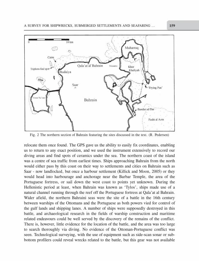
A SURVEY FOR SHIPWRECKS, SUBMERGED SETTLEMENTS AND SEAFARING ... 159
relocate them once found. The GPS gave us the ability to easily fix coordinates, enabling
us to return to any exact position, and we used the instrument extensively to record our
diving areas and find spots of ceramics under the sea. The northern coast of the island
was a centre of sea traffic from earliest times. Ships approaching Bahrain from the north
would either pass by this coast on their way to settlements and cities on Bahrain such as
Saar - now landlocked, but once a harbour settlement (Killick and Moon, 2005) or they
would head into harbourage and anchorage near the Barbar Temple, the area of the
Portuguese fortress, or sail down the west coast to points yet unknown. During the
Hellenistic period at least, when Bahrain was known as ‘Tylos’, ships made use of a
natural channel running through the reef off the Portuguese fortress at Qala’at al Bahrain.
Wider afield, the northern Bahraini seas were the site of a battle in the 16th century
between warships of the Ottomans and the Portuguese as both powers vied for control of
the gulf lands and shipping lanes. A number of ships were supposedly destroyed in this
battle, and archaeological research in the fields of warship construction and maritime
related endeavours could be well served by the discovery of the remains of the conflict.
There is, however, little evidence for the location of the battle, and the area was too large
to search thoroughly via diving. No evidence of the Ottoman-Portuguese conflict was
seen. Technological surveying, with the use of equipment such as side-scan sonar or sub-
bottom profilers could reveal wrecks related to the battle, but this gear was not available
Fig. 2 The northern section of Bahrain featuring the sites discussed in the text. (R. Pedersen)
SHIPWRECKS AROUND THE WORLD: REVELATIONS OF THE PAST160
to the survey. Explorations along Bahrain’s north coast revealed places on the seafloor
containing scattered and broken ceramics. These occurred in clusters around reefs and
other shallows indicating that they were material jettisoned from boats at anchor. This is
a common practice when one drops a ceramic piece on a boat, one throws it overboard. In
anchorages and harbourages, this detritus tends to pile up. All the cast-off pottery witnessed
by the survey consisted of heavy walled, gray, crudely made utilitarian vessels of late
date.
In the Vicinity of Budaiya
On the north-western corner of Bahrain Island is the village of Budaiya. This village
contains a number of fishing boats from which local inhabitants make a living. Such
places are steeped in nautical history and lore, and investigations in the area proved
fruitful for our research. From diving, and talking with local people, we found a shipwreck,
a possible submerged settlement site, an area of the sea floor containing a concentration
of ceramics, and information concerning underwater features and exploration. Seaward
from Budaiya, there is an area of the seafloor that appears to contain walls. Local fishermen
believe these are the remains of houses under the sea. The clarity of the water readily
revealed what seemed to be man-made walls in about 2 m of sea. The walls, some at right
angles to others, were too deep to be fish traps, and such stone-built traps would be
atypical for Bahrain as traps there are made of a fencing of poles. If this was a submerged
settlement, the only times the sea would have been low enough to permit occupation
would have been circa 1800 BC and 400 BC (Sanlaville and Paskoff, 1986). This area
requires further investigation to determine its nature. Farther out from Budaiya is a channel
of deeper water with a rocky bottom surrounded by reef. The channel is a natural feature
that leads from the open sea to the village and continues south along the island’s western
edge. This access to deep water explains the presence of the village it is reliant on the sea
for its livelihood and the channel presents a geographical advantage. At the northern end
of the channel its entrance is marked by a cairn of rocks so that ships may find the
approaches to Budaiya. The cairn and the surrounding area have been explored by British
sport divers who spotted stone anchors and ceramics in the vicinity. On at least one
occasion, it was reported, electronic instruments recorded a curious underwater feature
on the west side of the channel. The cairn and the immediate area were not investigated
by the survey due to limitations of time.
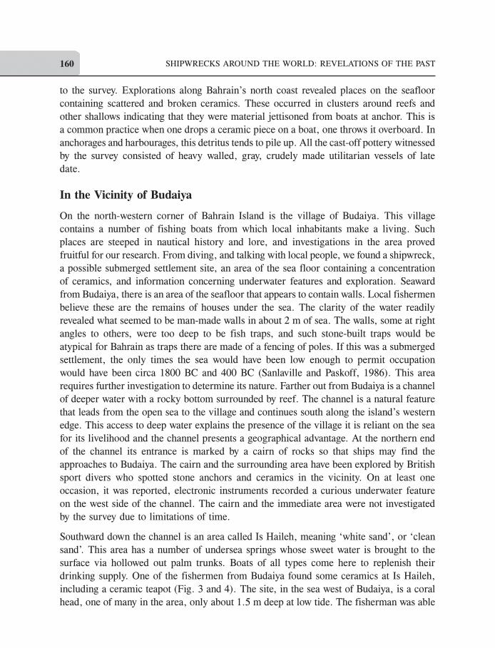
Southward down the channel is an area called Is Haileh, meaning ‘white sand’, or ‘clean
sand’. This area has a number of undersea springs whose sweet water is brought to the
surface via hollowed out palm trunks. Boats of all types come here to replenish their
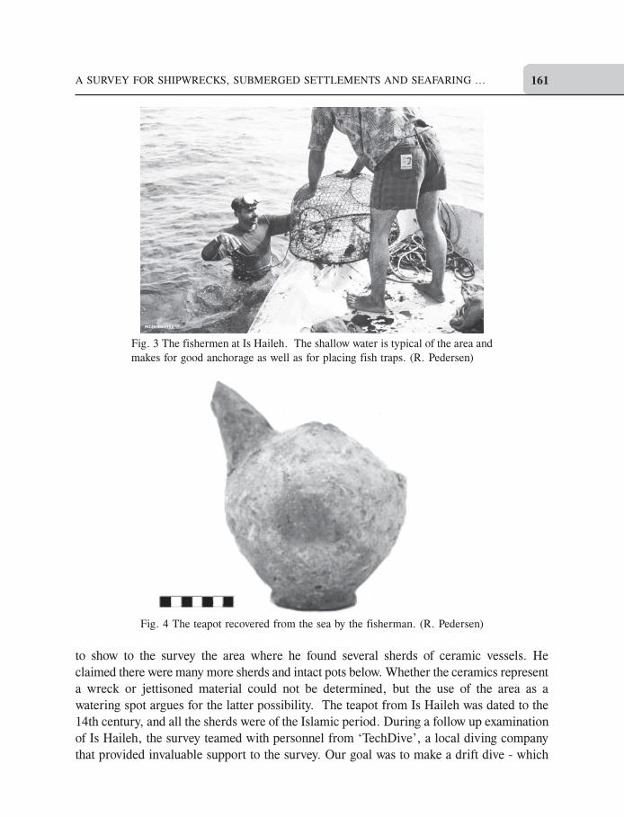
drinking supply. One of the fishermen from Budaiya found some ceramics at Is Haileh,
including a ceramic teapot (Fig. 3 and 4). The site, in the sea west of Budaiya, is a coral
head, one of many in the area, only about 1.5 m deep at low tide. The fisherman was able
A SURVEY FOR SHIPWRECKS, SUBMERGED SETTLEMENTS AND SEAFARING ... 161
Fig. 3 The fishermen at Is Haileh. The shallow water is typical of the area and
makes for good anchorage as well as for placing fish traps. (R. Pedersen)
Fig. 4 The teapot recovered from the sea by the fisherman. (R. Pedersen)
to show to the survey the area where he found several sherds of ceramic vessels. He
claimed there were many more sherds and intact pots below. Whether the ceramics represent
a wreck or jettisoned material could not be determined, but the use of the area as a
watering spot argues for the latter possibility. The teapot from Is Haileh was dated to the
14th century, and all the sherds were of the Islamic period. During a follow up examination
of Is Haileh, the survey teamed with personnel from ‘TechDive’, a local diving company
that provided invaluable support to the survey. Our goal was to make a drift dive - which
SHIPWRECKS AROUND THE WORLD: REVELATIONS OF THE PAST162
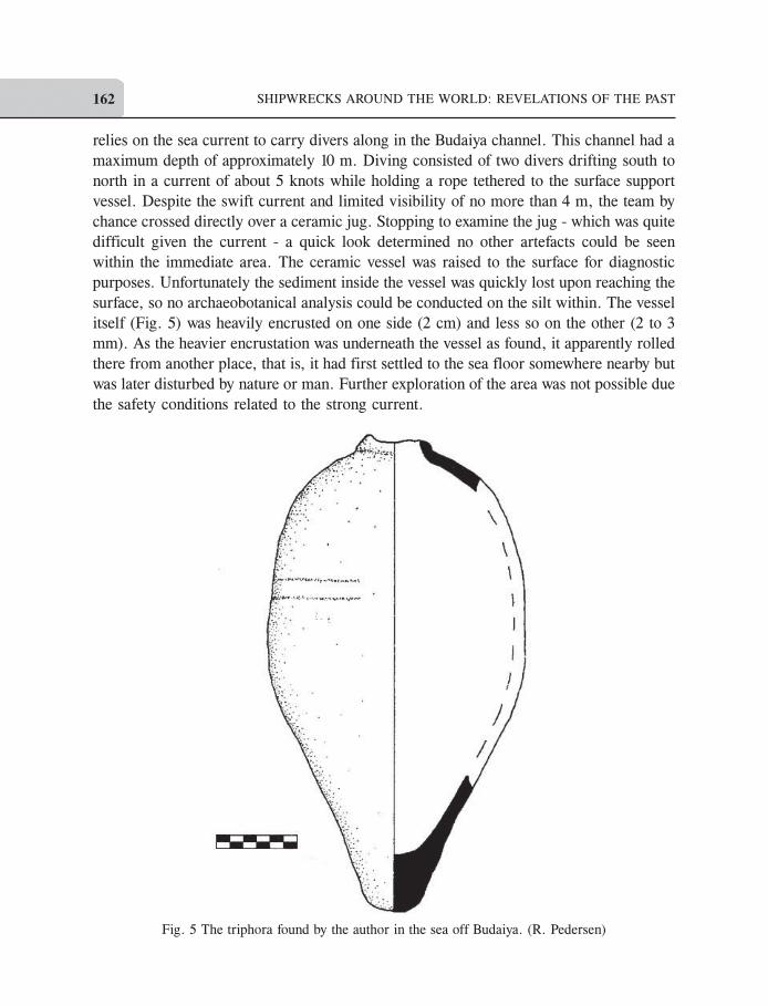
relies on the sea current to carry divers along in the Budaiya channel. This channel had a
maximum depth of approximately 10 m. Diving consisted of two divers drifting south to
north in a current of about 5 knots while holding a rope tethered to the surface support
vessel. Despite the swift current and limited visibility of no more than 4 m, the team by
chance crossed directly over a ceramic jug. Stopping to examine the jug - which was quite
difficult given the current - a quick look determined no other artefacts could be seen
within the immediate area. The ceramic vessel was raised to the surface for diagnostic
purposes. Unfortunately the sediment inside the vessel was quickly lost upon reaching the
surface, so no archaeobotanical analysis could be conducted on the silt within. The vessel
itself (Fig. 5) was heavily encrusted on one side (2 cm) and less so on the other (2 to 3
mm). As the heavier encrustation was underneath the vessel as found, it apparently rolled
there from another place, that is, it had first settled to the sea floor somewhere nearby but
was later disturbed by nature or man. Further exploration of the area was not possible due
the safety conditions related to the strong current.
Fig. 5 The triphora found by the author in the sea off Budaiya. (R. Pedersen)
A SURVEY FOR SHIPWRECKS, SUBMERGED SETTLEMENTS AND SEAFARING ... 163
The ceramic jug was ovoid but slightly asymmetrical, with a pointed toe. The neck and
handles of the jug were missing, but upon cleaning, the attachment points for three handles
became visible on the shoulder. This was then not an amphora, a two handled vessel, but
a ‘triphora’. The neck was broken off nearly completely. The toe was chipped and worn.
There was no evidence of paint or a slip; however there was a decorative band in the
fabric. This is a pair of parallel lines1.9 cm apart. Each was 1.9 mm wide and incised to
a depth of 1 mm. The container measured 36 cm in length, 20.4 cm at its maximum
diameter, and had a volume of 4.6 litres. The nearly non-existent stump of the neck had
an outer diameter of 6.4 cm and inner of 4.5 cm. The handle-attachment points on the
shoulder were each 3.5 cm in diameter and located approximately 2.5 cm from the edge
of the neck opening. The fabric was coarse with large inclusions, light in colour, and
approximately 9 mm thick. The triphora appears to be from a shipwreck known to the
British expatriate divers as the ‘Amphora wreck’. This wreck lies in the same area where
the triphora was located, and at least two similar vessels were reported to have been found
there. Both of these were transported to Britain as souvenirs some decades ago. Sport
divers reportedly also raised the neck and shoulder of another ceramic form, but the
description given was not clear. The divers reported that the wreck was scattered but that
more of these ceramic vessels can be found in the channel off Budaiya. No one recalled
having seen any other artefact types in the area of the wreck, but they admitted they never
examined the site closely. The date of the triphora, and therefore the shipwreck, is
problematic as the ceramic form is largely unrecognized except in a general form - three-
handled vessels appear to be common in the late Islamic era of the region. The local
villagers, however, have a legend about a wrecking near the cairn at the northern end of
the channel off Budaiya. The villagers claim a ship wrecked there ‘several generations’
ago. The British divers assumed this means about 100 years ago. The connection of this
tale, the triphora, and the wreck found by the British sport divers is unproven, but the
evidence points to the conclusion that our find, the British finds, and the wrecking story
are indeed related.
Information from a Pearl Diver
Interviews with an old pearl diver yielded three areas of interest: An area known as the
‘Frying Pan’, another equated with mysterious disappearances of ships, and a zone
containing underwater walls. The area called the ‘Frying Pan’ (Arabic name unknown) is
located between islands of Muharraq and Sitra at the southern end of Khor Khaliyah (Fig.
2). The constriction between the islands causes conflicting currents during the change of
tide causing the sea to ‘bubble like a frying pan’. Many ships have been lost there, according
to the pearl diver, and sailors pass through the strait cautiously. Ships sailing to and from
the ancient Dilmun capital, now located under Manama, would have passed through the
strait between the islands and may have faced similar dangers as those encountered by
SHIPWRECKS AROUND THE WORLD: REVELATIONS OF THE PAST164
modern vessels. A channel, however, has been dredged through this area to a depth of 9.8
m, and this, combined with heavy sea traffic, would be a problem for any archaeological
investigation there. The margins of the area have not been completely dredged, however,
so there may be remains of ships in the unaffected zones. The pearl diver told of the
existence of submerged walls near the island of Qassar al Qulay’ah, found to the west of
the frying pan. The survey saw neither these - as the water was not entered - nor any overt
evidence of occupation on the island. Aside from modern refuse and some nondescript
ceramic sherds, the island appeared devoid of human activity. However, the island would
have been the logical place for a lighthouse, or even a sentry post to guard the southern
entrance to the bay. Further investigation may reveal such use of Qassar al Qulay’ah as
well as the existence and nature of the walls. Another area mentioned by the pearl diver
was called, at least in translation, the ‘Bermuda Triangle of the Gulf’. In this place in the
open sea, two strong currents meet and, as a result many ships are lost. When sailors pass
through this area, they sacrifice to the sea either a goat or a chicken as appeasement to the
‘Djinni’ for safe passage. The pearl diver stated this place is to the northeast of Bahrain,
has no bottom, and mountains can be seen from there. This leads to the conclusion that
the ‘triangle’ is far out in the gulf, within sight of Iran.
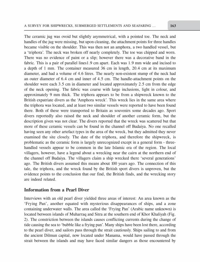
The Bandar ad Dar Interviews
Interviewing fishermen and divers has long been a method of gathering information for
archaeological research, and the men in Bahrain who make their living from the sea
proved to be valuable sources of data. On Sitra Island, Bandar ad Dar is a fishing port
whose harbour is filled with traditional wooden working boats (Fig. 6). Interviews with
Fig. 6 The fishing harbour on Sitra Island with its traditional wooden boats. (R. Pedersen)
A SURVEY FOR SHIPWRECKS, SUBMERGED SETTLEMENTS AND SEAFARING ... 165
the fishermen at Bandar ad Dar yielded four areas of potential archaeological interest.
When queried if they knew of any pottery in the sea and whether they knew of any
shipwrecks, several fishermen responded they had found pottery but, as they saw no value
in it, they always threw it back. They could not pin-point locations. However, all agreed
there were pottery and many wrecks to be found along Fasht al-Azm, a large reef reaching
east from Bahrain toward Qatar. In addition, the fishermen named three other areas
considered dangerous for ships and known to contain wrecks of recent dates. These are
Halul (an island located between Qatar and the United Arab Emirates), Gaidat Bulyal,
and Fasht al-Dibal (a reef between Bahrain and Qatar).
Shipwrecks
The survey was told of two shipwrecks found in the vicinity of Manama in the 20th
century. Like many shipwrecks around the world these were found during construction
and little was noted of them at the time. The first of these was found during the building
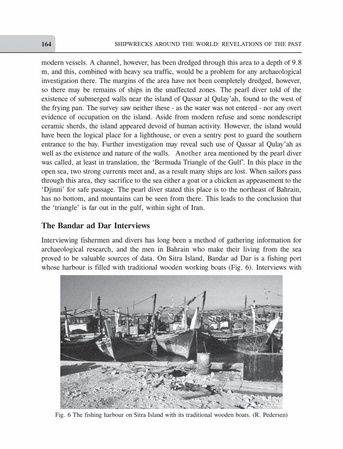
of the coast guard station at the old Abu Mahir fort on Muharraq Island (Fig. 7). At one
Fig. 7 A map of Muharraq as the shoreline existed in the early 1990s. (R. Pedersen)
SHIPWRECKS AROUND THE WORLD: REVELATIONS OF THE PAST166
point, possibly in the 16th or 17th centuries, the fort was sacked and burned, as apparently
was a ship lying at anchor. The ship remains, found in the water adjacent to the fort,
showed signs of fire. The keel and several other timbers were noted by the discoverers, as
were five cannons. The cannons were removed, and are now displayed at the reconstructed
facade of the fort and at the entrance to the Bahrain National Museum. The wreck itself
was left in place and now lies under the concrete wharf along the waterfront of the fort.
Attributes of the wreck were not recorded. Other wrecks of the same period and battle
may lie in the small, shallow bay between Abu Mahir Fort and Arad Fort, but this has not
been investigated. A number of ceramics have been reportedly found in the bay, but these
may be simply the detritus of ordinary harbour activity and not indicative of wrecks. The
second shipwreck is located under a buoy just off the Dhow harbour on Manama’s northern
shore. The wreck of unknown date was discovered some decades ago during the dredging
of a channel. Older residents remember large ship timbers being hauled off the sea bottom,
which were neither recorded nor preserved. Whether any parts of this shipwreck remain
underwater is unclear, but as the site is marked by a buoy, some of it may still be extant.
The Flats near the Portuguese Fortress
On the central northern coast of Bahrain lie the ruins of the Portuguese fortress known as
Qala’at al-Bahrain. This site has been occupied since antiquity, as excavations have revealed
strata dating to the Dilmun Period (late third/early second millennium BC), the Hellenistic
period (late first millennium BC), the period of Portuguese occupation, and through the
late Islamic era. The Portuguese, in their expansion into the Indian Ocean beginning in
the late 1490s, established forts in Bahrain and elsewhere in the gulf, and battled Ottoman
Turks for control of the Persian Gulf. The fortresses were ultimately abandoned as
Portuguese power in the region faded. The seafront at the Portuguese fortress is a tidal
flat of mud and reef extending north approximately one km. At high tide, water covers
it to a depth of about one meter. At low tide, the flats are exposed. The mud may be a
meter, or more, deep in some places. Running through the flats is a channel. Although it
is silting up, the channel once gave the fortress and city access to the sea. The Danish
expedition of Glob and Bibby noted a slipway for servicing or launching ships at the
landward end of the channel. The channel was explored by the survey as far as was
permissible due to conditions of reef growth and siltation. During Hellenistic Tylos, there
was a Pharos, or lighthouse, at the opening of the channel on the western corner. This
area of the Pharos was examined for evidence of this construction. Examination of the top
of the reef, as well as the surrounding environs for cut stone blocks yielded no trace of the
lighthouse, nor any objects that could be associated with it. Either the materials were
long ago scavenged, or the ruins lie under sand in the channel or overgrown by the reef.
Similarly, no evidence of ships or shipping was seen in the channel. High degrees of
siltation were occurring at the time due to a land filling project to the east of the channel,
A SURVEY FOR SHIPWRECKS, SUBMERGED SETTLEMENTS AND SEAFARING ... 167
which greatly obscured features. Throughout the northern zone, silt was observed lying
over various reefs, killing them, and in the channel linking the Hellenistic settlement with
the sea a great amount of sand was building up. Indeed, over the subsequent years after
the survey, much of the northern coast of Bahrain and the island of Muharraq have been
greatly modified by massive land reclamation projects obliterating the ancient seabed.
The Hellenistic settlement, as well as the earlier phases of the site, certainly would have
used a number of ships and boats in the servicing of their city. The flats lying north of the
city may contain watercraft abandoned after they outlived their usefulness as it is common
practice among maritime people to simply abandon worn out boats in harbours, on beaches,
and flats. Evidence of such abandonment of hulls could be seen during the survey. A
modern fibreglass-on-wood-frame boat was left a few hundred meters north of the fort
where it was slowly disintegrating and sinking into the mud. There is the potential of
finding ancient vessels similarly abandoned on the flats, although modern reclamation,
dredging, and construction threaten this area.
Traditional Boat Yards: Repositories of Technology
As mentioned, boats of traditional shape and technology sailed the Persian Gulf from
ancient times into the modern period. Much ancient technology has fallen into disuse in
the face of the simpler European nailing techniques, that is, using iron nails to fasten
planks onto a framework. Indeed wooden boats of any form are in danger of obsolescence
and extinction due to the spread of inexpensive, more durable fibreglass hulls. The
traditional boatyards of Bahrain and Muharraq Islands, however, still contain invaluable
information on methods of wooden boat building in the Persian Gulf. Thus, boat yards
were visited by the survey to observe the construction of wooden watercraft. Evidently,
with the demise of the age-old sewing technique in Bahrain, two boat construction methods
have taken its place. The first, as noted by R. Le Baron Bowen Jr. in the mid-twentieth
century, is a typical frame-first construction in which no plans are used and frames are set
up on the keel based on the builder’s eye for proportion:
...Every other rib runs through the keel; alternate ribs start on each side of the keel.
The planks are put on in more or less logical order, but no attempt is made to fit or spile
them. When they have finished running the planks, there are a lot of little spaces,
maybe one inch by six inches that are filled in with little patches. All planks and patches
are nailed on with large-headed hand-wrought iron nails clinched over on the inside of
the ribs; stains of these nails streak down the outside of the hull (Le Baron Bowen Jr.,
1949b: 109, 111).
The boats are rubbed above the waterline with fish oil ‘appalling in its pungency’, while
below the waterline a ‘mixture of lime and tallow in a thick paste’ is smeared on (Le
Baron Bowen Jr., 1949b: 109, 111). The second technique is one that was witnessed by the
INA survey in 1993. It is a method that uses a system of external moulds to first partly
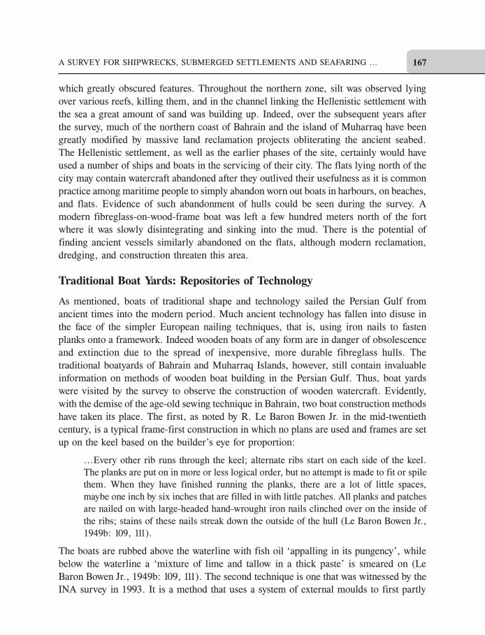
SHIPWRECKS AROUND THE WORLD: REVELATIONS OF THE PAST168
create the shell, or outer skin, of the boat, and then adds the internal framework. First the
keel was laid level, followed by the erection of the stem and post and their attachment to
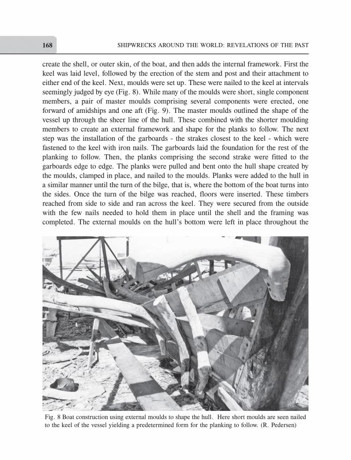
either end of the keel. Next, moulds were set up. These were nailed to the keel at intervals
seemingly judged by eye (Fig. 8). While many of the moulds were short, single component
members, a pair of master moulds comprising several components were erected, one
forward of amidships and one aft (Fig. 9). The master moulds outlined the shape of the
vessel up through the sheer line of the hull. These combined with the shorter moulding
members to create an external framework and shape for the planks to follow. The next
step was the installation of the garboards - the strakes closest to the keel - which were
fastened to the keel with iron nails. The garboards laid the foundation for the rest of the
planking to follow. Then, the planks comprising the second strake were fitted to the
garboards edge to edge. The planks were pulled and bent onto the hull shape created by
the moulds, clamped in place, and nailed to the moulds. Planks were added to the hull in
a similar manner until the turn of the bilge, that is, where the bottom of the boat turns into
the sides. Once the turn of the bilge was reached, floors were inserted. These timbers
reached from side to side and ran across the keel. They were secured from the outside
with the few nails needed to hold them in place until the shell and the framing was
completed. The external moulds on the hull’s bottom were left in place throughout the
Fig. 8 Boat construction using external moulds to shape the hull. Here short moulds are seen nailed
to the keel of the vessel yielding a predetermined form for the planking to follow. (R. Pedersen)
A SURVEY FOR SHIPWRECKS, SUBMERGED SETTLEMENTS AND SEAFARING ... 169
process. More moulds of varying length were added as needed, nailed to the outer face of
the planking as strakes were completed. These additional moulds formed the shape of the
sides as they would reach toward the sheer line of the hull. Additional planking was then
added and fastened to the moulds, creating the sides of the boat. Futtocks (the upper parts
of the internal frames) were inserted, adding to the internal framework as the sides reached
completion. In this way, the shell and internal framework were completed simultaneously,
following the shape created by the master and secondary moulds. The boat was thus not a
true shell-first construction, and not a true frame-first construction, but a hybrid bridging
the two techniques. Framing followed shell, shell followed framing, and both followed the
predetermined shape created by the system of moulds.
With the shell finished, holes were drilled through the planking and frames. Large iron
spikes were driven through the holes, their ends protruding from the frames inside. The
spike ends were then double-clenched, that is, bent over twice, in a herringbone pattern.
After the planking and frames were firmly fastened together, the external moulds were
removed from the hull for use on the next vessel to be built. This reuse creates a conservative
hull shape among vessels from the same yard, as there is little variation between boats
built with the same moulds. The main variance would occur due to the placement of the
moulds along the keel line. Whether there was any measuring system governing their
Fig. 9 The short moulds and one of the master moulds. The combination of the two gives the vessel
its shape as the planking is nailed to the mould up to the sheerline of the vessel. (R. Pedersen)
SHIPWRECKS AROUND THE WORLD: REVELATIONS OF THE PAST170
linear placement is not known, as already mentioned. Given the experience of the
shipbuilders, however, varying mould placement due to a lack of standard measurement
procedures would have produced only minimal differences in boat shape. How old this
method of boat construction is has not been discovered. Ethnographical records of boat
construction in the Persian Gulf are scant, and historical records about the topic are
nearly non-existent. It is possible, if not probable, that this method evolved as the stitching
of planking fell out of fashion and nailing melded with aspects of ancient shipbuilding
techniques. For the finishing touch, after the superstructure and internal utilitarian features
were constructed, the outside of the hull below the waterline was smeared with a mixture
of lime and fat that acted as a sealant and as well as an anti-fouling coating. This layer is
properly called a ‘paying’. The upper works were preserved and waterproofed with oil.
This is an ancient technique, related by numerous medieval travellers to the region, by Le
Baron Bowen as related above, and recorded in the Epic of Gilgamesh (Pedersen, 2004a:
236).
Islands in the Desert
The Danish expeditions to Bahrain led by Bibby and Glob ventured into the southern
reaches of Bahrain island and discovered a hillock at Ras al-Jazayir that was covered with
a midden of oyster shells. This midden was associated with Dilmun-period ceramics,
charcoal, fish bones and assorted mollusk shells (Nielsen, 1958: 159-160). The hillock,
and others like it, was, the Danes found out, an island during ancient times, becoming
landlocked due to changes over the centuries in the relative sea level of one to two meters
(Nielsen, 1958: 158; Sanlaville and Paskoff, 1986b: 15-24). Clearly, this former island
had been a place where ancient seafarers in small boats had put ashore to shuck the
oysters they had gathered to claim the gem within (Nielsen, 1958: 158-160). Pearling has
long been one of the professions of Bahrain, only to cease with the petroleum age. The
mound discovered by the Danes confirmed the industry’s long presence in Bahrain (Nielsen,
1958: 160). The shell midden, located some 4 to 5 km. off the main island’s coast in the
Dilmun period, now lies 1 km. from the sea, and contained flints, small stone columns,
and pottery from the third millennium BC (Glob, 1957: 125-127). Teaming up with
Robert Killick and Jane Moon, then the leaders of the London-Bahrain Archaeological
expedition excavating the Dilmun city at Saar (Killick and Moon, 2005), we decided to
find and examine anew the former island found by the Danish expedition in 1957. Killick
suggested we try to locate two places: the shell midden excavated by the Danes (Glob,
1957: 157; Potts, 1990: 208); and an Ubaid site, a low mound nearly 1.5 km from the sea
but believed to have once been an island (Roaf, 1974: 499). Over 6,000 years ago, the
Neolithic people of the Ubaid culture spread south from Mesopotamia to the southern
reaches of the gulf (Oates, 1986: 80) and Ubaidians could only have reached Bahrain by
boat. The site was said to be ‘barely distinguishable from the surrounding sandy desert
A SURVEY FOR SHIPWRECKS, SUBMERGED SETTLEMENTS AND SEAFARING ... 171
except for the numerous chips of flint and shell on the surface which cover an area of at
least 100m in diameter’ (Roaf, 1974: 499). Its hallmarks include various fish bones,
forms of pottery, goat and dugong bones, and a number of tools (Roaf, 1974: 501). It was
excavated by the British in the 1970s and dates to about 4,000 BC (Larsen, 1986: d42;
Roaf, 1974), making it not only one of the oldest identified sites on the island but probably
the oldest maritime related site in Bahrain.
Both sites are located in sabkha, the sandy flats once part of the sea on Bahrain’s southwest
coast. To locate the two sites, we would use the GPS that we had been using on the sea.
For this, we needed the longitude and latitude coordinates of each place, information
which was not published or at least not immediately available to us. However, a simple
map from a book showed the general longitude and latitude positions we needed. The
sites were marked by dots, which are in scale about 500 m in diameter. We were able to
estimate coordinates for both sites, but we did not know how precisely the sites were
marked on the map. Thus, our figures contained a potential half km error at minimum.
Furthermore, the GPS signal in the gulf at the time had a degraded accuracy to no less
than 150 m. Thus, even if our calculations from the map were exact, the GPS could still
place us well off the mark. It was worth pursuing, however. A few years earlier, a team of
archaeologists and explorers used GPS to find their way through the desert of Oman in
their search for the fabled lost city of Ubar. Flying by helicopter and guided by GPS, the
search team was able to locate ancient caravan tracks that had been spotted with radar
from the space shuttle Challenger. These tracks proved to be part of the old network that
linked the cities of southern Arabia and led the expedition to the lost city (Blom et al.,
1997). We hoped for similar success with our GPS. Thus, with our derived coordinates,
we headed into the desert. As we sped south, the GPS screen displayed the distance
between us and the longitude/latitude coordinates we had derived for the site, and the
unit’s direction finder kept our course straight through the featureless sands. Guided by
the signal from outer space, we turned off the road onto desert pathways somewhere near
the Ubaid site. We then proceeded by foot over gently rolling dunes, only to find our way
blocked by a chain-link fence enclosing a camel herd. Somewhere beyond the perimeter
lay the Ubaid site. This objective was out of bounds and we turned our sights to the
Dilmun-period site with its midden of oyster shells. Returning to the road we travelled
southward through the sabkha toward our second target until the GPS indicated that we
had arrived at the position calculated from the map. We were again on the sabkha, this
time only meters away from a camel-racing track stretching into the desert. There was no
mound, only the white fencing around the track and the flat, shell-littered sand of the
ancient seabed. We feared the midden had been destroyed to make way for camel races.
Scanning our surroundings with binoculars we could see to the east several low dunes
containing no piles of shell, which still glitter in the sun even after millennia of exposure.
More distant features blurred in the hot air rising from the sand. Southward, beyond the
SHIPWRECKS AROUND THE WORLD: REVELATIONS OF THE PAST172
far turn of the racetrack, we spotted a hillock rising prominently and promisingly over the
desert. We headed there. Upon reaching the hillock we saw it was a natural sand mound
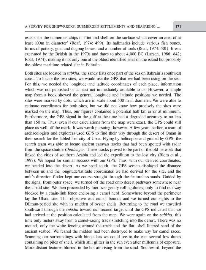
with piles of oyster shells on top (Fig. 10). Searching around the compacted shells, in
some places over a meter deep, we found numerous pottery sherds of the Dilmun period.
Standing atop the pile of oyster shells, we could see the waters of the gulf a km to the
west. Its western section had been bulldozed away, but the outline of the surviving section
of the mound was visible against the flat of the sabkha. Clearly, this was an ancient island
that had been used by oystermen. The gently rising strand on the island’s east face, where
the ancient mariners must have beached their boats, lay between the piles of shells and the
ancient seabed. Somewhere on this island ancient pearl divers had made camp to shuck
oysters and harvest pearls.
We had found a midden of the correct age, but we could not tell whether it was the same
one that the Danish team had found and excavated. The remaining section of our midden
was small - the one the Danes studied was 5.5 m high and covered an area 200 by 100 m
(Nielsen, 1958: 157). Although there was a degree of error in our estimate of the
coordinates, the midden we stood on was close to the position we had derived. It is
Fig. 10 The midden the survey located in Bahrain’s desert. Oyster shells
litter the former island and still glitter in the sun after millennia. (R. Pedersen)
A SURVEY FOR SHIPWRECKS, SUBMERGED SETTLEMENTS AND SEAFARING ... 173
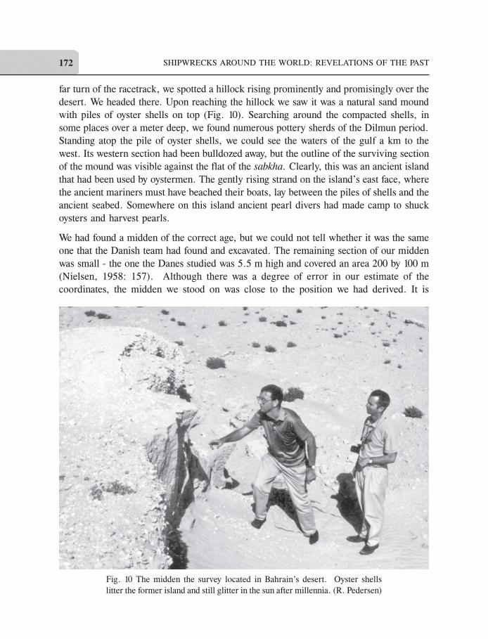
possible that the bulk of the Danes’ midden was destroyed by the construction of the
camel race track. The western section of the mound and midden we found had been
completely cut down to ground level by construction machinery, so perhaps we discovered
only the remains of the larger feature (Fig. 11). Yet, to the south lay several other hillocks.
Fig. 11 The western, surviving edge of the island and midden
after being cut through by earth-moving machinery. (R. Pedersen)
SHIPWRECKS AROUND THE WORLD: REVELATIONS OF THE PAST174
Was one of those the actual midden we sought? Or were these other mounds seen by the
Danes but not investigated, which they felt were similar former island sites (Nielsen,
1958: 160)? We could not tell. The day was ending and we turned back north to home and
base. The ancient island in the sabkha and its possible accompanying neighbours await
further research.
Results and Conclusions
Bahrain with its long history of seafaring is a promising area for research into the nautical
archaeology of the Persian Gulf. It is impossible to estimate the number of ships that have
sailed the island’s waters over the millennia, but where ships sail, they also sink.
Undoubtedly, more than the few shipwrecks found by or reported to our survey exist in
these waters. Further research is required to trace down the rumours, verify stories, and
find the actual shipwrecks that must exist in the Persian Gulf. Although the seas around
Bahrain are shallow - always a negative factor for shipwreck preservation - the existence
of the Triphora wreck argues that wrecked ships can and do survive in Bahraini waters. A
comprehensive underwater survey utilizing modern remote-sensing techniques such as
multi-beam sonar would be invaluable to creating the data needed to find shipwrecks,
further our understanding of the sea and land morphology of the islands, and add
significantly to our knowledge of some of the world’s oldest maritime trading routes.
Acknowledgements
This project was generously funded by the Institute of Nautical Archaeology and made
possible by the kind assistance of the Bahrain Ministry of Information, the Bahrain National
Museum, BAPCO, Kevin Patience, Robert Killick, Jane Moon, James Coggeshall, and
the many interested and enthusiastic individuals in Bahrain. I particularly thank Abdulaziz
Soweileh, superintendent of archaeology for his friendship and aid.
Endnotes
1
The gulf is also known as the ‘Arabian Gulf’ but here the traditional Classical terminology is used.
References
Agius, D. A., 2008. Classic Ships of Islam. Brill, Leiden.
Bibby, G., 1966. Arabian Gulf Archaeology. Kuml, 90-95.
Blom, R., Crippen, R., Elachi, C., and Clapp, N., 1997. Space Technology and the Discovery of the
Lost City of Ubar. Proceedings of the Aerospace Conference, IEEE Xplore Digital Library, Vol. 1:
19-28.
Glob, P. V., 1957. Snake Sacrifices in Bahrain’s Ancient Capital. Kuml, 125-127.
Glob, P. V., 1956. A Neo-Babylonian Burial from Bahrain’s Prehistoric Capital. Kuml, 172-174.
Glob, P. V., 1954. Bahrain - Island of the Hundred Thousand Burial-Mounds. Kuml, 100-105.
A SURVEY FOR SHIPWRECKS, SUBMERGED SETTLEMENTS AND SEAFARING ... 175
Killick, R., and Moon, J., (Eds.), 2005. The Early Dilmun Settlement at Saar. Archaeology International,
Ludlow.
Kovacs, M., 1989. The Epic of Gilgamesh. Stanford University Press, Stanford.
Larsen, C. E., 1986. Variation in Holocene Land Use Patterns on the Bahrain Islands: Construction of
a Land Use Model. In Haya Ali Khalifa and Michael Rice (Eds.), Bahrain Through the Ages: The
Archaeology, KPI Limited, London: 25-46.
Le Baron Bowen Jr., R., 1949a. Arab Dhows of Eastern Arabia. Private Printing.
Le Baron Bowen Jr., R., 1949b. Arab Dhows of Eastern Arabia. American Neptune, Vol. 9: 87- 132.
McGrail, S., Blue, L., Kentley, E., and Palmer, C., 2003. Boats of South Asia. Routledge Curzon,
London.
Mortensen, P., 1956. The Temple Oval at Barbar. Kuml, 195-198.
Nielsen, V., 1958. Famed for its Many Pearls. Kuml, 157-161.
Oates, J., 1986. The Gulf in Prehistory. In Haya Ali Khalifa and Michael Rice (Eds.), Bahrain Through
the Ages: The Archaeology, KPI Limited, London: 79-86.
Pedersen, R. K., 2005. Was Noah’s Ark a Sewn Boat? Biblical Archaeology Review, Vol. 31 (3): 18-56.
Pedersen, R. K., 2004a. Traditional Arabian Watercraft and the Ark of the Gilgamesh Epic: interpretations
and realizations. In Michael MacDonald (Ed.), Proceedings of the Seminar for Arabian Studies,
Archaeopress, Oxford: 231-238.
Pedersen, R. K., 2004b. The Shipwreck in a Coconut Grove: The Kadakkarapally Boat. The INA
Quarterly, Vol. 31 (2): 3-9.
Pedersen, R. K., 2003. The Boat-building Sequence in the Epic of Gilgamesh and the Sewn Boat
Relation. Texas A&M University, Texas.
Pedersen, R. K., 1993. The Ships of Eden: Nautical Archaeology in Bahrain. INA Quarterly, Vol. 20
(2): 13-18.
Potts, D. T., 1990. The Arabian Gulf in Antiquity. Volume 1. Clarendon Press, Oxford.
Roaf, M., (1974). Excavations at Al Markh, Bahrain: A fish midden of the fourth millennium BC.
Paleorient, Vol. 2 (2): 499-501.
Sanlaville, P., and Paskoff, R., 1986. Shoreline Changes in Bahrain since the Beginning of Human
Occupation. In Haya Ali Khalifa and Michael Rice (Eds.), Bahrain Through the Ages: The Archaeology,
KPI Limited, London: 15-24.
Swamy, L. N., 1999. Traditional Boats of Karnataka and their Building Practices. In K. S. Behera
(Ed.), Maritime Heritage of India, Aryan Books International, New Delhi: 116-142.
Vosmer, T., 1997. Indigenous fishing craft of Oman. International Journal of Nautical Archaeology,
Vol. 26 (3): 217-235.
Ralph K Pedersen is the Deutscher Akademischer Austausch Dienst Gastdozent for
Nautical Archaeology at Philipps-Universität Marburg. Previously, he served as Distinguished
Visiting Professor in Anthropology and Knapp Chair in Liberal Arts at the University of San
Diego and the Whittlesey Chair Visiting Assistant Professor in the Department of History
and Archaeology at the American University of Beirut. Dr. Pedersen has excavated a
1500 year old shipwreck at Black Assarca Island, Eritrea; surveyed shipwrecks off New
York’s Long Island, and served as an Associate Director of India’s Kadakkarapally Boat
Project. He has also conducted extensive research in Lebanon. He has been a Research
Associate with the Institute of Nautical Archaeology since 1992. Dr. Pedersen holds a
doctorate from the Nautical Archaeology Program at Texas A&M University.
Email: [email protected]
First published in 2015