r s i t y , eb i o prosp d i v e ngand journal of ... · impacts of furrow irrigation on shesher...
TRANSCRIPT

Impacts of Furrow Irrigation on Shesher and Welala Natural Reservoirs of LakeTana Sub Basin, EthiopiaDereje Tewabe*
Researcher and Center Director ARARI, Bahir-Dar Fisheries and Other Aquatic Life Research Center, Ethiopia*Corresponding author: Dereje Tewabe, Researcher and Center Director ARARI, Bahir-Dar Fisheries and Other Aquatic Life Research Center, P.O.Box 794, Bahir-Dar, Ethiopia, Tel: +251 0911991164; E-mail: [email protected]
Received date: Sep 08, 2014, Accepted date: Oct 15, 2014, Publication date: Oct 20, 2014
Copyright: © 2014 Tewabe D. This is an open-access article distributed under the terms of the Creative Commons Attribution License, which permits unrestricted use,distribution, and reproduction in any medium, provided the original author and source are credited.
Abstract
The survey was conducted from March 2012 to March 2013 based on field observations and samples. Shesher isnatural reservoir of Lake Tana found at coordinates of 0350300 and 1322162 UTM and at altitudes 1805 a.s.l.Welala natural reservoir is found at UTM coordinates of 0348348 and 1326081 with altitude of 1804 a.s.l. The areaof Shesher and Welala was estimated about 500 ha and 110 ha respectively, which are impounded by open waterfor extended period of a year and both with maximum depth of 3 m during rainy season. Both reservoirs filled theircapacity during the rainy season through the inflow river of Ribb and the surrounding flood plain. But during pick dryseason of March, 2012 and March 2013 the survey showed unexpected, amazing and sudden death of a home formany biodiversity that both Shesher and Welala natural reservoirs dried up totally. Birds fetch their food fromremnants small shrink wet mud spot and it is not uncommon to see remnant dead fishes eaten by birds. This is dueto several and unlimited human encroachments mainly for crop cultivation, without any rules and regulations. Majorcrops cultivated by drained two reservoirs using gravitational force were Eragrastis teff, Cheak pea, Grass pea,Lentils and Safflower. During dry season no one could be able found drinking water even for their animals andhumans, inhabitants started digging well to fetch water from the middle of Shesher and Welala reservoirs. Thedrainage system was carried out at every 50 m intervals by making large furrows in both sides of two reservoirs untiltheir water totally vanished. These reservoirs should be properly and sustainably exploited by designing appropriateinterventions without land use change, for instance it could be serve for fisheries, ecotourism and livestock sectors.
Keywords: Eco-tourism, Eragrastis teff, Fisheries; Floodplain andIntervention
IntroductionDirect effects of climate change on wetlands are likely to be
accentuating by human induced changes that will increase stress onwetland ecosystems. Up to 60% wetlands have been destroyed in thelast 100 years due to drainage, conversion, infrastructure developmentand pollution. These changes could have been responsible for most ofthe loss in freshwater biological diversity in the United States in recentdecades [1]. Water demand is projected to increase steadily during thecoming decades. However, climate change is expected to lead to adecrease in water availability, especially in arid and semi-arid areas. Toaddress this problem, many countries will need to continue efforts toincrease reservoir storage capacity to meet the increasing demands forfreshwater.
Nowadays in most parts of Ethiopia, watersheds are facing extremedegradation due to intensive cultivation, overgrazing, increasedpopulation, increased deforestation and other human actions [2]. Inhighlands of Ethiopia, there is a serious degradation of land which alsoaffects the wetlands providing significant contribution to foodproduction. This increased pressure upon the wetlands is leading toenvironmental degradation, and crop yields have declined by 50 to65% in the past 20 years. Water bodies are vulnerable to climatechange due to rainfall variability, inappropriate land and water use.Water management programs are not developed in most developingcountries, where they are most needed. Furthermore, the cost for
managing water supplies are increasing compared to limited financialresources [3].
Given the fragility of wetlands, its importance for water supply andthe growing pressures to convert them to agriculture uses, there is anurgent need for sustainable use of wetlands. This requiresmanagement regimes, which help to maintain some of the naturalcharacteristics of wetlands while also allowing partial conversion toallow activities, which can meet the economic needs of communities.A balance has to be made between the environmental functioning ofthe two wetlands and their use for livelihood purposes. The purpose ofthis survey is therefore, to evaluate the current encroachment status ofShesher and Welala natural reservoirs in Lake Tana sub basins.
ObjectiveTo evaluate the current status of Shesher and Welala natural
reservoirs with respect to anthropogenic activities and able to proposepossible solutions
Materials and Methods
Study areaThe study was conducted in the north eastern part of Lake Tana
(source of the Blue Nile). The lake is the largest one (3150 km2) inEthiopia, comprising 50% of the total freshwater resources of thecountry. It is a shallow lake with a mean depth of 8 m and maximumdepth of 14 m, situated 1800 m above sea level. Seven large, permanentrivers and about 40 small seasonal rivers feed the lake. The trophic
Tewabe, J Biodivers Biopros Dev 2014, 1:3 DOI: 10.4172/2376-0214.1000131
Review Article Open Access
J Biodivers Biopros DevISSN:2376-0214 IJBBD, an open access journal
Volume 1 • Issue 3 • 1000131
Journal of Biodiversity, Bioprospecting and DevelopmentJo
urna
l of B
iodi
versi
ty, Bioprospecting and Developm
ent
ISSN: 2376-0214
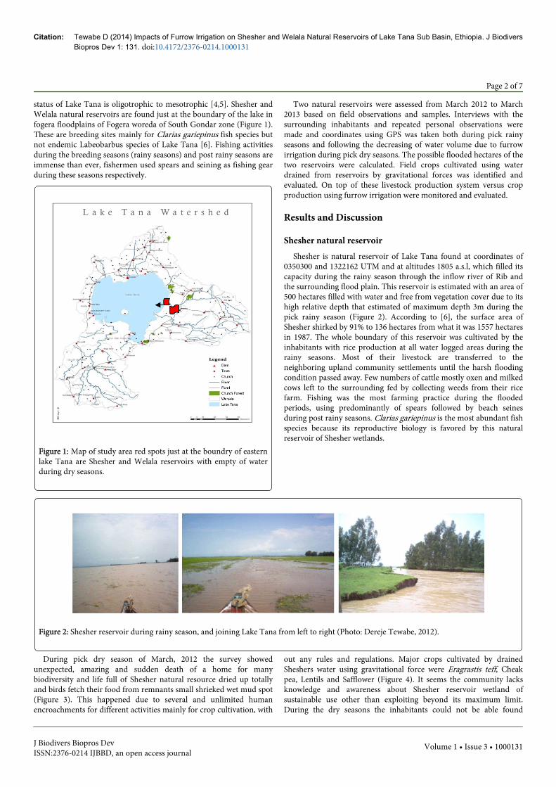
status of Lake Tana is oligotrophic to mesotrophic [4,5]. Shesher andWelala natural reservoirs are found just at the boundary of the lake infogera floodplains of Fogera woreda of South Gondar zone (Figure 1).These are breeding sites mainly for Clarias gariepinus fish species butnot endemic Labeobarbus species of Lake Tana [6]. Fishing activitiesduring the breeding seasons (rainy seasons) and post rainy seasons areimmense than ever, fishermen used spears and seining as fishing gearduring these seasons respectively.
Figure 1: Map of study area red spots just at the boundry of easternlake Tana are Shesher and Welala reservoirs with empty of waterduring dry seasons.
Two natural reservoirs were assessed from March 2012 to March2013 based on field observations and samples. Interviews with thesurrounding inhabitants and repeated personal observations weremade and coordinates using GPS was taken both during pick rainyseasons and following the decreasing of water volume due to furrowirrigation during pick dry seasons. The possible flooded hectares of thetwo reservoirs were calculated. Field crops cultivated using waterdrained from reservoirs by gravitational forces was identified andevaluated. On top of these livestock production system versus cropproduction using furrow irrigation were monitored and evaluated.
Results and Discussion
Shesher natural reservoirShesher is natural reservoir of Lake Tana found at coordinates of
0350300 and 1322162 UTM and at altitudes 1805 a.s.l, which filled itscapacity during the rainy season through the inflow river of Rib andthe surrounding flood plain. This reservoir is estimated with an area of500 hectares filled with water and free from vegetation cover due to itshigh relative depth that estimated of maximum depth 3m during thepick rainy season (Figure 2). According to [6], the surface area ofShesher shirked by 91% to 136 hectares from what it was 1557 hectaresin 1987. The whole boundary of this reservoir was cultivated by theinhabitants with rice production at all water logged areas during therainy seasons. Most of their livestock are transferred to theneighboring upland community settlements until the harsh floodingcondition passed away. Few numbers of cattle mostly oxen and milkedcows left to the surrounding fed by collecting weeds from their ricefarm. Fishing was the most farming practice during the floodedperiods, using predominantly of spears followed by beach seinesduring post rainy seasons. Clarias gariepinus is the most abundant fishspecies because its reproductive biology is favored by this naturalreservoir of Shesher wetlands.
Figure 2: Shesher reservoir during rainy season, and joining Lake Tana from left to right (Photo: Dereje Tewabe, 2012).
During pick dry season of March, 2012 the survey showedunexpected, amazing and sudden death of a home for manybiodiversity and life full of Shesher natural resource dried up totallyand birds fetch their food from remnants small shrieked wet mud spot(Figure 3). This happened due to several and unlimited humanencroachments for different activities mainly for crop cultivation, with
out any rules and regulations. Major crops cultivated by drainedSheshers water using gravitational force were Eragrastis teff, Cheakpea, Lentils and Safflower (Figure 4). It seems the community lacksknowledge and awareness about Shesher reservoir wetland ofsustainable use other than exploiting beyond its maximum limit.During the dry seasons the inhabitants could not be able found
Citation: Tewabe D (2014) Impacts of Furrow Irrigation on Shesher and Welala Natural Reservoirs of Lake Tana Sub Basin, Ethiopia. J BiodiversBiopros Dev 1: 131. doi:10.4172/2376-0214.1000131
Page 2 of 7
J Biodivers Biopros DevISSN:2376-0214 IJBBD, an open access journal
Volume 1 • Issue 3 • 1000131

drinking water even for their animals and themselves, they starteddigging well to fetch water from the Shesher reservoir.
Figure 3: Total dried up of Shesher reservoir with shrieked mud aggregated by birds at the center.
Figure 4: Major crops cultivated by draining water through furrow irrigation system from Shesher reservoir of Lake Tana wetland.
Un studied water use that is extensive use of irrigation to alldirections of the reservoir causes shortage or even loss of wholeavailable water which leads to wilt and dried of crop prior its ripening
periods, there has been a lot of clues such as cracking of soil at earlystage of Eragrastis teff and its color also indicates its future negativefate that might end up with non ripe seeds (Figure 5).
Figure 5: Lack of irrigable water that shows cracked soil and poor plant color of Eragrastis teff that might lead to wilt and death of a plantprior to ripe.
Such type of irrigation system in Shesher reservoir could not berecommended practice because it is not well studied and high pressurewas imposed from four kebele inhabitants of its surrounding withoutcalculating its carrying capacity, it drained until the water lost from thearea by making furrows even followed its small shrinkage (Figure 6).
Water could not be found even for drinking of their animals and forthemselves, as a result they started digging of the ground to fetch waterfor themselves and their animals (Figure 7).
Citation: Tewabe D (2014) Impacts of Furrow Irrigation on Shesher and Welala Natural Reservoirs of Lake Tana Sub Basin, Ethiopia. J BiodiversBiopros Dev 1: 131. doi:10.4172/2376-0214.1000131
Page 3 of 7
J Biodivers Biopros DevISSN:2376-0214 IJBBD, an open access journal
Volume 1 • Issue 3 • 1000131

Figure 6: Uncontrolled drainage of Shesher reservoir for irrigation purpose until it totally dried up from the area.
Figure 7: Digging ground water (Well) at the center of Shesher reservoir for their animals after complete dried up of the reservoir.
Figure 8: Furrows of Welala reservoir with 50 m intervals at both sides of farm lands to irrigate their crops.
Welala natural reservoirWelala wetland is found at UTM coordinates of 0348348 and
1326081 with altitude of 1804 a.s.l. The surface area of Welala is
estimated about 110 ha, which is impounded by open water for alongperiod of a year with maximum depth of 3m during rainy season.According to [6] its surface area was 159 hectares shirked by 47% from
Citation: Tewabe D (2014) Impacts of Furrow Irrigation on Shesher and Welala Natural Reservoirs of Lake Tana Sub Basin, Ethiopia. J BiodiversBiopros Dev 1: 131. doi:10.4172/2376-0214.1000131
Page 4 of 7
J Biodivers Biopros DevISSN:2376-0214 IJBBD, an open access journal
Volume 1 • Issue 3 • 1000131
what it was 298 ha in 1987. Welala wetland was imposed by one kebeleonly, Nabega Giorgis that has bylaw, to be assigned only forcommunal grazing land in contrast to Shesher wetland. But humanencroachment is defined here by draining water in both directions forcrop cultivation on neighboring lands other than Welala territories.The drainage system carried out at every 50 m intervals by makinglarge furrows in both sides of Welala (Figure 8), as a result the volumedecreased very rapidly and becomes unable of supporting the biota ofWelala ecosystems.
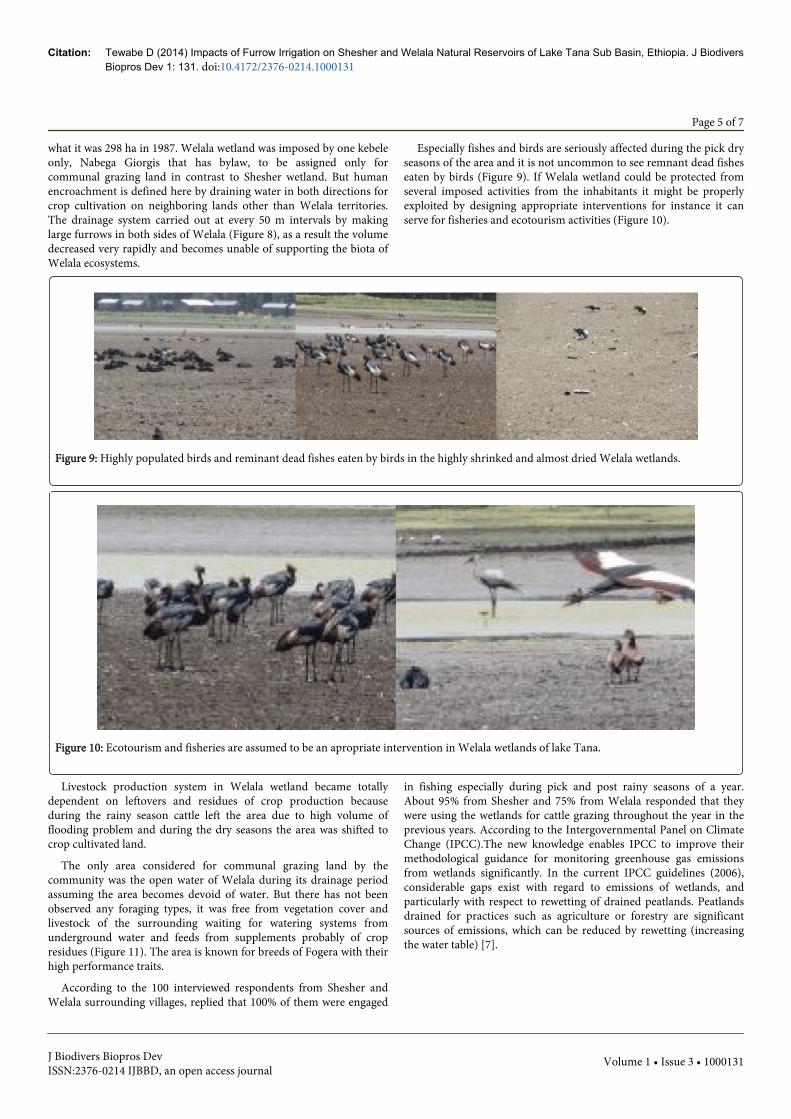
Especially fishes and birds are seriously affected during the pick dryseasons of the area and it is not uncommon to see remnant dead fisheseaten by birds (Figure 9). If Welala wetland could be protected fromseveral imposed activities from the inhabitants it might be properlyexploited by designing appropriate interventions for instance it canserve for fisheries and ecotourism activities (Figure 10).
Figure 9: Highly populated birds and reminant dead fishes eaten by birds in the highly shrinked and almost dried Welala wetlands.
Figure 10: Ecotourism and fisheries are assumed to be an apropriate intervention in Welala wetlands of lake Tana.
Livestock production system in Welala wetland became totallydependent on leftovers and residues of crop production becauseduring the rainy season cattle left the area due to high volume offlooding problem and during the dry seasons the area was shifted tocrop cultivated land.
The only area considered for communal grazing land by thecommunity was the open water of Welala during its drainage periodassuming the area becomes devoid of water. But there has not beenobserved any foraging types, it was free from vegetation cover andlivestock of the surrounding waiting for watering systems fromunderground water and feeds from supplements probably of cropresidues (Figure 11). The area is known for breeds of Fogera with theirhigh performance traits.
According to the 100 interviewed respondents from Shesher andWelala surrounding villages, replied that 100% of them were engaged
in fishing especially during pick and post rainy seasons of a year.About 95% from Shesher and 75% from Welala responded that theywere using the wetlands for cattle grazing throughout the year in theprevious years. According to the Intergovernmental Panel on ClimateChange (IPCC).The new knowledge enables IPCC to improve theirmethodological guidance for monitoring greenhouse gas emissionsfrom wetlands significantly. In the current IPCC guidelines (2006),considerable gaps exist with regard to emissions of wetlands, andparticularly with respect to rewetting of drained peatlands. Peatlandsdrained for practices such as agriculture or forestry are significantsources of emissions, which can be reduced by rewetting (increasingthe water table) [7].
Citation: Tewabe D (2014) Impacts of Furrow Irrigation on Shesher and Welala Natural Reservoirs of Lake Tana Sub Basin, Ethiopia. J BiodiversBiopros Dev 1: 131. doi:10.4172/2376-0214.1000131
Page 5 of 7
J Biodivers Biopros DevISSN:2376-0214 IJBBD, an open access journal
Volume 1 • Issue 3 • 1000131
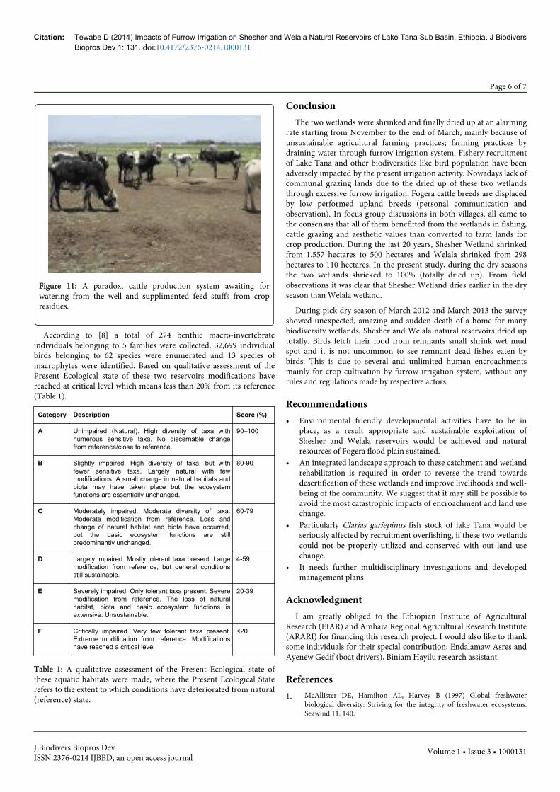
Figure 11: A paradox, cattle production system awaiting forwatering from the well and supplimented feed stuffs from cropresidues.
According to [8] a total of 274 benthic macro-invertebrateindividuals belonging to 5 families were collected, 32,699 individualbirds belonging to 62 species were enumerated and 13 species ofmacrophytes were identified. Based on qualitative assessment of thePresent Ecological state of these two reservoirs modifications havereached at critical level which means less than 20% from its reference(Table 1).
Category Description Score (%)
A Unimpaired (Natural). High diversity of taxa withnumerous sensitive taxa. No discernable changefrom reference/close to reference.
90–100
B Slightly impaired. High diversity of taxa, but withfewer sensitive taxa. Largely natural with fewmodifications. A small change in natural habitats andbiota may have taken place but the ecosystemfunctions are essentially unchanged.
80-90
C Moderately impaired. Moderate diversity of taxa.Moderate modification from reference. Loss andchange of natural habitat and biota have occurred,but the basic ecosystem functions are stillpredominantly unchanged.
60-79
D Largely impaired. Mostly tolerant taxa present. Largemodification from reference, but general conditionsstill sustainable.
4-59
E Severely impaired. Only tolerant taxa present. Severemodification from reference. The loss of naturalhabitat, biota and basic ecosystem functions isextensive. Unsustainable.
20-39
F Critically impaired. Very few tolerant taxa present.Extreme modification from reference. Modificationshave reached a critical level
<20
Table 1: A qualitative assessment of the Present Ecological state ofthese aquatic habitats were made, where the Present Ecological Staterefers to the extent to which conditions have deteriorated from natural(reference) state.
ConclusionThe two wetlands were shrinked and finally dried up at an alarming
rate starting from November to the end of March, mainly because ofunsustainable agricultural farming practices; farming practices bydraining water through furrow irrigation system. Fishery recruitmentof Lake Tana and other biodiversities like bird population have beenadversely impacted by the present irrigation activity. Nowadays lack ofcommunal grazing lands due to the dried up of these two wetlandsthrough excessive furrow irrigation, Fogera cattle breeds are displacedby low performed upland breeds (personal communication andobservation). In focus group discussions in both villages, all came tothe consensus that all of them benefitted from the wetlands in fishing,cattle grazing and aesthetic values than converted to farm lands forcrop production. During the last 20 years, Shesher Wetland shrinkedfrom 1,557 hectares to 500 hectares and Welala shrinked from 298hectares to 110 hectares. In the present study, during the dry seasonsthe two wetlands shrieked to 100% (totally dried up). From fieldobservations it was clear that Shesher Wetland dries earlier in the dryseason than Welala wetland.
During pick dry season of March 2012 and March 2013 the surveyshowed unexpected, amazing and sudden death of a home for manybiodiversity wetlands, Shesher and Welala natural reservoirs dried uptotally. Birds fetch their food from remnants small shrink wet mudspot and it is not uncommon to see remnant dead fishes eaten bybirds. This is due to several and unlimited human encroachmentsmainly for crop cultivation by furrow irrigation system, without anyrules and regulations made by respective actors.
Recommendations• Environmental friendly developmental activities have to be in
place, as a result appropriate and sustainable exploitation ofShesher and Welala reservoirs would be achieved and naturalresources of Fogera flood plain sustained.
• An integrated landscape approach to these catchment and wetlandrehabilitation is required in order to reverse the trend towardsdesertification of these wetlands and improve livelihoods and well-being of the community. We suggest that it may still be possible toavoid the most catastrophic impacts of encroachment and land usechange.
• Particularly Clarias gariepinus fish stock of lake Tana would beseriously affected by recruitment overfishing, if these two wetlandscould not be properly utilized and conserved with out land usechange.
• It needs further multidisciplinary investigations and developedmanagement plans
AcknowledgmentI am greatly obliged to the Ethiopian Institute of Agricultural
Research (EIAR) and Amhara Regional Agricultural Research Institute(ARARI) for financing this research project. I would also like to thanksome individuals for their special contribution; Endalamaw Asres andAyenew Gedif (boat drivers), Biniam Hayilu research assistant.
References1. McAllister DE, Hamilton AL, Harvey B (1997) Global freshwater
biological diversity: Striving for the integrity of freshwater ecosystems.Seawind 11: 140.
Citation: Tewabe D (2014) Impacts of Furrow Irrigation on Shesher and Welala Natural Reservoirs of Lake Tana Sub Basin, Ethiopia. J BiodiversBiopros Dev 1: 131. doi:10.4172/2376-0214.1000131
Page 6 of 7
J Biodivers Biopros DevISSN:2376-0214 IJBBD, an open access journal
Volume 1 • Issue 3 • 1000131

2. Zenebe Mekonen (2014) Watershed degradation and the growing risk oferosion in Hawassa-Zuria District, Southern Ethiopia. J Flood RiskManagement 7: 118–127.
3. Dereje Tewabe (2011) Climate Change and Its Impact on Wetlands ofEthiopia. J.Recent Trends Biosci 1: 70-73.
4. Nagelkerke LAJ (1997) The barbs of Lake Tana, Ethiopia: morphologicaldiversity and its implications for taxonomy, trophic resourcepartitioning, and fisheries. Ph.D. Thesis, Experimental AnimalMorphology and Cell Biology, Wageningen Agricultural University, TheNetherlands: 296.
5. Tesfaye Wudneh (1998) Biology and management of fish stock in BahirDar gulf, Lake Tana, Ethiopia. Wageningen Agricultural University,Wageningen: 143.
6. Anteneh W, Dejen E, Getahun A (2012) Shesher and Welala floodplainwetlands (Lake Tana, Ethiopia): are they important breeding habitats forClarias gariepinus and the migratory Labeobarbus fish species?ScientificWorldJournal 2012: 298742.
7. UNFCCC (2010) IPCC: new science allows addressing peatlandemissions in UNFCCC. IPCC at the UN climate conference (UNFCCC)in Cancun, Mexico.
8. Negash Atnafu, Eshete Dejen, Jacobus Vijverberg (2011) Assessment ofthe Ecological Status and Threats of Welala and Shesher Wetlands, LakeTana Sub-Basin (Ethiopia). Journal of Water Resource and Protection 3:540-547.
Citation: Tewabe D (2014) Impacts of Furrow Irrigation on Shesher and Welala Natural Reservoirs of Lake Tana Sub Basin, Ethiopia. J BiodiversBiopros Dev 1: 131. doi:10.4172/2376-0214.1000131
Page 7 of 7
J Biodivers Biopros DevISSN:2376-0214 IJBBD, an open access journal
Volume 1 • Issue 3 • 1000131