radar fall 2011 - department of geological and … · bright-banding . operational radar ... used...
TRANSCRIPT

RADAR Fall 2011
Meteorology 311

What is it? • RADAR
– RAdio Detection And Ranging
• Transmits electromagnetic pulses toward target. – Tranmission rate is around 100 pulses per second. – Short silent period between pulses. – Pulse repetition frequency (PRF)
• Measures the amount of beam that returns to the receiver. – Called reflectivity. – Energy is scattered back to antenna by precipitation size particles. – Back-scattered energy.
• Amount of energy return is primarily dependent on three factors:
1. Size of target. 2. Distance from the target. 3. Wavelength of pulse.
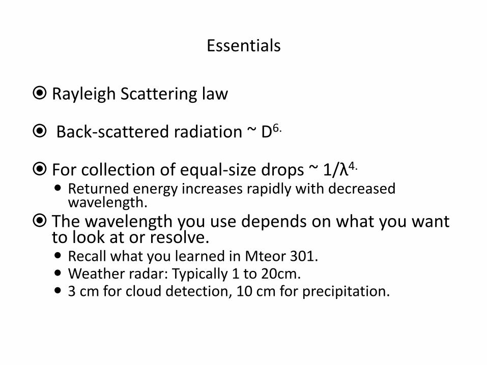
Essentials
Rayleigh Scattering law
Back-scattered radiation ~ D6.
For collection of equal-size drops ~ 1/λ4. Returned energy increases rapidly with decreased
wavelength. The wavelength you use depends on what you want
to look at or resolve. Recall what you learned in Mteor 301. Weather radar: Typically 1 to 20cm. 3 cm for cloud detection, 10 cm for precipitation.

Reflectivity values
Reflectivity is measured in decibels (dBZ)
20 dBZ → Precipitation reaches the ground. Important to realize for chasing.
Rainfall
20-45 dBZ : light to moderate. 40-50 dBZ : Pretty good rainfall. 60-70 dBZ : More than likely hail.
Snowfall
25-30 dBZ : Light to moderate snowfall. 30-35 dBZ : Moderate to heavy snowfall. 35-40 dBZ : Very heavy snowfall (rare) or rimed flakes.
Ice
Ice itself doesn’t have a very high reflectivity. Why is hail so reflective? Bright-banding


Operational Radar
A.k.a., the things you see on Gibson Ridge software.
Current radars: WSR-88D’s (NEXRAD) ○ Weather Surveillance Radar made operational in 1988 and are of
the doppler variety.
○ Previous radars were WSR-57’s and WSR-74’s.
○ 28 ft diameter dish that rotates at 360º at several tilts.
○ Dual polarization and phased-array are future radar types soon to be implemented.
Course notes pictures.
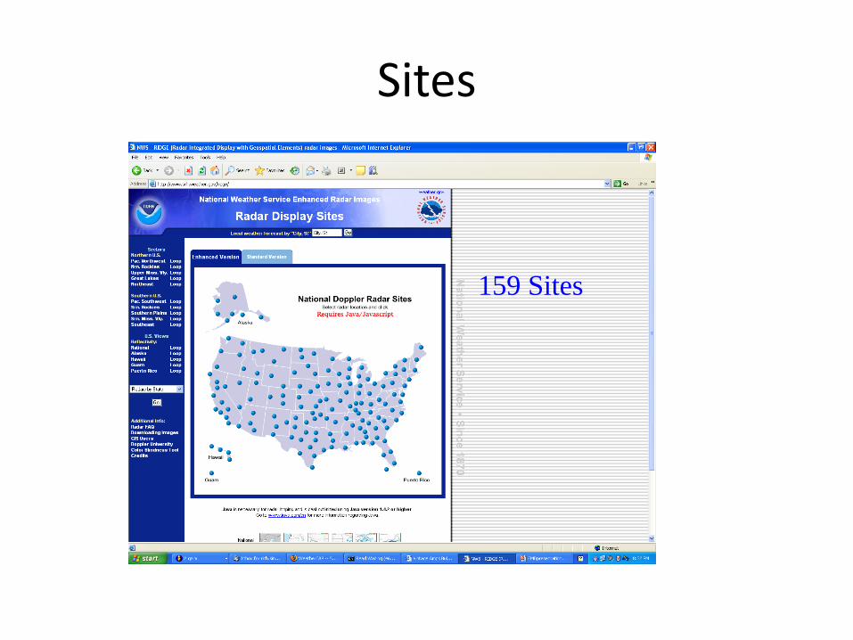
Sites
159 Sites

Image provided by Rich Kinney, NWS, Des Moines

Images provided by Rich Kinney,
NWS, Des Moines
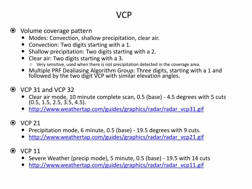
VCP
Volume coverage pattern Modes: Convection, shallow precipitation, clear air. Convection: Two digits starting with a 1. Shallow precipitation: Two digits starting with a 2. Clear air: Two digits starting with a 3.
○ Very sensitive, used when there is not precipitation detected in the coverage area.
Multiple PRF Dealiasing Algorithm Group: Three digits, starting with a 1 and followed by the two digit VCP with similar elevation angles.
VCP 31 and VCP 32
Clear air mode, 10 minute complete scan, 0.5 (base) - 4.5 degrees with 5 cuts (0.5, 1.5, 2.5, 3.5, 4.5).
http://www.weathertap.com/guides/graphics/radar/radar_vcp31.gif
VCP 21 Precipitation mode, 6 minute, 0.5 (base) - 19.5 degrees with 9 cuts. http://www.weathertap.com/guides/graphics/radar/radar_vcp21.gif
VCP 11
Severe Weather (precip mode), 5 minute, 0.5 (base) - 19.5 with 14 cuts http://www.weathertap.com/guides/graphics/radar/radar_vcp11.gif

Newer VCP’s
• VCP 211, 212, 221
• Same elevation angles as VCP 11, 12, and 21.
• Sachidananda-Zrnic Algorithm (SZ-2)
– Reduces range ambiguity for Doppler data.

PRF
Pulse repetition frequency
Frequency at which pulses are emitted (pulses per second). Essentially how long the ‘listening’ stage is (PRT = 1/PRF).
Determines the maximum unambiguous range and maximum unambiguous velocity Huh?
Rmax = maximum range which a transmitted pulse wave can travel and return to the radar before the next pulse is emitted.
Rmax = C / (2*PRF)
Huh, again? Vmax = maximum velocity which a Doppler radar can determine unambiguously.
Vmax = ( * PRF) / 4
Purple haze: Radar cannot determine which pulse return signal may have come from. Also called “Range folding”.
Doppler Dilemma.


Products
Base reflectivity: Lowest elevation scan. Basically used to tell what is out there.
Composite reflectivity: Composed of the greatest reflectivity from any elevation angle seen from the radar. Used to reveal the highest reflectivity in all echoes.
Base velocity Provides basic wind field from the 0.5º elevation scan via Doppler effect. Radar can only measure motions that have a component along a radial, or essentially toward or away
from the radar. Spectrum width
Spread in the velocity values. Large spectrum width means a lot of turbulence.
Storm relative motion: Used to detect “mesoscale” circulations. Mean wind field is “subtracted” from base velocity.
VIL Vertically integrated liquid water. Amount of liquid water that the radar detects in a vertical column of the atmosphere for an area of
precipitation. High values are associated with heavy rain or hail.
Echo Tops Maximum height of precipitation echoes.

Base Reflectivity

Classic Supercell
0 5 10
Nautical miles
Light Rain
Moderate/Heavy
Rain & Hail
Supercell Thunderstorm (top view)
Anvil Edge
Gust Front
WSR-88D Radar Image
N
Hook echo
Hook echo
Images provided by Rich Kinney, NWS, Des Moines

Composite Reflectivity
• Jetstream - An Online School for Weather: RIDGE radar composite reflectivity


TBSS

TBSS
• National Weather Service Forecast Office - Midland/Odessa Texas
• Figure #16.

Bright Banding
Image provided by Rich Kinney, NWS, Des Moines

Radar fine line 88D can detect subtle differences in humidity and temperature, and the
location of boundaries that may be the focus for storm initiation or
intensification
Image provided by Rich Kinney, NWS, Des Moines

AP
• Anomalous propagation.

Dual Polarization
• Two beams with different polarization directions: one with horizontal polarization (current polarization) and one with vertical polarization
• New products useful for:
– Precipitation type.
– Rain and snow rate estimates.
– Identification of aircraft icing conditions.
• Reference: http://www.cimms.ou.edu/~kscharf/pol/
– Page produced by Kevin Scharfenberg, who was also an invited speaker at the 2008 Severe Storms and Doppler Radar Conference hosted by the Central Iowa NWA.

ZDR – Differential Reflectivity
• ZDR ~ 10 log (Ph / Pv ) [db]
• Average shape of what you are measuring.
• Typical values range from -2 db to 6 db.
• Type discriminator
– ZDR > 0?
– ZDR < 0?
– ZDR = 0?
• Volume discriminator:
– Same Z, high ZDR?
– Same Z, low ZDR?

ρhv – Correlation Coefficient
• Describes similarities in the back scatter characteristics of the vertically and horizontally polarized echos.
• Rain: typically above 0.95.
• Hail: 0.90 to 0.95.
• Drizzle/very light rain: below 0.90
• Ice pellets/graupel: typically above 0.95
• Snow: typically above 0.95
• Bright band: 0.90 to 0.95,
• Good indicator of mixed precipitation regions

KDP – Specific differential phase
• Takes advantage of difference in propagation speeds in
different media (water vs. air). • Takes range from radar into account to determine where
phase difference is occurring. • Proportional to φDP = φh – φv, called the differential phase
shift.
• KDP>0, oblate hydrometeors.
• KDP<0, vertically oriented hydrometeors.
• KDP~0, spherical hydrometeors.
• Good indicator of mixed precipitation regions and, therefore, rainfall accumulation.