radiocarbon ages and stratigraphy in the city area of the ... filethe sambor prei kuk archaeological...
TRANSCRIPT

43Radiocarbon ages and stratigraphy in the city area of the Sambor Prei Kuk site (Kubo et al.)
Abstract
The Sambor Prei Kuk archaeological site in central Cambodia is known as one of the primary
cultural and political centers of the Pre-Angkor Period in Indochina. The main part of the site is
situated on a sandy upland along the Stung Sen River floodplain and is divided into the city area
and temple area by the O Krou Ke River (creek). The temple area comprises the three major
walled complexes of Prasat Sambor, Prasat Tao, and Prasat Yeai Pouen and a number of Hindu
brick towers. The city area is demarcated by moats, which are found in the west of temple area.
This archaeological site is considered the ancient capital city of Chenla called Isanapura and
constructed by King Isanavarman I in the early seventh century, as described in the Chinese
ancient chronicle of Sui-shu. However, investigations thus far have mainly targeted temple
complexes, whereas clear evidence exhibiting the prosperity or chronological framework of
the archaeological site has been scarcely reported. In February 2012, we discovered a 1500 m
long section in the city area that was revealed during road construction. Subsequently, record-
ing of the stratigraphy, analysis of cultural deposits, and survey of the western city moat were
conducted. Radiocarbon (AMS 14C) dates of the layer containing structures were from the fifth
to seventh centuries and the fourteenth century (road cut section, Trenches B and H), while
the moat floor dated to the sixth century (moat section, Site 1). These dates suggest that the
construction of Sambor Prei Kuk dates to the Pre-Angkor period. Further investigations are
required to confirm the foundation age of the city area and to reveal the relationship between
Sambor Prei Kuk and ancient Isanapura.
43早稲田大学大学院教育学研究科紀要 第 26号 2016年 3月
Radiocarbon Ages and Stratigraphy in the City Area of the Sambor Prei Kuk Pre-Angkor Archaeological Site,
Cambodia
KUBO Sumiko,1 NAGUMO Naoko,2
CHHUM Menghong,3 SHIMODA Ichita4
1 Graduate School of Education, Waseda University2 International Centre for Water Hazard and Risk Management, Public Works Research Institute3 Japan-APSARA Safeguarding Angkor4 World Heritage Studies, University of Tsukuba

44 Radiocarbon ages and stratigraphy in the city area of the Sambor Prei Kuk site (Kubo et al.)
1. Introduction
The Sambor Prei Kuk archaeological site located in central Cambodia (Fig. 1a) is known as one of
the primary cultural and political centers during the Pre-Angkor Period. Many foreign explorers and
researchers have been attracted to the abundant Hindu remains and mysterious engineering works
such as moats, ponds, and canals at the site. After several basic studies conducted by French research-
ers from late nineteenth to early twentieth centuries, the initial comprehensive reports on the site were
published by the École Française d’Extrême-Orient (EFEO) (e.g., Parmentier, 1927). Consequently, the
site’s cultural value has been widely recognized (e.g., Coedes, 1947; Briggs, 1951). Although investiga-
tions and research activities at Sambor Prei Kuk were discontinued during the Cambodian civil war
(1970s to 1980s), the Ministry of Culture and Fine Arts (Cambodia) and Waseda University (Japan)
established a joint team named the Sambor Prei Kuk Conservation Project. Scholarly investigations and
conservation practices have been undertaken since 1998 (e.g., Kojo and Kubo, 2003; Sambor Prei Kuk
Conservation Project, 2004; Shimoda and Nakagawa, 2006; Nagumo et al., 2010).
The main part of the site comprises the eastern temple area and western city area bordered naturally
by the O Krou Ke River (Fig. 1b). Impressive archaeological and architectural remains including brick
towers have been found surrounding the three walled temple complexes of Prasat Sambor, Prasat Tao,
and Prasat Yeai Pouen in the temple area (Fig. 1c). In contrast, few remarkable remains other than
those of engineering feats such as moats, canals, and ponds were found in the city area. Therefore,
most early stage research of the conservation project has been conducted at the temple area, but clear
evidence exhibiting the city’s past prosperity and construction age is still insufficient (Sambor Prei Kuk
Conservation Project, 2004).
In February 2012, a development program by the Cambodian government and the United Nation’s
World Food Programme (WFP) undertook road construction within the city area. This work yielded
abundant artifacts and building remains along the side ditches. After the Sambor Prei Kuk Conservation
Project requested the construction be stopped, it conducted immediate investigations after the side
ditches were cleaned. In parallel, infill deposits of the city moat were observed. This paper reports the
results of those investigations.
2. Study area
2.1. The Sambor Prei Kuk archaeological site
Sambor Prei Kuk is situated on the sandy upland approximately 5 m higher than the adjacent flood-
plain of the Stung Sen River (Fig. 1b). The upland surface is covered with white to pale orange quartz-
rich sand and is subdivided into upland surfaces I, II, and III based on relative elevations and land use

45Radiocarbon ages and stratigraphy in the city area of the Sambor Prei Kuk site (Kubo et al.)
characteristics (Kubo et al., 2012). Upland surface I is the highest surface around the site and is covered
by forest; upland surface II is partly covered by vegetation, and upland surface III is almost barren land
with lower moisture content. The temple complexes of Prasat Sambor, Prasat Yeai Poeun, and Prasat
Tao are situated within dense forest on upland surface I facing the floodplain. Two causeways from
Prasat Sambor and Prasat Yeai Poeun reach close to the Stung Sen River, and an artificial canal from the
O Krou Ke River Valley also approaches the river (Fig. 1b and 1c). The city moats of the north, south,
and west sides with embankments define the ca. 2×2 km city area together with the O Krou Ke River.
Fig. 1 Location of Sambor Prei Kuk (a), Land classification map of surrounding Sambor Prei Kuk (b), reproduced from Kubo et al. (2012), and distribution of archaeological remains in the core area of Sambor Prei Kuk (c) reproduced from Shimoda and Nakagawa (2006). US I (Upland Surface I), US II (Upland Surface II), US III (Upland Surface III), BM I (Back Marsh I), BM II (Back Marsh II), BM III (Back Marsh III), MS (Meander Scroll), AC (Abandoned Channel), NL (Natural Levee), VP (Valley Plain), SB (Sand Bar), and WS (Water Surface).
46 Radiocarbon ages and stratigraphy in the city area of the Sambor Prei Kuk site (Kubo et al.)
Several archaeological mounds are found in this enclosed city area. Furthermore, characteristic small
tanks (ponds) and paddy field structures are also distributed outside of the city (e.g., Kojo and Kubo,
2003; Shimoda and Nakagawa, 2006).
The adjacent Stung Sen River floodplain develops into a meander belt comprising meander scrolls and
abandoned channels, which suggest past changes in water flow route. Nagumo et al. (2013) identified
the accumulation of back marsh deposits at the rate of approximately 0.5 mm/yr during the Holocene,
and the present micro-topography seems to have been established after ca. 5.5 ka along with the
Mekong-Tonle Sap connection. Therefore, the flow route and floodplain environment of the Stung Sen
River during the Pre-Angkor and Angkor periods was likely similar to today.
Considering the limited number of reports of previous archaeological research at the site, artifacts
excavated by the French archaeologist B. P. Groslier in the 1960s in the northern section of Prasat Yeai
Poeun are important for identifying ancient structures and construction ages of the temple area. Thus,
Y. Kojo reexamined Groslier’s artifacts and reported the presence of unglazed potteries, Khmer and
Chinese ceramics, flat roof tiles, stone artifacts, bronze rings, berg crystals, and iron products (Kojo
and Kubo, 2003). Shimamoto et al. (2008) report on the artifacts shows that the excavated Khmer and
Chinese ceramics derive from the late eighth to fourteenth centuries (Angkor Period), also noting
that abundant earthenware examples have similar characteristics to those found at other Pre-Angkor
archaeological sites. Additionally, the Sambor Prei Kuk Conservation Project re-excavated Groslier’s site
in 2008 and detected nine archaeological layers; based on artifacts such as Khmer and Chinese ceram-
ics, stoneware, red-painted pottery, and spouted jars (kundi), these layers date to the Pre-Angkor and
Angkor periods. AMS 14C dates also support this stratigraphy, indicating continuous use of the temple
area during the sixth to seventh centuries (Pre-Angkor Period) at least until the eighth and ninth centu-
ries (Angkor Period) (Kubo et al., 2012).
Architectural investigations based on decorative elements, inscriptions, as well as excavations around
the main tower of Prasat Sambor and walls of the complex also indicated that those buildings were
initially constructed in the seventh century and had been modified several times for use as an important
regional center until at least the tenth century (Shimoda and Nakagawa, 2008).
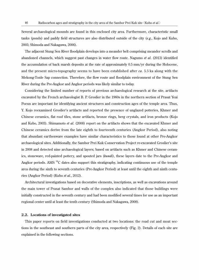
2.2. Locations of investigated sites
This paper reports on field investigations conducted at two locations: the road cut and moat sec-
tions in the southeast and southern parts of the city area, respectively (Fig. 2). Details of each site are
explained in the following sections.
47Radiocarbon ages and stratigraphy in the city area of the Sambor Prei Kuk site (Kubo et al.)
1) Road cut section (Photo 1, 2)
This location includes the cleaned walls of side ditches measuring almost 1 m deep along the newly
constructed 1500 m long road (Fig. 2a and 2b). During the road construction, archaeological remains
such as brick structures, laterite, and pottery fragments were exposed on the walls of side ditches.
Therefore, urgent architectural and archaeological investigations were conducted at nine sites (A,
B, B’, C, D, E, F, G, H) after deep trenches were excavated and ditch walls were cleaned. Regarding
archaeological artifacts, Chhum et al. (2012, 2013) reported a total of 2162 excavated artifacts including
potsherds, roof tiles, and spouted jars, among others. They also found piled bricks in the B, B’, C, D, and
E trenches and identified them as parts of the peripheral wall on the western side of the M78/79 site
(Fig. 2b).
We observed cultural deposits in the trenches of B, F, and H. Samples were collected to reveal the
stratigraphy and geomorphological background of the site as well as to use in AMS 14C dating. A tool
known as the Handy Geoslicer was also used for soil sampling in the F trench.
2) Moat section (Photo 3, 4)
The ancient city moats identified in aerial photos (Kojo and Kubo, 2003) are rain-fed and remain
marshy in some areas even during the dry season. In the well-preserved section, the moat is almost
1.5 m deep and more than 20 m wide, whereas embankments on both sides of the moats are almost 1
m high (Shimoda and Nakagawa, 2006). We selected two sites in the western moat (Site 1 and 2) for
Fig. 2 Locations of road-cutting and moat sections (a), layout of road-cutting trenches reproduced from Chhum et al. (2012) (b) and horizontal cross-sections of Site 1 and 2 in moat section (c).
48 Radiocarbon ages and stratigraphy in the city area of the Sambor Prei Kuk site (Kubo et al.)
excavating less than 1 m-deep trenches to observe the moat infill sediments and collect samples for 14C
dating. The Handy Geoslicer was used to collect undisturbed sediments, while a boring stick and hand
auger were also used for test drillings.
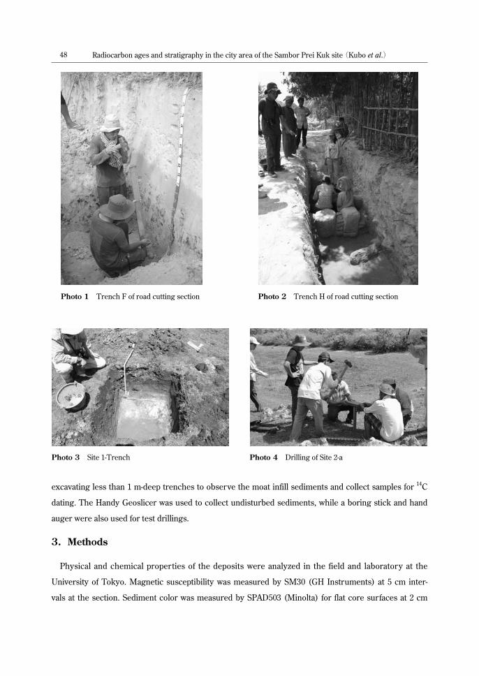
3. Methods
Physical and chemical properties of the deposits were analyzed in the field and laboratory at the
University of Tokyo. Magnetic susceptibility was measured by SM30 (GH Instruments) at 5 cm inter-
vals at the section. Sediment color was measured by SPAD503 (Minolta) for flat core surfaces at 2 cm
Photo 1 Trench F of road cutting section Photo 2 Trench H of road cutting section
Photo 3 Site 1-Trench Photo 4 Drilling of Site 2-a

49Radiocarbon ages and stratigraphy in the city area of the Sambor Prei Kuk site (Kubo et al.)
intervals using the L*a*b* color specification system. Sediment samples were collected to determine the
particle size by a laser diffraction particle size analyzer (SALD-3000S, Shimadzu). Additionally, samples
from the moat section (Site 1-a) were analyzed with an X-ray analytical microscope (XGT-5000WR,
Horiba) to observe the contents of chemical elements (Si, Al, Ti, Fe). The ignition loss was measured by
dry ashing processes at 600°C for 3 hours using a muffle furnace (FO510, Yamato) at 5 cm intervals.
AMS 14C ages were measured at the Institute of Accelerator Analysis Ltd., Japan, and conventional
ages were calibrated into calendar ages (2σ cal yr BP) using OxCal version 4.1 (Bronk Ramsey, 2009)
and by applying the IntCal09 calibration database (Reimer et al., 2009).
4. Description and results
4.1. Road cut section
1) Trench B
Measuring almost 35 m wide, Trench B is situated in the eastern side of the road and divided into
three sections. The first section is part of the waterway, whereas the second section is part of peripheral
wall at the M78/79 site. Here, over 1000 archaeological relics such as pottery sherds were collected.
Drillings were conducted at three adjacent locations in Section 3 (B-a, B-b and B-c), comparable to the
inner area of the M78/79 site (Fig. 3).
Sediments in Section 3 are mainly composed of medium sand with silt. From the bottom to the
depth of 150 cm, the median particle size is almost the same, <2 ϕ , but it gradually decreases toward
the ground surface. Sediments are hard and yellowish at the depth of 220–190 cm and yellow patchy
patterns appear on the trench surface. Pottery and brick fragments are concentrated at the depth of
130–75 cm, and potsherds are scattered at approximately 55 cm and 30 cm from the ground surface. The
value of magnetic susceptibility abruptly increases from 130 cm in depth due to the occurrence of these
artifacts. Charcoals recovered at 40 cm in depth (B-c) were dated to 1349–1392 cal AD and 429–562 cal
AD from 95 cm deep (B-b) (Table 1).
2) Trench F
Using the Handy Geoslicer, we drilled 80 cm beyond the depth of 190 cm in Trench F. The trench
mainly contains coarse sand with silt with a median particle size of 1.5 ϕ ; the magnetic susceptibility
value is quite low at less than 0.1×10⁻³ SI units. At the time of investigation, sediments deeper than 94
cm became water-saturated, facilitating a more vivid illustration of color changes. Similar to Trench B,
sediments are reddish or orange due to oxidation patches from the bottom to a depth of 120 cm (Fig. 3);
changes in water content may have formed these patches. Silt concretions between 90 and 50 cm deep
and black nodules between 170 and 140 cm deep are also recognized. Here we saw fewer artifacts than
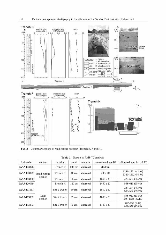
50 Radiocarbon ages and stratigraphy in the city area of the Sambor Prei Kuk site (Kubo et al.)
Fig. 3 Columnar sections of road-cutting sections (Trench B, F and H).
Table 1 Results of AMS-14C analysis.
Lab code section location depth material conventional age BP calibrated age, 2σ , cal AD
IAAA-113328
Road-cuttingsection
Trench F 233 cm charcoal Modern —
IAAA-113329 Trench B 40 cm charcoal 650 ± 20 1284−1321 (41.9%)1349−1392 (53.5%)
IAAA-113330 Trench B 95 cm charcoal 1560 ± 30 429−562 (95.4%)
IAAA-120069 Trench H 120 cm charcoal 1450 ± 20 568−649 (95.4%)
IAAA-113331
Moatsection
Site 1 trench 60 cm charcoal 1530 ± 30 432−495 (35.7%)503−597 (59.7%)
IAAA-113332 Site 2 trench 53 cm charcoal 1060 ± 20 898−920 (13.3%)946−1023 (82.1%)
IAAA-113333 Site 2 trench 92 cm charcoal 1140 ± 30 782−790 (1.8%)809−979 (93.6%)

51Radiocarbon ages and stratigraphy in the city area of the Sambor Prei Kuk site (Kubo et al.)
in Trench B, represented by a potsherd found at the depth of 95 cm. Charred material from 233 cm deep
yielded modern dates (Table 1).
3) Trench H
Columnar-shaped laterite blocks and bricks are arranged in an east–west direction with piled bricks
in Trench H (Fig. 3). Although no detailed description of the deposits is available, charred material from
120 cm deep yielded an age of 568–649 cal AD (Table 1).
4.2. Moat section
1) Site 1
This site is located near the northwestern corner of the city area, where moat and dike structures
are well-preserved (Fig. 2). During the investigations in February (dry season), water still remained,
and moat infill sediments were wet. Before digging the trench, sediment samples were collected using
a hand-auger and the Handy Geoslicer (Site 1-a). Test pits (Site 1-b and 1-c) were made using a boring
stick.
At Site 1-a, medium sand was found at the depth of 200–60 cm. The sand gradually becomes finer and
resembles silt toward the ground surface. In concordance with the particle size change, sediment color
becomes darker at around 90 cm in depth and reflects gradations of dark gray at around 30 cm in depth.
The value of ignition loss indicates that this sediment color change derives from the content of humus
materials. Those sediments are quartz-rich, and the SiO2 content of about 80% at the bottom becomes
more than 95% until the depth of around 40 cm. It then decreases again toward the ground surface,
inversely proportional to the content of Al2O3, TiO2, and Fe2O3. Site 1-b and 1-c show similar character-
istics: white sand at the bottom gradually becomes darker and humus-like higher up, and the border is
located at depths of 70 to 80 cm (Fig. 3). The square trench measuring 100×100 cm in Site 1 is located
east of Site 1-a, and the border between the lower white sand and upper dark and humus-rich silt is situ-
ated at the depth of 60 cm. The radiocarbon age from the depth of 60 cm and upper limit of the white
sand was 503–597 cal AD (Table 1).
2) Site 2
The moat and dike structures at Site 2 are less clear than at Site 1, and the relative elevation between
the moat and dikes is <1 m at the largest part (Fig. 2). Similar to Site 1, the bottom part of the moat infill
to the depth of 50 cm is medium white sand, but the upper part is less humus-rich and the particle size
is larger than that of Site 1. The moat around Site 2 seems to have been buried comparable to Site 1.
Therefore, less humus and fewer coarse sediments have accumulated in the upper part of Site 2-a.
52 Radiocarbon ages and stratigraphy in the city area of the Sambor Prei Kuk site (Kubo et al.)
The trench is 96 cm deep and the sediments have similar characteristics to those at Site 2-a. The
upper limit of the orange-white sand layer is at a depth of 54 cm. The layer gradually becomes darker at
the depth of 54–40 cm and then becomes dark gray toward the ground surface with a topsoil at a depth
of 10–0 cm. Brick and pottery fragments are found at the depth of 96–85 cm, and scattered charcoals
were collected at 96–53 cm. The AMS radiocarbon age of the sample at 92 cm was 809–979 cal AD,
whereas an age of 946–1023 cal AD was obtained from charcoal at the depth of 53 cm, almost at the
upper limit of the white sand (Table 1).
5. Discussion
Since H. Parmentier surveyed Sambor Prei Kuk in the early twentieth century, people have identified
the site as the capital city of the Pre-Angkor Chenla kingdom called Isanapura. The name Isanapura
appears in the Chinese chronicle of the Sui Dynasty (Sui-shu). This places the Kingdom of Chenla
southwest of Lin-yi (Champa) and the prince (Isanavarman I) resided in the city of Y-che-na (city of Isana
or Isanapura), which sent an ambassador to the Chinese imperial court in 616 AD of the Pre-Angkor
Period. Twentieth-century French researchers such as L. Finot and G. Coedès also identified that the
initial construction of Prasat Yeai Poeun was by Isanavarman I in the seventh century (Shimoda and
Nakagawa, 2006). Recent investigations of archaeological (e.g., Shimamoto et al., 2008; Kubo et al., 2012)
and architectural (e.g., Shimoda and Nakagawa, 2006) remains indicated that construction of the temple
area probably dates to the Pre-Angkor Period and that the site was used until the Angkor Period.
AMS Radiocarbon dates from the sixth to seventh centuries in Trench H of the road cut section prob-
ably indicate the construction age of structures made from piled laterite and bricks. Ages from Trench
B are younger (fifth to sixth centuries) in the lower part of the layer containing brick and pottery frag-
ments; that layer overlapped with the Angkor layer dating to the fourteenth century (Fig. 3). These ages
suggest that the area around M78/79 had been occupied since at least the fifth to sixth centuries (Pre-
Angkor Period) until the fourteenth century (Angkor Period). These dates support the interpretation of
excavated structures from M78/79 as well as earthenware showing Pre-Angkor characteristics (Chhum
et al., 2013). However, Shimoda et al. (2014) reported the ages of 210–415 cal AD (CH3) and 484–536 cal
AD (CH5) in the base of the peripheral wall (Trench B) of M78/79, whose dates vary widely between
the third and sixth centuries. Therefore, the M78/79 site should have been constructed during the Pre-
Angkor Period, but additional chronological evidence is necessary to confirm the exact age of construc-
tion.
On the other hand, in the well-preserved moat section (trench in Site 1), dates from the sixth century
derived from the upper limit of the basal white sand of the moat, indicating that moat construction dates
to the Pre-Angkor Period, and humic sediments probably accumulated since then. The layer with brick

53Radiocarbon ages and stratigraphy in the city area of the Sambor Prei Kuk site (Kubo et al.)
and pottery fragments is dated to the ninth to tenth centuries, and the age of the base of upper humic
soil dates to the tenth to eleventh centuries (Site 2) (Fig. 4). In contrast to Site 1, the white sand layer at
Site 2 indicated an Early Angkor age. This is probably because the site has been affected by the collapse
of the western moat or artificial modification, as the cross-sectional view (Fig. 2) suggests. Although
these results indicate moat construction in the sixth century, Shimoda et al. (2014) obtained younger
ages from the central part of the western moat: 400–500 cal AD (MT01, ca. 45 cm depth); 325–550 cal
AD (MT02, ca. 30 cm depth); and 406–544 cal AD (MT04, ca. 45 cm depth). Therefore, detailed discus-
sion is necessary to determine the exact age of initial construction in this case.
The dates of samples obtained from road cut and moat sections agree with results of archaeological
and architectural investigations. They suggest that the city area was constructed during the Pre-Angkor
Period and was utilized until the Angkor Period. This means that both the temple and city areas of
Sambor Prei Kuk were possibly used over several centuries as an important cultural and political center
Fig. 4 Columnar Sections of moat section (Site 1 and 2).

54 Radiocarbon ages and stratigraphy in the city area of the Sambor Prei Kuk site (Kubo et al.)
of Khmer society. However, younger ages were reported by Shimoda et al. (2008) at those sites. Further
investigations considering archaeological and architectural characteristics in conjunction with radio-
carbon dates of the city area are necessary to identify the exact construction age of each structure and
obtain the proof that Sambor Prei Kuk is in fact the Pre-Angkor city of Isanapura, capital of the Chenla
kingdom.
6. Conclusion
This paper reported on excavations at the Sambor Prei Kuk, an archaeological site considered to be
the Pre-Angkor (seventh century) city of Isanapura, capital of the Chenla kingdom. We investigated the
site’s stratigraphy and acquired samples for AMS 14C dating from the road cut and moat sections in the
city area. Pre-Angkor and Angkor layers have been found at less than 1 m below the ground surface, and
Pre-Angkor dates were obtained from samples below the layer yielding Angkor Period dates. However,
several Pre-Angkor dates were slightly younger than the presumed foundation age of Isanapura.
Further interdisciplinary investigations are necessary to reveal the initial construction ages and function
of each structure in the city area. Such data will potentially prove that Sambor Prei Kuk is in fact the Pre-
Angkor city of Isanapura.
Acknowledgements
We express our sincere thanks to all members of the Sambor Prei Kuk Conservation Project, espe-
cially Professor Emeritus Takeshi Nakagawa, Dr. So Sokuntheary, and Mr. Him Sophorn. Laboratory
analyses were supported by Professor Toshihiko Sugai at The University of Tokyo.
This research was funded by a Grant-in-Aid for Scientific Research from the Ministry of Education,
Culture, Sports, Science and Technology, Japan (No. 21401004); the Sumitomo Foundation; and
Foundation for Cultural Heritage and Art Research. Results of this paper were partly presented at the
meeting of the Japan Association for Quaternary Research in 2012 and the XIX International Union for
Quaternary Research Congress in 2015.
References
Briggs, L.P., 1951. The Ancient Khmer Empire. The American Philosophical Sciety (reprinted in 1999 by White Lotus,
Bangkok).
Bronk Ramsey, C., 2009. Bayesian analysis of radiocarbon dates. Radiocarbon 51: 337–360.
Chhum, M., Nakagawa, T., Shimoda, I. and Shimoda, M., 2012. Archaeological feature existing inside Khmer ancient
city ISANAPURA, case study on the result of rescue excavation survey around road construction area in Feb 2012.
Summaries of technical papers of annual meeting 2012, Architectural Institute of Japan, 479–480.
Chhum, M., Shimoda, I., and Nakagawa, T., 2013. Construction and utilization dating of temples based on exist-
ing remains inside the city compound—Structure of the ancient Khmer city of Isanapura (Part I)—. Journal of
55Radiocarbon ages and stratigraphy in the city area of the Sambor Prei Kuk site (Kubo et al.)
Architecture and Planning 690: 1865–1874.
Coedes, G., 1947. Pour mieux comprende Angkor. Musee Guimet, Paris (Japanese translation by Miyake, I., 1993,
“Angkor Iseki” 2nd ed., Rengo Syuppan.)
Kojo Y. and Kubo S., 2003. A preliminary report of the investigations in Sambor Pri Kuk Archaeological site (7th
Century), Central Cambodia—Results in 1998 and 1999—. The Bulletin of the Graduate School of Education, Waseda
University, No. 13, 15–31.
Kubo S., Shimamoto, S., Nagumo, N., Yamagata, M. Him, S., So, S., Chang, V., Lun, V., Shimoda, I. and Nakgawa,
T., 2012. Geomorphology, Archaeostratigraphy, and 14C Ages of Sambor Prei Kuk Pre-Angkorean Site, Central
Cambodia. Bulletin of the Graduate School of Education, Waseda University, No. 22, 73–90.
Nagumo, N., Sugai, T. and Kubo, S., 2010. Location of a pre-Angkor capital city in relation to geomorphological fea-
tures of lower reach of the Stung Sen River, central Cambodia. Geodinamica Acta 23: 255–266.
Nagumo, N., Sugai, T. and Kubo, S., 2013. Late Quaternary floodplain development along the Stung Sen River in the
Lower Mekong Basin, Cambodia. Geomorphology 198: 84–95.
Parmentier, H., 1927. L’art khmèr primitif (2Vol.). PEFEO, 21–22, Paris, 45p.
Reimer, P.J., Baillie, M.G.L., Bard, E., Bayliss, A., Beck, J.W., Blackwell, P.G., Ramsey, C.B., Buck, C.E., Burr, G.S.,
Edwards, R.L., Friedrich, M., Grootes, P.M., Guilderson, T.P., Hajdas, I., Heaton, T.J., Hogg, A.G., Hughen, K.A.,
Kaiser, K.F., Kromer, B., McCormac, F.G., Manning, S.W., Reimer, R.W., Richards, D.A., Southon, J.R., Talamo, S.,
Turney, C.S.M., van der Plicht, J. and Weyhenmeyer, C.E., 2009. IntCal09 and Marine09 radiocarbon age calibration
curves, 0–50,000 years cal BP. Radiocarbon 51: 1111–1150.
Sambor Prei Kuk Conservation Project, 2004. Conserving and Developing SPK. Dept of Culture and Fine Arts in
Kampong Thom and Waseda University, 106p.
Shimamoto, S., Yamamoto, N. and Nakagawa, N., 2008. Reexamination on the dating of ceramics of Sambor Prei Kuk
found by B. P. Groslier. Journal of Southeast Asian Archaeology 28: 47–60.
Shimoda, I. and Nakagawa, T., 2006. Distribution of the remains and central area of the monuments—A study on a
structure of the ancient city, Isanapura (Part I)—. Journal of Architecture and Planning 602: 211–218.
Shimoda, I. and Nakagawa, T., 2008. Alteration of an early Khmer temple complex, Prasat Sambor. Journal of
Architecture and Planning 628: 1363–1370.
Shimoda, I., Chhum, M., Nakagawa, N., Yonenobu, H. and Haraguchi, T., 2014. Construction date of the Ancient
Khmer City, Sambor Prei Kuk. Annual meeting of the Japan Society for Scientific Studies on Cultural Properties
abstract, No. 31, P-002.