railway infrastructure - survey · railway infrastructure - survey ... or heritage railways...
TRANSCRIPT

AS 7634:2017
R a i l w a y I n f r a s t r u c t u r e - S u r v e y
Infrastructure Standard

AS 7634:2017
Railway Infrastructure - Survey
RISSB ABN 58 105 001 465 Page 1 Accredited Standards Development Organisation
This Australian Standard® AS 7634 Railway Infrastructure - Survey was prepared by a Rail Industry Safety and
Standards Board (RISSB) Development Group consisting of representatives from the following organisations:
Queensland Rail Aurizon Operations Limited Pacific National
ARTC TfNSW Sydney Trains
WSP
The Standard was approved by the Development Group and the Infrastructure Standing Committee in March, 2017.
On March 23, 2017 the RISSB Board approved the Standard for release.
This standard was issued for public consultation and was independently validated before being approved.
Development of the Standard was undertaken in accordance with RISSB’s accredited process. As part of the
approval process, the Standing Committee verified that proper process was followed in developing the Standard.
RISSB wishes to acknowledge the positive contribution of subject matter experts in the development of this Standard.
Their efforts ranged from membership of the Development Group through to individuals providing comment on a draft
of the Standard during the open review.
I commend this Standard to the Australasian rail industry as it represents industry good practice and has been
developed through a rigorous process.
Paul Daly
Chief Executive Officer
Rail Industry Safety and Standards Board
Keeping Standards up-to-date
Australian Standards developed by RISSB are living documents that reflect progress in science, technology and
systems. To maintain their currency, Australian Standards developed by RISSB are reviewed every seven years,
and new editions are published. Between editions, amendments may be issued. Australian Standards developed by
RISSB may also be withdrawn.
It is important that readers assure themselves they are using a current Australian Standard developed by RISSB,
which should include any amendments that may have been issued since the Standard was published. Information
about Australian Standards developed by RISSB, including amendments, can be found by visiting www.rissb.com.au.
RISSB welcomes suggestions for improvements, and asks readers to notify us immediately of any apparent
inaccuracies or ambiguities. Members are encouraged to use the change request feature of the RISSB website at:
http://www.rissb.com.au/products/. Otherwise, please contact us via email at [email protected] or write to Rail
Industry Safety and Standards Board, PO Box 4271, Kingston ACT 2604, Australia.

AS 7634:2017
Railway Infrastructure - Survey
RISSB ABN 58 105 001 465 Page 2 Accredited Standards Development Organisation
AS 7634:2017
Railway Infrastructure - Survey
Document details
First published as: AS 7634:2017
ISBN 978-1-76035-703-0
Published by SAI Global Limited under licence from the Rail Industry Safety and Standards Board,
PO Box 4271, Kingston ACT 2604, Australia
Copyright
© RISSB
All rights are reserved. No part of this work may be reproduced or copied in any form or by any means, electronic or
mechanical, including photocopying, without the written permission of RISSB, unless otherwise permitted under the
Copyright Act 1968.
Notice to users
This RISSB product has been developed using input from rail experts from across the rail industry and represents
good practice for the industry. The reliance upon or manner of use of this RISSB product is the sole responsibility of
the user who is to assess whether it meets their organisation’s operational environment and risk profile.

AS 7634:2017
Railway Infrastructure - Survey
RISSB ABN 58 105 001 465 Page 3 Accredited Standards Development Organisation
Document control
Document identification
Designation / Title
AS 7634:2017 Railway Infrastructure - Survey
Document history
Publication Version Effective Date Reason for and Extent of Change(s)
2017 March 23, 2017 First Publication
Approval
Name Date
Rail Industry Safety and Standards Board 23/03/2017

AS 7634:2017
Railway Infrastructure - Survey
RISSB ABN 58 105 001 465 Page 4 Accredited Standards Development Organisation
Contents
1 Introduction ................................................................................................................... 6
1.1 Purpose .......................................................................................................... 6
1.2 Scope ............................................................................................................. 6
1.3 Compliance ..................................................................................................... 6
1.4 Referenced documents ................................................................................... 7
1.4.1 Normative references ...................................................................................... 7
1.5 Definitions ....................................................................................................... 7
1.6 Abbreviations .................................................................................................. 9
2 Planning ....................................................................................................................... 9
2.1 General ........................................................................................................... 9
2.2 Competency.................................................................................................. 10
2.3 Strategy ........................................................................................................ 10
2.4 Categories of Railway Survey Systems ......................................................... 10
2.4.1 National Geospatial Reference System ......................................................... 10
2.4.2 Non-National Geospatial Reference System ................................................. 11
2.5 Instrumentation, Tools and Equipment .......................................................... 11
2.5.1 Specialised Tools and Equipment ................................................................. 11
2.5.2 Instrumentation ............................................................................................. 12
3 Implementation ........................................................................................................... 13
3.1 Application of the Rail Survey Control Network ............................................. 13
3.1.1 Rail Survey Control Marks ............................................................................ 13
3.1.2 Placement of Rail Survey Control Marks ....................................................... 13
3.1.3 Installation of Rail Survey Control Marks ....................................................... 14
3.2 Application of the Track Control or Monument Network ................................ 15
3.2.1 Track Control Marks ...................................................................................... 15
3.2.2 Placement of Track Control Marks ................................................................ 15
3.3 Survey Mark Identification Requirements ...................................................... 16
3.3.1 Coordinated Survey Networks....................................................................... 16
3.3.2 Non-Coordinated Survey Networks ............................................................... 17
4 Observations and Reporting ....................................................................................... 17
4.1 Coordinated Survey Networks....................................................................... 17
4.1.1 Observational Requirements ......................................................................... 17
4.1.2 Reporting ...................................................................................................... 18
4.1.3 Observational Deliverables ........................................................................... 18
4.2 Non-National Geospatial Reference System Survey Networks ..................... 18
4.2.1 Local or Assumed Coordinated Survey Networks ......................................... 18
4.2.2 Non-Coordinated Survey Networks ............................................................... 19
5 Data Management and Quality Assurance.................................................................. 19
5.1 Survey Data Management System ................................................................ 19

AS 7634:2017
Railway Infrastructure - Survey
RISSB ABN 58 105 001 465 Page 5 Accredited Standards Development Organisation
5.2 Records Management Requirements ............................................................ 19
5.2.1 Coordinated Networks .................................................................................. 19
5.2.2 Non-Coordinated Networks ........................................................................... 20
Appendix Contents
Appendix A Typical Railway Surveying Tasks .................................................................. 21
Appendix B Specialised Tools and Equipment used for Railway Surveying Purposes ..... 23
Appendix C Different Types of Rail Survey Control Marks - Typical Examples ................. 24
Appendix D Examples of Track Control Marks, Monuments, Plaques, and Data Plates ... 25

AS 7634:2017
Railway Infrastructure - Survey
RISSB ABN 58 105 001 465 Page 6 Accredited Standards Development Organisation
1 Introduction
1.1 Purpose
The purpose of this Standard is to –
(a) specify requirements relating to the design, construction, measurement,
maintenance and monitoring of a railway survey system, to be able to support
various engineering activities undertaken within, and applicable to a modern
railway environment;
(b) achieve a standardised approach to railway engineering surveying; and
(c) provide mandatory and recommended guidance so that the rail survey system
developed is aligned with the safe operation of the railway network, in
accordance with the requirements of Rail Safety National Law.
1.2 Scope
This Standard covers surveying systems for railways as defined under AS 7630 'Railway
Infrastructure - Track Classification'.
This Standard is intended to cover railway survey systems based on –
(a) the current National Geospatial Reference Systems (NGRS) for Australia and
New Zealand; and
(b) non-NGRSs
This Standard covers railway survey system requirements and promotes current good practice.
This Standard is not specifically intended to cover urban on-street tramway, or light rail
networks, cane railways, or heritage railways operating on a private reservation, but items from
this Standard may be applied to such systems as deemed appropriate by the relevant Rail
Infrastructure Manager (RIM).
1.3 Compliance
There are two types of control contained within Australian Standards developed by RISSB:
(a) Mandatory requirements.
(b) Recommended requirements.
Each of these types of control address hazards that are deemed to require controls based on
existing Australian and International Codes of Practice and Standards.
A mandatory requirement is a requirement that the Standard provides as the only way of
treating the hazard.
Mandatory requirements are identified within the text by the term ‘shall’.
A recommended requirement is one where the Standard recognises that there are limitations to
the universal application of the requirement and that there may be circumstances where the
control cannot be applied or that other controls may be appropriate or satisfactory, subject to
agreement with the Rail Infrastructure Manager (RIM), Rolling Stock Operator (RSO), and/or
Rail Safety Regulator.

AS 7634:2017
Railway Infrastructure - Survey
RISSB ABN 58 105 001 465 Page 7 Accredited Standards Development Organisation
Recommended clauses are mandatory unless the Rail Infrastructure Manager or Rolling Stock
Operator can demonstrate a better method of controlling the risk.
Recommended requirements are to be considered when compliance with the Standard is being
assessed.
Recommended requirements are identified within the text by the term ‘should’.
Hazards addressed by this Standard are listed on the RISSB website www.rissb.com.au
1.4 Referenced documents
1.4.1 Normative references
The following documents are referred to in this Standard:
(a) Rail Safety National Law.
(b) AS 7630 Railway Infrastructure - Track Classification.
(c) RISSB National Guideline - Glossary of Railway Terminology.
(d) ICSM Standard for the Australian Survey Control Network (SP1).
1.5 Definitions
General railway technical terms can be found in the National Guideline - Glossary of Railway
Terminology.
Specific terms used in this Standard are defined below:
Australian Height Datum (AHD): this is the geodetic datum for altitude in Australia. From
measurements taken in the late 1960s at 30 tide gauges around the mainland, and 2 tide
gauges around Tasmania, 0.000 m AHD was assigned to the mean sea level of these results.
Referred to as Australian Height Datum 1971 (AHD71) and Australian Height Datum (Tasmania)
1983 (AHD-TAS83).
Azimuth: this is the adopted meridian for a survey, based on the reference system used. This
can be determined by various means, one example being by the occupation of two marks with
known coordinates.
Best Mean Fit (BMF): this is a designed geometric alignment which minimises track slewing on
open track and as near as possible adopts the existing track alignment across timber and steel
bridges, the centre of the deck on concrete bridges and the design clearance to platforms and
other lineside structures. Best Mean Fit can refer to both horizontal and vertical centreline
design track alignments.
Datum Plate: these plates are typically fastened to structures adjacent to the track and contain
information relating to the track alignment. They have a small adjustable aluminium or plastic
block affixed to the face of the plate which acts as the reference point. As a minimum, they
should display the following information relating to this block:
Kilometrage.
Distance to the adjacent track design gauge face or centreline.
Design track superelevation.

AS 7634:2017
Railway Infrastructure - Survey
RISSB ABN 58 105 001 465 Page 8 Accredited Standards Development Organisation
Additional information, such as design height to low rail and track centres for example, can be
provided if required. See also Plaque.
Detail or Topographic Survey: this is a survey carried out to provide information of sufficient
accuracy and extent for the design of the railway or other infrastructure, in brown or green field
environments.
Geocentric Datum of Australia 1994 (GDA94): this is the current geodetic datum, first
adopted nationally across Australia on 1 January 2000. The map projection associated with
GDA94 is the Map Grid of Australia 1994 (MGA94), which conforms to the Universal Transverse
Mercator Grid coordinate system. It was the first geocentric datum compatible with modern
GNSS positioning techniques adopted within Australia. GDA94 is a plate-fixed static coordinate
datum, based on a global framework, the International Terrestrial Reference Frame 1992
(ITRF92), held at the reference epoch of 1 January 1994.
Geocentric Datum of Australia 2020 (GDA2020): this is the proposed geographic coordinate
system for Australia. GDA2020 is based on a global framework, the International Terrestrial
Reference Frame (ITRF), projected to a reference date of 1 January 2020 as a conventional
plate-fixed or static datum. The shift in horizontal coordinates from GDA94 is approximately 1.8
metres.
Global Navigation Satellite System (GNSS): this is a generic term for all satellite based
positioning systems.
Global Navigation Satellite System (GNSS) Heighting: This is a height (z coordinate)
determined from GNSS observations based on the national ellipsoid model. A correction must
be applied using reliable AHD-ellipsoid separation values (N values) to determine AHD values.
Map Grid of Australia (MGA): this is a metric rectangular grid. It is a Cartesian coordinate
system based on the Universal Transverse Mercator projection and the Geocentric Datum of
Australia. The unit of measure is the metre. It is important to know what epoch the MGA is
referring to as there will be differing versions due to tectonic movement. Care needs to be
exercised to nominate which epoch the published coordinates relate to (MGA94 or MGA2020).
Monument: this is a physical structure (for example, post or concrete block) defining major
points, sometimes used for track control marks. See also Survey Monument, Track Control
Mark.
National Geospatial Reference System (NGRS): this is a combination of infrastructure, data,
software and knowledge. It includes all aspects of a coordinate datum, along with tools, utilities
and the standards and guidelines that facilitate its use.
New Zealand Geodetic Datum 2000 (NZGD2000): this is the current official geodetic datum for
New Zealand. It is based on the International Terrestrial Reference Frame 1996 (ITRF96), and
uses the Geodetic Reference System 1980 (GRS80). It manages slow crustal deformation
using a deformation model. It is a geocentric datum, compatible with GNSS. The unit of
measure is the metre, and it was implemented in 1998.
New Zealand Vertical Datum 2016 (NZVD2016): this is the current official national vertical
datum for New Zealand. It is defined by the NZGeoid2016 geoid, with normal-orthometric
heights in metres. It is consistent with NZGD2000, meaning that normal-orthometric NZVD2016
heights can be transformed to ellipsoidal NZGD2000 heights, and vice versa. It was adopted on
27 June 2016.

AS 7634:2017
Railway Infrastructure - Survey
RISSB ABN 58 105 001 465 Page 9 Accredited Standards Development Organisation
Permanent Survey Mark, State Permanent Mark, Permanent Mark or State Survey Mark
(PSM, SPM, PM or SSM): These marks form part of the State Survey Control Network.
Permanent survey marks are unique to the State or Territory, and as such are registered in the
relevant State or Territory Survey Control Database (or register). The information registered
may include coordinates, height, access notes and other administrative information.
Plaque, survey plaque, datum plate, data plate, tag, label: these plates or plaques contain
information relating the rail survey control mark, track control mark or monument to the adjacent
track alignment. See also Datum Plate.
Rail Survey Control Network: this is the network of permanent rail survey control marks that
provide the survey framework for all engineering activities. This rail survey control network
consists of the physical marks, measurements, calculations and coordinates related to them.
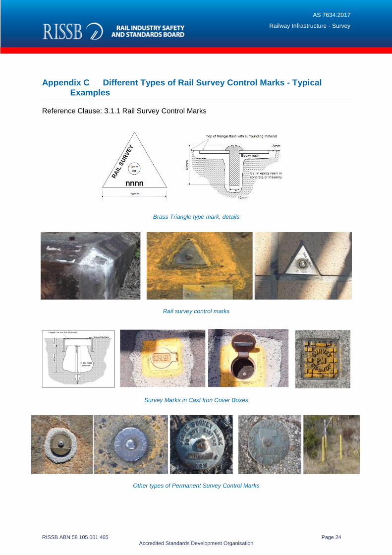
Rail Survey Control Mark: these are permanent survey marks made of high quality, durable
and corrosion resistant materials, intended specifically for use in the railway environment and
installed in stable ground, solid rock, or in concrete in-situ, where the potential for disturbance is
minimised. They are uniquely identified, and located at regular intervals along a rail corridor,
providing the opportunity for connection to the adjacent State Survey Control Network if
required. Examples of these types of marks are provided in Appendix C.
State Survey Control Network: this is the network of physical permanent uniquely identified
ground marks, installed and maintained across a state or territory, which provide the realisation
of the National Geospatial Reference System (NGRS).
Survey Monument: these are physical structures defining significant points, sometimes used
as track control marks. In some jurisdictions, survey monuments comprise of a truncated
concrete cylinder with track alignment information stamped upon the top. See also, Monument,
Track Control Mark.
Track Control Mark (TCM): this is a mark specifically placed to provide a reference to the
design alignment of the track to which it relates.
1.6 Abbreviations
DBYD Dial Before You Dig
EDM Electromagnetic Distance Measurement
ICSM Intergovernmental Committee on Surveying and Mapping
SSP Stainless Steel Pin
2 Planning
2.1 General
Railway survey systems shall encompass all aspects of railway surveying and associated
requirements in relation to –
(a) personnel;
(b) equipment;
(c) methodology - design, working, configuration, usability;

AS 7634:2017
Railway Infrastructure - Survey
RISSB ABN 58 105 001 465 Page 10 Accredited Standards Development Organisation
(d) documentation; and
(e) maintenance.
2.2 Competency
All railway survey work and associated activities detailed within this Standard shall only be
undertaken by, or under the direct supervision of, suitably qualified persons holding recognised
qualifications, as authorised and approved by the Rail Infrastructure Manager:
(a) Such authorised persons shall be responsible for the precise location of
infrastructure using surveying techniques.
(b) They are the only persons authorised to place, amend or relocate rail survey
control marks, track control marks or monuments, and any associated survey
plaques or tags.
All personnel undertaking survey work in the rail environment shall also be suitability qualified in
the safe working requirements and regulations of that jurisdiction.
Where compliance with the requirements of this Standard is not considered to be reasonably
practicable, the Rail Infrastructure Manager shall minimise identified non-compliance risks.
Lists of typical railway survey activities are in Appendix A. These lists are not exhaustive, but
are designed to provide guidance in the efficient allocation of surveying resources.
2.3 Strategy
The railway survey system shall provide –
(a) an element of assurance that the railway network can operate in a safe
manner; and
(b) a framework to support all engineering activities undertaken on a modern
railway network.
The application of a railway survey system may have different requirements, depending on the
environment in which it is located.
2.4 Categories of Railway Survey Systems
Railway survey systems shall be based upon –
(a) a National Geospatial Reference System (refer to Section 2.4.1); or
(b) a non-National Geospatial Reference System (refer to Section 2.4.2), that is –
i. an assumed, local or historic coordinate system; or
ii. an alternative system such as a non-coordinated system.
A non-National Geospatial Reference System shall only be used with the approval of the Rail
Infrastructure Manager
2.4.1 National Geospatial Reference System
Railway survey systems should be based on, and connected to, the NGRS.

AS 7634:2017
Railway Infrastructure - Survey
RISSB ABN 58 105 001 465 Page 11 Accredited Standards Development Organisation
This enables coordinated track alignment to be described in the national framework, and for this
information to be integrated with mapping and other features, for example in a Geographic
Information System (GIS).
In Australia, all surveys so established shall use the current national horizontal and vertical
reference systems, namely the Geocentric Datum of Australia (GDA94), and the Australian
Height Datum (AHD71) for the Australian mainland, and (AHD-TAS83) for Tasmania.
In New Zealand, all surveys so established shall use the current national horizontal and vertical
reference systems, namely the New Zealand Geodetic Datum 2000 (NZGD2000), and the New
Zealand Vertical Datum 2016 (NZVD2016).
The horizontal and vertical datums used, and the origins and values of coordinates and heights,
shall be recorded so that full traceability is documented.
2.4.2 Non-National Geospatial Reference System
It is recognised that while some jurisdictions may have non-NGRS railway survey systems, a
compliant NGRS railway survey system represents best practice.
In some jurisdictions, to minimise calculations, specific projects may adopt local coordinate
systems. This may be useful during the construction phase of the project and to provide a
short-term solution, but when looked at from the 'whole of life' aspect, may create
interoperability issues with adjacent surveys.
There may also be historic reasons for maintaining the use of coordinate systems that are not
based on the current NGRS. When survey work is being undertaken in a non-NGRS survey
network, care shall be taken to ensure that any such work will integrate seamlessly with the
existing survey system.
In some cases, it may be necessary to provide information in multiple formats, depending on the
requirements of the Rail Infrastructure Manager.
The horizontal and vertical datums used, and the origins and values of coordinates and heights,
shall be recorded so that full traceability is documented.
Alternative systems shall only be used after consideration of the appropriate risk, and
circumstantial analysis, and then only with the approval of the Railway Infrastructure Manager.
Such alternative systems may include non-coordinated systems. Non-coordinated systems are
sometimes used in rural locations, where the cost to introduce and maintain a rail survey control
network is not warranted. Typically, the justification for the introduction of a coordinated railway
survey system will be determined by the amount and type of track maintenance that is
undertaken. For example, branch lines with minimal or seasonal rail traffic will not require
significant investment to maintain their trafficability. However, whenever any investment is
considered for these lines, this should include the installation of a compliant NGRS railway
survey system.
2.5 Instrumentation, Tools and Equipment
2.5.1 Specialised Tools and Equipment
Specialised tools and types of equipment have been developed and refined by survey
personnel working in the rail environment for many years. This equipment has been developed

AS 7634:2017
Railway Infrastructure - Survey
RISSB ABN 58 105 001 465 Page 12 Accredited Standards Development Organisation
to meet the issues and exacting standards required for the purposes of rail survey control and
track control. There is also the requirement for this equipment to be robust enough to withstand
a harsh work environment.
These tools shall be calibrated prior to their use, and on an ongoing basis, as deemed
appropriate by the Rail Infrastructure Manager.
Some examples of these specialised tools and equipment are listed below:
(a) Right-angled offset prism.
(b) Coping tool.
(c) Track bar.
(d) Magnetic rail prism.
Examples of this type of equipment are illustrated in Appendix B.
The use of metallic and invar staves shall not be permitted on any railway projects. Only non-
conductive certified staves shall be used.
Any other equipment used that has the potential to impact upon, or adversely affect any
electrical, signalling or other critical equipment, shall be certified as insulated and safe for use in
the rail environment.
2.5.2 Instrumentation
Instrument specifications shall be based on the equipment recommendations outlined in the
Intergovernmental Committee on Surveying and Mapping (SP1) document 'Guideline for
Conventional Traverse Surveys' for total station instruments, and 'Guideline for Control Surveys
by Differential Levelling' for differential levelling instruments.
Instrument specifications for GNSS equipment shall be based on the recommendations outlined
in the Intergovernmental Committee on Surveying and Mapping (SP1) document 'Guideline for
Control Surveys by GNSS'.
Instrumentation and survey techniques for other types of surveys shall be compatible with the
type of work being undertaken, and shall be agreed to in consultation with the Rail Infrastructure
Manager.
It is recognised that many survey tasks can be undertaken using innovative methods rather than
conventional survey methods. However, before any work is undertaken using non-traditional
survey methods or techniques, the proposed methodology shall be thoroughly investigated and
accepted by the Rail Infrastructure Manager.
The Rail Infrastructure Manager shall confirm that where any work is undertaken using non-
conventional survey techniques, care shall be taken to ensure that the accuracy required for the
purpose and/or output of the survey is maintained.
All survey equipment shall be maintained in good adjustment (within equipment manufacturers’
stated precisions) and condition.
Examples of information required to ensure equipment is in good working order include –
(a) an annual service certificate confirming that the instrumentation meets
minimum operating specifications;

AS 7634:2017
Railway Infrastructure - Survey
RISSB ABN 58 105 001 465 Page 13 Accredited Standards Development Organisation
(b) details of tests, such as component calibration, alignment and self-tests
performed in the last 12 months which show the equipment to be achieving
the required precision and accuracy; and
(c) details of measurements undertaken along an EDM Test Baseline, either
annually or immediately after instrument servicing, to ensure the legal
traceability of the measuring equipment.
Requirements relating to the accuracy of rail survey control, in terms of survey uncertainties for
the various types of instrumentation outlined above, are detailed in Section 4.1.1.
3 Implementation
3.1 Application of the Rail Survey Control Network
The rail survey control network shall have appropriate connections to the State or Territory
Survey Control Network. These connections shall be agreed to in consultation with the Rail
Infrastructure Manager before work commences.
The safety of survey personnel and equipment shall be of paramount importance when
designing rail survey control networks and installing rail survey control marks.
3.1.1 Rail Survey Control Marks
Rail survey control marks are permanent survey marks and shall be assigned a unique
identifier.
All marks used for rail survey control shall have the following characteristics:
(a) Made of high quality, durable and corrosion resistant materials.
(b) Installed in stable ground or in solid rock.
(c) Installed in locations that minimise their likelihood of being disturbed.
Examples of the types of marks that can be used for rail survey control marks include –
(a) survey pillar;
(b) brass plug or triangle;
(c) star picket set in concrete; and
(d) stainless steel nail and washer
Examples of these types of marks are illustrated in Appendix C.
Where necessary, temporary rail survey control marks (such as pegs, nails in rock or star
pickets) may be installed for a short term and a specific purpose.
However, permanent rail survey control marks shall be installed and observed as a mandatory
requirement for project handover, as required and approved by the Rail Infrastructure Manager.
3.1.2 Placement of Rail Survey Control Marks
Where practicable, the placement of rail survey control marks should, at regular intervals, allow
for connection to relevant State or Territory Survey Control Marks external to the rail corridor.

AS 7634:2017
Railway Infrastructure - Survey
RISSB ABN 58 105 001 465 Page 14 Accredited Standards Development Organisation
Rail survey control marks shall be –
(a) placed at regular intervals as determined by the Rail Infrastructure Manager;
(b) positioned adjacent to the track such that they are easily accessible and
useable by all railway maintenance staff working in the operational corridor;
and
(c) placed in stable accessible ground, clear of running lines and as far as is
practicable, clear of access roads and other areas that may pose a risk to
persons (when occupying or accessing the mark), rail or road traffic.
Rail survey control marks shall be so placed to ensure that a complete coverage of the rail
network is achieved.
Rail survey control marks should not be established outside of the railway corridor.
The appropriate risk assessment procedures and approval from the Rail Infrastructure Manager
shall be obtained, prior to any placement of rail survey control marks in restricted locations such
as tunnels and viaducts.
Rail survey control marks shall be placed with the long-term strategic aim of Survey Control
densification in mind, and with their usefulness in terms of intervisibility and future connections
to adjacent surveys considered.
3.1.3 Installation of Rail Survey Control Marks
Where possible, rail survey control marks shall be installed –
(a) in stable structures, such as concrete, stone, masonry or solid rock;
(b) countersunk with the surrounding surface, to ensure that the mark does not
constitute a tripping hazard, and to minimise the risk of accidental damage or
destruction;
(c) clear of the danger zone;
(d) as far as is practicable, clear of access roads or other hazards that can pose a
risk to survey staff and instrument safety when the mark is being occupied;
(e) in a manner, such that a levelling staff can be placed upon the mark without
interference; and
(f) securely, using a bonding compound such as two-part epoxy or equivalent to
ensure adequate adhesion.
The rail survey control mark shall be suitably identified by paint or surrounding star pickets, both
to advise of its location and to afford a degree of protection from accidental damage.
In circumstances where it is not possible to install the rail survey control mark in stable ground,
a suitable design and construction methodology shall be approved by the Rail Infrastructure
Manager and applied to ensure the stability and durability of the installed mark.
Such a mark could consist of a stainless steel or brass rod, or galvanised star picket driven to
refusal, capped with a concrete collar and preferably protected by a cast iron cover box flush
with the finished surface; or where ground stability is suitable, a mark installed in concrete in-
situ.

AS 7634:2017
Railway Infrastructure - Survey
RISSB ABN 58 105 001 465 Page 15 Accredited Standards Development Organisation
In all cases where ground penetration is a requirement, a services search of the site such as a
Dial Before You Dig (DBYD) and/or any state jurisdictional specific services search shall be
undertaken as determined by the Rail Infrastructure Manager.
The services search is undertaken to ensure –
(a) that no buried services are damaged; and
(b) the safety of the personnel involved.
3.2 Application of the Track Control or Monument Network
The track control marking or monument network is a further breakdown of the rail survey control
network, and shall be established using the same coordinate reference system.
These networks are installed to provide a reference to the design alignment of the track to
which they relate.
A non-coordinated survey network shall only be applied in rural locations where coordinated
track alignment is not available, has not been defined, or in other specific circumstances as
indicated and approved by the Rail Infrastructure Manager.
The frequency and permanency of track control marks shall be related to, and appropriate for
the purpose of their installation.
3.2.1 Track Control Marks
Track control marks or monuments are permanent survey marks and shall be assigned a unique
identifier.
All marks installed for the purpose of permanent track control shall have the following
characteristics:
(a) Made of high quality, durable and corrosion resistant materials.
(b) Installed in stable ground, solid rock, or solid structures such as posts or
overhead wiring structures.
Examples of the types of marks that can be used for permanent track control include –
(a) stainless steel pins;
(b) brass or steel bars;
(c) spiggots;
(d) star pickets;
(e) survey monuments;
(f) mast bolts;
(g) rail section, channel iron or post in concrete;
(h) galvanised iron or black pipe.
Examples of these types of marks are illustrated in Appendix D.
3.2.2 Placement of Track Control Marks
Track control marks or monuments shall –
AS 7634:2017
Railway Infrastructure - Survey
RISSB ABN 58 105 001 465 Page 16 Accredited Standards Development Organisation
(a) be located at regular intervals as determined by the Rail Infrastructure
Manager; and
(b) more frequently located on curved track as compared to tangent track.
Track control marks or monuments shall be positioned adjacent to the track, such that they are
easily accessible and useable by all railway maintenance staff working in the operational
corridor.
Track control marks or monuments shall be placed in a manner that is not hazardous to
pedestrians, rail or road traffic.
In electrified areas as a minimum, track control marks or monuments shall be located at every
overhead wiring structure.
At locations with restricted clearance such as platforms, tunnels and bridges, track control
marks or monuments shall be placed at more frequent intervals in line with risk requirements
and as agreed with the Rail Infrastructure Manager.
Marks placed for the purposes of non-coordinated networks are normally located at set
intervals, and at a set offset relative to the referenced track.
In all cases where ground penetration is a requirement, a services search of the site such as a
Dial Before You Dig (DBYD) and/or any state jurisdictional specific services search shall be
undertaken as determined by the Rail Infrastructure Manager.
The services search is undertaken to ensure –
(a) that no buried services are damaged; and
(b) the safety of the personnel involved.
3.3 Survey Mark Identification Requirements
3.3.1 Coordinated Survey Networks
In addition to the physical mark being installed in the ground or in a wall or cutting, an identifying
plaque, marker, datum plate or tag shall be affixed to or attached adjacent to the physical mark.
This identifier shall provide by embossing, marking, engraving or by electronic means the
following information:
(a) Kilometrage of the mark (if applicable, preferably to the mm).
(b) Design superelevation / cant (in mm) of the track adjacent to the mark.
(c) Design offset (in mm) from the mark to the adjacent track / rail running face.
(d) Additional information as required.
Such additional information may include –
(a) height from the mark (up or down in mm) to the low rail of the adjacent track;
(b) design radius of the circular curve (in mm) if the mark is located adjacent to a
circular curve;
(c) information relating to the track being referenced (for example, track name,
designation, code);

AS 7634:2017
Railway Infrastructure - Survey
RISSB ABN 58 105 001 465 Page 17 Accredited Standards Development Organisation
(d) design track centres between the track being referenced and an adjacent
track;
(e) information relating to the mark attachment location (for example, overhead
wiring structure number, road over-line bridge name); and
(f) point number or unique identifier of the reference mark.
Different types of plaques, markers, datum plates or tags are illustrated in Appendix D.
3.3.2 Non-Coordinated Survey Networks
Identifying markers should be placed at track control marks or monuments located adjacent to
the major track geometry or spring points. These track control marks shall have a marker,
datum plate or tag affixed to, or attached adjacent to the physical mark, with information relating
to the major track geometry or spring point.
Generally, track control marks placed in non-coordinated networks are installed at a regular
defined frequency and offset to the referenced track. Due to their defined location, unless
otherwise indicated by the Rail Infrastructure Manager, each of these marks may not require an
accompanying marker, datum plate or tag.
4 Observations and Reporting
4.1 Coordinated Survey Networks
4.1.1 Observational Requirements
The rail survey control and track control networks shall be designed to be observed using
conventional total station traverse and radiation (terrestrial) survey techniques.
Where GNSS observations are used to incorporate baseline information with the terrestrial
survey information, the observations and reductions shall be designed to achieve a survey
uncertainty of < 15 mm for horizontal position, based upon the techniques documented in the
ICSM (SP1) document 'Guideline for Control Surveys by GNSS', unless otherwise advised by
the Rail Infrastructure Manager.
For conventional (terrestrial) survey observations, the methods employed shall be designed to
achieve a survey uncertainty of < 2 mm, based on the requirements outlined in the ICSM (SP1)
document 'Guideline for Conventional Traverse Surveys', unless otherwise advised by the Rail
Infrastructure Manager.
Survey observation requirements and techniques for track control and other information shall be
as specified by the Rail Infrastructure Manager.
Alternative survey techniques that may be more appropriate for the task may be considered for
surveys other than rail survey control and track control, for example detail surveys.
Heights for rail survey control and track control shall be determined using conventional
differential levelling techniques, based on AHD in Australia and NZVD in New Zealand.
The methods employed shall result in a maximum allowable misclosure between forward and
back levelling of 12 mm * √k (where k = distance in kilometres), based on the requirements

AS 7634:2017
Railway Infrastructure - Survey
RISSB ABN 58 105 001 465 Page 18 Accredited Standards Development Organisation
outlined in the ICSM (SP1) document ‘Guideline for Control Surveys by Differential Levelling’,
unless otherwise advised by the Rail Infrastructure Manager.
Where AHD or NZVD information is not available within a reasonable proximity of the project,
then GNSS techniques as approved by the Rail Infrastructure Manager, shall be employed to
establish a benchmark for the project, which can subsequently be adjusted back to AHD or
NZVD from the observed ellipsoidal height.
Sufficient observations shall be made to ensure redundancies in the data set to allow a rigorous
least square adjustment to be undertaken to ensure the integrity of the observed data. Check
measurements to significant marks, including all radiated track control marks, shall be made to
ensure the integrity of the observed data.
4.1.2 Reporting
A survey report shall be provided, and contain the following information —
(a) job or project details;
(b) surveyors’ details;
(c) equipment details, observation techniques, rail survey control network details,
photographs and field notes / sketches;
(d) data processing methods and software used;
(e) least squares adjustment details, accuracies and software used, constraints,
options, analysis and results; and
(f) any other relevant details as required by the Rail Infrastructure Manager.
4.1.3 Observational Deliverables
Observed survey data for rail survey control and track control shall be provided in a format as
mandated by the Rail Infrastructure Manager.
All data should be compatible with the requirements of the respective State or Territory
surveying and mapping agencies for integration into their geodetic control networks.
The datasets shall be provided to the Rail Infrastructure Manager with sufficient information to
ensure traceability, and in such a format that they will be available for future readjustment of the
rail survey control network.
4.2 Non-National Geospatial Reference System Survey Networks
4.2.1 Local or Assumed Coordinated Survey Networks
In addition to any requirements detailed in Section 4.1, the Rail Infrastructure Manager may
specify other special survey requirements relating to the applicable coordinate system that will
need to be met.
Special survey requirements may include particular issues relating to observation techniques,
data collation, validation, calculation or reporting. There may also be specific requirements
relating to marks to be occupied or observed.
Any such special survey requirements shall be identified and confirmed with the Rail
Infrastructure Manager, prior to any survey activities commencing.

AS 7634:2017
Railway Infrastructure - Survey
RISSB ABN 58 105 001 465 Page 19 Accredited Standards Development Organisation
4.2.2 Non-Coordinated Survey Networks
Observation techniques and calculation systems employed for data collected using
measurement methods applicable to non-coordinated railway systems, shall be as determined
by the Rail Infrastructure Manager.
5 Data Management and Quality Assurance
5.1 Survey Data Management System
Each Rail Infrastructure Manager shall maintain all survey data in an appropriate data
management system, enabling safe and secure storage, searching and management of 3D
coordinate and other information relating to established ground marks within their rail survey
control network and track control network.
In relation to survey data management, the Rail Infrastructure Manager shall specify and define
the following -
(a) Data formats; and
(b) The method required for recording the location of all permanent rail survey
control and track control marks or monuments.
The data management system shall be accessible to all relevant and authorised parties as
required.
All rail survey control marks and track control marks shall be appropriately recorded and
classified, with approved implemented processes for the functions of maintenance, inspection
and repair / replacement.
With regards to the maintenance and upkeep of the rail survey control and track control
networks, some of the issues that the Rail Infrastructure Manager needs to consider include –
(a) is the mark still available?
(b) has any movement of the mark been identified? and
(c) have any adverse reports been received from, or issues identified by users of
the mark?
Where rail survey control and/or track control marks have been destroyed, removed, damaged
or displaced, obliterated or defaced, the affected marks shall be replaced unless otherwise
advised by the Rail Infrastructure Manager.
In the case of track control marks, a new or revised plaque or datum plate shall also be
installed. Any such work shall be undertaken in consultation with the Rail Infrastructure
Manager.
Where it is identified that there is a risk that rail survey control or track control marks may, or will
be destroyed, the Rail Infrastructure Manager should be informed at the earliest opportunity.
5.2 Records Management Requirements
5.2.1 Coordinated Networks
The Rail Infrastructure Manager shall ensure that on completion of all surveys –

AS 7634:2017
Railway Infrastructure - Survey
RISSB ABN 58 105 001 465 Page 20 Accredited Standards Development Organisation
(a) all relevant railway databases are updated, including track design alignment
and clearance data; and
(b) other relevant authorities are notified.
5.2.2 Non-Coordinated Networks
The Railway Infrastructure Manager shall maintain records and databases relating to any
activities undertaken for the purposes of locating the position of non-coordinated track.
These records shall include current and historical measurement and marking sheets, to ensure
that a record is maintained of the current track position and any other conditions relating
thereto.

AS 7634:2017
Railway Infrastructure - Survey
RISSB ABN 58 105 001 465 Page 21 Accredited Standards Development Organisation
Appendix A Typical Railway Surveying Tasks
Examples of different types of railway surveying projects undertaken.
(Reference Clause: 2.2)
The following list contains specific examples of survey tasks undertaken by surveyors within the
railway corridor and danger zone:
Survey control (in the rail environment).
Track control, monumentation, installation and maintenance.
Detail surveys for specific requirements, by various techniques
(conventional total station, scanning, LIDAR, aerial photo).
Track design (alignment and grading), track realignment, duplication,
and bifurcation.
Track lifts and pulls.
Track work on ballasted track, track slabs, transition slabs, direct
fixation.
Precise monitoring for deformation, settlement movement and erosion.
Track reconditioning, track renewal, track maintenance.
Turnout, crossover and special track work installation or renewal.
Kinematic structure clearance surveys.
Half-block replacement.
Retaining walls.
Track drainage, culverts, stormwater, open drain, effective waterway.
Underline track crossing installations, under track bores and associated
monitoring.
Location of buried services infrastructure (both rail and external).
Platform interface issues (rebuilds, awnings, coping location, platform
heights, cutbacks, platform gap reduction, level and standard access).
Under bridges; ballast top, transom top, direct fix, deck renewal or
replacement.
Overbridges; road, pedestrian, deck replacement, clearance
requirements.
Level crossing surveys.
Tunnels, deflection walls, overbridges.
Line side equipment, km posts, speed boards (regarding location and
kinematic clearance).
Signals, dwarf signals, gantries.

AS 7634:2017
Railway Infrastructure - Survey
RISSB ABN 58 105 001 465 Page 22 Accredited Standards Development Organisation
Overhead wiring structures, including precast footings, portal and
planted post positioning.
OHWS drop verticals, contact wires, catenary wires, other attached
infrastructure, and cantilever calculation requirements.
Stabling yard infrastructure.
Creep measurements.
The following list provides examples of survey work undertaken within the rail corridor (but
external to the Danger Zone), where specific railway surveying competencies are NOT required:
Access roads.
Power poles and conductors (clear of the danger zone).
Earthworks, sound mounds, noise walls.
Embankments, cuttings, retaining walls.
Buried infrastructure, DBYD (clear of the danger zone).
Fencing, railway land boundary determination.
Platform works behind the yellow (safety) line.
Substation works, feeders, general electrical set out work.
Car parks, road works, kerb and gutter.
Stations, buildings.
Drainage (non-track).
Due to safety concerns for survey personnel and equipment, it may be necessary to plan for a
track possession to undertake some of these survey projects.

AS 7634:2017
Railway Infrastructure - Survey
RISSB ABN 58 105 001 465 Page 23 Accredited Standards Development Organisation
Appendix B Specialised Tools and Equipment used for Railway Surveying Purposes
Reference Clause: 2.5.1 Specialised Tools and Equipment - Source TfNSW T HR TR 13000 ST
Offset prism and associated attachment arms
Right angled offset prism being used to measure a SSP
Platform Coping Tool
Magnetic Rail Prism
Track Bar used to measure track centreline
AS 7634:2017
Railway Infrastructure - Survey
RISSB ABN 58 105 001 465 Page 24 Accredited Standards Development Organisation
Appendix C Different Types of Rail Survey Control Marks - Typical Examples
Reference Clause: 3.1.1 Rail Survey Control Marks
Brass Triangle type mark, details
Rail survey control marks
Survey Marks in Cast Iron Cover Boxes
Other types of Permanent Survey Control Marks

AS 7634:2017
Railway Infrastructure - Survey
RISSB ABN 58 105 001 465 Page 25 Accredited Standards Development Organisation
Appendix D Examples of Track Control Marks, Monuments, Plaques, and Data Plates
Reference Clause: 3.2.1 Track Control Marks
Brass Bar and Survey Plaque
Datum Plate
Track Data Plate
SSP and Survey Plaque
Brass Bar TCM in Platform
Typical locations for TCMs
Brass Bar type survey mark
Stainless Steel Pin type survey mark
90 - 100
12
– 1
2.7
2 X 1mm chamfer
2

AS 7634:2017
Railway Infrastructure - Survey
RISSB ABN 58 105 001 465 Page 26 Accredited Standards Development Organisation
About Rail Industry Safety and Standards Board
The Rail Industry Safety and Standards Board is a not for profit company limited by guarantee. Wholly owned by its
funding members, RISSB is required to apply the whole of its income and assets to achieving the objects listed in its
constitution.
RISSB is responsible for the development and management of Standards, Rules, Codes of Practice and Guidelines
for the Australian rail industry.
For further information, visit www.rissb.com.au
RISSB Australian Standards Development Process
The Standards development process is rigorous and transparent.
Authors work with RISSB's Project Managers and Development Groups to ensure that products are acceptable to
industry. Standing Committees oversee this work and ensure that proper governance and process is followed. The
products are exposed to the public and industry for comment, and validated by an independent validator.
Once agreed by the Development Groups, Standing Committees and Validator, the drafts are passed to the RISSB
Board for approval.
The same process is used in developing other RISSB products, although Guidelines are not exposed to the public for
comment or validated, given their non-binding nature.
Standards Development and Accreditation Committee
RISSB is accredited by the Standards Development and Accreditation Committee (SDAC), and all Standards
produced by RISSB since 31 July 2007 are published as Australian Standards.
The Standards Development and Accreditation Committee audits RISSB annually to ensure that RISSB’s processes
are in accordance with SDAC accreditation requirements.
Sales and distribution
Australian Standards developed by RISSB are sold and marketed through SAI Global. For further information, please
visit www.saiglobal.com.
Financial members of RISSB are granted access with membership.

ISBN Enter ISBN.
ABN 58 105 001 465
For information regarding the development of Australian Standards developed by RISSB contact:
Rail Industry Safety and Standards Board Suite 4, Level 4, Plaza Offices (East) Terminal Complex, Canberra Airport ACT 2609 Australia
PO Box 4271, Kingston ACT 2604, Australia
Telephone: 07 3724 0000 (Int. call: +61 7 3724 0000)
Fax: (02) 6270 4516 (Int: +61 2 6270 4516)
email: [email protected]
For information regarding the sale and distribution of Australian Standards developed by RISSB contact:
SAI Global Limited Phone: 13 12 42 Fax: 1300 65 49 49 Email: [email protected] http://infostore.saiglobal.com/store
ISBN: 978-1-76035-703-0