rajiv awas yojana (ray) - mpurban.gov.inmis.pdf · guidelines for gis, mis & gis - mis...
TRANSCRIPT

Rajiv Awas Yojana (RAY)
Guidelines for
GIS, MIS & GIS - MIS Integration
2013 - 2022
Ministry of Housing & Urban Poverty Alleviation
Government of India
Guidelines for GIS, MIS & GIS - MIS Integration
ii
Contents
Preface .......................................................................................................................................... iii
Abbreviations ................................................................................................................................ v
1. Introduction .............................................................................................................................. 1
1.1 Geographical Information System (GIS) & Remote Sensing ............................................ 1
1.2 Management Information System (MIS) ............................................................................ 2
1.2.1 Online Monitoring System for Slum, Household & Livelihood Survey ...................... 2
1.2.2 Offline Monitoring System for Slum, Household & Livelihood Survey ..................... 2
1.3 GIS-MIS Integration ............................................................................................................ 3
2. GIS Mapping & GIS MIS Integration of Preparation of Slum Free City Plan of Action (SFCPoA) ....................................................................................................................................... 4
2.1 Preparation of City Base Map for the "planning area" ...................................................... 4
2.2 Data entry into Online Monitoing System for Slum, Household & Livelihood Survey 7
2.3. GIS & MIS Integration at Slum Level ................................................................................ 8
3. GIS Mapping & GIS MIS Integration for Preparation of Detailed Project Report (DPR) ........................................................................................................................................................ 9
3.1 Preparation of Geo Referenced Slum Base Map of Priortised Slums using TSS ........... 9
3.2 Data entry into Online Monitoing System for Slum, Household & Livelihood Survey ...................................................................................................................................................... 11
3.3. GIS & MIS Integration at Household Level .................................................................... 12
4. Funding Pattern ..................................................................................................................... 14
Annexure I: Illustrative examples of Georeferencing of paper maps & DGPS survey points ........................................................................................................................................... 15
Annexure II: Potential Sources of Base Map Features.......................................................... 21
Annexure III: List of Standardised Reports ........................................................................... 22
Annexure IV: Illustration of data integartion from MIS to GIS .......................................... 28
Annexure V: Tenability Analysis & Priortisation of Tenable Slums using GIS ................. 30
Annexure VI: Standardised list of Thematic Layers/Maps .................................................. 21
Annexure VII: Guidelines for Technical Support Institutions/Agencies/Consultants and the norms of engagement of Technical Consultants to be engaged by the States/Cities under Rajiv Awas Yojana (RAY), MoHUPA ........................................................................... 32
Annexure VIII: Bid and Contract Specifications ................................................................... 42
Guidelines for GIS, MIS & GIS - MIS Integration
iii
Preface
Rajiv Awas Yojana (RAY) envisages a “Slum Free India" with inclusive and equitable
cities in which every citizen has access to basic civic and social services and decent
shelter.
In pursuance of this vision of “Slum free India”, Rajiv Awas Yojana (RAY) was
launched in June 2011 in two phases; the preparatory phase for a period of two years
which ended in June 2013 and implementation phase. Central Government has
approved the implementation phase for the period of 2013-2022.
RAY envisages a two-step implementation strategy i.e. preparation of Slum
free City Plan of Action (SFCPoA) and preparation of projects for selected slums.
RAY Scheme Guidelines issued by the Ministry broadly describe the Scope,
Coverage, Reforms, Implementation Approach, Central Assistance, Administrative
and Implementation structure and Monitoring mechanisms under RAY.
However, to assist States/ULBs to implement RAY, the following operational
guidelines have been prepared by the Ministry:
1. Guidelines for Reforms
2. Guidelines for GIS, MIS and GIS-MIS integration
3. Guidelines for preparation of Slum-free City Plan of Action
4. Guidelines for Community Participation
5. Guidelines for preparation of Detailed Project Reports
6. Guidelines for Project Management
7. Guidelines for Social Audit
8. Guidelines for Capacity Building
9. Quality Assurance Manual

Guidelines for GIS, MIS & GIS - MIS Integration
iv
The above mentioned guidelines are uploaded on the Ministry’s website at
www.mhupa.gov.in.
Operational guidelines provide a general reference framework for implementation
under RAY. Feedback and suggestions are welcome and may be posted at Ministry
through RAY Vaarta (www.mhupa-ray.gov.in), an interactive website which serves as
a common platform for discussions and dissemination of information.
Guidelines for GIS, MIS & GIS - MIS Integration
v
Abbreviations
BT – Bituminous
CAD – Computer Aided Design
CC – Cement Concrete
CGG – Centre for Good Governance
DEM - Digital Elevation Model
DPR – Detailed Project Report
GIS - Geographical Information System
GPR – Ground Penetrating Radar
GPS _ Global Positioning System
GTS: Great Trigonometrical Survey
IFB – Invitation for Bid
MIS – Management Information System
MoHUPA – Ministry of Housing & Urban Poverty Alleviation
NBO – National Buildings Organisation
NRSC – National Remote Sensing Centre
NSDI – National Spatial Data Infrastructure
PHC/HC – Public Health Clinic
PSP- Public Stand Post
RAY – Rajiv Awas Yojana
RfP – Request for Proposal
SRSAC – State Remote Sensing Application Centre
TBM - Temporary Bench Marks
TC – Technical Consultant
TSS – Total Station Survey
ULB – Urban Local Body
UTM - Universal Transverse Mercator
WBM - Water Bound Macadam
WGS - World Geodetic System
YASHADA – Yashwantrao Chavan Academy of Development Administration
Guidelines for GIS, MIS & GIS - MIS Integration
1
1. Introduction:
Under the scheme, two step implementation strategy has been adopted i.e.
preparation of Slum-free City Plans of Action (SFCPoAs) on ‘whole city’ basis and
Detailed Project Reports (DPRs) on ‘whole slum’ basis for selected slums. The
preparation of SFCPoA and DPR will involve Socio-economic survey, mapping of
slums using geospatial technology, integration of geospatial and socio-economic
data, identification of development model and implementation of the same for each
selected slum. Preparation of these guidelines is mainly to assist the ULBs/States on
the process to be followed for GIS mapping at City and Slum level, data entry of slum
survey and household survey data into MIS and integration of this MIS with GIS at
slum level and household level for preparation of SFCPoA & DPR. The key
stakeholders are Slum Dwellers, ULBs, States and the Ministry of Housing and
Urban Poverty Alleviation.
GIS mapping & GIS MIS integration under RAY will need to be conducted only for
cities with population more than 3 lakh (as per 2011 census). However, all cities
which were included during preparatory phase of RAY will need to conduct GIS
mapping & GIS MIS integration irrespective of city population.
ULBs will conduct the slum survey and input the data into Slum MIS. Concerned
authorities at State and at the Ministry can review all reports for periodic monitoring
of progress. All cities covered in preparatory phase and to be included during
implementation phase (irrespective of city population), will be required to undertake
data entry into Online Monitoring System for Slum, Household & Livelihood Survey.
1.1 Geographical Information System (GIS) & Remote Sensing
Remote Sensing which includes both aerial as well as satellite based systems, allow
collection of physical data rather easily, with speed and on repetitive basis, and
together with GIS will help to analyze the data spatially, offering possibilities of
generating various options for slum re-development (modelling), thereby optimizing
the whole planning process. These information systems also offer interpretation of
physical data with other socio-economic data, and thereby providing an important
linkage in the planning process and making it more effective and meaningful. With
the help of satellite based maps and digital information all the required information
is integrated in GIS based urban management system. This not only helps to unify
information on common platform but also enables updating information as and

Guidelines for GIS, MIS & GIS - MIS Integration
2
when required with ease and precision. This has specific importance in the context of
slums and informal settlements where accurate representation of the ground
scenario with that of the socio-economic conditions of the people is a necessity for
inclusive planning.
1.2 Management Information System (MIS)
1.2.1 Online Monitoring System for Slum, Household & Livelihood
Survey
Online Monitoring System for Slum, Household & Livelihood Survey (Slum MIS) is a
web based online tool developed by Ministry to build a robust information system
about facilities available in Slums and also about the socio-economic profile of the
households and their livelihoods. User Manual has been prepared and made
available as an online help through a ‘Help’ option1. Socioeconomic survey for RAY is
to be conducted in the formats prescribed by M/o HUPA2 . The details should be
entered into Slum MIS. Reports can be generated by using e-tools provided in the
system.
This Slum MIS will serve as a useful databank for various reports to be used for
monitoring and implementation of all programmes of the ULB. Some of benefits
could be as under:
Baseline Information for Planning & Policy making.
Identification of current levels of civic & social infrastructure, gaps therein so
as to take appropriate steps to overcome shortcomings.
Identification of livelihood needs such as training, employment etc. in each
Slum area and decision-making on the same.
1.2.2 Offline Monitoring System for Slum, Household & Livelihood
Survey
Though it is preferred and expected that data in MIS will be entered using online
system but if for some reason it is not possible to use online system then to facilitate
1 Online MIS Users Manual (http://surveys.cgg.gov.in/helpDesk/ULB_UM.pdf), Offline MIS Users Manual
(http://surveys.cgg.gov.in/helpDesk/ULB_UM_OFFLINE.pdf)
2 Refer D.O No. N-11011/43/2013-RAY-II dated 13
th May’2013, Guidance Note & Revised format can be
downloaded from http://mhupa.gov.in/ray/
Guidelines for GIS, MIS & GIS - MIS Integration
3
data entry an offline data entry module has also been developed within the existing
online system. The desired ULB may use the “Offline Services” menu
(http://surveys.cgg.gov.in) and register itself for offline data entry. The Survey
Agency can further download the offline module, configure it on a single computer
(or multiple computers over the LAN) and enter the data and upload the data file to
the Online System. The ULB will have the access to see the details of upload and
reports through online system. The user guide is available at “Offline Services” menu
at the in the online system. The user guide is also available at “Admin Services /
Help” in the offline module.
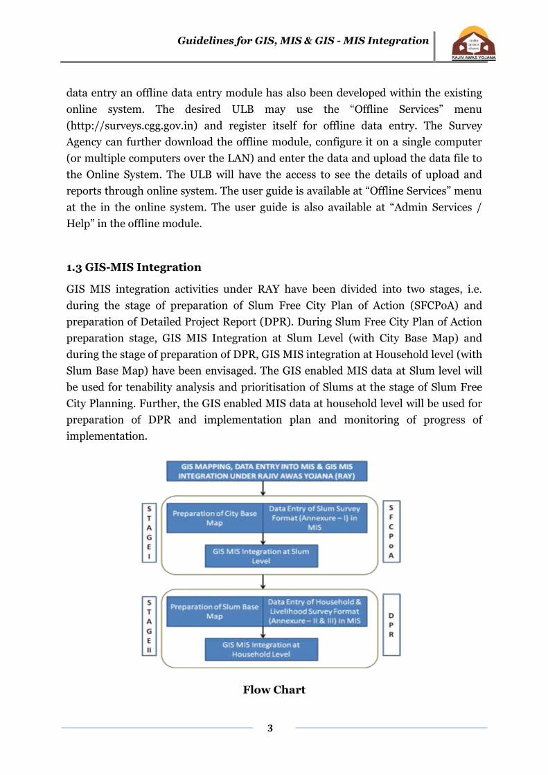
1.3 GIS-MIS Integration
GIS MIS integration activities under RAY have been divided into two stages, i.e.
during the stage of preparation of Slum Free City Plan of Action (SFCPoA) and
preparation of Detailed Project Report (DPR). During Slum Free City Plan of Action
preparation stage, GIS MIS Integration at Slum Level (with City Base Map) and
during the stage of preparation of DPR, GIS MIS integration at Household level (with
Slum Base Map) have been envisaged. The GIS enabled MIS data at Slum level will
be used for tenability analysis and prioritisation of Slums at the stage of Slum Free
City Planning. Further, the GIS enabled MIS data at household level will be used for
preparation of DPR and implementation plan and monitoring of progress of
implementation.
Flow Chart
Guidelines for GIS, MIS & GIS - MIS Integration
4
2. GIS Mapping & GIS MIS Integration for Preparation of Slum Free City
Plan of Action (SFCPoA): The SFCPoA will be an overall action plan of the
ULB with investment requirements projected and prioritized for
improving/developing the existing slums and providing houses including basic
civic infrastructure and social amenities for the urban poor for the next 10-15
years. To achieve these things, a systematic approach is essential for better
designing & planning. An updated city base map prepared using high resolution
satellite image and GIS integrated MIS data at slum level will help to find
appropriate and accurate solution in a shorter time.
2.1 Preparation of City Base Map for the “planning area3”: The basic
requirement for starting the Slum socio-economic survey is to have an
updated City Base Map for the “planning area”. The steps required to
undertake for preparation of City Base Map will be as follows:
a. Step – I: Data Inventory of existing City Base Map: A city base map
between 1:2000 – 1:10,000 scale may be available with the ULB or any
other department of State Govt. In such cases, the first step will be
collection of those base maps for the “planning area” including
boundaries of municipal area, zones, wards & Slums. These maps may
be in two forms i.e paper maps (hard copy or soft copy) or GIS layers.
These maps/layers can be used /modified for preparation of updated
city base map for RAY. In case of existing GIS data, only the required
layers needs to be extracted, updated and converted to prescribed
output data format and projection system4(if the data format and
projection system are different). In case of paper maps, the data for
preparation of city base map will be captured in three steps, i.e
scanning, georeferencing and digitisation. Georeferencing of scanned
paper maps (scanned paper map usually called raster map/image) after
scanning paper maps will be converted to raster image) involves
various steps which are illustrated in Annexure I as an example using
one of the software tools. These steps may change depending on the
software selected for georeferencing of raster image. The potential
3 “Planning Area” means any area declared to be a regional planning area, local planning area or a site for a new
town under the relevant Act
4 Refer para 1.2.3(b) of Annexure4.
Guidelines for GIS, MIS & GIS - MIS Integration
5
source of existing GIS data and Paper Maps has been provided in
Annexure II.
b. Step – II: Inventory of Existing High Resolution Satellite Image: In
some cases, high resolution satellite image (Cartosat – I, II, Quickbird,
World View or IKONOS etc) may also be available in ULB or any other
department of State Govt. If these images have been procured recently,
it can also be used for city base map preparation under RAY.
c. Step – III: Procurement of Cartosat I/II Satellite Image: If base
map/GIS layers/ high resolution satellite image are not readily
available with the cities/States, then CartosatI/II image needs to be
procured from National Remote Sensing Centre (NRSC) for the entire
“Planning Area” of the RAY City. For cities/towns where Cartosat I/II5
images are not available, concerned States/ULBs would need to take
approval of CSMC with demand and justification for an alternative
satellite product as it will have cost implication.
Availability of Cartosat I & II data may be checked in NRSC by using
following steps:
Go to NRSC website: http://www.nrsc.gov.in/
Click to Option User Services
Click to New User Option to complete Registration
formalities
After completing registration formalities, put user id and
password to enter into browsing site.
Click to Demos option to learn the step by step process of
searching satellite image and placing order for satellite
images.
d. Step – IV: Collection of GCPs for Georeferencing of Satellite Image:
After procurement of satellite images, GCPs (Ground Control Points)
should be collected from field using DGPS6 for georeferencing of
Satellite Image. Minimum 10 GCPs should be collected. These points
should ideally be spread over the entire planning area.
5 Refer to 2nd CSMC Minutes of Meeting Dated 19th January, 2012.
6 Differential Global Positioning System is an enhancement to Global Positioning System that provides
improved location accuracy, from the 15-meter nominal GPS accuracy to about 10 cm in case of the best
implementations.
Guidelines for GIS, MIS & GIS - MIS Integration
6
e. Step – V: Georeferencing of Satellite Image: The process of defining
the position of geographical objects relative to a standard reference grid
is known as georeferencing. It is a system that links information to a
position on earth’s surface. The GCPs collected during DGPS survey
can directly be downloaded in the GIS platform and will be used as tie
point for georefencing of Satellite image. The detailed step by step
process of georeferencing has been explained in Annexure I.
f. Step – VI: Feature Extraction from Satellite Image for preparation of
City Base Map: Following thematic layers needs to be
extracted/digitised:
1. Administrative boundaries (planning area, municipal,
zones & wards). Each boundary needs to be marked on
the satellite image using GPS survey points.
2. Key physical features such as roads, rivers, railways,
water bodies, important land marks etc.
3. Land use & Land cover
Delineation of Slum Boundary and Identification of Vacant land on
the GIS Base Map: After finalisation of the updated Slum list, each
Slum will be marked on the city base map using GPS survey points and
satellite image. This information will be saved in a separate thematic
layer (Slum Boundary), over the City Base Map. The Slum boundary
layer should indicate the Slum code numbers of all the Slums. After
demarcation of all the Slum boundaries in GIS interface, a unique Slum
code needs to be entered in the attribute field of Slum Boundary layer.
This unique Slum code should be the same as the Slum codes to be
given or already given in the NBO format (Slum Profile, Revised
Annexure I Part C) for socio-economic surveys, which will be used as
common reference point for integration of socio-economic data and
GIS data at Slum level. This will become the Slum code for all future
references to that Slum. Before initiating the process of delineation of
Slum boundary and Slum survey, ULBs need to finalise the unique
slum code (as specified in revised Annexure I of NBO format) of each
Slum. In the same way, vacant lands should be identified and marked

Guidelines for GIS, MIS & GIS - MIS Integration
7
in a separate thematic layer on the city base map of planning area with
the help of satellite image and field verification. 7
2.2 Data entry into Online Monitoring System for Slum, Household
& Livelihood Survey: The Slum Survey data collected through Socio
Economic Survey should be entered in Online/Offline Monitoring System
for Slum, Household & Livelihood Survey (http://surveys.cgg.gov.in/). The
Slum Survey Format (Annexure I of NBO format) has been revised8 by
highlighting essential /mandatory parameters and adding some additional
fields for the purpose of preparation of SFCPoA. Data entry into
online/offline Monitoring system needs to be done as per the revised
format. Cities/towns that have completed their slum survey under USHA
Scheme should validate/ratify the data and incorporate changes in the
slum survey data into MIS, if required. The analysis reports which can be
generated in MIS have been detailed out at Annexure III.
Note: As the complete process of GIS & MIS integration at Slum level is
dependent on the Unique Slum Code, ULB should take necessary steps to ensure
that same unique code (example of unique slum code: 0001 - 9999) has been
entered in MIS & GIS data of each slum.
Preparation of city base map and data entry into MIS can be done simultaneously
as shown in Flow chart (page – 3)
7 Note: Data for administrative boundaries including Slum boundaries may be available in two forms, technical
description/coordinates and paper maps. Annexure – I may be referred for detailed step by step process of
delineation of boundaries from technical description/coordinates and paper maps.
8 Refer D.O No. N-11011/43/2013-RAY-II dated 13
th May’2013, Guidance Note & Revised format may be
downloaded from http://mhupa.gov.in/ray/Annexure_I_Slum_Survey_Format_Revised_for_RAY.pdf
During the preparatory phase, 20 cities (Ajmer, Bhopal, Jabalpur, Indore, Gwalior,
Hyderabad, Vijaywada, Belgaum, Bellary, Shimoga, Tumkur, Davangere, Gulbarga, Hubli
Dharwad, Mangalore, Kathua, Annathnag, Udhampur, Agartala, Madurai) have completed
preparation of City base map and SFCpoA. The city like Ajmer (population – 5.42 lakh as
per census 2011) with planning area of 375.36 Sq. Km took approximately 1 month for
preparation of city base map and approximately 6 months for completing entire process of
preparation of SFCPoA.

Guidelines for GIS, MIS & GIS - MIS Integration
8
2.3 GIS & MIS Integration at Slum Level:
Integration of GIS with MIS means matching the common parameters
(fields) from the attribute of the spatial data (Map) with MIS based
common fields. This would enable the viewing of the integrated data and
the preparation of the reports. Under RAY, Unique Slum code will be the
common reference point for GIS MIS integration at slum level. Based on
this unique slum code, the attribute tables associated with the GIS layers of
geo-referenced base map will then be integrated with MIS at Slum, zone
and city level base maps on GIS platform. The data integration procedure
from MIS to GIS has been illustrated in Annexure IV. After integration,
the socio-economic and other databases on tenability, land tenure, land
ownership, land value of Slums in MIS could be viewed spatially on the
GIS map. Further, the entire process of tenability analysis and
prioritisation of slums can also done in GIS and the process of tenability
analysis and prioritisation of slums under GIS have explained in
Annexure V.
The list of standardised thematic layers needs to be generated at this stage have
indicated in Annexure VI
Note: MIS linked GIS databases of City base map will be fundamental datasets for
ULBs; therefore it must be prepared correctly. In case ULBs do not have the
capability to create such data, it is recommended to outsource the work to any
Agency with expertise in image processing and GIS. Detailed Guidelines for
engagement of Technical Consultants and Model Bid document for GIS Mapping
under Rajiv Awas Yojana (RAY), have been provided at Annexure VII & VIII.
Guidelines for GIS, MIS & GIS - MIS Integration
9
3. GIS Mapping & GIS MIS Integration for Preparation of Detailed Project Report (DPR):
On the basis of prioritization of slums in SFCPoAs, cities would be required to
prepare Detailed Project Reports (DPRs) following a ‘whole slum’ approach. In
each selected slum, an integrated approach would be adopted with the provision
of housing, basic civic infrastructure and social amenities. The detailed Slum Base
Map prepared using Total Station Survey (TSS) data and GIS enabled MIS data at
household level will help to establish the locations and spatial dimension of
property and also to improve the coverage and provision of municipal services.
3.1 Preparation of Geo Referenced Slum Base Map of Prioritised
Slums using TSS:
In case of Slums which are prioritised and are to be developed in situ, it is
required to carry out detailed physical survey using Total Station9 for preparation
of DPR. During preparation of DPR, for detailed infrastructure planning and
designing of a slum, it is necessary to map the existing infrastructure, the actual
ground coverage of each house/building and also the topography. For this
purpose it is required to create spatial information at 1:500/1:200 scale. This
large scale map cannot be derived only using high resolution satellite data. Thus,
it is required to create detailed plan by carrying out Total Station Survey for the
slum selected for intervention and preparation of DPR.
With the use of total station topographical survey will be faster, accurate and can
be performed at multiple sites simultaneously. It is capable of creating many
more data sets. TSS data can be quickly and directly transferred to computer
which in turn will reduce the scope of manual error to bare minimum. Further,
computers can be employed for map making and plotting contour and cross-
sections. Contour intervals and scales can be changed in no time. Therefore, it is
recommended to use Total Station for surveying instead of any traditional
method of surveying for preparation of DPR.
Further, it is also required to carry out TSS and Slum mapping exercise in the 100
-200 meter peripheral belt of the slum. This will help to establish linkages with
cities existing trunk infrastructure and total fund requirement for establishing the
said linkages.
9 A total station is an electronic/optical instrument used in modern surveying. It consists of an EDM (Electronic
Distance Meter), Theodolite, Microprocessor combined into one. It also has a memory card to store the data.
Guidelines for GIS, MIS & GIS - MIS Integration
10
For the preparation of digitized base map (Annexure VI) of the Slum, the
following information needs to be collected from the field survey/total station
survey:
Slum boundary with schedule of boundaries of related Slum / Slum pockets.
Width and length of plots of all occupants, building foot prints.
Approach road, streets, lanes, by-lanes in the Slum.
Existing land use such as residential, commercial including petty shops or
others.
Type and length of existing roads (CC, BT, WBM and earthen)
Existing water supply lines and details of Public Stand Posts (PSPs), bore
wells, hand pumps and individual connections.
Details of sewerage system and Sanitation services – individual, community
and public toilets.
Details of storm water drains and the pucca / kutcha drains leading to final
disposal points.
Solid waste management system with details of dustbins and collecting points.
Street lighting with pole number, location and type of fixture and distance to
transformer and its capacity.
Community hall, anganwadi centre, PHC/HC, primary school and other
educational institutions.
Contours at 0.5 m and 1.0 m intervals shall be incorporated through total
station or similar spatial survey techniques.
Note: Before initiating TSS, Municipal Officials should conduct data inventory of
the existing data sets within its own department or any other department of State
Govt. The data may be available in the form of GIS layers or paper maps. The
same needs to be modified/updated during the time of physical survey, if
required.
Whenever total station surveys are carried out, care should be taken to establish
control points and temporary bench marks (TBM) at suitable locations during
survey for use at a later stage or during implementation of works. The list of such
Guidelines for GIS, MIS & GIS - MIS Integration
11
control points and TBM shall be recorded both in drawing as well as in MS excel
format. During the survey, all levels should refer to mean sea level (MSL). For this
purpose, GTS benchmark10 should be used. If a GTS benchmark it is not available
within the town or city, the nearest GTS benchmark should be used to establish
one or more control points using a closed traverse. It is required to capture at
least levels at road intersections/junctions covering the entire Slum up to points
of connectivity to town wide infrastructure with respect to water supply, sewerage
and storm water drainage systems like ELSRs/GLSRs/Sumps/pumping stations
etc. While the Total Station Survey generally captures all surface features,
underground utilities like water supply, pipeline, sewer line, electric cables etc
will have to be superimposed on drawings generated out of Total Station Survey.
In general, Total Station Survey drawings are plotted on CAD platform. These
drawings need to be converted into the GIS platform and superimposed over City
Base Map.
3.2 Data entry into Online Monitoring System for Slum, Household &
Livelihood Survey:
The Household and Livelihood Survey data collected through Socio Economic
Survey needs to be entered in Online/Offline Monitoring System for Slum,
Household & Livelihood Survey (http://surveys.cgg.gov.in/). The Household
and Livelihood Survey Format (Annexure II & III of NBO format) has been
revised11 by highlighting essential /mandatory parameters and adding some
additional fields for the purpose of preparation of DPR. Data entry into
online/offline Monitoring system needs to be done as per the revised format.
Cities/towns that have completed their Household & Livelihood survey under
USHA Scheme should validate/ratify the data from community and
incorporate changes in the Household & Livelihood survey data into MIS, if
required. The analysis reports which can be generated in MIS have been
detailed out in Annexure III.
10
A G.T.S. (Great Trigonometrical Survey) benchmark is a permanently fixed reference survey station (or
point), having known elevation with respect to a standard datum (mean sea level). 11
Refer D.O No. N-11011/43/2013-RAY-II dated 13th
May’2013, Guidance Note & Revised format may be
downloaded from http://mhupa.gov.in/ray/Annexure_II & III_Survey_Format_Revised_for_RAY.pdf

Guidelines for GIS, MIS & GIS - MIS Integration
12
Note: Preparation of slum base map and data entry into MIS can be done
simultaneously as shown in Flow chart (page – 3).
3.3 GIS & MIS Integration at Household Level:
During Household survey, each house and household in the Slum should be
assigned unique number12 by Municipal authority. In case, houses and
household do not have house and household number, ULB should issue
unique numbers for each house and household. The same unique numbers
must be given to the TSS team, by the ULB authorities, so that they can assign
the same number in the GIS (TSS) database (attribute field) against each
building foot print of the priority Slums. The unique house number will be
used as a common reference point for GIS (TSS)-MIS integration at household
level. GIS MIS integration at Household level is to be done for the purposes of
preparing DPR.
Note: ULB should take necessary steps to ensure that same House Number &
Household Number has been entered in MIS & GIS data of each house &
household. The unique House Number is important for GIS MIS integration for
Household level. Further it is also noted that Unique Household Number will also
be used for linkages with UIDAI for Biometric information.
The GIS enabled MIS data at household level will then be used for the
preparation of following thematic layers during DPR stage:
Existing Infrastructure Base Map of Slum
Digital Elevation Model (DEM)13, Relief14 & Slope Map of Slum.
Socio economic condition of Slum Households
Location & size of each dwelling Units
12
Example: House No – 1, Household No – 1/A, 1/B, 1/C etc. This will also determine how many Household is
residing in one house.
13 DEM will help to analyse ground condition of slum, topography, ground slope and direction of drainage.
Further, this will also help to identify the vulnerable areas like prone to flooding/water logging and landslides
(in case of hilly areas).
14 Relief map will be used to generate 3D view of the Slum Base Map (existing housing and infrastructure
condition) and the proposed development models (layout plans) during the preparation of DPR.
Guidelines for GIS, MIS & GIS - MIS Integration
13
The GIS enabled MIS data at household level will be used for preparation of
entire implementation plan and to track progress of construction of dwelling
units.
Note: MIS linked GIS databases of slum base map and CAD data will be
fundamental datasets for ULBs; therefore it must be prepared correctly. In case
ULBs do not have the capability to create such data, it is recommended to outsource
the work to any Agency with expertise in image processing, Total Station Survey and
GIS. Detailed Guidelines for engagement of Technical Consultants and Model Bid
document for GIS Mapping under Rajiv Awas Yojana (RAY), have been provided in
Annexure VII & VIII.
Guidelines for GIS, MIS & GIS - MIS Integration
14
4. Funding Pattern:
The above mentioned activities will be funded by Central Government in the ratio
50:50 for cities with population more than 5 lakhs, 75:25 for cities with population
less than 5 lakhs and 80:20 for NE and special category States. Financial norms in
term of per unit cost for different activities for GIS mapping, data entry into MIS and
GIS MIS integration are applicable as decided in 2nd & 3rd CSMC meeting held on
19.01.2012 & 11.09.12.

Guidelines for GIS, MIS & GIS - MIS Integration
15
Annexure I: Illustrative examples of Georeferencing of paper maps &
DGPS survey points
a. Illustrative example: process of Georeferencing
Identification of Ground Control Points (GCPs) on existing maps:
A set of GCPs could be identified on maps such as four corners of a toposheet (not
limiting only to 4 corner points), which provides information of latitudes and
longitudes at the four corners. For better results, additional known control points
could be identified and mapped. These points should ideally be spread over the
entire map. In the following example, the longitudes and latitudes of four corners are
as indicated (For the sake of understanding, geo-referencing procedure is illustrated
for only four corners points of a toposheets).
Values in Degree Minutes Seconds need to be converted into Degree Decimals. The
four points would have following values respectively for points marked (1) to (4) –
Longitude Latitude
75.5 28.5
75.5 28.75
75.75 28.75
75.75 28.5
Prepare a table as shown above for the GCPs in .dbf format. (Such a table could be
Toposheet
75o 30’,
28o 45’
75o 45’,
28o 45’
75o 30’,
28o 30’
75o 45’,
28o 30’
1
2 3
4
Central Meridian
75o 37’ 30”
(75.625 in Deg. Dec.)
Guidelines for GIS, MIS & GIS - MIS Integration
16
prepared in MS Excel and saved as a Dbase table). This table could be named as
GCP.dbf, which would be used for registration of the scanned toposheet. The step-
by-step guide is given below of using ArcGIS georeferencing tool as an example.
Creating a Master GCP layer:
1. Open ArcMap. From the “View” menu chose “Data Frame Properties”. The Data
Frame Properties window opens. It shows the Co-ordinate System Tab indicating
“No projection” in “Current Co-ordinate System”. Co-ordinate system for the map
needs to be specified.
2. Click on “New” button to choose “Projected Co-ordinate System”. A window for
“New Projected Co-ordinate System” opens. Specify a name for the new co-
ordinate system such as “My Projection”. In the projection frame – chose “UTM”
from the drop-down list.
3. The remaining parameters of False Easting, False Northing, Central Meridian and
Latitude of origin need to be specified, based on the extent of map. For this, we
would take reference of Lat-Long values that we have used.
4. For example, following values will be considered as parameters
False Easting – 0.0
False Northing - 0.0
Central Meridian - 75.625 (Central meridian of the Toposheet)
Latitude of origin - 0.0
5. In the Geographic Projection System area, Click “Select” button. This opens the
“Browse for Co-ordinate System” dialog. Double-click on “Spheroid Based” folder.
From the available list, chose “WGS84.prj”. Click “Ok” on all the co-ordinate
system windows. This would apply the specified projection and geographic co-
ordinate system parameters to the “Data Frame”. Also, from the “General” tab,
change the display units from “meters” to “Degree; Minutes; Seconds”. Click
“Apply” and then “Ok” on the “Data Frame Properties” window.
6. Go to the main menu bar in ArcMap. Select “Tools” and then chose “Add X- Y
Data”. A window for “Add X-Y Data” opens. From this “Chose a table from the
map or browse for another table” option, click on the button having an icon
resembling “open folder” icon. Chose the appropriate location where your
Guidelines for GIS, MIS & GIS - MIS Integration
17
GCP.dbf table (created in step 2) is stored. Once the table name is selected, the
fields of Longitude and Latitude are automatically picked up for X-Field and Y-
Field. Do not select any spatial reference at this stage. Click “Ok” on the “Add X-Y
Data” window. The system processes and adds a layer in Table of Contents and
shows the four points on the display area. Thus, control points are established
with the specified co-ordinate system.
7. Right click on the layer name in the Table of Contents, chose “Data” from the
context menu and chose “Export Data”. (This would help to export this layer as a
new shape file). You are asked by the software to opt between two options, which
are –
Use the same co-ordinate system as this layer’s source data and
Use the same co-ordinate system as the Data Frame.
8. Select the second option and specify an output shape file name such as
“Projected_GCP.shp”.
9. In case of data available in DGPS, you can directly download GCPs from DGPS
and convert into GIS format/shp file. Further, it is also necessary to
define/project the projection system (as mentioned above).
10. You can use this projected shape file for assigning spatial reference information
properties to other image file or vector files (Do not close ArcMap at this stage).
11. Go to ArcMap and add this image file. At first, the image file will not be seen in
the display area. Now, go to the “View” Menu and select Toolbars >
Georeferencing.
12. From the Georeferencing toolbar, make sure that “Auto Adjust” is un-selected.
13. From the same toolbar, click on “Fit to Display”. This would show the image file
on the display area. Now, the image as well as control points will be visible. Using
“add control points button” on “georeferencing” toolbar, links between points on
the toposheet image and the control points can be added. When all the links have
been established, select “Update Display” from the “georeferencing” toolbar.
14. This would register the image with GCPs. Now, select the “View Link Table”
button from the “georeferencing” toolbar, RMS error in the form of “Residual”
will appear. If the RMS error is within acceptable limits select “Auto Adjust”.
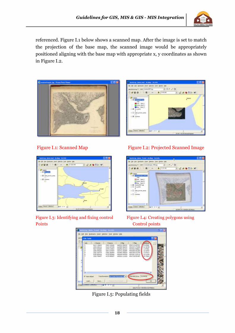
15. Following images present an illustration of how a map is scanned and geo-
Guidelines for GIS, MIS & GIS - MIS Integration
18
referenced. Figure I.1 below shows a scanned map. After the image is set to match
the projection of the base map, the scanned image would be appropriately
positioned aligning with the base map with appropriate x, y coordinates as shown
in Figure I.2.
Figure I.1: Scanned Map Figure I.2: Projected Scanned Image
Figure I.3: Identifying and fixing control Figure I.4: Creating polygons using
Points Control points
Figure I.5: Populating fields

Guidelines for GIS, MIS & GIS - MIS Integration
19
Based on the feature of interest, multiple coordinates could be digitized and hence,
polygons can be drawn (Figure I.5). The attribute table of the polygon will have to be
then populated with information pertaining to the polygon. For instance, if a slum is
digitized from the map, information on land ownership, dimensions of the structure
and any relevant information need to be populated under individual fields. An
example of populating fields is shown in Figure I.2 above. Each polygon would also
have a unique identification number.
b. Illustrative procedure of digitizing CAD based paper maps or
toposheets
If there are CAD based paper maps available, those maps can also be digitized using
the procedure explained above. ULB will be able to convert a CAD file with necessary
geo-coordinates to a GIS vector file format (shape file). Following figures (Figure I.6
to Figure I.10) are an illustration of how CAD based maps could be digitized.
Figure I.6: Scanned Image
Figure I.7: Activate geo-reference tool (red circle)

Guidelines for GIS, MIS & GIS - MIS Integration
20
Figure I.8: Set Control points as shown Figure I.9: Setting up additional control
points
Figure I.10: Populating the attribute table of line shape file
After digitizing the scanned map and vectorisation with associated attributes, a
separate layer will be created with appropriate title as shape file. Along with the city
base map and other infrastructure layers such as roads, sewer and other permanent
feature shape files, the newly created layer would also be brought into the user
interface on the screen as required. This layer, as with other layers could be activated
and de-activated depending on the need.
Guidelines for GIS, MIS & GIS - MIS Integration
21
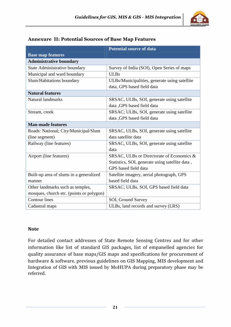
Annexure II: Potential Sources of Base Map Features
Base map features
Potential source of data
Administrative boundary
State Administrative boundary Survey of India (SOI), Open Series of maps
Municipal and ward boundary ULBs
Slum/Habitations boundary ULBs/Municipalities, generate using satellite
data, GPS based field data
Natural features
Natural landmarks SRSAC, ULBs, SOI, generate using satellite
data ,GPS based field data
Stream, creek SRSAC; ULBs, SOI, generate using satellite
data ,GPS based field data
Man-made features
Roads: National; City/Municipal/Slum
(line segment)
SRSAC, ULBs, SOI, generate using satellite
data satellite data
Railway (line features) SRSAC, ULBs, SOI, generate using satellite
data
Airport (line features) SRSAC, ULBs or Directorate of Economics &
Statistics, SOI, generate using satellite data ,
GPS based field data
Built-up area of slums in a generalized
manner
Satellite imagery, aerial photograph, GPS
based field data
Other landmarks such as temples,
mosques, church etc. (points or polygon)
SRSAC; ULBs, SOI, GPS based field data
Contour lines SOI, Ground Survey
Cadastral maps ULBs, land records and survey (LRS)
Note
For detailed contact addresses of State Remote Sensing Centres and for other
information like list of standard GIS packages, list of empanelled agencies for
quality assurance of base maps/GIS maps and specifications for procurement of
hardware & software, previous guidelines on GIS Mapping, MIS development and
Integration of GIS with MIS issued by MoHUPA during preparatory phase may be
referred.
Guidelines for GIS, MIS & GIS - MIS Integration
22
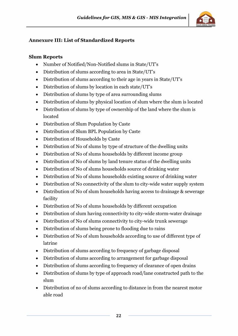
Annexure III: List of Standardized Reports
Slum Reports
Number of Notified/Non-Notified slums in State/UT’s
Distribution of slums according to area in State/UT’s
Distribution of slums according to their age in years in State/UT’s
Distribution of slums by location in each state/UT’s
Distribution of slums by type of area surrounding slums
Distribution of slums by physical location of slum where the slum is located
Distribution of slums by type of ownership of the land where the slum is
located
Distribution of Slum Population by Caste
Distribution of Slum BPL Population by Caste
Distribution of Households by Caste
Distribution of No of slums by type of structure of the dwelling units
Distribution of No of slums households by different income group
Distribution of No of slums by land tenure status of the dwelling units
Distribution of No of slums households source of drinking water
Distribution of No of slums households existing source of drinking water
Distribution of No connectivity of the slum to city-wide water supply system
Distribution of No of slum households having access to drainage & sewerage
facility
Distribution of No of slums households by different occupation
Distribution of slum having connectivity to city-wide storm-water drainage
Distribution of No of slums connectivity to city-wide trunk sewerage
Distribution of slums being prone to flooding due to rains
Distribution of No of slum households according to use of different type of
latrine
Distribution of slums according to frequency of garbage disposal
Distribution of slums according to arrangement for garbage disposal
Distribution of slums according to frequency of clearance of open drains
Distribution of slums by type of approach road/lane constructed path to the
slum
Distribution of no of slums according to distance in from the nearest motor
able road

Guidelines for GIS, MIS & GIS - MIS Integration
23
Distribution of no of slums by type of internal road in the slum
Distribution of no of slums having street light facility in the slum
No of slums by distance from nearest anganwadis primary schools
No of slums by distance from nearest Municipal pre-school
No of slums by distance from nearest Private pre-school
No of slums by distance from nearest Municipal Primary School
No of slums by distance from nearest State Government Primary School
No of slums by distance from nearest Private Primary School
No of slums by distance from nearest Municipal High School
No of slums by distance from nearest State Government High School
No of slums by distance from nearest Private High School
No of slums by distance from nearest Adult education centre
No of slums by distance from nearest Non-formal education centre
No of slums by distance from nearest Urban Health post
No of slums by distance from nearest Primary Health Centre
No of slums by distance from nearest Government hospital
No of slums by distance from nearest Maternity Centre
No of slums by distance from nearest Private Clinic
No of slums by distance from nearest Registered Medical Practitioner
No of slums by distance from nearest Ayurvedic doctor/vaidya
No of slums by availability of no of community hall within slum
No of slums by availability of no of Livelihood centre within slum
No of slums by availability of no of Vocational training/Training-cum-
production centre within slum
No of slums by availability of Street children rehabilitation centre within slum
No of slums by availability of no of Night shelter within slum
No of slums by availability of no of Old Age Home within slum
No of slums dwellers holding/covered under social development/welfare
schemes
No of Self Help Groups/DWUCA Groups functioning within slum
No of Thrift and Credit societies functioning within slum
No of slums having slum-dwellers association in the slum
No of Youth associations functioning within the slum
No of Women associations/Mahila samithis functioning within the slum

Guidelines for GIS, MIS & GIS - MIS Integration
24
Household Reports
Distribution of slum population by sex
Distribution of slum households by caste
Distribution of slum households by religion
Status of slum as per minority status
Distribution of female headed household in slum according to the marital
status
Distribution of illiterate adult members in the slum household according to
the gender
No of children in slum household in the age group 6-14 not attending school
No of handicapped person per family in slums
Status of female major earning member in the slum household
Distribution of families below poverty line in slums
Distribution of slum household by land tenure status
Distribution of slum household by house type/structure
Distribution of slum household by type of roof
Distribution of slum household by type of flooring
Distribution of slum household by type of lighting
Distribution of slum household by type of fuel for cooking
Distribution of slum household by source of drinking water
Distribution of slum household by duration of piped water supply
Distribution of slum households according to the distance from the source of
water supply, if it is outside premises of the household
Distribution of slum household according to the existence of toilet facilities
Distribution of slum household according to bath room facilities
No of slum households by type of road in front of houses
No of slum households by type of pre-school available
No of slum households by type of high-school available
No of slum households by type of health facility access
Access to welfare benefits to family members in the slum household
Possession of consumer durables among slum households
Possession of livestock by slum households
Migration details of household of slum according to no. of years of stay in this
town/city
Migration stream of household of slum
No of slum households by type of migration
Guidelines for GIS, MIS & GIS - MIS Integration
25
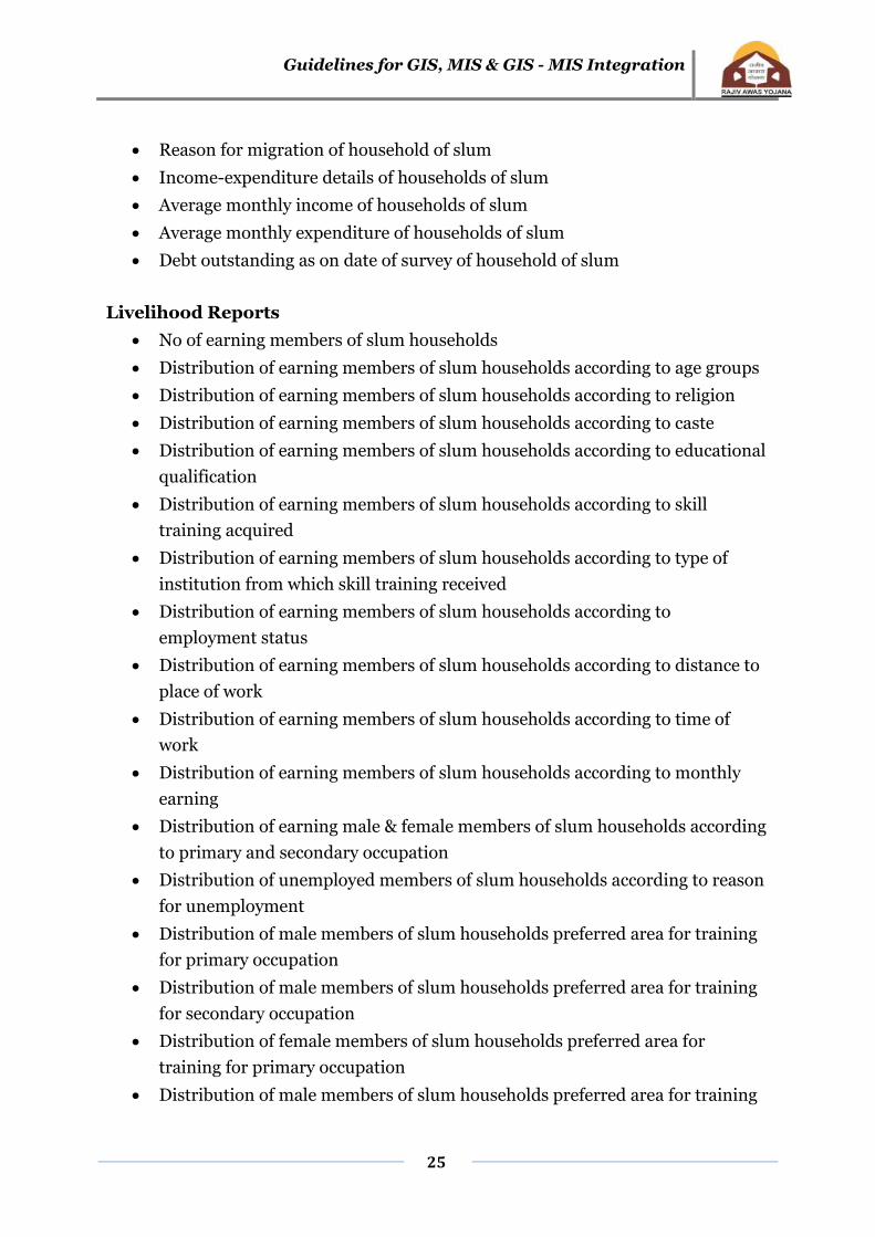
Reason for migration of household of slum
Income-expenditure details of households of slum
Average monthly income of households of slum
Average monthly expenditure of households of slum
Debt outstanding as on date of survey of household of slum
Livelihood Reports
No of earning members of slum households
Distribution of earning members of slum households according to age groups
Distribution of earning members of slum households according to religion
Distribution of earning members of slum households according to caste
Distribution of earning members of slum households according to educational
qualification
Distribution of earning members of slum households according to skill
training acquired
Distribution of earning members of slum households according to type of
institution from which skill training received
Distribution of earning members of slum households according to
employment status
Distribution of earning members of slum households according to distance to
place of work
Distribution of earning members of slum households according to time of
work
Distribution of earning members of slum households according to monthly
earning
Distribution of earning male & female members of slum households according
to primary and secondary occupation
Distribution of unemployed members of slum households according to reason
for unemployment
Distribution of male members of slum households preferred area for training
for primary occupation
Distribution of male members of slum households preferred area for training
for secondary occupation
Distribution of female members of slum households preferred area for
training for primary occupation
Distribution of male members of slum households preferred area for training
Guidelines for GIS, MIS & GIS - MIS Integration
26
for secondary occupation
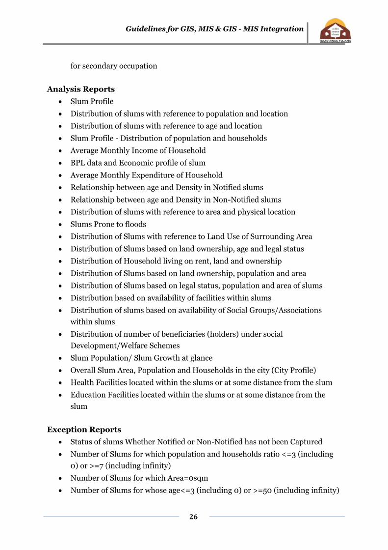
Analysis Reports
Slum Profile
Distribution of slums with reference to population and location
Distribution of slums with reference to age and location
Slum Profile - Distribution of population and households
Average Monthly Income of Household
BPL data and Economic profile of slum
Average Monthly Expenditure of Household
Relationship between age and Density in Notified slums
Relationship between age and Density in Non-Notified slums
Distribution of slums with reference to area and physical location
Slums Prone to floods
Distribution of Slums with reference to Land Use of Surrounding Area
Distribution of Slums based on land ownership, age and legal status
Distribution of Household living on rent, land and ownership
Distribution of Slums based on land ownership, population and area
Distribution of Slums based on legal status, population and area of slums
Distribution based on availability of facilities within slums
Distribution of slums based on availability of Social Groups/Associations
within slums
Distribution of number of beneficiaries (holders) under social
Development/Welfare Schemes
Slum Population/ Slum Growth at glance
Overall Slum Area, Population and Households in the city (City Profile)
Health Facilities located within the slums or at some distance from the slum
Education Facilities located within the slums or at some distance from the
slum
Exception Reports
Status of slums Whether Notified or Non-Notified has not been Captured
Number of Slums for which population and households ratio <=3 (including
0) or >=7 (including infinity)
Number of Slums for which Area=0sqm
Number of Slums for whose age<=3 (including 0) or >=50 (including infinity)
Guidelines for GIS, MIS & GIS - MIS Integration
27
Number of Slums for which basic information indicators have not been
entered
Number of Slums for which water, sanitation and road infrastructure has not
been captured
Number of Slums for which education facilities have not been captured
Number of Slums for which health facilities have not been captured
Number of Slums for which social development facilities have not been
captured
Number of Slums for which pension holders information has not been
captured
Number of Slums for which no. of SHG's and other societies information has
not been captured

Guidelines for GIS, MIS & GIS - MIS Integration
28
Annexure IV: Illustration of data integration from MIS to GIS
The illustration given hereunder is the procedure adopted using the ArcGIS software
as an example. Data from a tabular relational database can be brought into ArcGIS
(and most other GIS software programs) in at least two ways:
Databases in .dbf format can be imported into ArcGIS from any source that supports the
.dbf format
Databases can be queried "live" using SQL and ODBC capabilities - this method
may be preferable in situations where data is continually being updated by MIS
System (Surveys).
Using the Open Database Connectivity (ODBC) Manager to Configure a Connection:
The ODBC Manager in Windows XP/NT manages how different databases including
Excel, Access, Arcview, etc., can link to one another. Before any link is made a
connection must be established by using the ODBC Manager. Following steps
illustrates the procedure.
1. Click on the Windows START button, then go to SETTINGS - CONTROL PANEL
2. In the CONTROL PANEL window, double click on the ODBC icon.
3. Following interface form will be visible.
FigureII.1: ODBC data source admin Figure II.2: ODBC data source set up
4. Under the User DSN tab, click Add.
5. Select the Microsoft Access Driver and click Finish.
6. For Data Source Name, type ms-access
7. Choose OK. The "ms-access" driver should now appear under User Data Sources
Guidelines for GIS, MIS & GIS - MIS Integration
29
8. Click OK to exit
9. Close the CONTROL PANEL
10. The Basic SQL Connect Process
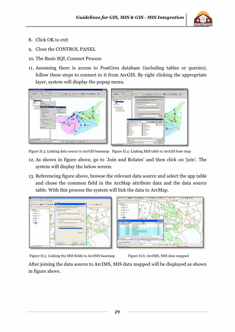
11. Assuming there is access to PostGres database (including tables or queries),
follow these steps to connect to it from ArcGIS. By right clicking the appropriate
layer, system will display the popup menu.
Figure II.3: Linking data source to ArcGIS basemap Figure II.4: Linking MIS table to ArcGIS base map
12. As shown in figure above, go to ’Join and Relates’ and then click on ‘join’. The
system will display the below screen.
13. Referencing figure above, browse the relevant data source and select the app table
and chose the common field in the ArcMap attribute data and the data source
table. With this process the system will link the data to ArcMap.
Figure II.5: Linking the MIS fields to ArcIMS basemap Figure II.6: ArcIMS, MIS data mapped
After joining the data source to ArcIMS, MIS data mapped will be displayed as shown
in figure above.
Guidelines for GIS, MIS & GIS - MIS Integration
30
Annexure V: Tenability Analysis & Prioritisation of Tenable Slums using
GIS
1 Tenability Analysis: Creation of 3 thematic layers in GIS - Tenable, Semi tenable
(will be determined by overlaying Slum Boundary layer over Master Plan Map)
and Untenable. 15
2 Prioritisation of Tenable Slums: Prioritisation of Tenable Slums will be done
based on the infrastructure, housing condition, tenure status and BPL, SC / ST
population. Separate sets of thematic layers will be used to analyse the status of
infrastructure, tenure and vulnerability of Slums.16 The steps to be followed for
prioritisation of tenable Slums using GIS are as follows:
Creation of Infrastructure deficiency layer by sorting following parameters
from the main Slum Boundary layer of GIS Base Map
o Percentage of households not covered with piped water supply
o Percentage of households not covered with individual toilets
o Percentage of length not covered with pucca drains
o Percentage deficiency of pucca road, narrow access( <3m)
o Percentage of road length without street lights
o Percentage of households without access to facilities of disposal of solid
waste
Creation of vulnerability condition layer by sorting housing condition, BPL
and SC/ST parameter from the main Slum Boundary layer of GIS Base Map
Assigning scores to each parameter of Infrastructure and vulnerability layers.
Add a table/field to calculate average score/ weightage in both the layers.
Use Weightage Sum technique to calculate final score and preparation of final
thematic layer of prioritised Slum.
15 Refer Step2, 2.2 of Guidelines for Preparation of Slum Free City Plan of Action.
16 Refer Step2, 2.3 of Guidelines for Preparation of Slum Free City Plan of Action.
Guidelines for GIS, MIS & GIS - MIS Integration
31
Annexure VI: Standardised list of Thematic Layers/Maps
Stage - I
1. Location map of the city showing regional setting (India-State-District-
City)
2. Geo-referenced city base map
3. Slum pockets marked on the GIS base map with municipal boundary and
ward boundaries.
4. Slum pockets marked on the satellite image of the Planning Area
5. Existing land use land cover of Planning Area
6. Tenable, Semi-tenable and Untenable slums
7. Tenure status of slums
8. Land ownership of slums
9. Slum Density
10. Land value ranges of areas under slums
11. Vacant land pockets marked on the satellite image of planning area
12. Vacant land with trunk infrastructure marked on satellite image of
planning area
13. Vacant land with residential zoning marked on satellite image of planning
area
14. Vacant land with non-residential zoning marked on satellite image of
planning area
15. Land pockets reserved for EWS/LIG housing including in industrial
estates.(if any)
16. Spatial distribution of affordable housing zones developed in the last 5
years
Stage – II
Georeferenced Slum Base Map
Land use Land cover Map
Existing infrastructure layout
Location & Size (Building foot prints) of existing Dwelling Units & all other
plots (including vacant plots)

Guidelines for GIS, MIS & GIS - MIS Integration
32
Annexure VII: Guidelines for Technical Support Institutions/ Agencies/
Consultants and the norms of engagement of Technical Consultants to be
engaged by the States/Cities under Rajiv Awas Yojana (RAY), MoHUPA.
1.1 Introduction
This section is intended to provide guidance to the ULBs regarding the work to be
carried out for mapping by external agencies such as Technical Consultant and / or
institution to be engaged by the ULBs in the event that the ULBs themselves are
unable or not in a position to carry out the work themselves. The quality checking of
the deliverables may be carried out by the ULB through a Third Party Inspection
Monitoring (TPIM) process.
1.2 Scope of Work
1.2.1 Brief Description of work
The work may comprise either or both (i) city level mapping and (ii) mapping of
slums in a particular ULB. In case of City level mapping, the work will comprise
preparation of Base Maps of the geographical area generally within the ULB area and
around, depending on specific requirement of a ULB. The Base Map will depict all
physical features like roads, highways, railway lines, parks, open areas, water bodies
(e.g., rivers, canals, nalas etc.), administrative boundaries like municipal boundaries,
ward boundaries etc. in separate layers., In case of Slum Mapping, the work will
comprise of preparation of maps of slums showing each property or structure, lanes,
open areas, landmarks, surrounding roads/lanes/access etc.
Ground truthing has to be carried out along with the collection of attribute data for
spatial features. The bidders will have to deliver the final outputs in CD-ROM media
(should be readable under standard windows NT/2000 platform) and hard copy.
Each of the activity will be followed by quality assurance checks by the RAY
Technical Cell experts (city team) and the Municipal Corporation officials or the
empanelled agency/State level Space Application Centre (SRSACs).
1.2.2 Objectives
The objectives of Mapping are:
Develop a common digital geo-referenced base map that will be used by all

Guidelines for GIS, MIS & GIS - MIS Integration
33
participating sections/departments within ULB for detailed mapping. This
map is to be updated regularly to maintain an accurate and reliable
information data base on properties and all components of infrastructure on a
common, scalable and physically verifiable municipal GIS platform.
Establish the locations of property (building or plot) in slums onto the GIS
base map and its corresponding data which would provide a spatial dimension
of Properties.
Improve the coverage and provision of municipal services (e.g. water and
sewerage connections) through mapping of all existing infrastructure facilities
onto the map.
Allow spatial analysis of service provision levels, revenue generation and
social composition, particularly identifying the location of poor and socially
excluded communities.
1.2.3 Description of Tasks
(a) Preparation of Geo-referenced City Base Map and Slum Mapping
This task is focused on the preparation of digital geo-referenced GIS base map for the
town/city/agglomeration limits of the ULB. It is likely that the ULB may or may not
have GIS base maps obtained from satellite imageries. ULB should share existing GIS
database /paper maps/satellite image with TC. The Technical Consultant (TC) shall
review all available maps (either print on paper or available soft copies), quality of
available data and date(s) of acquisition as well as their scales. In the absence of GIS
maps, the TC shall procure such satellite images or maps from official sources (e.g.,
NRSC, State RSACs etc.) or other reliable sources. In case the ULBs have paper maps
on a suitable scale, the TC may geo-reference it using GPS, as outlined in Annexure
I.
Total Station survey will be used for slum mapping. The base map shall contain all
key physical features, the boundaries of each plot or building (structure) and a plot or
building identification number (Unique House no & Household no as specified in
Section 3.3). The map shall be multipurpose and could be used by various sections of
the ULB such as engineering, revenue (taxation) and town planning.
Guidelines for GIS, MIS & GIS - MIS Integration
34
(b) Data Contents and Specifications
The preparation of geo-referenced city base map shall be based on high-resolution
latest satellite imageries and DGPS. Slum mapping shall be done using Total Station
Survey. To facilitate sharing of information between various municipal sections, it is
critical that GIS base mapping be compatible with standard data base formats as
specified below.
Vector data format: Shape file format (.shp)/ Geodatabase
Raster data format (including Satellite image): Geo tiff
Projection: UTM
Datum: WGS 84
The base map shall be prepared using various layers for ease of operation in GIS.
Each layer shall include, but not be limited to, the following:
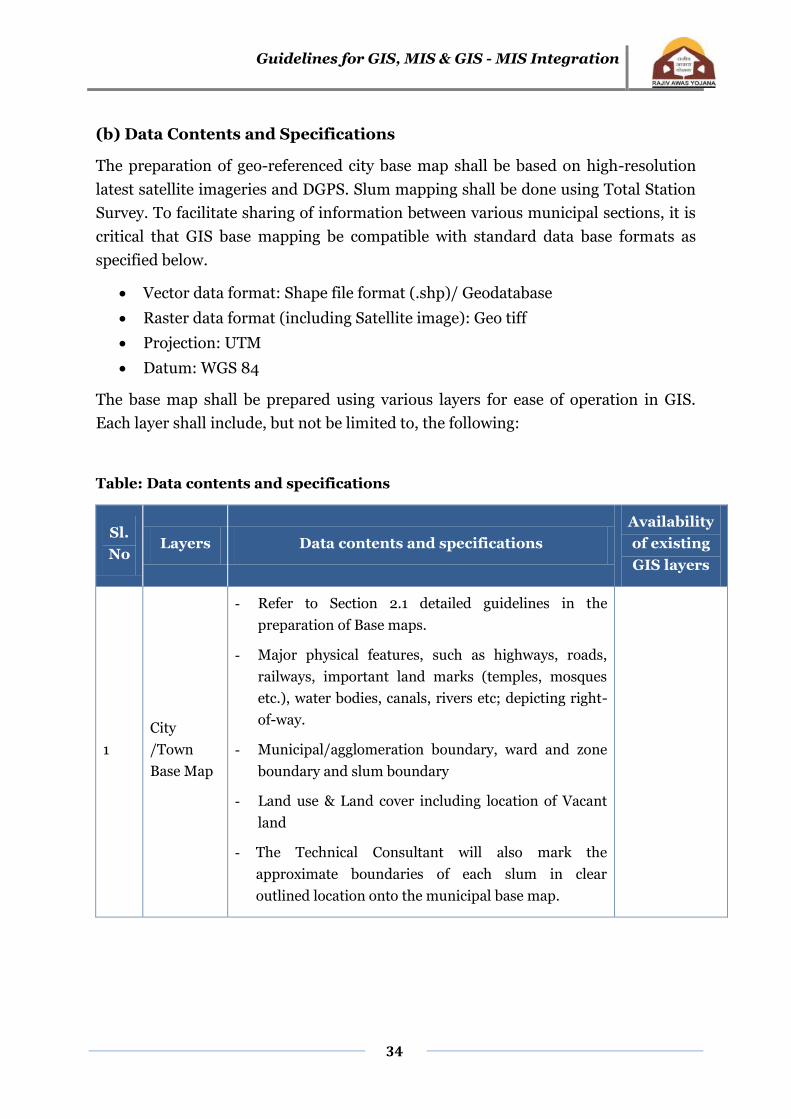
Table: Data contents and specifications
Sl.
No Layers Data contents and specifications
Availability
of existing
GIS layers
1
City
/Town
Base Map
- Refer to Section 2.1 detailed guidelines in the
preparation of Base maps.
- Major physical features, such as highways, roads,
railways, important land marks (temples, mosques
etc.), water bodies, canals, rivers etc; depicting right-
of-way.
- Municipal/agglomeration boundary, ward and zone
boundary and slum boundary
- Land use & Land cover including location of Vacant
land
- The Technical Consultant will also mark the
approximate boundaries of each slum in clear
outlined location onto the municipal base map.

Guidelines for GIS, MIS & GIS - MIS Integration
35
Sl.
No Layers Data contents and specifications
Availability
of existing
GIS layers
2 Slum Base
Map
- Refer to Section 3.1 detailed guidelines in the
preparation of Base maps.
- Foot prints of each building (structure) and its use
(residential, commercial etc.), number of levels
(storeys), community centres, anganwadis, balwadi
centres, community toilets, schools, health
clinics/post offices and religious structures.
- Structures related to garbage collection, boundary
walls and fencing and other utilities, plinth level of
each building structure.
- Open (vacant) plots, play grounds, parks and gardens
- Commercial and non-household based activity areas
such as small factories and manufacturing units if any
Integration of GIS data with MIS data at slum level
Existing Infrastructure at Slum Level
- Roads & footpaths (both pucca and kutcha), Parks,
Playgrounds and Open spaces, all drains with
direction of flow (in the case of larger drains, sections
and levels), landmarks e.g., Places of Worship, Police
Stations, Bus Stations etc;
- Water supply pipelines, source works e.g., bore wells/
hand pumps etc. or municipal supply), public water
stand-posts
- Sewers, location of manholes (gutters)
- Street lights, electric poles
- Power and telecommunication lines / poles
- Natural and man-made drainage channels
- Elevations at all road junctions and turnings
-

Guidelines for GIS, MIS & GIS - MIS Integration
36
Sl.
No Layers Data contents and specifications
Availability
of existing
GIS layers
Existing Offsite infrastructure (adjacent linked
infrastructure)
- Urban Infrastructure e.g., Roads/lanes/access,
drainage, sewerage, water and power (access roads,
location of secondary water mains and information on
any main drains running through the slum or to which
the slum is connected.
- Distances of slum to city wide services like access
road, outfall drain, section of offsite drains and major
culverts, disposal points and HFLs, diameters of
pipes, ELSR/GLSR capacities and levels.
- Diameters of trunk sewer, MH top and invert levels at
junction with main sewer distance from the slum
settlement and capacity of treatment facilities.
Transformer (location and capacity) connection for
street lighting.
- Municipal Corporation boundary, ward and zone
boundaries and slum boundary
Contours
- Contours at 0.5 meter interval. Spot levels at all
junctions, changes in slope and at 30 meter intervals
along all roads and lanes.
- GTS Bench mark – Exact location, Reduced Level and
notation
- TBM – Exact location, Reduced Level and notation.
- DEM & slope map
Integration of GIS data with MIS data at household level
ULB should issue unique numbers for each house and household. The same unique
numbers will be assigned to all buildings or structures in each slum. This is critical
for proper representation of geographical data and location of each structure, which
Guidelines for GIS, MIS & GIS - MIS Integration
37
shall form part of GIS for the spatial analysis and will link property referencing for
Unique Identification Authority of India. In the case of digitization, the data needs to
be checked for accuracy, completeness, displacement, edge matching, symbology etc.
All accuracy specifications as described by the implementing agency will have to be
strictly adhered to. Adequate number of benchmarks shall be put and catalogued.
4.2.4 Quality assurance
In order to maintain the desired quality of mapping, it is required to assure the
quality of work. In the case of preparation of city-level Base Maps using high
resolution latest satellite imageries such as, Cartosat or Quickbird images, spatial
accuracy needs to be maintained. In case of digitization and geo-referencing of paper
maps of various components of infrastructure, the method to be adopted for
digitization shall conform to the standards prescribed by the Survey of India. In the
case of digitization, the data needs to be checked for accuracy, completeness,
displacement, edge matching, symbology etc The Base Maps should clearly show
location of each slum – notified or otherwise. While superimposing infrastructure
and utilities, care should be taken to achieve high accuracies on ground in conformity
with the scale of mapping. For example, If 1 m spatial resolution satellite images are
used, the scale of thematic map should be 1:4,000 and RMS (Root Mean Square)
error should be less than a pixel. However, the positional accuracies would be 2.0 m
with respect to 0.5 mm mapping/ plotting accuracy of such maps. In special cases,
an accuracy interval may be specified to prepare required maps in the first stage,
which could further be improved on quality evaluation and recommendations. These
may be updated at a later stage by systematically carrying out checks covering each
ward / zone with respect to each component – water supply, sewerage, storm water
drainage, power transmission / distribution, telephone and similar utilities. Since
each of them will be in separate layers, updating and verification by each department
/ agency should be practicable. The updated, corrected and verified layers can then
be superimposed by the ULB or their TCs. This way, the ULBs will have a reliable and
accurate data base, which can be updated at regular intervals and used by concerned
departments / agencies, without any conflict, whether spatial or administrative.
During delineation of Slum Boundary, it is required to assign unique Slum Code ( as
specified in para 2.2 of the Guideline) in the attribute field of slum boundary layer –
whether notified or not. Unique House No (as specified in para 3.3 of the Guideline)
for all buildings or structures in each slum shall be done in close consultation with
the ULB Technical Cell. This is critical for inter-linking of (a) geographical data and
Guidelines for GIS, MIS & GIS - MIS Integration
38
location for each structure (which shall form part of GIS for the spatial analysis) and
(b) Slum socio-economic data in a seamless manner. At a future date, these IDs may
be utilized to be converted / linked with the IDs generated by the Unique
Identification Authority of India.
In case of maps being produced by Total Station Survey, the map scale is 1:500, and a
plotting accuracy of 0.5 mm will be required, representing 0.25 m on the ground.
All accuracy specifications as stipulated by the implementing agency should be
strictly adhered to. Adequate number of benchmarks (minimum 2 in each slum or 3
in a slum cluster) shall be established and catalogued.
The ULBs through its RAY Technical Cell experts (city team) and / or its designated
officials or Empanelled Agency or SRSACs: should carry out checks to ensure
availability of the following:
o Index grid and inventory of the city cadastral sheets, as much as available.
o Inventory of the other maps like development plan, infrastructure/
facility/amenity maps with date(s) of production
o Clarity and readability of the scanned files.
o Correct mosaic
o Digitization accuracy
o Layers name in digitization and colour codes
o Topological accuracy
o Metadata for scanned files
o Correctness, mapping accuracy and consistency of the output produced with
respect to the input maps
In addition, the designated cell / officials should co-ordinate between GIS Mapping
team(s) and MIS and Socio-economic survey team(s) to ensure that proper
integration of GIS and MIS interfaces are maintained.
4.2.5 Outputs and Deliverables
a. For City-level Base Maps:
Detailed Geo-referenced maps as described in the scope of work shall be
Guidelines for GIS, MIS & GIS - MIS Integration
39
produced both in digital form and hard copy(ies).
City maps with various layers as per scope of work.
b. For Slum Mapping:
Detailed Geo-referenced maps as described in the scope of work for the
selected slums – separate maps for each unit of the slum or cluster of
slums shall be produced both in digital form and hard copy(ies).
Slum maps with different layers (including cadastral information)
Hard copies shall be produced (preferably in A2 size sheets) at a scale of 1:500. The
digital copy should have facility such that the printout of combination of layers may
be taken as required.
The printed copies shall include standardised cartographic legends, bar scale, north
sign, control points, sheet reference, date of survey, title and project logo. The
standard map layout should be finalised in close consultation with the city level
Technical Cell.
4.3 Working Arrangement
The assignment will be contracted by the ULB(s) to Technical Consultants / Survey
firms or other para-statal organisations. Management of the assignment and all
logistical, financial and methodological arrangements will be ensured by the ULB.
The ULBs will ensure the support of municipal officials and other concerned
agencies, where necessary through monitoring and output review committee or such
other suitable arrangements.
a. Items to be provided by the ULBs
The ULBs will:
Provide a Senior officer in the rank of deputy commissioner or equivalent to
liaise with the TC
Brief the Consultant on the objectives, design, methodology and programme
for the GIS mapping and survey
Nominate officers to participate in a) survey work, b) database development
and (c) GIS mapping; (d) making them available in the field to observe and
Guidelines for GIS, MIS & GIS - MIS Integration
40
oversee survey work and data verification.
Provide timely advice to the Consultant concerning the work under the
programme and slums for survey.
Provide the TC with maps of survey areas, if available
Provide the Consultant with necessary authorisation to procure the satellite
data or maps of existing town area and the future expansion area (periphery
or urban agglomeration area).
Provide the TC with all necessary authorisation to undertake the surveys and
field verification.
Provide access to office space, if available.
b. Items to be provided by the Technical Consultant
In addition to the results and deliverables listed above, the TC will provide:
All materials (including satellite data) and equipment necessary for DGPS
surveys, digitised base mapping
All survey equipment and data entry staff
All satellite data processing, field survey and data entry staff
Organisation and orientation training to enable municipal staff to participate
in the GIS base mapping preparation, survey and data entry, and to
manipulate and produce reports from the databases.
Arrange office equipments – Computers, software including software for
satellite data processing.
Arrange for all transportation and travelling required for their (TC’s) own staff
4.4 Requirement of manpower for the Technical Consultants/Agency /
Institute
The technical consultants/ Agency/Institute should have following competencies
with adequate manpower.
Team Leader
GIS/Remote Sensing Specialist
Guidelines for GIS, MIS & GIS - MIS Integration
41
Town/Urban Planner
Municipal Engineer
Surveyor
Draughtsman (Civil)
4.5 Reporting and Timing – To be specified by ULBs while work
allotment
Report for each slum or slum group
Suggested time
period from
starting date
Inception Report highlighting review of collected available
maps and related data, identification of existing data gaps and
proposal how to bridge data gaps, detailed work programme
__weeks
Draft City base map __weeks
Slum Map(s), including infrastructure provision / availability
of off-site services as applicable
__weeks
Final City base map
Including Final Slum Map(s) and Report based on the TOR
including Analysis & GIS-MIS integration.
__weeks
Please refer to Annexure VIII for Illustrative Bid Document.
Guidelines for GIS, MIS & GIS - MIS Integration
42
Annexure VIII: Bid and Contract Specifications
Where states/cities find it difficult to engage consultants with technical abilities to
handle both engineering and GIS areas, separate agencies might be contracted
through transparent tendering processes to include tenders for engineering and GIS
consultants separately.
Illustrative Bid Document17
To streamline the process of engaging vendors, consultants and other professional
services for the Government of India projects, the Ministry of Finance, GoI, have
issued a “Manual of Policies and Procedure of Employment of Consultants”. The
purpose of these Guidelines is to define the Government of India’s broad policies and
procedures for selection, contracting and monitoring of consultants and other
professional services providers financed from Govt. of India’s resources. It is
therefore, advised the ULBs, implementing RAY programme adhere to the guidelines
listed in the manual.
To help ULBs in selecting a Vendor for creation of a model bidding document is
prepared and appended in this section. A few changes are generally necessary to
meet local ULBs requirements in the Instructions to Bidders and the Conditions of
Contract.
The model Bidding Documents is intended as model Contract. Care should be taken
to check the relevance of the provisions of the standard documents against the
requirements of the specific Services to be procured. The following directions should
be observed when using the documents:
1. All the documents listed in the Table of Contents are normally required for the
procurement of Services; however, they should be adapted as necessary to the
circumstances of the particular Project.
2. Details to be provided by the ULBs prior to release of the bidding documents are
limited to the Invitation for Bids (Section I), Instructions to Bidders and Bidding
Data (Section II), and Special Conditions of Contract (Section V), in addition
17
(YASHADA 2008)
Guidelines for GIS, MIS & GIS - MIS Integration
43
Specifications (and/or Terms of Reference), Drawings, symbology and Activity
Schedule, respectively can be included as separate Sections. Specific details
should be furnished in the spaces indicated by italicized notes inside brackets.
Those details not filled in by the Corporation are the responsibility of the Bidder.
3. Modifications to address specific Project or Contract needs should be provided as
amendments to the Conditions of Contract. If modifications are made to the
bidding procedures, they can be presented in the Bidding Data.
4. The cover should be modified as required to identify the bidding documents as to
the names of the Project, Contract and Corporation, in addition to the date of
issue. In the following paragraphs a model bid document following two bid
system for procuring GIS services is described. This document can be
appropriately modified and used for procuring GIS services for urban areas.

Guidelines for GIS, MIS & GIS - MIS Integration
44
Illustrative Bid Document
Invitation for Bids
Notes on the Invitation for Bids
The Invitation for Bids is normally issued as
1. An advertisement in at least one newspaper of national circulation in the
country and in two news papers of state and local circulation and in the official
gazette, if any; and
2. A letter addressed to a Service Providers who had expressed interest in
bidding for the Services required.
Its purpose is to supply information to enable potential bidders to decide on their
participation. Apart from the essential items listed in these Sample Bidding
Documents, the Invitation for Bids should also indicate any important bid
evaluation criteria.
The Invitation for Bids may be incorporated in the bidding documents merely for
the record, or it may be omitted. In either event, the information contained in the
Invitation for Bids should conform to the bidding document, and in particular, to
the relevant information in the Bidding Data and the Special Conditions of
Contract.

Guidelines for GIS, MIS & GIS - MIS Integration
45
Invitation for Bids (IFB)
The Municipal Corporation of ….., invites sealed bids in prescribed form in two envelops
system, one for technical and the other for commercial proposal , from eligible Bidders
for carrying out the Creation of large scale database in GIS environment using high
resolution satellite images , large scale maps and field Survey data , wherein the work
involves scanning, digitization, geo-referencing, edge matching, mosaicing and
information extraction pertaining to the infrastructure, utilities / facility /amenity, urban
land use, surveying and conversion of vector data format etc.
Bidding documents (and additional copies) may be purchased at [name and address of
Municipal Corporation office] for a non-refundable fee of [amount in Rupees], for each
set. Interested bidders may obtain further information at the same address.
Bids shall be valid for a period of [days] after Bid opening and must be accompanied by
bid security of [amount in Rupees] or its equivalent in a convertible currency, and shall
be delivered to [name and full address of receiving office] on or before [time and date of
Bid closing], at which time they will be opened in the presence of the bidders who wish to
attend. Late bids will be rejected.
Bids of those qualifying in the Technical Qualification described in Section – I will be
considered for evaluation, while that of disqualified bidders will be returned unopened.
The attention of prospective Bidders is drawn to the fact that they will be required to
certify in their bids that all software used is either covered by a valid license or was
produced by The Bidder.
Place: Commissioner/ Admin Officer
Date: Municipal Corporation of ….
Guidelines for GIS, MIS & GIS - MIS Integration
46
Illustrative Technical Qualification Proposal
Instructions to Bidders on Technical Qualification Proposal
The proposal would be evaluated by the evaluation Committee constituted by the
Municipal Corporation on the basis of criteria set out in the technical qualification
document to identify the successful bidders for execution of the work.
Scope of Work
The scope of services include provision of GIS support services to create geo-
referenced city base map showing slums using high resolution satellite images, to
overlay all infrastructure data like road, property, drain, sewer, water supply,
utility points erected on road/footpaths, culverts, street lights, bus shelters,
hoardings, traffic points data etc. over the base maps, in various layers. These
maps are to be created using the physical surveying (Total Survey Station or GPS
technology), ancillary data, departmental input and collection of data for
attributes of various layers. The maps thus created should be geo-referenced and
Geographic Information Systems compatible. The field data collection, validation
with municipal and other records and integrating with the base maps are also to
be provided by the Bidders.
The scope of works shall include the following major components. (The
corporations can add more work here and or delete a few if not required by
them)
a. Preparing the City Base Map in GIS environment using high resolution
satellite images (refer para 2.1 of the guidelines) and GIS & MIS integration at
Slum level (refer para 2.3 of the guidelines)
b. Field verification for creation of city base maps and slum base maps.
c. Mapping of slums and collection of data regarding slums (refer para 3.1 of
guidelines) and and GIS & MIS integration at Household level (refer para 3.3
of the guidelines)
d. Mapping of various Utilities like water, electric, sewage, street lighting etc,

Guidelines for GIS, MIS & GIS - MIS Integration
47
using spatial survey (like Total Station Survey), GPS and Ground penetrating
Radar (GPR) where ever necessary.
e. Conducting field surveying for slum areas to generate contours of 0.5 meter
interval for creation of Digital Terrain maps for drainage planning / disaster
management etc.
Type of Illustrative contract
The entire work may be distributed to multiple consultants in order to meet the
project schedule as and when required. The job contract would be awarded to the
empanelled consultants in lots/sections. The job contract of one section at a time
would be awarded. Next section would be awarded after successful completion of
the previous awarded work.
All activities will have to be executed at Corporation office premises. If required,
Consultants will have to carry out physical site verification as well as collect the
additional data for spatial features. The proposal shall remain valid for a period of
two years from the date of issue of notification of award unless extended by
mutual consent subject to satisfactory performance of the work by consultants.
Corporation reserves the right to accept or reject any or all the proposals /bids
which does not meet the requirement without assigning any reason thereof. The
consultant should clarify that their firm is not black listed or debarred for
participating in any bid/ tender by the State /any Govt. agency.
Content of Qualification and Bidding Documents
The contents of the Technical Qualification and Bid Documents are listed below
and should be read in conjunction with any addenda issued:
Section I Technical Qualification Proposal
Section II Sample forms for Technical Qualification
Section III Bidding Document
Section IV Sample Forms for Commercial Bidding
Bidders are expected to examine all instructions, forms, terms, specifications, and

Guidelines for GIS, MIS & GIS - MIS Integration
48
other information in the Qualification and Bid Document. Failure to furnish all
information required by the Document or to submit a bid not substantially
responsive to the Qualification and Bid Document in every respect will be at the
Bidder’s risk and may result in its rejection.
Bid Opening
The following is the schedule of bid opening:
The date of opening of technical qualification proposal is (insert Date) at
(insert time) Hrs.
The expected date of opening of commercial bid will be indicated to the
technically qualified bidders by the telephone/ fax/ mail.
Technical Qualification Criteria
Experience
a. Qualification will be based on Bidders meeting all the following minimum
criteria regarding their general and particular experience, financial position,
personnel and equipment capabilities, other relevant information as
demonstrated by The Bidder’s responses in the Information Forms attached to
the Letter of Application and evaluation of the sample work.
b. The Bidder shall provide evidence that it has been engaged in Remote Sensing
/ GIS activities/ Total Station Survey/mapping utilities/large scale database
creation, in the role of prime Consultant, partner in a joint venture, or sub
consultant.
c. The Bidder should also give evidence that it has successfully completed or
substantially completed work of a nature, complexity, and requiring
technology similar to the proposed contract. The works may have been
executed by The Bidder as a prime Consultant, or proportionately as member
of a joint venture, or sub Consultant, with references being submitted to
confirm satisfactory performance.
Guidelines for GIS, MIS & GIS - MIS Integration
49
d. The Bidder have to compulsorily produce the documentary evidence for
completion of the work of similar nature valued with turnover of not less than
Rs. Lakhs ( in words) for each of the last three financial years
Financial Capabilities
a. The Bidder shall demonstrate that it has access to, or has available, liquid
assets, unencumbered real assets, lines of credit, and other financial means
(independent of any contractual advance payment) sufficient to meet the
activity cash flow requirements for the subject contract(s) in the event of
stoppage, start-up, or other delays in payment, of the
b. The minimum estimated amount of Rs (specify amount in Rs) or in multiples
thereof depending on the number of lots taken up simultaneously.
c. In the relevant Information Form, The Bidder shall also demonstrate, to the
satisfaction of Corporation, that it has adequate sources of finance to meet the
cash flow requirements on activities currently in progress and for future
contract commitments.
d. The audited balance sheets or, other financial statements acceptable to
Corporation, shall be submitted and must demonstrate the soundness of The
Bidder’s financial position. If deemed necessary, Corporation shall have the
authority to make inquiries with The Bidder’s bankers.
Personnel Capabilities
The Bidder shall provide general information on the management structure of the
firm, and shall identify the suitably qualified personnel of the proposed project
team18 including Project Manager, GIS Specialist and Image processing /CAD
specialist, Urban/town Planner, Municipal Engineer, Surveyor and Draughtsman
(Civil) required during contract implementation. The Bidder shall provide further
details of the proposed personnel and their experience records in the relevant
information forms.
18
No of specialist in each position will depend on the size of city and slum
Guidelines for GIS, MIS & GIS - MIS Integration
50
System Capabilities
The Bidder shall own, or have assured access (through hire, lease, purchase
agreement, or other commercial means, or approved subcontracting) to systems
including licensed software, in full working condition, as listed below, and must
demonstrate that, based on known commitments, they will be available for timely
use in the proposed contract.
System Types
1. GIS Systems
2. CAD Systems and
3. Image Processing Systems etc.
4. GPS systems and post processing software
5. Total station survey equipment and data conversion capabilities
Methodology & Project Plan
The Bidder must attach with their application, a detail note giving a general
description on the approach to the methods, specifications, data formats,
technologies, quality assurance schemes proposed, deployment schedule,
capacity, number of systems proposed to be used, number of lots that it can
undertake simultaneously, etc., for ensuring completion of the work as per
specifications within the desired time-frame.
Submission of Sample work
o The Bidder should submit the completed sample work in digital format on
CD-ROM along with the Qualification Document. The deliverables of the
sample work will be as per the specifications provided in the Section 4.2.3 (b)
& Table of Data content and specification. The vector layers should have
proper annotation, symbology and unique ID to facilitate attribute
attachment. Metadata file should be submitted in excel format and ULBs may
also refer to the NSDI format19 for the same. Surveying of utilities like water
pipelines, sewage lines, electric lines etc using ground penetrating Radar
19
http://nsdiindia.gov.in/nsdi/nsdiportal/images/NSDIMetadataDocument.pdf.

Guidelines for GIS, MIS & GIS - MIS Integration
51
(GPR) where ever applicable and associated attribute data collection. A write
up on the methodology followed, accuracy parameters including error
limitations and systems used.
Litigation History
The Bidder shall provide accurate information on the related Application Form
about any litigation or arbitration resulting from contracts completed or ongoing
under its execution over the last two years. A consistent history of awards against
The Bidder or any partner of a joint venture may result in failure of the
application.
Right to Waive
Corporation reserves the right to waive minor deviations in the qualification
criteria if they do not materially affect the capability of the Bidder to perform the
contract.
Disqualification
Even though The Bidder meets the qualification criteria, they are subject to be
disqualified if they have:
made misleading or false representation in the form, statements and
attachments submitted; and/or
Record of poor performance such as abandoning the work, not properly
completing the contract, inordinate delays in completion, litigation history, or
financial failures, etc.
Guidelines for GIS, MIS & GIS - MIS Integration
52
Illustrative form for Technical Qualification
Technical Qualification Proposal
[letterhead paper of The Bidder or partner responsible for a joint venture, including full postal
address, and telephone, facsimile and telex numbers, and cable address]
Date:
To:
Project Name: Creation of large scale slum survey and creating Geodatabase of the slums.
1. Being duly authorized to represent and act on behalf of __________________ (hereinafter
referred to as “The Bidder ”), and having reviewed and fully understood all of the Qualification
requirements and information provided, the undersigned hereby applies for Qualification to bid on
the contract or contracts indicated below:
Contract No: Corporation /…………., Dated .
2. Attached to this letter are copies of original documents defining1:
(a) The Bidder 's legal status;
(b) the principal place of business; and
(c) the place of incorporation (for Bidders that are Corporations), or the place of registration. (for
Bidders that are partnerships or individually owned firms).
3. Corporation and its authorized representatives are hereby authorized to conduct any inquiries or
investigations to verify the statements, documents, and information submitted in connection with this
application, and to seek clarification from our bankers and clients regarding any financial and
technical aspects. This Letter of Application will also serve as authorization to any individual or
authorized representative of any institution referred to in the supporting information to provide such
information deemed necessary and as requested by yourselves to verify statements and information
provided in this application, such as the resources, experience, and competence of The Bidder.
4. Corporation may contact the following persons for further information:
General and managerial inquiries Contact 1 Address and communication facilities
Personnel inquiries Contact 1 Address and communication facilities
Technical inquiries Contact 1 Address and communication facilities
Financial inquiries Contact 1 Address and communication facilities Contact 2 Address and communication facilities
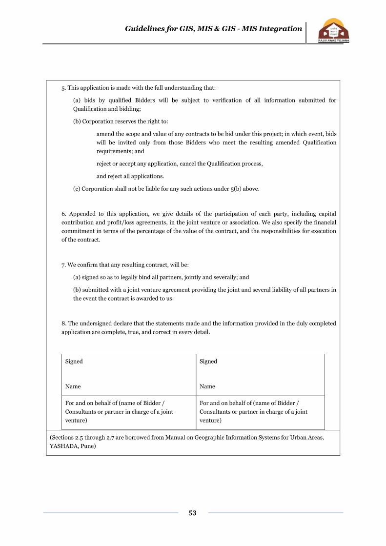
Guidelines for GIS, MIS & GIS - MIS Integration
53
5. This application is made with the full understanding that:
(a) bids by qualified Bidders will be subject to verification of all information submitted for
Qualification and bidding;
(b) Corporation reserves the right to:
amend the scope and value of any contracts to be bid under this project; in which event, bids
will be invited only from those Bidders who meet the resulting amended Qualification
requirements; and
reject or accept any application, cancel the Qualification process,
and reject all applications.
(c) Corporation shall not be liable for any such actions under 5(b) above.
6. Appended to this application, we give details of the participation of each party, including capital
contribution and profit/loss agreements, in the joint venture or association. We also specify the financial
commitment in terms of the percentage of the value of the contract, and the responsibilities for execution
of the contract.
7. We confirm that any resulting contract, will be:
(a) signed so as to legally bind all partners, jointly and severally; and
(b) submitted with a joint venture agreement providing the joint and several liability of all partners in
the event the contract is awarded to us.
8. The undersigned declare that the statements made and the information provided in the duly completed
application are complete, true, and correct in every detail.
Signed
Name
Signed
Name
For and on behalf of (name of Bidder /
Consultants or partner in charge of a joint
venture)
For and on behalf of (name of Bidder /
Consultants or partner in charge of a joint
venture)
(Sections 2.5 through 2.7 are borrowed from Manual on Geographic Information Systems for Urban Areas,
YASHADA, Pune)

Guidelines for GIS, MIS & GIS - MIS Integration
54
Expertise and Inputs
The staff proposed should have experience in the design of services; experience in
managing and developing client relationship; in product development, project
management; and also experience in technologies like Windows operating systems;
client/server hardware and software; input/output technology, digitizing equipment,
internet services and related technologies.