ramanian .jaurnal o/mineral deoasits 79 - igrrjes.igr.ro/wp-content/uploads/2012/08/2000... ·...
TRANSCRIPT
Ramanian .Jaurnal o/Mineral Deoasits 79 Suool. 1 2000
NEW GEOLOGICAL AND GEOPHYSICAL DATA REGARDING THE VOLCANIC EDIFICE FANCEL-LAPUSNA (EAST CARPATHIANS, ROMANIA)
T. POPA, 1. SEBA, S. POPA, M. NEDELCIU, V. SPRANCEANA, P. TAMBREA, D. MARINESCU S.C. PROSPECTIUNI S.A .• I Caransebes St.. Bucuresti-32. Romania; E-mail: prospec [email protected].
83
The geological and geophysical prospecting activities carried out in 1988 in the FancelLapusna area (Gurghiu Mountains, E Carpathians), aimed to identify the possible gold-silver minerali zation.
The volcanic edifice Fancel-Lapusna (FL) is included in the vo lcanic Neogene CalimaniGurghiu-Harghita (CGH) chain of the Romanian East Carpathians, a typical subduction product, composed mainly of cale-alealine rocks. The lack of acid rocks as compared to other vo lcanic areas in Romania is a typical feature of the CGH chain. The structure and morphology of the CGH chains is dominated by an axial row of closely spaced, adjoined or partially overlapping andesite composite edifices with large and merged peripheral vo lcanic aprons that form a continuous edge especially along the western side of the chain. The stratovolcanoes are mediumsized with 1000 to 1500 m relative e levations, and slightly or moderately eroded (Szakacs, Seghedi , 1996). They usually consist to thick piles of basalt-andesite lava flo ws, andesite and daci te lava domes or domes complexes with thin interbedded pyroclastics (Szakacs, Seghedi, 1996). In their central part uncovered shallow intrusions with their related hydrotermal alteration zones are frequentl y present in erosionally extended central depressions of craterial origin . The age ofthe northern part ofthe chain (Calimani Mountains) is Miocene-Pliocene and the GurghiuHarghita Mountains are considered to be moulded during the Pliocene (Szakacs, Seghedi , 1996).
FL is volcanic edifice which dominates the northern part of the Gurghiu Mountains, in the East Carpathians. The geological-structural setting is represented by the presence of two morpho-structural units: the lower unit (an volcanoclastic one) Lower Miocene in age, and the upper unit (a stratovolcanic one), Miocene-Pliocene in age, consisting of lava flows, domes and pyroclaslic products of prevailing pyroxene andesites and hornblende pyroxene andesites.
The acq uired data were displayed by class ical mapping (various maps) and by 3D modeling. In the 3D modeling, the geology and significant geophysical or geochemical anomalies were superposed on a Digital Elevation Model (DEM). This model was obtained by digiti zing 1: 10,000 scale maps.
The geophysical data have been integrated to the tectono-vo lcanic geo logical interpretation. A comparative analysis of the FL volcanic edifice was done, special attention being conferred to the hydrothermal a lterations. The hydrothermal alterations are propyliti c, potassic, intermediate argillic, advanced argilli c and silifications (Meyer, Hemley, 1967; Stanciu, 1973; Stanciu, 1996).
A detailed study regarding the petrophysical properties of the outcropping rocks was performed, using rock samples collected in 1998 and samples previously collected from boreholes.
Gravity and magnetic prospecting in FL area evidenced: Large maximum anomalies and various local gravity anomalies, by detailed gravity (165
stalion on sq. km) prospecting. The gravity anomaly is elliptical in shape, with its main axis trend ing WNW-ESE. It covers an area of 8 x l a sq. km and is surrounded by a belt of increased horizontal gradient. Inside it, two maximal intensity anomalies occur, which partly correspond to
84 Romanian Journal QfMinerql Devosits 79 Suvvl 1 2000
the structures Fancel Peak - Zambroi Peak and South Batrana Peak, both including small dioritic-andesitic intrusions.
According to the authors, the positive gravity anomaly is generated by the thickening of the compact lava flows in the central area of the volcanic structure, accompanied by andesitic subvolcanic bodies. Two bidimensional modeling (Botezatu, 1982; Suceava, Sava, 1974) of the anomalous sources approximate the measured effect .
Two minimum gravity anomalies within the central volcanic structure underline a supposed hydrothermal altered zone.
According to aeromagnetic data, two craterial volcanic structures, partly eroded, may be configured. They are reflected by groups of maximal anomalies with intensities ranging between 350 and 1,000 gamma, generated by andesite and diorite bodies, whose limits may be marked by a ser ies of main fracture systems, followed by secondary discontinuities of small amplitude. In the central section of the two cited craterial structures, anomalous zones are outlined slightly negative (-50 to -200 y), which probably reflect the existence of strongly hydrothermally altered rocks.
Various anomalies were identified by land magnetic survey (2500 station on sq. krn). Land magnetic data acquired on an area of aprox. 7 sq. krn south of Batrana Peak
reflected a separation between areas where fresh and propylitised andesites are spread and areas covered by hydrothermally altereted andesites.
A low and uniform magnetic field corresponds to the hydrothermally altered areas (argillic alteration). In an area bounded by Eseniu Creek and Crucii Creek the magnetic data identified on a negative background (with values between -200 and -500 y) low positive anomalies (+ I 00, +200 y) of small extent, corresponding to the argillic alteration. Another area, bounded by Gropsoara Creek and Fancelul Mic Creek, minimum magnetic domain reflects the effect of argillised andesites. Low radiometric and spectrometral anomalies (potassic component) mapped in this region but overlying the maximal magnetic anomalies, correlated with microscope studies explains the presence of potassic alteration in this area. The radiometric survey (5000 station on sq. krn) contoured low values I y anomalies varying between 5 and 9flRlh, the average values being 6.5 to 7 flRlh.
Horizontal anomalous magnetic gradient belts outlined the presence of some radial and quasi-circular fracture lines which could show sector collapse areas in the structure.
Maximum IP anomalies, generated by the presence of pyrite in andesites as dissemination, were identified in the Lapusna Creek area by electric al survey (AB= 1200m; MN=40; 20 m space). They are correlated with a minimum magnetic anomaly. Small areas with increased apparent resistivity that overlie the hydrothermal zones are related to silicified rocks.
The unaltered andesite rocks are marked out by the low IP values and resistivity fields. Afler the integrated interpretat ion of the geological, geochemical and geophysical data,
the connection between applied geophysics methods (Botezatu, 1982) and geological studies is established in order to obtain a comprehensive geo-structural and metallogenetical image.
References Botezatu, R. (1982) Modele geofizice ale alcatuirii geologice a Romaniei, Editura Academiei. Meyer, C., Hemley, J. L. (1967) Wall rock alteration. In Bames, H. L. ed., Geochemistry of hydrothennal ore
deposits: New York, Hoit, Rinehart and Winston, p. 166-235. Szakacs, A., Seghedi, I. (1996) Volcaniclastics sequences around andesitic stratovolcanoes (East Carpathians,
Romania, workshop guide). Rom. J. Petrology, 77, Suppl.l.
Romanian .Journal o{Mineral DeDosilS 79 SuVD!. 1 2000 85
Stanciu, C. (1973) Contributii la cunoasterea transformarilor hidrotermale ale vulcanitelor din muntii Gurghiu. An. Univ. Bucuresti, XX II, p. 31-37.
Stanci u, C. (1996) Zonele de alterare hidrotermala interceptate de foraje în vulcan itele neogene din Carpatii Orientali. An. InsI. Geo/. Rom. , 69, Part 1, p. 259-261.
Suceava, M., Sava, C. (1974) Modelage des sources des anomalies du champ de la gravitat ia" dans la zone de la calde ira Fincel-Lapusna. Rev. roum. geol .. geophys" geogr .. (Geophysique) , 18, p. 127- 139.
HEAVY METALS D1STRIBUTION IN DUST FROM THE CENTRAL PART OF BUCHAREST
Gh. C. POPESCU, L. DUMITRESCU University of Bucharesl, 70 I 11 Bucharest, Romania
Introduction. This paper, based on a case study in the central part of Bucharest city, focuses on the local pollution as a serious environrnental problem, generated by the anthropical activities due to the urbanization development, transportation and, secondary, industrial activity.
Bucharest is the most important city of Romania, located in the plain area. The atmosphere of central part of the town is loaded with particles of dust and noxio us gases erriitted, mainly, by urban transportation and other anthropical activities (constructions, energy plants, industrial activities etc.)
Among the multitude of pollution factors directly related with the human factors , the dust has been considerated and analyzed as a results of natural or anthropical processes . Based on a mineralogical and geochemical study, the human influence on the dust, and consequently on the environment, could be established and evaluated.
Finally, the paper describes the strongly negative ecological impact generated by the demographic increase (> 1 0,000 inhab./sq.km) and anthropical activities development direct ly affected and affecting the environment. Samples prelevation. Particles of dust were sampled from important crossroads from the central part of the town. Some samples were also taken from inside buildings (indoor samples) in' order to compare the dust particJes composition with the outdoor samples. Mineralogical data. Outdoor dust samples have been analyzed from the granulometric, morphomeric and mOrphoscopic point of v iew by means of optical microscope and SEM. For indoor dust morphoscopic and optic analyses (by oPlical microscope and SEM) were performed. • Granulometric analyses showed that the outdoor dust is simi lar to argillaceous silt (Shapard and Link diagrams). The distribution is unimodal and asymmetric. Generally, the unimodal di stribution shows that the samples derived from the same source. [n this case, there are several sources, but the secondary populations overlap and superimpose the main populations. The thickness of the cJastic material presents an asymmetric distribution. The cumulative curve indicates that the saltation was the main transport process and traction and suspension were the secondary ones. • The morphometric analyses revealed that the mineral grains are subrounded with roundness index Ro = 0.7 - 0.8. This fact suggests a long period oftransportation process . • The morphoscopic analyses indicate that the evo lution of mineral grains was made in several environments. Each of these environrnents imprinted specific characteristics to the grains: chemical, mechanical and biotic. In this case, the actions of the wind, the main transportat ion

86 Romanian Journal o{Mineral Devosits. 79 Suvvl 1 2000
factor, modified the mineral grains by impact structures, concoidal ruptures, and V- and Ushaped cavities. These final structures are specifical to low transportat ion energy. * The microscopic analyses showed that outdoor samples of dust contain, on an average: 55 % transparent minerals (quartz, calcite, feldspars, muscovite), 8 % opaque minerals (goethite, limonite), I % heavy minerals (chlorite, biotite, zoizite, garnets, hornblende), 20 % argillaceous mineral s, 10 % anthropical products (combustion products, glass fragments , textile fragments etc. ) and 6 % vegetal fragments (spores, fungies, cuticles and other parts of plants). The indoor dust samples contained more organic and anthropical products (textile fragments, soot, ashes and vegetal fragments) than outdoor dust. Quartz, clay minerals, calcite and muscovite are mineral s observed in indoor dust. Geochemical data. The bulk chemical analyses have been obtained by ICP-AES and XRF. Outdoor and indoor dust samples had a high heavy metals content. The variation of the heavy metals contents in outdoor dust was: 102 ppm - 1800 ppm Pb, 184 ppm - 7500 ppm Zn, 35 ppm - 800 ppm Cu, 31.6 ppm - 750 ppm Cr, 8.99 ppm - 58.7 ppm Ni. It was observed that in the indoor dust the composition was higher then in outdoor samples for: Pb (248 ppm - 2289 ppm), Cu (423 ppm - 4225 ppm) and Ni (23.8 ppm - 77,2 ppm). Conclusions • A good correlation between Pb-Zn (r= 0.677), Pb-Cr (r=0.8137) and Zn-Cr (r=0.587) was observed. This fact suggests the same sources for these elements. The difference up to the perfect correlation has been given by the other sources of heavy metals. * There is a low correlation between the heavy metals from outdoor dust samples, a.g. Cu-Zn (r=0.1215), Cu-Pb (r=0.2417) and Cu-Cr (r=0.199). This fact reflects the different sources of these elements. * In the central zone of the studied area, a good correlation has been observed between outdoor and indoor contents of the same elements (rPb=0.823, rZn=O. 97 6, rCu=0.998, rCr=0 .903, rNi=0.294). This fact reflects the same sources ofthese e1ements. The difference up to the perfect correlation results from specific indoor activities. • The maximal distribution of heavy metals was observed in the central part of the studied area. Pb has the maximum concentration (> 1500 ppm) in two zones: Independentei - Libertatii Blvd . and Unirii - Goga Blvd. In these areas the concentrations were more than the maximum admited concentration (MAC). Zn presents the maximum concentration values (>7000 ppm) on the Calea Victoriei alignment. In this area the maximum concentrations were in two crossroads Kogalniceanu Blvd.- Calea Victoriei and Independentei - Victoriei Blvd. The maximal value of Cu concentration (>3500 ppm) was registred in Dacia Blvd. - Calea Mosilor crossroad. Cr concentration value exceeded the MAC in two points on the Calea Victoriei alignment: Dacia Blvd. - Victoriei (> 500ppm) and Independentei Blvd. - Libertatii Blvd. crossroads. The different locations of these maximal di stributions have been given by the anthropical activities specific to these areas superimposed on the industrial pollution of the zone. For the central part of Bucharest the characteri., tic phenomena is a baric microdepression given by the difference of temperature between the central part of the town and the surrounding districts. This fact facilitates the appearance of a convection circuit in the atmospheric flow, which transports the industrial pollutants from surrounding industrial areas to the central part of the town. Besides, in the central area of Bucharest most streets are "canyon type" (the roads width is lower than the height ofthe buildings). This fact modifies the meteorological parameters (wind velocity and direction) thus the dispersion degree of pollution is disturbed. In the central part of Bucharest
Romanian .Joumal o(Minera/ DeQosits 79 SuDDI 1 2000 87
the traffic has the highest density thus the people who live and work here are permanently exposed to pollution. The environmental POllution effects. The pollution inj1uence on tlIe climate change. The pollution in Bucharest with suspension powders favorises the following phenomena in the atmosphere: air opacity, nebu/ous manifestation, lemperalure increase and occurrence of "glasshouse" ~fJect. In the region the important quantities of powders and pollutants determine the pholochemical jog. The wind in the area is relatively slow, the average wind velocity varying between l.4rn1s and 2.5rn1s. These small values show low ventilation, the dilution capacity on the a ir being reduced. As regards the thermal stratification, this is stable, determining a waveshaped zone of pOllutants, the noxious substances being stagnated above the city. Tlle pollution inj1uence on human IIealtll. The pollution combined with local and specific climatic factors produces higher concentration of certain elements, thus generating functional disorders of the organisms and negative influences on the human factor in the area. By the direct act ion of the dust on the human health, the following effects can happen: headaches, sneezing, coughing, nausea, fatigue, skin rashes, nose, throat and eyes irritations. The danger is greater, if the dust has the heavy metals concentration and other harmful elements for human health above MAC. • A future trend of the local policy is the environmental rehabilitation. The first stage of thi s process is based on healthier relations between humans and environment, according to the legislation.
Acknowledgements. The analyses were performed at the Dep!. of Geochemistry, Eco le des Mines, St. Etienne, France, and the authors wish to express their gratitude to Prof. Essaid Bila!, Head of Dept. , who facilitated the access to the high performance analytical devices (SEM, ICPAES and XRF).
HYOROGEOCHEMICAL EVALUATION OF HYOROCARBONS ANO IODINE FROM THE MEOTIAN ANO SARMA TIAN SEDIMENTS A T THE CONTACT
OF THE MOESIAN PLATFORM ANO THE GETIC OEPRESSION, MATASARI - BAL TENI - TlCLENI - SLATINA ARE A
R. POPESCU, Gh. PALADE, V. AXENTE, L. PETRESCU Un iversity of Bucharest. RO-70 139 Bucharest, Romania
Hydrogeochemical and seismological research suggested a facies variation from north to south , from the depression to the platform zone. The Getic Depression area seems to be characterized mostly by pelitic sed iments with some psammitic rock intercalations.
The platform zone is characterized by almost continuous alternations of pelitic and psammitic layers.The intermediate zone seems to consist prevalently ofneritic-littoral sediments .
The north plunging of the pre-Tertiary and subsequent sediments from the platform zone take place s lowly up to a certain latitude. Farther to the north the plunging is more rapid and the influences are strongly expressed both in the behavior of the aquifers under depositary conditions and on the chemistry of the oiI field waters from the Meotian - Sarmatian sediments.The aquifers are under reduction conditions and in a close system from the hydrogeological point of view containing waters with a high mineralization degree and chemicallY metamorphosed.

88 Romanian Journal Q/Mineral DepQsits 79 Supol I 2000
The oii deposit fluids accumulated in Sarmatian and Meotian sediments of the region represent a typical example of the role of depositary environment of organic matters, the nature and origins of sedimentation basin waters, where the bitumenization processes took place. The waters of these Sarmatian and Meotian sedimentation basins are isolated, without any circulation, during the filling ofthe basins and are kept as connate waters in genesis aquiviclude deposits and in primary - secondary accumulation aquifers inside an aquifer complex.
Related to the hydrogeological and espec ially hydrogeochemical characteristics the aquifers are hydrogeologically closed, under reduction conditions, without hydrogeo logical accessibility, in most propitious conditions of genesis, accumulation and conservation of fluid oi i deposits with different types of oii field waters.
One type of oii field waters is the organic type resulting from the decay of proper organic matter that generated the hydrocarbons . In this type of oii field waters the iodine concentration is above 100mg!1 and the concentration of ammonium, resulting from the reduction of the nitrate oxidants organic compounds and of the soil organic matter is above 150 m gl!.
Another type of oii field waters is mainly marine and subsidiary old continentally infiltTation waters. This is composed, besides organic micro-compounds, of iodine with a concentration below 100 mgll , and ammonium with 50 - 100 mg/ l concentrations, of direct micro-compounds associated with hydrocarbons, naftenic acids, fenols , benzene, hydrogen sulphide and light and heavy gaseous hydrocarbons - methane, ethane, propane, iso-butane. butane, pentane.
WithoUI a significant importance there are mixed waters in chemical metamorphosed processes, with aggressive C02, minor quantities of sulphates, atmospheric and biogenic nitrate. bromine, iodine and ammonium with minor concentrations, mainly under 10 and even 2 m gl!.
From the hydrogeochemical point of view the oii field fluids are located in two main types of aquifers:
- aquifers hydrogeologically closed from reduction environments, eutrophics, withoUl hydrogeological accessibility, in the most favorable conditions of genesis, accumulation and conservation of fluids; - aqui fers without a stable hydrodynamics, where there are water exchanges inside" the sedimentation basins and between the aquifers without hydrogeological accessibility, in favourable conditions ofmigration, accumulation and conservation offluids.
Inside the area under study, Meotian and Sarmatian sediments, oil -generating rocks are considered the aquiviclude pelitic rocks, marlstones being the most representative.
They were considered as oil-generating rocks on mineralogical and petrographical criteria, black colour and bitumen content. These physical characteristics are suited mostly to the platform sediments, beneath the depression, considered with an oil-generating role .
Mainly burial depth and temperature of the sediments determine the transformation of organic matter in hydrocarbons and organic waters . Therefore the oii and gas from Sarmatian and Pleistocene sediments of the Moesian Platform beneath the depression can be considered as autochthonous.
Most of the hydrocarbon accumulations are located in granular collector-type rocks, primary gas cap zones less. The oii and gas deposits are stratiform, arched and cut by faults, both in platform and depression, with aII types of closures - tectonical, stratigraphical or lithologica!. The tectonical closure is the main type.
Roman;an .Journal QfMineral Deoosils. 79 SuRol I 2aaa 89
The hydrocarbons are usually located in aquifers of the same layer or natural reservoir or in different layers of the same complex: continuous stratigraphic formations with local discordances.
From the hydrogeochemical point of view, good hydrogeological conditions and presence of a li direct and specific micro-compounds, five zones are interesting for hydrocarbons, bromine and especially iodine in the Sarmatian sediments: Balteni - Barbatesti - Carbunesti, Gradistea -Zatreni - Romanesti , Bibesti - Bulbuceni , Mitrofani - Campu Mare and Varteju - Bradesti -Racari .
In the Meotian sediments the interesting zones for gas and oii accumulations are: Varteju - Lacusteni - Iancu Jianu, Varteju - Lacusteni - Campu Mare - Dragasani , but also Balteni and Socu zones that have very good conditions from the hydrogeological point o f view.
It is to note that in both Sarmatian and Meotian, environments of accumulation and conservation, an active anaerobic bacterial decay of the organic matter mixed w ith fine sediments took place.
The accumulation and diagenesis of organic sediments took place slowly because sedimentary formations were mostl y continuous, in a cJosed hydrogeo logica l regime. thi s statement being supponed by the values of the genesis hydrogeochemical coefficient, Na/CI (0,8-1) . A s light fl uid dispersion was possible in the absence of a thick impermeable layer able to retain the fluids in reduction conditions.
The high values of hydrodynamics coefficients of metamorphic processes, such as Ca/Mg, (Cl-Na) /Mg (2-6), in the zone bordering to the nonh and the south the intermediary zone between the Getic Depression and the Moesian Platfonn support these findings.
CHEMI CAL ANAL YSES OF FLUID INCLUSIONS BY SEM/EDA, IN THE GOLD-QUARTZ VEINS, LEAOTA MOUNT AINS
D. PREDETEANU, Gh. POPESCU University of Bucharest, 70 111 Bucharest. Romania
Eadington (1974, in Haynes, 1988) proposed that qualitative, and in some cases semiquantitative, compositional data could be obtained by Energy Dispersive Analysis (EDA) of salt residues, ca lled decrepitates.
The results of analyses performed by Haynes et al. (1988) of natura l quartz containing synthetic incJusions of known compositions in the systems NaCl-KCl, NaCl-CaCh and NaClKCl-CaCI2 show that the compositions of moderately to highly saline fluid inclusions can be determined semi-quantitative ly by SEM/EDA of the solid residue produced during thermal decrepi tation .
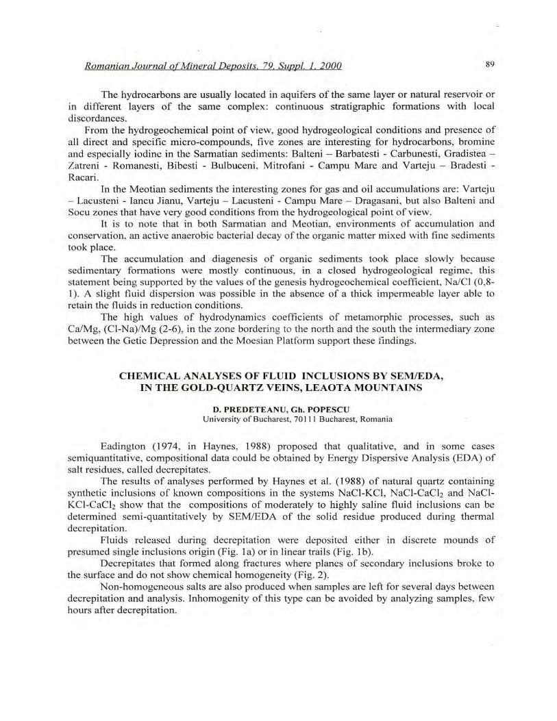
Fluids released during decrepitation were deposited either in discrete mounds of presumed single incJusions origin (Fig. l a) or in linear trails (Fig. I b) .
Decrepitates that formed along fractures where planes o f secondary incJusions broke to the surface and do not show chemical homogeneity (Fig. 2).
Non-homogeneous salts are also produced when samples are left for several days between decrepitation and analysis. Inhomogenity of this type can be avoided by analyzing samples, few hours afler decrepitation.

90 Romanian Journal QfMineral DeDQsjts 79. SuDDI 1. 2000
a Fi.!;. 1. SC<1 ll ll ill g c leclroll pholOl1licrograph::. of tluiel incl usiun - dcrivcd ekcrep itatc sa lts. <1. Dl.:.' crcpit ntc ofprcsullled si nglc incl us ion origill (s<l mpk no. c5165 , Ghi lllbav Valle)'). b . FrilClurc-rlligncd lincar dccrcp itatc (samplc ilO . 21,;), Caselor Va llcy)
b
Rapid evaporations and precipitation, which characterized decrepitation of individual inclusions, may be essential in preventing differentiation and redistribution of elements within the solid residue and thus, preserving chemical homogeneity in the decrepitate.
.. .. " .
'0 ~ •• ::.
..
"
N.
o
. '>' o ' •• " .
""o " •• ~, o
• o . • -. - o ~ ." 't> 8 •• .,; ~ Joo. • •
• • • °0
• • 10
• 0 ••• o .o~. . "
""''" _______ ______ --' '0'
o l" ;j~~lor Vall e)' • lihlmh (l \- V. \ley • 111ull V~l1cy
Fi:?,. ]:. Th~ l'el ;' !lve r:.lH.> of!h~ maJ\H CiltÎ'1I1S N 3, K <I nd Ca in 1hret 5:)I'T\p les of th. Le il o r" Mountains . ]
After decrepitation, inclus ion contents are separated into volatile and non-volatile fractions .Estimating inclusion chemistry by SEM/EDA of the solid non-volatile fraction involves that none of the salt component is lost during decrepitation through vaporization. Differences in the volatility of the various solutes in the inclusion fluids may be a problem when decrepitation temperatures over 4500C are employed. For this reason, decrepitation was performed at temperatures ranging between 350 and 450. Decrepitate size is a function of inclusion size and salinity:
0,0145sr;3 ~ rl Where: 5 ~ salinity, r; ~ inclusion radius, rd ~ decrepitate radius.
The study of Haynes et al. (1988) indicates an optimum decrepitate diameter in the range of 10-30 im.
Prior to thermal decrepitation and SEMIEDA, the inclusions were subjected to traditional heatinglfreezing TUns.
Fluid inclus ion petrography and microthermometry show that the main stage vein minerals precipitated from a homogeneous fluid composed of H20 , CO2 and salts.
Romanian Journal o{Mineral Dgposils 79 Suaal 1 2000 91
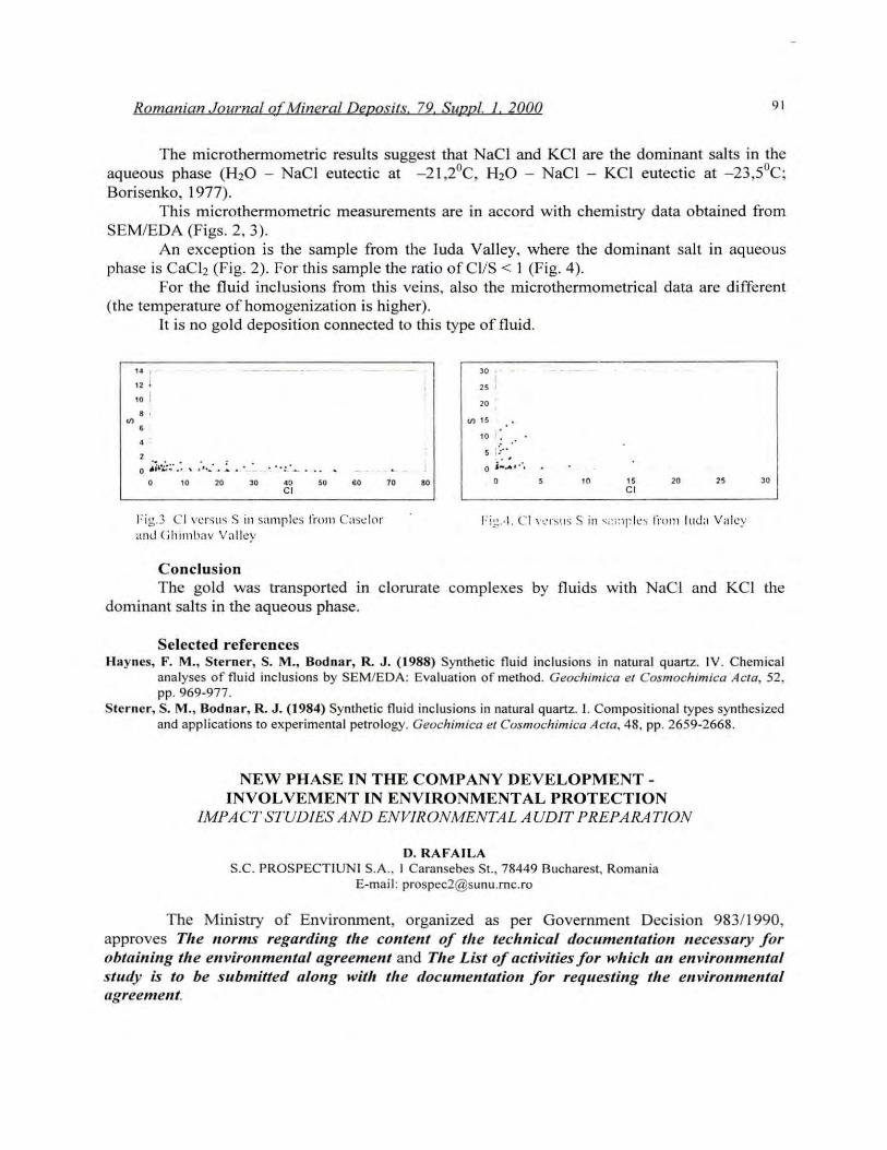
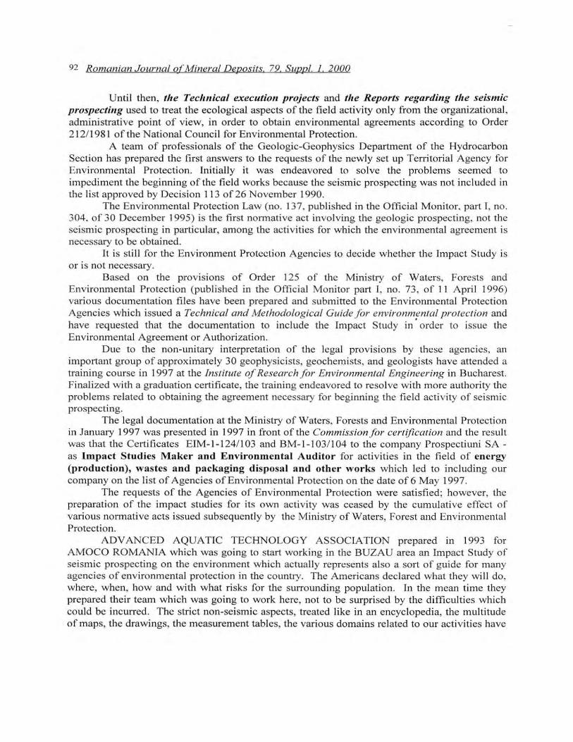
The microthermometric results suggest that NaCI and KCI are the dominant salts in the aqueous phase (H20 - NaCI eutectic at -2 1,20C, H 20 - NaCI - KCI eutectic at - 23,50C; Borisenko, 1977).
This microthermometric measurements are in accord with chemistry data obtained from SEMIEDA (Figs. 2, 3).
An exception is the sample from the Iuda Valley, where the dominant salt in aqueous phase is CaC12 (Fig. 2). For this sample the ratio ofCl!S < 1 (Fig. 4).
For the fluid inc1usions from thi s veins, also the microthermometrical data are different (the temperature of homogenization is higher).
'"
It is no gold deposition connected to this type of fluid.
U ,
12 i 10 i .. , o Âi~i-~·: . .. ; ..•. .. .:. . .. _ '. :_. _ ...
o " " " C I 60
Fig.3 C I \,cfSlI S S in snmrles li'om Cast:lo r unt! (jlli m bav Va lley
Conclusion
" 20
,,'" 10 : :
s ::: ..... o i ....... . ',
70 80 10 " C I 20 " JO
The go ld was transported in c10rurate complexes by fluids with Naei and KCI the dominant salts in the aqueous phase.
Se1ected references Haynes, F. M., Sterner, S. M ., Bodnar, R. J. (1988) Synthetic fluid incJusions in natural quartz. IV. Chem ica l
analyses of fluid inclusions by SEM/EDA: Evaluat ion of method. GeochimÎCa e l Cosmochimico "Acta. 52 , pp. 969-977.
Sterner, S. M., Bodnar, R. J. (1984) Synthet ic flu id inclusions in natural quartz. 1. Compositional types synthesized and appl ications to experimenta l petrology. Geochimica el Cosmochimica Acta. 48. pp. 2659-2668.
NEW PHASE IN THE COMPANY DEVELOPMENTINVOLVEMENT IN ENVIRONMENTAL PROTECTION
IMPA CT STUD1ES AND ENV1RONMENTA L AUDIT PREPARA T10N
D. RAFAILA S.C. PROSPECTIUNI S.A., 1 Caransebes SI., 78449 Bucharest, Romania
E-mai l: prospec2@sunu .rnc.ro
The Ministry of Environment, organized as per Government Decision 98311990, approves T!te lIorms regardillg t!te contellt of t!te teelmical documelltatioll lIecessary for obtaillillg t!te environmental agreement and T!te List of activities for ",!tiell an envirolIInental study is to be submitted along wit!t t!te documentation for requestillg tlle environmental llgreenlent.
92 Romanian .Journal of Mineral Deposits, 79, Suapl 1 2aaa
Until then, tire Tecllnical execution projects and tlle Reports regarding tlle seismic prospecting used to treat the ecological aspects of the field activity on ly from the organizational , administrative point of view, in order to obtain environmental agreements according to Order 212/198 1 of the National Counci l for Environmental Protection,
A team of professionals of the Geologic-Geophysics Department of the Hydrocarbon Section has prepared the first answers to the requests of the newly set up Territorial Agency for Environmental Protection, Initially it was endeavored to solve the problems seemed to impediment the beginning ofthe field works because the seismic prospect ing was not included in the list approved by Decision 11 3 of26 November 1990,
The Environmental Protection Law (no , 137, published in the Official Monitor. part 1, no, 304, of 30 December 1995) is the first normative act involving the geologic prospecting, not the seismic prospecting in particular, among the activities for which the environmental agreement is necessary to be obtained,
It is still for the Environment Protection Agencies to decide whether the Impact Study is 01' is not necessary,
Based on the provisions of Order 125 of the Ministry of Waters, Forests and Environmental Protection (published in the Officia l Monitor part 1, no, 73 , of 11 Apri l 1996) various documentat ion files have been prepared and submitted to the Environmental Protection Agencies wh ich issued a Technical and Methodolog ical Guide f or environmental protection and have requested that the documentation to include the Impact Study in' order to issue the Environmental Agreement or Authorization,
D ue to the non-unitary interpretation of the legal provisions by these agencies, an important group of approximately 30 geophysicists, geochemists, and geo logists ha ve attended a training course in 1997 at the InstitUie of Research f or Environmental Engineering in Bucharest. Finalized with a graduation certificate, the training endeavored to reso lve with more authority the problems related to obtaining the agreement necessary for beginning lhe field activity of sei smic prospecting,
The legal documentation at the Ministry of Waters, Forests and Environmental Protection in January 1997 was presented in 1997 in front of the Commissionfor certificat ion and the resul! was that the Certificates EIM-I-124/103 and BM-I-I03/ 104 to the company Prospectiuni SAas Impact Studies Maker aod Eoviroomcotal Auditor for activities in the field of eoergy (productioo), wastes aod packagiog disposal aod other works which led to including our company on the li st of Agencies of Environmental Protection on the date of6 May 1997,
The requests of the Agencies of Environmental Protection were satisfied; however, the preparation of the impact studies for its own activity was ceased by the cumulative effecl of various normative acts issued subsequently by the Ministry of Waters, Forest and Environmental Protection,
ADV ANCED AQUA TIC TECHNOLOG Y ASSOCIATION prepared in 1993 for AMOCO ROMANIA which was going to start working in the BUZAU area an Impact Study of seismic prospecting on the environment which actually represents also a sort of guide for many agencies of environmental protection in the countlY, The Americans declared what they will do, where, when, how and with what ri sks for the surrounding population, [n the mean time they prepared their team which was going to work here, not to be surprised by the difficulties which could be incurred, The strict non-seismic aspects, treated like in an encyclopedia, the multitude of maps, the drawings, the measurement tables, the various domains re lated to our activities have

Romanian Journql of Mineral Devosits 79 SURRI. 1. 2000 93
created an overview of the area. Taking this study as a model , we have accomplished the first frames for the impact
studies in the prospecting areas in that year. First, we thought it would be better to prepare studies for each area in particular and only
if this was requested from the territory. Four such impact studies have been realized and from these studies, 16 excerpts have been drawn for personalized areas which have been presented to the Environmental Protection Agency.
We have assessed that much information was redundant, irrespective of the working area and we have agreed that these studies have been performed according to large geological units: Getic, Moldavian, Pannonian, Transylvanian Depression, Moesian Platform and North Dobrogean Cape.
Twelve such impact studies have been effectuated between 1994 and 1995 for many working areas and they have submitted to 25 Agencies of Environmental Protection.
Necessities regarding follow up and control have led to the conc1usion that these impact studies should be achieved according to beneficiaries, which have also been presented to the Agencies of Environmental Protection and we have obtained the first environmental agreements.
Many trips were necessary as weB as a significant w~rk of presentation and promotion of the activity of seismic prospecting in order to obtain a more correct interpretation of the environmental legislation in order to choose a better way to assess the qualities of seismic prospecting and environmental protection. Personalized impact studies have been effectuated for the territorial agencies of environmental protection.
Recent1y we intend to research the legal possibilities for the Agencies for Environmental Protection to accept the Impact Studies for the activity of seismic prospecting, wherever it is developed in the country, and to obtain a general environmental agreement for the whole year.
Only 28 such impact studies have been carried out between 1997 and 1999 for the working area and they have submitted to 45 Agencies of Environmental Protection.
On 7 April 1999, according to the provisions of Order 125/1996 the documentat ion necessary for renewal of the certification as Impact Studies Maker and Environmental Auditor is submitted and presented to the Commission for certification of MWFEP (MAPPM) and we have obtained it.
Today, we are in the position of environmental auditors with experience, participating even in the interpretation of the Environmental Law in relation with the seismic prospecting for the territorial agencies.
\Ve have also participated in the Environmental Audit - level zero, prepared by the company NHN Ecoinvest srl and we have obtained the environmental agreement for privatization purposes.