ramended xx xx - city of san diego official website current vernal pool mapping and reference to the...
TRANSCRIPT

OTAY MESA COMMUNITY PLAN
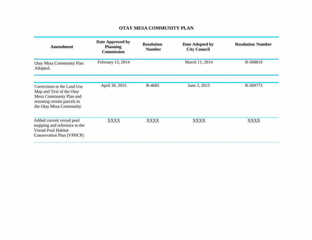
Amendment
Date Approved by
Planning
Commission
Resolution
Number
Date Adopted by
City Council
Resolution Number
Otay Mesa Community Plan
Adopted.
February 13, 2014 March 11, 2014 R-308810
Corrections to the Land Use
Map and Text of the Otay
Mesa Community Plan and
rezoning certain parcels in
the Otay Mesa Community
April 30, 2015 R-4685 June 2, 2015 R-309773
Added current vernal pool
mapping and reference to the
Vernal Pool Habitat
Conservation Plan (VPHCP)
XXXX XXXX XXXX XXXX

Land Use Element
Otay Mesa Community Plan LU-14
1 to provide further guidance to determine consistency
with City policies.
POLICIES AND RECOMMENDATIONS
2.1-1 Require Specific Plans and any required rezoning
for the Southwest and Central Village Areas to be
consistent with the policies of this plan.
2.1-2 Achieve sustainable and efficient land use patterns
with comprehensive neighborhood and
community village development through Specific
Plans that:
a. Respect the natural topography and sensitive
habitat areas with growth patterns that
balance development with preservation of
natural resources.
b. Provide a land use map that illustrates the
detailed land use designations, including any
lands set aside for resource conservation,
consistent with the MSCP Subarea Plan and any
future Vernal Pool Habitat Conservation Plan
(VPHCP). The specific plan land use map will
refine the Otay Mesa Community Plan Land Use
Map (Figure 2-1) as part of the specific plan
approval process.
c. Illustrate the complete circulation system that,
where possible, follows a grid pattern, and
indicate how the system will relate to the
overall Otay Mesa circulation system.
d. Strive for block sizes along local and collector
streets to have a maximum perimeter of 1,800
feet.
e. Illustrate a separate system of pedestrian and
bicycle facilities and pathways linking the
activity centers with the residential areas,
public facilities, and open space systems.
f. Distribute parks comprehensively throughout
the village area. Refer to Policy 7.1-7 of the
Recreation Element for further
recommendations.
1. Link parks to one another with pathways to
increase connectivity and enhance sense of
community.
Separate Pedestrian System
2. Locate neighborhood parks at the end of
streets and adjacent to canyons, when

Conservation Element
Otay Mesa Community Plan CE-6
Multiple Species Conservation Program
The Multiple Species Conservation Program (MSCP) is a
long-term habitat conservation planning program for
southwestern San Diego County. The Multi-Habitat
Planning Area (MHPA) is the planned habitat preserve.
The MHPA was incorporated into the Otay Mesa
Community Plan through a 1997 plan amendment
which identified approximately 2,500 acres in the
community as MHPA open space (see Figure 8-3). The
Otay Mesa areas of the MHPA consists primarily of slopes,
mesas with vernal pool resources and/or restorable
habitat, and wide, deep canyons draining the vast
mesas into the Otay River Valley or towards Mexico,
with one linkage connecting south to north across Otay
Mesa Road.
Within Otay Mesa, the MSCP envisions “a network of
open and relatively undisturbed canyons containing a
full ensemble of native species which provide functional
wildlife habitat and movement capability.” The MSCP
includes Specific Management Directives for the Otay
Mesa Area. These directives, along with the General
and Community Plan policies and recommendations, are
aimed at carrying out this vision and include measures
to protect sensitive species, limit access into the
canyons, and to provide restoration. Species protected
in the Otay Mesa MSCP area are identified in Table 8-1.
Vernal Pools Habitat Conservation Plan (VPHCP)
Vernal pools are highly specialized habitats that support
biologically sensitive species (Figure 8-4). They are
important environmental resources that occur on mesas
located in Otay Mesa. Management of these resources
is governed by City, State and Federal policies and
regulations. The Otay Mesa Community Plan is
consistent with these policies, guidelines and regulations.
Table 8-1
Otay Mesa Protected Species
Plants Animals
California orcutt grass Burrowing owl
Coast barrel cactus California gnatcatcher
Otay Mesa mint Cactus wren
Otay tarplant Cooper’s hawk
Orcutt’s bird’s beak Golden eagle
Orcutt’s brodiaea Northern harrier
Spreading navarretia Orange-throated whiptail
San Diego goldenstar Peregrine falcon
San Diego thorn-mint Riverside fairy shrimp
Small-leaved rose San Diego fairy shrimp
Snake cholla San Diego horned lizard
Variegated dudleya
San Diego button-
celery

Conservation Element
Otay Mesa Community Plan CE-7
As of 2011, the City of San Diego is engaged in the
process of preparing a Vernal Pool Habitat Conservation
Plan (HCP). The HCP is a comprehensive planning
approach to preserve vernal pool species and their
habitat within Otay Mesa and the City as a whole. The
HCP will create a new vernal pool boundary and
updated conditions of coverage for several protected
species. The OMCP may require an amendment
following adoption of the vernal pool HCP in order to
provide consistency between the land use plan and
habitat conservation plan.
The City of San Diego has prepared a Vernal Pool Habitat
Conservation Plan (VPHCP). The purpose of the VPHCP is
to provide an effective framework to protect, enhance,
and restore vernal pool resources within the City’s
jurisdiction, while improving and streamlining the
environmental and permitting process for impacts to
threatened and endangered species associated with
vernal pools. The VPHCP is a comprehensive planning
approach to preserve vernal pool species and their
habitat within Otay Mesa and the City as a whole and
covers the following species which occur in Otay Mesa:
Otay mesa mint (Pogagyne nudisculai), Spreading
navarretia (Navarretia fossalis), San Diego button celery
(Eryngium aristulatum var. parishii), California Orcutt grass
(Orcuttia californiaca). Riverside fairy shrimp
(Branchinectra sandiegonensis). The VPHCP expanded
the MHPA to include mesa top areas with vernal pool
resources and/or restorable vernal pool lands (see Figure
8-3).
Burrowing Owl
Burrowing Owls (Athene cuniculari) are long-legged, ground-
dwelling birds that inhabit Otay Mesa. Otay Mesa is one of the
few areas in San Diego County where a population of breeding
burrowing owl remain. Anecdotal information and limited surveys
suggest that burrowing owls are declining in San Diego County,
with the highest remaining density of birds in Otay Mesa. This
population may include at most 20 to 30 pairs of owls.
Typical burrowing owl habitat is flat, open terrain with soft soil,
short grass, sparsely distributed vegetation, or exposed ground.
The owls will occupy burrows created by other rodents, but can
also inhabit artificial burrows, such as cement culverts, cement,
asphalt, or wood debris piles; or openings beneath cement or
asphalt pavement.

Conservation Element
Otay Mesa Community Plan CE-9
Education
While the community plan, implementing zoning, MSCP,
and other regulations provide the legal framework for
open space protections, the residents of Otay Mesa will
also play an important role in determining the ultimate
success of preservation and restoration programs. Many
of the protected canyon areas form the boundaries of
residential neighborhoods.
POLICIES AND RECOMMENDATIONS
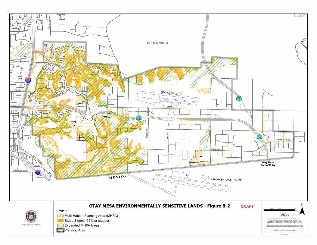
Environmentally Sensitive Lands
8.1-1 Implement the Environmentally Sensitive Lands
Regulations related to biological resources and
steep hillsides for all new development.
8.1-2 Preserve a network of open and relatively
undisturbed canyons and adjacent mesa tops
containing a full ensemble of native species and
providing functional wildlife habitat and
movement capability.
8.1-3 Plan development to minimize grading and relate
to the topography and natural features of Otay
Mesa.
MSCP Implementation
8.1-4 Implement the V P H C P a n d MSCP Management
Policies and Directives for Otay Mesa through the
project review process.
8.1-5 Implement City regulations and Biology Guidelines
for preservation, acquisition, restoration,
management and monitoring of biological
resources.
8.1-6 Implement the VPHCP and Area Specific
Management Directives and Conditions of
Coverage as stated in Appendix A Table 3-
5 of the MSCP Subarea Plan for Species
protected in Otay Mesa and identified in Table 8-
1.

Conservation Element
Otay Mesa Community Plan CE-11
Vernal Pools
8.1-7 Require preservation, restoration, management,
and monitoring within identified vernal pool
preservation areas in accordance with the VPHCP
and City, state, and federal policies and
regulations. The VPCHP identifies mesa top areas
within the MHPA for vernal pool conservation (see
Figure 8-3). If conservation and/or vernal pool
mitigation occurs outside the MHPA, t he
boundaries of vernal pool preserve areas should
be of sufficient size and shape to protect the
vernal pool basins, watersheds, functional buffers,
and areas necessary to maintain vernal pool
ecosystem function and species viability.
a. Design, as feasible, the preserve areas to
provide connectivity between vernal pools,
surrounding open space, and nearby vernal
pool complexes.
b. Conduct management and monitoring of
preserved and restored vernal pool sites in
accordance with the VPHCP and citywide
regulations and Biology Guidelines.
8.1-8 Amend the Otay Mesa Community Plan as needed
for consistency with an adopted Vernal Pool
Habitat Conservation Plan (HCP).
Education
8.1-9 Foster local stewardship and develop positive
neighborhood awareness of the open space preserve
areas with environmental education programs through
local schools, Homeowner’s Associations (HOAs),
community groups, and
%&s(
AòH
AäH
!"̂$
BROWN FIELD
M E X I COAEROPUERTO DE TIJUANA
CHULA VISTA
Otay MesaPort of Entry
AòH
LA M
EDIA
RD
SIEMPRE VIVA RDBRITA
NNIA
BL
CACT
US R
D
CAM DE LA PLAZA
ALTA RD
DEL SOL BL
OTAY MES
A RD
MELROSE A
V
OLEANDER AV
OCEAN VIEW HILLS PY
BRAN
DYWI
NE AV
ALTA RD
CACT
US R
D
DEL SOL BL
MAIN ST
EAST BEYER BL
PALM (SB) AV
OCEAN VIEW HILLS PY
BEYER BL
SIEMPRE VIVA RD
OTAY VALLEY RD
0 2,000 4,0001,000Feet
THIS MAP IS PROVIDED WITHOUT WARRANTY OF ANY KIND,EITHER EXPRESS OR IMPLIED, INCLUDING BUT NOT LIMITED TO,THE IMPLIED WARRANTIES OF MERCHANTABILITY AND FITNESS,
FOR A PARTICULAR PURPOSE. Copyright SanGIS. All Rights Reserved.
This product may contain information from the SANDAG Regional Information System which cannot be reproduced without written permission of SANDAG.
This product may contain information which has been reproduced with permission granted by Thomas Bros. Maps.
OTAY MESA ENVIRONMENTALLY SENSITIVE LANDS - Figure 8-2
Path: L:\GIS\PGIS\Community Planning\Otay Mesa\ADOPTED PLAN 2014\AMENDMENTS\VPHCP Apr2016\Fig_8_2_OtayMesa_EnvironmentallySensitiveLands.mxdDate: 5/13/2016
¯LegendMulti-Habitat Planning Area (MHPA)Steep Slopes (25% or steeper)Expanded MHPA AreasPlanning Area
DRAFT

%&s(
AòH
AäH
!"̂$
BROWN FIELD
M E X I COAEROPUERTO DE TIJUANA
CHULA VISTA
Otay MesaPort of Entry
AòH
LA M
EDIA
RD
SIEMPRE VIVA RDBRITA
NNIA
BL
CACT
US R
D
CAM DE LA PLAZA
ALTA RD
DEL SOL BL
OTAY MES
A RD
MELR
OSE A
V
OCEAN VIEW HILLS PY
OLEA
NDER
AV
BRAN
DYWI
NE AV
CACT
US R
D
DEL SOL BL
MAIN ST
PALM (SB) AV
EAST BEYER BL
OCEAN VIEW HILLS PY
BEYER BL
SIEMPRE VIVA RD
OTAY VALLEY RD
0 2,000 4,0001,000Feet
THIS MAP IS PROVIDED WITHOUT WARRANTY OF ANY KIND,EITHER EXPRESS OR IMPLIED, INCLUDING BUT NOT LIMITED TO,THE IMPLIED WARRANTIES OF MERCHANTABILITY AND FITNESS,
FOR A PARTICULAR PURPOSE. Copyright SanGIS. All Rights Reserved.
This product may contain information from the SANDAG Regional Information System which cannot be reproduced without written permission of SANDAG.
This product may contain information which has been reproduced with permission granted by Thomas Bros. Maps.
OTAY MESA MHPA/Open Space - Figure 8-3
Path: L:\GIS\PGIS\Community Planning\Otay Mesa\ADOPTED PLAN 2014\AMENDMENTS\VPHCP Apr2016\Fig_8_3_OtayMesa_MHPA_OpenSpace.mxdDate: 5/13/2016
¯LegendMulti-Habitat Planning Area (MHPA)Expanded MHPA AreasPlanning AreaPlanned Open Space
DRAFT

AòH
AòH
%&s(
M E X I C O
Otay MesaPort of Entry
!"̂$
AäH
Aeropuertode Tijuana
Brown FieldAirport
LA M
EDIA
RD
CAM DE LA PLAZA
CACT
US R
D
BRITA
NNIA
BL
OTAY
MESA RD
DEL SOL BLDEL SOL BL
SIEMPRE
VIVA RD
OCEAN VIEWHILLS PY
BRAN
DYW
INE
AV
CACT
US R
D
ALTA
RD
ALTA RD
OTAY MESA RD
HARV
EST
SIEMPRE VIVA
ENRI
CO FE
RMI
LA M
EDIA
AIRWAY
Otay Mesa Community Plan Vernal Pool Resources - Figure 8-4
THIS MAP IS PROVIDED WITHOUT WARRANTY OF ANY KIND,EITHER EXPRESS OR IMPLIED, INCLUDING BUT NOT LIMITED TO,THE IMPLIED WARRANTIES OF MERCHANTABILITY AND FITNESS,
FOR A PARTICULAR PURPOSE. Copyright SanGIS. All Rights Reserved.
This product may contain information from the SANDAG Regional Information System which cannot be reproduced without written permission of SANDAG.
This product may contain information which has been reproduced with permission granted by Thomas Bros. Maps.
¯
Path : L:\ GIS\PGI S\Comm un ity Pla nnin g\Ota y Me sa \ADOPTED PLA N 2 014 \AM ENDME NTS\V PHCP Apr20 16\ Fig_ 8_4 _Ota yMesa _Vernal_P ool_Reso urce s.mxd
Date: 5 /24/2016
0 1,000 2,000 3,000500Feet
LegendVernal Pools Community Plan Boundary
DRAFT