ramsar information sheet (ris) for dinder national …
TRANSCRIPT

RAMSAR INFORMATION SHEET (RIS) FOR DINDER NATIONAL PARK, SUDAN.
1- Name and address of the compiler of this form:
* Dr. Salwa Mansour Abdel Hameed, Director of Wildlife Research Center, Ministry of Science and Technology, P. O. Box 16 code 14412 Elmourada , Omdurman, Tel-Fax 013- 314798, E.mail: salwa39@ hotmail.com
*Mr. Abdelhafes Osman Eljack,Government Project Coordinator, Dinder National Park Project. P. O. Box 10488, Khartoum, Tel. 011-781479, E-mail: [email protected]
2- Date this sheet was completed/updated: August,2003 3- Country: Republic of Sudan
4. Name of the Ramsar site: Dinder National Park (DNP) 3- Map of site included: Refer to Annex III of the Explanatory Note and Guidelines, for detailed guidance on provision of suitable maps. (a) hard copy Yes
(b) digital Yes
4- Geographical coordinates (latitude/longitude): The Dinder National Park boundaries follow the Rahad river at latitude 12 26 N and longitude 35 02 E continuing in a north western direction up to latitude 12 42 N and 34 48 E at River Dinder. It further continues up to latitude 12 32 N and longitude 34 32 E along Khor Kenana. It then diverts slightly to the south east, to latitude 11 55 N and longitude 34 44 E, to be enclosed by the Sudan- Ethiopian border. 7. General location:
Include in which part of the country and which large administrative region(s), and the location of the nearest large town.

Dinder National Park occurs in the south-eastern part of central Sudan –close to the Sudan- Ethiopian border. Administratively, the park falls in the Dinder District of Sennar State. However a small proportion falls under Rosieres District of the Blue Nile State. It borders the Gadarif State at a north-eastern direction. The nearest towns are El Rosieres (75 km far), Dinder (50 km far) Singa (170 km.) and El Gadarif (550 km). 8. Elevation: (average and/or max. and min.). At Ethiopian plateau topping 3133 m asl. Range from 515m asl at the south-eastern to 100 m asl at north- eastern reaches of the park in the Sudan. 9. Area: (in hectares) 1.084.600 hectares. 10. Overview: Provide a short paragraph giving a summary description of the principal ecological characteristics and importance of the wetland. DNP is the only national park north of the 10th parallel which forms an important ecological zone in the arid and semiarid Sudano – Saharan region. The most striking feature of the park is the presence of the wetlands (known locally as mayas), which are one of the three major ecosystems in the park. The wetlands are formed by meanders and oxbows along the rivers. There are about 40 mayas and pools that are part of the rivers Rahad and Dinder drainage systems. The wetlands are important because they are source of water and of the most nutritious grasses to the herbivores specially during the most severe part of the dry season.
11. Ramsar Criteria: Circle or underline each Criterion applied to the designation of the Ramsar site. See Annex II of the Explanatory Notes and Guidelines for the Criteria and guidelines for their application (adopted by Resolution VII.11).
1 2 3 4 8 12. Justification for the application of each Criterion listed in 11. above: Provide justification for each Criterion in turn, clearly identifying to which Criterion the justification applies (see Annex II for guidance on acceptable forms of justification). Justification for the application of each criterion listed in 11 above.

Criteria 1 : Because of its geo-physical location, the DNP lies along the transition ecotone zone between two floristic regions. The Ethiopian high plateau and the arid Saharan-Sudanian biomes. The park also lies along the boundary of two major faunal realms of the world i. e the paleoartic and Ethiopian region and an intermixing of the two faunal zones takes place, adding to the diversity of the floral and faunal communities. Criteria 2 : The wetlands support large number of animal species, some are endangered such as tiang (Damaliscus korrigum, classified as conservation dependent by IUCN), lion (Panthera leo, classified as Vulnerable in the IUCN Red List), Elephant (Loxodonta africana, classified by IUCN as Vulnerable), leopard (Panthera pardus, cited on CITES Appendix D), wild dog (Lycaon pictus, (classified as endangered by IUCN), the red –fronted gazell (Gazella rufifrons, listed as vulnerable by IUCN), greater kudu (Tragelaphus strepsicerus, listed as conservation dependent by IUCN) , Nubian giraffe (Giraffa camelopardalis, classified as endangered by IUCN), black-backed jackal (Conis mesomelas, considered endangered), Arabian bustard (Aredeotis arabs, cited on CITES Appendix II ) and greater bustard (Ardeotis kori, cited on CITES Appendix II). There are also numerous hides of insects which serve a vital function in recycling of the organic compounds. Criteria 3: The park is an island of a diverse array of fauna and flora of the region which support biodiversity that is not found elsewhere in the region. With regard to lion (Panthera leo) and the elephant (Loxodonta africana), it is the only area in the region where such species still exist. Thus the preservation of the park is of a regional and global importance and the conservation of its unique floral and faunal communities will serve in preserving the biodiversity of the region. About 938 spp of birds were recorded in Sudan (Nikolaus, 1987) which represent 10% of the world birds. 218 species are migrants representing 23% of the birds in Sudan. The other species beside migratory water birds are the bustard (Ardeotis spp.), the saddle-billed stork (Ephippiorhynchus senegalensis) and what is thought to be the largest population in the world of the tufted Guinea fowl (Numida meleagris) (about one million) depend on the major wetlands such as Gererrisa. Abdel Ghani, Ras Amir, Simaaya, Ein Es Shams, Ras El Feel, Semsair and Sambrouk (HCENR-WRC, 2001). The wetlands also protect endemic species which live in the region or are perminant settlers of the park and numerous kinds of fishes and insects. Criteria 4: The wetlands provides a refuge for a large number of migratory birds. Geographically Sudan lies in the center of migration routes between three continents. Dinder lies on the road of migration of African wintering birds during their pass to eastern Africa Rift valley lakes or southward. Due to the variety and nature of Dinder’ wetlands, about 250 species are identified, many of them are

migrants. The major migrants include yellow-billed (Mycteria ibis), whooly necked stork (Ciconia episcopus), yellow and European wagtail (Motacilla spp). The park is also used by intra-Africa migrants, because the rainy season of the park differs from the south of the equator, e.g. Abdmi’s stork (Ciconia abdimii), spur-wing goose (Plectropterus gambensis). The park supports a large population of animals during the dry season and a lesser number when it rains from June through October. The mammalian fauna in particular ungulates such as the tiang, roan antelope (Hippotragus equinus), red-fronted gazelle (Gazella rufifrons), reedbuck (Redunca redunca), oribi (Ourebia ourebia), warthog (Phacochoerus aethiopicus), waterbuck (Kobus defassa), lion and ostrich (Struthio camelus) leave the park during the wet season to high grounds to the east in Ethiopia and return back with the onset of the dry season. The elephant, on the other hand migrates to the park during the wet season. Criteria 8 : The habitats of the flood plain, depression, lakes, mayas and pools are rich in their ichthyofauna and are a major breeding ground for the fishes, amphibians, water dwelling insects and micro fauna which greatly enhance the biodiversity of these wetlands. They offer refuge and protection to fish after the flood season and therefore are a valuable reserve for reactive net when the next flood starts and joins the pools and mayas to the main channel of Dinder and the Blue Nile. Many members of the fishes of the Nile are represented in these habitats. Of the 115 spp. of fish recorded in the Nile, 32 fish spp. are found. Each pool or maya carries a community that differs in structure from others both in quantitative and qualitative terms (HCENR-WRC, 2002). 13. Biogeography (required when Criteria 1 and/or 3 and /or certain applications of Criterion 2 are applied to the designation): Name the relevant biogeographic region that includes the Ramsar site, and identify the biogeographic regionalisation system that has been applied. A and b) biogeographic region and regionalisation scheme: Harrision and Jackson (1958) give a general classification of Sudan Vegetation in which the Dinder area is included in the Acacia seyal- Balanites Savanna alternating with grass area zone, and Anogeissus-Combretum hartmannianum Savanna woodland zone. The Dinder National Park is at the cross-road of the Afro-tropical and palmeric-desertic biogeographic zones which continuously trans-covers a border ecosystem between the Sudan and Ethiopia 14. Physical features of the site: Describe, as appropriate, the geology, geomorphology; origins - natural or artificial; hydrology; soil type; water quality; water depth, water

permanence; fluctuations in water level; tidal variations; downstream area; general climate, etc. The park falls within the clay plains which are believed to have developed in the pleistocene as a result of deposits of alluvial origin laid down by flooding from the Blue Nile and its tributaries. The soil of the wetlands mainly consists of heavy, dark cracking vertisols broken near the rivers and streams (khors), with areas of sand, sandy loam (azaz) and sandy entisols. The drainage of the Rahad and Dinder rivers is located in the Ethiopian plateau sloping down from 3133 m asl at the southeastern to about 100m asl at the northeastern reaches of the park in Sudan. The rivers drop quickly but their gradient decreases near the border and they flow northwesterly across level plain and downstream into the Blue Nile. They reach a width of 12m in some places but get thinner toward the north of the plain. They are more common within the eastern reaches of the park. Here the clays are characterized by rock fragments and the occurrence of inselbergs (jebels) which protrude in the form of huge rock masses with little vegetation growing on them. They are surrounded by green vegetation as most of the rain water flows into depressions at the base of the inselbergs. The wetlands (meadows i.e mayas) found along the floodplain river have been formed due to the meandering character of the channel land and the nature of flow of its water. They occupy low-lying basins, meanders and oxbows. They are generally crescent shaped with slight and/ or no clear banks. Mayas vary in area from less than 0.2km2 to 4. 5km2. The work of Abdel Hameed et al in 1996 and 1999, on the hydrology and drainage system of river Dinder and its tributaries forms a strong baseline to any further investigation. Ali (2001) has recently looked into the hydrology of the park. This was an attempt to update the above as well as to the work of Moghraby and Abdo (1985). The mayas receive their waters through :
a-Direct rainfall b-Sheet flow c-From river Dinder and tributaries feeder channels.
Abdel Hameed et al (1996) stated that “ the basic drainage system in the park is a dentritic tree- like’ The main drainage systems consist of river Dinder (east and west ), river Rahad, Khor Galegou, and Khor Masawik. Khor Galegou is a cardinal tributary of river Dinder. The system includes at least 40 Mayas. The largest of which is Ras Amir, 4. 5km2 in area . In older maps it was indicated as lake Ras Amir. It really dried up before 1970, and since then , it became less perennial, drying up, haphazardly every few years, and full of water in other years. The second largest mayas in this expanse is Farash el Naam, 22km east of the series of mayas known as the Gadahat. It has an area of 1.6km2 . like Ras Amir, conditions have become more erratic and generally less perennial, after the mid-1980s droughts. The Godahat are a chain of eleven small mayas. The third Godah, in the downstream direction, is the largest gadah (0.2 km2. ). These small mayas are all connected, in series, to the adjacent Khor Galegou with well- defined channels.
In the upstream reach of khor Galegou, the mayas are well known due to the inaccessibility of the terrain. El Gammam el Affin, Hasa Heisa and El Mallwi are names of some of the wetland there. Khor Masawik is also a large tributary of river Dinder. The prominent mayas in this drainage system total 11 in number. Sambarouk is the largest, with an area of around 2.3 km2. It flows through the crescent shaped wetland. In the Eastern bank of river Dinder at least 12 mayas span this reach. The most conspicuous are Ein el shams (1.8 km2); Mayat Musa, Simseer, and Al Abyad. There are least 13 large mayas along the western bank of river Dinder. The most conspicuous include Gerirrisa (about 2km2), El Dabkara, Beit El Wahash (3.6 km2); and Simaaya( 4.2 km2 ) (Abdel Hameed et al 1996b). There are numerous less known mayas, off the beaten tracks, along the various tributaries of river Dinder essentially khors: El Atshan, El Atesh, and Kenana. The tracks along these khors are difficult and often impassable. Traveling on a recently opened road from Ras El Fill, at least four significant mayas were readily accessible. A number of pools remain on the sandy bed of river Dinder after it ceases to flow in the dry season. Birkat el Toumsaah, El Gezira Um Urrug, el Hunnu el Azrag, el Zommati and el Tabia are only a few. Very little is known about their numbers, locations and volumes of water retained in them. One thing is certain, however. It is a dynamic state of affairs, seasonally and annually. This is due to the violent nature of the river flow. Some get silted up, like the one called el Dabkara. New ones are probably formed but not yet surveyed. The depth of the water fluctuates from year to year according to the water flow and runoff. Runoff is a coefficient of rainfall. In Ras Amir the depth of water can reach up to 6 meters. 15. Physical features of the catchment area: Describe the surface area, general geology and geomorphological features, general soil types, general land use, and climate (including climate type). In general appearance the Park is a flat plain. On the south-eastern portion of the park, towards the Ethiopian plateau, isolated highlands and inselberge occur, such as Kadalo the major Jebels, include Magano, Halawa, Ummdok Alnour, Menza, Menchalong. The terrain was divided into four main physiographic units, which are alluvium, clay-plain, depressions and hills, and pediments. Further subdivisions of those main units were made where significant variation in relief, or drainage intensity were found (Abdel Hameed et al 1996a). The Alluvium unit was formed along the drainage system. Subdivision was made between the river and khor’s flood plains. It is a low lying area, almost a flat terrain. It is characterized by stratified silt, clay loam and sand of variable depths. Sand loam was found in river beds. The Clay plain are spread throughout the area. Based on undulations and topography variations, the clay plain was divided into three sub-units as follows:-
A-Flat to gentle undulating plain , below 450m ASL.

B-Gently to undulating clay plain. This sub-unit was bounded by contour lines 450-510m ASL
C-Undulating to rolling clay plain lies above 510m ASL. More subdivisions were made within each sub-unit according to the degree of their dissection. Soils of the clay plain are formed of dark cracking clays (Vertisols). Their texture varies from silty to clay. The presence of surface of gravel’s and stones were observed in the higher elevations. Depressions are the very low lying areas of the clay plain. Two different types were identified varying in sizes and depth. The most important ones are the relatively deep small size depressions which are known as Mayas. Mayas are part of the water course that has been separated as oxbow lakes and got partially burried to form depressions that get filled in the rainy season by rain or by flood or by both. Newly formed mayas are described as young. The flood deposit silt every year on the Mayas bed decreasing the amount of water stored and forming drier mayas called old (Hakim et al 1978, Abdel Hameed 1983). Mayas are of special ecological importance due to fact that they provide water and green fodder for the big game and bird population throughout the dry season. The soil of most of these mayas was found to be vertisols. The hills and pediment unit composed of rocky outcrops found in the eastern and southern part of the area. Some isolated hills are found in the western part. Shallow soils were developed in the pediments and the foot slopes of these hills. The Rahad and Dinder rivers are the largest tributaries of the Blue Nile. They both drain parts of the Ethiopian highlands. They descend from the Ethiopian highlands and flow north- westerly across the flat plain and empty their waters into the Blue Nile river. River Rahad flows through the northern boundary of DNP, while river Dinder flows through the center of the park. Both rivers have a seasonal character. They start to flow around the middle of June and peaking around the middle of August each year. They cease flowing sometime in November. The sandy riverbed, thereafter, is left with numerous pools, some of which may retain water throughout the dry season and may hold water up to the next rainy season. Dinder or Rahad rivers have nearly the same length, identical hydrology and comparable volumes of annual flows. The catchment area of river Dinder is around 16,000km2 and has average annual discharge of about three billion cubic meters (3 bcm9) (Ali, 2001). The channel traversing the park ranges from 150 to 400m in width and is one to nine meters in depth (Abdel Hameed et al 1996b). Holsworth (1968) and Dasmann (1972) have described two types of soils in DNP: the vertisols and the entisols. The former, which are the most extensive in the park, are dark, heavy clays and “self-ploughing” soils often known as the black cotton soil. They crack deeply during the early dry season. The entisols dominate the eastern limits of the park towards the foothills of the Ethiopian plateau and along river banks. This type of soils occurs in patches of sandy loam and sandy clay. They intersperse with the vertisols. The general climate of the park is characterized by two seasons: the hot and humid rainy season (May-November) and cool and dry season (December – March). Butting and Lea (1962) associate the rainfall of central Sudan with that of West

African System which is derived from South Atlantic and Congo air masses, with little or no Indian Ocean influence. The isohyets run from west to east, until they turn first to north- east and then east and south-east, until they turn first to north-east and then east and south-east, around the Ethiopian highlands. Dinder National Park, therefore lies in the zone of north-easterly winds, in which rainfall decreases to the north-east. Consequently the decrease in the mean annual total is of the order of 30mm for every 20km and this decrease in rainfall is the main reason for the marked zonation of the vegetation of the park. The north –eastern part of the park has the least rainfall (600-800mm) which gradually increases with distance towards the south –east of the park (800-1000mm). It was only in 2001 that a meteorological station was installed by the Dinder National Park project (The project was submitted by the Higher Council for the Environment and Natural Resources with collaboration of WCGA to the Global Environmental Facility (GEF) which falls under the UNDP. The amounts of the rainfall of the nearest meteorological stations in Damazin, Singa and Gedarif show the variations in the annual rainfall in DNP. The effective rains in DNP start in May in the south-east and in June in north-east. The normal rainy season is from May to November. The peak is in August. In terms of general landuse, the mayas and pools and the catchment area are of vital importance as a source of water for birds, wildlife, trespassing livestock, poachers, honey collectors and households. This water is the lifeline to the villagers of Magano who are allowed to settle at el Tabia in the dry season. Occasionally in lean years when mayas dry up completely, those pools become the only source of water in the area. 16. Hydrological values: Describe the functions and values of the wetland in groundwater recharge, flood control, sediment trapping, shoreline stabilization, etc. The area of the park is dominated by the Al Atshan formation tapering off towards el Tabia, underlain by shallower Basements outcrops. The water bearing formations, in the river Rahad area, lie in the superficial deposits along the banks of the river. Along river Dinder copious quantities of high quality water could be tapped from the superficial deposits of the river terraces. There are three boreholes at Galegou, Ras Amir and Gerirrisa wetlands and one hand pump at el Seneit. The borehole at Galegou is 8m deep while that at Gerirrisa is 16m, Ras Amir being 60m deep. Deep boreholes could go down to 70m while slim boreholes (hand pump operated) can draw water at less than 50m. However, there seems to be differences of opinion as to the volume and accessibility of ground water in the area. Some scientists advocate that ground water supplies are abundant and readily accessible all over the area of the park (Ali, 2001). Mayas’ use for grazing has been extensively studied by Hage El Tom (1982), Abdel Hameed (1983), Hashim (1984) and many others. They have been, consequently, classified as productive and non-productive habitats, based on their carrying capacities and water retention potential. The productive mayas , for example, Simseer, Simaaya, Gerirrisa and Ras Amir contain large quantities of fish during the dry season. The most important species

include “garmut” (Clarias lazera), “noak” (Heterotis niloticus), “gurgur” (Synodontus spp) and “bulti” (Tilapia niloticus) (Mahmoud, 1984, HCENR-WRC, 2002 ). These are fed upon by birds, like herons, pelicans, marabou stork, fish eagle and waterfowl. Illegal fishing, by local communities surrounding the park, takes place every dry season. Besides being an important source of water in the dry season, mayas are the only source of green fodder then. Degradation in the catchment areas and repeated fires increased rates of erosion and eventual siltation of beds of mayas. Mayas function as silt trapping sites. The park is a watershed area protecting the most influential feeders of the Blue Nile and their tributaries. Since many communities depend on the banks of the rivers outside the park for cultivation, these wetlands minimized the damage during the floods time especially during high floods. i.e. the flood-plain has a high rate of water retention. 17. Wetland Types a) presence: Circle or underline the applicable codes for the wetland types of the Ramsar "Classification System for Wetland Type" present in the Ramsar site. Descriptions of each wetland type code are provided in Annex I of the Explanatory Notes and Guidelines. Inland: L M N O P Q R Sp Ss Tp Ts U Va Vt W Xf Xp Y Zg Zk(b) N- seasonal rivers/ streams P- seasonal intermittent freashwater lakes R-seasonal alkaline lake and flats Ss- seasonal marches pools/ marches pools inorganic soil Ts- seasonal intermittent freashwater marshes/pools XF-fresh water, tree dominated wetland b) dominance: List the wetland types identified in (a) above in order of their dominance (by area) in the Ramsar site, starting with the wetland type with the largest area. N, P, Ss, Ts XF, R. 18. General ecological features: Provide further description, as appropriate, of the main habitats, vegetation types, plant and animal communities present in the Ramsar site.

Many descriptions of the ecological features of the park have been given by different authors: Andrews (1984), Smith (1949); Harrison and Jackson (1958); Holsworth (1968), Dasmann (1972). According to Smith (1949), the distribution of tree species is influenced by the combined effects of rainfall; soil texture; and topography. Harrison and Jackson (1958) give a general classification of Sudan Vegetation in which the Dinder area is included in the Acacia seyal- Balanites Savanna alternating with grass area zone, and Anogeissus-Combretum hartmannianum Savanna woodland zone. The description given by Dasmann (1972) differ from the rest in that Dasmann has classified the vegetation of DNP into four categories: Wooded grassland; Open grassland, woodland and riverine forest. Hakim et al (1978) and Abdel Hameed et al (1996a) recognized three types of ecosystem: A. seyal- Balanites woodlands; riverine ecosystem and the mayas (Wetlands) ecosystems. Abdel Hameed et al (1996a) studied the landscape ecological features of the park by remote sensing techniques and found that the terrain was divided into four (4) main physiographic units, which are alluvium, clay-plain, depressions and hills, and pediments. Within each unit soils are described and classified as well as the vegetation communities. The main vegetation in the alluvium unit (river flood plain) is the riverine forest which is composed of multilayered vegetation. The upper-storey consists of doom palm (Hyphaene thebaica), and Acacia siberiana, while the lower storey is dominated by Ziziphus abyssinica, Ziziphus spina-christi and Mimosa pigra. Dominant grasses are Sorghum sp. and Brachiaria sp. In the Clay plains, largest in extent are the Acacia seyal, Balanites aegyptiaca and Combretum sp. woodlots and tall coarse sorghum grasses The vegetation types in the depressions vary with the age and the successional stage of the mayas. The center of the young mayas is dominated by mat-shaped vegetation, surrounded by grasses and rings of trees in a certain consistent pattern. The vegetation cover in the hills and pediment units is made of trees of higher water affinity such as Boswellia papyrifera, Adansonia sp., Sterculia sp., Dalbergia sp., Ficus sp., Anogeissus sp., Tamarindus sp. and Terminalia sp. All are of economic importance. Most of this unit falls in areas receiving more than 1000mm annual rainfall. Each of the three major ecosystems (A. seyal- Balanites woodlands; riverine ecosystem and the mayas (Wetlands) ecosystems), has its own plant and animal communities and each contributing to the overall diversity of the area. The woodlands are inhabited mostly by the browsers and many small mammals, while the grazers mostly seen in and around the wetlands. The baboon (Papio anubis), grivet monkey (Cercopithecus aethiops), and red hussar monkey (Erythrocebus sp.) are abundant all over the park. The striped hyaena (Hyaena hyaena) spotted hyena (Crocuta crocuta) are the mammalian scavengers. Warthog are common and frequently tilt the soil in search of tubers and roots in all communities. There are abundant starlings, bee-eaters, sunbirds, rollers and a myriad of colorful sparrows and finches. Herons, egrets, marabou storks and pelicans are commonly seen near the ponds. The Guinea fowl is the most common game bird. In the Hills and Pediment the Greater kudu (Tragelaphus strepsiceros) is found. Rock hyraxes (Heterohyrax brucei) are commonly seen near the inselberges.

Reptile species that occur in the park are represented by python, monitor lizard, and various species of snakes. The African python (Python sebae) is found in the riverine zone (HCENR-WRC, 2001). 19. Noteworthy flora: Provide additional information on particular species and why they are noteworthy (expanding as necessary on information provided in 12. Justification for the application of the Criteria) indicating, e.g., which species/communities are unique, rare, endangered or biogeographically important, etc. Do not include here taxonomic lists of species present - these may be supplied as supplementary information to the RIS. The distribution of vegetation along the park seems to be influenced by soil, water regime, and elevations. The northern part of Dinder is dominated by Acacia-seyal and Balanites aegyptiaca savanna, which merges with the Anogeissus Combretum woodlots. Acacia seyal, Balanites sp. and Combretum sp seem to follow the micro topographic changes. In the relatively flat areas A. seyal predominates while Combretum sp. occupies the depression and Balanites sp. is always found in the ridges (Abdel Hameed et al (1996b). In wetter areas they were associated with Entada sp. and Combretum sp. Pure Combretum sp. stands were found in lower sites of the light texture soil. In depressions and low sites and edges of water courses associations of A. siberiana and Z. spina-christi prevail. The floor of the woodland is occupied by the savanna grasses and a herbaceous cover. Along the banks of the Dinder River the dominant trees are Hyphaene thebaica, Acacia siberiana, Stereospermum kunthianum, Entada sudanica, Ficus sycomorus, Combretum spp. and Tamarindus indica. Also in large areas along the banks tall wild sorghum grass grows. This species also covers some of the wetlands. Where water is abundant, Bracharia sp., Echinochloa sp., Cynodon sp., and Pennistetum sp. thrive in a green mat all year round. As going southwards, the composition of the riverine forest changes gradually as the species of higher water affinity start to come in e.g. Dalbergia sp. Sterculia sp. and Anogeissus leiocarpus. The vegetation along the khors is composed mostly of A. siberiana, A. nilotica, T. indica and Z. spina-christi, associated mostly with woodland vegetation of the clay plain. The vegetation types vary with the age and the successional stage of the mayas. The center of the young mayas is dominated by mat-shaped vegetation e.g. Cynodon dactylon, Typha sp., Ipomaea aquatica and Kyllinga sp. The edges of the maya are surrounded by grasses such as Echinochloa sp., Bracharia sp. and Sorghum sp., and rings of trees (A. siberiana, Z. spinachristi, Balanites sp. and A. seyal) surrounded the edges of the mayas in a certain consistent pattern. (List of plant spp in Annex I). 20. Noteworthy fauna:

Provide additional information on particular species and why they are noteworthy (expanding as necessary on information provided in 12. Justification for the application of the Criteria) indicating, e.g., which species/communities are unique, rare, endangered or biogeographically important, etc., including count data. Do not include here taxonomic lists of species present - these may be supplied as supplementary information to the RIS. The Park has a high level of biodiversity with over 250 species of birds, 27 species of large mammals, some of which are listed by the IUCN as endangered, vulnerable or threatened species, in addition to an unknown number of smaller mammals. The park also gives refuge to a large number of migratory birds in the wetland ecosystem. The lion and leopard (Panthera pardus) are the large predators. They prey on a number of game species such as the reedbuck, waterbuck , oribi, buffalo (Syncerus caffer), bushbuck (Tragelaphus scriptus). Elephant migrates here during the wet season. Populations of migratory species such as the tiang and roan antelope have declined due to large-scale agricultural development outside the park within their wet season habitat. Baboons (Papio anubis) are found in large numbers and are believed to be reaching an alarming level. Among the predators the wild dog (Lycaon pictus) is considered to be endangered in the park. Population of the red –fronted gazell (Gazella rufifrons), greater kudu (Tragelaphus strepsicerus) and black-backed jackal (Canis mesomelas) are considered rare in the park. The Nubian giraffe (Giraffa camelopardalis) has also not been seen since 1995. A serious decrease in the number of tiang has been reported in the last two decades. This mainly due to increasing loss of their wet season habitats and competition with livestock. The endangered Arabian bustard (Ardeotis arabs) and greater bustard (Ardeotis kori) also visit the park. Amphibians are represented by the frogs, mostly the toad species. These are preyed upon by small cats, owls and other bird species, along the riverbed and at the edges of the productive mayas The riverine ecosystem harbours specialized species of insects such as the small mound builder (Trinervitermes geminatus), and the great mound builder (Macro termites) which are preyed upon by the pangolin (Manis temminckii), Aardvark (Orycteropus after) and other species. The mounds are mostly found in high frequency in the south-eastern part of the park (HCENR-WRC,2001). The other species that is prevalent in the park during the wet season is the Tabanus fly (Tabanidae spps.). These flies, whose bite is so painful, bother the animals in the park and perhaps, this may be one of the reasons that force the migratory species to leave the park in wet season. Sand-fly is prevalent in the whole of Dinder area especially when humidity is high. It is the host of the parasite that causes kalazar. The insect species that is of economic importance to the local communities living aground and within the park are the bees. These insects make many bee-hives in the trees. When the season is ripe, some individuals from the local community enter the

park illegally to collect honey. These individuals are, sometimes, the cause of uncontrolled fires in the park every dry season. (List of willife spp in Annex II). 21. Social and cultural values: e.g., fisheries production, forestry, religious importance, archaeological sites, social relations with the wetland, etc. Distinguish between historical/archaeological/religious significance and current socio-economic values.
The population of Magano Mountain village was known to exist at the south-western boundaries of the park before the park was established. They trace back their history to 1912. When the park’s boundaries were extended in 1983, the Magano population was directly affected by the new extension. Instead of being located outside the park’s boundaries, the village is now situated inside the park. Consequently all activities of the Magano inhabitants are being practiced inside the park since 1983 (Awad etal, 1992). The Magano community (about 300 individuals) has built its own system of belief. This manifested itself around certain taboos and prohibitions. They depend mainly on rain-fed agricultural crops and domestic livestock goats. Water a cardinal issue for the Magano community. It decides their settlement and movement. They accordingly move in the dry season, mainly due to the scarcity of water in the wet-season settlements, to El Tabia, in south-east of the park, where the river retains a permanent pools. At the onset of the rainy season, usually in June, they return to their village. Their rainy seasons source of water for domestic usage is “Khartoush well”. The foundation of this well is surrounded with taboos and prohibitions. The “Kujur” is the one who advised that this water could be used, however, with certain prohibitions and taboos. Myth plays an important role in the life of the Magano population (Awad et al, 1992). The Kujur is the man of the community who is believed to heal, make rain, attends and blesses ritual performances, contains pests, cares for bees and so on. The Kujur is the one who controls bees, their existence and production of honey. He is the one believed to decide on the movement of bees; he, at the season of honey collection, is given a quantity of the best honey collected from the whole group, entrusted to some one to hand it to the Kujur (Awad etal, 1992). (More about Magano community in Annex III) There are two main non-wood products that are utilized by the communities around and within the park. The first is the “Saaf” which are young leaves of the dome palm. These are used for making mats, baskets, honey pots and handicrafts. Some of the manufactured items are for household use and others are for sale. Saaf has also social functions and is of symbolic significance being weaved and tied around the hand and leg. It is perceived as a protection for spouses and circumcised girls against evil eyes. It is also used to protect the corpse from rottening until it is buried. The other non-wood product is the" japaly" which is the root of some plant species.

Archeology of Dinder Area :- The region of the rivers Dinder and Rahad had been, until recently, an unexplored area. Preliminary investigation carried out in 1997 and 2002 along these rivers and their drainge systems have revealed an abundance of archaeological sites. These are situated at Queisi and nearby localities. Within the Dinder National Park, the sites are apparently closely associated with maya’s such as Abdel Ghani, Ras Amir, Gerirrisa and Farash El Naam. Apart from Shereb, other surface finds consist of grinding stones, Archer’s Looses and spindle whorls. On the basis of these finds, the sites are tentatively dated to the late Meroitic period, that is the first to the fourth centuries A. D. Similar dates can be assigned to other sites located along the river Rahad and further to the east at and around Jebel Abu Sabika. Near the latter locality sites of rock paintings and engravings were also found. The Meroitic dates for the sites agree with others obtained from excavations in the vicinity of Sennar. The Dinder finds, however, are significant in another respect: they revealed the considerable geographical extent of the Meroitic Kingdom and opened new possibilities for the investigation of its relationship with the kingdom of Axum (Ahmed and El Mograby, 2003). Archaeological work along the Dinder and southern Blue Nile regions in general is also pertinent to the question of Fung origins, which is one of the most complex problems in the medieval history of the Sudan. So far, the only remains attributed to this period were excavated at Abu Geili across the Blue Nile from Sennar. Additional sites of the Fung period are highly likely to turn up along the river Dinder (Ahmed and El Mograby, 2003). In 1997, evidence was uncovered extending the range of the Meroitic civilization to the banks of rivers Dinder and Rahad. At least 20 or so archeological sites are believed to exist within the park’s boundaries. At Jebel Hafar to the north east of the park ancient rock paintings were seen and documented by the members of the formulation mission and has been officially reported to the Department of Antiquities. For such reasons the park has been proposed to UNESCO (since 2001) as a World Heritage site. It is not improbable the next few years will witness archaeological activities in the vicinity of the park . 22. Land tenure/ownership: (a) within the Ramsar site: The land of the park is owned by the National Government. (b) in the surrounding area: Dinder National Park is bordered by three States: Sennar, Gedarif, and Blue Nile. The lands of the three states surrounding the park are under the authority of the state government. Large agricultural lands are owned by local tribal leaders who assume the responsibility of land distribution. Leaders distributed traditional agricultural lands to migrants. About 24% of Rahad households are landless. They rent land to cultivate.

23. Current land (including water) use: (a) within the Ramsar site: The Magano population practice cultivation. The average household agricultural area is only 5 feddans. The Rahad villagers have small plots along the banks of the Rahad River known locally as Gerif in which they grow fruits, vegetables and grains. They are allowed to grow sorghum and millet in small plots within five kilometres of their villages in rain fed fields. They are also allowed to collect dead wood for fuel and wild fruits. A few individuals from the communities, living around and within the park, do fish in the productive mayas like Ras Amir, Gerirrisa, Simseer and Simaaya. The species of fish available in these mayas are: “gormut” (Clarias lazera), “noak” (Heterotis niloticus), “bulti” (Tilapia niloticus) and “gurgur” (Synobipes spps) (Mahmoud, 1984). These are locally sold as dried fish at the local market centres of the communities. Most of this dried fish is bought by rich merchants and farmers for feeding the labourers during the rainy season. (b) in the surroundings/catchment: Agriculture is the main economic activity in the surroundings. It is of two types : traditional rain-fed and gerif cultivation. In the traditional rain-fed agriculture, a variety of crops are grown. The average area per household is about 19 feddans. Most of the cultivated area is put under dura as the main stable crop and seasam as the main cash crop, and other crops as cow peas, lentils, millet which is the second stable crop, and groundnuts (HCENR-WRC, 2001). Gerif land is the land which stretches along the river banks and from which river water receded after flood time. All Rahad villages inside the park possess gerif land, with Um Kura west having over 46% of all gerif lands while Um Salala has only just over 1%. Crops produced here are mostly high-value vegetables and fruits (Mango, guava and papaya) and beans. After harvest the gerif land is usually rented for nomads to graze the crop residues. This, like the rest of the nomads, constitutes an attraction for animal herds to enter the park. Animal Raising :- The permanent residents keep limited numbers of domestic animals (goats, sheeps, donkeys, chickens and sometimes cattle). They mostly concentrate on small animals and poultry because of convenience (HCENR-WRC, 2001). Settled villagers generally keep their animals in their vicinity. Animals graze first on the natural pasture around the villages, and then they move in to the tradition and mechanized rain-fed farms to feed on crop residues and sometimes they move into the park. Nomadic pastoralists, during the dry seasons, move to the area to utilize the available water and grazing resources. Non-Wood Products :-

The non-wood products that are utilized by the communities around and within the park include the wild fruits and other special parts of both plants and animals that are used for food and medication. The wild fruits that are eaten include the dome palm, “Nabag” (Ziziphus spp.), “Lalob” (Balanites) and “Tebeldi” (Adansonia digitata). Some are sold in the local market centers. “Saaf” which are young leaves of the dome palm are used for making mats, baskets, honey pots and handicrafts. Some of the manufactured items are for household use and others are for sale. Fishing in the mayas and pools (as stated above) beside the use of pool water for all household uses. 24. Factors (past, present or potential) adversely affecting the site's ecological character, including changes in land (including water) use and development projects: (a) within the Ramsar site: (b) in the surrounding area: There are many problems and threats to the ecosystems and biodiversity of Dinder National Park. These problems and threats are all related to various human activities by the communities living around and within the park and also by those who are living in large towns. Before the establishment of the park (in 1935), the area was inhabited by people. Human settlement in the Dinder region dates as far back as the pre-nineteenth century. Samuel Baker (the British Explorer) described Dinder area as fairly heavily populated, when he visited, in 1861 (Ali, 1986). However, in the mid-and late- 1880s, a massive outward migration occurred, either to support and defend the Mahdist revolution (1885-1898), or due to the notorious famine of 1888. In his visit to Dinder area in 1898, Harrison found the area void of people but noticed the remnants and traces of earlier human settlements (Mohammed 1999). However, resettlement of the area intensified in the early nineteen sixties through immigration from western Sudan and West African countries because of famine and severe droughts of the 1980’s (Suliman, 1986). The tribal structure of these immigrants shows a multiplicity of tribes: Masaleat; Burgo; Dago; Fellata; Houss; Salahab; Halween; Rezaigat; and many other smaller tribes. Nomadic pastoralists have also been attracted by the area where they continued to dwell during the dry seasons to utilize the available water and grazing resources. The other two factors that accelerated the influx of human populations into the Dinder area are the unplanned and uncontrolled expansion of mechanized rain-fed agriculture. This created a good market for wage labour, thereby attracting increasing numbers of workers who settled seasonally or permanently in the vicinity of the park. (El Moghraby and Abdu, 1985). The second factor is the Land Registration Act of 1905 which confirms that all land, with a few exceptions, belongs to the public. Consequently, the Native Administrators and Tribal Leaders, as a means of consolidating their own powers and authority and to extend their influence over their respective domains, distributed traditional agricultural lands to migrants and encouraged them to settle in their respective area. Land degradation is another

major environmental problem. Large tracts of marginal land around the park have been converted into agricultural fields. These marginal areas are prone to declining yields after a few years of cultivation because of their fragile soils and a thin nutrient base. After a few years the fields are abandoned and the farmers move to a new area. Such large-scale agricultural practice have resulted in the abolishment of the traditional grazing, wood-lots keeping and farming pattern which assured sustained production and development. The land users could rely on such rotational use of land for centuries, producing wood, farm products and opening grazing land for their livestock. Both the mechanized and tradition rain-fed farming are causing a great deal of harm mainly to the migratory wildlife species. The wet seasons habitat of these wildlife species have been mostly occupied by mechanized rain-fed farming. The vegetation of these wet season habitats for wild animals have cleared to give way for the production of various food crops. When animals come to their wet season habitats, they are considered as vermin and therefore, waterbuck and reedbuck have drastically been reduced. The meat of game species killed is used for feeding the labourers work on the farms. Illegal hunting, fishing and poaching inside the park are common activities both in the wet and dry seasons. In 1969 the inhabitants of Bandagheu poisoned a waterhole in the park. As a result, several hundred animals were killed in order to make biltong (dry meat) for hundreds of poachers inside the park. The above problems are intensified due to lack of any Land Use Plan for the three States bordering the Dinder National Park. However, in 1983 the Sudanese Government issued a decree based upon the recommendation of the FAO- 1972 Consultant, extending the boundaries of the Park 20 Km on all directions. Ten villages west of the Rahad River fell within the new boundaries of the park. In the past, there appeared to have been insufficient coordination among the three States with regard to land-use policies and environmental management in the Dinder region. The three States have allotted tracts brush land surrounding the park for the development of mechanized agriculture. It should be noted that serious revisions of these practices are already made. It is decided by the Blue Nile State to take back large areas of land from mechanized farming neighbouring the Dinder Park and transfer these lands to grazing and forestry practices. The Blue Nile, Sennar and Gedarif States are implementing plans to open corridors (within cultivated land) for livestock passage from the dry season grazing areas to the wet season grazing areas. The Rahad Irrigation Scheme (estimated to total 171 million dollars) has been planned for since 1972 by an agreement between the Government of Sudan and the World Bank. The Scheme would transport water from the Blue Nile to irrigate some 800.000 feddans (1 feddan=4200m²) of land along both sides of the lower reaches of the Rahad River for production of cotton and ground nuts. Stage one of the project includes a pumping station on the eastern bank of the Blue Nile above Singa town to transport water by a canal to 300.000 feddans. Stage two of the Scheme would involve the construction of the Rahad Link Canal; which would transport water from Roseires reservoir on the Blue Nile to the Rahad River and through supplementry canals from Rahad River to the project area, watering the remaining 500.000 feddans. The Rahad canal if constructed in the planned area, mostly

cleared, will cut across the migration route of Dinder National Park animals. This may result in reduction of the park’s wild animals population (Dasmann, 1972). According to a 1993 survey conducted by the Sudan Population Census Bureau over 5500 people live in 36 villages outside the park. More recent estimates reported the population to be about 10.000 people living in 38 villages. They are engaged in subsistence agriculture and seasonal farm labour. The majority of the sedentary people keep limited number of domestic animals. After harvest the mechanized and gerif farm lands are rented to the nomads to graze their live-stock on crop residues. When the crop residues have been exhausted, the park, therefore, becomes an attractive area for large animal herds during the dry season. The presence of a large number of livestock has strained the pastures of the area and overgrazing outside the park is prevalent. Trespassing of livestock into the park takes place at a regular basis despite heavy fines imposed by the Wildlife Conservation General Administration (WCGA) on the owner when they are caught. The fines include confiscation of half of any herd found within the boundaries of the park. Among the trespassers are owners of the Fulani cattle, which come from West Africa. International borders do not bind these nomadic tribesmen. They move around with their animals in search of the best pastures. They rarely settle in one place more than a few weeks. They camp near the villages during the dry season to graze their cattle in the park. With the onset of the rainy season they move to pastures in Ethiopia. Other transgressors include local Rufa’a cattlemen and sheepherders from central and eastern Sudan. Special mention is to be made here of the aggressiveness and high violence potential of the Umbararo tribe. They constitute a heavy burden on the limited grazing land including the park, and sings of over-grazing have been evident in a number of locations (mayas). To make green grass available for their animals the cattle herders burn large tracts of the tall sorghum grass to promote re-growth of green grass. Fires result in the loss of nutritious perennial grasses. These are gradually replaced by coarse annual grasses, which provide little food for herbivores during the dry season (Abdelhameed 1983). As a result, most of the grasses observed in the upland areas were annuals reaching up to four meters in height in some places. These have also overtaken the more nutritious grasses of those wetlands, which have become dry. Beside the animal herders, honey collectors also start fires. Honey collection starts in the dry season, usually in the months of January- March. During this period many uncontrolled fires are usually caused by the poachers and honey-gatherers. To dislodge the bees they burn portions of the tree resulting in accidental fires. In the process not only the tree, but the hive is destroyed also. The third major causes of fire are the Game Officers and Scouts. They burn the grasses to clear roads. Since fire lines are not used, the fires are uncontrolled and result in the burning of large tracts of land. Such uncontrolled fires are a major detriment to the biodiversity of the park as all the micro-fauna, nesting bird; small mammals and reptiles are destroyed in the process. The fires affect even mature stands of trees. The leaves of a large number of fire resistant trees get burned in the process. The constant removal, by fire, of litter accelerates erosion. Constant and uncontrolled fires will, therefore change the composition of the park’s vegetation. Mat-forming grasses are replaced

by unpalatable annuals and eventually by trees (Abdelhameed 1983), and this in turn would affect the distribution of wild animals in the park. Beside the natural processes and drought, water and vegetation condition were found to be highly influenced by human activities in the park. The major human activities which might lead to Mayas and vegetation deterioration are tree cutting and firing which accelerate erosion and sedimentation. Some of the Maya’s feeders have been blocked resulting in not receiving water directly from Dinder river or from khors Galegou and Masawik. The decrease in the annual volume of discharge of the river and consequently the maximum water level is one of the main causes behind the dryness of many mayas. Cutting of trees, either the whole or parts, is a common activity around and within the park. Trees are cut for many reasons by the local communities. Trees may be cut for poles which are used for building the huts, and the branches that are not within reach of camels and goats are cut for browsing. Trees (all species of Acacia and Balanites) are also cut- down for the production of charcoal which is used as a source of fuel. In summary the impacts inflicted on the park are made by all who intervene in the park to use its resources. These stakeholders include nomadic pastoralists and settled animal raisers, traditional rain-fed and gerif cultivators, mechanized rain-fed farmers, charcoal makers, firewood collectors, collectors of other minor forest products, poachers, fishermen, and craftsmen. These activities, especially grazing, cultivation, trees felling, poaching, and fire setting tend to reduce the nutritional quality of wildlife forage, and to reduce biodiversity; that is, put in jeopardy the very function of the park. 25. Conservation measures taken: List national category and legal status of protected areas, including boundary relationships with the Ramsar site; management practices; whether an officially approved management plan exists and whether it is being implemented. The National Comprehensive Strategy (1992-2002) of the country devotes considerable attention to biodiversity conservation and encourages the private sector to invest in the conservation of natural resources. The establishment of additional protected areas, public awareness involving local communities in conservation matters and strengthening cooperation with neighboring countries in the field of wildlife conservation are highlighted in the strategy. At the present time there are 9 national parks, 14 games reserves and 3 sanctuaries in the country representing the major habitat types. The wildlife resources including the protected areas in their various forms in the country are being managed by the WCGA. The Administration falls fully under the Ministry of Interior and has the mandate to uphold law and order in the protected areas of the country. The existing Wildlife law of 1986 is the main legal code for wildlife conservation in

the country. The law acts as a management tool whereby in some articles provision of powers to the wildlife personnel have been authorized to eliminate any wild animal damage to livestock in the surrounding villages. The law serves tourism by provision of guidance and protection. It allows promotion of the research activities in the parks. The law prohibits any activities that could make destruction in the ecosystems. Since the establishment of National Parks in Sudan in the middle of the 1930s, National Parks have been managed in a form of law enforcement manner, depending fully on patrolling programmes. The total number of the manpower of the Dinder National Park is 280 men among which 17 are officers and the rest are non commissioned officers (game scouts). The park is run without a comprehensive management plan. The main management activities, taking place in the park are:- *Conduction of patrolling programs with consideration to high wildlife- populated areas and areas of special significance (Wetlands). *Opening of roads using very limited resources. *Guidance of tourists and other official visitors. *Operate the water pump machines in the dry wetlands during the dry season (in Gererrisa, Ras Amir). *Construction of temporary huts that are made up from grasses and woods. Indeed, management interventions are very minimal and are not well studied, monitored or evaluated. Management interventions such as burning of grass to open the roads and drilling wells to pump water in years of drought are having serious effect on animals and habitats. The Dinder National Park project (as stated before) aims at: -The maintenance of the Biodiversity of the Park in both flora and fauna. -Sustainable utilization of the Park resources through involvement of the local communities in the park management. -Maintenance of the park genetic pool from the encroachment of the agricultural schemes. Achievement of the project that started in June 2000: Basic ecological studies for information provision has been done, and that included plants, wildlife and their distribution population, birds, fisheries, insect, range condition, forestry and detailed maps for habitats, wildlife and plants distribution. A socio economic study was conducted in twenty six villages inside and out side the park and many parameters were determined such as date of the village establishment, the relationship between the tribes etc. A hydrological survey has been implemented to determine water inside and outside the park and Gererrisa Maya have been accomplished. Abdel Ghani Maya have been excavated to increase its depth. Water measurement poles have been fixed in Mayas, Gererrisa, Simaaya, Farsh El Naam, Ain es Shams, Maya Musa and Maya Abdel Ghani. Meteorological stations have been fixed one in Galagou game post and another five in different locations. The park boundaries have been demarcated. Different services and facilities have been provided. Hand pumps have been established in Galagou, Ras El Feel, Farsh El Naam, El Ibik for provision of drinking water. Sixteen camels were bought to assist in patrolling

and game scouts were trained to use them. A national team had been selected for the management plan with the assistance of a hired international Consultant. 26. Conservation measures proposed but not yet implemented, e.g. management plan in preparation; official proposal as a legally protected area, etc Management plan now under preparation which contains all basic information that assists in designing an appropriate management plan for the park resources and involvement of local communities in the park management. The Plan Objectives: Overall development objective: The conservation of biodiversity in the park by encouraging species conservation and the sustainable use of resources through the integration of local communities in the utilization and management of the natural resources of the park. Objective 1: Conservation of biodiversity of the park through development and implementation of the management plan for Dinder National Park. Objective 2: Long-term sustainable conservation of biodiversity in the park by encouraging species and habitat conservation and maintenance of the park as a coherent system. Objective 3: Long-term sustainable management of the Transition Zone through the integration of the local communities living inside and along the borders in the sustainable utilization and management of the natural resources of the park. The management plan is developed in consultation with the Wildlife Administration, and all other stakeholders. Within the context of the management planning exercise, aspects pertaining to habitat and species management approaches, patrolling frequencies and patterns, strategies towards communities and pastoralists. The objectives could be maintained through different proposed management activities and conservation measures such as:- *Training of officers in wildlife fields and proper approaches in how to deal with local communities and training of the local communities in various related aspects. Training packages will be defined. *Development of the basic infrastructure and this involves provision of drinking water, establishment of permanent buildings, roads, establishment of a permanent camp site, tourism development, maintenance of the Mayas and provision of appropriate maps and firebreaks network. *Research encouragement specifically in the Ecological and Biological fields that could be beneficial to the park management and promotion of understanding among local communities (socioeconomic studies). The research findings will be used in augmenting the development of an overall strategy for sustainable use of natural resources, biodiversity conservation and land use, depending on the proposed zonation pattern. The Core Zone will include the riverine ecosystem of river Dinder, khor Galegu, khor masaweek and khor Kenana. and maya ecosystem. All mayas will be included in this zone. *To establish species habitat requirements, habitat management will be restricted to

selected areas. Others will be left to evolve naturally. Other activities such patrolling, recreation tourist sight seeing, fishing in some selected pools will be allowed. Limited management interventions will be practiced such as maya improvement, road construction, research plots. Public access to the core zone has to be limited to research, educational, recreational and tourist uses. But for practical reasons, special areas (e.g Maganou village) within the core zone have to be used by the endogenous people of such areas. *The Buffer Zone will include almost all the woodland “Dahara” ecosystem (except those included in the core area). Limited activities will be carried out, on plot basis, under the strict supervision of the management authority. Removal of dead wood, collection of forest products, fruits, honey…etc, will be practiced in small-scale experimental plots before applying over large area. All benefits gained from these activities will be enjoyed by the village communities. Development and management of this zone would be directed to the range and forest management. *The Transitional Zone will extend along river Rahad western bank (except Daleib Mugdi core area), including the 38 villages who depend partly for their livelihood on the resources of the park. Limited activities, agreed upon with the village communities, will be carried out under the supervision of the Wildlife Forces. New income generating activities will address sustained harvest of forest products as well as limited subsistence traditional agriculture. Activities will also include range improvement, in certain plots for controlled livestock grazing. Utilization of natural resources on sustainable basis should carefully be regulated, managed and monitored in such a way as to ensure the realization of the strategic goal as well as the supportive objectives. All types of resource utilization have to be under the supervision and control of the parks administration after agreeing on the details with the local communities and other users. Policies in this respect should encourage resource use through local committees and cooperative societies rather than by individual users. *DNP had been included in the UNESCO list of biosphere reserves since 1978. Awareness and community development is integral to the management of the DNP as a biosphere reserve, via promotion of local people understanding towards the park and its importance and promotion of living standards among local communities via establishment of money generating projects. Facilities and service are provided for education programme in the park to stimulate visitors’ interest. *Drawing of land use plan in the areas bordering the park. 27. Current scientific research and facilities: e.g., details of current research projects, including biodiversity monitoring; existence of a field research station, etc. Upon the request of the Government of Sudan, FAO undertook ecological studies of the park and the surrounding areas in 1968 and 1972. The main purpose of the studies was to evaluate the possible effects of the proposed Rahad canal on the movement of migratory species and its effects on the wildlife of the park. In the first study a natural resource management area was proposed west of the park’s boundaries and an experimental game utilization area was proposed north of
Galegou. In the second study a belt extending 30km from the parks western boundaries was proposed to be added as a game reserve. Under the Environmental Training and Management in Africa (ETMA) program sponsored by the United States Agency for Development Project (No. 689-0427) a study of the Dinder National Park was initiated with the Institute of Environmental Studies (IES) in 1985. The aim of the study was to evaluate indicators of change and the ever increasing pressure exerted by human settlements near the park, the emergence of urban centers and the effects of the expansion of mechanized farming and charcoal production in the environs of the park. Furthermore under the same project the wetlands of the park were surveyed and channels feeding two wetlands were cleared to rehabilitate these habitats since high concentrations of wildlife occur there during the dry season. The IES, Wildlife Research Center (WRC), and Sudan Environment Conservation Society (SECS) have actively participated in management intervention in the park. The wetlands and the channels, which feed these vital ecosystems, were surveyed in 1983. Silted channels were opened to improve the productivity of the El Abyad and El Simaaya wetlands. Boreholes were drilled and pumps installed to provide water to Ras Amir and Gererrisa during exceptionally dry years in the 1970s and 1980s. WRC, National Remote Sensing Center (NRSC) and SECS have conducted a joint research project in 1993 to evaluate the wildlife habitats of the park by remote sensing techniques. The purpose of the study is to maximize the use of Dinder river flood waters, increase the storage capacity of the wetland pools, develop ground water supplies and monitor the sediment movement which block the channels and reduces and/or stop the flow of sediment to the wetlands. Plans at this point in time aim at the rehabilitation of 15 mayas inside as well as outside the park. They also carried out research on the drainage system of the park and monitor the process of annual riverbank erosion, to study the formation of new wetlands. The Regional Office of UNESCO in Cairo has provided some funds (5000 USD) for some additional surveys in 1998. HCENR via Dinder project in collaboration with different research centers and institutes conducted ecological base-line surveys to up-date the information for the management plan process during 2001-2003. The WRC, Univ. of Juba and IES are conducting a great deal of research on the ecology and biology of a number of ungulate species, study the causes of decline of certain migratory species, census of wild animals and birds, studies on habitats and wetland ecosystem ,and the impacts of human activities on the ecosystems e.g. of current research; effect of fire on small mammals, assessment of plant diversity on the park, monitoring of Tiang in the park. Due to lack of funds it has not been possible to augment the research further and put the results to practice. A Research Station which belongs to the Wildlife Research Center was established since 1975 in Dinder Town, because of the difficulties of accessibility to the Park in the rainy season and for fund limitations. But the park authority provides accommodation to all scientists and researchers who visit the park annually. A field research station, inside the park is going to be established by the Wildlife Research Center as part of the management plan.

28. Current conservation education: e.g. visitors' centre, observation hides and nature trails, information booklets, facilities for school visits, etc. Dinder National Park is a valuable site for school classes and university students to gain practical education in the fields of biology, ecology, geology, socio-economics and so forth, since its establishment. The IES, University of Khartoum (different departments) University of Juba, University of Sennar have pursued an annual program which involves graduate education in environmental studies, short term training in natural resources management. The park has been visited annually by the schools’students of the nearby villages and towns. The park authority provide school visits with accommodation free of charge. They provide lectures targeted for different groups of visitors. The SECS is primarily depending on voluntary work with very few sources of income. The society's efforts are mainly geared toward education, public awareness and environmental rehabilitation. It is involved in a wide range of programs. Its strategy for 1994-2004 advocates strengthening of grassroots institutions in dealing with environmental problems. An educational programme was carried out to promote the local understanding about the park’s importance. In phase one twenty one villages out of 35 were covered. The targeted population for public awareness was 9.286 individuals, 34.13% children, 41.81% males and 23.9% females. Excluding the public awareness and out of the total population 44.035 there were other training aspects in the resources management. That covered the wildlife personnel, army forces and people in Umbagara, Tabia. About 30 meetings and lectures were conducted using deferent media methods such as videos, visits and lectures and that covered 21 villages. SECS focus on building community-based organizations. SECS is active in promoting environmental awareness in the area by talking to the community leaders. Efforts included a well-structured slides talk about Dinder National Park, the production of documentary video film (in both languages) as well as a visitor guide book, posters and calendar. There are many tourist roads. The management plan suggests 3 trails to be constructed inside the park. The Dinder project has established a 4x6m² visitor center, in collaboration with the Natural History Museum/ University of Khartoum will be in use by the end of 2003. The center should be as entertaining as possible, for instance, there should be sketch maps showing the different zones of the park and roads, film and slide shows, magazines and pamphlets. Information about the historical, archaeological and geological sites, and about regulations and rules governing the administration of the park are given through pamphlets and magazines. The library under preparation now would contain any documentation concerning the history of the park, the types of animal species, including rare and endangered species, found in the park. Specimens of materials used in the past by the inhabitants of the area, like the remains of pottery, grinding stones and so forth, would be displayed in a small museum. Handicrafts and souvenirs would be obtained from the villages surrounding the park. One of these could possibly be the Bajindo, the music

instrument of the Magano people (HCENR, 2003). 29. Current recreation and tourism: State if the wetland is used for recreation/tourism; indicate type(s) and their frequency/intensity. The wetlands are the major areas for the concentration of all wildlife species found in the park beside the birds and waterfowl. For this reason they are the major tourist attraction in the park. Most of the tourists are foreigners who work in Khartoum. Generally the tourist number is low, with average visitors number 500 per season. 30. Jurisdiction: Include territorial, e.g. state/region, and functional/sectoral, e.g. Dept of Agriculture/Dept. of Environment, etc. Dinder National is bordered by three States: Sennar, Gedarif, and Blue Nile. Administratively fall under Sennar State. Wildlife Conservation General Administration (WCGA)/ Federal Minister of Interior. 31. Management authority: Provide the name and address of the local office(s) of the agency(ies) or organisation(s) directly responsible for managing the wetland. Wherever possible provide also the title and/or name of the person or persons in this office with responsibility for the wetland. General (police) Omer Ahmed Hamid General Director, Wildlife Conservation General Administration, Federal Minister of Interior Khartoum North, Sudan Tel. 249 (013) 344620 Fax E-mail Brigader(police) Sanad Sulieman Bin Sulieman Dinder National Park, Manager Dinder Town, Sennar State Tel. 0264-24188 Fax

32. Bibliographical references: scientific/technical references only. If biogeographic regionalisation scheme applied (see 13 above), list full reference citation for the scheme. Bibliographical References: Abdel Hameed S.M.,1983. Vegetation of mayas of the Dinder National Park, Sudan .M.Sc. Thesis, Colorado State University, Fort Collins, USA.93pp. Abdel Hameed, S. M., A. A.Hamid ,N .M. Awad, E.E. Maghraby, O.A.Osman and S.H.Hamid. 1996 a. Assessment of Wildlife Habitats in Dinder National Park by Remote Sensing Techniques. Albuhuth Vol. 5(1) May 1996. pp 41-55. Abdel Hameed, S. M., A. A.Hamid ,N .M.Awad, E.E. Maghraby and O.A.Osman . 1996 b. Watershed management in D.N.P. Agriculture and Forest Meterology J .Vol 84 No 1-2.March 1996 pp 89-96 . Abdel Hameed, S. M., A. A.Hamid ,N .M.Awad, E.E. Maghraby and O.A.Osman. 1999. Assessment of Watershed Problem in Dinder National Park. WRS., Unpul. report. 18pp. Ahmed, K. A. and A. I. El Maghraby,2003. Archaeological sites in Dinder National Park. Dinder Project, HCENR. 5pp. Ali,O. H. 2001. Assessment of Water Resources in Dinder National Park. Dinder Project, HCENR. 10pp. Ali, S.A. 1986. Vegetation Dynamic of the Mayas of Dinder National Park. M.Sc. Thesis. Univ. of Khartoum.
Andrews, F. W. 1984. The vegetation of the Sudan pp. 32-61. In J. D. Tothill el. Agriculture in the Sudan. Oxford Univ. press, London 974 pp. Awad, N.M., Gutbi, A.S.A., Mohamadani, A. H. and Gobera, H.M. 1992. Dinder N. Park:Inddddigenous population, The Case of Maggano Community. Sudan Development Association(SDA) and Wildlife Research Center. 60pp. Butting, A.H. and J.J. Lea. 1962. The soil and vegetation of Fung, East Central Sudan. J.of Ecol. 50:529-556. Dasmann, W. 1972. Development and management of Dinder National Park and its Wildlife ; F.A.O. No. TA 3113. F.A.O. Rome. 61pp.
Hage El Tom, A. K. 1982. Some aspects of the ecology of some mayas of Dinder National Park . M.Sc. Thesis. Institute of Environmental Studies. Univ. of Khartoum. Hakim, S., B. Fadlalla, N. M. Awad, and S. Abdel Wahab. 1978. Ecosystems of the Vegetation of Dinder National Park Unpuble. Report Wildlife Research Center. Khartoum, Sudan 9 p. Harrison, M.N. and J.K Jackson 1958. Ecological Classification of the Vegetation of the Sudan. Forest Bull.No.2, Agricultural Publication Committee, Khartoum University, Sudan Hashim, I. M. 1984. Meadow use by wild ungulates in Dinder National Park, Sudan. Ph.D. Thesis, NMSU, USA. 84pp. HCENR- WRC. 2001. Ecological Base-line Survey in Dinder National Park. Part I. Report 2001 / Dinder Project. 82pp. HCENR- WRC. 2002. Ecological Base-line Survey in Dinder National Park. Part II .Report 2002 / Dinder Project. 85pp. HCENR 2003. Management plan of Dinder National Park. Draft document. Dinder Project. 124pp. Holsworth, N. W. 1968. Dinder N. Park. Report to the government of the Sudan. FAO. No TA 2457. F.A.O. Rome 26pP. Mohammed, H. A. 1999. A change in the relationship between man and the environment in Southern Blue Nile Area. A case study of the Dinder Province. MA. Thesis, Univ. of Khartoum. Mahmoud , Z. M. 1984. Ichthyofauna of the Dinder National Park, Sudan. Afr. J. Ecol., 14:27-29 . El Moghraby, A. I. and A.S.E. Abdu. 1985. The Dinder National Park study area. Final report. Environmental management in the Sudan. Institute of Environmental Studies, University of Khartoum. 45pp. Nikolaus, G. 1987. Distribution Atlas of Sudan’s Birds with notes on Habitat and Status. Bonner Monographeen N. 25. Boon. Smith, J. 1949. Distribution of tree species in the Sudan in relation to rainfall and soil texture Agr. Pub. Comm., Khartoum, Sudan. 68 p.

Suliman, S. S. 1986. The effect of competition between Wildlife and Domestic livestock in natural rangeland of the Dinder National Park. M.Sc. Thesis. IES. Univ. of Khartoum.
Annex (I) (a). List of Common Trees and Shrubs in the Ramsar Site; Dinder National Park, Sudan. Scientific name Local name
1. Acacia mellifera Kitir 2. A. nubica Laot 3. A. Senegal Hashab 4. A. seyal var. fistula Sofar abiad 5. A. seyal var. seyal Talh 6. A. siberiana Kuk 7. A. nilotica Sunt 8. A. polycantha Kakamout 9. Albizia aylmeri Sireira 10. Adansonia digitata Tabaldi 11. Anogeissus leiocarpus Al Sahab 12. Balanites aegyptiaca Higleig 13. Boscia senegalensis Mukheit 14. Boswellia papyrifera Tarag Tarag, Gafal 15. Capparis decidua Tundub 16. Combretum aculeatum Shuheit 17. C. hartmanianum Habil 18. C. glutinosum Habil 19. Commiphora africana Gafal 20. Crateva adansonii Dabkar 21. Dalbergia melanoxylon Abanous 22. Dichrostachys cinerea Kadad 23. Diospyros mespiliformis Gughan 24. Entada africana Sesaban 25. Faidherbia albida Haraz 26. Ficus sycomorus Gumeiz 27. Gardenia lutea Abu Gawi 28. Grewia tenax Gudeim 29. G. mollis Basham 30. G. flavensis Gregdan 31. Hyphaene thebaica Dom 32. Lannea fruticosa Layoun 33. Lonchocarpus laxiflora Khashash Abiad 34. Mytenus senegalensis Youi 35. Oxytenanthera abyssinica Gana 36. Piliostigma reticulatum Abu Khameira 37. P. thonningii Abu Khameira 38. Pseudocedrela kotschyi Druba 39. Pterocarpus lucens Taraya 40. Salix safsaf Safsaf 41. Sterculia setigera Tar Tar

42. Stereospermum kunthianum Khash Khash Azrak 43. Tamarindus indica Aradeib 44. Tamarix aphylla Tarfa 45. Terminalia brownii Subagh 46. Terminalia laxiflora Subagh 47. Ziziphus abyssinica Nabag El Feel 48. Z. spina-christi Sidir 49. Xeromphis nilotica Um mideko
conti... List of endangered species in the park. 1. Acacia nilotica subsp. tomentosa Sunat 2. Adansonia digitata Tabaldi 3. Albizia aylmeri Sereira 4. Dalbergia melanoxylon Abanous 5. Diospyros mespiliformis Gughan 6. Pseudocedrela kotschyi Druba 7. Pterocarpus lucens Taraia 8. Oxytenanthera abyssinica Gana

(b). List of Common Herbaceous Species in the Ramsar Site; Dinder National Park, Sudan. (DRY-SEASON COLLECTION)
NO. Botanical name Local Name
1 Abutilon Spp. Hambouk 2 Achyranthes aspera Khashm Elnaseiba 3 Amaranthus spinosus 4 Andropogon gayanus Abu Rakhies 5 Aristida funiculata Ghabash 6 A. mutabilis Gaw 7 Asparagus africana Umm Mushbut 8 Beckeropsis uniseta Umm furaw 9 Blepharis linariifolia Moreib 10 Borreria verticillata Bighail 11 Brachiaria deflexa Simsim Elgidad 12 B. ramosa Um chir 13 B. obtusiflora Umchir 14 Burgia spp. 15 Cassia tora Kawal 16 Celosia argentea Danab Elkadis 17 Chloris gayana Afan Elkhadim 18 Corchorus olitorios Mulikiyia 19 Chrozophora Spp. Argasi 20 Commelina imberbis Beid 21 Crotalaria senegalensis Safari 22 Cymbopogon nervatus Nal 23 Cymbopogon proximus Mahareib 24 Cynadon dactylon Nagila 25 Cyperus Spp. Seida 26 Dactyloctenium aegyptium Abu assabi 27 Denebra retroflexa Mamleiha 28 Desmodium dichotomum Abu Areida 29 Echinochloa colonum Difera 30 E. stagnina Birdi 31 Eragrostis Spp. Banu 32 Foeniculum vulgare 33 Heliotropium sudanicum Danab Elagrab 34 Hibiscus Spp. Durraba 35 Hybanthus enneaspermus 36 Hygrophylla spinosa Um shoka 37 Hyparrhenia pseudcambaria Anzora 38 H. rufa Um surma 39 Ipomoea aquatica Arkala

40 Ischaemum brachyatherum Bous 41 Leptadenia heterophyla Shaalob 42 Leucas urticifolia 43 Leucas africana Asal Eltair 44 Monechma spp. 45 Ocimum americanum Reihan 46 Oldenlandia senegalensis Garajoub 47 Pennisetum pedicellatum Um Dofofo 48 P. ramosum Danab Elbaashoum 49 Pidens pilosa Black jack 50 Rhynchosia memnonia Adan Elfar 51 Rottboellia exaltata Abu Balila 52 Schoenefeldia gracilis Umm ferido 53 Sesbania sesban Soreib 54 Setaria incrassata Um Hadeida 55 S. pallida fusca Danab Elfalu 56 S. Verticellata Um Abaka 57 Solanum dobium Gubein 58 S. incanum Gubein 59 Sorghum purpureo sericum Aneis 60 S. sudanensis Adar 61 Sporobolus humifusus Aish elfar 62 Tribulus terrestris Derreisa 63 Vahlia digyna 64 Vossia cuspidata Heliu 65 Xanthium brasilicum Ramtouk

Annex II (a). Partial List of common Mammals in the Ramsar Site; Dinder National Park, Sudan.
Scientific English Name
Gazella rufifrons laevipes (Sundeva 11) Hystrix cristata (Linnaeus) Python sebae (Gmelin)
Red-fronted gazelle Porcupine Python
Damaliscus korrigum tiang (Henglin) Hippotragus equinus bakeri (Henglin) Redunca bohor cottoni (W. Rothchild) Kobus defassa harnieri (Murie) Tragelaphus scriptus bor (Henglin) Syncerus caffer aequinoctialis (Blyth) Giraffa camelopardalis (Linnaeus) Ourebia ourebia montana (Cretzschmar) Phacochoerus aethiopicus aelinani (Cretzschmar) Tragelaphus strepsiceros chora (Cretzschmar) Madoqua saltiana (Desmarest) Panthera leo leo (Linnaeus) Panthera pardus chui (Heller) Felis serval phillipsi (G. M. Allen) Hyaena hyaena dubbah (Meyer) Crocuta crocuta fortis (J. A. Uen) Viverra civettina (Schreber) Mellivora capensis (Storr) Herpestes ichneumon (Linnaeus) Canis mesomelas (Schreber) Cercopithecus aethiops (Linnaeus) Erythrocebus patas (Schreber) Papio anubis (J. P. Fisher)
Tiang Roan antelope Reedbuck Waterbuck Bushbuck Buffalo Giraffe Oribi Warthog Greater kudu Dik dik Lion Leopard Serval cat Striped hyaena Spotted hyaena Civet cat Honey badger Grey mongoose Black-backed jackal Grivet monkey Red hussar monkey Baboon

(b) Partial List of common Bird species in the Ramsar Site; Dinder National Park, Sudan. (DRY-SEASON COLLECTION) Struthioniformes : Struthionidae Ostriches Struthio camelus Ostrich locally common Pelecaniformes : Pelecanidae (Pelicans) Pelecanus rufescens Pink-backed Pelican Ciconiiformes : Ardeidae Herons, Bitterns and Egrets Ardea cinerea Grey Heron Ardea melanocephala Black-headed Heron Ardeola ralloides Squacco Heron Bubulcus ibis Cattle Egret Egretta garzetta Little Egret Ardea purpurea Purple Heron Egretta intermedia Yellow- billed Egret Scopidae : Hammerkops Scopus umbretta Hammerkop Ciconiidae: Storks Anastomus lamelligerus Open-billed Stork Ciconia abdimii Abdim‘s Stork Ciconia episcopus Wooly- necked Stork
Ephippiorhynchus senegalensis Saddle-billed Stork Leptoptilos crumeniferus Marabou Mycteria ibis Yellow-billed stork
Threskiornithidae: Ibises and Spoobills Bostrychia hagedash Hadada Plegadis falcinellus Glassy Ibis
Threskiornis aethiopicus Sacred Ibis Platalea alba African Spoonbill
Anseriformes : Anatidae : Ducks, Geese and Swans Dendrocygna bicolor Fulvous Whistling Duck D. viduata White-faced whistling Duck
Alopochen aegyptiacus Egyption Goose Anas platyrhynchos Mallard A. querquedula Garganey Plectropterus gambensis Spur-winged Goose Sarkidornis melanotos Knob-billed Duck
Falconiformes : Accipitridae : Birds of Prey Gyps rueppellii Ruppell‘s Vulture Neophron monachus Hooded Vulture
N. percnopterus Egyption Vulture Circus macrourus Pallid Harrier
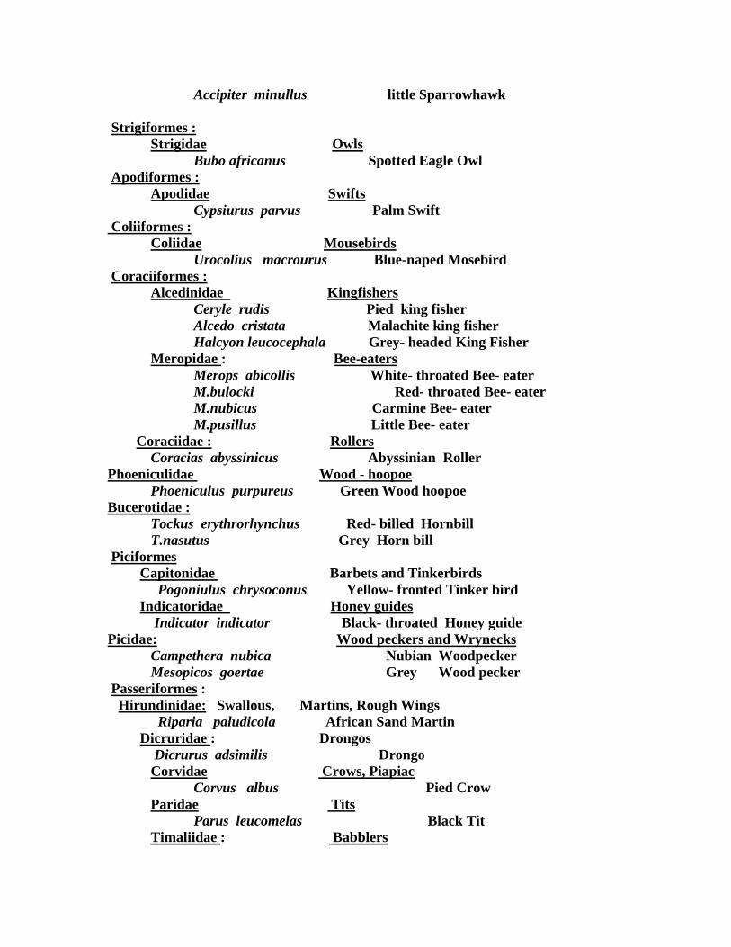
Accipiter minullus little Sparrowhawk Strigiformes : Strigidae Owls Bubo africanus Spotted Eagle Owl Apodiformes : Apodidae Swifts Cypsiurus parvus Palm Swift Coliiformes : Coliidae Mousebirds Urocolius macrourus Blue-naped Mosebird Coraciiformes : Alcedinidae Kingfishers Ceryle rudis Pied king fisher Alcedo cristata Malachite king fisher Halcyon leucocephala Grey- headed King Fisher Meropidae : Bee-eaters Merops abicollis White- throated Bee- eater
M.bulocki Red- throated Bee- eater M.nubicus Carmine Bee- eater M.pusillus Little Bee- eater
Coraciidae : Rollers Coracias abyssinicus Abyssinian Roller Phoeniculidae Wood - hoopoe Phoeniculus purpureus Green Wood hoopoe Bucerotidae : Tockus erythrorhynchus Red- billed Hornbill
T.nasutus Grey Horn bill Piciformes Capitonidae Barbets and Tinkerbirds Pogoniulus chrysoconus Yellow- fronted Tinker bird Indicatoridae Honey guides Indicator indicator Black- throated Honey guide Picidae: Wood peckers and Wrynecks Campethera nubica Nubian Woodpecker Mesopicos goertae Grey Wood pecker Passeriformes : Hirundinidae: Swallous, Martins, Rough Wings Riparia paludicola African Sand Martin Dicruridae : Drongos Dicrurus adsimilis Drongo Corvidae Crows, Piapiac Corvus albus Pied Crow Paridae Tits Parus leucomelas Black Tit
Timaliidae : Babblers

Turdoides leucocephalus White- headed Babbler Pycnonotidae Bulbuls Pycnonotus barbatus White- vented Bulbul Turdidae Trushes and Robins Oenanthe oenanthe Northern Wheatear Muscicapidae Flycatchers Batis minor Black- headed Batis Terpsiphone viridis Paradise Flycatcher Motacillidae Wagtails, Pipits, Long claws Motacilla alba White Wagtail
M. Flava Yellow Wagtail Laniidae Shrikes Lanius collurio Red- backed Shrike
L. nubicus Nubian (masked) Shrike L. senator Woodchat Shrike
Sturnidae Starlings Oxpeckers Creatophora cinerea Wattled Starling Lamprotornis chalybaeus Blue- eared Glaossy Starling
L. purpuropterus Ruppell‘s long-tailed Glossy Starling Buphagus africanus Yellow- billed Oxpecker
Nectariniidae : Sunbirds Nectarinia pulchella Beautiful Sunbirds Ploceidae : Weavers Ploceus badius Cinnamon Weaver
P. velatus Vitelline Masked Weaver Quelea quelea Red- billed Quelea Passer domesticus House Sparrow P. griseus Grey- headed Sparrow Vidua macroura Pin- tailed whydoh
Estrildidae Waxbills Estrilda astrild Wax bill Lagonosticta senegala Red-billed Fire finch Uraeginthus bengalus Red- cheeked Cordon-blew Amadina fasciata Cut- throat Lonchura malabarica Silver- bill Fringillidae Buntings, Canaries, Seed- Eaters Serinus mozambicus Yellow-fronted Canary
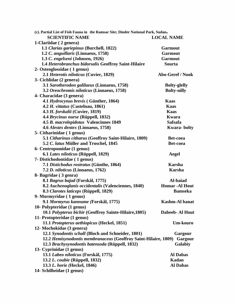
(c). Partial List of Fish Fauna in the Ramsar Site; Dinder National Park, Sudan. SCIENTIFIC NAME LOCAL NAME
1-Clariidae ( 2 genera) 1.1 Clarias gariepinus (Burchell, 1822) Garmout 1.2 C. anguillaris (Linnaeus, 1758) Garmout 1.3 C. engelseni (Johnsen, 1926) Garmout 1.4 Heterobranchus bidorsalis Geoffroy Saint-Hilaire Sourta
2- Osteoglossidae ( 1 genus) 2.1 Heterotis niloticus (Cuvier, 1829) Abo-Geref / Nook
3- Cichlidae (2 genera) 3.1 Sarotherodon galilaeus (Linnaeus, 1758) Bolty-glelly 3.2 Oreochromis niloticus (Linnaeus, 1758) Bolty-nilly
4- Characidae (3 genera) 4.1 Hydrocynus brevis ( Günther, 1864) Kaas 4.2 H. vittatus (Castelnau, 1861) Kaas 4.3 H. forskalii (Cuvier, 1819) Kaas 4.4 Brycinus nurse (Rüppell, 1832) Kwara 4.5 B. macrolepidotus Valencinnes 1849 Safsafa 4.6 Alestes dentex (Linnaeus, 1758) Kwara- bolty
5- Citharinidae ( 1 genus) 5.1 Citharinus citharus (Geoffroy Saint-Hilaire, 1809) Bet-coea 5.2 C. latus Müller and Troschel, 1845 Bet-coea
6- Centropomidae (1 genus) 6.1 Lates niloticus (Rüppell, 1829) Aegel
7- Distichodontidae ( 1 genus) 7.1 Distichodus rostratus (Günthe, 1864) Karsha 7.2 D. niloticus (Linnaeus, 1762) Karsha
8- Bagridae ( 3 genra) 8.1 Bagrus bajad (Forskål, 1775) Al-baiad 8.2 Auchenoglanis occidentalis (Valenciennes, 1840) Homar -Al Hout 8.3 Clarotes laticeps (Rüppell, 1829) Bamseka
9- Mormyridae ( 1 genus) 9.1 Mormyrus kannume (Forskål, 1775) Kashm-Al banat
10- Polypteridae (1 genus) 10.1 Polypterus bichir (Geoffroy Sainte-Hilaire,1805) Dabeeb- Al Hout
11- Protopteridae (1 genus) 11.1 Protopterus aethiopicus (Heckel, 1851) Um-kouro
12- Mochokidae (3 genera) 12.1 Synodontis schall (Bloch and Schneider, 1801) Gargour 12.2 Hemisynodontis membranaceus (Geoffroy Saint-Hilaire, 1809) Gargour 12.3 Brachysynodontis batensoda (Rüppell, 1832) Galabiy
13- Cyprinidae (1 genus) 13.1 Labeo niloticus (Forskål, 1775) Al Dabas 13.2 L. coubie (Rüppell, 1832) Kadan 13.3 L. horie (Heckel, 1846) Al Dabas
14- Schilbeidae (1 genus)

14.1 Schilbe intermedius ( Rüppell, 1832) Shelbaia 14.2 S. uranoscopus (Rüppell, 1832) Shelbaia
(d). Partial List of Insects Fauna in the Ramsar Site; Dinder National Park, Sudan. (DRY-SEASON COLLECTION)
Order Orthoptera 1.Acridoidea (Short-horned, Grasshoppers and Locusts) 16 species.
2.Grylloidea (Crickets) 4 species 3.Tettigonidea (Longhorned Grasshoppers) 3 species 4.Gryllotalpoidea (Mole Crickets) 1 species
Family Gryllotalpidae Gryllotaalpa gryllotalpa (L.) Order Odonata (Dragonflies and Damselflies) Anisoptera (Dragonflies) 7 species Zygoptera (Damselflies) 3 species Order Hemiptera (Bugs) Homoptera Family Coccidae 5 species Family Aphididae 4 species Family Cicadidae 2 species Family Psyllida (Gall-forming bugs) 2 species Heteroptera Family Pentatomidae 3 species Nezara viridula L. Family Lygaeidae 3 species Lygaeus equestris L. Family Notonectidae (Water Boatmen ) 1 species Anisope debilis Gerst. Order Dermaptera (Earwigs) 1 species Order Dictyoptera (Cockroaches and Mantids) Family Blattidae (Cockroaches) Family Mantids ( Mantids) 3 species Order Embioptera (Web Spinners) 1 species Order Isoptera (Termites ) 3 species Order Neuroptera (Antlions and Lacewings) 2 species. Order Lepidoptera (Butterflies and Moths ) 7 species. Family Sphingidae (Hawk Moths) Agrius convolvuli L. Family Arctiidae (Tiger Moths) Utetheisa pulchella L. Family Nymphalidae Hypolimnas misippus L. Family Danidae (Monarch Butterflies) Danus chrysippus L. Order Diptera (Flies) Family Tabanidae1 species
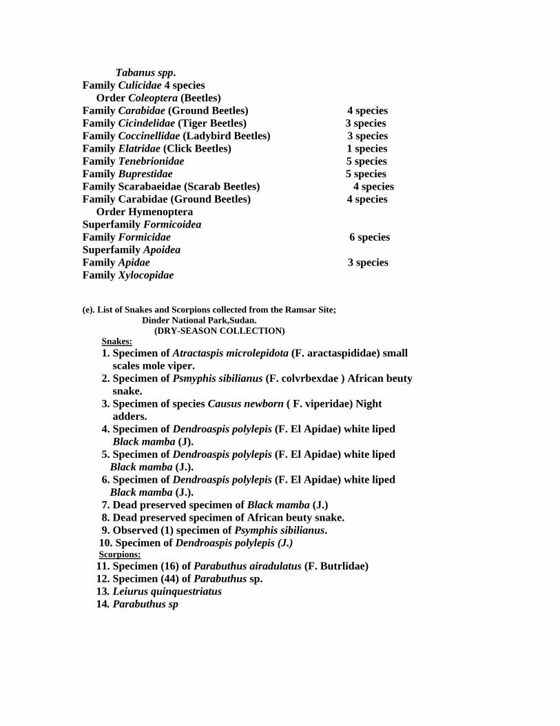
Tabanus spp. Family Culicidae 4 species Order Coleoptera (Beetles) Family Carabidae (Ground Beetles) 4 species Family Cicindelidae (Tiger Beetles) 3 species Family Coccinellidae (Ladybird Beetles) 3 species Family Elatridae (Click Beetles) 1 species Family Tenebrionidae 5 species Family Buprestidae 5 species Family Scarabaeidae (Scarab Beetles) 4 species Family Carabidae (Ground Beetles) 4 species Order Hymenoptera Superfamily Formicoidea Family Formicidae 6 species Superfamily Apoidea Family Apidae 3 species Family Xylocopidae (e). List of Snakes and Scorpions collected from the Ramsar Site; Dinder National Park,Sudan.
(DRY-SEASON COLLECTION) Snakes: 1. Specimen of Atractaspis microlepidota (F. aractaspididae) small scales mole viper. 2. Specimen of Psmyphis sibilianus (F. colvrbexdae ) African beuty snake. 3. Specimen of species Causus newborn ( F. viperidae) Night adders. 4. Specimen of Dendroaspis polylepis (F. El Apidae) white liped Black mamba (J). 5. Specimen of Dendroaspis polylepis (F. El Apidae) white liped Black mamba (J.). 6. Specimen of Dendroaspis polylepis (F. El Apidae) white liped Black mamba (J.). 7. Dead preserved specimen of Black mamba (J.) 8. Dead preserved specimen of African beuty snake. 9. Observed (1) specimen of Psymphis sibilianus. 10. Specimen of Dendroaspis polylepis (J.) Scorpions:
11. Specimen (16) of Parabuthus airadulatus (F. Butrlidae) 12. Specimen (44) of Parabuthus sp. 13. Leiurus quinquestriatus 14. Parabuthus sp

Annex (III) Magano Community
The Magano population is not from a single ethnic group. Originally the area was under the authority of the Hamaj since the Fung Sultanate (5 centuries ago). The dominant group now is the Hadarba. Size-wise the Gumuz are the second distinctive ethnic group inhabiting the Magno Mountains. Ethnically, the population of Magano Mountain Community belongs to four major tribal groups: Hamaj, Funj, Gumuz and Abu Ramala. The percentages of these tribal groups make 82.9% of the population. The rest belong to the Hallween, Agallen, Nuba, and Dinka. The Hamaj is the third significat group. They are allenates of the Funj in the kingdom of Sennar and who, historically, inhabited this area. Other minor groups and due to different reasons, found their way to the Magano village, for example, Halloween, Kawahla, Mesaleit, Dinka and many other smaller tribes. The Gumuz have their distinctive dialect and cultural practices, yet this has been subdued by the dominant culture of the Abrmlaween (Hadarba). This materializes in the dialect of the Hadarba being the medium of communication. It also has another cultural manifestation, that is the dominant Music is the Bajindo which pertains to the Hadarba Culture. Although the Gumuz has their own cultural performances, yet the Bajindo remains the sole music that accompanies most of their rituals. A popular type of Islam is adopted among the Magano Community. However, the Gumuz are more or less pagans, yet acculturated with Islam.