rangeland ecological site descriptions of marine corps air
TRANSCRIPT

United StatesDepartment ofAgriculture
NaturalResourcesConservationService
RangelandEcological SiteDescriptions ofMarine Corps AirGround CombatCenter, TwentyNinePalms, California
In cooperation with theNatural Resources andEnvironmental AffairsDirectorate, Marine CorpsAir Ground Combat Center,TwentyNine Palms and theMojave Desert ResourceConservation District


3
The following information is an excerpt from the Soil Survey of the Marine Corps Air GroundCombat Center, Twentynine Palms.
By Leon J. Lato, Peter B. Fahnestock, and Patti Novak-Echenique, United States Department ofAgriculture, Natural Resources Conservation Service.
Fieldwork by Leon J. Lato, Patti Novak-Echenique, John Rule, Alfred Ramos, and Steve Slusser,Natural Resources Conservation Service
United States Department of Agriculture, Natural Resources Conservation Service,in cooperation withNatural Resources and Environmental Affairs Division, Marine Corps Air Ground Combat Center,Twentynine Palms and the Mojave Desert Resource Conservation District.
Pattie Novak-Echerique, Plant Ecologist, developed and authored the Ecological SiteDescriptions in this excerpt.

4

5
Rangeland Ecological Site DescriptionsRangeland Ecological Site Descriptions .................... 5Introduction ............................................................. 6
Alluvial Plain ....................................................... 8A. Physical Characteristics............................... 8B. Ecological Site Interpretations ...................... 9
Cobbly Wash ..................................................... 11A. Physical Characteristics............................. 11B. Ecological Site Interpretations .................... 13
Desert Patina ..................................................... 15A. Physical Characteristics............................. 15B. Ecological Site Interpretations .................... 16
Dry Wash ............................................................ 18A. Physical Characteristics............................. 18B. Ecological Site Interpretations .................... 20
Dune 3-5" P.Z. .................................................... 22A. Physical Characteristics............................. 22B. Ecological Site Interpretations .................... 23
Granitic Drain 5-7" P.Z. ..................................... 26A. Physical Characteristics............................. 26B. Ecological Site Interpretations .................... 28
Granitic Loam 3-5" P.Z. ..................................... 30A. Physical Characteristics............................. 30B. Ecological Site Interpretations .................... 31
Gravelly Ridge 5-7" P.Z. .................................... 34A. Physical Characteristics............................. 34B. Ecological Site Interpretations .................... 35
Gypsic Flat 3-5" P.Z. .......................................... 37A. Physical Characteristics............................. 37B. Ecological Site Interpretations .................... 38
Lava Flow 3-5" P.Z. ............................................ 40A. Physical Characteristics............................. 40B. Ecological Site Interpretations .................... 41
Limy 3-5" P.Z. .................................................... 43A. Physical Characteristics............................. 43B. Ecological Site Interpretations .................... 45
Limy 5-7" P.Z. .................................................... 47A. Physical Characteristics............................. 47B. Ecological Site Interpretations .................... 49
Limy Hill 3-5" P.Z. ............................................. 51A. Physical Characteristics............................. 51B. Ecological Site Interpretations .................... 52
Limy Hill 5-7" P.Z. ............................................. 54A. Physical Characteristics............................. 54B. Ecological Site Interpretations .................... 56
Loamy Hill 5-7" P.Z. .......................................... 58A. Physical Characteristics............................. 58B. Ecological Site Interpretations .................... 59
Moist Granitic Drain .......................................... 62A. Physical Characteristics............................. 62B. Ecological Site Interpretations .................... 64
Outwash Plain ................................................... 66A. Physical Characteristics............................. 66B. Ecological Site Interpretations .................... 67
Saline Flat 3-5” P.Z. ........................................... 69A. Physical Characteristics............................. 69B. Ecological Site Interpretations .................... 70
Saline Hill 3-5" P.Z. ........................................... 72A. Physical Characteristics............................. 72B. Ecological Site Interpretations .................... 73
Sandhill 3-5" P.Z. .............................................. 75A. Physical Characteristics............................. 75B. Ecological Site Interpretations .................... 77
Sandy Plain 3-5" P.Z. ........................................ 79A. Physical Characteristics............................. 79B. Ecological Site Interpretations .................... 81
Shallow Gravelly Loam 5-7" P.Z. ...................... 83A. Physical Characteristics............................. 83B. Ecological Site Interpretations .................... 85
Sodic Dune 3-5" P.Z. ......................................... 87A. Physical Characteristics............................. 87B. Ecological Site Interpretations .................... 88
Sodic Sand 3-5" P.Z. ......................................... 90A. Physical Characteristics............................. 90B. Ecological Site Interpretations .................... 91
Steep South Slope ............................................ 93A. Physical Characteristics............................. 93B. Ecological Site Interpretations .................... 94
Valley Wash ....................................................... 96A. Physical Characteristics............................. 96B. Ecological Site Interpretations .................... 98
Bibliography for Ecological Sites ...................... 100Index of Ecological Sites .................................... 103Table 20.—Listing of Point Data ......................... 104
Issue 2001

6 Soil Survey
IntroductionLandscapes of native vegetation are divided into
ecological sites for the purposes of inventory,evaluation, and management. An ecological site, asdefined for rangeland, is a distinctive kind of land withspecific physical characteristics that differs from otherkinds of land in its ability to produce a distinctive kindand amount of vegetation.
An ecological site is the product of all theenvironmental factors responsible for its developmentincluding parent material, landscape, climate, soils,biota, hydrology, fire and time in place. The ecologicalsite description contains information on each of theenvironmental factors. Included are brief descriptionsof: a) physiographic and climatic features; b) majoridentifiable plant community types that may occupythe site, including the historic climax plant community;c) total annual production; d) ecological dynamics ofthe plant communities; e) soils and their mainproperties; f) and site interpretations and generalmanagement considerations for wildlife, livestock,threatened and endangered species, hydrology,recreation, fire, aesthetics and restoration/revegetation.
The historic climax plant community for a site is theplant community that existed prior to Europeanimmigration and settlement. It is the plant communitythat had developed on the site as a result of all siteforming factors. This community was best adapted tothe unique combination of environmental factorsassociated with the site. Natural disturbances, suchas drought, fire, grazing by native fauna and insects,were inherent in the development and maintenance ofthese native plant communities. These naturaldisturbances are reflected in the site descriptions.Plant communities that are subjected to abnormaldisturbances and physical site deterioration or that areprotected from natural influences for long periodsseldom typify the historic climax vegetation and mayexist in a steady state that is different from the historicclimax plant community.
The historic climax plant community is not a preciseassemblage of species for which the proportions arethe same from place to place or from year to year. Inall plant communities, variability is apparent inproductivity and occurrence of individual species.Spacial boundaries of the communities can berecognized by characteristic patterns of speciescomposition, association, and community structure.Generally one species or a group of species dominatesa site. Because of their stability in the climax plantcommunity, they can be used to distinguish sites and
to differentiate one site from another. Species of minoroccurrence can be used to distinguish sites when thedominant species are in equal proportion.
At times, less frequently occurring plants mayincrease on a site, or plants not formerly found in theclimax community may invade the site. The presenceor abundance of these plants may fluctuate greatlybecause of differences in microenvironment, weatherconditions or human actions. Using these species forsite identification can be misleading; thus they shouldnot be used to differentiate sites.
The following ecological site inventory methods areused in determining the characteristic plantommunities of an ecological site:
1. Identification and evaluation of reference and/orrelict sites with similar plant communities andassociated soils.
2. Interpolation and extrapolation of plant, soil, andclimatic data from existing historic reference areasalong a continuum to other points on thatcontinuum for which no suitable referencecommunity is available.
3. Evaluation and comparison of the same ecologicalsite occurring in different areas, but that haveexperienced different levels of disturbance andmanagement. Further comparison is made withareas that are not disturbed.
4. Evaluating and interpretation of research datadealing with the ecology, management, and soils ofplant communities.
5. Review of historical accounts, survey and militaryrecords, and botanical literature of the area.
The initial description of the historic climax plantcommunity should be considered as an approximationsubject to modification as additional knowledge isgained.
Climax plant communities change alongenvironmental gradients. When changes in soils,aspect, topography, or moisture conditions are abrupt,plant community boundaries are distinct. Boundariesare broader and less distinct where plant communitieschange gradually along wide environmental gradients ofrelatively uniform soils and topography. Thus, the needfor site differentiation may not be readily apparent untilthe cumulative impact of soil, topography, hydrology, orclimate is examined over a broad area. Frequently,such differences are reflected first in production andsecond in the kinds and proportion of plant speciesmaking up the core of the plant community. Ofnecessity, boundaries between ecological sites along acontinuum of closely related soils and a graduallychanging climate are somewhat arbitrary.

Marine Corp Air Combat Center, Twentynine Palms, California 7
The following criteria are used to differentiate oneecological site from another:
1. Significant differences in the species or speciesgroups that are in the characteristic plantcommunity.
2. Significant differences in the relative proportion ofspecies or species groups in the characteristicplant community.
3. Significant differences in the total annualproduction of the characteristic plant community.
4. Soil factors that determine the plant productionand composition, the hydrology of the site, and thefunctioning of the ecological processes of the watercycle, mineral cycles, and energy flow.
Differences in kind, proportion, and production ofplants are the result of differences in soil, topography,climate and other environmental factors. Slightvariations in these factors are not criteria for sitedifferentiation. Individual environmental factors arefrequently associated with significant differences innative plant communities. The differences in theenvironmental factors must be great enough to affectthe kinds, and amounts and proportions of the plantcommunity to be differentiated into a distinct site.
Ecological site inventories were conducted and sitedescriptions were developed in cooperation with theFort Irwin National Training Center Soil Survey.

8 Soil Survey
Alluvial PlainPlant Symbol: ATPO/ACHYSite Number: 030XY047NV
A. Physical Characteristics
1. Physiographic Features
a. This site occurs on alluvial flats and lake plains.Elevations are 1745 to 2735 feet. Slopes range from0 to 4 percent but slopes of 0 to 2 percent is mosttypical.
2. Climatic Features
a. The climate on this site is arid characterized bywarm, moist winters (30 to 60 degrees F) and hot,dry summers (70 to 110 degrees F). The averageannual precipitation ranges from 2 to 6 inches withmost falling as rain from November to March.Approximately 30 percent to 45 percent of theannual precipitation occur from July to September asa result of summer convection storms. Mean annualair temperature is 61 to 73 degrees F.
b. The average frost-free period is 240 to 360 days.
3. Interpretive Plant Community
a. The representative natural plant community isDesert Saltbush Scrub or Allscale Series. Thiscommunity is dominated by allscale saltbush.Potential vegetative composition is about 15 percentgrasses, 5 percent forbs, and 80 percent shrubs.
b. The following table lists the major plant species andpercentages by weight, air dry, of the total plantcommunity that each contributes in an averageproduction year. Fluctuations in species compositionand relative production may change from year toyear dependent upon abnormal precipitation or otherclimatic factors.
Shrubs and Trees (80 percent):
_____________________________________________________________Symbol Common Name % Composition (air-dry weight)
ATPO Allscale saltbush 60-70SSSS Other shrubs 5-15** LATR2 Creosotebush AMDU2 White bursage ATCA2 Fourwing saltbush EPNE Nevada ephedra LEFR2 Desert alyssum PSEM Emory dalea SUMO Mojave seablite ATHY Desert holly_____________________________________________________________** Allow no more than 5 percent of eachspecies of this group, and no more than 15percent in aggregate
Grasses and Grass-like Plants (15 percent):
_____________________________________________________________Symbol Common Name % Composition (air-dry weight)_____________________________________________________________ACHY Indian ricegrass 5-15PPGG Other perennial grasses 2-10** DISP Inland saltgrass PLRI3 Big galletaAAGG Other annual grasses T-3 BOBA2 Sixweeks grama_____________________________________________________________** Allow no more than 4 percent of eachspecies of this group, and no more than 10percent in aggregate
Forbs (5 percent):
_____________________________________________________________Symbol Common Name % Composition (air-dry weight)PPFF Other perennial forbs T-5** SPAM2 Desert globemallowAAFF Other annual forbs T-10 CRYPT Cryptantha GECA2 Desert sunflower PLOV Desert Indianwheat_____________________________________________________________** Allow no more than 2 percent of eachspecies of this group, and no more than 5percent in aggregate
c. Approximate ground cover (basal and crown) is 5 to15 percent.
d. The historical plant community will produceapproximately the following amounts of air-dryherbage per acre:
_____________________________________________________________________Estimated Total Annual Production Air-Dry Weight lbs./acre _Favorable Years 500Normal Years 400Unfavorable Years 250_____________________________________________________________________
e. Ecological dynamics: As ecological conditiondeteriorates perennial grasses decrease. Allscalesaltbush may initially increase but with continuedsite degradation allscale will also decrease. Non-native grasses and forbs such as schismus, red-stem filaree and Russian thistle will invade this site.White burrobush is a pioneer species on this site.
f. Major plant community types:Desert Saltbush Scrub or Allscale Series --This is
a xerophytic phase of saltbush scrub with limitedsalt tolerance. This community usually consistsof low, grayish, microphyllus shrubs, 0.3 to 1meter tall, with some succulent species. Shrubsare widely spaced with total cover typically low.Stands are dominated by allscale. Annuals areseasonally present. This site is stable in thiscondition.

Marine Corp Air Combat Center, Twentynine Palms, California 9
g. Plant Growth CurvesGrowth Curve Number--CA3007Growth Curve Name--Allscale saltbushDescription: Growth begins in early spring; flowering
and seed set occur by October.Percent of total production per month:
___________________________________________________________Jan Feb Mar Apr May Jun Jul Aug Sep Oct Nov Dec0 10 15 30 20 10 5 5 5 0 0 0___________________________________________________________
Growth Curve Number--CA3022Growth Curve Name--Indian ricegrassDescription: Growth starts in early spring with most
growth occurring from April to May. Flowering andseed set occur by June. Dormancy occurs duringthe hot summer months.
Percent of total production per month:__________________________________________________________Jan Feb Mar Apr May Jun Jul Aug Sep Oct Nov Dec0 5 15 30 35 5 0 0 5 5 0 0__________________________________________________________
4. Site Documentation
a. Principal sites that commonly occur in associationwith this potential plant community include:(030XY046NV) Outwash Plain(030XY127CA) Sodic Dune 3-5” P.Z.(030XY133CA) Sodic Sand 3-5” P.Z.
b. Competing sites (and their differentiae) which aresimilar to this potential plant community:(030XY046NV) Outwash Plain [AMDU2, LATR2
important shrubs](030XY133CA) Sodic Sand 3-5” P.Z. [ATCA2, LATR2
dominant shrubs]c. This ecological site description is based on the
following documentation:Sampling technique_3__ NV-ECS-1_1_ SCS-Range 417___ Other
5. Soils
a. The soils that characterize this site are very deepand somewhat excessively drained. They are formedin mixed alluvium. Surface textures and subsurfacetextures are sands and sandy loams. The soils areslightly to moderately alkaline. Available watercapacity is low and permeability is rapid. Wind erosionhazard is severe. Effective rooting depth is 60 inchesor more. Water tables are greater than 60 inches.
_________________________________________________________________________
Representative Soil Map Units
180 Cajon minor component in Hypoint, saline-Cajon dry association, 0-4 percent slopes
210 Typic Torriorthents minor component inKentonmill-Lava flow complex, 0-2 percentslopes
903 Typic Torriorthents minor component inPlaya-Typic Torriorthents association,0-4 percent slopes
________________________________________________________________________
6. Wildlife Communities
a. This site provides habitat for small mammals suchas Merriam’s kangaroo rats, desert kangaroo rats,little pocket mice, black-tailed jackrabbits andcoyotes. Allscale saltbush provides valuable coverand forage.
b. Reptiles occurring on this site include zebra-tailedlizards, western whiptails, desert iguana and side-blotched lizards. Sidewinders also occur. Habitat fordesert tortoise is limited due to the occurrence ofponding and flooding.
c. Birds occurring on this site include commonravens, horned larks, LeConte thrashers, andseveral species of sparrows including black-throated, sage and Brewer’s sparrows.
B. Ecological Site Interpretations
1. Livestock Grazing
a. Season of Use--Other Mgt. Considerations:Allscale is a highly palatable plant for domesticlivestock and provides valuable forage during thewinter and early spring months. Overgrazing caneliminate this species from the site. In favorableyears, annual forbs and grasses may providelimited spring grazing.
b. General guide to initial stocking rate. Beforemaking specific recommendations, an on-siteevaluation must be made.
________________________________________________________________
Pounds/acre air dry AUM/AC AC/AUM_
Normal Years 400________________________________________________________________
2. General Management Considerations
a. Military Operations--Management for this sitewould be to protect it from excessive disturbanceand maintain existing plant cover. Land clearing orother disturbances that destroy the vegetation andthe soil crust and structure can result in soilcompaction, reduced infiltration rates, acceleratederosion, soil blowing, barren areas and theintroduction of non-native plant species. Vehiclesshould be limited to existing roads and trails. Thesoils are dusty when subjected to vehicular trafficand treatment may be desirable in areas of heavytraffic. The frequency of flash flooding may alsoincrease with an increase in surface runoff and lossof vegetative cover.

10 Soil Survey
3. Ecosystem Management
a. Wildlife Habitat--Management for this site would beto protect it from excessive disturbance andmaintain existing plant cover. Vehicle activity off ofdesignated tank trails and roads may result in lossof vegetative cover, increased erosion anddestruction of small mammal burrows. Close roadsand trails no longer being used and revegetateusing native species indigenous to this site. Waterdevelopments would increase the species diversityof this site.
b. Revegetation of Disturbed Areas--Speciesindigenous to this site are recommended for anyrevegetation efforts.Allscale saltbush is valuable for erosion control
and cover restoration. Direct seeding should bedone during the fall and winter months when lowsoil temperatures and high soil moisture arefavorable for germination.
Transplanting seedlings is more effective thandirect seeding. Planting in late fall or early springallows for acclimation to summer conditions.Transplants that are dormant during the hot, dryseason are best maintained that way rather thanattempting to force them to break dormancy andundergo new vegetative growth out of season.Supplemental irrigation is recommended for thefirst growing season, especially if winter rainfallhas been sparse. Protection from rodents is alsorecommended.
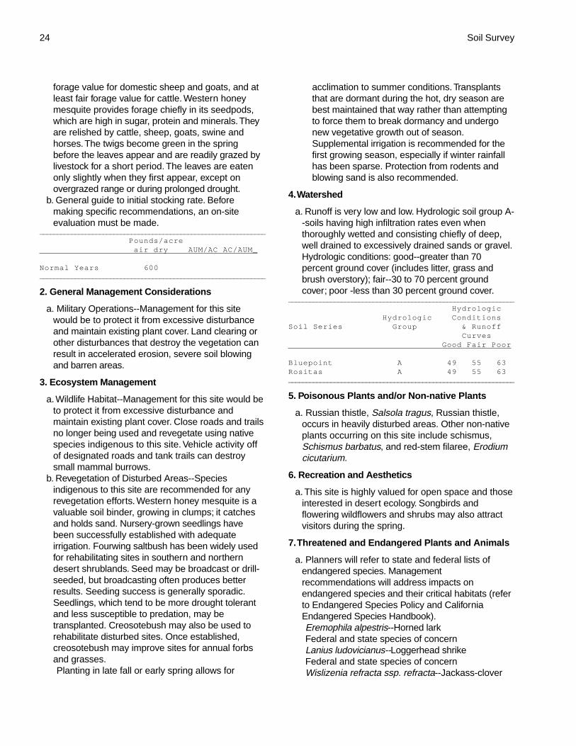
4. Watershed
a. Runoff is very low to low. Hydrologic group A--soilshaving high infiltration rates even when thoroughlywetted and consisting of deep, well drained toexcessively drained sands or gravel. Hydrologicconditions: good--greater than 70 percent groundcover (includes litter, grass and brush overstory);fair--30 to 70 percent ground cover; poor--less than30 percent ground cover.
________________________________________________________________
Hydrologic Hydrologic ConditionsSoil Series Group & Runoff Curves Good Fair Poor
Cajon A 49 55 63Typic Torriorthents A 49 55 63_______________________________________________________________
5. Poisonous Plants and/or Non-native Plants
a. Russian thistle, Salsola tragus, occurs in heavilydisturbed areas. Schismus, Schismus barbatus,occurs throughout the site. Saltcedar, Tamarixramosissima, occurs in washes and bomb cratersthat intermittently hold water.
6. Recreation and Aesthetics
a. This site is highly valued for open space and thoseinterested in desert ecology. Flowering wildflowersand shrubs may also attract visitors during thespring.
7. Threatened and Endangered Plants and Animals
a. Planners will refer to state and federal lists ofendangered species. Managementrecommendations will address impacts onendangered species and their critical habitats (referto Endangered Species Policy and CaliforniaEndangered Species Handbook).Eremophila alpestris--Horned larkFederal and State species of concernToxostoma lecontei--LeConte’s thrasherState species of concern
8. Fire
a. The foliage of the saltbushes appears to have fire-retarding qualities associated with the salt contentof the leaves. A severe fire, however, will typicallykill aboveground portions of the saltbushes. Indianricegrass sustains slight damage by fire and canreestablish via seed dispersed from adjacentunburned areas.
9. Typical Site Location
NW 1/4, Sec. 35, T7N, R6EApproximately 10 miles southwest of Ludlow, CALavic Lake QuadrangleUTM 11S 0561500e 3835300n; (Datum=NAS-C)San Bernardino Co., CA

Marine Corp Air Combat Center, Twentynine Palms, California 11
Cobbly WashPlant Symbol: HYEM-ACGR/PLRI3Site Number: 030XB128CA
A. Physical Characteristics
1. Physiographic Features
a. This site occurs along drainageways of inset fans.Elevation is 1100 to 2400 feet. Slopes range from 2to 8 percent.
2. Climatic Features
a. The climate on this site is arid, characterized bywarm, moist winters (30 to 60 degrees F) and hot,dry summers (70 to 110 degrees F). The averageannual precipitation ranges from 2 to 6 inches withmost falling as rain from November to March.Approximately 30 percent to 45 percent of theannual precipitation occurs from July to Septemberas a result of summer convection storms. Meanannual air temperature is 61 to 73 degrees F.
b. The average frost-free period is 300 to 360 days.
3. Interpretive Plant Community
a. The representative natural plant community isMojave Wash Scrub. Desert lavender, catclawacacia, creosotebush and big galleta dominate thiscommunity. Potential vegetative composition isabout 15 percent grasses, 10 percent forbs, and 75percent shrubs.
b. The following table lists the major plant speciesand percentages by weight, air dry, of the total plantcommunity that each contributes in an averageproduction year. Fluctuations in speciescomposition and relative production may changefrom year to year dependent upon abnormalprecipitation or other climatic factors.
Shrubs and Trees (75 percent):___________________________________________________________________
Symbol Common Name % Composition (air-dry weight)
HYEM Desert lavender 30-50ACGR Catclaw acacia 2-10LATR2 Creosotebush 2-10HYSA White burrobush 2-5BEJU Sweetbush 2-5SSSS Other shrubs 10-15** ENFA White brittlebush POGR Odora SAME Bladdersage KRGR White ratany AMDU2 White bursage BABR Shortleaf baccharis SEAR8 Desertsenna PSSP3 Smoketree
ENFR Bush encelia_____________________________________________________________** Allow no more than 5 percent of eachspecies of this group, and no more than 20percent in aggregate
Grasses and Grass-like Plants (15 percent):___________________________________________________________________
Symbol Common Name % Composition (air-dry weight)
PLRI3 Big galleta 5-10PPGG Other perennial grasses 2-5** ACSP12 Desert needlegrassAAGG Other annual grasses T-5 ARAD Sixweeks threeawn BOBA2 Sixweeks grama_____________________________________________________________** Allow no more than 2 percent of eachspecies of this group, and no more than 5percent in aggregate
Forbs (10 percent):___________________________________________________________________
Symbol Common Name % Composition (air-dry weight)
PPFF Other perennial forbs 2-8** ERIN4 Desert trumpet MIBI8 Wishbone herb ASSU Rush milkweed EUPO3 Sandmat SPAM2 Desert globemallowAAFF Other annual forbs T-10 PLOV Desert Indianwheat CRYPT Cryptantha PHACE Phacelia MOCO Ghost flower_____________________________________________________________** Allow no more than 3 percent of eachspecies of this group, and no more than 8percent in aggregate
c. Approximate ground cover (basal and crown) is 5to 15 percent.
d. The historical plant community will produceapproximately the following amounts of air-dryherbage per acre:
______________________________________________________________________
Estimated Total Annual Production Air-Dry Weight lbs./acre _
Favorable Years 500Normal Years 350Unfavorable Years 200________________________________________________________________
e. Ecological dynamics: As ecological conditiondeteriorates, creosotebush, white burrobush andwhite bursage will initially increase. Perennial forbsand grasses will decrease. Continued surfacedisturbance may reduce the cover of the short-livedperennials as well as the long-lived perennials such

12 Soil Survey
as desert lavender, creosotebush and catclaw acacia.Species likely to invade this site include saltcedar andnon-native annual grasses and forbs such asschismus, red brome, red-stem filaree and Russianthistle.
f. Major plant community types:Mojave Wash Scrub--The historic site potential is a
diverse community with an open canopy of shrubsand scattered trees. Perennial grasses and forbs arecommon. Annuals are seasonally present and areabundant in years of above average precipitation.This site is inherently unstable due to the frequencyof flooding.
g. Plant Growth CurveGrowth Curve Number--CA3023Growth Curve Name--Desert lavenderDescription: If moisture and temperature conditions
are favorable growth may occur throughout the year.Flowering may occur at any time during the year,with peak flowering occurring from October throughMay. Seeds are typically collected during the spring.
Percent of total production per month:_____________________________________________________________________Jan Feb Mar Apr May Jun Jul Aug Sep Oct Nov Dec5 5 15 20 20 5 0 0 10 10 5 5_____________________________________________________________________
Growth Curve Number--AZ3091Growth Curve Name--Catclaw acaciaDescription: Greens up in spring; flowers in May and
June and pods mature between July andSeptember.
Percent of total production per month:_____________________________________________________________________Jan Feb Mar Apr May Jun Jul Aug Sep Oct Nov Dec0 0 0 5 15 10 15 30 15 10 0 0_____________________________________________________________________
Growth Curve Number--CA3015Growth Curve Name--CreosotebushDescription: Growth starts in early spring, flowering
and seed set occurs by July. Dormancy occursduring the hot summer months. With sufficientsummer/fall precipitation, some vegetation maybreak dormancy and produce a flush of growth.
Percent of total production per month:_____________________________________________________________________Jan Feb Mar Apr May Jun Jul Aug Sep Oct Nov Dec0 5 20 30 20 10 0 10 5 0 0 0_____________________________________________________________________
4. Site Documentation
a. Principal sites that commonly occur in associationwith this potential plant community include:(030XB092NV) Desert Patina(030XB019NV) Limy 3-5" P.Z.
b. Competing sites (and their differentiae) which aresimilar to this potential plant community:(030XB028NV) Valley Wash [HYSA dominant shrub,
HYEM minor shrub](030XB136CA) Dry Wash [HYSA-LATR2 dominant
shrubs; less productive site]c. This ecological site description is based on the
following documentation:Sampling technique_2_ NV-ECS-1___ SCS-Range 417_2_ Other
5. Soils
a. The soils that characterize this site are very deepand excessively drained. They are formed instratified alluvium from mixed sources. Surface andsubsurface textures are loamy coarse sands,extremely gravelly sands and very cobbly sands.Available water capacity is very low andpermeability is very rapid. Wind erosion hazard isnegligible due to surface rock fragments. Effectiverooting depth is 60 inches or more. Water tables aregreater than 60 inches. This site is subject tofrequent flooding.
________________________________________________________________________
Representative Soil Map Units
274 Arizo minor component, Arizo extremelygravelly loamy coarse sand, dry, 2-8percent slopes
276 Arizo minor component, Arizo dry-Twobitter association, 2-8 percentslopes
313 Carrizo minor component, Carrizocomplex, 2-8 percent slopes
314 Carrizo minor component, Carrizocomplex, 2-8 percent slopes, rubbly
315 Carrizo minor component, Carrizo-Clegorpass association, 2-8 percentslopes
________________________________________________________________________
6. Wildlife Communities
a. Mammals common to this site includes long-tailedpocketmice, canyon mice, white-tailed antelopesquirrels, coyotes and black-tailed jackrabbits.Catclaw acacia seeds and pods are valuable foragefor ground squirrels.
b. Common lizards include the side-blotched lizard,western whiptail and zebra-tailed lizard. Deserttortoises frequently den in the banks and berms ofwashes and feed on vegetation occurring in thewash.
c. Birds common to this site include Costa'shummingbirds, black-throated sparrows, black-tailed gnatcatchers, verdins and mourning doves.Catclaw acacia provides food and cover for severalspecies of birds. Desert lavender provides nestingsites.

Marine Corp Air Combat Center, Twentynine Palms, California 13
B. Ecological Site Interpretations
1. Livestock Grazing
a. Season of Use--Other Mgt. Considerations: Thissite has limited value for livestock grazing due tolow productivity. Desert lavender provides limitedforage for livestock. Catclaw acacia is poor foragefor livestock. It may be browsed in early springwhen twigs are green but is otherwise seldomeaten. Creosotebush is unpalatable. Duringfavorable years, annual grasses and forbs provideadditional forage.
b. General guide to initial stocking rate. Beforemaking specific recommendations, an on-siteevaluation must be made.
________________________________________________________________
Pounds/acre air dry AUM/AC AC/AUM_
Normal Years 350________________________________________________________________
2. General Management Considerations
a. Military Operations--Vehicle use in washes candestroy the vegetation and channel morphology.The frequency of flash flooding may also increasewith increased surface runoff and loss of vegetativecover. Channel width and depth will also increase.Gully stabilization methods include straw balecheckdams, rock riprap and sand bags.Management for this site would be to protect it fromexcessive disturbance and maintain existing plantcover.
3. Ecosystem Management
a. Wildlife Habitat--Management for this site would beto protect it from excessive disturbance andmaintain existing plant cover. Close roads and trailsno longer being used and revegetate using nativespecies indigenous to this site. Vehicle activity inwashes may destroy desert tortoise and smallmammal habitat. Water developments wouldincrease the species diversity of this site.
b. Revegetation of Disturbed Areas--Speciesindigenous to this site are recommended for anyrevegetation efforts. Desert lavender has beensuccessfully transplanted using cuttings. Catclawacacia has shown varying success whentransplanted onto disturbed sites. Seedlings shouldbe grown in tall containers to allow for thedevelopment of a deep root system. Whiteburrobush is a short-lived species, although theseeds have high viability and germination ratescompared to other desert shrubs. Creosotebush, isa long-lived species, which once established may
improve the site for annuals that grow under itscanopy by trapping fine soil, organic matter andseeds. Creosotebush can be used for long-termstabilization and for improvement of desert tortoisehabitat.Transplanting seedlings is more effective than
direct seeding. Planting in late fall or early springallows for acclimation to summer conditions.Transplants that are dormant during the hot, dryseason are best maintained that way rather thanattempting to force them to break dormancy andundergo new vegetative growth out of season.Supplemental irrigation is recommended for thefirst growing season, especially if winter rainfallhas been sparse. Protection from rodents is alsorecommended.
4. Watershed
a. Runoff is very low and low. Hydrologic soil group A--soils having high infiltration rates even whenthoroughly wetted and consisting chiefly of deep,well drained to excessively drained sands or gravel.Hydrologic conditions: good--greater than 70percent ground cover (includes litter, grass andbrush overstory); fair--30 to 70 percent groundcover; poor--less than 30 percent ground cover.
________________________________________________________________
Hydrologic Hydrologic ConditionsSoil Series Group & Runoff Curves Good Fair Poor
Arizo A 49 55 63Carrizo A 49 55 63________________________________________________________________
5. Poisonous Plants and/or Non-native Plants
a. Salsola tragus, Russian thistle, occurs in heavilydisturbed areas. Other non-native plants occurringon this site include red brome, Bromus rubens; red-stem filaree, Erodium cicutarium; and schismus,Schismus spp.
6. Recreation and Aesthetics
a. This site is valued for open space and thoseinterested in desert ecology. Desert tortoise,flowering wildflowers and shrubs may also attractvisitors during the spring.
7. Threatened and Endangered Plants and Animals
a. Planners will refer to state and federal lists ofendangered species. Managementrecommendations will address impacts onendangered species and their critical habitats (referto Endangered Species Policy and California

14 Soil Survey
Endangered Species Handbook).Gopherus agassizii--Desert TortoiseFederal and State threatened
8. Fire
a. This site is usually unaffected by fire because oflow fuel loads, although a year of exceptionallyheavy winter rains can generate fuels by producinga heavy stand of annual forbs and grasses. Desertlavender and catclaw acacia are able to resproutfrom the root crown following top-kill by fire. Whiteburrobush establishes quickly after fire via off-site
seeds and sprouting. Creosotebush possesseslimited sprouting ability, thus, can be killed by fire.
9. Typical Site Location
SW1/4 Sec. 31, T3N R10EApproximately 6 miles northeast of Marine Corps AirGround Combat Center headquartersLead Mountain SE QuadrangleUTM 11S 0593800e 3795500n (Datum=NAS-C)San Bernardino Co., CA

Marine Corp Air Combat Center, Twentynine Palms, California 15
Desert PatinaPlant Symbol: LATR2Site Number: 030XB092NV
A. Physical Characteristics
1. Physiographic Features
a. This site occurs on summits of fan remnants.Elevation is 720 to 3500 feet. Slopes range from 0to 8 percent, but slopes from 2 to 4 percent aremost typical.
2. Climatic Features
a. The climate on this site is arid characterized bywarm, moist winters (30 to 60 degrees F) and hot,dry summers (70 to 110 degrees F). The averageannual precipitation ranges from 2 to 6 inches withmost falling as rain from November to March.Approximately 30 percent to 45 percent of theannual precipitation occurs from July to Septemberas a result of summer convection storms. Meanannual air temperature is 61 to 73 degrees F.
b. The average frost-free period is 240 to 360 days.
3. Interpretive Plant Community
a. The representative natural plant community isMojave Creosotebush Scrub or CreosotebushSeries. This community is dominated bycreosotebush. Potential vegetative composition isabout 5 percent grasses, 5 percent forbs, and 90percent shrubs.
b. The following table lists the major plant speciesand percentages by weight, air dry, of the total plantcommunity that each contributes in an averageproduction year. Fluctuations in speciescomposition and relative production may changefrom year to year dependent upon abnormalprecipitation or other climatic factors.
Shrubs and Trees (90 percent):___________________________________________________________________
Symbol Common Name % Composition (air-dry weight)LATR2 Creosotebush 90-95SSSS Other shrubs T-5** AMDU2 White bursage KRER Range ratany KRGR White ratany OPUNT Cactus SEAR8 Desertsenna ENFR Bush encelia ATHY Desert holly YUSC2 Mojave yucca________________________________________________________________
** Allow no more than 5 percent in aggregate
Grasses and Grass-like Plants (5 percent):___________________________________________________________________
Symbol Common Name % Composition (air-dry weight)
PPG Other perennial grasses T-5**ERPU8 FluffgrassAAGG Other annual grasses T-5___________________________________________________________________
** Allow no more than 3 percent of eachspecies of this group, and no more than 5percent in aggregate
Forbs (5 percent):___________________________________________________________________
Symbol Common Name % Composition (air-dry weight)
PPFF Other perennial forbs T-3**ERIN4 Desert trumpetMIBI8 Wishbone herbSTEPH WirelettuceAAFF Other annual forbs T-5CHRI TurksheadPLOV Desert IndianwheatPSRA Turtleback___________________________________________________________________
** Allow no more than 3 percent in aggregate
c. Approximate ground cover (basal and crown) is 1to 3 percent.
d. The historical plant community will produceapproximately the following amounts of air-dryherbage per acre:
________________________________________________________________
Estimated Total Annual Production Air-Dry Weight lbs./acre _
Favorable Years 150Normal Years 75Unfavorable Years 25________________________________________________________________
e. Ecological dynamics: This is a very stable plantcommunity so long as the desert pavement isundisturbed. This site is characterized by lowproductivity with little plant diversity. Annual forbsaccount for most of the variability in productionlevels. Disturbance would cause an increase indesert trumpet and wirelettuce and an introductionof non-native species such as red brome,schismus, and red-stem filaree. White burrobush isthe primary perennial pioneer species.
f. Major plant community types:Mojave Creosotebush Scrub or Creosotebush
Series--The historic site potential ischaracterized by widely spaced shrubs up to 2meters tall. Creosotebush dominates this series.White bursage may be present but is not animportant shrub. Perennial grasses are sparse.

16 Soil Survey
Annual forbs and grasses are seasonally present.This site is stable in this condition.
g. Plant Growth CurvesGrowth Curve Number--CA3015Growth Curve Name--CreosotebushDescription: Growth starts in early spring, flowering
and seed set occur by July. Dormancy occursduring the hot summer months. With sufficientsummer/fall precipitation, some vegetation maybreak dormancy and produce a flush of growth.
Percent of total production per month:_____________________________________________________________________Jan Feb Mar Apr May Jun Jul Aug Sep Oct Nov Dec0 5 20 30 20 10 0 10 5 0 0 0_____________________________________________________________________
4. Site Documentation
a. Principal sites that commonly occur in associationwith this potential plant community include:(030XB005NV) Limy 5-7" P.Z.(030XB145CA) Valley Wash
b. Competing sites (and their differentiae) which aresimilar to this potential plant community:(030XB019NV) Limy 3-5" P.Z. [More productive
site](030XB005NV) Limy 5-7" P.Z. [More productive
site;AMDU2-LATR2 codominant](030XB017NV) Limy Hill 3-5" P.Z. [Less
productive site; occurs on mountain sideslopes]c. This ecological site description is based on the
following documentation:Sampling technique_11_ NV-ECS-1____ SCS-Range 417____ Other
5. Soils
a. The soils that characterize this site are very deepand well drained. They are formed in mixedalluvium. Surface textures are extremely gravellyloams. Subsoil textures are very gravelly loams,very gravelly coarse sands and very gravelly sandyloams. Available water capacity is very low to lowand permeability is moderate. Wind erosion hazardis negligible due to surface rock fragments.Effective rooting depth is 60 inches or more.
________________________________________________________________________
Representative Soil Map Units
261 Twobitter-Cajon-Arizo complex, 2-8percent slopes
276 Arizo, dry-Twobitter association, 2-8percent slopes
293 Arizo-Twobitter association, 2-4 percentslopes
315 Carrizo-Clegorpass association, 2-8percent slopes
________________________________________________________________________
6. Wildlife Communities
a. This site provides habitat for mammals such aslong-tailed pocket mice, canyon mice, black-tailedjackrabbits and coyotes.
b. Lizards common to this site include westernwhiptail and side-blotched lizard. Desert tortoisemay dig depressions in the desert pavement tocollect rainwater.
c. Birds common to this site include common ravens,horned larks, rock wrens and black throatedsparrows.
B. Ecological Site Interpretations
1. Livestock Grazing
a. Season of Use--Other Mgt. Considerations--Thissite has limited use for livestock grazing due to lowproductivity. The primary source of forage is limitedto annual grasses and forbs and low amounts ofwhite bursage. Creosotebush is unpalatable tolivestock. Domestic sheep use this shrub forshade.
b. General guide to initial stocking rate. Beforemaking specific recommendations, an on-siteevaluation must be made.
________________________________________________________________
Pounds/acre air dry AUM/AC AC/AUM_
Normal Years 75________________________________________________________________
2. General Management Considerations
a. Military Operations--Management for this sitewould be to protect it from excessive disturbanceand maintain existing plant cover. Land clearing orother disturbances that destroy the vegetation anddesert pavement can result in soil compaction,reduced infiltration rates, accelerated erosion, soilblowing, barren areas and the introduction of non-native plants.
3. Ecosystem Management
a. Wildlife Habitat--Management for this site would beto protect it from excessive disturbance andmaintain existing plant cover. Close roads and trailsno longer being used and revegetate using nativespecies indigenous to this site. Vehicle activity offof designated roads and tank trails can result indestruction of tortoise habitat. Water developmentswould increase the species diversity of this site.
b. Revegetation of Disturbed Areas--Speciesindigenous to this site are recommended for anyrevegetation efforts. Creosotebush transplants,grown in tall pots, are essential on soils that have a

Marine Corp Air Combat Center, Twentynine Palms, California 17
thick argillic horizon. The tall pots will allow theroots to develop below the argillic horizon. Plantingin late fall or early spring allows for acclimation tosummer conditions. Transplants that are dormantduring the hot, dry season are best maintained thatway rather than attempting to force them to breakdormancy and undergo new vegetative growth outof season. Supplemental irrigation is recommendedfor the first growing season, especially if winterrainfall has been sparse. Protection from rodents isalso recommended.
4. Watershed
a. Runoff is low to medium. Hydrologic group B--soilshaving moderate infiltration rates when thoroughlywetted and consisting chiefly of moderately deep todeep, moderately well drained to well drained soilswith moderately fine to moderately coarse textures.Hydrologic conditions: good--greater than 70percent ground cover (includes litter, grass andbrush overstory); fair--30 to 70 percent groundcover; poor--less than 30 percent ground cover.
________________________________________________________________
Hydrologic Hydrologic ConditionsSoil Series Group & Runoff Curves Good Fair Poor
Clegorpass B 68 72 77Twobitter B 68 72 77________________________________________________________________
5. Poisonous Plants and/or Non-native Plants
a. Non-native plants occurring on this site includered-stem filaree, Erodium cicutarium; andschismus, Schismus barbatus.
6. Recreation and Aesthetics
a. This site is highly valued for open space and thoseinterested in desert ecology. Flowering wildflowers andshrubs may also attract visitors during the spring.
7. Threatened and Endangered Plants and Animals
a. Planners will refer to state and federal lists ofendangered species. Management recommendationswill address impacts on endangered species and theircritical habitats (refer to Endangered Species Policyand California Endangered Species Handbook).Gopherus agassizii--Desert TortoiseFederal and State threatenedEremophila alpestris--Horned LarkFederal and State species of concern
8. Fire
a. This site is usually unaffected by fire because of lowfuel loads. White bursage and creosotebush possesslimited sprouting ability, thus, can be killed by fire.White bursage, however, can rapidly re-establish fromseed.
9. Typical Site Location
NW1/4 Sec. 19 T4N, R11EApproximately 13 miles southwest of Amboy, CALead Mountain NE QuadrangleUTM 11S, 0603341e 3809876n (Datum=NAS-C)San Bernardino Co., CA

18 Soil Survey
Dry WashPlant Symbol: HYSA-LATR2Site Number: 030XB136CA
A. Physical Characteristics
1. Physiographic Features
a. This site occurs on inset fans along drainagewaysof ephemeral streams. Elevation is 1800 to 2835feet. Slopes gradients of 2 to 8 percent are mosttypical.
2. Climatic Features
a. The climate on this site is arid characterized bywarm, moist winters (30 to 60 degrees F) and hot,dry summers (70 to 110 degrees F). The averageannual precipitation ranges from 2 to 6 inches withmost falling as rain from November to March.Approximately 45 percent of the annualprecipitation occurs from July to September as aresult of summer convection storms. Mean annualair temperature is 64 to 70 degrees F.
b. The average frost-free period is 240 to 300 days.
3. Interpretive Plant Community
a. The representative natural plant community isMojave Wash Scrub. This community is dominatedby white burrobush and creosotebush. Potentialvegetative composition is about 10 percentgrasses, 10 percent forbs, and 80 percent shrubs.
b. The following table lists the major plant speciesand percentages by weight, air dry, of the total plantcommunity that each contributes in an averageproduction year. Fluctuations in speciescomposition and relative production may changefrom year to year dependent upon abnormalprecipitation or other climatic factors.
Shrubs and Trees (80 percent):________________________________________________________________
Symbol Common Name % Composition (air-dry weight)
HYSA White burrobush 20-30LATR2 Creosotebush 5-15SEAR8 Desertsenna 5-15EPCA2 California ephedra 5-15SSSS Other shrubs 10-20** ATPO Allscale saltbush ENFR Bush encelia ISAR Bladderpod AMDU2 White bursage CHPA12 Desert rabbitbrush BEJU Sweetbush SAME Bladdersage
PETH4 Thurber sandpaper plant KRGR White ratany ACGR Catclaw acacia PSSP3 Smoketree__________________________________________________________________
** Allow no more than 5 percent of eachspecies of this group, and no more than 20percent in aggregate
Grasses and Grass-like Plants (10 percent):___________________________________________________________________
Symbol Common Name % Composition (air-dry weight)
PLRI3 Big galleta 1-5PPGG Other perennial grasses 2-5** ACSP12 Desert needlegrass ACHY Indian ricegrass ERPU8 FluffgrassAAGG Other annual grasses T-5 BOBA2 Sixweeks grama________________________________________________________________
** Allow no more than 2 percent of eachspecies of this group, and no more than 5percent in aggregate
Forbs (10 percent):___________________________________________________________________
Symbol Common Name % Composition (air-dry weight)
PPFF Other perennial forbs 5-10** NIOC Hole-in-the sand plant DAWR Sacred datura SPAM2 Desert globemallow ASER Desert milkweedAAFF Other annual forbs T-10 MAGL3 Desert dandelion NADE2 Leafy nama PLOV Desert Indianwheat________________________________________________________________
** Allow no more than 3 percent of eachspecies of this group, and no more than 10percent in aggregate
c. Approximate ground cover (basal and crown) is 5to 15 percent.
d. The historical plant community will produceapproximately the following amounts of air-dryherbage per acre:
________________________________________________________________
Estimated Total Annual Production Air-Dry Weight lbs./acre _
Favorable Years 350
Normal Years 150
Unfavorable Years 75________________________________________________________________
e. Ecological dynamics: As ecological conditiondeteriorates, white burrobush and bush encelia willinitially increase, perennial grasses and forbs willdecrease. Continued surface disturbance may

Marine Corp Air Combat Center, Twentynine Palms, California 19
reduce the cover of the short-lived perennials as wellas the long-lived perennials such as creosotebush.Species likely to invade this site are saltcedar andnon-native annual grasses and forbs such asschismus, red brome, red-stem filaree and Russianthistle.
f. Major plant community types:Mojave Wash Scrub --The historic site potential is a
diverse community with an open canopy of shrubsless than 2 meters tall. This site lacks a treecomponent. Perennial grasses and forbs are sparseand annuals are seasonally present. This site isinherently unstable due to the occurrence andfrequency of flooding.
g. Plant Growth CurvesGrowth Curve Number--CA3011Growth Curve Name--White burrobushDescription: Growth starts in early spring; flowering
and seed set occur by June. Plants go dormant asa result of drought stress. New twig and leaf growthis initiated after summer and winter rains.
Percent of total production per month:_____________________________________________________________________Jan Feb Mar Apr May Jun Jul Aug Sep Oct Nov Dec0 5 25 30 20 10 0 5 5 0 0 0_____________________________________________________________________
Growth Curve Number--CA3015Growth Curve Name--CreosotebushDescription: Growth starts in early spring, flowering
and seed set occur by July. Dormancy occursduring the hot summer months. With sufficientsummer/fall precipitation, some vegetation maybreak dormancy and produce a flush of growth.
Percent of total production per month:_____________________________________________________________________Jan Feb Mar Apr May Jun Jul Aug Sep Oct Nov Dec0 5 20 30 20 10 0 10 5 0 0 0________________________________________________________________
Growth Curve Number--CA3017Growth Curve Name--DesertsennaDescription: Growth starts in spring, flowering occurs
from April to May and occasionally after summerrains.
Percent of total production per month:________________________________________________________________Jan Feb Mar Apr May Jun Jul Aug Sep Oct Nov Dec0 0 10 20 40 15 5 5 5 0 0 0________________________________________________________________
4. Site Documentation
a. Principal sites that commonly occur in associationwith this potential plant community include:(030XB005NV) Limy 5-7" P.Z.(030XB019NV) Limy 3-5" P.Z.(030XB001NV) Limy Hill 5-7" P.Z.
b. Competing sites (and their differentiae) which aresimilar to this potential plant community:(030XB050NV) Dry Wash [ATPO important shrub](030XB148CA) Gravelly Wash [More productive site;
has CHLI2](030XB145CA) Valley Wash [More productive site;
has ACGR](030XB128CA) Cobbly Wash [HYEM-ACGR
dominant shrubs]c. This ecological site description is based on the
following documentation:Sampling technique_6_ NV-ECS-1_2_ SCS-Range 417_1_ Other
5. Soils
a. The soils that characterize this site are very deep andexcessively drained. They are formed in mixedalluvium. Surface textures are very gravelly andextremely gravelly loamy sands. Subsurface texturesare extremely gravelly coarse sands, very gravellyloamy coarse sands and sands. Available watercapacity is very low to low and the permeability israpid to very rapid. Wind erosion hazard is negligible todue surface rock fragments. Effective rooting depth is60 inches or more. Water tables are greater than 60inches. This site is subject to frequent flooding.
________________________________________________________________________
Representative Soil Map Units
100 Hypoint minor component, Cajon-Pipeflatassociation, 2-8 percent slopes
103 Arizo minor component, Cajon-Calcio-Edalphcomplex, 2-4 percent slopes
105 Arizo minor component, Cajon-Arizo-Bluepoint complex, 2-8 percent slopes
298 Arizo complex, 2-4 percent slopes,frequently flooded
________________________________________________________________________
6. Wildlife Communities
a. Mammals occurring on this site include coyotes,black-tailed jackrabbits, Merriam's kangaroo rats,cactus and canyon mice, and long-tailed pocket mice.
b. Common lizards include the side-blotched lizard,desert horned lizard, western whiptail and zebra-tailedlizard. Desert tortoise frequently den in the banks andberms of washes and feed on vegetation occurring inthe wash.
c. Birds commonly occurring on this site include hornedlarks, mourning doves, Costa’s hummingbirds,common ravens, black-tailed gnatcatchers, rockwrens, loggerhead shrikes and black-throatedsparrows.

20 Soil Survey
B. Ecological Site Interpretations
1. Livestock Grazing
a. Season of Use--Other Mgt. Considerations: Thissite has limited use for livestock grazing due to lowproductivity. White burrobush seeds are grazed bydomestic sheep. Creosotebush is unpalatable tolivestock. Annual forbs and grasses provideabundant forage during favorable years.
b. General guide to initial stocking rate. Beforemaking specific recommendations, an on-siteevaluation must be made.
__________________________________________________________________
Pounds/acre air dry AUM/AC AC/AUM_
Normal Years 150___________________________________________________________________
2. General Management Considerations
a. Military Operations--Vehicle use in washes mayalter the vegetation and channel morphology. Thismay result in increased peak flows, acceleratederosion, soil blowing and barren areas. Thefrequency of flash flooding may also increase withincreased surface runoff and loss of vegetativecover. Channel width and depth will also increase.Gully stabilization methods include straw balecheckdams, rock riprap and sand bags.Management for this site would be to protect it fromexcessive disturbance and maintain existing plantcover.
3. Ecosystem Management
a. Wildlife Habitat--Dry washes are known to bezones of high animal activity in the desert. Anabundance of insects attracts both birds andmammals to the wash. The occurrence of taller,statured shrubs also provide wildlife cover, thus thewashes serve as wildlife corridors. Management forthis site would be to protect it from excessivedisturbance and maintain existing plant cover.Close roads and trails no longer being used andrevegetate using native species indigenous to thissite. Restore channel morphology where impacted.Water developments would also increase thespecies diversity of this site.
b. Revegetation of Disturbed Areas--Speciesindigenous to this site are recommended for anyrevegetation efforts. White burrobush is a short-lived species, although the seeds have highviability and germination rates compared to otherdesert shrubs. Creosotebush, is a long-livedspecies, which once established may improve thesite for annuals that grow under its canopy by
trapping fine soil, organic matter and seeds.Creosotebush can be used for long-termstabilization and for improvement of desert tortoisehabitat.Transplanting seedlings is more effective than
direct seeding. Planting in late fall or early springallows for acclimation to summer conditions.Transplants that are dormant during the hot, dryseason are best maintained that way rather thanattempting to force them to break dormancy andundergo new vegetative growth out of season.Supplemental irrigation is recommended for thefirst growing season, especially if winter rainfallhas been sparse. Protection from rodents is alsorecommended.
4. Watershed
a. Runoff is very low and low. Hydrologic soil group A--soils having high infiltration rates even whenthoroughly wetted and consisting chiefly of deep,well drained to excessively drained sands or gravel.Hydrologic conditions: good--greater than 70percent ground cover (includes litter, grass andbrush overstory); fair--30 to 70 percent groundcover; poor--less than 30 percent ground cover.
____________________________________________________________________
Hydrologic Hydrologic ConditionsSoil Series Group & Runoff Curves Good Fair Poor
Arizo A 49 55 63Carrizo A 49 55 63________________________________________________________________
5. Poisonous Plants and/or Non-native Plants
a. Salsola tragus, Russian thistle, occurs in heavilydisturbed areas. Other non-native plants occurringon this site include red brome, Bromus rubens; red-stem filaree, Erodium cicutarium; and schismus,Schismus spp..
6. Recreation and Aesthetics
a. This site is valued for open space and thoseinterested in desert ecology. Desert tortoise,flowering wildflowers and shrubs may also attractvisitors during the spring.
7. Threatened and Endangered Plants and Animals
a. Planners will refer to state and federal lists ofendangered species. Managementrecommendations will address impacts onendangered species and their critical habitats (referto Endangered Species Policy and CaliforniaEndangered Species Handbook).

Marine Corp Air Combat Center, Twentynine Palms, California 21
Gopherus agassizii--Desert TortoiseFederal and State threatenedEremophila alpestris--Horned LarkFederal and State species of concernMuilla coronata--Crowned muillaSpecies of limited distribution
8. Fire
a. This site is usually unaffected by fire because oflow fuel loads, although a year of exceptionallyheavy winter rains can generate fuels by producinga heavy stand of annual forbs and grasses. White
burrobush establishes quickly after fire via off-siteseeds and sprouting. Creosotebush possesseslimited sprouting ability, thus, can be killed by fire.
9. Typical Site Location
SE1/4 Sec. 31, T3N R8EApproximately seven miles northwest of MCAGCC
mainsideDeadman Lake SW QuadrangleUTM 11S 0575300e 3795900n (Datum=NAS-C)San Bernardino Co., CA

22 Soil Survey
Dune 3-5" P.Z.Plant Symbol: PRGLT-ATCA2/ACHYSite Number: 030XY154CA
A. Physical Characteristics
1. Physiographic Features
a. This site occurs on stabilized sand dunes.Elevation is 1750 to 2300 feet. Slopes range from 4to 30 percent.
2. Climatic Features
a. The climate on this site is arid, characterized bywarm, moist winters (30 to 60 degrees F) and hot,somewhat dry summers (70 to 110 degrees F). Theaverage annual precipitation ranges from 2 to 6inches with most falling as rain from November toMarch. Approximately 45 percent of the annualprecipitation occurs from July to September as aresult of summer convection storms. Mean annualair temperature is 64 to 70 degrees F.
b. The average frost-free period is 240 to 300 days.
3. Interpretive Plant Community
a. The representative natural plant community isStabilized and Partially Stabilized Desert Dunes orMesquite Series. Western honey mesquite and four-wing saltbush dominate this community. Potentialvegetative composition is about 10 percentgrasses, 10 percent forbs, and 80 percent shrubs.
b. The following table lists the major plant speciesand percentages by weight, air dry, of the total plantcommunity that each contributes in an averageproduction year. Fluctuations in speciescomposition and relative production may changefrom year to year dependent upon abnormalprecipitation or other climatic factors.
Shrubs and Trees (80 percent):_______________________________________________________________
Symbol Common Name % Composition (air-dry weight)
PRGLT Western honey mesquite 40-60ATCA2 Fourwing saltbush 5-15ATPO Allscale saltbush 5-15LATR2 Creosotebush T-5SSSS Other shrubs 5-15** SUMO Mojave seablite OPUNT Cactus AMDU2 White bursage________________________________________________________________
** Allow no more than 5 percent of eachspecies of this group and no more than 15percent in aggregate
Grasses and Grass-like Plants (10 percent):___________________________________________________________________
Symbol Common Name % Composition (air-dry weight)
ACHY Indian ricegrass 2-15PPGG Other perennial grasses 2-8** DISP Inland saltgrass PLRI3 Big galleta SPCR Sand dropseedAAGG Other annual grasses 2-8 BOBA2 Sixweeks grama________________________________________________________________
** Allow no more than 2 percent of eachspecies of this group and no more than 8percent in aggregate
Forbs (10 percent):___________________________________________________________________
Symbol Common Name % Composition (air-dry weight)
PPFF Other perennial forbs 2-8** CRCA5 California crotonAAFF Other annual forbs 2-10 CRYPT Cryptantha OEDE2 Triangle eveningprimrose AMTE3 Bristly fiddleneck BAPL Wooly marigold LOMA Desert calico________________________________________________________________
** Allow no more than 2 percent of eachspecies of this group and no more than 8percent in aggregate
c. Approximate ground cover (basal and crown) is 15to 30 percent.
d. The historical plant community will produceapproximately the following amounts of air-dryherbage per acre:
________________________________________________________________
Pounds/acre air dry AUM/AC AC/AUM_
Favorable Years 900Normal Years 600Unfavorable Years 400________________________________________________________________
e. Ecological dynamics: As ecological conditiondeteriorates western honey mesquite andcreosotebush will initially increase. The perennialgrasses and forbs will decrease. Continued surfacedisturbance may reduce the cover of the short-livedperennials as well as the long-lived perennials. Die-off of western honey mesquite may also occur withwatertable drawdown or other changes ingroundwater hydrology. Non-native annual forbs andgrasses such as Russian thistle and schismus willinvade this site.
f. Major plant community types:Stabilized and Partially Stabilized Desert Dunes or

Marine Corp Air Combat Center, Twentynine Palms, California 23
Mesquite Series--The historic site potential ischaracterized by wind blown sand accumulationswhich are stabilized or partially stabilized byshrubs, scattered low annuals and perennialgrasses. The total cover increases as the dunes areprogressively stabilized. This site is typically a fairlydense stand of shrubs dominated by Prosopisglandulosa var. torreyana and Atriplex canescens.Perennial grasses are sparse. Annuals areseasonally present. Dunes will retain water justbelow the surface allowing the perennial vegetationto survive long drought periods. Western honeymesquite is a phreatophyte, with a well-developedtaproot to access the groundwater table, allowingthis species to maintain leaves during the driest andhottest months of the year.
g. Plant Growth CurveGrowth Curve Number--CA3016Growth Curve Name--Western honey mesquiteDescription: Growth begins in early spring; leaves
grow in two time periods, January to April and Julyto September. Flowers develop from February toMay. Pods begin maturing in April to May and maycontinue until August.
Percent of total production per month:_____________________________________________________________________Jan Feb Mar Apr May Jun Jul Aug Sep Oct Nov Dec5 15 20 15 10 5 10 10 5 5 0 0_____________________________________________________________________
Growth Curve Number--CA3008Growth Curve Name--Fourwing SaltbushDescription: Growth begins in spring to early summer,
flowering occurs in May through September, fruitripens from October to December, with seeddispersal from October through April. Seed mayremain on the plants for one to two years.
Percent of total production per month:_____________________________________________________________________Jan Feb Mar Apr May Jun Jul Aug Sep Oct Nov Dec0 0 5 25 35 15 10 5 5 0 0 0_____________________________________________________________________
4. Site Documentation
a. Principal sites that commonly occur in associationwith this potential plant community include:(030XY127CA) Sodic Dune 3-5" P.Z.(030XY133CA) Sodic Sand 3-5" P.Z.(030XB150CA) Sandhill 3-5" P.Z.(030XY129CA) Gypsic Flat 3-5" P.Z.
b. Competing sites (and their differentiae) which aresimilar to this potential plant community:(030XY133CA) Sodic Sand 3-5" P.Z. [PRGLT absent;
less productive site](030XY127CA) Sodic Dune 3-5" P.Z. [PRGLT absent;
less productive site]c. This ecological site description is based on the
following documentation:Sampling technique_2_ NV-ECS-1___ SCS-Range 417___ Other
5. Soils
a. The soils that characterize this site are very deepand somewhat excessively drained. They areformed in sandy eolian material blown from recentalluvium. Surface and subsurface textures areloamy sands, fine sands and loamy fine sands.Available water capacity is low and permeability israpid. Wind erosion hazard is severe to very severe.Effective rooting depth is greater than 60 inches.Water tables are greater than 60 inches.
________________________________________________________________________
Representative Soil Map Units
151 Rositas inclusion in Rositas sand, 4-30percent slopes
160 Bluepoint association, 4-30 percentslopes
________________________________________________________________________
6. Wildlife Communities
a. This site provides habitat for small mammals suchas southern grasshopper mice, and Merriam's anddesert kangaroo rats. Coyotes and black-tailedjackrabbits may also occur. Fourwing saltbush is apreferred browse for rabbits and small mammals.Rabbits and small mammals readily eat the seedsof fourwing saltbush and western honey mesquite.Western honey mesquite also provides valuableshade and cover for mammals.
b. Reptiles common to this site include Mojave fringe-toed lizards, western whiptails, side-blotchedlizards and sidewinders. The sandy textures of thesoil are a restrictive feature for burrowing reptiles,such as the desert tortoise.
c. Birds common to this site include common ravens,loggerhead shrikes, mourning doves, Wilson's andorange-crowned warblers, horned larks, blue-graygnatchaters, verdins and several species ofsparrows. Upland game birds and small nongamebirds readily eat seeds of fourwing saltbush andhoney mesquite. Western honey mesquite providesvaluable nesting habitat for several species ofbirds.
B. Ecological Site Interpretations
1. Livestock Grazing
a. Season of Use--Other Mgt. Considerations:Fourwing saltbush is considered valuable browsefor domestic livestock and can withstand heavygrazing. Fourwing saltbush is rated fair to good
24 Soil Survey
forage value for domestic sheep and goats, and atleast fair forage value for cattle. Western honeymesquite provides forage chiefly in its seedpods,which are high in sugar, protein and minerals. Theyare relished by cattle, sheep, goats, swine andhorses. The twigs become green in the springbefore the leaves appear and are readily grazed bylivestock for a short period. The leaves are eatenonly slightly when they first appear, except onovergrazed range or during prolonged drought.
b. General guide to initial stocking rate. Beforemaking specific recommendations, an on-siteevaluation must be made.
________________________________________________________________
Pounds/acre air dry AUM/AC AC/AUM_
Normal Years 600________________________________________________________________
2. General Management Considerations
a. Military Operations--Management for this sitewould be to protect it from excessive disturbanceand maintain existing plant cover. Land clearing orother disturbances that destroy the vegetation canresult in accelerated erosion, severe soil blowingand barren areas.
3. Ecosystem Management
a. Wildlife Habitat--Management for this site would beto protect it from excessive disturbance andmaintain existing plant cover. Close roads and trailsno longer being used and revegetate using nativespecies indigenous to this site. Vehicle activity offof designated roads and tank trails can destroysmall mammal burrows.
b. Revegetation of Disturbed Areas--Speciesindigenous to this site are recommended for anyrevegetation efforts. Western honey mesquite is avaluable soil binder, growing in clumps; it catchesand holds sand. Nursery-grown seedlings havebeen successfully established with adequateirrigation. Fourwing saltbush has been widely usedfor rehabilitating sites in southern and northerndesert shrublands. Seed may be broadcast or drill-seeded, but broadcasting often produces betterresults. Seeding success is generally sporadic.Seedlings, which tend to be more drought tolerantand less susceptible to predation, may betransplanted. Creosotebush may also be used torehabilitate disturbed sites. Once established,creosotebush may improve sites for annual forbsand grasses.Planting in late fall or early spring allows for
acclimation to summer conditions. Transplantsthat are dormant during the hot, dry season arebest maintained that way rather than attemptingto force them to break dormancy and undergonew vegetative growth out of season.Supplemental irrigation is recommended for thefirst growing season, especially if winter rainfallhas been sparse. Protection from rodents andblowing sand is also recommended.
4. Watershed
a. Runoff is very low and low. Hydrologic soil group A--soils having high infiltration rates even whenthoroughly wetted and consisting chiefly of deep,well drained to excessively drained sands or gravel.Hydrologic conditions: good--greater than 70percent ground cover (includes litter, grass andbrush overstory); fair--30 to 70 percent groundcover; poor -less than 30 percent ground cover.
________________________________________________________________
Hydrologic Hydrologic ConditionsSoil Series Group & Runoff Curves Good Fair Poor
Bluepoint A 49 55 63Rositas A 49 55 63________________________________________________________________
5. Poisonous Plants and/or Non-native Plants
a. Russian thistle, Salsola tragus, Russian thistle,occurs in heavily disturbed areas. Other non-nativeplants occurring on this site include schismus,Schismus barbatus, and red-stem filaree, Erodiumcicutarium.
6. Recreation and Aesthetics
a. This site is highly valued for open space and thoseinterested in desert ecology. Songbirds andflowering wildflowers and shrubs may also attractvisitors during the spring.
7. Threatened and Endangered Plants and Animals
a. Planners will refer to state and federal lists ofendangered species. Managementrecommendations will address impacts onendangered species and their critical habitats (referto Endangered Species Policy and CaliforniaEndangered Species Handbook).Eremophila alpestris--Horned larkFederal and state species of concernLanius ludovicianus--Loggerhead shrikeFederal and state species of concernWislizenia refracta ssp. refracta--Jackass-clover

Marine Corp Air Combat Center, Twentynine Palms, California 25
Species rare in California, common elsewhere
8. Fire
a. The response of western honey mesquite followingfire varies with fire intensity. Plants are either top-killed or killed. Plants will resprout following lowintensity fires. Fourwing saltbush is reportedlytolerant of fire. It is characterized by a lowvolatilization rate, which renders the plantsomewhat fire-resistant. If burned, fourwingsaltbush can resprout from the root crown orunderground portions of the stem. This species canalso reestablish some sites through an abundance
of wind-dispersed seed from adjacent unburnedsites. Creosotebush is very flammable and is poorlyadapted to fire, due to its limited sprouting ability.Factors such as season of burning, fuel quantity,fire intensity and age of existing shrubs will affectthe ability of creosotebush to resprouting.
9. Typical Site Location
SW1/4 Sec. 21, T3N R8EWest of Deadman LakeDeadman Lake SW QuadrangleUTM 11S 0578000 e 3798700n (Datum=NAS-C)San Bernardino Co., CA

26 Soil Survey
Granitic Drain 5-7" P.Z.Plant Symbol: PSSP3-ACGRSite Number: 030XB103NV
A. Physical Characteristics
1. Physiographic Features
a. This site occurs on drainageways of inset fans andaxial-stream terraces. Elevation is 960 to 2800 feet.Slopes range from 2 to 8 percent.
2. Climatic Features
a. The climate on this site is arid, characterized bywarm, moist winters (30 to 60 degrees F) and hot,somewhat dry summers (70 to 110 degrees F). Theaverage annual precipitation ranges from 2 to 6inches with most falling as rain from November toMarch. Approximately 30 percent to 45 percent ofthe annual precipitation occurs from July toSeptember as a result of summer convectionstorms. Mean annual air temperature is 64 to 73degrees F.
b. The average frost-free period is 240 to 360 days.
3. Interpretive Plant Community
a. The representative natural plant community isMojave Wash Scrub. Smoketree and catclawdominate this community. Potential vegetativecomposition is about 5 percent grasses, 15 percentforbs, and 80 percent shrubs and trees.
b. The following table lists the major plant speciesand percentages by weight, air dry, of the total plantcommunity that each contributes in an averageproduction year. Fluctuations in speciescomposition and relative production may changefrom year to year dependent upon abnormalprecipitation or other climatic factors.
Shrubs and Trees (80 percent):________________________________________________________________
Symbol Common Name % Composition (air-dry weight)
PSSP3 Smoketree 50-70ACGR Catclaw acacia 5-10HYSA White burrobush 2-8BEJU Sweetbush 2-5SSSS Other shrubs 5-25** ENFR Bush encelia LATR2 Creosotebush AMDU2 White bursage KRGR White ratany ENFA White brittlebush PETH4 Thurber sandpaper plant HYEM Desert lavender PSARS Mojave indigo bush EPCA2 California ephedra
BRIN Wooly brickellbush SEAR8 Desertsenna CHLI2 Desert willow ISAR Coastal bladderpod PHCA8 Mesquite mistletoe LYAN Anderson wolfberry________________________________________________________________
** Allow no more than 5 percent of eachspecies of this group and no more than 25percent in aggregate
Grasses and Grass-like Plants (5 percent):___________________________________________________________________
Symbol Common Name % Composition (air-dry weight)
PPGG Other perennial grasses 2-8** PLRI3 Big galleta ERPU8 Fluffgrass ACSP12 Desert needlegrassAAGG Other annual grasses 1-5 ARIST Threeawn BOBA2 Sixweeks grama________________________________________________________________
** Allow no more than 2 percent of eachspecies of this group and no more than 8percent in aggregate
Forbs (15 percent):___________________________________________________________________
Symbol Common Name % Composition (air-dry weight)
PPFF Other perennial forbs 2-8** SPAM2 Desert globemallow ERIN4 Desert trumpet EUPO3 Sandmat ASSU Rush milkweedAAFF Other annual forbs T-10 SACO6 Chia ESGL Desert goldpoppy ATPL Parachute plant AMTE3 Fiddleneck CRYPT Cryptantha GILIA Gilia MIBI6 Bigelow monkeyflower________________________________________________________________
** Allow no more than 2 percent of eachspecies of this group and no more than 8percent in aggregate
c. Approximate ground cover (basal and crown) is 5to 15 percent.
d. The historical plant community will produceapproximately the following amounts of air-dryherbage per acre:
________________________________________________________________
Estimated Total Annual Production Air-Dry Weight lbs./acre _
Favorable Years 500Normal Years 350Unfavorable Years 200________________________________________________________________

Marine Corp Air Combat Center, Twentynine Palms, California 27
e. Ecological dynamics: Surface disturbance mayreduce plant cover, density and diversity of this site.These changes can be very subtle or extremelyobvious depending on the intensity of use, rate of useand an assortment of environmental factors(topography, soil type). Short-lived perennials such aswhite burrobush and bush encelia may initiallyincrease. Continued surface disturbance may reducethe cover of the short-lived perennials as well as thelong-lived perennials such as smoketree and catclawacacia. Species likely to invade this site are saltcedarand non-native annual grasses and forbs such asschismus, red brome, red-stem filaree and Russianthistle.
f. Major plant community types:Mojave Desert Wash Scrub--The historic site potential
is characterized by a shrubby, diverse, opencommunity dominated by Psorothamnus spinosusand Acacia greggii. Perennial grasses and forbs aresparse. Annuals are seasonally present and areabundant in years of above average precipitation.This site is inherently unstable due to theoccurrence and frequency of flooding.
g. Plant Growth CurveGrowth Curve Number--CA3020Growth Curve Name--SmoketreeDescription: Leafless for most of the year, although
leaves will emerge with rains. Flowering may occurfrom February through November, with peakflowering from May through July. Pods maturebetween July and September.
Percent of total production per month:_____________________________________________________________________Jan Feb Mar Apr May Jun Jul Aug Sep Oct Nov Dec0 0 5 15 25 25 15 5 5 5 0 0_____________________________________________________________________
Growth Curve Number--AZ3091Growth Curve Name--Catclaw acaciaDescription: Greens up in spring; flowers in May and
June; pods mature between July and September.Percent of total production per month:
_____________________________________________________________________Jan Feb Mar Apr May Jun Jul Aug Sep Oct Nov Dec0 0 0 5 15 10 15 30 15 10 0 0_____________________________________________________________________
4. Site Documentation
a. Principal sites that commonly occur in associationwith this potential plant community include:(030XB145CA) Valley Wash(030XB005CA) Limy 5-7" P.Z.(030XB137CA) Granitic Loam 3-5" P.Z.(030XB019NV) Limy 3-5" P.Z.
b. Competing sites (and their differentiae) which aresimilar to this potential plant community:(030XB145CA) Valley Wash [PSSP3 minor
component](030XB136CA) Dry Wash [PSSP3 and ACGR
absent](030XB131CA) Moist Granitic Drain [CHLI2 co-
dominant; more productive site]c. This ecological site description is based on the
following documentation:Sampling technique_1_ NV-ECS-1_1_ SCS-Range 417_4_ Other
5. Soils
a. The soils that characterize this site are very deepand excessively drained. They are formed in mixedalluvium. Surface textures are gravelly coarsesands and extremely gravelly sands. Subsurfacehorizons are stratified lenses of extremely gravelly,very gravelly and/or gravelly coarse sands.Available water capacity is very low andpermeability is very rapid. Wind erosion hazard isnegligible due to surface rock fragments. Effectiverooting depth is 60 inches or more. Water tables aregreater than 60 inches. This site is subject tofrequent flooding.
_________________________________________________________________________
Representative Soil Map Units
294 Arizo complex, 2-4 percent slopes298 Arizo complex, 2-4 percent slopes,
frequently flooded316 Carrizo, Carrizo warm association, 2-4
percent slopes, frequently flooded________________________________________________________________________
6. Wildlife Communities
a. This site provides habitat for small mammals suchas white-tailed antelope squirrels, long-tailed pocketmice, canyon mice, cactus mice, and Merriam'skangaroo rats. Black-tailed jackrabbits and coyotesmay also occur.
b. Reptiles common to this site include lizards suchas the zebra-tailed, desert horned, desert spiny,long-tailed brush, side-blotched, and westernwhiptail. Speckled rattlesnakes and coachwhipsmay also occur. Desert tortoises frequently den inthe banks and berms of washes and feed onvegetation occurring in the wash.
c. Birds occurring on this site include mourningdoves, Costa's hummingbirds, horned larks,common raven, verdins, blue-gray and black-tailedgnatcatchers, phainopeplas, house finches andseveral species of sparrows. Long-eared and greathorned owls have been observed in canyons wherethis site occurs. Smoketree provides nesting sites

28 Soil Survey
for verdins and gnatcatchers. Catclaw acacia'sspiny branches provide cover for numeroussongbirds, and nesting habitat for verdins.
B. Ecological Site Interpretations
1. Livestock Grazing
a. Season of Use--Other Mgt. Considerations: Thissite has limited value for livestock grazing due tolow productivity. Smoketree and catclaw acacia areconsidered poor forage for livestock. Catclawacacia may be browsed in the early spring whentwigs are green but is otherwise seldom eaten.Annual forbs and grasses provide abundant forageespecially during favorable years.
b. General guide to initial stocking rate. Beforemaking specific recommendations, an on-siteevaluation must be made.
________________________________________________________________
Estimated Total Annual Production Air-Dry Weight lbs./acre _
Normal Years 350________________________________________________________________
2. General Management Considerations
a. Military Operations--Vehicle use in washes mayalter the vegetation and channel morphology. Thismay result in increased peak flows, acceleratederosion, soil blowing and barren areas. Thefrequency of flash flooding may also increase withincreased surface runoff and loss of vegetativecover. Channel width and depth will increase. Gullystabilization methods include straw balecheckdams, rock riprap and sand bags.Management for this site would be to protect it fromexcessive disturbance and maintain existing plantcover.
3. Ecosystem Management
a. Wildlife Habitat--Dry washes are known to bezones of high animal activity in the desert. Anabundance of insects attracts both birds andmammals to the wash. The occurrence of tallerstatured shrubs also provide wildlife cover, thus thewashes serve as wildlife corridors. Management forthis site would be to protect it from excessivedisturbance and maintain existing plant cover.Close roads and trails no longer being used andrevegetate using native species indigenous to thissite. Restore channel morphology where impacted.Water developments would also increase thespecies diversity of this site.
b. Revegetation of Disturbed Areas--Species
indigenous to this site are recommended for anyrevegetation efforts.Catclaw acacia has shown varying success when
transplanted onto disturbed sites. Seedlingsshould be grown in tall containers to allow for thedevelopment of a deep root system. Smoketreedevelops an extensive root system and is a rapidgrower under favorable conditions. It can be aneffective soil stabilizer, especially in sandy soils.White burrobush is a short-lived species,although the seeds have high viability andgermination rates compared to other desertshrubs. Creosotebush, is a long-lived species,which once established may improve the site forannuals that grow under its canopy by trappingfine soil, organic matter and seeds.Creosotebush can be used for long-termstabilization and for improvement of deserttortoise habitat.
Transplanting seedlings is more effective thandirect seeding. Planting in late fall or early springallows for acclimation to summer conditions.Transplants that are dormant during the hot, dryseason are best maintained that way rather thanattempting to force them to break dormancy andundergo new vegetative growth out of season.Supplemental irrigation is recommended for thefirst growing season, especially if winter rainfallhas been sparse. Summer annuals and non-native plants should be removed from around thetransplanted shrubs to reduce competition forwater. Protection from rodents is alsorecommended.
4. Watershed
a. Runoff is very low and low. Hydrologic soil group A--soils having high infiltration rates even whenthoroughly wetted and consisting chiefly of deep,well drained to excessively drained sands or gravel.Hydrologic conditions: good--greater than 70percent ground cover (includes litter, grass andbrush overstory); fair--30 to 70 percent groundcover; poor -less than 30 percent ground cover.
________________________________________________________________
Hydrologic Hydrologic ConditionsSoil Series Group & Runoff Curves Good Fair Poor
Arizo A 49 55 63Carrizo A 49 55 63________________________________________________________________

Marine Corp Air Combat Center, Twentynine Palms, California 29
5. Poisonous Plants and/or Non-native Plants
a. Non-native plants occurring on this site includered-stem filaree, Erodium cicutarium; red brome,Bromus rubens; Russian thistle, Salsola tragus; andschismus, Schismus barbatus.
6. Recreation and Aesthetics
a. This site is valued for open space and thoseinterested in desert ecology. Smoketree andwildflowers provide spectacular floral displaysespecially in years with above averageprecipitation.
7. Threatened and Endangered Plants and Animals
a. Planners will refer to state and federal lists ofendangered species. Managementrecommendations will address impacts onendangered species and their critical habitats (referto Endangered Species Policy and CaliforniaEndangered Species Handbook).Gopherus agassizii--Desert tortoiseFederal and State threatened
Eremophila alpestris--Horned larkFederal and State species of concernCynanchum utahense--Utah vine milkweedSpecies of limited distribution
8. Fire
a. This site is usually unaffected by fire because oflow fuel loads, although a year of exceptionallyheavy winter rains can generate fuels by producinga heavy stand of annual forbs and grasses. Catclawacacia is able to resprout from the root crownfollowing top-kill by fire. Smoketree is top-killed byfire and surviving roots may resprout. Whiteburrobush establishes quickly after fire via off-siteseeds and sprouting. Creosotebush possesseslimited sprouting ability, thus, can be killed by fire.
9. Typical Site Location
NW1/4 Sec. 29, T6N R7EApproximately 12 miles southwest of Ludlow, CAUTM 11s 0566800e 3827000n (Datum=NAS-C)San Bernardino Co., CA

30 Soil Survey
Granitic Loam 3-5" P.Z.Plant Symbol: AMDU2/PLRI3Site Number: 030XB137CA
A. Physical Characteristics
1. Physiographic Features
a. This site occurs on sand sheets and fan apronsover fan remnants. This site benefits from additionalrun-in moisture from adjacent upslope areas.Elevation is 1800 to 3135 feet. Slopes range from 0to 15 percent, but slope gradients of 2 to 8 percentare most typical.
2. Climatic Features
a. The climate on this site is arid characterized bywarm, moist winters (30 to 60 degrees F) and hot,dry summers (70 to 100 degrees F). The averageannual precipitation ranges from 2 to 6 inches withmost falling as rain from November to March.Approximately 45 percent of the annualprecipitation occurs from July to September as aresult of summer convection storms. Mean annualair temperature is 64 to 70 degrees F.
b. The average frost-free period is 240 to 300 days.
3. Interpretive Plant Community
a. The representative natural plant community isMojave Creosotebush Scrub or White BursageSeries. This community is dominated by whitebursage and big galleta. Potential vegetativecomposition is about 35 percent grasses, 10percent forbs, and 55 percent shrubs.
b. The following table lists the major plant speciesand percentages by weight, air dry, of the total plantcommunity that each contributes in an averageproduction year. Fluctuations in speciescomposition and relative production may changefrom year to year dependent upon abnormalprecipitation or other climatic factors.
Shrubs and Trees (55 percent):_________________________________________________________________
Symbol Common Name % Composition (air-dry weight)
AMDU2 White bursage 30-45LATR2 Creosotebush 10-20KRAME Ratany 2-5 KRER Range ratany KRGR White ratanySSSS Other shrubs 5-15** EPCA2 California ephedra LYCIU Boxthorn ENFR Bush encelia ACSP Rayless goldenhead PETH4 Thurber sandpaper plant
OPUNT Cactus ENFA White brittlebush SEAR8 Desertsenna YUBR Joshua tree________________________________________________________________
** Allow no more than 5 percent of eachspecies of this group, and no more than 15percent in aggregate
Grasses and Grass-like Plants (35 percent):___________________________________________________________________
Symbol Common Name % Composition (air-dry weight)
PLRI3 Big galleta 20-40ACHY Indian ricegrass 2-10PPGG Other perennial grasses 2-5**AAGG Other annual grasses 2-5 BOBA2 Sixweeks grama________________________________________________________________
** Allow no more than 3 percent of eachspecies of this group, and no more than 5percent in aggregate
Forbs (10 percent):___________________________________________________________________
Symbol Common Name % Composition (air-dry weight)
PPFF Other perennial forbs 2-8** MIBI8 Wishbone herb CRCA5 California croton STPA4 WirelettuceAAFF Other annual forbs T-10 OEDE2 Triangle eveningprimrose OECL Browneyed eveningprimrose BAPL Wooly marigold NADE2 Leafy nama________________________________________________________________
** Allow no more than 2 percent of eachspecies of this group, and no more than 8percent in aggregate
c. Approximate ground cover (basal and crown) is 5to 15 percent.
d. The historical plant community will produceapproximately the following amounts of air-dryherbage per acre:
________________________________________________________________
Estimated Total Annual Production Air-Dry Weight lbs./acre _
Favorable Years 600Normal Years 450Unfavorable Years 300________________________________________________________________
e. Ecological dynamics: Surface disturbance mayreduce plant cover, density, and diversity of thissite. These changes can be very subtle orextremely obvious depending on the intensity ofuse, rate of use, and an assortment ofenvironmental factors (topography, rainfall, and soiltype). As ecological condition deteriorates, biggalleta and other perennial grasses decrease.

Marine Corp Air Combat Center, Twentynine Palms, California 31
Short-lived perennials such as bush encelia, raylessgoldenhead, California croton and wirelettuce willinitially increase. Continued surface disturbance mayreduce the cover of the short-lived perennials as wellas the long-lived perennials such as creosotebush,ratany and California ephedra. White bursage, a long-lived opportunistic species may initially increase. Witha loss of perennial cover, non-native annual grassesand forbs such as red brome, schismus, red-stemfilaree and Russian thistle will readily invade this site.White burrobush and wirelettuce are the primaryperennial pioneer species.
f. Major plant community types:Mojave Creosotebush Scrub or White Bursage Series-
-The historic site potential has an open two-tieredcanopy less than 2 meters tall with few creosotebushes in the upper tier over the lower one of whitebursage and big galleta. Annuals are seasonallypresent. This site is stable in this condition.
g. Plant Growth CurvesGrowth Curve Number--CA3004Growth Curve Name--White bursageDescription: Growth starts in early spring, flowering
and seed set occur by July. Dormancy occursduring the hot summer months. With sufficientsummer/fall precipitation, some vegetation maybreak dormancy and produce a flush of growth.
Percent of total production per month:_____________________________________________________________________Jan Feb Mar Apr May Jun Jul Aug Sep Oct Nov Dec0 5 25 35 20 0 0 10 5 0 0 0_____________________________________________________________________
Growth Curve Number--CA3024Growth Curve Name--Big galletaDescription: Some green up in spring; dormant May
and June; most growth occurs after summer rains.Percent of total production per month:
_____________________________________________________________________Jan Feb Mar Apr May Jun Jul Aug Sep Oct Nov Dec0 5 20 10 0 0 15 40 10 0 0 0_____________________________________________________________________
4. Site Documentation
a. Principal sites that commonly occur in associationwith this potential plant community include:(030XB005NV) Limy 5-7" P.Z.(030XB136CA) Dry Wash(030XB148CA) Sandy Plain 3-5” P.Z.(030XB150CA) Sandhill 3-5” P.Z.
b. Competing sites (and their differentiae) which aresimilar to this potential plant community:(030XB134CA) Cobbly Claypan 5-7" P.Z. [More
productive site](030XB150CA) Sandhill 3-5" P.Z. [AMDU2 minor
shrub; more productive site]
(030XB148CA) Sandy Plain 3-5" P.Z. [AMDU2minor shrub; more productive site]
(030XB018NV) Granitic Loam 3-5" P.Z. [ENFAimportant shrub]
c. This ecological site description is based on thefollowing documentation:Sampling technique__2_ NV-ECS-1__9_ SCS-Range 417_10_ Other
5. Soils
a. The soils that characterize this site are very deepand well drained to somewhat excessively drained.They are formed in sandy and granitic alluvium.Surface textures are sands, coarse sands andloamy sands. Subsurface textures are sands,coarse sands, loamy sands and loamy coarsesands. Available water capacity is low and thepermeability is rapid. Wind erosion hazard is verysevere. Effective rooting depth is 60 inches ormore.
_________________________________________________________________________
Representative Soil Map Units
100 Cajon-Pipeflat association, 2-8 percentslopes
103 Cajon-Calcio-Edalph complex, 2-4 percentslopes
107 Cajon complex, 2-4 percent slopes108 Cajon loamy sand, 2-8 percent slopes205 Bluepoint-Pipeflat-Cajon association, 0-
4 percent slopes261 Twobitter-Cajon-Arizo complex, 2-8
percent slopes________________________________________________________________________
6. Wildlife Communities
a. This site provides habitat for small mammals suchas little pocket mice and Merriam's and desertkangaroo rats, black-tailed jackrabbits and coyotes.
b. Reptiles occurring on this site include zebra-tailed,side-blotched, long-tailed brush, desert night anddesert spiny lizards; western whiptails and deserttortoise. The sandy subsurface textures of Cajonsoils may be a restrictive feature to burrowingreptiles.
c. Birds occurring on this site include horned larks,common ravens, cactus wrens, and black-throatedand sage sparrows.
B. Ecological Site Interpretations
1. Livestock Grazing
a. Season of Use--Other Mgt. Considerations: Biggalleta is highly palatable to cattle and horses.White bursage is fair browse for cattle and horses,

32 Soil Survey
and fair to good browse for goats. Sheep also usethis shrub, feeding primarily on new growth andseeds. During favorable years, annual forbs andgrasses provide additional forage.
b. General guide to initial stocking rate. Beforemaking specific recommendations, an on-siteevaluation must be made.
________________________________________________________________
Pounds/acre air dry AUM/AC AC/AUM_
Normal Years 450________________________________________________________________
2. General Management Considerations
a. Military Operations--Management for this sitewould be to protect it from excessive disturbanceand maintain existing plant cover. Land clearing orother disturbances that destroy the vegetation andsoil structure can result in accelerated erosion, soilblowing, and barren areas.
3. Ecosystem Management
a. Wildlife Habitat--Management for this site would beto protect it from excessive disturbance andmaintain existing plant cover. Close roads and trailsno longer being used and revegetate using nativespecies indigenous to this site. Vehicle activity offof designated roads and tank trails may result indestruction of desert tortoise and small mammalburrows. Removal of weedy species with anappropriate monitoring program is recommended.Water developments would increase the speciesdiversity of this site.
b. Revegetation of Disturbed Areas--Speciesindigenous to this site are recommended for anyrevegetation efforts. White bursage is valuable forerosion control and cover restoration. Big galletahas moderate potential for erosion control and long-term revegetation and low potential for short-termrevegetation projects. Big galleta is somewhateffective at holding blowing sand because of itsisolated, clumped growth form.Transplanting seedlings is more effective than
direct seeding. Planting in late fall or early springallows for acclimation to summer conditions.Transplants that are dormant during the hot, dryseason are best maintained that way rather thanattempting to force them to break dormancy andundergo new vegetative growth out of season.Supplemental irrigation is recommended for thefirst growing season, especially if winter rainfallhas been sparse. Protection from rodents is alsorecommended.
4. Watershed
a. Runoff is low. Hydrologic soil group A--soils havinghigh infiltration rates even when thoroughly wettedof deep, well drained to excessively drained sandsor gravel. Hydrologic conditions: good--greater than70 percent ground cover (includes litter, grass andbrush overstory); fair--30 to 70 percent groundcover; poor--less than 30 percent ground cover.
________________________________________________________________
Hydrologic Hydrologic ConditionsSoil Series Group & Runoff Curves Good Fair Poor
Cajon A 49 55 63________________________________________________________________
5. Poisonous Plants and/or Non-native Plants
a. Salsola tragus, Russian thistle, occurs in heavilydisturbed areas. Other non-native plants occurringon this site include red brome, Bromus rubens; red-stem filaree, Erodium cicutarium; and schismus,Schismus spp..
6. Recreation and Aesthetics
a. This site is highly valued for open space and thoseinterested in desert ecology. Desert tortoise,flowering wildflowers and shrubs may also attractvisitors during the spring.
7. Threatened and Endangered Plants and Animals
a. Planners will refer to state and federal lists ofendangered species. Managementrecommendations will address impacts onendangered species and their critical habitats (referto Endangered Species Policy and CaliforniaEndangered Species Handbook).Gopherus agassizii--Desert TortoiseFederal and State threatenedUma scoparia--Mojave fringe-toed lizardSpecies of special concern (State level)Eremophila alpestris--Horned larkFederal and State species of concernCynanchum utahense--Utah vine milkweedSpecies of limited distribution
8. Fire
a. Desert communities are usually unaffected by firebecause of low fuel loads, although a year ofexceptionally heavy winter rains can generate fuelsby producing a heavy stand of annual forbs andgrasses. If non-native annual forbs and grasses arepresent, the intensity and frequency of fires willincrease significantly. When fires do occur, theeffect on the ecosystem may be extreme due to

Marine Corp Air Combat Center, Twentynine Palms, California 33
the harsh environment and the slow rate ofrecovery. White bursage and creosotebush possesslimited sprouting ability, thus, can be killed by fire.White bursage, however, can rapidly re-establishfrom seed. Fire damage to big galleta varies,depending on whether plants are dormant whenburned. If plants are dry, damage may be severebecause the live center may be burned out. Biggalleta may resprout from rhizomes.
9. Typical Site Location
NE1/4 Sec 3, T2N, R7EApproximately seven miles west of Deadman LakeDeadman Lake SW QuadrangleUTM 11S 0570640e 3794230n (Datum=NAS-C)San Bernardino Co., CA

34 Soil Survey
Gravelly Ridge 5-7" P.Z.Plant Symbol: ENFA-AMDU2Site Number: 030XB099NV
A. Physical Characteristics
1. Physiographic Features
a. This site occurs on convex sideslopes ofmountains. Elevation is 1040 to 2620 feet. Slopesrange from 8 to 30 percent.
2. Climatic Features
a. The climate on this site is arid, characterized bywarm, moist winters (30 to 60 degrees F) and hot,somewhat dry summers (70 to 110 degrees F). Theaverage annual precipitation ranges from 2 to 6inches with most falling as rain from November toMarch. Approximately 30 percent of the annualprecipitation occurs from July to September as aresult of summer convection storms. Mean annualair temperature is 70 to 78 degrees F.
b. The average frost-free period is 300 to 360 days.
3. Interpretive Plant Community
a. The representative natural plant community isMojave Creosotebush Scrub or White BrittlebushSeries. White brittlebush and white bursagedominate this community. Potential vegetativecomposition is about 10 percent grasses, 15percent forbs, and 75 percent shrubs.
b. The following table lists the major plant speciesand percentages by weight, air dry, of the total plantcommunity that each contributes in an averageproduction year. Fluctuations in speciescomposition and relative production may changefrom year to year dependent upon abnormalprecipitation or other climatic factors.
Shrubs and Trees (75 percent):_______________________________________________________________
Symbol Common Name % Composition (air-dry weight)
AMDU2 White bursage 30-40ENFA White brittlebush 25-35LATR2 Creosotebush 5-10KRAME Ratany 2-5 KRER Range ratany KRGR White ratanySSSS Other shrubs 5-15** OPUNT Cactus BEJU Sweetbush ECPO2 Hedgehog barrel cactus MATE4 Common fishhook cactus_______________________________________________________________
** Allow no more than 3 percent of eachspecies of this group and no more than 15percent in aggregate
Grasses and Grass-like Plants (10 percent):___________________________________________________________________
Symbol Common Name % Composition (air-dry weight)
PPGG Other perennial grasses 2-5** PLRI3 Big galleta ERPU8 FluffgrassAAGG Other annual grasses T-10 ARAD Sixweeks threeawn VUOC Sixweeks fescue________________________________________________________________
** Allow no more than 2 percent of eachspecies of this group and no more than 5percent in aggregate
Forbs (15 percent):___________________________________________________________________
Symbol Common Name % Composition (air-dry weight)
PPFF Other perennial forbs 2-5** ASTRA Milkvetch ERIN4 Desert trumpetAAFF Other annual forbs T-10 PLOV Desert Indianwheat AMTE3 Bristly fiddleneck OENTH Eveningprimrose________________________________________________________________
** Allow no more than 2 percent of eachspecies of this group and no more than 5percent in aggregate
c. Approximate ground cover (basal and crown) is 5to 10 percent.
d. The historical plant community will produceapproximately the following amounts of air-dryherbage per acre:
________________________________________________________________
Estimated Total Annual Production Air-Dry Weight lbs./acre _
Favorable Years 300Normal Years 225Unfavorable Years 150________________________________________________________________
e. Ecological dynamics: The rocky habitat protectsthis site from extensive ecological site degradationby livestock grazing or off-road vehicle use. Whitebrittlebush is an early colonizer of disturbed sites,often replacing long-lived perennials in postfirecommunities. White burrobush is also a pioneerspecies on this site. Non-native annual grasses andforbs such as schismus and red-stem filaree areinvaders on this site.

Marine Corp Air Combat Center, Twentynine Palms, California 35
f. Major plant community types:Mojave Creosotebush Scrub or Brittlebush Series--
The historic site potential is characterized by widelyspaced shrubs less than a meter tall occurring onhot, dry, rocky slopes. White brittlebush and whitebursage are codominant on this site. Perennialgrasses and forbs are sparse. White brittlebush isallelopathic and produces a toxic, water-solublesubstance that inhibits the growth of several winterannuals. A sparse cryptogamic crust is present inundisturbed areas. This site is stable in thiscondition.
g. Plant Growth CurveGrowth Curve Number--CA3004Growth Curve Name--White bursageDescription: Growth starts in early spring, flowering
and seed set occur by July. Dormancy occursduring the hot summer months. With sufficientsummer/fall precipitation, some vegetation maybreak dormancy and produce a flush of growth.
Percent of total production per month:_____________________________________________________________________Jan Feb Mar Apr May Jun Jul Aug Sep Oct Nov Dec0 5 25 35 20 0 0 10 5 0 0 0_____________________________________________________________________
Growth Curve Number--CA3012Growth Curve Name--White brittlebushDescription: Growth starts in early spring; flowering
and set seed by July. Dormancy occurs during thehot summer months. Late summer and fall rains willbreak dormancy.
Percent of total production per month:_____________________________________________________________________Jan Feb Mar Apr May Jun Jul Aug Sep Oct Nov Dec0 5 25 35 20 0 0 10 5 0 0 0_____________________________________________________________________
Growth Curve Number--CA3015Growth Curve Name--CreosotebushDescription: Growth starts in early spring, flowering
and seed set occur by July. Dormancy occursduring the hot summer months. Late summer andfall rains will break dormancy.
Percent of total production per month:_____________________________________________________________________Jan Feb Mar Apr May Jun Jul Aug Sep Oct Nov Dec0 5 20 30 20 10 0 10 5 0 0 0_____________________________________________________________________
4. Site Documentation
a. Principal sites that commonly occur in associationwith this potential plant community include:(030XB092NV) Desert Patina(030XB077NV) Steep South Slope(030XB145CA) Valley Wash(030XB001NV) Limy Hill 5-7" P.Z.(030XB005NV) Limy 5-7" P.Z.
b. Competing sites (and their differentiae) which aresimilar to this potential plant community:(030XB077NV) Steep South Slope [AMDU2 minor
shrub; more productive site](030XB001NV) Limy Hill 5-7" [ENFA minor shrub]
c. This ecological site description is based on thefollowing documentation:Sampling technique___ NV-ECS-1___ SCS-Range 417_1_ Other
5. Soils
a. The soils that characterize this site are shallowand very shallow and are somewhat excessivelydrained. They are formed in stratified alluvium fromvolcanic sources. Surface textures are verygravelly loamy coarse sands. Subsurface texturesare very gravelly coarse sandy loams. Availablewater capacity is very low and permeability is rapid.Wind erosion hazard is slight. Effective rootingdepth is 0 to 7 inches on Sunrock soils.
_________________________________________________________________________
Representative Soil Map Units
141 Sunrock minor component, Sunrock-Haleburu-Lava Flows association, 15-75percent slopes
_________________________________________________________________________
6. Wildlife Communities
a. This site provides habitat for small mammals suchas canyon mice, long-tailed pocket mice and white-tailed antelope squirrels. This site also provideshabitat for desert bighorn sheep.
b. This site provides habitat for lizards such aswestern whiptails, side-blotched lizards, desert-collared lizards and chuckwallas. The depth tobedrock is a restrictive feature for burrowing reptilessuch as the desert tortoise.
c. Birds common to this site include common ravens,rock wrens, black-throated sparrows, and Say'sphoebe.
B. Ecological Site Interpretations
1. Livestock Grazing
a. Season of Use--Other Mgt. Considerations: Thelimiting factors for livestock grazing are the steep,rocky slopes and low forage productivity. Whitebrittlebush and creosotebush have no forage valuefor domestic livestock. White bursage is fair browsefor cattle and horses, and fair to good browse forsheep.
b. General guide to initial stocking rate. Before

36 Soil Survey
making specific recommendations, an on-siteevaluation must be made.
________________________________________________________________
Pounds/acre air dry AUM/AC AC/AUM_
Normal Years 225_________________________________________________________________
2. General Management Considerations
a. Military Operations--The steep rocky slopesrestrict extensive vehicle and foot traffic.Management for this site would be to protect it fromexcessive disturbance and maintain existing plantcover.
3. Ecosystem Management
a. Wildlife Habitat--Management for this site would beto protect it from excessive disturbance andmaintain existing plant cover. Water is the mainlimitation on this site. Water developments wouldgreatly increase the diversity of species and wouldaide in the distribution and population size of thedesert bighorn sheep.
b. Revegetation of Disturbed Areas--Speciesindigenous to this site are recommended for anyrevegetation efforts. White brittlebush is valuablefor rehabilitating low maintenance landscapes,critical stabilization areas and other disturbedareas. It is easily transplanted and can beestablished by direct seeding during the fall or earlyspring months. White bursage and creosotebush arealso valuable for erosion control and coverrestoration.
4. Watershed
a. Runoff is medium. Hydrologic group D--soils havingvery slow infiltration rates when thoroughly wettedand consisting chiefly of clay soils with a highswelling potential, soils with a permanent high watertable, soils with a claypan or clay layer at or nearthe surface, and shallow soils over nearlyimpervious material. Hydrologic conditions: good--greater than 70 percent ground cover (includeslitter, grass and brush overstory); fair--30 to 70percent ground cover; poor--less than 30 percentground cover.
________________________________________________________________
Hydrologic Hydrologic ConditionsSoil Series Group & Runoff Curves Good Fair Poor
Sunrock D 84 86 88________________________________________________________________
5. Poisonous Plants and/or Non-native Plants
a. Non-native species occurring on this site includered-stem filaree, Erodium cicutarium; red brome,Bromus rubens; and schismus, Schismus spp.
6. Recreation and Aesthetics
a. This site has value for open space and thoseinterested in desert ecology. Flowering shrubs andwildflowers are aesthetically pleasing in the spring.
7. Threatened and Endangered Plants and Animals
a. Planners will refer to state and federal lists ofendangered species. Managementrecommendations will address impacts onendangered species and their critical habitats (referto Endangered Species Policy and CaliforniaEndangered Species Handbook).Sauromalus obesus--Common chuckwallaFederal Species of ConcernOvis canadensis nelsoni--Nelson's bighorn sheepSpecies of special concern
8. Fire
a. White brittlebush is often top-killed or completelykilled by fire. The wind-dispersed seeds readilyinvade post-fire environments and often becomewell established. The likelihood of white brittlebushrecovery from fire by sprouting is greater on cool,less xeric sites where fires are often less severe.White bursage and creosotebush possess limitedsprouting ability, thus, can be killed by fire. Whitebursage, however, can rapidly re-establish fromseed.
9. Typical Site Location
NE1/4 Sec. 22 T5N R10EApproximately 11 miles southwest of Amboy, CABagdad SW QuadrangleUTM 11S 0598902e 3818795n (Datum=NAS-C)San Bernardino Co., CA

Marine Corp Air Combat Center, Twentynine Palms, California 37
Gypsic Flat 3-5" P.Z.Plant Symbol: SUMO-ATPOSite Number: 030XY129CA
A. Physical Characteristics
1. Physiographic Features
a. This site occurs on alluvial flats. Elevation is 590to 655 feet. Slopes range from 0 to 4 percent.
2. Climatic Features
a. The climate on this site is arid, characterized bywarm, moist winters (30 to 60 degrees F) and hot,dry summers (70 to 110 degrees F). The averageannual precipitation ranges from 2 to 5 inches withmost falling as rain from November to March.Approximately 30 percent of the annualprecipitation occurs from July to September as aresult of summer convection storms. Mean annualair temperature is 69 to 75 degrees F.
b. The average frost-free period is 300 to 360 days.
3. Interpretive Plant Community
a. The representative natural plant community isDesert Sink Scrub or Bush Seepweed Series. Thiscommunity is dominated by Mojave seablite andallscale saltbush. Potential vegetative compositionis about 5 percent grasses, 5 percent forbs, and 90percent shrubs.
b. The following table lists the major plant speciesand percentages by weight, air dry, of the total plantcommunity that each contributes in an averageproduction year. Fluctuations in speciescomposition and relative production may changefrom year to year dependent upon abnormalprecipitation or other climatic factors.
Shrubs and Trees (90 percent):___________________________________________________________________
Symbol Common Name % Composition (air-dry weight)
SUMO Mojave seablite 50-65ATPO Allscale saltbush 10-25ATCA2 Fourwing saltbush 5-15SSSS Other shrubs T-5** AMDU2 White bursage LATR2 Creosotebush________________________________________________________________
** Allow no more than 5 percent in aggregate
Grasses and Grass-like Plants (5 percent):___________________________________________________________________
Symbol Common Name % Composition (air-dry weight)
PPGG Other perennial grasses T-5** DISP Inland saltgrass
AAGG Other annual grasses T-5 BOBA2 Sixweeks grama________________________________________________________________
** Allow no more than 2 percent of eachspecies of this group, and no more than 5percent in aggregate
Forbs (5 percent):_________________________________________________________________
Symbol Common Name % Composition (air-dry weight)
PPFF Other perennial forbs 2-5** EUPO2 SandmatAAFF Other annual forbs T-5 CHRI Turkshead PLOV Desert Indianwheat GECA2 Desert sunflower________________________________________________________________
** Allow no more than 2 percent of eachspecies of this group, and no more than 5percent in aggregate
c. Approximate ground cover (basal and crown) is 2to 10 percent.
d. The historical plant community will produceapproximately the following amounts of air-dryherbage per acre:
________________________________________________________________
Estimated Total Annual Production Air-Dry Weight lbs./acre _
Favorable Years 250Normal Years 150Unfavorable Years 75________________________________________________________________
e. Ecological dynamics: This site is characterized bylow productivity with little plant diversity.Disturbance would allow for the introduction of non-native annuals such as schismus and red-stemfilaree. White burrobush is the primary perennialpioneer species.
f. Major plant community types:Desert Sink Scrub or Bush Seepweed Series: This
site occurs adjacent to dry lake beds and ischaracterized by a low, open shrublandsdominated by alkali-tolerant chenopods,especially Suaeda moquinii. Perennial grassesand forbs are sparse. Annuals are sparse andseasonally present. This site is stable in thiscondition.
g. Plant Growth CurveGrowth Curve Number--CA3010Growth Curve Name--Mojave SeabliteDescription: Growth begins in early spring;
flowering occurs from July to September.Percent of total production per month:
_____________________________________________________________________Jan Feb Mar Apr May Jun Jul Aug Sep Oct Nov Dec0 0 5 15 20 30 15 10 5 0 0 0_____________________________________________________________________

38 Soil Survey
Growth Curve Number--CA3007Growth Curve Name--Allscale SaltbushDescription: Growth begins in early spring; flowers
and sets seed by October.Percent of total production per month:
_____________________________________________________________________Jan Feb Mar Apr May Jun Jul Aug Sep Oct Nov Dec0 10 15 30 20 10 5 5 5 0 0 0_____________________________________________________________________
Growth Curve Number--CA3008Growth Curve Name--Fourwing SaltbushDescription: Growth begins in spring to early summer,
flowering occurs in May through September, fruitripens from October to December, with seeddispersal from October through April. Seed mayremain on the plants for one to two years.
Percent of total production per month:_____________________________________________________________________Jan Feb Mar Apr May Jun Jul Aug Sep Oct Nov Dec0 0 5 25 35 15 10 5 5 0 0 0_____________________________________________________________________
4. Site Documentation
a. Principal sites that commonly occur in associationwith this potential plant community include:(030XY132CA) Saline Flat 3-5" P.Z.(030XY046NV) Outwash Plain
b. Competing sites (and their differentiae) which aresimilar to this potential plant community:(030XY047NV) Alluvial Plain [SUMO minor shrub;
more productive site](030XY127CA) Sodic Dune 3-5" P.Z. [ATCA2
dominant shrub; more productive site]c. This ecological site description is based on the
following documentation:Sampling technique_2_ NV-ECS-1___ SCS-Range 417_3_ Other
5. Soils
a. The soils that characterize this site are very deep andwell drained. They are formed in lake sediments.Surface textures are fine sandy loams, very finesandy loams and loamy coarse sands. Subsurfacetextures are very fine sandy loams, gravelly finesandy loams and loams. These soils are moderately tostrongly alkaline and have a gypsic horizon from 4 to12 inches. Available water capacity is very low andpermeability is moderate. Wind erosion hazard ismoderate. Effective rooting depth is 60 inches ormore. Water tables are greater than 60 inches. Thissite is subject to ponding.
_________________________________________________________________________
Representative Soil Map Units
253 Amboy Crater-Gypboy association, 0-15percent slopes________________________________________________________________________
6. Wildlife Communities
a. This site has low species diversity. Smallmammals that may occur include round-tailedground squirrels and Merriam's kangaroo rats.Coyotes and black-tailed jackrabbits may alsooccur.
b. Lizards common to this site include westernwhiptails and zebra-tailed lizards.
c. Birds occurring on this site include horned larks,black-throated sparrows, loggerhead shrikes andcommon ravens.
B. Ecological Site Interpretations
1. Livestock Grazing
a. Season of Use--Other Mgt. Considerations: Thissite has limited use for livestock grazing due tovery low productivity and lack of stock water.Mojave seablite is considered poor forage forlivestock. Allscale and fourwing saltbush areconsidered valuable browse. Fourwing saltbush hasfair to good forage value for domestic sheep andgoats, and at least fair forage value for cattle.Fourwing saltbush can withstand heavy grazing,however, overgrazing can eliminate allscalesaltbush from this site.
b. General guide to initial stocking rate. Beforemaking specific recommendations, an on-siteevaluation must be made.
________________________________________________________________
Pounds/acre air dry AUM/AC AC/AUM_
Normal Years 100________________________________________________________________
2. General Management Considerations
a. Military Operations--Management for this sitewould be to protect it from excessive disturbanceand maintain existing plant cover. Land clearing orother disturbances that destroy the vegetation canresult in soil compaction, reduced infiltration rates,accelerated erosion, soil blowing, barren areas andthe introduction of non-native plants.
3. Ecosystem Management
a. Wildlife Habitat--Management for this site would beto protect it from excessive disturbance andmaintain existing plant cover. Close roads and trails

Marine Corp Air Combat Center, Twentynine Palms, California 39
no longer being used and revegetate using nativespecies indigenous to this site. Removal of weedyspecies and an appropriate monitoring program arealso recommended.
b. Revegetation of Disturbed Areas--Speciesindigenous to this site are recommended for anyrevegetation efforts. Fourwing saltbush and allscalehave been widely used for rehabilitating sites insouthern and northern desert shrublands. Seedmay be broadcast or drill-seeded, but broadcastingoften produces better results. Direct seeding shouldbe done during the fall and winter months when lowsoil temperatures and high soil moisture arefavorable for germination. Seeding success isgenerally sporadic.Transplanting seedlings is more effective than
direct seeding. Seedlings tend to be moredrought tolerant and less susceptible topredation. The soil profile should be irrigated priorto transplanting and supplemental irrigation isrecommended for the first growing season.Protection from rodents is also recommended.
4. Watershed
a. Runoff is very low. Hydrologic soil group B--soilshaving moderate infiltration rates when thoroughlywetted and consisting chiefly of moderately deep todeep, moderately well drained to well drained soilswith moderately fine to moderately coarse textures.Hydrologic conditions: good--greater than 70percent ground cover (includes litter, grass andbrush overstory); fair--30 to 70 percent groundcover; poor--less than 30 percent ground cover.
________________________________________________________________
Hydrologic Hydrologic ConditionsSoil Series Group & Runoff Curves Good Fair Poor
Prehoda B 68 72 77________________________________________________________________
5. Poisonous Plants and/or Non-native Plants
a. Schismus, Schismus spp. occurs in disturbedareas. Saltcedar, Tamarix ramosissima, occurs inwashes and bomb craters that intermittently holdwater.
6. Recreation and Aesthetics
a. This site is highly valued for open space and thoseinterested in desert ecology.
7. Threatened and Endangered Plants and Animals
a. Planners will refer to state and federal lists ofendangered species. Managementrecommendations will address impacts onendangered species and their critical habitats (referto Endangered Species Policy and CaliforniaEndangered Species Handbook).Eremophila alpestris--Horned larkFederal and state species of concernLanius ludovicianus--Loggerhead shrikeFederal and state species of concern
8. Fire
a. This community is usually unaffected by firebecause of low fuel loads. The foliage of thechenopods appears to have fire-retarding qualitiesassociated with the salt content of the leaves. Asevere fire, however, will typically kill theaboveground portions. If burned, saltbushes canresprout from the root crown or undergroundportions of the stem. These species can alsoreestablish sites through an abundance of wind-dispersed seed from adjacent unburned sites.
9. Typical Site Location
NW 1/4, Sec. 25 T5N R10EApproximately 8 miles west and 5 miles south of
Amboy, CALead Mountain QuadrangleUTM 11S 0601762e 3817324n; (Datum=NAS-C)San Bernardino Co., CA

40 Soil Survey
Lava Flow 3-5" P.Z.Plant Symbol: ATHY-AMDU2Site Number: 030XB130CA
A. Physical Characteristics
1. Physiographic Features
a. This site occurs on summits of lava flows.Elevation is 1870 to 1935 feet. Slopes range from 0to 2 percent.
2. Climatic Features
a. The climate on this site is arid, characterized bywarm, moist winters (30 to 60 degrees F) and hot,somewhat dry summers (70 to 110 degrees F). Theaverage annual precipitation ranges from 2 to 6inches with most falling as rain from November toMarch. Approximately 30 percent of the annualprecipitation occurs from July to September as aresult of summer convection storms. Mean annualair temperature is 69 to 74 degrees F.
b. The average frost-free period is 300 to 360 days.
3. Interpretive Plant Community
a. The representative natural plant community isDesert Saltbush Scrub or Desert holly Series. Thiscommunity is dominated by desert holly and whitebursage. Potential vegetative composition is about5 percent grasses, 10 percent forbs, and 85 percentshrubs.
b. The following table lists the major plant speciesand percentages by weight, air dry, of the total plantcommunity that each contributes in an averageproduction year. Fluctuations in speciescomposition and relative production may changefrom year to year dependent upon abnormalprecipitation or other climatic factors.
Shrubs and Trees (85 percent):___________________________________________________________________
Symbol Common Name % Composition (air-dry weight)
ATHY Desert holly 50-65AMDU2 White bursage 5-15LYAN Anderson wolfberry 2-10ATPO Allscale saltbush 2-5SSSS Other shrubs 5-10** LATR2 Creosotebush ACGR Catclaw acacia OPRA Branched pencil cholla KRGR White ratany XYTOT Mojave aster PTGLT Western honey mesquite ECPO2 Hedgehog barrel cactus OPBA2 Beavertail pricklypear_____________________________________________________________
** Allow no more than 3 percent of eachspecies of this group, and no more than 10percent in aggregate
Grasses and Grass-like Plants (5 percent):___________________________________________________________________
Symbol Common Name % Composition (air-dry weight)
PPGG Other perennial grasses 2-5** ERPU8 Fluffgrass PLRI3 Big galleta ARIST ThreeawnAAGG Other annual grasses T-5 BOBA2 Sixweeks grama_____________________________________________________________
** Allow no more than 2 percent of eachspecies of this group, and no more than 5percent in aggregate
Forbs (10 percent):___________________________________________________________________
Symbol Common Name % Composition (air-dry weight)
PPFF Other perennial forbs 2-8** ERIN4 Desert trumpet SPAM2 Desert globemallow STEPH WirelettuceAAFF Other annual forbs T-10 PLOV Desert Indianwheat CHRI Turkshead CRYPT Cryptantha CHBR Spineflower_____________________________________________________________
** Allow no more than 2 percent of eachspecies of this group, and no more than 8percent in aggregate
c. Approximate ground cover (basal and crown) is 5to 10 percent.
d. The historical plant community will produceapproximately the following amounts of air-dryherbage per acre:
_____________________________________________________________
Estimated Total Annual Production Air-Dry Weight lbs./acre _
Favorable Years 300Normal Years 200Unfavorable Years 100_____________________________________________________________
e. Ecological dynamics: This is a very stable plantcommunity so long as the surface rock fragmentsare undisturbed. Disturbance would cause anincrease in desert trumpet and wirelettuce and anintroduction of non-native species such as redbrome, schismus, and red-stem filaree. Whiteburrobush is the primary perennial pioneer species.
f. Major plant community types:

Marine Corp Air Combat Center, Twentynine Palms, California 41
Desert Saltbush Scrub or Desert holly Series--Thehistoric plant community is an open canopy ofshrubs less than 1 meter tall. Stands typically arestrongly dominated by a single Atriplex species.Perennial grasses are sparse and annuals areseasonally present. This site is stable in thiscondition.
g. Plant Growth CurveGrowth Curve Number--CA3005Growth Curve Name--Desert hollyDescription: Growth starts in early winter, flowering
usually occurs in the winter and seed set occurs byMay.
Percent of total production per month:_____________________________________________________________________Jan Feb Mar Apr May Jun Jul Aug Sep Oct Nov Dec10 25 30 20 10 0 0 0 0 0 0 5_____________________________________________________________________
Growth Curve Number--CA3004Growth Curve Name--White bursageDescription: Growth starts in early spring, flowering
and seed set occurs by July. Dormancy occursduring the hot summer months. With sufficientsummer/fall precipitation, some vegetation maybreak dormancy and produce a flush of growth.
Percent of total production per month:_____________________________________________________________________Jan Feb Mar Apr May Jun Jul Aug Sep Oct Nov Dec0 5 25 35 20 0 0 10 5 0 0 0_____________________________________________________________________
4. Site Documentation
a. Principal sites that commonly occur in associationwith this potential plant community include:(030XB017NV) Limy Hill 3-5" P.Z.(030XY047NV) Alluvial Plain(030XB137CA) Granitic Loam 3-5" P.Z.
b. Competing sites (and their differentiae) which aresimilar to this potential plant community:(030XB126CA) Saline Slope 3-5" P.Z. [LYAN, ATPO
minor shrubs; less productive site](030XB152CA) Saline Hill 3-5" P.Z. [AMDU2, LYAN
minor shrubs]c. This ecological site description is based on the
following documentation:Sampling technique_4_ NV-ECS-1___ SCS-Range 417_2_ Other
5. Soils
a. The soils that characterize this site are well drainedand very shallow and shallow to bedrock. They areformed in residuum and colluvium from basalt andeolian material. Surface textures are extremely
gravelly fine sandy loams. Subsurface textures areloams. Available water capacity is very low andpermeability is moderate. Wind erosion hazard isnegligible due to surface rock fragments. Effectiverooting depth is 0 to 7 inches.
________________________________________________________________________
Representative Soil Map Units _
210 Kentonmill-Lava flows complex, 0-2percent slopes______________________________________________________________________
6. Wildlife Communities
a. Mammals occurring on this site include white-tailedantelope squirrels, long-tailed pocket mice, canyonmice, woodrats and black-tailed jackrabbits.Coyotes may also occur.
b. Reptiles occurring on this site include side-blotched lizards, western whiptails and commonchuckwalla. Snakes include speckled rattlesnakesand coachwhips. The shallow depth of the soil is arestrictive feature to burrowing reptiles such asdesert tortoise.
c. Birds common to this site include mourning dove,Say's phoebe, horned larks, black-throatedsparrows, rock wrens, loggerhead shrikes andcommon ravens.
B. Ecological Site Interpretations
1. Livestock Grazing
a. Season of Use--Other Mgt. Considerations: Thissite has limited use for livestock grazing due to theabundance of rock outcrop and low forageproduction. The primary source of forage is limitedto annual grasses and forbs and low amounts ofwhite bursage and allscale saltbush.
b. General guide to initial stocking rate. Beforemaking specific recommendations, an on-siteevaluation must be made.
________________________________________________________________
Pounds/acre air dry AUM/AC AC/AUM_
Normal Years 200________________________________________________________________
2. General Management Considerations
a. Military Operations--Management for this sitewould be to protect if from excessive disturbanceand maintain existing plant cover. Land clearing andother disturbances that destroy the vegetation,surface rock fragments and soil structure can resultin soil blowing and the introduction of non-nativeplants.

42 Soil Survey
3. Ecosystem Management
a. Wildlife Habitat--Management for this site would beto minimize disturbance and maintain existingvegetation and surface rock fragments.
b. Revegetation of Disturbed Areas--Speciesindigenous to this site are recommended for anyrevegetation efforts. Desert holly and white bursageare effective for erosion control and slopestabilization. Transplanting seedlings is moreeffective than direct seeding. Planting in late fall orearly spring allows for acclimation to summerconditions. Transplants that are dormant during thehot, dry season are best maintained that way ratherthan attempting to force them to break dormancyand undergo new vegetative growth out of season.Supplemental irrigation is recommended for the firstgrowing season, especially if winter rainfall hasbeen sparse. Protection from rodents is alsorecommended.
4. Watershed
a. Runoff is negligible. Hydrologic group D--soilshaving very slow infiltration rates when thoroughlywetted and consisting chiefly of clay soils with ahigh swelling potential, soils with a permanent highwater table, soils with a claypan or clay layer at ornear the surface, and shallow soils over nearlyimpervious material. Hydrologic conditions: good--greater than 70 percent ground cover (includeslitter, grass and brush overstory); fair--30 to 70percent ground cover; poor--less than 30 percentground cover.
________________________________________________________________
Hydrologic Hydrologic ConditionsSoil Series Group & Runoff Curves Good Fair Poor
Kentonmill D 84 86 88_________________________________________________________________
5. Poisonous Plants and/or Non-native Plants
a. Non-native plants occurring on this site includeschismus, Schismus barbatus and red-stem filaree,Erodium cicutarium.
6. Recreation and Aesthetics
a. This site is valued for open space and thoseinterested in desert ecology. Flowering wildflowersand shrubs provide aesthetic value during thespring.
7. Threatened and Endangered Plants and Animals
a. Planners will refer to state and federal lists ofendangered species. Managementrecommendations will address impacts onendangered species and their critical habitats (referto Endangered Species Policy and CaliforniaEndangered Species Handbook).Sauromalus obesus--Common chuckwallaFederal Species of ConcernEremophila alpestris--Horned larkFederal and state species of concernLanius ludovicianus--Loggerhead shrikeFederal and state species of concern
8. Fire
a. The foliage of the saltbushes appears to have fire-retarding qualities associated with the salt contentof the leaves. A severe fire, however, will typicallykill the aboveground portions of the saltbushes.White bursage possesses limited sprouting abilityand can be killed by fire. White bursage, however,can rapidly re-establish from seed.
9. Typical Site Location
NE 1/4 Sec. 22, T7N R6EApproximately 10 miles southwest of Ludlow, CAUTM 11S 0561386e 3838429n; (Datum=NAS-C)San Bernardino Co., CA

Marine Corp Air Combat Center, Twentynine Palms, California 43
Limy 3-5" P.Z.Plant Symbol: LATR2-AMDU2/PLRI3Site Number: 030XB019NV
A. Physical Characteristics
1. Physiographic Features
a. This site occurs on alluvial fans, fan aprons andsummits of fan remnants. Elevation is 620 to 3845feet. Slopes range from 0 to 15 percent, but slopesof 2 to 8 percent are most typical.
2. Climatic Features
a. The climate on this site is arid characterized bywarm, moist winters (30 to 60 degrees F) and hot,dry summers (70 to 110 degrees F). The averageannual precipitation ranges from 2 to 7 inches withmost falling as rain from November to March.Approximately 30 to 45 percent of the annualprecipitation occurs from July to September as aresult of summer convection storms. Mean annualair temperature is 57 to 73 degrees F.
b. The average frost-free period is 200 to 360 days.
3. Interpretive Plant Community
a. The representative natural plant community isMojave Creosotebush Scrub or CreosotebushSeries. This community is dominated bycreosotebush. Potential vegetative composition isabout 5 percent grasses, 5 percent forbs, and 90percent shrubs.
b. The following table lists the major plant speciesand percentages by weight, air dry, of the total plantcommunity that each contributes in an averageproduction year. Fluctuations in speciescomposition and relative production may changefrom year to year dependent upon abnormalprecipitation or other climatic factors.
Shrubs and Trees (90 percent):___________________________________________________________________
Symbol Common Name % Composition (air-dry weight)
LATR2 Creosotebush 65-80AMDU2 White bursage 5-25KRAME Ratany T-5 KRER Range ratany KRGR White ratanySSSS Other shrubs 2-10** EPNE Nevada ephedra ENCEL Encelia BEJU Sweetbush OPRA Branched pencil cholla OPEC Staghorn cholla YUSC2 Mojave yucca SEAR8 Desertsenna________________________________________________________________
** Allow no more than 3 percent of eachspecies of this group, and no more than 10percent in aggregate
Grasses and Grass-like Plants (5 percent):_________________________________________________________________
Symbol Common Name % Composition (air-dry weight)
PPGG Other perennial grasses T-5** PLRI3 Big galleta ACHY Indian ricegrass ERPU8 Fluffgrass ACSP12 Desert needlegrassAAGG Other annual grasses T-5 BOBA2 Sixweeks grama________________________________________________________________
** Allow no more than 2 percent of eachspecies of this group, and no more than 5percent in aggregate
Forbs (5 percent):_________________________________________________________________
Symbol Common Name % Composition (air-dry weight)
PPFF Other perennial forbs T-5** SPAM2 Desert globemallow ERIN4 Desert trumpetAAFF Other annual forbs T-5 PLOV Desert Indianwheat CHFR Pincushion flower CHRI Turkshead GECA2 Desert sunflower________________________________________________________________
** Allow no more than 2 percent of eachspecies of this group, and no more than 5percent in aggregate
c. Approximate ground cover (basal and crown) is 5to 15 percent.
d. The historical plant community will produceapproximately the following amounts of air-dryherbage per acre:
________________________________________________________________
Estimated Total Annual Production Air-Dry Weight lbs./acre _
Favorable Years 225Normal Years 150Unfavorable Years 100________________________________________________________________
e. Ecological dynamics: Defoliation and death ofbranches of creosotebush may occur as a result oflong periods of intense moisture stress. Surfacedisturbance may reduce plant cover, density, anddiversity of this site. These changes can be verysubtle or extremely obvious depending on theintensity of use, rate of use, and an assortment ofenvironmental factors (topography, rainfall, and soiltype). Destructive impacts such as land clearingmay reduce the cover of long-lived perennial shrubs

44 Soil Survey
such as creosotebush, ratany and Nevada ephedra.White bursage a long-lived opportunistic speciesmay initially increase. With a loss of perennialcover, non-native annual grasses and forbs such asred brome, schismus and red-stem filaree willreadily invade this site. White burrobush is aperennial pioneer species, which may increase onthis site.
f. Major plant community types:Mojave Creosotebush Scrub or Creosotebush
Series--The historic site potential ischaracterized by widely spaced shrubs up to 2meters tall. Creosotebush dominates this series.White bursage may be present but is not animportant shrub. Perennial grasses are sparse.Annual forbs and grasses are seasonally present.This site is stable in this condition.
Mojave Creosote Bush Scrub/Introduced Annuals--This plant community occurs across the westend of the MLRA. Introduced annuals such asred brome, schismus and filaree have invadedthe historic climax plant community and havebecome a dominant component of theherbaceous cover. This change from native tonon-natives may be due to a combination offactors. Contributing factors include: (1) invasionof alien species, (2) changes in the kinds ofanimals and their grazing patterns, (3) droughtand (4) change in fire history. This site is stablein this condition unless basal cover falls below 5percent, on slopes greater than 5 percent.
g. Plant Growth CurvesGrowth Curve Number--CA3015Growth Curve Name--CreosotebushDescription: Growth starts in early spring, flowering
and seed set occur by July. Dormancy occursduring the hot summer months. With sufficientsummer/fall precipitation, some vegetation maybreak dormancy and produce a flush of growth.
Percent of total production per month:_____________________________________________________________________Jan Feb Mar Apr May Jun Jul Aug Sep Oct Nov Dec0 5 20 30 20 10 0 10 5 0 0 0_____________________________________________________________________
4. Site Documentation
a. Principal sites that commonly occur in associationwith this potential plant community include:(030XB005NV) Limy 5-7" P.Z.(030XB136CA) Dry Wash
b. Competing sites (and their differentiae) which aresimilar to this potential plant community:(030XB005NV) Limy 5-7" P.Z. [More productive
site; AMDU2-LATR2 codominant](030XB092NV) Desert Patina [Less productive
site; desert pavement present]
c. This ecological site description is based on thefollowing documentation:Sampling technique_8_ NV-ECS-1_2_ SCS-Range 417_6_ Other
5. Soils
a. The soils that characterize this site are very deepand excessively drained to somewhat excessivelydrained. They are formed in mixed alluvium. Surfacetextures are extremely gravelly loamy sands, verycobbly sandy loams, sandy loams and gravellysandy loams. Subsoil textures are sandy loams,coarse sandy loams, gravelly loamy coarse sands,gravelly coarse sands and extremely gravelly sands.Available water capacity is very low to low andpermeability is moderate to very rapid. Wind erosionhazard is negligible to moderate, depending on theamount of surface rock fragments and/or surfacetexture. Effective rooting depth is 60 inches or more.
_________________________________________________________________________
Representative Soil Map Units _
200 Narea-Macagce-Edalph complex, 2-8 percentslopes
231 Calcio-Edalph-Calcio complex, 0-8 percentslopes
274 Arizo extremely gravelly loamy coarsesand, dry, 2-8 percent slopes
276 Arizo dry-Twobitter association, 2-8percent slopes
278 Arizo extremely gravelly loam, 8-15percent slopes
290 Arizo-Tonopah association, 2-8 percentslopes
300 Narea-Edalph-Macagce complex, 0-30percent slopes
313 Carrizo complex, 2-8 percent slopes314 Carrizo complex, 2-8 percent slopes,
rubbly401 Haleburu-Arizo association, 2-15 percent
slopes________________________________________________________________________
6. Wildlife Communities
a. This site provides habitat for small mammals suchas long-tailed pocket mice, canyon mice, black-tailed jackrabbits, badgers and coyotes. Desertwoodrats build nests in the basalt boulders. Manysmall mammals browse creosotebush or consumeits seeds. Black-tailed jackrabbits and coyotes arealso common.
b. Reptiles occurring on this site include lizards, suchas western whiptails, desert horned, desert spinyand side-blotched lizards.
c. Birds occurring on this site include Brewer’s andblack-throated sparrows, mourning doves, commonravens, greater roadrunners, Say’s phoebes, housefinches and horned larks.

Marine Corp Air Combat Center, Twentynine Palms, California 45
B. Ecological Site Interpretations
1. Livestock Grazing
a. Season of Use--Other Mgt. Considerations: Theprimary source of forage is limited to annualgrasses and forbs and low amounts of whitebursage. White bursage is fair browse for cattle andhorses, and fair to good browse for goats. Sheepalso use this shrub, feeding primarily on new growthand seeds. Creosotebush is unpalatable tolivestock. Domestic sheep use this shrub forshade.
b. General guide to initial stocking rate. Beforemaking specific recommendations, an on-siteevaluation must be made.
________________________________________________________________
Pounds/acre air dry AUM/AC AC/AUM_
Normal Years 150________________________________________________________________
2. General Management Considerations
a. Military Operations--Management for this sitewould be to protect it from excessive disturbanceand maintain existing plant cover. Land clearing orother disturbances that destroy the vegetation andsoil crust and structure can result in soilcompaction, reduced infiltration rates, acceleratederosion, soil blowing, barren areas and theintroduction of non-native plant species. Gullystabilization methods include straw balecheckdams, rock riprap, and sand bags.
3. Ecosystem Management
a. Wildlife Habitat--Management for this site would beto maintain existing vegetative cover and protect itfrom excessive disturbance. Vehicle activity off ofdesignated tank trails and roads can result indestruction of desert tortoise and small mammalburrows. Water developments would increase thespecies diversity of this site.
b. Revegetation of Disturbed Areas--Speciesindigenous to this site are recommended for anyrevegetation efforts. White bursage andcreosotebush are valuable for erosion control andcover restoration. Nevada ephedra forms dense,spreading colonies, which make it valuable for soilstabilization.Transplants are more effective than direct seeding,
although Nevada ephedra seedlings are verytolerant of drought and generally establish wellfollowing fall or winter seeding.
Planting transplants in late fall or early springallows for acclimation to summer conditions.
Supplemental irrigation is recommended for thefirst growing season, especially if winter rainfallhas been sparse. Summer annuals and non-native species should be removed from aroundthe transplanted shrubs to reduce competition forwater. Protection from rodents is alsorecommended.
Shallow ripping of heavily compacted soils mayfacilitate water infiltration, seed germination andrapid root growth. This may also improve overallplant survival and growth.
4. Watershed
a. Runoff is very low to low. Hydrologic group A--soilshaving high infiltration rates when thoroughly wettedand consisting chiefly have deep, well drained toexcessively drained sands or gravel. Hydrologicgroup B--soils having moderate infiltration rateswhen thoroughly wetted and consisting chiefly ofmoderately deep to deep, moderately well drainedto well drained soils with moderately fine tomoderately coarse textures. Hydrologic conditions:good--greater than 70 percent ground cover(includes litter, grass and brush overstory); fair--30to 70 percent ground cover; poor--less than 30percent ground cover.
________________________________________________________________
Hydrologic Hydrologic ConditionsSoil Series Group & Runoff Curves Good Fair Poor
Arizo A 49 55 63Calcio B 68 72 77Carrizo A 49 55 63Macagce B 68 72 77Tonopah A 49 55 63________________________________________________________________
5. Poisonous Plants and/or Non-native Plants
a. Non-native plants occurring on this site includered-stem filaree, Erodium cicutarium; andschismus, Schismus spp. Russian thistle, Salsolatragus, occurs in heavily disturbed areas.
6. Recreation and Aesthetics
a. This site is valued for open space. Floweringwildflowers and shrubs provide aesthetic valueduring the spring.
7. Threatened and Endangered Plants and Animals
a. Planners will refer to state and federal lists ofendangered species. Managementrecommendations will address impacts onendangered species and their critical habitats (referto Endangered Species Policy and California

46 Soil Survey
Endangered Species Handbook).Gopherus agassizii--Desert TortoiseFederal and State threatenedEremophila alpestris--Horned LarkFederal and State species of concernEscobaria vivipara var. alversonii--Foxtail cactusFederal candidate
8. Fire
a. Desert communities are usually unaffected by firebecause of low fuel loads, although a year ofexceptionally heavy winter rains can generate fuelby producing a heavy stand of annual forbs andgrasses. When fires do occur, the effect on the
ecosystem may be extreme due to the harshenvironment and the slow rate of recovery.Creosotebush is very flammable and is poorlyadapted to fire due to its limited sprouting ability.Season of burning, fuel quantity, fire intensity andage of existing creosotebush all affect itsresprouting ability.
9. Typical Site Location
NW1/4, Sec. 12, T2N R7EApproximately nine miles northwest of Twentynine
Palms, CADeadman Lake SW QuadrangleUTM 11S 0572950e 3793080n (Datum=NAS-C)San Bernardino Co., CA

Marine Corp Air Combat Center, Twentynine Palms, California 47
Limy 5-7" P.Z.Plant Symbol: AMDU2-LATR2/PLRI3Site Number: 030XB005NV
A. Physical Characteristics
1. Physiographic Features
a. This site occurs on alluvial fans, specifically fanterraces, fan aprons, and fan remnants. Elevation is600 to 3930 feet. Slopes range from 2 to 15percent, but slope gradients of 2 to 8 percent aremost typical.
2. Climatic Features
a. The climate on this site is arid characterized bywarm, moist winters (30 to 60 degrees F) and hot,dry summers (70 to 110 degrees F). The averageannual precipitation ranges from 2 to 7 inches withmost falling as rain from November to March.Approximately 30 percent to 45 percent of theannual precipitation occurs from July to Septemberas a result of summer convection storms. Meanannual air temperature is 57 to 73 degrees F.
b. The average frost-free period is 200 to 360 days.
3. Interpretive Plant Community
a. The representative natural plant community isMojave Creosotebush Scrub or Creosotebush-WhiteBursage Series. This community is dominated bywhite bursage and creosotebush. Potentialvegetative composition is about 15 percentgrasses, 10 percent forbs, and 75 percent shrubs.
b. The following table lists the major plant speciesand percentages by weight, air dry, of the total plantcommunity that each contributes in an averageproduction year. Fluctuations in speciescomposition and relative production may changefrom year to year dependent upon abnormalprecipitation or other climatic factors.
Shrubs and Trees (75 percent):___________________________________________________________________
Symbol Common Name % Composition (air-dry weight)
AMDU2 White bursage 25-50LATR2 Creosotebush 10-25KRAME Ratany 2-5 KRGR White ratany KRER Range ratanyEPNE Nevada ephedra T-5SSSS Other shrubs 5-15** LYAN Anderson wolfberry OPUNT Cactus PSARS Mojave indigo bush
EPCA2 California ephedra SEAR8 Desertsenna ENFR Bush encelia YUSC2 Mojave yucca ENFA White brittlebush________________________________________________________________
** Allow no more than 3 percent of eachspecies of this group, and no more than 15percent in aggregate
Grasses and Grass-like Plants (15 percent):_________________________________________________________________
Symbol Common Name % Composition (air-dry weight)
PLRI3 Big galleta T-8PPGG Other perennial grasses T-8** ACSP12 Desert needlegrass ACHY Indian ricegrass ERPU8 FluffgrassAAGG Other annual grasses T-10 VUOC Sixweeks fescue BOBA2 Sixweeks grama________________________________________________________________
** Allow no more than 3 percent of eachspecies of this group, and no more than 5percent in aggregate
Forbs (10 percent):_________________________________________________________________
Symbol Common Name % Composition (air-dry weight)
PPFF Other perennial forbs 2-8** ERIN4 Desert trumpet MIBI8 Wishbone herb SPAM2 Desert globemallow STEPH WirelettuceAAFF Other annual forbs T-20 CRYPT Cryptantha AMTE3 Bristly fiddleneck MAGL3 Desert dandelion CHFR Fremont pincushion________________________________________________________________
** Allow no more than 3 percent of eachspecies of this group, and no more than 10percent in aggregate
c. Approximate ground cover (basal and crown) is 10to 20 percent.
d. The historical plant community will produceapproximately the following amounts of air-dryherbage per acre:
________________________________________________________________
Estimated Total Annual Production Air-Dry Weight lbs./acre _
Favorable Years 500Normal Years 300Unfavorable Years 200________________________________________________________________
e. Ecological dynamics: Defoliation and death ofbranches of creosotebush may occur as a result of

48 Soil Survey
long periods of intense moisture stress. Surfacedisturbance may reduce plant cover, density, anddiversity of this site. These changes can be verysubtle or extremely obvious depending on theintensity of use, rate of use and an assortment ofenvironmental factors (topography, rainfall, and soiltype). With surface disturbance, short-livedperennials such as encelia, rayless goldenhead,desert trumpet and wirelettuce may initiallyincrease. Continued disturbance may reduce thecover of the short-lived perennials as well as thelong-lived perennials such as creosotebush, rangeratany and Nevada ephedra. White bursage, a long-lived opportunistic species may initially increase.With long-term disturbance it too will decrease. Witha loss of perennial cover, non-native annualgrasses and forbs such as red brome, schismus,red-stem filaree and Russian thistle will readilyinvade this site. White burrobush and wirelettuceare the primary perennial pioneer species.
f. Major plant community types:Mojave Creosotebush Scrub or Creosotebush-
White Bursage Series--The historic site potentialis characterized by widely spaced shrubs, 0.5 to2 meters tall. Creosotebush and white bursageform the most characteristic association.Perennial grasses and forbs are common. Thecomposition and abundance of annual vegetationdiffers from year to year, depending on the timeand amount of precipitation. This site is stable inthis condition.
Mojave Creosote Bush Scrub/Introduced Annuals--This plant community occurs across the westend of the MLRA. Introduced annuals such asred brome, schismus and filaree have invadedthe historic climax plant community and havebecome a dominant component of theherbaceous cover. This change from native tonon-natives may be due to a combination offactors. Contributing factors include: (1) invasionof alien species, (2) changes in the kinds ofanimals and their grazing patterns, (3) droughtand (4) change in fire history. This site is stablein this condition unless basal cover falls below 5percent, on slopes greater than 5 percent.
g. Plant Growth CurvesGrowth Curve Number--CA3015Growth Curve Name--CreosotebushDescription: Growth starts in early spring, flowering
and seed set occur by July. Dormancy occursduring the hot summer months. With sufficientsummer/fall precipitation, some vegetation maybreak dormancy and produce a flush of growth.
Percent of total production per month:_____________________________________________________________________Jan Feb Mar Apr May Jun Jul Aug Sep Oct Nov Dec0 5 20 30 20 10 0 10 5 0 0 0_____________________________________________________________________
Growth Curve Number--CA3004Growth Curve Name--White bursageDescription: Growth starts in early spring, flowering
and seed set occur by July. Dormancy occursduring the hot summer months. With sufficientsummer/fall precipitation, some vegetation maybreak dormancy and produce a flush of growth.
Percent of total production per month:_____________________________________________________________________Jan Feb Mar Apr May Jun Jul Aug Sep Oct Nov Dec0 5 25 35 20 0 0 10 5 0 0 0_____________________________________________________________________
Growth Curve Number--AZ3075Growth Curve Name--White ratanyDescription: Growth starts in spring; flowering and
seed set occur by June. Dormancy does not occurduring the hot, dry summer months. Summer rainswill initiate new growth.
Percent of total production per month:_____________________________________________________________________Jan Feb Mar Apr May Jun Jul Aug Sep Oct Nov Dec0 0 5 20 35 5 15 15 5 0 0 0________________________________________________________________
4. Site Documentation
a. Principal sites that commonly occur in associationwith this potential plant community include:(030XB137CA) Granitic Loam 3-5" P.Z.(030XB019NV) Limy 3-5" P.Z.(030XB136CA) Dry Wash(030XB001NV) Limy Hill 5-7" P.Z.
b. Competing sites (and their differentiae) which aresimilar to this potential plant community:(030XB019NV) Limy 3-5" P.Z. [Less productive site;
LATR2 dominant shrub](030XB001NV) Limy Hill 5-7" P.Z. [Less productive
site; steeper slopes]c. This ecological site description is based on the
following documentation:Sampling technique_12 NV-ECS-1_7_ SCS-Range 417_17 Other
5. Soils
a. The soils that characterize this site are moderatelydeep to very deep. They are well drained to somewhatexcessively drained. They are formed in mixedalluvium. Surface textures are extremely gravellyloamy sands and sands, loamy coarse sands, gravellyloamy coarse sands and gravelly sandy loams.

Marine Corp Air Combat Center, Twentynine Palms, California 49
Subsurface textures are sandy loams, loamycoarse sands, sandy clay loams and gravellysandy clay loams. Available water capacity is verylow to moderate and permeability is moderatelyslow to very rapid. Wind erosion hazard is negligibleto very severe, depending on the amount of surfacerock fragments and/or surface texture. Effectiverooting depth is 60 inches or more. Desfirex has aweakly cemented duripan from 20 to 30 inches.
_________________________________________________________________________
Representative Soil Map Units
200 Narea-Macagce-Edalph complex, 0-8percent slopes
270 Arizo extremely gravelly loamy sand, 2-8percent slopes
293 Arizo-Twobitter association, 2-4 percentslopes
297 Arizo-Hypoint-Olympus complex, 2-8percent slopes
313 Carrizo complex, 2-8 percent slopes361 Cajon coarse sand, 0-4 percent slopes372 Calcio-Edalph-Desfirex complex, 2-4
percent slopes________________________________________________________________________
6. Wildlife Communities
a. This site provides habitat for small mammals suchas white-tailed antelope ground squirrels, desertkangaroo rats, long-tailed pocket mice and canyonmice. Many of the small mammals browsecreosotebush or consume its seeds or use it forcover or den building. Black-tailed jackrabbits andcoyotes are common.
b. Reptiles occurring on this site include lizards, suchas the western whiptails, zebra-tailed lizards,desert horned lizards, desert spiny lizards, side-blotched lizards and desert tortoise. Desert tortoisedig their burrows under creosotebush where itsroots stabilize the soil.
c. Birds occurring on this site include sage and black-throated sparrows, mourning doves, Costa’shummingbirds, loggerhead shrikes, horned larksand common ravens.
B. Ecological Site Interpretations
1. Livestock Grazing
a. Season of Use--Other Mgt. Considerations: Whitebursage is fair browse for cattle and horses, andfair to good browse for goats. Sheep also use thisshrub, feeding primarily on new growth and seeds.Creosotebush is unpalatable to livestock. Domesticsheep use creosotebush primarily for shade. Rangeratany is rated fair to good for cattle and sheep.During favorable years, annual forbs and grassesprovide additional forage on this site.
b. General guide to initial stocking rate. Before
making specific recommendations, an on-siteevaluation must be made.
________________________________________________________________
Pounds/acre air dry AUM/AC AC/AUM_
Normal Years 300________________________________________________________________
2. General Management Considerations
a. Military Operations--Land clearing or otherdisturbances that destroy the vegetation and soilcrust and structure can result in soil compaction,reduced infiltration rates, accelerated erosion, soilblowing and barren areas.The frequency of flash flooding may also increase
with increased surface runoff and loss ofvegetative cover. Gully stabilization methodsinclude straw bale checkdams, rock riprap andsand bags.
3. Ecosystem Management
a. Wildlife Habitat--Management for this site would beto protect it from excessive disturbance andmaintain existing plant cover. Close roads and trailsno longer being used and revegetate using nativespecies indigenous to this site. Vehicle activity offof designated roads and tank trails can result indestruction of desert tortoise and small mammalburrows. Water developments would increase thespecies diversity of this site.
b. Revegetation of Disturbed Areas--Speciesindigenous to this site are recommended for anyrevegetation efforts. White bursage is valuable forerosion control and cover restoration. Creosotebushmay also be used to rehabilitate disturbed sites.Once established, creosotebush may improve sitesfor annual forbs and grasses. Nevada ephedraforms dense, spreading colonies, which make itvaluable for soil stabilization.Transplanting seedlings is more effective than
direct seeding. Planting in late fall or early springallows for acclimation to summer conditions.Transplants that are dormant during the hot, dryseason are best maintained that way rather thanattempting to force them to break dormancy andundergo new vegetative growth out of season.Supplemental irrigation is recommended for thefirst growing season, especially if winter rainfallhas been sparse. Summer annuals and non-native species should be removed from aroundthe transplanted shrubs to reduce competition forwater. Protection from rodents is alsorecommended.
Shallow ripping of heavily compacted soils may

50 Soil Survey
facilitate water infiltration, seed germination andrapid root growth. This may also improve overallplant survival and growth.
4. Watershed
a. Runoff is very low to low. Hydrologic soil group A--soils having high infiltration rates even whenthoroughly wetted and consisting chiefly of deep,well drained to excessively drained sands or gravel.Hydrologic group B--soils having moderateinfiltration rates when thoroughly wetted andconsisting chiefly of moderately deep to deep,moderately well drained to well drained soils withmoderately fine to moderately coarse textures.Hydrologic group C--soils having slow infiltrationrates when thoroughly wetted and consisting chieflyof soils with a layer that impedes downwardmovement of water, or soils with moderately fine tofine texture. Hydrologic conditions: good--greaterthan 70 percent ground cover (includes litter, grassand brush overstory); fair--30 to 70 percent groundcover; poor--less than 30 percent ground cover.
________________________________________________________________
Hydrologic Hydrologic ConditionsSoil Series Group & Runoff Curves Good Fair Poor
Arizo A 49 55 63Cajon A 49 55 63Calcio B 68 72 77Carrizo A 49 55 63Desfirex C 79 81 85Edalph B 68 72 77Gravesumit B 68 72 77Hypoint A 49 55 63Olympus B 68 72 77Narea B 68 72 77________________________________________________________________
5. Poisonous Plants and/or Non-native Plants
a. Cuscuta sp.--Dodder: The presence of dodder isrelated to the soil-moisture conditions, therefore, itsimpact varies from year to year. Dodder has theability to kill the host plant and consequentlyinfluence the ecology of an area. Russian thistle,Salsola tragus, occurs in heavily disturbed areas.Other non-native species occurring on this siteinclude red-stem filaree, Erodium cicutarium; and
schismus, Schismus spp.
6. Recreation and Aesthetics
a. This site is highly valued for open space and thoseinterested in desert ecology. Flowering wildflowersmay also attract visitors during the spring.
7. Threatened and Endangered Plants and Animals
a. Planners will refer to state and federal lists ofendangered species. Managementrecommendations will address impacts onendangered species and their critical habitats (referto Endangered Species Policy and CaliforniaEndangered Species Handbook).Gopherus agassizii--Desert TortoiseFederal and State threatenedEremophila alpestris--Horned LarkFederal and State species of concernLanius ludovicianus--Loggerhead shrikeFederal and State species of concernCastela emoryi--Crucifixion thornConsidered rare in California, common elsewhereEscobaria vivipara var. alversonii--Foxtail cactusFederal candidate
8. Fire
a. Desert communities are usually unaffected by firebecause of low fuel loads, although a year ofexceptionally heavy winter rains can generate fuelsby producing a heavy stand of annual forbs andgrasses. When fires do occur, the effect on theecosystem may be extreme due to the harshenvironment and the slow rate of recovery. Whitebursage and creosotebush possess limitedsprouting ability, thus, can be killed by fire. Whitebursage, however, can rapidly re-establish fromseed. Range ratany resorts from the rootcrownfollowing top-kill by fire.
9. Typical Site Location
NW1/4 Sec. 34, T3N R11EApproximately 2 miles northwest of Cleghorn LakesCleghorn Lakes QuadrangleUTM 11S 0608570 3796981n (Datum=NAS-C)San Bernardino Co., CA

Marine Corp Air Combat Center, Twentynine Palms, California 51
Limy Hill 3-5" P.Z.Plant Symbol: LATR2Site Number: 030XB017NV
A. Physical Characteristics
1. Physiographic Features
a. This site occurs on steep sideslopes of mountainson all exposures. Elevation is 610 to 4690 feet.Slopes range from 4 to 75 percent, but slopes of 8to 30 percent are most typical.
2. Climatic Features
a. The climate on this site is arid characterized bywarm, moist winters (30 to 60 degrees F) and hot,dry summers (70 to 110 degrees F). The averageannual precipitation ranges from 2 to 7 inches withmost falling as rain from November to March.Approximately 30 percent to 45 percent of theannual precipitation occurs from July to Septemberas a result of summer convection storms. Meanannual air temperature is 57 to 78 degrees F.
b. The average frost-free period is 200 to 360 days.
3. Interpretive Plant Community
a. The representative natural plant community isMojave Creosotebush Scrub or CreosotebushSeries. This community is dominated bycreosotebush. Potential vegetative composition isabout 10 percent grasses, 5 percent forbs, and 85percent shrubs.
b. The following table lists the major plant speciesand percentages by weight, air dry, of the total plantcommunity that each contributes in an averageproduction year. Fluctuations in speciescomposition and relative production may changefrom year to year dependent upon abnormalprecipitation or other climatic factors.
Shrubs and Trees (85 percent):___________________________________________________________________
Symbol Common Name % Composition (air-dry weight)
LATR2 Creosotebush 75-90AMDU2 White bursage 5-15SSSS Other shrubs 5-10** EPNE Nevada ephedra THMO Turpentinebroom KRGR White ratany KRER Range ratany ACGR Catclaw acacia LYAN Anderson wolfberry XYTOT Mojave aster ECPO2 Hedgehog barrel cactus OPBA2 Beavertail pricklypear
OPRA Branched pencil cholla MATE4 Common fishhook cactus PSPO Nevada dalea BEJU Sweetbush ENCEL Encelia PESC4 Schotts pygmycedar________________________________________________________________
** Allow no more than 3 percent of eachspecies of this group, and no more than 10percent in aggregate
Grasses and Grass-like Plants (10 percent):_________________________________________________________________
Symbol Common Name % Composition (air-dry weight)
PPGG Other perennial grasses 2-10** ACSP12 Desert needlegrass ERPU8 Fluffgrass PLRI3 Big galletaAAGG Other annual grasses T-5________________________________________________________________
** Allow no more than 2 percent of eachspecies of this group, and no more than 10percent in aggregate
Forbs (5 percent):_________________________________________________________________
Symbol Common Name % Composition (air-dry weight)
PPFF Other perennial forbs 2-8** ERIN4 Desert trumpet SPAM2 Desert globemallow STEPH WirelettuceAAFF Other annual forbs T-10 PLOV Desert Indianwheat MAGL3 Desert dandelion CHFR Fremont pincushion________________________________________________________________
** Allow no more than 2 percent of eachspecies of this group, and no more than 8percent in aggregate
c. Approximate ground cover (basal and crown) is 5to 10 percent.
d. The historical plant community will produceapproximately the following amounts of air-dryherbage per acre:
________________________________________________________________
Estimated Total Annual Production Air-Dry Weight lbs./acre _
Favorable Years 125Normal Years 75Unfavorable Years 25________________________________________________________________
e. Ecological dynamics: As ecological conditiondeteriorates, creosotebush and the opportunisticwhite bursage would increase. Disturbance to thissite may result in the introduction of non-nativeforbs and grasses such as red brome, schismus

52 Soil Survey
and red-stem filaree. White burrobush andwirelettuce are also pioneer species.
f. Major plant community types:Mojave Creosotebush Scrub or Creosotebush
Series--The historic site potential ischaracterized by widely spaced shrubs up to 2meters tall. Creosotebush dominates this series.White bursage may be present but is not animportant shrub. Perennial grasses are sparse.Annual forbs and grasses are seasonally present.This site is stable in this condition.
g. Plant Growth CurveGrowth Curve Number--CA3015Growth Curve Name--CreosotebushDescription: Growth starts in early spring, flowering
and seed set occur by July. Dormancy occursduring the hot summer months. With sufficientsummer/fall precipitation, some vegetation maybreak dormancy and produce a flush of growth.
Percent of total production per month:_____________________________________________________________________Jan Feb Mar Apr May Jun Jul Aug Sep Oct Nov Dec0 5 20 30 20 10 0 10 5 0 0 0_____________________________________________________________________
4. Site Documentation
a. Principal sites that commonly occur in associationwith this potential plant community include:(030XB001NV) Limy Hill 5-7" P.Z.(030XB077NV) Steep South Slope
b. Competing sites (and their differentiae) which aresimilar to this potential plant community:(030XB139CA) Limy Hill 3-5" P.Z. [POSE present](030XB001NV) Limy Hill 5-7" P.Z. [AMDU2
dominant; more productive site](030XB019NV) Limy 3-5" P.Z. [AMDU2 important
shrub; more productive site]c. This ecological site description is based on the
following documentation:Sampling technique_11 NV-ECS-1___ SCS-Range 417_15 Other
5. Soils
a. The soils that characterize this site are veryshallow, shallow and very deep. They are welldrained to somewhat excessively drained. They areformed in mixed alluvium from granitic and volcanicsources. Surface textures are extremely gravellysandy loams, extremely gravelly fine sandy loamsand extremely stony sandy loams. Subsoil texturesare loams, extremely gravelly and very gravellysandy loams and extremely gravelly loamy sands.Available water capacity is predominantly very low
and permeability is moderate to rapid. Wind erosionhazard is negligible to moderate, depending on theamount of surface rock fragments and/or surfacetexture. Effective rooting depth of the shallow soilsis 0 to 10 inches to bedrock. Effective rooting depthof the very deep soils is 60 inches or more.
_________________________________________________________________________
Representative Soil Map Units
120 Eastrange gravelly sandy loam, 8-30percent slopes
130 Owlshead association, 8-30 percentslopes, very stony
140 Sunrock-Lava flows complex, 4-15 percentslopes, extremely stony
223 Gayspass complex, 8-30 percent slopes282 Mask extremely gravelly fine sandy
loams, 8-30 percent slopes406 Haleburu-Noble Pass complex, 15-50
percent slopes423 Dalvord association, 15-50 percent
slopes________________________________________________________________________
6. Wildlife Communities
a. This site provides habitat for small mammals suchas antelope ground squirrels, desert woodrats,canyon mice and long-tailed pocket mice. Manysmall mammals browse creosotebush andconsume its seeds. Desert bighorn sheep, bobcats,black-tailed jackrabbits and coyotes may alsooccur.
b. Reptiles occurring on this site include lizards, suchas the western whiptail, desert collared lizard,desert spiny lizard, and side-blotched lizard;chuckwalla; and snakes such as gopher,coachwhip, western patch-nosed and speckledrattlesnake. Depth to bedrock is a restrictive featureto burrowing reptiles, such as the desert tortoise.
c. Birds occurring on this site include black-throatedsparrows, rock wrens, common ravens and raptors.
B. Ecological Site Interpretations
1. Livestock Grazing
a. Season of Use--Other Mgt. Considerations: Thissite has limited use for livestock grazing due to thesteep, rocky slopes and low productivity.Creosotebush is unpalatable to livestock.
b. General guide to initial stocking rate. Beforemaking specific recommendations, an on-siteevaluation must be made.
________________________________________________________________
Pounds/acre air dry AUM/AC AC/AUM_
Normal Years 75________________________________________________________________

Marine Corp Air Combat Center, Twentynine Palms, California 53
2. General Management Considerations
a. Military Operations--The steep rocky slopes restrictextensive vehicle and foot traffic. Management forthis site would be to protect it from excessivedisturbance and maintain existing plant cover.
3. Ecosystem Management
a. Wildlife Habitat--Management for this site would beto protect it from excessive disturbance and maintainexisting plant cover. Close roads and trails no longerbeing used and revegetate using native speciesindigenous to this site. Water is the main limitation onthis site. Water developments would greatly increasethe diversity of species and aid in the distributionand population size of the desert bighorn sheep.
b. Revegetation of Disturbed Areas--Speciesindigenous to this site are recommended for anyrevegetation efforts. Creosotebush is valuable forerosion control and cover restoration. Transplantingseedlings is more effective than direct seeding.Planting in late fall or early spring allows foracclimation to summer conditions. Transplants thatare dormant during the hot, dry season are bestmaintained that way rather than attempting to forcethem to break dormancy and undergo new vegetativegrowth out of season. Supplemental irrigation isrecommended for the first growing season,especially if winter rainfall has been sparse.Protection from rodents is also recommended.
4. Watershed
a. Runoff is low to medium. Hydrologic soil group A--soils having high infiltration rates even whenthoroughly wetted and consisting chiefly of deep,well drained to excessively drained sands or gravel.Hydrologic group B--soils having moderate infiltrationrates when thoroughly wetted and consisting chieflyof moderately deep to deep, moderately well drainedto well drained soils with moderately fine tomoderately coarse textures. Hydrologic group C--soils having slow infiltration rates when thoroughlywetted and consisting chiefly of soils with a layerthat impedes downward movement of water, or soilswith moderately fine to fine texture. Hydrologic groupD--soils having very slow infiltration rates whenthoroughly wetted and consisting chiefly of clay soilswith a high swelling potential, soils with a permanenthigh water table, soils with a claypan or clay layer ator near the surface, and shallow soils over nearlyimpervious material. Hydrologic conditions: good--greater than 70 percent ground cover (includes litter,grass and brush overstory); fair--30 to 70 percentground cover; poor--less than 30 percent groundcover.
______________________________________________________________
Hydrologic Hydrologic ConditionsSoil Series Group & Runoff Curves Good Fair Poor
Dalvord D 84 86 88Eastrange A 49 55 63Gayspass B 68 72 77Haleburu D 84 86 88Mask B 68 72 77Owlshead C 79 81 85Sunrock D 84 86 88_______________________________________________________________
5. Poisonous Plants and/or Non-native Plants
a. Non-native species occurring on this site include redbrome, Bromus rubens; red-stem filaree, Erodiumcicutarium; and schismus, Schismus spp.
6. Recreation and Aesthetics
a. This site is highly valued for open space and thoseinterested in desert ecology. Flowering wildflowers andshrubs may also attract visitors during the spring.
7. Threatened and Endangered Plants and Animals
a. Planners will refer to state and federal lists ofendangered species. Management recommendationswill address impacts on endangered species and theircritical habitats (refer to Endangered Species Policyand California Endangered Species Handbook).Ovis canadensis nelsoni--Nelson’s bighorn sheepSpecies of special concernSauromalus obesus--ChuckwallaFederal Species of Concern
8. Fire
a. Desert communities are usually unaffected by firebecause of low fuel loads, although a year ofexceptionally heavy winter rains can generate fuels byproducing a heavy stand of annual forbs and grasses.When fires do occur, the effect on the ecosystem maybe extreme due to the harsh environment and the slowrate of recovery. White bursage and creosotebushpossess limited sprouting ability, thus, can be killedby fire. White bursage, however, can rapidly re-establish from seed.
9. Typical Site Location
NW1/4, Sec. 18, T4N R10EApproximately 12 miles southwest of Amboy, CALead Mountain QuadrangleUTM 11S 0603357e 3811171n (Datum=NAS-C)San Bernardino Co., CA

54 Soil Survey
Limy Hill 5-7" P.Z.Plant Symbol: AMDU2-LATR2/PLRI3Site Number: 030XB001NV
A. Physical Characteristics
1. Physiographic Features
a. This site occurs on sideslopes of fan remnants,low hills and mountains on all exposures. Elevationis 845 to 4700 feet. Slopes range from 8 to 75percent, but slope gradients of 15 to 50 percent aremost typical.
2. Climatic Features
a. The climate on this site is arid characterized bywarm, moist winters (30 to 60 degrees F) and hot,dry summers (70 to 110 degrees F). The averageannual precipitation ranges from 3 to 7 inches withmost falling as rain from November to March.Approximately 30 percent to 45 percent of theannual precipitation occurs from July to Septemberas a result of summer convection storms. Meanannual air temperature is 57 to 75 degrees F.
b. The average frost-free period is 200 to 360 days.
3. Interpretive Plant Community
a. The representative natural plant community isMojave Creosotebush Scrub or White BursageSeries. This community is dominated by whitebursage, creosotebush and desert needlegrass.Potential vegetative composition is about 15percent grasses, 10 percent forbs, and 75 percentshrubs.
b. The following table lists the major plant speciesand percentages by weight, air dry, of the total plantcommunity that each contributes in an averageproduction year. Fluctuations in speciescomposition and relative production may changefrom year to year dependent upon abnormalprecipitation or other climatic factors.
Shrubs and Trees (75 percent):_________________________________________________________________
Symbol Common Name % Composition (air-dry weight)
AMDU2 White bursage 50-60LATR2 Creosotebush 5-20KRAME Ratany 2-5 KRER Range ratany KRGR White ratanyPSARS Mojave indigo bush T-5SSSS Other shrubs 10-15** ENCEL Encelia LYAN Anderson wolfberry XYTOT Mojave aster
EPNE Nevada ephedra LEFR2 Desert alyssum ECPO2 Hedgehog barrel cactus ECEN Hedgehog cactus OPBA2 Beavertail pricklypear MATE4 Common fishhook cactus SEAR8 Desertsenna VIPA Parish’s viguiera________________________________________________________________
** Allow no more than 3 percent of eachspecies of this group, and no more than 15percent in aggregate
Grasses and Grass-like Plants (15 percent):___________________________________________________________________
Symbol Common Name % Composition (air-dry weight)
ERPU8 Fluffgrass 2-5PLRI3 Big galleta T-5PPGG Other perennial grasses T-5** ACSP12 Desert needlegrass ARIST ThreeawnAAGG Other annual grasses T-5 BOBA2 Sixweeks grama ARAD Sixweeks threeawn________________________________________________________________
** Allow no more than 2 percent of eachspecies of this group, and no more than 5percent in aggregate
Forbs (10 percent):___________________________________________________________________
Symbol Common Name % Composition (air-dry weight)
PPFF Other perennial forbs 5-10** ERIN4 Desert trumpet MIBI8 Wishbone herb SPAM2 Desert globemallow STEPH Wirelettuce ASTRA MilkvetchAAFF Other annual forbs T-10 PLOV Desert Indianwheat CHFR Fremont pincushion CRYPT Cryptantha________________________________________________________________
** Allow no more than 3 percent of eachspecies of this group, and no more than 10percent in aggregate
c. Approximate ground cover (basal and crown) is 10to 20 percent.
d. The historical plant community will produceapproximately the following amounts of air-dryherbage per acre:
________________________________________________________________
Estimated Total Annual Production Air-Dry Weight lbs./acre _
Favorable Years 350Normal Years 250Unfavorable Years 100________________________________________________________________

Marine Corp Air Combat Center, Twentynine Palms, California 55
e. Ecological dynamics: As ecological conditiondeteriorates, desert needlegrass and other perennialgrasses will decline. Short-lived perennials such asencelia, desert trumpet and wirelettuce will initiallyincrease. White bursage, a long-lived opportunisticspecies will also increase. Non-native annual grassesand forbs such as red brome, schismus and red-stemfilaree are invaders on this site. White burrobush is theprimary perennial pioneer species.
f. Major plant community types:Mojave Creosotebush Scrub or White Bursage Series-
-The historic site potential is characterized bywidely spaced shrubs, 0.5 to 2 meters tall. Whitebursage dominates. Perennial grasses and forbs arecommon. The composition and abundance of annualvegetation differs from year to year, depending onthe time and amount of precipitation. Pockets ofcryptogamic crust have developed between thesurface rock and vegetation. This site is stable inthis condition.
g. Plant Growth CurvesGrowth Curve Number--CA3004Growth Curve Name--White bursageDescription: Growth starts in early spring, flowering
and seed set occur by July. Dormancy occursduring the hot summer months. With sufficientsummer/fall precipitation, some vegetation maybreak dormancy and produce a flush of growth.
Percent of total production per month:_____________________________________________________________________Jan Feb Mar Apr May Jun Jul Aug Sep Oct Nov Dec0 5 25 35 20 0 0 10 5 0 0 0_____________________________________________________________________
Growth Curve Number--CA3015Growth Curve Name--CreosotebushDescription: Growth starts in early spring, flowering
and seed set occur by July. Dormancy occursduring the hot summer months. With sufficientsummer/fall precipitation, some vegetation maybreak dormancy and produce a flush of growth.
Percent of total production per month:_____________________________________________________________________Jan Feb Mar Apr May Jun Jul Aug Sep Oct Nov Dec0 5 20 30 20 10 0 10 5 0 0 0_____________________________________________________________________
Growth Curve Number--CA3024Growth Curve Name--Big galletaDescription: Growth starts in spring; most growth
occurs in summer and seed set occurs by latesummer.
Percent of total production per month:_____________________________________________________________________Jan Feb Mar Apr May Jun Jul Aug Sep Oct Nov Dec0 5 20 10 0 0 15 40 10 0 0 0_____________________________________________________________________
4. Site Documentation
a. Principal sites that commonly occur in associationwith this potential plant community include:(030XB145CA) Valley Wash(030XB077NV) Steep South Slope(030XB017NV) Limy Hill 3-5" P.Z.(030XB005NV) Limy 5-7" P.Z.
b. Competing sites (and their differentiae) which aresimilar to this potential plant community:(030XB017NV) Limy Hill 3-5" P.Z. [Less productive
site; LATR2 dominant](030XB005NV) Limy 5-7" P.Z. [More productive
site; does not occur on hill landforms]c. This ecological site description is based on the
following documentation:Sampling technique25+ NV-ECS-1___ SCS-Range 417_4_ Other
5. Soils
a. The soils that characterize this site are primarilyvery shallow to shallow over a duripan or bedrock.The soils are well drained to somewhat excessivelydrained. They are formed in mixed alluvium, fromgranitic and volcanic sources. Surface textures areloamy coarse sands, extremely gravelly and verygravelly sandy loamsand extremely gravelly fine sandy loams.Subsurface textures are loams, loamy coarsesands, extremely gravelly and very gravelly sandyloams and extremely gravelly loamy sands.Available water capacity is very low to moderateand permeability is moderately rapid to rapid. Winderosion hazard is negligible to severe, depending onthe amount of surface rock fragments. Effectiverooting depth is 0 to 10 inches on shallow soils andgreaterthan 60 inches on very deep soils. Owlshead soilshave a weakly cemented and fractured duripan from11 to 29 inches.
_________________________________________________________________________
Representative Soil Map Units
121 Eastrange-Gayspass-Edalph complex, 8-50percent slopes
130 Owlshead association, 8-30 percentslopes, very stony
141 Sunrock-Haleburu-Lava flows association,15-75 percent slopes
190 Lavabed-Dalvord association, 8-50 percentslopes
416 Goldroad-Dalvord-Rock outcropassociation, 15-50 percent slopes
423 Dalvord association, 15-50 percent slopes________________________________________________________________________

56 Soil Survey
6. Wildlife Communities
a. This site provides habitat for small mammals suchas antelope ground squirrels, desert woodrats,canyon mice and long-tailed pocket mice. Many smallmammals browse creosotebush and consume itsseeds. Desert bighorn sheep, bobcats, black-tailedjackrabbits and coyotes may also occur.
b. This site provides habitat for lizards, such as thewestern whiptail, desert collared lizard andchuckwalla; and snakes such as gopher, coachwhip,western patch-nosed and speckled rattlesnake. Depthto bedrock or a duripan is a restrictive feature toburrowing reptiles, such as the desert tortoise,although tortoise have been documented on this site.
c. Birds common on this site include black-throatedsparrows, rock wrens and common ravens andraptors.
B. Ecological Site Interpretations
1. Livestock Grazing
a. Season of Use--Other Mgt. Consideration: This sitehas limited use for livestock grazing due to the steeprocky slopes and low productivity. White bursage isfair browse for cattle and horses, and fair to goodbrowse for sheep. Creosotebush is unpalatable tolivestock.
b. General guide to initial stocking rate. Before makingspecific recommendations, an on-site evaluationmust be made.
________________________________________________________________
Pounds/acre air dry AUM/AC AC/AUM_
Normal Years 250________________________________________________________________
2. General Management Considerations
a. Military Operations--The steep rocky slopes restrictextensive vehicle and foot traffic. Management forthis site would be to protect it from excessivedisturbance and maintain existing plant cover.Disturbance of the cryptogamic crust may result inincreased soil erosion.
3. Ecosystem Management
a. Wildlife Habitat--Management for this site would beto protect it from excessive disturbance and maintainexisting plant cover. Close roads and trails no longerbeing used and revegetate using native speciesindigenous to this site. Water is the main limitation onthis site. Water developments would greatly increasethe diversity of species and aid in the distribution andpopulation size of the desert bighorn sheep.
b. Revegetation of Disturbed Areas--Species
indigenous to this site are recommended for anyrevegetation efforts. White bursage and creosotebushare valuable for erosion control and cover restoration.Desert needlegrass may be used for cover restorationin areas of light disturbance, but it is susceptible toexcessive trampling.Transplanting seedlings is more effective than direct
seeding. Planting in late fall or early spring allowsfor acclimation to summer conditions. Transplantsthat are dormant during the hot, dry season are bestmaintained that way rather than attempting to forcethem to break dormancy and undergo newvegetative growth out of season. Supplementalirrigation is recommended for the first growingseason, especially if winter rainfall has been sparse.Summer annuals and non-native species should beremoved from around the transplanted shrubs toreduce competition for water. Protection fromrodents is also recommended.
4. Watershed
a. Runoff ranges from low to medium. Hydrologic soilgroup A--soils having high infiltration rates even whenthoroughly wetted and consisting chiefly of deep, welldrained to excessively drained sands or gravel.Hydrologic group B--soils having moderate infiltrationrates when thoroughly wetted and consisting chiefly ofmoderately deep to deep, moderately well drained towell drained soils with moderately fine to moderatelycoarse textures. Hydrologic group C--soils having slowinfiltration rates when thoroughly wetted andconsisting chiefly of soils with a layer that impedesdownward movement of water, or soils with moderatelyfine to fine texture. Hydrologic group D--soils havingvery slow infiltration rates when thoroughly wetted andconsisting chiefly of clay soils with a high swellingpotential, soils with a permanent high water table,soils with a claypan or clay layer at or near thesurface, and shallow soils over nearly imperviousmaterial. Hydrologic conditions: good--greater than 70percent ground cover (includes litter, grass and brushoverstory); fair--30 to 70 percent ground cover; poor--less than 30 percent ground cover.
______________________________________________________________
Hydrologic Hydrologic ConditionsSoil Series Group & Runoff Curves Good Fair Poor
Dalvord D 84 86 88Eastrange A 49 55 63Edalph B 68 72 77Gayspass B 68 72 77Haleburu D 84 86 88Owlshead C 79 81 85______________________________________________________________

Marine Corp Air Combat Center, Twentynine Palms, California 57
5. Poisonous Plants and/or Non-native Plants
a. Cuscuta sp.--Dodder: The presence of dodder isrelated to the soil-moisture conditions, therefore, itsimpact varies from year to year. Dodder has theability to kill the host plant and consequentlyinfluence the ecology of the area.Non-native species occurring on this site include
red brome, Bromus rubens; red-stem filaree,Erodium cicutarium; and schismus, Schismusspp.
6. Recreation and Aesthetics
a. This site is highly valued for open space and thoseinterested in desert ecology. Flowering wildflowersand shrubs may also attract visitors during thespring.
7. Threatened and Endangered Plants and Animals
a. Planners will refer to state and federal lists ofendangered species. Managementrecommendations will address impacts onendangered species and their critical habitats (referto Endangered Species Policy and CaliforniaEndangered Species Handbook).Gopherus agassizii--Desert TortoiseFederal and State threatenedSauromalus obesus--ChuckwallaFederal Species of Concern
Allium parishii--Parish’s onionSpecies of limited distributionEscobaria vivipara var. alversonii--Foxtail cactusFederal candidateFerocactus cylindraceus var. cylindraceus--
California barrel cactusThreatened by collectingOvis canadensis nelsoni--Nelson’s bighorn
sheepSpecies of special concern
8. Fire
a. Desert communities are usually unaffected byfire because of low fuel loads, although a year ofexceptionally heavy winter rains can generatefuels by producing a heavy stand of annual forbsand grasses. When fires do occur, the effect onthe ecosystem may be extreme due to the harshenvironment and the slow rate of recovery. Whitebursage and creosotebush possess limitedsprouting ability, thus, can be killed by fire. Whitebursage, however, can rapidly re-establish fromseed.
9. Typical Site Location
SE1/4 Sec 11, T3N R11EApproximately five miles north of Cleghorn LakesCleghorn Lakes QuadrangleUTM 11S 0611130e 3802574n (Datum=NAS-C)San Bernardino Co., CA

58 Soil Survey
Loamy Hill 5-7" P.Z.Plant Symbol: ATCO-AMDU2/PLRI3Site Number: 030XB153CA
A. Physical Characteristics
1. Physiographic Features
a. This site occurs on sideslopes of mountains on allexposures. Elevations are 2935 to 4400 feet.Slopes range from 8 to 30 percent.
2. Climatic Features
a. The climate on this site is arid, characterized bywarm, moist winters (30 to 60 degrees F) and hot,somewhat dry summers (70 to 100 degrees F). Theaverage annual precipitation ranges from 3 to 6inches with most falling as rain from November toMarch. Approximately 30 percent of the annualprecipitation occurs from July to September as aresult of summer convection storms. Mean annualair temperature is 57 to 64 degrees F.
b. The average frost-free period is 235 to 300 days.
3. Interpretive Plant Community
a. The representative natural plant community isShadscale Scrub or Shadscale Series. Shadscale,white bursage and big galleta dominate thiscommunity. Potential vegetative composition isabout 15 percent grasses, 10 percent forbs, and 75percent shrubs.
b. The following table lists the major plant speciesand percentages by weight, air dry, of the total plantcommunity that each contributes in an averageproduction year. Fluctuations in speciescomposition and relative production may changefrom year to year dependent upon abnormalprecipitation or other climatic factors.
Shrubs and Trees (75 percent):_______________________________________________________________
Symbol Common Name % Composition (air-dry weight)
ATCO Shadscale 35-50AMDU2 White bursage 10-20KRGR White ratany 2-5EPNE Nevada ephedra 2-5SSSS Other shrubs 5-15** LATR2 Creosotebush LYAN Anderson wolfberry XYTOT Mojave aster ACGR Catclaw acacia SEAR8 Desertsenna YUSC2 Mojave yucca OPBA2 Beavertail pricklypear THMO Turpentinebroom LEFR2 Desert alyssum________________________________________________________________
** Allow no more than 3 percent of eachspecies of this group and no more than 15percent in aggregate
Grasses and Grass-like Plants (15 percent):___________________________________________________________________
Symbol Common Name % Composition (air-dry weight)
PLRI3 Big galleta 5-10ACSP12 Desert needlegrass 2-8PPGG Other perennial grasses 2-5**ACHY Indian ricegrassERPU8 FluffgrassAAGG Other annual grasses T-5BOBA2 Sixweeks grama________________________________________________________________
** Allow no more than 2 percent of eachspecies of this group and no more than 5percent in aggregate
Forbs (10 percent):___________________________________________________________________
Symbol Common Name % Composition (air-dry weight)
PPFF Other perennial forbs 5-10** SPAM2 Desert globemallow ERIN4 Desert trumpet MIBI8 Wishbone herb STEPH WirelettuceAAFF Other annual forbs T-10 AMTE3 Bristly fiddleneck CHFR Fremont pincushion CRYPT Cryptantha LOMA Desert calico PHACE Phacelia________________________________________________________________
** Allow no more than 3 percent of eachspecies of this group and no more than 10percent in aggregate
c. Approximate ground cover (basal and crown) is 5to 15 percent.
d. The historical plant community will produceapproximately the following amounts of air-dryherbage per acre:
________________________________________________________________
Estimated Total Annual Production Air-Dry Weight lbs./acre _
Favorable Years 250Normal Years 150Unfavorable Years 50________________________________________________________________
e. Ecological dynamics: Successive years of above-average precipitation may result in considerabledie-off of many species of native shrubs, especiallyshadscale. With shadscale die-off, short-livedperennials such as desert trumpet and wirelettucewill initially increase. White bursage, a long-livedopportunistic species will also initially increase.

Marine Corp Air Combat Center, Twentynine Palms, California 59
With a loss of perennial cover, non-native annualgrasses and forbs such as red brome, schismus andfilaree will readily invade this site. White burrobush is aperennial invader on this site.
f. Major plant community types:Shadscale Scrub or Shadscale Series--The historic
site potential is characterized by low, intricatelybranched, often spiny shrubs, 0.3 to 0.6 meters tall,with a continuous, intermittent or open canopydominated by Atriplex confertifolia. Perennialgrasses and forbs are common. Annuals areseasonally present. The composition of the annualvegetation differs from year to year, depending onthe time and amount of rainfall. This site is stable inthis condition.
g. Plant Growth CurveGrowth Curve Number--CA3003Growth Curve Name--ShadscaleDescription: Growth starts in early spring; flowering
and seed set occur by August. Plants may breakdormancy after summer rains.
Percent of total production per month:_____________________________________________________________________Jan Feb Mar Apr May Jun Jul Aug Sep Oct Nov Dec0 5 20 35 20 10 5 5 0 0 0 0_____________________________________________________________________
Growth Curve Number--CA3004Growth Curve Name--White bursageDescription: Growth starts in early spring, flowering
and seed set occur by July. Dormancy occursduring the hot summer months. With sufficientsummer/fall precipitation, some vegetation maybreak dormancy and produce a flush of growth.
Percent of total production per month:_____________________________________________________________________Jan Feb Mar Apr May Jun Jul Aug Sep Oct Nov Dec0 5 25 35 20 0 0 10 5 0 0 0_____________________________________________________________________
Growth Curve Number--CA3024Growth Curve Name--Big galletaDescription: Some green up in spring; dormant May
and June; most growth occurs after summer rains.Percent of total production per month:
_____________________________________________________________________Jan Feb Mar Apr May Jun Jul Aug Sep Oct Nov Dec0 5 20 10 0 0 15 40 10 0 0 0_____________________________________________________________________
4. Site Documentation
a. Principal sites that commonly occur in associationwith this potential plant community include:(030XB017NV) Limy Hill 3-5" P.Z.(030XB001NV) Limy Hill 5-7" P.Z.
b. Competing sites (and their differentiae) which aresimilar to this potential plant community:(030XB121CA) Calcareous Hill 5-7" P.Z. [LATR2
important shrub; ACSP12 dominant grass]
(030XB122CA) Calcareous Loam 3-5" P.Z. [LATR2important shrub; more productive site]
(030XB002NV) Loamy Hill 5-8" P.Z. [EPNEimportant shrub; ACHY dominant grass]
c. This ecological site description is based on thefollowing documentation:Sampling technique___ NV-ECS-1___ SCS-Range 417_2_ Other
5. Soils
a. The soils that characterize this site are veryshallow and shallow and well drained. They areformed in colluvium and residuum from mainlyvolcanic sources. Surface textures are extremelygravelly sandy loams. Subsurface textures are verygravelly sandy loams. Available water capacity isvery low and permeability is moderately rapid. Winderosion hazard is negligible due to surface rockfragments. Effective rooting depth is 0 to 8 inchesto slightly fractured unweathered bedrock.
_________________________________________________________________________
Representative Soil Map Units
403 Haleburu-Upspring complex, 8-50 percentslopes
________________________________________________________________________
6. Wildlife Communities
a. This site provides habitat for mammals such asMerriam's kangaroo rats, desert woodrats, long-tailed pocket mice, black-tailed jackrabbits andcoyotes. Desert bighorn sheep may also occur.
b. This site provides habitat for reptiles such as side-blotched lizards, western whiptails andchuckwallas.
c. Birds common to this site include horned larks,common ravens, loggerhead shrikes, black-throatedsparrows and raptors.
B. Ecological Site Interpretations
1. Livestock Grazing
a. Season of Use--Other Mgt. Considerations: Thissite has limited value for livestock grazing due tothe steep slopes, low productivity and lack of stockwater. Shadscale is considered valuable browse forcattle and sheep. Shadscale is often eaten duringthe early spring before spines mature. The seedsare also readily eaten by livestock. White bursageis fair browse for cattle and horses, and fair to goodbrowse for goats. Sheep also use this shrub,feeding primarily on new growth and seeds. Duringfavorable years, perennial and annual forbs and

60 Soil Survey
grasses provide additional forage.b. General guide to initial stocking rate. Before
making specific recommendations, an on-siteevaluation must be made.
________________________________________________________________
Pounds/acre air dry AUM/AC AC/AUM_
Normal Years 150________________________________________________________________
2. General Management Considerations
a. Military Operations--The steep rocky slopesrestrict extensive vehicle and foot traffic.Management for this site would be to protect it fromexcessive disturbance and maintain existing plantcover.
3. Ecosystem Management
a. Wildlife Habitat--Management for this site would beto protect it from excessive disturbance andmaintain existing plant cover. Close roads and trailsno longer being used and revegetate using nativespecies indigenous to this site. Water is the mainlimitation on this site. Water developments wouldincrease the species diversity of this site.
b. Revegetation of Disturbed Areas--Speciesindigenous to this site are recommended for anyrevegetation efforts.Shadscale and white bursage are effective shrubs
for revegetation of disturbed sites. Transplantingseedlings is more effective than direct seeding.Planting in late fall or early spring allows foracclimation to summer conditions. Transplantsthat are dormant during the hot, dry season arebest maintained that way rather than attemptingto force them to break dormancy and undergonew vegetative growth out of season.Supplemental irrigation is recommended for thefirst growing season, especially if winter rainfallhas been sparse. Protection from rodents is alsorecommended.
4. Watershed
a. Runoff is medium. Hydrologic group D--soils havingvery slow infiltration rates when thoroughly wettedand consisting chiefly of clay soils with a highswelling potential, soils with a permanent high watertable, soils with a claypan or clay layer at or nearthe surface, and shallow soils over nearlyimpervious material. Hydrologic conditions: good--greater than 70 percent ground cover (includeslitter, grass and brush overstory); fair--30 to 70percent ground cover; poor--less than 30 percentground cover.
________________________________________________________________
Hydrologic Hydrologic ConditionsSoil Series Group & Runoff Curves Good Fair Poor
Upspring D 84 86 88_________________________________________________________________
5. Poisonous Plants and/or Non-native Plants
a. Non-native species occurring on this site includered brome, Bromus rubens; red-stem filaree,Erodium cicutarium; and schismus, Schismus spp.
6. Recreation and Aesthetics
a. This site is highly valued for open space and thoseinterested in desert ecology. Flowering wildflowersand shrubs may also attract visitors during thespring.
7. Threatened and Endangered Plants and Animals
a. Planners will refer to state and federal lists ofendangered species. Managementrecommendations will address impacts onendangered species and their critical habitats (referto Endangered Species Policy and CaliforniaEndangered Species Handbook).Ovis canadensis nelsoni--Nelson's bighorn sheepSpecies of special concernSauromalus obesus--Common chuckwallaFederal species of concernEremophila alpestris--Horned larkFederal and State species of concernLanius ludovicianus--Loggerhead shrikeFederal and State species of concern
8. Fire
a. Desert communities are usually unaffected by firebecause of low fuel loads, although a year ofexceptionally heavy winter rains can generate fuelsby producing a heavy stand of annual forbs andgrasses. When fires do occur, the effect on theecosystem may be extreme due to the harshenvironment and the slow rate of recovery. Saltbushspecies, such as shadscale, are generally resistantto fire because of a low volatilization rate. Whitebursage possesses limited sprouting ability but canrapidly re-establish from seed. Fire damage to biggalleta varies; depending on whether plants aredormant when burned. If plants are dry, damagemay be severe because the live center may beburned out. Big galleta may resprout from rhizomes.Desert needlegrass has persistent dead leaf bases,which make it susceptible to burning. A rapid, coolfire may top-kill desert needlegrass but may not

Marine Corp Air Combat Center, Twentynine Palms, California 61
burn deep into the root crown, allowing forresprouting.
9. Typical Site Location
NE1/4 Sec. 5, T5N R7EApproximately 13 miles southwest of Ludlow, CA
Lavic SE QuadrangleUTM 11S 0567038e 3823720n (Datum=NAS-C)San Bernardino Co., CA

62 Soil Survey
Moist Granitic DrainPlant Symbol: CHLI2-PSSP3Site Number: 030XB131CA
A. Physical Characteristics
1. Physiographic Features
a. This site occurs in drainageways of inset fans.Elevation is 1065 to 2900 feet. Slopes range from 0to 4 percent.
2. Climatic Features
a. The climate on this site is arid, characterized bywarm moist winters (30 to 60 degrees F) and hot,dry summers (70 to 110 degrees F). The averageannual precipitation ranges from 2 to 6 inches withmost falling as rain from November to March.Approximately 30 percent to 45 percent of theannual precipitation occurs from July to Septemberas a result of summer convection storms. Meanannual air temperature is 64 to 73 degrees F.
b. The average frost-free period is 240 to 360 days.
3. Interpretive Plant Community
a. The representative natural plant community isMojave Desert Wash Scrub or Catclaw AcaciaSeries. Desertwillow and smoketree dominate thiscommunity. Potential vegetative composition isabout 10 percent grasses, 15 percent forbs, and 75percent shrubs and trees.
b. The following table lists the major plant speciesand percentages by weight, air dry, of the total plantcommunity that each contributes in an averageproduction year. Fluctuations in speciescomposition and relative production may changefrom year to year dependent upon abnormalprecipitation or other climatic factors.
Shrubs and Trees (75 percent):________________________________________________________________
Symbol Common Name % Composition (air-dry weight)
CHLI2 Desertwillow 30-50PSSP3 Smoketree 15-25HYSA White burrobush 5-10SSSS Other shrubs 10-20** ATPO Allscale saltbush EPCA2 California ephedra LATR2 Creosotebush ACGR Catclaw BEJU Sweetbush PETH4 Thurber sandpaper plant SEAR8 Desertsenna AMDU2 White bursage ENFR Bush encelia
ISAR Bladderpod PESC4 Schotts pygmycedar_____________________________________________________________
** Allow no more than 5 percent of eachspecies of this group, and no more than 20percent in aggregate
Grasses and Grass-like Plants (10 percent):___________________________________________________________________
Symbol Common Name % Composition (air-dry weight)
PLRI3 Big galleta 5-10PPGG Other perennial grasses 2-5** ACSP12 Desert needlegrassAAGG Other annual grasses T-5 BOBA2 Sixweeks grama ARAD Sixweeks threeawn________________________________________________________________
** Allow no more than 2 percent of eachspecies of this group, and no more than 5percent in aggregate
Forbs (15 percent):___________________________________________________________________
Symbol Common Name % Composition (air-dry weight)
PPFF Other perennial forbs 2-8** ERIN4 Desert trumpet STPA2 Wirelettuce ASER Desert milkweed EUPO3 SandmatAAFF Other annual forbs T-10 CHFR Fremont pincushion NADE2 Leafy nama ATPL Parachute plant SACO6 Chia________________________________________________________________
** Allow no more than 3 percent of eachspecies of this group, and no more than 8percent in aggregate
c. Approximate ground cover (basal and crown) is 10to 30 percent.
d. The historical plant community will produceapproximately the following amounts of air-dryherbage per acre:
________________________________________________________________
Estimated Total Annual Production Air-Dry Weight lbs./acre _
Favorable Years 1800Normal Years 1500Unfavorable Years 1000________________________________________________________________
e. Ecological dynamics: As ecological conditiondeteriorates white burrobush, desert trumpet,wirelettuce and white bursage will initially increase.Continued surface disturbance may reduce thecover of the short-lived perennials as well as thelong-lived perennials such as smoketree and desert

Marine Corp Air Combat Center, Twentynine Palms, California 63
willow. Species likely to invade this site includesaltcedar and introduced annual grasses and forbssuch as schismus, red brome, red-stem filaree andRussian thistle.
f. Major plant community types:Mojave Desert Wash Scrub--The historic site potential
is characterized by a shrubby, diverse, opencommunity dominated by Chilopsis linearis ssp.arcuata and Psorothamnus spinosus. Perennialgrasses and forbs are sparse. Annual forbs andgrasses are seasonally present and are abundant inyears of above average precipitation. This site isinherently unstable due to the occurrence andfrequency of flooding.
g. Plant Growth CurveGrowth Curve Number--CA3021Growth Curve Name--DesertwillowDescription: Growth starts in spring; flowering occurs
mostly in May and June, but may also occur aftersummer rains. Fruits ripen from late summer to falland capsules persist over winter.
Percent of total production per month:_____________________________________________________________________Jan Feb Mar Apr May Jun Jul Aug Sep Oct Nov Dec0 0 10 15 35 15 10 5 5 5 0 0_____________________________________________________________________
Growth Curve Number--CA3020Growth Curve Name--SmoketreeDescription: Most of the year this plant is leafless,
although leaves will emerge with rains. Floweringoccurs from March through November, with peakflowering usually from May into July. Seeds maturethroughout the summer, with peak seed productionin July.
Percent of total production per month:_____________________________________________________________________Jan Feb Mar Apr May Jun Jul Aug Sep Oct Nov Dec0 0 5 15 25 25 15 5 5 5 0 0_____________________________________________________________________
Growth Curve Number--CA3011Growth Curve Name--White burrobushDescription: Growth starts in early spring; flowering
and seed set occur by June. Plants go dormant asa result of drought stress. New twig and leaf growthis initiated after summer and winter rains.
Percent of total production per month:_____________________________________________________________________Jan Feb Mar Apr May Jun Jul Aug Sep Oct Nov Dec0 5 25 30 20 10 0 5 5 0 0 0_____________________________________________________________________
4. Site Documentation
a. Principal sites that commonly occur in associationwith this potential plant community include:(030XB136CA) Dry Wash(030XB145CA) Valley Wash
(030XB005NV) Limy 5-7" P.Z.b. Competing sites (and their differentiae) which are
similar to this potential plant community:(030XB136CA) Dry Wash [CHLI2-PSSP3 absent;
less productive site](030XB145CA) Valley Wash [CHLI2-PSSP3 minor
trees; less productive site](030XB050NV) Dry Wash [CHLI2-PSSP3 absent;
less productive site](030XB103NV) Granitic Drain 5-7" P.Z. [CHLI2
minor component; less productive site]c. This ecological site description is based on the
following documentation:Sampling technique_5_ NV-ECS-1___ SCS-Range 417___ Other
5. Soils
a. The soils that characterize this site are very deepand excessively drained. They are formed instratified alluvium from mixed sources. Surfacetextures are very gravelly loamy coarse sands andgravelly coarse sands. Subsurface horizons arestratified lenses of gravelly through extremelygravelly coarse sands and very gravelly andextremely gravelly loamy coarse sands. Availablewater capacity is very low and permeability is rapidand very rapid. Wind erosion hazard is negligibledue to surface rock fragments. Effective rootingdepth is 60 inches or more. Water tables are greaterthan 60 inches. This site is subject to frequentflooding.
________________________________________________________________________
Representative Soil Map Units
272 Arizo association, 0-4 percent slopes,frequently flooded
310 Carrizo association, 2-4 percent slopes,frequently flooded
________________________________________________________________________
6. Wildlife Communities
a. Mammals occurring on this site include long-tailedpocket mice, Merriam's kangaroo rats, cactusmice, woodrats, coyotes and black-tailedjackrabbits.
b. Common lizards include zebra-tailed lizards, desertspiny lizards, long-tailed brush lizards, side-blotched lizards and western whiptails. Westernshovel-nosed snakes also occur.
c. Birds occurring on this site include Costa'shummingbirds, Northern mockingbirds,phainopeplas, blue-gray and black-tailedgnatcatchers, lesser goldfinches, house finches,

64 Soil Survey
horned larks, common ravens, loggerhead shrikes,verdins, Gambel's quail, and several species ofwrens and sparrows. Desert willow provides nestingsites for songbirds and cover for other wildlifespecies. The sucrose in desert willow nectar is agood energy source for bees and hummingbirds.Smoketree provides nesting sites for verdins andgnatcatchers.
B. Ecological Site Interpretations
1. Livestock Grazing
a. Season of Use--Other Mgt. Considerations: Thissite has limited value for livestock grazing due tolow productivity.Desert willow and smoketree are considered to be
unpalatable to livestock. Use of desert willow bylivestock generally indicates over-browsing oroverstocking of the range. Following fire,however, desert willow sprouts may be highlypalatable. White burrobush seeds are grazed bydomestic sheep. Annual forbs and grassesprovide abundant forage during favorable years.
b. General guide to initial stocking rate. Beforemaking specific recommendations, an on-siteevaluation must be made.
________________________________________________________________
Pounds/acre air dry AUM/AC AC/AUM_
Normal Years 1200________________________________________________________________
2. General Management Considerations
a. Military Operations--Vehicle use in washes mayalter the vegetation and channel morphology. Thismay result in increased peak flows, acceleratederosion, soil blowing and barren areas. Thefrequency of flash flooding may also increase withincreased surface runoff and loss of vegetativecover. Channel width and depth will also increase.Gully stabilization methods include straw balecheckdams, rock riprap and sand bags.Management for this site would be to protect it fromexcessive disturbance and maintain existing plantcover.
3. Ecosystem Management
a. Wildlife Habitat--Dry washes are known to bezones of high animal activity in the desert. Theabundance of insects attracts both birds andmammals to the wash. The occurrence of tallerstatured shrubs also provide wildlife cover, thus thewashes serve as wildlife corridors. Management forthis site would be to protect it from excessivedisturbance and maintain existing plant cover.
Close roads and trails no longer being used andrevegetate using native species indigenous to thissite. Restore channel morphology where impacted.Water developments would also increase thespecies diversity of this site.
b. Revegetation of Disturbed Areas--Speciesindigenous to this site are recommended for anyrevegetation efforts.Desert willow and smoketree are effective soil
stabilizers and are usually transplanted fromnursery stock. White burrobush is a short-livedspecies, although the seeds have high viabilityand germination rates compared to other desertshrubs.
Transplanting seedlings is more effective thandirect seeding. Planting in late fall or early springallows for acclimation to summer conditions.Transplants that are dormant during the hot, dryseason are best maintained that way rather thanattempting to force them to break dormancy andundergo new vegetative growth out of season.Supplemental irrigation is recommended for thefirst growing season, especially if winter rainfallhas been sparse. Summer annuals and non-native plants should be removed from around thetransplanted shrubs to reduce competition forwater. Protection from rodents is alsorecommended.
4. Watershed
a. Runoff is very low to low. Hydrologic soil group A--soils having high infiltration rates even whenthoroughly wetted and consisting chiefly of deep,well drained to excessively drained sands or gravel.Hydrologic conditions: good--greater than 70percent ground cover (includes litter, grass andbrush overstory); fair--30 to 70 percent groundcover; poor--less than 30 percent ground cover.
________________________________________________________________
Hydrologic Hydrologic ConditionsSoil Series Group & Runoff Curves Good Fair Poor
Arizo A 49 55 63Carrizo A 49 55 63________________________________________________________________
5. Poisonous Plants and/or Non-native Plants
a. Salsola tragus, Russian thistle, occurs in heavilydisturbed areas. Other non-native plants occurringon this site include red brome, Bromus rubens; red-stem filaree, Erodium cicutarium; and schismus,Schismus spp..

Marine Corp Air Combat Center, Twentynine Palms, California 65
6. Recreation and Aesthetics
a. This site is valued for open space and thoseinterested in desert ecology. Desert willow,smoketree and wildflowers provide spectacularfloral displays especially in years with aboveaverage precipitation.
7. Threatened and Endangered Plants and Animals
a. Planners will refer to state and federal lists ofendangered species. Managementrecommendations will address impacts onendangered species and their critical habitats (referto Endangered Species Policy and CaliforniaEndangered Species Handbook).Eremophila alpestris--Horned larkFederal and state species of concernLanius ludovicianus--Loggerhead shrikeFederal and state species of concernCynanchum utahense--Utah vine milkweedSpecies of limited distribution
8. Fire
a. This site is usually unaffected by fire because oflow fuel loads, although a year of exceptionallyheavy winter rains can generate fuels by producinga heavy stand of annual forbs and grasses. Desertwillow is able to sprout from the root crownfollowing top-kill by fire. Smoketree is top-killed byfire and surviving roots may resprout. Whiteburrobush establishes quickly after fire via off-siteseeds and sprouting.
9. Typical Site Location
SW1/4 Sec. 17 T4N R10EApproximately 14 miles southwest of Amboy, CALead Mountain QuadrangleUTM 11S 0595577e 3809884n (Datum=NAS-C)San Bernardino Co., CA

66 Soil Survey
Outwash PlainPlant Symbol: ATPO-AMDU2/ACHYSite Number: 030XY046NV
A. Physical Characteristics
1. Physiographic Features
a. This site occurs on sand sheets, alluvial flats andlake plains. Elevation is 595 to 2735 feet. Slopesrange from 0 to 15 percent, but slope gradients of 2to 4 are most typical.
2. Climatic Features
a. The climate on this site is arid characterized bywarm, moist winters (30 to 60 degrees F) and hot,dry summers (70 to 110 degrees F). The averageannual precipitation ranges from 2 to 6 inches withmost falling as rain from November to March.Approximately 30 percent to 45 percent of theannual precipitation occurs from July to Septemberas a result of summer convection storms. Meanannual air temperature is 62 to 74 degrees F.
b. The average frost-free period is 240 to 360 days.
3. Interpretive Plant Community
a. The representative natural plant community isDesert Saltbush Scrub or Allscale Series. Thiscommunity is dominated by allscale saltbush andcreosotebush. Potential vegetative composition isabout 10 percent grasses, 10 percent forbs, and 80percent shrubs.
b. The following table lists the major plant speciesand percentages by weight, air dry, of the total plantcommunity that each contributes in an averageproduction year. Fluctuations in speciescomposition and relative production may changefrom year to year dependent upon abnormalprecipitation or other climatic factors.
Shrubs and Trees (80 percent):_________________________________________________________________
Symbol Common Name % Composition (air-dry weight)
ATPO Allscale saltbush 25-45AMDU2 White bursage 10-20LATR2 Creosotebush 5-15ATCA2 Fourwing saltbush 2-10SSSS Other shrubs 5-15** EPNE Nevada ephedra LYCIU Wolfberry SUMO Mojave seablite ENCEL Encelia_____________________________________________________________
** Allow no more than 5 percent of eachspecies of this group, and no more than 15percent in aggregate
Grasses and Grass-like Plants (10 percent):___________________________________________________________________
Symbol Common Name % Composition (air-dry weight)
ACHY Indian ricegrass 2-8PPGG Other perennial grasses 2-8** ACSP12 Desert needlegrassAAGG Other annual grasses 1-3________________________________________________________________
** Allow no more than 2 percent of eachspecies of this group, and no more than 8percent in aggregate
Forbs (10 percent):___________________________________________________________________
Symbol Common Name % Composition (air-dry weight)
PPFF Other perennial forbs 1-8** SPAM2 Desert globemallow ERIN4 Desert trumpet TIOB Honeysweet tidestromiaAAFF Other annual forbs T-10 PLOV Desert Indianwheat ERIOG Buckwheat________________________________________________________________
** Allow no more than 2 percent of eachspecies of this group, and no more than 8percent in aggregate
c. Approximate ground cover (basal and crown) is 5to 10 percent.
d. The historical plant community will produceapproximately the following amounts of air-dryherbage per acre:
________________________________________________________________
Estimated Total Annual Production Air-Dry Weight lbs./acre _
Favorable Years 400Normal Years 300Unfavorable Years 150________________________________________________________________
e. Ecological dynamics: As ecological conditiondeteriorates perennial grasses decrease. Allscalesaltbush may initially increase but with continuedsite degradation allscale will also decrease. Non-native annuals such as schismus and Russianthistle will invade this site. White burrobush is apioneer species on this site.
f. Major plant community types:Desert Saltbush Scrub or Allscale Series --This is
a xerophytic phase of saltbush scrub with limitedsalt tolerance. This series usually consists oflow, grayish, microphyllus shrubs, 0.3 to 1 metertall, with some succulent species. Shrubs arewidely spaced with total cover typically low.Stands are dominated by allscale. Annuals areseasonally present. This site is stable in thiscondition.

Marine Corp Air Combat Center, Twentynine Palms, California 67
g. Plant Growth CurvesGrowth Curve Number--CA3007Growth Curve Name--Allscale SaltbushDescription: Growth begins in early spring; flowering
and seed set occur by October.Percent of total production per month:
_____________________________________________________________________Jan Feb Mar Apr May Jun Jul Aug Sep Oct Nov Dec0 10 15 30 20 10 5 5 5 0 0 0_____________________________________________________________________
Growth Curve Number--CA3004Growth Curve Name--White bursageDescription: Growth starts in early spring, flowering
and seed set occur by July. Dormancy occursduring the hot summer months. With sufficientsummer/fall precipitation, some vegetation maybreak dormancy and produce a flush of growth.
Percent of total production per month:_____________________________________________________________________Jan Feb Mar Apr May Jun Jul Aug Sep Oct Nov Dec0 5 25 35 20 0 0 10 5 0 0 0_____________________________________________________________________
Growth Curve Number--CA3015Growth Curve Name--CreosotebushDescription: Growth starts in early spring, flowering
and seed set occur by July. Dormancy occursduring the hot summer months. With sufficientsummer/fall precipitation, some vegetation maybreak dormancy and produce a flush of growth.
Percent of total production per month:_____________________________________________________________________Jan Feb Mar Apr May Jun Jul Aug Sep Oct Nov Dec0 5 20 30 20 10 0 10 5 0 0 0_____________________________________________________________________
4. Site Documentation
a. Principal sites that commonly occur in associationwith this potential plant community include:(030XY047NV) Alluvial Plain(030XY129CA) Gypsic Flat 3-5” P.Z.(030XB019NV) Limy 3-5” P.Z.(030XB005NV) Limy 5-7" P.Z.
b. Competing sites (and their differentiae) which aresimilar to this potential plant community:(030XY047NV) Alluvial Plain [More productive site;
AMDU2, LATR2 minor components]c. This ecological site description is based on the
following documentation:Sampling technique_1_ NV-ECS-1___ SCS-Range 417_4_ Other
5. Soils
a. The soils that characterize this site are somewhatexcessively drained and very deep. They are formed inmixed alluvium. Surface textures are sands, loamy
sands and loamy fine sands. Subsurface texturesare loamy sands, very gravelly coarse sands togravelly sands. These soils are saline and/oralkaline. Available water capacity is very low to lowand permeability is rapid. Wind erosion hazard ismoderate to severe. Effective rooting depth is 60inches or more.
_________________________________________________________________________
Representative Soil Map Units
160 Bluepoint association, 4-30 percentslopes
180 Hypoint, saline-Cajon dry association,0-4 percent slopes
252 Bristolake-Carrizo association, 0-4percent slopes
296 Arizo-Hypoint, saline association, 2-8percent slopes
________________________________________________________________________
6. Wildlife Communities
a. This site provides habitat for little pocket mice,Merriam's and desert kangaroo rats and black-tailed rabbits. Coyotes also frequent this site.Allscale and creosotebush provide valuable forageand cover to small mammals.
b. This site provides habitat for lizards such aswestern whiptail, side-blotched lizard, zebra-tailedlizard and desert iguana. Sidewinders may alsooccur.
c. Birds common to this site include horned larks,common ravens, sage and Brewer's sparrows andLeconte thrashers.
B. Ecological Site Interpretations
1. Livestock Grazing
a. Season of Use--Other Mgt. Considerations:Allscale is a highly palatable plant for domesticlivestock and provides valuable forage during thewinter and early spring months. Overgrazing caneliminate this species from the site. White bursageis fair browse for cattle and horses, and fair to goodbrowse for goats. Sheep also use this shrub,feeding primarily on new growth and seeds.Creosotebush is unpalatable to livestock, butprovides shade to domestic sheep. During favorableyears, annual forbs and grasses provide additionalforage.
b. General guide to initial stocking rate. Beforemaking specific recommendations, an on-siteevaluation must be made.
________________________________________________________________
Pounds/acre air dry AUM/AC AC/AUM_
Normal Years 300________________________________________________________________

68 Soil Survey
2. General Management Considerations
a. Military Operations--Management for this sitewould be to protect it from excessive disturbanceand maintain existing plant cover. Land clearing orother disturbances that destroy the vegetation canresult in accelerated erosion, soil blowing andbarren areas. The frequency of flash flooding mayalso increase with increased surface runoff andloss of vegetative cover.
3. Ecosystem Management
a. Wildlife Habitat--Management for this site would beto protect it from excessive disturbance andmaintain existing plant cover. Vehicle activity off ofdesignated tank trails and roads can result in lossof vegetative cover and increased erosion. Closeroads and trails no longer being used andrevegetate using native species indigenous to thissite. Water developments would increase thespecies diversity of this site.
b. Revegetation of Disturbed Areas--Speciesindigenous to this site are recommended for anyrevegetation efforts. Allscale saltbush, whitebursage, fourwing saltbush and creosotebush arevaluable for erosion control and cover restoration.Direct seeding should be done during the fall andwinter months when low soil temperatures and highsoil moisture are favorable for germination.Transplanting seedlings is more effective thandirect seeding. The soil profile should be irrigatedprior to transplanting and supplemental irrigation isrecommended for the first growing season.Protection from rodents is also recommended.
4. Watershed
a. Runoff is very low to low. Hydrologic soil group A--soils having high infiltration rates even whenthoroughly wetted and consisting chiefly of deep,well drained to excessively drained sands or gravel.Hydrologic group B--soils having moderateinfiltration rates when thoroughly wetted andconsisting chiefly of moderately deep to deep,moderately well drained to well drained soils withmoderately fine to moderately coarse textures.Hydrologic conditions: good--greater than 70percent ground cover (includes litter, grass andbrush overstory); fair--30 to 70 percent groundcover; poor--less than 30 percent ground cover.
________________________________________________________________
Hydrologic Hydrologic ConditionsSoil Series Group & Runoff Curves Good Fair Poor
Bluepoint A 49 55 63Bristolake A 49 55 63Hypoint A 49 55 63_________________________________________________________________
5. Poisonous Plants and/or Non-native Plants
a. Russian thistle, Salsola tragus, occurs in heavilydisturbed areas. Other non-native plants includeschismus, Schismus spp., and red-stem filaree,Erodium cicutarium.
6. Recreation and Aesthetics
a. This site is highly valued for open space and thoseinterested in desert ecology. Flowering wildflowersand shrubs may also attract visitors during thespring.
7. Threatened and Endangered Plants and Animals
a. Planners will refer to state and federal lists ofendangered species. Managementrecommendations will address impacts onendangered species and their critical habitats (referto Endangered Species Policy and CaliforniaEndangered Species Handbook).Eremophila alpestris--Horned larkFederal and State species of concernToxostoma lecontei--LeConte’s thasherState species of concern
8. Fire
a. The foliage of the saltbushes appears to have fire-retarding qualities associated with the salt contentof the leaves. A severe fire, however, will typicallykill aboveground portions of the saltbushes.Creosotebush and white bursage possess limitedsprouting ability, thus, can be killed by fire. Whitebursage, however, can rapidly re-establish fromseed.
9. Typical Site Location
NW1/4, Sec. 10, T4N R11EApproximately seven miles southwest of Amboy, CALead Mountain NE QuadrangleUTM 11S 0608941e 3812990n (Datum=NAS-C)San Bernardino Co., CA

Marine Corp Air Combat Center, Twentynine Palms, California 69
Saline Flat 3-5” P.Z.Plant Symbol: ALOC2-SUMOSite Number: 030XY132CA
A. Physical Characteristics
1. Physiographic Features
a. This site occurs on convex hummocks on alluvialflats. Elevation is 590 to 655 feet. Slopes rangefrom 4 to 15 percent.
2. Climatic Features
a. The climate on this site is arid, characterized bywarm, moist winters (30 to 60 degrees F) and hot,dry summers (70 to 110 degrees F). The averageannual precipitation ranges from 2 to 5 inches withmost falling as rain from November to March.Approximately 30 percent to 45 percent of theannual precipitation occurs from July to Septemberas a result of summer convection storms. Meanannual air temperature is 69 to 75 degrees F.
b. The average frost-free period is 300 to 360 days.
3. Interpretive Plant Community
a. The representative natural plant community isDesert Sink Scrub or Iodinebush Series. Iodinebushand Mojave seablite dominate this community.Potential vegetative composition is about 5 percentgrasses, 5 percent forbs, and 90 percent shrubs.
b. The following table lists the major plant speciesand percentages by weight, air dry, of the total plantcommunity that each contributes in an averageproduction year. Fluctuations in speciescomposition and relative production may changefrom year to year dependent upon abnormalprecipitation or other climatic factors.
Shrubs and Trees (90 percent):___________________________________________________________________
Symbol Common Name % Composition (air-dry weight)
ALOC2 Iodinebush 50-65SUMO Mojave seablite 10-20ATCA2 Fourwing saltbush 5-15SSSS Other shrubs 2-10** ATPO Allscale saltbush LATR2 Creosotebush AMDU2 White bursage HYSA White burrobush________________________________________________________________
** Allow no more than 2 percent of eachspecies of this group and no more than 10percent in aggregate
Grasses and Grass-like Plants (5 percent):___________________________________________________________________
Symbol Common Name % Composition (air-dry weight)
PPGG Other perennial grasses 2-5** DISP2 Inland saltgrassAAGG Other annual grasses T-2 BOBA2 Sixweeks grama________________________________________________________________
** Allow no more than 2 percent of eachspecies of this group and no more than 5percent in aggregate
Forbs (10 percent):___________________________________________________________________
Symbol Common Name % Composition (air-dry weight)
PPFF Other perennial forbs 2-5** SEVE Western sea-purslaneAAFF Other annual forbs T-5 MONU Nuttall monolepis GECA2 Desert sunflower OLLI Oligomeris________________________________________________________________
** Allow no more than 2 percent of eachspecies of this group and no more than 5percent in aggregate
c. Approximate ground cover (basal and crown) is 2to 10 percent.
d. The historical plant community will produceapproximately the following amounts of air-dryherbage per acre:
______________________________________________________________________________
Estimated Total Annual Production Air-Dry Weight lbs./acre _
Favorable Years 150Normal Years 100Unfavorable Years 50________________________________________________________________
e. Ecological dynamics: This site is characterized bylow productivity with little plant diversity.Disturbance would allow for the introduction of non-native species such as schismus, Schismus spp.and Russian thistle, Salsola tragus.
f. Major plant community types:Desert Sink Scrub or Iodine Bush Series: This is a
halophytic phase of saltbush scrub on soils withavailable groundwater and high concentrations ofsalt or alkali. The historic site potential ischaracterized by an open canopy with low totalcover and widely spaced succulent chenopodsgrowing on small hummocks. Perennial grasses andforbs are sparse. Annuals are seasonally present.This site is associated with a playa and may beintermittently flooded.
g. Plant Growth CurveGrowth Curve Number--CA3029

70 Soil Survey
Growth Curve Name--IodinebushDescription: Growth begins in spring; flowering
occurs from June to August. Seeds mature byOctober.
Percent of total production per month:_____________________________________________________________________Jan Feb Mar Apr May Jun Jul Aug Sep Oct Nov Dec0 0 5 15 25 30 15 10 5 0 0 0_____________________________________________________________________
Growth Curve Number--CA3010Growth Curve Name--Mojave seabliteDescription: Growth begins in early spring;
flowering occurs from July to September.Percent of total production per month:
_____________________________________________________________________Jan Feb Mar Apr May Jun Jul Aug Sep Oct Nov Dec0 0 5 15 20 30 15 10 5 0 0 0_____________________________________________________________________
4. Site Documentation
a. Principal sites that commonly occur in associationwith this potential plant community include:(030XY129CA) Gypsic Flat 3-5" P.Z.(030XY046NV) Outwash Plain
b. Competing sites (and their differentiae) which aresimilar to this potential plant community:(030XY127CA) Sodic Dune 3-5" P.Z. [ATCA2-
SUMO dominant shrubs; more productive site]c. This ecological site description is based on the
following documentation:Sampling technique_1_ NV-ECS-1___ SCS-Range 417_1_ Other
5. Soils
a. The soils that characterize this site are very deepand well drained. They are formed in mixedalluvium. Surface textures are very fine sandyloams. The surface texture is flocculated due to theextremely high salt concentrations. Subsurfacetextures are fine sandy loams, loams and siltloams. Available water capacity is very low andpermeability is moderate. Wind erosion hazard ismoderate. Effective rooting depth is 60 inches ormore. Water tables are greater than 60 inches.
_________________________________________________________________________
Representative Soil Map Units
253 Amboy-Crater-Gypboy association, 0-15percent slopes
902 Typic Haplosalids-Gypboy association, 0-15 percent slopes
________________________________________________________________________
6. Wildlife Communities
a. This site has low species diversity. Smallmammals that may occur include round-tailedground squirrels and Merriam's kangaroo rats.Coyotes and black-tailed jackrabbits may alsooccur.
b. Lizards common to this site include westernwhiptails and zebra-tailed lizards.
c. Birds occurring on this site include horned larks,black-throated sparrows, loggerhead shrikes andcommon ravens.
B. Ecological Site Interpretations
1. Livestock Grazing
a. Season of Use--Other Mgt. Considerations: Thissite has limited value for livestock grazing due tovery low productivity and lack of stock water.Iodinebush and Mojave seablite are consideredpoor forage for livestock.
b. General guide to initial stocking rate. Beforemaking specific recommendations, an on-siteevaluation must be made.
_________________________________________________________________
Pounds/acre air dry AUM/AC AC/AUM_
Normal Years 100________________________________________________________________
2. General Management Considerations
a. Military Operations--Management for this sitewould be to protect it from excessive disturbanceand maintain existing plant cover. Land clearing orother disturbances that destroy the vegetation canresult in soil compaction reduced infiltration rates,accelerated erosion, soil blowing, barren areas andthe introduction of non-native plants.
3. Ecosystem Management
a. Wildlife Habitat--Management for this site would beto protect it from excessive disturbance andmaintain existing plant cover. Close roads and trailsno longer being used and revegetate using nativespecies indigenous to this site. Removal of non-native species and an appropriate monitoringprogram are also recommended.
b. Revegetation of Disturbed Areas--Speciesindigenous to this site are recommended for anyrevegetation efforts. Transplanting seedlings ismore effective than direct seeding. The soil profileshould be irrigated prior to transplanting andsupplemental irrigation is recommended for the firstgrowing season. Protection from rodents is alsorecommended.

Marine Corp Air Combat Center, Twentynine Palms, California 71
4. Watershed
a. Runoff is medium. Hydrologic soil group B--soilshaving moderate infiltration rates when thoroughlywetted and consisting chiefly of moderately deep todeep, moderately well drained to well drained soilswith moderately fine to moderately coarse textures.Hydrologic conditions: good--greater than 70percent ground cover (includes litter, grass andbrush overstory); fair--30 to 70 percent groundcover; poor--less than 30 percent ground cover.
________________________________________________________________
Hydrologic Hydrologic ConditionsSoil Series Group & Runoff Curves Good Fair Poor
Gypboy B 68 72 77________________________________________________________________
5. Poisonous Plants and/or Non-native Plants
a. Schismus, Schismus spp. occurs in disturbedareas. Saltcedar, Tamarix ramosissima, occurs inwashes and bomb craters that intermittently holdwater.
6. Recreation and Aesthetics
a. This site is highly valued for open space and thoseinterested in desert ecology.
7. Threatened and Endangered Plants and Animals
a. Planners will refer to state and federal lists ofendangered species. Managementrecommendations will address impacts onendangered species and their critical habitats (referto Endangered Species Policy and CaliforniaEndangered Species Handbook).Eremophila alpestris--Horned larkFederal and state species of concernLanius ludovicianus--Loggerhead shrikeFederal and state species of concern
8. Fire
a. This community is usually unaffected by firebecause of low fuel loads. The foliage of thechenopods appears to have fire-retarding qualitiesassociated with the salt content of the leaves. Asevere fire, however, will typically kill theaboveground portions. These species canreestablish sites through an abundance of wind-dispersed seed from adjacent unburned sites.
9. Typical Site Location
SW1/4 Sec. 6, T5N R11EApproximately 7 miles west 1 mile south of Bagdad,
CAAmboy Crater QuadrangleUTM 11S 0603339e 3822869n (Datum=NAS-C)San Bernardino Co., CA

72 Soil Survey
Saline Hill 3-5" P.Z.Plant Symbol: ATHY-AMDU2/ACSP12Site Number: 030XB152CA
A. Physical Characteristics
1. Physiographic Features
a. This site occurs on steep sideslopes of mountainson all exposures. Elevation is 2100 to 4500 feet.Slopes range from 15 to 75 percent.
2. Climatic Features
a. The climate on this site is arid, characterized bywarm, moist winters (30 to 60 degrees F) and hot,somewhat dry summers (70 to 100 degrees F). Theaverage annual precipitation ranges from 2 to 7inches with most falling as rain from November toMarch. Approximately 30 percent of the annualprecipitation occurs from July to September as aresult of summer convection storms. Mean annualair temperature is 57 to 70 degrees F.
b. The average frost-free period is 200 to 300 days.
3. Interpretive Plant Community
a. The representative natural plant community isDesert Saltbush Scrub or Desert-holly Series. Thiscommunity is dominated by desert holly and whitebursage. Potential vegetative composition is about10 percent grasses, 10 percent forbs, and 80percent shrubs.
b. The following table lists the major plant speciesand percentages by weight, air dry, of the total plantcommunity that each contributes in an averageproduction year. Fluctuations in speciescomposition and relative production may changefrom year to year dependent upon abnormalprecipitation or other climatic factors.
Shrubs and Trees (80 percent):________________________________________________________________
Symbol Common Name % Composition (air-dry weight)
ATHY Desert holly 60-75AMDU2 White bursage 5-15LATR2 Creosotebush 2-5SSSS Other shrubs 5-15** ATCO Shadscale ENFA White brittlebush LEFR2 Desert alyssum XYTOT Mojave aster PLPL Arrowleaf LYAN Anderson wolfberry KRGR White ratany________________________________________________________________
** Allow no more than 3 percent of eachspecies of this group and no more than 15percent in aggregate
Grasses and Grass-like Plants (10 percent):___________________________________________________________________
Symbol Common Name % Composition (air-dry weight)
ACSP12 Desert needlegrass 2-8PPGG Other perennial grasses 2-8** PLRI3 Big galleta ERPU8 FluffgrassAAGG Other annual grasses T-5 BOBA2 Sixweeks grama________________________________________________________________
** Allow no more than 3 percent of eachspecies of this group and no more than 8percent in aggregate
Forbs (10 percent):___________________________________________________________________
Symbol Common Name % Composition (air-dry weight)
PPFF Other perennial forbs 2-8** SPAM2 Desert globemallow ERIN4 Desert trumpet STEPH Wirelettuce MIBI8 Wishbone herbAAFF Other annual forbs T-10 PEEM Emory rocklily AMTE3 Bristly fiddleneck ERIOG Buckwheat CRYPT Cryptantha________________________________________________________________
** Allow no more than 2 percent of eachspecies of this group and no more than 8percent in aggregate
c. Approximate ground cover (basal and crown) is 3to 10 percent.
d. The historical plant community will produceapproximately the following amounts of air-dryherbage per acre:
________________________________________________________________
Estimated Total Annual Production Air-Dry Weight lbs./acre _
Favorable Years 250Normal Years 150Unfavorable Years 50________________________________________________________________
e. Ecological dynamics: As ecological conditiondeteriorates, the perennial grasses decrease. Theopportunistic shrubs such as desert holly, whitebursage and shadscale increase. Desert trumpetand wirelettuce will also increase. Invaders on thissite include non-native species such as red-stemfilaree, red brome and schismus. White burrobush isthe primary perennial pioneer species.

Marine Corp Air Combat Center, Twentynine Palms, California 73
f. Major plant community types:Desert Saltbush Scrub or Desert-holly Series--The
historic site potential is comprised of low, grayishmicrophyllous shrubs, 0.3 to 1 meter tall, withsome succulent species. Total cover often low,with bare ground between the widely spacedshrubs. Stands typically are strongly dominatedby a single Atriplex species. Perennial grassesand forbs are sparse. Annual grasses and forbsare seasonally present. Pockets of cryptogamiccrust have developed in between the surfacerock and vegetation. This site is stable in thiscondition.
g. Plant Growth CurveGrowth Curve Number--CA3005Growth Curve Name--Desert hollyDescription: Growth starts in early winter; flowering
and seed set occur by April.Percent of total production per month:
_____________________________________________________________________Jan Feb Mar Apr May Jun Jul Aug Sep Oct Nov Dec10 25 30 20 10 0 0 0 0 0 0 5_____________________________________________________________________
Growth Curve Number--CA3004Growth Curve Name--White bursageDescription: Growth starts in early spring, flowering
and seed set occur by July. Dormancy occursduring the hot summer months. With sufficientsummer/fall precipitation, some vegetation maybreak dormancy and produce a flush of growth.
Percent of total production per month:_____________________________________________________________________Jan Feb Mar Apr May Jun Jul Aug Sep Oct Nov Dec0 5 25 35 20 0 0 10 5 0 0 0_____________________________________________________________________
4. Site Documentation
a. Principal sites that commonly occur in associationwith this potential plant community include:(030XB001NV) Limy Hill 5-7" P.Z.(030XB077NV) Steep South Slope
b. Competing sites (and their differentiae) which aresimilar to this potential plant community:(030XB126CA) Saline Slope 3-5" P.Z. [PLRI3,
POSE dominant grasses](030XB130CA) Lava Flow 3-5" P.Z. [LYAN
important shrub; more productive site]c. This ecological site description is based on the
following documentation:Sampling technique_2_ NV-ECS-1___ SCS-Range 417___ Other
5. Soils
a. The soils that characterize this site are shallowand very shallow. They are formed in colluvium andresiduum from mainly volcanic sources. Surfacetextures are extremely gravelly sandy loams.Subsurface textures are very gravelly sandy loams,sandy loams and fine sandy loams. Available watercapacity is very low and permeability is moderate.Wind erosion hazard is negligible due to surfacerock fragments. Effective rooting depth is 4 to 14inches to unweathered rhyolite bedrock.
_______________________________________________________________________
Representative Soil Map Units
403 Upspring saline minor component inHaleburu-Upspring complex, 8-50 percentslopes
407 Lithic Torriorthents minor component inHaleburu-Pacific Mesa-Sunrock complex,15-75 percent slopes
420 Lithic Torriorthents minor component inDalvord-Goldroad-Rock outcropassociation, 15-75 percent slopes
________________________________________________________________________
6. Wildlife Communities
a. This site provides habitat for small mammals suchas antelope ground squirrels, desert woodrats, andcanyon and long-tailed pocket mice.
b. This site provides habitat for lizards, such as thewestern whiptail, desert collared lizard, andchuckwalla; and snakes such as gopher,coachwhip, western patch-nosed and speckledrattlesnake. Depth to bedrock is a restrictive featureto burrowing reptiles, such as the desert tortoise.
c. Birds common to this site include black-throatedsparrows, rock wrens, common ravens and raptors.
B. Ecological Site Interpretations
1. Livestock Grazing
a. Season of Use-Other Mgt. Considerations: Thissite has limited use for livestock grazing due to lowproduction, steep slopes and lack of stock water.White bursage is fair browse for cattle and horses,and fair to good browse for goats. Sheep also usethis shrub, feeding primarily on new growth andseeds. Creosotebush is unpalatable to livestock.During favorable years, annual grasses and forbsprovide additional forage.
b. General guide to initial stocking rate. Beforemaking specific recommendations, an on-siteevaluation must be made.
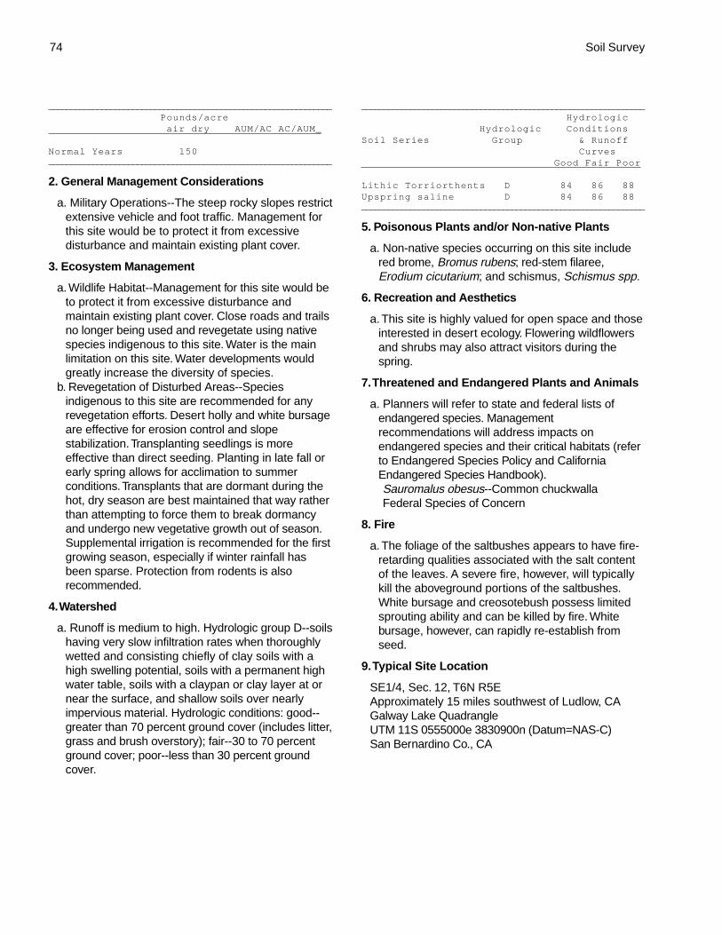
74 Soil Survey
________________________________________________________________
Pounds/acre air dry AUM/AC AC/AUM_
Normal Years 150________________________________________________________________
2. General Management Considerations
a. Military Operations--The steep rocky slopes restrictextensive vehicle and foot traffic. Management forthis site would be to protect it from excessivedisturbance and maintain existing plant cover.
3. Ecosystem Management
a. Wildlife Habitat--Management for this site would beto protect it from excessive disturbance andmaintain existing plant cover. Close roads and trailsno longer being used and revegetate using nativespecies indigenous to this site. Water is the mainlimitation on this site. Water developments wouldgreatly increase the diversity of species.
b. Revegetation of Disturbed Areas--Speciesindigenous to this site are recommended for anyrevegetation efforts. Desert holly and white bursageare effective for erosion control and slopestabilization. Transplanting seedlings is moreeffective than direct seeding. Planting in late fall orearly spring allows for acclimation to summerconditions. Transplants that are dormant during thehot, dry season are best maintained that way ratherthan attempting to force them to break dormancyand undergo new vegetative growth out of season.Supplemental irrigation is recommended for the firstgrowing season, especially if winter rainfall hasbeen sparse. Protection from rodents is alsorecommended.
4. Watershed
a. Runoff is medium to high. Hydrologic group D--soilshaving very slow infiltration rates when thoroughlywetted and consisting chiefly of clay soils with ahigh swelling potential, soils with a permanent highwater table, soils with a claypan or clay layer at ornear the surface, and shallow soils over nearlyimpervious material. Hydrologic conditions: good--greater than 70 percent ground cover (includes litter,grass and brush overstory); fair--30 to 70 percentground cover; poor--less than 30 percent groundcover.
________________________________________________________________
Hydrologic Hydrologic ConditionsSoil Series Group & Runoff Curves Good Fair Poor
Lithic Torriorthents D 84 86 88Upspring saline D 84 86 88________________________________________________________________
5. Poisonous Plants and/or Non-native Plants
a. Non-native species occurring on this site includered brome, Bromus rubens; red-stem filaree,Erodium cicutarium; and schismus, Schismus spp.
6. Recreation and Aesthetics
a. This site is highly valued for open space and thoseinterested in desert ecology. Flowering wildflowersand shrubs may also attract visitors during thespring.
7. Threatened and Endangered Plants and Animals
a. Planners will refer to state and federal lists ofendangered species. Managementrecommendations will address impacts onendangered species and their critical habitats (referto Endangered Species Policy and CaliforniaEndangered Species Handbook).Sauromalus obesus--Common chuckwallaFederal Species of Concern
8. Fire
a. The foliage of the saltbushes appears to have fire-retarding qualities associated with the salt contentof the leaves. A severe fire, however, will typicallykill the aboveground portions of the saltbushes.White bursage and creosotebush possess limitedsprouting ability and can be killed by fire. Whitebursage, however, can rapidly re-establish fromseed.
9. Typical Site Location
SE1/4, Sec. 12, T6N R5EApproximately 15 miles southwest of Ludlow, CAGalway Lake QuadrangleUTM 11S 0555000e 3830900n (Datum=NAS-C)San Bernardino Co., CA

Marine Corp Air Combat Center, Twentynine Palms, California 75
Sandhill 3-5" P.Z.Plant Symbol: LATR2/PLRI3Site Number: 030XB150CA
A. Physical Characteristics
1. Physiographic Features
a. This site occurs on thick sand sheets. Elevationsare 1830 to 3025 feet. Slopes range from 0 to 8percent.
2. Climatic Features
a. The climate on this site is arid characterized bywarm, moist winters (30 to 60 degrees F) and hot,dry summers (70 to 110 degrees F). The averageannual precipitation ranges from 2 to 6 inches withmost falling as rain from November to March.Approximately 45 percent of the annualprecipitation occurs from July to September as aresult of summer convection storms. Mean annualair temperature is 64 to 70 degrees F.
b. The average frost-free period is 240 to 300 days.
3. Interpretive Plant Community
a. The representative natural plant community isMojave Creosotebush Scrub or Big Galleta Series.This community is dominated by creosotebush andbig galleta. Potential vegetative composition isabout 60 percent grasses, 15 percent forbs, and 25percent shrubs.
b. The following table lists the major plant speciesand percentages by weight, air dry, of the total plantcommunity that each contributes in an averageproduction year. Fluctuations in speciescomposition and relative production may changefrom year to year dependent upon abnormalprecipitation or other climatic factors.
Shrubs and Trees (25 percent):___________________________________________________________________
Symbol Common Name % Composition (air-dry weight)
LATR2 Creosotebush 5-15AMDU2 White bursage 2-10SSSS Other shrubs 5-10** EPCA2 California ephedra OPEC Staghorn cholla BRIN Wooly brickellbush ENFR Bush encelia PETH4 Thurber sandpaper plant LEFR2 Desert alyssum PSEM Emory dalea ATCA2 Fourwing saltbush KRGR White ratany________________________________________________________________
** Allow no more than 3 percent of eachspecies of this group, and no more than 10percent in aggregate
Grasses and Grass-like Plants (60 percent):________________________________________________________________
Symbol Common Name % Composition (air-dry weight)
PLRI3 Big galleta 50-65ACHY Indian ricegrass 5-15PPGG Other perennial grasses T-5** SPCR Sand dropseedAAGG Other annual grasses T-5 BOBA2 Sixweeks grama________________________________________________________________
** Allow no more than 2 percent of eachspecies of this group, and no more than 5percent in aggregate
Forbs (15 percent):________________________________________________________________
Symbol Common Name % Composition (air-dry weight)
CRCA5 California croton 2-5PPFF Other perennial forbs 2-8** STEPH WirelettuceAAFF Other annual forbs T-20 DICA4 Desert dicoria OEDE2 Triangle eveningprimrose ABVI Desert sandverbena BAPL3 Wooly marigold ACCO3 Frostmat CRYPT Cryptantha________________________________________________________________
** Allow no more than 2 percent of eachspecies of this group, and no more than 8percent in aggregate
c. Approximate ground cover (basal and crown) is 10to 20 percent.
d. The historical plant community will produceapproximately the following amounts of air-dryherbage per acre:
________________________________________________________________
Estimated Total Annual Production Air-Dry Weight lbs./acre _
Favorable Years 1000Normal Years 700Unfavorable Years 450________________________________________________________________
e. Ecological dynamics: Surface disturbance mayreduce plant cover, density and diversity of thissite. These changes can be very subtle orextremely obvious depending on the intensity ofuse, rate of use and an assortment ofenvironmental factors (topography, rainfall, soiltype). As ecological condition deteriorates, biggalleta and other perennial grasses decrease.

76 Soil Survey
Short-lived perennials such as bush encelia,California croton and wirelettuce will initiallyincrease. Continued surface disturbance mayreduce the cover of the short-lived perennials aswell as the long-lived perennials such ascreosotebush and California ephedra. Whitebursage, a long-lived opportunistic species mayinitially increase. With a loss of perennial cover,non-native annual grasses and forbs such asschismus, red-stem filaree and Russian thistle willreadily invade this site. White burrobush andwirelettuce are the primary perennial pioneerspecies.
f. Major plant community types:Mojave Creosotebush Scrub or Big Galleta Series--
The historic site potential is characterized by anopen two-tiered canopy less than 2 meters tall withcreosotebush in the upper tier over the lower one ofwhite bursage and big galleta. A spectacular displayof annual forbs occurs during years of above-average precipitation. This site is stable in thiscondition.
g. Plant Growth CurvesGrowth Curve Number--CA3024Growth Curve Name--Big galletaDescription: Some green up in spring; dormant May
and June; most growth occurs after summerrains.
Percent of total production per month:____________________________________________________________________Jan Feb Mar Apr May Jun Jul Aug Sep Oct Nov Dec0 5 20 10 0 0 15 40 10 0 0 0____________________________________________________________________
Growth Curve Number--CA3015Growth Curve Name--CreosotebushDescription: Growth starts in early spring, flowering
and seed set occur by July. Dormancy occursduring the hot summer months. With sufficientsummer/fall precipitation, some vegetation maybreak dormancy and produce a flush of growth.
Percent of total production per month:____________________________________________________________________Jan Feb Mar Apr May Jun Jul Aug Sep Oct Nov Dec0 5 20 30 20 10 0 10 5 0 0 0____________________________________________________________________
Growth Curve Number--CA3004Growth Curve Name--White bursageDescription: Growth starts in early spring, flowering
and seed set occur by July. Dormancy occursduring the hot summer months. With sufficientsummer/fall precipitation, some vegetation maybreak dormancy and produce a flush of growth.
Percent of total production per month:____________________________________________________________________Jan Feb Mar Apr May Jun Jul Aug Sep Oct Nov Dec0 5 25 35 20 0 0 10 5 0 0 0_____________________________________________________________________
Growth Curve Number--CA3022Growth Curve Name--Indian ricegrassDescription: Growth starts in early spring with most
growth occurring from April to May. Flowering andseed set occur by July. Dormancy occurs during thehot summer months.
Percent of total production per month:_____________________________________________________________________Jan Feb Mar Apr May Jun Jul Aug Sep Oct Nov Dec0 5 15 30 35 5 0 5 5 0 0 0_____________________________________________________________________
4. Site Documentation
a. Principal sites that commonly occur in association withthis potential plant community include:(030XB137CA) Granitic Loam 3-5" P.Z.(030XB005NV) Limy 5-7" P.Z.(030XB148CA) Sandy Plain 3-5” P.Z.
b. Competing sites (and their differentiae) which aresimilar to this potential plant community:(030XB134CA) Cobbly Claypan 5-7" P.Z. [AMDU2
dominant shrub, ACHY minor grass](030XB137CA) Granitic Loam 3-5" P.Z. [AMDU2
dominant shrub; less productive site](030XB148CA) Sandy Plain 3-5" P.Z. [More productive
site]c. This ecological site description is based on the
following documentation:Sampling technique_4_ NV-ECS-1_1_ SCS-Range 417_4_ Other
5. Soils
a. The soils that characterize this site are very deep andsomewhat excessively drained. They are formed insandy eolian material blown from mixed rock sources.Surface textures are sands, coarse sands and loamyfine sands. Subsurface textures are sands, loamycoarse sands, loamy sands and coarse sands.Available water capacity is low and permeability israpid. Wind erosion hazard is severe. Effective rootingdepth is 60 inches or more.
_________________________________________________________________________
Representative Soil Map Units
105 Cajon-Arizo-Bluepoint complex, 2-8 percentslopes
110 Bluepoint sand, 2-8 percent slopes205 Bluepoint-Pipeflat-Cajon association, 0-4
percent slopes________________________________________________________________________
6. Wildlife Communities
a. Small mammals occurring on this site include round-tailed ground squirrels, white-tailed antelope squirrels,little pocket mice and desert kangaroo rats. Black-tailed

Marine Corp Air Combat Center, Twentynine Palms, California 77
jackrabbits, badgers and coyotes may also occur.b. Reptiles common to this site include lizards such
as Mojave fringe-toed lizards, side-blotched lizards,zebra-tailed lizards, side-blotched lizards, long-tailed brush lizards and western whiptails. This sitealso provides habitat for several species of snakesincluding western shovel-nosed snakes,sidewinders and glossy snakes. The sandysubsurface textures of may be a restrictive featureto burrowing reptiles.
c. Birds common to this site include horned larks,common ravens, loggerhead shrikes, LeConte’sthrashers and several species of sparrows.
B. Ecological Site Interpretations
1. Livestock Grazing
a. Season of Use--Other Mgt. Considerations: Biggalleta and Indian ricegrass are highly palatable tocattle and horses. White bursage is fair browse forcattle and horses, and fair to good browse forgoats. Sheep also use this shrub, feeding primarilyon new growth and seeds. White bursage is one ofthe major forage species of feral burros, especiallyin winter. Creosotebush is unpalatable to livestock.Domestic sheep use this shrub for shade. Duringfavorable years, annual forbs and grasses provideabundant forage.
b. General guide to initial stocking rate. Beforemaking specific recommendations, an on-siteevaluation must be made.
_______________________________________________________________________________
Pounds/acre air dry AUM/AC AC/AUM_
Normal Years 700________________________________________________________________
2. General Management Considerations
a. Military Operations--Management for this sitewould be to protect it from excessive disturbanceand maintain existing plant cover. Land clearing orother disturbances that destroy the vegetation canresult in accelerated erosion, severe soil blowingand barren areas.
3. Ecosystem Management
a. Wildlife Habitat--Management for this site would beto protect it from excessive disturbance andmaintain existing plant cover. Close roads and trailsno longer being used and revegetate using nativespecies indigenous to this site. Vehicle activity offof designated roads and tank trails may destroysmall mammal burrows. Removal of weedy specieswith an appropriate monitoring program is
recommended. Water developments would increasethe species diversity of this site.
b. Revegetation of Disturbed Areas--Speciesindigenous to this site are recommended for anyrevegetation efforts. White bursage is valuable forerosion control and cover restoration. Big galletahas moderate potential for erosion control and long-term revegetation and low potential for short-termrevegetation projects. Big galleta is somewhateffective at holding blowing sand because of itsisolated, clumped growth form. Creosotebush mayalso be used to rehabilitate disturbed sites. Onceestablished, creosotebush may improve sites forannual forbs and grasses. Transplanting seedlingsis more effective than direct seeding. Planting inlate fall or early spring allows for acclimation tosummer conditions. Transplants that are dormantduring the hot, dry season are best maintained thatway rather than attempting to force them to breakdormancy and undergo new vegetative growth outof season. Supplemental irrigation is recommendedfor the first growing season, especially if winterrainfall has been sparse. Protection from rodents isalso recommended.
A good stand of Indian ricegrass is also effective incontrolling wind erosion. Drilling Indian ricegrassseed in late fall at a depth of 2.5cm isrecommended. Deep planting the seed providesfavorable moisture relations in the seedbed,protection from wind deflation and protection fromgranivores.
4. Watershed
a. Runoff is negligible to very low. Hydrologic soilgroup A--soils having high infiltration rates evenwhen thoroughly wetted and consisting chiefly ofdeep, well drained to excessively drained sands orgravel. Hydrologic conditions: good--greater than 70percent ground cover (includes litter, grass andbrush overstory); fair--30 to 70 percent groundcover; poor--less than 30 percent ground cover.
_______________________________________________________________
Hydrologic Hydrologic ConditionsSoil Series Group & Runoff Curves Good Fair Poor
Bluepoint A 49 55 63_______________________________________________________________
5. Poisonous Plants and/or Non-native Plants
a. Russian thistle, Salsola tragus, Russian thistle,occurs in heavily disturbed areas. Other non-nativeplants occurring on this site include schismus,Schismus arabicus, and red-stem filaree, Erodium

78 Soil Survey
cicutarium.
6. Recreation and Aesthetics
a. This site is highly valued for open space and thoseinterested in desert ecology. Flowering wildflowersand shrubs may also attract visitors during thespring.
7. Threatened and Endangered Plants and Animals
a. Planners will refer to state and federal lists ofendangered species. Managementrecommendations will address impacts onendangered species and their critical habitats (referto Endangered Species Policy and CaliforniaEndangered Species Handbook).Eremophila alpestris--Horned larkFederal and State species of concernLanius ludovicianus--Loggerhead shrikeFederal and State species of concernUma scoparia--Mojave fringe-toed lizardSpecies of Special Concern (state level)Cynanchum utahense--Utah vine milkweedSpecies of limited distributionPenstemon albomarginatus--White-margined
beardtongueFederal candidate
8. Fire
a. Desert communities are usually unaffected by firebecause of low fuel loads, although a year ofexceptionally heavy winter rains can generate fuelsby producing a heavy stand of annual forbs andgrasses. If non-native annual forbs and grasses arepresent, the intensity and frequency of fires willincrease significantly. When fires do occur, theeffect on the ecosystem may be extreme due tothe harsh environment and the slow rate ofrecovery. Fire damage to big galleta varies,depending on whether plants are dormant whenburned. If plants are dry, damage may be severebecause the live center may be burned out. Biggalleta may resprout from rhizomes. Indianricegrass sustains slight damage by fire and canreestablish via seed dispersed from adjacentunburned areas. White bursage and creosotebushpossess limited sprouting ability, thus, can be killedby fire. White bursage, however, can rapidly re-establish from seed.
9. Typical Site Location
SE1/4, Sec. 3, T3N R8E;Approximately three miles north of Deadman LakeDeadman Lake SW QuadrangleUTM 11S 0579844e 3803367n (Datum=NAS-C)San Bernardino Co., CA

Marine Corp Air Combat Center, Twentynine Palms, California 79
Sandy Plain 3-5" P.Z.Plant Symbol: LATR2/PLRI3Site Number: 030XB148CA
A. Physical Characteristics
1. Physiographic Features
a. This site occurs on sand sheets and alluvial plains.Elevation is 2235 to 2800 feet. Slopes range from 0to 4 percent.
2. Climatic Features
a. The climate on this site is arid, characterized bywarm, moist winters (30 to 60 degrees F) and hot,somewhat dry summers (70 to 100 degrees F). Theaverage annual precipitation ranges from 2 to 6inches with most falling as rain from November toMarch. Approximately 30 percent to 45 percent ofthe annual precipitation occurs from July toSeptember as a result of summer convectionstorms. Mean annual air temperature is 64 to 70degrees F.
b. The average frost-free period is 240 to 300 days.
3. Interpretive Plant Community
a. The representative natural plant community isMojave Creosotebush Scrub or Big Galleta Series.Creosotebush and big galleta dominate thiscommunity. Potential vegetative composition isabout 70 percent grasses, 15 percent forbs, and 15percent shrubs.
b. The following table lists the major plant speciesand percentages by weight, air dry, of the total plantcommunity that each contributes in an averageproduction year. Fluctuations in speciescomposition and relative production may changefrom year to year dependent upon abnormalprecipitation or other climatic factors.
Shrubs and Trees (15 percent):___________________________________________________________________
Symbol Common Name % Composition (air-dry weight)
LATR2 Creosotebush 5-15SSSS Other shrubs 2-10** AMDU2 White bursage OPEC Staghorn cholla KRGR White ratany EPCA2 California ephedra ACSP Rayless goldenhead________________________________________________________________
** Allow no more than 2 percent of eachspecies of this group and no more than 10percent in aggregate
Grasses and Grass-like Plants (70 percent):_________________________________________________________________
Symbol Common Name % Composition (air-dry weight)
PLRI3 Big galleta 50-65ACHY Indian ricegrass 10-20PPGG Other perennial grasses 2-5** SPCR Sand dropseedAAGG Other annual grasses T-5 BOBA2 Sixweeks grama________________________________________________________________
** Allow no more than 2 percent of eachspecies of this group and no more than 5percent in aggregate
Forbs (15 percent):_________________________________________________________________
Symbol Common Name % Composition (air-dry weight)
CRCA5 California croton 2-8PPFF Other perennial forbs 2-5** SPAM2 Desert globemallowAAFF Other annual forbs T-20 ABVI Desert sandverbena OEDE Triangle eveningprimrose BAPL Wooly marigold OECL Browneyed eveningprimrose MAGL3 Desert dandelion CRYPT Cryptantha CHST Steve’s duskymaiden ASTRA Milkvetch________________________________________________________________
** Allow no more than 2 percent of eachspecies of this group and no more than 5percent in aggregate
c. Approximate ground cover (basal and crown) is 10to 20 percent.
d. The historical plant community will produceapproximately the following amounts of air-dryherbage per acre:
________________________________________________________________
Estimated Total Annual Production Air-Dry Weight lbs./acre _
Favorable Years 1400Normal Years 1000Unfavorable Years 700________________________________________________________________
e. Ecological dynamics: Surface disturbance mayreduce plant cover, density and diversity of thissite. These changes can be very subtle orextremely obvious depending on the intensity ofuse, rate of use and an assortment ofenvironmental factors (topography, soil type). Asecological condition deteriorates big galleta andother perennial grasses decrease. Short-livedperennials such as rayless goldenhead andCalifornia croton will initially increase. Continued

80 Soil Survey
surface disturbance may reduce the cover of theshort-lived perennials as well as the long-livedperennials such as creosotebush, white ratany andCalifornia ephedra. White bursage, a long-livedopportunistic species may initially increase. With aloss of perennial cover, non-native annual grasses andforbs such as schismus, red-stem filaree and Russianthistle will readily invade this site. White burrobush is aprimary perennial pioneer species.
f. Major plant community types:Mojave Creosotebush Scrub or Big Galleta Series--The
historic site potential is characterized by an open two-tiered canopy less than 2 meters tall with creosotebushin the upper tier over a dense stand of big galleta andIndian ricegrass. A spectacular display of annual forbsoccurs during years of above-average precipitation. Thissite is stable in this condition.
g. Plant Growth CurveGrowth Curve Number--CA3024Growth Curve Name--Big galletaDescription: Some green up in spring; dormant May
and June; most growth occurs after summer rains.Percent of total production per month:
___________________________________________________________________Jan Feb Mar Apr May Jun Jul Aug Sep Oct Nov Dec0 5 20 10 0 0 15 40 10 0 0 0___________________________________________________________________
Growth Curve Number--CA3015Growth Curve Name--CreosotebushDescription: Growth starts in early spring, flowering
and seed set occur by July. Dormancy occursduring the hot summer months. With sufficientsummer/fall precipitation, some vegetation maybreak dormancy and produce a flush of growth.
Percent of total production per month:___________________________________________________________________Jan Feb Mar Apr May Jun Jul Aug Sep Oct Nov Dec0 5 20 30 20 10 0 10 5 0 0 0___________________________________________________________________
Growth Curve Number--CA3022Growth Curve Name--Indian ricegrassDescription: Growth starts in early spring with most
growth occurring from April to May. Flowering andseed set occurs by July. Dormancy occurs duringthe hot summer months.
Percent of total production per month:___________________________________________________________________Jan Feb Mar Apr May Jun Jul Aug Sep Oct Nov Dec0 5 15 30 35 5 0 5 5 0 0 0___________________________________________________________________
4. Site Documentation
a. Principal sites that commonly occur in associationwith this potential plant community include:(030XB137CA) Granitic Loam 3-5" P.Z.(030XB150CA) Sandhill 3-5" P.Z.
(030XB005NV) Limy 5-7" P.Z.b. Competing sites (and their differentiae) which are
similar to this potential plant community:(030XB137CA) Granitic Loam 3-5" P.Z. [AMDU2
dominant shrub; less productive site](030XB150CA) Sandhill 3-5" P.Z. [Less productive
site](030XB039NV) Limy Fan 5-7" P.Z. [MUPO2
present]c. This ecological site description is based on the
following documentation:Sampling technique_1_ NV-ECS-1_2_ SCS-Range 417_3_ Other
5. Soils
a. The soils that characterize this site are very deepand somewhat excessively drained. They areformed in eolian and alluvial deposits. Surfacetextures are sands. Subsurface textures are sands,fine sandy loams, loamy sands and silt loams.These soils are moderately to very stronglyalkaline. Available water capacity is low andpermeability is rapid. Wind erosion hazard is verysevere. Effective rooting depth is 60 inches ormore.
_________________________________________________________________________
Representative Soil Map Units
100 Cajon-Pipeflat association, 2-8 percent
slopes
205 Bluepoint-Pipeflat-Cajon association, 0-
4 percent slopes________________________________________________________________________
6. Wildlife Communities
a. Small mammals occurring on this site includeround-tailed ground squirrels, little pocket mice, andMerriam's and desert kangaroo rats. Black-tailedjackrabbits and coyotes are also common.
b. Reptiles occurring on this site include severalspecies of lizards including Mojave fringe-toedlizards, long-tailed brush lizards, side-blotchedlizards, and western whiptails. Common snakesinclude western shovel-nosed snakes, glossysnakes and sidewinders. The sandy subsurface soiltextures may be a restrictive feature for burrowingreptiles, such as the desert tortoise.
c. Birds common to this site include horned larks,common ravens, loggerhead shrikes, LeConte'sthrashers and several species of sparrows. Raptorsobserved on this site include northern harriers,sharp-shinned hawks and American kestrels.

Marine Corp Air Combat Center, Twentynine Palms, California 81
B. Ecological Site Interpretations
1. Livestock Grazing
a. Season of Use--Other Mgt. Considerations: Biggalleta and Indian ricegrass are highly palatable tocattle and horses. White bursage is fair browse forcattle and horses, and fair to good browse forgoats. Sheep also use this shrub, feeding primarilyon new growth and seeds. Creosotebush isunpalatable to livestock. Domestic sheep use thisshrub for shade. During favorable years, annualforbs and grasses provide abundant forage.
b. General guide to initial stocking rate. Beforemaking specific recommendations, an on-siteevaluation must be made.
________________________________________________________________
Pounds/acre air dry AUM/AC AC/AUM_
Normal Years 1000________________________________________________________________
2. General Management Considerations
a. Military Operations--Management for this sitewould be to protect it from excessive disturbanceand maintain existing plant cover. Land clearing orother disturbances that destroy the vegetation andsoil structure can result in soil compaction reducedinfiltration rates, accelerated erosion, severe soilblowing and barren areas.
3. Ecosystem Management
a. Wildlife Habitat--Management for this site would beto protect it from excessive disturbance andmaintain existing plant cover. Close roads and trailsno longer being used and revegetate using nativespecies indigenous to this site. Vehicle activity offof designated roads and tank trails can destroysmall mammal burrows. Removal of weedy specieswith an appropriate monitoring program isrecommended. Water is the main limitation to thissite. Water developments would increase thespecies diversity of this site.
b. Revegetation of Disturbed Areas--Speciesindigenous to this site are recommended for anyrevegetation efforts.Big galleta has moderate potential for erosion
control and long-term revegetation and lowpotential for short-term revegetation projects. Biggalleta is somewhat effective at holding blowingsand because of its isolated, clumped growthform. Creosotebush and white bursage are alsovaluable for erosion control and cover restoration.Once established, creosotebush may improvesites for annual forbs and grasses.
Transplanting seedlings is more effective thandirect seeding. Planting in late fall or early springallows for acclimation to summer conditions.Transplants that are dormant during the hot, dryseason are best maintained that way rather thanattempting to force them to break dormancy andundergo new vegetative growth out of season.Supplemental irrigation is recommended for thefirst growing season, especially if winter rainfallhas been sparse. Protection from rodents is alsorecommended.
A good stand of Indian ricegrass is also effectivein controlling wind erosion. Drilling Indianricegrass seed in late fall at a depth of 2.5cm isrecommended. Deep planting the seed providesfavorable moisture relations in the seedbed,protection from wind deflation and protection fromgranivores.
4. Watershed
a. Runoff is very low. Hydrologic group B--soilshaving moderate infiltration rates when thoroughlywetted and consisting chiefly of moderately deep todeep, moderately well drained to well drained soilswith moderately fine to moderately coarse textures.Hydrologic conditions: good--greater than 70percent ground cover (includes litter, grass andbrush overstory); fair--30 to 70 percent groundcover; poor--less than 30 percent ground cover.
________________________________________________________________
Hydrologic Hydrologic ConditionsSoil Series Group & Runoff Curves Good Fair Poor
Pipeflat B 68 72 77________________________________________________________________
5. Poisonous Plants and/or Non-native Plants
a. Russian thistle, Salsola tragus, Russian thistle,occurs in heavily disturbed areas. Other non-nativeplants occurring on this site include schismus,Schismus barbatus, and red-stem filaree, Erodiumcicutarium.
6. Recreation and Aesthetics
a. This site is highly valued for open space and thoseinterested in desert ecology. Flowering wildflowersand shrubs may also attract visitors during thespring.
7. Threatened and Endangered Plants and Animals
a. Planners will refer to state and federal lists ofendangered species. Managementrecommendations will address impacts on

82 Soil Survey
endangered species and their critical habitats (referto Endangered Species Policy and CaliforniaEndangered Species Handbook).Uma scoparia--Mojave fringe-toed lizardSpecies of special concern (state level)Eremophila alpestris--Horned larkFederal and State species of concernLanius ludovicianus--Loggerhead shrikeFederal and State species of concernCynanchum utahense--Utah vine milkweedSpecies of limited distribution
8. Fire
a. Desert communities are usually unaffected by firebecause of low fuel loads, although a year ofexceptionally heavy winter rains can generate fuelsby producing a heavy stand of annual forbs andgrasses. When fires do occur, the effect on theecosystem may be extreme due to the harsh
environment and the slow rate of recovery. Firedamage to big galleta varies; depending on whetherplants are dormant when burned. If plants are dry,damage may be severe because the live centermay be burned out. Big galleta may resprout fromrhizomes. Indian ricegrass sustains slight damageby fire and can reestablish via seed dispersed fromadjacent unburned areas. White bursage andcreosotebush possess limited sprouting ability,thus, can be killed by fire. White bursage, however,can rapidly re-establish from seed.
9. Typical Site Location
SE1/4 Sec. 13 T3N R6EApproximately 15 miles north of Joshua Tree, CAGoat Mountain QuadrangleUTM 11S 0564131e 3800842n (Datum=NAS-C)San Bernardino Co., CA

Marine Corp Air Combat Center, Twentynine Palms, California 83
Shallow Gravelly Loam 5-7" P.Z.Plant Symbol: CORA-MESP2/PLRI3-ACSP12Site Number: 030XB151CA
A. Physical Characteristics
1. Physiographic Features
a. This site occurs on sideslopes of mountains on allexposures. Elevation is 3195 to 4400 feet. Slopesrange from 8 to 50 percent.
2. Climatic Features
a. The climate on this site is arid, characterized bywarm, moist winters (30 to 60 degrees F) and hot,somewhat dry summers (70 to 100 degrees F). Theaverage annual precipitation ranges from 4 to 7inches with most falling as rain from November toMarch. Approximately 30 percent of the annualprecipitation occurs from July to September as aresult of summer convection storms. Mean annualair temperature is 57 to 63 degrees F.
b. The average frost-free period is 180 to 240 days.
3. Interpretive Plant Community
a. The representative natural plant community isBlackbush Scrub or Black Bush Series. Thiscommunity is dominated by blackbrush, spinymenodora, big galleta and desert needlegrass.Potential vegetative composition is about 15percent grasses, 15 percent forbs, and 70 percentshrubs.
b. The following table lists the major plant speciesand percentages by weight, air dry, of the total plantcommunity that each contributes in an averageproduction year. Fluctuations in speciescomposition and relative production may changefrom year to year dependent upon abnormalprecipitation or other climatic factors.
Shrubs and Trees (70 percent):___________________________________________________________________
Symbol Common Name % Composition (air-dry weight)
CORA Blackbrush 35-50MESP2 Spiny menodora 5-15EPNE Nevada ephedra 5-15LATR2 Creosotebush 2-8YUSC2 Mojave yucca 1-3SSSS Other shrubs 10-20** KRER Range ratany KRGR White ratany PSARS Mojave indigo bush AMDU2 White bursage
XYTOT Mojave aster THMO Turpentinebroom KRLA2 Winterfat LYAN Anderson wolfberry ERFA2 California buckwheat ACGR Catclaw acacia LEFR2 Desert alyssum ENAC Acton encelia ECPO2 Hedgehog barrel cactus________________________________________________________________
** Allow no more than 5 percent of eachspecies of this group and no more than 20percent in aggregate
Grasses and Grass-like Plants (15 percent):_________________________________________________________________
Symbol Common Name % Composition (air-dry weight)
PLRI3 Big galleta 5-10ACSP12 Desert needlegrass 2-5PPGG Other perennial grasses 2-5** ERPU8 Fluffgrass ACHY Indian ricegrassAAGG Other annual grasses T-5________________________________________________________________
** Allow no more than 2 percent of eachspecies of this group and no more than 5percent in aggregate
Forbs (15 percent):_________________________________________________________________
Symbol Common Name % Composition (air-dry weight)
SPAM2 Desert globemallow 2-5PPFF Other perennial forbs 2-8** ERIN4 Desert trumpet STEPH Wirelettuce ASTRA MilkvetchAAFF Other annual forbs T-10 OECL Browneyed eveningprimrose PHACE Phacelia CRYPT Cryptantha ERIAS Eriastrum________________________________________________________________
** Allow no more than 2 percent of eachspecies of this group and no more than 8percent in aggregate
c. Approximate ground cover (basal and crown) is 20to 35 percent.
d. The historical plant community will produceapproximately the following amounts of air-dryherbage per acre:
________________________________________________________________
Estimated Total Annual Production Air-Dry Weight lbs./acre _
Favorable Years 500Normal Years 300Unfavorable Years 200________________________________________________________________

84 Soil Survey
e. Ecological dynamics: Blackbrush is a long-liveddominant on older, undisturbed geomorphic surfaces.Succession occurs at a very slow rate. Increasing incover and density, this shrub becomes more dominantover time. Following a fire, blackbrush decreases or isremoved from the community and Californiabuckwheat and the perennial grasses will increase.Non-native annual grasses and forbs, such as redbrome, schismus and red-stem filaree are post-fireinvaders on this site. Current knowledge indicates thatthe return of blackbrush may take many years.
f. Major plant community types:Blackbush Scrub or Black Bush Series--The historic
site potential is characterized by low, oftenintricately branched shrubs, 0.5 to 2 meters tall,with an open or continuous canopy. This site isdominated by blackbrush. Perennial grasses andforbs are common. Annuals are seasonally present.Pockets of cryptogamic crust have developedbetween the surface rock fragments. This site isstable in this condition.
g. Plant Growth CurveGrowth Curve Number--CA3018Growth Curve Name--BlackbrushDescription: Growth starts in early spring; flowering
and seed set occur by July.Percent of total production per month:
_________________________________________________________________________________________________________________________________Jan Feb Mar Apr May Jun Jul Aug Sep Oct Nov Dec0 10 30 35 20 5 0 0 0 0 0 0___________________________________________________________________________
Growth Curve Number--CA3013Growth Curve Name--Spiny menodoraDescription: Growth starts in spring, flowering and
seed set occur by June.Percent of total production per month:
________________________________________________________________________Jan Feb Mar Apr May Jun Jul Aug Sep Oct Nov Dec0 10 30 35 20 5 0 0 0 0 0 0_____________________________________________________________________
Growth Curve Number--CA3024Growth Curve Name--Big galletaDescription: Some green up in spring; dormant May
and June; most growth occurs after summer rains.Percent of total production per month:
_____________________________________________________________________Jan Feb Mar Apr May Jun Jul Aug Sep Oct Nov Dec0 5 20 10 0 0 15 40 10 0 0 0_______________________________________________________________________________
Growth Curve Number--AZ3087Growth Curve Name--Desert needlegrassDescription: Growth starts in spring; most growth
occurs in summer and seed set occurs by latesummer.
Percent of total production per month:_____________________________________________________________________Jan Feb Mar Apr May Jun Jul Aug Sep Oct Nov Dec0 5 15 25 20 15 15 5 0 0 0 0_____________________________________________________________________
4. Site Documentation
a. Principal sites that commonly occur in associationwith this potential plant community include:(030XB001NV) Limy Hill 5-7" P.Z.(030XB145CA) Valley Wash
b. Competing sites (and their differentiae) which aresimilar to this potential plant community:(030XB029NV) Shallow Gravelly Loam 5-7" P.Z.
[MESP2, EPNE minor components](030XB143CA) Shallow Granitic Loam 5-7" P.Z.
[LATR2 important shrub; more productive site](030XB144CA) Shallow Granitic Slope 5-7" P.Z.
[ACSP12 dominant grass; less productive site]c. This ecological site description is based on the
following documentation:Sampling technique_1_ NV-ECS-1___ SCS-Range 417_3_ Other
5. Soils
a. The soils that characterize this site are shallow andvery shallow and well drained. They are formed inresiduum and colluvium from granitic sources. Surfacetextures are very gravelly loamy coarse sands, loamycoarse sands and loamy sands. Subsurface texturesare very gravelly sandy loams, coarse sandy loamsand sandy loams. Available water capacity is very lowand permeability is moderately rapid. Wind erosionhazard is negligible due to surface rock fragments.Effective rooting depth is 8 to 20 inches to hardgranitic bedrock.
_________________________________________________________________________
Representative Soil Map Units
190 Lavabed-Dalvord association, 8-50 percentslopes
________________________________________________________________________
6. Wildlife Communities
a. Small mammals occurring on this site include white-tailed antelope squirrels, Botta's pocket gophers, littleand long-tailed pocket mice, Merriam's kangaroo rats,cactus mice and southern grasshopper mice. Black-tailed jackrabbits, bobcats and coyotes also occur.
b. Reptiles occurring on this site include zebra-tailedlizards, long-nosed leopard lizards, desert spinylizards, side-blotched lizards, desert night lizards andwestern whiptails. The depth to bedrock is a restrictivefeature for burrowing reptiles such as the deserttortoise, although desert tortoises may occur in

Marine Corp Air Combat Center, Twentynine Palms, California 85
adjacent washes.c. Songbirds common to this site include mourning
doves, lesser nighthawks, ash-throated flycatchers,horned larks, verdins, cactus wrens, rock wrens,mountain bluebirds, loggerhead shrikes, housefinches and several species of sparrows. Red-tailedhawks also occur.
B. Ecological Site Interpretations
1. Livestock Grazing
a. Season of Use--Other Mgt. Considerations: Thissite has limited use for livestock grazing due to lowproductivity and lack of stock water. Blackbrush isfair winter browse for sheep and cattle. It is betterutilized by sheep and goats than cattle. Nevadaephedra is rated good to fair forage for goats and fairto poor for cattle and sheep. The spines of spinymenodora keep it from being heavily utilized bylivestock. Big galleta is highly palatable to cattle andhorses. Desert needlegrass produces considerablebasal foliage and is valuable forage while young.During favorable years, annual forbs and grassesprovide additional forage on this site.
b. General guide to initial stocking rate. Before makingspecific recommendations, an on-site evaluationmust be made.
_____________________________________________________________
Pounds/acre air dry AUM/AC AC/AUM_
Normal Years 300_____________________________________________________________
2. General Management Considerations
a. Military Operations--Management for this site wouldbe to protect it from excessive disturbance andmaintain existing plant cover. Land clearing or otherdisturbances that destroy the vegetation and the soilcrust and structure can result in soil compaction,reduced infiltration rates, accelerated erosion, soilblowing and barren areas. The frequency of flashflooding may also increase with increased surfacerunoff and loss of vegetative cover.
3. Ecosystem Management
a. Wildlife Habitat--Management for this site would beto protect it from excessive disturbance andmaintain existing plant cover. Close roads and trailsno longer being used and revegetate using nativespecies indigenous to this site. Water is the mainlimitation on this site; thus, water developmentswould increase the species diversity.
b. Revegetation of Disturbed Areas--Speciesindigenous to this site are recommended for any
revegetation efforts.Blackbrush has medium erosion control potential,
low establishment requirements and low long andshort-term revegetation potential. Nevadaephedra forms dense, spreading colonies, whichmake it valuable for soil stabilization.Creosotebush may also be used to rehabilitatedisturbed sites. Once established, creosotebushmay improve sites for annual forbs and grasses.Big galleta has moderate potential for erosioncontrol and long-term revegetation and lowpotential for short-term revegetation projects. Biggalleta is somewhat effective at holding blowingsand because of its isolated, clumped growthform. Desert needlegrass may be used forrevegetation in areas of light disturbance, but it issusceptible to excessive trampling.
Transplants are more effective than direct seeding,although Nevada ephedra seedlings are verytolerant of drought and generally establish wellfollowing fall or winter seedings. Plantingseedlings in late fall or early spring allows foracclimation to summer conditions. Transplantsthat are dormant during the hot, dry season arebest maintained that way rather than attemptingto force them to break dormancy and undergonew vegetative growth out of season.Supplemental irrigation is recommended for thefirst growing season, especially if winter rainfallhas been sparse. Summer annuals and non-native species should be removed from aroundtransplants to reduce competition for water.Protection from rodents is also recommended.
4. Watershed
a. Runoff is medium. Hydrologic group D--soils havingvery slow infiltration rates when thoroughly wettedand consisting chiefly of clay soils with a highswelling potential, soils with a permanent high watertable, soils with a claypan or clay layer at or nearthe surface, and shallow soils over nearlyimpervious material. Hydrologic conditions: good--greater than 70 percent ground cover (includeslitter, grass and brush overstory); fair--30 to 70percent ground cover; poor--less than 30 percentground cover.
______________________________________________________________
Hydrologic Hydrologic ConditionsSoil Series Group & Runoff Curves Good Fair Poor
Lavabed D 84 86 88_____________________________________________________________

86 Soil Survey
5. Poisonous Plants and/or Non-native Plants
a. Non-native species occurring on this site includered brome, Bromus rubens; red-stem filaree,Erodium cicutarium; and schismus, Schismus spp.
6. Recreation and Aesthetics
a. This site is highly valued for open space and thoseinterested in desert ecology. Flowering wildflowersand shrubs may also attract visitors during thespring.
7. Threatened and Endangered Plants and Animals
a. Planners will refer to state and federal lists ofendangered species. Managementrecommendations will address impacts onendangered species and their critical habitats (referto Endangered Species Policy and CaliforniaEndangered Species Handbook).Gopherus agassizii--Desert TortoiseFederal and State threatenedEremophila alpestris--Horned larkFederal and State species of concernLanius ludovicianus--Loggerhead shrikeFederal and State species of concern
8. Fire
a. Desert communities are usually unaffected by firebecause of low fuel loads, although a year ofexceptionally heavy winter rains can generate fuelsby producing a heavy stand of annual forbs andgrasses. When fires do occur, the effect on theecosystem may be extreme due to the harshenvironment and the slow rate of recovery.Blackbrush and creosotebush possess limitedsprouting ability, thus, can be killed by highintensity fires. Both species are very slow to re-invade burned areas. Nevada ephedra and desertneedlegrass are reported to resprout from the rootcrown after fire damages aboveground vegetation.Fire damage to big galleta varies; depending onwhether plants are dormant when burned. If plantsare dry, damage may be severe because the livecenter may be burned out. Big galleta may resproutfrom rhizomes.
9. Typical Site Location
NE1/4 Sec. 30, T7N R5EApproximately 18 miles southwest of Ludlow, CASunshine Peak QuadrangleUTM 11S 0546330e 3837015n (Datum=NAS-C)San Bernardino Co., CA

Marine Corp Air Combat Center, Twentynine Palms, California 87
Sodic Dune 3-5" P.Z.Plant Symbol: ATCA2-SUMOSite Number: 030XY127CA
A. Physical Characteristics
1. Physiographic Features
a. This site occurs on partially stabilized sand dunesand shrub-coppice dunes. Elevation is 1745 to 2915feet. Slopes range from 0 to 15 percent.
2. Climatic Features
a. The climate on this site is arid characterized bywarm, moist winters (30 to 60 degrees F) and hot,dry summers (70 to 110 degrees F). The averageannual precipitation ranges from 2 to 6 inches withmost falling as rain from November to March.Approximately 30 percent to 45 percent of theannual precipitation occurs from July to Septemberas a result of summer convection storms. Meanannual air temperature is 64 to 75 degrees F.
b. The average frost-free period is 240 to 360 days.
3. Interpretive Plant Community
a. The representative natural plant community isStabilized and Partially Stabilized Desert Dunes orFourwing Saltbush Series. This community isdominated by fourwing saltbush and Mojaveseablite. Potential vegetative composition is about10 percent grasses, 10 percent forbs, and 80percent shrubs.
b. The following table lists the major plant speciesand percentages by weight, air dry, of the total plantcommunity that each contributes in an averageproduction year. Fluctuations in speciescomposition and relative production may changefrom year to year dependent upon abnormalprecipitation or other climatic factors.
Shrubs and Trees (80 percent):___________________________________________________________________
Symbol Common Name % Composition (air-dry weight)
ATCA2 Fourwing saltbush 50-60SUMO Mojave seablite 10-20ATPO Allscale saltbush 5-15SSSS Other shrubs T-10** LATR2 Creosotebush________________________________________________________________
** Allow no more than 3 percent of eachspecies of this group, and no more than 10percent in aggregate
Grasses and Grass-like Plants (10 percent):___________________________________________________________________
Symbol Common Name % Composition (air-dry weight)
PPGG Other perennial grasses T-5** SPAI Alkali sacaton DISP Inland saltgrassAAGG Other annual grasses T-5________________________________________________________________
** Allow no more than 2 percent of eachspecies of this group, and no more than 5percent in aggregate
Forbs (10 percent):___________________________________________________________________
Symbol Common Name % Composition (air-dry weight)
PPFF Other perennial forbs T-5**AAFF Other annual forbs T-10 BAPL Wooly marigold OEDE Triangle evening primrose GECA2 Desert sunflower________________________________________________________________
** Allow no more than 2 percent of eachspecies of this group, and no more than 5percent in aggregate
c. Approximate ground cover (basal and crown) is 10to 20 percent.
d. The historical plant community will produceapproximately the following amounts of air-dryherbage per acre:
_____________________________________________________________
Estimated Total Annual Production Air-Dry Weight lbs./acre _
Favorable Years 700Normal Years 500Unfavorable Years 300________________________________________________________________
e. Ecological dynamics: As ecological conditiondeteriorates the perennial grasses will decrease.Fourwing saltbush and Mojave seablite willincrease. Non-native annual forbs and grasses suchas Russian thistle and schismus will invade thissite.
f. Major plant community types:Stabilized and Partially stabilized Desert Dunes or
Fourwing Saltbush Series--The historic sitepotential is wind blown sand accumulations thatare stabilized or partially stabilized by shrubs,scattered low annuals and perennial grasses. Thetotal cover increases as the dunes areprogressively stabilized. This site ischaracterized by an open to fairly dense stand of

88 Soil Survey
shrubs dominated by Atriplex canescens, A.polycarpa and Suaeda moquinii. Perennial grassesare sparse. Annuals are seasonally present. Duneswill retain water just below the surface allowing theperennial vegetation to survive long drought periods.This site is stable in this condition.
g. Plant Growth CurvesGrowth Curve Number--CA3008Growth Curve Name--Fourwing SaltbushDescription: Growth begins in spring to early summer,
flowering occurs in May through September; fruitripens from October to December, with seeddispersal from October through April. Seed mayremain on the plants for one to two years.
Percent of total production per month:_____________________________________________________________________Jan Feb Mar Apr May Jun Jul Aug Sep Oct Nov Dec0 0 5 25 35 15 10 5 5 0 0 0_____________________________________________________________________
Growth Curve Number--CA3010Growth Curve Name--Mojave SeabliteDescription: Growth begins in early spring; flowering
occurs from July to September.Percent of total production per month:
_____________________________________________________________________Jan Feb Mar Apr May Jun Jul Aug Sep Oct Nov Dec0 0 5 15 20 30 15 10 5 0 0 0_____________________________________________________________________
Growth Curve Number--CA3007Growth Curve Name--Allscale SaltbushDescription: Growth begins in early spring; flowers
and sets seed by October.Percent of total production per month:
_____________________________________________________________________Jan Feb Mar Apr May Jun Jul Aug Sep Oct Nov Dec0 10 15 30 20 10 5 5 5 0 0 0_____________________________________________________________________
4. Site Documentation
a. Principal sites that commonly occur in associationwith this potential plant community include:(030XY047NV) Alluvial Plain(030XY154CA) Dune 3-5” P.Z.
b. Competing sites (and their differentiae) which aresimilar to this potential plant community:(030XB142CA) Sandy 5-7" P.Z. [KRLA2 co-dominant;
ACHY dominant grass; less productive site](030XY133CA) Sodic Sand 3-5" P.Z. [LATR2
important shrub; less productive site](030XY154CA) Dune 3-5" P.Z. [PRGLT dominant
shrub; more productive site]c. This ecological site description is based on the
following documentation:Sampling technique_2_ NV-ECS-1
_1_ SCS-Range 417___ Other
5. Soils
a. The soils that characterize this site are very deepand somewhat excessively drained. They areformed in sandy eolian material blown from recentalluvium. Surface textures are loam sands andloamy fine sands. Subsurface textures are loamyfine sands and fine sands. Available water capacityis low and permeability is rapid. Wind erosionhazard is severe. Effective rooting depth is 60inches or more. Water tables are greater than 60inches.
_________________________________________________________________________
Representative Soil Map Units
901 Bluepoint, minor component in TypicHaplosalids
903 Typic Torriorthents minor component inTypic Haplosalids, clayey
________________________________________________________________________
6. Wildlife Communities
a. This site provides habitat for small mammals suchas desert kangaroo rats and southern grasshoppermice. Coyotes and black-tailed jackrabbits mayalso occur. Fourwing saltbush is a preferred browsefor rabbits and small mammals. The seeds are alsoreadily eaten.
b. This site provides habitat for reptiles such asMojave fringe-toed lizards, western whiptails, side-blotched lizards and sidewinders. The sandytextures of the soil are a restrictive feature forburrowing reptiles, such as the desert tortoise.
c. Birds common to this site include common ravens,loggerhead shrikes, horned larks, blue-graygnatcatchers, and several species of sparrows.Upland game birds and small nongame birds readilyeat seeds of fourwing saltbush.
B. Ecological Site Interpretations
1. Livestock Grazing
a. Season of Use--Other Mgt. Considerations:Allscale and fourwing saltbush are valuable browsefor domestic livestock. Fourwing saltbush has fairto good forage value for domestic sheep and goats,and at least fair forage value for cattle. Fourwingsaltbush can withstand heavy grazing, however,overgrazing can eliminate allscale saltbush fromthis site.
b. General guide to initial stocking rate. Beforemaking specific recommendations, an on-siteevaluation must be made.
________________________________________________________________

Marine Corp Air Combat Center, Twentynine Palms, California 89
Pounds/acre air dry AUM/AC AC/AUM_
Normal Years 500________________________________________________________________
2. General Management Considerations
a. Military Operations--Management for this sitewould be to protect it from excessive disturbanceand maintain existing plant cover. Land clearing orother disturbances that destroy the vegetation canresult in accelerated erosion, severe soil blowing,barren areas and the introduction of non-nativeweedy species. Off-road vehicle use may destroysmall mammal burrows.
3. Ecosystem Management
a. Wildlife Habitat--Management for this site would beto protect it from excessive disturbance andmaintain existing plant cover. Close roads and trailsno longer being used and revegetate using nativespecies indigenous to this site. Removal of non-native species and an appropriate monitoringprogram are also recommended.
b. Revegetation of Disturbed Areas--Speciesindigenous to this site are recommended for anyrevegetation efforts. Fourwing saltbush has beenwidely used for rehabilitating sites in southern andnorthern desert shrublands. Seed may bebroadcast or drill-seeded, but broadcasting oftenproduces better results. Seeding success isgenerally sporadic. Seedlings, which tend to bemore drought tolerant and less susceptible topredation, may be transplanted. Seedlings aregenerally transplanted during the early spring, sincethree weeks or more of good soil moisture arerequired for establishment.
4. Watershed
a. Runoff is very low. Hydrologic soil group A--soilshaving high infiltration rates even when thoroughlywetted and consisting chiefly of deep, well drainedto excessively drained sands or gravel. Hydrologicconditions: good--greater than 70 percent groundcover (includes litter, grass and brush overstory);fair--30 to 70 percent ground cover; poor--less than30 percent ground cover.
________________________________________________________________
Hydrologic Hydrologic ConditionsSoil Series Group & Runoff Curves Good Fair Poor
Bluepoint A 49 55 63Typic Torriorthents A 49 55 63________________________________________________________________
5. Poisonous Plants and/or Non-native Plants
a. Russian thistle, Salsola tragus, occurs in heavilydisturbed areas. Schismus, Schismus arabicus,also occurs.
6. Recreation and Aesthetics
a. This site is highly valued for open space and thoseinterested in desert ecology. Flowering wildflowersmay also attract visitors during the spring.
7. Threatened and Endangered Plants and Animals
a. Planners will refer to state and federal lists ofendangered species. Managementrecommendations will address impacts onendangered species and their critical habitats (referto Endangered Species Policy and CaliforniaEndangered Species Handbook).Uma scoparia--Mojave fringe-toed lizardSpecies of Special Concern (state level)Eremophila alpestris--Horned larkFederal and State species of concernLanius ludovicianus--Loggerhead shrikeFederal and State species of concern
8. Fire
a. The foliage of the chenopods appear to have fire-retarding qualities associated with the salt contentof the leaves. A severe fire, however, will typicallykill the aboveground portions. If burned, saltbushescan resprout from the root crown or undergroundportions of the stem. These species can alsoreestablish sites through an abundance of wind-dispersed seed from adjacent unburned sites.
9. Typical Site Location
SE1/4 Sec. 23, T7N R6EApproximately 10 miles southwest of Ludlow, CALavic Lake QuadrangleUTM 11S 0561600e 3837500n (Datum=NAS-C)San Bernardino Co., CA

90 Soil Survey
Sodic Sand 3-5" P.Z.Plant Symbol: ATCA2-LATR2Site Number: 030XY133CA
A. Physical Characteristics
1. Physiographic Features
a. This site occurs on partially stabilized sand dunesand shrub-coppice dunes. Elevation is 595 to 1935feet. Slopes range from 4 to 30 percent.
2. Climatic Features
a. The climate on this site is arid characterized bywarm, moist winters (30 to 60 degrees F) and hot,dry summers (70 to 110 degrees F). The averageannual precipitation ranges from 2 to 6 inches withmost falling as rain from November to March.Approximately 30 percent of the annualprecipitation occurs from July to September as aresult of summer convection storms. Mean annualair temperature is 70 to 75 degrees F.
b. The average frost-free period is 300 to 360 days.
3. Interpretive Plant Community
a. The representative natural plant community isStabilized and Partially Stabilized Desert Dunes orFourwing Saltbush Series. Fourwing saltbush andcreosotebush dominate this community. Potentialvegetative composition is about 10 percentgrasses, 10 percent forbs, and 80 percent shrubs.
b. The following table lists the major plant speciesand percentages by weight, air dry, of the total plantcommunity that each contributes in an averageproduction year. Fluctuations in speciescomposition and relative production may changefrom year to year dependent upon abnormalprecipitation or other climatic factors.
Shrubs and Trees (80 percent):___________________________________________________________________
Symbol Common Name % Composition (air-dry weight)
ATCA2 Fourwing saltbush 35-50LATR2 Creosotebush 15-25ATPO Allscale saltbush 5-15SSSS Other shrubs 2-10** HYSA White burrobush AMDU2 White bursage SUMO Mojave seablite________________________________________________________________
** Allow no more than 3 percent of eachspecies of this group and no more than 10percent in aggregate
Grasses and Grass-like Plants (10 percent):___________________________________________________________________
Symbol Common Name % Composition (air-dry weight)
PPGG Other perennial grasses 2-8** ACHY Indian ricegrass PLRI3 Big galletaAAGG Other annual grasses T-5 BOBA2 Sixweeks grama________________________________________________________________
** Allow no more than 2 percent of eachspecies of this group and no more than 5percent in aggregate
Forbs (10 percent):___________________________________________________________________
Symbol Common Name % Composition (air-dry weight)
PPFF Other perennial forbs T-5** CRCA5 California croton HEUN2 DesertlilyAAFF Other annual forbs T-10 OEDE2 Triangle eveningprimrose GECA2 Desert sunflower PAARA Spanish needle BAPL Wooly marigold CRYPT Cryptantha PLOV Desert Indianwheat OECL Browneyed eveningprimrose________________________________________________________________
** Allow no more than 2 percent of eachspecies of this group and no more than 5percent in aggregate
c. Approximate ground cover (basal and crown) is 5to 15 percent.
d. The historical plant community will produceapproximately the following amounts of air-dryherbage per acre:
________________________________________________________________
Estimated Total Annual Production Air-Dry Weight lbs./acre _
Favorable Years 700Normal Years 500Unfavorable Years 300________________________________________________________________
e. Ecological dynamics: As ecological conditiondeteriorates the perennial grasses will decrease.Fourwing saltbush and creosotebush will increase.Non-native annual forbs and grasses such asRussian thistle and schismus will invade this site.
f. Major plant community types:Stabilized and Partially stabilized Desert Dunes or
Fourwing Saltbush Series--The historic sitepotential is wind blown sand accumulations,which are stabilized or partially stabilized byshrubs, scattered low annuals and perennial

Marine Corp Air Combat Center, Twentynine Palms, California 91
grasses. The total cover increases as the dunes areprogressively stabilized. This site is characterizedby an open stand of shrubs dominated by Atriplexcanescens, A. polycarpa and Larrea tridentata.Perennial grasses are sparse. Annuals areseasonally present. Dunes will retain water justbelow the surface allowing the perennial vegetationto survive long drought periods.
g. Plant Growth CurveGrowth Curve Number--CA3008Growth Curve Name--Fourwing SaltbushDescription: Growth begins in spring to early summer,
flowering occurs in May through September, fruitripens from October to December, with seeddispersal from October through April. Seed mayremain on the plants for one to two years.
Percent of total production per month:_____________________________________________________________________Jan Feb Mar Apr May Jun Jul Aug Sep Oct Nov Dec0 0 5 25 35 15 10 5 5 0 0 0_____________________________________________________________________
Growth Curve Number--CA3015Growth Curve Name--CreosotebushDescription: Growth starts in early spring, flowering
and seed set occurs by July. Dormancy occursduring the hot summer months. With sufficientsummer/fall precipitation, some vegetation maybreak dormancy and produce a flush of growth.
Percent of total production per month:_____________________________________________________________________Jan Feb Mar Apr May Jun Jul Aug Sep Oct Nov Dec0 5 20 30 20 10 0 10 5 0 0 0________________________________________________________________
Growth Curve Number--CA3007Growth Curve Name--Allscale SaltbushDescription: Growth begins in early spring; flowers
and sets seed by October.Percent of total production per month:
_____________________________________________________________________Jan Feb Mar Apr May Jun Jul Aug Sep Oct Nov Dec0 10 15 30 20 10 5 5 5 0 0 0________________________________________________________________
4. Site Documentation
a. Principal sites that commonly occur in associationwith this potential plant community include:(030XY127CA) Sodic Dune 3-5” P.Z.(030XY046NV) Outwash Plain(030XY129CA) Gypsic Flat 3-5" P.Z.(030XY154CA) Dune 3-5” P.Z.
b. Competing sites (and their differentiae) which aresimilar to this potential plant community:(030XY127CA) Sodic Dune 3-5" P.Z. [SUMO
important shrub; more productive site](030XY154CA) Dune 3-5" P.Z. [PRGLT dominant
species]
c. This ecological site description is based on thefollowing documentation:Sampling technique_2_ NV-ECS-1_1_ SCS-Range 417_2_ Other
5. Soils
a. The soils that characterize this site are very deepand somewhat excessively drained. They areformed in sandy eolian material blown from recentalluvium. Surface textures are sands and loamyfine sands. Subsurface textures are sands and finesands. Available water capacity is low andpermeability is rapid. Wind erosion hazard is verysevere. Effective rooting depth is 60 inches ormore. Water tables are greater than 60 inches.
________________________________________________________________________
Representative Soil Map Units
151 Rositas sand, 4-30 percent slopes________________________________________________________________________
6. Wildlife Communities
a. This site provides habitat for small mammals suchas round-tailed ground squirrels, desert kangaroorats and southern grasshopper mice. Coyotes andblack-tailed jackrabbits also occur. Fourwingsaltbush is a preferred browse for rabbits and smallmammals. The seeds are also readily eaten.
b. Reptiles common to this site include Mojave fringe-toed lizards, long-tailed brush lizards, westernwhiptails, side-blotched lizards and sidewinders.The sandy subsurface soil textures may be arestrictive feature for burrowing reptiles, such asthe desert tortoise.
c. Birds common to this site include common ravens,loggerhead shrikes, horned larks, LeConte'sthrasher, blue-gray gnatchaters and several speciesof sparrows. Upland game birds and small nongamebirds readily eat seeds of fourwing saltbush.
B. Ecological Site Interpretations
1. Livestock Grazing
a. Season of Use--Other Mgt. Considerations:Allscale and fourwing saltbush are valuable browsefor domestic livestock. Fourwing saltbush has fairto good forage value for domestic sheep and goats,and at least fair forage value for cattle. Fourwingsaltbush can withstand heavy grazing, however,overgrazing can eliminate allscale saltbush fromthis site.
b. General guide to initial stocking rate. Beforemaking specific recommendations, an on-site

92 Soil Survey
evaluation must be made.________________________________________________________________Pounds/acre air dry AUM/AC AC/AUM_
Normal Years 500________________________________________________________________
2. General Management Considerations
a. Military Operations--Management for this site wouldbe to protect it from excessive disturbance andmaintain existing plant cover. Land clearing or otherdisturbances that destroy the vegetation and canresult in accelerated erosion, severe soil blowing,barren areas and the introduction of non-native plantspecies.
3. Ecosystem Management
a. Wildlife Habitat--Management for this site would beto protect it from excessive disturbance andmaintain existing plant cover. Close roads and trailsno longer being used and revegetate using nativespecies indigenous to this site. Off-road vehicle usemay destroy small mammal burrows. Removal ofnon-native plant species and an appropriatemonitoring program are also recommended.
b. Revegetation of Disturbed Areas--Speciesindigenous to this site are recommended for anyrevegetation efforts. Fourwing saltbush has beenwidely used for rehabilitating sites in southern andnorthern desert shrublands. Seed may be broadcastor drill-seeded, but broadcasting often producesbetter results. Seeding success is generallysporadic. Seedlings, which tend to be more droughttolerant and less susceptible to predation, may betransplanted. Seedlings are generally transplantedduring the early spring, since three weeks or moreof good soil moisture are required for establishment.Creosotebush may also be used to rehabilitatedisturbed sites. Once established, creosotebushmay improve sites for annual forbs and grasses.
4. Watershed
a. Runoff is very low. Hydrologic soil group A--soilshaving high infiltration rates even when thoroughlywetted and consisting chiefly of deep, well drainedto excessively drained sands or gravel. Hydrologicconditions: good--greater than 70 percent groundcover (includes litter, grass and brush overstory);fair--30 to 70 percent ground cover; poor--less than30 percent ground cover.
________________________________________________________________Hydrologic Hydrologic ConditionsSoil Series Group & Runoff Curves Good Fair Poor
Rositas A 49 55 63_____________________________________________________________
5. Poisonous Plants and/or Non-native Plants
a. Schismus, Schismus spp. and Russian thistle,Salsola tragus, occur in disturbed areas.
6. Recreation and Aesthetics
a. This site is highly valued for open space and thoseinterested in desert ecology. Flowering wildflowersmay also attract visitors during the spring.
7. Threatened and Endangered Plants and Animals
a. Planners will refer to state and federal lists ofendangered species. Managementrecommendations will address impacts onendangered species and their critical habitats (referto Endangered Species Policy and CaliforniaEndangered Species Handbook).Uma scoparia--Mojave fringe-toed lizardSpecies of Special Concern (state level)Eremophila alpestris--Horned larkFederal and state species of concernLanius ludovicianus--Loggerhead shrikeFederal and state species of concernToxostoma lecontei--LeConte's thrasherState species of concern
8. Fire
a. Fourwing saltbush is reportedly tolerant of fire. It ischaracterized by a low volatilization rate, whichrenders the plant somewhat fire-resistant. If burned,fourwing saltbush can resprout from the root crownor underground portions of the stem. This speciescan also reestablish some sites through anabundance of wind-dispersed seed from adjacentunburned sites. Creosotebush is very flammableand is poorly adapted to fire, due to its limitedsprouting ability. Factors such as season ofburning, fuel quantity, fire intensity and age ofexisting shrubs will affect the ability ofcreosotebush to resprouting.
9. Typical Site Location
NE 1/4, Sec. 11, T5N R10E;Approximately 8 miles southwest of Amboy, CABagdad SW QuadrangleUTM 11S 0600697e 3822641n (Datum=NAS-C)San Bernardino Co., CA

Marine Corp Air Combat Center, Twentynine Palms, California 93
Steep South SlopePlant Symbol: ENFA/PLRI3Site Number: 030XB077NV
A. Physical Characteristics
1. Physiographic Features
a. This site typically occurs on steep southerlyexposures of hills and mountains. At lowerelevations, this site occurs on all exposures.Elevation is 850 to 3500 feet. Slopes range from 15to 75 percent, but slope gradients of 30 to 75percent are most typical.
2. Climatic Features
a. The climate on this site is arid characterized bywarm, moist winters (30 to 60 degrees F) and hot,dry summers (70 to 110 degrees F). The averageannual precipitation ranges from 2 to 6 inches withmost falling as rain from November to March.Approximately 30 percent-45 percent of the annualprecipitation occurs from July to September as aresult of summer convection storms. Mean annualair temperature is 70 to 78 degrees F.
b. The average frost-free period is 300 to 360 days.
3. Interpretive Plant Community
a. The representative natural plant community isMojave Creosotebush Scrub or Brittlebush Series.This community is dominated by white brittlebushand creosotebush. Potential vegetative compositionis about 10 percent grasses, 10 percent forbs, and80 percent shrubs.
b. The following table lists the major plant speciesand percentages by weight, air dry, of the total plantcommunity that each contributes in an averageproduction year. Fluctuations in speciescomposition and relative production may changefrom year to year dependent upon abnormalprecipitation or other climatic factors.
Shrubs and Trees (80 percent):___________________________________________________________________
Symbol Common Name % Composition (air-dry weight)
ENFA White brittlebush 70-80LATR2 Creosotebush 2-10AMDU2 White bursage T-5KRAME Ratany T-5 KRER Range ratany KRGR White ratanySSSS Other shrubs 2-10** EPNE Nevada ephedra ECPO2 Hedgehog barrel cactus XYTOT Mojave aster
CHTE4 Needleleaf rabbitbrush PSARS Mojave indigo bush PLPL Arrowleaf PESC4 Schotts pigmycedar BEJU Sweetbush OPBA2 Beavertail pricklypear ACGR Catclaw acacia ECEN Hedgehog cactus ECPO2 Hedgehog barrel cactus TRCA8 California trixis________________________________________________________________** Allow no more than 3 percent of eachspecies of this group, and no more than 10percent in aggregate
Grasses and Grass-like Plants (10 percent):_________________________________________________________________
Symbol Common Name % Composition (air-dry weight)
PPGG Other perennial grasses 2-15** PLRI3 Big galleta ACSP12 Desert needlegrass ERPU8 Fluffgrass ARIST ThreeawnAAGG Other annual grasses T-5 BOBA2 Sixweeks grama________________________________________________________________
** Allow no more than 2 percent of eachspecies of this group, and no more than 15percent in aggregate
Forbs (10 percent):________________________________________________________________
Symbol Common Name % Composition (air-dry weight)
PPFF Other perennial forbs T-10** ERIN4 Desert trumpet MIBI8 Wishbone herb STEPH Wirelettuce SPAM2 Desert globemallowAAFF Other annual forbs T-10 PLOV Desert Indianwheat AMTE3 Bristly fiddleneck CRYPT Cryptantha PEEM Emory rocklily________________________________________________________________
** Allow no more than 3 percent of eachspecies of this group, and no more than 10percent in aggregate
c. Approximate ground cover (basal and crown) is 5to 15 percent.
d. The historical plant community will produceapproximately the following amounts of air-dryherbage per acre:
________________________________________________________________
Estimated Total Annual Production Air-Dry Weight lbs./acre _
Favorable Years 500Normal Years 250Unfavorable Years 100_____________________________________________________________

94 Soil Survey
e. Ecological dynamics: The steep rocky habitat protectsthis site from extensive ecological site degradation bylivestock grazing or off-road vehicle use. Whitebrittlebush is an early colonizer of disturbed sites, oftenreplacing long-lived perennials in post-fire communities.White burrobush is also a pioneer species on this site.
f. Major plant community types:Mojave Creosotebush Scrub or Brittlebush Series--The
historic site potential is characterized by widelyspaced shrubs less than a meter tall occurring onhot, dry, rocky slopes. White brittlebush dominatesthis site. Perennial grasses and forbs are sparse.White brittlebush is allelopathic and produces a toxic,water-soluble substance that inhibits the growth ofseveral winter annuals. A sparse cryptogamic crust ispresent in undisturbed areas. This site is stable inthis condition.
g. Plant Growth CurvesGrowth Curve Number--CA3012Growth Curve Name--White brittlebushDescription: Growth starts in early spring; flowering and
seed set occur by July. Dormancy occurs during thehot summer months. Late summer and fall rains willbreak dormancy.
Percent of total production per month:_____________________________________________________________________Jan Feb Mar Apr May Jun Jul Aug Sep Oct Nov Dec0 5 25 35 20 0 0 10 5 0 0 0________________________________________________________________
Growth Curve Number--CA3015Growth Curve Name--CreosotebushDescription: Growth starts in early spring, flowering and
seed set occur by July. Dormancy occurs during thehot summer months. Late summer and fall rains willbreak dormancy.
Percent of total production per month:_____________________________________________________________________Jan Feb Mar Apr May Jun Jul Aug Sep Oct Nov Dec0 5 20 30 20 10 0 10 5 0 0 0_____________________________________________________________________
4. Site Documentation
a. Principal sites that commonly occur in association withthis potential plant community include:(030XB017NV) Limy Hill 3-5" P.Z.(030XB001NV) Limy Hill 5-7" P.Z.
b. Competing sites (and their differentiae) which aresimilar to this potential plant community:(030XB001NV) Limy Hill 5-7" P.Z. [AMDU2 dominant;
less productive site](030XB099NV) Gravelly Ridge 5-7" P.Z. [AMDU2
important shrub; less productive site]c. This ecological site description is based on the
following documentation:Sampling technique
_10 NV-ECS-1_1_ SCS-Range 417_5_ Other
5. Soils
a. The soils that characterize this site are shallow tovery shallow and well drained to somewhatexcessively drained. They are formed in alluviumand colluvium from granitic and volcanic rocks.Surface and subsurface textures are extremelygravelly or very gravelly coarse sandy loams orloamy coarse sands. Available water capacity isvery low and permeability is moderate tomoderately rapid. Wind erosion hazard is slight tonegligible due to surface rock fragments. Effectiverooting depth is 0 to 8 inches to bedrock.
_________________________________________________________________________
Representative Soil Map Units
141 Sunrock-Haleburu-Lava Flows association,15-75 percent slopes
142 Sunrock-Pacific Mesa association, 8-75percent slopes, rubbly
145 Sunrock-Sunrock,dry-Lava flows complex,8-30 percent slopes, extremely stony
416 Goldroad-Dalvord-Rock outcropassociation, 15-50 percent slopes
420 Dalvord-Goldroad-Rock outcropassociation, 15-75 percent slopes
________________________________________________________________________
6. Wildlife Communities
a. This site provides habitat for small mammals suchas canyon mice, long-tailed pocket mice, white-tailed antelope squirrels and desert woodrats, whichprefer rocky habitats. This site provides habitat fordesert bighorn sheep. White brittlebush is a browsespecies of the desert bighorn.
b. Reptiles that prefer a rocky habitat and occur onthis site include the chuckwalla, western whiptail,side-blotched and desert collared lizard. The depthto bedrock is restrictive to burrowing reptiles, suchas the desert tortoise.
c. Birds common to this site include common ravens,rock wrens, Say’s phoebes, black-throatedsparrows and sage sparrows.
B. Ecological Site Interpretations
1. Livestock Grazing
a. Season of Use--Other Mgt. Considerations: Thelimiting factors for livestock grazing are the steep,rocky slopes and low forage productivity. Whitebrittlebush has low forage value for livestock.
b. General guide to initial stocking rate. Beforemaking specific recommendations, an on-siteevaluation must be made.

Marine Corp Air Combat Center, Twentynine Palms, California 95
________________________________________________________________
Pounds/acre air dry AUM/AC AC/AUM_
Normal Years 250________________________________________________________________
2. General Management Considerations
a. Military Operations--The steep rocky slopesrestrict extensive vehicle and foot traffic.Management for this site would be to protect it fromexcessive disturbance and maintain existing plantcover.
3. Ecosystem Management
a. Wildlife Habitat--Management for this site would beto protect it from excessive disturbance andmaintain existing plant cover. Water is the mainlimitation on this site. Water developments wouldgreatly increase the diversity of species and wouldaid in the distribution and population size of thedesert bighorn sheep.
b. Revegetation of Disturbed Areas--Speciesindigenous to this site are recommended for anyrevegetation efforts. White brittlebush is valuablefor rehabilitating low maintenance landscapes,critical stabilization areas and other disturbedareas. It is easily transplanted and can beestablished by direct seeding during the fall or earlyspring months.
4. Watershed
a. Runoff is medium to high. Hydrologic soil group D--soils having very slow infiltration rates whenthoroughly wetted and consisting chiefly of claysoils with a high swelling potential, soils with apermanent water-table, soils with a claypan or claylayer at or near the surface, and shallow soils overnearly impervious material. Hydrologic conditions:good--greater than 70 percent ground cover(includes litter, grass and brush overstory); fair--30to 70 percent ground cover; poor--less than 30percent ground cover.
________________________________________________________________
Hydrologic Hydrologic ConditionsSoil Series Group & Runoff Curves Good Fair Poor
Goldroad D 84 86 88Sunrock D 84 86 88________________________________________________________________
5. Poisonous Plants and/or Non-native Plants
a. Non-native species occurring on this site includered brome, Bromus rubens; red-stem filaree,Erodium cicutarium; and schismus, Schismus spp.
6. Recreation and Aesthetics
a. This site has value for open space and thoseinterested in desert ecology. Flowering shrubs andwildflowers are aesthetically pleasing in the spring.
7. Threatened and Endangered Plants and Animals
a. Planners will refer to state and federal lists ofendangered species. Managementrecommendations will address impacts onendangered species and their critical habitats (referto Endangered Species Policy and CaliforniaEndangered Species Handbook).Sauromalus obesus--ChuckwallaFederal Species of ConcernOvis canadensis nelsoni--Nelson’s bighorn sheepSpecies of special concern
8. Fire
a. White brittlebush is often top-killed or completelykilled by fire. The wind-dispersed seeds readilyinvade post-fire environments and often becomewell established. The likelihood of white brittlebushrecovery from fire by sprouting is greater on cool,less xeric sites where fires are often less severe.
9. Typical Site Location
NW1/4 Sec. 12, T3N R11EApproximately seven miles north of Cleghorn LakesCleghorn Lakes QuadrangleUTM 11S 0611427e 3803241n (DATUM=NAS-C]San Bernardino Co., CA

96 Soil Survey
Valley WashPlant Symbol: HYSA-LATR2/PLRI3Site Number: 030XB145CA
A. Physical Characteristics
1. Physiographic Features
a. This site occurs on along drainageways of insetfans. Elevation is 620 to 4700 feet. Slopes rangefrom 2 to 8 percent.
2. Climatic Features
a. The climate on this site is arid, characterized bywarm, moist winters (30 to 60 degrees F) and hot,somewhat dry summers (70 to 110 degrees F). Theaverage annual precipitation ranges from 2 to 7inches with most falling as rain from November toMarch. Approximately 30 percent of the annualprecipitation occurs from July to September as aresult of summer convection storms. Mean annualair temperature is 57 to 73 degrees F.
b. The average frost-free period is 180 to 360 days.
3. Interpretive Plant Community
a. The representative natural plant community isMojave Wash Scrub. White burrobush, creosotebushand catclaw acacia are the dominant species onthis site. Potential vegetative composition is about15 percent grasses, 15 percent forbs, and 70percent shrubs.
b. The following table lists the major plant speciesand percentages by weight, air dry, of the total plantcommunity that each contributes in an averageproduction year. Fluctuations in speciescomposition and relative production may changefrom year to year dependent upon abnormalprecipitation or other climatic factors.
Shrubs and Trees (70 percent):_________________________________________________________________
Symbol Common Name % Composition (air-dry weight)
HYSA White burrobush 15-25LATR2 Creosotebush 5-15ACGR Catclaw acacia 3-15AMDU2 White bursage 2-5SSSS- Other shrubs andTTTT trees 10-25** BEJU Sweetbush ENFR Bush encelia
ENFA White brittlebush PESC4 Schotts pigmycedar EPNE Nevada ephedra ATPO Allscale saltbush SEAR8 Desertsenna PETH4 Thurber sandpaper plant PSSP3 Smoketree KRGR White ratany HYEM Desert lavender PHCA8 Mesquite mistletoe VIPA Goldeneye SAME Bladdersage LYAN Anderson wolfberry________________________________________________________________
** Allow no more than 5 percent of eachspecies of this group and no more than 25percent in aggregate
Grasses and Grass-like Plants (15 percent):___________________________________________________________________
Symbol Common Name % Composition (air-dry weight)
PLRI3 Big galleta 5-10PPGG Other perennial grasses 2-5** ACHY Indian ricegrass ACSP12 Desert needlegrass ERPU8 FluffgrassAAFF Other annual grasses T-10 BOBA2 Sixweeks grama ARIST Threeawn
_____________________________________________________________** Allow no more than 2 percent of eachspecies of this group and no more than 5percent in aggregate
Forbs (15 percent):
_____________________________________________________________Symbol Common Name % Composition (air-dry weight)
PPFF Other perennial forbs 2-10** SPAM2 Desert globemallow ASER Desert milkweed EUPO3 Sandmat ASSU Rush milkweed SAHI2 Hairy milkweed CUPA Coyote melonAAFF Other annual forbs T-10 MAGL3 Desert dandelion STEXE Small wirelettuce SACO6 Chia ESGL Desert goldpoppy DAWR Sacred datura MIBI Bigelow monkeyflower
_____________________________________________________________** Allow no more than 2 percent of eachspecies of this group, and no more than 10percent in aggregate
c. Approximate ground cover (basal and crown) is 5to 15 percent.

Marine Corp Air Combat Center, Twentynine Palms, California 97
d. The historical plant community will produceapproximately the following amounts of air-dryherbage per acre:
_____________________________________________________________
Estimated Total Annual Production Air-Dry Weight lbs./acre _
Favorable Years 500Normal Years 350Unfavorable Years 200________________________________________________________________
e. Ecological dynamics: Surface disturbance mayreduce plant cover, density and diversity of this site.These changes can be very subtle or extremelyobvious depending on the intensity of use, rate ofuse and an assortment of environmental factors(topography, soil type). Short-lived perennials as wellas the long-lived perennials such as creosotebush,white bursage and catclaw acacia may decrease incover. Species likely to invade this site includesaltcedar and non-native annual grasses and forbssuch as schismus, red brome, red-stem filaree andRussian thistle.
f. Major plant community types:Mojave Wash Scrub--The historic site potential is a
diverse community with an open canopy of shrubsand scattered trees. Perennial grasses and forbsare common. Annuals are seasonally present andare abundant in years of above averageprecipitation. This site is inherently unstable dueto the occurrence and frequency of flooding.
g. Plant Growth CurveGrowth Curve Number--CA3011Growth Curve Name--White burrobushDescription: Growth starts in early spring; flowering
and seed set occur by June. Plants go dormantas a result of drought stress. New twig and leafgrowth is initiated after summer and winter rains.
Percent of total production per month:_____________________________________________________________________Jan Feb Mar Apr May Jun Jul Aug Sep Oct Nov Dec0 5 25 30 20 10 0 5 5 0 0 0_____________________________________________________________________
Growth Curve Number--CA3015Growth Curve Name--CreosotebushDescription: Growth starts in early spring, flowering
and seed set occur by July. Dormancy occursduring the hot summer months. With sufficientsummer/fall precipitation, some vegetation maybreak dormancy and produce a flush of growth.
Percent of total production per month:_____________________________________________________________________Jan Feb Mar Apr May Jun Jul Aug Sep Oct Nov Dec0 5 20 30 20 10 0 10 5 0 0 0_____________________________________________________________________
Growth Curve Number--AZ3091Growth Curve Name--Catclaw acaciaDescription: Greens up in spring; flowers in May
and June; pods mature between July andSeptember.
Percent of total production per month:_____________________________________________________________________Jan Feb Mar Apr May Jun Jul Aug Sep Oct Nov Dec0 0 0 5 15 10 15 30 15 10 0 0_____________________________________________________________________
4. Site Documentation
a. Principal sites that commonly occur in associationwith this potential plant community include:(030XB131CA) Moist Granitic Drain(030XB005NV) Limy 5-7" P.Z.(030XB103NV) Granitic Drain 5-7" P.Z.(030XB001NV) Limy Hill 5-7" P.Z.(030XB077NV) Steep South Slope
b. Competing sites (and their differentiae) which aresimilar to this potential plant community:(030XB128CA) Cobbly Wash [HYEM-ACGR
dominant shrubs](030XB050NV) Dry Wash [ATPO important shrub;
less productive](030XB136CA) Dry Wash [SEAR8 important
shrub; less productive](030XB149CA) Gravelly Wash [More productive
site; ACGR absent](030XB103NV) Granitic Drain 5-7" P.Z. [PSSP3
dominant species](030XB131CA) Moist Granitic Drain [CHLI2-
PSSP3 dominant species; more productive site]c. This ecological site description is based on the
following documentation:Sampling technique_9_ NV-ECS-1___ SCS-Range 417_2_ Other
5. Soils
a. The soils that characterize this site are very deepand excessively drained soils. They are formed inmixed alluvium. Surface textures are extremelygravelly sands and loamy sands. Subsurfacehorizons are stratified lenses of extremely gravellycoarse sands, very gravelly coarse sands and verygravelly loamy coarse sands. Available watercapacity is very low. Permeability is very rapid. Winderosion hazard is negligible due to surface rockfragments. Effective rooting depth is 60 inches ormore. Water tables are greater than 60 inches. This

98 Soil Survey
site is subject to frequent flooding._________________________________________________________________________
Representative Soil Map Units
292 Arizo association, 2-4 percent slopes294 Arizo complex, 2-4 percent slopes310 Carrizo association, 2-4 percent slopes,
frequently flooded316 Carrizo-Carrizo warm association 2-4
percent slopes, frequently flooded________________________________________________________________________
6. Wildlife Communities
a. Mammals commonly occurring on this site includewhite-tailed antelope squirrels, long-tailed pocketmice, Merriam's kangaroo rats, cactus and canyonmice, coyotes and black-tailed jackrabbits.
b. Reptiles commonly occurring on this site includelizards such as the zebra-tailed, desert horned,desert spiny, long-tailed, side-blotched and westernwhiptail. Speckled rattlesnakes and coachwhipsmay also occur. Desert tortoises frequently den inthe banks and berms of washes and feed onvegetation occurring in the wash.
c. Birds common to this site include mourning dove,Costa's hummingbirds, verdins, black-tailedgnatcatchers, Northern mockingbirds,phainopeplas, lesser goldfinches, house finchesand Brewer's and white-crowned sparrows. Raptorsthat occur include red-tailed hawks and prairiefalcons. Catclaw acacia's spiny branches providecover for numerous songbirds, and nesting habitatfor verdins.
B. Ecological Site Interpretations
1. Livestock Grazing
a. Season of Use--Other Mgt. Considerations: Thissite has low value for livestock grazing due to lowproductivity. White burrobush seeds are readilyeaten by domestic sheep. Creosotebush isunpalatable to livestock. Catclaw acacia isconsidered poor forage for livestock. It may bebrowsed in the early spring when twigs are greenbut is otherwise seldom eaten. Annual forbs andgrasses provide abundant forage during favorableyears.
b. General guide to initial stocking rate. Beforemaking specific recommendations, an on-siteevaluation must be made.
_____________________________________________________________
Pounds/acre air dry AUM/AC AC/AUM_
Normal Years 350_____________________________________________________________
2. General Management Considerations
a. Military Operations--Vehicle use in washes mayalter the vegetation, and channel morphology. Thismay result in increased peak flows, acceleratederosion, soil blowing and barren areas. Thefrequency of flash flooding may also increase withincreased surface runoff and loss of vegetativecover. Channel width and depth will also increase.Gully stabilization methods include straw balecheckdams, rock riprap and sand bags.Management for this site would be to protect it fromexcessive disturbance and maintain existing plantcover.
3. Ecosystem Management
a. Wildlife Habitat--Dry washes are known to bezones of high animal activity in the desert. Anabundance of insects attracts both birds andmammals to the wash. The occurrence of tallerstatured shrubs also provide wildlife cover, thus thewashes serve as wildlife corridors. Management forthis site would be to protect it from excessivedisturbance and maintain existing plant cover.Close roads and trails no longer being used andrevegetate using native species indigenous to thissite. Restore channel morphology where impacted.Water developments would also increase thespecies diversity of this site.
b. Revegetation of Disturbed Areas--Speciesindigenous to this site are recommended for anyrevegetation efforts.White burrobush is a short-lived species, although
the seeds have high viability and germinationrates compared to other desert shrubs.Creosotebush, is a long-lived species, whichonce established may improve the site forannuals that grow under its canopy by trappingfine soil, organic matter and seeds.Creosotebush can be used for long-termstabilization and for improvement of deserttortoise habitat. Catclaw acacia has shownvarying success when transplanted ontodisturbed sites. Seedlings should be grown in tallcontainers to allow for the development of a deeproot system.
Transplanting seedlings is more effective thandirect seeding. Planting in late fall or early springallows for acclimation to summer conditions.Transplants that are dormant during the hot, dryseason are best maintained that way rather thanattempting to force them to break dormancy andundergo new vegetative growth out of season.Supplemental irrigation is recommended for thefirst growing season, especially if winter rainfall

Marine Corp Air Combat Center, Twentynine Palms, California 99
has been sparse. Summer annuals and non-native plants should be removed from around thetransplanted shrubs to reduce competition forwater. Protection from rodents is alsorecommended.
4. Watershed
a. Runoff is very low and low. Hydrologic soil group A--soils having high infiltration rates even whenthoroughly wetted and consisting chiefly of deep,well drained to excessively drained sands or gravel.Hydrologic conditions: good--greater than 70percent ground cover (includes litter, grass andbrush overstory); fair--30 to 70 percent groundcover; poor--less than 30 percent ground cover.
________________________________________________________________
Hydrologic Hydrologic ConditionsSoil Series Group & Runoff Curves
Good Fair Poor
Arizo A 49 55 63Carrizo A 49 55 63________________________________________________________________
5. Poisonous Plants and/or Non-native Plants
a. Non-native plants occurring on this site includered-stem filaree, Erodium cicutarium; red brome,Bromus rubens; Russian thistle, Salsola tragus; andschismus, Schismus barbatus. Saltcedar, Tamarixramosissima occurs in scattered localities.
6. Recreation and Aesthetics
a. This site is valued for open space and thoseinterested in desert ecology. Flowering wildflowersand shrubs provide spectacular displays especiallyin years with above average precipitation.
7. Threatened and Endangered Plants and Animals
a. Planners will refer to state and federal lists ofendangered species. Managementrecommendations will address impacts onendangered species and their critical habitats (referto Endangered Species Policy and CaliforniaEndangered Species Handbook).Gopherus agassizii--Desert TortoiseFederal and State threatenedEscobaria vivipara var. alversonii--Foxtail cactusFederal candidateLinanthus arenicola--Sand linanthusRare in California, common elsewhereCastela emoryi--Crucifixion thornRare in California, common elsewhereCynanchum utahense--Utah vine milkweedSpecies of limited distribution
8. Fire
a. This site is usually unaffected by fire because oflow fuel loads, although a year of exceptionallyheavy winter rains can generate fuels by producinga heavy stand of annual forbs and grasses. Whiteburrobush establishes quickly after fire via off-siteseeds and sprouting. Creosotebush possesseslimited sprouting ability, thus, can be killed by fire.Catclaw acacia is able to sprout from the rootcrown following top-kill by fire.
9. Typical Site Location
SE1/4 Sec. 29, T7N R7E;Approximately seven miles southwest of Ludlow, CALavic Lake QuadrangleUTM 11S 0567400e 3835820n (Datum=NAS-C)
San Bernardino Co., CA

100
Bibliography for Ecological Sites
Ackerman, T.L., E.M. Romney, A. Wallace and J.E. Kinnear. 1980. Phenology of desert shrubs in southern NyeCounty, Nevada. p. 4-23. In: Great Basin Naturalist Memoirs. No. 4. Nevada desert ecology. Brigham YoungUniversity. Provo, UT.
Aldon, E.F. 1984. Methods for establishing fourwing saltbush (Atriplex canescens) on disturbed sites in theSouthwest. p. 265-268. In: Proceedings - Symposium on the biology of Atriplex and related chenopods. U.S.Forest Service Gen. Tech. Rep. INT-172. Intermountain Forest and Range Experiment Station, Ogden, UT.
Bowns, J.E. and N.E. West. 1976. Blackbrush (Coleogyne ramosissima Torr.) on southwestern Utah rangelands.Utah Agricultural Experiment Station, Research Report 27. Logan, UT.
Brooks, M.L. 1999. Alien annual grasses and fire in the Mojave Desert. Madrono 46: 13-19.
Brown, D.E. and R.A. Minnich. 1986. Fire and changes in creosote bush scrub of the western Sonoran Desert,California. American Midland Naturalist 116: 411-422.
Callison, J. J.D. Brotherson, and J.E. Bowns. 1985. The effects of fire on the blackbrush (Coleogyne ramosissima)community of southwestern Utah. J. of Range Manage 38 (6) 535-538.
Gabbert, W.D., B.W. Schultz, J.P. Angerer, and W.K. Ostler. 1995. Plant succession on disturbed sites in four plantassociations in the northern Mojave Desert. p. 183-188. In: Proceedings - Wildland shrub and arid landrestoration symposium. U.S. Forest Service Gen. Tech. Report INT-GTR-315. Intermountain Research Station,Ogden, UT.
Hickman, J.C. 1993. The Jepson manual: higher plants of California. University of California Press, Berkeley, CA.
Holland, R.F. 1986. Preliminary descriptions of the terrestrial natural communities of California. Unpublished report.State of California, The Resources Agency, Department of Fish and Game, Natural Heritage Division,Sacramento, CA.
Lovich, J.E. 1992. Restoration and revegetation of degraded habitat as a management tool in recovery of thethreatened desert tortoise. Unpublished report. USDI - Bureau of Land Management, Riverside, CA.
Martin A.C., H.S. Zim and A.L. Nelson. 1961. American wildlife and plants - a guide to wildlife food habits. DoverPublications, New York, NY.
McLaughlin, S.P. and J.E. Bowers. 1982. Effects of wildfire on a Sonoran Desert plant community. Ecology. 63 (1):246-248.
Minnich R.A., A. Sanders, S. Wood, K. Barrows, and J. Lyman. 1993. Natural resources management plan, MarineCorps Air-Ground Combat Center, Twentynine Palms, California. Unpublished report. University of California,Riverside, CA.
Munz, P.A. 1968. A California flora and supplement. University of California Press, Berkeley, CA.

Marine Corp Air Combat Center, Twentynine Palms, California 101
O'Leary, J.F. and R.A. Minnich. 1981. Postfire recovery of creosote bush scrub vegetation in the western ColoradoDesert. Madrono 28:61-66.
Prose, D.V., and S.K. Metzger. 1985. Recovery of soils and vegetation in World War II military base camps: MojaveDesert. U.S. Geological Survey Open-File Report 85-234. Reston, VA.
Prose, D.V., S.K. Metzger, and H.G. Wilshire. 1987. Effects of substrate disturbance on secondary plant succession;Mojave Desert, California. J. of Applied Ecology 24: 305-313.
Romney, E.M., R.B. Hunter and A. Wallace. 1990. Field trip report: natural and managed recovery of vegetation ondisturbed areas at the Nevada Test Site. p. 344-349. In: Proceedings - Symposium on cheatgrass invasion,shrub die-off, and other aspects of shrub biology and management. U.S. Forest Service Gen. Tech. ReportINT-276. Intermountain Research Station, Ogden, UT.
Sampson, A.W. and B.S. Jespersen. 1963. California range brushlands and browse plants. University of California,Division of Agricultural Sciences.
Sawyer, J.O. and T. Keeler-Wolf. 1995. A manual of California vegetation. California Native Plant Society.Sacramento, CA.
Stubbendieck, J., S.L. Hatch. and K.J. Kjar. 1982. North American range plants. University of Nebraska Press,Lincoln, NE.
U.S. Department of Agriculture, Soil Conservation Service. 1982. National list of scientific plant names. Vol. 1. Listof plant names. SCS-TP-159. Washington, D.C.
Vasek, F.C. 1979. Early successional stages in Mojave Desert scrub vegetation. Israel Journal of Botany 28: 133-148.
Vasek, F.C. and M.G. Barbour. 1977. Mojave Desert scrub vegetation. p. 835-867. In: M.G. Barbour and J. Major,editors. Terrestrial vegetation of California. Wiley-Interscience, reprinted by the California Native Plant Society1988. Sacramento, CA.
Wallace, A. and D.L. Nelson. 1990. Wildland shrub dieoffs following excessively wet periods: a synthesis.p. 81-83. In: Proceedings - Symposium on cheatgrass invasion, shrub die-off, and other aspects of shrubbiology and management. U.S. Forest Service Gen. Tech. Rept. INT-276. Intermountain Research Station,Ogden, Utah.
Wallace, A., E.M. Romney and R.B. Hunter. 1980. Regulative effect of dodder (Cuscuta nevadensis) on thevegetation of the northern Mojave desert. p. 98-99. Brigham Young University, Provo, UT.
Wallace, A., E.M. Romney and R.B. Hunter, 1980a. The challenge of a desert: revegetation of disturbed desertlands. p. 216-226. In: Great Basin Naturalist Memoirs. No. 4. Nevada desert ecology. Brigham YoungUniversity, Provo, UT.
Wasser, C.H. 1982. Ecology and culture of selected species useful in revegetating disturbed lands in the West.FWS/OBS.82/56. U.S. Fish and Wildlife Service, Washington, DC.
Watson, MC., B.A. Roundy, S.E. Smith, H. Heydari, B. Munda. 1995. Water requirements for establishing nativeAtriplex species during summer in southern Arizona. p. 119-125. In: Proceedings - Wildland shrubs and aridland restoration symposium. U.S. Forest Service Gen. Tech. Rept. Int.-GTR-315. Intermountain Forest andRange Exp. Sta., Ogden, UT.

102 Soil Survey
Yeaton, R.I. 1982. Ecomorphology and habitat utilization of Echinocereus engelmannii and Echinocereustriglochidiatus (Cactaceae) in southeastern California. Great Basin Naturalist 42 (3): 353-359.
Yeaton, R.I. , R.W. Yeaton, J.P. Waggoner, and J.E. Horenstein. 1985. The ecology of Yucca over an environmentalgradient in the Mojave Desert: distribution and interspecific interaction. J. of Arid Environments 8 (1):33-44.
Young, J.A., R.R. Blank, W.S. Longland, and D.E. Palmquist. 1994. Seeding Indian ricegrass in an arid environmentin the Great Basin. J. of Range Manage 47 (1): 2-7.

103
Index of Ecological Sites
Site# Site Name Habitat Type
030XY047NV Alluvial Plain ATPO/ACHY030XB128CA Cobbly Wash HYEM-ACGR/PLRI3030XB092NV Desert Patina LATR2030XB136CA Dry Wash HYSA-LATR2/PLRI3030XY154CA Dune 3-5" P.Z. PRGLT-ATCA2/ACHY030XB103NV Granitic Drain 5-7" P.Z. PSSP3-ACGR030XB137CA Granitic Loam 3-5" P.Z. AMDU2/PLRI3030XB099NV Gravelly Ridge 5-7" P.Z. ENFA-AMDU2030XY129CA Gypsic Flat 3-5" P.Z. SUMO-ATPO030XB130CA Lava Flow 3-5 P.Z. ATHY-AMDU2030XB019NV Limy 3-5" P.Z. LATR2-AMDU2/PLRI3030XB005NV Limy 5-7" P.Z. AMDU2-LATR2/PLRI3030XB017NV Limy Hill 3-5" P.Z. LATR2030XB001NV Limy Hill 5-7" P.Z. AMDU2-LATR2/PLRI3030XB153CA Loamy Hill 5-7" P.Z. ATCO-AMDU2/PLRI3030XB131CA Moist Granitic Drain CHLI2-PSSP3030XY046NV Outwash Plain ATPO-AMDU2/ACHY030XY132CA Saline Flat 3-5" P.Z. ALOC2-SUMO030XB152CA Saline Hill 3-5" P.Z. ATHY-AMDU2/ACSP12030XB150CA Sandhill 3-5" P.Z. LATR2/PLRI3030XB148CA Sandy Plain 3-5" P.Z. LATR2/PLRI3030XB151CA Shallow Gravelly Loam 5-7" P.Z. CORA-MESP2/PLR13-ACSP12030XY127CA Sodic Dune 3-5" P.Z. ATCA2-SUMO030XY133CA Sodic Sand 3-5" P.Z. ATCA2-LATR2030XB077NV Steep South Slope ENFA/PLRI3030XB145CA Valley Wash HYSA-LATR2/PLRI3

104 Soil Survey
Table 20.—Listing of Point Data (Absense of data means data not recorded)_____________________________________________________________________________________________Map Unit| Pit | Dat | UTM | Site | Additional # | # | Described | East | North | # | Notes________|_________|___________|_________|_________|____________|_____________________________ | | | | | | 144 | 11-001 | 95/03/07 | | | 030xb137ca | 407 | 11-003 | 95/03/07 | 555812 | 3839467 | | 407 | 11-003 | 95/03/07 | 555812 | 3839467 | | 407 | 11-004 | 95/03/07 | | | | 120 | 11-005 | 98/07/01 | 554795 | 3840036 | 030xb017nv | 297 | 11-006 | 98/07/01 | 553960 | 3840563 | 030xb005nv | 120 | 11-007 | 98/07/01 | 553973 | 3841117 | 030xb019nv | 297 | 11-008 | 98/07/01 | 556658 | 3841397 | 030xb005nv | 297 | 11-009 | 98/07/01 | 556791 | 3841284 | 030xb005nv | 297 | 11-010 | 98/07/01 | 557007 | 3841173 | 030xb005nv | 292 | 11-173 | 95/03/05 | 553561 | 3842232 | 030xb005nv | 297 | 11-174 | 95/03/05 | 551239 | 3839808 | 030xb005nv | 297 | 11-175 | 95/03/05 | | | 030xb005nv | 144 | 11-343 | | 554936 | 3842235 | 030xb137ca | 407 | 12-001 | 95/03/06 | | | | 407 | 12-002 | 95/03/06 | 553220 | 3834390 | | 407 | 12-002a | | | | | 407 | 12-003 | 95/03/06 | | | 030xb001nv | 407 | 12-004 | 95/03/06 | 553010 | 3834500 | 030xb001nv | 121 | 12-006 | 95/03/06 | | | 030xb001nv | 419 | 12-008 | 95/03/06 | 550186 | 3838197 | 030xb001nv | 297 | 12-009 | 98/01/13 | 550095 | 3835859 | 030xb005nv |veg data #12-4 407 | 12-010 | | 550812 | 3836218 | | 407 | 12-011 | 98/01/12 | 550779 | 3836164 | | 293 | 12-014 | 94/03/28 | 553960 | 3838680 | 030xb092nv | 293 | 12-015 | 94/05/30 | 554030 | 3839050 | 030xb092nv | 297 | 12-016a | 94/03/29 | 551160 | 3832600 | 030xb092nv | 121 | 12-016b | 94/05/06 | 551100 | 3832600 | 030xb092nv | 407 | 12-017 | 98/09/17 | 554365 | 3831561 | 030xb077nv |veg data #3-12 407 | 12-018 | 98/09/17 | 554382 | 3831637 | 030xb001nv |veg data #4-12 190 | 12-019 | 98/10/06 | 545978 | 3837386 | 030xb151ca |veg data #12-2 190 | 12-020 | 98/10/06 | 546330 | 3837015 | 030xb151ca |Lavabed TL; veg data #6-12 190 | 12-021 | 98/10/06 | 546010 | 3837580 | 030xb151ca | 190 | 12-022 | 98/10/06 | 546010 | 3837629 | 030xb151ca |veg data 297 | 12-176 | 95/03/05 | 550650 | 3835270 | 030xb005nv |veg data #12-3 297 | 12-177 | 95/03/05 | | | 030xb017nv | 297 | 12-178 | 95/03/05 | 551129 | 3833740 | 030xb005nv | 121 | 12-179 | 95/03/05 | 549712 | 3834013 | 030xb019nv | 297 | 12-180 | 95/03/06 | 550468 | 3833870 | | 297 | 12-181 | 95/03/06 | | | 030xb019nv | 297 | 12-182 | 95/03/06 | 550686 | 3835807 | | 190 | 12-361 | 97/08/03 | 545512 | 3837842 | 030xb151ca | 121 | 13-001 | 95/03/06 | | | 030xb005nv | 121 | 13-002a | 95/03/06 | 554244 | 3830076 | 030xb019nv | 121 | 13-004 | 95/03/06 | | | 030xb005nv | 270 | 13-005 | 98/06/23 | 548985 | 3827387 | 030xb005nv | 120 | 13-006 | 98/07/23 | 550194 | 3826266 | 030xb001nv | 131 | 13-007 | 98/09/15 | 551978 | 3826199 | 030xb017nv | 131 | 13-008 | 98/09/15 | 551991 | 3826304 | 030xb001nv | 407 | 13-009 | 98/09/15 | 553268 | 3826006 | 030xb001nv | 407 | 13-010 | 98/09/15 | 553331 | 3825976 | 030xb077nv | 406 | 13-011 | 98/09/15 | 548272 | 3831143 | 030xb001nv | 406 | 13-012 | 98/09/15 | 548637 | 3831248 | 030xb001nv | 121 | 13-013 | 98/09/17 | 554520 | 3830840 | 030xb001nv |veg data #4-13 274 | 13-196 | 95/03/30 | 554444 | 3829876 | 030xb019nv | 121 | 13-213 | 95/03/06 | 554190 | 3830140 | 030xb019nv | 406 | 13-380 | 97/10/06 | 556930 | 3827364 | 030xb017nv |veg data #1-13 223 | 14-001 | 97/12/28 | 554778 | 3822360 | 030xb017nv | 223 | 14-002 | 98/01/16 | 555359 | 3822798 | 030xb092nv | 295 | 14-003 | 97/12/25 | 550013 | 3821373 | 030xb005nv | 295 | 14-004 | 97/12/25 | 550191 | 3820898 | 030xb019nv | 223 | 14-006 | 98/01/14 | 554925 | 3822941 | 030xb001nv | 223 | 14-007 | 98/01/14 | 551313 | 3822643 | 030xb137ca | 107 | 14-008 | 98/07/23 | 555562 | 3819618 | 030xb005nv |veg data #2-14 107 | 14-009 | 98/07/23 | 554782 | 3819028 | 030xb137ca |veg data #3-14 107 | 14-010 | 98/07/23 | 554192 | 3821622 | 030xb137ca |

Marine Corp Air Combat Center, Twentynine Palms, California 105
Table 20.—Listing of Point Data--Continued_____________________________________________________________________________________________Map Unit| Pit | Dat | UTM | Site | Additional # | # | Described | East | North | # | Notes________|_________|___________|_________|_________|____________|_____________________________ | | | | | | 274 | 14-349 | 97/01/09 | | | 030xb092nv |veg data #4-14 295 | 14-352 | 97/01/13 | 549903 | 3822256 | | 107 | 14-359 | 97/02/08 | 553693 | 3820723 | 030xb137ca | 107 | 14-365 | | 553865 | 3820770 | 030xb137ca | 416 | 15-001 | 98/09/02 | 554988 | 3816205 | 030xb001nv |veg data #3-15 416 | 15-002 | 98/09/02 | 554988 | 3816083 | 030xb077nv |veg data #4-15 361 | 16-001 | 98/05/29 | 556513 | 3805222 | 030xb005nv | 361 | 16-002 | 98/05/29 | 555133 | 3803436 | 030xb005nv | 180 | 16-003 | 98/07/21 | 556742 | 3809394 | 030xy046nv | 270 | 16-004 | 94/05/11 | 556908 | 3807730 | 030xb0 | 180 | 16-350 | 97/01/10 | 555541 | 3809764 | 030xy046nv | 297 | 16-351 | 97/01/13 | 554119 | 3810503 | 030xy046nv |off base 297 | 21-001 | 95/03/05 | 5 | 38 | 030xb0 | 297 | 21-002 | 98/06/25 | 558096 | 3839588 | | 297 | 21-172 | 95/03/05 | | | 030xb092nv | 297 | 21-184 | 95/03/07 | 557755 | 3840176 | 030xb0 | 210 | 22-001a | 95/03/05 | 561827 | 3838801 | 030xb0 | 903 | 22-002 | 95/03/05 | | | | 903 | 22-003 | 95/03/05 | | | | 270 | 22-004 | 95/03/07 | 558642 | 3832113 | 030xb0 | 279 | 22-005 | 95/03/07 | 562616 | 3832928 | 030xb0 | 313 | 22-006 | 94/03/07 | 5 | 38 | 030xb0 | 279 | 22-007 | 95/03/29 | | | | 295 | 22-008 | 95/03/30 | 5 | 38 | 030xb0 | 293 | 22-016a | 94/03/10 | 534699 | 3866865 | 030xb0 | 293 | 22-016b | 94/05/04 | 56701 | 383347 | 030xb0 | 170 | 22-017 | 97/12/19 | 566234 | 3835316 | 030xb0 | 277 | 22-017 | 94/03/22 | 564289 | 3835467 | 030xb0 | 170 | 22-018 | 97/12/18 | 566222 | 3835372 | 030xb0 | 270 | 22-020 | 97/12/19 | 560902 | 3833070 | 030xb0 | 360 | 22-021 | 97/12/19 | 566958 | 3835275 | 030xb0 | 360 | 22-022 | 97/12/19 | 566853 | 3835116 | 030xb0 | 360 | 22-023 | 97/12/19 | 567296 | 3834652 | 030xb0 | 252 | 22-024 | 98/06/26 | 561069 | 3834240 | 030xy046nv | 400 | 22-025 | 98/09/16 | 565854 | 3836635 | 030xb077nv | 400 | 22-026 | 98/09/16 | 565891 | 3836835 | 030xb001nv |veg data #5-22 400 | 22-027 | 98/09/16 | 565966 | 3837172 | 030xb017nv | 210 | 22-028 | 98/09/16 | 561820 | 3838609 | 030xb130ca |veg data #2-22 210 | 22-029 | 98/09/16 | 561486 | 3838597 | 030xb130ca |veg data #7-22 210 | 22-030 | 98/09/16 | 561386 | 3838429 | 030xb130ca |Kentonmill TL;veg data #8-22 145 | 22-031 | 98/09/16 | 557541 | 3836941 | 030xb017nv | 145 | 22-032 | 98/09/16 | 557491 | 3836391 | 030xb077nv |veg data #9-22 170 | 22-033 | 98/10/13 | 565956 | 3835262 | 030xb005nv | 170 | 22-034 | 98/10/13 | 556329 | 3834932 | 030xb005nv | 170 | 22-035 | 98/10/13 | 564593 | 3835240 | 030xb005nv | 297 | 22-171 | 95/03/05 | 558495 | 3838654 | 030xb005nv |Olympus mp 313 | 22-186 | 95/03/07 | 5 | 38 | 030xb0 | 252 | 22-187 | 95/03/07 | 562963 | 3836358 | 030xb0 | 252 | 22-188 | 95/03/07 | 560396 | 3834172 | 030xb0 | 170 | 22-191 | 95/03/29 | 564219 | 3835441 | 030xb019nv | 252 | 22-192 | 95/03/27 | 562367 | 3835768 | 030xb0 | 279 | 22-193 | 95/08/27 | 562835 | 3834795 | 030xb0 | 276 | 22-194 | 95/03/28 | 565519 | 3831757 | 030xb0 | 295 | 22-197 | 95/03/21 | 50 | 38 | 030xb0 | 295 | 22-198 | 95/03/30 | 566044 | 3836455 | 030xb0 | | 22-291 | 95/03/29 | 564219 | 3835419 | 030xb0 | 279 | 23-001 | 98/01/05 | | | 030xb005nv |veg data #23-1 407 | 23-002 | 98/06/24 | 2566450 | 3825922 | 030xb017nv | 407 | 23-003 | 98/06/24 | 566081 | 3826233 | 030xb017nv | 276 | 23-004 | 98/06/25 | 566053 | 3830686 | 030xb092nv |veg data #2-23 276 | 23-005 | 98/08/27 | 557440 | 3825892 | 030xb092nv |veg data #3-23 130 | 23-006 | 98/10/17 | 565490 | 3828958 | 030xb001nv |veg data #4-23 130 | 23-007 | 98/09/17 | 565123 | 3828869 | 030xb017nv |veg data #5-23 274 | 23-010 | 94/03/09 | | | | 121 | 24-001 | 98/01/13 | 558784 | 3823010 | 030xb0 | 223 | 24-002 | 97/12/17 | 558598 | 3821695 | 030xb092nv |

106 Soil Survey
Table 20.—Listing of Point Data--Continued_____________________________________________________________________________________________Map Unit| Pit | Dat | UTM | Site | Additional # | # | Described | East | North | # | Notes________|_________|___________|_________|_________|____________|_____________________________ | | | | | | 223 | 24-003 | 97/12/17 | 558753 | 3821624 | 030xb017nv | 223 | 24-004 | 98/01/15 | 559236 | 3821527 | 030xb0 | 223 | 24-005 | 98/01/15 | 559214 | 3821489 | 030xb017nv | 223 | 24-007 | 98/01/16 | 558260 | 3821877 | 030xb092nv | 223 | 24-008 | 98/05/27 | 558595 | 3821634 | 030xb017nv | 223 | 24-009 | 98/05/27 | 558422 | 3821615 | 030xb017nv | 223 | 24-010 | 98/01/15 | 558267 | 3821661 | 030xb017nv | 223 | 24-011 | 98/05/27 | 558075 | 3821439 | 030xb017nv |Gayspass TL 121 | 24-012 | 98/08/27 | 558998 | 3823313 | 030xb092nv | 121 | 24-013 | 98/08/27 | 558923 | 3823454 | 030xb005nv | 121 | 24-015 | 98/05/27 | 559026 | 3819276 | 030xb001nv | 230 | 24-016 | 98/05/27 | 559566 | 3819893 | 030xb005nv | 121 | 24-017 | 98/01/12 | 558976 | 3819132 | 030xb0 | 121 | 24-018 | 98/01/03 | 558989 | 3819120 | 030xb017nv | 121 | 24-019 | 98/01/12 | 559022 | 3818915 | 030xb0 | 403 | 24-020 | 98/06/24 | 567038 | 3823720 | 030xb153ca |Upspring var;veg data #24-2 403 | 24-021 | 98/06/24 | 569941 | 3823993 | 030xb153ca | 403 | 24-022 | 98/06/24 | 569941 | 3823993 | 030xb153ca | 403 | 24-023 | 98/06/24 | 566913 | 3823986 | 030xb153ca | 403 | 24-024 | 98/06/24 | 567187 | 3822781 | 030xb153ca |veg data #24-3 274 | 24-025 | 98/08/17 | 561462 | 3821023 | 030xb019nv | 295 | 24-026 | 98/08/26 | 562533 | 3817553 | 030xb005nv | 295 | 24-027 | 98/08/25 | 563925 | 3817908 | 030xb005nv | 121 | 24-028 | 98/08/27 | 559182 | 3823743 | 030xb005nv | 121 | 24-342 | 97/01/02 | 558673 | 3822828 | 030xb0 | 279 | 25-004 | 97/11/28 | 565722 | 3802232 | 030xb005nv | 231 | 25-005 | 98/08/03 | 566884 | 3812323 | 030xb019nv | 231 | 25-006 | 98/08/03 | 566582 | 3812459 | 030xb019nv | 292 | 25-007 | 98/01/05 | 558010 | 3813210 | 030xb0 | 278 | 25-008 | 98/01/17 | 560498 | 3813992 | 030xb092nv | 278 | 25-009 | 98/01/17 | 560243 | 3813793 | 030xb0 | 120 | 25-010 | 98/06/23 | 564782 | 3815886 | 030xb017nv | 295 | 25-011 | 98/06/23 | 565623 | 3814478 | 030xb005nv |Hypoint mp 295 | 25-012 | 98/06/23 | 565941 | 3817104 | 030xb019nv | 231 | 25-013 | 98/08/02 | 568060 | 3811659 | 030xb092nv | 279 | 25-014 | 98/08/02 | 565758 | 3812337 | 030xb005nv | 278 | 25-015 | 98/08/26 | 56319 | 381135 | 030xb005nv | 365 | 25-016 | 98/08/26 | 564005 | 3814506 | 030xb005nv |Gravesumit mp 365 | 25-346 | | 564432 | 3814733 | 030xb005nv |veg data #2-25 295 | 25-385 | 97/11/26 | 56218 | 3813794 | 030xb0 | 365 | 25-386 | 97/11/26 | 565112 | 3813166 | 030xb005nv | 279 | 25-387 | 97/11/27 | 5 | 38 | 030xb005nv | 901 | 26-001 | 98/01/06 | 557691 | 3809662 | 030xb0 | 901 | 26-002 | 98/01/06 | 557560 | 3809849 | 030xb0 | 901 | 26-003 | 98/01/06 | 557406 | 3809862 | 030xb0 | 278 | 26-004 | 98/01/13 | 561911 | 3808866 | 030xb0 | 180 | 26-005 | 98/01/09 | 558332 | 3809313 | 030xb0 | 361 | 26-006 | 98/05/28 | 559735 | 3804889 | 030xb005nv | 361 | 26-007 | 98/05/28 | 559446 | 3806135 | 030xb005nv | 361 | 26-008 | 98/05/28 | 558265 | 3806092 | 030xb005nv | 120 | 26-009 | 98/07/21 | 565830 | 3805523 | 030xb0 | 105 | 26-010 | 98/07/21 | 560408 | 3811145 | 030xb137ca | 231 | 26-011 | 98/08/25 | 568196 | 3809924 | 030xb005nv | 230 | 26-012 | 98/08/25 | 567240 | 3806200 | 030xb005nv |veg data #2-26 230 | 26-013 | 98/08/25 | 568571 | 3805143 | 030xb005nv | 105 | 26-014 | 98/09/02 | 560480 | 3810078 | 030xb137ca | 105 | 26-015 | 98/09/02 | 560706 | 3809770 | 030xb137ca | 105 | 26-016 | 98/09/02 | 561405 | 3808316 | 030xb005nv | 205 | 27-001 | 98/05/26 | 561396 | 3801526 | 030xb137ca | 205 | 27-002 | 98/05/26 | 561280 | 3802184 | 030xb148ca | 205 | 27-003 | 98/08/29 | 559345 | 3801815 | 030xb137ca | 205 | 27-004 | 94/02/28 | 564233 | 3802802 | 030xb0 | 105 | 27-005 | 98/07/07 | 567741 | 3802395 | 030xb137ca | 205 | 27-053 | 95/01/02 | | | 030xb0 | 231 | 27-056a | 95/02/14 | 566182 | 3796202 | 030xb0 | 231 | 27-058 | 95/02/14 | 566120 | 3796268 | 030xb005nv |Calcio TL;veg data #3-27

Marine Corp Air Combat Center, Twentynine Palms, California 107
Table 20.—Listing of Point Data--Continued_____________________________________________________________________________________________Map Unit| Pit | Dat | UTM | Site | Additional # | # | Described | East | North | # | Notes________|_________|___________|_________|_________|____________|_____________________________ | | | | | | 231 | 27-069 | 95/03/12 | 566222 | 3796380 | 030xb005nv | 231 | 27-122 | 95/02/20 | | | 030xb019nv | 230 | 27-123 | 95/02/20 | | | 030xb0 | 231 | 27-124 | 95/02/21 | 560682 | 3848244 | 030xb019nv | 231 | 27-125 | 95/02/21 | | | 030xb0 | 361 | 27-126 | 95/02/23 | 560229 | 3798084 | 030xb005nv |production;v.t.3;old Goatjoe 361 | 27-127 | 95/02/23 | 559648 | 3797953 | 030xb0 | 361 | 27-131 | 95/02/23 | | | 030xb005nv | 205 | 27-143 | 95/03/21 | 559641 | 3802628 | 030xb0 | 205 | 27-147 | 95/03/22 | 563595 | 3800283 | 030xb137ca | 205 | 27-148 | 95/03/22 | 564131 | 3800842 | 030xb148ca |Pipeflat TL;production & | | | | | | veg data #27-5 205 | 27-149 | 95/03/22 | 564692 | 3801485 | 030xb148ca | 205 | 27-150 | 95/03/22 | 564355 | 3802319 | 030xb148ca | 205 | 27-151 | 95/03/21 | 559640 | 3802238 | 030xb150ca |veg data #2-27 361 | 27-153 | 96/10/04 | | | | | 27-154 | 96/10/04 | | | | | 27-202 | 95/06/15 | 55805 | 380059 | 030xb0 | 230 | 27-205 | 95/07/10 | 563217 | 3798623 | 030xb005nv |old Edalph loc 231 | 27-209 | 95/07/26 | 565332 | 3798283 | 030xb0 | 205 | 27-258 | 96/02/16 | 561227 | 3802193 | 030xb148ca | 205 | 27-259 | 96/03/06 | 562418 | 3800711 | 030xb137ca |production & veg data #27-2-3 205 | 27-260 | 96/03/06 | 561177 | 3801179 | 030xb0 | 231 | 27-355 | 97/01/31 | 562792 | 3798357 | 030xb0 | 230 | 27-356 | 97/02/07 | 562790 | 3798361 | 030xb0 | 103 | 28-001 | 98/03/30 | 563671 | 3792914 | 030xb137ca |production 103 | 28-002 | 98/03/30 | 564368 | 3792393 | 030xb137ca | 203 | 28-010 | 95/04/03 | | | 030xb019nv | 203 | 28-011 | 95/04/03 | | | 030xb005nv | 100 | 28-012 | 95/04/03 | 566511 | 3791333 | 030xb137ca | 103 | 28-013 | 95/04/03 | 565601 | 3791222 | 030xb137ca | 103 | 28-014 | 94/03/21 | 566233 | 3796427 | 030xb005nv | 103 | 28-014 | | 5650 | 37911 | 030xb137ca | 103 | 28-015 | 95/04/03 | | | 030xb019nv | 103 | 28-016 | 95/04/04 | | | 030xb019nv | 203 | 28-017 | 95/04/04 | | | 030xb019nv | 372 | 28-018 | 95/04/05 | 563408 | 3793638 | 030xb137ca | 103 | 28-019 | 98/04/24 | | | 030xb005nv |production 231 | 28-058 | 95/02/14 | 566120 | 3796268 | 030xb005nv | 372 | 28-064 | 95/07/25 | 576162 | 3796420 | 030xb005nv | 203 | 28-129 | 95/02/24 | 567484 | 3791287 | 030xb005nv | 103 | 28-130 | 95/02/24 | 591109 | 3764619 | 030xb005nv | 103 | 28-131 | 95/02/24 | 564540 | 3791984 | 030xb137ca |veg data #2-28 103 | 28-132 | 95/02/24 | 592201 | 3762040 | 030xb005nv | 100 | 28-133 | 95/02/24 | 561423 | 3792936 | 030xb137ca |veg data #2-28 200 | 28-137 | 95/03/16 | | | 030xb019nv | 200 | 28-138 | 95/03/15 | | | 030xb019nv | 203 | 28-139 | 95/03/16 | 568101 | 3792043 | 030xb005nv | 203 | 28-140 | 95/03/16 | 567804 | 3791400 | 030xb005nv |Desfirex TL;production & | | | | | | veg data #1-28 103 | 28-208 | 95/07/21 | 562912 | 3794946 | 030xb005nv | 372 | 28-211 | 95/03/15 | 563013 | 3794942 | 030xb005nv | 360 | 32-001 | 98/07/02 | 569970 | 3834010 | 030xb019nv | 360 | 32-002 | 98/07/02 | 571012 | 3834658 | 030xb005nv | 360 | 32-003 | 98/07/02 | 570856 | 3834898 | 030xb019nv | 360 | 32-004 | 98/07/01 | 570912 | 3833922 | 030xb005nv | 130 | 33-001 | 95/03/31 | 569543 | 3825697 | 030xb017nv | 130 | 33-002 | 98/05/06 | 573249 | 3825345 | 030xb019nv |veg data #2-33 130 | 33-003 | 98/05/06 | 573320 | 3825213 | 030xb017nv | 130 | 33-004 | 98/05/06 | 571255 | 3829366 | 030xb017nv |Owlshead mp 130 | 33-005 | 98/05/06 | 571206 | 3829411 | 030xb001nv |veg data #3-33 142 | 33-006 | 98/09/18 | 578145 | 3826623 | 030xb077nv | 142 | 33-007 | 98/09/18 | 578616 | 3826443 | 030xb001nv | 142 | 33-008 | 98/09/18 | 578070 | 3826262 | 030xb017nv | 130 | 33-056 | 94/12/26 | 571543 | 3829580 | 030xb092nv |veg data #1-33 130 | 33-270 | 96/07/15 | 569543 | 3825705 | 030xb017nv |veg data #33-1

108 Soil Survey
Table 20.—Listing of Point Data--Continued_____________________________________________________________________________________________Map Unit| Pit | Dat | UTM | Site | Additional # | # | Described | East | North | # | Notes________|_________|___________|_________|_________|____________|_____________________________ | | | | | | 130 | 33-271 | 96/07/15 | 570031 | 3825948 | 030xb017nv |veg data #33-2 279 | 33-279 | 96/07/17 | 576991 | 3826736 | 030xb005nv |veg data #33-3 279 | 33-281 | 96/07/17 | 577075 | 3826005 | 030xb019nv | 142 | 33-9 | 98/09/18 | 577335 | 3826489 | 030xb017nv | 290 | 34-001 | 98/05/05 | 577441 | 3821779 | 030xb019nv |Tonopah mp;veg data #34-5 290 | 34-002 | 98/05/05 | 577479 | 3821720 | 030xb019nv | 290 | 34-003 | 98/05/05 | 577175 | 3821601 | 030xb019nv | 290 | 34-004 | 98/05/19 | 577246 | 3821725 | 030xb019nv | 293 | 34-005 | 98/05/19 | 576542 | 3822582 | 030xb019nv | 293 | 34-006 | 98/05/19 | 578501 | 3824330 | 030xb092nv | 130 | 34-007 | 98/08/28 | 574885 | 3823212 | 030xb017nv | 293 | 34-008 | 98/08/28 | 577465 | 3823784 | 030xb019nv | 407 | 34-009 | 98/09/10 | 574928 | 3819335 | 030xb001nv | 407 | 34-010 | 98/09/10 | 575220 | 3818644 | 030xb001nv | 293 | 34-017 | 94/03/30 | 57501 | 382399 | | 279 | 34-059 | 95/02/15 | 575178 | 3828140 | | 131 | 34-272 | | | | | 293 | 34-273 | 96/07/16 | 574726 | 3823810 | 030xb092nv |veg data #2-34 293 | 34-274 | 96/07/16 | 575303 | 3828039 | 030xb092nv |veg data #1-34 293 | 34-275 | 96/07/16 | 575539 | 3824276 | | 293 | 34-277 | 96/07/16 | | | | 293 | 34-278 | 96/07/17 | 575483 | 3824090 | | 407 | 34-381 | 97/10/08 | 573684 | 3821817 | | 120 | 35-001 | 98/07/22 | 571445 | 3811618 | 030xb017nv |veg data #10-35 401 | 35-002 | 98/07/22 | 571839 | 3813990 | 030xb019nv | 295 | 35-003 | 98/07/22 | 572202 | 3813042 | 030xb019nv | 130 | 35-004 | 98/09/10 | 580070 | 3812072 | 030xb017nv | 270 | 35-005 | 98/09/10 | 578825 | 3815954 | 030xb005nv | 406 | 35-006 | 98/09/10 | 579078 | 3816019 | 030xb001nv | 406 | 35-007 | 98/09/10 | 579143 | 3815916 | 030xb001nv | 406 | 35-008 | 98/09/10 | 579079 | 3815749 | 030xb001nv | 401 | 35-018 | 94/05/01 | 571460 | 3816200 | 030xb019nv | 416 | 35-221 | 95/12/18 | 573614 | 3813792 | 030xb001nv | 416 | 35-222 | 95/12/18 | 573614 | 3813711 | 030xb001nv |veg data #8-35 416 | 35-224 | 95/12/18 | 573627 | 3813644 | 030xb001nv | 416 | 35-225 | 95/12/18 | | | 030xb017nv | 416 | 35-226 | 95/12/18 | | | 030xb017nv | 416 | 35-227 | 95/12/19 | 573601 | 3813782 | 030xb001nv | 423 | 35-232 | 95/12/20 | | | 030xb017nv |veg data #35-8 295 | 35-235 | 95/12/28 | 573908 | 3814016 | 030xb092nv | 274 | 35-237 | 95/12/29 | 574000 | 3814200 | | 406 | 35-238 | 95/12/29 | 574017 | 3814212 | | 406 | 35-239 | 96/01/03 | 575300 | 3815800 | 030xb017nv |Haleburu mp ;veg data #35-9 406 | 35-242 | 95/10/04 | 573684 | 3813757 | 030xb017nv |veg data #35-7 423 | 35-243 | 96/01/04 | 576299 | 3815755 | 030xb017nv |veg data #35-2 423 | 35-246a | 96/01/08 | 576975 | 3815551 | | 406 | 35-246b | 96/01/09 | 576900 | 3813100 | | 406 | 35-247 | 96/01/09 | | | | 406 | 35-250 | 96/01/10 | 578600 | 3814500 | 030xb001nv |veg data #35-4 406 | 35-251 | 96/01/09 | 578600 | 3813500 | 030xb001nv | 406 | 35-382 | 97/10/08 | 573945 | 3816939 | 030xb017nv | 110 | 36-001 | 98/03/04 | 577784 | 3804310 | 030xb150ca | 110 | 36-002 | 98/03/04 | 577575 | 3804495 | 030xb150ca |veg data #36-3 120 | 36-003 | 98/07/08 | 575090 | 3804948 | 030xb017nv | 120 | 36-004 | 98/07/08 | 574855 | 3804233 | 030xb017nv | 272 | 36-005 | 98/07/08 | 573697 | 3808850 | 030xb131nv |veg data #4-36 120 | 36-006 | 98/07/22 | 571064 | 3809640 | 030xb017nv |veg data #3-36 231 | 36-007 | 98/08/25 | 569351 | 3840705 | 030xb005nv | 416 | 36-202 | 95/04/30 | 579414 | 3807428 | 030xb077nv | 416 | 36-203 | 95/04/30 | 579311 | 3807424 | 030xb077nv | 416 | 36-240 | 96/01/03 | 579301 | 3807232 | 030xb077nv | 416 | 36-241 | 96/01/03 | 579401 | 3807282 | 030xb077nv | 416 | 36-242 | 96/01/03 | 579393 | 3807289 | 030xb077nv | 231 | 36-254 | 96/02/06 | 570793 | 3808541 | 030xb137ca | 120 | 36-255 | 96/02/06 | 572800 | 3808400 | 030xb017nv | 230 | 36-256 | 96/02/07 | 570818 | 3804240 | 030xb005nv |veg data #36-2

Marine Corp Air Combat Center, Twentynine Palms, California 109
Table 20.—Listing of Point Data--Continued_____________________________________________________________________________________________Map Unit| Pit | Dat | UTM | Site | Additional # | # | Described | East | North | # | Notes________|_________|___________|_________|_________|____________|_____________________________ | | | | | | 120 | 36-300 | 96/09/27 | 572068 | 3809260 | 030xb017nv | 120 | 36-301 | 96/09/27 | 572088 | 3809208 | 030xb017nv | 151 | 37-001 | 95/04/12 | | | 030xy133ca |veg data #5-37 110 | 37-002 | 98/03/04 | 579028 | 3803348 | 030xb150ca |*production & veg data #3-37 110 | 37-003 | 98/03/04 | 579844 | 3803367 | 030xb150ca | 230 | 37-004 | 98/07/07 | 569165 | 3802548 | 030xb005nv |Edalph TL 230 | 37-005 | 98/07/07 | 571164 | 3800697 | 030xb005nv | 361 | 37-006 | 98/07/07 | 572853 | 3800001 | 030xb005nv | 107 | 37-007 | 98/07/08 | 574073 | 3899546 | 030xb137ca | 120 | 37-008 | 98/07/09 | 573427 | 3803590 | 030xb017nv | 237 | 37-021 | 95/02/28 | | | 030xb137ca | 151 | 37-025 | 95/03/22 | 578500 | 3797940 | 030xy133ca | 151 | 37-026 | 95/03/22 | | | 030xb004nv | 151 | 37-027 | 95/03/22 | | | 030xy045nv |veg data #6-37 230 | 37-049 | 94/11/28 | 570324 | 3798748 | 030xb019nv | 230 | 37-050 | 95/09/16 | 570931 | 3798545 | 030xb005nv |production & veg data #1-37 230 | 37-051 | 95/12/01 | 571922 | 3798737 | 030xb005nv | 230 | 37-052 | 94/12/07 | 573333 | 3798716 | 030xb137ca | 298 | 37-055 | 95/01/18 | 573300 | 3798707 | 030xb103nv | | 37-066 | 95/03/16 | 577340 | 3796960 | 030xb137ca | |37-067 | 95/03/02 | 576727 | 3796168 | 030xb137ca | 203 | 37-068 | 95/03/12 | 576740 | 3796970 | 030xb019nv | 107 | 37-072 | 95/03/18 | 577370 | 3797680 | 030xb137ca |veg data #2-37,#37-1 110 | 37-073 | 95/03/21 | 577850 | 3797550 | 030xb150ca |veg data #37-2 151 | 37-074 | 95/03/21 | 578480 | 3797740 | 030xb047nv | 151 | 37-075 | 95/04/04 | 578316 | 3797523 | 030xb046nv | 151 | 37-076 | 95/04/04 | 578298 | 3797297 | 030xb137ca | 903 | 37-077 | 95/04/05 | 579376 | 3798133 | |barren 903 | 37-078 | 97/04/06 | 579240 | 3798007 | |barren 107 | 37-080 | 95/03/27 | 577023 | 3799544 | 030xb137ca | 107 | 37-081 | 95/03/28 | 575001 | 3799012 | 030xb137ca | 107 | 37-082 | 95/03/28 | 577322 | 3798898 | 030xb137ca | 237 | 37-121 | 95/02/20 | | | 030xb005nv | 903 | 37-199 | 95/05/16 | 578375 | 3799541 | 030xy046nv | 296 | 37-200 | 95/05/25 | 577949 | 3800543 | 030xy046nv |veg data #4-37 420 | 37-202 | 95/06/15 | 055805 | 380059 | | 230 | 37-251 | | 574344 | | 030xy046nv | 361 | 37-252 | 96/02/05 | 571984 | 3801810 | 030xb103nv |*production & veg data #37-3 237 | 37-257 | 96/02/16 | 570221 | 3800342 | 030xb103nv | |38-00| 95/02/08 | | | 030xb005nv | 200 | 38-001 | 94/02/22 | 590629 | 3780389 | 030xb019nv | 200 | 38-002 | 95/02/08 | | | 030xb005nv | 200 | 38-002 | 94/06/23 | 572916 | 3794557 | 030xb019nv | | 38-005 | 95/02/08 | | | 030xb005nv | | 38-005 | 94/03/01 | 566539 | 3794960 | | | 38-006 | 94/03/02 | 570808 | 3796521 | | | 38-007 | 94/03/02 | 569581 | 3794619 | 030xb137ca | | 38-007 | 95/02/08 | | | | 203 | 38-008 | 95/02/09 | | | 030xb005nv | | 38-009 | 95/02/08 | | | 030xb005nv | 200 | 38-011 | 95/02/17 | 592054 | 3774764 | 030xb005nv | | 38-012 | 95/02/25 | | | 030xb005nv | 200 | 38-012 | 94/04/18 | 572885 | 3794583 | 030xb005nv | | 38-013 | 95/02/25 | | | 030xb137ca | 203 | 38-019 | 94/05/02 | 577422 | 3795853 | 030xb005nv |veg data #38-7 100 | 38-020 | 94/10/03 | 570640 | 3794230 | 030xb137ca |production & veg data #38-2 203 | 38-021 | 94/06/17 | 574411 | 3795854 | 030xb005nv |Narea TL;production 200 | 38-022 | 94/08/03 | 572938 | 3794588 | 030xb019nv | 203 | 38-023 | 95/03/16 | | | 030xb005nv | 203 | 38-023 | 94/08/04 | 572999 | 3794512 | 030xb019nv | 200 | 38-024 | 94/08/15 | 573323 | 3793822 | 030xb005nv | 200 | 38-025 | 94/08/18 | 572718 | 3793374 | 030xb019nv |Macagce TL;production & | | | | | veg data #38-4 203 | 38-026 | 94/08/18 | 574076 | 3794936 | 030xb019nv |veg data #38-9 200 | 38-027 | 94/10/20 | 572718 | 3793374 | 030xb019nv |veg data #38-5 203 | 38-028 | 94/08/22 | | | 030xb005nv |

110 Soil Survey
Table 20.—Listing of Point Data--Continued_____________________________________________________________________________________________Map Unit| Pit | Dat | UTM | Site | Additional # | # | Described | East | North | # | Notes________|_________|___________|_________|_________|____________|_____________________________ | | | | | | 206 | 38-029 | 94/08/23 | 574070 | 3794906 | 030xb005nv | 200 | 38-030 | 95/04/03 | | | 030xb005nv | | 38-031 | 94/08/30 | 572867 | 3795557 | 030xb137ca | 202 | 38-031a | 95/04/03 | | | 030xb145ca | | 38-032 | 95/04/03 | | | 030xb137ca | | 38-032 | 94/09/06 | 575248 | 3796826 | 030xb137ca | | 38-033 | 94/09/07 | 574755 | 3794674 | 030xb005nv | | 38-034 | 94/09/08 | 573712 | 3795659 | 030xb019nv | 332 | 38-034a | 95/04/03 | | | 030xb137ca | 237 | 38-035 | 94/09/12 | 573710 | 3795667 | 030xb137ca |veg data #38-6 200 | 38-036 | 94/09/12 | 573270 | 3793379 | 030xb137ca | 203 | 38-037 | 94/09/13 | 574638 | 3796122 | 030xb005nv | 203 | 38-037 | 95/04/06 | 580699 | 3794790 | | 151 | 38-038 | 95/04/06 | 580157 | 3794845 | 030xb137ca | 160 | 38-039 | 95/04/11 | 571439 | 3795079 | 030xy045nv |Bluepoint mp 203 | 38-040 | 94/09/15 | 574639 | 3795304 | 030xb005nv | | 38-042 | 94/09/17 | 574787 | 3796505 | 030xb005nv | | 38-043 | 94/09/19 | 572408 | 3793635 | 030xb005nv | | 38-044 | 94/09/20 | 572235 | 3793465 | 030xb019nv | | 38-045 | 94/09/21 | 573206 | 3792700 | 030xb019nv | 200 | 38-046 | 94/09/22 | 573381 | 3793046 | 030xb005nv | | 38-047 | 94/09/22 | 569501 | 3793257 | | 200 | 38-048 | 98/10/07 | 579789 | 3891744 | 030xb019nv |calcio 200 | 38-049 | 98/10/07 | 578658 | 3893238 | 030xb019nv |edalph 200 | 38-050 | 98/10/07 | 577396 | 3892255 | 030xb019nv |calcio 203 | 38-054 | 95/11/18 | 574006 | 3794903 | | 203 | 38-059 | 95/02/17 | 575768 | 3793565 | 030xb005nv |veg data #38-3 203 | 38-060 | 95/02/17 | 537715 | 3796120 | 030xb005nv | 203 | 38-062 | 95/02/27 | 576940 | 3796360 | 030xb005nv | 200 | 38-063 | 95/02/27 | 576280 | 3796160 | 030xb005nv | 200 | 38-064 | 95/02/27 | 576200 | 3796220 | | | 38-065 | 95/03/01 | 575540 | 3794400 | 030xb019nv | 203 | 38-069 | 95/03/15 | 577180 | 3796050 | 030xb005nv | 203 | 38-070 | 95/03/15 | 577180 | 3796110 | 030xb005nv | 203 | 38-071 | 95/03/15 | 577160 | 3796120 | 030xb005nv | 203 | 38-078 | 95/04/04 | 579278 | 3795149 | 030xb005nv | 203 | 38-079 | 98/04/22 | 578503 | 3790352 | 030xb005nv | 203 | 38-110 | 95/11/10 | 571023 | 3794048 | 030xb103nv | 298 | 38-111 | 95/11/10 | 572038 | 3795044 | 030xb103nv | 100 | 38-112 | 95/11/10 | 572283 | 3795192 | 030xb103nv | 200 | 38-113 | 95/11/11 | 571542 | 3794581 | 030xb103nv | 100 | 38-114 | 95/11/11 | 571192 | 3794523 | 030xb103nv | 298 | 38-115 | 95/11/11 | 572286 | 3795122 | 030xb103nv | 200 | 38-128 | 95/02/24 | 593633 | 3769664 | 030xb005nv | 200 | 38-134 | 95/03/14 | 570263 | 3794214 | 030xb005nv | 200 | 38-135 | 95/03/14 | 569068 | 3793099 | 030xb005nv | | 38-206 | 95/07/17 | 576041 | 3795463 | 030xb005nv | 203 | 38-207 | 95/07/20 | 575093 | 3795983 | 030xb005nv | 298 | 38-210 | 95/08/02 | 573324 | 3795990 | 030xb103nv | 314 | 43-001 | 98/10/15 | 585594 | 3824522 | 030xb019nv | 314 | 43-002 | 98/10/15 | 586864 | 3825443 | 030xb019nv | 141 | 44-001 | 97/12/30 | 582285 | 3820910 | 030xb077nv | 142 | 44-002 | 97/12/30 | 582265 | 3820895 | 030xb077nv | 141 | 44-003 | 97/12/30 | 582300 | 3820891 | 030xb077nv | 313 | 44-004 | 97/12/26 | 584580 | 3820834 | 030xb136ca | 141 | 44-005 | 97/12/31 | 590526 | 3818368 | 030xb077nv |Sunrock mp 141 | 44-006 | 97/12/31 | 590538 | 3818398 | 030xb077nv | 141 | 44-007 | 97/12/31 | 590650 | 3818372 | | 315 | 44-008 | 98/01/06 | 591477 | 3820920 | 030xb092nv | 315 | 44-009 | 98/01/13 | 590689 | 3821652 | 030xb092nv | 315 | 44-010 | 98/01/13 | 590689 | | | 313 | 44-011 | 98/03/03 | 582725 | 3821525 | 030xb005nv |veg data #1-44 313 | 44-012 | 98/03/03 | 583038 | 3821981 | 030xb005nv |veg data #1-44 315 | 44-014 | 98/03/03 | 581351 | 3822744 | 060xb019nv | 313 | 44-015 | 98/03/31 | 585020 | 3820534 | 030xb005nv | 313 | 44-016 | 98/03/31 | 588406 | 3824154 | 030xb019nv |veg data #10-44

Marine Corp Air Combat Center, Twentynine Palms, California 111
Table 20.—Listing of Point Data--Continued_____________________________________________________________________________________________Map Unit| Pit | Dat | UTM | Site | Additional # | # | Described | East | North | # | Notes________|_________|___________|_________|_________|____________|_____________________________ | | | | | | 313 | 44-017 | 98/03/31 | 586188 | 3823883 | 030xb019nv | 290 | 44-319 | 96/10/23 | 581497 | 3818884 | 030xb092nv |veg data #3-44,#4-44 290 | 44-320 | 96/10/23 | 581526 | 3818775 | 030xb092nv |veg data #5-44 315 | 44-321 | 96/10/25 | 588014 | 3817943 | 030xb092nv |veg data #8-44 315 | 44-322 | 96/10/24 | 587982 | 3818554 | 030xb092nv |veg data #8-44 143 | 44-323 | 96/10/24 | 587683 | 3818239 | 030xb017nv |veg data #6-44 143 | 44-324 | 96/11/15 | 581520 | 3818775 | 030xb017nv |veg data #7-44 143 | 44-325 | 96/10/24 | 581522 | 3818772 | 030xb017nv | 143 | 45-001 | 98/06/05 | 590052 | 3815300 | 030xb017nv | 406 | 45-002 | 98/06/05 | 591723 | 3814632 | 030xb017nv | 143 | 45-003 | 98/09/09 | 590212 | 3816570 | 030xb017nv | 143 | 45-004 | | | | | 315 | 45-314 | 97/10/25 | 591005 | 3811917 | 030xb092nv | 315 | 45-315 | 96/10/25 | | | 030xb092nv | 315 | 45-316 | 98/08/12 | 590169 | 3812053 | 030xb092nv | 315 | 46-001 | 98/03/02 | 591762 | 3810799 | 030xb092nv | 315 | 46-002 | 98/03/02 | 591466 | 3801241 | 030xb092nv | 270 | 46-003 | 98/01/29 | 585992 | 3805758 | 030xb005nv |Arizo mp; veg data #1-46 110 | 46-004 | 98/04/29 | 587170 | 3804575 | 030xb150nv |veg data #2-46 270 | 46-005 | 98/04/28 | 557707 | 3804747 | 030xb005nv | 416 | 46-006 | | | | | 416 | 46-007 | 98/09/09 | 588713 | 3811092 | 030xb001nv | 416 | 46-008 | 98/10/02 | 546330 | 3837015 | 030xb001ca | 416 | 46-230 | 95/12/19 | | | 030xb077nv |veg data #46-1 416 | 46-231 | 95/12/19 | | | | 416 | 46-241 | 96/01/03 | 580541 | 3809081 | 030xb001nv |veg data #4-46 416 | 46-244 | 96/01/08 | 580768 | 3809118 | 030xb001nv | 416 | 46-245 | 96/01/08 | 5807 | 38004 | 030xb077nv |veg data #5-46 416 | 46-245-a| 96/01/08 | 580555 | 3809188 | 030xb001nv | | 46-249 | 96/01/10 | 5798 | 38113 | 030xb092nv | 315 | 46-340 | 96/12/20 | 591383 | 3810451 | | 203 | 47-001 | 98/01/08 | 588515 | 3798809 | 030xb005nv | 416 | 47-002 | 98/02/12 | 590594 | 3800126 | 030xb077nv | 203 | 47-003 | 98/01/13 | 587755 | 3798415 | 030xb005nv | 203 | 47-004 | 98/02/13 | 587718 | 3798958 | 030xb092nv | 130 | 47-005 | 98/02/13 | 588023 | 3799811 | 030xb092nv | 416 | 47-006 | 98/03/04 | 586596 | 3799481 | 030xb077nv |veg data #2-47 416 | 47-007 | 98/03/05 | 586332 | 3799084 | 030xb001nv |veg data #3-47 416 | 47-008 | 98/03/05 | | | 030xb077nv | 422 | 47-009 | 98/03/05 | 587020 | 3798142 | 030xb001nv |veg data #4-47 422 | 47-010 | 98/03/05 | 586954 | 3798150 | 030xb019nv | 276 | 47-011 | 98/06/17 | 590783 | 3796911 | 030xb092nv | 276 | 47-012 | 98/06/17 | 590387 | 3798383 | 030xb019nv | 130 | 47-013 | 98/06/16 | 588869 | 3798901 | 030xb019nv | 203 | 47-014 | 98/06/17 | 588420 | 3798523 | 030xb005nv | 203 | 47-015 | 98/06/17 | 588540 | 3797384 | 030xb005nv | 130 | 47-016 | 98/09/10 | 589163 | 3800230 | 030xb001nv | 130 | 47-017 | 98/09/10 | 589198 | 3800231 | 030xb092nv | 416 | 47-219 | 96/12/17 | 584288 | 3803793 | 030xb001nv | 416 | 47-220 | 96/12/17 | 584011 | 3803843 | 030xb001nv | 416 | 47-228 | 95/12/19 | | | | 416 | 47-229 | 95/12/19 | 584194 | 3803576 | 030xb001nv |veg data #47-1 108 | 48-001 | 95/02/10 | 585412 | 3790417 | 030xb150ca | 108 | 48-002 | 97/12/10 | 582920 | 3791394 | 030xb137ca | 416 | 48-003 | 98/02/12 | 589947 | 3795881 | 030xb077nv | 108 | 48-004 | 98/03/17 | 589468 | 3790639 | 030xb137ca |veg data #4-48 110 | 48-005 | 98/04/22 | 582441 | 3793457 | 030xb150ca |veg data #48-3 108 | 48-006 | 98/04/22 | 582421 | 3792236 | 030xb137ca |veg data #1-48 108 | 48-007 | 98/04/22 | 584380 | 3791270 | 030xb137ca |veg data #2-48 120 | 48-008 | 98/05/13 | 583116 | 3790569 | 030xb001nv | 108 | 48-009 | 98/05/13 | 585709 | 3790682 | 030xb137ca | 420 | 48-010 | 98/05/15 | 587021 | 3790942 | 030xb001nv | 261 | 48-011 | 98/06/17 | 588862 | 3793869 | 030xb092nv | 151 | 48-079 | 95/04/04 | 580584 | 3795179 | | 108 | 48-261 | 95/03/26 | 585493 | 3790449 | 030xb005nv | 108 | 48-293 | 96/09/09 | 583749 | 3791791 | 030xb137ca |veg data #3-48,#48-1

112 Soil Survey
Table 20.—Listing of Point Data--Continued_____________________________________________________________________________________________Map Unit| Pit | Dat | UTM | Site | Additional # | # | Described | East | North | # | Notes________|_________|___________|_________|_________|____________|_____________________________ | | | | | | 108 | 48-357 | 97/02/09 | 585301 | 3790388 | | 110 | 48-358 | 97/02/09 | 584547 | 3792842 | 030xb148ca | 420 | 48-376 | 97/09/20 | 585217 | 3793271 | | 108 | 49-001 | 95/02/10 | | | | 601 | 49-002 | 95/02/10 | | | | 108 | 49-003 | 95/02/14 | | | 030xb137ca | 108 | 49-004 | 95/02/10 | | | 030xb137ca | 108 | 49-005 | 95/02/10 | | | 030xb137ca | 108 | 49-006 | 95/02/10 | | | 030xb137ca | 108 | 49-007 | 95/02/16 | 588700 | 3786000 | 030xb137ca | 108 | 49-008 | 95/02/16 | 588600 | 3786400 | 030xb137ca | 108 | 49-009 | 95/02/16 | | | 030xb137ca | 108 | 49-010 | 95/02/16 | | | | 108 | 49-011 | 95/02/16 | | | 030xb005nv | 108 | 49-012 | 95/02/16 | | | | 601 | 49-013 | 95/02/16 | | | | 108 | 49-014 | 95/02/16 | | | | 108 | 49-015 | 95/02/25 | | | | 108 | 49-016 | 95/02/25 | | | | 108 | 49-017 | 95/02/25 | | | | 108 | 49-018 | 95/02/25 | | | | 108 | 49-019 | 95/02/25 | | | | 108 | 49-020 | 95/02/25 | | | | 108 | 49-021 | 95/02/25 | | | | 601 | 49-022 | 95/04/10 | | | | 108 | 49-023 | 98/03/17 | 589593 | 3789206 | 030xb137ca |veg data #1-49 105 | 49-024 | 98/03/18 | 593046 | 3789531 | 030xb148ca |veg data #2-49 231 | 49-025 | 98/05/12 | 588181 | 3789455 | 030xb005nv | 903 | 49-026 | 98/05/12 | 586902 | 3785553 | 030xy129ca | 252 | 49-027 | 98/05/12 | 537588 | 3784741 | 030xb019nv | 252 | 49-028 | 98/05/12 | 587495 | 3784778 | 030xb046nv | 200 | 49-029 | 98/05/13 | 583125 | 3790086 | 030xb137ca | 108 | 49-030 | 98/05/13 | 5887750 | 3788329 | 030xb019nv | 601 | 49-031 | 98/05/14 | 587503 | 3786954 | 030xb046nv | 108 | 49-032 | 98/05/15 | 588074 | 3787229 | 030xb137ca | 903 | 49-033 | 98/05/15 | 586032 | 3787077 | | 108 | 49-035 | 98/05/23 | 587996 | 3787356 | 030xb005nv | 903 | 49-057 | 95/02/10 | 579376 | 3798130 | barren |playa 601 | 49-060 | 95/02/16 | 587743 | 3787034 | | 601 | 49-060a | 95/02/16 | 587792 | 3787092 | | 108 | 49-061 | 98/02/16 | 587797 | 3787001 | | 420 | 49-201 | 95/04/29 | 587646 | 3789507 | | 420 | 49-371 | 97/09/13 | 587869 | 3789496 | | 420 | 49-373 | 97/09/13 | 588011 | 3788900 | | 420 | 49-374 | 97/09/13 | 588492 | 3788701 | | 420 | 49-375 | 97/09/13 | 588441 | 3788748 | | 420 | 49-377 | 97/09/21 | 588223 | 3788877 | | 313 | 54-007 | 98/06/03 | 598902 | 3818795 | | 252 | 54-008 | 97/12/02 | 506010 | 3838186 | 030xy129ca | 253 | 54-010 | 97/12/03 | 601885 | 3824555 | 030xy129ca |veg data #54-2 252 | 54-011 | 97/12/04 | 603038 | 3824379 | 030xy132ca |veg data #54-1 151 | 54-012 | 97/01/23 | 600697 | 3822641 | 030xy133ca |Rositas mp; *production #54-3 151 | 54-013 | 97/12/23 | 600480 | 3822201 | 030xy046nv |production 151 | 54-014 | 98/04/01 | 600441 | 3821986 | 030xy046nv | 252 | 54-015 | 98/04/01 | 600417 | 3821739 | | 253 | 54-016 | 97/12/29 | 602131 | 3824425 | 030xy129ca | 253 | 54-017 | 97/12/29 | 602254 | 3824366 | 030xy129ca | 253 | 54-018 | 97/12/28 | 603227 | 3824458 | 030xy132ca | 253 | 54-019 | 98/01/21 | 602795 | 3824526 | 030xy132ca | 252 | 54-020 | 98/04/02 | 600942 | 3823098 | 030xy046nv | 252 | 54-022 | 98/01/19 | 599153 | 3824518 | 030xy046nv | 252 | 54-024 | 98/01/19 | 598031 | 3824522 | 030xy046nv | 252 | 54-025 | 98/04/02 | 597352 | 3824555 | 030xb019nv | 252 | 54-026 | 98/01/19 | 599667 | 3824556 | 030xy046nv | 313 | 54-027 | 98/04/30 | 598746 | 3820336 | 030xy046nv | 313 | 54-028 | 98/04/30 | 598020 | 3820793 | 030xb046nv |

Marine Corp Air Combat Center, Twentynine Palms, California 113
Table 20.—Listing of Point Data--Continued_____________________________________________________________________________________________Map Unit| Pit | Dat | UTM | Site | Additional # | # | Described | East | North | # | Notes________|_________|___________|_________|_________|____________|_____________________________ | | | | | | 313 | 54-029 | 98/04/30 | 595378 | 3821935 | 030xb019nv | 253 | 54-030 | 98/06/02 | 603338 | 3822869 | 030xb132ca |Gypboy TL;veg data #2-54 253 | 54-031 | 98/06/02 | 602671 | 3822959 | 030xb132ca | 313 | 54-307 | 96/10/01 | | | 030xb129ca |veg data #54-1 313 | 55-005 | 98/01/21 | 600910 | 3813970 | | 313 | 55-006 | 98/06/04 | 594067 | 3813833 | 030xb019nv | 253 | 55-009 | 98/04/02 | 601851 | 3817430 | 030xy129ca | 313 | 55-010 | 98/05/04 | 591876 | 3812327 | 030xb019nv | 120 | 55-012 | 98/06/04 | 593522 | 3815794 | 030xb017nv |Eastrange mp 315 | 55-013 | 98/08/12 | 592932 | 3815731 | 030xb092nv | 253 | 55-303 | 96/09/31 | 602985 | 3816734 | |veg data #54-2 252 | 55-304 | 96/10/25 | 603114 | 3811339 | 030xy129ca |veg data #55-2 | 55-305 | 96/09/30 | 602451 | 3816437 | 030xy046nv |veg data #55-3 253 | 55-306 | 98/04/02 | 601762 | 3817324 | 030xy129ca |Prehoda TL;veg data #55-6 315 | 55-317 | 96/12/19 | | | 030xb092nv | 120 | 55-331 | 96/11/15 | 593025 | 3816303 | 030xb001nv |veg data #5-55 120 | 55-332 | 96/11/15 | | | 030xb017nv |veg data #6-55 313 | 56-001 | 98/03/02 | 596818 | 3805644 | 030xb092nv | 313 | 56-002 | 98/03/10 | 596743 | 3805959 | 030xb092nv | 313 | 56-003 | 98/05/07 | 594341 | 3807504 | 030xb019nv | 313 | 56-004 | 98/05/07 | 595297 | 3808211 | 030xb019nv | 313 | 56-005 | 98/05/07 | 595368 | 3808113 | 030xb019nv | 310 | 56-006 | 98/06/04 | 594499 | 3810283 | 030xb103nv | 310 | 56-007 | 98/06/04 | 595577 | 3809884 | 030xb103nv | 315 | 56-008 | 98/03/09 | 6033141 | 3809870 | 030xb092nv |Clegorpass TL 314 | 56-009 | 98/09/29 | 599037 | 3808580 | 030xb019nv |clegghorn pass like 314 | 56-010 | 98/09/29 | 598320 | 3807769 | 030xb019nv |carrizo 282 | 56-308 | 96/12/20 | 603258 | 3811109 | 030xb017nv |veg data #1-56 282 | 56-310 | 96/10/25 | 603357 | 3811171 | 030xb017nv |Mask TL 313 | 56-327 | 96/12/26 | 600837 | 3810689 | 030xb092nv | 276 | 57-001 | 98/02/10 | 596795 | 3803667 | 030xb005nv | 130 | 57-002 | 98/05/07 | 597969 | 3798041 | 030xb017nv | 274 | 57-003 | 98/05/07 | 598695 | 3799656 | 030xb019nv | 416 | 57-004 | 98/09/30 | 592872 | 3802370 | 030xb001nv |veg data #1-57 416 | 57-013 | 94/03/16 | 596906 | 3800282 | | 276 | 58-001 | 98/04/21 | 593889 | 3795353 | 030xb092nv |Twobitter mp 276 | 58-002 | 98/04/21 | 594930 | 3795560 | 030xb092nv | 274 | 58-003 | 98/03/12 | 600172 | 3796116 | 030xb019nv | 416 | 58-004 | 98/02/11 | 595222 | 3796627 | 030xb077nv | 274 | 58-005 | 98/03/12 | 601774 | 3796518 | 030xb019nv | 416 | 58-006 | 98/02/11 | 593408 | 3796471 | 030xb077nv | 279 | 58-007 | 98/03/18 | 592715 | 3792275 | 030xb005nv | 279 | 58-008 | 98/03/18 | 592935 | 3791477 | 030xb005nv | 261 | 58-009 | 98/03/18 | 593124 | 3790791 | 030xb092nv | 274 | 58-010 | 98/04/21 | 606368 | 3796671 | 030xb019nv | 274 | 58-011 | 98/04/21 | 602724 | 3796745 | 030xb019nv | 416 | 58-012 | 98/02/11 | 595797 | 3797247 | 030xb077nv | 140 | 64-001 | 98/09/14 | 606079 | 3822572 | 030xb001nv | 252 | 65-001 | 98/04/30 | 605373 | 3815105 | 030xy046nv | 252 | 65-002 | 98/06/03 | 608941 | 3812990 | 030xy046nv |Bristolake TL 416 | 66-001 | 98/04/06 | 612925 | 3806297 | 030xb077nv | 313 | 66-002 | 98/04/16 | 606451 | 3706220 | 030xb050nv | 313 | 66-003 | 98/04/16 | 606117 | 3706377 | 030xb005nv | 252 | 66-004 | 98/06/03 | 604440 | 3810938 | 030xb019nv |Carrizo mp 315 | 66-005 | 98/09/03 | 603858 | 3809924 | 030xb092nv | 297 | 67-001 | 98/03/10 | 607210 | 3799017 | 030xb092nv | 297 | 67-002 | 98/04/15 | 607222 | 3798820 | 030xb092nv | 297 | 67-003 | 98/04/16 | 607285 | 3798776 | | 419 | 67-005 | 98/02/26 | 610038 | 3797972 | 030xb005nv | 416 | 67-006 | 98/03/13 | 603781 | 3797300 | 030xb077nv | 416 | 67-007 | 98/03/13 | 603818 | 3797344 | 030xb077nv | 416 | 67-008 | 98/03/12 | 603879 | 3797465 | 030xb001nv | 297 | 67-009 | 98/03/26 | 608570 | 3796981 | 030xb005nv |production 416 | 67-010 | 98/04/07 | 611427 | 3803241 | 030xb077nv |Goldroad mp; production 416 | 67-011 | 98/04/07 | 611130 | 3802574 | 030xb001nv |Dalvord mp; veg data #3-67 416 | 67-012 | 98/04/07 | | | 030xb001nv |

114
Table 20.—Listing of Point Data--Continued_____________________________________________________________________________________________Map Unit| Pit | Dat | UTM | Site | Additional # | # | Described | East | North | # | Notes________|_________|___________|_________|_________|____________|_____________________________ | | | | | | 297 | 67-013 | 98/04/15 | 608142 | 3798273 | 030xb005nv | 297 | 67-014 | 98/06/11 | 608788 | 3797087 | 030xb005nv | 419 | 67-015 | 98/09/03 | 610095 | 3797221 | 030xb005nv |veg data #4-67,#5-67 419 | 67-016 | 98/09/03 | 610045 | 3797236 | 030xb001nv |veg data #6-67 422 | 67-312 | 96/12/26 | 606920 | 3801923 | 030xb001nv |veg data #67-1 422 | 67-313 | 96/12/26 | 606923 | 3801991 | 030xb017nv |veg data #67-2 419 | 68-001 | 98/01/10 | 610629 | 3795871 | | 419 | 68-002 | 98/01/10 | 610755 | 3795899 | 030xb001nv | 419 | 68-003 | 98/01/23 | 610384 | 3795964 | 030xb001nv |veg data #1-68 419 | 68-004 | 98/01/23 | 610463 | 3795767 | 030xb001nv |veg data #1-68 419 | 68-005 | 98/01/23 | 610569 | 3795798 | | 419 | 68-006 | 98/01/23 | 610462 | 3796108 | | 419 | 68-007 | 98/01/23 | 610454 | 3796140 | | 297 | 68-008 | 98/09/03 | 608963 | 3796720 | 030xb005nv | 419 | 68-009 | 98/09/03 | 609474 | 3796824 | 030xb005nv | 313 | 76-001 | 98/04/07 | 616046 | 3805448 | 030xb136ca | 313 | 76-002 | 98/04/07 | 616078 | 3805279 | 030xb019nv | 315 | 76-003 | 98/08/31 | 615776 | 3809345 | 030xb092nv | 315 | 76-004 | 98/01/31 | 616296 | 3809289 | 030xb092nv | 315 | 76-008 | 94/03/07 | | | | 313 | 76-009 | 94/03/08 | 616571 | 3805572 | | 313 | 76-009n | | 617860 | 3806413 | | 297 | 76-311 | 96/10/01 | | | 030xb092nv |veg data #1-67______________________________________________________________________________________________