rap and lrp for rumsl’s 1500 mw solar park project and … · 2021. 6. 18. · final 2.1 aritra...
TRANSCRIPT

The business of sustainability
RAP and LRP for RUMSL’s 1500 MW Solar Park Project and associated infrastructure across Neemuch, Agar and Shajapur
Final Report-Volume II B Agar Solar Park (Units 4&5)
03 May 2021
Project No.: 0528741
www.erm.com
www.erm.com Version: 2.1 Project No.: 0528741 Client: Rewa Ultra Mega Solar Limited (RUMSL) 22 March 2021
RAP AND LRP FOR RUMSL’S 1500 MW SOLAR PARK PROJECT AND ASSOCIATED INFRASTRUCTURE ACROSS NEEMUCH, AGAR AND SHAJAPUR Final Report-Volume II B Agar Solar Park (Units 4&5)
CONTENTS
Document details This is the Resettlement Action Plan (RAP) and Livelihood Restoration Plan (LRP) consolidated
across RUMSL’s 1500 MW solar park project in Madhya Pradesh, India. The deliverable is
intended to summarise and document the land and natural-resource based dependence of
affected communities in Agar, Shajapur and Neemuch districts of Madhya Pradesh and to
provides entitlements and the proposed strategy to implement the same. The RAP and LRP is
accompanied by four (4) separate annexure volumes that provide project-specific resettlement
and livelihood restoration impact details.
Document title RAP and LRP for RUMSL’s 1500 MW Solar Park Project and associated infrastructure
across Neemuch, Agar and Shajapur
Document subtitle Final Report-Volume II B Agar Solar Park (Units 4&5)
Project No. 0528741
Date 22 March 2021
Version 2.1
Author ERM India Private Limited
Client Name Rewa Ultra Mega Solar Limited (RUMSL)
Document history
ERM approval to issue
Version Revision Author Reviewed by Name Date Comments
Draft 1.0 Aritra
Chakrabarty
Shruti Srikanth
Shashank
Chaudhary
Sumati Bhatia
Rutuja
Tendolkar
Neena Singh 18
November
2020
Draft for Client
Draft Final 2.0 Aritra
Chakrabarty
Shruti Srikanth
Akshita Misra
Sumati Bhatia
Rutuja
Tendolkar
Ajay Pillai 24 March
2021
Draft final for
disclosure
Final 2.1 Aritra
Chakrabarty
Shruti Srikanth
Akshita Misra
Sumati Bhatia
Rutuja
Tendolkar
Ajay Pillai 03 May 2021 Final for
disclosure
www.erm.com Version: 2.1 Project No.: 0528741 Client: Rewa Ultra Mega Solar Limited (RUMSL) 22 March 2021
RAP AND LRP FOR RUMSL’S 1500 MW SOLAR PARK PROJECT AND ASSOCIATED INFRASTRUCTURE ACROSS NEEMUCH, AGAR AND SHAJAPUR Final Report-Volume II B Agar Solar Park (Units 4&5)
CONTENTS
Signature Page
03 May 2021
RAP and LRP for RUMSL’s 1500 MW Solar Park Project and associated infrastructure across Neemuch, Agar and Shajapur
Final Report-Volume II B Agar Solar Park (Units 4&5)
Name Ajay Pillai
Job title Partner In Charge
Name Rutuja Tendolkar
Job title Principal Consultant
ERM India Private Limited
3rd Floor, Building.10B,
DLF Cyber City
Gurgaon, NCR – 122002
© Copyright 2021 by ERM Worldwide Group Ltd and/or its affiliates (“ERM”).
All rights reserved. No part of this work may be reproduced or transmitted in any form,
or by any means, without the prior written permission of ERM.

www.erm.com Version: 2.1 Project No.: 0528741 Client: Rewa Ultra Mega Solar Limited (RUMSL) 22 March 2021
RAP AND LRP FOR RUMSL’S 1500 MW SOLAR PARK PROJECT AND ASSOCIATED INFRASTRUCTURE ACROSS NEEMUCH, AGAR AND SHAJAPUR Final Report-Volume II B Agar Solar Park (Units 4&5)
CONTENTS
CONTENTS
EXECUTIVE SUMMARY: AGAR SOLAR PARK ................................................................................... I
Preamble ...................................................................................................................................................... I Project Overview ........................................................................................................................................... I
Key Project Development Timelines ............................................................................................. III Land Footprint for Agar Solar Park ............................................................................................... III Avoidance and Impact Minimization ............................................................................................. IV
Overview of Project Affected Households ................................................................................................. VIII
Project Affected Villages ............................................................................................................. VIII Project Affected Land Parcels ..................................................................................................... VIII Titleholders and Non-titleholders .................................................................................................. IX Project Affected Households ......................................................................................................... IX Key Survey Milestones .................................................................................................................. X
Profile of Project Affected Communities ....................................................................................................... X
Profile of Villages in the Project Footprint ...................................................................................... X Profile of Project Affected Households ............................................................................................ Profile of Key Stakeholder Groups and Feedback .......................................................................... I
Involuntary Resettlement Impacts ............................................................................................................... IV
Overview of Project-Affected Land and Assets ............................................................................. IV Intensity of Involuntary Resettlement Impacts ............................................................................. VII
Project-specific Strategies for Implementation ............................................................................................. X Grievance Management ............................................................................................................................... X
1. INTRODUCTION TO VOLUME II B ............................................................................................. 1
1.1 Brief Project Description for Agar Solar Park ................................................................................. 1 1.2 Project Development Timelines ..................................................................................................... 5 1.3 Approach, Methodology and Survey Coverage ............................................................................. 6
1.3.1 Resettlement Scoping during ESIA Consultations ........................................................ 6 1.3.2 Optimisation Exercise ................................................................................................... 6 1.3.3 RAP Survey Coverage .................................................................................................. 6 1.3.4 Specific Limitations applicable to the RAP surveys, for Units 4&5 ................................ 7
1.4 Layout of the Volume II B ............................................................................................................... 9
2. PROJECT FOOTPRINT AND LAND PROCUREMENT STATUS ............................................ 10
2.1 Project Footprint .......................................................................................................................... 10
2.1.1 Government Land Allotment ....................................................................................... 11 2.1.2 Use of Government Land ............................................................................................ 12 2.1.3 Private Land Procurement .......................................................................................... 14 2.1.4 Private Land ................................................................................................................ 14
2.2 Impact Avoidance and Project Boundary Optimization ................................................................ 15
2.2.1 Comparison of Project Land Requirements ................................................................ 15 2.2.2 Optimizations carried out & suggested ....................................................................... 15
3. SUMMARY OF PROJECT AFFECTED ENTITITES ................................................................. 20
3.1 Land Use and other Sensitivities ................................................................................................. 20 3.2 Directly Affected Villages ............................................................................................................. 23 3.3 Affected Land Parcels .................................................................................................................. 24
3.3.1 Project affected area and survey coverage ................................................................. 24 3.3.2 Assets affected ........................................................................................................... 25
3.4 Project Affected Households (PAHs) ........................................................................................... 25
4. SOCIO-ECONOMIC BASELINE PROFILE OF AFFECTED COMMUNITIES OF AGAR
SOLAR PARK ............................................................................................................................ 27

www.erm.com Version: 2.1 Project No.: 0528741 Client: Rewa Ultra Mega Solar Limited (RUMSL) 22 March 2021
RAP AND LRP FOR RUMSL’S 1500 MW SOLAR PARK PROJECT AND ASSOCIATED INFRASTRUCTURE ACROSS NEEMUCH, AGAR AND SHAJAPUR Final Report-Volume II B Agar Solar Park (Units 4&5)
CONTENTS
4.1 Profile of Villages in the Project Footprint .................................................................................... 27
4.1.1 Profile of Villages in Unit 4, Agar ................................................................................. 27 4.1.2 Profile of Villages in Unit 5: Susner ............................................................................. 33 4.1.3 Cultural Resources ..................................................................................................... 37
4.2 Socioeconomic profile of the households surveyed in the Project Footprint ................................ 38
4.2.1 Demographics ............................................................................................................. 38 4.2.2 Social Group Dynamics .............................................................................................. 42 4.2.3 Education .................................................................................................................... 44 4.2.4 Land and Asset Ownership ......................................................................................... 46 4.2.5 Livelihood Profile ......................................................................................................... 52 4.2.6 Agricultural Activities ................................................................................................... 55 4.2.7 Livestock Rearing ....................................................................................................... 60 4.2.8 Income and Expenditure ............................................................................................. 62 4.2.9 Community Dependence on Natural Resources ......................................................... 64 4.2.10 Physical and Social Infrastructure ............................................................................... 67 4.2.11 Gender Profile ............................................................................................................. 71 4.2.12 Vulnerability ................................................................................................................ 75
5. STAKEHOLDER ENGAGEMENT AND CONSULTATION ....................................................... 78
5.1 Stakeholder Identification and Analysis ....................................................................................... 78 5.2 Overview of Engagement as part of Resettlement Planning ........................................................ 90
5.2.1 Project Layout Finalization .......................................................................................... 90 5.2.2 Government Land Allotment ....................................................................................... 90 5.2.3 ESIA ............................................................................................................................ 90 5.2.4 Resettlement Surveys ................................................................................................. 91
5.3 Incorporation of Stakeholder Feedback into Project Decision Making ......................................... 91
6. INVOLUNTARY RESETTLEMENT IMPACTS .......................................................................... 93
6.1 Summary of Key Impacts ............................................................................................................. 93 6.2 Project-Affected Land and Assets ................................................................................................ 95
6.2.1 Affected Residential Structures ................................................................................... 98 6.2.2 Affected Immovable Assets ........................................................................................ 98 6.2.3 Private agricultural land parcels ................................................................................ 100 6.2.4 Government land used for agriculture and private fodder lots .................................. 101 6.2.5 Clearing of crops ....................................................................................................... 102 6.2.6 Change of land use on government land used for grazing ........................................ 102 6.2.7 Clearing of privately owned fruit and timber trees ..................................................... 103
6.3 Involuntary Displacement Impacts ............................................................................................. 104
6.3.1 Physical Displacement: Households Impacted by Loss of Residential Structure and
other Immovable Assets ........................................................................................... 104 6.3.2 Economic displacement ............................................................................................ 105 6.3.3 Community based livelihood impacts ........................................................................ 108 6.3.4 Gendered livelihood impacts ..................................................................................... 110 6.3.5 Impact on Vulnerable groups .................................................................................... 110
7. IMPLEMENTATION STRATEGIES FOR AGAR SOLAR PARK ............................................ 112
7.1 Completion of pending activities prior to Implementation ........................................................... 112 7.2 Stakeholder Engagement and Grievance Management ............................................................ 112 7.3 RAP implementation schedule for Agar Solar Park ................................................................... 113
www.erm.com Version: 2.1 Project No.: 0528741 Client: Rewa Ultra Mega Solar Limited (RUMSL) 22 March 2021
RAP AND LRP FOR RUMSL’S 1500 MW SOLAR PARK PROJECT AND ASSOCIATED INFRASTRUCTURE ACROSS NEEMUCH, AGAR AND SHAJAPUR Final Report-Volume II B Agar Solar Park (Units 4&5)
CONTENTS
APPENDIX
APPENDIX A PHOTO-DOCUMENTATION
APPENDIX B SUMMARY OF CONSULTATIONS
APPENDIX C SUMMARY PROFILE OF INFORMAL USERS IN AGAR SOLAR PARK
APPENDIX D PROFILE OF RESIDENTIAL STRUCTURES WITHIN AGAR SOLAR PARK
List of Tables
Table 0.1 Salient Features: Agar Solar Park: 550 MW ..................................................................... I
Table 0.2 Village Wise Land Requirement for the Project (ha) ....................................................... III
Table 0.3 Impact avoidance undertaken by village ......................................................................... IV
Table 0.4 Land Footprint by Ownership, in Project Villages .........................................................VIII
Table 0.5 Land required for Solar Park .........................................................................................VIII
Table 0.6: Status of Household Survey Coverage ........................................................................... X
Table 0.7 Profile of Households Surveyed .........................................................................................
Table 0.8: Stakeholder Group Categorization .................................................................................... I
Table 0.9 Feedback Received for Incorporation into Resettlement Planning ................................. III
Table 0.10 Land Area under Informal land Use ................................................................................ IV
Table 0.11 Count of Immovable and Fixed Assets ............................................................................ V
Table 0.12 Households dependent on open grazing ........................................................................ VI
Table 0.13 Economic and Physical displacement of PAHs .............................................................VII
Table 0.14: Impact on households owning private/patta land .........................................................VIII
Table 0.15 Park Specific Implementation Insights ............................................................................. X
Table 1.1 Agar Solar Park project summary .................................................................................... 1
Table 1.2 Field survey activities: Agar Solar Park ........................................................................... 7
Table 1.3 Absentee PAH Not Surveyed ........................................................................................... 8
Table 2.1 Village Wise Project Footprint ........................................................................................ 10
Table 2.2 Dates of Government Land Allotment for Agar Solar Park ............................................ 11
Table 2.3 Designated government grazing land ............................................................................ 13
Table 2.4 Impact avoidance undertaken by village ........................................................................ 15
Table 3.1 Land requirement in Project Villages ............................................................................. 23
Table 3.2 Land parcels required for the Solar Park ....................................................................... 24
Table 3.3 Survey coverage ............................................................................................................ 24
Table 3.4 Status of Household Surveys ......................................................................................... 26
Table 4.1 Population Profile of Villages ......................................................................................... 27
Table 4.2 Proportion of village population as per Livelihood Source ............................................. 30
Table 4.3 Village Population .......................................................................................................... 33
Table 4.4 Percentage of population as per Livelihood Sources .................................................... 35
Table 4.5: Cultural resources in the Solar Park .............................................................................. 37
Table 4.6 Demographic Profile of surveyed households ............................................................... 38
Table 4.7 Age structure of the population ...................................................................................... 39
Table 4.8 Summary of Qualitative Observation on Social groups ................................................. 42
Table 4.9 Literacy amongst surveyed population .......................................................................... 44
Table 4.10: Age wise literacy levels among Surveyed households .................................................. 46
Table 4.11 Size of land holdings ...................................................................................................... 47
Table 4.12 Land holding amongst the PAHs by Village ................................................................... 47
Table 4.13 Movable Assets amongst surveyed households by village ........................................... 51
Table 4.14 Count of PAHs by cropping pattern ............................................................................... 56
Table 4.15 Month wise dependence on Grazing land and Fodders ................................................ 62
Table 4.16 Average Annual Expenditure by Income group (INR).................................................... 63

www.erm.com Version: 2.1 Project No.: 0528741 Client: Rewa Ultra Mega Solar Limited (RUMSL) 22 March 2021
RAP AND LRP FOR RUMSL’S 1500 MW SOLAR PARK PROJECT AND ASSOCIATED INFRASTRUCTURE ACROSS NEEMUCH, AGAR AND SHAJAPUR Final Report-Volume II B Agar Solar Park (Units 4&5)
CONTENTS
Table 4.17 Types of Tree plantations .............................................................................................. 66
Table 4.18 Tree species by use ....................................................................................................... 66
Table 4.19 Fruit species by productivity ........................................................................................... 66
Table 4.20 Sources of Electricity ..................................................................................................... 68
Table 4.21 Demography of women led households among surveyed PAH .................................... 72
Table 4.22 Qualitative Observations on Female headed and Male headed households ................ 74
Table 4.23 Types of vulnerability among PAHs ............................................................................... 76
Table 5.1 Stakeholder Group Categorisation ................................................................................. 78
Table 5.2 Assessment parameters and characteristics ................................................................. 79
Table 5.3: Characterization and Assessment of Stakeholders Significance .................................. 80
Table5.4 Stakeholder positioning .................................................................................................. 89
Table 5.5 Feedback Received for Incorporation into Resettlement Planning ................................ 91
Table 6.1 Summary of Impacts for the TL RoW ............................................................................. 94
Table 6.2 Count of Immovable and Fixed Assets .......................................................................... 99
Table 6.3 Land Area under Informal land Use ............................................................................. 101
Table 6.4 Households dependent on open grazing ..................................................................... 102
Table 6.5 Economic and Physical displacement of PAHs ........................................................... 104
Table 6.6 Project-affected households owning private/patta land ............................................... 105
Table 6.7 Number of Informal Users (squatters/encroachers) ..................................................... 106
Table 6.8 PAH impacted by loss of timber trees .......................................................................... 108
Table 6.9 Dependence of households on grazing land ............................................................... 109
Table 7.1 Pre- implementation actions ........................................................................................ 112
List of Figures
Figure 0.1 Overview of Agar Solar Park Layout ................................................................................ II
Figure 0.2 Residential Clusters in Unit 4 avoided & suggested ......................................................VII
Figure 0.3: Overview of Key Village-level Attributes: Agar ............................................................... XI
Figure 0.4: Overview of Key Village-level Attributes: Susner ...........................................................XII
Figure 0.5 Prioritisation of Stakeholders ........................................................................................... II
Figure 1.1 Structure of the RAP and LRP Deliverables for 1500 MW .............................................. 1
Figure 1.2 Project Location Map ....................................................................................................... 3
Figure 1.3 Agar Solar Park Footprint Map ........................................................................................ 4
Figure 2.1 Residential Clusters in Unit 4 avoided & suggested ...................................................... 18
Figure 2.2 Photographs of residential clusters on Government Landin Unit 4: Karwa Khedi (above)
and Madhopur (below) ................................................................................................... 19
Figure 3.1 Sensitivity map of Unit 4 ................................................................................................ 21
Figure 3.2 Sensitivity map of Unit 5 ................................................................................................ 22
Figure 4.1 Proportion of Social Group Households ........................................................................ 28
Figure 4.2 Distribution of Households by Land Holding ................................................................. 29
Figure 4.3 Number of Landless Households ................................................................................... 29
Figure 4.4 Preference for R&R Support ......................................................................................... 32
Figure 4.5 Proportion of Social Group Households ........................................................................ 33
Figure 4.6 Distribution of Households by Land Holding .................................................................. 34
Figure 4.7 Number of Landless Households ................................................................................... 34
Figure 4.8 Preference for R&R Support (Unit 5) ............................................................................. 36
Figure 4.9 Age-Sex Pyramid ........................................................................................................... 39
Figure 4.10 Social groups by Village ................................................................................................. 40
Figure 4.11 Residential structure in the villages ............................................................................... 41
Figure 4.12 Level of Education among surveyed population ............................................................ 45
Figure 4.13 Types of Housing ........................................................................................................... 49
Figure 4.14 Type of Livestock holdings amongst the surveyed households .................................... 49
Figure 4.15 Primary livelihoods across Age groups .......................................................................... 52

www.erm.com Version: 2.1 Project No.: 0528741 Client: Rewa Ultra Mega Solar Limited (RUMSL) 22 March 2021
RAP AND LRP FOR RUMSL’S 1500 MW SOLAR PARK PROJECT AND ASSOCIATED INFRASTRUCTURE ACROSS NEEMUCH, AGAR AND SHAJAPUR Final Report-Volume II B Agar Solar Park (Units 4&5)
CONTENTS
Figure 4.16 Primary Occupation Profile by village ............................................................................ 53
Figure 4.17: Primary Occupation Profile gender ................................................................................ 53
Figure 4.18 Primary occupation by Social group .............................................................................. 54
Figure 4.19 Households engaged in Agriculture by Village .............................................................. 56
Figure 4.20 Seasonal calendar for major crops of surveyed households ......................................... 58
Figure 4.21 Crop Productivity per hectare (in Quintal) ...................................................................... 58
Figure 4.22 Cropping pattern amongst PAH by types of Farmer ...................................................... 59
Figure 4.23 Food security amongst PAH by Types of farmers ......................................................... 60
Figure 4.24 Uses of livestock ............................................................................................................ 60
Figure 4.25 Annual income of the Surveyed Households (INR) ....................................................... 62
Figure 4.26 Annual Income of surveyed households by social group (INR) ..................................... 63
Figure 4.27 Income-Expenditure Comparison .................................................................................. 64
Figure 4.28 Dependence of surveyed households on Natural Resources ....................................... 65
Figure 4.29 Preference of Health care facility ................................................................................... 67
Figure 4.30 Source of Drinking water ................................................................................................ 68
Figure 4.31 Source of water for household use ................................................................................ 68
Figure 4.32 Sanitation Facilities in households ................................................................................. 69
Figure 4.33 Cooking Fuel Usage across Social Groups ................................................................... 70
Figure 4.34 Sources of Credit ........................................................................................................... 71
Figure 4.35 Primary Employment among women ............................................................................. 74
Figure 5.1 Position of Stakeholders as per stakeholder assessment ............................................. 89
Figure 6.1 Overview of impacted assets surveyed in Unit 4 ........................................................... 96
Figure 6.2 Overview of impacted assets surveyed in Unit 5 ........................................................... 97
Figure 6.3 Storage shed structure on agricultural parcels ............................................................ 100
Figure 6.4 A typical residential structure ....................................................................................... 105

www.erm.com Version: 2.1 Project No.: 0528741 Client: Rewa Ultra Mega Solar Limited (RUMSL) 22 March 2021
RAP AND LRP FOR RUMSL’S 1500 MW SOLAR PARK PROJECT AND ASSOCIATED INFRASTRUCTURE ACROSS NEEMUCH, AGAR AND SHAJAPUR Final Report-Volume II B Agar Solar Park (Units 4&5)
CONTENTS
Acronyms and Abbreviations
Name Description
AGOL ArcGIS Online
ASP Agar Solar Park
DC District Collector
DEM Draft Entitlement Matrix
DRO District Revenue Officer
EMC External Monitoring Consultant
ESF Environmental and Social Framework, 2018 (of the World Bank)
ESIA Environmental and Social Impact Assessment
ERM ERM India Private Limited
ESMPF Environmental and Social Management Policy Framework
GoMP Government of Madhya Pradesh
Ha Hectares
HoH Head of Household
IFC International Finance Corporation
L&A Land and Asset
LRP Livelihood Restoration Plan
MPLRC Madhya Pradesh Land Revenue Code
MPNRED Madhya Pradesh New and Renewable Energy Department
MW Mega Watt
PAE Project Affected Entity
PAH Project Affected Household
PAP Project Affected Persons
PGCIL Power Grid Corporation of India Limited
PMC Project Management Contract
PRC Principal Revenue Commissioner
'PS Performance Standards, 2012 (of the IFC)
PWD Public Works Department
RAP Resettlement Action Plan
RFCTLARR Right to Fair Compensation and Transparency in Land Acquisition, Resettlement and Rehabilitation
RUMSL Rewa Ultra Mega Solar Limited
SDO Sub Divisional Officer
SGURR Sgurr Energy India
SLR Superintendent of Land Records
SPD Solar Project Developers
WB World Bank

www.erm.com Version: 2.1 Project No.: 0528741 Client: Rewa Ultra Mega Solar Limited (RUMSL) 22 March 2021 Page I
RAP AND LRP FOR RUMSL’S 1500 MW SOLAR PARK PROJECT AND ASSOCIATED INFRASTRUCTURE ACROSS NEEMUCH, AGAR AND SHAJAPUR Final Report-Volume II B Agar Solar Park (Units 4&5)
EXECUTIVE SUMMARY: AGAR SOLAR PARK
EXECUTIVE SUMMARY: AGAR SOLAR PARK
Preamble
Rewa Ultra Mega Solar Limited (RUMSL) has been authorized by the Ministry of New and Renewable
Energy Development (MNRED) to develop eleven solar parks (including internal power evacuation
infrastructure and associated transmission lines) with an aggregate capacity of 1500 MW (hereafter
referred to as the Project or the 1500 MW Project). This includes the 550 MW Agar Solar Park in Agar
and Susner Tehsil, Agar District of Madhya Pradesh (the Project).
The World Bank (WB) intends to finance the Project and/or its associated facilities whereas the
International Finance Corporation (IFC) is providing transaction advisory to RUMSL to implement a
competitive bidding and tender process to support the development of the Project.
In order to align the Project to the requirements of the WB and IFC; RUMSL appointed ERM India
Private Limited (ERM) to undertake an Environmental and Social Impact Assessment (ESIA) of Agar
Solar Park and its associated facilities. The scope of the ESIA includes two technical studies, i.e. the
Resettlement Action Plan and Livelihood Restoration Plan (RAP&LRP) and the Development of the
approach and strategy to undertake Free, Prior and Informed Consent (FPIC), which includes an
Indigenous Peoples Development Plan (IPDP).
Volume I is the overarching RAP & LRP for the 1500 MW Project and its power evacuation
infrastructure. This document (Volume II B) is a companion document to Volume I which summarises
the consolidated outcome of the resettlement surveys undertaken for Agar Solar Park in order to
provide an overview of the profile of affected communities and describe involuntary resettlement
impacts. The transmission line for Agar Solar Park is covered as part of Volume II-D.
Project Overview
The following table summarises salient features of the Agar Solar Park. This is followed by an
overview of the project layout, key project development timelines as of March 2021, the land footprint,
and specific impact avoidance and mitigation that was undertaken to optimize the layout.
Table 0.1 Salient Features: Agar Solar Park: 550 MW
S. No. Particulars Description
Unit 4 Unit 5
1. Project Village location Unit 4 (Agar):
Pipalya Kumar, Madhopur,
Ladwan, Kesai Dehariya, Karwa
Khedi, Dudhpura and Bijnakhedi;
Unit 5 (Susner):
Palda, Naharkheda, Umariya and
Pipalya Nankar
2. Tehsil Agar Tehsil Susner Tehsil
3. District Name/State Agar, Madhya Pradesh Agar, Madhya Pradesh
4. Location Coordinates Agar: 23°44'38.58"N and 76°
7'1.26"E
Susner: 23°55'28.07"N and 76°
2'21.30"E
5. Capacity Unit 4 (Agar): 200 MW Unit 5 (Susner): 350 MW
6. Pooling Stations and
Power Evacuation
The evacuation from the proposed Solar Park at Agar shall be carried
out through the development of 33/220 kV substation at each unit
established in connection with the proposed 220/400 kV ISTS
substation of PGCIL at Agar.
9. Site Conditions Barren rocky surfaces, flat land, hilly at some portions
10. Land Area require and
(Allotted) for solar park
608.09 (608.09) ha 789.99 (789.99) ha

www.erm.com Version: 2.1 Project No.: 0528741 Client: Rewa Ultra Mega Solar Limited (RUMSL) 22 March 2021 Page II
RAP AND LRP FOR RUMSL’S 1500 MW SOLAR PARK PROJECT AND ASSOCIATED INFRASTRUCTURE ACROSS NEEMUCH, AGAR AND SHAJAPUR Final Report-Volume II B Agar Solar Park (Units 4&5)
EXECUTIVE SUMMARY: AGAR SOLAR PARK
Figure 0.1 Overview of Agar Solar Park Layout
www.erm.com Version: 2.1 Project No.: 0528741 Client: Rewa Ultra Mega Solar Limited (RUMSL) 22 March 2021 Page III
RAP AND LRP FOR RUMSL’S 1500 MW SOLAR PARK PROJECT AND ASSOCIATED INFRASTRUCTURE ACROSS NEEMUCH, AGAR AND SHAJAPUR Final Report-Volume II B Agar Solar Park (Units 4&5)
EXECUTIVE SUMMARY: AGAR SOLAR PARK
Key Project Development Timelines
As of March 2021, the following activities have been undertaken for the planning and development of
Agar Solar Park:
Site Selection: – the Agar-Malwa district was carved out of Shajapur district in 2013 with four
tehsils i.e. Agar, Susner, Badod, and Nalkheda. The project was selected in Agar and Susner
tehsil by Knight Frank during 2016 – 2017. Further to this the process of formal land allotment
was initiated based on the MP Solar Policy, 2012 and MP Land Revenue Code, 1959 from March
2017;
Environmental and Social Baseline and Scoping - An E&S baseline review was undertaken in
May-June 2019 which was prepared in August 2017. The scoping visit for Agar Solar Park was
undertaken in September 2018 to understand the site selection, environmental and social
sensitivities and identify relevant stakeholders. As part of this visit, consultations were undertaken
in –Umariya, Pipalya Nankar, Ladwan and Karwa Khedi villages (these villages had been chosen
based on the village with the highest proportion of land take in the project, and higher share of
SC/ST population). Base on the scoping visit, an E&S scoping visit report was submitted which
had identified the environmental and social sensitivities around the Project site.
Environmental and Social Impact Assessment (ESIA) and Resettlement Scoping: ERM
undertook site visit during 10- 20 December, 2019 and 22-30 January 2020 to understand the site
setting, review the E&S sensitivities identified during the scoping stage and to identify the
relevant local stakeholders. Iterative activities during the ESIA development and resettlement
scoping phase also helped to suggest avoidance and impact minimization measures;
Resettlement Surveys: The RAP related site visit was undertaken in July – August 2020, based
on which a Livelihood Restoration Plan (LRP) has been created. The details of the same have
been provided in the report.
Bid Process for the Agar Solar Park: To be completed;
Land Procurement and Land Access: The land allotment process of government for Agar Solar
Park started in May 2017. Procurement of private land is yet to be initiated
Construction work: Timeline to be determined basis the completion of the bid process; and
Indicated Commercial Operations Date (CoD): To be Decided.
Land Footprint for Agar Solar Park
The following table summarises the total land footprint for Agar Solar Park across the eleven (11)
affected villages as well as by type of land ownership:
Table 0.2 Village Wise Land Requirement for the Project (ha)
Unit Villages Government Land (NRED Allotted
and Newly Identified) (ha)
Private
Land (ha)
Total land (ha)
Unit 4 Pipalya Kumar 34.80 5.06 39.86
Madhopur 15.77 0.00 15.77
Ladwan 168.32 2.80 171.12
Kesai Dehariya 28.30 0.00 28.30
Karwa Khedi 155.09 0.00 155.09
Dudhpura 98.38 43.59 141.97
Bijnakhedi 55.98 0.00 55.98

www.erm.com Version: 2.1 Project No.: 0528741 Client: Rewa Ultra Mega Solar Limited (RUMSL) 22 March 2021 Page IV
RAP AND LRP FOR RUMSL’S 1500 MW SOLAR PARK PROJECT AND ASSOCIATED INFRASTRUCTURE ACROSS NEEMUCH, AGAR AND SHAJAPUR Final Report-Volume II B Agar Solar Park (Units 4&5)
EXECUTIVE SUMMARY: AGAR SOLAR PARK
Unit Villages Government Land (NRED Allotted
and Newly Identified) (ha)
Private
Land (ha)
Total land (ha)
Agar Sub-total 556.64 51.45 608.09
Unit 5 Palda 119.69 6.48 126.17
Naharkheda 86.89 62.71 149.6
Umariya 328.8 13.06 341.87
Pipalya Nankar 181.36 0 181.36
Susner Sub-total 716.74 82.25 789.99
Agar-Susner total (Unit 4 & 5) 1273.38 133.7 1398.08
Source: RUMSL, June 2020
As indicated above, of the total land requirement of 1398.08 ha; 133.7 ha or 9.5% is comprised of
land under private and/or patta title (which convers Bhumiswami rights1 to titleholders under the MP
Land Revenue Code, 1954 as amended). The balance government land identified in the villages
across Units 4&5 of the Solar Park comprise mostly of land classified as Charnoi, Charagah and
Germumkin. These land categories are included in the Nistar Patrak2 data of each village implying
common property resources and collective dependence; primarily firewood collection as well as open
grazing. . As part of the allotment exercise, it has been ensured that a a minimum of 2% of total
agricultural land available in the village is available for grazing of cattle, as stipulated in the MP Land
Revenue Code (1959, as amended).
While open grazing of livestock is permitted, two other types of informal use of government land are
also apparent:
Encroachment of government land by private/patta land owners in the immediate vicinity of their
land parcels for agricultural use;
Informal users or squatters who have occupied government land (including
charnoi/charagah/kabil kast) for agricultural use or homestead area or creation of fodder lots who
may or may not have private/patta land.
Further to the completion of the land allotment, private/patta land procurement and physical land
access and the concurrent change of ownership; RUMSL will allot the required land to selected solar
park developers (SPD) through a lease process. The private land procurement as per the provisions
of the MP Consent-based Land Policy (2014) is yet to be initiated.
Avoidance and Impact Minimization
The following table documents impact avoidance and minimization undertaken for Agar Solar Park
based on confirmed land footprint and therefore are excluded from resettlement impacts. This has led
to an overall reduction of the land requirement by 46.23 ha:
Table 0.3 Impact avoidance undertaken by village
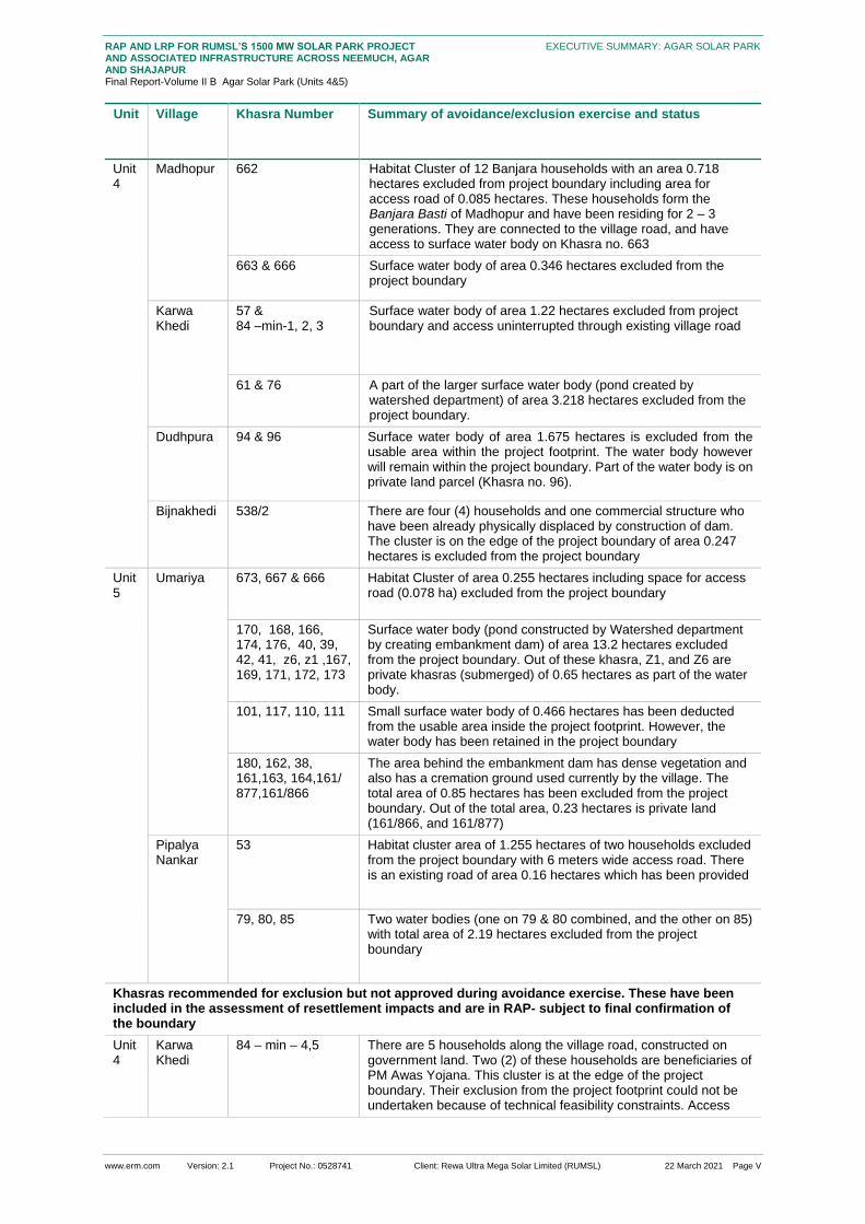
Unit Village Khasra Number Summary of avoidance/exclusion exercise and status
Khasras for which exclusion/avoidance completed or mitigation measures agreed
1 For the purposes of this project, the bhumiswami is considered as the titleholder with formal rights over private land and/or
patta land in accordance with Section 158 of the Madhya Pradesh Land Revenue Code, 1954 as amended 2 Nistar Patrak for every village embodying a scheme of management of all unoccupied land in the village. The Collector may
divert unoccupied land, for exercise of Nistar rights for – pasture, grass, bir or fodder reserve (clause b) subject to a minimum of two (2) percent of the total agricultural land of that village.
www.erm.com Version: 2.1 Project No.: 0528741 Client: Rewa Ultra Mega Solar Limited (RUMSL) 22 March 2021 Page V
RAP AND LRP FOR RUMSL’S 1500 MW SOLAR PARK PROJECT AND ASSOCIATED INFRASTRUCTURE ACROSS NEEMUCH, AGAR AND SHAJAPUR Final Report-Volume II B Agar Solar Park (Units 4&5)
EXECUTIVE SUMMARY: AGAR SOLAR PARK
Unit Village Khasra Number Summary of avoidance/exclusion exercise and status
Unit 4
Madhopur 662 Habitat Cluster of 12 Banjara households with an area 0.718 hectares excluded from project boundary including area for access road of 0.085 hectares. These households form the Banjara Basti of Madhopur and have been residing for 2 – 3 generations. They are connected to the village road, and have access to surface water body on Khasra no. 663
663 & 666 Surface water body of area 0.346 hectares excluded from the project boundary
Karwa Khedi
57 & 84 –min-1, 2, 3
Surface water body of area 1.22 hectares excluded from project boundary and access uninterrupted through existing village road
61 & 76 A part of the larger surface water body (pond created by watershed department) of area 3.218 hectares excluded from the project boundary.
Dudhpura 94 & 96 Surface water body of area 1.675 hectares is excluded from the usable area within the project footprint. The water body however will remain within the project boundary. Part of the water body is on private land parcel (Khasra no. 96).
Bijnakhedi 538/2 There are four (4) households and one commercial structure who have been already physically displaced by construction of dam. The cluster is on the edge of the project boundary of area 0.247 hectares is excluded from the project boundary
Unit 5
Umariya 673, 667 & 666 Habitat Cluster of area 0.255 hectares including space for access road (0.078 ha) excluded from the project boundary
170, 168, 166, 174, 176, 40, 39, 42, 41, z6, z1 ,167, 169, 171, 172, 173
Surface water body (pond constructed by Watershed department by creating embankment dam) of area 13.2 hectares excluded from the project boundary. Out of these khasra, Z1, and Z6 are private khasras (submerged) of 0.65 hectares as part of the water body.
101, 117, 110, 111 Small surface water body of 0.466 hectares has been deducted from the usable area inside the project footprint. However, the water body has been retained in the project boundary
180, 162, 38, 161,163, 164,161/ 877,161/866
The area behind the embankment dam has dense vegetation and also has a cremation ground used currently by the village. The total area of 0.85 hectares has been excluded from the project boundary. Out of the total area, 0.23 hectares is private land (161/866, and 161/877)
Pipalya Nankar
53 Habitat cluster area of 1.255 hectares of two households excluded from the project boundary with 6 meters wide access road. There is an existing road of area 0.16 hectares which has been provided
79, 80, 85 Two water bodies (one on 79 & 80 combined, and the other on 85) with total area of 2.19 hectares excluded from the project boundary
Khasras recommended for exclusion but not approved during avoidance exercise. These have been included in the assessment of resettlement impacts and are in RAP- subject to final confirmation of the boundary
Unit 4
Karwa Khedi
84 – min – 4,5 There are 5 households along the village road, constructed on government land. Two (2) of these households are beneficiaries of PM Awas Yojana. This cluster is at the edge of the project boundary. Their exclusion from the project footprint could not be undertaken because of technical feasibility constraints. Access

www.erm.com Version: 2.1 Project No.: 0528741 Client: Rewa Ultra Mega Solar Limited (RUMSL) 22 March 2021 Page VI
RAP AND LRP FOR RUMSL’S 1500 MW SOLAR PARK PROJECT AND ASSOCIATED INFRASTRUCTURE ACROSS NEEMUCH, AGAR AND SHAJAPUR Final Report-Volume II B Agar Solar Park (Units 4&5)
EXECUTIVE SUMMARY: AGAR SOLAR PARK
Unit Village Khasra Number Summary of avoidance/exclusion exercise and status
road to these houses have to be maintained in order to preserve ease of access to agricultural land parcels
Unit 5
Umariya 297 There are seven (7) land users who have been squatting on this government Khasra for agriculture over an area of approximately 4 hectares. It was suggested to exclude the agricultural area, since it is situated at the eastern edge of the project boundary. However, the same could not be exercised due to technical constraint relating to minimum land requirement for setting up per MW of solar panels.
748, 776, 777, 795, 800, 849, 872
There are 14 land users who have been squatting on these government Khasras for agriculture over an area of approximately 6.4 hectares. This land area lies at the south-east edge of the boundary and was suggested to be carved out from the project boundary. However, the same could not be undertaken due to technical feasibility issues.
Pipalya Nankar
92 There are seven (7) land users who have been using the government land parcel informally for agriculture, and are at the edge of the project boundary. It was suggested that the agricultural land use area be carved out from the total khasra area included in the project footprint. However the exclusion could not be undertaken due to technical feasibility.
Unit 4
Dudhpura 54 There are four (4) households with total area of 0.806 hectares at the edge of the project boundary without existing road access. Their exclusion from the project footprint could not be undertaken.
Source: Based on site visits undertaken, review of drone imagery of land use, and land allotment details provided by RUMSL.

www.erm.com Version: 2.1 Project No.: 0528741 Client: Rewa Ultra Mega Solar Limited (RUMSL) 22 March 2021 Page VII
RAP AND LRP FOR RUMSL’S 1500 MW SOLAR PARK PROJECT AND ASSOCIATED INFRASTRUCTURE ACROSS NEEMUCH, AGAR AND SHAJAPUR Final Report-Volume II B Agar Solar Park (Units 4&5)
EXECUTIVE SUMMARY: AGAR SOLAR PARK
Figure 0.2 Residential Clusters in Unit 4 avoided & suggested
Note: Approximately 25 households were considered for avoidance from Unit 4, of which four households in Dudhpura on Khasra no. 54 have not been excluded from the project boundary.

www.erm.com Version: 2.1 Project No.: 0528741 Client: Rewa Ultra Mega Solar Limited (RUMSL) 22 March 2021 Page VIII
RAP AND LRP FOR RUMSL’S 1500 MW SOLAR PARK PROJECT AND ASSOCIATED INFRASTRUCTURE ACROSS NEEMUCH, AGAR AND SHAJAPUR Final Report-Volume II B Agar Solar Park (Units 4&5)
EXECUTIVE SUMMARY: AGAR SOLAR PARK
Overview of Project Affected Households
Project Affected Villages
The following table provides an overview of the eleven (11) project affected villages and the balance
land that is available post land allotment and private/patta land procurement:
Table 0.4 Land Footprint by Ownership, in Project Villages
Village Name Geographical Area of Village (ha)
Land required for the Agar solar park (ha)
Land remaining (ha)
Proportion of Land Remaining (%)
Government land (ha)
Private land (ha)
Total
Pipalya Kumhar 383.51 34.8 5.06 39.86 343.65 89.61
Madhopur 509.42 15.77 0 15.77 493.65 96.90
Ladwan 590.74 168.32 2.8 171.12 419.62 71.03
Kesai Dehariya 252.77 28.3 0 28.3 224.47 88.80
Karwa Khedi 587.09 155.09 0 155.09 432 73.58
Dudhpura 495.71 98.38 43.59 141.972 353.738 71.36
Bijnakhedi 709.41 55.98 0 55.98 653.43 92.11
Agar Sub-total 3528.65 556.64 51.45 608.09 2920.56 82.77
Palda 801.75 119.69 6.48 126.17 675.58 84.26
Naharkheda 837.35 86.69 62.71 149.6 687.75 82.13
Umariya 607.12 328.8 13.06 341.87 265.25 43.69
Pipalya Nankar 630.81 181.36 0 181.36 449.45 71.25
Susner Sub-total 2877.03 716.74 82.25 789.99 2087.04 72.54
Agar Solar Park 6405.68 1273.38 133.7 1398.08 5007.6 78.17
Source: Land data provided by RUMSL as on June 2020 (Figures in brackets indicates parcels either entirely or partially that
were surveyed during the Land and Asset inventory)
As part of the resettlement surveys, ERM surveyed all of these eleven (11) villages through a Village
Questionnaire as well as select qualitative discussions and focus group discussions in order to
identify livelihood impacts, collective dependence concerns, general stakeholder insights and profiling
vulnerable social groups (gender, economic vulnerabilities, caste groups etc.).
Project Affected Land Parcels
The following table provides an overview of the government and private/patta land parcels which are
affected across the villages as well as those that were surveyed:
Table 0.5 Land required for Solar Park
Unit Type Number of Khasras Land Area (ha)
Unit 4 Government 126 (04) 556.64 (12.5)
Private 21 (00) 51.45 (0.0)
Sub - total 147 (04) 608.35 (12.5)
Unit 5 Government 195 (31) 716.74 (47.78)

www.erm.com Version: 2.1 Project No.: 0528741 Client: Rewa Ultra Mega Solar Limited (RUMSL) 22 March 2021 Page IX
RAP AND LRP FOR RUMSL’S 1500 MW SOLAR PARK PROJECT AND ASSOCIATED INFRASTRUCTURE ACROSS NEEMUCH, AGAR AND SHAJAPUR Final Report-Volume II B Agar Solar Park (Units 4&5)
EXECUTIVE SUMMARY: AGAR SOLAR PARK
Unit Type Number of Khasras Land Area (ha)
Private 38 (11) 181.86 (11.2)
Sub - total 233 (42) 898.6 (58.98)
Source: Land data provided by RUMSL as on June 2020 (Figures in brackets indicates parcels either entirely or partially that
were surveyed during the Land and Asset inventory)
As part of the resettlement surveys, ERM undertook a Land and Asset Inventory of 11.2 hectares
private land parcels as well as 60.8 hectares of government land parcels in order to identify assets,
impacts on titleholders and any non-titleholders as well as their intensity. These corresponded to 95
PAHs. For the remaining parcels that could not be surveyed, ERM undertook a spatial analysis of the
land parcels as well as their land use in order to ascertain involuntary resettlement impacts.
Titleholders and Non-titleholders
The following table provides an overview of the titleholders and non-titleholders for Agar Solar Park,
including the ones that could be identified and therefore including in either the land and asset
inventory and/or household survey (see 0.3.4):
Unit Village Title Holders Non-Title Holders
Private Patta Encroachers Informal users
IV Pipalya Kumar
03 0 NA 03
Madhopur
00 00 02 01
Ladwan
12 00 00 00
Kesai Dehariya
01 (00) 00 02 00
Karwa Khedi
16 (00) 00 NA NA
Dudhpura
42 (00) 33 (00) NA NA
Bijnakhedi
00 00 NA NA
V Palda
11 (03) 00 01 13
Naharkheda
18 (04) 00 NA 11
Umariya
17 (08) 00 03 23
Pipliya Nankar
11 (01) 00 11 NA
Project Affected Households
Based on the above, Agar Solar Park will lead to involuntary resettlement of 263 Project Affected
Households as summarised in the subsequent table:

www.erm.com Version: 2.1 Project No.: 0528741 Client: Rewa Ultra Mega Solar Limited (RUMSL) 22 March 2021 Page X
RAP AND LRP FOR RUMSL’S 1500 MW SOLAR PARK PROJECT AND ASSOCIATED INFRASTRUCTURE ACROSS NEEMUCH, AGAR AND SHAJAPUR Final Report-Volume II B Agar Solar Park (Units 4&5)
EXECUTIVE SUMMARY: AGAR SOLAR PARK
Table 0.6: Status of Household Survey Coverage
Survey Coverage by category Count (in numbers) Proportion (%)
Total PAH 263 100
Households Surveyed 138 49.2
Source: HH survey 2020
Of these PAH, ERM covered 138 households through a household census survey in order to obtain a
socio-economic, demographic, livelihood, vulnerability and access to infrastructure profile. 42 of the
138 were landless households that were covered as a sample for the household survey. Of the
remaining 125 PAHs that could not be surveyed, Section 1.3.4 provides the reasons for the same.
Key Survey Milestones
Based on field surveys undertaken from in August 2020, the following resettlement survey milestones
have been flagged for specific attention in order to influence implications for entitlements and RAP
and LRP implementation:
Village kick-off meetings: 8
Survey completion meetings: 7
Reiteration of grievance redressal mechanism in the above meetings: 7
The dates for the survey completion meeting can be considered as a cut-off date to identify nature of
impacts and categories of impacts. As the project is not formally initiating land acquisition and in view
of the parallel government allotment process; these survey completion dates cannot be considered as
a formal cut-off date to recognise rights and titleholders/non-titleholders in view of the following:
Land titles can still change due to any potential transactions and buying and selling up to
commencement of the procurement process under the MP Mutual Consent-based Land
Procurement Policy (2014);
The survey process, may encourage opportunistic use of the government land.
In view of the above, for households that could not be covered as part of the resettlement surveys;
RUMSL will have to put in place the following process elements during RAP and LRP
implementation3:
For private land owners : Households of land owners that could not be surveyed can be covered
as part of the engagement process during land procurement;
For informal users (encroachers and squatters): As part of physical land access, additional
households of informal users can be identified and thereafter surveyed provided they can
demonstrate that the occupation and use of government land predates the survey (this can be
confirmed through drone imagery of December 2019-January 2020 available with RUMSL,
records of the local patwaris linked to any fines or notices that may have been issued as well as
through village leaders).
Profile of Project Affected Communities
Profile of Villages in the Project Footprint
3 This scope is included in the ToR of the Resettlement Implementation Consultant provided as an appendix in Volume I.

www.erm.com Version: 2.1 Project No.: 0528741 Client: Rewa Ultra Mega Solar Limited (RUMSL) 22 March 2021 Page XI
RAP AND LRP FOR RUMSL’S 1500 MW SOLAR PARK PROJECT AND ASSOCIATED INFRASTRUCTURE ACROSS NEEMUCH, AGAR AND SHAJAPUR Final Report-Volume II B Agar Solar Park (Units 4&5)
EXECUTIVE SUMMARY: AGAR SOLAR PARK
Figure 0.3: Overview of Key Village-level Attributes: Agar

www.erm.com Version: 2.1 Project No.: 0528741 Client: Rewa Ultra Mega Solar Limited (RUMSL) 22 March 2021 Page XII
RAP AND LRP FOR RUMSL’S 1500 MW SOLAR PARK PROJECT AND ASSOCIATED INFRASTRUCTURE ACROSS NEEMUCH, AGAR AND SHAJAPUR Final Report-Volume II B Agar Solar Park (Units 4&5)
EXECUTIVE SUMMARY: AGAR SOLAR PARK
Figure 0.4: Overview of Key Village-level Attributes: Susner
www.erm.com Version: 2.1 Project No.: 0528741 Client: Rewa Ultra Mega Solar Limited (RUMSL) 22 March 2021 Page
RAP AND LRP FOR RUMSL’S 1500 MW SOLAR PARK PROJECT AND ASSOCIATED INFRASTRUCTURE ACROSS NEEMUCH, AGAR AND SHAJAPUR Final Report-Volume II B Agar Solar Park (Units 4&5)
EXECUTIVE SUMMARY: AGAR SOLAR PARK
Profile of Project Affected Households
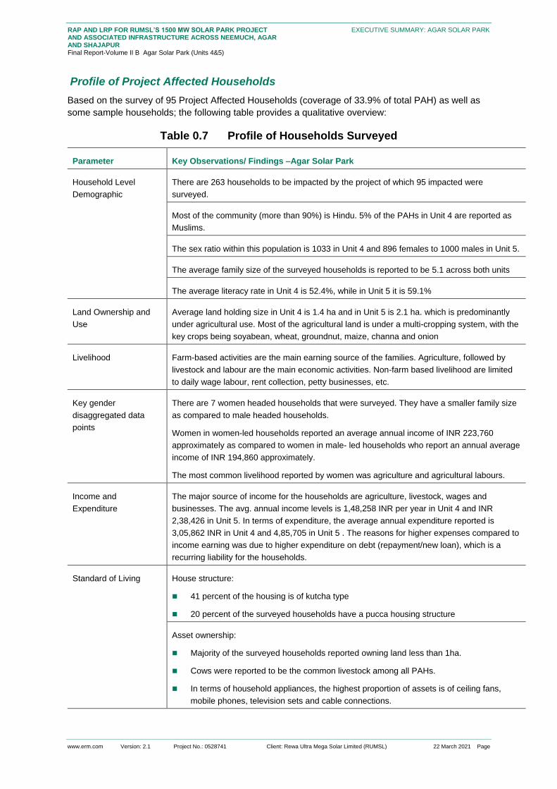
Based on the survey of 95 Project Affected Households (coverage of 33.9% of total PAH) as well as
some sample households; the following table provides a qualitative overview:
Table 0.7 Profile of Households Surveyed
Parameter Key Observations/ Findings –Agar Solar Park
Household Level
Demographic
There are 263 households to be impacted by the project of which 95 impacted were
surveyed.
Most of the community (more than 90%) is Hindu. 5% of the PAHs in Unit 4 are reported as
Muslims.
The sex ratio within this population is 1033 in Unit 4 and 896 females to 1000 males in Unit 5.
The average family size of the surveyed households is reported to be 5.1 across both units
The average literacy rate in Unit 4 is 52.4%, while in Unit 5 it is 59.1%
Land Ownership and
Use
Average land holding size in Unit 4 is 1.4 ha and in Unit 5 is 2.1 ha. which is predominantly
under agricultural use. Most of the agricultural land is under a multi-cropping system, with the
key crops being soyabean, wheat, groundnut, maize, channa and onion
Livelihood Farm-based activities are the main earning source of the families. Agriculture, followed by
livestock and labour are the main economic activities. Non-farm based livelihood are limited
to daily wage labour, rent collection, petty businesses, etc.
Key gender
disaggregated data
points
There are 7 women headed households that were surveyed. They have a smaller family size
as compared to male headed households.
Women in women-led households reported an average annual income of INR 223,760
approximately as compared to women in male- led households who report an annual average
income of INR 194,860 approximately.
The most common livelihood reported by women was agriculture and agricultural labours.
Income and
Expenditure
The major source of income for the households are agriculture, livestock, wages and
businesses. The avg. annual income levels is 1,48,258 INR per year in Unit 4 and INR
2,38,426 in Unit 5. In terms of expenditure, the average annual expenditure reported is
3,05,862 INR in Unit 4 and 4,85,705 in Unit 5 . The reasons for higher expenses compared to
income earning was due to higher expenditure on debt (repayment/new loan), which is a
recurring liability for the households.
Standard of Living House structure:
41 percent of the housing is of kutcha type
20 percent of the surveyed households have a pucca housing structure
Asset ownership:
Majority of the surveyed households reported owning land less than 1ha.
Cows were reported to be the common livestock among all PAHs.
In terms of household appliances, the highest proportion of assets is of ceiling fans,
mobile phones, television sets and cable connections.

www.erm.com Version: 2.1 Project No.: 0528741 Client: Rewa Ultra Mega Solar Limited (RUMSL) 22 March 2021 Page I
RAP AND LRP FOR RUMSL’S 1500 MW SOLAR PARK PROJECT AND ASSOCIATED INFRASTRUCTURE ACROSS NEEMUCH, AGAR AND SHAJAPUR Final Report-Volume II B Agar Solar Park (Units 4&5)
EXECUTIVE SUMMARY: AGAR SOLAR PARK
Parameter Key Observations/ Findings –Agar Solar Park
In terms of vehicles, most of the PAHs reported ownership of two wheelers including
bicycles and motor cycles.
Amongst the agricultural implements, PAHs reported ownership mostly of implements
such as tractors and water pump sets.
Participation in collectives:
The most common of them is an SHG for buffalo procurement, whose members are pre-
dominantly male.
There are relatively few female SHGs in the area, most of them are non-functional the
female SHGs are primarily for provision of monetary support for setting up small
businesses
Dependence on Natural
Resources
Community dependence on natural resources is mainly for grazing and fodder, water for
livestock and firewood and dung collection
Access to Physical and
Social Infrastructure
The access to primary healthcare is limited within the project footprint, and resident typically
have to travel 3-5 km for a hospital. There are no doctors or clinics within the villages. The
average distance for schools is 2 km. on an average, 20% of the households have a
functional toilet at and almost all households are connected to the government grid supply for
electricity
Source: RAP & LRP surveys 2020
Profile of Key Stakeholder Groups and Feedback
Stakeholder Identification and Analysis
Table 0.8: Stakeholder Group Categorization
Stakeholder
Groups
Primary Stakeholders Secondary Stakeholders
Individual and
Community
Private land owners and Patta land holders
from the Project Area villages
Informal land Users (Encroachers/Squatters
to be impacted)
Agricultural labourers
Grazers/Livestock holding households
Banjara households and Bhil households
Women groups
Vulnerable groups (Landless households,
Below Poverty Line households, women
headed households)
Owners of land required for temporary
occupation or use during construction
phase
■ Fence line community
Government
Bodies and
District Administration of Agar-Malwa
Gram Panchayats of the impacted villages
■ Civil Society/Local Non-
governmental organizations (NGOs)
■ Local Media

www.erm.com Version: 2.1 Project No.: 0528741 Client: Rewa Ultra Mega Solar Limited (RUMSL) 22 March 2021 Page II
RAP AND LRP FOR RUMSL’S 1500 MW SOLAR PARK PROJECT AND ASSOCIATED INFRASTRUCTURE ACROSS NEEMUCH, AGAR AND SHAJAPUR Final Report-Volume II B Agar Solar Park (Units 4&5)
EXECUTIVE SUMMARY: AGAR SOLAR PARK
Stakeholder
Groups
Primary Stakeholders Secondary Stakeholders
Institutional
Stakeholders
Agar and Susner Tehsildars;
Patwaris
EPC Contractor
RUMSL
Local Political Groups
Dairy Cooperatives
Agriculture and Livestock
Department at Agar
Industrial Training Institute (ITI),
Agar
Department of Animal Husbandry,
Dairy Development, Agar
Figure 0.5 Prioritisation of Stakeholders
As a part of the resettlement planning, engagement was undertaken at various stages with the
stakeholders. RUMSL was responsible for overall coordination across various stakeholders including
the district administration, and the administration at the tehsil level
A District Renewable Energy Officer (DREO) has been appointed by RUMSL to undertake the
initial meetings with the Tehsil office, and guide the land allotment process. The land allotment
process was initiated in 2017 for the government land parcels
Consultations were undertaken during this stage by ERM with the villages that were identified to
be part of the project footprint (September 2018). During this stage, a site reconnaissance visit
was undertaken based on the proposed project footprint

www.erm.com Version: 2.1 Project No.: 0528741 Client: Rewa Ultra Mega Solar Limited (RUMSL) 22 March 2021 Page III
RAP AND LRP FOR RUMSL’S 1500 MW SOLAR PARK PROJECT AND ASSOCIATED INFRASTRUCTURE ACROSS NEEMUCH, AGAR AND SHAJAPUR Final Report-Volume II B Agar Solar Park (Units 4&5)
EXECUTIVE SUMMARY: AGAR SOLAR PARK
The resettlement surveys were undertaken during the period July – August 2020. An
engagement process was set up at the start and end of surveys in each village. The kick-off
meetings were used to understand the existing level of information about the project available
with the community and incorporate any feedback received from the community on the concerns
regarding involuntary impacts, and feedback for project planning. The close-out meeting was
carried out at the end of the survey process to summarise key outcomes, relay the significance of
survey completion dates to identify categories and types of impacts and to reiterate the
mechanism to register any grievances from the community to the DREO..
It was during the kick-off meetings with Ladwan, Dudhpura, Bijnakhedi and Pipalya Kumhar (Unit
4) which provided the scope of right to refusal of the village towards to the project and its
associated activities, based on the understanding of the extent of impacts on the households.
The refusal to participate in resettlement surveys by one village created a ripple effect – the
refusal by one village (the first refusal was expressed by Ladwan) spreads to other villages in
terms of negative sentiments regarding the project. The concerns and reasons of refusal were
recorded from the kick-off meetings and subsequent meetings held with Sarpanch, Tehsildar and
the same was shared with RUMSL.
Table 0.9 Feedback Received for Incorporation into Resettlement Planning
Feedback Received Incorporation into Resettlement Planning
Lack of engagement by the
project prior to the ESIA
stage of the project
As part of the Resettlement Planning, alternative grazing land has been
recommended with ease of access to such grazing lands for the village
Provision of water supply
infrastructure from existing
dam
The community in Kasai Dehariya has raised the concern of lack of water
supply infrastructure and have expressed the need for provision of pipelines to
draw water from the dam to their fields to make irrigation water supply
perennial in nature.
Allow grass cutting/ fodder
collection within the project
boundary
As part of Resettlement Planning, a Grazing Management Plan has been
prepared (included in the consolidated RAP report) that includes the
measures
Increase in distance to
access grazing land
As part of Resettlement Planning, the loss of access to grazing land has been
assessed and mitigation measures have been included in the Grazing
Management Plan.
Heat Island effect leading to
effect on land productivity of
the remaining land parcels
As part of project disclosure and engagement activities, the communities will
be informed and made aware of the mitigation measures to reduce the same,
and improve farm productivity.
Loss of access to land for
Open defecation
As part of the Resettlement Planning, this issue has been addressed in the
Gender Action Plan (GAP).

www.erm.com Version: 2.1 Project No.: 0528741 Client: Rewa Ultra Mega Solar Limited (RUMSL) 22 March 2021 Page IV
RAP AND LRP FOR RUMSL’S 1500 MW SOLAR PARK PROJECT AND ASSOCIATED INFRASTRUCTURE ACROSS NEEMUCH, AGAR AND SHAJAPUR Final Report-Volume II B Agar Solar Park (Units 4&5)
EXECUTIVE SUMMARY: AGAR SOLAR PARK
Involuntary Resettlement Impacts
Overview of Project-Affected Land and Assets
Land Parcels
134 hectares of private agricultural land parcels (61 percent from unit 5) and 60 hectares of
government land parcels used informally for agriculture and grazing, will be impacted due to project
activities
Table 0.10 Land Area under Informal land Use
Unit Village Encroachment for agriculture (ha)
Squatter for agriculture (ha)
Squatter for Agriculture and fodder (ha)
Squatter for fodder lot (ha)
Grand Total
Unit 4 Bijnakhedi 3.4 1.5 NA NA 4.9
Kesai Dehariya
3.3 NA NA 3.3
Madhopur Kheda
2.8 1.4 NA NA 4.2
Agar Sub-total 6.22 6.22 6.2
Unit 5 Naharkheda NA 7.5 2.7 NA 10.2
Palada 1.1 10.1 NA NA 11.2
Pipalya Nankar
3.8 NA NA NA 3.8
Umariya 1.2 21.5 0.16 22.8
Susner Sub-total 6.1 6.1 39.1 2.7 0.16
Grand Total 12.3 12.3 45.3 2.7 0.16
Source: LA survey 2020
Crops
Of the total 194 hectares of land under agricultural use, the LA survey assessed 71 hectares of land
where the common practice was observed to be of double and triple cropping. Soyabean was
observed to be the major crop cultivated in almost 45 percent of the area followed by wheat which
was cultivated in 33 percent of the total area. The loss to farmers, from clearing standing crops will
depend on when the possession of the land required for the project will be taken by the Solar Park
Developer (SPD)
Structures
There are three residential structures in Naharkheda and four in Dudhpura 4 that will be affected
because of the project. Apart from these the project footprint is reported to impact seven (7)
immovable structures in structures in Naharkheda and Umariya villages, both in Unit 5.The estimated
total area to be affected by immovable assets like cattle shed, water feeding stall, fodder storage shed
is 0.25 hectares. The structures within this area were visually assessed to be in use during Rabi
cropping season. There are 27 land parcels which are occupied by other fixed and salvageable
assets like sanitary arrangement, wire fencing (with cemented pillar, and wooden poles), open wells
and pipelines.
4 Identified by Geospatial assessment.

www.erm.com Version: 2.1 Project No.: 0528741 Client: Rewa Ultra Mega Solar Limited (RUMSL) 22 March 2021 Page V
RAP AND LRP FOR RUMSL’S 1500 MW SOLAR PARK PROJECT AND ASSOCIATED INFRASTRUCTURE ACROSS NEEMUCH, AGAR AND SHAJAPUR Final Report-Volume II B Agar Solar Park (Units 4&5)
EXECUTIVE SUMMARY: AGAR SOLAR PARK
Table 0.11 Count of Immovable and Fixed Assets
Unit Village
Ag
ric
ult
u
ral
sh
ed
Sto
rag
e/
Catt
le
sh
ed
San
ita
ry
ass
et
Op
en
we
ll
Oth
er
Pip
eli
ne
Wir
e
fen
cin
g
wit
h
sto
ne
pil
lar
Wir
e
fen
cin
g
wit
h
wo
od
en
po
le
Unit 4
Bijnakedhi NA NA NA NA NA 2 NA NA
Madhopur NA NA NA 2 NA NA
Unit 5
Naharkheda 4 1 1 4 1 2 NA NA
Palada NA NA NA 9 2 NA NA NA
Pipalya Nankar NA NA NA 9
2 NA 3
Umariya 1 1 2 12
2 6
Grand Total 5 2 3 36 3 6 2 9
Source: LA survey 2020
NA: Not Applicable
Trees
The LA survey assessed 129 timber trees, spread across 10 private land parcels which are assumed
to be impacted. On an average, there are 10-12 trees on a single private land parcel. Similarly, 33
fruit trees were assessed on 13 land parcels with an average of 1-3 fruit trees on one land parcel. It
has been found that 72 percent of the fruit trees are in the young productive (fruit bearing) years.
Majority of the fruit trees are orange (57 percent).
Common property Resources
Government land is used for open grazing of livestock (grazing on shrubs, grasses that grow in the
open) and there are designated land areas (Charnoi, Chargah) which are meant to be used for
grazing by the village community. However, there are no physical identifiers for such land parcels, and
typically, grazing is undertaken on any open government land parcel. The actual land categories are
not known to the local community and thus do not provide the complete understanding of the grazing
land use in the village.
Table 0.12 Designated government grazing land
Un
it
Village Charnoi &
Kadim
available
after
Project
allotment
(ha)
Total
government
land after
Project
allotment (ha)
Total
Agriculture
land in the
Village as per
Census 2011
data
Share of
Charnoi &
Kadim to
government
land in the
village after
Project
allotment (%)
Share of
Charnoi &
Kadim to
agricultural
land in the
village
after Project
allotment (%)
Un
it 4
Kasai
Dehariya
0
207.07 252.36
0
0.00

www.erm.com Version: 2.1 Project No.: 0528741 Client: Rewa Ultra Mega Solar Limited (RUMSL) 22 March 2021 Page VI
RAP AND LRP FOR RUMSL’S 1500 MW SOLAR PARK PROJECT AND ASSOCIATED INFRASTRUCTURE ACROSS NEEMUCH, AGAR AND SHAJAPUR Final Report-Volume II B Agar Solar Park (Units 4&5)
EXECUTIVE SUMMARY: AGAR SOLAR PARK
Un
it
Village Charnoi &
Kadim
available
after
Project
allotment
(ha)
Total
government
land after
Project
allotment (ha)
Total
Agriculture
land in the
Village as per
Census 2011
data
Share of
Charnoi &
Kadim to
government
land in the
village after
Project
allotment (%)
Share of
Charnoi &
Kadim to
agricultural
land in the
village
after Project
allotment (%)
Dudhpura 63.97 161.718 66.01 39.5 96.91
Ladwan 66.82 103.31 266 64.7 25.12
Karwa
Khedi
61.72
179.85 223
34.3
27.68
Madhopura 138.58 231.61 171.39 59.8 80.86
Bijnakhedi 152.67 256.57 277.62 59.5 54.99
Pipaliya
Kumhar
33.35
168.32 175.51
19.8
19.00
Agar Sub - total 517.11 1308.48 1431.89 39.5 36.11
Un
it 5
Naharkheda 148.2
335.16 313.51
44.4
47.27
Umariya 247.12 91.35 181.93 NA* 135.83
Pipaliya
Nankar
19.63
87.84 334.61
22.3
5.87
Palda 27.6 287.35 368.47 9.6 7.49
Susner Sub -
total
442.77 801.7 1198.52
55.2
36.94
Grand Total 959.88 2110.15 2630.41 45.5 36.49
Source: Nistar Patrak data of each village
*the proportion cannot be calculated for Umariya, as the Charnoi land allotted exceeds the available government land
The area under informal use for grazing is estimated at approximately 3.4 hectares. This land area
use has been assessed, as separate from the use of notified and designated government grazing
land (Charnoi).
Table 0.13 Households dependent on open grazing
Unit Village No.of HHs using government
land for grazing
% of total HHs in the village
Unit 4 Ladwan NA NA
Dudhpura 40 40
Bijnakhedi 50 15
Kesai Dehariya 25 25
Madhopur 20 16

www.erm.com Version: 2.1 Project No.: 0528741 Client: Rewa Ultra Mega Solar Limited (RUMSL) 22 March 2021 Page VII
RAP AND LRP FOR RUMSL’S 1500 MW SOLAR PARK PROJECT AND ASSOCIATED INFRASTRUCTURE ACROSS NEEMUCH, AGAR AND SHAJAPUR Final Report-Volume II B Agar Solar Park (Units 4&5)
EXECUTIVE SUMMARY: AGAR SOLAR PARK
Unit Village No.of HHs using government
land for grazing
% of total HHs in the village
Pipalya Kumhar 0 0
Agar Sub-total 135 21
Naharkheda 55 18
Palada 0 0
Pipalya Nankar 50 16
Umariya 0 0
Susner sub-total 105 17.5
Grand total 240 19.2
Source: LA survey 2020
It is understood that out of the surveyed PAHs, 65 percent depend on common land for collection of
firewood for cooking and grass (for livestock feed).
Intensity of Involuntary Resettlement Impacts
Table 0.14 Economic and Physical displacement of PAHs
Unit Villages Total PAHs Economically displaced PAHs
Physically displaced aPAHs
Unit
4
Bijnakhedi 9 9 0
Kesai Dehariya 3 3 0
Madhopur 5 5 0
Ladwan 12 12 0
Karwa Khedi 16 16 0
Dudhpura 75 71 4
Pipaliya Kumhar 3 3 0
Agar Sub-total 123 119 4
Unit
5
Naharkheda 41 41 1
Palada 27 35 0
Pipalya Nankar 23 24 0
Umariya 48 53 0
Susner Sub-total 139 138 1
Grand Total 262 257 5
Source: HH survey 2020

www.erm.com Version: 2.1 Project No.: 0528741 Client: Rewa Ultra Mega Solar Limited (RUMSL) 22 March 2021 Page VIII
RAP AND LRP FOR RUMSL’S 1500 MW SOLAR PARK PROJECT AND ASSOCIATED INFRASTRUCTURE ACROSS NEEMUCH, AGAR AND SHAJAPUR Final Report-Volume II B Agar Solar Park (Units 4&5)
EXECUTIVE SUMMARY: AGAR SOLAR PARK
Physical Displacement
As mentioned before, the land procurement will lead to physical displacement of some structures.
Three structures are on private land parcel belonging to one household, and the rest of the structures
are on government land parcels belonging to four (4) households three of these structures are of
seasonal use while the others are more permanent structures, constructed with lower value material.
Apart from residential structures, there are eight (8) households, of which five (5) households will be
impacted by loss of agricultural storage sheds, and three (3) households impacted by loss of
fodder/cattle sheds, used during the farming season. The structures that will be impacted are isolated
structures, away from the main village settlement and have seasonal use. The loss of such physical
assets is concurrent with the loss of livelihood due to economic displacement.
Economic Displacement
Land procurement for the project is reported to impact land holdings, this includes loss of private and
patta land due to the land procurement for the project and the overall reduction in land holding amongst
the PAHs. As mentioned above, the surveyed villages have reported that their primary source of
livelihood is agriculture and this loss of land will result in a permanent loss of agriculture and livelihood.
While Dudhpura (unit 4) has the highest number of PAHs impacted by loss of private/patta land, Palda
(unit 5) has the highest number of PAHs who would become landless. Moreover, loss of government
land, is another concern for the households who have reported encroachment of informal use of
government land for agricultural use or fodder cultivation.
Table 0.15: Impact on households owning private/patta land
Unit Villages Private land
owning PAHs
Patta land
owning PAHs
Total PAPs Potential
landless PAHs
Unit 4 Bijnakhedi 0 0 0 NA
Kesai Dehariya 1 0 4 0
Madhopur 0 0 0 NA
Ladwan 12 0 48 0
Karwa Khedi 16 0 240 0
Dudhpura 42 33 450 0
Pipalya Kumhar 3 0 15 0
Agar Sub-total 74 33 753 0
Unit 5 Naharkheda 18 0 72 0
Palada 11 0 77 10
Pipalya Nankar 11 0 78 5
Umariya 17 0 59 0
Susner Sub-total 59 0 286 11

www.erm.com Version: 2.1 Project No.: 0528741 Client: Rewa Ultra Mega Solar Limited (RUMSL) 22 March 2021 Page IX
RAP AND LRP FOR RUMSL’S 1500 MW SOLAR PARK PROJECT AND ASSOCIATED INFRASTRUCTURE ACROSS NEEMUCH, AGAR AND SHAJAPUR Final Report-Volume II B Agar Solar Park (Units 4&5)
EXECUTIVE SUMMARY: AGAR SOLAR PARK
Unit Villages Private land
owning PAHs
Patta land
owning PAHs
Total PAPs Potential
landless PAHs
Grand total 131 33 1039 26
Source: LA survey & HH survey 2020
About 23 percent of private land owners have an annual earning of less than INR 1,00,000 per annum
who are marginal land holders. Apart from a loss of income from agriculture, the affected land owners
are also expected to lose out on land improvement expenditures that they had incurred.
Community based livelihood impacts
The primary impact at the community level arises due to reduction in available land for open grazing,
due to land allotment, i.e. loss of livelihood and sustenance linked to use of government land for open
grazing of livestock. The reduction in common land for grazing will also lead to reduction in count of
livestock head by households, due to reduction in land available per unit of livestock, especially for
those in economically weaker groups, as input costs will increase (creation of stall-shed, feeding stalls
etc.). Moreover there is also assumed to be an impact on livelihood from livestock activities.
Madhopur village in Unit 4 has nearly 10 households of the Banjara community who depend on
livestock as their primary source of livelihood. The loss of income form livestock is estimated at INR
36,000 per year, excluding input costs of fodder. Although these households are not directly impacted
by the land procurement for the project footprint, consultations with these communities reveal that
they will be affected by the loss of land for open grazing.
Gendered livelihood impacts
There are 11 women headed households that have been identified of which 4 have been surveyed.
These households are primarily dependent on agricultural labour work and supplementary income
from livestock. The women headed households identified through the households survey are likely to
be economically displaced by the project and did not report any other source of income other than
their agricultural income as part of the household survey. Another impact on female headed
households will be the Impact due to loss of access to government grazing land that were located
near their village, and are now included in the project boundary. Due to the project impact on the
grazing areas close to the settlement, grazing areas may be available at further distances, the
alternative is to access the parcels which are at greater distance and will thus have higher time cost
implications and shift in the division of labour at the household level.
Impact on Vulnerable groups
There are 12 vulnerable households, seven of which are women headed, 3 are artisanal households
and 1 household is below the poverty line. The impacts on these households are similar to the
impacts discussed for the rest of PAHs, and uniform.
Impacts on Indigenous Communities
The Bhil community in Ladwan (16 households) will be potentially economically displaced due to
project activities. In terms of impact to this community, a Bhil household family shall incur the loss of
INR 1,32,120.00 annually due to shift towards market purchase of fodder, ten (10) households will be
economically displaced as the reported using private land and government land informally for
agriculture.

www.erm.com Version: 2.1 Project No.: 0528741 Client: Rewa Ultra Mega Solar Limited (RUMSL) 22 March 2021 Page X
RAP AND LRP FOR RUMSL’S 1500 MW SOLAR PARK PROJECT AND ASSOCIATED INFRASTRUCTURE ACROSS NEEMUCH, AGAR AND SHAJAPUR Final Report-Volume II B Agar Solar Park (Units 4&5)
EXECUTIVE SUMMARY: AGAR SOLAR PARK
Project-specific Strategies for Implementation
Volume I of the RAP and LRP provides the overarching entitlement matrix, market valuation
framework, livelihood restoration, approach to resettlement housing and the overarching
implementation arrangements, roles and responsibilities as well as schedule.
The following table summarises key aspects that need to be considered by RUMSL while
implementing the RAP and LRP for Agar Solar Park:
Table 0.16 Park Specific Implementation Insights
Aspect Description
Stakeholder consultations and
information disclosure;
The project shall undertake focused and dedicated engagement activities
with the local community and affected households prior to the initiation of
land purchase and RAP&LRP implementation. These engagement activities
shall specifically be focused on the three villages Ladwan, Karwa Khedi and
Dudhpura that had filed formal objections against the project to the District
Collector.
Completion of RAP&LRP
surveys
Undertake the resettlement surveys for the villages which refused to
participate in the process during the RAP&LRP preparation. The completion
of the RAP&LRP surveys should be undertaken only with the consent of the
PAHs.
Grievance Management
Given the gap at the current stage with regards to missing information from four villages of Unit 4, and
the associated large scale grievances reported during the resettlement surveys undertaken in August
2020, it is suggested that regular engagement should be undertaken with all the villages in the project
footprint, with specific focus on the villages who have refused to resettlement surveys. These range
from Consultations with the Gram Panchayat to provide update on the land procurement process of
private land in the villages to conducting workshops with specific stakeholder groups identified during
the resettlement surveys to incorporate feedback and suggestions on resettlement planning.

www.erm.com Version: 2.1 Project No.: 0528741 Client: Rewa Ultra Mega Solar Limited (RUMSL) 22 March 2021 Page 1
RAP AND LRP FOR RUMSL’S 1500 MW SOLAR PARK PROJECT AND ASSOCIATED INFRASTRUCTURE ACROSS NEEMUCH, AGAR AND SHAJAPUR Final Report-Volume II B Agar Solar Park (Units 4&5)
INTRODUCTION TO VOLUME II B
1. INTRODUCTION TO VOLUME II B
Rewa Ultra Mega Solar Limited (RUMSL) has been authorized by the Ministry of New and Renewable
Energy Development (MNRED) to develop three solar parks (including internal evaluation
infrastructure and associated transmission lines) with an aggregate capacity of 1500 MW (hereafter
referred to as the Project or the 1500 MW Project) across the districts of Neemuch, Agar and
Shajapur in Madhya Pradesh, India.
ERM India Pvt Ltd. (ERM) has been engaged by Rewa Ultra Mega Solar Limited (RUMSL) to develop
a Resettlement Action Plan (RAP) and Livelihood Restoration Plan (LRP) for the three solar parks
(1500 MW) and their associated evacuation infrastructures.
This report is Volume II (B) for the Agar Solar Park RAP and LRP of 550 MW capacity that is located
in two Tehsil i.e. Agar Tehsil (Unit 4 of 200 MW) and Susner Tehsil (Unit 5 of 350 MW).
Figure 1.1 Structure of the RAP and LRP Deliverables for 1500 MW
1.1 Brief Project Description for Agar Solar Park
The proposed 550 MW Agar Solar Park will be developed as two units. Unit 4 of capacity 200 MW at
Agar Tehsil and Unit 5 of 350 MW at Susner Tehsil.
Table 1.1 Agar Solar Park project summary
S. No. Particulars Description for Unit 4 Description for Unit 5
1. Project Village location Unit 4 (Agar):
Pipalya Kumar, Madhopur,
Ladwan, Kesai Dehariya, Karwa
Khedi, Dudhpura and Bijnakhedi;
Unit 5 (Susner):
Palda, Naharkheda, Umariya and
Pipalya Nankar
2. Tehsil Agar Tehsil Susner Tehsil
3. District Name/State Agar, Madhya Pradesh Agar, Madhya Pradesh
4. Location Coordinates Agar: 23°44'38.58"N and 76°
7'1.26"E
Susner: 23°55'28.07"N and
76° 2'21.30"E
5. Capacity Unit 4 (Agar): 200 MW Unit 5 (Susner): 350 MW
Volume I (RAP-LRP) Complete 1500 MW project and TLs [
Common Sections]
Volume II A – Neemuch Solar Park (RAP-LRP)
Volume II B- Agar Solar Park (RAP-LRP) This Document
Volume II C – Shajapur Solar Park (RAP-LRP)
Volume II D – Transmission Line (RAP-LRP)

www.erm.com Version: 2.1 Project No.: 0528741 Client: Rewa Ultra Mega Solar Limited (RUMSL) 22 March 2021 Page 2
RAP AND LRP FOR RUMSL’S 1500 MW SOLAR PARK PROJECT AND ASSOCIATED INFRASTRUCTURE ACROSS NEEMUCH, AGAR AND SHAJAPUR Final Report-Volume II B Agar Solar Park (Units 4&5)
INTRODUCTION TO VOLUME II B
S. No. Particulars Description for Unit 4 Description for Unit 5
6. Pooling Stations and
Power Evacuation
The evacuation from the proposed Solar Park at Agar shall be carried
out through the development of 33/220 kV substation at each unit
established in connection with the proposed 220/400 kV ISTS
substation of PGCIL at Agar.
9. Site Conditions Barren rocky surfaces, flat land, hilly at some portions
18. Land Area Allotted 608.09 ha 789.99 ha
A more detailed description is included in the ESIA document for the Agar Solar Park.
An overview of the project location is provides in the subsequent figures.
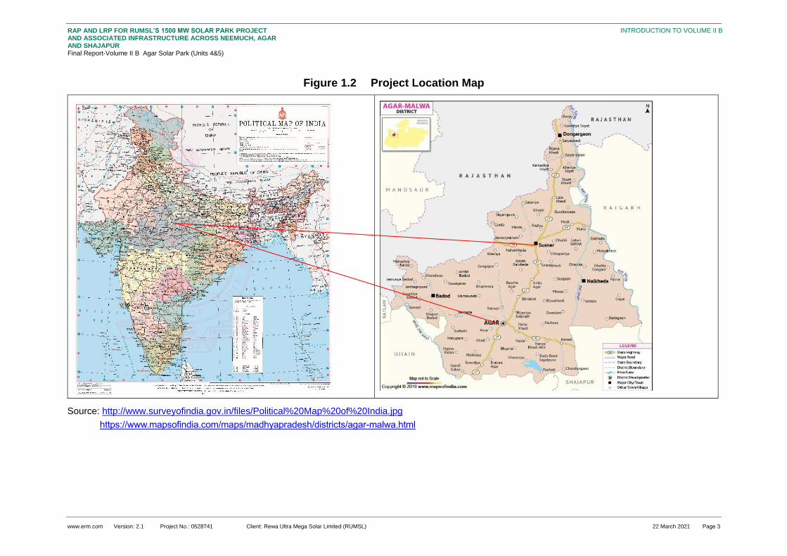
www.erm.com Version: 2.1 Project No.: 0528741 Client: Rewa Ultra Mega Solar Limited (RUMSL) 22 March 2021 Page 3
RAP AND LRP FOR RUMSL’S 1500 MW SOLAR PARK PROJECT AND ASSOCIATED INFRASTRUCTURE ACROSS NEEMUCH, AGAR AND SHAJAPUR Final Report-Volume II B Agar Solar Park (Units 4&5)
INTRODUCTION TO VOLUME II B
Figure 1.2 Project Location Map
Source: http://www.surveyofindia.gov.in/files/Political%20Map%20of%20India.jpg
https://www.mapsofindia.com/maps/madhyapradesh/districts/agar-malwa.html

www.erm.com Version: 2.1 Project No.: 0528741 Client: Rewa Ultra Mega Solar Limited (RUMSL) 22 March 2021 Page 4
RAP AND LRP FOR RUMSL’S 1500 MW SOLAR PARK PROJECT AND ASSOCIATED INFRASTRUCTURE ACROSS NEEMUCH, AGAR AND SHAJAPUR Final Report-Volume II B Agar Solar Park (Units 4&5)
INTRODUCTION TO VOLUME II B
Figure 1.3 Agar Solar Park Footprint Map
Source: Project boundary data provided by RUMSL, June 2020
www.erm.com Version: 2.1 Project No.: 0528741 Client: Rewa Ultra Mega Solar Limited (RUMSL) 22 March 2021 Page 5
RAP AND LRP FOR RUMSL’S 1500 MW SOLAR PARK PROJECT AND ASSOCIATED INFRASTRUCTURE ACROSS NEEMUCH, AGAR AND SHAJAPUR Final Report-Volume II B Agar Solar Park (Units 4&5)
NTRODUCTION TO VOLUME II B
1.2 Project Development Timelines
The overall project overview and project progress timeline has been described in Section 2 of Volume
I of the RAP-LRP. The details provided here pertain to specific activities undertaken for Agar Solar
Park, starting from site selection to resettlement surveys.
Site selection – the Agar-Malwa district was carved out of Shajapur district in 2013 with four
tehsils i.e. Agar, Susner, Badod, and Nalkheda. The project was selected in Agar and Susner
tehsil by Knight Frank during 2016 - 2017. The potential project areas were thereafter discussed
and finalised through workshops between RUMSL, potential lenders and third party consultants;
further to which the process of formal land allotment was initiated based on the MP Solar Policy,
2012 and taking into account the relevant procedural provisions of the MP Land Revenue Code,
1959.
Knight frank baseline – A review was undertaken in May – June 2019 of the baseline report which
was prepared in August 2017
Scoping – E&S scoping visit for Agar Solar Park was undertaken in September 2018 to
understand the site selection, environmental and social sensitivities and identify relevant
stakeholders. As part of this visit, consultations were undertaken in –Umariya, Pipalya Nankar,
Ladwan and Karwa Khedi villages (these villages had been chosen based on the village with the
highest proportion of land take in the project, and higher share of SC/ST population). Based on
the scoping visit, an E&S scoping visit report was submitted which had identified the
environmental and social sensitivities around the Project site.
Environmental and Social Impact Assessment (ESIA) – ERM undertook site visit during 10- 20
December, 2019 and 22-30 January 2020 to understand the site setting, review the E&S
sensitivities identified during the scoping stage and to identify the relevant local stakeholders. The
activities undertaken included –
Identification of key social risks/receptors in the study area;
Understanding of prevailing community engagement processes;
Understanding aspects of community health and safety, if any, linked to the proposed
Project;
Understanding land-based impacts, livelihood impacts, issues of vulnerable groups, cultural
heritage issues;
Understanding significance of impacts on biodiversity and natural resource management; and
Consultations with the local communities and focused group discussions in the vicinity to
understand their views and concerns of the Project
Based on the ESIA study, the impacts identified during scoping stage were updated, stakeholders
were identified and mitigation measures with relevance to displacement and resettlement were
incorporated into RAP planning;
Resettlement Planning – the information collected from the ESIA study was used to undertaken
the planning of the resettlement activities based on identified land based impacts leading to
potential economic and physical displacement of the stakeholders. The RAP related site visit was
undertaken in July – August 2020, based on which a Resettlement Action Plan (RAP) and
Livelihood Restoration Plan (LRP) has been created. The details of the same have been provided
in the subsequent sections.
Bid Process for Agar Solar Park – To Be Completed

www.erm.com Version: 2.1 Project No.: 0528741 Client: Rewa Ultra Mega Solar Limited (RUMSL) 22 March 2021 Page 6
RAP AND LRP FOR RUMSL’S 1500 MW SOLAR PARK PROJECT AND ASSOCIATED INFRASTRUCTURE ACROSS NEEMUCH, AGAR AND SHAJAPUR Final Report-Volume II B Agar Solar Park (Units 4&5)
NTRODUCTION TO VOLUME II B
Land Procurement and Land Access: The land allotment process of government for Agar Solar
Park started in May 2017. Procurement of private land is yet to be initiated;
Construction work: Timeline to be determined basis the completion of the bid process;; and
Indicative Commencement of Operation Date (CoD) – To Be Decided
1.3 Approach, Methodology and Survey Coverage
The overarching approach and methodology undertaken for resettlement planning has been
discussed in Section 1 of the Volume I of the RAP-LRP. The following section summarises the
specific methodology for the Agar Solar Park.
1.3.1 Resettlement Scoping during ESIA Consultations
Based on the screening assessment conducted by ERM in October (22 – 25) 2019, an ESIA and
RAP-LRP study was proposed for the Solar Park. The ESIA visit was undertaken in December (10 –
20), 2019 and January (22 – 30) 2020 to understand the site setting, environmental and social
sensitivities and to identify the relevant local stakeholders. An initial impact assessment of potential
impacts on the various environmental, ecological and social elements was identified during the ESIA
study.
The consultations undertaken in the project footprint villages during this stage informed the scope of
the RAP and provided and estimate of the extent of impacts. The detailed impact assessment of the
involuntary resettlement impacts was undertaken in the RAP study during July – August 2020 to
assess the extent of land – based impacts, loss of livelihood and conduct specific consultations with
the impacted stakeholder groups as identified and updated from the ESIA study. Data for the RAP
study was collected through two field tools – household survey and the Land & Asset survey.
1.3.2 Optimisation Exercise
Prior to undertaking the field work pertaining to RAP, an optimization of the project land footprint was
undertaken based on E&S sensitivities identified from the ESIA study, as well as geospatial
assessment of the area. The exercise involved exclusion of land parcels with presence of physical
structures, water bodies, dense vegetation and/or sites of cultural significance. This helped in
reducing the extent and scale of adverse and irreversible impacts. The details of the optimization
process are provided in Section 2.2.
1.3.3 RAP Survey Coverage
Resettlement surveys were conducted in parallel for Agar and Susner sites during 28th July 2020 to
28th August 2020 based on the activities discussed in Vol I Section 1.4. Overall, the survey coverage
is outlines below:
Ten (10) of a total of eleven Project affected villages were profiled using Village Profiling tool
covering Project affected villages for the Agar Solar Park. :
92 Land and asset surveys using Tool (of these 13 percent were undertaken recall based);
138 household-level socioeconomic surveys of which 42 households (30.4 percent) formed the
sample for more community-wide project impacts for grazing land reduction and effects on casual
agricultural labourers;
19 qualitative discussions.
The household socioeconomic survey and the Land & Asset survey were initiated from Umariya
village in Susner of Unit 5 of the Solar Park. Of the 263 households assessed as project affected, 96
(36.5 percent) could be surveyed. The list of surveys and consultations held across the villages in Unit
4 and Unit 5 are presented in the table below.

www.erm.com Version: 2.1 Project No.: 0528741 Client: Rewa Ultra Mega Solar Limited (RUMSL) 22 March 2021 Page 7
RAP AND LRP FOR RUMSL’S 1500 MW SOLAR PARK PROJECT AND ASSOCIATED INFRASTRUCTURE ACROSS NEEMUCH, AGAR AND SHAJAPUR Final Report-Volume II B Agar Solar Park (Units 4&5)
NTRODUCTION TO VOLUME II B
Table 1.2 Field survey activities: Agar Solar Park
Unit
Village Kick Off Meeting
Land and Asset Survey Dates
Household Survey Dates
Survey Completion Meeting
Total PAH number
Total PAHs Surveyed
Unit 4
Madhopur 24-08-2020
24-08-2020
25-08-2020 26-08-2020 5 5
Unit 4
Bijnakhedi 24-08-2020
24-08-2020
25-08-2020 26-08-2020 9 9
Unit 4
Kesai Dehariya
25-08-2020
27-08-2020
25-08-2020 27-08-2020 3 2
Unit 4
Pipalya Kumhar
25-08-2020
NA 25/08/2020 (only sample households surveyed)
26-08-2020 3 0
Unit 4
Ladwan 06-08-2020
NA NA 12 0
Unit 4
Dudhpura 25-08-2020
NA NA 75 0
Unit 4
Karwa Khedi
24-08-2020
NA NA 16 0
Total Unit 4
123 16
Unit 5
Umariya 06-08-2020
07/08/2020 – 08/08/2020
07/08/2020 – 08/08/2020
15-08-2020 48 30
Unit 5
Naharkheda
08-08-2020
08/08/2020 – 10/08/2020
08/08/2020 – 11/08/2020
16-08-2020 42 24
Unit 5
Pipalya Nankar
14-08-2020
15-08-2020
15/08/2020 – 17/08/2020
18-08-2020 23 10
Unit 5
Palada 15-08-2020
17-08-2020
17-08-2020 18-08-2020 27 16
Total Unit 5
140 80
Grand Total
263 96
Source: Resettlement surveys, August 2020
Note: the discrepancy in Total PAH Number and Total PAH surveyed has been explained in Section 1.3.4.
1.3.4 Specific Limitations applicable to the RAP surveys, for Units 4&5
The limitations arising during the RAP study which were encountered, due to either protests, or
absence of households, or refusals to participate in the survey exercise. The overall limitations have
been included in the consolidated RAP, and the specific limitations pertaining to Agar Solar Park are
listed below.

www.erm.com Version: 2.1 Project No.: 0528741 Client: Rewa Ultra Mega Solar Limited (RUMSL) 22 March 2021 Page 8
RAP AND LRP FOR RUMSL’S 1500 MW SOLAR PARK PROJECT AND ASSOCIATED INFRASTRUCTURE ACROSS NEEMUCH, AGAR AND SHAJAPUR Final Report-Volume II B Agar Solar Park (Units 4&5)
NTRODUCTION TO VOLUME II B
Four villages in Agar Solar Park; Ladwan; Karwa Khedi, Dudhpura and Pipalya Kumhar refused to
participate in the survey due to their opposition to the proposed project5. Dudhpura’s opposition
stemmed from their previous experience with government project (water reservoir and check
dam) which had led to loss of about 60-70 percent of their land. What was once a fairly large
village in the area, has now been split into three (3) hamlets around a large water body. The
previous project (~ 20 years ago) had led to loss of agricultural and arable land and subsequent
economic displacement. The residents of Dudhpura reported that, currently, the village is left with
little or no land. Residents of Ladwan and Karwa Khedi displayed strong opposition to the current
project due to the apprehension of loss of private land and associated land based livelihoods;
6 households though consented to LA survey did not consent to HH survey due to reluctance to
provide household level information. The households are informal users of government land for
agriculture and belonged to the following villages of Unit 5 –
Two (2) households in Umariya, and one household each in Naharkheda, Bijnakhedi,
Palada, and Pipalya Nankar
A total of 167 households were absent for either the HH or LA survey. This includes the
households who did not give consent to either of the surveys. Their village wise break up is given
below –
Table 1.3 Absentee PAH Not Surveyed
Unit Village No.of Absentee PAHs
Unit 4 Kesai Dehariya 1
Unit 4 Pipalya Kumhar 1
Unit 4 Ladwan 12
Unit 4 Karwa Khedi 16
Unit 4 Dudhpura 75
Unit 4 Pipaliya Nankar 03
Agar Sub-total 107
Unit 5 Naharkheda 18
Unit 5 Palada 11
Unit 5 Pipalya Nankar 13
Unit 5 Umariya 18
Susner Sub-total 60
24 households in Naharkheda, and seven (7) households in Pipalya Nankar refused permission
for taking photographs during the HH survey, and thus these data points are not available
5 Covered in 6.2.2

www.erm.com Version: 2.1 Project No.: 0528741 Client: Rewa Ultra Mega Solar Limited (RUMSL) 22 March 2021 Page 9
RAP AND LRP FOR RUMSL’S 1500 MW SOLAR PARK PROJECT AND ASSOCIATED INFRASTRUCTURE ACROSS NEEMUCH, AGAR AND SHAJAPUR Final Report-Volume II B Agar Solar Park (Units 4&5)
NTRODUCTION TO VOLUME II B
18 LA surveys were done with a representative of the impacted household and not family member
or relative of the family who could not be present during the duration of the survey.
The pending surveys related to household data and data on land and asset will need to be covered in
the implementation phase.
Disclaimer: This report has been finalized on the basis of discussions with RUMSL and feedback
from World Bank and the IFC. A recommended strategy for community-level disclosure of the
RAP and LRP has been suggested to RUMSL and is being currently deliberated. In view of the
COVID-19 pandemic related health and safety concerns and travel restrictions (as of 30 April
2021), this report has been finalised based on the understanding that RUMSL and the
Resettlement Implementation Consultant will undertake the recommended disclosure. A Hindi
translation of the Volume 1 Executive Summary will be provided to the local community. Any
relevant feedback from the local community can be incorporated by the RIC as a part of RAP and
LRP implementation
1.4 Layout of the Volume II B
Section 1 (this section) Introduction
Section 2 Project Footprint and Land Procurement Status
Section 3 Summary of Project Affected Entities
Section 4 Socio-Economic Baseline Profile of Affected Communities
Section 5 Stakeholder Engagement and Consultation
Section 6 Involuntary Resettlement Impacts
Section 7 Implementation Strategies for Agar Solar Park
Annexure A Photo Documentation
Annexure B Summary of Consultations
Annexure C Profile of Informal Users in Agar Solar Park
Annexure D Profile of Residential Structures within Agar Solar Park
Annexure E Household Level Entitlements (to be developed once an
agreement on Entitlements and valuation is achieved)

www.erm.com Version: 2.1 Project No.: 0528741 Client: Rewa Ultra Mega Solar Limited (RUMSL) 22 March 2021 Page 10
RAP AND LRP FOR RUMSL’S 1500 MW SOLAR PARK PROJECT AND ASSOCIATED INFRASTRUCTURE ACROSS NEEMUCH, AGAR AND SHAJAPUR Final Report-Volume II B Agar Solar Park (Units 4&5)
PROJECT FOOTPRINT AND LAND PROCUREMENT STATUS
2. PROJECT FOOTPRINT AND LAND PROCUREMENT STATUS
2.1 Project Footprint
The Solar Park will be spread across eleven villages in Agar and Susner Tehsil, Agar-Malwa District.
The land required for 550 MW Solar Park including solar fields 1398.08 hectares. The following table
provides a summary of the land requirement by village and land ownership type:
Table 2.1 Village Wise Project Footprint
Unit Villages Government Land (NRED Allotted
and Newly Identified) (ha)
Private Land
(ha)
Total land (ha)
Unit 4 Pipalya Kumar 34.80 5.06 39.86
Madhopur 15.77 0.00 15.77
Ladwan 168.32 2.80 171.12
Kesai Dehariya 28.30 0.00 28.30
Karwa Khedi 155.09 0.00 155.09
Dudhpura 98.38 43.59 141.97
Bijnakhedi 55.98 0.00 55.98
Agar Sub-total 556.64 51.45 608.09
Unit 5 Palda 119.69 6.48 126.17
Naharkheda 86.89 62.71 149.6
Umariya 328.8 13.06 341.87
Pipalya Nankar 181.36 0 181.36
Susner Sub-total 716.74 82.25 789.99
Agar-Susner total (Unit 4 & 5) 1273.38 133.7 1398.08
Source: RUMSL, January 2021
Total area for Unit 4 (Agar) is 608.09 hectares comprising of land from seven villages namely Pipalya
Kumhar, Madhopur, Ladwan, Kasai Dahariya, Karwa Khedi, Dudhpura, Bijnakhedi, which fall under
Agar tehsil of Agar-Malwa District. Total area for Unit 5 (Susner) is 789.99 hectares comprising of land
from four villages namely Palda, Naharkheda, Umariya and Pipalya Nankar, which fall under Susner
Tehsil of Agar-Malwa District. The understanding of the land requirement in comparison to total land
available per village is provided in Section 3.2.
The plant area for both units is in two discontinuous Units, due to the feasible avoidance criteria
applied in the selection process (refer to Section 2.2).
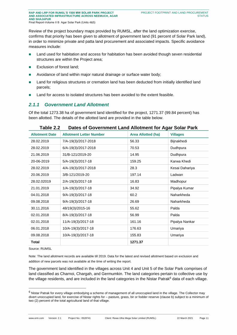
www.erm.com Version: 2.1 Project No.: 0528741 Client: Rewa Ultra Mega Solar Limited (RUMSL) 22 March 2021 Page 11
RAP AND LRP FOR RUMSL’S 1500 MW SOLAR PARK PROJECT AND ASSOCIATED INFRASTRUCTURE ACROSS NEEMUCH, AGAR AND SHAJAPUR Final Report-Volume II B Agar Solar Park (Units 4&5)
PROJECT FOOTPRINT AND LAND PROCUREMENT STATUS
Review of the project boundary maps provided by RUMSL, after the land optimization exercise,
confirms that priority has been given to allotment of government land (91 percent of Solar Park land),
in order to minimize private and patta land procurement and associated impacts. Specific avoidance
measures include:
Land used for habitation and access for habitation has been avoided though seven residential
structures are within the Project area;
Exclusion of forest land;
Avoidance of land within major natural drainage or surface water body;
Land for religious structures or cremation land has been deducted from initially identified land
parcels;
Land for access to isolated structures has been avoided to the extent feasible.
2.1.1 Government Land Allotment
Of the total 1273.38 ha of government land identified for the project, 1271.37 (99.84 percent) has
been allotted. The details of the allotted land are provided in the table below.
Table 2.2 Dates of Government Land Allotment for Agar Solar Park
Allotment Date Allotment Letter Number Area Allotted (ha) Villages
28.02.2019 7/A-19(3)/2017-2018 56.33 Bijnakhedi
28.02.2019 6/A-19(3)/2017-2018 70.53 Dudhpura
21.06.2019 31/B-121/2019-20 14.95 Dudhpura
20-06-2019 5/A-19(3)/2017-18 159.25 Karwa Khedi
28.02.2019 4/A-19(3)/2017-2018 28.3 Kesai Dahariya
20.06.2019 3/B-121/2019-20 197.14 Ladwan
28.02.02019 2/A-19(3)/2017-18 16.83 Madhopur
21.01.2019 1/A-19(3)/2017-18 34.92 Pipalya Kumar
04.01.2018 9/A-19(3)/2017-18 60.2 Naharkheda
09.08.2018 9/A-19(3)/2017-18 26.69 Naharkheda
30.11.2016 48/19(3)/2015-16 55.62 Palda
02.01.2018 8/A-19(3)/2017-18 56.99 Palda
02.01.2018 11/A-19(3)/2017-18 161.16 Pipalya Nankar
06.01.2018 10/A-19(3)/2017-18 176.63 Umariya
09.08.2018 10/A-19(3)/2017-18 155.83 Umariya
Total 1271.37
Source: RUMSL
Note: The land allotment records are available till 2019. Data for the latest and revised allotment based on exclusion and
addition of new parcels was not available at the time of writing the report.
The government land identified in the villages across Unit 4 and Unit 5 of the Solar Park comprises of
land classified as Charnoi, Chargah, and Germumkin. The land categories pertain to collective use by
the village residents, and are included in the land categories in the Nistar Patrak6 data of each village.
6 Nistar Patrak for every village embodying a scheme of management of all unoccupied land in the village. The Collector may
divert unoccupied land, for exercise of Nistar rights for – pasture, grass, bir or fodder reserve (clause b) subject to a minimum of two (2) percent of the total agricultural land of that village.

www.erm.com Version: 2.1 Project No.: 0528741 Client: Rewa Ultra Mega Solar Limited (RUMSL) 22 March 2021 Page 12
RAP AND LRP FOR RUMSL’S 1500 MW SOLAR PARK PROJECT AND ASSOCIATED INFRASTRUCTURE ACROSS NEEMUCH, AGAR AND SHAJAPUR Final Report-Volume II B Agar Solar Park (Units 4&5)
PROJECT FOOTPRINT AND LAND PROCUREMENT STATUS
As part of the allotment exercise, it has been ensured that a minimum of 2% of total agricultural land
available in the village is available for grazing of cattle, as stipulated in the MP Land Revenue Code
(1959, as amended).
2.1.2 Use of Government Land
The current land use of government land is characterized by open grazing, and squatting for seasonal
agriculture. The two types of informal use of government land are defined below:
Land owner encroachment on government land: The private land owner who has occupied
part of Government Land, adjoining the private/ patta lands into their agricultural land use area.
There is no legal claim over those occupied government land parcels.
Squatter on government land: Squatters are informal users, who have occupied government
land (including Charnoi/Chargah/kabil kast) for agricultural use, while their private/patta land is at
a different location in the village. Squatting can also be undertaken by landless households for
agriculture and/or residence.
2.1.2.1 Encroachments
Encroachment of government land adjoining existing private/patta land to cultivate larger parcels has
been noted in villages of Agar Tehsil (Ladwan, Karwa Khedi, Dudhpura, and Pipalya Kumhar) and in
Naharkheda, and Palda village in Susner Tehsil.
Agar- Unit 4
In Agar, private land owners with large land holdings who are at a relatively higher economic position
in the village, have used encroachment as a practice to increase the area under cultivation for
agricultural use and also occupied land for grazing their own livestock, and hence prohibiting its use
by the other residents of village. This practice has been in existence for more than ten (10) years due
to which the more powerful land owners have occupied large parcels for agricultural and their own
pastoral activities. As a result, the available government land for grazing, for the wider community,
has reduced.
The available land for households of relatively lower economic and social status (households
belonging to SC community, and women headed households, households with only livestock based
income) has reduced.
Susner- Unit 5
In Susner, the trend of encroachment is different and has been undertaken by patta land holders,
whose patta land is outside the project footprint. The patta land allotted to the Harijan households is of
poor quality and they have encroached upon government land for seasonal farming. It should be
noted that patta land has been largely avoided from the land procurement process (except
Dudhpura), as part of avoidance measures undertaken, unless unavoidable, such as maintaining
contiguous land footprint.
Patta land has been identified to be part of the project footprint in Dudhpura village (Unit 4), wherein
18 hectares7 of patta land is part of the total land take for the project footprint from the village.
The LA survey of government land covered 12.3 hectares of government land under encroachment, which accounts for less than one percent (0.96) of the allotted government land for the Solar Park. This corresponded to 17 PAHs in baseline survey who reported encroachment for agriculture.
7 The patta land holders have been identified based on the land owner listing exercise carried out during the resettlement
surveys, and provided by the Patwari. The land area has been estimated from the land area statement data provided by RUMSL.

www.erm.com Version: 2.1 Project No.: 0528741 Client: Rewa Ultra Mega Solar Limited (RUMSL) 22 March 2021 Page 13
RAP AND LRP FOR RUMSL’S 1500 MW SOLAR PARK PROJECT AND ASSOCIATED INFRASTRUCTURE ACROSS NEEMUCH, AGAR AND SHAJAPUR Final Report-Volume II B Agar Solar Park (Units 4&5)
PROJECT FOOTPRINT AND LAND PROCUREMENT STATUS
2.1.2.2 Informal Use of Government land by Squatters
Squatting is defined as separate from encroachment, wherein a household/ a group of households
are informally using government land. These squatters do not have formal land titles on the occupied
land but may have invested time and money to make the occupied land fertile and productive through
land improvement measures (adding top soil, fertilizers) for farming, while their private land/patta land
is at a different location in the village . Squatting is a more recent phenomenon as compared to
encroachment and has been in existence for an average of 5 – 10 years (as reported by the PAPs
during the LA survey). ). The land used by squatting households is rain –fed, lacks any permanent
source of irrigation, and produces lower output (mainly soyabean, and wheat if rainfall is good).
The practice of squatting is prevalent among Banjara households (Madhopur) who are spatially, and
socially separated from the main village and depend on squatted-upon land for production of grains to
meet household consumption needs. The LA survey assessed 48.16 hectares of government land
under squatting, which accounts for 3.8 percent of the allotted government land. This corresponded to
60 PAHs in baseline survey who reported squatting on government land. Across both the Units, the
extent of area under squatting is higher in Unit 5 with 87 percent of the squatting land in Susner.
2.1.2.3 Grazing
Government land is used for open grazing of livestock (grazing on shrubs, grasses that grow in the
open) and there are designated land areas (Charnoi, Chargah) which are meant to be used for
grazing by the village community. However, there are no physical identifiers for such land parcels, and
typically, grazing is undertaken on any open government land parcel. The actual land categories are
not known to the local community and thus do not provide the complete understanding of the grazing
land use in the village. Nevertheless it is important to understand the availability of designated grazing
land to assess the compliance to the provisions of the MP Land Revenue Code in terms of grazing
land availability (refer to Grazing Management Plan for further details) . The total designated grazing
land available in the Project villages, and as a proportion of total government land in the village is as
given below:
Table 2.3 Designated government grazing land
Un
it
Village Charnoi &
Kadim
available
after
Project
allotment
(ha)
Total
government
land after
Project
allotment (ha)
Total
Agriculture
land in the
Village as per
Census 2011
data
Share of
Charnoi &
Kadim to
government
land in the
village after
Project
allotment (%)
Share of
Charnoi &
Kadim to
agricultural
land in the
village
after Project
allotment (%)
Un
it 4
Kasai
Dehariya
0
207.07 252.36
0
0.00
Dudhpura 63.97 161.718 66.01 39.5 96.91
Ladwan 66.82 103.31 266 64.7 25.12
Karwa
Khedi
61.72
179.85 223
34.3
27.68
Madhopura 138.58 231.61 171.39 59.8 80.86
Bijnakhedi 152.67 256.57 277.62 59.5 54.99
Pipaliya
Kumhar
33.35
168.32 175.51
19.8
19.00
Agar Sub - total 517.11 1308.48 1431.89 39.5 36.11

www.erm.com Version: 2.1 Project No.: 0528741 Client: Rewa Ultra Mega Solar Limited (RUMSL) 22 March 2021 Page 14
RAP AND LRP FOR RUMSL’S 1500 MW SOLAR PARK PROJECT AND ASSOCIATED INFRASTRUCTURE ACROSS NEEMUCH, AGAR AND SHAJAPUR Final Report-Volume II B Agar Solar Park (Units 4&5)
PROJECT FOOTPRINT AND LAND PROCUREMENT STATUS
Un
it
Village Charnoi &
Kadim
available
after
Project
allotment
(ha)
Total
government
land after
Project
allotment (ha)
Total
Agriculture
land in the
Village as per
Census 2011
data
Share of
Charnoi &
Kadim to
government
land in the
village after
Project
allotment (%)
Share of
Charnoi &
Kadim to
agricultural
land in the
village
after Project
allotment (%)
Un
it 5
Naharkheda 148.2
335.16 313.51
44.4
47.27
Umariya 247.12 91.35 181.93 NA* 135.83
Pipaliya
Nankar
19.63
87.84 334.61
22.3
5.87
Palda 27.6 287.35 368.47 9.6 7.49
Susner Sub -
total
442.77 801.7 1198.52
55.2
36.94
Grand Total 959.88 2110.15 2630.41 45.5 36.49
Source: Nistar Patrak data of each village
*the proportion cannot be calculated for Umariya, as the Charnoi land allotted exceeds the available government land
The above table shows the availability of designated grazing land, after the government land
allotment for the Project. The reduction in available government land, post allotment is highest in Unit
5 of the Solar Park, with the highest impact in loss of government land in Umariya (21 percent left
after allotment). The village is also having the highest impact due to land take (44 percent of land left
after land take). Consultations undertaken with the community also confirmed the findings from the
above data – the available open grazing land is limited, and currently, the village residents have ease
of access to the same. The solar plant will lead to increase travel time (to the alternatively allotted
land for grazing), and will be further away from the water catchment area of the village, which is used
as source for drinking water for livestock.
The availability of such classified grazing land, post allotment is the highest in Ladwan and Madhopur.
The latter has also reported the highest dependence of households on grazing, as an economic
activity (Section 4.2). As compared to Unit 5, villages of Unit 4 have higher share of grazing land
available post land allotment, and hence face lesser impact on open grazing.
2.1.3 Private Land Procurement
Private land procurement as per the provisions of the MP Consent-based Land Policy (2014) is yet to
be initiated.
2.1.4 Private Land
The private land identified for the Solar Park is 133.7 hectares, all under agriculture/horticulture,
and/or fodder crop cultivation. The land use of private land has remained the same, with the intensity
of agriculture increasing, with multiple cropping almost round the year; over the years. Use of
irrigation systems to improve agricultural productivity has led to double and triple cropping (Section
4.2). Private agricultural land is also used for cultivation of fodder crop as livestock feed, and grazing
during lean agricultural period.
www.erm.com Version: 2.1 Project No.: 0528741 Client: Rewa Ultra Mega Solar Limited (RUMSL) 22 March 2021 Page 15
RAP AND LRP FOR RUMSL’S 1500 MW SOLAR PARK PROJECT AND ASSOCIATED INFRASTRUCTURE ACROSS NEEMUCH, AGAR AND SHAJAPUR Final Report-Volume II B Agar Solar Park (Units 4&5)
PROJECT FOOTPRINT AND LAND PROCUREMENT STATUS
2.2 Impact Avoidance and Project Boundary Optimization
2.2.1 Comparison of Project Land Requirements
The initial land requirement proposed for the Agar Solar Park was 1453.71 ha, of which 688.77 ha
was proposed to be required for Unit 4, and 769.94 ha for Unit 5. The number of villages identified
were seven (7) villages in Unit 4, and four villages (4) villages in Unit 5. The current land requirement
has been reduced to 1398.08 ha, out of which 43.5 percent is in Unit 4, and the rest in Unit 5. The
reduction is the result of land area optimization exercise undertaken, which was a result of the land
optimization exercise undertaken to reduce the E&S risks, while maintaining techno-economic
viability.
The exclusion of land parcels was undertaken based on a review of aerial imagery, site visits at
multiple stages (scoping, ESIA) undertaken by ERM, and an avoidance exercise undertaken by
RUMSL’s consultants , based on the land allotment details provided by RUMSL. This included details
of the land parcels, current status of land ownership, land use as per government records, the total
area of each land parcel and the area allotted to the project. In addition to this, RUMSL made
available the village wise land parcel maps through MAP IT8 for the purpose of analysis.
Exclusion as part of the E&S studies includes: 7.645 Ha (Unit 4), and 45.50 Ha (Unit 5)
The details of the optimizations suggested and completed are provided in Table 2.4 below.
2.2.2 Optimizations carried out & suggested
The detailed impact avoidance and boundary optimisation exercise undertaken for each of the Units
has been described below. This exercise was undertaken based on site visits undertaken and GIS
imagery analysis of land cover, review of existing land use, and presence of residential structures.
The table also contains a summary of the optimisations that were accepted and those that that could
not be undertaken due to technical feasibility constraints.
Table 2.4 Impact avoidance undertaken by village
Unit Village Khasra Number Summary of avoidance/exclusion exercise and status
Khasras for which exclusion/avoidance completed or mitigation measures agreed
Unit
4
Madhopur 662 Habitat Cluster of 12 Banjara households with an area 0.718
hectares excluded from project boundary including area for
access road of 0.085 hectares. These households form the
Banjara Basti of Madhopur and have been residing for 2 – 3
generations. They are connected to the village road, and have
access to surface water body on Khasra no. 663 (point 2 in
Figure 2.1)
663 & 666 Surface water body of area 0.346 hectares excluded from the
project boundary
Karwa
Khedi
57 &
84 –min-1, 2, 3
Surface water body of area 1.22 hectares excluded from project
boundary and access uninterrupted through existing village road
61 & 76 A part of the larger surface water body (pond created by
watershed department) of area 3.218 hectares excluded from the
project boundary.
8 Madhya Pradesh Agency for Promotion of Information Technology (Department of Science and Technology, GoMP)

www.erm.com Version: 2.1 Project No.: 0528741 Client: Rewa Ultra Mega Solar Limited (RUMSL) 22 March 2021 Page 16
RAP AND LRP FOR RUMSL’S 1500 MW SOLAR PARK PROJECT AND ASSOCIATED INFRASTRUCTURE ACROSS NEEMUCH, AGAR AND SHAJAPUR Final Report-Volume II B Agar Solar Park (Units 4&5)
PROJECT FOOTPRINT AND LAND PROCUREMENT STATUS
Unit Village Khasra Number Summary of avoidance/exclusion exercise and status
Dudhpura 94 & 96 Surface water body of area 1.675 hectares is excluded from the
usable area within the project footprint. The water body however
will remain within the project boundary. Part of the water body is on
private land parcel (Khasra no. 96).
Bijnakhedi 538/2 There are four (4) households and one commercial structure who
have been already physically displaced by construction of dam.
The cluster is on the edge of the project boundary of area 0.247
hectares is excluded from the project boundary ( point 1 in
Figure 2.1)
Unit
5
Umariya 673, 667 & 666 Habitat Cluster of area 0.255 hectares including space for access
road (0.078 ha) excluded from the project boundary
170, 168, 166,
174, 176, 40, 39,
42, 41, z6, z1 ,167,
169, 171, 172, 173
Surface water body (pond constructed by Watershed department
by creating embankment dam) of area 13.2 hectares excluded
from the project boundary. Out of these khasra, Z1, and Z6 are
private khasras (submerged) of 0.65 hectares as part of the water
body.
101, 117, 110, 111 Small surface water body of 0.466 hectares has been deducted
from the usable area inside the project footprint. However, the
water body has been retained in the project boundary
180, 162, 38,
161,163, 164,161/
877,161/866
The area behind the embankment dam has dense vegetation and
also has a cremation ground used currently by the village. The
total area of 0.85 hectares has been excluded from the project
boundary. Out of the total area, 0.23 hectares is private land
(161/866, and 161/877)
Pipalya
Nankar
53 Habitat cluster area of 1.255 hectares of two households excluded
from the project boundary with 6 meters wide access road. There
is an existing road of area 0.16 hectares which has been provided
79, 80, 85 Two water bodies (one on 79 & 80 combined, and the other on 85)
with total area of 2.19 hectares excluded from the project
boundary
Khasras recommended for exclusion but not approved during avoidance exercise. These have been
included in the assessment of resettlement impacts and are in RAP- subject to final confirmation of
the boundary
Unit
4
Karwa
Khedi
84 – min – 4,5 There are 5 households along the village road, constructed on
government land. Two (2) of these households are beneficiaries of
PM Awas Yojana. This cluster is at the edge of the project
boundary. Their exclusion from the project footprint could not be
undertaken because of technical feasibility constraints. Access
road to these houses have to be maintained in order to preserve
ease of access to agricultural land parcels. (point 3 in Figure 2.1)
Unit
5
Umariya 297 There are seven (7) land users who have been squatting on this
government Khasra for agriculture over an area of approximately
4 hectares. It was suggested to exclude the agricultural area,
since it is situated at the eastern edge of the project boundary.
However, the same could not be exercised due to technical
constraint relating to minimum land requirement for setting up per
MW of solar panels.

www.erm.com Version: 2.1 Project No.: 0528741 Client: Rewa Ultra Mega Solar Limited (RUMSL) 22 March 2021 Page 17
RAP AND LRP FOR RUMSL’S 1500 MW SOLAR PARK PROJECT AND ASSOCIATED INFRASTRUCTURE ACROSS NEEMUCH, AGAR AND SHAJAPUR Final Report-Volume II B Agar Solar Park (Units 4&5)
PROJECT FOOTPRINT AND LAND PROCUREMENT STATUS
Unit Village Khasra Number Summary of avoidance/exclusion exercise and status
748, 776, 777, 795,
800, 849, 872
There are 14 land users who have been squatting on these
government Khasras for agriculture over an area of approximately
6.4 hectares. This land area lies at the south-east edge of the
boundary and was suggested to be carved out from the project
boundary. However, the same could not be undertaken due to
technical feasibility issues.
Pipalya
Nankar
92 There are seven (7) land users who have been using the
government land parcel informally for agriculture, and are at the
edge of the project boundary. It was suggested that the
agricultural land use area be carved out from the total khasra area
included in the project footprint. However the exclusion could not
be undertaken due to technical feasibility.
Unit
4
Dudhpura 54 There are four (4) households with total area of 0.806 hectares at
the edge of the project boundary without existing road access.
Their exclusion from the project footprint could not be undertaken.
(point 4 in Figure 2.1)
Source: Based on site visits undertaken, review of drone imagery of land use, and land allotment details provided by RUMSL.

www.erm.com Version: 2.1 Project No.: 0528741 Client: Rewa Ultra Mega Solar Limited (RUMSL) 22 March 2021 Page 18
RAP AND LRP FOR RUMSL’S 1500 MW SOLAR PARK PROJECT AND ASSOCIATED INFRASTRUCTURE ACROSS NEEMUCH, AGAR AND SHAJAPUR Final Report-Volume II B Agar Solar Park (Units 4&5)
PROJECT FOOTPRINT AND LAND PROCUREMENT STATUS
Figure 2.1 Residential Clusters in Unit 4 avoided & suggested
Note: Approximately 25 households were considered for avoidance from Unit 4, of which four households in Dudhpura on Khasra no. 54 have not been excluded from the project boundary.

www.erm.com Version: 2.1 Project No.: 0528741 Client: Rewa Ultra Mega Solar Limited (RUMSL) 22 March 2021 Page 19
RAP AND LRP FOR RUMSL’S 1500 MW SOLAR PARK PROJECT AND ASSOCIATED INFRASTRUCTURE ACROSS NEEMUCH, AGAR AND SHAJAPUR Final Report-Volume II B Agar Solar Park (Units 4&5)
PROJECT FOOTPRINT AND LAND PROCUREMENT STATUS
Figure 2.2 Photographs of residential clusters on Government Landin Unit 4:
Karwa Khedi (above) and Madhopur (below)
www.erm.com Version: 2.1 Project No.: 0528741 Client: Rewa Ultra Mega Solar Limited (RUMSL) 22 March 2021 Page 20
RAP AND LRP FOR RUMSL’S 1500 MW SOLAR PARK PROJECT AND ASSOCIATED INFRASTRUCTURE ACROSS NEEMUCH, AGAR AND SHAJAPUR Final Report-Volume II B Agar Solar Park (Units 4&5)
SUMMARY OF PROJECT AFFECTED ENTITITES
3. SUMMARY OF PROJECT AFFECTED ENTITITES
3.1 Land Use and other Sensitivities
The figures below show the spatial distribution of the different land uses of within the allotted land for
the solar park. Project affected land use categories along with a tabular summary of project-affected
entities based on different types of dependence, as identified through the RAP study have been
included. The graphical representation below provides a snapshot of the land use within the project
boundary identified. On the basis of the land use categories identified and the dependence reported,
the RAP study presents an assessment of impacts and the PAHs
The map below shows the current land use by the community for agricultural (light yellow colour) and
residential purposes (dark yellow colour) within the Solar Park footprint. Of the total land area under
cultivation (123.14 ha) within the Solar Park footprint, 60.9 ha (49.45 percent) is informal use of
government land. The figure below showcases the land under agriculture, with the land under informal
use for agriculture differentiated from that agriculture on private/patta land.
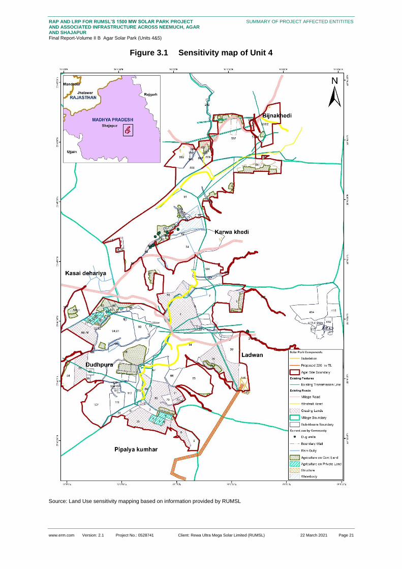
www.erm.com Version: 2.1 Project No.: 0528741 Client: Rewa Ultra Mega Solar Limited (RUMSL) 22 March 2021 Page 21
RAP AND LRP FOR RUMSL’S 1500 MW SOLAR PARK PROJECT AND ASSOCIATED INFRASTRUCTURE ACROSS NEEMUCH, AGAR AND SHAJAPUR Final Report-Volume II B Agar Solar Park (Units 4&5)
SUMMARY OF PROJECT AFFECTED ENTITITES
Figure 3.1 Sensitivity map of Unit 4
Source: Land Use sensitivity mapping based on information provided by RUMSL

www.erm.com Version: 2.1 Project No.: 0528741 Client: Rewa Ultra Mega Solar Limited (RUMSL) 22 March 2021 Page 22
RAP AND LRP FOR RUMSL’S 1500 MW SOLAR PARK PROJECT AND ASSOCIATED INFRASTRUCTURE ACROSS NEEMUCH, AGAR AND SHAJAPUR Final Report-Volume II B Agar Solar Park (Units 4&5)
SUMMARY OF PROJECT AFFECTED ENTITITES
Figure 3.2 Sensitivity map of Unit 5

www.erm.com Version: 2.1 Project No.: 0528741 Client: Rewa Ultra Mega Solar Limited (RUMSL) 22 March 2021 Page 23
RAP AND LRP FOR RUMSL’S 1500 MW SOLAR PARK PROJECT AND ASSOCIATED INFRASTRUCTURE ACROSS NEEMUCH, AGAR AND SHAJAPUR Final Report-Volume II B Agar Solar Park (Units 4&5)
SUMMARY OF PROJECT AFFECTED ENTITITES
Source: Land Use sensitivity mapping based on information provided by RUMSL
The land use maps above shows the presence of open grazing land (Unit 4), and seasonal streams
(Unit 5), across the project land footprint. A perennial water body in Umariya village which, although
excluded from the project footprint (refer Table 2.4) is at the edge of the project boundary, and the
ease of access to the same, will be hindered, due to the solar plant. Another sensitivity highlighted is
the presence of forest land in Naharkheda village (Khasra numbers 10, 75, and 76), at the southern
edge of the project boundary. The forest was designated to be developed under Panchvan scheme
(Social Forestry Program9). However, according to the discussions with the Patwaris, the local
community did not undertake the forest development and thus the land categorization was changed
back to government land. The total area of this (erstwhile forest, but now government) land is 29.15
hectares which accounts for 4 percent of the government land procurement for Unit 5 (Susner), and
3.6 percent of the total land requirement for Unit 5. Currently, the land has been allotted to the project.
3.2 Directly Affected Villages
Based on the final project footprint, the following villages have been identified as impacted villages
along with the area impacted in each village. Of all the impacted villages, Umariya has the highest
impact with 56 percent of the total village land being procured for the project footprint. The lowest land
impact is observed in Madhopur, where only 3 percent of the total village land is being procured. In
total, the Solar Park is affecting 22 percent of the land across the impacted villages.
Table 3.1 Land requirement in Project Villages
Village Name Geographical Area of Village (ha)
Land required for the Agar solar park (ha)
Land remaining (ha)
Proportion of Land Remaining (%)
Government land (ha)
Private land (ha)
Total
Pipalya Kumhar 383.51 34.8 5.06 39.86 343.65 89.61
Madhopur 509.42 15.77 0 15.77 493.65 96.90
Ladwan 590.74 168.32 2.8 171.12 419.62 71.03
Kesai Dehariya 252.77 28.3 0 28.3 224.47 88.80
Karwa Khedi 587.09 155.09 0 155.09 432 73.58
Dudhpura 495.71 98.38 43.59 141.972 353.738 71.36
Bijnakhedi 709.41 55.98 0 55.98 653.43 92.11
Agar Sub-total 3528.65 556.64 51.45 608.09 2920.56 82.77
Palda 801.75 119.69 6.48 126.17 675.58 84.26
Naharkheda 837.35 86.69 62.71 149.6 687.75 82.13
Umariya 607.12 328.8 13.06 341.87 265.25 43.69
Pipalya Nankar 630.81 181.36 0 181.36 449.45 71.25
Susner Sub-total
2877.03 716.74 82.25 789.99 2087.04 72.54
Agar Solar Park
6405.68 1273.38 133.7 1398.08 5007.6 78.17
Source: Land data provided by RUMSL as on June 2020
9 Joint Forest Management Program under the provisions of M.P Lok Vaniki Rules 2002 for management of forest land allotted
by the government, by Gram Panchayat.
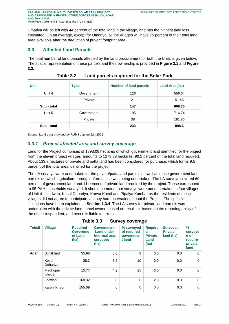
www.erm.com Version: 2.1 Project No.: 0528741 Client: Rewa Ultra Mega Solar Limited (RUMSL) 22 March 2021 Page 24
RAP AND LRP FOR RUMSL’S 1500 MW SOLAR PARK PROJECT AND ASSOCIATED INFRASTRUCTURE ACROSS NEEMUCH, AGAR AND SHAJAPUR Final Report-Volume II B Agar Solar Park (Units 4&5)
SUMMARY OF PROJECT AFFECTED ENTITITES
Umariya will be left with 44 percent of the total land in the village, and has the highest land loss
estimated. On an average, except for Umariya, all the villages will have 75 percent of their total land
area available after the deduction of project footprint area.
3.3 Affected Land Parcels
The total number of land parcels affected by the land procurement for both the Units is given below.
The spatial representation of these parcels and their ownership is provided in Figure 3.1 and Figure
3.2.
Table 3.2 Land parcels required for the Solar Park
Unit Type Number of land parcels Land Area (ha)
Unit 4 Government 126 556.64
Private 21 51.45
Sub - total 147 608.35
Unit 5 Government 195 716.74
Private 38 181.86
Sub - total 233 898.6
Source: Land data provided by RUMSL as on Jan 2021
3.3.1 Project affected area and survey coverage
Land for the Project comprises of 1398.08 hectares of which government land identified for the project
from the eleven project villages’ amounts to 1273.38 hectares, 90.5 percent of the total land required.
About 133.7 hectares of private and patta land has been considered for purchase, which forms 9.5
percent of the total area identified for the project.
The LA surveys were undertaken for the private/patta land parcels as well as those government land
parcels on which agriculture through informal use was being undertaken. The LA surveys covered 60
percent of government land and 11 percent of private land required by the project. These correspond
to 95 PAH households surveyed. It should be noted that surveys were not undertaken in four villages
of Unit 4 – Ladwan, Kesai Dehariya, Karwa Khedi and Pipalya Kumhar as the residents of these
villages did not agree to participate, as they had reservations about the Project. The specific
limitations have been explained in Section 1.3.4. The LA survey for private land parcels was
undertaken with the private land parcel owners based on recall i.e. based on the reporting ability of
the of the respondent, and hence is liable to errors.
Table 3.3 Survey coverage
Tehsil Village Required Government Land (ha)
Government Land under informal use, surveyed (ha)
% surveyed of required government land
Required Private Land (ha)
Surveyed Private land (ha)
% surveyed of require private land
Agar Bijnakhedi 55.98 5.0 9 0.0 0.0 0
Kesai Dehariya
28.3 3.3 10 0.0 0.0 0
Madhopur Kheda
15.77 4.2 25 0.0 0.0 0
Ladwan 168.32 0 0 2.8 0.0 0
Karwa Khedi 155.09 0 0 0.0 0.0 0

www.erm.com Version: 2.1 Project No.: 0528741 Client: Rewa Ultra Mega Solar Limited (RUMSL) 22 March 2021 Page 25
RAP AND LRP FOR RUMSL’S 1500 MW SOLAR PARK PROJECT AND ASSOCIATED INFRASTRUCTURE ACROSS NEEMUCH, AGAR AND SHAJAPUR Final Report-Volume II B Agar Solar Park (Units 4&5)
SUMMARY OF PROJECT AFFECTED ENTITITES
Tehsil Village Required Government Land (ha)
Government Land under informal use, surveyed (ha)
% surveyed of required government land
Required Private Land (ha)
Surveyed Private land (ha)
% surveyed of require private land
Dudhpura 98.38 0 0 43.59 0.0 0
Pipalya Kumhar
34.8 0 0 5.06 0.0 0
Agar Sub-total 556.64 12.5 2.2 51.45 0.0 0
Susner
Naharkheda 86.89 9.9 11.4 62.71 7.36 11.7
Palda 119.69 11.14 9.3 6.48 2.7 41.6
Pipalya Nankar
181.36 3.86 2.1 0.5 0.2 40
Umariya 328.80 22.88 7.0 13.06 0.94 7.2
Susner Sub-total 716.74 47.78 6.6 82.75 11.2 13.5
Grand Total 1273.38 60.28 4.73 134.2 11.2 8.34
Source: Land data provided by RUMSL and LA survey 2020
3.3.2 Assets affected
The assets affected due to the land procurement pertain to loss of access to land. The extent of these
impacts on the fixed assets are further described in Section 6. This section provides the summary of
such assets, including their counts and spread across the villages
Residential structures: seven (7) residential structures, of which three (3) have been surveyed.
These structures are typically part of one single homestead area are impacted due to the project
activities
Other immovable structures: 65 other structures which include storage shed, agricultural shed,
greenhouse, cattle shed, water stall for animals, wells, etc. Out of these 20 are fixed assets that
are salvageable such as toilet, wire fencing with stone/wooden poles, and pipeline.
Standing crop: There are 135 land parcels (government and private) with agricultural activities
spread over an area of 123.14 ha that are likely to be affected by project land requirement. Of
these, 87 land parcels with farming activity that were surveyed which is spread over an area of 71
hectares
Timber and Fruit trees: 450 timber trees and 54 fruit trees were surveyed. None of the fruit trees
were part of a planted orchard
3.4 Project Affected Households (PAHs)
As part of resettlement surveys, household –level socioeconomic surveys were carried out for those
who are to be directly impacted by the land procurement (private land owners and informal users of
government land) for the proposed project.
The baseline (Section 4.2) has been developed, based on the responses received on the 138
completed HH surveys undertaken for Agar solar Park, of which 68.8 percent are directly project
affected households (PAHs). The following table provides a summary PAH and coverage of the
survey.
Similarly, 92 LA surveys were undertaken which covered 96 PAHs (out of 263 PAHs), out of which all
but five households will be both economically and physically displaced.

www.erm.com Version: 2.1 Project No.: 0528741 Client: Rewa Ultra Mega Solar Limited (RUMSL) 22 March 2021 Page 26
RAP AND LRP FOR RUMSL’S 1500 MW SOLAR PARK PROJECT AND ASSOCIATED INFRASTRUCTURE ACROSS NEEMUCH, AGAR AND SHAJAPUR Final Report-Volume II B Agar Solar Park (Units 4&5)
SUMMARY OF PROJECT AFFECTED ENTITITES
Table 3.4 Status of Household Surveys
Survey Coverage by category Count (in numbers) Proportion (%)
Total PAH 263 100
Physically Displaced PAHs 01 0.4
Economically Displaced PAHs 262 99.6
Households Surveyed 138 49.2
Physically Displaced PAH 01 0.4
Economically Displaced PAH 95 36
Sample Households 43 15.3
Households that refused survey or are absentee households
16710 63.49
Partial surveys conducted (Phone interviews
1 0.3
Source: HH survey 2020
10 These include the identified PAH in Ladwan, Karwa Khedi, Dudhpura and Pipalya Kumhar.

www.erm.com Version: 2.1 Project No.: 0528741 Client: Rewa Ultra Mega Solar Limited (RUMSL) 22 March 2021 Page 27
RAP AND LRP FOR RUMSL’S 1500 MW SOLAR PARK PROJECT AND ASSOCIATED INFRASTRUCTURE ACROSS NEEMUCH, AGAR AND SHAJAPUR Final Report-Volume II B Agar Solar Park (Units 4&5)
SOCIO-ECONOMIC BASELINE PROFILE OF AFFECTED COMMUNITIES OF AGAR SOLAR PARK
4. SOCIO-ECONOMIC BASELINE PROFILE OF AFFECTED COMMUNITIES
OF AGAR SOLAR PARK
A socioeconomic baseline for the project area was included in the ESIA document based on primary
consultations and secondary data.
The baseline presented in this section is based on an enumeration and survey of project affected
entities (ref. Section 3). This section profiles the socio-economic, livelihood, gender disaggregated
and vulnerability profile across affected communities on the basis of information collected through the
RAP surveys and consultations.
Nine (9) villages using a village profile checklist;
138 household surveys (PAH and households that were part of the sample survey); and
19 discussions with key stakeholders and/or focus groups.
The information provided in Section 4.1 is based on the village profiling exercise and consultations
conducted with Gram Panchayat while the household level information in Section 4.2 is based on the
primary household survey data.
4.1 Profile of Villages in the Project Footprint
The project footprint in the Agar district is comprised of two units, Unit 4 and Unit 5. While, unit 4
consists of 7 villages; Bijnakhedi, Madhopur, Pipalya Kumhar, Kesai Dehariya, Dudhpura, Ladwan
and Karwa Khedi, Unit 5 consists of 4 villages; Umariya, Naharkheda, Palda and Pipalya Nankar. The
detailed profile of Unit 4: Agar and Unit 5: Susner is given in the following sections.
4.1.1 Profile of Villages in Unit 4, Agar
4.1.1.1 Village Population
Villages in unit 4 have a total population of 5,504 persons comprising of 993 households. Out of these
villages, Kesai Dehariya has reported the highest population, followed by Bijnakhedi.
Table 4.1 Population Profile of Villages
Villages Total HHs Total Population
Bijnakhedi 275 1,250
Dudhpura 100 600
Kesai Dehariya 100 1500
Madhopura 120 425
Pipaliya Kumhar 160 800
Ladwan 238 829
Source: Village Profiling 2020 Note: the above figures are based on the information made available by the village representatives as part of the Village Profiling. There is likely to be a discrepancy with the official numbers available in the Census, due to the fact that these numbers are based on the recall ability of the representatives (including Panchayat representatives) and the Census data is now a decade old and needs to be updated.
4.1.1.2 Social Stratification
While a mixed population characterises the total population in the villages in terms of religion and
caste, the dominant religion is reported to be Hinduism, with 90 per cent of the population being
Hindus (according to the village profile, filled in consultation with villages in each village).

www.erm.com Version: 2.1 Project No.: 0528741 Client: Rewa Ultra Mega Solar Limited (RUMSL) 22 March 2021 Page 28
RAP AND LRP FOR RUMSL’S 1500 MW SOLAR PARK PROJECT AND ASSOCIATED INFRASTRUCTURE ACROSS NEEMUCH, AGAR AND SHAJAPUR Final Report-Volume II B Agar Solar Park (Units 4&5)
SOCIO-ECONOMIC BASELINE PROFILE OF AFFECTED COMMUNITIES OF AGAR SOLAR PARK
Figure 4.1 Proportion of Social Group Households
Source: Village Profiling 2020
A majority of the population in the villages belonged to the Other Backward Classes (OBC) category.
The villages have the lowest ST population as compared to other social groups, with only Ladwan
(6.7 per cent of the total households) reporting ST population.
The main groups among the Hindus in unit 4 villages include Gurjars, Brahmins, Sondhiya, Rajputs,
Meghwals, Chamar, Balahi, Bhil, Lohar, Nai, Banjara, Prajapati, Dhobi, Kumhar, Sonar, Sutaar and
Banghi. Of these, the castes, Prajapati, Meghwals, Chamar, Balahi, and Kumhar are categorised as
Scheduled Castes. According to the consultations with the villagers, Bhil community are the
Scheduled Tribe (ST) category residents of Ladwan.
4.1.1.3 Land Ownership
According to the consultation, the land use in the villages in Unit 4 is characterised by a dominance of
agriculture (privately owned) and grazing purpose (open government lands).
As can be seen in the figure given below, majority of the households (62.1 per cent of total
households) fall under the category of marginal farmers, that is, those owning less than 1 hectare. ,
Kesai Dahariya has the largest number of them at 79 per cent and Dudhpura the fewest, at 30 per
cent, but, as noted later, this villages also has the largest number of landless households (60 per
cent). While the small farmers (owning 1 to 2 ha or more) count is around 20.5 per cent of the total
households, and the semi-medium farmers (holding 2 to 4 ha or more) comprises 6.1 per cent of the
total households in the villages. Only 1.2 percent are medium farmers (owing 4 to 10 ha), while there
are no land owners in the large land holding category (more than 10 ha). A majority (~62 percent) are
marginal farmers.

www.erm.com Version: 2.1 Project No.: 0528741 Client: Rewa Ultra Mega Solar Limited (RUMSL) 22 March 2021 Page 29
RAP AND LRP FOR RUMSL’S 1500 MW SOLAR PARK PROJECT AND ASSOCIATED INFRASTRUCTURE ACROSS NEEMUCH, AGAR AND SHAJAPUR Final Report-Volume II B Agar Solar Park (Units 4&5)
SOCIO-ECONOMIC BASELINE PROFILE OF AFFECTED COMMUNITIES OF AGAR SOLAR PARK
Figure 4.2 Distribution of Households by Land Holding
Source: Village Profiling 2020
As shown in the table given below, a smaller proportion of the total, 96 households (12.7 per cent) are
landless. Among the villages, Dudhpura reported the highest number of landless households (around
60 per cent of the total households), followed by Bijnakhedi (7.3 per cent). Pipaliya Kumhar recorded
the minimum number of landless households (around 3 per cent). The highest share of landless
households in Dudhpura is a result of land loss to the previous project of Watershed department of
construction of water reservoir. The project led to loss of 60 – 70 percent of total land of the village, as
was reported during village profiling with this residents of the village. The previous experience of this
village with a high number of landless households as a result of the previous land acquisition, has
most likely caused the community of this village to oppose the current project anticipating further
negative impacts and reduction in land.
Figure 4.3 Number of Landless Households
Source: Village Profiling 2020
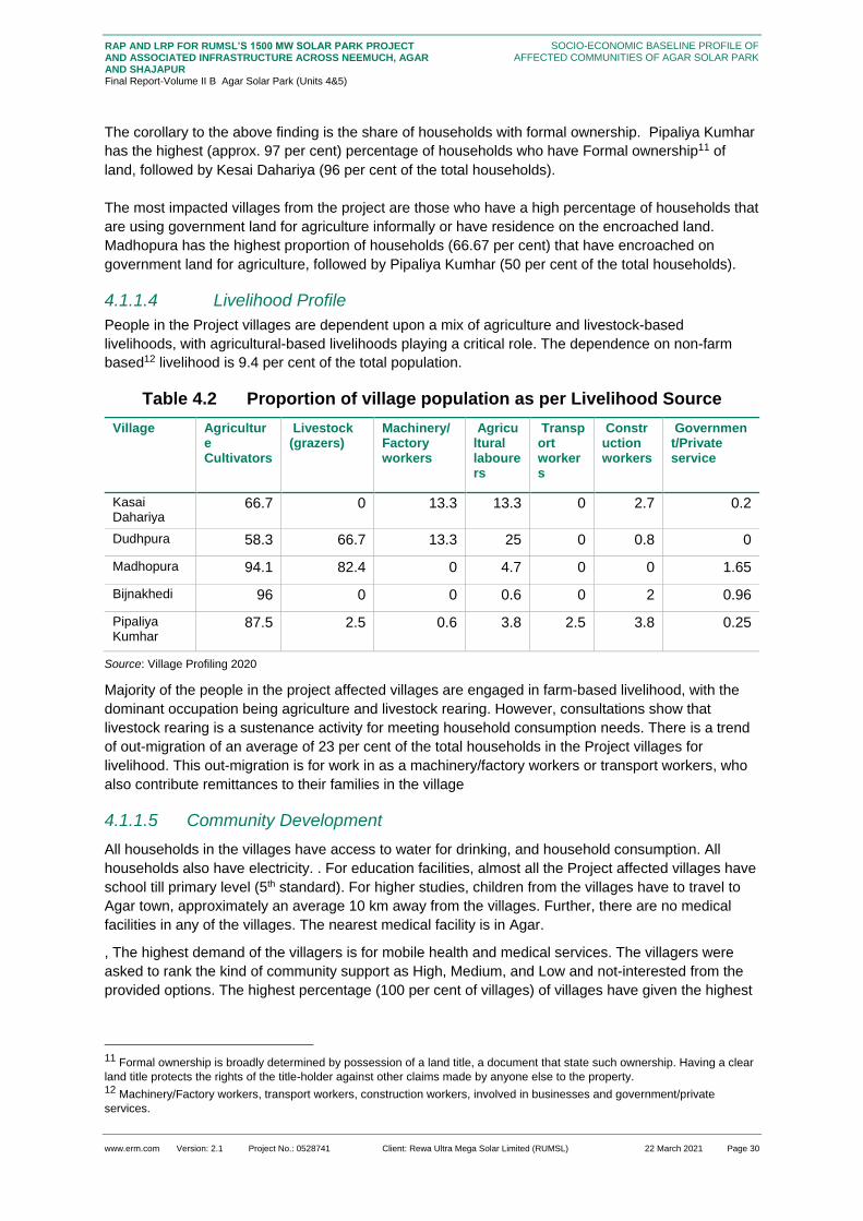
www.erm.com Version: 2.1 Project No.: 0528741 Client: Rewa Ultra Mega Solar Limited (RUMSL) 22 March 2021 Page 30
RAP AND LRP FOR RUMSL’S 1500 MW SOLAR PARK PROJECT AND ASSOCIATED INFRASTRUCTURE ACROSS NEEMUCH, AGAR AND SHAJAPUR Final Report-Volume II B Agar Solar Park (Units 4&5)
SOCIO-ECONOMIC BASELINE PROFILE OF AFFECTED COMMUNITIES OF AGAR SOLAR PARK
The corollary to the above finding is the share of households with formal ownership. Pipaliya Kumhar
has the highest (approx. 97 per cent) percentage of households who have Formal ownership11 of
land, followed by Kesai Dahariya (96 per cent of the total households).
The most impacted villages from the project are those who have a high percentage of households that
are using government land for agriculture informally or have residence on the encroached land.
Madhopura has the highest proportion of households (66.67 per cent) that have encroached on
government land for agriculture, followed by Pipaliya Kumhar (50 per cent of the total households).
4.1.1.4 Livelihood Profile
People in the Project villages are dependent upon a mix of agriculture and livestock-based
livelihoods, with agricultural-based livelihoods playing a critical role. The dependence on non-farm
based12 livelihood is 9.4 per cent of the total population.
Table 4.2 Proportion of village population as per Livelihood Source
Village Agriculture Cultivators
Livestock (grazers)
Machinery/Factory workers
Agricultural labourers
Transport workers
Construction workers
Government/Private service
Kasai Dahariya
66.7 0 13.3 13.3 0 2.7 0.2
Dudhpura 58.3 66.7 13.3 25 0 0.8 0
Madhopura 94.1 82.4 0 4.7 0 0 1.65
Bijnakhedi 96 0 0 0.6 0 2 0.96
Pipaliya Kumhar
87.5 2.5 0.6 3.8 2.5 3.8 0.25
Source: Village Profiling 2020
Majority of the people in the project affected villages are engaged in farm-based livelihood, with the
dominant occupation being agriculture and livestock rearing. However, consultations show that
livestock rearing is a sustenance activity for meeting household consumption needs. There is a trend
of out-migration of an average of 23 per cent of the total households in the Project villages for
livelihood. This out-migration is for work in as a machinery/factory workers or transport workers, who
also contribute remittances to their families in the village
4.1.1.5 Community Development
All households in the villages have access to water for drinking, and household consumption. All
households also have electricity. . For education facilities, almost all the Project affected villages have
school till primary level (5th standard). For higher studies, children from the villages have to travel to
Agar town, approximately an average 10 km away from the villages. Further, there are no medical
facilities in any of the villages. The nearest medical facility is in Agar.
, The highest demand of the villagers is for mobile health and medical services. The villagers were
asked to rank the kind of community support as High, Medium, and Low and not-interested from the
provided options. The highest percentage (100 per cent of villages) of villages have given the highest
11 Formal ownership is broadly determined by possession of a land title, a document that state such ownership. Having a clear
land title protects the rights of the title-holder against other claims made by anyone else to the property. 12 Machinery/Factory workers, transport workers, construction workers, involved in businesses and government/private
services.
www.erm.com Version: 2.1 Project No.: 0528741 Client: Rewa Ultra Mega Solar Limited (RUMSL) 22 March 2021 Page 31
RAP AND LRP FOR RUMSL’S 1500 MW SOLAR PARK PROJECT AND ASSOCIATED INFRASTRUCTURE ACROSS NEEMUCH, AGAR AND SHAJAPUR Final Report-Volume II B Agar Solar Park (Units 4&5)
SOCIO-ECONOMIC BASELINE PROFILE OF AFFECTED COMMUNITIES OF AGAR SOLAR PARK
rank to Mobile health van, followed by fodder and feed development, and veterinary support with 80
per cent of villages giving this preference a medium rank.

www.erm.com Version: 2.1 Project No.: 0528741 Client: Rewa Ultra Mega Solar Limited (RUMSL) 22 March 2021 Page 32
RAP AND LRP FOR RUMSL’S 1500 MW SOLAR PARK PROJECT AND ASSOCIATED INFRASTRUCTURE ACROSS NEEMUCH, AGAR AND SHAJAPUR Final Report-Volume II B Agar Solar Park (Units 4&5)
SOCIO-ECONOMIC BASELINE PROFILE OF AFFECTED COMMUNITIES OF AGAR SOLAR PARK
Figure 4.4 Preference for R&R Support

www.erm.com Version: 2.1 Project No.: 0528741 Client: Rewa Ultra Mega Solar Limited (RUMSL) 22 March 2021 Page 33
RAP AND LRP FOR RUMSL’S 1500 MW SOLAR PARK PROJECT AND ASSOCIATED INFRASTRUCTURE ACROSS NEEMUCH, AGAR AND SHAJAPUR Final Report-Volume II B Agar Solar Park (Units 4&5)
SOCIO-ECONOMIC BASELINE PROFILE OF AFFECTED COMMUNITIES OF AGAR SOLAR PARK
4.1.2 Profile of Villages in Unit 5: Susner
4.1.2.1 Village Population
As can be seen in the following table, villages in unit 5 are characterised by a total population of 4,741
individuals and 945 households. Of these entire villages, Pipaliya Nankar has reported the highest
population, followed by Naharkheda.
Table 4.3 Village Population
Villages Total Households Total Population
Naharkheda 300 1250
Palda 135 941
Pipaliya Nankar 300 1800
Umariya 210 750
Source: Village Profiling 2020
4.1.2.2 Social Stratification
While a mixed population characterises the total population in the villages in terms of religion and
caste, the dominant religion is reported to be Hinduism, with almost 100 per cent of the population
being Hindus (according to the village profile, filled in consultation with villages in each village).
Figure 4.5 Proportion of Social Group Households
Source: Village Profiling 2020
Majority of the village population belongs to the Other Backward Classes (OBC) category. Reportedly,
there is not ST population in the villages of unit 5.
The main groups among the Hindus include Gurjars, Brahmins, Sondhiya, Rajputs, Meghwals,
Chamar, Balahi, Bhil, Lohar, Nai, Banjara, Prajapati, Dhobi, Kumhar, Sonar, Sutaar and Banghi.
Out of these, the castes, Prajapati, Meghwals, Chamar, Balahi, and Kumhar are reported to be
categorised as Scheduled Castes. According to the consultations with the villagers, the Scheduled
Tribe found in the villages include, Bhil.

www.erm.com Version: 2.1 Project No.: 0528741 Client: Rewa Ultra Mega Solar Limited (RUMSL) 22 March 2021 Page 34
RAP AND LRP FOR RUMSL’S 1500 MW SOLAR PARK PROJECT AND ASSOCIATED INFRASTRUCTURE ACROSS NEEMUCH, AGAR AND SHAJAPUR Final Report-Volume II B Agar Solar Park (Units 4&5)
SOCIO-ECONOMIC BASELINE PROFILE OF AFFECTED COMMUNITIES OF AGAR SOLAR PARK
4.1.2.3 Land Ownership and Land Holding
Major proportion of the households (61.2 per cent) are marginal farmers. Households within the
category of small land holding is18.3 per cent of the total households, and the semi-medium land
holders comprise of 10.1 per cent of the total households in the villages. While only 0.64 percent are
medium land holders, there are no households with more than 10 ha of land holding. Of all the
villages, Naharkheda is the most vulnerable village in terms of landholding, as 77.7 per cent of the
total households’ falls under the category of marginal farmers.
Figure 4.6 Distribution of Households by Land Holding
Source: Village Profiling 2020
In Unit 5, there is a small proportion (9.8 per cent of the total households) of landless households.
Among the villages, Pipaliya Nankar has the highest number of landless household (around 16.7 per
cent), followed by Umariya (9.5 per cent). Palada village recorded the minimum number of landless
households (0.7 per cent of the total households).
Figure 4.7 Number of Landless Households

www.erm.com Version: 2.1 Project No.: 0528741 Client: Rewa Ultra Mega Solar Limited (RUMSL) 22 March 2021 Page 35
RAP AND LRP FOR RUMSL’S 1500 MW SOLAR PARK PROJECT AND ASSOCIATED INFRASTRUCTURE ACROSS NEEMUCH, AGAR AND SHAJAPUR Final Report-Volume II B Agar Solar Park (Units 4&5)
SOCIO-ECONOMIC BASELINE PROFILE OF AFFECTED COMMUNITIES OF AGAR SOLAR PARK
On the other hand, Palada village is having highest (96.3 per cent of the total households) percentage
of households who have formal ownership of land, followed by Umariya (95.2 per cent of the total
households).
The most impacted villages from the project are those who have a high percentage of households that
are using government land informally for agriculture or have residence on the encroached land.
Naharkheda has highest share of households (50.7 per cent) using government land for agriculture,
followed by Pipaliya Nankar (33.3 per cent of the total households). Additionally, in Naharkheda 18.3
percent of the total households have encroached government land for residential purpose.
4.1.2.4 Livelihood Profile
As can be seen from the below table, the villagers are dependent upon a mix of agriculture and
livestock-based livelihoods, with agricultural-based livelihoods playing a critical role. A sizeable share
of households (85.2 per cent of total population in the villages) are engaged agricultural activity while
22.6 per cent of total population are involved in livestock based livelihood activities and approx. 9.1
per cent of total population are involved as agricultural labour work. The dependence on non-farm
based13 livelihood is 8.7 per cent of the total population.
Table 4.4 Percentage of population as per Livelihood Sources
Village
Ag
ricu
ltu
re
Liv
esto
ck
(gra
zers
/h
erd
ers
/etc
.)
Cra
ft a
nd
Tra
de/A
rti
san
al
wo
rkers
Mach
iner
y/F
acto
ry
wo
rkers
Ag
ricu
ltu
r
al
lab
ou
rers
Tra
nsp
ort
wo
rkers
Co
nstr
ucti
on
wo
rkers
Bu
sin
esse
s
Go
vern
me
nt/
Pri
vate
serv
ice
Naharkheda 84 1.6 0 8 16 0 0.6 0.2 0.24
Umariya 98.7 100 0 0 0 0 1.3 0 0
Pipaliya Nankar
83.3 11.1 0 11.1 8.3 0 2.8 0 0.44
Palda 79.8 10.6 0.4 0 8.5 2.1 1.1 0.3 0.11
Source: Village Profiling 2020
Out-migration has been reported by 9 per cent of the total households in the Project villages for
livelihood, mostly this out-migration is for work in as a machinery/factory workers or transport workers.
4.1.2.5 Community Development
Per the village profile, 100 per cent of the households in the village have access to water for drinking,
household consumptions and irrigation purpose as well as access to electricity through grid supply.
For education facilities, almost all the Project affected villages have school till primary level (5th
standard). For further studies, children from the villages have to travel to Susner town, which is at
approximately average 10 km away from the villages. Further, there are no medical facilities in any of
the villages. The nearest medical facility is in Susner.
Findings from the village profile regarding the expected community support from the Project are
presented in the figure given above. Based on this ranking exercise for community support programs,
75 per cent of households have given high rank to Fodder and Feed development, Scholarship
Scheme, and Facilitation of access to school. Productivity enhancement of cattle, Formation of new
SHGs and support to existing ones and veterinary support has received medium rank from 50 per
cent of households.
13 Machinery/Factory workers, transport workers, construction workers, involved in businesses and government/private
services.

www.erm.com Version: 2.1 Project No.: 0528741 Client: Rewa Ultra Mega Solar Limited (RUMSL) 22 March 2021 Page 36
RAP AND LRP FOR RUMSL’S 1500 MW SOLAR PARK PROJECT AND ASSOCIATED INFRASTRUCTURE ACROSS NEEMUCH, AGAR AND SHAJAPUR Final Report-Volume II B Agar Solar Park (Units 4&5)
SOCIO-ECONOMIC BASELINE PROFILE OF AFFECTED COMMUNITIES OF AGAR SOLAR PARK
Figure 4.8 Preference for R&R Support (Unit 5)

www.erm.com Version: 2.1 Project No.: 0528741 Client: Rewa Ultra Mega Solar Limited (RUMSL) 22 March 2021 Page 37
RAP AND LRP FOR RUMSL’S 1500 MW SOLAR PARK PROJECT AND ASSOCIATED INFRASTRUCTURE ACROSS NEEMUCH, AGAR AND SHAJAPUR Final Report-Volume II B Agar Solar Park (Units 4&5)
SOCIO-ECONOMIC BASELINE PROFILE OF AFFECTED COMMUNITIES OF AGAR SOLAR PARK
4.1.3 Cultural Resources
There are no listed cultural resources, that are nationally or state-protected, are affected by the
Project. The cultural resource in the area are primarily religious structures such as temples. Although
none of these was noted to be within the proposed solar park boundary based on the aerial survey
imagery, a final check for some locations, after adjustments to the boundary are made, will need to be
confirmed, on-ground. There are small shrines of local deities and Chhatris (elevated dome shaped
pavilions used as element of honouring a site of religious prominence) in the area. The details of
cultural resources are given below in table
Table 4.5: Cultural resources in the Solar Park
Unit Village Cultural
Resource
Status of
cultural
resource on
inside or
outside the
project
boundary
Remarks Categorization
of the
Resources as
per IFC PS 8
Recommendation
for RUMSL
Ladwan Local Deity As per the
consultation
with villages,
the local deity
is outside the
Project
Footprint,
however, the
physical
verification
was not done
by the ERM
site team
The ST
community of
the village
worship the
local deities
(Gwal and
Nagdevta)
regularly and
during festival
season.
Though the
deities are
worshipped
primarily by
the ST
community,
the people
from other
communities
visit the
shrine as
well.
The shrine of
these deities
are adjacent
to the new
colony on the
outskirt of the
village.
Tangible form
of Cultural
Resources
To be confirmed
on ground-
whether this is
inside or outside
the boundary. In
case it is in the
project boundary
and cannot be
avoided,
alternative access
needs to be
provided or the
heritage site to be
relocated in
consultation with
the local
community

www.erm.com Version: 2.1 Project No.: 0528741 Client: Rewa Ultra Mega Solar Limited (RUMSL) 22 March 2021 Page 38
RAP AND LRP FOR RUMSL’S 1500 MW SOLAR PARK PROJECT AND ASSOCIATED INFRASTRUCTURE ACROSS NEEMUCH, AGAR AND SHAJAPUR Final Report-Volume II B Agar Solar Park (Units 4&5)
SOCIO-ECONOMIC BASELINE PROFILE OF AFFECTED COMMUNITIES OF AGAR SOLAR PARK
4.2 Socioeconomic profile of the households surveyed in the Project Footprint
This section provides an overview of the socio-economic baseline of the surveyed project affected
households (PAH) and sample households. The socio-economic profile is entirely based on the
primary survey and consultations conducted in the 8 villages in all two units across Agar Solar Park in
Madhya Pradesh. The villages surveyed in Agar have a distinct profile with different socio-economic
characteristics. This section of report discusses the aspects related to education, livelihood, land and
asset ownership, financial conditions, physical and social infrastructure amongst the PAHs. It also
attempts to highlight different vulnerabilities amongst the population and their dependency on
resources to understand involuntary resettlement impacts.
4.2.1 Demographics
The table below provides the demographic characteristics of the 138 PAH in the 11 villages.
Table 4.6 Demographic Profile of surveyed households
Village Number of Households
Total Population
Sex Ratio14
Average Family Size
Dependency
Ratio15
Unit 4
Bijnakhedi 15 70 1158 5.1 72.7
Madhopur 11 65 1104 5.6 72.7
Kesai Dehariya 5 24 714 4.8 50
Pipalya Kumhar 3 15 875 5 66.6
Ladwan NA NA NA NA NA
Karwa Khedi NA NA NA NA NA
Dudhpura NA NA NA NA NA
Unit 4 Sub-total 34 181 1033 5.1 65.5
Unit 5
Umariya 36 186 823 5.2 66.07
Naharkheda 30 178 854 5.9 67.2
Pipalya Nankar 16 76 809 4.7 42.8
Palada 22 128 969 5.8 32
Unit 5 Sub-total 104 568 862 5.4 52.01
Grand Total 138 749 896 5.1 58.7
Source: HH survey 2020
The overall sex ratio among PAHs in Unit 4 and 5 is lower than the sex ratio of the district (949) and
country’s sex ratio of 940 females per thousand males. However unit 4 shows a positive sex ratio as
compared to unit 5.
Looking at the dependency ratio, Unit 5 has a lower dependency ratio as compared to Unit 4. The
potential reason for low dependency can be a high proportion of people engaging in income
14 Sex ratio refers to the ratio of females to males among the PAH. 15 Dependency ratio refers to the proportion of dependents with respect to the working population among the PAH. The formula
used to calculate this ratio is PAPs below 15 years of age + PAPs above 60 years of age divided by the PAPs between 15-60 years of age.

www.erm.com Version: 2.1 Project No.: 0528741 Client: Rewa Ultra Mega Solar Limited (RUMSL) 22 March 2021 Page 39
RAP AND LRP FOR RUMSL’S 1500 MW SOLAR PARK PROJECT AND ASSOCIATED INFRASTRUCTURE ACROSS NEEMUCH, AGAR AND SHAJAPUR Final Report-Volume II B Agar Solar Park (Units 4&5)
SOCIO-ECONOMIC BASELINE PROFILE OF AFFECTED COMMUNITIES OF AGAR SOLAR PARK
generating activities. The dependency can only be lowered if there are better educational, vocational
and employment opportunities for vulnerable groups in the society.
As shown in Table 4.6 the average family size is 5.1. Among the surveyed households, 58.6 percent have up to 5 members in their family while, 41.3 percent have 5 to 10 family members. The households reporting more than 5 members primarily comprised of joint families, with two or more brothers residing together in the same household along with their families, parents, unmarried siblings and other dependents. The surveyed households reported a preference of nuclear families, with sons usually separating to set up their own household after marriage. This trend of nuclear families was understood to be higher among the younger generation who choose to live away from their parents. However, a variation across social groups also plays a role in the family sizes. Five (5) out of the seven (7) Muslim households have a preference of joint families. The lowest family size was reported was of 4.7 in Pipalya Nankar. In terms of age wise population distribution, Figure 4.9 shows that the majority of the population in the district is in the age group of 15-35, i.e. the youth population. The sex ratio among different age groups is detailed in Table 4.7. The population between the ages of 6-15 shows the lowest sex ratio among all age groups. As can be seen in the table, the sex ratio of children below the age of 6 and between the ages of 6-15 is relatively lower than those who are 35 years and above. Despite of several policies and schemes to promote gender development, these figures raise serious concerns towards gender equality in the area.
Table 4.7 Age structure of the population
Age group Males % Females % Total % Sex Ratio
Below 6 40 10.1 33 9.2 73 9.7 825
6-15 years 72 18.2 58 16.3 130 17.3 805
15-35 years 152 38.5 139 39.1 291 38.8 914
35-60 years 94 23.8 92 25.9 186 24.8 978
Above 60+ 36 9.1 33 9.2 69 27.7 916
Total 394 100 355 100 749 100 887
Source: HH survey 2020
Figure 4.9 Age-Sex Pyramid
Source: HH survey 2020
50.00 40.00 30.00 20.00 10.00 0.00 10.00 20.00 30.00 40.00 50.00
Below 6
6-15 years
15-35 years
35-60 years
Above 60+
Male Female

www.erm.com Version: 2.1 Project No.: 0528741 Client: Rewa Ultra Mega Solar Limited (RUMSL) 22 March 2021 Page 40
RAP AND LRP FOR RUMSL’S 1500 MW SOLAR PARK PROJECT AND ASSOCIATED INFRASTRUCTURE ACROSS NEEMUCH, AGAR AND SHAJAPUR Final Report-Volume II B Agar Solar Park (Units 4&5)
SOCIO-ECONOMIC BASELINE PROFILE OF AFFECTED COMMUNITIES OF AGAR SOLAR PARK
4.2.1.1 Religion, Caste and Ethnicity
Nearly 95 percent of the PAHs are Hindu while, the remaining 5 percent are Muslim households. The
Hindu households have a higher sex ratio (902), as compared to the households in the Muslim
category (869). The surveyed villages reported practice monogamy and the preferred norms of
kinship are endogamous.
Social group profiling of the PAEs shows that 45 percent of them belong to OBC category
households, and 29 percent belong to SC category households (out of 92 impacted households).
There are no caste based differences observed in occupation/livelihood, however, landlessness has
been observed to be highest among the OBC households (42 percent of the households) across the
PAEs.
The division of social groups by village is detailed in Figure 4.10.
Figure 4.10 Social groups by Village
Source: HH survey 2020
Though the surveyed villages have a mixed population from various social groups, the majority of the
surveyed population belonged to the Other Backward Classes (OBC) category (51.4 percent) followed
by Schedule Castes (SC) category (26.08 percent). The Solar Park has the lowest ST population (1.4
percent) as compared to other social groups, as can be seen in the Figure 4.10. As reported during
the survey, ST households are present in Umariya (Unit 5) and Kesai Dahariya (Unit 4) only. The
main caste groups amongst the surveyed households comprise of the Rajputs in General category,
Banjaras and Sondhiyas in the OBC category, Malviyas and Meghwals in the SC category. Pinjaras,
Fakirs, Multans and Mansuris are the dominant castes among Muslims. Among the OBC’s nearly 24
percent Banjaras, followed by the Sondhiyas.
4.2.1.2 Settlement Pattern
The settlement pattern in the villages have undergone a significant change over the years. The main
village has grown in size and extended to a larger area.
There is typically one main settlement in the village, followed by scattered multiple hamlets around the
main settlement in the radius of 500 mtrs – 1 km radius. These extended hamlets are spatially
segregated by caste hierarchy wherein the main settlement has dominant higher caste groups. .
These extended hamlets are either called a baldi or a colony. There is no apparent in the livelihood
profile, and regular life in the extended hamlets as compared to the main settlement.
Bijnakhedi MadhopurKesai
DehariyaPipliyaKumhar
UmariyaNaharkhed
aPipliyaNankar
Palada
General 1 1 4 12 7 3
OBC 6 17 4 2 17 8 5 12
SC 1 1 14 10 4 7
ST 1 1
0
2
4
6
8
10
12
14
16
18
General OBC SC ST
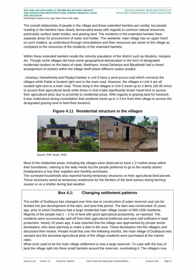
www.erm.com Version: 2.1 Project No.: 0528741 Client: Rewa Ultra Mega Solar Limited (RUMSL) 22 March 2021 Page 41
RAP AND LRP FOR RUMSL’S 1500 MW SOLAR PARK PROJECT AND ASSOCIATED INFRASTRUCTURE ACROSS NEEMUCH, AGAR AND SHAJAPUR Final Report-Volume II B Agar Solar Park (Units 4&5)
SOCIO-ECONOMIC BASELINE PROFILE OF AFFECTED COMMUNITIES OF AGAR SOLAR PARK
The overall relationship of people in the village and these extended hamlets are cordial, but people
residing in the hamlets have clearly demarcated areas with regards to common natural resources,
particularly surface water bodies, and grazing land. The residents in the extended hamlets have
separate areas for procurement of water and fodder. The residents’ main village has an upper hand
on such matters, as understood through consultations and their resources are closer to the village as
compared to the resources of the residents of the extended hamlets.
Within these extended hamlets reside the minority population of the district such as Muslims, Harijans
etc. Though some villages did have some geographical demarcation in the form of designated
residential clusters on the basis of caste, Madhopur, Kesai Dehariya and Bijnakhedi had a mixed
arrangement of clusters within the village itself where different castes resided.
, Umariya, Naharkheda and Pipalya Nankar in unit 5 have a semi-pucca road which connects the
villages while Palda is located right next to the main road. However, the villages in Unit 4 are all
located right next to a main road. Those living in the villages in Unit 5 travel up to 2-3kms (30-45 mins)
to access their agricultural lands while those in Unit 4 take significantly lesser travel time to access
their agricultural plots due to proximity to residential areas. With regards to grazing land for livestock,
it was understood during consultation that residents travel up to 1-3 km from their village to access the
designated grazing land to feed their livestock.
Figure 4.11 Residential structure in the villages
Source: RAP study, 2020
Most of the residential areas, including the villages were observed to have 1-2 market areas within
their boundaries, catering to the daily needs but the people preferred to go to the nearby district
headquarters to buy their supplies and monthly purchases.
The surveyed households also reported having temporary structures on their agricultural land parcels.
These structures acted as temporary residences for the families of the land owners during farming
season or as a shelter during bad weather.
Box 4.1: Changing settlement patterns
The profile of Dudhpura has changed over time due to construction of water reservoir and can be
divided into pre-development of the dam, and post that period. The dam was constructed 15 years
ago, prior to which Dudhpura had a large residential main village cluster of 900-1000 residents.
Majority of the people had 1 – 2 ha of land with good agricultural productivity, as reported. The
residents were economically well-off from their agricultural livelihood and were self-sufficient in food
production. Nearly 15 years ago, it was reported that the village was approached by private sector
developers, who were planning to make a dam in the area. These developers met the villagers and
discussed their motive. People recall that over the following months, the main village of Dudhpura was
vacated and the ancestral agricultural plots of the village residents were purchased at the market
rates.
What once used to be the main village settlement is now a large reservoir. To cope with the loss of
land the village split into three small hamlets around the reservoir, overlooking it. The villagers now

www.erm.com Version: 2.1 Project No.: 0528741 Client: Rewa Ultra Mega Solar Limited (RUMSL) 22 March 2021 Page 42
RAP AND LRP FOR RUMSL’S 1500 MW SOLAR PARK PROJECT AND ASSOCIATED INFRASTRUCTURE ACROSS NEEMUCH, AGAR AND SHAJAPUR Final Report-Volume II B Agar Solar Park (Units 4&5)
SOCIO-ECONOMIC BASELINE PROFILE OF AFFECTED COMMUNITIES OF AGAR SOLAR PARK
live in semi-pucca houses with approximately 0.01 - 0.2 ha of land holding. Their livelihoods were
reported to be dependent on non-farm based sectors and their food sufficiency has also significantly
reduced.
Source: consultations with the local community during RAP study
4.2.2 Social Group Dynamics
The district is characterised by a mixed population in terms of religion and social/caste groups, while
Hindus are the predominant religion, OBCs are the predominant caste group.
The marriages within these villages are mostly endogamous and the social set up is patriarchal. As
highlighted in section 4.2.1.2, in most villages, the different social categories reside in different
clusters and hamlets within the village. However, the people reported having a cordial relationship
across communities. Cultural activities are celebrated, across communities, and with participation by
various groups.
In terms of decision making at the village level, even where people from “lower castes” are the elected
representatives of the village as per the 73rd amendment16, However, the traditionally dominant caste
group members of the panchayat hold the decision making power in the villages. For example, in
Naharkheda in Unit 5 had a sarpanch who is a Dalit in the SC category and the previous sarpanch of
Bijnakhedi, for the past 7-10 years, has been a Muslim woman. However the decision making
authority in both villages continue to be the village elders belonging to the general category who act
as advisors or ‘committee members’.
Box 4.2: Spatial segregation by Caste Groups
Source: Consultations with the local community during RAP study
The following table provides a summary of the qualitative assessment of social group dynamics which
are further elaborated with data in relevant sections:
Table 4.8 Summary of Qualitative Observation on Social groups
Aspect General OBC SC ST
Settlement
Pattern
Live in the main
settlement.
Live in the main
settlement but in the
outskirts of the village
on a particular street.
Live in a particular
street in the
outskirts of the
settlement.
Live in the outskirts of
the village.
16 Accordingly, it is proposed to add a new Part relating to Panchayats in the Constitution to provide for among other things,
Gram Sabha in a village or group of villages; constitution of Panchayats at village and other level or levels; direct elections to all seats in Panchayats at the village and intermediate level, if any, and to the offices of Chairpersons of Panchayats at such levels; reservation of seats for the Scheduled Castes and Scheduled Tribes in proportion to their population for membership of Panchayats and office of Chairpersons in Panchayats at each level. (http://legislative.gov.in/constitution-seventy-third-amendment-act-1992)
Umariya Village in Susner tehsil, has one temple in the heart of the village. The festivities in the temple are
attended by everyone in the village, regardless of their caste group.
The Harijans (SCs) in the village live on one street, about a kilometre from the main village, called the “Harijan
Mohalla”. The houses on this street are semi-pucca and kutcha and in dilapidated state, compared to those in the
main settlement, and belonging to households of the dominant caste groups.
Harijans of the village are expected to fetch their water from a source which is distant from the main source of
water of the village. Though the interactions between the villages does not highlight this societal divide, the
infrastructure and the separation of houses makes evident the caste, and associated economic differences.

www.erm.com Version: 2.1 Project No.: 0528741 Client: Rewa Ultra Mega Solar Limited (RUMSL) 22 March 2021 Page 43
RAP AND LRP FOR RUMSL’S 1500 MW SOLAR PARK PROJECT AND ASSOCIATED INFRASTRUCTURE ACROSS NEEMUCH, AGAR AND SHAJAPUR Final Report-Volume II B Agar Solar Park (Units 4&5)
SOCIO-ECONOMIC BASELINE PROFILE OF AFFECTED COMMUNITIES OF AGAR SOLAR PARK
Aspect General OBC SC ST
Land
Ownership
Mostly marginal
holdings.
Mostly small and
medium size land
holdings.
Mostly small
holdings.
Have marginal land
holdings.
Literacy
Levels
Nearly 40 percent
of the population is
literate with
education up to
higher secondary
and in some cases,
vocational training.
The main reason
for discontinuation
of education is for
household chores.
Nearly 35 percent of
the population is
literate and are
educated till primary
levels, few instances of
education beyond
secondary or higher
secondary.
The main reason for
discontinuation of
education is for
household chores and
work.
Nearly 40 percent
is educated till
primary and
secondary levels.
Few instances of
vocational training.
The main reason
for discontinuation
of education is for
household chores.
Nearly 30 percent of
the population is
educated till primary
levels. A few instances
of vocational training.
The main reason for
discontinuation of
education is for
household chores or
illness and disability.
Skill Levels There are 2
persons, a couple
who are masons
(Rajmistris) in
Umariya village.
There are 3 persons; a
couple in Umariya and
a 22 year old man in
Palda who are artisans
practicing weaving.
A 35 year old man
in Naharkheda is
an artisan who
practices weaving.
None
Participation
in the Work
Force
People in the
working age (15-
60) mainly engage
in agriculture and
agriculture labour.
Very few of them
have a business or
shop.
People in the working
age (15-60) participate
mostly in agriculture,
agricultural labour and
construction work. Few
of them have a
business or shop and
only nearly 2% of this
population has a
government or
teaching job.
People in the
working age (15-
60) participate
mostly in
agriculture,
agriculture labour
and construction
work.
Very few are
engaged in
government jobs,
as drivers or have
a business or
shop.
People in the working
age (15-60) participate
only in agriculture and
agriculture labour
Poverty
Levels17
None18 Low (5.07 percent) Low (0.7 percent) Low (0.7 percent)
Gender
Roles
Decision making authority in the household are the male head and
the male members of the family.
Decision making
authority in the
household are the male
17 Defined with respect to annual income reported by surveyed households. 18 Low poverty levels- less than 25 percent of the population is below poverty line
Medium poverty levels- less than 50 percent of the population is below poverty line High Poverty levels- more than 50 percent of the population is below poverty line
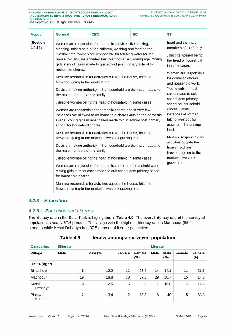
www.erm.com Version: 2.1 Project No.: 0528741 Client: Rewa Ultra Mega Solar Limited (RUMSL) 22 March 2021 Page 44
RAP AND LRP FOR RUMSL’S 1500 MW SOLAR PARK PROJECT AND ASSOCIATED INFRASTRUCTURE ACROSS NEEMUCH, AGAR AND SHAJAPUR Final Report-Volume II B Agar Solar Park (Units 4&5)
SOCIO-ECONOMIC BASELINE PROFILE OF AFFECTED COMMUNITIES OF AGAR SOLAR PARK
Aspect General OBC SC ST
(Section
4.2.11) Women are responsible for domestic activities like cooking,
cleaning, taking care of the children, washing and feeding the
livestock etc. women are responsible for fetching water for the
household and are anointed this role from a very young age. Young
girls in most cases made to quit school post primary school for
household chores.
Men are responsible for activities outside the house, fetching
firewood, going to the markets etc.
Decision making authority in the household are the male head and
the male members of the family
, despite women being the head of household in some cases.
Women are responsible for domestic chores and in very few
instances are allowed to do household chores outside the domestic
space. Young girls in most cases made to quit school post primary
school for household chores.
Men are responsible for activities outside the house, fetching
firewood, going to the markets, livestock grazing etc.
Decision making authority in the household are the male head and
the male members of the family
, despite women being the head of household in some cases.
Women are responsible for domestic chores and household work.
Young girls in most cases made to quit school post primary school
for household chores.
Men are responsible for activities outside the house, fetching
firewood, going to the markets, livestock grazing etc.
head and the male
members of the family
, despite women being
the head of household
in some cases.
Women are responsible
for domestic chores
and household work.
Young girls in most
cases made to quit
school post primary
school for household
chores. Some
instances of women
taking livestock for
grazing in the grazing
lands.
Men are responsible for
activities outside the
house, fetching
firewood, going to the
markets, livestock
grazing etc.
4.2.3 Education
4.2.3.1 Education and Literacy
The literacy rate in the Solar Park is highlighted in Table 4.9. The overall literacy rate of the surveyed
population is nearly 57.6 percent. The village with the highest illiteracy rate is Madhopur (55.4
percent) while Kesai Dehariya has 37.5 percent of literate population.
Table 4.9 Literacy amongst surveyed population
Categories Illiterate Literate
Village Male Male (%) Female Female (%)
Male Male (%)
Female Female (%)
Unit 4 (Agar)
Bijnakhedi 5 12.2 11 26.8 14 34.1 11 26.8
Madhopur 19 18.8 38 37.6 29 28.7 15 14.8
Kesai Dehariya
3 12.5 6 25 11 45.8 4 16.6
Pipalya Kumhar
2 13.4 2 13.3 6 40 5 33.3

www.erm.com Version: 2.1 Project No.: 0528741 Client: Rewa Ultra Mega Solar Limited (RUMSL) 22 March 2021 Page 45
RAP AND LRP FOR RUMSL’S 1500 MW SOLAR PARK PROJECT AND ASSOCIATED INFRASTRUCTURE ACROSS NEEMUCH, AGAR AND SHAJAPUR Final Report-Volume II B Agar Solar Park (Units 4&5)
SOCIO-ECONOMIC BASELINE PROFILE OF AFFECTED COMMUNITIES OF AGAR SOLAR PARK
Categories Illiterate Literate
Unit 4: Average %
29 14.2 57 25.6 60 37.1 35 22.8
Unit 5 (Susner)
Umariya 38 20.4 51 27.4 64 33.9 33 17.7
Naharkheda 22 12.3 34 19.1 74 41.5 48 26.9
Pipalya Nankar
14 18.4 16 21.05 28 36.8 18 23.6
Palada 23 17.9 33 25.7 42 32.8 30 23.4
Unit 5: Average
97 17.2 134 23.3 208 36.2 129 22.9
Total Average
126 16.8 191 25.4 268 35.2 164 21.9
Source: HH survey 2020
It is reported that 40.7 percent of the surveyed population have completed primary education and
nearly 19.9 percent have never attended formal schooling. Only about 9.3 percent of the surveyed
population have studied till secondary or higher secondary and only about 7 percent have pursued
graduate or post graduate courses. A popular field of education among the surveyed households are
informal vocational training. Nearly 20 percent of surveyed people reported pursuing vocational
programmes.
Figure 4.12 Level of Education among surveyed population
Source: HH survey 2020
Looking at the educational infrastructure within and around the surveyed villages, while most children
attend the government schools in or near their villages, there are a growing number of households
who prefer sending their children to private schools rather than government schools. While Primary
schools are reported to be relatively closer to the villages most children in Susner who are in
secondary or higher secondary classes attend schools which are 5-6 kms away. Children cover this
distance by foot, or in some case, use public transport. This is a contributing factor to high drop outs
post primary schools in the villages. It is understood that families are not comfortable letting their
children, specifically girls, travel such a distance to attend school and opt to discontinue their
education after primary school.
0%
20%
40%
60%
80%
100%
Bijnakhedi KesaiDehariya
Madhopur Naharkheda Palda PipliyaKumhar
PipliyaNankar
Umariya
Primary Secondary level Higher Secondary level
Graduate Post Graduate Vocational Training
Not school going age Never attended formal education

www.erm.com Version: 2.1 Project No.: 0528741 Client: Rewa Ultra Mega Solar Limited (RUMSL) 22 March 2021 Page 46
RAP AND LRP FOR RUMSL’S 1500 MW SOLAR PARK PROJECT AND ASSOCIATED INFRASTRUCTURE ACROSS NEEMUCH, AGAR AND SHAJAPUR Final Report-Volume II B Agar Solar Park (Units 4&5)
SOCIO-ECONOMIC BASELINE PROFILE OF AFFECTED COMMUNITIES OF AGAR SOLAR PARK
Those studying in graduate and post-graduate degree courses, and vocational training either travel to
Nalkheda, Shajapur, Susner, and in some cases, undertake residential facilities for courses in Indore
or Bhopal.
Table 4.10: Age wise literacy levels among Surveyed households
Age group Literate Illiterate
Male Female Male Female
6-15 years 63 55 9 4
15-35 years 132 85 20 54
35-60 years 53 14 41 78
Above 60+ 13 5 23 28
Total 261 159 93 164
Source: HH survey 2020
Table 4.10Table 4.10 indicates the learning gap between males and females in the Project footprint
villages. Overall, 51.5 percent of the women are illiterate and of them, 78.3 percent did not get the
opportunity to attend any formal educational institution due to household chores or traditional family
rules, as understood during consultation. Young girls drop out after completing primary level of
learning, due to societal norms, and physical distance of higher education institutions from the village
areas.
The male members of the family are allowed to study beyond primary school but nearly 22.2 percent
gave up studies due to a death in the family or an illness or disability, while 16.5 percent of them left
studies because of lack of interest. 22.7 percent of the male drop-outs are engaged in agriculture and
labour work. A few households in Umariya, Palada and Madhopur had children below the age of 10
who were going to school but also helping out in the fields.
Even though, the above table shows the difference between male and female literacy levels, there
also is a growing trend in the willingness to educate girls to higher education, and provide support to
undertake higher education courses.
4.2.3.2 Other Skills (non-farm based)
Several skills have been reported across villages in both the Units, specifically Umariya, Naharkheda,
and Kesai Dehariya. Only about 0.9 percent of the PAPs reported practicing traditional artisanal skills,
mainly practiced by the older population in the village and women in the OBC category. These
traditional crafts mostly relate to weaving. Apart from the traditional crafts, there are welders and
Rajmistris (masons) who practice their craft as means of livelihood but have not obtained any formal
certification for the same.
Knowledge and skills on farm-based activities (agriculture and livestock rearing), are ubiquitous
across the project affected households
4.2.4 Land and Asset Ownership21
Over the years, there has been a change in agriculture and cropping patterns in the area with regards
to increase in multiple cropping (highlighted in Section 6) per land parcel due to reduction in available
area for agriculture. The available land has reduced due to pressure of increasing
hamlets/settlements and land procurement for development projects.
21 This section takes into consideration the PAH with land holding only, the sample households mentioned in 4are not taken
into consideration as they are landless.

www.erm.com Version: 2.1 Project No.: 0528741 Client: Rewa Ultra Mega Solar Limited (RUMSL) 22 March 2021 Page 47
RAP AND LRP FOR RUMSL’S 1500 MW SOLAR PARK PROJECT AND ASSOCIATED INFRASTRUCTURE ACROSS NEEMUCH, AGAR AND SHAJAPUR Final Report-Volume II B Agar Solar Park (Units 4&5)
SOCIO-ECONOMIC BASELINE PROFILE OF AFFECTED COMMUNITIES OF AGAR SOLAR PARK
Box 4.3: Prior experience with displacement due to an infrastructure project
In Kesai Dehariya, Unit 4, a private sector dam has been built near the village a few years back. The
dam was built for energy generation and irrigation. The dam led to the acquisition of agricultural land
of the village residents. In lieu of construction project, the village community was promised direct
water access from the dam which however, did not happen.
The water has been directed to other industrial areas and has not been sourced to the village. It’s
been nearly 7 years and the residents of the village are required to travel up to one (1) km to fetch
water for their household from the nearby pond. The loss of their ancestral land not only impacted
their livelihood but also led to the loss of grazing land for many residents in the village. The residents
of the village are now more dependent on seasonal migrant livelihoods and also have been forced to
significantly reduce their livestock holding,
Source: Consultations with the local community during RAP study
The other villages in Agar tehsil who were surveyed expressed similar apprehensions of loss of land
for grazing for their livestock and loss of livelihood overall.
As has been stated above, the land identified for the purpose of the project is comprised of primarily
government land (90.5 percent), with a small sections of private land. Approximately 9.5 percent of
land is private which also includes patta land (the extent is not known currently). All the private land
owners are residents of Agar Tehsil. The land identified is comprised mainly of agricultural land and
grazing land. Table 4.11 details the proportion of PAHs across land holdings and Table 4.12 details
the same by village.
Table 4.11 Size of land holdings
Land Holding Size PAH PAHs (%)
Marginal Farmer (<1 ha) 33 35
Small Farmer (1-2 ha) 28 27
Semi-medium Farmer (2-4 ha) 24 26
Medium Farmer (4-10 ha) 8 9
Large Farmer (>10 ha) 3 3
Source: HH survey 2020
Note: the total number of PAHs with land are 96.
Table 4.12 Land holding amongst the PAHs by Village
Village
Marg
inal
Farm
er
(<1 h
a)
M
arg
inal
Farm
er
(<1 h
a)
%
Sm
all
Farm
er
(1-
2 h
a)
S
mall
Farm
er
(1-
2 h
a)
%
Sem
i-
med
ium
Farm
er
(2-
4 h
a)
S
em
i-
med
ium
Farm
er
(2-
4 h
a)
%
Med
ium
Farm
er
(4-
10 h
a)
Med
ium
Farm
er
(4-
10 h
a)
%
Larg
e
Farm
er
(>10 h
a)
Larg
e
Farm
er
(>10 h
a)
%
Unit 4
Bijnakhedi 1 50 1 50
Madhopur 1 30 4 80 1 10
Kesai Dehariya
1 50 1 50
Pipalya Kumhar

www.erm.com Version: 2.1 Project No.: 0528741 Client: Rewa Ultra Mega Solar Limited (RUMSL) 22 March 2021 Page 48
RAP AND LRP FOR RUMSL’S 1500 MW SOLAR PARK PROJECT AND ASSOCIATED INFRASTRUCTURE ACROSS NEEMUCH, AGAR AND SHAJAPUR Final Report-Volume II B Agar Solar Park (Units 4&5)
SOCIO-ECONOMIC BASELINE PROFILE OF AFFECTED COMMUNITIES OF AGAR SOLAR PARK
Village
Ma
rgin
al
Fa
rme
r
(<1
ha
)
Ma
rgin
al
Fa
rme
r
(<1
ha
) %
S
mall
Fa
rme
r (1
-
2 h
a)
S
mall
Fa
rme
r (1
-
2 h
a)
%
Sem
i-
med
ium
Fa
rme
r (2
-
4 h
a)
S
em
i-
med
ium
Fa
rme
r (2
-
4 h
a)
%
Me
diu
m
Fa
rme
r (4
-
10 h
a)
Me
diu
m
Fa
rme
r (4
-
10 h
a)
%
La
rge
Fa
rme
r
(>1
0 h
a)
La
rge
Fa
rme
r
(>1
0 h
a)
%
Unit 4 total 2 13
2 25 5 56 1 s6
Unit 5
Umariya 11 41 5 19 7 26 4 15
Naharkheda 10 42 1 33 2 8 2 8 2 8
Pipalya Nankar
5 50 4 40 1 10
Palada 5 31 4 25 5 31 1 6 1 6
Unit 4 total 31 40 14 27 15 19 7 9 3 4
Source: HH survey 2020
Majority of the PAHs (34.7 percent approx.) are categorised as marginal farmers, owning less than
one (1) hectare of land, while the PAHs with large land holdings (more than 10 hectares) are
comprised of about 3 percent of the total PAHs. The large farmers are reported to be only in Unit 5
while marginal and small farmers are across both units. The potential impacts from the land
procurement for the project in terms of change in land holdings and loss of livelihoods is discussed in
the section on impacts.
A look at land holding by caste group shows that among the marginal farmers, 45.4 percent of the
PAHs belong to SC category in Unit 5 while all of the large farmers (with more than 10 hectares of
land holding) belong to General category. Among the land owners with semi-medium land holding (2
– 4 hectares), 66.6 percent of them belong to OBC category. Analysis of land holding by gender
shows that 6.06 percent of marginal landholding is by women headed households. Only one (1)
woman reported to medium size of land holding in Madhopur.
As mentioned before, the land holdings of PAHs, specifically in Unit 4, have reduced in size due to
developmental projects in the area. 3 villages who were surveyed, for this reason, had reservations
about this project. The residents of Dudhpura reported that they had lost nearly 60-70 percent of their
ancestral land to the dam that was built in the place where their village once used to be. They were
displaced from their village and now live in small hamlets around the dam with no benefits from the
project. This has been accompanied by a reduction in the land used for cultivation and for grazing.
This trend is expected to continue in the future.
This change in size of land holdings has also led to a gradual shift in primary occupation among
people. The Banjaras in Madhopur and Bijnakhedi have reduced their dependence on land and land
based livelihoods. Their main source of livelihood has shifted to being labour work in non-farm
enterprises (casual labour work in cities, stone crushing quarries in other states) and business. The
men in the Banjara community migrate to another state (Haryana, and then to Tamil Nadu) for major
part of the year for work.
4.2.4.1 Nature of Primary Residence
Except for 3 residential structures, all residences are owned by the PAHs who also reside there. About 41 percent of the housing is of kutcha type, and 20 percent of PAHs have a pucca housing structure. There are 10 PAHs who have been allocated housing by the Gram Panchayat as part of the Pradhan Mantri Awas Yojna scheme. Of these, six (6) are in Madhopur and the remaining in Kesai Dahariya.

www.erm.com Version: 2.1 Project No.: 0528741 Client: Rewa Ultra Mega Solar Limited (RUMSL) 22 March 2021 Page 49
RAP AND LRP FOR RUMSL’S 1500 MW SOLAR PARK PROJECT AND ASSOCIATED INFRASTRUCTURE ACROSS NEEMUCH, AGAR AND SHAJAPUR Final Report-Volume II B Agar Solar Park (Units 4&5)
SOCIO-ECONOMIC BASELINE PROFILE OF AFFECTED COMMUNITIES OF AGAR SOLAR PARK
Figure 4.13 Types of Housing
Source: HH survey 2020
4.2.4.2 Livestock Ownership
The PAHs are characterised by livestock holdings of cows, buffaloes, goats and sheep with the most
common being cows and buffaloes. The dependence on livestock is mostly for household
consumption along with the sale of dairy products, especially milk. Cows, buffaloes, and goats are the
milk animals. Figure 4.14 shows the number of PAH which have different varieties of livestock in the
district. Cows are the most commonly owned livestock. Each household has at least one head of
livestock. The social group bifurcation of ownership shows no apparent difference in ownership. The
difference arise in cases of buffalo ownership which is higher in General and OBC social group in
comparison to the SC and ST social group. The reason behind the low ownership of buffalo between
the two social groups stems from their financial status. Households from general and OBC categories
are also better off and have more land. The other reasons for significantly low ownership of buffaloes
are:
the purchasing cost of buffalo is very high, reportedly the cost of a buffalo varies from INR 70,000
to 100,000;
the cost of veterinary support is high for buffalo;
buffalo need more fodder as compare to cow and goat, therefore in the dry season it is very
difficult for low income earning household to purchase fodder for buffalo
Figure 4.14 Type of Livestock holdings amongst the surveyed households
Source: HH survey 2020
0%
10%
20%
30%
40%
50%
60%
70%
80%
Kutcha Semi-pucca Pucca
61
4 5
45
72
35
52
0
10
20
30
40
50
60
70
1-5. 5-10. More than 10
Cow Buffalo Goat

www.erm.com Version: 2.1 Project No.: 0528741 Client: Rewa Ultra Mega Solar Limited (RUMSL) 22 March 2021 Page 50
RAP AND LRP FOR RUMSL’S 1500 MW SOLAR PARK PROJECT AND ASSOCIATED INFRASTRUCTURE ACROSS NEEMUCH, AGAR AND SHAJAPUR Final Report-Volume II B Agar Solar Park (Units 4&5)
SOCIO-ECONOMIC BASELINE PROFILE OF AFFECTED COMMUNITIES OF AGAR SOLAR PARK
4.2.4.3 Poultry Ownership
Some, 5 households own poultry, all of whom have 5-10 poultry. 2 of these households are in Palda
while 3 are in Madhopur and 80 percent of them are in the OBC category.
4.2.4.4 Other Movable Assets
In terms of household appliances, the highest proportion of assets is of ceiling fans, mobile phones,
television sets and cable connections. In terms of vehicles, most of the PAHs reported ownership of
two wheelers including bicycles and motor cycles. Amongst the agricultural implements, PAHs
reported ownership mostly of implements such as tractors and water pump sets.

www.erm.com Version: 2.1 Project No.: 0528741 Client: Rewa Ultra Mega Solar Limited (RUMSL) 22 March 2021 Page 51
RAP AND LRP FOR RUMSL’S 1500 MW SOLAR PARK PROJECT AND ASSOCIATED INFRASTRUCTURE ACROSS NEEMUCH, AGAR AND SHAJAPUR Final Report-Volume II B Agar Solar Park (Units 4&5)
SOCIO-ECONOMIC BASELINE PROFILE OF AFFECTED COMMUNITIES OF AGAR SOLAR PARK
Table 4.13 Movable Assets amongst surveyed households by village
Village Kitchen Appliance
Kitchen Appliance %
Household Appliance
Household Appliance %
Agricultural appliance
Agricultural appliance %
Means of Transport
Means of Transport %
Communication devices
Communication devices%
Unit 4
Bijnakhedi 0 4 50% 0 3 37.5% 7 87.5%
Madhopur 1 5.5% 1 5.5% 2 11.1% 14 77.7% 11 100%
Kesai Dehariya 0 1 20% 0 2 40% 4 80%
Pipalya Kumhar
0 1 33.3% 0 1 33.3% 2 66.6%
Ladwan NA NA NA NA NA
Karwa Khedi NA NA NA NA NA
Dudhpura NA NA NA NA NA
Agar Sub-total
1 5.5% 7 27.2% 2 11.1% 20 47.1% 24 83.2%
Unit 5
Umariya 8 22.2% 18 50% 2 5.5% 18 50% 32 88.8%
Naharkheda 8 26.6% 10 33.3% 3 10% 12 40% 30 100%
Pipalya Nankar 3 18.7% 5 31.2% 2 12.5% 7 43.7% 16 100%
Palda 2 9.09% 8 36.3% 2 9.09% 16 72.7% 21 95.4%
Susner Sub-total
21 19.1% 41 37.7% 9 9.2% 53 51.6% 99 96.5%
Grand Total 22 12.3% 48 32.4% 48 10.1% 73 49.3% 123 89.5%
Source: HH survey 2020

www.erm.com Version: 2.1 Project No.: 0528741 Client: Rewa Ultra Mega Solar Limited (RUMSL) 22 March 2021 Page 52
RAP AND LRP FOR RUMSL’S 1500 MW SOLAR PARK PROJECT AND ASSOCIATED INFRASTRUCTURE ACROSS NEEMUCH, AGAR AND SHAJAPUR Final Report-Volume II B Agar Solar Park (Units 4&5)
SOCIO-ECONOMIC BASELINE PROFILE OF AFFECTED COMMUNITIES OF AGAR SOLAR PARK
4.2.5 Livelihood Profile
Out of the 749 PAPs, 34.3 percent of the individuals have no current occupation. Out of these
individuals 49.2 percent are below the age of 10 and about 7.02 percent are above the age of 60 and
are thus, dependents. Apart from them, 48.8 percent of the PAPs are working of which, females
constitute 30 percent. Housewives are not considered as a part of the income earning population
even though they constitute nearly 35 percent of the surveyed population. The reason for the same is
detailed in the below sections.
4.2.5.1 Primary Occupation
Looking at the primary occupation amongst the surveyed household, livelihoods across various age
groups is given in Figure 4.15. It can be seen that among the working population (15-60 years of age)
the dominant primary occupation reported is farm based activities (35-50 years). Even though there is
a mixed dependence upon farm based and non-farm based activities across age groups, it was
reported that there is a greater dependence on agriculture for sustenance as compared to non-farm
based activities.
Figure 4.15 Primary livelihoods across Age groups
Source: HH survey 2020
Figure 4.16 highlights the segregation of primary occupation within the surveyed villages. It can be
understood that the most common primary occupation among villages is agriculture (23.6 percent),
except for Pipalya Kumhar. Agricultural labour and livestock rearing is reported as the most common
secondary occupation with nearly 14 percent of the PAPs engaged in the same.
15-35 years 35-60 years Above 60+
Unemployed 17.07% 8.20% 34.50%
Non- Farm Based 20.60% 15.80% 5.40%
Farm Based 62.70% 75.80% 60.00%
62.70%75.80%
60.00%
20.60%
15.80%
5.40%
17.07%8.20%
34.50%
0%10%20%30%40%50%60%70%80%90%
100%
Farm Based Non- Farm Based Unemployed

www.erm.com Version: 2.1 Project No.: 0528741 Client: Rewa Ultra Mega Solar Limited (RUMSL) 22 March 2021 Page 53
RAP AND LRP FOR RUMSL’S 1500 MW SOLAR PARK PROJECT AND ASSOCIATED INFRASTRUCTURE ACROSS NEEMUCH, AGAR AND SHAJAPUR Final Report-Volume II B Agar Solar Park (Units 4&5)
SOCIO-ECONOMIC BASELINE PROFILE OF AFFECTED COMMUNITIES OF AGAR SOLAR PARK
Figure 4.16 Primary Occupation Profile by village
Source: HH survey 2020
Looking at the gendered distribution of occupation among villages, there is a domination of men in
almost all types of occupations. Women are most commonly engaged in farm based activities. The
discussion of primary occupation among women is detailed in Section 4.2.11
Figure 4.17: Primary Occupation Profile gender
Source: HH survey 2020
0%
10%
20%
30%
40%
50%
60%
70%
80%
90%
100%
Bijnakhedi Madhopur KesaiDehariya
PipliyaKumhar
Umariya Naharkheda PipliyaNankar
Palada
Agriculture Agricultural labour
Government and private job Business/shop
Contract worker/ construction worker Housewife
Livestock Other
Unemployed
0%
10%
20%
30%
40%
50%
60%
70%
80%
90%
100%
Males Female

www.erm.com Version: 2.1 Project No.: 0528741 Client: Rewa Ultra Mega Solar Limited (RUMSL) 22 March 2021 Page 54
RAP AND LRP FOR RUMSL’S 1500 MW SOLAR PARK PROJECT AND ASSOCIATED INFRASTRUCTURE ACROSS NEEMUCH, AGAR AND SHAJAPUR Final Report-Volume II B Agar Solar Park (Units 4&5)
SOCIO-ECONOMIC BASELINE PROFILE OF AFFECTED COMMUNITIES OF AGAR SOLAR PARK
Lastly, the caste wise distribution of occupation in Figure 4.18 a similar trend of preference of
agriculture across different castes. It can also be seen that non-farm based activities are not very
common among the ST households in the area.
Figure 4.18 Primary occupation by Social group
Source: HH survey 2020
4.2.5.2 Farm Based Livelihoods
As can be seen in Section 4.2.5.1 farm based livelihoods, including agriculture and agricultural
labour, is the most common livelihood among most surveyed households. The potential reason
behind this choice of livelihood is the traditional familial responsibilities among the households and
providing financial support. As can be seen in Figure 4.15, a large proportion of people engaged in
agriculture are between the ages of 35-60. A comparatively lesser number of surveyed population
between the ages of 15-35 are engaged in farm based activities. These individuals are studying and
engaged in agriculture and agricultural labour to support their families, financially. During consultation
it was understood that most people prefer to continue with their familial occupation of agriculture
rather than venturing out to other sectors because lack of opportunities in the village and the absence
of monetary resources to pursue the same. Another reason for this is the absence of vocational
training centres, graduate and post-graduate colleges in the area.
As mentioned before the engagement in farm based activities of surveyed population between the
ages of 35-60 is significantly higher. As can be seen in the above mentioned tables and as
understood during consultations, the potential reasons for the same is the familial responsibility of
providing financial support. It was understood during consultations that people in this age group were
forced to quit their education to support to their family occupation. The average gross income from
agriculture and horticulture reported by the PAH was approximately INR 1, 60,000 22annually and
approximately INR 60, 000 annually from agricultural labour.
4.2.5.3 Non-Farm Based Livelihoods
Non-farm based livelihoods are also reported among 15-35 year olds (Figure 4.15). Nearly 11.7
percent of the surveyed households work in non-farm based occupations as their primary source of
income, of which 61.6 percent are between the ages of 15-35. The most common non-farm based
occupation reported is small business or shop and working as a construction worker. The average
annual income from a small business or a shop is INR 2, 17, 244.
22 The reported income based on multi cropping system in the area. .
0%
10%
20%
30%
40%
50%
60%
70%
80%
90%
100%
General OBC SC ST
Farm Based Non- Farm Based Unemployed

www.erm.com Version: 2.1 Project No.: 0528741 Client: Rewa Ultra Mega Solar Limited (RUMSL) 22 March 2021 Page 55
RAP AND LRP FOR RUMSL’S 1500 MW SOLAR PARK PROJECT AND ASSOCIATED INFRASTRUCTURE ACROSS NEEMUCH, AGAR AND SHAJAPUR Final Report-Volume II B Agar Solar Park (Units 4&5)
SOCIO-ECONOMIC BASELINE PROFILE OF AFFECTED COMMUNITIES OF AGAR SOLAR PARK
Gender- disaggregation of non-farm occupation shows that non-farm based occupations are also
male dominated. Among these, 42.8 percent of the business or shop owners are in the age group of
15-35 years. The potential reason for the lack of women participation in non-farm based activities
might be the absence of opportunities. Women in the area are generally discouraged to engage in
work outside the house. . It was understood that women mostly engage in farm-based activities and
that too only if a male member of the family is engaged in the same with them. When it comes to non-
farm based activities, women are mainly employed in construction work: 17.8 percent of construction
workers are female, mainly between the ages of 30-40 and 15-25. The average annual household
income from construction work is approximately INR 60,780, annually.
The literacy levels among the non-farm occupation related workers is high. 64.2 percent of people
who are construction workers are literate and have completed some form of graduate or vocational
level of education. Similarly, 82.1 percent of business and shop owners are literate and have
completed vocational level of education.
4.2.5.4 Migration
Over the years, the dependence on non-farm based activities has increased. It was understood that
migrant labour has become a popular choice in the past decade. The Banjaras in Agar tehsil have
shifted their dependence from agriculture to migrant labour and business. They travel to other states
(Kerala, Tamil Nadu Maharashtra, and Gujrat) for up to 8-9 months of the year for their occupation. It
was understood during consultations that the trend to migrate and work was a recent phenomenon.
Even though the numbers of people who migrate are low, this trend is growing. The potential reason
for the same is the lack of growth in agriculture and the need to venture out for money.
Nearly 16 percent of the PAHs have family members that migrate from their village to work in another
district or state. Of the 16 percent, 31.8 percent are women. 86.3 percent of those of migrate, migrate
outside their district. The most common occupation which they migrate for is labour work. Only 4.5
percent of the people who migrated, left their villages for a private job. The migrant workers send an
average of INR 22,500 annually, as remittances to their families in the village. Of the people who
migrated, only 50 percent of the workers returned during the COVID19 nationwide lockdown. While in
their village, 45.5 percent of the people were unemployed. It was reported that all the migrant
workers, returned to their district of migration once the lockdown was lifted.
4.2.6 Agricultural Activities
Nearly 52.4 percent of the total surveyed population between 15-60 years of age are engaged in farm
based activities. Of those engaged in agriculture, 52.6 percent are male and the rest are female. The
female contribute equally to the activity but are not considered the earning member of the family. The
reason for the same is discussed in Section 4.2.11.
It was understood during consultations that the most commonly grown crops in these villages are
Soyabean, Wheat, Maize, Kabuli Channa and Urad dal. The cropping pattern varies from village to
village depending on the type of soil and the availability of land in the area. Most surveyed
households reported that they cultivate 2-3 crops in a year while some households who have more
than 1.25 – 1.3 hectares of land have a variety of crops up to 8 growing in one season.
It was reported that during the previous year, due to high rainfall in the area, the entire district of Agar
suffered significant losses of Soyabean productivity. This can be a potential reason for the above
mentioned cropping pattern; uncertainty of weather. The damage has been seen in the picture below.

www.erm.com Version: 2.1 Project No.: 0528741 Client: Rewa Ultra Mega Solar Limited (RUMSL) 22 March 2021 Page 56
RAP AND LRP FOR RUMSL’S 1500 MW SOLAR PARK PROJECT AND ASSOCIATED INFRASTRUCTURE ACROSS NEEMUCH, AGAR AND SHAJAPUR Final Report-Volume II B Agar Solar Park (Units 4&5)
SOCIO-ECONOMIC BASELINE PROFILE OF AFFECTED COMMUNITIES OF AGAR SOLAR PARK
Picture 1: Soyabean cropping in the PF Picture 2: Pests on soyabean crop
Source: RAP Study, August 2020
Figure 4.19, shows the proportion of surveyed households engaged in agriculture. Umariya and
Naharkheda have the highest proportion of households who are engaged in agriculture. In Pipalya
Kumhar, the surveyed households reported to agricultural labour work as their primary source of
earning, supplemented by seasonal non-farm work on the other hand, have no households who are
engaged in agriculture as their primary source of livelihood.
Figure 4.19 Households engaged in Agriculture by Village
Table 4.14 Count of PAHs by cropping pattern
Unit Village Single Cropping
Double cropping
Triple cropping
Four, more than four crops
Unit 4
Bijnakhedi 6 6 NA NA
Kesai Dehariya
2 2 2 NA
25%
66%
60%
69.40%
63.30%68.70%
54.50%
0%
10%
20%
30%
40%
50%
60%
70%
80%
Bijnakhedi Madhopur KesaiDehariya
Umariya Naharkheda PipliyaNankar
Palda
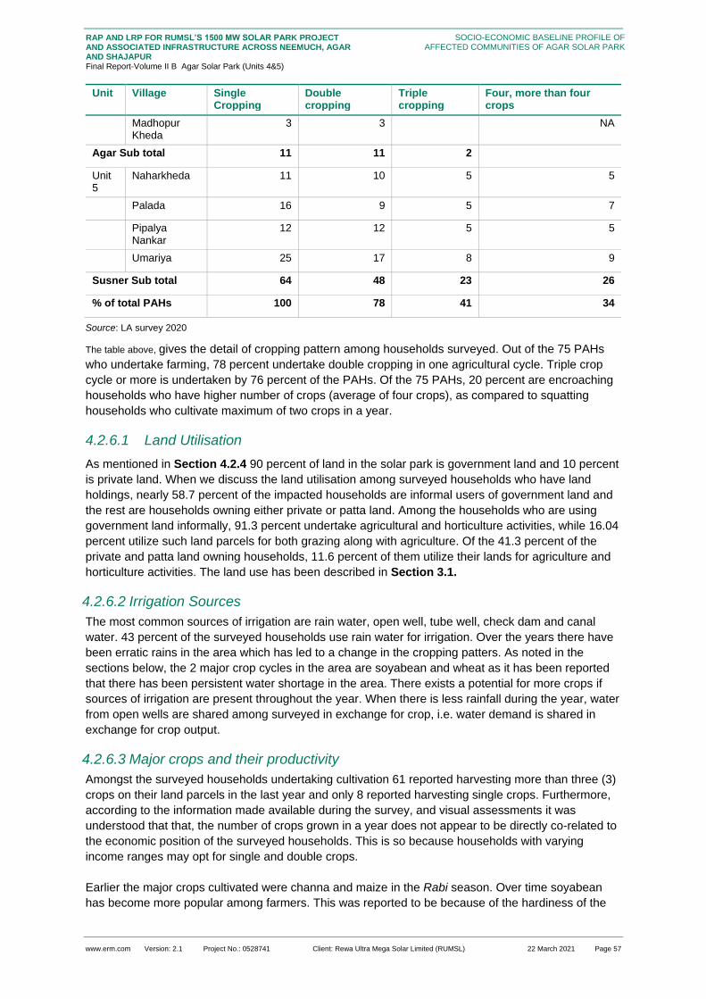
www.erm.com Version: 2.1 Project No.: 0528741 Client: Rewa Ultra Mega Solar Limited (RUMSL) 22 March 2021 Page 57
RAP AND LRP FOR RUMSL’S 1500 MW SOLAR PARK PROJECT AND ASSOCIATED INFRASTRUCTURE ACROSS NEEMUCH, AGAR AND SHAJAPUR Final Report-Volume II B Agar Solar Park (Units 4&5)
SOCIO-ECONOMIC BASELINE PROFILE OF AFFECTED COMMUNITIES OF AGAR SOLAR PARK
Unit Village Single Cropping
Double cropping
Triple cropping
Four, more than four crops
Madhopur Kheda
3 3
NA
Agar Sub total 11 11 2
Unit 5
Naharkheda 11 10 5 5
Palada 16 9 5 7
Pipalya Nankar
12 12 5 5
Umariya 25 17 8 9
Susner Sub total 64 48 23 26
% of total PAHs 100 78 41 34
Source: LA survey 2020
The table above, gives the detail of cropping pattern among households surveyed. Out of the 75 PAHs
who undertake farming, 78 percent undertake double cropping in one agricultural cycle. Triple crop
cycle or more is undertaken by 76 percent of the PAHs. Of the 75 PAHs, 20 percent are encroaching
households who have higher number of crops (average of four crops), as compared to squatting
households who cultivate maximum of two crops in a year.
4.2.6.1 Land Utilisation
As mentioned in Section 4.2.4 90 percent of land in the solar park is government land and 10 percent
is private land. When we discuss the land utilisation among surveyed households who have land
holdings, nearly 58.7 percent of the impacted households are informal users of government land and
the rest are households owning either private or patta land. Among the households who are using
government land informally, 91.3 percent undertake agricultural and horticulture activities, while 16.04
percent utilize such land parcels for both grazing along with agriculture. Of the 41.3 percent of the
private and patta land owning households, 11.6 percent of them utilize their lands for agriculture and
horticulture activities. The land use has been described in Section 3.1.
4.2.6.2 Irrigation Sources
The most common sources of irrigation are rain water, open well, tube well, check dam and canal
water. 43 percent of the surveyed households use rain water for irrigation. Over the years there have
been erratic rains in the area which has led to a change in the cropping patters. As noted in the
sections below, the 2 major crop cycles in the area are soyabean and wheat as it has been reported
that there has been persistent water shortage in the area. There exists a potential for more crops if
sources of irrigation are present throughout the year. When there is less rainfall during the year, water
from open wells are shared among surveyed in exchange for crop, i.e. water demand is shared in
exchange for crop output.
4.2.6.3 Major crops and their productivity
Amongst the surveyed households undertaking cultivation 61 reported harvesting more than three (3)
crops on their land parcels in the last year and only 8 reported harvesting single crops. Furthermore,
according to the information made available during the survey, and visual assessments it was
understood that that, the number of crops grown in a year does not appear to be directly co-related to
the economic position of the surveyed households. This is so because households with varying
income ranges may opt for single and double crops.
Earlier the major crops cultivated were channa and maize in the Rabi season. Over time soyabean
has become more popular among farmers. This was reported to be because of the hardiness of the
www.erm.com Version: 2.1 Project No.: 0528741 Client: Rewa Ultra Mega Solar Limited (RUMSL) 22 March 2021 Page 58
RAP AND LRP FOR RUMSL’S 1500 MW SOLAR PARK PROJECT AND ASSOCIATED INFRASTRUCTURE ACROSS NEEMUCH, AGAR AND SHAJAPUR Final Report-Volume II B Agar Solar Park (Units 4&5)
SOCIO-ECONOMIC BASELINE PROFILE OF AFFECTED COMMUNITIES OF AGAR SOLAR PARK
crop for heavy rains and dry spells. However, due to excessive rainfall the entire standing crop was
infested by insects causing excessive damage in the past year. Apart from soyabean, the other
commonly grown crops in the district are wheat, maize, channa and dal, of which soyabean and
maize are kharif crops and wheat, dal and channa are rabi crops. Approximately 97 percent of the
PAH grow soyabean and nearly 76.5 percent grow wheat. Apart from the popular crops, many
households also reportedly grow vegetables; onion, potato, ladyfinger, green chillies and coriander.
The seasonal calendar is given below:
Figure 4.20 Seasonal calendar for major crops of surveyed households
Ja
nu
ary
Fe
bru
ary
Ma
rch
Ap
ril
Ma
y
Ju
ne
Ju
ly
Au
gu
st
Se
pte
mb
er
Oc
tob
er
No
vem
be
r
De
ce
mb
er
Soyabean
Wheat
Maize
Channa
Dal
Lady finger Green chillies
Potato
Garlic
Onion
Coriander
Source: HH survey 2020
Apart from the four major crops listed above, the other crops grown include Maize, Mustard, Onion
and Groundnut (in decreasing order of number of households reporting to cultivating these crops).
Soyabean is the Kharif crop and acts as the major cash crop for the region. Wheat is primarily grown
for sustenance and is used (about 50 percent of output) for self-consumption. Apart from wheat, urad
dal and kabuli channa are grown as intermediate crops between the two crop cycles. The Minimum
Support Price (MSP) that the farmers received for soyabean in the previous year was INR 3710 per
quintal and INR 1925 per quintal for wheat.
Figure 4.21 Crop Productivity per hectare (in Quintal)
Source: HH survey 2020
130
186.5
75
56 51.5
0
20
40
60
80
100
120
140
160
180
200
Soyabean Wheat Maize Channa Dal

www.erm.com Version: 2.1 Project No.: 0528741 Client: Rewa Ultra Mega Solar Limited (RUMSL) 22 March 2021 Page 59
RAP AND LRP FOR RUMSL’S 1500 MW SOLAR PARK PROJECT AND ASSOCIATED INFRASTRUCTURE ACROSS NEEMUCH, AGAR AND SHAJAPUR Final Report-Volume II B Agar Solar Park (Units 4&5)
SOCIO-ECONOMIC BASELINE PROFILE OF AFFECTED COMMUNITIES OF AGAR SOLAR PARK
Looking at the crop production with respect to land holding size, Figure 4.22 highlights the popularity
of soyabean across all types of farmers. The potential reason for the same is the security that
soyabean as a cash crop and the ease of sale in the market. Small and marginal farmers, despite
their land holding size, grow multiple crops, which include vegetables. Nearly 7-10 percent of them
sell these less commonly cultivated crops rather than consuming them. The potential reason behind
this higher income potential. They prefer to procure grains and vegetables from the market or through
government assistance rather than lose out on their income. Nearly 50 percent of the major crops
mentioned above are utilized for self-consumption and the rest are sold for income. Apart from
soyabean, of which 20-30 percent of the output is kept for self-consumption, up to 50 percent of
wheat is reportedly kept by many households for themselves. The discussion on subsistence is
covered in Section 4.2.6.4
Figure 4.22 Cropping pattern amongst PAH by types of Farmer
Source: HH survey 2020
4.2.6.4 Food Security
With regards to food security, the information was collected on sufficiency of production of grains,
pulses, and vegetables. Across all three categories, the insufficiency reported is highest for vegetable
production – 84.05 percent of the surveyed households have a shortfall in production. This is followed
by pulses - 76.8 percent of the surveyed households report that the pulses they cultivate are also
insufficient, and nearly 61.6 percent of the surveyed households report that the grains that they
cultivate in their fields are insufficient. The potential reasons for insufficiency is growth of cash crops
in majority of land holdings. Government assistance in the form of distribution of food ration through
Public Distribution System (PDS) shops is available primarily for grains (74 percent) and pulses (59.4
percent) while only 6.5 percent of the surveyed households report that they receive government
assistance in terms of purchase of vegetables from government run mandis. The shortfall in
production is met through open market purchase, at a quarterly frequency, and sometimes, for every
month in a given year.
Looking at food sufficiency with respect to land holding sizes (Figure 4.23), it can be seen that
despite land holding size, there is limited sufficiency of vegetables and the procurement is mainly
through purchase or via government assistance. Semi-medium, medium and large farmers are most
secure in terms of sustenance of grains and pulses as compared to marginal and small farmers.
0%
10%
20%
30%
40%
50%
60%
70%
80%
90%
100%
Marginal Farmer Small Farmer Semi MediumFamer
Medium Farmer Large Farmer
Soyabean Wheat Maize Channa Dal Mustard Onion Groundnut

www.erm.com Version: 2.1 Project No.: 0528741 Client: Rewa Ultra Mega Solar Limited (RUMSL) 22 March 2021 Page 60
RAP AND LRP FOR RUMSL’S 1500 MW SOLAR PARK PROJECT AND ASSOCIATED INFRASTRUCTURE ACROSS NEEMUCH, AGAR AND SHAJAPUR Final Report-Volume II B Agar Solar Park (Units 4&5)
SOCIO-ECONOMIC BASELINE PROFILE OF AFFECTED COMMUNITIES OF AGAR SOLAR PARK
Figure 4.23 Food security amongst PAH by Types of farmers
Source: HH survey 2020
4.2.7 Livestock Rearing
Most households own cows. The breed of cows in the villages are Malvi23 , an indigenous breed of
cow, local to Madhya Pradesh. They are a breed of the Zeebu cattle from the Malwa region of
Madhya Pradesh. The potential reason behind the high number of cow in the region are:
They are traditionally owned by household in the area.
The other reason is for draught- the cow here basically being the mother of bullocks that helped
farmers to plough the field, and pull their cart.
Figure 4.24 show the use of livestock for self-consumption and for income across the PAHs. The PAH
that use livestock for self also use this livestock as income sources. The most common uses of
livestock are for milk production. The men of the household are responsible for selling the produce
and for decisions regarding purchase and sale of livestock.
Figure 4.24 Uses of livestock
Source: HH survey 2020
23 http://afs.okstate.edu/breeds/cattle/malvi/index.html/
0%
10%
20%
30%
40%
50%
60%
70%
80%
90%
100%
Marginal Farmers Small Farmers Semi-mediumFarmers
Medium Farmers Large Farmers
Grains Pulses Vegetables
Cow Buffalo Goat
Self Consumption 68 53 38
Income Source 15 37 25
0
10
20
30
40
50
60
70
80
Self Consumption Income Source

www.erm.com Version: 2.1 Project No.: 0528741 Client: Rewa Ultra Mega Solar Limited (RUMSL) 22 March 2021 Page 61
RAP AND LRP FOR RUMSL’S 1500 MW SOLAR PARK PROJECT AND ASSOCIATED INFRASTRUCTURE ACROSS NEEMUCH, AGAR AND SHAJAPUR Final Report-Volume II B Agar Solar Park (Units 4&5)
SOCIO-ECONOMIC BASELINE PROFILE OF AFFECTED COMMUNITIES OF AGAR SOLAR PARK
There has reportedly been a reduction in the number of cows, and buffaloes purchased for livestock
due to reduction in grazing land, the cattle market becoming inactive and increasing dependence on
market purchase of fodder (expenditure item). Another reason reported by the local community in lack
of cattle and livestock trade is due to the emergence of gau rakshaks and incidences of violence
against people that were transporting cattle. In Madhya Pradesh, there are cow protection laws which
prohibit the slaughter and illegal transportation of cows. There have been cases there have been
arrests made of people in the district for “illegally smuggling” cows under the NSA and Prevention of
Cruelty to Animals Act24. This has also resulted in local communities transporting cattle in the middle
of the night and abandoning them in nearby villages as well as along roads and highways. This has
led to unintended consequences that include: an increase in awara gai (stray cows); collision with
vehicles for cattle left astray on roads and highways and also increased instances of crop damage in
villages that are made to receive these cattle. Majority of the cows graze on private lands, and/or
available grazing land without any direct supervision. Abandoned cows are usually found on
government land and may be tended to by some people from the village, although without any claim
of ownership or responsibility. There have been reports of destruction of agricultural fields by groups
of abandoned cows in some villages in Susner, especially in the last few years.
Box 4.4: The Case of Abandoned Cows
Source: consultations with the local community during RAP study
The most common practice for feeding is open grazing with a combination of either crop residue or
market purchased fodder. Of the households that have livestock, 62.4 percent purchase fodder from
markets to feed their animals, specifically for cows and buffaloes. 94.2 percent practice grazing on
open government lands and 27.1 percent allow their livestock to graze on private parcels. Though the
common grazing practices are in open grazing lands, the surveyed households reported that this is
possible only for a few months of the year (monsoon season) for cows and buffaloes. The reason
behind this was reported to be the poor quality of grass and the low availability of grass in in the dry
seasons. Another reason was reported to be the shrinking in area of available grazing lands due to
encroachment or squatting and increasing number of development projects in the area (Section
4.2.4). The surveyed households reported that they now prefer to purchase fodder from markets and
charging a fee for better quality grazing areas and availability of fodder. Details the on dependence on
different sources of grazing for livestock throughout a typical year is given in table below.
24 https://www.newindianexpress.com/nation/2019/feb/08/nsa-against-2-for-cow-smuggling-in-mp-1935998.html
Stray cows are a common sight in villages in Unit 4 and Unit 5. . Large herds of cows amble around aimlessly,
unclaimed. An increasing number of farmers have started setting their cows astray because of diminishing
resources to feed them. These unprotected stray cattle, which once used to sell at a premium value are now
an unproductive asset and a nuisance to farmers and villagers. Farmers are now forced to spend more money
to protect their farm against these stray cattle which have damaged crops. They create a threat to farmers as
they wander into agricultural plots and eat the crops. These stray cattle are a road hazard too. There are a
number of government funded cow sheds but they are not a preferred by the farmers because the cattle are
reportedly not ill-fed and improperly cared for.
A unique case has been observed in Umariya. The village has come up with a solution to this
stray/abandoned cattle problem. The residents of the village pooled their resources and funded a gaushala for
the stray cows. The cows are kept in a confined unit where they are fed and taken care of by the villagers all
together. The cattle are taken for grazing by one person in the open fields nearby and in some seasons the
residents purchase fodder for the cattle too. The dung are used by some households in the village as fuel.
This development has led to lower crop damage by theses stray cattle and also reduced number of road
accidents and near-misses.
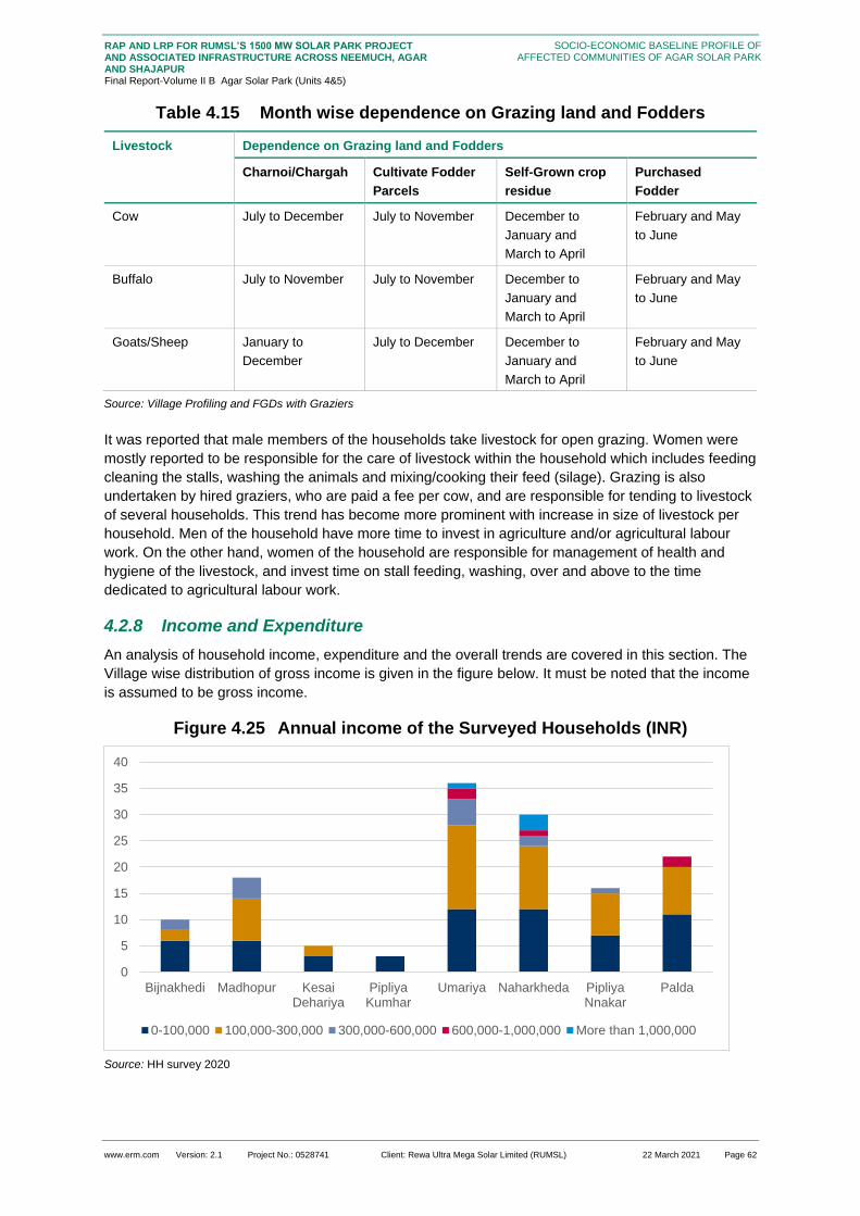
www.erm.com Version: 2.1 Project No.: 0528741 Client: Rewa Ultra Mega Solar Limited (RUMSL) 22 March 2021 Page 62
RAP AND LRP FOR RUMSL’S 1500 MW SOLAR PARK PROJECT AND ASSOCIATED INFRASTRUCTURE ACROSS NEEMUCH, AGAR AND SHAJAPUR Final Report-Volume II B Agar Solar Park (Units 4&5)
SOCIO-ECONOMIC BASELINE PROFILE OF AFFECTED COMMUNITIES OF AGAR SOLAR PARK
Table 4.15 Month wise dependence on Grazing land and Fodders
Livestock Dependence on Grazing land and Fodders
Charnoi/Chargah Cultivate Fodder
Parcels
Self-Grown crop
residue
Purchased
Fodder
Cow July to December July to November December to
January and
March to April
February and May
to June
Buffalo July to November July to November December to
January and
March to April
February and May
to June
Goats/Sheep January to
December
July to December December to
January and
March to April
February and May
to June
Source: Village Profiling and FGDs with Graziers
It was reported that male members of the households take livestock for open grazing. Women were
mostly reported to be responsible for the care of livestock within the household which includes feeding
cleaning the stalls, washing the animals and mixing/cooking their feed (silage). Grazing is also
undertaken by hired graziers, who are paid a fee per cow, and are responsible for tending to livestock
of several households. This trend has become more prominent with increase in size of livestock per
household. Men of the household have more time to invest in agriculture and/or agricultural labour
work. On the other hand, women of the household are responsible for management of health and
hygiene of the livestock, and invest time on stall feeding, washing, over and above to the time
dedicated to agricultural labour work.
4.2.8 Income and Expenditure
An analysis of household income, expenditure and the overall trends are covered in this section. The
Village wise distribution of gross income is given in the figure below. It must be noted that the income
is assumed to be gross income.
Figure 4.25 Annual income of the Surveyed Households (INR)
Source: HH survey 2020
0
5
10
15
20
25
30
35
40
Bijnakhedi Madhopur KesaiDehariya
PipliyaKumhar
Umariya Naharkheda PipliyaNnakar
Palda
0-100,000 100,000-300,000 300,000-600,000 600,000-1,000,000 More than 1,000,000

www.erm.com Version: 2.1 Project No.: 0528741 Client: Rewa Ultra Mega Solar Limited (RUMSL) 22 March 2021 Page 63
RAP AND LRP FOR RUMSL’S 1500 MW SOLAR PARK PROJECT AND ASSOCIATED INFRASTRUCTURE ACROSS NEEMUCH, AGAR AND SHAJAPUR Final Report-Volume II B Agar Solar Park (Units 4&5)
SOCIO-ECONOMIC BASELINE PROFILE OF AFFECTED COMMUNITIES OF AGAR SOLAR PARK
The income across different social categories among surveyed households are detailed in Figure
4.26.
Figure 4.26 Annual Income of surveyed households by social group (INR)
Source: HH survey 2020
The average annual gross income reported from agriculture is INR 2, 73,497, while that from the
government or private job was reported to be INR 94,740. The average income from livestock
activities was reported as INR 87,820. Another important source of income for the PAHs is business
activities, with an average annual income of INR 217,244. Apart from these, the other sources of
income reported by the surveyed households include old age pension and assistance received from
government.
In terms of expenditure, the major heads were reported to be for the basic household provisions
(ration), education, cultural expenses, agricultural inputs and health care. The households reported
maximum expenditure on loan repayment (INR I, 84,604).
Table 4.16 and Figure 4.27 shows the correlation between income and expenditure among the
households. The table and figure highlight that the surveyed households report higher expense as
compared to income. One potential cause of this trend is the dependence of this data on recall ability
of the respondents and the general trend towards over estimating the expenses incurred in
comparison to income.
Table 4.16 Average Annual Expenditure by Income group (INR)
Income Range Average Annual Household Expenditure (INR)
Lowest Annual Household Expenditure (INR)
Median Annual Household Expenditure (INR)
Highest Annual Household Expenditure (INR)
Below 100,000 237,739 22,000 1,82,400 599,050
100,000-300,000 454,829 57,775 316,460 1,141,200
300,000-600,000 659,957 175,000 496,700 1,158,040
General OBC SC ST
More than INR1,00,00,000 2 2 0 0
INR6,00,000-INR1,00,00,000 2 2 1 0
INR3,00,000-INR6,00,000 3 8 1 0
INR1,00,000-INR3,00,000 12 26 18 1
Below 100,000 9 33 17 1
0
10
20
30
40
50
60
70
80
Below 100,000 INR1,00,000-INR3,00,000 INR3,00,000-INR6,00,000
INR6,00,000-INR1,00,00,000 More than INR1,00,00,000

www.erm.com Version: 2.1 Project No.: 0528741 Client: Rewa Ultra Mega Solar Limited (RUMSL) 22 March 2021 Page 64
RAP AND LRP FOR RUMSL’S 1500 MW SOLAR PARK PROJECT AND ASSOCIATED INFRASTRUCTURE ACROSS NEEMUCH, AGAR AND SHAJAPUR Final Report-Volume II B Agar Solar Park (Units 4&5)
SOCIO-ECONOMIC BASELINE PROFILE OF AFFECTED COMMUNITIES OF AGAR SOLAR PARK
Income Range Average Annual Household Expenditure (INR)
Lowest Annual Household Expenditure (INR)
Median Annual Household Expenditure (INR)
Highest Annual Household Expenditure (INR)
600,000-1,000,000 1,415,690 983,650 1,445,300 1,962,300
More than 1,000,000 2,281,812 278,000 692,730 5,861,600
Source: HH survey 2020
Figure 4.27 Income-Expenditure Comparison
Source: HH survey 2020
4.2.9 Community Dependence on Natural Resources
One of the main forms of dependence on natural resources is the community’s dependence on
firewood as a cooking fuel. The primary reason for this dependence was reported to be the costs of
refilling LPG. The other household natural resource dependents are given in Figure 4.28

www.erm.com Version: 2.1 Project No.: 0528741 Client: Rewa Ultra Mega Solar Limited (RUMSL) 22 March 2021 Page 65
RAP AND LRP FOR RUMSL’S 1500 MW SOLAR PARK PROJECT AND ASSOCIATED INFRASTRUCTURE ACROSS NEEMUCH, AGAR AND SHAJAPUR Final Report-Volume II B Agar Solar Park (Units 4&5)
SOCIO-ECONOMIC BASELINE PROFILE OF AFFECTED COMMUNITIES OF AGAR SOLAR PARK
Figure 4.28 Dependence of surveyed households on Natural Resources
Source: HH survey 2020
Among the surveyed households, firewood is the most commonly gathered natural resource. The
most preferred areas from where these resources are collected are the common land (65.2 percent of
PAHs) and the nearby forest (32.9 percent of PAHs). The small percentage of households that collect
leaves are OBC and SC households who use dried leaves as fuel in the kitchen and for selling paan,
as reported during consultations. It should be noted that although no forest land is included in the
Project footprint, the ease of access to the land may be restricted due to the Solar Plant boundary
demarcation.
The gender dynamic play a key role in natural resource procurement too. While it is the responsibility
of the women of the household to fetch water, especially the young women of the house, the
responsibility of collecting firewood is with both men and women. They travel up to one (1) km to
collect water and up to two (2) kms for firewood. The households reported collecting up to 100 to
150kgs of firewood each month.
Box 4.5: Gender segregation in natural resource procurement
Source: consultations with the local community during RAP study
4.2.9.1 Trees within Project Footprint
The table below gives the details of trees identified within the project footprint through the LA survey.
A total of 341 trees are identified.
FirewoodFodder/Gr
assFruit Bark Leaf
Soil /Stone
Water Other
Total PAH 82 21 22 3 2 21 4 8
82
21 22
3 2
21
48
0
10
20
30
40
50
60
70
80
90
Another common sight in the surveyed villages are young children fetching water or wood for
the house. Young girls, from a very early age are expected to contribute to the household.
They work with their mothers and learn the basic household chores from a very young age
along with school work. One of the primary activities that they are responsible for from a very
young age is fetching water for the household. From an age of 6-7, they travel on foot, up to 1-
1.5 kms to fetch water. The boys, on the other hand, are expected to work on the fields and
fetch wood from the forest and are functioned into the system by the older male members of
the family. The socio-cultural set up of the village get epitomized in the gendered dynamics of
everyday roles from a very early age.

www.erm.com Version: 2.1 Project No.: 0528741 Client: Rewa Ultra Mega Solar Limited (RUMSL) 22 March 2021 Page 66
RAP AND LRP FOR RUMSL’S 1500 MW SOLAR PARK PROJECT AND ASSOCIATED INFRASTRUCTURE ACROSS NEEMUCH, AGAR AND SHAJAPUR Final Report-Volume II B Agar Solar Park (Units 4&5)
SOCIO-ECONOMIC BASELINE PROFILE OF AFFECTED COMMUNITIES OF AGAR SOLAR PARK
Table 4.17 Types of Tree plantations
Unit Type of tree Count
Unit 425 Fruit tree young non productive 7
Fruit tree young productive 28
Fruit tree mature 4
Timber Tree Above 45 cm DBH 140
Agar Sub-total 179
Unit 5 Fruit tree young non productive 6
Fruit tree young productive 24
Fruit tree mature 3
Timber Tree Above 45 cm DBH 129
Susner Sub-total 162
Grand total
341
Source: LA survey 2020
The tables below describe the type of tree species surveyed on the private land parcels.
Table 4.18 Tree species by use
Tree Type Fodder Fuelwood NTFP Other Timber Grand Total
Khejdi 3 NA 30 NA 3 36
Palash NA 27 NA NA NA 27
Babul NA NA 9 NA 4 13
Neem NA 1 NA NA 20 21
Imli NA NA NA 1 NA 1
Ber NA NA 1 5 NA 6
Peepal NA NA NA NA 2 2
Tendu NA NA 1 NA NA 1
Others NA 18 4 NA 22
Grand Total 3 46 41 10 29 129
Source: LA survey 2020
Table 4.19 Fruit species by productivity
Fruit Type Young Non Productive Young Productive Mature
Guava 2 2 NA
Orange NA 19 NA
Mango 4 1 NA
Nutmeg NA 2 NA
Pomegranate NA NA 3
25 The count of trees for private land parcels of Unit 4 has been estimated based on the findings in Unit 5

www.erm.com Version: 2.1 Project No.: 0528741 Client: Rewa Ultra Mega Solar Limited (RUMSL) 22 March 2021 Page 67
RAP AND LRP FOR RUMSL’S 1500 MW SOLAR PARK PROJECT AND ASSOCIATED INFRASTRUCTURE ACROSS NEEMUCH, AGAR AND SHAJAPUR Final Report-Volume II B Agar Solar Park (Units 4&5)
SOCIO-ECONOMIC BASELINE PROFILE OF AFFECTED COMMUNITIES OF AGAR SOLAR PARK
Grand Total 6 24 3
Source: LA survey 2020
4.2.10 Physical and Social Infrastructure
This section provides an understanding of the surveyed households’ access to basic social and
physical infrastructure including access to water for drinking and household purposes, sanitation
facilities, electricity, health facilities and credit and market facilities.
4.2.10.1 Healthcare and Health Infrastructure
Figure 4.29 Preference of Health care facility
Source: HH survey 2020
Amongst the surveyed households, more than 50 percent reported a preference for private facilities
for medical treatment, in both common complaints and complex cases. It is understood that the
preference for public facilities is mostly resultant from the cost implications of treatment at a private
clinic/hospital. The distance of the facility also plays a contributing factor to the preference.
This dependence upon private facilities is also facilitated by the availability of these facilities in close
proximity to the area of residence of the households.
Among the social groups, 70.8 percent of OBC and 50 percent of SC prefer to go to a private hospital
for treatment of small illnesses. But only 39.4 percent of SC and 51.3 percent of OBC prefer private
hospital for treatment of serious illnesses. They prefer to travel to a government hospital even if there
is considerable distance from their village. One general category household in Pipalya Nankar
reported a traditional delivery preference over private or government hospitals. Only 18.05 percent of
OBC prefer to go to a private institution for delivery while 89.1 percent of SC prefer a private hospital
for the same.
The most common chronic health condition reported by the surveyed population in the last year
include common asthma, blood pressure, diabetes and stomach and intestine related problems.
Common disabilities which many reported were related to eye sight and physical disability.
4.2.10.2 Access to Electricity
All surveyed households reported that they have access to electricity. The table below highlights the
sources of electricity.
37.60% 46.30%
79.70%
61.60% 59.90%
18.80%
0 0 0.70%
0%
10%
20%
30%
40%
50%
60%
70%
80%
90%
100%
Common Illness Major illness Institutionalized Delivery
Government Private Traditional
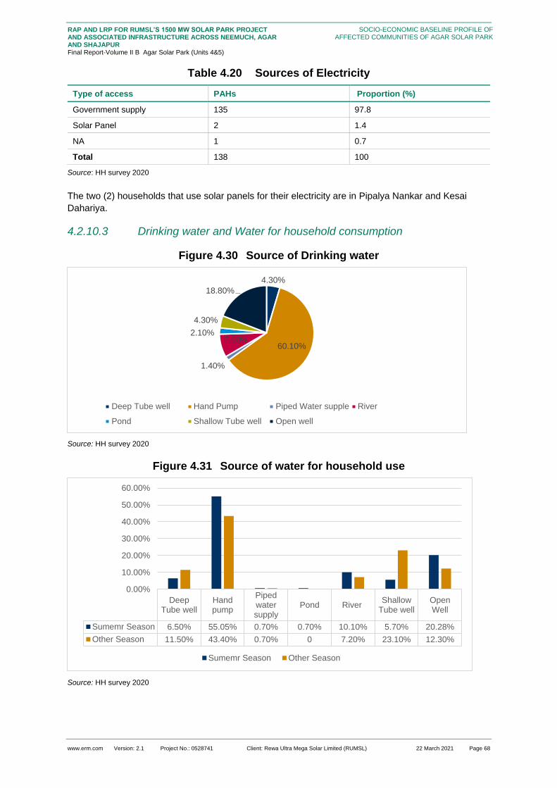
www.erm.com Version: 2.1 Project No.: 0528741 Client: Rewa Ultra Mega Solar Limited (RUMSL) 22 March 2021 Page 68
RAP AND LRP FOR RUMSL’S 1500 MW SOLAR PARK PROJECT AND ASSOCIATED INFRASTRUCTURE ACROSS NEEMUCH, AGAR AND SHAJAPUR Final Report-Volume II B Agar Solar Park (Units 4&5)
SOCIO-ECONOMIC BASELINE PROFILE OF AFFECTED COMMUNITIES OF AGAR SOLAR PARK
Table 4.20 Sources of Electricity
Type of access PAHs Proportion (%)
Government supply 135 97.8
Solar Panel 2 1.4
NA 1 0.7
Total 138 100
Source: HH survey 2020
The two (2) households that use solar panels for their electricity are in Pipalya Nankar and Kesai
Dahariya.
4.2.10.3 Drinking water and Water for household consumption
Figure 4.30 Source of Drinking water
Source: HH survey 2020
Figure 4.31 Source of water for household use
Source: HH survey 2020
4.30%
60.10%
1.40%
7.90%2.10%
4.30%
18.80%
Deep Tube well Hand Pump Piped Water supple River
Pond Shallow Tube well Open well
DeepTube well
Handpump
Pipedwatersupply
Pond RiverShallow
Tube wellOpenWell
Sumemr Season 6.50% 55.05% 0.70% 0.70% 10.10% 5.70% 20.28%
Other Season 11.50% 43.40% 0.70% 0 7.20% 23.10% 12.30%
0.00%
10.00%
20.00%
30.00%
40.00%
50.00%
60.00%
Sumemr Season Other Season

www.erm.com Version: 2.1 Project No.: 0528741 Client: Rewa Ultra Mega Solar Limited (RUMSL) 22 March 2021 Page 69
RAP AND LRP FOR RUMSL’S 1500 MW SOLAR PARK PROJECT AND ASSOCIATED INFRASTRUCTURE ACROSS NEEMUCH, AGAR AND SHAJAPUR Final Report-Volume II B Agar Solar Park (Units 4&5)
SOCIO-ECONOMIC BASELINE PROFILE OF AFFECTED COMMUNITIES OF AGAR SOLAR PARK
As seen in the graphs above, the source for both drinking water and water for daily use varied in
summer and other seasons. Overall, approximately 91 percent of the households experienced good
water while 7 percent complained of water being of poor quality.
Of the total households surveyed, 50 percent reported having access to drinking water purposes and
22.46 percent reported to have access to water for household purposes at a distance of more than
100 metres. These comprise of those households dependent upon tube wells and hand pumps.
When it comes to scarcity of water, 47.1 percent of the households reported that they do not face any
severe scarcity of drinking water for household. 31.8 percent reported that they face shortage of water
for a period of 2-3 months during the summer season and 20.2 percent reported to face water scarcity
for more than 3 months in summer
4.2.10.4 Sanitation and Wastewater Disposal
In terms of access to sanitation facilities, 50 percent of the surveyed households reported access to
private toilets. Among these the details about the type of facility is given in the graph below.
Figure 4.32 Sanitation Facilities in households
Source: HH survey 2020
Of those who have latrine with septic tanks, 43.75 percent are in the general category and 6.5 percent
each are in the SC and OBC category. Nearly 64 percent of those who practice open defecation are
OBC.
The practice of open defecation has reduced over the years but the fall in numbers has been minimal
The government’s scheme of Swach Bharat Abhiyan, which led to the initiative of creating latrines in
all houses, was implemented in the Project villages in Unit 4 and Unit 5. During consultation it was
understood that though almost every house has a toilet, most people prefer to practice open
defecation. The women of the households were the most ardent practitioners of this practice. The
potential reasons for this practice were the taboo of the toilets being unhygienic and smelly and the
lack of water in the facility. The absence of a septic tank under dry latrines made it difficult to clean, as
understood during consultation.
The loss of land around their village has created a threat in the loss of land for open defecation round
these project affected villages and was communicated during consultations especially in the villages
in Unit, specifically Madhopur.
31.10%
23.10%
44.20%
0.70%
Dry Latrine Latrine with sepctic tank Open defacation NA

www.erm.com Version: 2.1 Project No.: 0528741 Client: Rewa Ultra Mega Solar Limited (RUMSL) 22 March 2021 Page 70
RAP AND LRP FOR RUMSL’S 1500 MW SOLAR PARK PROJECT AND ASSOCIATED INFRASTRUCTURE ACROSS NEEMUCH, AGAR AND SHAJAPUR Final Report-Volume II B Agar Solar Park (Units 4&5)
SOCIO-ECONOMIC BASELINE PROFILE OF AFFECTED COMMUNITIES OF AGAR SOLAR PARK
Box 4.6: The Swach Bharat Mission in Agar
Source: consultations with the local community during RAP study
4.2.10.5 Energy
Figure 4.33 Cooking Fuel Usage across Social Groups
Source: HH survey 2020
The graph shows the fuel requirement across surveyed households. It must be noted that 24.6
percent of the households use 2 sources of fuel and 23.4 percent of the households use 3 sources of
fuel, thus, the above graph does not represent individual households. These households use a
combination of LPG, firewood and cow dung. While LPG gas remains an unviable option for a
substantial proportion of the surveyed households, there are growing concerns associated with the
dependence upon fire wood as a cooking fuel. These concerns are primarily resultant from the
decreasing availability of agricultural land (due to developmental projects in the area) and increasing
market rates for fire wood. This can be seen in the fact that more than 50 percent of the surveyed
households reported having to transverse a distance of more than 3 km for the procurement of fire
wood.
4.2.10.6 Markets and Market Linkage
Among the surveyed households, nearly 59 percent of the households have taken loan in the past
year. Among these households there are some who took loan from multiple credit sources. The most
common reason for taking a loan was for home construction (33.3 percent). Those who took loan for
15
24
6
29
33
6
2 1 1
64
57
23
0
10
20
30
40
50
60
70
Firewood LPG Cow Dung
General SC ST OBC
As a part of the swach bharat mission mass construction of toilets were undertaken for each
household (who did not have a toilet with the household premises). People do not prefer to use the
toilets, primarily, because the toilets constructed and all are single pit latrines. This pit overflows
fast and requires manual or machine excavation. Another reason that toilet usage has not gained
the expected momentum in these villages is the absence of water facility for these toilets. The
toilets are now defunct, due to the above reasons. The sanitation system of these toilets have
made them categorically unusable in most houses which has led to an increase in cases of open
defecation over the years.

www.erm.com Version: 2.1 Project No.: 0528741 Client: Rewa Ultra Mega Solar Limited (RUMSL) 22 March 2021 Page 71
RAP AND LRP FOR RUMSL’S 1500 MW SOLAR PARK PROJECT AND ASSOCIATED INFRASTRUCTURE ACROSS NEEMUCH, AGAR AND SHAJAPUR Final Report-Volume II B Agar Solar Park (Units 4&5)
SOCIO-ECONOMIC BASELINE PROFILE OF AFFECTED COMMUNITIES OF AGAR SOLAR PARK
health and treatment (14.8 percent) also took loans to pay off another loan, for marriage or ritual, for
expenditure on livestock and expenditure on agriculture.
The most common sources of loan are from micro-credit or savings group (46.9 percent). Nearly 24.7
percent of the surveyed households sourced their loan from the bank. Those who took a bank loan
also took loans from cooperatives, informal money lenders and micro-credit and savings groups too.
The potential reason which came up during consultations for having multiple sources of loans is the
interest rate, collateral in some cases and the process of taking a bank loan. Women headed
households prefer taking loans from cooperatives, informal money lender or family and friends.
Figure 4.34 Sources of Credit
Source: HH survey 2020
In terms of access to market facilities, nearly 37 percent of the surveyed households reported that
they have a village facility within 500ms for their daily needs. 22.09 percent of those PAH who do not
have a market within their village or a market which is more than 500ms, travel 10-20km for their daily
needs. These households are mainly in Unit 5. When it comes to the market for buying and selling
agricultural products, the population within the surveyed household have to travel a minimum of 5kms.
24.1 percent of those who require to buy or sell agricultural products have to travel 10-20kms for the
same. The PAH who need to buy and sell livestock and livestock products have the markets within
500m. In Susner tehsil, the preferred market is in Susner city and in Agar Tehsil, the preferred market
is in Agar city.
4.2.10.7 Memberships of Groups
Among the villages in the solar park, there is a prevalence of self- help groups (SHG). The most common of them is an SHG for buffalo procurement, whose members are pre-dominantly male. There are relatively few female SHGs in the area, most of them are non-functional the female SHGs are primarily for provision of monetary support for setting up small businesses. The potential reason for the non-functionality of these female led SHGs is the lack of coordination and support for management.
4.2.11 Gender Profile
As mentioned before, the surveyed villages have a traditional backdrop. The decision making
authority is reserved with the men of the household. The men are considered to be the main earning
member of the family even though the women contribute equally. Their economic stance in the
domestic front gives them the natural authority within the household. Only 5.05 percent of households
are headed by women. These households have the eldest woman as the head (mostly widows).
Within these households as well, the eldest son, is reported to be the economic and subsequently
social power holder in the family while the eldest woman simply holds position of the head.
19.8
25.7
15.8
37.6
0.9
Bank Cooperative
Informal money lender Micro-credit and savings group
Family and friends

www.erm.com Version: 2.1 Project No.: 0528741 Client: Rewa Ultra Mega Solar Limited (RUMSL) 22 March 2021 Page 72
RAP AND LRP FOR RUMSL’S 1500 MW SOLAR PARK PROJECT AND ASSOCIATED INFRASTRUCTURE ACROSS NEEMUCH, AGAR AND SHAJAPUR Final Report-Volume II B Agar Solar Park (Units 4&5)
SOCIO-ECONOMIC BASELINE PROFILE OF AFFECTED COMMUNITIES OF AGAR SOLAR PARK
Understanding the literacy levels among women, consultations with women groups revealed that girl
children do not study beyond middle school (till 8th standard), and are engaged in household chores
after dropping out of formal education. The reason or the same has been discussed in Section
4.2.3.1. The women headed households, too do not encourage females to study beyond middle
school. The illiteracy rate among the project affected people is 42.3 percent and women constitute
60.2 percent of this proportion. The low literacy rate among women is due to a number of reasons;
73.4 percent of the women reported dropping out of formal education due to pressure of household
chores followed by illness or disability (8.6 percent).
Box 4.7: Traditional gender biases
Source: HH survey 2020
As mentioned earlier, Madhopur and Bijnakhedi (Unit 4) higher proportion of women headed
households. These households have relatively smaller family sizes as compared to the other villages.
This has been an outcome of migration of male members (eldest male members) to outside the
district for work. While the head of the household and the decision making authority is held by the
eldest male members, the women are the decision makers and heads when the male head is away.
The demographic characteristics of the women headed households are provided in the table below.
Table 4.21 Demography of women led households among surveyed PAH
Village/town Number
Sex Ratio Average family size
Women HoH
Male HoH Women HoH
Male HoH Women HoH
Male HoH
Unit 4
Bijnakhedi 1 14 1000 1150 5 5.5
Madhopur 11 1104 5.6
Kesai Dehariya 3 2 750 714 4.6 4.8
Pipalya Kumhar 3 875 5
Ladwan NA NA NA NA NA
Karwa Khedi NA NA NA NA NA
Dudhpura NA NA NA NA NA
Total 4 30 875 960 4.8 5.2
Unit 5
Umariya 3 33 600 770 2.7 5.5
Naharkheda 30 854 5.9
Pipalya Nankar 16 809 4.7
Across the two units, there were very few women who were comfortable in participating during
the survey. Most women hesitated in answering any questions or even talking in the absence
of the male member of their household. They were uncomfortable engaging with any outsider
without their sons or husbands. This was a general trend across the villages. The women who
interacted did so by veiling their face. It was uncommon to see women travelling or interacting
with others without a veil over their head or in some cases, covering their face. This was a
common traditional practice in the village and was expected of women specifically. The
gendered traditions within these villages were almost always upheld by women and are very
clearly evident in everyday practices within the villages

www.erm.com Version: 2.1 Project No.: 0528741 Client: Rewa Ultra Mega Solar Limited (RUMSL) 22 March 2021 Page 73
RAP AND LRP FOR RUMSL’S 1500 MW SOLAR PARK PROJECT AND ASSOCIATED INFRASTRUCTURE ACROSS NEEMUCH, AGAR AND SHAJAPUR Final Report-Volume II B Agar Solar Park (Units 4&5)
SOCIO-ECONOMIC BASELINE PROFILE OF AFFECTED COMMUNITIES OF AGAR SOLAR PARK
Village/town Number
Sex Ratio Average family size
Palada 22 969 5.8
Total 3 101 600 850 2.7 5.4
Grand Total 7 130 737 905 3.7 5.3
Source: HH survey 2020
Nearly 20 percent of the women reported that their primary occupation as agriculture labour and 8.8
percent of them were housewives and construction labourers as their secondary occupation (Section
4.1.1.4). These women are either employed on their own fields or as labour on other fields. In the
former scenario, women contribute equally to the household income as compared to the male
members and in the latter scenario, they are paid a negligible daily wage as compared to their male
counter parts working along with them. In both cases, working women are not considered to be the
earning members of their household. This is because women engaged in agriculture do not perceive
this to be an economic activity even though they contribute to the household income or receive wage.
Discussions with women members of the household during survey shows that they consider the men
of the household as the sole earning member, even though they make almost equal monetary
contributions to the household. Even through there were women who were engaged in farm-based
occupations, they reported their primary occupation as housewives during surveys (31.5 percent).
Those who have reported an income earning activity, had an average annual income of INR 194,860
approximately. This is lower than the average annual income of women in the women-led households
where it was reported to be INR 223,760 approximately.
With regards to land ownership, daughters are legally registered as co-land owners but do not have
any decision making authority on access to and control of the sale of land, or say in any land
sale/purchase related activity. In recent years, the state has offered a rebate in the applicable stamp
duty and registration fees if the owner is female- this may have resulted in the increase of female
land/asset owners. However, functionally, all decisions are made by the male members of the
household. In some cases the land is also registered in the name of under aged (below 18 years) girls
as the head of the family divides the land among all their children. In these cases, though the women
remain the legal owners, the users of the land are the male members of the family. Even if the women
get married and move to another village, district or city, the users of the land remain the same and
there is no specific sharing of proceeds from any crops cultivated and/or income generated with these
co-owners Figure 4.35. details the primary occupation among men and women. As reported the
predominant occupations reported by women were home maker and agricultural activities.
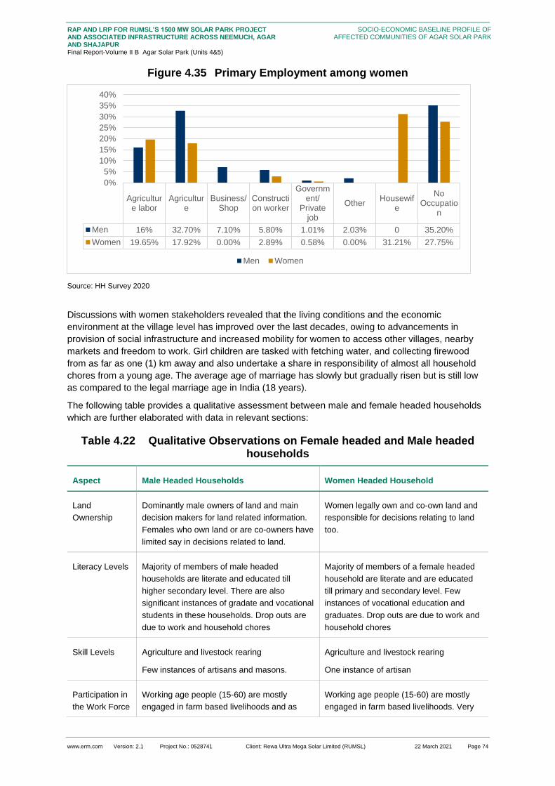
www.erm.com Version: 2.1 Project No.: 0528741 Client: Rewa Ultra Mega Solar Limited (RUMSL) 22 March 2021 Page 74
RAP AND LRP FOR RUMSL’S 1500 MW SOLAR PARK PROJECT AND ASSOCIATED INFRASTRUCTURE ACROSS NEEMUCH, AGAR AND SHAJAPUR Final Report-Volume II B Agar Solar Park (Units 4&5)
SOCIO-ECONOMIC BASELINE PROFILE OF AFFECTED COMMUNITIES OF AGAR SOLAR PARK
Figure 4.35 Primary Employment among women
Source: HH Survey 2020
Discussions with women stakeholders revealed that the living conditions and the economic
environment at the village level has improved over the last decades, owing to advancements in
provision of social infrastructure and increased mobility for women to access other villages, nearby
markets and freedom to work. Girl children are tasked with fetching water, and collecting firewood
from as far as one (1) km away and also undertake a share in responsibility of almost all household
chores from a young age. The average age of marriage has slowly but gradually risen but is still low
as compared to the legal marriage age in India (18 years).
The following table provides a qualitative assessment between male and female headed households
which are further elaborated with data in relevant sections:
Table 4.22 Qualitative Observations on Female headed and Male headed households
Aspect Male Headed Households Women Headed Household
Land
Ownership
Dominantly male owners of land and main
decision makers for land related information.
Females who own land or are co-owners have
limited say in decisions related to land.
Women legally own and co-own land and
responsible for decisions relating to land
too.
Literacy Levels Majority of members of male headed
households are literate and educated till
higher secondary level. There are also
significant instances of gradate and vocational
students in these households. Drop outs are
due to work and household chores
Majority of members of a female headed
household are literate and are educated
till primary and secondary level. Few
instances of vocational education and
graduates. Drop outs are due to work and
household chores
Skill Levels Agriculture and livestock rearing
Few instances of artisans and masons.
Agriculture and livestock rearing
One instance of artisan
Participation in
the Work Force
Working age people (15-60) are mostly
engaged in farm based livelihoods and as
Working age people (15-60) are mostly
engaged in farm based livelihoods. Very
Agriculture labor
Agriculture
Business/Shop
Construction worker
Government/
Privatejob
OtherHousewif
e
NoOccupatio
n
Men 16% 32.70% 7.10% 5.80% 1.01% 2.03% 0 35.20%
Women 19.65% 17.92% 0.00% 2.89% 0.58% 0.00% 31.21% 27.75%
0%
5%
10%
15%
20%
25%
30%
35%
40%
Men Women

www.erm.com Version: 2.1 Project No.: 0528741 Client: Rewa Ultra Mega Solar Limited (RUMSL) 22 March 2021 Page 75
RAP AND LRP FOR RUMSL’S 1500 MW SOLAR PARK PROJECT AND ASSOCIATED INFRASTRUCTURE ACROSS NEEMUCH, AGAR AND SHAJAPUR Final Report-Volume II B Agar Solar Park (Units 4&5)
SOCIO-ECONOMIC BASELINE PROFILE OF AFFECTED COMMUNITIES OF AGAR SOLAR PARK
Aspect Male Headed Households Women Headed Household
construction workers. Relatively larger
number engaged in business or shop
ownership as compared to women headed
households.
few instances of business and shop
ownership.
Infrastructure
access
Mostly Semi-pucca houses. Majority of the
households have a dry pit latrine, with a
limited number of houses having latrine with
septic tank. A combination of firewood and
LPG is used as source of cooking.
Mostly pucca and semi-pucca housing.
Majority of these households practice
open defecation. All women headed
households use a combination of firewood
and cow dung as their source of cooking.
4.2.12 Vulnerability
This section discusses the socio-economic vulnerabilities amongst the project affected households.
Considering the socio-economic context of the region, five main vulnerabilities have been identified
amongst the project affected households. These are below poverty line, female headed households,
households with only elderly persons, landless households and village artisans. This identification of
vulnerable groups has been guided by the Environmental and Social Management framework (ESMF)
for solar parks by World Bank. The vulnerabilities amongst the PAH has been discussed below:
Below poverty line households: It is noted that more than half of the population reported having a
Below Poverty Card. The purpose of having of having a BPL may or may not be related to
financial ability since the BPLs are commonly used for public distribution system. In Madhya
Pradesh, 83 % of rural households and overall, 80% of the households own ration card while only
1.3 percent of ration card holder owns Antodaya card which is for the poorest of the poor26. 27.
The report utilizes the Niti Ayog method28 of determination of poverty levels, which is based on
per capita expenditure, as calculated from information reported in the HH survey. This method
determines the poverty levels on actual spending, as compared to using a blanket approach of
identifying BPL cardholder households.. As per this method of determining poverty levels, 9
project affected households fall under the below poverty lines.
Female headed households: Gender related challenges are very apparent in the villages putting
a female household into the category of vulnerability. Cultural norms do not allow women sitting
on charpaayi (wooden-jute bed) next to male member of house and are required to cover their
faces in the presence of men and not talk to people outside the house.
Households with only elderly persons: An elderly person living alone or only with spouse are
vulnerable to social, financial and physical security. Furthermore, it is also noted that households
with only elderly have multiple vulnerabilities. Some are also BPL or headed by women. Being
poor in old age and without the support of other family member put such households in a severe
vulnerable position. They also lack social and financial assistance from the state. Firstly, not all
26 State Planning Commission. (2016). Report on socio-economic Disparities in Madhya Pradesh (Working Paper I). 27 State Planning Commission. (2016). Report on socio-economic Disparities in Madhya Pradesh (Working Paper I). http://mpplanningcommission.gov.in/international-aided-projects/pmpsu/Report%20on%20Socio-Econonic%20Disparities%20in%20Madhya%20Pradesh.pdf
28 As per the Planning commission method, the poverty line is determined by the ability of individual to
spend INR 32 per day per person for rural areas. The poverty level was calculated based on total
annual per capita expenditure. The values has been adjusted against inflation rate in 2020.
https://www.prsindia.org/theprsblog/poverty-estimation-india

www.erm.com Version: 2.1 Project No.: 0528741 Client: Rewa Ultra Mega Solar Limited (RUMSL) 22 March 2021 Page 76
RAP AND LRP FOR RUMSL’S 1500 MW SOLAR PARK PROJECT AND ASSOCIATED INFRASTRUCTURE ACROSS NEEMUCH, AGAR AND SHAJAPUR Final Report-Volume II B Agar Solar Park (Units 4&5)
SOCIO-ECONOMIC BASELINE PROFILE OF AFFECTED COMMUNITIES OF AGAR SOLAR PARK
elderly are beneficiaries of social security schemes and secondly even if they receive a pension
or any assistance, the amount of pension is meagre and not sufficient for self-sustenance.
Landless: Another vulnerable group is people who lack economic resources. Despite of several
development projects in the region, the life situation of landless people in the region has changed
or improved over the years. They have mainly remained excluded from the benefits of
developments planned to improve the quality of life of people.
Village artisans: Though there is only one household artisan, this vulnerable group has been
identified in keeping with the ESMF applicable for the project. However, there is a need to
support the artisans as they have no other livelihood source. Furthermore, lack on data on artisan
have hampered the required assistance or security from the state. Apart from the above
mentioned vulnerabilities, another category has been identified for the PF;
Uneducated youth without skills. The total number of individuals in this category are 45, of which
27 (60 percent) belong to the OBC category, whereas 6 are in the general category, 9 are SC
and 2 are ST. This trend in terms of social groups is in keeping with the overall trend of social
group composition in the villages, with OBC being the dominant category. This is thus reflective
of the overall low levels of literacy in the PAHs and the status of educational infrastructure in the
villages. The vulnerability for this group stems from the trend of the youth population moving
towards non-farm based livelihoods, in comparison to illiterate population without skills in other
age categories. This shift is primarily due to the reducing size of land holdings; due to growing
families; higher risk in agriculture etc. however, while overall the youth is moving towards non-
farm based livelihoods, the lack of literacy and skills restricts the opportunities available for such
individuals in terms of livelihood opportunities. the lack of literacy and appropriate skills is also
likely to restrict the ability of these individuals to partake in the employment opportunities created
by the project
Most PAHs were vulnerable in more than one way, thus, they had overlapping vulnerabilities. While
there are 80 percent BPL holders, women headed households constitute 4.2 percent of the PAH and
there are 1.05 percent artisans and elderly households each.
Table 4.23 Types of vulnerability among PAHs
Administrative Unit
Below Poverty Line
Women HoH Artisan Elderly Households
Uneducated youth without skills
Unit 4
Bijnakhedi 2
Madhopur 1 8
Kesai Dehariya 2 1 2
Pipalya Kumhar
Ladwan NA NA NA NA
Karwa Khedi NA NA NA NA
Dudhpura NA NA NA NA
Sub total 1 1 10
Unit 5
Umariya 2 3 1 14
Naharkheda 3 1 1 8
Pipalya Nankar 4
Palada 9

www.erm.com Version: 2.1 Project No.: 0528741 Client: Rewa Ultra Mega Solar Limited (RUMSL) 22 March 2021 Page 77
RAP AND LRP FOR RUMSL’S 1500 MW SOLAR PARK PROJECT AND ASSOCIATED INFRASTRUCTURE ACROSS NEEMUCH, AGAR AND SHAJAPUR Final Report-Volume II B Agar Solar Park (Units 4&5)
SOCIO-ECONOMIC BASELINE PROFILE OF AFFECTED COMMUNITIES OF AGAR SOLAR PARK
Administrative Unit
Below Poverty Line
Women HoH Artisan Elderly Households
Uneducated youth without skills
Sub total 3 2 1 35
Grand Total 9 4 3 1 45
Source: HH survey 2020
It can be noted that there is only one household in Umariya who are below the poverty line. The
household which is an elderly household are residents of Naharkheda and are also BPL holders. 66.7
percent of the artisans are also BPL holders, of which 33.3 percent are women headed household
living in Kesai Dahariya. Only about 57.1 percent of the women headed household have a BPL card.
71.4 percent of the women headed households are OBC, while only 14.2 percent are in the general
category It can be noted the PAH in the OBC category are the most vulnerable as compared to other
social groups.
Another case of vulnerability are the youth (15-35 years) who are illiterate and have no skill sets. They constitute nearly 9.4 percent of the overall PAH.

www.erm.com Version: 2.1 Project No.: 0528741 Client: Rewa Ultra Mega Solar Limited (RUMSL) 22 March 2021 Page 78
RAP AND LRP FOR RUMSL’S 1500 MW SOLAR PARK PROJECT AND ASSOCIATED INFRASTRUCTURE ACROSS NEEMUCH, AGAR AND SHAJAPUR Final Report-Volume II B Agar Solar Park (Units 4&5)
STAKEHOLDER ENGAGEMENT AND CONSULTATION
5. STAKEHOLDER ENGAGEMENT AND CONSULTATION
This section provides the stakeholder identification and mapping for the project based on the
understanding developed during RAP study. The broader stakeholder mapping was undertaken in the
ESIA stage. In the current stage of the project, the profiling has been developed for the stakeholders
linked to RAP study, and subsequently, their engagement has been mapped. The impact/influence of
each stakeholder is dynamic throughout the project life cycle, and hence the Stakeholder
Engagement Plan (SEP) is a live document and will be updated from time to time, so as to make it
comprehensive for any given period of time.
5.1 Stakeholder Identification and Analysis
The table below presents the key stakeholders identified at the RAP stage of the Project, and have
been categorized as primary and secondary stakeholders.
Table 5.1 Stakeholder Group Categorisation
Stakeholder
Groups
Primary Stakeholders Secondary Stakeholders
Individual and
Community
■ Private land owners and Patta land holders
from the Project Area villages
■ Informal land Users (Encroachers/Squatters
to be impacted)
■ Agricultural labourers
■ Grazers/Livestock holding households
■ Banjara households and Bhil households
■ Women groups
■ Vulnerable groups (Landless households,
Below Poverty Line households, women
headed households)
■ Owners of land required for temporary
occupation or use during construction
phase
■ Fence Line Community
Government
Bodies and
Institutional
Stakeholders
■ District Administration of Agar-Malwa
■ Gram Panchayats of the impacted villages
■ Agar and Susner Tehsildars;
■ Patwaris
■ EPC Contractor
■ RUMSL
■ Civil Society/Local Non-
governmental organizations (NGOs)
■ Local Media
Local Political Groups
Dairy Cooperatives
Agriculture and Livestock
Department at Agar
Industrial Training Institute (ITI),
Agar
Department of Animal Husbandry,
Dairy Development, Agar
www.erm.com Version: 2.1 Project No.: 0528741 Client: Rewa Ultra Mega Solar Limited (RUMSL) 22 March 2021 Page 79
RAP AND LRP FOR RUMSL’S 1500 MW SOLAR PARK PROJECT AND ASSOCIATED INFRASTRUCTURE ACROSS NEEMUCH, AGAR AND SHAJAPUR Final Report-Volume II B Agar Solar Park (Units 4&5)
STAKEHOLDER ENGAGEMENT AND CONSULTATION
The subsequent analysis has mapped the significance of the identified stakeholders based on specific
parameters and their characteristics. The significance of each stakeholder has been assessed
considering four parameters:
Impact on the project/ power to Influence the project;
Dependence on the project, and
Perception/ Expectation level
Table 5.2 Assessment parameters and characteristics
Parameters Characteristics
Influence/Power to Impact
■ Affecting the reputation of the project
■ Ability to cause delay in project activities
■ As pool of available labour for the project, can impact construction activities
■ Source of early warning signals for emerging concerns
Impacted by the Project
■ Direct Impact – Land intake
■ Indirect Impact – Impact on livelihoods
■ Vulnerability criteria*
Perception/ Expectation Level
■ Awareness amongst a few but no real concern
■ Broader awareness, but little concern
■ Considerable concern influencing a few
■ Considerable concern influencing many

www.erm.com Version: 2.1 Project No.: 0528741 Client: Rewa Ultra Mega Solar Limited (RUMSL) 22 March 2021 Page 80
RAP AND LRP FOR RUMSL’S 1500 MW SOLAR PARK PROJECT AND ASSOCIATED INFRASTRUCTURE ACROSS NEEMUCH, AGAR AND SHAJAPUR Final Report-Volume II B Agar Solar Park (Units 4&5)
STAKEHOLDER ENGAGEMENT AND CONSULTATION
Table 5.3: Characterization and Assessment of Stakeholders Significance
Sr.
no
Stakeholder Profile Power to Impact Impacted by the Project Perception/
Expectation
Primary Stakeholders
1 Private land owners This group is dependent on
their land parcels for their
livelihood needs;
Among the communities in the
villages of PFA, majority of the
land holding is with the
Sondhiyas, Rajputs, Gurjars,
and Thakurs. While Harijans
and Banjaras have the lowest
or no landholding, as reported
during the resettlement
surveys.
Among the land owning
households, the share of
marginal land holding is
highest (85% of the PAEs)
The stakeholder consent to sell
land can impact the project
development
Their support is key for the
smooth functioning of the
project related activities in the
area, even after land purchase,
in the operations phase
The dependence on land for
agriculture and livestock in the
area is high, as understood
through household survey,
The purchase of land for the
project development activities
will affect the livelihood of this
stakeholder group due to
reduction in land holdings;
Additionally, if this stakeholder
group is provided with an
alternate land parcel, the
quality of alternate land parcels
and the effort and investment
required to make it fit for
cultivation, is also of key
concern, as land improvement
investments have been
undertaken by these land
owners on their existing
parcels.
The private land owners with
marginal land holding (less
than 1 ha.) also work as
agricultural labourers on other
agricultural land as daily wage
labour. The impact on livelihood
will be therefore two-fold – loss
of income from reduced land
Considerable concern influencing a
few

www.erm.com Version: 2.1 Project No.: 0528741 Client: Rewa Ultra Mega Solar Limited (RUMSL) 22 March 2021 Page 81
RAP AND LRP FOR RUMSL’S 1500 MW SOLAR PARK PROJECT AND ASSOCIATED INFRASTRUCTURE ACROSS NEEMUCH, AGAR AND SHAJAPUR Final Report-Volume II B Agar Solar Park (Units 4&5)
STAKEHOLDER ENGAGEMENT AND CONSULTATION
Sr.
no
Stakeholder Profile Power to Impact Impacted by the Project Perception/
Expectation
holding of self, and loss of
income from agricultural labour
2 Informal Land Users
(encroachers/squatters (for
agriculture)
Encroachment differs in Agar
and Susner tehsils-
In Agar, large private land
owners who are relatively
economically well-off in the
village, have used
encroachment as a practice to
increase the area under
private control, and used for
agricultural, livestock
practices.
In Susner, the households
with existing patta land (which
is outside the project footprint)
have relied on encroachment
for seasonal cropping, and
grazing.
Squatting for agriculture has
been reported by households
wherein arable land
parcels/land classified as
grazing land is used for
farming at a location which is
not adjoining their private land
parcel (if any).
The landless households of
Harijan and the Sondhiya
community have been
practicing encroachment on
The power of this stakeholder
group to impact is moderate,
considering they do not have
legal rights on the land.
However they can influence the
attitude of the large community
by virtue of their economic
position in the village, as in the
case of households having
access to encroached land in
Agar tehsil who belong to the
wealthier strata and have a
dominant position in the
villages.
The project would lead to
disruption of economic
activities and incomes to these
households. The extent of
economic displacement of this
group is high considering the
lack of legal ownership of land,
and immovable assets.
The dependence on land-
based livelihood is high, and
the income loss is twofold –
loss of income from agriculture
on current informal land use,
and lack of alternative
economic opportunities.
Awareness among the few but no
real concern
www.erm.com Version: 2.1 Project No.: 0528741 Client: Rewa Ultra Mega Solar Limited (RUMSL) 22 March 2021 Page 82
RAP AND LRP FOR RUMSL’S 1500 MW SOLAR PARK PROJECT AND ASSOCIATED INFRASTRUCTURE ACROSS NEEMUCH, AGAR AND SHAJAPUR Final Report-Volume II B Agar Solar Park (Units 4&5)
STAKEHOLDER ENGAGEMENT AND CONSULTATION
Sr.
no
Stakeholder Profile Power to Impact Impacted by the Project Perception/
Expectation
government land which is
barren and mountainous
terrain
3 Agricultural labourers Agricultural labour work and
non-farm labour is a
prominent economic activity
for all the villagers.
Almost all private land owners
work as farm and non-farm
labourers.
Households owning marginal
land (less than one ha.) work
as farm labour for other land
owners for daily wages. They
are employed by large land
owners and those who are
higher in the caste hierarchy in
the village
The influence of this group on
the project is minimal,
considering they are a subset
of the private land owning
group and/or belong to landless
households
Both men and women derive
income from agricultural labour;
There also exists
sharecropping arrangement
where the farm labour work is
paid in terms of share in crop
output;
The project would lead loss of
income for this stakeholder
group, and also force them to
shift to non-farm labour which
is less available in the villages
and will require short-term/long-
tern migration
Awareness amongst a few but no
real concern
4 Banjara households in
Madhopur and Bhil
community of Ladwan
There is one pocket of
Banjara settlements (10 HHs)
in the Madhopur, who depend
on income from livestock and
are primarily squatters for
agriculture on government
land.
They have settled in
Madhopur for more than three
generations, and derive their
primary income from livestock
(as grazers)
Although this group forms part
of the larger category of
informal users their concerns
and impacts are to be treated
separately as their livelihood
profile and location profile is
relatively unique compared to
the overall profile of the village.
They depend on livestock
(grazing, cattle management)
as their main source of
livelihood. Their power to
impact the project is limited but
crucial as according to the
The dependence on the project
is the potential loss of access to
open grazing land, leading to
shift towards stall feeding, and
therefore higher costs of
livestock management. The
second impact is higher
dependence on non-farm
labour which is majorly
seasonal in nature
Awareness amongst a few but no
real concern

www.erm.com Version: 2.1 Project No.: 0528741 Client: Rewa Ultra Mega Solar Limited (RUMSL) 22 March 2021 Page 83
RAP AND LRP FOR RUMSL’S 1500 MW SOLAR PARK PROJECT AND ASSOCIATED INFRASTRUCTURE ACROSS NEEMUCH, AGAR AND SHAJAPUR Final Report-Volume II B Agar Solar Park (Units 4&5)
STAKEHOLDER ENGAGEMENT AND CONSULTATION
Sr.
no
Stakeholder Profile Power to Impact Impacted by the Project Perception/
Expectation
Bhil community (16 HHs)
present in Ladwan village.
They live on the outskirts of
the village, and are
marginalized in terms of social
hierarchy.
The Bhil community also
practices livestock – based
livelihood and derive their
primary income from sale of
livestock products
requirements of IFC PS 7, prior
informed consent from the IP
households is required to be
undertaken by the project.
5 Vulnerable households with
marginal land holding, BPL
households, Women
headed households
This stakeholder group is
comprised of /households that
are vulnerable due to their
social, or economic status in
the villages
This stakeholder group should
be provided with adequate
provisions in the RAP and LRP
for the differential impacts
expected on this group, as part
of the larger community. The
vulnerable group has limited
ability to impact the project
activities, due to their
marginalization in the village
community, and unequal
access to natural resources
The influence of project on this
group is similar in nature as the
entire project affected villages,
as it is a subset of the same
however, the impact is higher in
magnitude owing their nature of
vulnerability
Awareness amongst a few but no
real concern
6 Livestock holding
households/Grazers of
cattle on government land
Livestock holding is an
economic activity to support
farm income, and for landless
households, the major income
source. All households,
whether holding large land
parcels, small/marginal land
parcels, or landless own some
amount of livestock.
This group also has minimal
influence on the project as they
have no direct control on the
land purchase; however they
can raise concerns regarding
the loss of common property
resource (CPR) of the village
which was being used for
grazing
Livestock holding is an
economic activity to support
farm income, and for landless
households, the major income
source of livelihood.
This group, which is a part of
the private land owners group
as well as households without
any land holding will be
Considerable concern influencing
many

www.erm.com Version: 2.1 Project No.: 0528741 Client: Rewa Ultra Mega Solar Limited (RUMSL) 22 March 2021 Page 84
RAP AND LRP FOR RUMSL’S 1500 MW SOLAR PARK PROJECT AND ASSOCIATED INFRASTRUCTURE ACROSS NEEMUCH, AGAR AND SHAJAPUR Final Report-Volume II B Agar Solar Park (Units 4&5)
STAKEHOLDER ENGAGEMENT AND CONSULTATION
Sr.
no
Stakeholder Profile Power to Impact Impacted by the Project Perception/
Expectation
Livestock holding gives rise to
various earning sources such
as hired herder for cows
(grazers), sale of fodder, and
sale of animal/animal
products.
Based on the consultations
undertaken during RAP study,
villagers in Dudhpura, Ladwan,
and Karwa Khedi have raised
objections to the location of the
Project on their village land due
to their concern regarding the
potential impact on grazing
land, and loss of access to
common fodder lots
impacted by loss of available
government land for grazing
The impact of such loss will be
higher for landless households
with livestock who rely on
government grazing land for
fodder
7 Owners of land required for
temporary occupation or
use
Some of the project
components would require
short term leasing of land
available, largely from Private
and/ or Patta land owners
This stakeholder group is
critical for availability of land
parcels that are conveniently
located in the vicinity of project
footprint (based on the needs)
and are available without
disturbances or issues during
the lease period.
The project related activities on
these land parcels may be for
purposes of storage, set up of
labour camps, etc. and may
result in change in land use/
land cover due to construction
activities, contamination issues,
etc.
Awareness amongst a few but no
real concern
8 Gram Panchayats This stakeholder group is
comprised of Sarpanch, ward
member and Gram Sewak of
Panchayats of Palda,
Naharkheda (including
Umariya village), and Pipalya
Nankar in Susner Tehsil, and
Pipalya Kumhar, Ladwan
(including Karwa Khedi
village), Kesai Dehariya
(including Dudhpura village),
and Bijnakhedi (including
Madhopur village) in Agar
Tehsil.
This group has the ability to
influence the perception of the
community in regards to the
Project and its activities
The impact of project on this
stakeholder group is minimal
due to limited control that the
project can exert on the
functioning of this group.
Awareness amongst a few but no
real concern

www.erm.com Version: 2.1 Project No.: 0528741 Client: Rewa Ultra Mega Solar Limited (RUMSL) 22 March 2021 Page 85
RAP AND LRP FOR RUMSL’S 1500 MW SOLAR PARK PROJECT AND ASSOCIATED INFRASTRUCTURE ACROSS NEEMUCH, AGAR AND SHAJAPUR Final Report-Volume II B Agar Solar Park (Units 4&5)
STAKEHOLDER ENGAGEMENT AND CONSULTATION
Sr.
no
Stakeholder Profile Power to Impact Impacted by the Project Perception/
Expectation
9 Agar and Susner Tehsildars This group is comprised of the
regulatory authorities at the
tehsil level that are
responsible for land
demarcation for the project
and for various permits and
licenses pertaining to the
project
The Tehsildars are responsible
for executing the land
demarcation exercise, and the
extent of encroachment on
government land within the
project boundary.
Allotment of land parcels based
on their current use, and
ownership.
Noncompliance to conditions
laid down in permits issued by
this group stakeholders group
can result in penalties and fines
being levied on the Project.
The impact of the project is
limited on this stakeholder
group, and is limited to
permitting requirements.
Broader awareness, but little
concern
10 Patwaris This stakeholder group is
critical because the physical
verification of the allotted land
parcels, verification of
encroachment area, extent of
squatting on the allotted
government land parcels is
carried out by this stakeholder
group
This group has critical role in
impacting the project because
of their role determining the
land parcels, and also guiding
village opinion on the project
activities and the land take
process
No impact Broader awareness, but little
concern
11 District Administration The DC is important as all
land-related issues, and the
current protest towards land
procurement in the four
villages of Agar (refer Section
5.2.3) have been reaching out
The District Administration is a
high influence stakeholder due
to their pivotal role in land
allotment approval, oversight
on private land purchase, and
acting as the decision making
authority on award of
No impact Broader awareness, but little
concern

www.erm.com Version: 2.1 Project No.: 0528741 Client: Rewa Ultra Mega Solar Limited (RUMSL) 22 March 2021 Page 86
RAP AND LRP FOR RUMSL’S 1500 MW SOLAR PARK PROJECT AND ASSOCIATED INFRASTRUCTURE ACROSS NEEMUCH, AGAR AND SHAJAPUR Final Report-Volume II B Agar Solar Park (Units 4&5)
STAKEHOLDER ENGAGEMENT AND CONSULTATION
Sr.
no
Stakeholder Profile Power to Impact Impacted by the Project Perception/
Expectation
the District Administration with
regards to their grievances
compensation, solatium for
private land purchase, and for
other land based impacts, as
decided by the project
Secondary Stakeholders
12 Fence Line Community This stakeholder group is
comprised of the local
population in the eleven
villages, coming under the
project boundaries, and have
been using the land identified
by the Project for grazing,
accessing the agricultural
land, etc.
This stakeholder group shall
play a critical role in the smooth
functioning of the Project
The project will use land which
is currently being used by this
stakeholder group in accessing
their farms, ponds and other
common areas, grazing their
cattle, etc. there is also the
potential impact on agricultural
use of land in the immediate
project vicnity
These activities will be
disrupted after the project
related activities commence on
the identified land
Awareness amongst a few but no
real concern
13 Local Political Groups This stakeholder group is
comprised of the political
parties and local politicians
active in the region;
This group might be active in
the area and may play an
important role in the
polarisation of public opinion
towards the Project
This group can influence the
project life cycle by polarising
public opinion of the local
communities (within impacted
villages and Fence line
community);
The political groups can
capitalize on the existing
adverse sentiments regarding
the project site/construction
activities and make it a tool of
propaganda against the project
No impact Awareness amongst a few but no
real concern

www.erm.com Version: 2.1 Project No.: 0528741 Client: Rewa Ultra Mega Solar Limited (RUMSL) 22 March 2021 Page 87
RAP AND LRP FOR RUMSL’S 1500 MW SOLAR PARK PROJECT AND ASSOCIATED INFRASTRUCTURE ACROSS NEEMUCH, AGAR AND SHAJAPUR Final Report-Volume II B Agar Solar Park (Units 4&5)
STAKEHOLDER ENGAGEMENT AND CONSULTATION
Sr.
no
Stakeholder Profile Power to Impact Impacted by the Project Perception/
Expectation
14 Civil Society/Local NGOs NGOs and Civil Society
Organizations at local level
who may be active in the area.
Most of the NGOs and CSOs
working in the region are
district level NGOs.
However, currently there are
no active NGOs working in the
Agar-Malwa region in the
project affected villages, and
hence no consultation could
be undertaken
The influence of this
stakeholder group is potentially
limited as currently, there are
no active NGOs working in this
region
Based on understanding
through consultations with
villagers on NGOs who were
operating in the past, their role
is short-term in nature and
limited in outreach.
No impact Awareness amongst a few but no
real concern
15 Agriculture and Livestock
Department; Dairy
Development Board
To increase agricultural
production in the district
To increase livestock and
increase milk production in the
district. Promote
small/marginal and landless
farmers to undertake animal
husbandry
The stakeholder group can
provide assistance to the
project and help the project in
implementing the Grazing
Management Plan (GMP),
developed as part of the
mitigation measures for the
villagers in the affected areas;
They can influence the impact
mitigation measures to be
adopted by the Project during
the construction and operation
stage
No impact Awareness amongst a few but no
real concern
16 Industrial Training Institute
(ITI)
To provide training in industrial
trades to men and women and
develop the capacity for
securing employment in
industrial establishments
The stakeholder group can
provide assistance to the
project and help the project in
creating a goodwill among by
providing skill training specific
to the project requirements.
No impact Awareness amongst a few but no
real concern
www.erm.com Version: 2.1 Project No.: 0528741 Client: Rewa Ultra Mega Solar Limited (RUMSL) 22 March 2021 Page 88
RAP AND LRP FOR RUMSL’S 1500 MW SOLAR PARK PROJECT AND ASSOCIATED INFRASTRUCTURE ACROSS NEEMUCH, AGAR AND SHAJAPUR Final Report-Volume II B Agar Solar Park (Units 4&5)
STAKEHOLDER ENGAGEMENT AND CONSULTATION
Sr.
no
Stakeholder Profile Power to Impact Impacted by the Project Perception/
Expectation
They can influence the impact
mitigation measures to be
adopted by the Project during
the construction and operation
stage
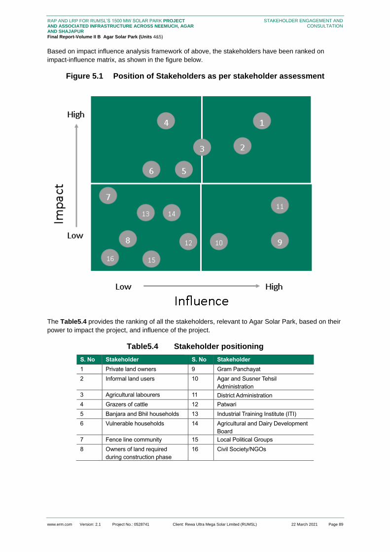
www.erm.com Version: 2.1 Project No.: 0528741 Client: Rewa Ultra Mega Solar Limited (RUMSL) 22 March 2021 Page 89
RAP AND LRP FOR RUMSL’S 1500 MW SOLAR PARK PROJECT AND ASSOCIATED INFRASTRUCTURE ACROSS NEEMUCH, AGAR AND SHAJAPUR
Final Report-Volume II B Agar Solar Park (Units 4&5)
STAKEHOLDER ENGAGEMENT AND CONSULTATION
Based on impact influence analysis framework of above, the stakeholders have been ranked on
impact-influence matrix, as shown in the figure below.
Figure 5.1 Position of Stakeholders as per stakeholder assessment
The Table5.4 provides the ranking of all the stakeholders, relevant to Agar Solar Park, based on their
power to impact the project, and influence of the project.
Table5.4 Stakeholder positioning
S. No Stakeholder S. No Stakeholder
1 Private land owners 9 Gram Panchayat
2 Informal land users 10 Agar and Susner Tehsil
Administration
3 Agricultural labourers 11 District Administration
4 Grazers of cattle 12 Patwari
5 Banjara and Bhil households 13 Industrial Training Institute (ITI)
6 Vulnerable households 14 Agricultural and Dairy Development
Board
7 Fence line community 15 Local Political Groups
8 Owners of land required
during construction phase
16 Civil Society/NGOs

www.erm.com Version: 2.1 Project No.: 0528741 Client: Rewa Ultra Mega Solar Limited (RUMSL) 22 March 2021 Page 90
RAP AND LRP FOR RUMSL’S 1500 MW SOLAR PARK PROJECT AND ASSOCIATED INFRASTRUCTURE ACROSS NEEMUCH, AGAR AND SHAJAPUR
Final Report-Volume II B Agar Solar Park (Units 4&5)
STAKEHOLDER ENGAGEMENT AND CONSULTATION
5.2 Overview of Engagement as part of Resettlement Planning
5.2.1 Project Layout Finalization
Consultations were undertaken during this stage by ERM with the villages that were identified to be
part of the project footprint (September 2018). During this stage, a site reconnaissance visit was
undertaken based on the proposed project footprint. As part of the visit, consultations were
undertaken with the residents of the following villages: Umariya, Pipalya Nankar, Ladwan and Karwa
Khedi.
The main concern raised during this stage was that while the project would require the diversion of
land from the villages, the local community is unlikely to benefit from the development of the project in
terms of employment opportunities. The community reported that even if the project provides them
with economic opportunities, it will be restricted to the construction phase and for small contracts and
unskilled work.
5.2.2 Government Land Allotment
The land allotment process was initiated in 2016 for the government land parcels, and later for the
private land parcels. For Agar Solar Park, the land allotment process was undertaken from 2016 to
2019. As part of the land allotment process, consultations were undertaken by the following agencies
with the village community in general, and land owners in particular.
RUMSL was responsible for overall coordination across various stakeholders including the
district administration, and the administration at the tehsil level. A District Renewable Energy
Officer (DREO) has been appointed by RUMSL to undertake the initial meetings with the Tehsil
office, and guide the land allotment process.
District Collector is the key officer contacted by RUMSL for any land related matters. The DC is
the authority for final communication on the decisions made on the land. He has the authority to
approve or reject allotment requests for any land parcels required for development projects. The
DC also holds consultations with the individual land owners regarding the land procurement of
private land, and the benefits/impact from project activities on the private land parcel owners.
Tehsil Administration was responsible for executing the tarmeem process (revision of land
records based on updated land use, land occupancy, and involves revision of land maps for
subdivisions in khasras. As part of the tarmeem process, the patwaris held consultations with the
Gram Panchayat on encroachment and squatting in the impacted villages in the Solar Park, and
with individual land owners who have been using government land parcels informally on the
duration of encroachment, and use of such encroached parcels.
It should be noted that despite more than 90 percent of the government land required is already
allotted to the project, however, despite that a process of optimization was undertaken in early 2020,
considering the environmental and social sensitivities identified.
5.2.3 ESIA
The ERM team undertook the ESIA study related site visits from December 2019 – January 2020 to
develop the socio-economic baseline of the villages in the project footprint, and held consultations
across all the eleven villages in the Solar Park. These consultations were focused on understanding
the general profile of the villages with specific focus on the types of caste groups, land holding
pattern, and gender differences in division of labour, livelihood profile, etc. this understanding was
used to develop the stakeholder profile and potential primary and secondary impacts, which was
updated based on the RAP study.

www.erm.com Version: 2.1 Project No.: 0528741 Client: Rewa Ultra Mega Solar Limited (RUMSL) 22 March 2021 Page 91
RAP AND LRP FOR RUMSL’S 1500 MW SOLAR PARK PROJECT AND ASSOCIATED INFRASTRUCTURE ACROSS NEEMUCH, AGAR AND SHAJAPUR
Final Report-Volume II B Agar Solar Park (Units 4&5)
STAKEHOLDER ENGAGEMENT AND CONSULTATION
5.2.4 Resettlement Surveys
The resettlement surveys were undertaken during the period July – August 2020, and as part of this
exercise consultations were undertaken through household surveys, Land and Asset surveys and
focus group discussions with potentially impacted stakeholder categories as listed in Table 5.1.
Through these consultations, information was collected on the extent of land use of private land,
government land, livelihood profile, caste differences in land use, and gender role in land based
livelihood. The information collected was utilized to update the impact significance of each
stakeholder group.
An important part of the resettlement surveys was the approach towards each village community
followed for undertaking HH and LA surveys. Kick-off meetings were scheduled for each of the project
footprint villages, in which the project was explained and the purpose of the resettlement surveys was
described. The kick-off meetings were used to incorporate feedback from the general community on
the concerns regarding involuntary impacts, and feedback for project planning.
It was during the kick-off meetings with Ladwan, Dudhpura, Bijnakhedi and Pipalya Kumhar (Unit 4)
which provided the scope of right to refusal of the village towards to the project and its associated
activities, based on the understanding of the extent of impacts on the households. The villagers of
Ladwan and Bijnakhedi opposed the project due to impact anticipated on loss of government grazing
land. The villagers of Dudhpura were concerned with the cumulative impacts foreseen on the village
due to this project, given that there had previous land based impact due to construction of check dam.
They were of the opinion that the solar project will lead to further loss of private agricultural land,
which has already reduced, and the households have to fulfil their livelihood requirements from
reduced land size holding.
The refusal to participate in resettlement surveys by one village created a ripple effect – the refusal by
one village (the first refusal was expressed by Ladwan) spreads to other villages in terms of negative
sentiments regarding the project. The concerns and reasons of refusal were recorded from the kick-off
meetings and subsequent meetings held with Sarpanch, Tehsildar and the same was shared with
RUMSL.
5.3 Incorporation of Stakeholder Feedback into Project Decision Making
Through the consultations and information collection undertaken from the resettlement surveys, the
following key feedback relevant to the resettlement planning was received for Agar Solar Park.
Table 5.5 Feedback Received for Incorporation into Resettlement Planning
Feedback
Received
Incorporation into Resettlement Planning
Cumulative
impacts and
double land loss:
Lack of
engagement by
the project prior to
the ESIA stage of
the project
The villagers of Dudhpura have already been impacted by land loss due to water
catchment area created by Watershed department created 10 – 15 years ago. The lake
is spread across 1.675 hectares over private and government land parcels. Due to
submergence of land for the lake, the available notified grazing land for the village has
reduced. The land procurement for the solar park will result in double – land loss, and
lead to further reduction in available government land for the village.
As part of the Resettlement Planning, alternative grazing land has been recommended
with ease of access to such grazing lands for the village
Provision of water
supply
The community in Kasai Dehariya has raised the concern of lack of water supply
infrastructure and have expressed the need for provision of pipelines to draw water from
the dam to their fields to make irrigation water supply perennial in nature.

www.erm.com Version: 2.1 Project No.: 0528741 Client: Rewa Ultra Mega Solar Limited (RUMSL) 22 March 2021 Page 92
RAP AND LRP FOR RUMSL’S 1500 MW SOLAR PARK PROJECT AND ASSOCIATED INFRASTRUCTURE ACROSS NEEMUCH, AGAR AND SHAJAPUR
Final Report-Volume II B Agar Solar Park (Units 4&5)
STAKEHOLDER ENGAGEMENT AND CONSULTATION
Feedback
Received
Incorporation into Resettlement Planning
infrastructure from
existing dam
Allow grass
cutting/ fodder
collection within
the project
boundary
The households across the project impacted villages have depended on open grazing
and use the Charnoi/Chargah land parcels for collection of fodder to be used for stall
feeding.
Given the extent of government land to be used for the project. A significant loss of
access to grazing land is estimated. The common feedback across the impacted villages
has been to allow uninterrupted access to those land parcels that will be included in the
project boundary for collection of fodder.
As part of Resettlement Planning, a Grazing Management Plan has been prepared
(included in the consolidated RAP report) that includes the measures
Increase in
distance to
access grazing
land
The villagers of Umariya were concerned over the increase in time taken to travel to the
government land parcels once the project boundary is set up. Currently, the grazing land
used to collect fodder/firewood, and for open grazing – all these activities are equally
shared by men and women. The women can allocate time to collect fodder since the land
parcels are within 10 - 15 minutes of walking time.
Once the project is set up (Unit 5), the alternative grazing land will be at much farther
distance, and the hence the time cost associated with accessing the land parcels will
increase (women will have to spend more time to travel to such fields and this will lead to
time loss for other activities)
As part of Resettlement Planning, the loss of access to grazing land has been assessed
and mitigation measures have been included in the Grazing Management Plan.
Heat Island effect
leading to effect
on land
productivity of the
remaining land
parcels
Villagers in Naharkheda were concerned over the potential loss in productivity of
remaining land parcels under agricultural use due to the heat generated from the solar
plant. The rise in surface temperatures due to the solar panels will lead to loss in
productive output.
As part of project disclosure and engagement activities, the communities will be informed
and made aware of the mitigation measures to reduce the same, and improve farm
productivity.
Loss of access to
land for Open
defecation
One of the key concerns expressed over the loss of land to the project is the current use
of land for open defection will be obstructed. Women, particularly, rely on open
defecation as the dry latrine toilets do not have drainage facility, and the structures are
mostly in impaired condition.
The apprehension is the loss of immediate accessible land parcels for defecation, and
the risk to safety of women in accessing distant land parcels for the same.
As part of the Resettlement Planning, this issue has been addressed in the Gender
Action Plan (GAP).

www.erm.com Version: 2.1 Project No.: 0528741 Client: Rewa Ultra Mega Solar Limited (RUMSL) 22 March 2021 Page 93
RAP AND LRP FOR RUMSL’S 1500 MW SOLAR PARK PROJECT AND ASSOCIATED INFRASTRUCTURE ACROSS NEEMUCH, AGAR AND SHAJAPUR
Final Report-Volume II B Agar Solar Park (Units 4&5)
INVOLUNTARY RESETTLEMENT IMPACTS
6. INVOLUNTARY RESETTLEMENT IMPACTS
This section presents the involuntary resettlement impacts linked to land procurement (for the project
boundaries of Unit 4 and Unit 5) associated with the Agar Solar Park. The impacts have been
identified and categorised based on the analysis of the information collected from the following
sources:
Project Information as described in Section 2.1
Project affected entities as described in Section 3
Socio-economic baseline of the Project Affected Households as described in Section 4.2
Spatial assessment of all (100 percent) land parcels within the solar park area, using aerial
imagery data and khasra related information from the official land records.
This section is in two parts, the first describes the affected assets (immovable and movable) in
Section 6.1and covers the extent and scale of loss of land and change in land use, loss of assets on
all such land parcels that are falling within the project footprint.
The second part, Section 6.2 provides an assessment of project-affected households, under each
impact category, based on their dependence on the project affected land and assets.
This section provides an analysis of the magnitude of such impacts due to land loss of the PAHs,
particularly loss of land – based livelihood, and potential landlessness.
6.1 Summary of Key Impacts
The analysis of the magnitude of such impacts due to land procurement for the solar park is
summarized below and detailed in the following section. These losses/impacts have been categorized
into the physical and economic displacement impact-types noted below:
Removal of residential structures which are located within the project footprint area
Removal of other immovable assets on the private/patta land parcels within the project footprint
area
Removal of other immovable assets constructed on government land which is
encroached/squatted upon
Loss of agricultural land leading to loss of livelihood that was dependent on private and patta
agricultural land within the project footprint and government land that is used ((occupied-
encroached/squatted upon) for agriculture;
Economic losses to cultivators from the clearing of standing crops on private, patta or occupied
land;
Economic loss to owners/users from the clearing of trees (fruit or timber) on private and patta
land or occupied land
Loss of access to grazing land due to use restrictions within the project boundary
The table below summarises the aggregate numbers of project affected households, assessed across
the project footprint.
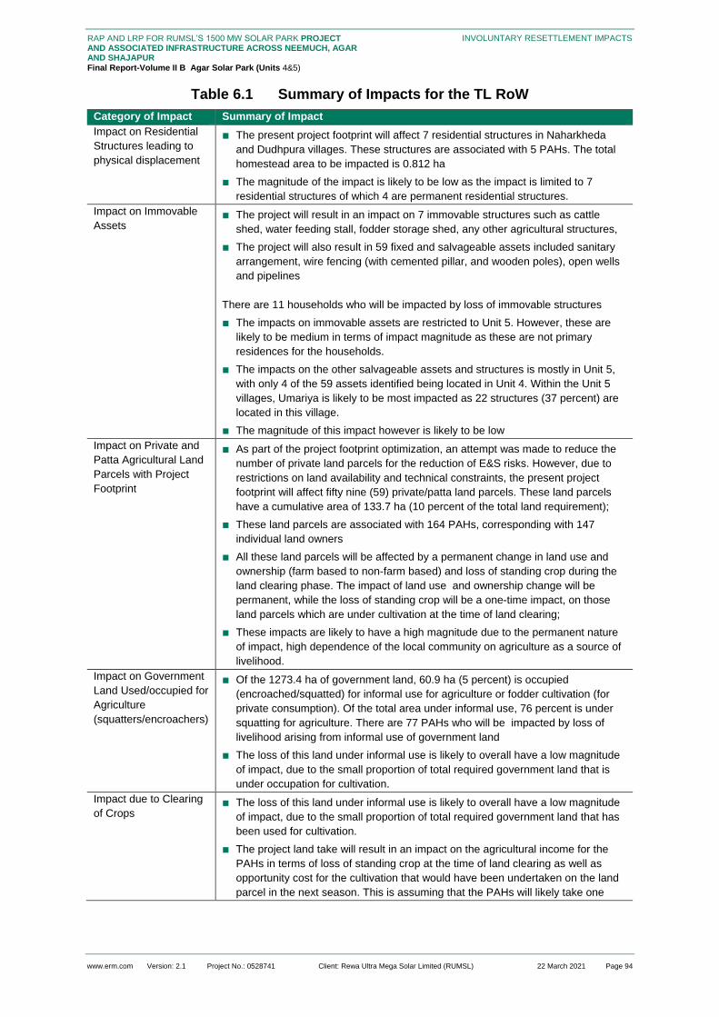
www.erm.com Version: 2.1 Project No.: 0528741 Client: Rewa Ultra Mega Solar Limited (RUMSL) 22 March 2021 Page 94
RAP AND LRP FOR RUMSL’S 1500 MW SOLAR PARK PROJECT AND ASSOCIATED INFRASTRUCTURE ACROSS NEEMUCH, AGAR AND SHAJAPUR
Final Report-Volume II B Agar Solar Park (Units 4&5)
INVOLUNTARY RESETTLEMENT IMPACTS
Table 6.1 Summary of Impacts for the TL RoW
Category of Impact Summary of Impact
Impact on Residential
Structures leading to
physical displacement
■ The present project footprint will affect 7 residential structures in Naharkheda
and Dudhpura villages. These structures are associated with 5 PAHs. The total
homestead area to be impacted is 0.812 ha
■ The magnitude of the impact is likely to be low as the impact is limited to 7
residential structures of which 4 are permanent residential structures.
Impact on Immovable
Assets ■ The project will result in an impact on 7 immovable structures such as cattle
shed, water feeding stall, fodder storage shed, any other agricultural structures,
■ The project will also result in 59 fixed and salvageable assets included sanitary
arrangement, wire fencing (with cemented pillar, and wooden poles), open wells
and pipelines
There are 11 households who will be impacted by loss of immovable structures
■ The impacts on immovable assets are restricted to Unit 5. However, these are
likely to be medium in terms of impact magnitude as these are not primary
residences for the households.
■ The impacts on the other salvageable assets and structures is mostly in Unit 5,
with only 4 of the 59 assets identified being located in Unit 4. Within the Unit 5
villages, Umariya is likely to be most impacted as 22 structures (37 percent) are
located in this village.
■ The magnitude of this impact however is likely to be low
Impact on Private and
Patta Agricultural Land
Parcels with Project
Footprint
■ As part of the project footprint optimization, an attempt was made to reduce the
number of private land parcels for the reduction of E&S risks. However, due to
restrictions on land availability and technical constraints, the present project
footprint will affect fifty nine (59) private/patta land parcels. These land parcels
have a cumulative area of 133.7 ha (10 percent of the total land requirement);
■ These land parcels are associated with 164 PAHs, corresponding with 147
individual land owners
■ All these land parcels will be affected by a permanent change in land use and
ownership (farm based to non-farm based) and loss of standing crop during the
land clearing phase. The impact of land use and ownership change will be
permanent, while the loss of standing crop will be a one-time impact, on those
land parcels which are under cultivation at the time of land clearing;
■ These impacts are likely to have a high magnitude due to the permanent nature
of impact, high dependence of the local community on agriculture as a source of
livelihood.
Impact on Government
Land Used/occupied for
Agriculture
(squatters/encroachers)
■ Of the 1273.4 ha of government land, 60.9 ha (5 percent) is occupied
(encroached/squatted) for informal use for agriculture or fodder cultivation (for
private consumption). Of the total area under informal use, 76 percent is under
squatting for agriculture. There are 77 PAHs who will be impacted by loss of
livelihood arising from informal use of government land
■ The loss of this land under informal use is likely to overall have a low magnitude
of impact, due to the small proportion of total required government land that is
under occupation for cultivation.
Impact due to Clearing
of Crops ■ The loss of this land under informal use is likely to overall have a low magnitude
of impact, due to the small proportion of total required government land that has
been used for cultivation.
■ The project land take will result in an impact on the agricultural income for the
PAHs in terms of loss of standing crop at the time of land clearing as well as
opportunity cost for the cultivation that would have been undertaken on the land
parcel in the next season. This is assuming that the PAHs will likely take one

www.erm.com Version: 2.1 Project No.: 0528741 Client: Rewa Ultra Mega Solar Limited (RUMSL) 22 March 2021 Page 95
RAP AND LRP FOR RUMSL’S 1500 MW SOLAR PARK PROJECT AND ASSOCIATED INFRASTRUCTURE ACROSS NEEMUCH, AGAR AND SHAJAPUR
Final Report-Volume II B Agar Solar Park (Units 4&5)
INVOLUNTARY RESETTLEMENT IMPACTS
Category of Impact Summary of Impact
more agricultural season to procure replacement land and make it productive, or
participate in the Livelihood Restoration opportunities
Change of land use on
government land used
for grazing
■ Data from the household survey with PAHs revealed that 65 percent of the PAHs
depend on government land for collection of firewood, followed by fodder, soil
and/or stone for top soil, boundary marking, and fruits. While most of it common
property accessible to local community, certain households have also
demarcated areas for their own personal use through fencing
■ Of the total government land identified for the project footprint, 198.68 ha is
designated as grazing land (Charnoi or Chargah) land in government records. In
addition to this, 3.4 ha is understood to be under use for grazing through private
fodder lots constructed for use by a household.
■ The LA survey assessed five (5) such land parcels with a total area of 3 hectares
which were reported to be used as fodder lots by individual households(apart
from agricultural use) from where firewood was collected from the Khejdi trees
and fodder/grass was collected for self-consumption.
■ Livestock holding has been reported by 24 percent of the PAHs (171), of which
35 percent of the households depend on livestock as a source of income.
■ The impact on government land; including such land parcels, due to project
footprint, will result in a reduction of land available for natural resource collection
Impact on Timber
and/or Fruit Trees ■ A total of 341 trees (timber and fruit) have been identified across 23 land parcels
in the project footprint.
■ 108 PAHs are assessed to be impacted by the loss of timber trees, while 19
PAHs will be impacted by loss of fruit trees
■ The project land take will require the felling/clearing of these trees as part of the
land clearing process. This will result in a significant economic impact or loss of
assets for the owners
Gendered Livelihood
Impact ■ Based on the information available, 11 female headed households are expected
to be impacted by the project
■ The women headed households identified through the households survey will be
economically displaced by the project and will be also be impacted due to lack of
any other source of earning to supplement agricultural income.
■ The women headed households identified through the households survey will be
economically displaced by the project and will be also be impacted due to lack of
any other source of earning to supplement agricultural income.
■ Apart from these impacts, women as a group are also likely to be impacted by
increased responsibilities for livestock rearing due to potential shift towards stall
feeding and lack of lack of access to the economic opportunities/ livelihood
restoration programs by the project, due to lower literacy levels and socio-
cultural norms and restrictions on women engaging in income generating
activities.
Impact on Vulnerable
Group ■ 21 households are likely to fall in the vulnerable group category due to baseline
conditions
■ The impacts of these households are similar in nature to the involuntary
economic displacement related impacts, discussed earlier.
6.2 Project-Affected Land and Assets
The overview of the impacted land within the project footprint and assets impacted and is shown on a
map in the following figures. The figures depict the distribution of assets impacted (crops, structures),
for the surveyed land parcels. The following subsections provide an understanding of the assets that
are likely to be impacted by the project.

www.erm.com Version: 2.1 Project No.: 0528741 Client: Rewa Ultra Mega Solar Limited (RUMSL) 22 March 2021 Page 96
RAP AND LRP FOR RUMSL’S 1500 MW SOLAR PARK PROJECT AND ASSOCIATED INFRASTRUCTURE ACROSS NEEMUCH, AGAR AND SHAJAPUR Final Report-Volume II B Agar Solar Park (Units 4&5)
INVOLUNTARY RESETTLEMENT IMPACTS
Figure 6.1 Overview of impacted assets surveyed in Unit 4

www.erm.com Version: 2.1 Project No.: 0528741 Client: Rewa Ultra Mega Solar Limited (RUMSL) 22 March 2021 Page 97
RAP AND LRP FOR RUMSL’S 1500 MW SOLAR PARK PROJECT AND ASSOCIATED INFRASTRUCTURE ACROSS NEEMUCH, AGAR AND SHAJAPUR Final Report-Volume II B Agar Solar Park (Units 4&5)
INVOLUNTARY RESETTLEMENT IMPACTS
Figure 6.2 Overview of impacted assets surveyed in Unit 5

www.erm.com Version: 2.1 Project No.: 0528741 Client: Rewa Ultra Mega Solar Limited (RUMSL) 22 March 2021 Page 98
RAP AND LRP FOR RUMSL’S 1500 MW SOLAR PARK PROJECT AND ASSOCIATED INFRASTRUCTURE ACROSS NEEMUCH, AGAR AND SHAJAPUR Final Report-Volume II B Agar Solar Park (Units 4&5)
INVOLUNTARY RESETTLEMENT IMPACTS
6.2.1 Affected Residential Structures
While the aim has been to minimize impacting residential structures, due to restrictions on land
availability and technical constraints, the present project footprint will affect seven (7) residential
structures.
Of these, three structures are located in Naharkheda (Unit 5). These structures have a common
homestead area, with each residence having a different outer wall and use. The total land area of
these structures taken together is 60.75 m2 (0.006 ha).
The 3 structures in Naharkheda are cemented structures (RCC with tin roof) used as secondary
residential accommodation, during the farming period, and also for storing fodder, firewood, etc.
In addition to this, Geospatial assessment of aerial imagery shows that there are four (4)
households in Dudhpura (Unit 4), whose residential structure will be impacted due to land
procurement. These could not be surveyed due to the limitations mentioned in Section 1.3.4.
These structures are on government land, with an estimated total homestead area of 0.806 ha.
The LA survey assessed three structures in Naharkheda within a common homestead area, each
having a different outer wall and separate use. The total land area of these structures taken
together is 60.75 m2 (0.006 ha).
The impact from the land procurement for the project on these structures will be permanent as
these structures will be removed during the land procurement.
These impacts are likely to have an overall low magnitude as the impact is limited to two villages.
The 3 structures in Naharkheda are on private land and are not the primary residences of the
households. However, the magnitude of impact in Dudhpura is estimated to be higher, as based
on the review of the aerial imagery it is assumed that these structures are primary residential
structures.
6.2.2 Affected Immovable Assets
Immovable structures include cattle shed, water feeding stall, fodder storage shed, any other
agricultural structures, which are used for agricultural activities.
The project footprint will result in an impact on seven (7) such structures in Naharkheda and
Umariya villages, both in Unit 5. The estimated total area to be affected is 0.25 hectares. The
Table below provides an understanding of these structures by type and village.
The agricultural and storage shed structures are primarily made of brick and wood, with mud
flooring, and supported by tin sheets/plastic sheets/thatch for roofing.
Visual observations of these structure during the LA survey showed that these structures are in
currently in use during the Rabi cropping season.
Other fixed and salvageable assets surveyed across the land parcels included sanitary arrangement,
wire fencing (with cemented pillar, and wooden poles), open wells and pipelines. There are fifty nine
(59) such assets on twenty seven (27) land parcels, Details of these assets are as given below:
Sanitary arrangement: Dry latrines constructed in the last two (2) years, most of them as part of
Clean India Mission program. These structures were built at an average cost of INR 25,000.
Open Well: Lined with brick and cement on the inside, these structures are typically 60 feet in
depth, and five (5) metres diameter, drawing water from the shallow aquifers. There are 36 open
wells, of which 95 percent are used by informal users of government land. The cost of
construction, including labour was reported to be an average of INR 3 lakhs. Some of the wells
are new (2 – 5 years) while one was reported to have been constructed ten (10) years ago.
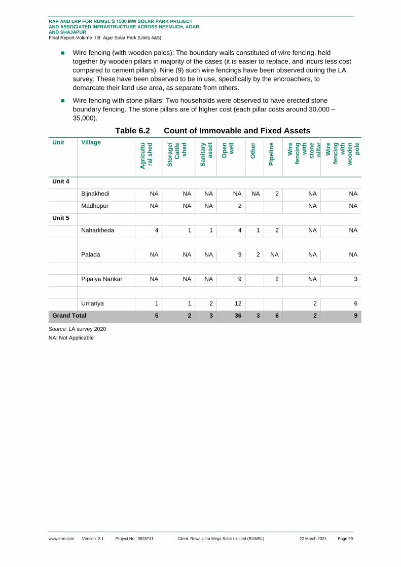
www.erm.com Version: 2.1 Project No.: 0528741 Client: Rewa Ultra Mega Solar Limited (RUMSL) 22 March 2021 Page 99
RAP AND LRP FOR RUMSL’S 1500 MW SOLAR PARK PROJECT AND ASSOCIATED INFRASTRUCTURE ACROSS NEEMUCH, AGAR AND SHAJAPUR Final Report-Volume II B Agar Solar Park (Units 4&5)
INVOLUNTARY RESETTLEMENT IMPACTS
Wire fencing (with wooden poles): The boundary walls constituted of wire fencing, held
together by wooden pillars in majority of the cases (it is easier to replace, and incurs less cost
compared to cement pillars). Nine (9) such wire fencings have been observed during the LA
survey. These have been observed to be in use, specifically by the encroachers, to
demarcate their land use area, as separate from others.
Wire fencing with stone pillars: Two households were observed to have erected stone
boundary fencing. The stone pillars are of higher cost (each pillar costs around 30,000 –
35,000).
Table 6.2 Count of Immovable and Fixed Assets
Unit Village A
gri
cu
ltu
ral
sh
ed
Sto
rag
e/
Catt
le
sh
ed
San
ita
ry
ass
et
Op
en
we
ll
Oth
er
Pip
eli
ne
Wir
e
fen
cin
g
wit
h
sto
ne
pil
lar
Wir
e
fen
cin
g
wit
h
wo
od
en
po
le
Unit 4
Bijnakhedi NA NA NA NA NA 2 NA NA
Madhopur NA NA NA 2 NA NA
Unit 5
Naharkheda 4 1 1 4 1 2 NA NA
Palada NA NA NA 9 2 NA NA NA
Pipalya Nankar NA NA NA 9
2 NA 3
Umariya 1 1 2 12
2 6
Grand Total 5 2 3 36 3 6 2 9
Source: LA survey 2020
NA: Not Applicable

www.erm.com Version: 2.1 Project No.: 0528741 Client: Rewa Ultra Mega Solar Limited (RUMSL) 22 March 2021 Page 100
RAP AND LRP FOR RUMSL’S 1500 MW SOLAR PARK PROJECT AND ASSOCIATED INFRASTRUCTURE ACROSS NEEMUCH, AGAR AND SHAJAPUR Final Report-Volume II B Agar Solar Park (Units 4&5)
INVOLUNTARY RESETTLEMENT IMPACTS
Figure 6.3 Storage shed structure on agricultural parcels
The impacts on immovable assets are restricted to Unit 5. However, these are likely to be
medium in terms of impact magnitude as these are not primary residences for the households.
The impact on the other salvageable assets and structures is mostly in Unit 5, with only 4 of the
59 assets identified being located in Unit 4. Within the Unit 5 villages, Umariya is likely to be most
impacted as 22 structures (37 percent) are located in this village. The magnitude of this impact
however is likely to be low, as the material from the structures can be salvaged and moved to an
alternate land parcel
6.2.3 Private agricultural land parcels
The selection of private parcels has been undertaken following avoidance criteria (Section 2.2)
wherein, the private land parcels within the final project boundary were selected after taking into
consideration optimization exercise for reduction of E&S risks.
As part of the project footprint optimization, an attempt was made to reduce the number of
private land parcels for the reduction of E&S risks. The only impact on Patta land is in Dudhpura
village. However, due to restrictions on land availability and technical constraints, the present
project footprint will affect fifty nine (59) private/patta land parcels. These land parcels have a
cumulative area of 133.7 ha (10 percent of the total land requirement);
Of these 59 land parcels, 21 (36 percent) are located in Unit 4, while the remaining are in Unit 5.
Of the total impacted private land, 61 percent of the land is being procured from four villages in
Unit 5.
The average area under holding per household is less 0.5 hectares. However, in terms of land
area, 38 percent of the total private land area is in Unit 4, while the remaining is in Unit 5,
indicating towards a larger size of land parcels in Unit 4.
All these land parcels will be affected by a permanent change in land use and ownership (farm
based to non-farm based) and loss of standing crop during the land clearing phase. The impact

www.erm.com Version: 2.1 Project No.: 0528741 Client: Rewa Ultra Mega Solar Limited (RUMSL) 22 March 2021 Page 101
RAP AND LRP FOR RUMSL’S 1500 MW SOLAR PARK PROJECT AND ASSOCIATED INFRASTRUCTURE ACROSS NEEMUCH, AGAR AND SHAJAPUR Final Report-Volume II B Agar Solar Park (Units 4&5)
INVOLUNTARY RESETTLEMENT IMPACTS
of land use and ownership change will be permanent, while the loss of standing crop will be a
one-time impact, on those land parcels which are under cultivation at the time of land clearing;
These impacts are likely to have a high magnitude due to the permanent nature of impact, high
dependence of the local community on agriculture as a source of livelihood. Within the project
footprint, the villages of Dudhpura (Unit 4) and Naharkheda (Unit 5) are likely to most impacted,
as the highest proportion of private land requirement is from these villages, comprising of 80
percent of the total private land requirement for the solar park.
6.2.4 Government land used for agriculture and private fodder lots
Of the 1273.4 ha of government land, 60.9 ha (5 percent) is occupied (encroached/squatted) for
agriculture or fodder cultivation (for private consumption). Of the total area under informal use, 76
percent is under squatting for agriculture. The table below provides details on the extent of
informal use of government land.
Table 6.3 Land Area under Informal land Use
Unit Village Encroachment for agriculture (ha)
Squatter for agriculture (ha)
Squatter for Agriculture and fodder (ha)
Squatter for fodder lot (ha)
Grand Total
Unit 4 Bijnakhedi 3.4 1.5 NA NA 4.9
Kesai Dehariya
3.3 NA NA 3.3
Madhopur Kheda
2.8 1.4 NA NA 4.2
Agar Sub-total 6.22 6.2 12.4
Unit 5 Naharkheda NA 7.5 2.7 NA 10.2
Palada 1.1 10.1 NA NA 11.2
Pipalya Nankar
3.8 NA NA NA 3.8
Umariya 1.2 21.5 0.16 22.8
Susner Sub-total 6.1 39.1 2.7 0.16 48.06
Grand Total 12.3 45.3 2.7 0.16 60.46
Source: LA survey 2020
NA: Not Applicable
The informal use (squatting/encroachment) of government land for agriculture has the following patterns
in Unit 4 and Unit 5:
Encroachment of government land adjacent to existing owned land to cultivate larger parcels or
plots in villages of Unit 4 (Ladwan, Karwa Khedi, Dudhpura, Pipalya Kumhar). Land owners of
large land parcels who are relatively economically well-off in the village, have used encroachment
as a practice to increase the area under private control, and used for agricultural, livestock
practices. This practice has been in existence for more than ten (10) years due to which the land
owning class has amassed large parcels for farm-related use.
Limited scale of squatting for agriculture: In certain villages of Susner tehsil, the use of
government land is prevalent among the marginal land holding households and/or landless
households (Pipalya Nankar, Umariya, Palada). These households have relied on squatting for
seasonal cropping, and grazing. The government land used for seasonal farming is mostly barren
and is of mountainous terrain usable for only single cropping.

www.erm.com Version: 2.1 Project No.: 0528741 Client: Rewa Ultra Mega Solar Limited (RUMSL) 22 March 2021 Page 102
RAP AND LRP FOR RUMSL’S 1500 MW SOLAR PARK PROJECT AND ASSOCIATED INFRASTRUCTURE ACROSS NEEMUCH, AGAR AND SHAJAPUR Final Report-Volume II B Agar Solar Park (Units 4&5)
INVOLUNTARY RESETTLEMENT IMPACTS
The general trend among encroachers/squatters, is to utilize government notified kabil kast land
(land suitable for farming) for agriculture.
In addition to this, 3.4 ha of government land has been encroached/squatted upon by individuals
for creation of private fodder lots for use by a single household/family.
Across both the Units, Umariya village in Unit 5 has the highest area that has been occupied for
informal use (22 hectares)
As seen from the table above, squatting is more common, and there is relatively a larger share of
land under squatting in Susner, as compared to Agar.
When compared with private land parcels in terms of crop being cultivated, it is understood that
the government land under agriculture is primarily used for cultivation of crop for income
purposes, with soyabean being the dominant crop (54 percent of the area under cultivation). This
preference is because this is a dependable source of income with a ready market and has a lower
investment requirement than wheat. Furthermore, this land is primarily cropped for a single
season, with only 30 percent of the total area being reported to be cultivated during the Rabi
season as well;
The loss of this land under informal use is likely to overall have a low magnitude of impact, due to
the small proportion of total required government land being under cultivation (by squatters and
encroachers).
6.2.5 Clearing of crops
A total of 194.6 hectares of land is under agricultural use (private and government land).
Cultivators of this agricultural land would be impacted by loss of standing crop at the time of land
clearing, depending on the season.
Within this agricultural land, the private land parcels reported a higher number of crops in a given
year (up to six crops), in comparison to agriculture on government land (up to 4 crops). Thus, given
the trend to multi crop in the area, the likelihood of impacts to standing crops increases. The land
parcels under multi-cropping would be more likely to be impacted by loss of standing crops;
The loss to farmers, from clearing standing crops will depend on when the possession of the land
required for the project will be taken by the Solar Park Developer (SPD). The more favourable option
would be to allow standing crops to be harvested before taking possession and thus not needing to
clear standing crops. This will reduce the extent of economic displacement (economic loss of
produce),
6.2.6 Change of land use on government land used for grazing
Of the total government land identified for the project footprint, 198.68 ha is designated as grazing
land (Charnoi or Chargah) land in government records.
As discussed in Section 4.2.7, open grazing is the preferred form of livestock feeding in most
villages. The dependence on government land for grazing has been assessed through village
profiling and consultations.
Table 6.4 Households dependent on open grazing
Village No.of persons % of total population
Naharkheda 20 1.6
Umariya 750 100
www.erm.com Version: 2.1 Project No.: 0528741 Client: Rewa Ultra Mega Solar Limited (RUMSL) 22 March 2021 Page 103
RAP AND LRP FOR RUMSL’S 1500 MW SOLAR PARK PROJECT AND ASSOCIATED INFRASTRUCTURE ACROSS NEEMUCH, AGAR AND SHAJAPUR Final Report-Volume II B Agar Solar Park (Units 4&5)
INVOLUNTARY RESETTLEMENT IMPACTS
Village No.of persons % of total population
Palada 100 10.6
Madhopur 350 82
Pipalya Nankar 200 11.1
Source: LA survey 2020
The above table shows that grazing is an important source of livelihood and is linked to availability of
land parcels for open grazing.
The impact observed is the highest in Umariya in Unit 5, where the potential magnitude of impact is
high – both in terms of loss of access grazing land, and loss of livelihood to grazers, as also the
individuals who are engaged in grazing activity as a source of livelihood.
Madhopur in Unit 5 also has high dependence which was also confirmed through consultations with
households. Their main source of livelihood is grazing of livestock which is supplemented by farm
income.
The overall magnitude of the impact is assessed as medium for most of the villages in the project
footprint. This is in keeping with the understanding that while alternative grazing land will be available
within the village after Project=related land procurement, the location in terms of distance from
settlement and suitability of the land for fodder or grazing is presently unknown. The loss of grazing
land may thus result in an increased travel time for grazing purposes as well as increased pressure
on the remaining grazing land in the village. This impact is likely to be most significant for the villages
Palda, Pipaliya Nankar, (unit 5) and Kesai Dehariya (Unit 4), as these villages will have the lowest
proportion of grazing land available after project land take. Kesai Dehariya does not have any grazing
land remaining after project land take.
6.2.7 Clearing of privately owned fruit and timber trees
A total of 341 trees (timber and fruit) have been identified across 23 land parcels in the project
footprint.
A total of 129 timber trees, spread across 10 private land parcels have been identified in the
project footprint. Of these 35 percent of the trees surveyed are used for fuelwood, followed by
construction related use (21 percent). On an average, there are 10 – 12 trees on a single land
parcel.
Among the timber trees assessed, 35 percent of them have an average diameter of more than 45
cm at breast height.
Similarly, 33 fruit trees were assessed on 13 land parcels with an average of 1 -3 fruit trees on
one land parcel. It has been found that 72 percent of the fruit trees are in the young productive
(fruit bearing) years. Majority of the fruit trees are orange (57 percent). The orange trees surveyed
were not part of a planted orchard.
The project land take will require the felling/clearing of these trees as part of the land clearing
process. This will result in a significant economic impact or loss of assets for the owners.
In terms of magnitude, the impact is likely to be comparable across the two units. While Unit 4
has a larger number of trees being impacted in comparison to Unit 5, the difference between the
two units in terms of number of trees and type is small (less than 10 percent)

www.erm.com Version: 2.1 Project No.: 0528741 Client: Rewa Ultra Mega Solar Limited (RUMSL) 22 March 2021 Page 104
RAP AND LRP FOR RUMSL’S 1500 MW SOLAR PARK PROJECT AND ASSOCIATED INFRASTRUCTURE ACROSS NEEMUCH, AGAR AND SHAJAPUR Final Report-Volume II B Agar Solar Park (Units 4&5)
INVOLUNTARY RESETTLEMENT IMPACTS
6.3 Involuntary Displacement Impacts
This section discusses the effect of the impact on land and assets on the PAHs. The impacts due to
the Project can be categorized as impacts on livelihood (economic displacement) and/or impacts on
structures for residential uses (physical displacement). These involuntary impacts will lead to
economic displacement of 257 PAHs, of which 95 (36 percent) were covered through the LA survey.
There are five (5) households who will be displaced due to loss of physical structure, and hence are
likely to physically displaced.
Table 6.5 Economic and Physical displacement of PAHs
Unit Villages Total PAHs Economically displaced PAHs
Physically displaced PAHs
Unit
4
Bijnakhedi 9 9 0
Kesai Dehariya 3 3 0
Madhopur 5 5 0
Ladwan 12 12 0
Karwa Khedi 16 16 0
Dudhpura 75 71 4
Pipaliya Kumhar 3 3 0
Agar Sub-total 123 119 4
Unit
5
Naharkheda 41 41 1
Palda 27 35 0
Pipalya Nankar 23 24 0
Umariya 48 53 0
Susner Sub-total 139 138 1
Grand Total 262 257 5
Source: LA survey 2020
6.3.1 Physical Displacement: Households Impacted by Loss of Residential Structure and other Immovable Assets
A key impact due to the land procurement for the project is the loss of residential structures located
within the project footprint. 5 PAHs will be impacted by the loss of residential structures across the
two units.
There are a total of seven structures, out of which, three structures are on private land parcel
belonging to one household, and the rest of the structures are on government land parcels belonging
to four (4) households. While the household in Naharkheda will be impacted by loss of temporary
residential structure, the four households in Dudhpura will be impacted by the loss of the permanent
residential structure.
Thus, the magnitude of impact is expected to be higher for the 4 PAHs in Dudhpura. Furthermore,
the loss of such physical assets is concurrent with the loss of livelihood due to economic
displacement, and hence the impacts are to be considered in totality for such PAHs.

www.erm.com Version: 2.1 Project No.: 0528741 Client: Rewa Ultra Mega Solar Limited (RUMSL) 22 March 2021 Page 105
RAP AND LRP FOR RUMSL’S 1500 MW SOLAR PARK PROJECT AND ASSOCIATED INFRASTRUCTURE ACROSS NEEMUCH, AGAR AND SHAJAPUR Final Report-Volume II B Agar Solar Park (Units 4&5)
INVOLUNTARY RESETTLEMENT IMPACTS
Figure 6.4 A typical residential structure
The above image represents the type of affected residential structures in Agar Solar Park. These are
isolated structures, away from the main village settlement and have seasonal use.
6.3.2 Economic displacement
6.3.2.1 Households impacted due to loss of private and patta land
A key impact is the loss of private and patta land due to the land procurement for the project and the
overall reduction in land holding amongst the PAHs. As can be seen from the table below, a total of
164 PAHs (63 percent of total PAHs) are to be impacted by the loss of private/patta land. These
correspond to 147 individual land owners spread across 133.7 ha
Table 6.6 Project-affected households owning private/patta land
Unit Villages Private land
owning PAHs
Patta land
owning PAHs
Total PAPs Potential
landless PAHs
Unit 4 Bijnakhedi 0 0 0 NA
Kesai Dehariya 1 0 4 0
Madhopur 0 0 0 NA
Ladwan 12 0 48 0
Karwa Khedi 16 0 240 0
Dudhpura 42 33 450 0

www.erm.com Version: 2.1 Project No.: 0528741 Client: Rewa Ultra Mega Solar Limited (RUMSL) 22 March 2021 Page 106
RAP AND LRP FOR RUMSL’S 1500 MW SOLAR PARK PROJECT AND ASSOCIATED INFRASTRUCTURE ACROSS NEEMUCH, AGAR AND SHAJAPUR Final Report-Volume II B Agar Solar Park (Units 4&5)
INVOLUNTARY RESETTLEMENT IMPACTS
Unit Villages Private land
owning PAHs
Patta land
owning PAHs
Total PAPs Potential
landless PAHs
Pipalya Kumhar 3 0 15 0
Agar Sub-total 74 33 753 0
Unit 5 Naharkheda 18 0 72 0
Palda 11 0 77 10
Pipalya Nankar 11 0 78 5
Umariya 17 0 59 0
Susner Sub-total 59 0 286 11
Grand total 131 33 1039 26
Source: LA survey & HH survey 2020
These 164 PAHs will be impacted by a permanent loss of asset and livelihoods; in terms of
agricultural livelihoods.
Amongst these PAHs, the impact magnitude is likely to be high, whereas it is assessed to be most
severe for the 26 households who would become landless due to the project land take.
While Dudhpura (unit 4) has the highest number of PAHs impacted by loss of private/patta land,
Palda (unit 5) has the highest number of PAHs who would become landless.
6.3.2.2 Households impacted due to change of land use of government land
There are 77 PAHs who will be impacted by loss of livelihood arising from informal use of government
land for agriculture, due to project land allotment. Of these 77 PAHs, 60 (77 percent) are squatters,
and the remaining are private land owners who have encroached upon adjacent government land for
agriculture. Each of these PAH have an average area of less than one hectare under informal
agricultural use. Of the 77 PAHs, 3 PAHs reported informal use of occupied government land for
fodder crop cultivation (two PAHs in Naharkheda, and one PAH in Umariya)
Table 6.7 Number of Informal Users (squatters/encroachers)
Unit Village Squatting households Encroacher households
Unit 4 Bijnakhedi 3 NA
Kesai Dehariya 2 NA
Madhopur 1 2
Agar Sub-total 15 2
Unit 5 Naharkheda 11 NA
Palda 13 1
Pipaliya Nankar NA 11
Umariya 23 3

www.erm.com Version: 2.1 Project No.: 0528741 Client: Rewa Ultra Mega Solar Limited (RUMSL) 22 March 2021 Page 107
RAP AND LRP FOR RUMSL’S 1500 MW SOLAR PARK PROJECT AND ASSOCIATED INFRASTRUCTURE ACROSS NEEMUCH, AGAR AND SHAJAPUR Final Report-Volume II B Agar Solar Park (Units 4&5)
INVOLUNTARY RESETTLEMENT IMPACTS
Unit Village Squatting households Encroacher households
Susner Sub-total 45 15
Grand Total 60 17
Source: HH survey 2020
Across both the Units, Umariya in Unit 5 has the highest area under informal use (22 ha) with 26
PAHs. Nine (9) of these households also reported to owning private agricultural land (outside the
project footprint) apart from the land under informal use. The magnitude of impact on these informal
users will be high due to a loss of livelihood associated with the land allotment and change in land
use. Amongst the PAHs, the impact on squatters (apart from the 9 households mentioned above) is
likely to be more severe as they are either landless or own land that is less productive in comparison;
as in the case of patta owners;
6.3.2.3 Households impacted due to loss of other structures
There are eleven (11) households who will be impacted by loss of immovable structures. Six of the
household are informal users of government land for agriculture and have constructed structures for
agricultural uses on those government parcels such as -livestock sheds, fodder storage shed, water
feeding stall. The rest are private land owners who have constructed temporary sheds/ kutcha
structures on their private agricultural land. While the overall impact magnitude is low, the highest
impact is likely to result from loss of access to open wells which are used for irrigation of land outside
the project footprint. In such cases, the project should consider allowing continued access to such
wells by other households during project construction and operation.
6.3.2.4 Households impacted due to loss of income from agricultural activities
As discussed in Section 1.1.1 and Section 4.2the primary occupation amongst the PAHs is farm
based activities (~76 percent across the age group 35-60 years) and a total of 194.6 ha across
the solar park is under agricultural use presently30. Almost all of the PAHs also engage in
agricultural labour work. On an average, agricultural income comprises 57 percent of the total
household income
The project land take will result in an impact on the agricultural income for the PAHs in terms of
loss of standing crop at the time of land clearing as well as opportunity cost of the cultivation that
would have been undertaken on the land parcel in the next season. This is assuming that the
PAHs will likely take one more agricultural season to procure replacement land and make it
productive, or participate in the Livelihood Restoration opportunities made available by the
project.
Agricultural activities also contribute towards the food security of the household. Thus, a reduction
in overall land under agriculture per household may, in some cases also impact the food security
of the household, thereby increasing the dependence on the Government PDS schemes or
increasing the expenditure on food grains. This is likely to be significant for households left with
sub-optimal land after the land procurement; whose land holdings get reduced significantly or
patta land owners who had encroached on government land due to low productivity of allotted
land);
The magnitude of impact is assessed as high, due to the importance of agricultural activities in
the household income as well as food security for the household
6.3.2.5 Households impacted due to loss of timber and fruit trees
108 PAHs are assessed to be impacted by the loss of timber trees, while 19 PAHs will be
impacted by loss of fruit trees
30
www.erm.com Version: 2.1 Project No.: 0528741 Client: Rewa Ultra Mega Solar Limited (RUMSL) 22 March 2021 Page 108
RAP AND LRP FOR RUMSL’S 1500 MW SOLAR PARK PROJECT AND ASSOCIATED INFRASTRUCTURE ACROSS NEEMUCH, AGAR AND SHAJAPUR Final Report-Volume II B Agar Solar Park (Units 4&5)
INVOLUNTARY RESETTLEMENT IMPACTS
Table 6.8 PAH impacted by loss of timber trees
Village PAH Count of Trees
Village PAH Ne
em
Khejdi Babul Palas
h
Ber Custa
rd
Apple
Imli Aran
d
Bakai
n
Other
s
Madhopur 32 4 0 0 0 0 0 0 0 0 0
Naharkheda 57 30 49 11 33 6 3 8 0 0 102
Palada 5 12 4 0 0 0 0 0 0 15
Pipalya
Nankar
2 3 0 0 0 0 0 1 0 0 2
Umariya 12 33 10 4 31 0 0 1 3 12 73
Grand total 108 70 71 19 64 6 3 10 3 12 192
Source: LA survey 2020
There are 27 PAHs who have trees on the land parcels, either in the category of timber, fodder, or
fuelwood. Of these, 9 PAHs are private land parcel holders.
Of the total timber trees reported, 71 percent (321 out of 450 trees) have been grown on
government land parcels being informally used for agriculture. According to the discussion with
the encroachers/squatters these trees have been grown by the individuals for their personal use,
and are differentiated from the naturally growing trees on government land;
All the households (17 PAHs) who have planted trees on government land parcel use it on an
ongoing basis for fodder, or twigs for use as fuelwood.
On an average a typical households has about 4 – 5 timber trees on the land parcel under
agricultural use,. The difference among private land owners and those who are cultivating
government land informally is in the type of trees grown. The informal land using households grow
neem (INR 10 per sapling), and Khejdi trees for household uses, while private land owners
cultivate Palash and Babul trees which have a higher price in the market (420/cubic meter) as
compared neem (14/cubic meter) as reported by the land parcel owners and informal land users
during consultations.
There are 19 PAHs who have reported and have been assessed for fruit trees on the land under
agricultural use. Of these, 12 PAHs are private land parcel holders while remaining are
encroachers/squatters on government land. The LA survey assessed 54 such fruit trees, across
13 land parcels, majority of which contained orange trees.
6.3.3 Community based livelihood impacts
The primary impact at the community level arises due to reduction in available land for open
grazing, due to land use change, i.e. loss of livelihood and sustenance linked to use of
government land for open grazing of livestock. Open grazing of livestock reduces the input costs
linked to grazing which otherwise would be market purchased fodder, and/or paying for stall
feeding, which would increase the input costs of livestock management, and reduce the net
income from sale of livestock products.

www.erm.com Version: 2.1 Project No.: 0528741 Client: Rewa Ultra Mega Solar Limited (RUMSL) 22 March 2021 Page 109
RAP AND LRP FOR RUMSL’S 1500 MW SOLAR PARK PROJECT AND ASSOCIATED INFRASTRUCTURE ACROSS NEEMUCH, AGAR AND SHAJAPUR Final Report-Volume II B Agar Solar Park (Units 4&5)
INVOLUNTARY RESETTLEMENT IMPACTS
Table 6.9 Dependence of households on grazing land
Unit Village No.of HHs using
government land for
grazing
% of total HHs in the
village
Unit 4 Ladwan NA NA
Dudhpura 40 40
Bijnakhedi 50 15
Kesai Dehariya 25 25
Madhopur 20 16
Pipalya Kumhar 0 0
Agar Sub-total 135 21
Naharkheda 55 18
Palada 0 0
Pipalya Nankar 50 16
Umariya 0 0
Susner sub-total 105 17.5
Grand total 240 19.2
Source: Village Profiling 2020
Open grazing of livestock is the most preferred option, as against stall feeding, reported during
consultations with livestock grazing households.
Livestock holding has been reported by 24 percent of the PAHs (171), of which 35 percent of the
households depend on livestock as a source of income.
The loss of income form livestock is estimated at INR 36,000 per year, excluding input costs of
fodder. Livestock income is a crucial source of livelihood for the marginal farmers and landless
households and is also a regular source of income for graziers – who tend to cattle for a cluster of
houses for a fee.
These households also include the Banjara community of Madhopur (10 households), who
depend specifically on livestock as the primary source of livelihood, supplemented by agricultural
income. Although these households are not directly impacted by the land procurement for the
project, consultations with these communities reveal that they will be affected by the loss of land
for open grazing.
Livestock management is the most important activity, and these households rely on grazing as
means of income (employed as graziers). Due to loss of access to grazing lands, these
households may have to rely on market purchase for fodder which would increase input costs,
and therefore affect their income.

www.erm.com Version: 2.1 Project No.: 0528741 Client: Rewa Ultra Mega Solar Limited (RUMSL) 22 March 2021 Page 110
RAP AND LRP FOR RUMSL’S 1500 MW SOLAR PARK PROJECT AND ASSOCIATED INFRASTRUCTURE ACROSS NEEMUCH, AGAR AND SHAJAPUR Final Report-Volume II B Agar Solar Park (Units 4&5)
INVOLUNTARY RESETTLEMENT IMPACTS
Secondly, the reduction in such common land for grazing could also lead to reduction in count of
livestock held by these households, as input costs increase (creation of stall-shed, feeding stalls,
etc.). Thus, the total income earning capacity for the household from livestock may reduce.
In keeping with this, the impact magnitude is assessed as high, especially for Dudhpura, as it has
reported the highest proportion of population dependent upon government land for grazing
6.3.4 Gendered livelihood impacts
The Section 4.2.12, assesses Female headed households as a vulnerable group. Based on the
information available, four (4) such households have been identified; based on extrapolated data for
the entire PAH, there are estimated to be 11 female headed households.
Female headed households are primarily dependent on agricultural labour work, and supplementary
income from livestock.
Out of these four households, two have reported agricultural work on their private land parcels, and
who will be impacted by loss of private land to the project footprint. Both of these households are
small land holders (less than 2 hectares), and derive an annual average income of INR 1, 77,500 from
agriculture for the household. The other two households depend on income from agriculture on
occupied government land.
The women headed households identified through the households survey are likely to be
economically displaced by the project and did not report any other source of income other than their
agricultural income as part of the household survey.
Another impact on female headed households will be the Impact due to loss of access to government
grazing land that were located near their village, and are now included in the project boundary. This is
based on the understanding that the grazing activities by women were primarily undertaken close to
the village settlement, with men taking livestock to grazing land that was located further away. Due to
the project impact on the grazing areas close to the settlement, grazing areas may be available at
further distances, the alternative is to access the parcels which are at greater distance and will thus
have higher time cost implications. This in turn may have an opportunity cost of time lost that was
earlier used for other agricultural labour work activities
Apart from the impacts on female headed households, there are also likely to be certain impacts
which differentially impact women in the project affected population. Most of the women land owners
are joint owners. If not managed well, there is a risk of women in joint land ownerships not getting
their fair share, or access to their share of the compensation amount. This may be further
compounded by the lack of access to the economic opportunities/ livelihood restoration programs by
the project, due to lower literacy levels and socio-cultural norms and restrictions on women engaging
in income generating activities.
Furthermore, reduction in available government land for open grazing is likely to lead to a shift
towards stall feeding in the short term. In the current practice of livestock management, the
responsibilities are shared equally by men and women, with women undertaking feeding of the
animals in stalls, cleaning, washing, mulching, while men undertake grazing, and help in collection of
fodder. The shift towards stall feeding could increase the work load and responsibilities of women of
the households without any remuneration attached for the same. Men on the other hand, may have
lesser work share as they were responsible for open grazing livestock and to a lesser degree, in stall-
feeding activities.
6.3.5 Impact on Vulnerable groups
The vulnerability profiling (Section 4.2.12) of impacted households shows that there are 21
vulnerable households, four of which are women headed, and the rest are artisanal income based (3
households), and 9 household below poverty line. The impacts of these households are uniform in
nature to the involuntary economic displacement related impacts, discussed earlier.

www.erm.com Version: 2.1 Project No.: 0528741 Client: Rewa Ultra Mega Solar Limited (RUMSL) 22 March 2021 Page 111
RAP AND LRP FOR RUMSL’S 1500 MW SOLAR PARK PROJECT AND ASSOCIATED INFRASTRUCTURE ACROSS NEEMUCH, AGAR AND SHAJAPUR Final Report-Volume II B Agar Solar Park (Units 4&5)
INVOLUNTARY RESETTLEMENT IMPACTS
However, there is one specific settlement of households belonging to the indigenous group, who will
be economically displaced due to land procurement, and project activities. The Bhil community in
Ladwan (16 households) will be potentially economically displaced due to project activities.
Livestock management is the most important economic activity for most of the Bhil families.
Village commons, or the common grazing areas on government land are the source of fodder for
these families.
As reported from consultations with the community, a Bhil household family could incur a loss
assessed to be about INR 1,32,000.00 annually due to the shift to market purchase of fodder.
The added adverse impact will be on women and children of these households who undertake the
responsibility of stall feeding, and major portion of livestock management related activities,
including milking, cleaning, washing etc. This may lead to distress sales of livestock due to lack of
grazing land, potentially affecting family incomes and nutrition levels.
In terms of impact due to loss of agricultural land, ten (10) households reported to using land (an
average of 0.5 ha) which includes both private land owners as well as encroachers. According to
the households, the land procurement could lead to loss of agricultural labour work (30 per cent of
their total income), loss of farm output produced for self-consumption as well as for sale.
All Bhil families collect firewood from the area where the solar park is proposed. On an average,
every family collects firewood worth INR 450.00 per month. The families would lose the access to
the firewood and dependency on alternative sources would increase, if alternate areas are not
available or accessible to them.
www.erm.com Version: 2.1 Project No.: 0528741 Client: Rewa Ultra Mega Solar Limited (RUMSL) 22 March 2021 Page 112
RAP AND LRP FOR RUMSL’S 1500 MW SOLAR PARK PROJECT AND ASSOCIATED INFRASTRUCTURE ACROSS NEEMUCH, AGAR AND SHAJAPUR Final Report-Volume II B Agar Solar Park (Units 4&5)
IMPLEMENTATION STRATEGIES FOR AGAR SOLAR PARK
7. IMPLEMENTATION STRATEGIES FOR AGAR SOLAR PARK
This section discusses the Solar Park specific implementation strategies that have been identified
based on the resettlement surveys undertaken, as distinct from the overall implementation plan
presented in Volume I of the RAP-LRP. This section provides the implementation strategies, the
necessary stakeholder engagement activities, and the RAP budget for Agar Solar Park.
7.1 Completion of pending activities prior to Implementation
Based on the entitlement matrix and measures of compensation, rehabilitation and livelihood
restoration, the following table summarises specific mechanisms that will need to be incorporated as a
part of the RAP and LRP Implementation, with specific focus on Unit 4 of the Solar Park, prior to the
implementation of RAP-LRP:
Table 7.1 Pre- implementation actions
Aspect Description
Stakeholder consultations and
information disclosure;
The project shall undertake focused and dedicated engagement activities
with the local community and affected households prior to the initiation of
land purchase and RAP&LRP implementation. This shall be focused on
providing the local community an understanding of the project context and
the potential impacts from the same, with a focus on the measures taken for
avoidance of impacts and the provisions for protection of Nistar rights.
These engagement activities shall specifically be focused on the three
villages Ladwan, Karwa Khedi and Dudhpura that had filed formal objections
against the project to the District Collector.
Completion of RAP&LRP
surveys
Undertake the resettlement surveys for the villages which refused to
participate in the process during the RAP&LRP preparation. The completion
of the RAP&LRP surveys should be undertaken only with the consent of the
PAHs. As such, the project will have to ensure an informed willingness to
participate in the project activities amongst the local community. As needed,
the project shall undertake focused discussions with groups of affected
households, land owners and other key stakeholder such as the Panchayat
members.
7.2 Stakeholder Engagement and Grievance Management
Given the gap at the current stage with regards to missing information from four villages of Unit 4, and
the associated large scale grievances reported during the resettlement surveys undertaken in August
2020, it is suggested that regular engagement should be undertaken with all the villages in the project
footprint, with specific focus on the villages who have refused to resettlement surveys.
As understood from consultations with DREO, and government officials at the Tehsil level, there is a
need to implement a process of grievance management and consultation activities for the villages.
These include –
Consultations with the Gram Panchayat to provide update on the land procurement process of
private land in the villages
Sharing of timeline of project activities with the Tehsil office and sensitisation on the same with
the Tehsildar.

www.erm.com Version: 2.1 Project No.: 0528741 Client: Rewa Ultra Mega Solar Limited (RUMSL) 22 March 2021 Page 113
RAP AND LRP FOR RUMSL’S 1500 MW SOLAR PARK PROJECT AND ASSOCIATED INFRASTRUCTURE ACROSS NEEMUCH, AGAR AND SHAJAPUR Final Report-Volume II B Agar Solar Park (Units 4&5)
IMPLEMENTATION STRATEGIES FOR AGAR SOLAR PARK
Regular meetings with the private and patta land holders to be impacted by land take should be
held by the DREO, in association with the Tehsildar, and Patwari to make them aware of the
potential land based impacts as well as share information on the livelihood restoration measures.
Conduct workshops with specific stakeholder groups identified during the resettlement surveys to
incorporate feedback and suggestions on resettlement planning such that the specific needs of
vulnerable groups are included in the implementation plan.
The current state of stakeholder engagement requires improvement in terms of record keeping of
grievances, identifying community representatives to ensure sustained engagement, and involvement
of local government authorities as a grievance record keeping and resolution platform.
7.3 RAP implementation schedule for Agar Solar Park
The overall implementation schedule in the Volume I of the RAP-LRP contains the key project timelines, including the disclosure of RAP and LRP as well as regular engagement activities. A Solar Park level implementation schedule will be prepared in keeping with the Volume 1 schedule for Agar Solar Park. .

www.erm.com Version: 2.1 Project No.: 0528741 Client: Rewa Ultra Mega Solar Limited (RUMSL) 22 March 2021
APPENDIX A PHOTO-DOCUMENTATION

www.erm.com Version: 2.1 Project No.: 0528741 Client: Rewa Ultra Mega Solar Limited (RUMSL) 22 March 2021
Photo 1: Land parcel in Unit 5 Photo 2: Soyabean crop on a land parcel in Unit 5
Photo 3: A kutcha structure in the middle of a land
parcel in Unit 5 Photo 4: Residential structures in Unit 4

www.erm.com Version: 2.1 Project No.: 0528741 Client: Rewa Ultra Mega Solar Limited (RUMSL) 22 March 2021
Photo 5: An isolated structure on a land parcel in Unit 5 Photo 6: Umariya Village in Unit 5
Photo 7: Kickoff meeting at Palda, Unit 5 Photo 8: An open well in Umariya, Unit 5

www.erm.com Version: 2.1 Project No.: 0528741 Client: Rewa Ultra Mega Solar Limited (RUMSL) 22 March 2021
Photo 9: Area within Project Boundary in Umariya, Unit
5 Photo 10: Residence in Umariya, Unit 5
Phot 11: Developmental Projects in Unit 4. Photo 12: Residential structure in Unit 4.
Photo 13: FGD in Naharkheda, Unit 5 Photo 14: Household Survey in Umariya, Unit 5

www.erm.com Version: 2.1 Project No.: 0528741 Client: Rewa Ultra Mega Solar Limited (RUMSL) 22 March 2021
Photo 15: Residential structure in Palda Photo 16: Kick off meeting in Naharkheda, Unit 5
Photo 17: L&A survey in Umariya, Unit 5 Photo 18: Corporate developmental initiative in Agar
Photo 19: Soyabean pests in Unit 5 Photo 20: Local deity in Unit 5

www.erm.com Version: 2.1 Project No.: 0528741 Client: Rewa Ultra Mega Solar Limited (RUMSL) 22 March 2021
APPENDIX B SUMMARY OF CONSULTATIONS

www.erm.com Version: 2.1 Project No.: 0528741 Client: Rewa Ultra Mega Solar Limited (RUMSL) 22 March 2021
SUMMARY OF CONSULTATIONS
FGD with Grazer’s Groups at Umariya
The village has approximately 200-3000 cows, 1500-2000 Buffaloes and 1000-1500 goats.
The typical
Most of the grazing area is restricted to the immediate vicinity (1-2 km) around the village abadi
area
The community does not use the land towards the east for grazing purposes as the land is more
fertile and suitable for agriculture. On the other hand the land towards the west of the abadi area
is hilly so more suitable for grazing
The community emphasised the importance of livestock holdings in the livelihoods of the local
community and suggested that the project should consider taking the panchvan land instead
The local community were of the opinion that the project should not disturb the waterbodies
existing in the proposed project footprint and allow access to the community for the same
Also, for water requirements for the project, the water should be purchased from the local
community instead of setting up new bore wells
Lastly, the community wanted access to project benefits through free electricity, jobs and hiring of
vehicles from the local village
FGD with Women’s group at Umariya Village
The women reported that livestock holdings are an essential part of the livelihood and
sustenance of the households
The men are responsible for the grazing of the livestock heads on the open government land.
The typical grazing area is 2-3 km around the village abadi area
The women are responsible for the activities surrounding livestock maintenance within the
homestead, such as cleaning the shed, milking, fodder for stall feeding and washing of the animal
Women are responsible for the collection of firewood and dung from the government land
surrounding the abadi area and typically go upto 1 km for the same
The women also use the land in the immediate vicinity of the abadi area for open defecation
If the project is set up close to the abadi area, women will lose access to the government land
and this will impact their sense of security as well the overall sustenance of the household
FGD with Grazer’s group at Palda
The community reported that very little grazing land remains in the village as a lot has been
diverted to forest land
The local community is not allowed to the forest land within the village
The cows in the village graze upto approximately 2 km from the abadi area whereas the goats
graze upto 4 km, upto the Pipaliya Nankar border
There are a lot of ‘awara gai’ in the village as outsiders come and strand the cattle they do not
want in the middle of the night in their village. They are thus not able to trace those responsible
While the project may set up gaushalas for cows, it will only for stray cows and not other animals
Also, one shelter cannot be created for goats and bufflaoes together
Also, the catlle breed needs to open graze in order to get adequate exercise and thus stall
feeding wont work, the households also typically don’t have adequate infrastructure to keep all
the livestock at home through the day

www.erm.com Version: 2.1 Project No.: 0528741 Client: Rewa Ultra Mega Solar Limited (RUMSL) 22 March 2021
If grazing land is left it should be close to the abadi area as they will not be able to use the land
beyond 2 km
FGD with Grazer’s group at Naharkheda
The cows in the village graze upto approximately 2 km from the abadi area
There are a lot of ‘awara gai’ in the village as outsiders come and strand the cattle they do not
want in the middle of the night in their village.
While the project may set up gaushalas for cows, it will only for stray cows and not other animals.
The local community will not consent to keeping their own cows in a gaushala as every
household has a different approach to maintaining their cattle, including the kind and amount of
fodder being used
Also, the catlle breed needs to open graze in order to get adequate exercise and thus stall
feeding wont work, the households also typically don’t have adequate infrastructure to keep all
the livestock at home through the day
If grazing land is left it should be close to the abadi area as they will not be able to use the land
that is too far away as the cattle cannot reach the land, graze and return within the same day
The village does not allow the nomadic herding community to graze in the area
FGD with Grazer’s group at Pipaliya Nankar
The cattle graze in the open for 8 months in a year. Rest is stall feeding with crop residue
Typically you need 15-18 kg of a fodder a day for a cow and 30-35 kg of fodder a day for
buffaloes. Goats eat significantly less, with only 1-2 kg of fodder being required
The typical cost of fodder and supplements for a cow is 8000 Rs for a month while for a buffalo its
more than 12000
In the past as well other projects have been developed in the area, which have not benefited the
population at all. It has increased the pressure on the existing land in the village
While on paper 2% land may be available for grazing, the local community does not know of its
location and that is not enough
According to the local community, if the cattle doesn’t roam while grazing, their health and
productivity will suffer
A reduction in grazing land would result in an increase in out migration from the village and an
increase in awara gai population
FGD with local community and Grazers at Palda
The village has forest land which should be diverted for the project, instead of grazing land being
used. This is because, grazing land is critical for the local community while they are not allowed
access to the forest land
Livestock was reported to be critical for sustenance, as agricultural activities have an
unpredictability associated with them, in terms of yield and productivity
Instead of 2% land, they need atleast 25% land in the village for grazing purposes
The local community had heard about the complaint filed by the Ladwan village against the
project and were keen to do the same as well
The project, if it comes, should undertake water shed development work that would help the
livestock holding
The village is divided into hamlets, and each hamlet has their own grazing area which is not used
by the other hamlets. Thus while the entire village may have 2% land remaining, it may not be
equally distributed

www.erm.com Version: 2.1 Project No.: 0528741 Client: Rewa Ultra Mega Solar Limited (RUMSL) 22 March 2021
The reduction in grazing land would result in a reduction in livestock holding, increase in awara
gai and overall increase in out migration
FGD with local community at Pipaliya Kumhar
The village is divided into two main settlements, Pipaliya Kumhar and Nai Abadi. The grazing
land between these two villages is divided, and the two populations do not use the other hamlets
land
There was a dam constructed in the village without the community’s consent or participation and
that resulted in a reduction in the overall land available for grazing
While on government records, grazing land may be remaining in the village, it may be
concentrated in one hamlet or already be encroached upon. Furthermore, the community is not
aware of the location of the government designated grazing land
FGD with women at Pipaliya Kumhar
At the time of the dam construction, the local community was deceived. During the public
meetings they were asked for their consent to the project. While the local community was against
the project, they were made to sign on a declaration supporting the project. this was done as at
that time the community was not literate and could not verify what was written on the document
In addition to grazing, the remaining government land is also used by the community for purposes
such as firewood and dung collection and open defecation.
Any new project in the village will result in an impact on the sustenance of the households in the
village
FGD with grazers and youth at Kesai Dehariya
According to the local community, the most stable and biggest source of income for the local
community was their livestock holding
The community was opposed to the project as it would reduce the government land available for
grazing, which would result in a reduction in total livestock holdings in the village and an increase
in awara gai in the area
Furthermore, the agricultural activities will also get impacted as the livestock holdings serve as an
important source of manure for the cultivation
If the project is to be constructed, adequate grazing needs to be left for the community and the
project needs to work with the government to provide free electricity and water to the community
from the Dam
The project should also provide employment. If employment is provided, even women of the
community will work
Unemployment in the youth is high in the village due to lack of opportunities. Most young boys
take care of the livestock holdings of the household and the young men typcailly migrate to
Mahrasthra and Rajasthan for work. While in Maharashtra, the youth is typically engaged in
cultivation of Tuar pulse and cotton, in Rajasthan they are involved in tile manufacturing

www.erm.com Version: 2.1 Project No.: 0528741 Client: Rewa Ultra Mega Solar Limited (RUMSL) 22 March 2021
APPENDIX C SUMMARY PROFILE OF INFORMAL USERS IN AGAR SOLAR PARK

www.erm.com Version: 2.1 Project No.: 0528741 Client: Rewa Ultra Mega Solar Limited (RUMSL) 22 March 2021
Summary Profile of Informal Users in Agar Solar Park
The table below provides a summary of the profile of the informal users (encroachers and squatters) on government land who will be impacted
due to the land procurement for the Agar Solar Park.
Village Khasra Number
PAE Number
PAH Number Caste Encroacher/ Squatter
Area Encroached/ Squatted (ha.)
Nature of Dependence (Agriculture/ Grazing/ firewood etc.)
Dependence on land for primary livelihood (Yes/No)
Years of Land Use
Any other Land Available
Assessment of Vulnerability* (NA denotes not applicable)
Umariya 297 531128 10123168120 SC Squatter 0.56 Agriculture No 5+ Yes NA
Umariya 297 531131 10123169129 SC Squatter 0.84 Agriculture Yes 5+ No Three (3) uneducated youth without any skill set
Umariya 849 531116 10123171132 SC Squatter 4.40 Agriculture Yes 5 No Squatter on forest land
Umariya 748 531112 10123168110 OBC Squatter 0.50 Agriculture/ Toilet
Yes 5 Yes One uneducated youth without any skill set
Umariya 872 531115 10123167131 OBC Squatter 0.10 Agriculture Yes 3+ Yes One uneducated youth without any skill set
Umariya 748 531113 10123167111 OBC Encroacher 0.35 Agriculture Yes 3 - 5 Yes One uneducated youth without any skill set
Umariya 748 531114 10123170112 OBC Encroacher 0.36 Agriculture Yes 3 - 5 Yes NA
Umariya 712 531120 10123170118 OBC Encroacher 0.02 Agriculture Yes 2+ Yes One educated youth without any skill set
Umariya 776 531140 10123170122 SC Squatter 2.04 Agriculture Yes 3+ No NA

www.erm.com Version: 2.1 Project No.: 0528741 Client: Rewa Ultra Mega Solar Limited (RUMSL) 22 March 2021
Village Khasra Number
PAE Number
PAH Number Caste Encroacher/ Squatter
Area Encroached/ Squatted (ha.)
Nature of Dependence (Agriculture/ Grazing/ firewood etc.)
Dependence on land for primary livelihood (Yes/No)
Years of Land Use
Any other Land Available
Assessment of Vulnerability* (NA denotes not applicable)
Umariya 776 531119 10123170125 OBC Squatter 0.00 Agriculture NA 3 - 5 NA NA
Umariya 300, 297 531134 10123167136 SC Squatter 0.85 Agriculture Yes NA Yes NA
Umariya 297 531124 10123170117 SC Squatter 0.31 Agriculture Yes NA Yes NA
Umariya 297 531129 10123169128 SC Squatter 0.50 Agriculture Yes 3 No NA
Umariya 297 531132 10123164130 OBC Squatter 0.51 Agriculture Yes NA Yes NA
Umariya 297 531130 10123164127 General
Squatter 0.10 Fodder Lot Yes <1 Yes Women HoH
Umariya 748 531107 10123164104 SC Squatter 0.65 Agriculture Yes 5+ No Below Poverty Line, and Artisan household with one uneducated youth without any skill set
Umariya 748 531108 10123164104 SC Squatter 0.60 Agriculture Yes 5+ No Below Poverty Line and Artisan
Umariya 748 531109 10123164106 SC Squatter 0.98 Agriculture Yes 3+ No One uneducated youth without any skill set
Umariya 748 531110 10123167107 SC Squatter 1.34 Agriculture Yes <3 No One uneducated youth without any skill set
Umariya 748 531111 10123170105 SC Squatter 1.42 Agriculture Yes <3 No NA

www.erm.com Version: 2.1 Project No.: 0528741 Client: Rewa Ultra Mega Solar Limited (RUMSL) 22 March 2021
Village Khasra Number
PAE Number
PAH Number Caste Encroacher/ Squatter
Area Encroached/ Squatted (ha.)
Nature of Dependence (Agriculture/ Grazing/ firewood etc.)
Dependence on land for primary livelihood (Yes/No)
Years of Land Use
Any other Land Available
Assessment of Vulnerability* (NA denotes not applicable)
Umariya 297 531127 10123169126 OBC Squatter 0.85 Agriculture Yes <3 No NA
Umariya 712 531121 10123168101 OBC Encroacher 0.06 Fodder Lot No <5 Yes NA
Umariya 800 531118 10123164719 OBC Squatter 3.10 Agriculture Yes <3 No NA
Umariya 297 531133 10123367126 General
Squatter 0.61 Agriculture Yes 3 - 5 Yes One uneducated youth without any skill set
Umariya 180 531138 Refused to HH
survey
Squatter 0.16 Agriculture Yes 5+ No NA
Umariya 180 531137 Refused to HH
survey
Squatter 0.48 Agriculture Yes 5+ No NA
Naharkheda 138 532148 10123269164 SC Squatter 0.03 Agriculture No 5+ Yes NA
Naharkheda 34 532161 Refused to HH survey
Squatter 1.56 Agriculture Yes 5+ No NA
Naharkheda 135 532149 10123269174 SC Squatter 0.06 Agriculture No <10 Yes NA
Naharkheda 135 532152 10123269171 SC Squatter 0.07 Agriculture + Storage shed
No 5 Yes NA
Naharkheda 137 532147 10123269167 SC Squatter 0.03 Agriculture No <10 No NA
Naharkheda 140 532142 10123264156 SC Squatter 2.54 Agriculture No <10 Yes NA
Naharkheda 19 532164 10123265163 General
Squatter 1.26 Agriculture Yes 5+ No NA

www.erm.com Version: 2.1 Project No.: 0528741 Client: Rewa Ultra Mega Solar Limited (RUMSL) 22 March 2021
Village Khasra Number
PAE Number
PAH Number Caste Encroacher/ Squatter
Area Encroached/ Squatted (ha.)
Nature of Dependence (Agriculture/ Grazing/ firewood etc.)
Dependence on land for primary livelihood (Yes/No)
Years of Land Use
Any other Land Available
Assessment of Vulnerability* (NA denotes not applicable)
Naharkheda 19 532165 10123265163 General
Squatter
1.26
Agriculture Yes 5+ No NA
Naharkheda 19 532166 10123265163 General
Squatter Agriculture Yes 5+ No NA
Naharkheda 19 532167 10123269157 General
Squatter
Agriculture
No
<10
Yes
NA
Naharkheda 19 532168 10123268151 General
NA
Naharkheda 140 532145 10123269166 SC Squatter 0.80 Agriculture No <10 Yes One uneducated youth without any skill set
Naharkheda 137 532143 10123269160 SC Squatter 2.70 Agriculture + Storage shed
Yes 10 No NA
Naharkheda 136 532146 10123264169 SC Squatter 0.03 Agriculture No 3+ Yes Elderly HH
Naharkheda 140 532144 10123264165 SC Squatter 0.80 Agriculture No 3+ Yes NA
Naharkheda 135 532150 10123264172 SC Squatter 0.06 Agriculture No 3+ Yes NA
Palada 921 534237 10123470267 OBC Squatter 0.12 Agriculture No 15+ Yes NA
Palada 1146 534239 10123470267 OBC Squatter 0.20 Agriculture No 15+ Yes NA
Palada 1163 534252 Refused to HH survey
Squatter 0.70 Agriculture Yes NA No NA
Palada 979 534248 10123468261 SC Squatter 1.00 Agriculture Yes 10 No NA

www.erm.com Version: 2.1 Project No.: 0528741 Client: Rewa Ultra Mega Solar Limited (RUMSL) 22 March 2021
Village Khasra Number
PAE Number
PAH Number Caste Encroacher/ Squatter
Area Encroached/ Squatted (ha.)
Nature of Dependence (Agriculture/ Grazing/ firewood etc.)
Dependence on land for primary livelihood (Yes/No)
Years of Land Use
Any other Land Available
Assessment of Vulnerability* (NA denotes not applicable)
Palada 1145, 1146
534240 10123470270 SC Squatter 2.40 Agriculture Yes <7 Yes One uneducated youth without any skill set
Palada 1146 534241 10123470270 SC Squatter
1.20
Agriculture Yes 5 No NA
Palada 1146 534242 10123470270 SC Squatter Agriculture Yes 5 No NA
Palada 860 534290 10123468268 OBC Encroacher 1.10 Agriculture No <7 Yes NA
Palada 1156 534251 10123470269 General
Squatter 1.20 Agriculture No 7 Yes NA
Palada 979 534249 10123467260 SC Squatter 1.00 Agriculture Yes 10 No One uneducated youth without any skill set
Palada 979 534247 10123468259 SC Squatter 0.30 Agriculture Yes <7 Yes NA
Palada 1144 534243 10123465393 OBC Squatter 0.56 Agriculture Yes 5 No Two (2) uneducated youth without any skill set
Palada 1154 534253 10123369400 General
Squatter 1.30 Agriculture No 5 Yes NA
Palada 1144 534244 10123469392 OBC Squatter 0.25 Agriculture Yes <10 No NA
Palada 1144 534245 10123464391 OBC Squatter Agriculture No 3 - 5 Yes NA
Palada 1144 534246 10123469394 OBC Squatter Agriculture Yes 7 - 10 No NA

www.erm.com Version: 2.1 Project No.: 0528741 Client: Rewa Ultra Mega Solar Limited (RUMSL) 22 March 2021
Village Khasra Number
PAE Number
PAH Number Caste Encroacher/ Squatter
Area Encroached/ Squatted (ha.)
Nature of Dependence (Agriculture/ Grazing/ firewood etc.)
Dependence on land for primary livelihood (Yes/No)
Years of Land Use
Any other Land Available
Assessment of Vulnerability* (NA denotes not applicable)
Palada 979 534250 10123470266 SC Squatter 0.90 Agriculture Yes 5 No One uneducated youth without any skill set
Pipliya Nankar
92 533228 10123365386 OBC Encroacher 0.30 Agriculture No 5+ Yes NA
Pipliya Nankar
92 533225 10123364372 OBC Encroacher 0.50 Agriculture No 5+ Yes NA
Pipliya Nankar
92 533231 Not available for HH survey
Encroacher 0.10 Agriculture No 5 - 6 Yes NA
Pipliya Nankar
178 533233 10123365376 OBC Encroacher 0.30 Agriculture No 10 - 15
Yes NA
Pipliya Nankar
178 533235 10123165113 OBC Encroacher Agriculture No 10 - 15
Yes One uneducated youth without any skill set
Pipliya Nankar
178 533232 10123364377 General
Encroacher Agriculture No 10+ Yes NA
Pipliya Nankar
92 533226 10123365374 OBC Encroacher Agriculture Yes 10 - 15
Yes NA
Pipliya Nankar
92 533229 Refused to HH survey
Encroacher 0.45 Agriculture No <10 Yes NA
Pipliya Nankar
92 533230 Refused to HH survey
Encroacher Agriculture No <10 Yes NA
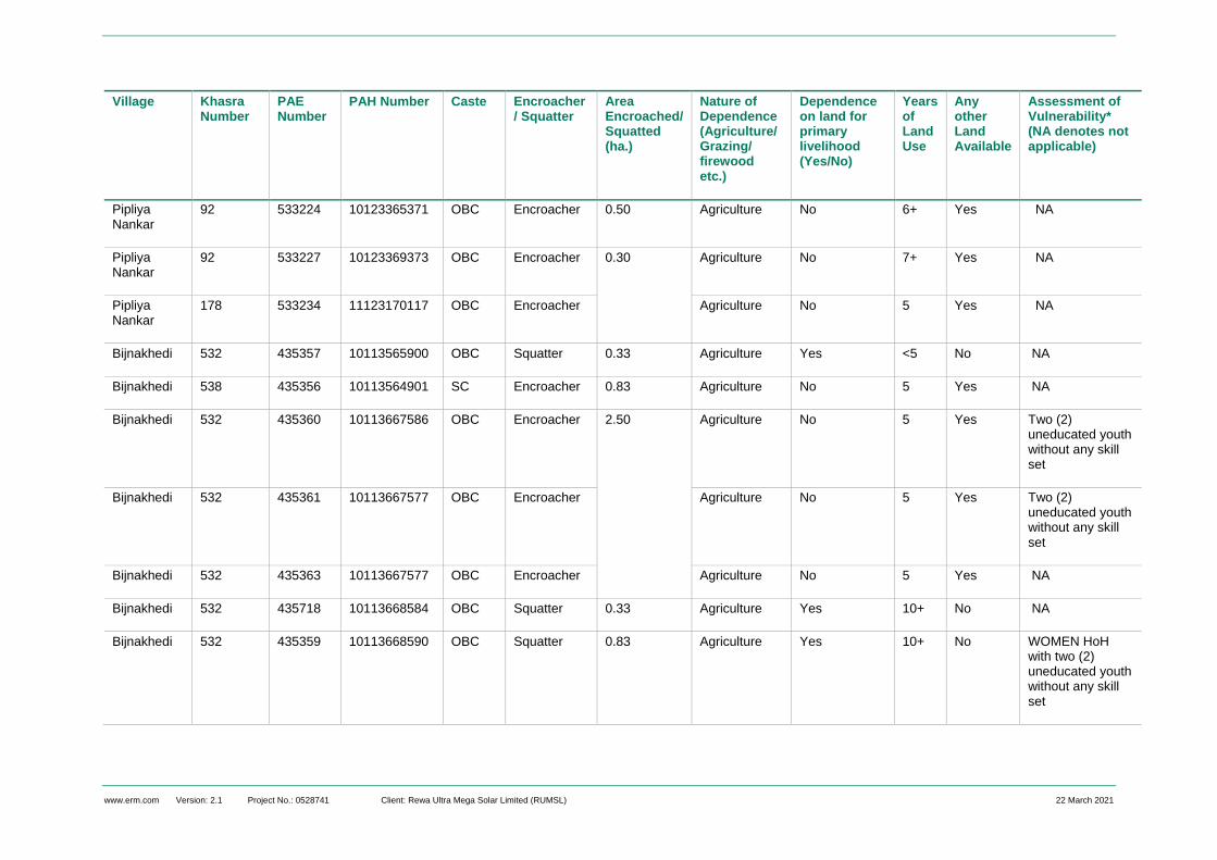
www.erm.com Version: 2.1 Project No.: 0528741 Client: Rewa Ultra Mega Solar Limited (RUMSL) 22 March 2021
Village Khasra Number
PAE Number
PAH Number Caste Encroacher/ Squatter
Area Encroached/ Squatted (ha.)
Nature of Dependence (Agriculture/ Grazing/ firewood etc.)
Dependence on land for primary livelihood (Yes/No)
Years of Land Use
Any other Land Available
Assessment of Vulnerability* (NA denotes not applicable)
Pipliya Nankar
92 533224 10123365371 OBC Encroacher 0.50 Agriculture No 6+ Yes NA
Pipliya Nankar
92 533227 10123369373 OBC Encroacher 0.30 Agriculture No 7+ Yes NA
Pipliya Nankar
178 533234 11123170117 OBC Encroacher Agriculture No 5 Yes NA
Bijnakhedi 532 435357 10113565900 OBC Squatter 0.33 Agriculture Yes <5 No NA
Bijnakhedi 538 435356 10113564901 SC Encroacher 0.83 Agriculture No 5 Yes NA
Bijnakhedi 532 435360 10113667586 OBC Encroacher 2.50 Agriculture No 5 Yes Two (2) uneducated youth without any skill set
Bijnakhedi 532 435361 10113667577 OBC Encroacher Agriculture No 5 Yes Two (2) uneducated youth without any skill set
Bijnakhedi 532 435363 10113667577 OBC Encroacher Agriculture No 5 Yes NA
Bijnakhedi 532 435718 10113668584 OBC Squatter 0.33 Agriculture Yes 10+ No NA
Bijnakhedi 532 435359 10113668590 OBC Squatter 0.83 Agriculture Yes 10+ No WOMEN HoH with two (2) uneducated youth without any skill set
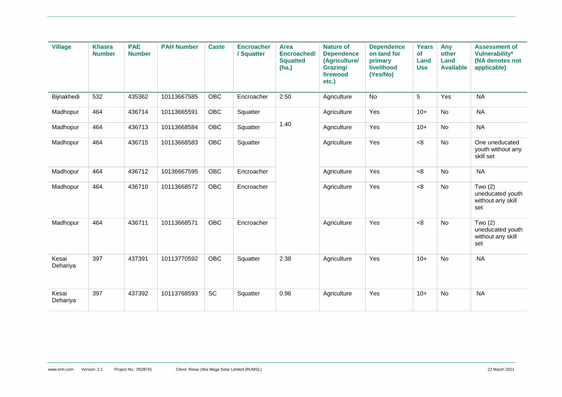
www.erm.com Version: 2.1 Project No.: 0528741 Client: Rewa Ultra Mega Solar Limited (RUMSL) 22 March 2021
Village Khasra Number
PAE Number
PAH Number Caste Encroacher/ Squatter
Area Encroached/ Squatted (ha.)
Nature of Dependence (Agriculture/ Grazing/ firewood etc.)
Dependence on land for primary livelihood (Yes/No)
Years of Land Use
Any other Land Available
Assessment of Vulnerability* (NA denotes not applicable)
Bijnakhedi 532 435362 10113667585 OBC Encroacher 2.50 Agriculture No 5 Yes NA
Madhopur 464 436714 10113665591 OBC Squatter
1.40
Agriculture Yes 10+ No NA
Madhopur 464 436713 10113668584 OBC Squatter Agriculture Yes 10+ No NA
Madhopur 464 436715 10113668583 OBC Squatter Agriculture Yes <8 No One uneducated youth without any skill set
Madhopur 464 436712 10136667595 OBC Encroacher Agriculture Yes <8 No NA
Madhopur 464 436710 10113668572 OBC Encroacher Agriculture Yes <8 No Two (2) uneducated youth without any skill set
Madhopur 464 436711 10113668571 OBC Encroacher Agriculture Yes <8 No Two (2) uneducated youth without any skill set
Kesai Dehariya
397 437391 10113770592 OBC Squatter 2.38 Agriculture Yes 10+ No NA
Kesai Dehariya
397 437392 10113768593 SC Squatter 0.96 Agriculture Yes 10+ No NA

www.erm.com Version: 2.1 Project No.: 0528741 Client: Rewa Ultra Mega Solar Limited (RUMSL) 22 March 2021
APPENDIX D PROFILE OF RESIDENTIAL STRUCTURES WITHIN AGAR SOLAR PARK

www.erm.com Version: 2.1 Project No.: 0528741 Client: Rewa Ultra Mega Solar Limited (RUMSL) 22 March 2021
Summary Profile of Residential STructures in Agar Solar Park
The tables below provides the details on PAE wise use of the residential structures that will be directly impacted due to the land procurement
for the project footprint, or can be potentially displaced (induced due to proximity to the project boundary) based on the field assessments
undertaken as part of the resettlement surveys.
S. No
Village Khasra No.
Direct/ Induced Displacement
Ownership Status of Land
PAH ID PAE ID Area of Structure (sq.mtr)
Description of Structure
Status of Use (temporary/
permanent)
Vulnerability Status of PAH
Approx Value of Structure
Unit 4
1 Dudhpura31 54 Induced
Displacement
Squatter on
Government
land
Not surveyed Not
surveyed
8060 Not
available
Permanent None 3,97,51,92032
Unit 5
2 Naharkheda 22-1 Direct
Displacement
Private
Land Owner
10123270153 532502 20.25 RCC Temporary None 1,38,955
3 Naharkheda 13-906 Direct
Displacement
Private
Land Owner
10123270153 532503 20.25 RCC Temporary None 1,38,955
4 Naharkheda 32-1 Direct
Displacement
Private
Land Owner
10123270153 532502 20.25 RCC Temporary None 1,38,955
31 DUdhpura local community did not consent to participate in the resettlement survey process. The details of the structure are based on the desk based sensitivity analysis undertaken 32 Assuming RBC type structures to be physically displaced with an approximate total area of 8060 sq.mtrs.

The business of sustainability
ERM has over 160 offices across the following
countries and territories worldwide
Argentina
Australia
Belgium
Brazil
Canada
China
Colombia
France
Germany
Hong Kong
Hungary
India
Indonesia
Ireland
Italy
Japan
Kazakhstan
Kenya
Malaysia
Mexico
The Netherlands
New Zealand
Panama
Peru
Poland
Portugal
Puerto Rico
Romania
Russia
Singapore
South Africa
South Korea
Spain
Sweden
Taiwan
Thailand
UAE
UK
US
Vietnam
ERM India Private Limited Building 10B, 3rd Floor
DLF Cyber City
Gurgaon – 122002
NCR
T: +91 124 4170300
F: +91 124 4170301
www.erm.com