rapid ecological assessment for driftless area study streams
TRANSCRIPT

Rapid Ecological Assessment for Driftless Area Study Streams
A Rapid Ecological Assessment Focusing on Rare Plants, Selected Rare Animals, and High-quality Natural Communities
Properties included in this report are listed on the next two pages Wisconsin’s Natural Heritage Inventory Program Bureau of Endangered Resources Department of Natural Resources P.O. Box 7921, Madison, WI 53707
June 2012 PUB-ER-836 2012

Properties included in this report, grouped by county: Chippewa Elk Creek Fishery Area Sand Creek Fishery Area Crawford Gordon's Bay Landing Public Access La Crosse Area Comprehensive Fishery
Area Statewide Public Access Stream Bank Protection Fee Program Rush Creek SNA (FM-owned parcels) Dane Black Earth Creek Fishery Area Mount Vernon Creek Fishery Area REM-Elvers Creek Stream Bank Protection Fee Program Dunn Bolen Creek Fishery Area Lake Menomin Fishery Area REM-Elk Creek REM-Gilbert Creek REM-Otter Creek REM-Tainter Lake Spawning Marsh REM-Wilson Creek Eau Claire REM-Clear Creek Statewide Habitat Areas Stream Bank Protection Fee Program Grant Mount Hope Rearing Station REM-Big Green River REM-Blue River REM-Castle Rock Creek REM-Little Platte River Snow Bottom SNA Iowa REM-Big Spring Creek REM-Conley Smith Creek REM-Love Creek REM-Pompey Pillar Creek Statewide Habitat Areas Stream Bank Protection Fee Program Trout Creek Fishery Area
Jackson Albion Rearing Station Beaver Creek Rearing Station Buffalo River Fishery Area Buffalo River Trail Prairies SNA Half Moon Bottoms SNA Half Moon Lake Fishery Area/Statewide
Habitat Areas Halls (Stockwell) Creek Fishery Area North Branch Trempealeau River
Fishery Area REM-So Branch Trempealeau River REM-Washington Coulee Sand Creek Streambank Protection
Area Smith Pond Fishery Area Stream Bank Protection Fee Program Tank Creek Fishery Area Trump Coulee Rearing Station La Crosse Statewide Habitat Areas Coon Creek Fishery Area La Crosse Area Comprehensive Fishery
Area Monroe Big Creek Fishery Area Coon Creek Fishery Area Eureka Maple Woods SNA La Crosse Area Comprehensive Fishery
Area La Crosse River Fishery Area Pinnacle Rock Rearing Station Portland Maples SNA REM-Rathbone Creek Sand Creek Pines SNA Sand Creek Streambank Protection
Area Pierce Rush River Delta SNA Statewide Habitat Areas
Continued on next page

Driftless Area Study Streams 3 3
Richland Bear Creek Fishery Area Pine River System Fishery Area REM-Ash Creek REM-Camp Creek REM-Elk Creek REM-Hansell Creek REM-Knapp Creek REM-Milancthon Creek REM-Mill Creek REM-Pine River Sabin Springs Fishery Area Statewide Public Access Willow Creek Fishery Area Sauk Bear Creek Fishery Area Bear Creek Sedge Meadow SNA Hulbert Creek Fishery Area Hulbert Creek Woods SNA REM-Baraboo River Statewide Habitat Areas Trempealeau Buffalo River Fishery Area Buffalo River Trail Prairies SNA REM-Buffalo River REM-Pine Creek Trempealeau Lakes Fishery Area Vernon Coon Creek Fishery Area La Crosse Area Comprehensive Fishery
Area REM-Bishop Branch Creek REM-Maple Dale Creek REM-Rainbow Springs REM-West Fork Kickapoo River Statewide Habitat Areas

Acknowledgments We extend our appreciation to the following for their support and assistance: the Ecosystem Management Planning Team, Kate Fitzgerald, Diane Brusoe, Ann Runyard, Rebecca Schroeder, John Pohlman, Paul Cunningham, and the 26 property managers. Funding for this project was provided by the Bureau of Fisheries Management, U.S. Fish and Wildlife Service Sportfish Restoration Program, and the Endangered Resources Fund. Primary Authors: Terrell Hyde and Amy Staffen Contributors:
Julie Bleser – data management Bob Hay – herptile surveys Dawn Hinebaugh – report maps and editing Randy Hoffman – ecology, State Natural Areas Terrell Hyde – data processing Christina Isenring – inventory coordination Kathy Kirk – lepidoptera surveys Ryan O’Connor – rare plant and natural community surveys, data processing Gary Emerson, A. Ludvig, Paul White, T. Brandt, Heather Kaarakka – bat surveys Elizabeth Slivinski – report maps William A. Smith – zoology Amy Staffen – breeding bird and natural community surveys, data processing Rich Staffen – breeding bird surveys, herptile surveys, data processing, inventory
coordination Kurt Schmude – aquatic invertebrate surveys Ryan Stephens – small mammal surveys James Theler – land snail surveys
Cover Photos: Top four pictures depicting natural communities:
Upper left: Pine Relict and Dry Cliff at Snow Bottom SNA, by Ryan O'Connor Upper right: Floodplain Forest at Rush River Delta SNA, by Richard Staffen Lower left: Southern Mesic Forest at Tainter Creek Fishery Area, by Ryan O'Connor Lower right: Bear Creek Fishery Area, WDNR staff.
Lower line of pictures depicting plants and animals, left to right:
Giant water-leaf (Hydrophyllum appendiculatum) at Eureka Maple Woods SNA, by Ryan O'Connor
Gophersnake (Pituophis catenifer), by U.S. Fish and Wildlife Service Cerulean warbler (Dendroica cerulea), by Dennis Malueg Broad-banded forest snail (Allogona profunda), by Armund Bartz Pickerel frog (Lithobates palustris) at Big Spring, by Richard Staffen Northern wild monkshood (Aconitum novaboracense), by Darcy Kind

Table of Contents
Acknowledgments......................................................................................................... 4 Table of Contents ............................................................................................................................. 5 List of Figures .................................................................................................................................. 6 List of Tables ................................................................................................................................... 6 Appendices ....................................................................................................................................... 7
Introduction ................................................................................................................. 10 Purpose and Objectives .................................................................................................................. 10 Overview of Methods .................................................................................................................... 10 Background on Past Efforts ........................................................................................................... 16 Special Management Designations ................................................................................................ 18 Public Lands .................................................................................................................................. 20
Regional Ecological Context ...................................................................................... 21 “Southwest Savanna” and “Western Coulee & Ridges” Ecological Landscapes .......................... 21 Regional Biodiversity Needs and Opportunities ............................................................................ 22 Rare Species of the Southwest Savanna and Western Coulee & Ridges Ecological Landscape ... 23
Description of the Study Area .................................................................................... 25 Location and Size ........................................................................................................................... 25 Ecoregion ....................................................................................................................................... 25 Physical Environment .................................................................................................................... 29 Vegetation ...................................................................................................................................... 31 Rare Species and High Quality Natural Communities ................................................................... 42
Management Opportunities and Considerations for Biodiversity Conservation ... 50 Landscape Level Opportunities and Considerations ...................................................................... 50 Community Level Opportunities and Considerations .................................................................... 60 Species or Taxa Level Opportunities and Considerations ............................................................. 64 Primary Sites: Site-specific Opportunities for Biodiversity Conservation .................................... 74
Future Needs ............................................................................................................... 77
Glossary ....................................................................................................................... 78
Species List ................................................................................................................. 79
Reference List ............................................................................................................. 84
Additional Resources ................................................................................................. 88

6 Rapid Ecological Assessment
List of Figures
Figure 1. Location of Driftless Area Study Streams Study Area ................................................................ 15
Figure 2. Ecological Landscapes of Wisconsin and the study area. ........................................................... 21
Figure 3. Landtype Associations for Driftless Area Study Streams, Zone 1. ............................................. 27
Figure 4. Landtype Associations for Driftless Area Study Streams, Zones 2 & 3. ..................................... 28
Figure 5. Trout Streams of Wisconsin. ..................................................................................................... 30
Figure 6. Vegetation of Driftless Area Study Streams prior to Euro-American settlement (Zone 1) ......... 32
Figure 7. Vegetation of Driftless Area Study Streams prior to Euro-American settlement (Zones 2 & 3) 33
Figure 8. Landcover of Driftless Area Study Streams (Zone 1). ................................................................ 35
Figure 9. Landcover of Driftless Area Study Streams (Zones 2 & 3). ........................................................ 36
Figure 10. Driftless Area Macroinvertebrate Stream Tolerance. ................................................................ 64
Figure 11. Primary Sites of Driftless Area Study Streams (Zone 1) ........................................................... 75
Figure 12. Primary Sites of Driftless Area Study Streams (Zones 2 and 3) ............................................... 76
List of Tables
Table 1. Driftless Area Study Streams NHI Field Surveys (2010-2012) .................................................... 12
Table 2. Major Natural Community Management Opportunities in the Southwest Savanna and Western Coulees & Ridges Ecological Landscape (EMPT 2007; WDNR 2006a) ................................................... 23
Table 3. Listing Status for rare species in the Southwest Savanna Ecological Landscape as of 2012. ...... 24
Table 4. Listing Status for rare species in the Western Coulees & Ridges Ecological Landscape as of 2012. ........................................................................................................................................................... 24
Table 5. Documented rare species and high-quality natural communities of Driftless Area Study Streams. .................................................................................................................................................................... 43
Table 6. Abundant and/or widespread non-native invasive species of the Driftless Area .......................... 53
Table 7. Moderate or not-widespread non-native invasive species of the Driftless Area ........................... 54
Table 8. New or potential non-native invasive species of the Driftless Area ............................................. 55
Table 9. Water quality assessments performed during aquatic invertebrate surveys in 2011 ..................... 63
Table 10. Breeding forest interior birds known from Driftless Area Study Streams. ................................. 66
Table 11. Breeding grassland and shrubland birds known from Driftless Area Study Streams. ................ 67
Table 12. Rare reptiles and amphibians of the Driftless Area and the Study Area. .................................... 71

Driftless Area Study Streams 7 7
Appendices
A. Natural Heritage Inventory Methods Overview
B. Map of Conservation Opportunity Areas for the Southwest Savanna and Western Coulees & Ridges Ecological Landscapes
C. Documented rare species and high-quality natural communities of Driftless Area Study Streams
D. Descriptions of Rare Species and High Quality Natural Communities Documented of Driftless Area Study Streams
E. Species of Greatest Conservation Need of Driftless Area Study Streams
F. Wisconsin Natural Heritage Working List Explanation
G. Primary Sites within Driftless Area Study Streams
H. Documented rare species and high-quality natural communities of Driftless Area Study Streams listed by Primary Site.
I. State Natural Areas that have no fisheries-owned parcels, but fall within the Driftless Area and are associated with streams.

8 Rapid Ecological Assessment
Driftless Area Study Streams at a Glance Exceptional Characteristics and Opportunities of the Study Area
Rare Animals and Plants. Driftless Area Study Streams properties support numerous rare species. Ninety-seven rare animal species have been documented at Driftless Area Study Streams, including 12 State Endangered species, 26 State Threatened species, 59 Special Concern species, and three associated rare animal assemblages. Forty-six rare plant species are also known from Driftless Area Study Streams, including six State Endangered, 14 State Threatened and 26 Special Concern species.
Forest Interior Bird Conservation. The larger Driftless Area region (including southeast Minnesota and northeast Iowa) represents one of the best opportunities in the upper Midwest for forest interior bird habitat management, particularly for species that depend on southern forest types (Wilson, 2008). Forest interior birds have suffered severe population declines in Wisconsin and throughout their range due to habitat loss. Twelve forester interior bird species were identified as breeding on WDNR Driftless Area Study Streams properties.
Oak Savanna Restoration. Oak savannas were historically common in Wisconsin but are now rare throughout the state, thus their restoration is critical to the survival of many rare plants and animals that depend on them. Abundant opportunities exist on Driftless Area Study Streams properties to restore Oak Opening, Oak Woodland, and Oak Barrens on a landscape scale and within a matrix of other habitats.
Coulees, Gorges, Cliffs, and Slopes. The Driftless Area's deeply dissected landscape includes coulees, gorges, cliffs, and shaded north-facing slopes that produce exceptionally cool and protected environments. These habitats often support relict communities in which northern species are prominent. Many Midwestern endemics and habitat specialists with limited distribution occur in these settings. Natural communities in the study area that are associated with these unique habitats include Southern Mesic Forest, Pine Relict, Dry Cliff, Moist Cliff, and Algific Talus Slope.
Cold- and Cool-Water Streams, Springs, Spring Seeps, and Riparian Wetlands. The porous sandstones of the Driftless Area retain large amounts of water, which are released at thousands of locations throughout the region via springs and spring seeps. The extensive network of cool-water streams within Driftless Area Study Streams properties support significant populations of pollution-intolerant invertebrates, rare nongame fish, and native brook trout.
Terrestrial/Land Snail Conservation. Land snails, in general, have a slow rate of dispersal; without suitable habitat or dispersal corridors, they can not expand as viable populations. Few intact habitats remain that will support the rarer native snail populations. Driftless Area Study Streams properties have abundant snail habitat in the form of cliffs, rock outcrops, dry prairies/savannas, and mesic forests. Six rare snail species are known in the study area.
Herptile Conservation. The Driftless Area offers one of the best opportunities in the state for herptile conservation. Driftless Area Study Streams properties provide diverse habitats suitable to herptiles, including prairies, barrens, oak savannas, aquatic resources, fractured limestone outcrops, and wetlands. Seven rare reptile and two rare amphibian species were detected on study area properties, in addition to numerous snake hibernacula.
Continued on next page...

Driftless Area Study Streams 9 9
Driftless Area Study Streams at a Glance (continued) Exceptional Characteristics and Opportunities of the Study Area (continued)
Small Mammal Conservation. Many native small mammals have declined both in range and abundance in the past 100 years due to habitat degradation and destruction (Stephens 2011). The extensive prairie/grassland and oak savanna habitats on Driftless Area Study Streams properties provide a significant opportunity for small mammal conservation. One rare upland mouse species was detected on several study area properties, and a rare shrew was detected unexpectedly on two properties, outside of this species' previously known range.
Bat Conservation. Opportunities to promote bat habitat at Driftless Area Study Streams properties include providing resources for roosting, foraging, and drinking. While no hibernacula were identified on Driftless Area Study Streams properties, surveys detected all seven bat species known to summer in Wisconsin, including three that are State Threatened.
Site Specific Opportunities for Biodiversity Conservation Seventeen ecologically important sites were identified in the Driftless Area Study Streams study area (listed below). These “Primary Sites” were delineated because they generally encompass the best examples of 1) rare and representative natural communities, 2) documented occurrences of rare species populations, and/or 3) opportunities for ecological restoration or connections. These sites warrant high protection and/or restoration consideration during the development of the property master plan. Complete descriptions and maps for each of the Primary Sites can be found in Appendix G.
DAS01 Copper Creek DAS02 Half Moon Bottoms Floodplain Forest DAS03 Eureka Maple Woods & Portland Maples SNA DAS04 Bear Creek Wetlands DAS05 Coon Creek Cliffs SNA DAS06 Sand Creek Pines and Barrens DAS07 LaCrosse River Pine-Oak Barrens DAS08 Rush Creek Coulees and Ridges DAS09 Snow Bottom SNA DAS10 Trout Creek Uplands DAS11 Pinnacle Rock Rearing Station DAS12 Milancthon Creek DAS13 Big Spring Creek DAS14 Tainter Creek DAS15 Rush River Delta SNA DAS16 Hulburt Creek Woods SNA DAS17 Buffalo River Trail Prairies SNA

Introduction
Purpose and Objectives This report is intended to be used as a source of information for developing a new master plan for fee-title Wisconsin DNR Fisheries Management properties within the Driftless Area (herein “Driftless Area Study Streams” Figure 11). The regional ecological context for Driftless Area Streams is also provided to assist in developing the Regional and Property Analysis that is part of the master plan. There are other properties in addition to the Driftless Area Study Streams that will be included in the master planning process that are not addressed in this report. Important information regarding State Natural Areas (SNA): There are instances where State Natural Areas consist of a mix of WDNR ownerships. For example, most parcels within Rush Creek SNA are owned and managed by the Bureau of Endangered Resources, but several are owned and managed by the Bureau of Fisheries. In situations like this, information pertaining only to the fisheries-owned parcels is provided in this main report and in Appendix C, D and E (rare species and natural communities found on Driftless Area Study Streams properties). In Appendix G and H, however, information on the Primary Sites covers all SNA parcels, regardless of WDNR ownership. In addition, Appendix I provides descriptions of SNAs that have no fisheries-owned parcels, but fall within the Driftless Area and are associated with streams; these sites are logical inclusions for this master planning initiative. The primary objectives of this project were to collect biological inventory information relevant to the development of a master plan for Driftless Area Study Streams, and to analyze, synthesize and interpret this information for use by the master planning team. This effort focused on assessing areas of documented or potential habitat for rare species and identifying natural community management opportunities. Survey efforts for Driftless Area Study Streams were limited to a “rapid ecological assessment” for 1) identifying and evaluating ecologically important areas, 2) documenting rare species occurrences, and 3) documenting occurrences of high quality natural communities. This report can serve as the “Biotic Inventory” document used for master planning, although inventory efforts were reduced compared to similar projects conducted on much larger properties such as state forests. There will undoubtedly be gaps in our knowledge of the biota of this property, especially for certain taxa groups; these groups have been identified as representing either opportunities or needs for future work.
Overview of Methods The Wisconsin Natural Heritage Inventory (NHI) program is part of the Wisconsin DNR’s Bureau of Endangered Resources and a member of an international network of natural heritage programs representing all 50 states, as well as portions of Canada, Latin America, and the Caribbean. These programs share certain standardized methods for collecting, processing, and managing data for rare species and natural communities. NatureServe, an international non-profit organization (see www.NatureServe.org for more information), coordinates the network. Natural heritage programs track certain elements of biological diversity: rare plants, rare animals, high-quality examples of natural communities, and other selected natural features. The NHI Working List contains the elements tracked in Wisconsin. They include endangered, threatened, and special concern
1 Please note that the three Zones delimited in all report maps are arbitrary, and were created for convenient frames of reference for the report.

Driftless Area Study Streams 11 11
plants and animals, as well as the natural community types recognized by NHI. The NHI Working List is periodically updated to reflect new information about the rarity and distribution of the state’s plants, animals, and natural communities. The most recent Working List is available from the Wisconsin DNR website (Wisconsin Natural Heritage Working List). The Wisconsin NHI program uses standard methods for biotic inventory to support master planning (Appendix A). Our general approach involves collecting relevant background information, planning and conducting surveys, compiling and analyzing data, mapping rare species and high quality natural community locations into the NHI database, identifying ecologically important areas, and providing interpretation of the findings through reports and other means. Existing NHI data are often the starting point for conducting a biotic inventory to support master planning. Prior to this project, NHI data for Driftless Area Study Streams were limited to: 1) the Statewide Natural Area Inventory, a county-by-county effort conducted by WDNR’s Bureaus of Research and Endangered Resources between 1969 and 1984 that focused on natural communities but include some surveys for rare plants and animals, and 2) taxa-specific surveys. The most recent taxa-specific field surveys for the study area were conducted during 2010-11 (Table 1). NHI surveys were limited in scope and focused primarily on documenting high quality terrestrial natural communities (including those in riparian corridors),and the rare plants, breeding birds, herptiles, bats, small mammals, terrestrial snails, and other terrestrial insects that occupy these habitats. While WDNR Fisheries staff will analyze fish surveys (including fish index of biotic integrity numbers) as part of the master planning process, NHI did conduct surveys of aquatic invertebrates and mussels for the Driftless Area Study Streams project. The collective results from all of the above surveys were used, along with other information, to identify ecologically important areas, or "Primary Sites," in the Driftless Area Study Streams study area. All 174 Driftless Area Study Streams received a preliminary review using NHI data, Digital Orthophotos, and Department biologist input. Private lands (including DNR owned easements) surrounding Driftless Area Streams properties were not surveyed. However, some Streambank protection program properties that are within or adjacent to a DNR owned property were surveyed. The Stream Bank Protection Program (SBP) was established in 1990 as a supplement to the traditional Fisheries Areas Program, with the goals to protect and restore corridors along cool and coldwater streams, to improve water quality, and to provide public access. The SBP program purchases easements directly from landowners to manage fish habitat and angling access on selected exceptional waterways identified under the program. During a preliminary screening process, survey locations were identified by using recent aerial photos, USGS 7.5’ topographic maps, various Geographic Information System (GIS) sources, information from past survey efforts, discussions with property managers, and the expertise of biologists familiar with the properties or with similar habitats in the region. Based on the location and ecological setting of properties within the Driftless Area Study Streams study area, key inventory considerations included the identification of: high quality prairies, wetlands, barrens, savannas, pine relicts, upland forests, and cliffs, as well as the location of habitats that had the potential to support rare species. Private lands (including easements) surrounding Driftless Area Study Streams properties were not surveyed. Within this report, scientific names have been used with first mention of species, thereafter the common name has been used. A list of all scientific names mentioned in the text is included at the end of this document.

12 Rapid Ecological Assessment
Table 1. Driftless Area Study Streams NHI Field Surveys (2010-2012) Properties with no survey dates were identified as lacking appropriate conditions for high-quality natural communities or important native plant/animal habitat during preliminary screening process.
Driftless Area Study Stream (county) Nat
ural
C
omm
unit
ies
Pla
nts
Bre
edin
g B
ird
Sur
veys
Her
ptil
es
Bat
s
Sm
all
Mam
mal
s
Aqu
atic
In
vert
ebra
tes
Ter
rest
rial
S
nail
s
Ter
rest
rial
In
sect
s
Albion Rearing Station (Jackson) Bear Creek Fishery Area (Richland, Sauk) 2010 2010 2011 2011 Bear Creek Sedge Meadow SNA (Sauk) 2010 2010 Beaver Creek Rearing Station (Jackson) 2010 2010 2010 2011 2011 2011 2011 2011 Big Creek Fishery Area (Monroe) 2011 2011 2011 Black Earth Creek Fishery Area (Dane) Bolen Creek Fishery Area (Dunn) Buffalo River Fishery Area (Jackson, Trempealeau) 2010 2010 2010 2011 2011 2011 2011 Buffalo River Trail Prairies SNA (Jackson) Buffalo River Trail Prairies SNA (Trempealeau) Coon Creek Fishery Area (La Crosse, Monroe, Vernon) 2010 2010 2011 2010 2011 2011 Elk Creek Fishery Area (Chippewa) 2010 2011 Eureka Maple Woods SNA (Monroe) 2010 2010 2011 Gordon's Bay Landing Public Access (Crawford)
Half Moon Bottoms SNA (Jackson) 2010-
11 Half Moon Lake Fishery Area/Statewide Habitat Areas (Jackson)
2010-11 2010 2011
Halls (Stockwell) Creek Fishery Area (Jackson) 2011 Hulbert Creek Fishery Area (Sauk) 2010 2011 Hulbert Creek Woods SNA (Sauk) 2010 La Crosse Area Comprehensive Fishery Area (Crawford) 2010 2010 2011 2011 La Crosse Area Comprehensive Fishery Area (La Crosse) La Crosse Area Comprehensive Fishery Area (Monroe) 2011 2011 2011 La Crosse Area Comprehensive Fishery Area (Vernon) 2010 2010
2010-11 2010 2011 2011 2011
La Crosse River Fishery Area (Monroe) 2011 2011 2011 2010 2011 Lake Menomin Fishery Area (Dunn) Mount Hope Rearing Station (Grant) 2010 2010 2010 2010 2011 2011 2011 Mount Vernon Creek Fishery Area (Dane) 2010 2010 2010 2011 North Branch Trempealeau River Fishery Area (Jackson) 2011 2011 2011 Pine River System Fishery Area (Richland) Pinnacle Rock Rearing Station (Monroe) 2012 2012 2011 2011 Portland Maples SNA (Monroe) 2010 2010 2011

Driftless Area Study Streams 13 13
Driftless Area Study Stream (county) Nat
ural
C
omm
unit
ies
Pla
nts
Bre
edin
g B
ird
Sur
veys
Her
ptil
es
Bat
s
Sm
all
Mam
mal
s
Aqu
atic
In
vert
ebra
tes
Ter
rest
rial
S
nail
s
Ter
rest
rial
In
sect
s
REM-Ash Creek (Richland) REM-Baraboo River (Sauk) REM-Big Green River (Grant) REM-Big Spring Creek (Iowa) 2010 2010 2010 2010 2011 2011 2011 REM-Bishop Branch Creek (Vernon) 2010 2010 2011 2011
REM-Blue River (Grant) 2010-
11 2010-
11 2010 2011 2011 2011 REM-Buffalo River (Trempealeau) REM-Camp Creek (Richland) 2011 REM-Castle Rock Creek (Grant) 2011 2011 REM-Clear Creek (Eau Claire) REM-Conley Smith Creek (Iowa) REM-Elk Creek (Dunn, Richland) 2011 REM-Elvers Creek (Dane) REM-Gilbert Creek (Dunn) REM-Hansell Creek (Richland) 2010 2010 2010 2011 REM-Knapp Creek (Richland) REM-Little Platte River (Grant)
REM-Love Creek (Iowa) 2010-
11 2010-
11 2010 2011 2011 2011 REM-Maple Dale Creek (Vernon) 2010 2010 2011 2011 REM-Milancthon Creek (Richland) 2010 2010 2010 2011 2011 2011 REM-Mill Creek (Richland) REM-Otter Creek (Dunn) REM-Pine Creek (Trempealeau) REM-Pine River (Richland) REM-Pompey Pillar Creek (Iowa) 2010 2010 2011 2011 2011 REM-Rainbow Springs (Vernon) REM-Rathbone Creek (Monroe) REM-So Branch Trempealeau River (Jackson) REM-Tainter Lake Spawning Marsh (Dunn) REM-Washington Coulee (Jackson) REM-West Fork Kickapoo River (Vernon) REM-Wilson Creek (Dunn) Rush River Delta SNA (Pierce) Sabin Springs Fishery Area (Richland) Sand Creek Fishery Area (Chippewa) Sand Creek Pines SNA (Monroe) 2010 2010 Sand Creek Streambank Protection Area (Jackson) Sand Creek Streambank Protection Area (Monroe) 2010 2010 2010 2010 2011 2011 2011 Smith Pond Fishery Area (Jackson) 2010 2011 Snow Bottom SNA (Grant) 2010- 2010- 2010

14 Rapid Ecological Assessment
Driftless Area Study Stream (county) Nat
ural
C
omm
unit
ies
Pla
nts
Bre
edin
g B
ird
Sur
veys
Her
ptil
es
Bat
s
Sm
all
Mam
mal
s
Aqu
atic
In
vert
ebra
tes
Ter
rest
rial
S
nail
s
Ter
rest
rial
In
sect
s
11 11
Statewide Habitat Areas (Eau Claire) Statewide Habitat Areas (Iowa) 2011 Statewide Habitat Areas (La Crosse) Statewide Habitat Areas (Pierce) 2010 Statewide Habitat Areas (Sauk) Statewide Habitat Areas (Vernon) Statewide Public Access (Crawford) 2011 2011 Statewide Public Access (Richland) Stream Bank Protection Fee Program (Crawford) 2011 2011 2011 2011 2011 2011 Stream Bank Protection Fee Program (Dane) Stream Bank Protection Fee Program (Eau Claire) 2010 2010 2010 2011 Stream Bank Protection Fee Program (Iowa) Stream Bank Protection Fee Program (Jackson) Tank Creek Fishery Area (Jackson) 2010 2010 2011 2011 Trempealeau Lakes Fishery Area (Trempealeau) 2011 2011 2010 2010 2011 Trout Creek Fishery Area (Iowa) 2010 2010 2010 2010 2011 2011 2011 Trump Coulee Rearing Station (Jackson) 2010 2010 2010 2010 2011 2011 2011 2011 Willow Creek Fishery Area (Richland) 2010 2010 2011 2011

Driftless Area Study Streams 15 15
Figure 1. Location of Driftless Area Study Streams Study Area (The Driftless Area is divided into arbitrary zones for convenient frames of reference for report. Property boundaries enlarged for visibility.)

16 Rapid Ecological Assessment
Background on Past Efforts A number of large-scale research and planning efforts identified the Driftless Area as well as Driftless Area Study Streams properties as being ecologically significant. The following are examples of such projects and the significant features identified. Wisconsin Wildlife Action Plan: Conservation Opportunity Areas The Wisconsin Wildlife Action Plan (WAP; WDNR 2006a) identified multiple Conservation Opportunity Areas (COA) within the Western Coulee & Ridges and Southwest Savanna Ecological Landscapes. These COAs are places in Wisconsin that contain ecological features, natural communities, or Species of Greatest Conservation Need (SGCN) habitat for which Wisconsin has a unique responsibility to protect when viewed from the global, continental, upper Midwest, or state perspective. Sixteen COAs in these ecological landscapes intersect at least one Driftless Area Study Streams property: Fort McCoy Barrens & Oak Savanna; Lower Kickapoo & Kickapoo; Coon Creek Mesic; Coulee Forests; Greensand Cuesta; Snow Bottom; Dodgeville & Wyoming Oak Woodland/Savanna; Rush Creek; Millville-Sandy Creek; Lower Black River to Black River Falls Dam; Mississippi Bluffs & Floodplain; Lower Wisconsin Bluffs & Floodplain; Lower Baraboo River; Upper Hall’s Creek; Little Platte River & Tributaries; and Southwest Grasslands & Streams. For more details on these COAs, see the "Management Opportunities and Considerations for Biodiversity Conservation" section of this report. Legacy Places The Land Legacy Report (WDNR 2006b) was designed to identify Wisconsin’s most important conservation and recreation needs for the next 50 years. There are many Land Legacy sites identified in the Driftless Area region. Below is a list of the Land Legacy sites identified that mention one of the Driftless Area Stream properties, primarily for their importance as headwaters: Badlands Baraboo River Black Earth Creek Black River Blue Mounds - Blanchardville Prairie and Savanna Copper Creek to Lynxville Hollows Coulee Coldwater Riparian Resources Hay River Kickapoo River La Crosse River Little and Big Green Rivers Mill Creek Pine River Platte River Rush Creek Snow Bottom - Blue River Valley Upper Mississippi River National Wildlife and Fish Refuge Upper Red Cedar River
Driftless Area Initiative The Wisconsin DNR is a partner in the Driftless Area Initiative, an effort to encourage multi-state collaboration to improve water quality and natural resources in the Driftless Area of the Upper Mississippi River Basin. The Nature Conservancy (TNC): Prairie Forest Border Ecoregional Plan The Nature Conservancy (2001) identified important Ecologically Significant Areas and restoration areas that will ensure the long-

Driftless Area Study Streams 17 17
term survival of all viable native species and ecological communities. Conservation targets for the Prairie-Forest Border include all native natural communities, globally rare species and other species for whom experts feel the Prairie-Forest Border is an important part of their range. Below are the Ecologically Significant Areas that intersect at least one of the Driftless Area Study Streams properties: Baraboo Hills Black River-Meadow Valley-Bear Bluff Coon Creek Fort McCoy Kickapoo River Little Platte River Lower Chippewa & Red Cedar Rivers Lower Wisconsin River Military Ridge Prairie Morgan Coulee Prairie Pecatonica and Sugar Rivers Ridgeway Pine Relict Rush Creek Snow Bottom
Midwest Driftless Area Restoration Effort (DARE) The Midwest Driftless Area Restoration Effort, of which the WDNR is a partner, is a geographically-focused, scientifically based, broad partnership formed to improve the trout resources throughout the four-state Driftless Area. It is part of the National Fish Habitat Action Plan. Partners work together in a coordinated regional approach to increase the effectiveness of watershed restoration by strategically linking upland conservation efforts with stream restoration (Trout Unlimited, n.d.; WDNR 2007a). Wisconsin DNR Basin and Watershed Plans The following Basin Plans have been developed that apply to water resources within the study area:
Black-Buffalo-Trempealeau Basin Plan o Elk Creek Watershed Plan
Bad Axe-LaCrosse Basin Plan o Rush Creek Watershed Plan
Lower Wisconsin Basin Plan o Bear Creek Watershed Plan
Natural Resources Conservation Service (NRCS) Rapid Watershed Assessments (RWA) Rapid Watershed Assessments provide initial estimates to help determine where conservation investments would best address the concerns of landowners, counties, watershed groups, and other stakeholders. These assessments help landowners and local leaders set priorities and determine the best actions to achieve their goals. RWAs provide a foundation for watershed or area planning, and are available for the following watersheds within the study area:
Coon-Yellow La Crosse-Pine Lower Chippewa Red Cedar
Lower Wisconsin Grant-Little Maquoketa Pecatonica
Forest Certification

18 Rapid Ecological Assessment
All DNR-managed lands, including state parks, wildlife areas, fishery areas, and natural areas, are recognized by the Forest Stewardship Council and the Sustainable Forestry Initiative as being responsibly managed (Forest Stewardship Council 2009). This certification emphasizes the state’s commitment to responsibly managing and conserving forestlands, supporting economic activities, protecting wildlife habitat, and providing recreational opportunities. Forest Legacy Program was created by Congress as part of the 1990 Farm Bill to identify and protect environmentally important private forestlands threatened with conversion to non-forest uses. The Forest Legacy Area boundaries of the Upper Mississippi River Driftless Corridor and the Baraboo River Areas contain many of the Driftless Area Study Streams properties. Currently, there are no funding opportunities for either of these areas through this program. The Baraboo Hills project was the first funded and completed project in Wisconsin's Forest Legacy Program. This project began in 2003 and was completed in 2007. The Baraboo Hills project involved 16 landowners, protected almost 1,000 acres of land and had the support of multiple governmental agencies, national and local conservation groups and the public.
Special Management Designations State Natural Areas State Natural Areas are places on the landscape that protect outstanding examples of native natural communities, significant geological formations, and archaeological sites. Designation confers a significant level of land protection through state statutes, administrative rules, and guidelines. The SNAs that intersect with Driftless Area Study Streams properties are as follows [Property (Owner), number of acres]:
Bear Creek Sedge Meadow (WDNR-FM), 89 acres Buffalo River Trail Prairies (WDNR-PR, -FM), 153 acres Coon Creek Cliffs (WDNR-FM), 27 acres Eureka Maple Woods (WDNR-ER, -FM), 135 acres Half Moon Bottoms (WDNR-FM), 202 acres Hulburt Creek Woods (WDNR-FM), 179 acres Portland Maples (WDNR-ER, -FM), 100 acres Rush Creek (WDNR-ER, -FM), 2,528 acres Rush River Delta (WDNR-ER), 340 acres Sand Creek Pines (WDNR-FM), 159 acres Snow Bottom (WDNR-ER, -FM), 342 acres
Important Bird Areas (IBA; WDNR 2007b) are critical sites for the conservation and management of Wisconsin’s birds. Multiple IBAs are within or adjacent to Driftless Areas Streams properties: Fort McCoy-Robinson Creek Governor Dodge State Park Kickapoo-Wildcat Lower Wisconsin River
Military Ridge-York Prairie Rush Creek Forest-Prairie Van Loon Bottoms Upper Mississippi River

Wisconsin's Impaired Waters (303d) Section 303(d) of the federal Clean Water Act requires states to develop a list of impaired waters ("303(d) list"). The identification and listing of waters as impaired is one step in a continual process of waterbody classification, assessment, and management, the ultimate goal of which is to protect, restore, and maintain the full potential of each waterbody to the maximum extent possible. The following are Driftless Area Study Streams that are currently designated 303(d):
Tainter Lake (impoundment on Red Cedar River) was originally listed in 1998 due to eutrophication and elevated pH impairments of the fish and aquatic life use caused by excess total phosphorus.
Snowden Branch a.k.a. Big Patch Creek (first five miles) was listed in 2004 as low priority due to degraded habitat caused by excessive sedimentation.
Vermont Creek (first 3.5 miles) was listed in 2004 as low priority due to elevated water temperature and degraded habitat.
Printz Creek (first three miles) was listed in 1998 as low priority due to degraded habitat. Trout Run (between river miles 2.3 and 7.6) was listed in 1998 as low priority due to elevated
water temperature, low dissolved oxygen, and sediment load. The stream was severely impacted by an upstream feedlot and unrestricted cattle access.
Outstanding and Exceptional Resource Waters (ORW and ERW) are officially designated (Wisconsin Administrative Code NR 102.11) waters that provide outstanding recreational opportunities, support valuable fish and wildlife habitat, have good water quality, are not significantly impacted by human activities, and, thereby recognized as being the highest quality waters in the state. Outstanding Resource Waters typically do not have any point sources discharging pollutants directly to the water (for instance, no industrial sources or municipal sewage treatment plants), and no increases of pollutant levels are allowed. If a waterbody has existing point sources at the time of designation, it is more likely to be designated as an ERW. Of Wisconsin’s 53,413 streams and rivers, 254 are designated as ORW—fewer than 1%. Class I and II Trout streams are automatically included as ERW or ORWs per NR Chapter 102. Below are the Driftless Area Study Streams ORW and ERW waters: Designated Outstanding Resource Waters (ORW):
Babb Hollow Creek Baraboo River Big Creek Big Elk Creek Big Spring Branch Biser Creek Bishop Branch Black Earth Creek Blue River Bostwick Creek Buffalo River Bufton Hollow Creek Cheyenne Valley Creek Clear Creek Cook Creek Cooley Creek Copper Creek
Elvers Creek Farmers Valley Creek Fisher Creek Garfoot Creek Graham Creek Jenkins Valley Creek Kepler Branch Little La Crosse River Little Platte River Lowes Creek Marble Creek Milancthon Creek Mill Creek North Branch Trempealeau River North Fork Buffalo River Pine Creek Rindahl Creek
Rush Creek Ryan Creek Sand Creek Smith Hollow Creek Soper Creek South Fork Buffalo River Spencer Creek Spring Brook Sugar River Tainter Creek Tank Creek Trempealeau River Washington Coulee Creek Wheat Hollow Creek Willow Creek
Designated Exceptional Resource Waters (ERW):

Big Elk Creek Black Earth Creek Camp Creek Castle Rock Creek Elk Creek
Little Green Reek Love Creek Mt Vernon Creek Rullands Coulee Creek Spring Coulee Creek
Strutt Creek Timber Coulee Creek Trout Creek
Public Lands All lands in the study area are owned by the Wisconsin Department of Natural Resources, and are managed by the Bureaus of Fisheries Management, Wildlife Management, Parks, and Endangered Resources. To help identify opportunities for collaboration and joint management, below are the non-Fisheries Management state properties that intersect at least one of the Driftless Area Study Streams properties:
Buffalo River State Trail (WDNR-PR) Extensive and Scattered Wildlife Habitat (WDNR-WM) Governor Dodge State Park (WDNR-PR) Lower Wisconsin State Riverway (WDNR-WR) Military Ridge State Trail (WDNR-PR) North Bend Bottoms Wildlife Area (WDNR-WM) Statewide Non-Point Easement Program (WDNR-ZZ) Wildcat Mountain State Park (WDNR-PR)
In addition to these state properties, four Driftess Area Study Stream properties are adjacent or fall within a federal properties:
Upper Mississippi River Wild Life and Fish Refuge (UWFWS) Fort McCoy Military Reservation (USDOD)

Driftless Area Study Streams 21 21
Regional Ecological Context
“Southwest Savanna” and “Western Coulee & Ridges” Ecological Landscapes This section is largely reproduced from the Ecological Landscapes of Wisconsin Handbook (WDNR In Prep. a). The WDNR has mapped the state into areas of similar ecological potential and geography called Ecological Landscapes. The Ecological Landscapes are based on aggregations of smaller ecoregional units (Subsections) from a national system of delineated ecoregions known as the National Hierarchical Framework of Ecological Units (NHFEU) (Cleland et al. 1997). These ecoregional classification systems delineate landscapes of similar ecological pattern and potential for use by resource administrators, planners, and managers. The WDNR Fisheries Properties in the Driftless Area Study Streams are scattered throughout the Southwest Savanna Ecological Landscape and the Western Coulee and Ridges Ecological Landscape (WDNR In prep. a) (Figure 2). While the Western Prairie Ecological Landscape is also within the Driftless Area of Wisconsin, there are no Driftless Area Study Streams properties within its boundaries.
Figure 2. Ecological Landscapes of Wisconsin and the study area.
(Property boundaries enlarged for visibility.) The Western Coulee and Ridges Ecological Landscape is the largest of the 16 Ecological Landscapes. It is located in southwestern and west-central Wisconsin within the Driftless Area, a region that escaped glaciation during the last glacial period. The Driftless Area is noted for its steeply dissected terrain, extensive network of streams, and lack of glacial deposits (although glacial outwash materials do occur in river valleys). Several large rivers including the Wisconsin, Mississippi, Chippewa, Kickapoo and Black flow through or border this Ecological Landscape.

22 Rapid Ecological Assessment
Historical vegetation consisted of southern hardwood forest, oak savanna, and prairie, along with wetlands (forested and open) along rivers and streams. With Euro-American settlement, most of the level land on ridgetops and in valley bottoms was cleared for agriculture. The untillable steep slopes between valley bottom and ridgetop either remained in forest or grew up into oak-dominated forests when early wildfire-suppression policies were instituted. Current vegetation of the Western Coulee and Ridges Ecological Landscape is a mix of forest (40% of total cover), agriculture, and grassland, with wetlands mostly restricted to the river valleys. The primary forest cover is oak-hickory (Quercus sp.-Carya sp.), while maple-basswood (Acer sp.-Tilia americana) forests are common in cooler, moister areas. Bottomland hardwoods occur in the valley bottoms of major rivers. Relict conifer stands are rare, and are associated with steep-faced outcrops with cool microclimates. This Ecological Landscape has few natural lakes, though oxbows and ponds may be found with large river floodplains. Impoundments have been installed on a number of rivers to create man-made lakes. The Southwest Savanna Ecological Landscape is also located within the Driftless Area of Wisconsin. Although no natural lakes occur in this Ecological Landscape, several large rivers flow through, including the Pecatonica, Galena, and Yellowstone Rivers. Historical vegetation of the Southwest Savanna Ecological Landscape consisted primarily of prairie, oak savanna, and oak-dominated forests. Only 11% of current land cover is classified as timberland in the Southwest Savanna Ecological Landscape. Almost three-quarters of the land here is in agricultural crops, with lesser amounts of grasslands, barrens, and urban areas. The major forest types are oak-hickory and maple-basswood. Prairie and oak savanna remnants occur mostly on rocky hilltops and slopes that were untillable; many of these sites are currently pastures. Relict stands of pine (Pinus spp.) occur on bedrock outcroppings along some stream systems.
Regional Biodiversity Needs and Opportunities Opportunities for sustaining natural communities in the Southwest Savanna and Western Coulee & Ridges Ecological Landscapes were developed in 2005 by the Ecosystem Management Planning Team (EMPT; not published until 2007) and later focused on wildlife SGCN and their habitat in the Wisconsin Wildlife Action Plan (WDNR 2006a). The goal of sustaining natural communities is to manage for natural community types that 1) historically occurred in a given landscape and 2) have a high potential to maintain their characteristic composition, structure, and ecological function over a long period of time (e.g., 100 years). This list can help guide land and water management activities so that they are compatible with the local ecology of the Ecological Landscape while maintaining important components of ecological diversity and function. Based on EMPT’s criteria, these are the most appropriate community types that could be considered for management activities within the Southwest Savanna and Western Coulee & Ridges Ecological Landscape. There are management opportunities for 28 natural communities in the Southwest Savanna Ecological Landscape. Of these, six are considered “major” (Table 1). Similarly, there are management opportunities for 45 natural communities in the Western Coulee and Ridges Ecological Landscape, 24 of which are considered “major.” A “major” opportunity indicates that the natural communities can be sustained in the Ecological Landscape, either because many significant occurrences of the natural community have been recorded in the landscape or major restoration activities are likely to be successful in maintaining the community’s composition, structure, and ecological function over a longer period of time. An additional ten natural communities are considered “important” in the Southwest Savanna Ecological Landscape and 13 in the Western Coulee and Ridges. An “important” opportunity indicates that although the natural

Driftless Area Study Streams 23 23
community does not occur extensively or commonly in the Ecological Landscape, one to several occurrences are present and are important in sustaining the community in the state. In some cases, important opportunities may exist because the natural community may be restricted to just one or a few Ecological Landscapes within the state and there may be a lack of opportunities elsewhere. Table 2. Major Natural Community Management Opportunities in the Southwest Savanna and Western Coulees & Ridges Ecological Landscape (EMPT 2007; WDNR 2006a)
Natural Community Southwest Savanna
Western Coulees & Ridges
Algific Talus Slope X Bedrock Glade X Cedar Glade X Coldwater streams X Coolwater streams X Dry Cliff X Dry Prairie X X Dry-mesic Prairie X X Emergent Marsh X Floodplain Forest X Hemlock Relict X Mesic Prairie X Moist Cliff X Oak Barrens X Oak Opening X X Oak Woodland X X Pine Relict X Sand Prairie X Shrub Carr X Southern Dry Forest X Southern Dry-mesic Forest
X
Southern Mesic Forest X Submergent Marsh X Surrogate Grasslands X X Warmwater streams X X
Rare Species of the Southwest Savanna and Western Coulee & Ridges Ecological Landscape Numerous rare species are known from the Southwest Savanna and Western Coulee & Ridges Ecological Landscapes. “Rare” species include all of those species that appear on the WDNR’s NHI Working List (Wisconsin Natural Heritage Working List), including those that are classified as “Endangered,” “Threatened,” or “Special Concern.” Tables 2 and 3 list the number of species known to occur in these two landscapes based on information stored in the NHI database as of February 21st 2012.

24 Rapid Ecological Assessment
Table 3. Listing Status for rare species in the Southwest Savanna Ecological Landscape as of 2012. Source is the NHI database. Listing Status is based on the Working List published June 2011.
Listing Status
Taxa Total Fauna
Total Plants
Total Listed Mammal
s Birds Herptiles Fishes Invertebrates
State Endangered 0 1 1 2 2 6 9 15
State Threatened 2 4 1 2 3 12 14 26 State Special Concern
3 5 5 1 10 24 16 40
Federally Endangered
0 0 0 0 0 0 0 0
Federally Threatened
0 0 0 0 0 0 1 1
Federal Candidate 0 0 0 0 0 0 0 0
Table 4. Listing Status for rare species in the Western Coulees & Ridges Ecological Landscape as of 2012. Source is the NHI database. Listing Status is based on the Working List published June 2011.
Listing Status
Taxa Total Faun
a
Total Plant
s
Total Listed Mammals Birds Herptiles Fishes Invertebrates
State Endangered 0 6 4 7 17 34 18 52 State Threatened 4 9 2 9 9 33 28 61 State Special Concern
5 13 11 10 80 119 68 187
Federally Endangered
0 0 0 0 3 3 0 3
Federally Threatened
0 0 0 0 0 0 2 2
Federal Candidate 0 0 1 0 2 3 0 3 The Wisconsin Wildlife Action Plan denoted Species of Greatest Conservation Need, or "SGCN," as animals that have low and/or declining populations that are in need of conservation action. They include various birds, fish, mammals, reptiles, amphibians, and invertebrates (e.g., dragonflies, butterflies, and freshwater mussels) that may be:
Already listed as threatened or endangered; At risk because of threats to their life history needs or their habitats; Stable in number in Wisconsin, but declining in adjacent states or nationally. Of unknown status in Wisconsin and suspected to be vulnerable.
There are five vertebrate SGCN significantly associated with the Southwest Savanna Ecological Landscape and 16 vertebrate SGCN significantly associated with the Western Coulee & Ridges Ecological Landscape (See Appendix E). This means that the species is (and/or historically was) significantly associated with the Ecological Landscape, and restoration of natural communities with which this species is associated in the Ecological Landscape would significantly improve conditions for the species.

Driftless Area Study Streams 25 25
Description of the Study Area
Location and Size The Driftless Area Study Streams study area consists of 174 properties on 17,858 acres2 in Chippewa, Crawford, Dane, Dunn, Eau Claire, Grant, Iowa, Jackson, La Crosse, Monroe, Pierce, Richland, Sauk, Trempealeau and Vernon Counties. All are owned by the Wisconsin DNR and managed by the Bureau of Fisheries Management. See Figure 1 for a map of the study area.
Ecoregion Landtype Associations Nested hierarchically within each Ecological Landscape are NHFEU Subsections which are further divided into Landtype Associations (LTAs) (Cleland et al. 1997). These LTAs are finer scaled polygons (areas of 10,000 – 300,000 acres) that make up each subsection, and are characterized by repeating patterns of characteristic landforms, soil groups, regional climate, and potential vegetation; these are most relevant to this study. Driftless Area Study Streams properties fall within the following LTAs (described below roughly in order from north to south; also see Figures 3 and 4): Knapp Loess Hills (222La03). The characteristic landform pattern is hilly dolostone and sandstone.
Soils are well-drained to somewhat poorly drained silt loam over non-calcareous silty loess, loamy residuum, or sandy loam till, much over glauconitic sandstone bedrock. Several Driftless Area Study Streams properties fall within this LTA, in Zone #1. This LTA comprises 1% of Driftless Area Study Streams.
Hay River Sandstone Hills (222La02). The characteristic landform pattern is hilly sandstone. Greater than 70% of the area has bedrock within five feet of the land surface. Soils are predominantly well-drained fine sandy loam, loamy sand, or silt loam over non-calcareous loamy or sandy residuum or over sandy or silty loess, all over glauconitic sandstone bedrock. Two Driftless Area Study Streams properties fall within this LTA, in Zone #1. This LTA comprises 1% of Driftless Area Study Streams.
Red Cedar/Chippewa Valley Trains (222La01). The characteristic landform pattern is nearly level outwash plain. Soils are predominantly well-drained loamy sand over outwash. Several Driftless Area Study Streams properties fall within this LTA, in Zone #1. This LTA comprises 4% of Driftless Area Study Streams.
Eau Claire/Lowes Valley Trains (222Lb03). The characteristic landform is outwash valley train and floodplain. Soils are excessively drained to well-drained loamy sand or loamy fine sand over non-calcareous sand outwash. One Driftless Area Study Streams property falls within this LTA, in Zone #1. This LTA comprises 2% of Driftless Area Study Streams.
Boone Valleys and Hills (222Lb05). The characteristic landform pattern is hilly summits surrounded by lower sandstone hills and narrow valleys. Greater than 70% of the area has bedrock within five feet of the land surface. Soils are well-drained loams and sands -- sandy loam, silt loam, or loamy fine sand over non-calcareous sandy or loamy alluvium, hillslope alluvium, or colluvium; some areas over sandstone bedrock. Numerous Driftless Area Study Streams properties fall within this LTA, both in Zone #1 and #2. This LTA comprises 35% of Driftless Area Study Streams.
2 Based on Geographical Information System (GIS) acreage derived from ArcSDE/Oracle WDNR Managed Lands (DML) shapefile as of September 2009.

26 Rapid Ecological Assessment
Trempealeau Sandstone Hills (222Lb07). The characteristic landform pattern is moderately steep, with hills and narrow valleys of sandstone. Greater than 70% of the area has bedrock within five feet of the land surface. Soils are well-drained silt loam or sandy loam over non-calcareous silty loess or over loamy, sandy, or clayey residuum or colluvium; most over glauconitic sandstone or dolostone bedrock. Three Driftless Area Study Streams properties fall within this LTA, in Zone #1 and 2. This LTA comprises 3% of Driftless Area Study Streams.
Northfield Low Hills (222Lb06). The characteristic landform pattern is hilly pediment and stream terrace flood plain. Greater than 70% of the area has bedrock within five feet of the land surface. Soils are well-drained silt loam over non-calcareous silty loess or over loamy or sandy hillslope alluvium or residuum; many areas over sandstone bedrock. Several Driftless Area Study Streams properties fall within this LTA, in Zone #2. This LTA comprises 3% of Driftless Area Study Streams.
Rountree Ridges, Tunnel City Hills, and Valleys-South (222Lc16). The characteristic landform pattern is hilly with steep backslopes and loess covered tunnel city hills and valleys common. Soils are well-drained silt loam or sandy loam over non-calcareous silty loess or over loamy or clayey residuum or colluvium; most over limestone or sandstone bedrock. Numerous Driftless Area Study Streams properties fall within this LTA, in Zone #2. This LTA comprises 13% of Driftless Area Study Streams.
LeFarge Hills and Valleys (222Ld02). Soils are well-drained silt loam over non-calcareous loamy, sandy, or clayey residuum or over silty loess; most areas over glauconitic sandstone bedrock. Numerous Driftless Area Study Streams properties fall within this LTA, all in Zone #2. This LTA comprises 6% of Driftless Area Study Streams.
Hills and Valleys - Wisconsin River Drainage (222Lc18). Soils are well-drained to moderately well-drained silt loam or sandy loam over non-calcareous clayey or loamy residuum or over silty loess. Most areas occur over limestone, sandstone, or shale bedrock. Numerous Driftless Area Study Streams properties fall within this LTA, in Zones #2 and 3 north and south of the Wisconsin River. This LTA comprises 24% of Driftless Area Study Streams.
Platteville Savanna (222Le02). The characteristic landform pattern is sloping, with summits, shoulders, and backslopes of ridges common. Soils are well-drained silt loam over calcareous and non-calcareous clayey, sandy, or loamy residuum, or over non-calcareous silty loess. Most areas occur over dolostone, limestone, or sandstone bedrock. Several Driftless Area Study Streams properties fall within this LTA, all in Zone #3. This LTA comprises 2% of Driftless Area Study Streams.
Mississippi River Valley Train-North (222Lc08). The characteristic landform pattern is nearly level river islands and floodplains. Soils are poorly drained to excessively drained sand or loamy fine sand over non-calcareous sand alluvium or outwash. Four Driftless Area Study Streams properties fall within this LTA, in all three zones. This LTA comprises 3% of Driftless Area Study Streams.
Eau Claire Sandstone Hills (222Lb02), Richland Ridge (222Ld01), Baraboo Basin Moraines (222Ld06), Mississippi River Valley Train-South (222Lc17), Eroded pre_Illinoian Ground Moraines (222Lc12), Viroqua Ridge (222Lc15), Wisconsin Dells (222Ra02), Spaulding Uplands (222Rb02). These LTAs each comprise <1% of the Driftless Area Study Streams study area.

Driftless Area Study Streams 27 27
3
Figure 3. Landtype Associations for Driftless Area Study Streams, Zone 1. (The Driftless Area is divided into arbitrary zones for convenient frames of reference for report. Property boundaries enlarged for visibility.)
28 Rapid Ecological Assessment
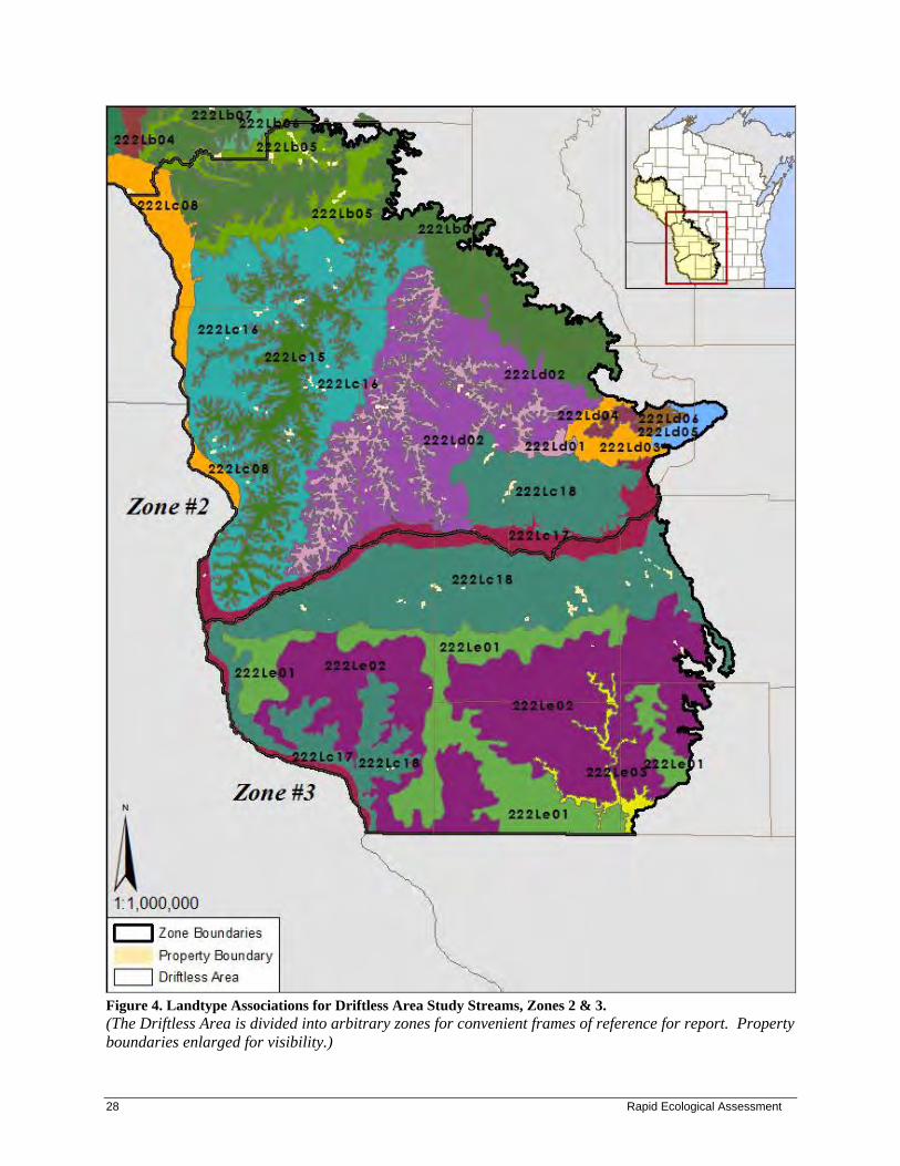
Figure 4. Landtype Associations for Driftless Area Study Streams, Zones 2 & 3. (The Driftless Area is divided into arbitrary zones for convenient frames of reference for report. Property boundaries enlarged for visibility.)

Driftless Area Study Streams 29 29
Physical Environment Geology, Landforms, and Glacial Geology The Driftless Area of Wisconsin lies in the southwestern and west-central part of the state (Figure 1), and covers about 12,700 square miles. The region escaped glaciation in the most recent glacial epochs, although glacial meltwater from surrounding areas rushed through the valley bottoms. This unique combination of geological influences resulted in a dramatic terrain -- deeply dissected valleys and steep-sided, rocky bluffs. The Driftless Area is characterized by an eroded plateau, with bedrock overlain by varying thicknesses of loess (wind-blown silt). Loess was probably blown in from the Mississippi River during glacial periods, thus its depths are deepest at or near the Mississippi (tens of feet thick) and become shallower as one moves east (about two feet thick in Madison area) (Dott and Attig 2004). Dolomite, sandstone, and limestone are the dominant bedrock types, with lesser amounts of shale and gneiss. Outcrops of Paleozoic bedrock are common, especially on the bluffs that rise above the Wisconsin and Mississippi Rivers. The preponderance of Karst topography (when layers of soluble bedrock are dissolved by water) means that caves are common throughout the Driftless Area – about 60 have been identified (Dott and Attig 2004). The influence of glacial meltwater is most evident in the complex network of streams and tributaries that deeply cut into the bedrock. Other notable relicts, however, are broad sandy outwash plains along the major rivers, especially the Black and the Wisconsin. The Black River channel served as the primary outlet for Glacial Lake Wisconsin: When the Green Bay Lobe of the Laurentide Ice sheet dammed the Wisconsin River at the Baraboo Hills, the water in the lake rose until it spilled over into the lowest point – the Black River (Dott & Attig 2004). The ancient sandy outwash plains along both rivers extend far beyond the extent of their modern-day floodplains. Soils Based on descriptions of the LTAs within which Driftless Area Study Streams properties fall (Cleland et al. 1997), most soils in the study area are well-drained to moderately-well-drained silt loams, sandy loams, or loamy sands. Limestone and sometimes sandstone bedrock often lie close to the surface, resulting in shallow soils and exposed bedrock (often in the form of cliffs or outcrops). Alluvial deposits occur along stream and river bottoms, yielding moderately-drained to poorly-drained soils. Glacial outwash plains along the major rivers are characterized by varying depths of sand and gravel. In his book "The Sand County Almanac," Aldo Leopold expressed concern for the soils of this region (Leopold 1949): “By 1930 it had become clear to all except the ecologically blind that southwestern Wisconsin’s topsoil was slipping seaward.” This soil loss was a direct result of intensive agricultural practices on steep, erodible slopes, particularly plowing, grazing, and logging. In 1933, a new federal agency, the Soil Erosion Service, selected Coon Creek near La Crosse as the first watershed in which to demonstrate the values of soil conservation measures (Helms 1983). This agency became the Soil Conservation Service (SCS) in 1935. By working with farmers to implement agricultural contouring, strip cropping, and terracing, the destructive forces of erosion were eventually reversed, heralding a new era of soil conservation in agriculture. Hydrology

30 Rapid Ecological Assessment
The Driftless Area is characterized by a finely dissected network of interconnected streams and tributaries. Springs and spring seeps feed hundreds of cold- and cool-water streams, many of which harbor trout (Figure 5), emphasizing the importance of trout fishing as a recreational past-time as well as an economic base for the region. Within the Western Coulee and Ridges Ecological Landscape alone, over 4,000 springs have been mapped (WDNR In prep. a). Springs are critical for maintaining proper temperatures and dissolved oxygen in streams for the many sensitive aquatic invertebrates and rare native fish (as well as brook trout [Salvelinus fontinalis]) that reside there.
Figure 5. Trout Streams of Wisconsin. Source: " Wisconsin DNR Trout Streams" shape file (WDNR 2008)
The lack of direct, recent glacial influence on the region resulted in a marked absence of lakes and wetlands, other than those that occur locally along river floodplains. In many places, impoundments were installed on streams to create artificial lakes. The WDNR maintains a number of artificial fish-rearing ponds throughout the study area. On the Mississippi River, a series of locks and dams were installed during the 1930's. These dams dramatically altered the hydrology of the river and its associated ecosystems. One can discern three

Driftless Area Study Streams 31 31
distinct zones between each dam (Dott and Attig 2004): 1) Immediately above each dam is a large, open reservoir lake; 2) Upstream from the lake is an extensive marsh with backwater sloughs; and 3) Between the marsh and the next dam upstream, a network of braided channels, sloughs, and small lakes course through a floodplain forest complex. Although most Driftless Area Study Streams properties are associated with smaller streams and creeks, several are directly associated with large rivers (Stream Order 6 or larger), including the Hay River, Red Cedar River, Black River, and Mississippi River. Nine other large rivers also 'influence' the study area: Chippewa River, Eau Claire River, Trempealeau River, Kickapoo River, Blue River, Grant River, Platte River, Baraboo River, and East Branch Pecatonica River.
Vegetation Historical Vegetation Data from the original Public Land Surveys are often used to infer forest composition and tree species dominance for large areas in Wisconsin prior to widespread Euro-American settlement. The purpose of examining historical conditions is to identify ecosystem factors that formerly sustained species and communities that are now altered in number, size, or extent, or which have been changed functionally (for example, by constructing dams, or suppressing fires). Although data are limited to a specific snapshot in time, they provide valuable insights into Wisconsin’s ecological capabilities. Maintaining or restoring some lands to more closely resemble historic systems and including some structural or compositional components of the historic landscape within actively managed lands can help conserve important elements of biological diversity (WDNR In prep. a). The early vegetation of Wisconsin was mapped by Robert Finley and published in 1976 (Finley 1976), and was based on notes and maps from the original Public Land Surveys. Finley’s map indicates that historical vegetation of the Driftless Area consisted of prairie and savanna on ridge tops, dry-mesic forest on moister slopes, mesic forests in protected valleys and on north-facing slopes, wet-mesic to mesic prairies and sedge meadows along rivers, and marshes and floodplain forests within the river floodplains (Figures 6 and 7). Prairie was also found on dry, thin soiled, south- and west-facing slopes, especially on bluffs along the bigger rivers. Pine Relicts were found throughout the Driftless Area on rocky cliffs and north-facing slopes, and harbored an assemblage of plants that were more typical of northern Wisconsin (Curtis 1959). This generalized description of the larger landscape is equally applicable to the Driftless Area Study Streams properties.

32 Rapid Ecological Assessment
Figure 6. Vegetation of Driftless Area Study Streams prior to Euro-American settlement (Zone 1) (Data from Finley, 1976. The Driftless Area is divided into arbitrary zones for convenient frames of reference for report. Property boundaries enlarged for visibility.)

Driftless Area Study Streams 33 33
Figure 7. Vegetation of Driftless Area Study Streams prior to Euro-American settlement (Zones 2 & 3) (Data from Finley, 1976. The Driftless Area is divided into arbitrary zones for convenient frames of reference for report. Property boundaries enlarged for visibility.)

34 Rapid Ecological Assessment
Current Vegetation Many of the factors that historically impacted vegetation continue to impact the study area today, and include but are not limited to geology, soils, hydrology, and climate. These factors are superseded in many areas, however, by more recent human influences on the land, particularly conversion of bluff tops and valley bottoms to agriculture, logging, installation of impoundments, fire suppression, and the introduction and spread of non-native invasive species. Today, nine general land cover types dominate the Driftless Area landscape: agriculture, barren (i.e., bare soil), deciduous forest, coniferous forest, wetland, grassland, shrubland, open water, and urban (Figures 8 and 9). In Wiscland savannas may be classified as grasslands, shrublands, or forest types.
The landscape-scale generalization of cover types described above helps us visualize the study area within a larger context. But which cover types typify the properties within the study area for this report? The most obvious commonality among all Driftless Area Study Streams properties is the presence of water, most often in the form of small, cool-water streams, less often in the form of rivers or artificial impoundments. Grass- or sedge-dominated wetlands, often brushy, most commonly create a buffer along the smaller creeks and streams, while a combination of Floodplain Forest and open/brushy wetlands may straddle larger rivers. The dominant upland forest cover is oak-hickory (this includes savannas and dry-mesic forests), while maple-basswood forests (i.e., mesic forests) are common in cooler, moister areas such as north-facing slopes. Rock outcrops and cliffs are common throughout the study area sites, and have several different natural communities associated with them, including Dry Cliff, Moist Cliff, and Pine Relict. Degraded remnant Dry Prairies are found on thin-soiled bluffs, especially on steep south- or west-facing slopes. Detailed descriptions of the natural community types that figure prominently on Driftless Area Study Streams properties are provided below:
Graminoid-Dominated Wetlands Most open wetlands dominated by grasses or sedges (graminoids) in the study area were drained in the past, then plowed or grazed. As wetlands were destroyed or degraded, stream flow during rain events became flashier, resulting in deeply-incised stream banks (sometimes 10-15 feet high) and heavy deposition of sediment. Nutrient-laden runoff from proximal urban and agricultural lands further contributed to the degradation of these wetlands. Wetlands that experienced such extensive disturbance are typically dominated by reed canary grass (Phalaris arundinacea) and/or lake sedge (Carex lacustris), and harbor a small number of forb generalists such as sawtooth sunflower (Helianthus grosseserratus), spotted Joe-Pye-weed (Eupatorium maculatum), giant goldenrod (Solidago gigantea), swamp aster (Aster puniceus), New England aster (Aster novae-angliae), orange jewelweed (Impatiens capensis), and tall meadowrue (Thalictrum dasycarpum). Project surveyors occasionally encountered less disturbed graminoid-dominated wetlands, most often in the form of Southern Sedge Meadow. Southern Sedge Meadow occurs on saturated soils (muck or peat), and is typically dominated by tussock sedge (Carex stricta) and blue-joint grass (Calamagrostis canadensis). Some sedges, especially the tussock sedge, form hummocks; these may be accentuated by grazing and frost action. Common sedge meadow associates are northern water-horehound (Lycopus uniflorus), panicled aster (Aster lanceolatus var. simplex), blue flag (Iris virginica), Canada goldenrod (Solidago canadensis), spotted Joe-Pye-weed, broad-leaved cat-tail (Typha latifolia), and swamp milkweed (Asclepias incarnata). Good examples of Southern Sedge Meadow within the study area occur at Rush Creek Fishery Area in Crawford County and at Bear Creek Fishery Area in Richland and Sauk Counties. The least common form of minimally disturbed graminoid-dominated wetland that surveyors encountered was Wet-mesic Prairie, which typically occurs as small inclusions within a larger sedge meadow/Shrub-carr matrix. This community is dominated by tall grasses including big bluestem (Andropogon gerardii),

Driftless Area Study Streams 35 35
bluejoint grass, and prairie cordgrass (Spartina pectinata). The forb component can be quite diverse, and typically will include azure aster (Aster oolentangiensis), shooting-star (Dodecatheon meadia), sawtooth sunflower, yellow coneflower (Ratibida pinnata), stiff goldenrod (Solidago rigida), and Culver's root (Veronicastrum virginicum). Examples of small Wet-mesic Prairie inclusions can be found at Willow Creek Fishery Area in Richland County.
Figure 8. Landcover of Driftless Area Study Streams (Zone 1). [From WDNR Wiscland GIS coverage (WDNR 1993). The Driftless Area is divided into arbitrary zones for convenient frames of reference for report. Property boundaries enlarged for visibility.]

36 Rapid Ecological Assessment
Figure 9. Landcover of Driftless Area Study Streams (Zones 2 & 3). [From WDNR Wiscland GIS coverage (WDNR 1993). The Driftless Area is divided into arbitrary zones for convenient frames of reference for report. Property boundaries enlarged for visibility.] Shrub-carr This wetland community occurs on saturated to seasonally-flooded soils, and is dominated by tall shrubs such as red-osier dogwood (Cornus stolonifera), white meadowsweet (Spiraea alba), and various willows (Salix discolor, S. bebbiana, and S. exigua). Vegetation growing underneath the woody species is usually typical of Southern Sedge Meadow, most commonly reed canary grass, less commonly blue-joint grass, lake sedge, and tussock sedge. Given that artificial drainage and fire suppression contribute to expansion

Driftless Area Study Streams 37 37
of Shrub-carr communities into open wetlands (Eggers and Reed 1987), this community type is well-represented throughout the study area. Floodplain Forest This is a lowland hardwood forest community that occurs within the floodplain of large rivers, usually stream order 3 or higher. Canopy dominants typically include silver maple (Acer saccharinum), river birch (Betula nigra), green ash (Fraxinus pennsylvanica), swamp white oak (Quercus bicolor), and eastern cottonwood (Populus deltoides). Dominant ground layer species include reed canary grass, wood nettle (Laportea canadensis), stinging nettle (Urtica dioica), jumpseed (Polygonum virginianum), and cut-leaved coneflower (Rudbeckia laciniata). Significant stands of Floodplain Forest occur in the study area along the Black River in Jackson County (especially Half Moon Bottoms SNA), along the Rush River in Pierce County (especially Rush River Delta SNA), along Cooley Creek in Crawford County (including part of Rush Creek SNA), and along the Mississippi River in Trempealeau County (including Trempealeau Lakes Fishery Area). Southern Mesic Forest Southern Mesic Forests lie within deep, shady coves and ravines and on north-facing slopes, and contain high amounts of sugar maple (Acer saccharum) and basswood. Deep shade created by dense canopy cover results in a very open understory and an abundant spring ephemeral display. On most Driftless Area Study Streams sites where Southern Mesic Forest occurs, gooseberries (Ribes spp.) are common, which is indicative of past grazing. Characteristic herbs are spring-beauty (Claytonia virginica), trout-lilies (Erythronium spp.), trilliums (Trillium spp.), violets (Viola spp.), bloodroot (Sanguinaria canadensis), blue cohosh (Caulophyllum thalictroides), mayapple (Podophyllum peltatum), and Virginia waterleaf (Hydrophyllum virginianum). Although large and intact examples of Southern Mesic Forest are rare in Wisconsin, a number of good examples occur within the Driftless Area Study Streams study area: at Coon Creek Fishery Area and Coon Creek Cliffs SNA in Vernon County, La Crosse Area Comprehensive Fishery Area on Tainter Creek in Vernon County, Eureka Maple Woods & Portland Maples SNA in Monroe County, Snow Bottom SNA in Grant County, Pinnacle Rock Rearing Station in Monroe County, and REM-Milancthon Creek in Richland County.
Mature Southern Mesic Forest at Eureka Maple Woods SNA. By Ryan O'Connor.

38 Rapid Ecological Assessment
Southern Dry Forest, Southern Dry-mesic Forest Southern Dry- and Dry-mesic Forests are common throughout the study area, and typically occur on south- and west-facing slopes of hills or on thin soiled hilltops and ridges; dry forests often occupy the upper, drier slopes while dry-mesic species occupy the lower slopes where slightly deeper soils and/or cooler, moister conditions prevail. Southern Dry Forest canopy dominants are white oak (Quercus alba) and black oak (Quercus velutina), with admixtures of red and bur oak (Q. rubra and Q. macrocarpa) and black cherry (Prunus serotina). Southern Dry-mesic Forest canopy dominants are red oak, white oak, shagbark hickory (Carya ovata) and basswood. Ground layer species for both dry and dry-mesic forests overlap, and include wild geranium (Geranium maculatum), false Solomon's-seal (Maianthemum racemosum), hog-peanut (Amphicarpaea bracteata), and woodland sunflower (Helianthus strumosus). Abundant brambles (Rubus spp.), gray dogwood (Cornus racemosa), and American hazelnut (Corylus americana) occupy a robust shrub layer in dry forests, but are much less pronounced in the dry-mesic forest where deeper shade and less frequent fire reduces their growth. While most of the dry and dry-mesic forests of the study area are still in the early stages of recovering from past logging, large canopy oaks still remain in many areas. The continuing invasion of shade-tolerant trees in the absence of regular fire has resulted in a cascade of environmental, compositional, and structural changes in these forests: As the subcanopy and canopy become more closed, deeper shade, higher soil moisture, and cooler microclimate ensue, creating a positive feedback cycle that progressively favors mesophytic species and disfavors shade-intolerant, fire-adapted species (Nowacki and Abrams 2008). In many areas, evidence of sustained and often heavy past grazing is apparent in the dominance of shrubs such as prickly ash (Zanthoxylum americanum) and multiflora rose (Rosa multiflora). Non-native invasive species such as non-native bush honeysuckle (Lonicera spp.) and garlic mustard (Alliaria petiolata) are also common in these forests. Good-quality examples of Southern Dry and Dry-mesic Forest have survived at Coon Creek Fishery Area in Vernon County, La Crosse Area Comprehensive Fishery Area on Tainter Creek in Vernon County, Hulbert Creek Woods SNA in Sauk County, Rush Creek SNA in Crawford County, Snow Bottom SNA and Mount Hope Rearing Station in Grant County, and Big Spring Creek, Love Creek and Trout Creek Fishery Areas in Iowa County. Northern Dry and Dry-mesic Forest Within the study area, Northern Dry and Dry-mesic Forest occur primarily where the Tension Zone passes through southwestern Chippewa County (e.g., Elk Creek Fishery Area), northern and eastern Jackson county (e.g., Buffalo River and Tank Creek Fishery Areas), and northern Monroe County (e.g., Sand Creek Pines SNA, Big Creek Fishery Area). These forests usually occur on sandy loams, sands or sometimes rocky soils. Dominant trees of Northern Dry Forest in the study area include jack and red pine (Pinus banksiana and P. resinosa), white oak, bur oak, and Hill's oak (Quercus ellipsoidalis). Northern Dry-mesic Forest is dominated by white pine (Pinus strobus) and red pine, red oak, and red maple (Acer rubrum). Common understory shrubs for both Northern Dry and Dry-mesic Forests are hazelnuts (Corylus spp.) and early low blueberry (Vaccinium angustifolium). Due to their location within the Tension Zone, ground layer species can be a mixture of both northern and southern forest species. Most examples of these community types within the study area are in the early stages of recovering from past logging and grazing. Good quality examples of Northern Dry-mesic Forest occur at Sand Creek Pines SNA in Monroe County and Hulbert Creek Woods SNA in Sauk County. Oak Opening and Oak Woodland Oak Opening and Oak Woodland are two fire-dependent savanna communities with scattered oaks as the dominant canopy tree and a variety of species growing underneath and between them. Oak Openings, as defined by Curtis (1959), have more than one tree per acre and less than 50% tree canopy coverage. Bur, white, and black oaks are dominant in mature stands, typically as large, open-grown trees with wide, horizontally spreading crowns over short, thick boles. Shagbark hickory, red oak, hackberry (Celtis

Driftless Area Study Streams 39 39
occidentalis) and black cherry are also sometimes present. American hazelnut is a common understory shrub. Under and between the oaks grow a mixture of sun-loving prairie plants, shade-loving woodland plants, and true savanna plants that prefer dappled sunlight. In contrast, Oak Woodland occupies a position on the vegetation continuum that is intermediate between Oak Opening and Southern Dry/Dry-mesic Forest, with canopy closures ranging from 50-95% (Richard Henderson, personal communication). The dominant tree of the Oak Woodland is the white oak, with lesser amounts of bur oak and black oak, and sometimes red oak, shagbark hickory, hackberry and black cherry. The diverse herb layer includes some members of the prairie, oak opening, and oak forest communities, but also features many grasses, sedges, legumes, composites and other forbs that are best adapted to the highly-filtered shade of the oak woodland. Of all community types in the Driftless Areas Streams study area, Oak Opening and Oak Woodland are among the most frequently encountered. With the cessation of regular fire beginning in the 19th century, these oak savannas were rapidly invaded by native trees (especially later successional species such as maples) and shrubs. The resulting deeper shade conditions promoted a groundlayer composition that was more typical of forests, causing declines in savanna groundlayer species, and limiting if not completely preventing oak reproduction. Grazing and invasion of non-native trees and shrubs further exacerbated these negative impacts. Although no high-quality Oak Opening or Oak Woodland sites were detected in the study area during surveys, some sites harbored examples of oak savanna with high restoration potential, including Trout Creek and Big Spring Creek Fishery Areas in Iowa County, Snow Bottom SNA in Grant County, Rush Creek SNA and Fishery Area in Crawford County, Hulbert Creek Woods SNA in Sauk County, Trump Coulee Rearing Station in Jackson County, and La Crosse Area Comprehensive Fishery Area on Tainter Creek in Vernon County. Oak Barrens and Pine Barrens Black oak is the dominant tree in this fire-adapted savanna community of dry, sandy sites, although white oak, bur oak, Hill's oak, and occasionally red oak may also be present. Common ground layer species include typical prairie associates such as lead plant (Amorpha canescens), goat’s-rue (Tephrosia virginiana), June grass (Koeleria macrantha), little bluestem (Schizachyrium scoparium), flowering spurge (Euphorbia corollata), frostweed (Helianthemum spp.), and wild lupine (Lupinus perennis). Heath species such as bracken fern, blueberries, bearberry, and sweet fern can also grow in patches of some Oak Barrens, and even achieve dominance. Pine Barrens are characterized by scattered pines (typically jack pines) which are often mixed with Hill's and bur oaks. Shrubs such as hazelnuts, (Corylus spp.) and prairie willow (Salix humilis), along with Sand Prairie herbs, occupy sunny openings. In both barrens communities, frequent fires can reduce the oaks to short, multi-stemmed “grubs." In areas that experience less frequent fires, large oaks may be present. Sites with Oak Barrens that have high restoration potential can be found at Trout Creek Fishery Area in Iowa County, and Tank Creek Fishery Area in Jackson County. La Crosse River Fishery Area in Monroe County harbors good restoration potential for Pine Barrens. Cliff Communities The greatest number of cliff communities in Wisconsin is found in the Driftless Area, and is associated mostly with outcrops of dolomite and sandstone. Cliff communities present environmental conditions that are unique on the landscape, allowing only specialized plants to grow. In fact, a great number of endemic or rare species are associated with cliff communities. Three communities associated with cliffs are found within the study area: Dry Cliff, Moist Cliff, and Pine Relict. Dry Cliff is the most commonly represented cliff community in the study area. The most characteristic plants of Dry Cliff are ferns (especially common polypody [Polypodium vulgare] and rusty woodsia [Woodsia ilvensis]), columbine (Aquilegia canadensis), harebell (Campanula rotundifolia), pale corydalis

40 Rapid Ecological Assessment
(Corydalis sempervirens), juneberry (Amelanchier spp.), northern bush-honeysuckle (Diervilla lonicera), and rock spikemoss (Selaginella rupestris). Good examples of Dry Cliff occur at Coon Creek Fishery Area in Monroe and Vernon Counties and Castle Rock Creek in Grant County. Pine Relicts are found somewhat frequently on Driftless Area Study Streams properties. These isolated stands of white pine and red pine or, less commonly, jack pine, occur on sandstone outcrops or on thin soils over sandstone. Ground layer species are often more typical of northern communities, and include blueberries (Vaccinium spp.), huckleberry (Gaylussacia baccata), wintergreen (Gaultheria procumbens), pipsissewa (Chimaphila umbellata), and partridge-berry (Mitchella repens). Herbs typically found in southern Wisconsin’s dry oak forests and prairies may also be found here. Good examples of Pine Relict are found at Castle Rock Creek and Snow Bottom SNA in Grant County. Moist Cliff is less common in the study area, and is cool, moist, and shaded (by trees or by the cliff itself due to aspect). Common species are columbine, fragile ferns (Cystopteris bulbifera and C. fragilis), wood ferns (Dryopteris spp.), rattlesnake-root (Prenanthes alba), and wild sarsaparilla (Aralia nudicaulis). Good examples of Moist Cliff occur at Coon Creek Fishery Area in Vernon County, at La Crosse Area Comprehensive Fishery Area on Tainter Creek in Vernon County, at Snow Bottom SNA in Grant County, and at La Valle Mill Pond on the Baraboo River in Sauk County.
Pine Relict and Dry Cliff at Snow Bottom SNA. By Ryan O'Connor.

Driftless Area Study Streams 41 41
Minor Natural Communities and Other Vegetative Cover Types Algific Talus Slope This rare community consists of steep slopes of fractured limestone (dolomite) rock that retains ice and emits cold air throughout the growing season. The cold microhabitats enable the persistence of northern species and "periglacial relicts" such as northern wild monkshood (Aconitum noveboracense) and rare terrestrial snails. The woody overstory is often sparse, with scattered small black ash (Fraxinus nigra) and paper birch (Betula papyrifera). Mountain maple (Acer spicatum), a northern shrub, may be frequent, and extensive beds of bulblet fern (Cystopteris bulbifera) and mosses are characteristic. Only one Driftless Area Study Streams site is known to harbor Algific Talus Slope: Coon Creek Fishery Area in Monroe County, a highly significant site in that it is the only Algific Talus Slope known outside of Grant County. Emergent Aquatic These open communities occur where there is permanent standing water, and are dominated by robust plants that emerge from the water. The most common emergents are cat-tails (Typha spp.), bulrushes (particularly Scirpus fluviatilis and S. validus), bur-reeds (Sparganium spp.), water-plantains (Alisma spp.), and arrowheads (Sagittaria spp.). Good examples of Emergent Aquatic communities may be found along Bear Creek in Richland and Sauk Counties and at Willow Creek Fishery Area in Richland County. Upland Prairie Upland prairie remnants occur in the study area on shallow rocky soils, often on steep south- and west-facing slopes (Dry and Dry-mesic Prairie), and on sandy soils on level or gently rolling terrain (Sand Prairie). A general definition of “prairie” is an open grassland with less than one tree per acre (typically bur oak) (Curtis 1959). Prairies are dominated, in terms of biomass, by grasses, but in terms of species diversity, the wildflowers, or “forbs,” capture the majority – 90% or more. Small shrubs such as wild roses (Rosa spp.), New Jersey tea (Ceanothus americana), American hazelnut, and leadplant complete the compositional picture. Some indicator species for Dry Prairie include little bluestem, side-oats grama (Bouteloua curtipendula), American pasqueflower (Anemone patens) and old field goldenrod (Solidago nemoralis). For Dry-mesic Prairie, some indicator species are prairie drop-seed (Sporobolus heterolepis), needle grass (Stipa spartea), Leonard’s skullcap (Scutellaria leonardii) and western sunflower (Helianthus occidentalis). Typical Sand Prairie associates include hairy panic grass (Dicanthelium acuminatum), hairy hawkweed (Hieracium longipilum), goat’s rue and long-branch frostweed (Helianthemum canadense). Virtually all remnants in the study area are small and generally highly degraded due to past grazing, fire suppression, and invasion of woody and non-native species. Good-quality Dry-mesic Prairie can be found at Buffalo River Trail Prairies SNA. High-quality examples of Dry Prairie occur at Rush Creek SNA in Crawford County. White Pine-Red Maple Swamp Sand milkweed (Asclepias amplexicaulis) at La Crosse River
Fishery Area. By Kathy Kirk.

42 Rapid Ecological Assessment
This swamp community is restricted to the margins of the bed of extinct glacial Lake Wisconsin in the central part of the state. It often occurs along headwater streams and seepages in gently sloping areas. White pine and red maple are the dominant trees, with other species, including yellow birch (Betula alleghaniensis) present in lesser amounts. Common understory shrubs are speckled alder (Alnus incana) and winterberry holly (Ilex verticillata). Characteristic herbs include skunk cabbage (Symplocarpus foetidus), cinnamon fern (Osmunda cinnamomea), and gold thread (Coptis trifolia). Sphagnum and other mosses are common. Only two examples of this community type were noted by surveyors, and they were low- to moderate-quality: one at Lowes Creek in Eau Claire County and one at Tank Creek Fishery Area in Jackson County. Surrogate Grassland Surrogate grasslands include agricultural habitats such as hayfields, small grains, row crops, fallow fields, old fields, pastures, fields planted to non-native cool-season grasses or native warm-season grasses, and prairie plantings. These are occasionally found in the study area on cleared bluff tops, valley bottoms, and sand terraces. Pine Plantation Pine plantations are relatively common throughout the study area.
Rare Species and High Quality Natural Communities Rare species and high-quality examples of native communities have been documented within the Driftless Area Study Streams property group. Table 4 shows the rare species and high-quality natural communities currently known from Driftless Area Study Streams. Appendix C shows the rare species and high-quality natural communities currently known from Driftless Area Study Streams listed by property. See Appendix D for narrative descriptions of the species and natural communities mentioned in this report.

e species and high-quality natural communities of Driftless Area Study Streams. d global ranks, and state status, see Appendix F. State status, tracking status, and ranks based on June 1, 2011 working list.
Scientific Name
Last Observed Date State Rank
Global Rank
State Status
Federal Status SGCN
Tracked by NHI
Empidonax virescens 2011 S3B G5 THR X Y Haliaeetus leucocephalus 2010 S4B,S4N G5 SC/P X Y Vireo bellii 2002 S2B G5 THR X Y Chlidonias niger 2010 S2B G4 SC/M X Y Coccyzus erythropthalmus 2010 S3S4B G5 SC/M X W Vermivora cyanoptera 2011 S4B G5 SC/M X W Dolichonyx oryzivorus 2000 S3S4B G5 SC/M X W Dendroica cerulea 2010 S2S3B G4 THR X Y Sturnella magna 2000 S3S4B G5 SC X W Vermivora chrysoptera 2010 S3S4B G4 SC/M X W Ammodramus savannarum 2010 S3B G5 SC/M X W Ammodramus henslowii 2010 S2S3B G4 THR X Y Wilsonia citrina 2011 S2S3B G5 THR X Y Oporornis formosus 2011 S1S2?B G5 THR X Y Chondestes grammacus 2010 S3B G5 SC/M X Y Empidonax minimus 2011 S4B G5 SC/M X W Seiurus motacilla 2011 S3B G5 SC/M X Y Circus cyaneus 2000 S3B, S2N G5 SC/M X W Melanerpes erythrocephalus 1990 S3B G4 SC/M X W Buteo lineatus 2010 S3S4B,S1N G5 THR X Y Catharus fuscescens 2011 S3S4B G5 SC/M X W Pooecetes gramineus 2010 S3S4B G5 SC/M X W Empidonax traillii 2011 S4B G5 SC/M X W Hylocichla mustelina 2011 S4B G5 SC/M X W Coccyzus americanus 2011 S3B G5 SC/M X W
Anguilla rostrata 2009 S2 G4 SC/N X Y Ictiobus niger 1998 S2 G5 THR X Y
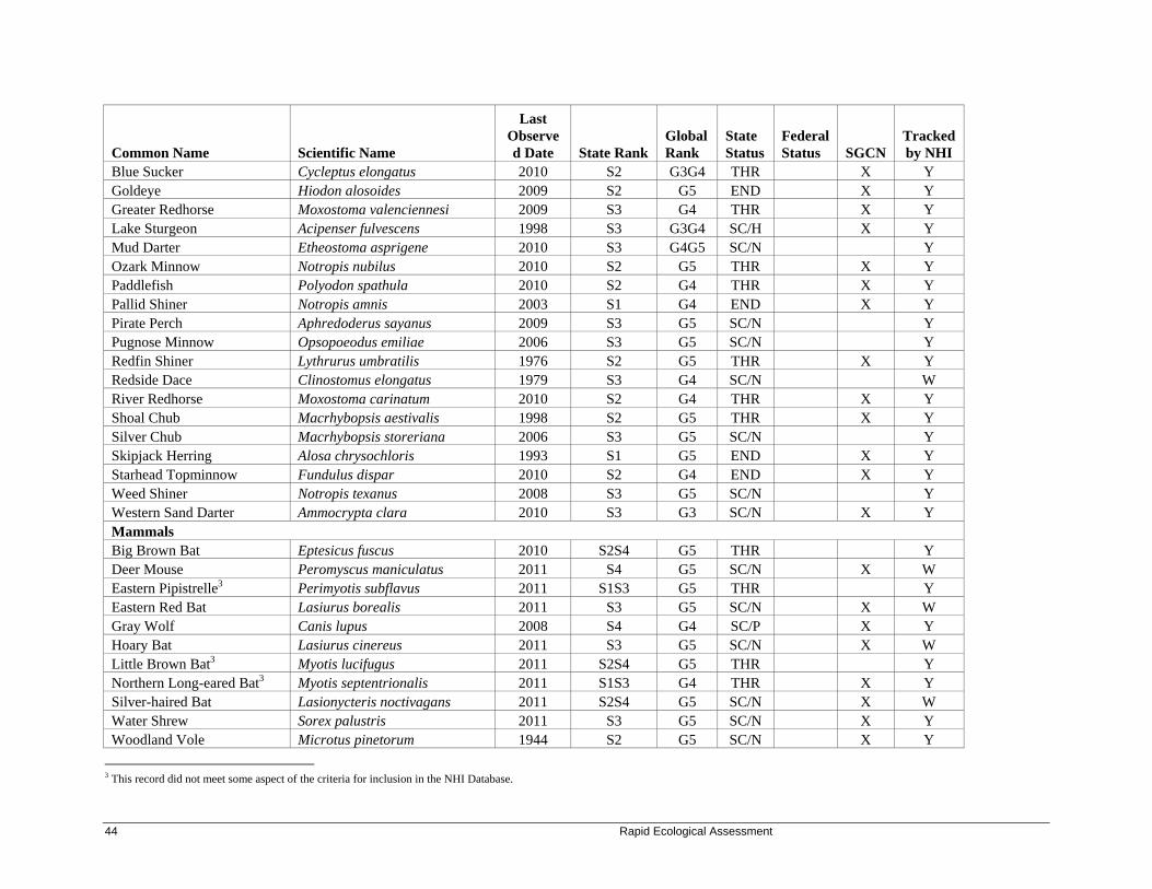
44 Rapid Ecological Assessment
Common Name Scientific Name
Last Observed Date State Rank
Global Rank
State Status
Federal Status SGCN
Tracked by NHI
Blue Sucker Cycleptus elongatus 2010 S2 G3G4 THR X Y Goldeye Hiodon alosoides 2009 S2 G5 END X Y Greater Redhorse Moxostoma valenciennesi 2009 S3 G4 THR X Y Lake Sturgeon Acipenser fulvescens 1998 S3 G3G4 SC/H X Y Mud Darter Etheostoma asprigene 2010 S3 G4G5 SC/N Y Ozark Minnow Notropis nubilus 2010 S2 G5 THR X Y Paddlefish Polyodon spathula 2010 S2 G4 THR X Y Pallid Shiner Notropis amnis 2003 S1 G4 END X Y Pirate Perch Aphredoderus sayanus 2009 S3 G5 SC/N Y Pugnose Minnow Opsopoeodus emiliae 2006 S3 G5 SC/N Y Redfin Shiner Lythrurus umbratilis 1976 S2 G5 THR X Y Redside Dace Clinostomus elongatus 1979 S3 G4 SC/N W River Redhorse Moxostoma carinatum 2010 S2 G4 THR X Y Shoal Chub Macrhybopsis aestivalis 1998 S2 G5 THR X Y Silver Chub Macrhybopsis storeriana 2006 S3 G5 SC/N Y Skipjack Herring Alosa chrysochloris 1993 S1 G5 END X Y Starhead Topminnow Fundulus dispar 2010 S2 G4 END X Y Weed Shiner Notropis texanus 2008 S3 G5 SC/N Y Western Sand Darter Ammocrypta clara 2010 S3 G3 SC/N X Y Mammals Big Brown Bat Eptesicus fuscus 2010 S2S4 G5 THR Y Deer Mouse Peromyscus maniculatus 2011 S4 G5 SC/N X W Eastern Pipistrelle3 Perimyotis subflavus 2011 S1S3 G5 THR Y Eastern Red Bat Lasiurus borealis 2011 S3 G5 SC/N X W Gray Wolf Canis lupus 2008 S4 G4 SC/P X Y Hoary Bat Lasiurus cinereus 2011 S3 G5 SC/N X W Little Brown Bat3 Myotis lucifugus 2011 S2S4 G5 THR Y Northern Long-eared Bat3 Myotis septentrionalis 2011 S1S3 G4 THR X Y Silver-haired Bat Lasionycteris noctivagans 2011 S2S4 G5 SC/N X W Water Shrew Sorex palustris 2011 S3 G5 SC/N X Y Woodland Vole Microtus pinetorum 1944 S2 G5 SC/N X Y
3 This record did not meet some aspect of the criteria for inclusion in the NHI Database.

Driftless Area Study Streams 45 45
Common Name Scientific Name
Last Observed Date State Rank
Global Rank
State Status
Federal Status SGCN
Tracked by NHI
Amphibians American Bullfrog Lithobates catesbeianus 2010 S3S4 G5 SC/H W Four-toed Salamander Hemidactylium scutatum 1928 S3? G5 SC/H X W Northern Cricket Frog Acris crepitans 2011 S1 G5 END X Y Northern Leopard Frog Lithobates pipiens 2011 S4? G5 SC/H W Pickerel Frog Lithobates palustris 2011 S3? G5 SC/H X Y Reptiles Blanding's Turtle Emydoidea blandingii 2010 S3S4 G4 THR X Y Gophersnake Pituophis catenifer 2009 S2S3 G5 SC/P X Y Gray Ratsnake Pantherophis spiloides 2003 S3 G5T5 SC/P X Y Ornate Box Turtle Terrapene ornata 1974 S1 G5 END X Y Plains Gartersnake Thamnophis radix 2011 S2? G5 SC/H Y Slender Glass Lizard Ophisaurus attenuatus 2008 S1 G5 END X Y Timber Rattlesnake Crotalus horridus 2009 S2S3 G4 SC/P X Y Wood Turtle Glyptemys insculpta 2011 S2 G4 THR X Y Terrestrial Snails Bristled Slitmouth Stenotrema barbatum 2011 S3 G5 SC/N W Broad-banded Forestsnail Allogona profunda 2011 S2S3 G5 SC/N Y Cherrystone Drop Hendersonia occulta 2011 S2S3 G4 THR X Y Domed Disc Discus patulus 2011 SU G5 SC/N Y Ribbed Striate Striatura exigua 2011 S2S3 G5 SC/N Y Smooth Coil Helicodiscus singleyanus 1987 S2? G5 SC/N Y Dull Gloss Zonitoides limatulus 2011 S1S2 G4G5 SC/N X Y

Common Name Scientific Name
Last Observed Date State Rank
Global Rank
State Status
Federal Status SGCN
Tracked by NHI
Mussels4 Buckhorn Tritogonia verrucosa 1932 S2 G4G5 THR X Y Butterfly Ellipsaria lineolata 1931 S2 G4G5 END X Y Elephant Ear Elliptio crassidens 1934 S1 G5 END X Y Fawnsfoot Truncilla donaciformis 2005 S1S2 G5 SC/P X Y Higgins' Eye Lampsilis higginsii 2005 S1 G1 END LE X Y Monkeyface Quadrula metanevra 1981 S2 G4 THR X Y Rock Pocketbook Arcidens confragosus 1982 S1S2 G4 THR X Y Wartyback Quadrula nodulata 1979 S1S2 G4 THR X Y Washboard Megalonaias nervosa 1979 S3 G5 SC/P Y Yellow & Slough Sandshells Lampsilis teres 1931 S1 G5 END X Y Stoneflies Quadrate Sallfly Haploperla orpha 1995 S2S3 G4 SC/N X Y Dragonflies and Damselflies Clamp-tipped Emerald Somatochlora tenebrosa 2011 S1S2 G5 SC/N X Y Cyrano Darner Nasiaeschna pentacantha 1964 S3S4 G5 SC/N W Russet-tipped Clubtail Stylurus plagiatus 1992 S3S4 G5 SC/N W Sand Snaketail Ophiogomphus smithi 2002 S2 G2G3 SC/N X Y Slender Bluet Enallagma traviatum 2010 S1S3 G5 SC/N X Y Smoky Shadowfly Neurocordulia molesta 1997 S3 G4 SC/N W Caddisflies A Lepidostomatid Caddisfly Lepidostoma libum 2011 S2S3 G3G4 SC/N X Y A Rhyacophilan Caddisfly Rhyacophila vibox 2011 S4 G5 SC/N X W Mayflies A Spiny Crawler Mayfly Ephemerella excrucians 2011 S5 G5 SC/N X W Aquatic Beetles A Predaceous Diving Beetle Agabus confinis 2011 S3 GNR SC/N X W A Predaceous Diving Beetle Hydroporus pseudovilis 2011 S2S3 GNR SC/N X Y A Water Scavenger Beetle Cymbiodyta blanchardi 2011 S2S3 GNR SC/N X W A Water Scavenger Beetle Cymbiodyta chamberlaini 2011 S3 GNR SC/N X W A Water Scavenger Beetle Hydrochara spangleri 2011 S3S4 GNR SC/N X W
4 All mussel species occur in the Mississippi River.

Driftless Area Study Streams 47 47
Common Name Scientific Name
Last Observed Date State Rank
Global Rank
State Status
Federal Status SGCN
Tracked by NHI
A Water Scavenger Beetle Sperchopsis tessellatus 2011 S3S4 GNR SC/N X W A Water Scavenger Beetle Hydrobius melaenum 2011 S4 GNR SC/N X W Miscellaneous Elements Bat Hibernaculum Bat Hibernaculum S3 GNR SC Y Bird Rookery Bird Rookery 1994 SU G5 SC Y Herp Hibernaculum Herp Hibernaculum 2008 SU GNR SC Y
Karner Blue Federal High Potential Range
Karner Blue Federal High Potential Range 2012 SNR GNR NA Y
Plants American Fever-few Parthenium integrifolium 1987 S3S4 G5 THR Y American ginseng Panax quinquefolius 2010 S4 G3G4 SC W Broad Beech Fern Phegopteris hexagonoptera 1901 S2 G5 SC Y Butternut Juglans cinerea 2011 S3? G4 SC W Canada Yew Taxus canadensis 2010 S4 G5 SC W Carolina Anemone Anemone caroliniana 1888 S1 G5 END Y Clustered Poppy-mallow Callirhoe triangulata 1861 S2 G3 SC Y Clustered Sedge Carex cumulata 1968 S2 G4? SC Y Dwarf Milkweed Asclepias ovalifolia 2010 S3 G5? THR Y Flat-stemmed Spike-rush Eleocharis compressa 1884 S2 G4 SC Y Glade Fern Diplazium pycnocarpon 2010 S2 G5 SC Y Glade Mallow Napaea dioica 2011 S3 G4 SC W Great Indian-plantain Cacalia muehlenbergii 2011 S3 G4 SC W Great Water-leaf Hydrophyllum appendiculatum 2011 S2S3 G5 SC Y Hooker's Orchid Platanthera hookeri 1884 S2 G4 SC Y Lobed Spleenwort Asplenium pinnatifidum 1990 S1 G4 THR Y Low Calamint Calamintha arkansana 1911 S2 G5 SC Y Musk-root Adoxa moschatellina 1936 S2 G5 THR Y
Narrow-leaved Dayflower Commelina erecta var. deamiana 1884 S1 G5T5 SC Y
Northern Wild Monkshood Aconitum noveboracense 2008 S2 G3 THR LT Y One-flowered Broomrape Orobanche uniflora 1931 S3 G5 SC Y Pale False Foxglove Agalinis skinneriana S2 G3G4 END Y Pale Green Orchid Platanthera flava var. herbiola 1928 S2 G4T4Q THR Y

48 Rapid Ecological Assessment
Common Name Scientific Name
Last Observed Date State Rank
Global Rank
State Status
Federal Status SGCN
Tracked by NHI
Pin Oak Quercus palustris 1993 S1 G5 SC Y Pink Milkwort Polygala incarnata 1914 S1 G5 END Y Prairie False-dandelion Nothocalais cuspidata 1886 S2 G5 SC Y Prairie Fame-flower Phemeranthus rugospermus 1991 S3 G3G4 SC Y Prairie Indian-Plantain Cacalia tuberosa 1968 S3 G4G5 THR Y Prairie Parsley Polytaenia nuttallii 1987 S2 G5 THR Y Prairie Ragwort Senecio plattensis 1959 S3 G5 SC Y Prairie Turnip Pediomelum esculentum 1989 S3 G5 SC Y Purple Milkweed Asclepias purpurascens 1931 S3 G5? END Y Rock Clubmoss Huperzia porophila 1980 S3 G4 SC Y
Rock Stitchwort Arenaria stricta ssp. dawsonensis 1958 S1 G5 SC Y
Roundstem Foxglove Agalinis gattingeri 2011 S2 G4 THR Y Shadowy Goldenrod Solidago sciaphila 2010 S4 G3G4 SC W Short's Rock-cress Arabis shortii 2011 S1S2 G5 SC Y Silky Prairie-clover Dalea villosa var. villosa 1958 S2 G5 SC Y Small Forget-me-not Myosotis laxa 1932 S2 G5 SC Y Small White Lady's-slipper Cypripedium candidum 1886 S3 G4 THR Y Smooth-sheath Sedge Carex laevivaginata 1989 S1 G5 END Y Snowy Campion Silene nivea 2011 S2 G4? THR Y Twinleaf Jeffersonia diphylla 2011 S3 G5 SC Y Violet Bush-clover Lespedeza violacea 1970 S2 G5 SC Y Whip Nutrush Scleria triglomerata 1932 S2S3 G5 SC Y Wild Hyacinth Camassia scilloides 1995 S2 G4G5 END Y Wild Licorice Glycyrrhiza lepidota 1910 S1 G5 SC Y Woodland Bluegrass Poa sylvestris 2011 S1 G5 SC Y Woolly Milkweed Asclepias lanuginosa 1998 S1 G4? THR Y Yellow Gentian Gentiana alba 2002 S4 G4 THR Y Yellow Giant Hyssop Agastache nepetoides 1993 S3 G5 THR Y Yellow Wild-indigo Baptisia tinctoria 1986 S1 G5 SC Y Natural Communities Algific Talus Slope Algific talus slope 2010 S1 G2 NA Y Cedar Glade Cedar glade 1984 S4 GNR NA Y

Driftless Area Study Streams 49 49
Common Name Scientific Name
Last Observed Date State Rank
Global Rank
State Status
Federal Status SGCN
Tracked by NHI
Dry Cliff Dry cliff 2010 S4 G4G5 NA Y Dry Prairie Dry prairie 1981 S3 G3 NA Y Emergent Marsh Emergent marsh 1986 S4 G4 NA Y Floodplain Forest Floodplain forest 2006 S3 G3? NA Y Hemlock Relict Hemlock relict 1976 S2 G2Q NA Y Moist Cliff Moist cliff 2011 S4 GNR NA Y Northern Dry-mesic Forest Northern dry-mesic forest 2010 S3 G4 NA Y Oak Barrens Oak barrens 2010 S2 G2? NA Y Pine Barrens Pine barrens 1998 S2 G2 NA Y Pine Relict Pine relict 2011 S2 G4 NA Y Riverine Lake/Pond Riverine Lake/Pond 1981 SU GNR NA Y Shrub-carr Shrub-carr 1976 S4 G5 NA Y Southern Dry Forest Southern dry forest 2011 S3 G4 NA Y Southern Dry-mesic Forest Southern dry-mesic forest 2011 S3 G4 NA Y Southern Mesic Forest Southern mesic forest 2011 S3 G3? NA Y Southern Sedge Meadow Southern sedge meadow 2010 S3 G4? NA Y Stream--Fast, Hard, Cold Stream--fast, hard, cold 1984 S4 GNR NA Y Stream--Fast, Soft, Cold Stream--fast, soft, cold 1981 SU GNR NA Y Stream--Slow, Hard, Cold Stream--slow, hard, cold 1969 SU GNR NA Y Stream--Slow, Soft, Cold Stream--slow, soft, cold 1982 SU GNR NA Y

Management Opportunities and Considerations for Biodiversity Conservation
Landscape Level Opportunities and Considerations Wildlife Action Plan Conservation Opportunity Areas (COAs) The Wisconsin Wildlife Action Plan (WDNR 2006a) identified multiple COAs in the Western Coulee and Ridges and Southwest Savanna Ecological Landscapes; Driftless Area Study Streams properties intersect 16 of them (See Appendix B for maps). They are listed below with a brief description. For more details on COAs and their designation in the Wildlife Action Plan, see the "Background on Past Efforts" section of this report or the WDNR Endangered Resources web pages.
Bur Oak Openings – Global Significance Description: Driftless Area natural communities over sandstone influenced soils including a continuum of Sand Prairie, Oak Barrens, Oak Woodland, Southern Dry Forest, Southern Dry-Mesic Forest, Shrub-carr, and Dry Cliff. COA(s): Ft. McCoy Barrens and Oak Savanna Ecological Landscape(s): Western Coulee and Ridges Driftless Area Features – Continental Significance Description: Driftless Area natural communities over loess and sandstone influenced soils including a continuum of Dry Prairie, Dry-Mesic Prairie, Oak Opening, Oak Woodland, Southern Dry Forest, Southern Dry-Mesic Forest, Southern Mesic Forest, Shrub-carr, Dry Cliffs, and Moist Cliffs. COA(s): Lower Kickapoo and Kickapoo; Coon Creek Mesic; Coulee Forests; Greensand Cuesta; Snow Bottom; Dodgeville and Wyoming Oak Woodland/Savanna; Rush Creek; and Millville-Sandy Creek. Ecological Landscape(s): Western Coulee and Ridges Large River Corridors – Continental Significance Description: Large river systems including riparian communities including Warmwater Rivers, Floodplain Forest, Emergent Marsh, Submergent Aquatics, Wild Rice, and Impoundments. Also included in this feature are upland communities that range from bluff top to bluff top including Southern Dry Forest, Southern Dry-mesic Forest, Dry Prairie, Oak Woodland, Oak Opening and Dry Cliff. COA(s): Lower Black River to Black River Falls Dam; Mississippi Bluffs & Floodplain; Lower Wisconsin Bluffs & Floodplain Ecological Landscape(s): Western Coulee and Ridges
Medium-sized Rivers and Streams – Upper Midwest/Regional Significance Description: Warmwater Rivers and streams including stream side communities including Floodplain Forest, Oak Opening, Oak Barrens, and Shrub-carr. COA(s): Lower Baraboo River; Upper Hall’s Creek. Ecological Landscape(s): Western Coulee and Ridges

Driftless Area Study Streams 51 51
Diverse Aquatic Communities – State Significance Description: Warmwater Stream systems featuring rare fish habitat. COA(s): Little Platte River and Tributaries Ecological Landscape(s): Western Coulee and Ridges and Southwest Savanna Large Sedge Meadows, Fens and Prairies – Upper Midwest Significance Description: Extensive grassland mostly surrogate, but also including proportionally large embedded patches of Dry Prairie, Dry-Mesic Prairie, Southern Sedge Meadow, Oak Opening, Oak Woodland, and Surrogate Grassland. COA(s): Southwest Grasslands and Streams Ecological Landscape(s): Southwest Savanna
Altered Ecological Processes The vegetation that historically occurred on Driftless Area Study Streams properties developed within a complex environment comprised of both elements that are relatively static over ecological time (e.g., soils, underlying landforms) and dynamic (e.g., hydrological cycles, nutrient cycles, wildfires). Some of the dynamic ecological processes that shaped these landscapes have been altered by humans. The hydrology of many of the streams and rivers in the study site were modified for various purposes: ditching and tiling for agriculture, installation of impoundments for fish rearing or waterfowl production, and installation of dams for flood control, agriculture, mill operations, etc. Significant restoration has been conducted in some areas to improve and restore both in-stream habitat as well as the adjacent stream corridor and immediate surrounding landscape (e.g., removal of small dams, resculpting stream banks, planting native prairie species on old agricultural fields in valleys, etc.). However, in many unrestored areas, the effects of past hydrologic modifications continue to negatively impact native plant communities and the species they support by either directly displacing them or by changing the moisture regime they need to survive. The negative impacts of dams and impoundments on animal communities are also well-documented, and should be mitigated to the extent possible and practical. Dams affect aquatic species and habitats by fragmenting them into disjunct segments, preventing the movements of some species between different stretches of the water bodies. Water below impoundments is warmer and of diminished quality, negatively affecting the aquatic invertebrate communities, increasing the growth of periphyton, and diminishing the quality and quantity of fish habitat. Impoundments typically have organically rich bottom sediments, resulting in algal blooms and periods of dissolved oxygen depletion near the bottom. Another ecological process that has been altered is how fire interacts with the natural communities and rare species of Driftless Area Study Streams properties. For virtually all of the natural communities (excluding moist cliffs, mesic forest, and aquatics), fire was a critical process in their development and in maintaining habitat for the species that depend on them. Without regular fire, native woody species can invade and dominate these communities. By volatilizing elevated soil nitrogen, fire also indirectly influences nutrient cycling, shifting conditions to generally favor native plants and to disfavor non-native invasive species. In woodlands, fire facilitates seedling establishment, controls tree species that are not adapted to fire, and prevents smothering of short-statured plants through the removal of leaf litter. In grasslands, fire promotes growth, flowering and overall diversity of native plants by removing excess thatch. Re-introducing fire into an area should be done with consideration of all of the species currently using the habitat and how the fire may impact the amount and quality of habitat available.

52 Rapid Ecological Assessment
Non-Native Invasive Species Many non-native terrestrial invasive plants, animals and pathogens are present on Driftless Area Study Streams properties and in the surrounding landscape. Non-native invasive species thrive in newly disturbed areas, but also may invade and compromise high-quality natural areas. They establish quickly, tolerate a wide range of conditions, are easily dispersed, and are free of the diseases, predators, and competitors that kept their populations in check in their native range. In terrestrial settings, non-native invasive plants out-compete and even kill native plants by monopolizing light, water, and nutrients, by altering soil chemistry and, in the case of garlic mustard, by altering mycorrhizal relationships. In situations where non-native invasive plants become dominant, they may even alter ecological processes by limiting one’s ability to use prescribed fire (a striking example being common buckthorn [Rhamnus cathartica]), by modifying hydrology (e.g., reed canary grass can alter surface flow and clog culverts), and by limiting tree regeneration and ultimately forest composition (WDNR In prep. b). In addition to the threats on native communities and native species diversity, terrestrial non-native invasive species negatively impact forestry (by reducing tree regeneration, growth and longevity), recreation (by degrading fish and wildlife habitat and limiting access), agriculture, and human health (plants that cause skin rashes or blisters). Similarly to terrestrial invasives, aquatic invasives are successful because they originate in other regions or continents, thus lacking natural checks and balances. Early and abundant growth of non-native aquatic plants not only overwhelms native plants, it may disrupt aquatic predator-prey relationships by fencing out larger fish, and may limit important aquatic food plants for waterfowl. The die-off of plants such as curly-leaf pondweed in summer can cause oxygen depletion in waterbodies, and decaying plants can contribute to nutrient loading and algal blooms. Aquatic invasive animals similarly present overwhelming competition to their native counterparts (e.g., rusty crayfish [Orconectes rusticus] versus native crayfish). Invasive mussels, which feed on plants, animals and debris that are suspended in the water, can contribute to increased water clarity and light penetration (fostering overgrowth of rooted aquatic plants), as well as a depleted food supply for native aquatic organisms. Zebra mussels (Dreissena polymorpha) not only monopolize resources and alter the aquatic environment, they literally smother native mussels by attaching to their shells in great masses. Apart from environmental impacts, aquatic invasives diminish aquatic recreational resources by inhibiting boat and swimming access, and by negatively affecting game fish populations. The primary usage of Driftless Area Study Streams for fishing and other forms of recreation has contributed to the introduction and spread of non-native invasive species throughout the properties. Parking areas, trails, and other high-use areas are typical entry points for non-native invasive species that are introduced by visitors’ footwear, clothing, vehicle tires, boats, and recreational equipment. Once established, these invasives may continue to spread along natural corridors (e.g., waterways) and along human-made corridors (e.g, trails and roads). They even have the potential to invade remote high-quality natural areas via vectors such as wind, water, and wildlife. Non-native invasive species may also be spread inadvertently through management activities such as timber operations and roadside mowing, especially if Best Management Practices aren’t followed. Since the study area properties are so numerous and widespread, the following information is generalized to the larger Driftless Area landscape. Non-native invasive species that are abundant and/or widespread throughout the Driftless Area and pose the greatest immediate threat to native species diversity, rare species habitats, or high-quality natural communities of properties within the study area are listed in Table 5. Although resources for complete control of these widespread invasives may be lacking, containment (i.e., limiting further spread) may be considered as an alternative action.

Driftless Area Study Streams 53 53
Table 6. Abundant and/or widespread non-native invasive species of the Driftless Area
Upland Habitats Wetland Habitats
Common Name Latin Name Open Wooded Open Wooded Aquatic
Plant
Autumn olive Eleagnus angustifolia X
Canada thistle Cirsium arvense X X X
Common buckthorn Rhamnus cathartica X X X X
Crown vetch Coronilla varia X
Curly-leaf pondweed Potamogeton crispus X Eurasian bush honeysuckles Lonicera spp. X X
Eurasian water milfoil Myriophyllum spicatum X
Garlic mustard Alliaria petiolata X X
Multiflora rose Rosa multiflora X X
Reed canary grass Phalarus arundinacea X X
Watercress Nasturtium officinalis X
White sweet clover Melilotus alba X
Wild parsnip Pastinaca sativa X X
Yellow sweet clover Melilotus officinalis X
Animal
European earthworms Acanthodrilidae, Lumbricidae, and Megascloedidae X X
Fungus
Oak wilt Ceratocystis fagacearum X X
Early detection and rapid control of new and/or small infestations, however, may be considered for higher prioritization in an invasive species management strategy (Boos et al. 2010). A number of non-native invasive species are, in fact, moderate in abundance or are not yet widespread in the Driftless Area (Table 6), while others are just getting started in the region or show potential to invade the Driftless Area (Table 7); monitoring for these species and rapid response to small infestations represent high-impact actions.

54 Rapid Ecological Assessment
Table 7. Moderate or not-widespread non-native invasive species of the Driftless Area
Upland Habitats Wetland Habitats
Common Name Latin Name Open Wooded Open Wooded Aquatic
Plant
Amur honeysuckle Lonicera amurense X X
Black swallowwort Vincetoxicum nigrum X X Blackberry lily Belamcanda chinensis X X
Celandine Chelidonium majus X
Common tansy Tanacetum vulgare X
Dame’s rocket Hesperis matronalis X X
Japanese barberry Berberis thunbergii X
Japanese hedgeparsley Torilis japonica X X
Japanese hops Humulus japonicus X X X
Japanese knotweed Polygonum cuspidatum X X X X
Leafy spurge Euphorbia esula X
Moneywort Lysimachia nummularia X X X
Narrow-leaved cattail Typha angustifolia X
Oriental bittersweet Celastrus orbiculatus X X
Phragmites Phragmites australis X X Poison hemlock Conium maculatum X X
Purple loosestrife Lythrum salicaria X
Spotted knapweed Centaurea biebersteinii X
Teasel spp. Dipsacus spp X Wild chervil Anthriscus sylvestris X X
Animal Feral domestic swine Sus domestica X X X
Quagga mussel Dreissena bugensis X
Rusty crayfish Orconectes rusticus X
Zebra mussel Dreissena polymorpha X
Fungus
Annosum root rot Heterobasidion annosum X
Japanese hops was located along Copper Creek in Crawford County. By Ryan O'Connor.

Driftless Area Study Streams 55 55
Table 8. New or potential non-native invasive species of the Driftless Area
Upland Habitats Wetland Habitats
Common Name Latin Name Open Wooded Open Wooded Aquatic
Plant
Brazilian waterweed Egeria densa X
Didymo Didymosphenia geminata X
Giant manna grass Glyceria maxima X X
Hydrilla Hydrilla verticillata X
Yellow floating heart Nymphoides peltata X
Water dropwort Oenanthe javonica X
Water hyacinth Eichhornia crassipes X
Water lettuce Pistia stratiotes X
Animal Asian clam Corbicula fluminea X
Asian crazy worm Amynthas spp. X X
Banded mystery snail Vivaparus georgianus X
Chinese mystery snail Cipangopaludina chinensis X
Emerald ash borer Agrilus planipennis X X
Faucet snail Bithynia tentaculata X
Japanese mystery snail Cipangopaludina japonica X
New Zealand mud snail Potamopyraus antipodarum X
Red swamp crayfish Procambarus clarkii ? ? X
Fungus & Other Pathogens
Viral hemorrhagic septicemia X
For recommendations on controlling specific invasive species consult with WDNR staff, refer to websites on invasive species, such as that maintained by the WDNR (search for "invasive species") and by the Invasive Plants Association of Wisconsin (http://www.ipaw.org), and seek assistance from local invasive species groups:
Southwestern Wisconsin Weed Management Area (Grant, Crawford, Lafayette, Iowa, Richland, Dane, Sauk Counties). Contact: Mark Horn, (608)836-0054, [email protected].
Greater Sauk Co. Invasive Plant Team - John Exo, UW Extension Basin Educator, [email protected], (608) 355-3554.
Monroe Co. Invasive Plant Team, [email protected] (608) 388-5374. Also refer to invasive species Best Management Practices (BMPs) for forestry, recreation, urban forestry, and rights-of-way, which were developed by the Wisconsin Council on Forestry (http://council.wisconsinforestry.org/).
56 Rapid Ecological Assessment
Following are details on a few key species: Emerald Ash Borer The emerald ash borer (Agrilus planipennis), a non-native invasive, wood-boring beetle that attacks ash trees, was positively identified for the first time in Wisconsin in 2008, and is now found in six counties. The beetle attacks all species of ash (Fraxinus spp.) in Wisconsin, and the risk to forests is high: Models predict that a healthy forest could lose 98% of its ash trees in six years (WDNR 2010a). Oak Wilt Oak wilt is caused by a fungus, Ceratocystis fagacearum, that effects water movement within oak trees, often killing the trees. The fungus was thought to be native, but the most recent science suggests that it is not (J. Cummings Carlson, WDNR, personal communication). It has been in the state for at least 100 years and is widespread throughout the southern part of the state. Oak wilt is often not a major concern for woodland or barrens restoration areas where open canopy conditions are favored, and dead oak trees can make long-lasting wildlife cavity trees. It can, however, have significant impacts to forested stands with a heavy oak component. European Earthworms The invasion of forests by European earthworms of the families Acanthodrilidae, Lumbricidae, and Megascloedidae is a concern throughout Wisconsin. While native earthworms were absent from much of Wisconsin after the last glaciation, non-native invasive earthworms have been introduced since widespread Euro-American settlement, primarily as discarded fishing bait (Hendrix and Bohlen 2002, Hale et al. 2005). Non-native earthworms can have dramatic impacts on forest floor properties by greatly reducing organic matter (Hale et al. 2005), microbial biomass (Groffman et al. 2004), nutrient availability (Suárez et al. 2004, Bohlen et al. 2004), and fine-root biomass (Groffman et al. 2004). These physical changes in the forest floor reduce densities of tree seedlings and rare herbs (Gundale 2002) and can favor non-native invasive plants (Kourtev et al. 1999). In a study of 51 Northern Wisconsin forest stands, Wiegmann (2006) found that shifts in ground layer plant community composition due to non-native earthworms were more severe in stands with high white-tailed deer densities. Since European earthworms are primarily spread by discarded fishing bait, angler education and outreach is a critical strategy to help slow the spread. Reed canary grass Reed canary grass is a cool-season, sod-forming, perennial wetland grass native to temperate regions of Europe, Asia, and North America. The Eurasian ecotype has been selected for its vigor and has been planted throughout the U.S. since the 1800's for forage and erosion control. Hatch and Bernthal (2008) determined that approximately 500,000 acres of wetlands in Wisconsin are infested with reed canary grass. In addition to incurring devastating impacts on native plants and animals, reed canary grass can also alter hydrology by trapping silt and contricting waterways, and reduce the carbon sequestration capacity of wetlands (Wisconsin Reed Canary Grass Management Working Group 2009). This species prefers disturbed areas, but can also move into intact native wetlands. Invasion is most often associated with disturbances including erosion, ditching, stream channelization, logging of forested wetlands, and planting. Nutrient inputs such as sedimentation, fertilizer or agricultural runoff also encourage invasion and proliferation of reed canary grass. Reed canary grass is extremely difficult to eradicate due to a number of factors: 1) A formidable seed bank may persist on a restoration site for many years; 2) A dense network of persistent rhizomes are difficult to eliminate; 3) Recolonization from proximal sites is likely, given the ubiquitous distribution of this species; and 4) Establishment of desirable native vegetation may be costly and difficult (especially in a riparian setting that is prone to flashy flooding). No single control method is universally applicable, and

Driftless Area Study Streams 57 57
in fact a combination of approaches applied over many years may be necessary. Each site has to be evaluated based on agricultural history, hydrological alteration, landscape context, and invasion pattern. Development of a comprehensive restoration plan is recommended to address not just reed canary grass control but also rapid re-establishment of desirable native vegetation and long-term monitoring. A working group of Wisconsin natural resource professionals with experience in reed canary grass control have been meeting since the fall of 2005 to develop guidelines for the control of this invasive grass in Wisconsin wetlands. Their management guide is an excellent reference for land managers (Wisconsin Reed Canary Grass Management Working Group 2009), and includes information on how to set up a management plan using a combination of practices and timing of treatments that's tailored to specific site conditions, a table of available control techniques, and a listing of native plant species and seed mixes that will compete with reed canary grass. Additionally, the herbicide Sethoxydim is showing great promise for reed canary grass control in Wisconsin (Annen et al 2005, Annen 2008). Climate Change Climate change will have an impact on the natural resources of the Driftless Area, though understanding of these changes is a growing science. Some changes that may result from climate change include increases in both summer and winter minimum temperatures, shifts in seasonal precipitation (more in the winter, less in the summer), and more frequent extreme weather events such as very heavy rainstorms or heat waves (WICCI 2011). Results of these changes may include the shifting of species ranges: Species at the southern edge of their range in the Driftless Area (e.g., sugar maple, white pine, and jack pine) may diminish in the region, while species at the northern edge of their range (e.g., honey locust [Gleditsia triacanthos], Kentucky coffee-tree [Gymnocladus dioica], chinquapin oak [Quercus muhlenbergii], and sycamore [Platanus occidentalis]) may expand further northward. Natural communities of coulees, gorges, cliffs, and north-facing slopes (and the plants and animals associated with them) will also be vulnerable, as their very existence is founded in their exceptionally cool, moist microclimate; this particularly applies to Pine Relicts, Hemlock Relicts, and Algific Talus Slopes. Lyons and collaborators (2010) note that Wisconsin models predict major declines in the occurrence of many fish species in response to a warmer climate. Trout are particularly vulnerable to these impacts, as they are very sensitive to changes in water temperature. The Coldwater Fish and Fisheries Working Group (Wisconsin's Initiative on Climate Change Impacts; WICCI 2011) developed watershed-scale models to predict the changes in coldwater habitat and associated fish distributions, and found that brook trout could be completely lost by the middle of the 21st century from Wisconsin streams under the worst-case scenario for climate change; a moderate scenario could incur a 94% loss of brook trout populations, while the 'best-case' scenario could result in the loss of 44%. Lastly, the magnitude and frequency of intense rain events are anticipated to increase with climate change. Heavy downpours increase the chances of flooding, which can damage or destroy habitats within and beyond established floodplains. Floodplain Forest trees do not tolerate prolonged saturated soils associated with flooding, and may be supplanted by invasive plants such as reed canary grass as trees are lost, especially if increased deposition of sediment also occurs (WICCI 2011). The unique topography of the Driftless Area presents opportunities to mitigate the impacts of Climate Change on vulnerable plants, animals, and natural communities. This could involve maintaining high canopy cover on north facing slopes, helping to maintain a cool microclimate for northern species. Maintaining canopy cover and diverse ground flora in spring recharge areas may also help increase rainwater infiltration, which in turn supplies springs and streams. Adaptation strategies that are recommended for riparian settings include promoting stream bank and channel stability, reducing erosion and siltation, and protecting streams from damaging flood events (WICCI 2011).

58 Rapid Ecological Assessment
High Conservation Value Forests The Wisconsin DNR manages 1.5 million acres that are certified by the Forest Stewardship Council (FSC) (Forest Stewardship Council 2009) and the Sustainable Forest Initiative (SFI). Forest certification requires forests to be managed using specified criteria for ecological, social, and economic sustainability. Principle 9 of the "Draft 7 FSC-US Forest Management Standard" concerns the maintenance of High Conservation Value Forests (HCVF). High Conservation Value Forests are defined as possessing one or more of the following:
Contain globally, regionally, or nationally significant concentrations of biodiversity values, including rare, threatened, or endangered species and their habitats.
Globally, regionally, or nationally significant large landscape level forests, contained within, or containing the management unit, where viable populations of most if not all naturally occurring species exist in natural patterns of distribution and abundance.
Are in or contain rare, threatened, or endangered ecosystems.
Provide basic services of nature in critical situations (e.g., watershed protection, erosion control).
Are fundamental to meeting basic needs of local communities (e.g., subsistence, health).
Are critical to local communities’ traditional cultural identity (areas of cultural, ecological, economic, or religious significance identified in cooperation with such local communities).
Wisconsin’s Statewide Forest Strategy Wisconsin’s Statewide Forest Assessment (WDNR 2010b) was based on Wisconsin’s Forest Sustainability Framework (Wisconsin Council on Forestry 2008) and was designed to assess the current state of Wisconsin’s public and private forests and analyze the sustainability of our forested ecosystems. Wisconsin’s Statewide Forest Strategy (WDNR 2010c) contains a collection of strategies and actions designed to address the management and landscape priorities identified in the Statewide Forest Assessment. The strategies are broad guides intended to focus the actions of the forestry community. All three of these documents include topics related to biological diversity in Wisconsin’s forests, and provide information useful for department master planning and management activities. The following strategies, organized using their number in the Statewide Forest Strategy document, are particularly pertinent to Driftless Area Study Streams planning efforts in terms of opportunities to maintain or enhance biological diversity (WDNR 2010c).
Southern Mesic Forest at Eureka Maple Woods SNA. By Ryan O'Connor

Driftless Area Study Streams 59 59
Strategy Number Strategy
1 Encourage planting to enhance, protect, and connect larger tracts of forested land in appropriate locations consistent with ecological landscapes.
5 Pursue the conservation and protection of large, unfragmented blocks of forest lands.
11 Encourage the management of under-represented forest communities.
12 Improve all forested communities with a landscape management approach that considers the representation of all successional stages.
13 Increase forest structure and diversity.
14 Encourage the use of disturbance mechanisms to maintain diverse forest communities.
15 Maintain the appropriate forest types for the ecological landscape while protecting forest health and function.
22 Strive to prevent infestations of invasive species before they arrive.
23 Work to detect new (invasive species) infestations early and respond rapidly to minimize impacts to forests.
24 Control and manage existing (invasive species) infestations.
25 Rehabilitate, restore, or adapt native forest habitats and ecosystems.
29 Attempt to improve the defenses of the forest and increase the resilience of natural systems to future climate change impacts.
30 Intentionally accommodate (climate) change and enable forest ecosystems to adaptively respond.
Deer herbivory The current level of the white-tailed deer (Odocoileus virginianus) herd in Wisconsin has become a significant barrier to the conservation of biodiversity and sustainable forest management (WDNR 2010d). Herbivory by white-tailed deer has been identified as a major disturbance contributing to ecological simplification of Wisconsin’s forests (Rooney et al. 2004, Kovach et al. 2006, Wisconsin Council on Forestry 2008, WDNR 2010d). Deer herbivory impacts songbirds, small mammals (Flowerdew and Ellwood 2001), invertebrate populations (Allombert et al. 2005), and rare plant abundance and frequency by altering natural community composition and structure. Deer herbivory causes a decreased cover in the shrub and sapling layer which negatively impacts species richness and abundance of songbirds that nest in that layer (DeCalesta 1994, McShea and Rappole 2000). Although there are many factors affecting long-term changes in Wisconsin’s forests, including invasive species and surrounding landscape condition, impacts from deer, in combination with other factors, remain a primary source of ecological change (Waller et al. 2009).

60 Rapid Ecological Assessment
Community Level Opportunities and Considerations The Wisconsin Wildlife Action Plan (WDNR 2006a) identifies 37 natural communities for which there are “Major” or “Important” opportunities for protection, restoration, or management in the Western Coulee & Ridges Ecological Landscapes. Eighteen of these natural communities are present on Driftless Area Study Streams properties:
Major Opportunity Important Opportunity Algific Talus Slope Northern Dry-mesic Forest Cedar Glade Pine Barrens Coldwater streams Southern Sedge Meadow Dry Cliff Dry Prairie Emergent Marsh Floodplain Forest Hemlock Relict Moist Cliff Oak Barrens Pine Relict Shrub Carr Southern Dry Forest Southern Dry-mesic Forest Southern Mesic Forest
The Wisconsin Wildlife Action Plan (WDNR 2006a) also identifies 17 natural communities for which there are “Major” or “Important” opportunities for protection, restoration, or management in the Southwest Savanna Ecological Landscapes. One of these natural communities is present on Driftless Area Study Streams properties: Coldwater streams (Important Opportunity). Although all of the above communities have been identified on Driftless Area Study Streams properties, only some are high quality, or have medium to high restoration potential. These include: Oak Savanna (Oak Opening, Oak Woodland, Oak Barrens) Historically, Oak Openings were abundant in Wisconsin, covering approximately 5.5 million acres (Curtis 1959) south of the Tension Zone. Review of historical literature indicates that Oak Openings once supported an exceptionally diverse flora, about 25% of the entire native flora of Wisconsin (Leach and Givnish 1999). Of the about 75,000 acres (Hoffman 2009) of Oak Opening remaining in Wisconsin, many of these are highly degraded or have succeeded to closed-canopy oak forests. The few extant remnants are mostly on drier sites, with the mesic and wet-mesic Oak Openings almost totally destroyed by conversion to agricultural or residential uses and by the encroachment of other woody plants due to fire suppression. Oak Woodland once occupied approximately 1.4 million acres (Curtis 1959) in pre-widespread Euro-American settlement Wisconsin; today, it is extraordinarily rare – only about 140,000 acres remain in the state (Hoffman 2009). Most of these remnants are highly degraded and have converted to closed-canopy oak forest. Oak Barrens historically occupied approximately 1.8 million acres in Pre-European Settlement Wisconsin (Richard Henderson, personal communication), but is now reduced to approximately 95,000 acres (Hoffman 2009; includes both pine and oak barrens).
Driftless Area Study Streams 61 61
Opportunities exist on Driftless Area Study Streams properties to restore Oak Openings, Oak Woodlands, and Oak Barrens, and to increase their connectivity. Such actions would also improve habitat for many plants and animals that are specialists of grassland, savanna, woodland, and barrens. Typical oak savanna restorations in Wisconsin require aggressive and intensive management for a period of 15 or more years. This reflects the highly degraded state of most sites, and the time and effort required to effectively restore system structure and function. Be aware that limited short-term efforts could result in merely a structural restoration with no ecosystem functionality, and may be considered wasteful. Also bear in mind that many former oak savannas are now closed-canopy forests that provide critical habitat for numerous bird species. Ecological restoration that converts closed-canopy forests to oak savanna may benefit some savanna specialist species at the expense of other species. As with all ecological restoration opportunities, sufficient resources must be available to ensure success of the project before the difficult decision of limiting habitat for some species in favor of other species is made. For State Natural Areas within the Driftless Area Study Streams study area, refer to the “Oak Savanna Management Guide” in the WDNR State Natural Area Handbook. Primary sites (Figure 10, Appendix G) that have high restoration potential for Oak Opening and Oak Woodland sites include Trout Creek Uplands (Iowa County), Big Spring Creek (Iowa County), Snow Bottom SNA (Grant County), Rush Creek SNA (Crawford County), Hulbert Creek Woods SNA (Sauk County), and Tainter Creek (Vernon County); Trump Coulee Rearing Station in Jackson County (not a Primary Site) also harbors similar opportunities. Sites with high potential for Oak Barrens restoration include Trout Creek Uplands Primary Site in Iowa County and Tank Creek Fishery Area in Jackson County. Communities of Coulees, Gorges, Cliffs, and Slopes The Driftless Area's deeply dissected landscape includes coulees, gorges, cliffs, and shaded north-facing slopes that produce exceptionally cool and protected environments. These habitats often support relict communities in which northern species are prominent. Many Midwestern endemics and habitat specialists with limited distribution occur in these settings. Natural communities in the study area that are associated with coulees, gorges, cliffs and north-facing slopes include Southern Mesic Forest, Pine Relict, Dry Cliff, Moist Cliff, and Algific Talus Slope. Southern Mesic Forest once occupied nearly 3,450,000 acres in Wisconsin, but only about 50,000 acres now remain due to fragmentation and conversion to agriculture (Hoffman 2002). Large and intact mesic forests can be rich repositories of native flora not found in other forest communities, particularly spring ephemerals. A number of good examples of Southern Mesic Forest occur within the Driftless Area Study Streams study area: at Coon Creek Fishery Area and Coon Creek Cliffs SNA in Vernon County, La Crosse Area Comprehensive Fishery Area on Tainter Creek in Vernon County, Eureka Maple Woods & Portland Maples SNA in Monroe County, Pinnacle Rock Rearing Station in Monroe County, and Milancthon Creek in Richland County. Pine Relict is a forest type that occurs as discrete, isolated stands in the Driftless Area of southwestern Wisconsin. Pine Relicts are vulnerable to degradation because they are often small, isolated, and located on heavily erodible soils. Managing these forests within a mosaic of other forest communities can help negate the native species losses, impacts from invasive species, and erosion of thin soils that threaten this globally rare natural community. Good examples of Pine Relict are found at Castle Rock Creek Fishery Area and Snow Bottom SNA in Grant County. Rare plants that are highly dependent on Driftless Area cliffs or talus slopes include the following: muskroot (Adoxa moschatellina), jeweled shooting star (Dodecatheon amethystemum), rock clubmoss (Huperzia porophila), purple-stem cliff-brake (Pellaea atropurpurea), and Shinner’s three-awned grass

62 Rapid Ecological Assessment
(Aristida dichotoma). Many bat species are dependent on caves, tunnels and abandoned mines in cliffs for roost sites and hibernacula. Fractured limestone outcrops can provide important snake hibernacula sites as well. Cliffs are prominent throughout the study area, the highest quality examples of which occur at Castle Rock Creek Fishery Area in Grant County, Coon Creek Fishery Area in Vernon County, at La Crosse Area Comprehensive Fishery Area on Tainter Creek in Vernon County, at Snow Bottom SNA in Grant County, and at La Valle Mill Pond on the Baraboo River in Sauk County. Algific Talus Slopes are extraordinarily rare communities restricted to the Driftless Area, and have been documented at just a few locations in Wisconsin. The biota of these unusual communities is especially unique in its representation of plants (e.g. the state and federally threatened northern wild monkshood) and land snails (e.g. broad-banded forestsnail [Allogona profunda] and Cherrystone Drop [Hendersonia occulta] ) that were apparently “stranded” in these cold microclimates thousands of years ago. Only one Driftless Area Study Streams site is known to harbor Algific Talus Slope: Coon Creek Fishery Area in Monroe County. Cold-Water Streams, Cool-Water Streams, Springs, Spring Seeps, and Riparian Wetlands The porous sandstones of the Driftless Area retain large amounts of water, which are released at thousands of locations throughout the region via springs and spring seeps. Springs and seeps maintain constant flows of cold, clear, oxygenated water if they have not been compromised by channelization, heavy grazing, removal of forest or grassland cover, or excess sedimentation from row crop agriculture and construction activities (WDNR In prep a). The extensive network of cool-water streams in the Driftless Area support significant populations of rare, pollution-intolerant invertebrates, rare nongame fish, and native brook trout. Most of these coldwater streams are designated trout streams. Of the 10,851 known springs in Wisconsin, more than 4,000 are documented in the Driftless Area (Macholl 2007), contributing significantly to the region's coldwater streams and their biota. These vital sources of groundwater discharge need to be protected from degradation, including reduced flow, increases in temperature, and contamination by polluted runoff (excess nutrients and sediments). At this time Wisconsin’s groundwater protection law applies to only about 3% of springs statewide, thus continued advocacy for stream and groundwater protection is essential. Groundwater contamination not only negatively affects springs, but also the streams into which the springs discharge, emphasizing the importance of identifying and removing sources of groundwater contamination. Limitation of nonpoint pollution runoff, groundwater withdrawal, and extensive timber harvests, along with restoration of native plant cover within the recharge area of springs, will help protect these important natural features along with the streams and native flora and fauna that they support (WDNR In prep. a). In 2011, 41 Driftless Area Stream properties in eight counties were sampled to locate conservation opportunities for aquatic invertebrates. Although no federal or state listed species were collected, three Special Concern species and eight SGCN were collected. Of the 41 sites, 11 were identified as having excellent water quality. Perceived water quality is based on the presence of water quality indicators: turbidity, chlorine or toxic scour, macrophytes, filamentous algae, planktonic algae, slimes, iron bacteria, and marl. Possible factors affecting water quality, such as silt and sediments, impoundment, and non-natives, were noted at each site as were possible pollutant sources. A summary of water quality surveys at all of the survey sites are listed below in Table 9.

Driftless Area Study Streams 63 63
Table 9. Water quality assessments performed during aquatic invertebrate surveys in 2011
Excellent Good Fair Poor Buffalo River Fishery Area
Beaver Creek Rearing Station
Beaver Creek Rearing Station
Halls (Stockwell) Creek Fishery Area
Fennimore Fork Castle Rock Creek
Buffalo River Fishery Area (4 sites)
Buffalo River Fishery Area (2 sites) REM-Blue River
Hulbert Creek Fishery Area
Halls (Stockwell) Creek Fishery Area (2 sites) Cooley Creek REM-Milancthon Creek
Mount Hope Rearing Station
Mount Hope Rearing Station
Copper Creek (La Crosse Area Comp) Smith Pond FA
Pinnacle Rock Rearing Station (2 sites)
REM-Big Spring Creek (2 sites)
Halls (Stockwell) Creek Fishery Area Willow Creek FA
REM-Big Spring Creek REM-Elk Creek North Branch Trempealeau River FA
REM-Hansell Creek Trump Coulee Creek REM-Pompey Pillar Creek
REM-Pompey Pillar Creek Willow Creek FA Rush Creek Sand Creek Tank Creek FA
Tank Creek FA Willow Creek FA (2 sites)
Riparian wetlands, most often in the form of narrow, linear corridors, are common throughout the study area. They serve to slow the release of water during storms (thus minimizing flooding), filter nutrients and pollutants that are carried in runoff, and provide moisture banks during low water periods or droughts. Riparian wetlands also provide vital habitat to many animals, as well as natural corridors for their migration. Many of the wetlands in the study area have been ditched, drained or tiled, thus limiting the many ecosystem services enumerated above. These important wetland services could be reactualized by restoring their hydrology, stream morphology, and native vegetation. A number of significant restoration projects are, in fact, already underway on Driftless Area Study Streams sites, and will serve as important models for future projects in the study area and the region. Restoration of riparian wetlands throughout the study area represents a vast undertaking that could require significant money, time, and other resources. A number of resources are available to assist managers in identifying the highest priorities for restoration based on elements of native biodiversity (or potential to support them), likelihood of project success based on landscape context and local support, and other factors: The Driftless Area Restoration Effort (DARE), is a "geographically focused, locally driven,
consensus based effort to protect, restore, and enhance rivers and streams for fish and other aquatic life throughout the Driftless Area" (Trout Unlimited n.d.). DARE is embraced by a broad partnership of federal, state, and local government, landowners, academic institutions, conservation organizations, and sporting groups. The DARE coalition is working to prioritize watershed focus areas and projects, implement conservation actions with measurable outcomes, and raise public awareness about Driftless Area natural resources through outreach and education. The WDNR is a partner in the DARE coalition.
The WDNR Bureau of Watershed Management, Lakes and Wetlands Section, has developed a comprehensive Wisconsin Wetlands: Assessment Methods and Tools webpage with numerous forms and protocols for assessing wetland conditions.
This Rapid Ecological Assessment report and supporting field data can help identify streams and/or riparian corridors that support rare aquatic invertebrates, herptiles, small mammals, birds, and plants,

64 Rapid Ecological Assessment
as well as identify streams with high-quality surrounding uplands that can be managed in a manner compatible with riparian restoration.
The WDNR collects macroinvertebrate samples from hundreds of sites annually for the purpose of assessing stream water quality (Lillie et al 2003). The University of Wisconsin - Stevens Point (UWSP) “Bug” database captures the survey data and produces a series of over 30 biological community attributes from each sample. Species tolerance, one of the attributes, provides a measure of the sensitivity of aquatic organisms to anthropogenic disturbance (Yuan 2006). For example, taxa lists at impaired and reference sites can be compared in terms of the presence or absence of taxa with different tolerance values to infer possible sources of stress. The loss of particularly sensitive taxa could also provide an early indication of impairment. The attributes from each sample are reported on the Surface Water Integrated Monitoring System (SWIMS) web site available to WDNR staff. Figure 10 shows UWSP Bug data points and an average of species tolerance values from each sample site. The circled dots are samples taken at a Driftless Area Study Streams property. Table 9 shows Driftless Area Stream properties that have samples in the UWSP Bug database and the average species richness and tolerance value for each property. Less impaired waters have a lower Tolerance Value.
Figure 10. Driftless Area Macroinvertebrate Stream Tolerance. (The Driftless Area is divided into Planning Regions, zones created by the WDNR bureaus ofFisheries and Facilities and Lands for the Master Planning process.)
Species or Taxa Level Opportunities and Considerations Wildlife Action Plan Priority Communities and Conservation Actions The Wisconsin Wildlife Action Plan identifies ecological priorities in each Ecological Landscape. Ecological priorities are the natural communities in each Ecological Landscape that are most important to the SGCN. Appendix E highlights the Ecological Priorities for vertebrate SGCN on Driftless Area Study Streams properties. Note that these Ecological Priorities include all of the natural communities that we have determined to provide the best opportunities for management from an ecological/biodiversity perspective.
Region

Driftless Area Study Streams 65 65
The Wildlife Action Plan also describes Priority Conservation Actions that make effective use of limited resources and address multiple species with each action. Implementing these actions and avoiding activities that may preclude successful implementation of these actions in the future would greatly benefit the SGCN on Driftless Area Stream properties. Priority Conservation Actions identified in the Wisconsin Wildlife Action Plan (WDNR 2006b) for the Southwest Savanna and Western Coulees & Ridges Ecological Landscapes that apply to Driftless Area Study Streams properties include:
Focus management and restoration efforts in the loess-influenced forest Conservation Opportunity Areas to emphasize a matrix of older oak-central hardwood forest with smaller patches of oak woodland, oak opening, regenerating younger forest, native prairies and relict forests.
Focus management and restoration efforts in the sandstone-influenced Conservation Opportunity Areas to emphasize dry oak savanna, oak woodland and sand prairie communities with smaller embedded patches containing oak forest, pine relicts, dry prairie, open shrubby barrens, closed canopy oak forest, and rock outcrops.
Protect the ecological river corridor gradients from lowlands to uplands, along with protection of the floodplain corridor. This will enlarge the amount of habitat available, allow for the movement of species upslope and downslope as environmental conditions change over time, provide migratory bird stopover habitat, and provide suitable habitat for species that require large areas or are dependent upon a mosaic of interconnected habitats, including a full range of seral stages, for their long-term survival.
Maintain and connect large blocks of older floodplain forest to provide habitat for the large number of SGCN that utilize this habitat while addressing the regeneration difficulties associated with dense stands of reed canary grass.
Restore oak openings and woodlands and expand and enhance dry prairie and shrub habitats on public lands in appropriate Conservation Opportunity Areas through fire, ground layer enhancement, and timber management.
Partner with prairie/savanna/forest restoration groups to manage and protect habitats to effectively keep SGCNs on the landscape.
Manage the sand and gravel-influenced floodplain forest of the Lower Chippewa and Lower Black Rivers for floodplain savanna conditions to help the recovery of eastern Massasauga rattlesnake (Sistrurus catenatus catenatus).
Manage appropriate native sand prairie and sand prairie restoration sites for nesting Ornate Box (Terrapene ornata) and Blanding’s Turtles (Emydoidea blandingii).
Conduct research on the interspecies competition between increasing “channel” shiners and the greatly decreasing pallid shiner (Notropis amnis).
Protect and restore appropriate habitat in the Mississippi and Lower Wisconsin Rivers for Shoal Chub (Macrhybopsis aestivalis).
Focus restoration of stream habitat and morphology on areas where land use and other factors suggest the most successful outcomes.
Protect and restore appropriate natural stream habitat with focus on accommodating the habitat needs of Wood Turtle (Glyptemys insculpta).
Protect and restore Ozark Minnow (Notropis nubilus) habitat in the watersheds and tributaries of the Platte River.
Forest Interior Bird Conservation

66 Rapid Ecological Assessment
The larger Driftless Area region (including southeast Minnesota, northwest Illinois, and northeast Iowa) represents one of the best opportunities in the upper Midwest for forest interior bird habitat management, particularly for species that depend on southern forest types (Wilson 2008). This is due, in part, to the fact that much of this rugged landscape has escaped extensive development, thus harboring significant tracts of forest. The four-state Driftless Area also provides vital stopover habitat for migratory birds: the Upper Mississippi River (which transects the Driftless Area) and its tributaries provide migration corridors for more than half of North America's bird species. The region also provides important breeding habitat for numerous declining forest interior bird species. State-owned fisheries property managers can play an important role in meeting the needs of forest interior birds by implementing recommendations identified in the Driftless Area Initiative's 2008 report on integrating habitat considerations and forest management planning within the tri-state Driftless Area (Wilson 2008). In the aforementioned Driftless Area Initiative report (Wilson 2008), 17 species were identified as primary members of the forest interior bird guild known to nest in the tri-state Driftless Area of the Upper Mississippi River Basin. Of these, 12 were identified as breeding on WDNR Driftless Area Study Streams properties (Table 10). Many of the rare forest interior birds found on Driftless Area Study Streams properties have had significant population declines in Wisconsin and throughout their range. Breeding Bird Survey data show an annual decline of 4.4% for cerulean warblers (Dendroica cerulea) in Wisconsin (Mossman 2006). Other forest interior birds that may be declining include Acadian flycatcher (Empidonax virescens), least flycatcher (Empidonax minimus) and veery (Catharus fuscescens). Species that have had population increases continue to be threatened by the edge effects of forest fragmentation. Table 10. Breeding forest interior birds known from Driftless Area Study Streams. Listing status is based on the NHI Working List published June 2011. Also included are common species that require forest interior habitat. See appendix F for explanation of state status.
Common Name Scientific Name State Status
Acadian flycatcher Empidonax virescens Threatened
cerulean warbler Dendroica cerulea Threatened
hooded warbler Wilsonia citrina Threatened
Kentucky warbler Oporornis formosus Threatened
least flycatcher Empidonax minimus Special Concern
Louisiana waterthrush Seiurus motacilla Special Concern
ovenbird Seiurus aurocapilla
prothonotary warbler Protonotaria citrea Special Concern
red-shouldered hawk Buteo lineatus Threatened
veery Catharus fuscescens Special Concern
wood thrush Hylocichla mustelina Special Concern
yellow-billed cuckoo Coccyzus americanus Special Concern Primary determinants of interior forest habitat quality include stand composition, age, size, structure, canopy closure, proximity to water or roads, slope and aspect, stand size and shape, and proximity to other stands on the landscape (Wilson 2008). Limiting fragmentation associated with, but not limited to, clear-cutting, road building, or utility and pipeline development is important to the continued viability of these large blocks of forest and their associated bird species (WDNR 2006a).

Driftless Area Study Streams 67 67
Maintaining the vertical structural diversity currently found within less fragmented forest stands is also important for some forest interior species. Cerulean, Kentucky (Oporornis formosus), and hooded (Wilsonia citrina) warblers, as well as veery and wood thrush (Hylocichla mustelina) all require a complexity of forest layers for nesting. These species use both shrub and tree species. Some forest interior birds also rely on limb structure that promotes horizontal canopy nesting areas. Oak savanna and Oak Woodlands, in the context of large contiguous forest patches, can provide a ‘soft edge’ between other habitat types and a closed-canopy forest. Oak Woodland restoration, within a large forested area, could promote understory growth and development of full-canopied oaks that produce horizontal limb structure for nesting that is favorable for cerulean warblers and other area-sensitive species such as Kentucky warbler, hooded warbler, veery, and wood thrush. Maintaining and expanding large blocks of contiguous, older forests in the Driftless Area is critical for the future of many forest interior birds. A number of Driftless Area Study Streams properties offer opportunities within a landscape context to provide habitat for these species, especially those that are in or near the following Important Bird Areas (WDNR 2007b): Van Loon Bottoms and Kickapoo-Wildcat. Primary sites that provide excellent habitat and likely support source populations of forest interior birds in the Driftless Area are Half Moon Bottoms Floodplain Forest, Eureka Maple Woods and Portland Maples SNA, Rush Creek Coulees and Ridges, Snow Bottom SNA, Trout Creek Uplands, Pinnacle Rock Rearing Station, Tainter Creek, Rush River Delta SNA, and Hulburt Creek Woods SNA (Figures 9 and 10; Appendix G). These areas should be considered for maintaining forest interior bird populations. Within the study area, one frequently encounters ridgetops that were historically converted to old-fields, and are embedded within a forested landscape. These grassland sites should be evaluated for potential for reforestation. Although these areas may currently provide some habitat for grassland-dependent species, there are expansive grassland landscapes elsewhere in the state where grasslands are a clear priority and where large tract sizes probably contribute to higher rates of nest success, and where the entire prairie plant-animal community is more intact; but there are very few forested landscapes that are suitable for high densities of forest interior birds and their associated plant-animal community (M. Mossman, personal communication). Grassland Bird Conservation Biologists and birders are concerned about population declines of many grassland bird species. Since the North American Breeding Bird Survey began in 1966, grassland birds have declined more steeply than any other group of birds in North America and the Midwest (Sample and Mossman 1997, Askins et al. 2007). Driftless Area Study Streams properties provide breeding habitat for at least 21 grassland bird species (Table 11). Grassland bird habitat in the study area occurs in the form of old fields, former CRP fields, open riparian wetlands, and barrens. Grassland bird habitat is most effectively maintained as large landscapes of continuous grassland, uninterrupted by hedgerows, with the cover of woody plants less than 5% (Sample and Mossman 1997). Hedgerows fragment grasslands and provide habitat/movement corridors for predators of grassland birds. Structural diversity within the grassland, including shrubs, short and tall grass, amount of residual herbaceous duff, a mix of grasses and forbs, and a management rotation of type, intensity, and frequency, is also important. Table 11. Breeding grassland and shrubland birds known from Driftless Area Study Streams. Listing status is based on the NHI Working List published June 2011.

Common Name Scientific Name State Status
Bell’s vireo Vireo bellii Threatened
blue-winged warbler Vermivora pinus Special Concern
bobolink Dolichonyx oryzivorus Special Concern
Brewer's blackbird Euphagus cyanocephalus
brown thrasher Toxostoma rufum Special Concern
clay-colored sparrow Spizella pallida
common yellowthroat Geothlypis trichas
eastern bluebird Sialia sialis
eastern meadowlark Sturnella magna Special Concern
field sparrow Spizella pusilla Special Concern
golden-winged warbler Vermivora chrysoptera Special Concern
grasshopper sparrow Ammodramus savannarum Special Concern
red-winged blackbird Agelaius phoeniceus
Henslow’s sparrow Ammodramus henslowii Threatened
lark sparrow Chondestes grammacus Special Concern
northern harrier Circus cyaneus Special Concern
sedge wren Cistothorus platensis
song sparrow Melospiza melodia
swamp sparrow Melospiza georgiana
vesper sparrow Pooecetes gramineus Special Concern
willow flycatcher Empidonax traillii Special Concern
The best opportunities for promoting grassland bird habitat are at Sand Creek Streambank Protection Area in Monroe County (~130 acres of barrens/shrubland/surrogate grassland), Bear Creek Sedge Meadow SNA and Fishery Area in Sauk and Richland Counties (~700 acres of wetland and surrogate grassland), Beaver Creek Rearing Station in Jackson County (~130 acres of surrogate grassland/shrubland), and the La Crosse River Fishery Area in Monroe County (113+ acres of Sand Prairie/Oak Barrens). The La Crosse River site is within the Fort McCoy – Robinson Creek Important Bird Area, designated for its importance to grassland and savanna birds. Areas with marginal habitat for grassland-dependent species, such as ridgetops and old-fields embedded within a forested landscape should be evaluated for potential for reforestation; see additional discussion in the previous section on forest interior birds. Invertebrate Conservation Terrestrial Insects

Driftless Area Study Streams 69 69
A number of uncommon terrestrial invertebrate species, especially Lepidopterans, are present or have the potential to occur on Driftless Area Study Streams properties, particularly sites with Southern Sedge Meadow, Wet-mesic Prairie, Dry Prairie, Sand Prairie, Oak Barrens, and Pine Barrens. The small remaining acreages and isolation of these community types throughout their historic range in Wisconsin have threatened the population viability of many invertebrates. During field visits in 2011, few rare and uncommon species were observed. However, the field biologist using their background and community knowledge used their scientific opinion to identify eight Driftless Area Streams properties as harboring healthy or extensive wetlands that could provide potential habitat for wetland invertebrates, while seven upland sites were identified as having potential for supporting grassland or barrens invertebrates:
Potential wetland invertebrate sites
Bear Creek Fishery Area Big Creek Fishery Area Milancthon Creek Fishery Area Maple Dale Creek Mt. Vernon Creek Fishery Area Rulland’s Coulee Creek Rush Creek Fishery Area Tainter Creek Trout Creek Fishery Area
Potential wetland invertebrate sites Beaver Creek Fish Rearing Station
(Northfield Lake State Fishery Area) Big Creek Fishery Area Blue River Fishery Area South Camp Creek Public Fishing Area La Crosse River Fishery Area Rush Creek Fishery Area south Sand Creek Fishery Area
Managing fire-dependant communities with their associated rare Lepidoptera can be a challenge. Martin and Hoffman (1990) addressed this subject in "Managing Lepidoptera on State Natural Area Prairies." Even though the guidance is for prairies, many of the concepts are applicable to other fire-dependant communities as well. The excerpt below is an example of methods used on State Natural Areas and is intended solely to underscore the delicate balance of trying to avoid losing a population through lack of management or through overly aggressive management:
The extensive fires that occurred in this landscape prior to European settlement killed billions of insects each and every time they occurred. However, these fires rarely burned the entire landscape. Patches of habitat were often left unburned and patterns of burn intensity varied enough to reduce the impacts on insects. Following these fires, the incredible fecundity (ability to reproduce) of most insects would permit rapid recolonization of their habitat. In today's landscape, though, prairies are fragmented into smaller remnants, which often are separated by miles of unacceptable habitat for certain Lepidoptera (butterflies, skippers, and moths). Could our prescribed burning or other management eliminate a rare butterfly population? Lepidoptera management is a subject area with much speculation and strongly held views. Endangered Resources staff have talked to butterfly experts and attended workshops on Lepidoptera management and have learned that prescribed burning must be done with care to avoid inadvertently stressing a species beyond recovery. Some Lepidoptera species are clearly sensitive to fire. For many, recolonization accelerates population recovery. Since it is difficult to say with certainty how a species will recover when burning an entire site, it is important that we take precautions to protect populations of these species when conducting burns. One way to preserve prairie insects is to divide the area to be burned into units and burn some, but not all, of those units in any one year. We incorporate this technique into the management plans for all of our State Natural Areas. First, we determine management goals for the entire natural area. In the case of prairie communities, a major goal usually includes

70 Rapid Ecological Assessment
improving the quality and size of the prairies through burning. Then we determine what species of concern are found on a particular area and which of these will be affected by our management. Larger prairie areas increase the likelihood that the affected species can be retained. The area is divided into burn units, and we devise a burning schedule that will allow those rare species to seek shelter in the unburned areas or build up a population large enough to recolonize the burned area, in case such backup is needed. Although this type of management requires additional time and expense, it is a necessary precaution to ensure that the entire insect component of our natural communities is preserved while maintaining the natural fire regime under which the community has evolved. Prairie plants and insects depend on each other; protecting these interrelationships is well worth the extra effort.
Terrestrial/Land Snails During June of 2011, 51 Driftless Area Stream properties in 14 counties were visited to locate conservation opportunities for terrestrial snails. Wisconsin’s snail species all represent remnant populations from the pre-European settlement period. Land snails, in general, have a slow rate of dispersal and without suitable habitat or habitat corridors they can not disperse or expand as a viable population(s). With the historic fragmentation and loss of native communities as a result of Euro-American disruption, few intact habitats remain that will support the rarer native snail populations. Terrestrial snail habitat includes depressions in rocky exposures with pockets of leaf litter, under or adjacent to decaying downed logs of deciduous trees, under loose tree bark on downed logs, or at protected locations on seasonally moist cliff faces. In prairie/savanna settings, habitat includes detritus adjacent to clumps of prairie grasses or rock exposures, and downed wood. Cherrystone drop (State Threatened) as living colonies were found at six Driftless Area Streams locations. Cherrystone drop is a Pleistocene relict, finding suitable habitat niches in the protected, steep slopes of the Driftless Area. The steep, rocky hillsides of the region provide protective north- and east-facing habitat niches, where underlying voids in the rocky substrate and accumulating leaf litter are not easily disturbed by livestock grazing, clear cutting, or cultivation. Three locations also produced broad-banded forestsnail (Special Concern); both living snails and fresh shells were found. These locations were in historic fire shadow zones and protected by the rugged terrain. These larger-sized snail species are vulnerable to predation by rodents and insectivores that can negatively impact population density. Other rare terrestrial snails that were observed include Domed disk (Discus patulus; Special Concern), dull gloss (Zonitoides limatulus; Special Concern), and ribbed striate (Striatura exigua; Special Concern). Conclusions from the terrestrial snail survey in the Driftless Area Study Streams include:
1) The Driftless Area stream corridors that were least disturbed by historic Euro-American practices held the highest potential for rare terrestrial snail populations in remnant habitats. In general, these were the areas with the greatest topographic relief.
2) The poorest habitats for terrestrial snails included areas that have been cultivated, subjected to intense livestock grazing, and/or heavily logged.
3) Some species of rare terrestrial snails can survive limited selective logging, especially if invasive plants such as garlic mustard are not introduced by logging equipment.
4) Terrestrial snails associated with prairie and oak savanna can diminish or disappear if woody invasion reaches advanced stages in the absence of fire.
5) Access to areas below moist sand stone cliffs should be limited, as they are fragile and can be easily damaged by foot traffic.

Driftless Area Study Streams 71 71
Small Mammal Communities of the Driftless Area Small mammals play an important role in ecosystem function, serving as prey for numerous predators, as a necessary means of disturbance for plant communities, by spreading mycorrhizal fungi, and by influencing the size and composition of some insect communities. Many native small mammals have declined both in range and abundance in the past 100 years due to habitat degradation and destruction (Stephens 2011). Given their relatively short dispersal capabilities, loss of these animals from an area makes it very difficult for them to recolonize unless a local source population exists nearby. Thus, it is important to determine the extent to which these sensitive species occur and when found, utilize adaptive management techniques in order to allow the species to persist as part of a functioning ecosystem. Targets for small mammal surveys in the Driftless Area focused on rare species associated with various prairie and savanna habitat types along with open and forested wetlands. Prairie and surrogate grassland habitats with sandy soils hold potential to support prairie vole (Microtus ochrogaster) and prairie deer mouse (Peromyscus maniculatus bairdii). One prairie deer mouse was captured in Jackson County at a dry sand prairie. No prairie voles were found during this effort, but suitable sandy grassland conditions to support this and the prairie deer mouse exist at several properties surveyed. However, the lack of connectivity of grassland areas at these properties limits the likelihood of repopulation if individuals are in fact gone from these areas. Southern Dry Forests and oak savanna are habitats strongly associated with the woodland vole (Microtus pinetorum). Although oak savanna types are globally rare, good-quality or restorable examples of savanna are still found within the Driftless Area. No woodland voles were captured during surveys, but properties with potential habitat to support this species were found at Trout and Love Creeks in Iowa County, Tainter Creek in Vernon County, and Rush Creek in Grant County. Surprising finds from the small mammal surveys were two records of water shrew (Sorex palustris) in Jackson County, which was formerly not known to occur in this region of the state (Stephens 2011). They are associated with small, fast-flowing cold water streams and were found in a sedge meadow/Alder Thicket at one site and a southern hardwood forest at a second site. Protecting water quality and natural stream habitat are important management considerations for water shrews. Herptile Conservation The vast majority of the study area falls within the Western Coulees and Ridges Ecological Landscape, an area offering the best opportunities in the state for herptile conservation. There are 17 herptile species significantly associated with this Ecological Landscape, more than in any other ecological landscape in Wisconsin (WDNR 2006a). The importance for herptiles in this region stems from the diversity of habitats present here, including undeveloped landscapes, and prevalent sandy soils, aquatic resources, and wetlands. Many of these habitats are found within the Driftless Area Study Streams properties, and ten of the associated rare species significantly associated with this area are documented from the study area (Table 12). Remnants of prairies, barrens, and oak savannas are all critically important habitats for snakes and lizards found here. Aquatic resources and wetlands associated with streams and rivers of the Driftless Area provide habitat for the rare amphibians and turtle species. Table 12. Rare reptiles and amphibians of the Driftless Area and the Study Area.
Common Name Scientific Name State Status Known from Study Area
Blanding's Turtle Emydoidea blandingii Threatened Yes
Four-toed Salamander Hemidactylium scutatum Special Concern Yes
Gophersnake Pituophis catenifer Special Concern Yes

72 Rapid Ecological Assessment
Common Name Scientific Name State Status Known from Study Area
Gray Ratsnake Pantherophis spiloides Special Concern Yes
Northern Cricket Frog Acris crepitans Endangered Yes
Ornate Box Turtle Terrepene ornata Endangered Yes
Pickerel Frog Lithobates palustris Special Concern Yes
Slender Glass Lizard Ophisaurus attenuatus Endangered Yes
Timber Rattlesnake Crotalus horridus Special Concern Yes
Wood Turtle Glyptemys insculpta Threatened Yes
Eastern Massasauga Sistrurus catenatus catenatus Endangered No
North American Racer Coluber constrictor Special Concern No
Prairie Ring-necked Snake Diadophis punctatus arnyi Special Concern No
Prairie Skink Plestiodon septentionalis Special Concern No
Six-lined Racerunner Aspidoscelis sexlineata Special Concern No
Smooth Softshell Apalone mutica Special Concern No
Western Wormsnake Carphophis vermis Special Concern No Habitat loss is a major threat to reptile populations. The Driftless Area offers significant opportunities for coordinated management of prairies, barrens, and savannas, all critical habitats for a suite of declining reptiles. By providing a continuum of these management dependant natural communities, the habitat needs for numerous wildlife species are maximized, and their safe movement from one location to the next is ensured. Birds are extremely mobile, but other animals like small mammals and herptiles need to have suitable habitat connections to enable them to repopulate areas and to fulfill their life history requirements. The Driftless Area historically provided large expanses of prairie, barrens and Oak Opening with connections to limestone outcrops and oak woodlands. These connections are significant for improving snake and lizard populations by enabling access to critical areas for basking and thermoregulation, overwintering, staging, nesting, and foraging. Management aimed at retaining or restoring open qualities of prairies, barrens, and savannas by controlling brush and invasive species would benefit many reptile species. Extensive spotted knapweed (Centaurea biebersteinii) populations are thought to deter reptile nesting in Sand Prairies and should be a priority for control efforts (Bob Hay, personal communication). Maintaining open grassland, barrens and savanna habitats for herptiles will also benefit many bird and invertebrate species that rely on these habitat types as well. Considerable inventory effort for this project was put into identifying snake den sites and searching for rare snakes. No new snake dens were found, but (Hay 2010) noted several areas with potential to serve as snake hibernacula. Open Sand Prairies, sand blows, and open surrogate grasslands with sandy soils are important turtle nesting sites and have good potential to support sand-loving reptiles (slender glass lizard [Ophisaurus attenuatus], gophersnake [Pituophis catenifor], and ornate box turtle). Maintaining open, native prairie, barrens, and savanna communities is a critical management consideration for ensuring the viability of both den and nesting sites. Stream and riparian area habitat projects aimed at enhancing trout populations can effectively be combined to improve habitat for many common and rare reptiles and amphibians. The Natural Resources Conservation Service (NRCS) has produced an outstanding resource entitled “Driftless Riparian Habitat Guide” (Hastings
Pickerel frog in watercress. By Rich Staffen.

Driftless Area Study Streams 73 73
2009) outlining habitat requirements for many stream/riparian-dependant herptiles, along with projects for developing habitat for non-game species in conjunction with trout stream restorations. Several stream enhancement projects were observed during herptile inventories which created amphibian breeding pools that were supporting excellent numbers of tadpoles, eggs, and adult frogs. These included high numbers of pickerel frogs (Lithobates palustris) and habitat with good potential to support northern cricket frogs (Acris crepitans). With the abundance of springs and coldwater tributaries in the project area, high numbers of pickerel frogs were found in the study area and should be considered an important conservation target for the area. Northern cricket frogs were once commonly found throughout the southern half of Wisconsin but a dramatic range contraction has led to them largely being restricted to the extreme southwestern portion of the state. Historical occurrences are scattered throughout the Driftless Area and recent populations have been verified in Vernon County, but the bulk of the current population resides in the extreme southern portion of the Western Coulee and Ridges Ecological Landscape and the entire Southwest Savanna Ecological Landscape. These are where efforts should be focused to protect populations and create habitat for this endangered species. Bat Conservation By feeding on insects, bats are an important component of healthy ecosystems. The Driftless Area of Wisconsin is particularly rich in known and potential bat hibernacula sites. Opportunities to promote bat habitat at Driftless Area Study Streams properties include providing resources for roosting, foraging, and drinking. Acoustical bat surveys were conducted at eight sites due to their suspected importance for bat conservation. While no hibernacula were identified on Driftless Area Study Streams properties, surveys detected all seven bat species known to summer in Wisconsin, including three that are State Threatened. No more than five species were observed at a given site. Foraging is done in small to medium forest openings or gaps, in other natural and artificial openings such as ponds, and along roads or water courses (Taylor 2006). Maintaining diverse forest flora and reducing non-native plant abundance is important for promoting invertebrate prey diversity and thus promoting foraging opportunities for bats (WDNR 2006a). Maintaining high-water quality and access to water is important for protecting bat populations. Wide buffers (generally wider than those recommended in Best Management Practices for water quality (WDNR 2010d)) around water, including rivers, streams, and wet meadows, are important for bats and other wildlife species using these areas (Taylor 2006). Hibernaculum disturbance, habitat degradation, and wind-turbine mortality are threats that affect all bat species found in Wisconsin. An emerging threat to Wisconsin’s bats, White-Nose Syndrome (WNS) has been called the “most precipitous wildlife decline in the past century in North America” by Bat Conservation International and has devastated bat populations in the eastern United States since 2006. It has recently been discovered that the fungus Geomyces destructans is the causal agent of White-Nose Syndrome (Lorch et al. 2011). Due to the emerging threats that bat populations face in Wisconsin, more information in the form of surveys (acoustic and roost) are needed to more accurately describe the bats that use Driftless Area Study Streams properties.

74 Rapid Ecological Assessment
Primary Sites: Site-specific Opportunities for Biodiversity Conservation Of the 174 properties evaluated, 17 ecologically important sites were identified in the Driftless Area Study Streams study area (Figures 11 and 12). These “Primary Sites” were delineated because they generally encompass the best examples of 1) rare and representative natural communities, 2) documented occurrences of rare species populations, and/or 3) opportunities for ecological restoration or connections. These sites warrant high protection and/or restoration consideration during the development of the property master plan. This report is meant to be considered along with other information when identifying opportunities for various management designations during the master planning process. Descriptions for each of the Primary Sites can be found in Appendix G. Information provided in the summary paragraphs includes location information, a site map, a brief summary of the natural features present, the site’s ecological significance, and management considerations. Appendix H lists the rare species and high-quality natural communities currently known at each Driftless Area Study Streams Primary Site.
Driftless Area Study Streams Primary Sites DAS01 Copper Creek DAS02 Half Moon Bottoms Floodplain Forest DAS03 Eureka Maple Woods & Portland Maples SNA DAS04 Bear Creek Wetlands DAS05 Coon Creek Cliffs SNA DAS06 Sand Creek Pines and Barrens DAS07 LaCrosse River Pine-Oak Barrens DAS08 Rush Creek Coulees and Ridges DAS09 Snow Bottom SNA DAS10 Trout Creek Uplands DAS11 Pinnacle Rock Rearing Station DAS12 Milancthon Creek DAS13 Big Spring Creek DAS14 Tainter Creek DAS15 Rush River Delta SNA DAS16 Hulburt Creek Woods SNA DAS17 Buffalo River Trail Prairies SNA

Driftless Area Study Streams 75 75
Figure 11. Primary Sites of Driftless Area Study Streams (Zone 1) (The Driftless Area is divided into arbitrary zones for convenient frames of reference for report. Property boundaries enlarged for visibility.)

76 Rapid Ecological Assessment
Figure 12. Primary Sites of Driftless Area Study Streams (Zones 2 and 3) (The Driftless Area is divided into arbitrary zones for convenient frames of reference for report. Property boundaries enlarged for visibility.)

Driftless Area Study Streams 77 77
Future Needs This project was designed to provide a rapid assessment of the biodiversity values for Driftless Area Study Streams managed lands. Although the report should be considered adequate for master planning purposes, additional efforts could help to inform future adaptive management efforts, along with providing useful information regarding the natural communities and rare species contained in Driftless Area Study Streams managed lands. Continued to monitor and control non-native invasive species. In order to protect the important
biodiversity values of Driftless Area Study Streams, a comprehensive non-native invasive species monitoring and control plan will be needed for detecting and rapidly responding to new non-native invasive threats.
Utilize the DNR-SWIMS application (Surface Water Integrated Monitoring System website available to WDNR staff) to identify and locate impaired waters or emerging water quality issues using the macroinvertebrate species tolerance values.
Continue to identify, protect, and restore headwater systems (including spring seeps and springs). Headwater systems are important for attenuating floods, maintaining water supplies, preventing siltation of downstream streams and rivers, maintaining water quality, and supporting biodiversity. Headwater systems, used by many animal species at different stages in their life history, provide shelter, food, and protection from predators, spawning sites and nursery areas, and travel corridors between terrestrial and aquatic habitats.
Refer to table 1 in overview of methods section to identify survey gaps and sites without ground reconnaissance.
Continue to partner on efforts like The Driftless Area Restoration Effort (DARE), to protect, restore, and enhance rivers and streams for fish and other aquatic life throughout the Driftless Area.
Continue to conduct public outreach and education on streambank protection throughout the Driftless Area.
In May and June 2011, 41 Driftless Area Stream properties in 8 counties were sampled to locate conservation opportunities for aquatic invertebrates. Over 900 species samples were collected and keyed out for identification.
While not documented on or near any of the Driftless Area Streams properties, it is worthy of special mention the recent discovery of a population of the Federally Endangered Hine’s emerald dragonfly (Somatochlora hineana) in the Lower Wisconsin State Riverway. Potential breeding sites can be characterized as open herbaceous wetlands with a minor shrub component, near or adjacent to the upland sand terrace bordering the floodplain, with spring seeps or runs discharging into the wetland from the terrace (above and or below the surface), and with burrowing crayfish present.
Continue to survey and monitor for aquatic inverts in streams in the region. While there has been a great deal of survey effort in the region, it still remains undersampled because of the variety of habitats that occur here. As a result of the 2011 Biotic Inventory, several species that were considered uncommon in the state were located at several sites, indicating that they may not be as rare as we thought, but rather that their preferred habitats are under-surveyed. Aquatic invertebrate data is a useful tool for monitoring stream health and for identifying streams in need of conservation and management action.

78 Rapid Ecological Assessment
Glossary Ecological Landscape - landscape units developed by the WDNR to provide an ecological framework to support natural resource management decisions. The boundaries of Wisconsin’s sixteen Ecological Landscapes correspond to ecoregional boundaries from the National Hierarchical Framework of Ecological Units, but sometimes combine subsections to produce a more manageable number of units. element - the basic building blocks of the Natural Heritage Inventory. They include natural communities, rare plants, rare animals, and other selected features such as colonial bird rookeries, bat hibernacula, and mussel beds. In short, an element is any biological or ecological entity upon which we wish to gather information for conservation purposes. element occurrence - an Element Occurrence (EO) is an area of land and/or water in which a rare species or natural community is, or was, present. An EO should have practical conservation value for the Element as evidenced by potential continued (or historic) presence and/or regular recurrence at a given location. For species, the EO often corresponds with the local population, but when appropriate may be a portion of a population (e.g., a single nest territory or long distance dispersers) or a group of nearby populations (e.g., metapopulation). For communities, the EO may represent a stand or patch of a natural community or a cluster of stands or patches of a natural community. Because they are defined on the basis of biological information, EOs may cross jurisdictional boundaries. endemic - native to or confined to a certain region. graminoid – a grass or grass-like plant, including grasses (Poaceae), sedges (Cyperaceae), rushes (Juncaceae), arrow-grasses (Juncaginaceae), and quillworts (Isoetes). Karst topography - a landscape that is characterized by numerous caves, sinkholes, fissures, and underground streams. Karst topography usually forms in regions of plentiful rainfall where bedrock consists of carbonate-rich rock, such as limestone, gypsum, or dolomite, that is easily dissolved. Landtype Association (LTA) - a level in the National Hierarchical Framework of Ecological Units (see next entry) representing an area of 10,000 – 300,000 acres. Similarities of landform, soil, and vegetation are the key factors in delineating LTAs. loess - windblown deposit of fine-grained, calcareous silt or clay.
natural community - an assemblage of plants and animals, in a particular place at a particular time, interacting with one another, the abiotic environment around them, and subject to primarily natural disturbance regimes. Those assemblages that are repeated across a landscape in an observable pattern constitute a community type. No two assemblages, however, are exactly alike. representative - native plant species that would be expected to occur in native plant communities influenced primarily by natural disturbance regimes in a given landscape - e.g., see Curtis (1959). SGCN (or “Species of Greatest Conservation Need”) – native wildlife species with low or declining populations that are most at risk of no longer being a viable part of Wisconsin’s fauna (from the “Wisconsin Wildlife Action Plan,” WDNR 2006).

Driftless Area Study Streams 79 79
Species List The following is a list of species referred to by common name in the report text. Animals Common Name Scientific Name Acadian flycatcher Empidonax virescens Blanding’s turtle Emydoidea blandingii broad-banded forest snail Allogona profunda brook trout Salvelinus fontinalis cerulean warbler Dendroica cerulea cherrystone drop Hendersonia occulta domed disk Discus patulus dull gloss Zonitoides limatulus eastern Massasauga rattlesnake Sistrurus catenatus catenatus emerald ash borer Agrilus planipennis European earthworms Acanthodrilidae, Lumbricidae, Megascloedidae gophersnake Pituophis catenifer Hine's emerald dragonfly Striatura exigua hooded warbler Wilsonia citrina Kentucky warbler Oporornis formosus least flycatcher Empidonax minimus northern cricket frog Acris crepitans ornate box turtle Terrapene ornata Ottoe's skipper Hesperia ottoe ozark minnow Notropis nubilus pallid shiner Notropis amnis pickerel frog Lithobates palustris prairie deer mouse Peromyscus maniculatus bairdii prairie vole Microtus ochrogaster ribbed striate Striatura exigua rusty crayfish Orconectes rusticus shoal chub Macrhybopsis aestivalis slender glass lizard Ophisaurus attenuatus veery Catharus fuscescens water shrew Sorex palustris woodland vole Microtus pinetorum wood thrush Hylocichla mustelina wood turtle Glyptemys insculpta zebra mussel Dreissena polymorpha

80 Rapid Ecological Assessment
Plants Common Name Scientific Name American hazelnut Corylus americana American pasqueflower Anemone patens arrowheads Sagittaria spp. azure aster Aster oolentangiensis basswood Tilia americana big bluestem Andropogon gerardii black ash Fraxinus nigra black cherry Prunus serotina black oak Quercus velutina bloodroot Sanguinaria canadensis blueberries Vaccinium spp. blue cohosh Caulophyllum thalictroides blue flag Iris versicolor blue-joint grass Calamagrostis canadensis brambles Rubus spp. broad-leaved cat-tail Typha latifolia bulblet fern Cystopteris bulbifera bulrushes Scirpus spp. bur oak Quercus macrocarpa bur-reeds Sparganium spp. Canada goldenrod Solidago canadensis cat-tails Typha spp. chinquapin oak Quercus muhlenbergii cinnamon fern Osmunda cinnamomea columbine Aquilegia canadensis common buckthorn Rhamnus cathartica common polypody Polypodium vulgare Culver's root Veronicastrum virginicum currants Ribes spp. cut-leaved coneflower Rudbeckia laciniata early low blueberry Vaccinium angustifolium eastern cottonwood Populus deltoides false Solomon's-seal Maianthemum racemosum flowering spurge Euphorbia corollata fragile ferns Cystopteris spp. frostweed Helianthemum spp. garlic mustard Alliaria petiolata giant goldenrod Solidago gigantea goat's-rue Tephrosia virginiana gold-thread Coptis trifolia gray dogwood Cornus racemosa green ash Fraxinus pennsylvanica hackberry Celtis occidentalis hairy hawkweed Hieracium longipilum hairy panic grass Dicanthelium acuminatum

Driftless Area Study Streams 81 81
Common Name Scientific Name harebell Campanula rotundifolia hazelnuts Corylus spp. hickory Carya spp. Hill's oak Quercus ellipsoidalis hog-peanut Amphicarpaea bracteata honey locust Gleditsia triacanthos huckleberry Gaylussacia baccata jack pine Pinus banksiana jeweled shooting star Dodecatheon amethystemum jumpseed Polygonum virginianum juneberry Amelanchier spp. June grass Koeleria macrantha Kentucky coffee-tree Gymnocladus dioica lake sedge Carex lacustris leadplant Amorpha canescens Leonard's skullcap Scutellaria leonardii little bluestem Schizachyrium scoparium long-branch frostweed Helianthemum canadense maples Acer spp. mayapple Podophyllum peltatum mountain maple Acer spicatum multiflora rose Rosa multiflora muskroot Adoxa moschatellina needle grass Stipa spartea New Jersey tea Ceanothus americana New England aster Aster novae-angliae non-native bush honeysuckle Lonicera spp. northern bush-honeysuckle Diervilla lonicera northern water-horehound Lycopus uniflorus northern wild monkshood Aconitum novaboracense oaks Quercus spp. old field goldenrod Solidago nemoralis orange jewelweed Impatiens capensis pale corydalis Corydalis sempervirens pannicled aster Aster lanceolatus var. simplex paper birch Betula papyrifera partridge-berry Mitchella repens pipsissewa Chimaphila umbellata prairie cord grass Spartina pectinata prairie drop-seed Sporobolus heterolepis prairie willow Salix humilis prickly ash Zanthoxylum americanum purple-stem cliff-brake Pellaea atropurpurea rattlesnake-root Prenanthes alba red maple Acer rubrum red oak Quercus rubra red-osier dogwood Cornus stolonifera

82 Rapid Ecological Assessment
Common Name Scientific Name red pine Pinus resinosa reed canary grass Phalaris arundinacea river birch Betula nigra rock clubmoss Huperzia porophila rock spikemoss Selaginella rupestris rusty woodsia Woodsia ilvensis sawtooth sunflower Helianthus grosseserratus shagbark hickory Carya ovata shooting-star Dodecatheon meadia Shinner's three-awn grass Aristida dichotoma side-oats grama Bouteloua curtipendula silver maple Acer saccharinum skunk cabbage Symplocarpus foetidus speckled alder Alnus incana spotted Joe-Pye-weed Eupatorium maculatum spotted knapweed Centaurea biebersteinii spring-beauty Claytonia virginica stiff goldenrod Solidago rigida stinging nettle Urtica dioica sugar maple Acer saccharum swamp aster Aster puniceus swamp milkweed Asclepias incarnata swamp white oak Quercus bicolor sycamore Platanus occidentalis tall meadowrue Thalictrum dasycarpum trilliums Trillium spp. trout-lilies Erythronium spp. tussock sedge Carex stricta violets Viola spp. Virginia waterleaf Hydrophyllum virginianum water-plantains Alisma spp. western sunflower Helianthus occidentalis white meadowsweet Spiraea alba white oak Quercus alba white pine Pinus strobus wild geranium Geranium maculatum wild lupine Lupinus perennis wild roses Rosa spp. wild sarsaparilla Aralia nudicaulis willows Salix spp winterberry holly Ilex verticillata wintergreen Gaultheria procumbens wood ferns Dryopteris spp. wood nettle Laportea canadensis woodland sunflower Helianthus strumosus yellow birch Betula alleghaniensis yellow coneflower Ratibida pinnata

Driftless Area Study Streams 83 83

84 Rapid Ecological Assessment
Reference List Allombert, S., Stockton, S., & Martin, J.-L. 2005. A Natural Experiment on the Impact of Overabundant
Deer on Forest Invertebrates. Conservation Biology 19(6); 1917-1929.
Annen, C.A. (2008). Effects of Tillage and Growth Regulator Pretreatments on Reed Canarygrass (Phalaris arundinacea L.) Control with Sethoxydim. Natural Areas Journal 28(1): 6-13.
Annen, C.A., Tyser, R.W., & Kirsch, E.M. (2005). Effects of a Selective Herbicide, Sethoxydim, on Reed Canarygrass. Ecological Restoration 23(2): 99-102.
Askins, R.A.., F. Chávez-Ramírez, B.C. Dale, C.A. Haas, J.R. Herkert, F.L. Knopf, and P.D. Vickery. 2007. Conservation of Grassland Birds in North America: Understanding Ecological Processes in Different Regions (Report of the AOU Committee on Conservation). Ornithological Monographs 64:1-46.
Bohlen, P.J., D.M. Pelletier, P.M. Groffman, T.J. Fahey, and M.C. Fisk. 2004. Influence of Earthworm Invasion on Redistribution and Retention of Soil Carbon and Nitrogen in Northern Temperate Forests. Ecosystems 7:13-27.
Boos, T., K. Kearns, C. LeClair, B. Panke, B. Scriver, and B. Williams. 2010. A Field Guide to Terrestrial Invasive Plants of Wisconsin. 124 pp. Madison, Wisconsin.
Cleland, D.T., P.E. Avers, W.H. McNab, M.E. Jensen, R.G. Bailey, T. King, and W.E. Russell. 1997. National Hierarchical Framework of Ecological Units. Pages 181-200 in M.S. Boyce and A. Haney, (eds), "Ecosystem Management Applications for Sustainable Forest and Wildlife Resources." Yale University Press, New Haven, CT.
Curtis, J.T. 1959. Vegetation of Wisconsin. University of Wisconsin Press, Madison, WI.
DeCalesta, D. S. 1994. Effect of White-tailed Deer on Songbirds within Forests in Pennsylvania. Journal of Wildlife Management 58(4): 711-718.
Dott, R.H.J., and J.W. Attig. 2004. Roadside Geology of Wisconsin. Mountain Press Publishing Company, Missoula, Montana.
Ecosystem Management Planning Team. 2007. Table of Opportunities for Sustaining Natural Communities by Ecological Landscape. 9 pp. Madison, Wisconsin.
Eggers, S.D., and D.M. Reed. 1987. Wetland plants and plant communities of Minnesota and Wisconsin. 201 pp. U.S. Army Corps of Engineers, St. Paul District, St. Paul, Minnesota.
Finley, R.O. 1976. Original Vegetation Cover of Wisconsin, map compiled from U.S. General Land Office. Wisconsin Geological and Natural History Survey, Madison, Wisconsin.
Flowerdew, J. R., & Ellwood, S. A. 2001. Impacts of woodland deer on small mammal ecology. Forestry 74(3): 209-218.
Forest Stewardship Council. 2009. Draft 7 FSC-US Forest Management Standard. Minneapolis, Minnesota.
Groffman, P.M., P.J. Bohlen, M.C. Fisk, and T.J. Fahey. 2004. Exotic Earthworm Invasion and Microbial Biomass in Temperate Forest Soils. Ecosystems 7:45-54.
Gundale, M. J. 2002. Influence of Exotic Earthworms on the Soil Organic Horizon and the Rare Fern Botrychium mormo. Conservation Biology 16:1555-1561.
Hale, C.M., L.E. Frelich, and P.B. Reich. 2005. Exotic European earthworm invasion dynamics in northern hardwood forests of Minnesota, USA. Ecological Applications 15:848-860.
Hastings, J. 2009. Driftless Riparian Habitat Guide. Natural Resources Conservation Service and Trout Unlimited.

Driftless Area Study Streams 85 85
Hatch, B.K. and T.W. Bernthal. 2008. Mapping Wisconsin wetlands dominated by reed canary grass, Phalaris arundinacea L.: a landscape level assessment. WDNR PUB-WT-900-2008.
Hay, R.W. 2010. Amphibian and Reptile Habitat Assessments and Species Observations for Master Planning of High Priority Fisheries Properties in the Driftless Area of Wisconsin (plus 2011 addenda). Conducted for Natural Heritage Inventory Section, Bureau of Endangered Resources, Madison, Wisconsin.
Helms, D. 1983. Coon Valley, Wisconsin: A conservation success story. Retrieved February 6, 2012, http://www.nrcs.usda.gov/wps/portal/nrcs/detail/national/about/history/?&cid=nrcs143_021379.
Hendrix, P.F., and P.J. Bohlen. 2002. Exotic Earthworm Invasions in North America: Ecological and Policy Implications. BioScience 52:801-811.
Hoffman, R. 2002. Wisconsin’s Natural Communities: How to Recognize Them, Where to Find Them. 464 pp. University of Wisconsin Press, Madison, Wisconsin.
Hoffman, R. 2009. Wisconsin’s Game Species and SGCN Habitats. In D.D. Tessen (ed), "Wisconsin’s Favorite Bird Haunts," Fifth Edition. Wisconsin Society for Ornithology, Inc.
Kourtev, P.S., W.Z. Huang, and J.G. Ehrenfeld. 1999. Differences in Earthworm Densities and Nitrogen Dynamics in Soils Under Exotic and Native Plant Species. Biological Invasions 1:237-245.
Kovach, J., Vander Zouwen, B., & Van Deelen, T. 2006. Deer Population Management and Impacts on Forest Management and Ecology. Wisconsin Council on Forestry Issue Brief. Retrieved from http://council.wisconsinforestry.org/pdf/deer/IssueBrief-DeerImpacts.pdf.
Leach, M.K., and T.J. Givnish. 1999. Gradients in the composition, structure, and diversity of remnant oak savannas in southern Wisconsin. Ecological Monographs 69:353-374.
Leopold, A. 1949. A Sand County Almanac. Oxford University Press.
Lillie, R.A., S.W. Szczytko, and M.A. Miller. 2003. Macroinvertebrate data interpretation guidance manual. Wisconsin Department of Natural Resources PUB-SS-965 2003.
Lorch, J.M., C.U. Meteyer, M.J. Behr, J.G. Boyles, P.M. Cryan, A.C. Hicks, A.E. Ballmann, J.T.H. Coleman, D.N. Redell, D.M. Reeder, and D.S. Blehert. 2011. Experimental infection of bats with Geomyces destructans causes white-nose syndrome. Nature 480:376-378.
Lyons, J., J.S. Stewart, and M. Mitro. 2010. Predicted effects of climate warming on the distribution of 50 stream fishes in Wisconsin, U.S.A. Journal of Fish Biology 77:1867-1898.
Macholl, J.A. 2007. Inventory of Wisconsin’s Springs. Wisconsin Geological and Natural History Survey. Madison, Wisconsin.
Martin, M. and Hoffman, R. 1990. Managing Lepodoptera on State Natural Area Prairies. The Niche: Newsletter of the Wisconsin Bureau of Endangered Resources. Spring 1990: Vol. 4, Issue #2.
McShea, W. J., & Rappole, J. H. (2000). Managing the Abundance and Diversity of Breeding Bird Populations through Manipulation of Deer Populations. Conservation Biology 14(4): 1161-1170.
Mossman, M. 2006. Cerulean Warbler. Pages 400-401 in N.J. Cutright, B.R. Harriman, and R.W. Howe (eds), "Atlas of the Breeding Birds of Wisconsin." The Wisconsin Society for Ornithology.
Nowacki, G. J., & Abrams, M. D. (2008). The Demise of Fire and “Mesophication” of Forests in the Eastern United States. BioScience 58(2): 123-138.
Rooney, T. P., Wiegmann, S. M., Rogers, D. A., and Waller, D. M. 2004. Biotic Impoverishment and Homogenization in Unfragmented Forest Understory Communities. Conservation Biology 18(3): 787-798.
Sample, D.W., and M.J. Mossman. 1997. Managing Habitat for Grassland Birds: A Guide for Wisconsin. Wisconsin Department of Natural Resources, Madison, Wisconsin.

86 Rapid Ecological Assessment
Stephens, R. 2011. Small Mammal Survey of the Driftless Area Stream Project and Mead & McMillan Wildlife Areas.
Suárez, E.R., D.M. Pelletier, T.J. Fahey, P.M. Groffman, P.J. Bohlen, and M.C. Fisk. 2004. Effects of Exotic Earthworms on Soil Phosphorus Cycling in Two Broadleaf Temperate Forests. Ecosystems 7:28-44.
Taylor, D.A.R. 2006. Forest Management and Bats. 16 pp. Bat Conservation International.
The Nature Conservancy. 2001. The Prairie-Forest Border Ecoregion: A Conservation Plan. Madison, Wisconsin.
Trout Unlimited. (n.d.). Driftless Area Restoration Effort. Retrieved from http://darestoration.com/.
Waller, D. M., Johnson, S., Collins, R., & Williams, E. (2009). Threats posed by ungulate herbivory to forest structure and plant diversity in the upper Great Lakes region with a review of methods to assess those threats. Report to National Park Service, Fort Collins, Colorado. 72 pp.
Wiegmann, S.M. 2006. Fifty years of change in northern forest understory plant communities of the upper Great Lakes. University of Wisconsin-Madison Doctoral Dissertation.
Wilson, D.C. 2008. Managing from a Landscape Perspective: A Guide for Integrating Forest Interior Bird Habitat Considerations and Forest Management Planning in the Driftless Area of the Upper Mississippi River Basin. Version 1.1. 48 pp. Madison, Wisconsin.
Wisconsin Council on Forestry. 2008. Wisconsin’s Forest Sustainability Framework. Madison, Wisconsin.
Wisconsin Department of Natural Resources [WDNR]. 1993. WISCLAND (Wisconsin Initiative for Statewide Cooperation on Landscape Analysis and Data) Land Cover GIS Layer. Madison, Wisconsin.
Wisconsin Department of Natural Resources [WDNR]. 2006a. Wisconsin Wildlife Action Plan. Madison, Wisconsin.
Wisconsin Department of Natural Resources [WDNR]. 2006b. Wisconsin Land Legacy Report: an inventory of places critical in meeting Wisconsin’s future conservation and recreation needs. Madison, Wisconsin.
Wisconsin Department of Natural Resources [WDNR]. 2007a. Program Goals & Strategies for Fisheries Management and Fisheries Research 2007-2013. Madison, Wisconsin.
Wisconsin Department of Natural Resources [WDNR]. 2007b. Important Bird Areas of Wisconsin: Critical Sites for the Conservation and Management of Wisconsin’s Birds. Madison, Wisconsin.
Wisconsin Department of Natural Resources [WDNR]. 2008. Wisconsin DNR Trout Streams vector digital data. Wisconsin Department of Natural Resources, Madison, Wisconsin.
Wisconsin Department of Natural Resources [WDNR]. 2010a. Emerald Ash Borer and Forest Management. Madison, Wisconsin.
Wisconsin Department of Natural Resources [WDNR]. 2010b. Wisconsin’s Statewide Forest Assessment. Madison, Wisconsin.
Wisconsin Department of Natural Resources [WDNR]. 2010c. Wisconsin’s Statewide Forest Strategy. Madison, Wisconsin.
Wisconsin Department of Natural Resources [WDNR]. 2010d. Wisconsin’s Forestry Best Management Practices for Water Quality. Madison, Wisconsin.
Wisconsin Department of Natural Resources [WDNR]. In prep. a. DRAFT Ecological Landscapes of Wisconsin (State of Wisconsin, Dept. of Nat. Resources, Handbook 1805.1). Madison, Wisconsin.
Wisconsin Department of Natural Resources [WDNR]. In prep. b. Old-growth and Old Forests Handbook. Madison. Wisconsin.

Driftless Area Study Streams 87 87
Wisconsin Initiative on Climate Change Impacts [WICCI]. (n.d.). Wisconsin Initiative on Climate Change Impacts. Retrieved from http://www.wicci.wisc.edu/index.php.
Wisconsin Initiative on Climate Change Impacts [WICCI]. 2011. Wisconsin’s Changing Climate: Impacts and Adaptation. Madison, Wisconsin.
Wisconsin Natural Heritage Working List. WDNR webpage. Wisconsin Reed Canary Grass Management Working Group. 2009. Reed Canary Grass (Phalaris
arundinacea) Management Guide: Recommendations for Landowners and Restoration Professionals. WDNR PUB-FR-428 2009.
Wisconsin's Initiative on Climate Change Impacts. http://www.wicci.wisc.edu/index.php. Wisconsin Wetlands: Assessment Methods and Tools. WDNR webpage. Yuan, L.L. 2006. Estimation and application of macroinvertebrate tolerance values. U.S. Environmental Protection Agency, National Center for Environmental Assessment. EPA/600/P-04/116F.

88 Rapid Ecological Assessment
Additional Resources Numerous online resources are available for learning more about the rare species, natural communities, and ecological concepts contained within this report. These are just a few of the resources that we recommend. Use the WDNR search function to locate the appropriate and up-to-date WDNR web pages.
1. Bureau of Endangered Resources’ Animals, Plants, and Communities Web Pages Information for plants, animals, and natural communities on the Wisconsin Working List, as well as Species of Greatest Conservation Need from the Wisconsin Wildlife Action Plan. For reptiles and amphibians, information for more common species is also provided here. At this time, the level of detail available varies among species; some have detailed factsheets while others have only a short paragraph or a map. These pages will continue to evolve as more information becomes available and are the Bureau of Endangered Resources’ main source of information for species and communities. Go to the WDNR web pages and search “Endangered Resources” or “ER.”
2. Wisconsin Natural Heritage Inventory Working List
The Wisconsin Natural Heritage Working List contains species known or suspected to be rare in the state and natural communities native to Wisconsin. It includes species legally designated as "Endangered" or "Threatened" as well as species in the advisory "Special Concern" category. This Web page offers a printable pdf file and a key to the Working List for use in conjunction with the information provided in #1 above. Go to the WDNR web pages and search “working list.”
3. Ecological Landscapes of Wisconsin Handbook Wisconsin’s 16 Ecological Landscapes have unique combinations of physical and biological characteristics such as climate, geology, soils, water, or vegetation. This handbook will contain a chapter for each of these landscapes with detailed information about their ecology, socioeconomics, and ecological management opportunities. An additional introductory chapter will compare the 16 landscapes in numerous ways, discuss Wisconsin’s ecology on the statewide scale, and introduce important concepts related to ecosystem management in the state. The full handbook is in development as of this writing, and chapters will be made available online as they are published. Currently, a set of Web pages provide brief Ecological Landscape descriptions, numerous maps, and other useful information, including management opportunities for natural communities and Species of Greatest Conservation Need. Go to the WDNR web pages and search “ecological landscape.”
4. The Wisconsin Wildlife Action Plan
This plan is the result of a statewide effort to identify native Wisconsin animal species of greatest conservation need. The plan also presents priority conservation actions to protect the species and their habitats. The plan itself is available online, and there are several online tools to explore the data within the plan. The Web pages are closely integrated with the pages provided in items #1 and #3 above. The Wildlife Action Plan Web pages are quite numerous, so we recommend the following links as good starting points for accessing the information. Go to the WDNR web pages and search “wildlife action plan.”

Driftless Area Study Streams 89 89
5. Wisconsin's Biodiversity as a Management Issue - A Report to Department of Natural Resources Managers This now out-of-print report presents a department strategy for conserving biological diversity. It provides department employees with an overview of the issues associated with biodiversity and provides a common point of reference for incorporating the conservation of biodiversity into our management framework. The concepts presented in the report are closely related to the material provided in this report, as well as the other resources listed in this section. Go to the WDNR web pages and search “biodiversity as a management issue.”
6. Wisconsin’s Statewide Forest Strategy Wisconsin’s Statewide Forest Strategy is a collection of many strategies and actions designed to address major issues and priority topics over the next five to ten years. It provides a long-term, comprehensive, coordinated approach for investing resources to address the management and landscape priorities identified in the Statewide Forest Assessment. Several of the strategies contain issues related to biodiversity and ecosystem management. Go to the WDNR web pages and search “statewide forest strategy.”
7. 2010 Wisconsin’s Statewide Forest Assessment The goal of this project was to assess the “state of affairs” of Wisconsin’s public and private forests and analyze the sustainability of our forested ecosystems. The Statewide Forest Assessment helps to explain trends, identify issues, and present an updated view of the status of forests in Wisconsin. The first chapter deals with biological diversity in Wisconsin’s forests, and the major conclusions from this assessment were used to develop the strategies in # 6 above. Go to the WDNR web pages and search “statewide forest assessment.”
8. Oak Savanna State Natural Area Management Guide (Oak Opening, Oak Woodland, Oak Barrens). Chapter 100.60 of WDNR State Natural Areas Handbook. This management guide contains the Wisconsin Department of Natural Resources’ format for addressing actions on State Natural Areas where the primary feature is oak savanna (more specifically, Oak Opening, Oak Woodland and Oak Barrens). The guide was developed in consultation with Department of Natural Resources savanna management specialists and property managers, and further supported by an analysis of peer-reviewed literature, and leads the reader through the process of developing a detailed management plan. An overview of management techniques is provided, along with pertinent regulations. This resource can be found on the "Manual Codes and Handbooks" Intranet website.

90 Rapid Ecological Assessment
Appendix A
Natural Heritage Inventory Overview and General Methodology This biotic inventory and analysis was conducted by the Wisconsin Natural Heritage Inventory (NHI) program. The Wisconsin NHI program is part of the Wisconsin DNR’s Bureau of Endangered Resources and a member of an international network of Natural Heritage programs representing all 50 states, as well as portions of Canada, Latin America, and the Caribbean. These programs share standardized methods for collecting, processing, and managing data for rare species, natural communities, and certain other natural features (e.g., bird rookeries). NatureServe, an international non-profit organization, coordinates the network. This appendix provides a general overview of the methodology we use for these projects. Please see the NatureServe Web site for more detailed information about standard methods used by the Heritage Network (www.NatureServe.org ) for locating, documenting, and ranking rare species and natural community occurrences. General Process Used when Conducting Biotic Inventories for Master Planning The Wisconsin NHI Program typically uses a “coarse filter-fine filter” approach to conducting biotic inventory projects for master planning. This approach begins with a broad assessment of the natural communities and aquatic features present, along with their relative quality and condition. The area’s landforms, soils, topography, hydrology, current land uses, and the surrounding matrix are also evaluated using Geographic Information Systems (GIS) and other electronic and hardcopy data sources. Data that describe conditions for the area prior to Euro-American settlement are often used during this step and at other times to further understand the ecological capabilities of the area. Often, we consult with local managers, biologists, or others familiar with the ecology of the area when preparing for an inventory project. The goals for this step are to identify the important ecological attributes and biological processes present, as well as to focus our inventory efforts. The level of survey intensity varies based on the size and ecological complexity of the property or group of properties, as well as the resources available. For larger properties such as state forests, biotic inventory efforts typically take more than one year. Ideally, taxa surveys are conducted following a coarse-filter analysis that sometimes include extensive natural community surveys. There is often time for “mop-up work” during the year following the completion of the main survey effort, whereby additional surveys are conducted for areas that could not be reached the first year or for which new information has become available. For smaller properties, a “Rapid Ecological Assessment” often takes the place of a full-scale biotic inventory. The level of effort for these projects varies based on the needs of the study area, although surveys are almost always completed during one field season. Coarse filter work for rapid assessments is often done based on GIS data, aerial photos, data acquired from previous efforts, and information from property managers and others knowledgeable about the area. Taxa-specific surveys can be costly and intensive and sometimes must be completed during a very narrow period of time. For example, bird surveys must be completed within an approximately one-month time window. For this and several other reasons, our surveys cannot locate every rare species occurrence within a given area. Therefore, it is important to use resources as efficiently as possible, making every effort to identify the major habitats present in the study area from the start. This approach concentrates inventory efforts on those sites most likely to contain target species to maximize efficient use of resources. Communication among biologists during the field season can help identify new areas of interest or additional priorities for surveys. The goal is to locate species populations with the highest conservation value whenever possible.

Driftless Area Study Streams 91 91
After all of the data are collected, occurrences of rare species, high-quality natural communities, and certain other features are documented, synthesized, and incorporated into the NHI Database. The NHI program refers to this process as “mapping” the data and uses a tabular and spatial database application designed specifically for the Heritage Network. Other secondary databases are also used by the Wisconsin NHI Program for storing additional species and community information such as species lists, GPS waypoints, photos, and other site documentation. Once the data mapping and syntheses are completed, the NHI Program evaluates data from the various department biologists, contractors, and other surveyors. This information is examined along with many other sources of spatial and tabular information including topographic maps, various types of aerial photography, digital soil and wetland maps, hydrological data, forest reconnaissance data, and land cover data. Typically, GPS waypoints and other spatial information from the various surveys are superimposed onto these maps for evaluation by NHI biologists. In addition to locating important rare species populations and high-quality natural community occurrences, the major products culminating from all of this work are the “Primary Sites.” These areas contain relatively undisturbed, high-quality, natural communities; provide important habitat for rare species; offer opportunities for restoration; could provide important ecological connections; or some combination of the above factors. The sites are meant to highlight, based on our evaluation, the best areas for conserving biological diversity for the study area. They often include important rare species populations, High Conservation Value Forests, or other ecologically important areas. The final report describes the Primary Sites, as well as rare or otherwise notable species, and other ecological opportunities for conserving or enhancing the biological diversity of the study area. The report is intended for use by department master planning teams and others and strives to describe these opportunities at different scales, including a broad, landscape context that can be used to facilitate ecosystem management. Select Tools Used for Conducting Inventory The following are descriptions of standard tools used by the NHI Program for conducting biotic inventories. Some of these may be modified, dropped, or repeated as appropriate to the project. File Compilation: Involves obtaining existing records of natural communities, rare plants and animals, and aquatic features for the study area and surrounding lands and waters from the NHI Database. Other databases with potentially useful information may also be queried, such as: forest reconnaissance data; the DNR Surface Water Resources series for summaries of the physical, chemical, and biological characteristics of lakes and streams (statewide, by county); the Milwaukee Public Museum's statewide Herp Atlas; the Wisconsin Breeding Bird Atlas; other NHI “atlas” and site databases; museum/herbarium collections for various target taxa; soil surveys; geological surveys; and the department’s fish distribution database. Additional data sources are sought out as warranted by the location and character of the site, and the purpose of the project. Manual files maintained within the Bureau of Endangered Resources, including the State Natural Area files, often contain information on a variety of subjects relevant to the inventory of natural features for an area. Literature Review: Field biologists involved with a given project consult basic references on the natural history and ecology of the area, as well as any documented rare species. This sometimes broadens and/or sharpens the focus of the inventory efforts.

92 Rapid Ecological Assessment
Target Elements: Lists of target elements including natural communities, rare plants and animals, and aquatic features are developed for the study area. Field inventory is then scheduled for the times when these elements are most identifiable or active. Inventory methods follow accepted scientific standards for each taxon. Compilation of Maps and Other Spatial Data: USGS 7.5 minute topographic quadrangles, most often in digital form, serve along with aerial photos as the base maps for field survey and often yield useful clues regarding access, extent of area to be surveyed, developments, and the presence and location of special features. These are used in conjunction with numerous GIS layers, which are now a basic resource tool for the efficient and comprehensive planning of surveys and the analysis of their results. WDNR wetland maps consist of aerial photographs upon which all wetlands down to a scale of 2 or 5 acres have been delineated. Each wetland polygon is classified based on characteristics of vegetation, soils, and water depth. These polygons have been digitized for most counties, and the resulting GIS layers can be superimposed onto other maps. Ecoregion GIS layers are useful for comprehensive projects covering large geographic areas such as counties, national and state forests, and major watersheds. These maps integrate basic ecological information on climate, landforms, geology, soils, and vegetation. Ecological Landscapes provide the broad framework most often used in Wisconsin; however smaller units, including Landtype Associations, can be very helpful for evaluating ecoregions at finer scales. Aerial photographs: These provide information on a study area not available from maps, paper files, or computer printouts. Examination of both current and historical photos, taken over a period of decades, can be especially useful in revealing changes in the environment over time. The Wisconsin NHI Program uses several different types of both color and black and white air photos. Typically, these are in digital format, although paired photos in print format can be valuable for stereoscopic viewing. High-resolution satellite imagery is often cost-prohibitive but is available for some portions of the state and is desirable for certain applications. Original Land Survey Records: The surveyors who laid out the rectilinear Town-Range-Section grid across the state in the mid-nineteenth century recorded trees by species and size at all section corners and along section lines. Their notes also included general impressions of vegetation, soil fertility, and topography, and note aquatic features, wetlands, and recent disturbances such as windthrow and fire. As these surveys typically occurred prior to extensive settlement of the state by Europeans, they constitute a valuable record of conditions prior to extensive modification of the landscape by European technologies and settlement patterns. The tree data are available in GIS format as raw points or interpreted polygons, and the notes themselves can provide helpful clues regarding the study area’s potential ecological capabilities. Interviews: Interviews with scientists, naturalists, land managers or others knowledgeable about the area to be surveyed often yield invaluable information. Global Positioning Systems (GPS): Small, portable GPS units are now a routine piece of field equipment used for virtually all NHI survey work. Collecting coordinates (waypoints) facilitates mapping and makes it easy to quickly communicate specific locations among biologists. Often waypoints are paired with photos and/or other information and stored in a waypoint tracking database. Aerial Reconnaissance: Fly-overs are desirable for large sites, and for small sites where contextual issues are especially important. When possible, this should be done both before and after ground level work. Flights are scheduled for those times when significant features of the study area are most easily identified and

Driftless Area Study Streams 93 93
differentiated. They are also useful for observing the general lay of the land, vegetation patterns and patch sizes, aquatic features, infrastructure, and disturbances within and around the site.

94 Rapid Ecological Assessment
Appendix B


Appendix C
Rare Species and High Quality Natural Communities of Driftless Area Study Streams Numerous rare species and high-quality examples of native communities have been documented on Driftless Area Study Streams properties. This table shows the rare species and high-quality natural communities currently known from Driftless Area Study Streams and listed by WDNR-Fisheries and Facilities and Lands Planning Regions (created for the master planning process). There are eight Planning Regions in the Driftless Area Study (Figure 1). Driftless Area Study Streams are listed with their associated planning regions on pages 2-4. For an explanation of state and global ranks, as well as state status, see Appendix F. State status, tracking status, and ranks are based on the working list published June 1, 2011. Species with a “W” in the “Tracked by NHI” column are on the Watch List (see Appendix F) and are not mapped in the NHI database. Various sources were used to determine the Watch List species and SGCN present and this may not be a complete list.
Figure 1. WDNR Fisheries / Facilities & Lands Master Planning Regions for Driftless Area Planning Group.

Planning Region
Common Name Scientific Name Bar
aboo
/Del
l Cre
ek
Bu
ffal
o/T
rem
p/B
eave
r/B
lack
Eau
Gal
le/H
ay/R
ed C
edar
/Elk
/Ch
ipp
ewa
Gra
nt/
Pla
tte/
Gal
ena
Kin
ny/
Ru
sh/T
rim
bel
le
Lax
/Coo
n/B
ad A
xe/K
ick
Low
er W
is
Su
gar/
Pec
aton
ica
State Rank Global Rank
State Status
Federal Status
SGCN
Tracked by NHI
Birds Acadian Flycatcher Empidonax virescens 2011 2010 S3B G5 THR Y Y Bald Eagle Haliaeetus leucocephalus 2001 2010 2010 S4B,S4N G5 SC/P Y Y Bell's Vireo Vireo bellii 2002 1987 S2B G5 THR Y Y Black Tern Chlidonias niger 2010 S2B G4 SC/M Y Y Cerulean Warbler Dendroica cerulea 1984 2010 2010 S2S3B G4 THR Y Y Henslow's Sparrow Ammodramus henslowii 2010 2010 S2S3B G4 THR Y Y Hooded Warbler Wilsonia citrina 2011 2010 S2S3B G5 THR Y Y Kentucky Warbler Oporornis formosus 2011 S1S2?B G5 THR Y Y Lark Sparrow Chondestes grammacus 2010 S3B G5 SC/M Y Y Louisiana Waterthrush Seiurus motacilla 2011 2010 S3B G5 SC/M Y Y Prothonotary Warbler Protonotaria citrea 2010 2010 S3B G5 SC/M Y Y
Red-shouldered Hawk Buteo lineatus 2010 1984 2010 S3S4B,S1N G5 THR Y Y
Fish American Eel Anguilla rostrata 1977 2009 2009 S2 G4 SC/N Y Y Black Buffalo Ictiobus niger 1998 1998 S2 G5 THR Y Y Black Redhorse Moxostoma duquesnei 1928 S1 G5 END Y Y Blue Sucker Cycleptus elongatus 1900 2010 2010 S2 G3G4 THR Y Y

98 Rapid Ecological Assessment
Planning Region
Common Name Scientific Name Bar
aboo
/Del
l Cre
ek
Bu
ffal
o/T
rem
p/B
eave
r/B
lack
Eau
Gal
le/H
ay/R
ed C
edar
/Elk
/Ch
ipp
ewa
Gra
nt/
Pla
tte/
Gal
ena
Kin
ny/
Ru
sh/T
rim
bel
le
Lax
/Coo
n/B
ad A
xe/K
ick
Low
er W
is
Su
gar/
Pec
aton
ica
State Rank Global Rank
State Status
Federal Status
SGCN
Tracked by NHI
Goldeye Hiodon alosoides 1995 2009 S2 G5 END Y Y Greater Redhorse Moxostoma valenciennesi 2009 S3 G4 THR Y Y Lake Sturgeon Acipenser fulvescens 1998 1994 S3 G3G4 SC/H Y Y Mud Darter Etheostoma asprigene 2010 2002 2002 2009 S3 G4G5 SC/N Y Ozark Minnow Notropis nubilus 2010 S2 G5 THR Y Y Paddlefish Polyodon spathula 2010 S2 G4 THR Y Y Pallid Shiner Notropis amnis 2003 2003 S1 G4 END Y Y Pirate Perch Aphredoderus sayanus 1993 2009 1994 S3 G5 SC/N Y Pugnose Minnow Opsopoeodus emiliae 2001 2006 S3 G5 SC/N Y Redfin Shiner Lythrurus umbratilis 1976 S2 G5 THR Y Y River Redhorse Moxostoma carinatum 2010 S2 G4 THR Y Y Shoal Chub Macrhybopsis aestivalis 1998 S2 G5 THR Y Y Silver Chub Macrhybopsis storeriana 2006 2006 1980 S3 G5 SC/N Y Skipjack Herring Alosa chrysochloris 1993 S1 G5 END Y Y Starhead Topminnow Fundulus dispar 2010 S2 G4 END Y Y Weed Shiner Notropis texanus 2001 2008 2008 1972 S3 G5 SC/N Y Western Sand Darter Ammocrypta clara 2010 2009 2009 S3 G3 SC/N Y Y Mammals Big Brown Bat Eptesicus fuscus 2010 S2S4 G5 THR Y

Driftless Area Study Streams 99 99
Planning Region
Common Name Scientific Name Bar
aboo
/Del
l Cre
ek
Bu
ffal
o/T
rem
p/B
eave
r/B
lack
Eau
Gal
le/H
ay/R
ed C
edar
/Elk
/Ch
ipp
ewa
Gra
nt/
Pla
tte/
Gal
ena
Kin
ny/
Ru
sh/T
rim
bel
le
Lax
/Coo
n/B
ad A
xe/K
ick
Low
er W
is
Su
gar/
Pec
aton
ica
State Rank Global Rank
State Status
Federal Status
SGCN
Tracked by NHI
Eastern Pipistrelle Perimyotis subflavus 1949 S1S3 G5 THR Y Water Shrew Sorex palustris 2011 S3 G5 SC/N Y Y Woodland Vole Microtus pinetorum 1944 S2 G5 SC/N Y Y Amphibians Northern Cricket Frog Acris crepitans 2011 S1 G5 END Y Y Pickerel Frog Lithobates palustris 2010 2011 2011 S3? G5 SC/H Y Y Reptiles Blanding's Turtle Emydoidea blandingii 2003 2001 2010 S3S4 G4 THR Y Y Gophersnake Pituophis catenifer 2009 S2S3 G5 SC/P Y Y Gray Ratsnake Pantherophis spiloides 2003 S3 G5T5 SC/P Y Y Ornate Box Turtle Terrapene ornata 1974 S1 G5 END Y Y Plains Gartersnake Thamnophis radix 2011 S2? G5 SC/H Y Slender Glass Lizard Ophisaurus attenuatus 2008 1990 S1 G5 END Y Y Timber Rattlesnake Crotalus horridus 1926 2009 S2S3 G4 SC/P Y Y Wood Turtle Glyptemys insculpta 1979 2011 S2 G4 THR Y Y Butterflies and Moths Gorgone Checker Spot Chlosyne gorgone 1994 S3 G5 SC/N Y Ottoe Skipper Hesperia ottoe 1978 S1 G3G4 SC/N Y Y

100 Rapid Ecological Assessment
Planning Region
Common Name Scientific Name Bar
aboo
/Del
l Cre
ek
Bu
ffal
o/T
rem
p/B
eave
r/B
lack
Eau
Gal
le/H
ay/R
ed C
edar
/Elk
/Ch
ipp
ewa
Gra
nt/
Pla
tte/
Gal
ena
Kin
ny/
Ru
sh/T
rim
bel
le
Lax
/Coo
n/B
ad A
xe/K
ick
Low
er W
is
Su
gar/
Pec
aton
ica
State Rank Global Rank
State Status
Federal Status
SGCN
Tracked by NHI
Dragonflies and Damselflies Sand Snaketail Ophiogomphus smithi 2002 1969 S2 G2G3 SC/N Y Y Slender Bluet Enallagma traviatum 2010 S1S3 G5 SC/N Y Y Stoneflies Quadrate Sallfly Haploperla orpha 1995 S2S3 G4 SC/N Y Y Mussels and Clams Buckhorn Tritogonia verrucosa 2004 1932 S2 G4G5 THR Y Y Butterfly Ellipsaria lineolata 1931 S2 G4G5 END Y Y Elephant Ear Elliptio crassidens 1934 S1 G5 END Y Y Elktoe Alasmidonta marginata 2004 S3 G4 SC/P Y Fawnsfoot Truncilla donaciformis 2000 2005 S1S2 G5 SC/P Y Y Higgins' Eye Lampsilis higginsii 2005 S1 G1 END LE Y Y Monkeyface Quadrula metanevra 1978 1981 S2 G4 THR Y Y Rock Pocketbook Arcidens confragosus 1982 S1S2 G4 THR Y Y Wartyback Quadrula nodulata 1979 S1S2 G4 THR Y Y Washboard Megalonaias nervosa 1932 1979 S3 G5 SC/P Y Yellow & Slough Sandshells Lampsilis teres 1931 S1 G5 END Y Y Terrestrial Snails

Driftless Area Study Streams 101 101
Planning Region
Common Name Scientific Name Bar
aboo
/Del
l Cre
ek
Bu
ffal
o/T
rem
p/B
eave
r/B
lack
Eau
Gal
le/H
ay/R
ed C
edar
/Elk
/Ch
ipp
ewa
Gra
nt/
Pla
tte/
Gal
ena
Kin
ny/
Ru
sh/T
rim
bel
le
Lax
/Coo
n/B
ad A
xe/K
ick
Low
er W
is
Su
gar/
Pec
aton
ica
State Rank Global Rank
State Status
Federal Status
SGCN
Tracked by NHI
Broad-banded Forestsnail Allogona profunda 2011 2011 S2S3 G5 SC/N Y Cherrystone Drop Hendersonia occulta 2011 2011 S2S3 G4 THR Y Y Domed Disc Discus patulus 2011 SU G5 SC/N Y Dull Gloss Zonitoides limatulus 2011 S1S2 G4G5 SC/N Y Y Ribbed Striate Striatura exigua 2011 S2S3 G5 SC/N Y Smooth Coil Helicodiscus singleyanus 1987 1987 S2? G5 SC/N Y Miscellaneous Elements Bat Hibernaculum Bat Hibernaculum S3 GNR SC Y Bird Rookery Bird Rookery 1987 1994 SU G5 SC Y Herp Hibernaculum Herp Hibernaculum 2008 SU GNR SC Y
Karner Blue Federal High Potential Range
Karner Blue Federal High Potential Range 2012 2012 SNR GNR NA Y
Plants American Fever-few Parthenium integrifolium 1987 S3S4 G5 THR Y Broad Beech Fern Phegopteris hexagonoptera 1901 S2 G5 SC Y Carolina Anemone Anemone caroliniana 1888 S1 G5 END Y Clustered Poppy-mallow Callirhoe triangulata 1861 S2 G3 SC Y

102 Rapid Ecological Assessment
Planning Region
Common Name Scientific Name Bar
aboo
/Del
l Cre
ek
Bu
ffal
o/T
rem
p/B
eave
r/B
lack
Eau
Gal
le/H
ay/R
ed C
edar
/Elk
/Ch
ipp
ewa
Gra
nt/
Pla
tte/
Gal
ena
Kin
ny/
Ru
sh/T
rim
bel
le
Lax
/Coo
n/B
ad A
xe/K
ick
Low
er W
is
Su
gar/
Pec
aton
ica
State Rank Global Rank
State Status
Federal Status
SGCN
Tracked by NHI
Clustered Sedge Carex cumulata 1968 S2 G4? SC Y Dwarf Milkweed Asclepias ovalifolia 2010 S3 G5? THR Y Flat-stemmed Spike-rush Eleocharis compressa 1884 S2 G4 SC Y Glade Fern Diplazium pycnocarpon 1930 1916 2010 S2 G5 SC Y Great Water-leaf Hydrophyllum appendiculatum 2011 S2S3 G5 SC Y Hooker's Orchid Platanthera hookeri 1884 S2 G4 SC Y Lobed Spleenwort Asplenium pinnatifidum 1990 S1 G4 THR Y Low Calamint Calamintha arkansana 1911 S2 G5 SC Y Musk-root Adoxa moschatellina 1936 S2 G5 THR Y
Narrow-leaved Dayflower Commelina erecta var. deamiana 1884 S1 G5T5 SC Y
Northern Wild Monkshood Aconitum noveboracense 2008 S2 G3 THR LT Y One-flowered Broomrape Orobanche uniflora 1931 S3 G5 SC Y Pale False Foxglove Agalinis skinneriana S2 G3G4 END Y
Pale Green Orchid Platanthera flava var. herbiola 1928 S2 G4T4Q THR Y
Pin Oak Quercus palustris 1993 S1 G5 SC Y Pink Milkwort Polygala incarnata 1914 S1 G5 END Y

Driftless Area Study Streams 103 103
Planning Region
Common Name Scientific Name Bar
aboo
/Del
l Cre
ek
Bu
ffal
o/T
rem
p/B
eave
r/B
lack
Eau
Gal
le/H
ay/R
ed C
edar
/Elk
/Ch
ipp
ewa
Gra
nt/
Pla
tte/
Gal
ena
Kin
ny/
Ru
sh/T
rim
bel
le
Lax
/Coo
n/B
ad A
xe/K
ick
Low
er W
is
Su
gar/
Pec
aton
ica
State Rank Global Rank
State Status
Federal Status
SGCN
Tracked by NHI
Prairie False-dandelion Nothocalais cuspidata 1886 S2 G5 SC Y Prairie Fame-flower Phemeranthus rugospermus 1991 S3 G3G4 SC Y Prairie Indian-Plantain Cacalia tuberosa 1968 S3 G4G5 THR Y Prairie Parsley Polytaenia nuttallii 1931 1931 1987 S2 G5 THR Y Prairie Turnip Pediomelum esculentum 1989 S3 G5 SC Y Purple Milkweed Asclepias purpurascens 1931 1931 S3 G5? END Y Rock Clubmoss Huperzia porophila 1980 S3 G4 SC Y
Rock Stitchwort Arenaria stricta ssp. dawsonensis 1958 S1 G5 SC Y
Roundstem Foxglove Agalinis gattingeri 1974 S2 G4 THR Y Short's Rock-cress Arabis shortii 2011 S1S2 G5 SC Y Silky Prairie-clover Dalea villosa var. villosa 1958 S2 G5 SC Y Small Forget-me-not Myosotis laxa 1932 S2 G5 SC Y Small White Lady's-slipper Cypripedium candidum 1885 1886 S3 G4 THR Y Smooth-sheath Sedge Carex laevivaginata 1989 S1 G5 END Y Snowy Campion Silene nivea 2011 S2 G4? THR Y Twinleaf Jeffersonia diphylla 2011 1991 S3 G5 SC Y Whip Nutrush Scleria triglomerata 1916 1932 S2S3 G5 SC Y Wild Hyacinth Camassia scilloides 1995 S2 G4G5 END Y

104 Rapid Ecological Assessment
Planning Region
Common Name Scientific Name Bar
aboo
/Del
l Cre
ek
Bu
ffal
o/T
rem
p/B
eave
r/B
lack
Eau
Gal
le/H
ay/R
ed C
edar
/Elk
/Ch
ipp
ewa
Gra
nt/
Pla
tte/
Gal
ena
Kin
ny/
Ru
sh/T
rim
bel
le
Lax
/Coo
n/B
ad A
xe/K
ick
Low
er W
is
Su
gar/
Pec
aton
ica
State Rank Global Rank
State Status
Federal Status
SGCN
Tracked by NHI
Wild Licorice Glycyrrhiza lepidota 1910 S1 G5 SC Y Woodland Bluegrass Poa sylvestris 2011 S1 G5 SC Y Woolly Milkweed Asclepias lanuginosa 1998 S1 G4? THR Y Yellow Gentian Gentiana alba 1986 2002 S4 G4 THR Y Yellow Giant Hyssop Agastache nepetoides 1921 1993 S3 G5 THR Y Yellow Wild-indigo Baptisia tinctoria 1986 S1 G5 SC Y Natural Communities Algific Talus Slope Algific talus slope 2010 S1 G2 NA Y Cedar Glade Cedar glade 1984 S4 GNR NA Y Dry Cliff Dry cliff 1976 2010 1984 S4 G4G5 NA Y Dry Prairie Dry prairie 1981 1976 S3 G3 NA Y Emergent Marsh Emergent marsh 1986 1977 1976 S4 G4 NA Y Floodplain Forest Floodplain forest 2010 1986 1981 1977 S3 G3? NA Y Hemlock Relict Hemlock relict 1976 S2 G2Q NA Y Moist Cliff Moist cliff 1976 2011 1984 S4 GNR NA Y Northern Dry-mesic Forest Northern dry-mesic forest 1998 S3 G4 NA Y Oak Barrens Oak barrens 2010 S2 G2? NA Y Pine Barrens Pine barrens 1998 S2 G2 NA Y Pine Relict Pine relict 2011 S2 G4 NA Y

Driftless Area Study Streams 105 105
Planning Region
Common Name Scientific Name Bar
aboo
/Del
l Cre
ek
Bu
ffal
o/T
rem
p/B
eave
r/B
lack
Eau
Gal
le/H
ay/R
ed C
edar
/Elk
/Ch
ipp
ewa
Gra
nt/
Pla
tte/
Gal
ena
Kin
ny/
Ru
sh/T
rim
bel
le
Lax
/Coo
n/B
ad A
xe/K
ick
Low
er W
is
Su
gar/
Pec
aton
ica
State Rank Global Rank
State Status
Federal Status
SGCN
Tracked by NHI
Riverine Lake/Pond Riverine Lake/Pond 1981 SU GNR NA Y Shrub-carr Shrub-carr 1976 1976 S4 G5 NA Y Southern Dry Forest Southern dry forest 1981 2011 S3 G4 NA Y Southern Dry-mesic Forest Southern dry-mesic forest 2011 S3 G4 NA Y Southern Mesic Forest Southern mesic forest 2011 1976 S3 G3? NA Y Southern Sedge Meadow Southern sedge meadow 2010 S3 G4? NA Y Stream--Fast, Hard, Cold Stream--fast, hard, cold 1984 S4 GNR NA Y Stream--Fast, Soft, Cold Stream--fast, soft, cold 1981 SU GNR NA Y Stream--Slow, Hard, Cold Stream--slow, hard, cold 1969 SU GNR NA Y Stream--Slow, Soft, Cold Stream--slow, soft, cold 1982 SU GNR NA Y

Appendix D
Summary Descriptions for Driftless Area Streams The following paragraphs give brief summary descriptions for some of the rare species documented Driftless Area Streams properties and mapped in the NHI Database. More information can be found on the Endangered Resources Web site (www.dnr.wi.gov/org/land/er/) for several of these species. Rare Animals A Lepidostomatid Caddisfly A Lepidostomatid Caddisfly, Lepidostoma libum, is a State Special Concern aquatic invertebrate. Caddisfly larvae occur most frequently in cool, slow-moving waters where detritus, or dead organic matter, collects. Lepidostomatid larvae use the accumulated plant matter, including twigs, pieces of bark, and leaves to build four-sided cases. A Rhyacophilan Caddisfly A Rhyacophilan caddisfly, Rhyacophila vibox, is a State Special Concern aquatic invertebrate that is most frequently found in lotic environments under rocks or in accumulated algae. A Spiny Crawler Mayfly A Spiny Crawler Mayfly, Ephemerella excrucians, is a State Special Concern aquatic invertebrate that is found in silt and sand at the bottom of streams and lakes. They consume floating detritus, dead organic matter, algae, and aquatic plants. A Predaceous Diving Beetle A Predaceous Diving Beetle, Agabus confinis, is a State Special Concern aquatic invertebrate that is found in small, cool pools, usually where the water is shaded by densely growing emergent plants such as sedges. A Predaceous Diving Beetle A Predaceous Diving Beetle, Hydroporus pseudovilis, is a State Special Concern aquatic invertebrate that is found in cold, spring-fed pools and creeks as well as among mosses that grow around the margins of springs. A Water Scavenger Beetle A Water Scavenger Beetle (Cymbiodyta blanchardi) is a State Special Concern beetle. Larvae burrows in substrate of spring fed seeps and streams. A Water Scavenger Beetle A Water Scavenger Beetle, Cymbiodyta chamberlaini, is a State Special Concern beetle. A Water Scavenger Beetle A water scavenger beetle (Hydrochara spangleri), a State Special Concern beetle, has been found in shallow floodplains of rivers. A Water Scavenger Beetle A water scavenging beetle (Sperchopsis tessellatus), a State Special Concern beetle, has been found in small, cool streams, usually with sand.

Driftless Area Study Streams 107 107
A Water Scavenger Beetle A water scavenging beetle (Hydrobius melaenum), a State Special Concern beetle, has been found under banks of small, spring-fed streams. Acadian Flycatcher Acadian Flycatcher (Empidonax virescens), a State Threatened bird, prefers lowland deciduous forests and heavily wooded hillsides in large blocks of southern forests. Recommended avoidance period for this species is May 1 - August 31. American Bullfrog American Bullfrog (Rana catesbeiana), a State Special Concern frog, may be found throughout Wisconsin in any permanent body of water - lakes, ponds, rivers, and creeks, although they have a very patchy distribution. In Wisconsin, bullfrogs appear to favor oligotrophic to mesotrophic waters, often breeding where dense submergent vegetation filters out the majority of the suspended solids. Adult bullfrogs overwinter in water to avoid freezing. Bullfrogs are active from April through mid-October. They breed from mid-May through late July or later. Larvae overwinter before transforming the following year or, or in rare situations, in their second full year. American Eel American eel (Anguilla rostrata), a State Special Concern fish, prefers large streams, rivers and lakes with muddy bottoms and still waters. To reach these conditions the eel has to traverse a wide variety of less suitable habitat including swift-flowing waters with a wide variety of substrates. Spawning occurs in the Sargasso Sea. Bald Eagle Bald Eagle (Haliaeetus leucocephalus), a bird listed as Special Concern in Wisconsin and Federally protected by the Bald & Golden Eagle Protection Act, prefers large trees in isolated areas in proximity to large areas of surface water, large complexes of deciduous forest, coniferous forest, wetland, and shrub communities. Large lakes and rivers with nearby tall pine trees are preferred for nesting. In southern Wisconsin, the recommended avoidance period extends from February 15 - July 1. In northern Wisconsin, the recommended avoidance period is from March 15 - August 1. Bell’s Vireo Bell's Vireo (Vireo bellii), a bird listed as Threatened in Wisconsin, prefers dense shrubby areas within an open prairie landscape. The recommended avoidance period is from May 25 - August 15. Big Brown Bat The big brown bat (Eptesicus fuscus) is a Threatened species in Wisconsin. During the summer months, they are found in various habitats including mixed forest habitats of deciduous woodlands, farmlands, edge habitats near water, and in urban areas. During the winter months, they are found in natural and manmade structures like caves, mines, and basements. Primarily insectivores, the big brown bat feeds on flying insects and small beetles found among tree foliage. During the breeding season from mid-September to mid-October, 1-2 young are produced per litter with the young flying in 4-5 weeks. Black-billed Cuckoo Black-billed Cuckoo (Coccyzus erythropthalmus) is a Special Concern species in Wisconsin. They typically nest in deciduous and mixed deciduous-coniferous woodlands near lakes or streams, and less often in coniferous forests. Their breeding season occurs from mid May to late August. Black Buffalo

108 Rapid Ecological Assessment
Black Buffalo (Ictiobus niger), a fish listed as Threatened in Wisconsin, prefers strong currents of large rivers, sloughs, backwaters and impoundments. Spawning occurs from April through mid-June. Black Redhorse Black Redhorse (Moxostoma duquesnei), a fish listed as Endangered in Wisconsin. In Wisconsin, the only known extant population is in the Wisconsin and Eau Claire Rivers near Wausau. It is found in clear water over gravel, bedrock, and sand where siltation is at a minimum. Spawning occurs in from late May through early June. Black Tern Black Tern (Chlidonias niger), a bird listed as Special Concern, prefers large shallow marshes with abundant vegetation adjacent to open water. The recommended avoidance period is from May 15 to July 31. Blanding’s Turtle Blanding's turtles (Emydoidea blandingii) are listed as a Threatened species in Wisconsin. They utilize a wide variety of aquatic habitats including deep and shallow marshes, shallow bays of lakes and impoundments where areas of dense emergent and submergent vegetation exists, sluggish streams, oxbows and other backwaters of rivers, drainage ditches (usually where wetlands have been drained), and sedge meadows and wet meadows adjacent to these habitats. This species is semi-terrestrial and individuals may spend a good deal of time on land. They often move between a variety of wetland types during the active season, which can extend from early March to mid-October. They overwinter in standing water that is typically more then 3 feet in deep and with a deep organic substrate but will also use both warm and cold-water streams and rivers where they can avoid freezing. Blanding's generally breed in spring, late summer or fall. Nesting occurs from about mid-May through June depending on spring temperatures. They strongly prefer to nest in sandy soils and may travel well over a mile to find suitable soils. This species appear to display nest site fidelity, returning to its natal site and then nesting in a similar location annually. Hatching occurs from early August through early September but hatchlings can successfully overwinter in the nest, emerging the following late April or May. This species takes 17 to 20 years or more to reach maturity. Blue Sucker Blue Sucker (Cycleptus elongatus), a fish listed as Threatened in Wisconsin, prefers large, deep rivers with moderate to strong currents over substrates of gravel or cobble. Spawning occurs from late April through early May. Blue-winged Warbler Blue-winged Warbler (Vermivora pinus) is a Special Concern species in Wisconsin. During breeding season, this species prefers early- to mid-successional habitats with dense vegetation, especially young trees, shrubs, and thickets. Its nesting season occurs from early May to mid June. Bobolink Bobolink (Dolichonyx oryzivorus) is a Special Concern species in Wisconsin. During breeding season, this species prefers open grasslands with a moderate litter layer and standing residual vegetation, including hay fields, pastures, idle grasslands, old fields, mesic prairies, and sedge meadows. Their breeding season occurs from mid May to mid July. Bristled Slitmouth Bristled slitmouth (Stenotrema barbatum) is a State Special Concern species of terrestrial snail. Broad-banded Forestsnail

Driftless Area Study Streams 109 109
Broad-banded Forestsnail (Allogona profunda) is a State Special Concern species of terrestrial snail. In the Driftless Area of Wisconsin, these snails have been found in historic fire shadow zones, where they are protected by the rugged terrain. This larger-sized snail species is vulnerable to predation by rodents and insectivores that can negatively impact population density. Brown Thrasher Brown Thrasher (Toxostoma rufum) is a bird of Special Concern in Wisconsin. This species nests in hedgerows and in brushy edges of fields and forests. Breeding occurs from early May to mid July. Buckhorn Buckhorn (Tritogonia verrucosa),a mussel listed as Threatened in Wisconsin, is found in medium to large-sized rivers, with a moderate to swift current, and clean, firm substrates. The known host fish are yellow and brown bullheads and flathead catfish. Butterfly Butterfly (Ellipsaria lineolata), a mussel listed as Endangered in Wisconsin, is found in large rivers in the western and southern parts of the state. It prefers a stable substrate containing rock, gravel and sand in swift current. The known host species include three common fish; drum, green sunfish, and sauger. Cerulean Warbler Cerulean Warbler(Dendroica cerulea), a bird listed as Threatened in Wisconsin, prefers lowland deciduous forests dominated by mature stands of American elm, cottonwood, and green ash and large upland blocks of mature dry-mesic to mesic forests. The recommended avoidance period is from May 1 - August 24. Cherrystone Drop Cherrystone Drop (Hendersonia occulta) State Threatened, these terrestrial snails have a thick 6-8mm wide shell that is wider than it is high, usually reddish or yellowish in color, and lacks an opening in the center of the base of the shell. Inhabitants of small areas of algific habitat or the similar cool, moist, shaded sites of cliffs where algific conditions occur without substantial talus or ice. The species is most often found on wooded alluvial-soil banks and bluffs. Clamp-tipped Emerald Clamp-tipped Emerald (Somatochlora tenebrosa), a State Special Concern dragonfly, has been found in small forest streams with intermittent riffles and pools. The flight period is early July thorough mid-August. Cyrano Darner Cyrano darner (Nasiaeschna pentacantha), is a State Special Concern dragonfly. This southern species breeds in swampy warm streams and lake coves and ponds with roots or branches in the water. The flight period is from early June to early July. Deer Mouse The deer mouse (Peromyscus maniculatus) is a Special Concern species in Wisconsin. The habitat requirements for the deer mouse are quite diverse including grasslands, agricultural fields, mixed hardwood forests, and alpine regions.

110 Rapid Ecological Assessment
Domed Disc Domed disc (Discus patulus) is a terrestrial snail listed as Special Concern in Wisconsin. This species is found under logs and moist leaves in upland deciduous forests, ravines, and river valleys. Dull Gloss Dull Gloss, (Zonitoides limatulus), a terrestrial snail listed as Special Concern, has a dull whitish shell, which measures 4.3-5mm wide. It is often found in floodplain forests. Eastern Pipistrelle Eastern Pipistrelle, (Perimyotis subflavus), (formerly Pipistrellus subflavus), a mammal listed as Special Concern, is usually a yellowish color, but it may vary from black, chocolate brown, silvery gray, or pale yellow to almost orange. Its individual hairs are actually tri-colored. This species typically roosts in caves for hibernation, and does so singly or in small groups. While little is known for certain about their daytime and summer roosts, they have been found in trees and tree foliage. For foraging, Eastern pipistrelles prefer habitat such as forest edges and waterways. Most mating occurs in the fall, with delayed fertilization and twin pups born in spring. Eastern Red Bat The eastern red bat (Lasiurus borealis) is a Special Concern species in Wisconsin. During both summer and winter, they are found in various forested habitats, often near trails, fields, and wetlands. The breeding season lasts from early-August to the end of September. Elephant Ear Elephant Ear (Elliptio crassidens), a mussel listed as Endangered in Wisconsin, is found in large rivers in the western part of the state. Only very old relic individuals have been found since 1920. The only known host is the skipjack herring, which only very rarely occurs in the upper Mississippi River and its tributaries. Fawnsfoot Fawnsfoot (Truncilla donaciformis) a State Special Concern Species, prefers large rivers or the lower reaches of medium-sized streams. It is most commonly found in sand or gravel. Once widespread and abundant, this species is rarely found in recent years. Known fish hosts are freshwater drum and sauger. Four-toed Salamander Four-toed salamanders (Hemidactylium scutatum), a species of special concern, prefer northern and southern hardwood forests and to a lesser degree, conifer swamps. They overwinter from November through late March by burrowing underground to avoid freezing. Mating can occur in fall or spring at breeding ponds, seepage pools or springs. In April, females move to microhabitats of dense, usually sphagnum, mosses overhanging the water's edge or dense mosses on downed woody debris overlying the water. Four-toed salamanders will also nest in inundated sedge tussock wetlands when mosses are not present. This species' unique nesting microhabitats appear to limit their abundance. Females remain with their eggs until hatching. Eggs hatch in late May or June and larvae drop into the water where they live until transforming in about six weeks. Four-toed salamanders remain active through November. Golden-winged Warbler Golden-winged Warbler (Vermivora chrysoptera) is a Special Concern species in Wisconsin. Although associated with early-successional habitats, this species requires a diverse landscape mosaic of habitat types to fulfill all of its life history needs. This habitat mosaic includes brushy forest openings, shrubby wetlands, or brushy grasslands and adjacent areas of more mature forest. This species will build their well-concealed nests on the ground. Nesting occurs from late May to late July.

Driftless Area Study Streams 111 111
Goldeye Goldeye (Hiodon alosoides), a fish listed as Endangered in Wisconsin, prefers the quiet, turbid waters of large rivers and their connecting lakes ponds and marshes. Spawning occurs from May through early July. Gophersnake Gophersnake (Pituophis catenifer), a species of Special Concern and a Protected Wild Animal, prefer sand prairies, bluff prairies, oak savannas and pine and oak barrens. Overwintering can occur in sand prairies, where they often den singly by using mammal burrows or other structures to get below the frost line or they may den communally using deep rock fissures on southerly exposed bluff prairies. This species is active from late March through early October, breeds mid-April through May and lays it's eggs in sand cavities they create or under large flat rocks in late June to early July. The eggs hatch in late August to early September. Grasshopper Sparrow Grasshopper Sparrow (Ammodramus savannarum), a bird listed as Special Concern, prefers prairies, retired cropland, unmowed highway right-of-ways, pastures (Kentucky bluegrass and timothy), shrub-carr wetlands, northern sedge meadows, and managed grasslands maintained for duck production. This bird will nest in areas of 5-25 cm height-density that has bare patches and a diverse structure with stiff forbs for song perches. The recommended avoidance period is from early May through mid-August. Gray Ratsnake Gray ratsnakes (Pantherophis spiloides) are a species of Special Concern and a Protected Wild Animal. They prefer savanna and oak forest habitats in southwestern Wisconsin and are known to communally overwinter with other bluff prairie species. This snake spends a lot of time in trees where it forages on cavity nesting birds and small rodents. It will often move into barns and other outbuildings in June during the sparrow and swallow nesting season. Gray ratsnakes are active from April through early October, breed from mid-May to early June and lay their eggs in mid- to late July, the latest egg-laying snake in Wisconsin. The young hatch in September, shortly before overwintering. Gray Wolf Gray Wolf (Canis lupus), also referred to as timber wolf, was removed from the federal threatened and endangered species list in January 2011. It is a Wisconsin Special Concern species and is on the state list of Protected Wild Animals (Wis. Admin. Code NR 10.02). Gray wolves are social animals, living in a family group, or pack. Pack sizes in Wisconsin average 2-6 individuals, with a few packs as large as 10-12 animals. A territory represents the geographic extent that a particular wolf pack will utilize in search of food and shelter. A wolf pack's territory may cover 20-80 square miles. Greater Redhorse Greater Redhorse (Moxostoma valenciennesi), a fish listed as Threatened in Wisconsin, This species prefers clear water of medium to large rivers, over bottoms of sand, gravel, or boulders. Spawning occurs in May or June. Henslow’s Sparrow Henslow's Sparrow (Ammodramus henslowii) a bird listed as Threatened in Wisconsin, prefers old fields, open grasslands, wet meadows, unmowed highway right-of-ways, undisturbed pastures, timothy hay fields, and fallow land grown up to tall weeds. The recommended avoidance period is from May 20 - August 15. Higgin’s Eye

112 Rapid Ecological Assessment
Higgin's Eye (Lampsilis higginsi), a mussel listed as Endangered at the Federal and State level, is found in large rivers in the western part of the state. It is found in flowing waters with various stable substrate types but seems to prefer stable sand. Several common fish species have been recorded as its host, including drum, large and small mouth bass, walleye, and sauger. Hoary Bat The hoary bat (Lasiurus cinereus) is a Special Concern species in Wisconsin. This species typically roosts in coniferous and mixed hardwood forests, but has also been found in trees along urban streets and city parks. The breeding season occurs from mid-August to mid-October. Hooded Warbler Hooded Warbler (Wilsonia citrina), a bird listed as Threatened in Wisconsin. This species is found in large upland forest tracts in southern Wisconsin, where they occur in pockets of dense understory near small or partial canopy openings. The recommended avoidance period is from May 1 - August 15. Kentucky Warbler Kentucky Warbler (Oporornis formosus), a bird listed as Threatened in Wisconsin. This species is found in large tracts of hardwood forest in southern Wisconsin, especially along Mississippi and Wisconsin rivers and their bluffs, and the Baraboo Hills. They breed in sites that are moist, with heavy undergrowth, thickets and ground vegetation. The recommended avoidance period is from May 16 - August 15. Lake Sturgeon Lake Sturgeon (Acipenser fulvescens), a fish listed as Special Concern, prefers large rivers and lakes. It also lives in the shoal waters of the Great Lakes. Inland it shows a preference for the deepest mid-river areas and pools. Spawning occurs from late April through early June in cold, shallow fast water. Lark Sparrow Lark Sparrow (Chondestes grammacus), a bird listed as Special Concern, prefers old field, prairie and upland shrub-carr areas. The recommended avoidance period is from May 10 - September 25. Least Flycatcher The Least Flycatcher (Empidonax minimus) is a State Special Concern species that is found in almost every major type of deciduous and mixed forest, although less commonly in conifers. Although Least Flycatcher historically bred throughout Wisconsin, the breeding range shifted mostly to the northern part of the state as deciduous forest cover was lost in the south. Nesting occurs from mid-May to mid-July. Little Brown Bat The little brown bat (Myotis lucifugus) is a Threatened species in Wisconsin. This species is found in various habitats such as caves, hollow trees, abandoned mines, and buildings. The breeding season lasts from late-August to the end of October. Louisiana Waterthrush Louisiana Waterthrush (Seiurus motacilla ), a bird of Special Concern in Wisconsin. This species breeds along rocky streams in relatively large, intact deciduous or mixed forest in the southern 2/3 of the state, and sometimes into floodplain forest where streams enter. The recommended avoidance period is from April 16 - July 15.

Driftless Area Study Streams 113 113
Monkeyface Monkeyface (Quadrula metanevra), a mussel listed as Threatened, is found in the western part of the state in swift, clean water in larger rivers in gravel or mixed sand and gravel. Three common host fishes have been reported: bluegill, green sunfish, and sauger. Mud Darter Mud Darter (Etheostoma asprigene), a fish listed as Special Concern, prefers moderate currents in sloughs, overflow areas, riffles, and pools of large, low-gradient rivers over bottoms of mud, sand, gravel, clay, or bedrock. Spawning occurs from mid-May through June. Northern Cricket Frog Northern Cricket Frog (Acris crepitans), an endangered species in Wisconsin, prefer ponds, lakes, and a variety of habitats along and adjacent to streams and rivers including, marshes, fens, sedge meadows, low prairies, and exposed mud flats. The species tends to breed in quite water (no or low flow) and may also move from streams and rivers to adjacent wetlands and ponds. Cricket frogs cannot tolerate freezing or complete inundation for more than 24 hours during the winter and seek a variety of microhabitats that provide suitable overwintering conditions, including crayfish burrows, small mammal burrows, rotted-out root channels, seepage areas where groundwater flow prevents freezing at the surface or spaces created by sloughing streambanks. Cricket frogs are active from late-March through November. Breeding occurs from mid-May through mid-August, with some larvae not transforming until late September. Northern Harrier Northern Harrier (Circus cyaneus), a bird listed as Special Concern, prefer retired cropland (timothy/quackgrass), old field habitat, sedge meadow, and restored prairies. The recommended avoidance period is from early April through late August. Northern Leopard Frog The Northern Leopard Frog (Lithobates pipiens), a State Special Concern species, breeds in a wide variety of wetlands, especially in those where fish are absent. They may forage far from water in old fields and prairies. Northern Leopard frogs breed from late March to early June, laying their eggs in clusters on submerged vegetation. Hatching occurs after 1 to 3 weeks, varying with water temperature, and metamorphosis occurs after 70 to 110 days as a tadpole. Northern Long-eared Bat Northern Long-eared Bat, (Myotis septentrionalis), a mammal listed as Special Concern, is usually dull light brown, with a gray underbelly. Habitat for the summer may include day roosts in buildings, under tree bark or shutters, or caves during the night. Hibernation sites are often in mines or caves, and this species may co-hibernate with other species. Foraging habitat includes forested hillsides and ridges, and small ponds or streams. Mating occurs in the fall with delayed fertilization in the spring, and one young produced between May and July. Ornate Box Turtle Ornate box turtles (Terrapene ornata), listed as Endangered in Wisconsin, prefer dry sand prairies, oak savannas with sandy soils and in sandy open oak woods. They overwinter in deep sand in open canopy habitat in microhabitats supporting sparse vegetation and in areas of disturbed soils such as the edges of sand blows. Ornates are active from late-March or early April through mid-October. Breeding primarily occurs in August but can happen throughout the active season. Nesting occurs from late-May through early July and hatching occurs in August or early September. Hatchlings may remain in nests and emerge the following spring.

114 Rapid Ecological Assessment
Ozark Minnow Ozark Minnow (Notropis nubilus), a fish listed as Threatened in Wisconsin, prefers clear, small to medium, low-gradient streams over bottoms of cobble. Spawning occurs from May through early August. Paddlefish Paddlefish (Polyodon spathula), listed as a Threatened Species in Wisconsin, prefers large rivers and their lakes. They spawn over mud or gravel in early spring during high flows. Pallid Shiner Pallid Shiner (Notropis amnis), a fish listed as Endangered in Wisconsin, prefers the quiet to sluggish flows of large lowland rivers and their sloughs and impoundments, over substrates of sand or mud. Spawning occurs from late March into April at around 10 degrees Celsius with rising water levels. Pickerel Frog Pickerel frogs (Lithobates palustris) are a Species of Special Concern in Wisconsin. It has a rather complex habitat range as it prefers to overwinter in cold water streams, seepage pools or spring holes, often taking advantage of water cress for cover. It moves to warmer water ponds to breed and lay eggs from April through mid-June. Adults spend most of the active season foraging on land in riparian habitats along streams and rivers. This species is active from late March to early November but can remain semi-active in winter under water. Larvae metamorphose from mid-July to mid-August. Pirate Perch Pirate Perch (Aphredoderus sayanus), a fish listed as Special Concern, prefers the quiet waters of oxbows, overflow ponds, sloughs, marshes, ditches, and the pools of medium to large rivers. The bodies of water often traversed are sand covered or soft muck bottoms, with organic debris present. Spawning occurs during May. Plains Gartersnake Plains gartersnakes (Thamnophis radix) are a Species of Special Concern in Wisconsin and prefer almost any open-canopy wetland type (not open water) and adjacent open to semi-open canopy upland, including prairies, old fields and weedy vacant lots. They also prefer low-canopy vegetation (<24"), although they will occupy habitats with taller vegetation such as reed canary grass. This species can be active from mid-March through early November, usually emerging shortly after frost-out and remaining active until daytime temperatures fall consistently below 500 F. Breeding usually occurs in April or early May but can occur in fall and live young are born between mid-July and mid-August. Pugnose Minnow Pugnose Minnow (Opsopoeodus (Notropis) emiliae), a fish listed as Special Concern, prefers quiet, weedy lakes, sloughs, and low-gradient rivers over bottoms of mud, sand, rubble, silt, or clay. Spawning occurs from mid-June through mid-July. Quadrate Sallfly Quadrate sallfly (Haploperla orpha) is a State Special Concern aquatic invertebrate. Quadrate sallfly nymphs can typically be found in medium and small sized streams. Redfin Shiner Redfin Shiner (Lythrurus umbratilis), a fish listed as Threatened in Wisconsin, prefers turbid waters of pools in low-gradient streams over substrates of boulders, cobble, sand, silt or detritus. Spawning occurs from early June through mid-August in sunfish nests and they coexist with the sunfish in the nesting territory.

Driftless Area Study Streams 115 115
Red-headed Woodpecker The Red-headed Woodpecker (Melanerpes erythrocephalus) inhabits a wide variety of habitats, including deciduous woodlands (both upland and wetland), oak savanna, and other open upland sites with scattered trees. They typically nest in dead trees or dead limbs of live trees, but also use natural cavities. Preferred nest trees vary from 1-3 feet DBH (diameter at breast height). Nesting occurs from mid-May to early June. Redside Dace Redside Dace (Clinostomus elongatus), a fish listed as Special Concern, prefers cool water pools and quiet riffles of small streams (usually adjacent to meadows or pastures) with substrate of cobble, sand, clay silt or bedrock. Spawning occurs from May to early June. Red-shouldered Hawk Red-shouldered Hawk (Buteo lineatus), a bird listed as Threatened in Wisconsin. This species prefers larger stands of medium-aged to mature lowland deciduous forests, dry-mesic and mesic forest with small wetland pockets. The recommended avoidance period is from March 1 - July 31. Ribbed Striate Ribbed striate (Striatura exigua) is a terrestrial snail that is listed as Special Concern in Wisconsin. River Redhorse River Redhorse (Moxostoma carinatum), a fish listed as Threatened in Wisconsin, prefers moderate to swift currents in large rivers systems, including impoundments and pools. River bottoms of clean gravel are preferred. Spawning occurs from mid May through June when water temperatures reach 68 to 74 degrees Fahrenheit. Rock Pocketbook Rock Pocketbook (Arcidens confragosus), a mussel listed as Threatened in Wisconsin, is found in large rivers in the western part of the state. It is found in all substrate types were there is current. Five fish species have been recorded as its host including eel, drum, shad, rockbass and crappie. Russet-tipped Clubtail Russet-tipped clubtail (Stylurus plagiatus), a State Special Concern dragonfly has been found in medium to large turbid rivers with sand or silt bottoms. The flight period extends from late June through mid-August. Sand Snaketail Sand snaketail (Ophiogomphus smithi), a State Special Concern dragonfly, has been found in small to medium clean, fast-flowing sandy warm streams. The flight period extends from late May through mid June. Shoal Chub Shoal Chub (Macrhybopsis (Hybopsis) aestivalis), a fish listed as Threatened in Wisconsin, prefers fast, moderate depth water over broad sand flats. Spawning occurs from May through June, sporadic in August.

116 Rapid Ecological Assessment
Silver Chub Silver Chub (Macrhybopsis (Hybopsis) storeriana), a fish listed as Special Concern, prefers large, low gradient rivers. This species is found in moderate to strong currents, riffles, pools and sloughs with or without vegetation over substrates of sand, mud, slay or gravel. Spawning occurs in June and July. Silver-haired Bat The silver-haired bat (Lasionycteris noctivagans) is a Special Concern species in Wisconsin. During the summer months, silver-haired bats are found in forested habitats, particularly coniferous woodlands, often adjacent to aquatic habitats like ponds, lakes, and streams. During the winter months, they are found hibernating in trees, rock crevices, and buildings. The breeding season is short, lasting from late-August to the end of September. Skipjack Herring Skipjack Herring (Alosa chrysochloris), a fish listed as Endangered in Wisconsin, prefers open water, larger river lakes and channels below dams. They may congregate in swift currents below dams early in the year. This species have been caught in nearshore areas of Lake Michigan and Green Bay. Spawning does not occur in Wisconsin waters. Slender Bluet Slender Bluet (Enallagma traviatum), a State Special Concern damselfly usually found in permanent lakes and ponds with abundant emergent vegetation. Slender Glass Lizard [Western] slender glass lizards (Ophisaurus attenuatus), listed as Endangered in Wisconsin, prefer sandy oak savannas, sand prairies, old fields with sandy soils, and woodland edges around and within all of these habitats. Glass lizards overwinter in burrows they create by forcing their bodies through lose sandy soils. This lizard is active from mid-April through September. Breeding occurs in May and eggs are deposited from late June to early July and hatch in August. Smoky Shadowfly Smoky Shadowfly (Neurocordulia molesta), a State Special Concern dragonfly, has been found in rocky segments of medium to large rivers. The flight period is from late May to early July. Smooth Coil Smooth Coil, (Helicodiscus singleyanus), a terrestrial snail listed as Special Concern, has a faintly yellow shell that is 2-3mm wide. It prefers open, grassy places, along roadsides and railroads, and meadows as its habitat. Starhead Topminnow Starhead Topminnow (Fundulus dispar), a fish listed as Endangered in Wisconsin, prefers quiet, clear-slightly turbid, shallow backwaters with an abundance of submerged aquatic plants. Spawning occurs from June through July. Timber Rattlesnakes Timber rattlesnakes (Crotalus horridus) are a species of Special Concern and a Protected Wild Animal. Adult males and non-gravid adult females prefer deciduous forests and woodland edges in an agricultural setting during the summer. Gravid females and juvenile timbers prefer to remain in open-canopy bluff prairies during the summer because of higher preferred body temperatures, but avoid overheating by taking advantage of various structures to provide shade, such as brush, trees or rock shelves. Timbers emerge from hibernation as early as mid-April but may continue to emerge well into June. They remain

Driftless Area Study Streams 117 117
active until as late as mid-October, with the females that give birth in a given year remaining active longer than other individuals. Timbers primarily breed in August and females give birth the following mid-August or mid-September. Individual females in WI usually produce young only once every three to four years. Veery Veery (Catharus fuscescens) is a State Special Concern bird that utilizes a variety of forest habitats. This area-sensitive species is able to use a wide variety of mesic to wet forest cover types and successional stages provided that there is thick deciduous undergrowth present. Nesting occurs from late May to early July. Vesper Sparrow The Vesper Sparrow (Pooecetes gramineus) is a Special Concern species in Wisconsin. It prefers dry, open habitats with short, sparse vegetation, some bare ground, and short to moderate shrub or tall forb cover. In Wisconsin, this includes Dry to Dry-mesic Prairie, short to medium height idle grasslands, shrubby grasslands, dry old fields, pastures, hay fields, small grain fields, weedy fence lines and roadsides, orchards, woodland edges, and shelterbelts. Nesting occurs from late April to mid-July. Wartyback Wartyback (Quadrula nodulata), a mussel listed as Threatened in Wisconsin, is found in large rivers in sand, mud, or fine gravel. It can be locally common. Six common host fishes have been reported, including crappie, bluegill, catfish, and bass species. Washboard Washboard (Megalonaias nervosa), a State Special Concern mussel. This species is found in the western part of the state in large rivers with moderate current. Although it has been found in various substrate types, it seems to be most abundant in stable mud. A number of common fish species have been recorded as its host (eel, catfish, centrarchids, bowfin and bass. Water Shrew Water Shrew (Sorex palustris), a state Special Concern mammal. This species is found in marshes, bogs, and cold, small streams with cover along the banks. Weed Shiner Weed Shiner (Notropis texanus), a fish listed as Special Concern, prefers sloughs, lakes, and still to sluggish sections of medium streams to large rivers, over substrates of sand, mud, clay, silt, detritus, gravel or boulders. Spawning occurs from late June through July at approximately 18 degrees Celsius. Western Sand Darter Western Sand Darter (Etheostoma clarum), a fish listed as Special Concern, prefers clear to slightly turbid waters with moderate to strong currents. They are often found in medium to large rivers over extensive sand flats. Spawning occurs from late June through July. Willow Flycatcher Willow Flycatcher (Empidonax traillii) is a Special Concern species that prefers shrubby wetlands and uplands. They commonly nest in elderberry, dogwood, honeysuckle, and willow, which are often placed over water. Nesting occurs from early June to early July.

118 Rapid Ecological Assessment
Wood Thrush The Wood Thrush (Hylocichla mustelina) is a Special Concern species that prefers large blocks of upland moist forests with mature trees, moderate to dense canopy cover, moderate undergrowth, and ample leaf litter. Nesting occurs from mid-May to late July. Wood Turtle Wood turtles (Clemmys insculpta), a Threatened species in Wisconsin, prefer clean rivers and streams with moderate to fast flows and adjacent riparian wetlands and upland deciduous forests. This species often forages in open wet meadows or in shrub-carr habitats dominated by speckled alder. They overwinter in streams and rivers in deep holes or undercut banks where there is enough water flow to prevent freezing. This semi-terrestrial species tends to stay within about 300 meters of rivers and streams but exceptions certainly occur, especially within the driftless area of southwestern and western Wisconsin. This species becomes active in spring as soon as the ice is gone and air temperatures reach around 50 degrees in March or April. They can remain active into mid-October but have been seen breeding under the ice. Wood turtles can breed at any time of year, but primarily during the spring or fall. Nesting usually begins in late May in northern WI and early June in southern WI and continues through June. This species nests in sand or gravel, usually very close to the water, although it is known to nest along sand and gravel roads or in abandoned gravel pits some distance from water. Hatching occurs in 55-75 days (August) depending on air temperatures. This species does not overwinter in nests, unlike other WI turtles. Wood Thrush The Wood Thrush (Hylocichla mustelina) is a Special Concern species that prefers large blocks of upland moist forests with mature trees, moderate to dense canopy cover, moderate undergrowth, and ample leaf litter. Nesting occurs from mid-May to late July. Yellow-billed Cuckoo The Yellow-billed Cuckoo (Coccyzus americanus) is a Special Concern species that prefers forested uplands and wetlands, oak woodlands, Shrub-carr, shrubby woodland edges, and dense willow or dogwood thickets, often near streams or lakes. Nesting occurs from late May to early August. Yellow & Slough Sandshell Yellow sandshell (Lampsilis teres anodontoides) and slough sandshell (Lampsilis teres teres) are subspecies of Lampsilis teres which is listed as Endangered in Wisconsin. They are found in large rivers in the western part of the state. The yellow sandshell occurs in swift currents in clean swept sandy areas in the main channel. Eight fish species have been recorded as its host, including gars, basses, sturgeon and centrarchid species. The slough sandshell occurs in muddy areas adjacent to the current of large rivers. Three fish species have been recorded as its host, including gar species. Rare Plants American Fever-few American Fever-few (Parthenium integrifolium), a State Threatened plant, is found in prairies and remnants along roads and railroads. It is sometimes planted and it can be difficult to tell whether a native plant is present. Blooming occurs late June through early September; fruiting occurs early August through early October. The optimal identification period for this species is late July through late September.

Driftless Area Study Streams 119 119
Broad Beech Fern Broad Beech Fern (Phegopteris hexagonoptera), a State Special Concern plant, is found in rich hardwood or mixed conifer-hardwood forests. The optimal identification period for this species is late May through late September. Butternut Butternut (Juglans cinerea) a "Watch" species in Wisconsin, is found in both lowland and upland forests. This tree is susceptible to butternut canker (Sirococcus clavigignenti-juglandacearum), a lethal fungal disease of unknown origin. Carolina Anemone Carolina Anemone (Anemone caroliniana), a State Endangered plant, is found in dry bluff and sand prairies and gravelly hillsides, mostly near the Mississippi and lower Chippewa Rivers. Blooming occurs early Apr. through late May; fruiting occurs late May through late June. The optimal identification period for this species is throughout May. Clustered Poppy-mallow Clustered Poppy-mallow (Callirhoe triangulata), a State Special Concern plant, is found in sand terrace prairies. Blooming occurs early July through late September; fruiting occurs early August through late September. The optimal identification period for this species is early July through late September. Clustered Sedge Clustered Sedge (Carex cumulata), a State Special Concern plant, is found in disturbed areas in barrens areas of Glacial Lake Wisconsin, including borrow pits, roadsides, sphagnum boggy woods, wooded sandstone bluff tops. Blooming occurs throughout June; fruiting occurs early July through early September. The optimal identification period for this species is early July through late August. Dwarf Milkweed Dwarf Milkweed (Asclepias ovalifolia), a State Threatened plant, is found in periodically brushed areas, rights-of-way. Blooming occurs early June through early July; fruiting occurs late June through late August. The optimal identification period for this species is throughout June. Flat-stemmed Spike-rush Flat-stemmed Spike-rush (Eleocharis compressa), a State Special Concern plant, is found in moist to wet, often calcareous prairies and mud flats. Blooming occurs early May through early June; fruiting occurs late June through late July. The optimal identification period for this species is late June through late July. Glade Fern Glade Fern (Diplazium pycnocarpon), a State Special Concern plant, is found in very rich mesic deciduous forests, often with dolomite near the surface. This species can be identified year-round. Glade Mallow Glade Mallow (Napaea dioica), a State Special Concern plant, is found in alluvial meadows, ditches, and forest margins near large rivers. Blooming occurs early June through early August; fruiting occurs early August through late September. The optimal identification period for this species is early July through late August.

120 Rapid Ecological Assessment
Great Indian-plantain Great Indian-plantain (Cacalia muehlenbergii), a State Special Concern plant, is found in mesic hardwood forests and adjacent mesic prairies, often with dolomite near the surface. Blooming occurs late June through late July; fruiting occurs late July through late August. The optimal identification period for this species is early June through late September. Great Water-leaf Great Water-leaf (Hydrophyllum appendiculatum), a State Special Concern plant, is found in rich moist woods. Blooming occurs from May through June. The optimal identification period for this species is May through June. Hooker’s Orchid Hooker's Orchid (Platanthera hookeri), a State Special Concern plant, is found in a variety of dry to moist, mostly mixed coniferous-hardwood forests. Blooming occurs late May through late July; fruiting occurs early July through late August. The optimal identification period for this species is early June through early September. Lobed Spleenwort Lobed Spleenwort (Asplenium pinnatifidum), a State Threatened plant, is found in crevices in dry sandstone cliffs. This species can be identified year-round. Low Calamint Low Calamint (Calamintha arkansana), a State Special Concern plant, is found most typically on wet dolomite flats on Lake Michigan (Door County), as well as fens and wet prairies. Blooming occurs late June through late September; fruiting occurs late July through late September. The optimal identification period for this species is early July through late August. Musk-root Musk-root (Adoxa moschatellina), a State Threatened plant, is found on moist shaded ledges and bare soil at cliff bases with relict northern plant species present. It is usually on or at the base of north-facing sandstone or limestone bluffs and talus slopes. Blooming occurs early May through late June; fruiting occurs early June through late July. The optimal identification period for this species is late May through late June. Narrow-leaved Dayflower Narrow-leaved Dayflower (Commelina erecta var. deamiana), a State Special Concern plant, is found in sand prairies and on sandstone outcrops, mostly along the lower Wisconsin River. Blooming occurs late June through early September; fruiting occurs late August through late September. The optimal identification period for this species is late June through early September. Northern Wild Monkshood Northern Wild Monkshood (Aconitum noveboracense), a State Threatened and Federally Threatened plant, is found on moist, moss ledges and cliff bases with cold air drainage resulting in a cool soil environment, as well as partially shaded sandstone cliffs and talus slopes. Blooming occurs late June through late September (peaks in August); fruiting occurs early August through late September. The optimal identification period for this species is late June through late September.

Driftless Area Study Streams 121 121
One-flowered Broomrape One-flowered Broomrape (Orobanche uniflora), a State Special Concern plant, is found in sandy prairies, thickets, moist woods, and on streambanks. Blooming occurs from April through June. The optimal identification period for this species is mid April through late June. Pale False Foxglove Pale False Foxglove (Agalinis skinneriana), a State Endangered plant, is found in dry and calcareous prairies, woods, and barrens. Blooming occurs late July through early September; fruiting occurs early September through late October. The optimal identification period for this species is late July through early September. Pale Green Orchid Pale Green Orchid (Platanthera flava var. herbiola), a State Threatened plant, is found in moist prairies, sedge meadows, shrub-carrs, alder thickets, fen and bog mats, conifer swamp margins, and ditches. Its habitat is varied and difficult to characterize. Blooming occurs early June through early August; fruiting occurs early July through late August. The optimal identification period for this species is late June through early August. Pin Oak Pin Oak (Quercus palustris), a State Special Concern plant, is found in southern floodplain forests. Blooming occurs throughout May; fruiting occurs late July through early September. The optimal identification period for this species is late May through late September. Pink Milkwort Pink Milkwort (Polygala incarnata), a State Endangered plant, is found in moist- to dry-mesic prairies. Blooming occurs early July through early August; fruiting occurs early August through early November. The optimal identification period for this species is early August through early November. Prairie False-dandelion Prairie False-dandelion (Nothocalais cuspidata), a State Special Concern plant, is found on dry, rock prairie bluffs and gravelly hillsides. Blooming occurs early May through early June; fruiting occurs late May through late June. The optimal identification period for this species is early May through early June. Prairie Fame-flower Prairie Fame-flower (Phemeranthus rugospermus), a State Special Concern plant, is found in open sandy prairies in barrens, often where there is little competition from other forbs. Blooming occurs late June through early August; fruiting occurs early July through early September. The optimal identification period for this species is early July through late August. Prairie Indian-Plantain Prairie Indian-Plantain (Cacalia tuberosa), a State Threatened plant, is found in a variety of deep-soiled prairies. Blooming occurs early May through late June; fruiting occurs late June through late July. The optimal identification period for this species is late May through late July. Prairie Parsley Prairie Parsley (Polytaenia nuttallii), a State Threatened plant, is found in prairies and persisting in open areas that were savannas. Blooming occurs early May through late June; fruiting occurs late June through late August. The optimal identification period for this species is early May through late August.

122 Rapid Ecological Assessment
Prairie Ragwort Prairie Ragwort (Senecio plattensis), a State Special Concern plant, is found in dry prairies. Blooming occurs late May through late June; fruiting occurs late June through late July. The optimal identification period for this species is late May through late June. Prairie Turnip Prairie Turnip (Pediomelum esculentum), a State Special Concern plant, is found in dry prairies, especially on dolomitic hillsides near oak woodland margins. Blooming occurs late May through late July; fruiting occurs early July through late August. The optimal identification period for this species is early June through late August. Purple Milkweed Purple Milkweed (Asclepias purpurascens), a State Endangered plant, is found in open oak forest margins and roadsides; it has wide soil moisture tolerances. Blooming occurs early June through late July; fruiting occurs early July through late August. The optimal identification period for this species is late June through late July. Rock Clubmoss Rock Clubmoss (Huperzia porophila), a State Special Concern plant, is found on moist shaded cliffs in mixed conifer-hardwood forests. This species can be identified year-round. Rock Stitchwort Rock Stitchwort (Arenaria stricta ssp. dawsonensis), a State Special Concern plant, is found on dolomite and sandstone ledges and dry prairies. Blooming occurs early June through early July; fruiting occurs early July through early September. The optimal identification period for this species is early July through early September. Roundstem Foxglove Roundstem Foxglove (Agalinis gattingeri), a State Threatened plant, is found in dry open woodlands, prairies, and sandstone outcrops. Blooming occurs late June through late September; fruiting occurs early August through late September. The optimal identification period for this species is early August through late September. Shadowy Goldenrod Shadowy Goldenrod (Solidago sciaphila), a State Special Concern plant, is found on dry sandstone bluff edges, often under pines and Hill's oak. Blooming occurs late August through late September; fruiting occurs throughout September. The optimal identification period for this species is throughout September. Short's Rock-cress Short's Rock-cress (Arabis shortii), a State Special Concern plant, is found in mesic alluvial floodplain forests. Blooming occurs throughout May; fruiting occurs throughout June. The optimal identification period for this species is early May through early June. Silky Prairie-clover Silky Prairie-clover (Dalea villosa var. villosa), a State Special Concern plant, is found on dry sandy river terraces and hillside prairies (often being invaded by red cedar) near the St. Croix and Mississippi Rivers. Blooming occurs late July through early September; fruiting occurs throughout September. The optimal identification period for this species is early August through late September.

Driftless Area Study Streams 123 123
Small Forget-me-not Small Forget-me-not (Myosotis laxa), a State Special Concern plant, is found in cold, clear forested streams. Blooming occurs early July through early August; fruiting occurs late July through late September. The optimal identification period for this species is early July through early September. Small White Lady's-slipper Small White Lady's-slipper (Cypripedium candidum), a State Threatened plant, is found in calcareous fens and prairies. Blooming occurs late May through early June; fruiting occurs throughout September. The optimal identification period for this species is late May through early June. Smooth-sheath Sedge Smooth-sheath Sedge (Carex laevivaginata), a State Endangered plant, is found in deciduous river bottoms, sloughs, and seeps with wet or inundated soils. It has also been found in sedge meadows, near seeps. Blooming occurs throughout June; fruiting occurs throughout July. The optimal identification period for this species is late June through early July. Snowy Campion Snowy Campion (Silene nivea), a State Threatened plant, is found on alluvial deciduous forest margins and meadows. Blooming occurs late June through late July; fruiting occurs early July through late August. The optimal identification period for this species is late June through late July. Twinleaf Twinleaf (Jeffersonia diphylla), a State Special Concern plant, is found in very rich hardwood forests, often with dolomite near the surface. Blooming occurs throughout May; fruiting occurs early July through early September. The optimal identification period for this species is early May through early June. Violet Bush-clover Violet Bush-clover (Lespedeza violacea), a State Special Concern plant, is found in dry forests and woodlands, usually on sandstone bluffs. Blooming occurs late June through late July; fruiting occurs late July through late September. The optimal identification period for this species is early July through early September. Whip Nutrush Whip Nutrush (Scleria triglomerata), a State Special Concern plant, is found on the sunny margins between jack pine/Hill's oak barrens and wet acid ditches with coastal plain species. Blooming occurs late June through late July; fruiting occurs early July through late August. The optimal identification period for this species is early July through late August. Wild Hyacinth Wild Hyacinth (Camassia scilloides), a State Endangered plant, is found in moist prairies remnants, especially along roads and railroad rights-of-way. Blooming occurs late April through late May; fruiting occurs starting in early June. The optimal identification period for this species is late April through late May. Wild Licorice Wild Licorice (Glycyrrhiza lepidota), a State Special Concern plant, is found in moist prairies and other grasslands and streambanks. It has been found naturalized on cinders of railroads and other disturbed areas. Blooming occurs throughout July; fruiting occurs early August through late October. The optimal identification period for this species is early August through late October.

124 Rapid Ecological Assessment
Woodland Bluegrass Woodland Bluegrass (Poa sylvestris), a State Special Concern plant, is found in very moist streambanks and mesic forest. Blooming occurs mid-May through June; fruiting occurs June through August. The optimal identification period for this species is early June through late July. Woolly Milkweed Woolly Milkweed (Asclepias lanuginosa), a State Threatened plant, is found in dry, sandy or gravelly hillside prairies. Blooming occurs late May through late June; fruiting occurs late June through late July. The optimal identification period for this species is late May through late June. Yellow Gentian Yellow Gentian (Gentiana alba), a State Threatened plant, is found in thin soil in dry, open woodlands, ridges and bluffs (often with dolomite near the surface), as well as moist sand prairies and roadside ditch. Blooming occurs late August through early October; fruiting occurs early September through early October. The optimal identification period for this species is throughout September. Yellow Giant Hyssop Yellow Giant Hyssop (Agastache nepetoides), a State Threatened plant, is found in woodlands and forest edges, thickets, and river margins. Blooming occurs early June through early October; fruiting occurs late July through early October. The optimal identification period for this species is late July through late September. Yellow Wild-indigo Yellow Wild-indigo (Baptisia tinctoria), a State Special Concern plant, is found in oak barrens. Blooming occurs late June through late July; fruiting occurs throughout August. The optimal identification period for this species is late June through early August.

Driftless Area Study Streams 125 125
Appendix E
Species of Greatest Conservation Need of Driftless Area Study Streams The following are vertebrate Species of Greatest Conservation Need (SGCN) associated with natural community types that are present on Driftless Area Study Streams in the Southwest Savanna and Western Coulees & Ridges Ecological Landscapes. Only SGCN with a high or moderate probability of occurring in these Ecological Landscapes are shown. Communities shown here are limited to those identified as “Major” or “Important” management opportunities in the Wisconsin Wildlife Action Plan (WDNR M006b). Letters indicate the degree to which each species is associated with a particular habitat type (S=significant association, M=moderate association, and L=low association). Animal-community combinations shown here that are assigned as either “S” or “M” are also Ecological Priorities, as defined by the Wisconsin Wildlife Action Plan (see dnr.wi.gov/org/land/er/WWAP/ for more information about these data). Shaded species have been documented on Driftless Area Study Streams properties.
Major Important Present
Dry
Pra
irie
Dry
Cli
ff
Hem
lock
Rel
ict
Pin
e R
elic
t
Sou
ther
n D
ry F
ores
t
Sou
ther
n D
ry-m
esic
For
est
Sou
ther
n M
esic
For
est
Ced
ar G
lade
Em
erge
nt M
arsh
Flo
odpl
ain
For
est
Shr
ub C
arr
Sou
ther
n S
edge
Mea
dow
Species that are Significantly Associated with the Southwest Savanna Landscape
Bell's Vireo M M
Blanchard's Cricket Frog S S
Blanding's Turtle S M M M S M M M
Bobolink M
Brown Thrasher M
Dickcissel L
Eastern Meadowlark M M
Field Sparrow S S
Grasshopper Sparrow S L
Henslow's Sparrow L
Northern Bobwhite M
Ornate Box Turtle S S S M S
Pickerel Frog M S M M S
Prairie Ringneck Snake S M M S
Red-headed Woodpecker M M M
Short-eared Owl M L M M
Slender Madtom
Upland Sandpiper S L
Vesper Sparrow S
Western Meadowlark M

126 Rapid Ecological Assessment
Major Important Present
Dry
Pra
irie
Dry
Cli
ff
Hem
lock
Rel
ict
Pin
e R
elic
t
Sou
ther
n D
ry F
ores
t
Sou
ther
n D
ry-m
esic
For
est
Sou
ther
n M
esic
For
est
Ced
ar G
lade
Em
erge
nt M
arsh
Flo
odpl
ain
For
est
Shr
ub C
arr
Sou
ther
n S
edge
Mea
dow
Willow Flycatcher L L S M
Yellow-bellied Racer S M M M S
Species that are Moderately Associated with the Southwest Savanna Landscape
American Golden Plover M L
Black-billed Cuckoo M S
Blue-winged Teal L S M M
Blue-winged Warbler M M M M M
Buff-breasted Sandpiper M
Bullsnake S S M M M M S
Eastern Red Bat M M M M M L M M M M
Franklin's Ground Squirrel L
Gravel Chub
Loggerhead Shrike M
Northern Harrier M L L M
Northern Long-eared Bat M L M M M L M M M M
Ozark Minnow
Prairie Vole S
Rusty Blackbird M S M
Solitary Sandpiper S S L L
Timber Rattlesnake S S S S S S S M
Wood Thrush M S S M
Woodland Vole S S L L
Yellow-billed Cuckoo L M M S M

Driftless Area Study Streams 127 127
Major Important
Ced
ar G
lade
Dry
Cli
ff
Dry
Pra
irie
Em
erge
nt M
arsh
Flo
odpl
ain
For
est
Hem
lock
Rel
ict
Moi
st C
liff
Oak
Bar
rens
Pin
e R
elic
t
Shr
ub C
arr
Sou
ther
n D
ry F
ores
t
Sou
ther
n D
ry-m
esic
For
est
Sou
ther
n M
esic
For
est
Nor
ther
n D
ry-m
esic
For
est
Pin
e B
arre
ns
Sou
ther
n S
edge
Mea
dow
Species that are Significantly Associated with the Western Coulees and Ridges Landscape Acadian Flycatcher M L S S
American Woodcock L L S L L L
Bald Eagle L
Bell's Vireo M M
Black Buffalo
Black Rat Snake S S S M S S S S
Black-billed Cuckoo M M S L M
Blanchard's Cricket Frog S S
Blanding's Turtle M S S M S M M M S M
Blue Sucker
Blue-winged Teal L S M M
Blue-winged Warbler M L M M M M
Bluntnose Darter
Bobolink M
Brown Thrasher M S S
Bullsnake S S S S M M M M S
Canvasback L
Cerulean Warbler S L S M
Crystal Darter
Dickcissel L L Eastern Massasauga Rattlesnake S S S S S S S
Eastern Meadowlark M M
Field Sparrow S S M M
Four-toed Salamander S S L S S M
Goldeye
Grasshopper Sparrow L S M L
Great Egret S M
Henslow's Sparrow L
Hooded Warbler S S
Kentucky Warbler S M S
Lake Sturgeon
Lark Sparrow S M S M
Least Flycatcher M L L L L M
Lesser Scaup L
Louisiana Waterthrush S S Midland Smooth Softshell Turtle

128 Rapid Ecological Assessment
Major Important
Ced
ar G
lade
Dry
Cli
ff
Dry
Pra
irie
Em
erge
nt M
arsh
Flo
odpl
ain
For
est
Hem
lock
Rel
ict
Moi
st C
liff
Oak
Bar
rens
Pin
e R
elic
t
Shr
ub C
arr
Sou
ther
n D
ry F
ores
t
Sou
ther
n D
ry-m
esic
For
est
Sou
ther
n M
esic
For
est
Nor
ther
n D
ry-m
esic
For
est
Pin
e B
arre
ns
Sou
ther
n S
edge
Mea
dow
Northern Bobwhite M
Northern Harrier M L M L M M
Northern Long-eared Bat L M M M M L M M M M M M
Northern Prairie Skink S M S S M M M S
Ornate Box Turtle S S S S M
Ozark Minnow
Paddlefish
Pallid Shiner
Peregrine Falcon S
Pickerel Frog S M M M S
Prairie Racerunner S S S
Prairie Ringneck Snake S S M M M
Prothonotary Warbler S
Red-headed Woodpecker M M M M L L
Red-shouldered Hawk S M M M
Redside Dace
River Redhorse
Rusty Blackbird M S M
Shoal Chub (Speckled Chub)
Short-billed Dowitcher S
Starhead Topminnow
Timber Rattlesnake S S S M S S S S
Veery M M M S M M M
Vesper Sparrow S S S
Western Meadowlark M M L
Western Sand Darter
Western Slender Glass Lizard S S S
Western Worm Snake S S M M
Whip-poor-will L L M M S S L M M
Willow Flycatcher L L S M
Wood Thrush M M S S L
Wood Turtle S S S S M S M
Worm-eating Warbler M S M
Yellow-bellied Racer S M S M M M M
Yellow-billed Cuckoo S M L M M
Yellow-crowned Night-Heron M S M

Driftless Area Study Streams 129 129
Species that are Moderately Associated with the Western Coulees and Ridges Landscape American Golden Plover M L
Black Tern S L
Buff-breasted Sandpiper M
Eastern Red Bat L M M M M M M M M M M L M
Franklin's Ground Squirrel L S S
Gilt Darter
Hoary Bat L M M M M M L L L M M
King Rail S M
Osprey
Prairie Vole S M L
Short-eared Owl M L M M
Silver-haired Bat L M M M M L L L M M
Solitary Sandpiper S S L L
Upland Sandpiper S M M L
Whooping Crane S M
Woodland Vole L L S S L
Yellow-throated Warbler S M

130 Rapid Ecological Assessment
Appendix F
Wisconsin Natural Heritage Working List Explanation The Wisconsin Natural Heritage Working List contains species known or suspected to be rare in the state and natural communities native to Wisconsin. It includes species legally designated as "Endangered" or "Threatened" as well as species in the advisory "Special Concern" category. Most of the species and natural communities on the list are actively tracked and we encourage data submissions on these species. This list is meant to be dynamic - it is updated as often as new information regarding the biological status of species becomes available. See the Endangered Resources Program web site for the most recent Natural Heritage Inventory Working List (http://dnr.wi.gov/org/land/er/wlist/).
Key
Scientific Name: Scientific name used by the Wisconsin Natural Heritage Inventory Program. Common Name: Standard, contrived, or agreed upon common names. Global Rank: Global element rank. See the rank definitions below. State Rank: State element rank. See the rank definitions below. US Status: Federal protection status in Wisconsin, designated by the Office of Endangered Species, U.S. Fish and Wildlife Service through the U.S. Endangered Species Act. LE = listed endangered; LT = listed threatened; XN = non-essential experimental population(s); LT,PD = listed threatened, proposed for de-listing; C = candidate for future listing. WI Status: Protection category designated by the Wisconsin DNR. END = endangered; THR = threatened; SC = Special Concern. WDNR and federal regulations regarding Special Concern species range from full protection to no protection. The current categories and their respective level of protection are SC/P = fully protected; SC/N = no laws regulating use, possession, or harvesting; SC/H = take regulated by establishment of open closed seasons; SC/FL = federally protected as endangered or threatened, but not so designated by WDNR; SC/M = fully protected by federal and state laws under the Migratory Bird Act. Special Concern species are those species about which some problem of abundance or distribution is suspected but not yet proved. The main purpose of this category is to focus attention on certain species before they become threatened or endangered.

Driftless Area Study Streams 131 131
Global & State Element Rank Definitions Global Element Ranks:
G1 = Critically imperiled globally because of extreme rarity (5 or fewer occurrences or very few remaining individuals or acres) or because of some factor(s) making it especially vulnerable to extinction. G2 = Imperiled globally because of rarity (6 to 20 occurrences or few remaining individuals or acres) or because of some factor(s) making it very vulnerable to extinction throughout its range. G3 = Either very rare and local throughout its range or found locally (even abundantly at some of its locations) in a restricted range (e.g., a single state or physiographic region) or because of other factors making it vulnerable to extinction throughout its range; in terms of occurrences, in the range of 21 to 100. G4 = Apparently globally secure, though it may be quite rare in parts of its range, especially at the periphery. G5 = Demonstrably secure globally, though it may be quite rare in parts of its range, especially at the periphery. GH = Of historical occurrence throughout its range, i.e., formerly part of the established biota, with the expectation that it may be rediscovered. GU = Possibly in peril range-wide, but their status is uncertain. More information is needed. GX = Believed to be extinct throughout its range (e.g. Passenger pigeon) with virtually no likelihood that it will be rediscovered. G? = Not ranked. Species with a questionable taxonomic assignment are given a "Q" after the global rank. Subspecies and varieties are given subranks composed of the letter "T" plus a number or letter. The definition of the second character of the subrank parallels that of the full global rank. (Examples: a rare subspecies of a rare species is ranked G1T1; a rare subspecies of a common species is ranked G5T1.)

132 Rapid Ecological Assessment
State Element Ranks
S1 = Critically imperiled in Wisconsin because of extreme rarity (5 or fewer occurrences or very few remaining individuals or acres) or because of some factor(s) making it especially vulnerable to extirpation from the state. S2 = Imperiled in Wisconsin because of rarity (6 to 20 occurrences or few remaining individuals or acres) or because of some factor(s) making it very vulnerable to extirpation from the state. S3 = Rare or uncommon in Wisconsin (21 to 100 occurrences). S4 = Apparently secure in Wisconsin, with many occurrences. S5 = Demonstrably secure in Wisconsin and essentially ineradicable under present conditions. SA = Accidental (occurring only once or a few times) or casual (occurring more regularly although not every year); a few of these species (typically long-distance migrants such as some birds and butterflies) may have even bred on one or more of the occasions when they were recorded. SE = An exotic established in the state; may be native elsewhere in North America. SH = Of historical occurrence in Wisconsin, perhaps having not been verified in the past 20 years, and suspected to be still extant. Naturally, an element would become SH without such a 20-year delay if the only known occurrence were destroyed or if it had been extensively and unsuccessfully looked for. SN = Regularly occurring, usually migratory and typically non-breeding species for which no significant or effective habitat conservation measures can be taken in Wisconsin. This category includes migratory birds and bats that pass through twice a year or, may remain in the winter (or, in a few cases, the summer) along with certain lepidoptera which regularly migrate to Wisconsin where they reproduce, but then completely die out every year with no return migration. Species in this category are so widely and unreliably distributed during migration or in winter that no small set of sites could be set aside with the hope of significantly furthering their conservation. SZ = Not of significant conservation concern in Wisconsin, invariably because there are no definable occurrences in the state, although the taxon is native and appears regularly in the state. An SZ rank will generally be used for long-distance migrants whose occurrence during their migrations are too irregular (in terms of repeated visitation to the same locations), transitory, and dispersed to be reliably identified, mapped, and protected. Typically, the SZ rank applies to a non-breeding population. SR = Reported from Wisconsin, but without persuasive documentation which would provide a basis for either accepting or rejecting the report. Some of these are very recent discoveries for which the program hasn't yet received first-hand information; others are old, obscure reports that are hard to dismiss because the habitat is now destroyed. SRF = Reported falsely (in error) from Wisconsin but this error is persisting in the literature.

Driftless Area Study Streams 133 133
SU = Possibly in peril in the state, but their status is uncertain. More information is needed. SX = Apparently extirpated from the state.
State Ranking of Long-Distance Migrant Animals:
Ranking long distance aerial migrant animals presents special problems relating to the fact that their non-breeding status (rank) may be quite different from their breeding status, if any, in Wisconsin. In other words, the conservation needs of these taxa may vary between seasons. In order to present a less ambiguous picture of a migrant's status, it is necessary to specify whether the rank refers to the breeding (B) or non-breeding (N) status of the taxon in question. (e.g. S2B,S5N).

134 Rapid Ecological Assessment
APPENDIX G
Primary Inventory Sites of Driftless Area Study Streams Seventeen ecologically important sites, or ‘Primary Sites,’ were identified on Driftless Area Study Streams properties (see Figures 1 and 2 for overview maps). Primary Sites are delineated because they generally encompass the best examples of 1) rare and representative natural communities, 2) documented occurrences of rare species populations, and/or 3) opportunities for ecological restoration or connections. These sites warrant high protection and/or restoration consideration during the development of the property master plan. This report is meant to be considered along with other information when identifying opportunities for various management designations during the master planning process.
THIS INFORMATION
NOT AVAILABLE TO PUBLIC
DUE TO SENSITIVE
LOCATIONAL INFORMATION
ON RARE SPECIES

Driftless Area Study Streams 135 135
Appendix H
Rare Species and High Quality Natural Communities of Driftless Area Study Streams Primary Sites This table shows the rare species and high-quality natural communities currently known from Driftless Area Study Streams listed by Primary Site. For sites that include State Natural Areas, the primary site boundary may go beyond that of the Driftless Area Study Streams study area. For this reason, there may species or natural communities that appear in this table that do not appear in tables elsewhere in the report. For an explanation of state and global ranks, as well as state status, see Appendix A. State status, tracking status, and ranks are based on the working list published June 1, 2011. Species with a “W” in the “Tracked by NHI” column are on the Watch List (see Appendix F) and are not mapped in the NHI database. Various sources were used to determine the Watch List species and SGCN present and this may not be a complete list.
THIS INFORMATION
NOT AVAILABLE TO PUBLIC
DUE TO SENSITIVE
LOCATIONAL INFORMATION
ON RARE SPECIES

136 Rapid Ecological Assessment
Appendix I
State Natural Areas that have no fisheries-owned parcels, but fall within the Driftless Area and are associated with streams These State Natural Area (SNA) sites are logical inclusions for this master planning initiative, and are described here mainly to provide a place-holder for their inclusion in the Driftless Area Study Streams master planning process. Information was copied directly from the WDNR State Natural Area webpages.
Ridgeway Pine Relict State Natural Area Description Ridgeway Pine Relict features a spectacular site with eight separate pine relicts set among soaring sandstone cliffs, numerous rock outcrops, shallow caves and rockshelters. Pine relicts are southern Wisconsin pine forests that have persisted since the last glacier receded some 12,000 years ago when a cooler climate was favorable for the growth of pine forests. As the climate warmed prairie and oak woodlands replaced the pine and today, remnant pine forests remain only on steep slopes and rocky cliffs in the Driftless Area. These rocky outcrops protected the pine remnants from fire and allowed the pines to reach old-growth status. The relict communities are unlike the northern pine forests because they contain both northern and southern plant species. Within the pine relict areas, white pine is generally more abundant than red pine, but there is good reproduction of both species. Jack pine is also present. Sugar maple, mountain maple, yellow birch, and hemlock constitute a smaller component. The ground flora includes pipsissewa, shin-leaf, wintergreen, huckleberry, and Canada mayflower. There is also a high diversity of ferns present including bracken, bulblet bladder, marginal wood, and interrupted fern. Between the relicts and surrounding them is forested land dominated by white oak with bur and red oak, black cherry, white birch, and shagbark and bitternut hickory. Other significant features include sandstone cliffs with shaded and open plant communities, diverse spring runs, sedge meadows, and dry-mesic prairie. Ridgeway Pine Relict was designated a State Natural Area in 1998. Site Objectives Manage the site as a reserve for pine relict and shaded cliff, as an oak savanna and prairie restoration site, and as an ecological reference area. Natural processes will determine the structure of the pine relict. Natural processes and prescribed fire will determine the structure of the remainder of the site’s natural communities. Provide opportunities for research and education on the highest quality native pine relicts. Management Approach The native dominant pine relict tree species (primarily white pine) are managed passively, and will gradually convert over time to a more mesic forest condition. The native dominant savanna tree species (primarily oaks) form the basis for an oak savanna restoration, along with the old field, which can be restored to mesic prairie. Some thinning of the canopy, understory manipulation and shrub control via harvest, brushing or fire may be needed to mimic natural disturbance patterns. Augmentation of the ground layer will only add species that historically would have been found on the site, using seeds or plugs from local genetic material; this usually occurs in the early stages of restoration. Other allowable activities throughout the site include control of invasive plants and animals, augmentation of native prairie species after careful review, maintenance of existing facilities, and access to suppress wildfires. Salvage of trees after a major wind event can occur if the volume of woody material inhibits fire prescriptions.

Driftless Area Study Streams 137 137
Pecatonica River Woods State Natural Area Description Pecatonica River Woods features a mosaic of natural community types including southern dry, dry-mesic, and mesic forest; floodplain forest; and a three-quarter mile segment of the Pecatonica River. The most significant feature of the site is the only known Wisconsin population of the state-endangered plant species fire pink (Silene virginica). Also present are populations of the state-endangered beak grass (Diarrhena americana) and three special concern plant species - heart-leaved skullcap (Scutellaria ovata), American gromwell (Lithospermum latifolium), and great Indian plantain (Arnoglossum reniforme). Other plants include Short's aster, great waterleaf, toothed cress, and grass sedge. A three-quarter mile stretch of the Pecatonica River flows through the site flanked by floodplain forest of silver maple and ash. To the east is a hillside with second-growth dry to mesic forest with white oak near the ridgetop and red oak, black cherry, black walnut, and sugar maple sloping down to the river. Pecatonica River Woods is owned by the DNR and was designated a State Natural Area in 1992. Site Objectives Manage the site as a southern dry/dry-mesic forest and floodplain forest reserve, as an aquatic reserve, and as an ecological reference area. Natural processes will determine the structure of the forest, in addition to prescribed understory manipulation for the upland forest (see below). Management Approach In the dry and dry-mesic forest, the native dominant tree species (primarily oaks) are managed passively, but understory manipulation and shrub control via harvest, brushing or fire may be needed to mimic natural disturbance patterns. The mostly passive canopy management and understory manipulation will determine the ecological characteristics of the upland forests. In the floodplain forest, native species are managed passively, allowing nature to determine their ecological characteristics. Across the entire site, allowable activities include control of invasive plants and animals, maintenance of existing facilities, and access to suppress fires. Salvage of trees after a major wind event is not considered compatible with management objectives.
Sugar River Wetlands State Natural Area Description Sugar River Wetlands features a diverse wetland complex including sedge meadow, calcareous fen, emergent aquatic, shrub-carr, and wet-mesic prairie. Located within the Upper Sugar River Watershed, this extensive wetland harbors numerous rare plant and animal species and contains the most diverse fishery in southern Wisconsin. The fen flora is diverse with many calcium-loving plants including Kalm's lobelia, grass-of-parnassus, and shrubby cinquefoil. The carbonate-rich groundwater that percolates up from the underlying bedrock provides high quality water to the surrounding wetlands and river. Intergrading with the fen is a wet-mesic prairie dominated by tall grasses including big blue-stem, Canada blue-joint grass, prairie cord grass, and Canada wild rye. The forb component is diverse with azure aster, shooting star, prairie blazing-star, prairie phlox, and culver's root. Also present is a southern sedge meadow with tussock sedge and a shrub-carr community dominated by tall shrubs such as red-osier dogwood, meadowsweet, and willows. Within these communities are a number of rare plants including the state threatened prairie parsley (Polytaenia nuttallii) and two special concern species, bluets (Houstonia caerulea) and glade mallow (Napaea dioica). Short-eared owls (Asio flammeus) frequent this area in winter and northern harriers (Circus cyaneus) nest within adjacent wetlands. The area is part of a larger grassland habitat restoration complex along the Sugar River, which seeks to establish landscape management areas for the benefit of declining grassland birds and animals, vegetation communities, and invertebrates that depend upon native vegetation. Sugar River Wetlands is owned by the DNR and was designated a State Natural Area in 1996.

138 Rapid Ecological Assessment
Site Objectives Manage the site as a restoration location for wet-mesic prairie, sedge meadow and calcareous fen, and as an aquatic preserve and wetland protection site. Natural processes and prescribed fire will determine the structure of the wetland communities. Provide opportunities for research and education on native wetland restorations. Management Approach The ecological characteristics of the site will be primarily restored by an intensive fire management program and a prairie seed planting program. The native wetland species are managed actively through tree/shrub control using tree harvest, brushing and especially fire to mimic natural disturbance patterns. Occasional fire-tolerant oaks and native shrubs such as white meadowsweet may be retained at low densities. Other allowable activities include control of invasive plants and animals, augmentation of native prairie species after careful review, maintenance of existing facilities, and access to suppress wildfires.
Trempealeau River Meadow State Natural Area Description Trempealeau River Meadow is a high quality wetland complex located in the Driftless Area of Wisconsin. The site features a large undisturbed sedge meadow with a diversity of species. Dominant plant species are tussock sedge, fox sedge, blue-joint grass, cord grass, fowl manna grass, and rice cut grass. Forbs include Canada anemone, marsh pea, panicled aster, swamp milkweed, spotted joe-pye weed, American water-horehound, and blunt-leaf bedstraw. Adjacent to the meadow is a shallow marsh with numerous emergent aquatics such as cat-tails, river bulrush, common rush, wool-grass, common bur-reed, swamp loosestrife, bulbet water-hemlock, wild rice, and broad-leaved arrowhead. At four locations the water deepens in old oxbows of the Trempealeau River forming deep-water marshes with an abundance of submerged aquatic species. An important aspect of these communities is the absence of invasive species. Large numbers of grassland birds, which are declining in Wisconsin, nest in the area. Species include bobolink, savannah sparrow, eastern meadowlark, sedge wren, and LeConte's sparrow (Ammodramus leconteii), a Wisconsin species of concern. Additional rare birds include the state-threatened great egret (Ardea alba), great blue heron (Ardea herodias), bald eagle (Haliaeetus leucocephalus), and the red-headed woodpecker (Melanerpes erythrocephalus). Trempealeau River Meadow is owned by the DNR and was designated a State Natural Area in 2002. Site Objectives Manage the site as a reserve for southern sedge meadow, wet prairie and floodplain forest, as an aquatic reserve and wetland protection site, and as an ecological reference area. Natural processes will determine the structure of the natural communities, along with prescribed vegetation management in the sedge meadow and prairie. Provide opportunities for research and education on the highest quality native wetland communities. Management Approach The ecological characteristics of the site will be primarily shaped by an intensive fire management program. The native sedge meadow and prairie species are managed actively through tree/shrub control using tree harvest, brushing and especially fire to mimic natural disturbance patterns. Occasional fire-tolerant trees and shrubs may be retained at low densities. Other allowable activities include control of invasive plants and animals, augmentation of native prairie species after careful review, maintenance of existing facilities, and access to suppress wildfires.

"The Wisconsin Department of Natural Resources provides equal opportunity in its employment, programs, services, and functions under an Affirmative Action Plan. If you have any questions, please write to Equal Opportunity Office, Department of Interior, Washington, D.C. 20240. This publication is available in alternative format (large print, Braille, audio tape. etc.) upon request. Please call (608264-6271) for more information.