rapid watershed assessment rio chama watershed - usda · rio chama watershed (huc8 13020102) 1...
TRANSCRIPT

Rio Chama Watershed (HUC8 13020102)
1
Rapid Watershed Assessment Rio Chama Watershed

Rio Chama Watershed (HUC8 13020102)
2
The U.S. Department of Agriculture (USDA) prohibits discrimination in all its programs and activities on the basis of race, color, national origin, age, disability, and where applicable, sex, marital status, familial status, parental status, religion, sexual orientation, genetic information, political beliefs, reprisal, or because all or a part of an individual's income is derived from any public assistance program. (Not all prohibited bases apply to all programs.) Persons with disabilities who require alternative means for communication of program information (Braille, large print, audiotape, etc.) should contact USDA's TARGET Center at (202) 720-2600 (voice and TDD). To file a complaint of discrimination write to USDA, Director, Office of Civil Rights, 1400 Independence Avenue, S.W., Washington, D.C. 20250-9410 or call (800) 795-3272 (voice) or (202) 720-6382 (TDD). USDA is an equal opportunity provider and employer.

Rio Chama Watershed (HUC8 13020102)
3
Table of Contents Overview ......................................................................................................................................... 5 Land Grant History: ........................................................................................................................ 7 Physical Setting ............................................................................................................................... 8 Precipitation .................................................................................................................................. 12 Land Ownership ............................................................................................................................ 13 Las Conchas Fire........................................................................................................................... 15 Land Use / Land Cover ................................................................................................................. 16 Hydrology ..................................................................................................................................... 20 Threatened and Endangered Species ............................................................................................ 28 Invasive Species ............................................................................................................................ 29 Common Resource Areas ............................................................................................................. 30 Conservation ................................................................................................................................. 32 Soil Resource Inventory ................................................................................................................ 35 Socioeconomic Data ..................................................................................................................... 39 References ..................................................................................................................................... 40
List of Tables Table 1. Rio Chama watershed acreage distribution. ..................................................................... 6 Table 2. Land ownership in the Rio Chama watershed. . ............................................................ 14 Table 3. Extent of NLCD classes in the Rio Chama watershed. .................................................. 17 Table 4. SW Region Gap analysis ecosystem acreages. ............................................................... 19 Table 5. NHD Water Course Type and Extents ........................................................................... 21 Table 6. Listed Uses. NS = Not Supporting, NA = not assessed, x = Fully Supporting ............ 24 Table 7. Clean Water Act reaches and impairments. ................................................................... 26 Table 8. Threatened and Endangered Plant and Animal Species. ............................................... 28 Table 9. Invasive Species Recognized by the SWEMP. .............................................................. 29 Table 10. 5 Year Trends in Applied Conservation Practices. Reported in Acres. ...................... 33 Table 11. 5 Year Trends in Location Specific Applied Conservation Practices. Reported in Feet if Linear (i.e. fence) ...................................................................................................................... 34 Table 12. Criteria Used for Soil Erosion Susceptibility Model. .................................................. 36 Table 13. Soil Erosion Potential Model Results. A greater rank indicates greater potential for erosion. .......................................................................................................................................... 38 Table 14. Socioeconomic Data of the Counties in the Watershed (2000). .................................. 39

Rio Chama Watershed (HUC8 13060002)
List of Figures Figure 1. Rio Chama Watershed Overview .................................................................................... 5 Figure 2. Hydrologic Soil Groups ................................................................................................. 10 Figure 3. Rio Chama Watershed Shaded Relief ........................................................................... 11 Figure 4. Rio Chama Watershed Annual Precipitation. ................................................................ 12 Figure 5. Rio Chama Watershed Land Ownership. ...................................................................... 13 Figure 6: Las Conchas Fire, Summer 2011 .................................................................................. 15 Figure 7. Subset of the National Land Cover Dataset over the Rio Chama Watershed. .............. 16 Figure 8. Subset of the SWREGAP over the Rio Chama Watershed. .......................................... 18 Figure 9. National Hydrologic Dataset (NHD) of the Rio Chama. .............................................. 20 Figure 10. Gauging Stations in the Rio Chama Watershed .......................................................... 22 Figure 11. Monthly Average of Mean Daily Flow on the Rio Chama near Chamita, NM. Period of observation: 1970-2009. .......................................................................................................... 23 Figure 12. 303(d) Impaired Waters.. ............................................................................................. 25 Figure 13. Declared Groundwater Basins of the Rio Chama. ....................................................... 27 Figure 14. Common Resource Areas of the Rio Chama. .............................................................. 30 Figure 15. National Cooperative Soil Survey coverage of the Rio Chama Watershed. ............... 35 Figure 16. Rio Chama Watershed Erosion Potential. ................................................................... 37

Rio Chama Watershed (HUC8 13020102)
5
Overview
Figure 1. Rio Chama Watershed Overview

Rio Chama Watershed (HUC8 13020102)
6
Overview The Rio Chama Watershed is located in southern Colorado and north central New Mexico. It covers 2,020,419 total acres (8,176 sq. km). Portions of the Rio Chama watershed extend into southern Colorado (Archuleta and Conejos counties), and Rio Arriba, Sandoval, and Taos counties. Table 1 summarizes the distribution of the Rio Chama watershed. Table 1. Rio Chama watershed acreage distribution.
County Acres Total
Acres in HUC
% of HUC in County
% of County in HUC
Rio Arriba 3,772,816 1,925,465 95 51
Sandoval 2,377,011 4,142 <1 <1
Taos 1,409,948 38,345 2 3
CO-Archuleta
866,050 40,835 2 5
CO-Conejos
825,586 11,466 <1 1
Sum (∑) -- 2,020,419 100 --

Rio Chama Watershed (HUC8 13020102)
Land Grant History: 1 The majority of the Upper Rio Chama watershed is within the Tierra Amarilla land grant boundary. The Tierra Amarilla land grant was the largest and most controversial land grant in northwestern New Mexico (Quintana 1991). The first application for the Tierra Amarilla land grant was made by seventy-two Hispanic settlers of the lower Rio Chama valley in 1814 to start a tract of agricultural land primarily to raise sheep. Two other unsuccessful petitions were submitted in 1820 and 1824. In 1832, Manuel Martinez submitted a grant petition on behalf of himself and his family, requesting that access to pastures, roads, and watering places be limited to grantees in an attempt to acquire a private vs. communal grant. The Committee of the Territorial Deputation rejected the request for limited access and made the Tierra Amarilla grant a community grant (Quintana 1991). There were no permanently inhabited Hispanic settlements in the area until 1860. In the same year, Congress changed the grant from a communal grant to a private grant for Martinez and his descendants. Although deeds supported settlers’ claims to their rights on common lands, the grant was signed over to Thomas Benton Catron in 1881, one of the richest landowners in the country (Quintana 1991). In 1901, Catron received patent on the entire grant with small exceptions of the lands allotted to settlers. By 1904, the area between the Village of Chama and Tierra Amarilla was cleared of ponderosa pine by the Southwestern Lumber and Railway Company, leading to subsequent gully erosion and siltation of downstream surface waters (Quintana 1991). The first fences were installed in 1912, depriving settlers of their open range rights. The Alianza was launched in Northern New Mexico in 1966, believing that colonialism had denied them access to the resources of their ancestral lands and had destroyed their communities. They appealed for a Congressional investigation into the circumstances that had led to this alienation of original land grantees. In 1967, the Alianza attempted a citizen’s arrest of a district attorney at the Tierra Amarilla Courthouse. The incident erupted into a shootout, leading to a manhunt for Alianza leader Reies Lopez Tijerina. The episode at the courthouse led to inquiries by the Civil Liberties Union and to a resurrected sense of pride and identity with the land and associated culture (Quintana 1991). Although the Alianza in now defunct, the issue of land ownership and management in the Tierra Amarilla land grant issue remains alive (Quintana 1991). The Upper Rio Chama watershed is currently dominated by private land with some US Forest Service and state wildlife land (Figure 5).

Rio Chama Watershed (HUC8 13020102)
Physical Setting
Geology: 2, 3 The Rio Chama originates in the Jemez, Conejos and San Juan Mountains of New Mexico and southwest Colorado in the Colorado Plateau physiographic province. It is the largest tributary to the Rio Grande and enters the Rio Grande Rift at its confluence. The mountain ranges consist of Paleoproterozoic Eon aged granitic plutons or quartzite; Tertiary Period aged volcanic (basalt, basaltic-andesite or rhyolite) and pyroclastic flow breccias from the Valles Caldera; and Paleoproterozoic Eon aged or earlier volcanic or metamorphic rocks. The valley floors consist of Cretaceous Period Mancos shale, Dakota sandstone or Mesa Verde group (mudstones, shales, sandstones and coal) until just upstream of Abiquiu Reservoir. Through the reservoir to just downstream, the river passes through the sandstones of the Jurassic Period San Rafael group and the Tertiary Period Chinle group (red sandstones and siltstones). Downstream to the confluence with the Rio Grande, the bedrock is the Tertiary Period partly compacted sands and gravels of the Santa Fe group or Quaternary Period alluvium. The Santa Fe Group consists of alluvial fans, river channel deposits and inter-bedded volcanic rocks preserved in a complex of depressed fault blocks within the Rio Grande depression. Above El Vado Lake, the Rio Chama is a Class IV to Class IV+ whitewater rafting river. Between El Vado Lake and Abiquiu Reservoir the Rio Chama is a Class II to Class III whitewater rafting river for this 70 mile stretch. Thirty-one of these miles pass through the Chama Canyon with spectacular geologic features and up to 1,500 feet walls. Resource concerns are high sedimentation rates caused by landslides in the Mancos shale; or high sediment erosion and water runoff as the result of forest fires. In addition the lowering of valleys by river incision is a continuing process. Many valleys are flanked by terraces. Rivers respond by aggrading during climates that promote large sediment yield and large, stable discharges; and incise during climates that produce flashy flows and reduce the sediment supply. Groundwater quality and quantity is a concern. Depth to groundwater is a concern if the shallow unconfined aquifer does not produce enough water for the resource or increased population demands are ‘mining’ the water. Groundwater in the Mancos shale, an aquiclude, has a low yield and usually is fair to poor quality for livestock or crops. Groundwater in the igneous rocks and volcanics is usually along fracture zones which are hard to intercept with water wells.

Rio Chama Watershed (HUC8 13020102)
Soils: Hydrologic soil groups are based on estimates of runoff potential. Soils are assigned to one of four groups according to the rate of water infiltration when the soils are not protected by vegetation, are thoroughly wet, and receive precipitation from long-duration storms. The soils in the Rio Chama Watershed are assigned to four groups (A, B, C, and D).
Group A. Soils having a high infiltration rate (low runoff potential) when thoroughly wet. These consist mainly of deep, well drained to excessively drained sands or gravelly sands. These soils have a high rate of water transmission.
Group B. Soils having a moderate infiltration rate when thoroughly wet. These consist chiefly of moderately deep or deep, moderately well drained or well drained soils that have moderately fine texture to moderately coarse texture. These soils have a moderate rate of water transmission.
Group C. Soils having a slow infiltration rate when thoroughly wet. These consist chiefly of soils having a layer that impedes the downward movement of water or soils of moderately fine texture or fine texture. These soils have a slow rate of water transmission.
Group D. Soils having a very slow infiltration rate (high runoff potential) when thoroughly wet. These consist chiefly of clays that have a high shrink-swell potential, soils that have a high water table, soils that have a claypan or clay layer at or near the surface, and soils that are shallow over nearly impervious material. These soils have a very slow rate of water transmission.

Rio Chama Watershed (HUC8 13020102)
Figure 2. Hydrologic Soil Groups

Rio Chama Watershed (HUC8 13020102)
Figure 3. Rio Chama Watershed Shaded Relief

Rio Chama Watershed (HUC8 13020102)
12
Precipitation 4
Figure 4. Rio Chama Watershed Annual Precipitation.

Rio Chama Watershed (HUC8 13020102)
13
Land Ownership 5,6
Figure 5. Rio Chama Watershed Land Ownership.

Rio Chama Watershed (HUC8 13020102)
14
Land Ownership
COUNTY BLM
DoD
FS
Indian Lands Private State
State Game and
Fish
State Parks
Rio Arriba 109,600
2,900
944,000
247,300 539,200 27,300
40,000
15,200
Sandoval 100
--
2,500
400 1,000 --
--
--
Taos 3,700
--
30,300
-- 3,400 1,000
--
--
Archuleta (CO) --
--
19,600
-- 21,200 --
--
--
Conejos (CO) --
--
10,700
-- 800 --
--
--
Watershed (∑) 113,400
2,900
1,007,100
247,700 565,600 28,300
40,000
15,200
% Watershed 6
<1
50
12 28 1
2
1
Table 2. Land ownership in the Rio Chama watershed. Reported to the nearest hundred acres.

Rio Chama Watershed (HUC8 13020102)
15
Las Conchas Fire 7 Date Started: June 26, 2011
Cause: Human
Size: 156,593 acres total, 10,059 in the Rio Chama watershed Residences: 63 destroyed Outbuildings: 49 destroyed; 2 damaged Location: On Santa Fe National Forest in Sandoval, Los Alamos, and Rio Arriba Counties; Santa Clara Pueblo; Jemez Pueblo; Cochiti Pueblo; Santo Domingo Pueblo; Bandelier National Monument; Valles Caldera National Preserve; and state and private in-holdings.
Safety and Health: Flash floods on and near burn scars can be life threatening. Monitor forecasts and prepare to take action or evacuate should flash flood warnings be issued. Thunderstorms can form, and subsequently produce lightning and heavy rainfall within 30 minutes.
Figure 6: Las Conchas Fire, Summer 2011

Rio Chama Watershed (HUC8 13020102)
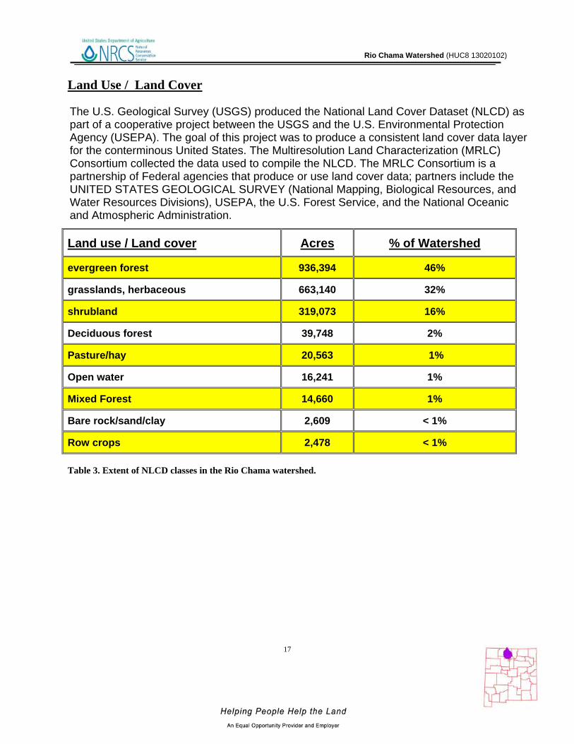
Land Use / Land Cover 8,9
Figure 7. Subset of the National Land Cover Dataset over the Rio Chama Watershed.
Rio Chama Watershed (HUC8 13020102)
17
Land Use / Land Cover
Table 3. Extent of NLCD classes in the Rio Chama watershed.
Land use / Land cover Acres % of Watershed
evergreen forest 936,394 46%
grasslands, herbaceous 663,140 32%
shrubland 319,073 16%
Deciduous forest 39,748 2%
Pasture/hay 20,563 1%
Open water 16,241 1%
Mixed Forest 14,660 1%
Bare rock/sand/clay 2,609 < 1%
Row crops 2,478 < 1%
The U.S. Geological Survey (USGS) produced the National Land Cover Dataset (NLCD) as part of a cooperative project between the USGS and the U.S. Environmental Protection Agency (USEPA). The goal of this project was to produce a consistent land cover data layer for the conterminous United States. The Multiresolution Land Characterization (MRLC) Consortium collected the data used to compile the NLCD. The MRLC Consortium is a partnership of Federal agencies that produce or use land cover data; partners include the UNITED STATES GEOLOGICAL SURVEY (National Mapping, Biological Resources, and Water Resources Divisions), USEPA, the U.S. Forest Service, and the National Oceanic and Atmospheric Administration.

Rio Chama Watershed (HUC8 13020102)
Land Use / Land Cover
Figure 8. Subset of the SWREGAP over the Rio Chama Watershed. The 12 dominant ecosystems are displayed in the legend.

Rio Chama Watershed (HUC8 13020102)
19
Land Use / Land Cover
Ecosystem Acres % of
WatershedRocky Mountain Ponderosa Pine Woodland 488,800 24 Southern Rocky Mountain Pinyon-Juniper Woodland 420,300 21 Inter-Mountain Basins Big Sagebrush Shrubland 157,200 8 Inter-Mountain Basins Semi-Desert Grassland 100,100 5 Rocky Mountain Montane Dry-Mesic Mixed Conifer Forest and Woodland 93,600 5 Rocky Mountain Aspen Forest and Woodland 91,000 5 Rocky Mountain Gambel Oak-Mixed Montane Shrubland 88,400 4 Inter-Mountain Basins Semi-Desert Shrub Steppe 88,000 4 Southern Rocky Mountain Juniper Woodland and Savanna 51,800 3 Rocky Mountain Subalpine Dry- Mesic Spruce-Fir Forest and Woodland 47,300 2 Rocky Mountain Montane Mesic Mixed Conifer Forest and Woodland 45,200 2 Southern Rocky Mountain Montane-Subalpine Grassland 44,800 2 Colorado Plateau Pinyon-Juniper Woodland 34,500 2 Western Great Plains Foothill and Piedmont Grassland 25,600 1 Rocky Mountain Subalpine Mesic Meadow 23,900 1 Rocky Mountain Subalpine Mesic Spruce-Fir Forest and Woodland 21,400 1 Inter-Mountain West Aspen-Mixed Conifer Forest and Woodland 20,300 1 Open Water 17,500 1 Rocky Mountain Lower Montane Riparian Woodland and Shrubland 15,900 1 Rocky Mountain Alpine-Montane Wet Meadow 15,300 1 Colorado Plateau Mixed Bedrock Canyon and Tableland 14,400 1 Rocky Mountain Cliff and Canyon 13,500 1 Agriculture 12,400 1 Western Great Plains Riparian Woodland and Shrubland 7,500 < 1
Table 4. SW Region Gap analysis ecosystem acreages. Reported to the nearest hundred acres
The landcover mapping effort for the Southwest Region Gap Analysis Project was a coordinated multi-institution endeavor. This dataset was created for regional terrestrial biodiversity assessment. Additional objectives were to establish a coordinated mapping approach to create detailed, seamless maps of land cover, all native terrestrial vertebrate species, land stewardship, and management status, and to analyze this information to identify those biotic elements that are underrepresented on lands managed for their long term conservation.

Rio Chama Watershed (HUC8 13020102)
20
Hydrology10,11,12,13,14,15,16 The National Hydrography Dataset (NHD) is a comprehensive set of data that encodes information about naturally occurring and constructed bodies of water, paths through which water flows, and related entities. The NHD identifies 9,539 miles (15,348 km) of water courses in the Rio Chama River Watershed. The majority of these courses typically flow intermittently in summer months during periods associated with high intensity convective thunderstorms.
Figure 9. National Hydrologic Dataset (NHD) of the Rio Chama.

Rio Chama Watershed (HUC8 13020102)
Water Course Type Miles
Artificial path 445
Connector 4
Canal / Ditch 134
Intermittent Stream / River 8,150
Perennial Stream / River 806
Sum (∑) 9,539
Table 5. NHD Water Course Type and Extents

Rio Chama Watershed (HUC8 13020102)
There are 15 water gauging stations in the watershed. USGS Site 08290000 is near the SE corner of the watershed on the Rio Chama near Chamita, NM. During the period 1971 – 2009, this site has had mean annual discharge of 570.8 cubic feet per second ranging from 234 (1972) to 922.6 (1987) cubic feet per second.
Figure 10. Gauging Stations in the Rio Chama Watershed

Rio Chama Watershed (HUC8 13020102)
Hydrology
Figure 11. Monthly Average of Mean Daily Flow on the Rio Chama near Chamita, NM. Period of observation: 1970-2009.
The Rio Chama watershed was identified as a priority participant for the Office of the State Engineer’s Active Water Resource Management (AWRM) plan. The AWRM initiative was launched in January 2004 in response to continued drought conditions in New Mexico. Active Water Resource Management refers to the essential tools and elements needed to enable the State Engineer to actively manage the state’s limited water resources. In New Mexico, the state constitution makes priority of right the basis for water administration. However, recent drought years have compelled the State Engineer to realize that, should it become necessary to conduct priority administration, the tools necessary to do so are not yet in place. The tools for AWRM include: measuring and metering, rules and regulations, creation of water districts and appointment of water masters, and development of water master manuals.
In the Rio Chama Basin, the State Engineer currently administers the release and delivery of the San Juan-Chama Project water. The entire Rio Chama watershed is targeted for Active Water Resource Management. A Water Master was hired for the Rio Chama.
0
200
400
600
800
1000
1200
1400
1600
Jan Feb Mar Apr May Jun Jul Aug Sep Oct Nov Dec
CFS
CFS
Rio Chama Watershed (HUC8 13020102)
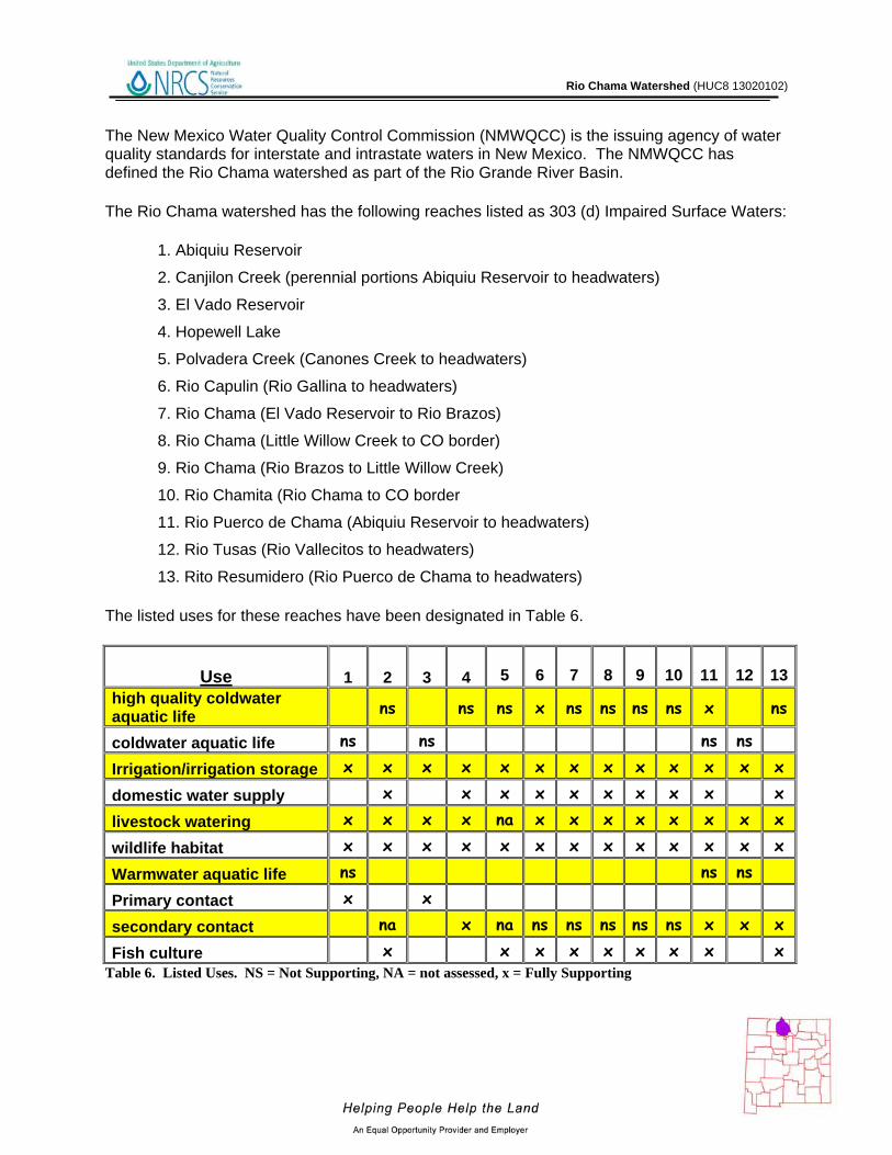
The New Mexico Water Quality Control Commission (NMWQCC) is the issuing agency of water quality standards for interstate and intrastate waters in New Mexico. The NMWQCC has defined the Rio Chama watershed as part of the Rio Grande River Basin.
The Rio Chama watershed has the following reaches listed as 303 (d) Impaired Surface Waters:
1. Abiquiu Reservoir
2. Canjilon Creek (perennial portions Abiquiu Reservoir to headwaters)
3. El Vado Reservoir
4. Hopewell Lake
5. Polvadera Creek (Canones Creek to headwaters)
6. Rio Capulin (Rio Gallina to headwaters)
7. Rio Chama (El Vado Reservoir to Rio Brazos)
8. Rio Chama (Little Willow Creek to CO border)
9. Rio Chama (Rio Brazos to Little Willow Creek)
10. Rio Chamita (Rio Chama to CO border
11. Rio Puerco de Chama (Abiquiu Reservoir to headwaters)
12. Rio Tusas (Rio Vallecitos to headwaters)
13. Rito Resumidero (Rio Puerco de Chama to headwaters)
The listed uses for these reaches have been designated in Table 6.
Use 1 2 3 4
5
6
7
8
9
10
11
12
13
high quality coldwater aquatic life ns ns ns x ns ns ns ns x ns
coldwater aquatic life ns ns ns ns
Irrigation/irrigation storage x x x x x x x x x x x x x
domestic water supply x x x x x x x x x x
livestock watering x x x x na x x x x x x x x
wildlife habitat x x x x x x x x x x x x x
Warmwater aquatic life ns ns ns
Primary contact x x
secondary contact na x na ns ns ns ns ns x x x
Fish culture x x x x x x x x x Table 6. Listed Uses. NS = Not Supporting, NA = not assessed, x = Fully Supporting

Rio Chama Watershed (HUC8 13020102)
Figure 12. 303(d) Impaired Waters. (numbers reference Table 6 stream reaches).

Rio Chama Watershed (HUC8 13020102)
26
Hydrology Under section 303(d) of the Clean Water Act, states, territories, and authorized tribes, are required to develop lists of impaired waters. These are waters for which technology-based regulations and other required controls are not stringent enough to meet the water quality standards set by states. The law requires that states establish priority rankings for waters on the lists and develop Total Maximum Daily Loads (TMDLs), for these waters. A TMDL is a calculation of the maximum amount of a pollutant a water body can receive and still safely meet water quality standards. Within the Rio Chama Watershed, there are several bodies of water that are listed as impaired as of the 2010-12 listing cycle. The river and stream reaches total 173.6 miles (279.38 km) and the listed water bodies cover 10,048 ac (40.66 sq. km).
Table 7. Clean Water Act reaches and impairments within the Mimbres watershed. Bear Canyon Reservoir, approximately 2 miles above the town of Mimbres, NM, supports a non-native sport fishery including channel catfish (Ictalurus punctatus), largemouth bass (Micropterus salmoidesi), and rainbow trout (Oncorhynchus mykiss). Sediment accumulation in Bear Canyon Reservoir in the past has prompted draining and excavation to improve sportfish habitat. Though the rate of sediment deposition is expected to diminish as watershed conditions improve, excavation is likely to again be necessary. Table 7. Possible Causes of Impairment
Impairment
Dissolved Oxygen
Temp-erature
Nutrient/ Eutrophi- cation
Total Fecal and Coliform
Mercury Or aluminum Turbidity
PCB’s
Specific Conductance
Sedi-menta-tion
1 x X (Hg) x
2 x x x x
3 x
4 x
5 x x
6 x
7 x x x x(Al) x
8 x x x(Al)
9 x x x x(Al) x
10 x x x x(Al) x
11 x x x x(Al)
12 x
13

Rio Chama Watershed (HUC8 13020102)
Figure 13. Declared Groundwater Basins of the Rio Chama.
A declared groundwater basin is an area of the state proclaimed by the State Engineer to be underlain by a groundwater source having reasonably ascertainable boundaries. By such proclamation the State Engineer assumes jurisdiction over the appropriation and use of groundwater from the source. The New Mexico portion of the Rio Chama watershed is completely within the Northern Rio Grande Underground Water Basin. The surface watershed in NM covers 1,967,952 of the approximately 4.97 million acres of the underground water basin in NM.

Rio Chama Watershed (HUC8 13020102)
28
Threatened and Endangered Species 17
Endangered species are those that are at risk of extinction throughout all or a significant portion of its native range. A threatened species is one that is likely to become endangered in the foreseeable future. The New Mexico Natural Heritage program tracks the status of threatened and endangered species which are listed on both federal and state lists. Table 8 lists those species which are currently listed and tracked in the Rio Chama River Watershed.
Table 8. Threatened and Endangered Plant and Animal Species.
Common Name Scientific Name Tax.Class Family Fed
StatusState
Status Rio Grande silvery
minnow Hybognathus amarus Actinopterygii Cyprinidae LE E
Boreal Toad Bufo boreas boreas Amphibia Bufonidae E
Jemez Mountains Salamander
Plethodon neomexicanus
Amphibia Plethodontidae E
American Peregrine Falcon
Falco peregrinus anatum
Aves Falconidae T
Boreal Owl Aegolius funereus Aves Strigidae T
Mexican spotted owl Strix occidentalis lucida Aves Strigidae LT
SW Willow Flycatcher Empidonax trailii extimus Aves Tyranni LE E
New Mexican Jumping Mouse
Zapus hudsonius luteus Mammalia Dipodidae E
American Marten Martes americana Mammalia Mustelidae T

Rio Chama Watershed (HUC8 13020102)
Invasive Species 18
Invasive species are those which have been introduced into a region or ecosystem and have the ability to out-compete native species for resources (i.e. water, nutrients, sunlight, etc.) The Southwest Exotic Plant Mapping Program (SWEMP) is a collaborative effort between the United States Geological Survey and federal, tribal, state, county and non-government organization partners in the southwest which maintains ongoing efforts to compile and distribute regional data on the occurrence of non-native invasive plants in the southwestern United States. Within the Rio Chama watershed, the SWEMP has identified 7 species of invasive plants (Table 9). Each of these species is defined as non-native by the USDA PLANTS database.
Scientific Name Common Name
Scrophylariaceae (Figwort Family) Dalmatian Toadflax
Brassicaceae (Mustard Family) Hoary Cress (Whitetop)
Euphorbiaceae (Spurge Family) Leafy Spurge
Asteraceae (Sunflower Family) Musk Thistle
Brassicaceae (Mustard Family) Perennial Pepperweed (Tall Whitetop)
Asteraceae (Sunflower Family) Russian Knapweed
Asteraceae (Sunflower Family) Spotted Knapweed Table 9. Invasive Species Recognized by the SWEMP.

Rio Chama Watershed (HUC8 13020102)
30
Common Resource Areas19
A Common Resource Area (CRA) is defined as a geographical area where resource concerns, problems, or treatment needs are similar. It is considered a subdivision of an existing Major Land Resource Area (MLRA) designation. Landscape conditions, soil, climate, human considerations, and other natural resource information are used to determine the geographic boundaries of a Common Resource Area.
Each Common Resource Area will have multiple Conservation System Guides associated with it. A Conservation System Guide associates, for a given CRA and land use, different components of Resource Management Systems and their individual effect on conserving soil and water resources.
Figure 14. Common Resource Areas of the Rio Chama.

Rio Chama Watershed (HUC8 13020102)
Common Resource Areas
36.2 – Southwest Plateaus, Mesas, and Foothills – Warm Semiarid Mesas and Plateaus This area encompasses the lower elevation mesas and plateaus. The temperature regime is mesic and the moisture regime is transitional from ustic to aridic. Vegetation is typically twoneedle pinyon, Utah juniper, and big sagebrush. Cropland is a significant land use in parts of this area, particularly on soils formed in thick deposits of eolian material. Precipitation ranges from 10 to about 16 inches. Elevations range from about 6,000 to 7.000 feet.
48.1 – Southern Rocky Mountains – High Mountains and Valleys This area is best characterized by steep, high mountain ranges and associated mountain valleys. The temperature regimes are mostly frigid and cryic; moisture regimes are mainly ustic and udic. Vegetation is sagebrush-grass at low elevations, and with increasing elevation ranges from coniferous forest to alpine tundra. Elevations range from 6,500 to 14,400 feet.
36.1 – Southwest Plateaus, Mesas, and Foothills – Cool Subhumid Mesas and Foothills This area encompasses the higher elevation mesas and foothills that represent a transition to the Southern Rocky Mountains. The temperature regime is frigid, and the moisture regime is ustic. The typical vegetation is big sagebrush, Gambel oak, and ponderosa pine. Land use is mainly forest and grazing land.

Rio Chama Watershed (HUC8 13020102)
32
Conservation 20
The USDA-Natural Resources Conservation Service (NRCS) focuses on the development and delivery of high quality products and services that enable people to be good stewards of our Nation’s soil, water, and related natural related resources on non-Federal lands. The Natural Resources Conservation Service’s conservation programs aid agricultural producers in their efforts to reduce soil erosion, enhance water supplies, improve water quality, increase wildlife habitat, and reduce damages caused by floods and other natural disasters. Public benefits include enhanced natural resources that help sustain agricultural productivity and environmental quality while supporting continued economic development, recreation, and scenic beauty.

Rio Chama Watershed (HUC8 13020102)
Conservation Practice
2006 2007 2008 2009 2010 TOTAL
# Acres # Acres # Acres # Acres # Acres
# Acres
Access Control 1 1 1 1
Brush Management 6 631 1 4 16 1,375 9 71 11 281 43 2,362
Conservation Crop Rotation
2 4 2 4
Cover Crop 1 3 1 3 2 6
Early Successional Habitat Dev/Mgmt
1 40 1 40
Forage and Biomass Planting
10 533 16 240 15 136 10 68 9 58 60 1,035
Forage Harvest Management
10 139 11 89 9 104 6 100 6 47 42 479
Forest Slash Treatment
2 50 2 50
Forest Stand Improvement
1 50 1 40 1 32 1 7 6 87 10 216
Grazing Land Mechanical Treatment
1 1 1 1
Integrated Pest Management
3 30 3 40 5 28 6 49 8 60 25 207
Irrigation Land Leveling
2 20 3 35 5 55
Irrigation System, Sprinkler
7 834 3 13 10 21 2 13 4 20 26 901
Irrigation Water Management
8 47 10 374 12 150 5 42 10 1,363 45 1,976
Land Smoothing 2 16 5 30 5 39 1 11 7 54 20 150
Nutrient Management
3 30 7 36 6 34 4 37 5 6 25 143
Prescribed Grazing 9 3,981 1 491 9 11,188 5 16,028 6 3,226 30 34,914
Range Planting 1 20 1 4 2 245 4 51 3 67 11 387
Residue Management
4 6 4 6
Residue Mgmt, Seasonal
1 1 2 4 3 5
Stream Habitat Imp and Mgmt
1 1 1 1
Tree/Shrub Establishment
1 4 2 362 7 72 1 1 11 439
Upland Wildlife Habitat Mgmt
12 2,792 5 19,374 14 13,375 4 19,303 4 891 39 55,735
SUM (∑) 74 9,144 65 20,739 114 27,103 68 35,876 88 6,251 409 99,113
Table 10. 5 Year Trends in Applied Conservation Practices. Reported in Acres.

Rio Chama Watershed (HUC8 13020102)
Conservation Practice
2006 2007 2008 2009 2010 TOTAL
# Feet # Feet # Feet # Feet # Feet # Feet Above-Ground, Multi-Outlet Pipeline
1 300 2 2,580 3 2880
Conservation Completion Incentive First Year
2 1 3
Diversion 1 100 2 4,000 1 950 4 5050
Fence 10 25,612 6 10,464 12 80,888 7 14,837 5 55,449 40 187250
Firebreak 1 300 1 300 Grade Stabilization Structure
1 7 14 22
Irrigation Field Ditch 7 8,096 8 11,466 2 5,321 2 2,308 19 27191 Irrigation Water Conveyance, Pipeline, High-Pressure, Underground, Plastic
4 1,573 4 1,485 6 3,052 4 5,292 4 4,543 22 15945
Irrigation Water Conveyance, Pipeline, Low-Pressure, Underground, Plastic
3 4,755 6 6,223 1 2,363 2 725 12 14066
Irrigation Water Conveyance, Pipeline, Steel
8 303 2 711 7 321 9 246 26 1581
Irrigation Water Conveyance, Pipeline, Rigid Gated Pipeline
1 60 4 2,180 1 780 6 3020
Pipeline 1 1 3 5,100 3 13,264 1 2,675 8 21040
Pond 9 1 4 4 5 23
Pumping Plant 6 3 7 4 3 23 Surface Drain, Main or Lateral
1 10 1 10
Structure for Water Control
25 9 17 20 17 88
Water Well 1 2 3
Watering Facility 8 5 1 2 1 17 Windbreak/Shelterbelt Establishment
2 1,391 2 1391
SUM (∑) 78 NA 47 NA 65 NA 65 NA 68 NA
323
279724
Table 11. 5 Year Trends in Location Specific Applied Conservation Practices. Reported in Feet if Linear (i.e. fence)

Rio Chama Watershed (HUC8 13020102)
35
Soil Resource Inventory 21
Figure 15. National Cooperative Soil Survey coverage of the Rio Chama Watershed.
The Rio Chama Watershed has a number of certified National Cooperative Soil Survey (NCSS) inventories. The National Forests in New Mexico are not covered, but have soils information available through their Terrestrial Ecosystem Unit Inventories. These will be integrated with the National Cooperative Soil Survey (NCSS) inventories in the next few years.
National Cooperative Soil Survey

Rio Chama Watershed (HUC8 13020102)
36
Soil Resource Inventory
In order to evaluate the susceptibility of erosion within the Rio Chama watershed, a model was developed using Soil Survey Geographic Database (SSURGO) information. The soil properties saturated hydraulic conductivity, soil loss tolerance, and wind erodibility group were used in conjunction with slope to assess soil mapunit potential for erosion. Saturated hydraulic conductivity and slope are reported in SSURGO databases as interval/ratio data whereas wind erodibility and soil loss tolerance are ordinal data. Data transformations for the model are listed -
Table 12. Criteria Used for Soil Erosion Susceptibility Model.
SSURGO Value Nominal Description Model Rank
Saturated Hydraulic Conductivity
µm / s 705.0 - 100.0 Very High 0 100.0 - 10.0 High 1
10.0 - 1.0 Moderately High 2 1.0 - 0.1 Moderately Low 3 0.1 - 0.01 Low 4
Slope % 0 - 5 0 5 - 10 1
10 - 15 2 15 - 25 3
> 25 4
Soil Loss Tolerance 5 High Tolerance For loss 0 4 ↓ 1 3 ↓ 2 2 ↓ 3 1 Low Tolerance For Loss 4
Wind Erodibility Group 1 Very High 4 2 Very High 4 3 High 3 4 High 3 4L High 3 5 Moderate 2 6 Moderate 2 7 Moderate 1 8 Slight 0

Rio Chama Watershed (HUC8 13020102)
37
Soil Resource Inventory
For each soil map unit (discrete delineation), the soil properties (named above) of the dominant soil type was used as the condition to be evaluated in the susceptibility to erosion model. Miscellaneous areas such as gravel pits, water, riverwash, etc. were excluded from evaluation. Possible range of values for each map unit are 0 – 16. Increasing values represent a higher susceptibility to soil erosion. Forest Service Soils are not able to be included in the model at this time.
Figure 16. Rio Chama Watershed Erosion Potential.

Rio Chama Watershed (HUC8 13020102)
38
Soil Resource Inventory
Table 13. Soil Erosion Potential Model Results. A greater rank indicates greater potential for erosion.
Rank Acres
1 836
2 86
3 34,009
4 140,617
5 886,504
6 194,264
7 253,267
8 91,166
9 65,999
10 57,242
11 26,187
12 3,480
13 39,426
14 3,298
15 41
Sum( ∑) 1,796,422

Rio Chama Watershed (HUC8 13020102)
39
Socioeconomic Data 22
COUNTY
Total population:
Total
Total population:
Urban
Total population:
Rural
Total Pop,: Rural Farm
Total Pop.: Rural
Nonfarm
Total population: Hispanic or Latino
Total population:
White alone
Total population:
Black or African
American alone
Total population: American Indian and
Alaska Native alone
Total population:
Asian alone
Total population:
Native Hawaiian and Other
Pacific Islander alone
Total population:
Some other race
alone
Total population:
Two or more races
Families: Median family
income adj. 2008
Rio Arriba 41,190 17,678 23,512
544
22,968 30,025 23,320 143 5,717 56 47 10,554 1,353 $41,387
Sandoval 89,908 68,906 21,002
161
20,841 26,437 58,512 1,535 14,634 894 98 11,118 3,117 $56,479
Taos 29,979 12,171 17,808
291
17,517 17,370 19,118 105 1,975 114 35 7,447 1,185 $37,778
Archuleta (CO)
9,898 3,644 6,254 238 6,016 1,659 8,743 35 139 31 3 690 257 $43,259
Conejos (CO)
8,400 0 8,400 547 7,853 4,949 6,112 18 142 13 6 1,806 303 $29,066
Table 14. Socioeconomic Data of the Counties in the Watershed (2000).

Rio Chama Watershed (HUC8 13020102)
40
References 1. Quintana, F. L. 1991. Pobladores: Hispanic Americans of the Ute Frontier. Second Edition. University of Notre Dame Press. Notre Dame, IN. 267 pp. 2. Robson, S.G. and Banta, E.R., 1995, Ground Water Atlas of the United States Arizona, Colorado, New Mexico, Utah: US Geological Survey Hydrologic Atlas 730-C, Washington, DC. 3. Pazzaglia, F.J., 2005, River Responses to Ice Age (Quaternary) Climates in New Mexico: in Lucas, S.G., Morgan, G.S. and Zeigler, K.E., eds., New Mexico’s Ice Ages, NM Museum of Natural History and Science Bull. No. 28. 4. Parameter-elevation Regressions on Independent Slopes Model (PRISM).PRISM is a unique knowledge-based system that uses point measurements of precipitation, temperature, and other climatic factors to produce continuous, digital grid estimates of monthly, yearly, and event-based climatic parameters. http://www.prism.oregonstate.edu/ 5. Bureau of Land Management – New Mexico State Office. - http://www.blm.gov/nm/st/en/prog/more/geographic_sciences/spatial_data_metadata.html 6. Bureau of Land Management – Colorado State Office. – http://www.blm.gov/co/st/en/BLM_Programs/geographical_sciences/gis/metadata.html 7. USDA Forest Service – Southwest Coordination Center – http://gacc.nifc.gov/swcc/predictive/intelligence/intelligence.htm 8. UNITED STATES GEOLOGICAL SURVEY - National Land Cover Dataset. http://landcover.United States Geological Survey.gov/ 9. Southwest Regional Gap Analysis Project (SWReGAP). http://earth.gis.usu.edu/swgap/ 10. UNITED STATES GEOLOGICAL SURVEY – National Hydrography Dataset. http://nhd.United States Geological Survey.gov/ 11. State of New Mexico Department of Game and Fish - http://www.wildlife.state.nm.us/conservation/comp_wildlife_cons_strategy/documents/ch5_Rio Chama.pdf 12. State of New Mexico Environment Department - http://www.nmenv.state.nm.us/swqb/Chama/intro.pdf, http://www.nmenv.state.nm.us/swqb/Surveys/LowerChama1999.pdf 13. State of New Mexico Clean Water Act 303(d)/305(b) Integrated Report ftp://ftp.nmenv.state.nm.us/www/swqb/303d-305b/2010/USEPA-Approved303dList.pdf 14. United States Environmental Protection Agency - http://cfpub.epa.gov/surf/huc.cfm?huc_code=13020102

15. UNITED STATES GEOLOGICAL SURVEY - http://waterdata.usgs.gov/nwis/rt 16. New Mexico - Office of the State Engineer- http://www.ose.state.nm.us/water_info_data.html 17. New Mexico Natural Heritage Program - http://nhnm.unm.edu/ 18. Southwest Exotic Plant Mapping Program - http://www.invasiveweeds.com/mapping/welcome.html 19. Natural Resources Conservation Service – Common Resource Area (CRA) Geographic Database http://soils.usda.gov/survey/geography/cra.html 20. Natural Resources Conservation Service – Performance Results System http://ias.sc.egov.usda.gov/PRSHOME/ 21. Natural Resources Conservation Service – Soil Data Mart http://soildatamart.nrcs.usda.gov/ 22. United States Census Bureau - http://factfinder.census.gov/home/saff/main.html?_lang=en