rare vertebrate species inventory - national park service€¦ · national park service . u.s....
TRANSCRIPT

National Park Service U.S. Department of the Interior Natural Resource Program Center
Sand Creek Massacre National Historic Site
Rare Vertebrate Species Inventory Natural Resource Report NPS/SOPN/NRTR—2008/001

ON THE COVER Sand Creek Massacre National Historic Site: Grassland along Big Sandy Creek Sand Creek north of the monument. Photograph by: John R. Sovell

Sand Creek Massacre National Historic Site
Rare Vertebrate Species Inventory Natural Resource Report NPS/SOPN/NRTR—2008/001 John Sovell, Jodie Bell, and Stephanie Neid John Sovell Colorado Natural Heritage Program Colorado State University 254 General Services Building Fort Collins, CO 80523 Prepared for: National Park Service Inventory and Monitoring Program Southern Plains Network Johnson City, Texas
June 2008 U.S. Department of the Interior National Park Service Natural Resource Program Center Fort Collins, Colorado
i

ii
The Natural Resource Publication series addresses natural resource topics that are of interest and applicability to a broad readership in the National Park Service and to others in the management of natural resources, including the scientific community, the public, and the NPS conservation and environmental constituencies. Manuscripts are peer-reviewed to ensure that the information is scientifically credible, technically accurate, appropriately written for the intended audience, and is designed and published in a professional manner. The Natural Resources Technical Reports series is used to disseminate the peer-reviewed results of scientific studies in the physical, biological, and social sciences for both the advancement of science and the achievement of the National Park Service’s mission. The reports provide contributors with a forum for displaying comprehensive data that are often deleted from journals because of page limitations. Current examples of such reports include the results of research that addresses natural resource management issues; natural resource inventory and monitoring activities; resource assessment reports; scientific literature reviews; and peer reviewed proceedings of technical workshops, conferences, or symposia. Views, statements, findings, conclusions, recommendations and data in this report are solely those of the author(s) and do not necessarily reflect views and policies of the U.S. Department of the Interior, NPS. Mention of trade names or commercial products does not constitute endorsement or recommendation for use by the National Park Service. Printed copies of reports in these series may be produced in a limited quantity and they are only available as long as the supply lasts. This report is also available from the Heartland I&M Network website (http://www.nature.nps.gov/im/units/HTLN) on the internet, or by sending a request to the address on the back cover. Please cite this publication as: Sovell, J. R., J. Bell, and S. Neid. 2008. Sand Creek Massacre National Historic Site Rare Vertebrate Species Inventory. Natural Resource Technical Report NPS/SOPN/NRTR—2007/001. National Park Service, Fort Collins, Colorado. NPS D-XXX, April 2009

Contents Page
Contents ......................................................................................................................................... iii
List of Tables .................................................................................................................................. v
Figures of Figures .......................................................................................................................... vi
Figures of Figures .......................................................................................................................... vi
Introduction..................................................................................................................................... 1
Project Scope of Work .............................................................................................................. 1
Study Area 7
Location and Regional Setting.................................................................................................. 7
Vegetation ................................................................................................................................. 8
Wildlife ................................................................................................................................... 10
Other Physical Characteristics ................................................................................................ 11
Methods 15
Plains Ambrosia (Ambrosia linearis)...................................................................................... 15
Burrowing Owl (Athene cunicularia) ..................................................................................... 15
Ferruginous Hawk (Buteo regalis).......................................................................................... 15
Mountain plover (Charadrius montanus) ................................................................................ 16
Black-tailed prairie dog (Cynomys ludovicianus)................................................................... 16
Arkansas darter (Etheostoma cragini) .................................................................................... 16
Texas horned lizard (Phrynosoma cornutum)......................................................................... 17
Lesser prairie chicken (Tympanuchus pallidicinctus) ............................................................ 17
Swift fox (Vulpes velox).......................................................................................................... 17
Results........................................................................................................................................... 19
Translocation of Lesser Prairie Chicken....................................................................................... 26
iii

Discussion..................................................................................................................................... 29
Literature Cited ............................................................................................................................. 31
iv

List of Tables Page
Table 1. Definition of natural heritage imperilment ranks. .............................................................4
Table 2. Element occurrence ranks and their definitions.................................................................6
Table 3. The plant communities and their area totals for the established SAND boundary............8
Table 4. Priority species for consideration in the Sand Creek Rare Species Inventory.................13
Table 5. Sampling dates at SAND and focal species searched for during each trip......................19
Table 6. Endangered, threatened, and species of conservation concern recorded from SAND. ...21
Table 7. Common animal species observed at Sand Creek National Historic Site during summer 2006.................................................................................................................................23
Table 7. Habitat requirements for the lesser prairie chicken. ........................................................27
v

vi
Figures of Figures Page
Figure 1. Regional setting of the Sand Creek Massacre National Historic Site. .............................2
Figure 2. Authorized and established park boundaries of Sand Creek Massacre National Historic Site. ...................................................................................................................................7
Figure 3. Vegetation map of Sand Creek Massacre National Historic Site.....................................9
Figure 4. A research scientist dipnets for small fishes at a wetland within SAND. ......................17
Figure 5. Black-tailed prairie dog ..................................................................................................20
Figure 6. Burrowing Owl...............................................................................................................20
Figure 7. Northern leopard frog. ....................................................................................................20
Figure 8. Distribution of endangered, threatened and species of concern at SAND. ....................22
Figure 9. Lek sites, historic lek sites, and production areas (nesting and brood rearing habitat defined as 2.4 km buffer zone around each lek site) of the lesser prairie chicken (after CNHP and CDOW).........................................................................................................26

Introduction Sand Creek Massacre National Historic Site (SAND) was authorized by the U. S. Congress in November of 2000 with an area of 12,500 acres for inclusion in the park boundaries. SAND is on the high plains of southeastern Colorado. It is in north-central Kiowa County near the border with Cheyenne County and is located 15 miles NNE of Eads, Colorado (Figure 1). These counties are on the state line bordering Kansas and SAND is approximately 25 miles from the Kansas state line. SAND is surrounded by dryland agricultural fields and rangeland. The current established boundary of SAND encompasses approximately 2,400 acres, which is managed by the National Park Service (NPS). The objective of the NPS is to preserve, protect, interpret, commemorate and memorialize the site for future generations. This includes preservation of the native biological resources found at the site. The NPS has divided the nation’s park units into networks based upon geographic similarities, common natural resources, and resource protection challenges. SAND is part of the Southern Plains Inventory and Monitoring Network (SOPN), but it was a late addition to the network and was not part of the Inventory and Monitoring Program’s original 270 target parks. The SOPN encompasses 11 park units in Colorado, New Mexico, Kansas, Oklahoma and Texas. Through biological inventories the NPS Inventory and Monitoring Network provides park managers with information about selected biological resources occurring within their park boundaries. The information from biological inventories assists with the development of both effective monitoring programs and effective management strategies for resource management and protection. The SOPN has undertaken a series of inventories across its park units, which includes documenting the presence and distribution of vertebrate animals and vascular plants. However SAND was not included in the initial inventory work conducted by the SOPN. Consequently, the NPS and the SOPN contracted with Colorado State University and the Colorado Natural Heritage Program (CNHP) to perform a rapid assessment biological inventory of the vertebrate biological resources at SAND. Project Scope of Work Information on the animal biological resources at SAND is incomplete. The objective of this project was to perform a biological assessment of the rare vertebrate species that occur, or have the potential to occur at SAND. The vertebrate assessment for SAND occurred within the established park boundary (Figure 1). The established park boundary is currently held by NPS while the authorized boundary surrounding the established boundary is in private ownership1. To accomplish the vertebrate assessment required a number of steps including office research and preparation prior to field work to identify species with the potential to inhabit SAND, development of a sampling design that will maximize the probability of observing all at risk species with the
1 The 105th Congress of the United States authorized the Sand Creek Massacre National Historic Site Study Act on October 6, 1998. Following a site location study the Sand Creek Massacre National Historic Site was authorized with Public Law 106-465, which requires “the National Park Service to acquire from willing sellers enough area to adequately protect, interpret, memorialize, and commemorate the site.” Of the proposed 12,500 acre site (“authorized” park boundary), 1555 acres have been acquired; this is the “established” park boundary (NPS 2005).
1

Figure 1. Regional setting of the Sand Creek Massacre National Historic Site.
2

potential to occur at SAND, implementation of the sampling design in the field, synthesis of the collected data, and production of a report based on the outcome of the data synthesis. Development of a species list and an appropriate sampling design require accurate information on the plant communities at SAND. The CNHP was contracted by SAND in 2005 to map the vegetation at SAND and although the vegetation map was not complete at initiation of this project in the spring of 2006 preliminary data on plant community structure on all 2,400 established acres at SAND was available. In addition, Kiowa County aerial imagery form the USDA’s National Agriculture Imagery Program (NAIP; National Agriculture Imagery Program 2005) was available through CNHP’s vegetation mapping project and both this imagery and the vegetation data were incorporated into development of the vertebrate species list and into construction of the sampling design for the field work phase of the project. Introduction to Natural Heritage Program Methodology and Element Ranking The CNHP is a member of the NatureServe network of natural heritage programs and conservation data centers. The natural heritage programs are located in all the states (and conservation data centers are in all Canadian provinces as well as in several countries in Central and South America). Each program serves as that state's (area’s) biological diversity data center, gathering information and field observations to help develop national and statewide conservation priorities. The multi-disciplinary team of scientists, planners, and information managers at the heritage programs use a standardized methodology to gather information on the rare, threatened, and endangered species and significant natural plant communities that occur in each state. Each program maintains data for species and plant communities that are referred to as “elements of natural diversity” or simply “elements”. Life history, status, and locational data are regularly updated in a comprehensive, shared data system. Sources of element data include published and unpublished literature, museum and herbaria labels, and field surveys conducted by knowledgeable naturalists, experts, agency personnel, and CNHP’s own staff of botanists, ecologists, and zoologists. The Natural Heritage Ranking System The cornerstone of Natural Heritage methodology is the use of a standardized element imperilment ranking system. Ranking species and ecological communities according to their imperilment status provides guidance for where Natural Heritage Programs should focus their information-gathering activities and provides data users with a concise and meaningful tool for decision-making. To determine the status of an element within Colorado, CNHP gathers information on plants, animals, and plant communities. Each of these elements of natural diversity is assigned a rank that indicates its relative degree of imperilment on a five-point scale (1 = critically imperiled, 5 = demonstrably secure). The criteria used to define the element imperilment rank are number of occurrences, size of populations, and overall quality of the populations. The primary criterion is the number of occurrences (in other words, the number of known distinct localities or populations). This factor is weighted more heavily than other factors because an element found in one place is more imperiled than something found in twenty-one places. Also of importance are the size of the geographic range, the number of individuals, the trends in both population and distribution, identifiable threats, and the number of protected occurrences. Element imperilment ranks are assigned both in terms of the element's degree of imperilment within Colorado (its State-rank or S-rank) and the element's imperilment over its entire range (its Global-rank
3

or G-rank). Taken together, these two ranks indicate the degree of imperilment of an element. For example, the lynx, which is thought to be secure in northern North America but is known from less than five current locations in Colorado, is ranked G5 S1 (globally-secure, but critically imperiled in this state). The Rocky Mountain Columbine, which is known only in Colorado from about 30 locations, is ranked a G3 S3 (vulnerable both in the state and globally, since it only occurs in Colorado and then in small numbers). Further, a tiger beetle that is only known from one location in the world at the Great Sand Dunes National Park and Preserve is ranked G1 S1 (critically imperiled both in the state and globally, because it exists in a single location). CNHP actively collects, maps, and electronically processes specific occurrence information for animal and plant species considered extremely imperiled to vulnerable in the state (S1 - S3). Certain elements are “watchlisted,” meaning that specific occurrence data are periodically analyzed to determine whether more active tracking is warranted. A complete description of each of the Natural Heritage ranks is provided in Table 1. This single rank system works readily for all elements except migratory animal species. Those animals that migrate may spend only a portion of their life cycles within the state. In these cases, it is necessary to distinguish between breeding, non-breeding, and resident species. As noted in Table 2, ranks followed by a "B,” for example S1B, indicate that the rank applies only to the status of breeding occurrences. Similarly, ranks followed by an "N” refer to non-breeding status, typically during migration and winter. Elements without this notation are believed to be year-round residents within the state. Natural Heritage Designations for Rare Species Natural Heritage imperilment ranks should not be interpreted as legal designations. Although most species protected under state or federal endangered species laws are extremely rare, not all rare species receive legal protection. Legal status is designated by either the U.S. Fish and Wildlife Service under the Endangered Species Act, or by the Colorado Division of Wildlife under Colorado Statutes 33-2-105 Article 2. In addition, the U.S. Forest Service recognizes some species as “Sensitive,” as does the Bureau of Land Management. Table 1. Definition of natural heritage imperilment ranks. Rank Definition
G/S1 Critically Imperiled globally/state because of rarity (5 or fewer occurrences in the world/state; or 1,000 or fewer individuals), or because some factor of its biology makes it especially vulnerable to extinction.
G/S2 Imperiled globally/state because of rarity (6 to 20 occurrences, or 1,000 to 3,000 individuals), or because other factors demonstrably make it very vulnerable to extinction throughout its range.
G/S3 Vulnerable through its range or found locally in a restricted range (21 to 100 occurrences, or 3,000 to 10,000 individuals).
G/S4 Apparently Secure globally/state, though it may be quite rare in parts of its range, especially at the periphery. Usually more than 100 occurrences and 10,000 individuals.
G/S5 Demonstrably Secure globally/state, though it may be quite rare in parts of its range, especially at the periphery.
G/SX Presumed Extinct globally, or extirpated within the state. G#? Indicates uncertainty about an assigned global rank. G/SU Unable to assign rank due to lack of available information. GQ Indicates uncertainty about taxonomic status. G/SH Historically known, but usually not verified for an extended period of time.
4

G#T# Trinomial rank (T) is used for subspecies or varieties. These taxa are ranked on the same criteria as G1-G5.
S#B Refers to the breeding season imperilment of elements that are not residents. S#N Refers to the non-breeding season imperilment of elements that are not permanent residents.
Where no consistent location can be discerned for migrants or non-breeding populations, a rank of SZN is used.
SZ Migrant whose occurrences are too irregular, transitory, and/or dispersed to be reliably identified, mapped, and protected.
SA Accidental in the state. SR Reported to occur in the state but unverified. S? Unranked. Some evidence that species may be imperiled, but awaiting formal rarity ranking.
Note: Where two numbers appear in a state or global rank (for example, S2S3), the actual rank of the element is uncertain, but falls within the stated range. Element Occurrences and their Ranking Actual locations of elements, whether they are single organisms, populations, or plant communities, are referred to as element occurrences. The element occurrence is considered the most fundamental unit of conservation interest and is at the heart of the Natural Heritage Methodology. To prioritize element occurrences for a given species, an element occurrence rank (EO-Rank) is assigned according to the size, ecological quality and landscape context of the occurrences whenever sufficient information is available. This ranking system is designed to indicate which occurrences are the healthiest and ecologically the most viable, thus focusing conservation efforts where they will be most successful. The EO-Rank is based on three factors: Size – a measure of the area or abundance of the element’s occurrence. This ranking factor takes into account factors such as area of occupancy, population abundance, population density, population fluctuation, and minimum dynamic area (which is the area needed to ensure survival or re-establishment of an element after natural disturbance). This factor for an occurrence is evaluated relative to other known, and/or presumed viable, examples. Condition/Quality – an integrated measure of the composition, structure, and biotic interactions that characterize the occurrence. This includes measures such as reproduction, age structure, biological composition (such as the presence of exotic versus native species), structure (for example, canopy, understory, and ground cover in a forest community), and biotic interactions (such as levels of competition, predation, and disease). Landscape Context – an integrated measure of two factors: the dominant environmental regimes and processes that establish and maintain the element, and connectivity. Dominant environmental regimes and processes include herbivory, hydrologic and water chemistry regimes (surface and groundwater), geomorphic processes, climatic regimes (temperature and precipitation), fire regimes, and many kinds of natural disturbances. Connectivity includes such factors as a species having access to habitats and resources needed for life cycle completion, fragmentation of ecological communities and systems, and the ability of the species to respond to environmental change through dispersal, migration, or re-colonization. Each of these three factors is rated on a scale of A through D, with A representing an excellent rank and D representing a poor rank. These ranks for each factor are then averaged to determine an appropriate
5

EO-Rank for the occurrence. If not enough information is available to rank an element occurrence, an EO-Rank of E is assigned. EO-Ranks and their definitions are summarized in Table 2. Table 2. Element occurrence ranks and their definitions. Rank Definition A Excellent viability. B Good viability C Fair viability. D Poor viability. H Historic: known from historical record, but not verified for an extended period of time. X Extirpated (extinct within the state). E Extant: the occurrence does exist but not enough information is available to rank. F Failed to find: the occurrence could not be relocated.
6

Study Area Location and Regional Setting As mentioned in the opening paragraph of the Introduction, SAND is located on the high plains of southeastern Colorado in the rain shadow of the Rocky Mountains (Figure 1). The authorized boundary of SAND surrounding the established boundary is in private ownership, and it is surrounded by dryland agricultural fields and rangeland with sparse development (Figure 2).
Figure 2. Authorized and established park boundaries of Sand Creek Massacre National Historic Site.
7

Vegetation Vegetation at SAND is a mosaic of sand sagebrush shrubland and shortgrass prairie bisected by a corridor of riparian vegetation (Figure 3). Seven plant communities were identified at SAND in the 2005 vegetation mapping project conducted by CNHP (Table 3, Figure 3). Sand sagebrush occupies the sandhills to the south and west of Big Sandy Creek on SAND and shortgrass prairie generally characterizes the loamier north and east side. The riparian corridor is a mosaic of cottonwood woodland, mesic grassland, and wet meadow surrounding a narrow, braided stream channel. Table 3. The plant communities and their area totals for the established SAND boundary.
Plant community common name
Plant community scientific name
Total area acres (ha) within the established boundary
Sand Sagebrush / Sand Bluestem Shrubland
Artemisia filifolia / Andropogon hallii Shrubland
677.09 (273.94)
Sand Sagebrush / Blue Grama Shrubland
Artemisia filifolia / Bouteloua (curtipendula, gracilis) Shrubland
537.96 (217.65)
Blue Grama– Buffalograss Herbaceous Vegetation
Bouteloua gracilis- Buchloe dactyloides Herbaceous Vegetation
372.23 (150.60)
Plains Cottonwood / Western Wheatgrass – Switchgrass Woodland
Populus deltoids / Pascopyrum smithii – Panicum vergatum Woodland
64.61 (26.14)
Bulrush Wet Meadow Shoenoplectus pungens Herbaceous Vegetation
12.96 (5.24)
Alkali Sacaton – Inland Saltgrass Herbaceous Vegetation
Sporobolus airoides – Distichlis spicata Herbaceous Vegetation
182.31 (73.76)
The shortgrass prairie ecological system occurs east of the Rocky Mountains covering much of the eastern plains of Colorado and extending into adjacent states. It generally occurs on flat to rolling terrain and is characterized by short-statured graminoids, such as grama grasses and buffalograss, and with a sporadic but diverse forb component. Occasionally a limited number of shrubs, e.g., sagebrush (Artemisia spp.), snakeweed (Gutierrezia sarothrae), or yucca (Yucca glauca) may punctuate the landscape (Costello 1944). In general, warm season species are more abundant than cool season species. Primary ecological processes that maintain shortgrass prairie are climate (especially precipitation) and grazing. The rain shadow of the Rocky Mountains restricts the amount of precipitation that falls on the plains, creating arid to semiarid conditions. Historically, grazing by roaming bison herds maintained the short stature of the vegetation. Today, grazing by domestic cattle maintains the vegetation structure; although, cattle herds require an established rotational grazing regime to maintain dynamic vegetation patches that reflect the inherent diversity within the system (NRCS 2004a). Fire is less important in this grassland primarily because xeric conditions tend to decrease fuel loads and thus decrease fire frequency. Drought effects on shortgrass prairie include low production and dieback of vegetation depending on the severity of conditions (Rondeau 2003, Albertson and Weaver 1944).
8

Figure 3. Vegetation map of Sand Creek Massacre National Historic Site.
9

The sand sagebrush ecological system occurs on somewhat excessively to excessively well-drained, deep, sandy soils and is most often associated with ancient dune systems and ancient floodplains. The system is characterized by a sparse to moderately dense short shrub layer of sand sagebrush over a diverse understory. Sand sagebrush is well-adapted to nutrient-poor soils and seed germination requires open, shallow soils. It re-sprouts vigorously after fire and is less palatable to cattle (McWilliams 2003). The herbaceous understory has abundant graminoids as well as diverse forbs. Graminoid species include tallgrass species such as sand bluestem, sand reed, little bluestem (Schizachyrium scoparium), needle and thread (Hesperostipa comata), and sideoats grama. Shorter-statured blue grama is generally ubiquitous within the system. Diverse forbs are often present including sandy indicators like othake (Palafoxia sphacelata), flatspine burr ragweed (Ambrosia acanthicarpa), mountain evening-primrose (Oenothera latifolia), western daisy fleabane (Erigeron bellidiastrum), Andean prairie clover (Dalea cylindriceps), and many others (Clark personal communication 2005, NRCS 2004b, Costello 1944). There is often a relatively high proportion of native annuals in this system, such as annual buckwheat (Eriogonum annuum) and prairie sunflower (Helianthus petiolaris). Species composition within sand sagebrush ecological systems responds to various disturbance mechanisms. Forbs and tallgrasses tend to be highly palatable to domestic cattle and will decrease with increased grazing (NRCS 2004b). Both sand sagebrush and blue grama are thought to increase in cover with continuous grazing. Increasing abundance of these species is considered to be an early stage of desertification as the nutrient balance and energy flow provided by greater plant diversity is compromised. The unconsolidated nature of sandy soils makes them especially susceptible to wind erosion. If vegetation cover is insufficient, vegetation is undermined as wind carries away the substrate; this is termed a blowout. Blowouts of a certain size are a natural dynamic in sandhill systems and tend to have blowout grass (Redfieldia flexuosa), Schweinitz's flatsedge (Cyperus schweinitzii), indian ricegrass (Oryzopsis hymenoides), James' clammyweed (Polanisia jamesii), and others (Ramaley 1939). Decreased plant vigor and cover from drought or from improper levels of grazing can encourage excessive blowouts, which are not desirable (NRCS 2004b). The riparian corridor of Big Sandy Creek is typical of an intermittent stream on the Great Plains. It is a linear ecological system that occupies the floodplain and terraces of Big Sandy Creek. These systems are maintained by hydrology, especially surface and subsurface flow. The porous nature of the bedrock surrounding SAND allows water to flow underground in alluvial aquifers. Further, mineralization increases specific conductance of groundwater resources within the Big Sandy Creek sub-basin; groundwater in this sub-basin is classified as a sodium calcium sulfate bicarbonate type (Coffin 1967). Thus the wet meadow vegetation along Big Sandy Creek has salinity indicator species such as alkali sacaton and inland saltgrass (Anderson et al. 1981). This riparian system is a mosaic of riparian woodland canopy, wet meadow, and wetlands. Wildlife SAND provides a small oasis of shortgrass prairie habitat that is surrounded by agricultural fields and sand sagebrush rangeland. It is habitat for a wide diversity of wildlife associated with shortgrass prairie, such as black-tailed prairie dogs (Cynomys ludovicianus ludovicianus), shortgrass prairie birds, raptors, and pronghorn (Antelocapra americana) (Sovell 2006) and for more generalist wildlife species such as mule deer (Odocoileus hemionus). The region also has an established population of non-native, feral hogs (Sus scrofa), (Hartman 2006).
10
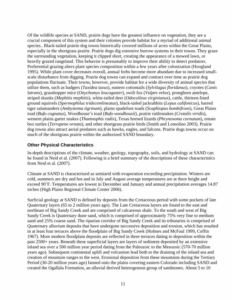
Of the wildlife species at SAND, prairie dogs have the greatest influence on vegetation, they are a crucial component of this system and their colonies provide habitat for a myriad of additional animal species.. Black-tailed prairie dog towns historically covered millions of acres within the Great Plains, especially in the shortgrass prairie. Prairie dogs dig extensive burrow systems in their towns. They graze the surrounding vegetation, keeping it clipped short, creating the appearance of a mowed lawn, or heavily grazed rangeland. This behavior is presumably to improve their ability to detect predators. Preferential grazing alters plant species composition within a few years after colonization (Hoogland 1995). While plant cover decreases overall, annual forbs become more abundant due to increased small-scale disturbance from digging. Prairie dog towns can expand and contract over time as prairie dog populations fluctuate. Their towns, however, provide habitat for a wide diversity of animal species that utilize them, such as badgers (Taxidea taxus), eastern cottontails (Sylvilagus floridanus), coyotes (Canis latrans), grasshopper mice (Onychomys leucogaster), swift fox (Vulpes velox), pronghorn antelope, striped skunks (Mephitis mephitis), white-tailed deer (Odocoileus virginianus), cattle, thirteen-lined ground squirrels (Spermophilus tridecemlineatus), black-tailed jackrabbits (Lepus califonicus), barred tiger salamanders (Ambystoma tigrinum), plains spadefoot toads (Scaphiopus bombifrons), Great Plains toad (Bufo cognatus), Woodhouse’s toad (Bufo woodhousii), prairie rattlesnakes (Crotalis viridis), western plains garter snakes (Thamnophis radix), Texas horned lizards (Phrynosoma cornutum), ornate box turtles (Terrapene ornata), and other shortgrass prairie birds (Smith and Lomolino 2003). Prairie dog towns also attract aerial predators such as hawks, eagles, and falcons. Prairie dogs towns occur on much of the shortgrass prairie within the authorized SAND boundary. Other Physical Characteristics In-depth descriptions of the climate, weather, geology, topography, soils, and hydrology at SAND can be found in Neid et al. (2007). Following is a brief summary of the descriptions of these characteristics from Neid et al. (2007). Climate at SAND is characterized as semiarid with evaporation exceeding precipitation. Winters are cold, summers are dry and hot and in July and August average temperatures are at there height and exceed 90˚F. Temperatures are lowest in December and January and annual precipitation averages 14.87 inches (High Plains Regional Climate Center 2006). Surficial geology at SAND is defined by deposits from the Cretaceous period with some pockets of late Quaternary layers (65 to 2 million years ago). The Late Cretaceous layers are found to the east and northeast of Big Sandy Creek and are comprised of calcareous shale. To the south and west of Big Sandy Creek is Quaternary dune sand, which is comprised of approximately 75% very fine to medium sand and 25% coarse sand. The riparian corridor of Big Sandy Creek and its tributaries is comprised of Quaternary alluvium deposits that have undergone successive deposition and erosion, which has resulted in at least four terraces above the floodplain of Big Sandy Creek (Holmes and McFaul 1999, Coffin 1967). More modern floodplain deposits are reflected in three terraces dating to deposition within the past 2500+ years. Beneath these superficial layers are layers of sediment deposited by an extensive inland sea over a 500 million year period dating from the Paleozoic to the Mesozoic (570-70 million years ago). Subsequent continental uplift and volcanism lead both to the draining of the inland sea and creation of mountain ranges to the west. Erosional deposition from these mountains during the Tertiary Period (30-20 million years ago) fanned onto the plains covering eastern Colorado including SAND and created the Ogallala Formation, an alluvial derived heterogenous group of sandstones. About 5 to 10
11

million years ago additional uplifting resulted in erosional processes on the plains at which time the South Platte and Arkansas rivers eroding broad valleys within the plains. More recently, alternating cycles of wet periods followed by dry periods during the Quaternary (2 million years ago) favored periods of deposition and erosion respectively, which augmented the Great Plains landscape by creating a sequence of terraces in the riparian drainages that are distinguishable by their different sediment characteristics (Holmes and McFaul 1999, May and Holen 1985, Schultz and Stout 1977).. The topography at SAND consists of gently undulating hills comprised of sand plains stabilized by vegetation, dunes of Aeolian deposits, and smooth plains. SAND is bisected by Big Sandy Creek and it is to the north and east of the creek where smooth plains dominated by grassland occur, while to the south and west there are irregularly surfaced sandhills stabilized by sandsage shrubland. These sandhills terminate in a bluff that overlooks Big Sandy creek to the north. The soils at SAND differ dramatically on either side of Big Sandy Creek. To the north and east of the creek where upland plains are found, the soils are loamy and are relatively deep, well drained, low in organic matter, and are susceptible to wind erosion. Native vegetation in these soils is comprised of shortgrass species like blue grama (Bouteloua gracilis), western wheatgrass (Pascopyrum smithii), sideoats grama (Bouteloua curtipendula), and galleta (Pleuraphis jamesii). To the south and west the soils are sandy, they exhibit considerable hill and swale morphology, are very susceptibility to wind erosion, and management concerns are primarily devised to prevent blowouts. Native vegetation in these sandy soils has a strong component of tallgrass species such as sand bluestem (Andropogon hallii), sand reed (Calamovilfa longifolia), sand muhly (Muhlenbergia arenicola), and switchgrass (Panicum virgatum) as well as short and midgrass species such as blue grama and sideoats grama. Valent soils, the sandiest and most arid of the group, have sand sagebrush (Artemisia filifolia). Within the current floodplain of Big Sandy Creek there is a mix of sand and loam soils that developed from the alluvial and aeolian deposits of the ancient alluvial terraces. These sand and loam soils are of shallow depth and overlay a seasonally shallow water table that is from one to three feet below the surface on average in the spring (Anderson et al. 1981). Native vegetation within the channel is characterized by alkali sacaton (Sporobolus airoides), inland saltgrass (Distichlis spicata), switchgrass, western wheatgrass, indiangrass (Sorghastrum nutans), and alkali muhly (Muhlenbergia asperifolia). Big Sandy Creek is the major hydrologic feature at SAND. Like all streams of semiarid climates Big Sandy Creek contains short reaches that maintain perennial flows and there is one such stretch on SAND where a spring fed tributary to the northeast enters the Big Sandy just after the tributary bisects the Chivington Ditch. There are also isolated areas along the entire extent of Big Sandy Creek within the boundary of SAND where pools maintain surface water throughout most of the summer months. These isolated pools are maintained by groundwater recharge through direct infiltration of precipitation and from surface flows after rain events. The primary habitat at the park is short-grass prairie and sandsage shrubland with the intermittent Big Sandy Creek bisecting the park. Short-grass prairie is home to several candidates for federal endangered or threatened species status and several State of Colorado listed species. The SOPN determined that an inventory of the biological resources at SAND was needed. Based on the habitats found at SAND and the plants and animals known to inhabit the surrounding region the SOPN identified nine priority species targeted for inventory at SAND (Table 4) and defined the tasks required to complete this
12
inventory. The presence of a prairie dog complex at SAND increases the chances of several State of Colorado listed species and federal candidate species being present. Table 4. Priority species for consideration in the Sand Creek Rare Species Inventory. Species Common Name Ambrosia linearis plains ambrosia Athene cunicularia Burrowing Owl Buteo regalis Ferruginous Hawk Charadrius montanus Mountain Plover Cynomys ludovicianus black-tailed prairie dog Etheostoma cragini Arkansas darter Phrynosoma cornutum Texas horned lizard Tympanuchus pallidicinctus Lesser Prairie Chicken Vulpes velox swift fox The development of park management plans and monitoring programs requires the knowledge of the presence and condition of T and E species and species of concern. Specifically, several of the species with the potential to inhabit SAND are sensitive to grazing practices (including lack of grazing). All grazing has ceased within the 2,400 acre area acquired by the NPS within the last five years. SAND cannot manage for T and E species and species of concern and develop appropriate general management plans, resource management plans or grassland management practices if the status of these species is unknown. The NPS and the SOPN are interested in surveying the land within the current established boundary for the occurrence of T and E species and species of concern with the potential, or that are known, to inhabit SAND. The NPS and the SOPN contracted with Colorado State University and CNHP to perform a rapid assessment biological inventory of the biological resources at SAND. The objectives of this project are listed below in order of importance.
1. Determine relative abundance and presence of the swift fox. 2. Determine relative abundance and condition of the Arkansas darter population. 3. Determine extent and density estimates in black-tailed prairie dog colony according to Plumb
et al. (2001). 4. Conduct species specific survey to detect presence of lesser-prairie chicken. 5. Conduct species specific survey to detect presence of Ambrosia linearis. 6. Determine density and condition of mountain plover, ferruginous hawk, and burrowing owl
populations. 7. Determine relative abundance and presence of Texas horned lizard. 8. When taxonomic experts are present during surveys for above species, record incidental
observations of vertebrate and vascular plant species that have not previously been documented at SAND.
This interim report identifies the location, quality, and abundance/density of nine federal candidate species or State listed and/or endemic species of conservation priority at SAND (Table 1). To understand the ranking system employed by the Natural Heritage Network and that is used throughout
13

this report the reader may find it useful to read the section, “Introduction to Natural Heritage Program Methodology and Element Ranking” (see above).
14

Methods Sampling protocols were designed to maximize the potential of observing each of the nine targeted species, and were necessarily different for each of those nine species; although, there was some overlap between the sampling methods. An account of the methods used to survey for each of the nine target species is given below. Plains Ambrosia (Ambrosia linearis) Given the relatively small area of SAND, targeted searches were completed within the entire suitable habitat, which typically includes open, sandy, sparsely vegetated areas. Given the survey dates and the phenology of plains ambrosia, searches were for plants in fruit. Burrowing Owl (Athene cunicularia) Burrowing owls can be found in annual and perennial grasslands, deserts, and scrublands characterized by low-growing vegetation (Zarn 1974). Burrowing owls typically use burrows made by fossorial mammals, such as ground squirrels or badgers, but in eastern Colorado burrowing owls are most closely associated with prairie dog towns and the burrows created by this fossorial mammal. Occupancy of suitable burrowing owl habitat can be verified at a site by an observation of at least one burrowing owl, or, alternatively, its molted feathers, cast pellets, prey remains, eggshell fragments, or excrement at or near a burrow entrance. Burrowing owls exhibit high site fidelity, reusing burrows year after year (Rich 1984, Feeney 1992). Each black-tailed prairie dog town present within the boundary of SAND was walked twice, once during early May when owls should have established nest burrows and may have initiated egg incubation, and once during mid-June when young-of-the year should begin to be visible above ground. The June survey was necessary for mapping burrow concentration areas and for completing a census during breeding season. Pedestrian survey transects were spaced to allow 100 percent visual coverage of the ground surface within each prairie dog colony. The distance between transects was no more than 50 meters. In addition, all burrowing owl observed during completion of other field work, including the census of each black-tailed prairie dog town, were documented. Ferruginous Hawk (Buteo regalis) Ferruginous hawks inhabit grassland and semi-desert shrubland, and are rare in pinyon-juniper woodlands (Andrew and Righter 1994). Habitat records for ferruginous hawks in Colorado indicate that the vast majority of records occur in shortgrass prairie and lowland cottonwood riparian forests (Kingery 1998). Ferruginous hawks are a common winter resident of Colorado’s eastern plains, but are uncommon in other habitats and during other seasons (Andrews and Righter 1994). Occupancy of suitable ferruginous hawk habitat can be verified through the quadrate technique (Taylor 2003). In this technique the landscape is divided into equally sized areas (e.g. 4 x 4 miles) and a randomly selected sub-sample of these quadrates are intensely surveyed. This technique is usually reserved for large landscapes, while SAND represented a smaller study area. Point counts along road transects can produce accurate estimates of abundance for grassland bird species (Saunders 2001), but
15

drawbacks to this method include visibility concerns, which can lead to road bias (since roads do not exist everywhere within a study site). At SAND roads exist on nearly every portion of the installation suitable for ferruginous hawks, only the area behind and west of the irrigation canal is outside of binocular or spotting scope range. As a result, ferruginous hawk were surveyed at SAND using the road transect technique supplemented by intensely hiking those areas or quadrates that represented blind spots unobservable from roads. Roads within SAND were traveled daily during three, five-day sampling periods identified in Table 2. Mountain plover (Charadrius montanus) Mountain plover surveys were conducted between local sunrise and 10:00 am (a period of horizontal light, which facilitates spotting the white breast of the adult plovers). Suitable habitat (areas of low grasses and black-tailed prairie dog towns) within the project area was driven to minimize early flushing. Flushing distances for mountain plovers may be within 3 meters for vehicles, but plovers often flush at 50 to 100 meters when approached by humans on foot (U. S. Fish and Wildlife Service 2002). Binoculars and spotting scopes were used to confirm sightings. Surveys were not conducted in poor weather (e.g., high wind, precipitation, etc.). Surveys for mountain plovers were conducted during the breeding period, April through July, when the highest numbers of plovers are likely to be tending nests and territories, and therefore are most likely to be detected. Surveys for plovers were conducted in early May and mid-June (Table 2) and all mountain plover observed during this surveying were recorded from a stationary vehicle (plovers did not appear to be wary of vehicles). Black-tailed prairie dog (Cynomys ludovicianus) The black-tailed prairie dog monitoring protocol developed for seven national parks was used to determine the abundance of prairie dogs at SAND. The census was conducted from June 14th to June 18th, 2006 (Table 2). In summary, the field methodology followed the sampling approach of Plumb et al. (2001). This method required setting up a 200 m x 200 m (4-ha) plot in each prairie dog colony and conducting visual counts of prairie dogs. Plots were established 24 hours prior to conducting counts in order for prairie dogs to return to normal behavior following the intrusion of people walking through the colony. Arkansas darter (Etheostoma cragini) Seines have been effectively used to sample fish in small, relatively simple streams. Hand-held seines and dip nets were used to sample fish at SAND (Photo 1). All sampling was performed by a 2-person crew, with the primary investigator present to assist with species identification and to ensure uniform application of the seining technique. Collections were made from ponds, pools and backwaters along Big Sandy Creek and its tributaries on SAND. Fishes were identified, enumerated, photo vouchered, and released. Sampling was performed in May and June (Table 2).
16

Figure 4. A research scientist dipnets for small fishes at a wetland within SAND. Texas horned lizard (Phrynosoma cornutum) Texas horned lizards were surveyed using visual encounter surveys along transects in suitable habitat. Searches for Texas horned lizards and their sign (i.e., remains of Texas horned lizards, their scat, and track patterns) were conducted between 0800 to 1700 hours during the June and July trips (Table 2). The field methodology followed was similar to the approach of Henke and Fair (1998). Suitable habitat, which includes broken shortgrass prairie with ample bareground as results from occupation by prairie dogs or through grazing by livestock (Hammerson 1999), was searched during periods when lizards would have been active. Little of this habitat type occurs at SAND except for on the two prairie dog towns. Two censuses were conducted during the summer field season (Table 2). Transects were slowly walked and intense visual surveys for Texas horned lizards (and burrowing owl) were conducted. Lesser prairie chicken (Tympanuchus pallidicinctus) Auditory and visual surveys were conducted to detect leks of lesser prairie chickens. Surveys were completed in suitable weather (no rain, sustained winds <10 m.p.h.) between 0530 and 0900 hours. Routes were driven on existing roads, or walked in suitable habitat (sparsely vegetated areas in sandsage shrubland). Five minute listening stops at 0.5-mile intervals were conducted along the routes. Sampling took place during May and June, 2006 (Table 2). Swift fox (Vulpes velox) Suitable habitat (shortgrass prairie usually devoid of shrubs) at SAND was systematically searched for active and inactive dens on foot at an effort of 1–2 hours/3 square km. Swift fox dens were differentiated from those of other prairie burrowers by the presence of tracks or the size and keyhole shape of openings. The UTM coordinates of each den, whether it was a swift fox den or the den of another carnivore species, were recorded. This work was conducted in May, June and July (Table 2) when pups would be present above ground making dens more obvious to a surveyor. In addition to the systematic daytime searches, spot-lighting for carnivore species was conducted for two nights during the June trip
17

and for three nights in July. In addition, 48 trap nights were spent trapping live trapping for swift fox in June of 2008.
18

Results Four survey trips were made to SAND between May and September, 2006 and one trip was completed in June of 2008 (Table 5), representing 40 people days. Each trip included a two-person crew except for the trip completed at the end of July in 2006 and the trip in June, 2008, when only one researcher completed the trips. Table 5. Sampling dates at SAND and focal species searched for during each trip. Focus of the Survey Effort Dates Plains
Ambrosia Burrowing
Owl Ferruginous
Hawk Mountain
Plover Black-tailed Prairie Dog
ArkansasDarter
Texas Horned Lizard
Lesser Prairie
Chicken
Swift Fox
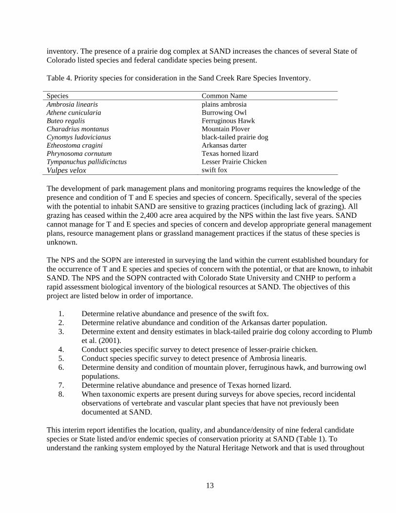
2006 5/3 – 5/7 X X X X X X 6/14 – 6/18 X X X X X X X X 7/24 – 7/281 X X X X 9/6 – 9/10 X 2008 6/2 – 6/51 X 1 A single person completed these trips. The threatened, endangered and species of conservation concern recorded from SAND are listed in Table 6. Black-tailed prairie dog (Photo 2) colonies occupied 16.6 hectares of the northwest corner of SAND and 75.7 hectares of the site’s southeast corner (Figure 4). Densities of those portions of each colony within the boundary of SAND were estimated as 33 prairie dogs/hectare and 49 prairie dogs/hectare, respectively. In addition, Burrowing Owls (Athene cunicularia) (Photo 3) were observed on the southern colony and Mountain Plover (Charadrius montanus) were observed just offsite on the north prairie dog colony on private land (Figure 4). Numerous carnivore dens were recorded from SAND during the survey. Track sign surrounding most dens within the north unit of SAND indicated these were American badger (Taxidea taxus) dens. Others certainly were coyote (Canis latrans) dens as determined by the carcass of a coyote observed outside the entrance of one den along Sand Creek in the Park’s south unit. However, for approximately half of the recorded dens lack of recent activity and sign made it impossible to identify with certainty what species had excavated the den. Additional species of conservation concern that were recorded from SAND during the survey included the following: bleached skimmer (Libellula composite), Northern Harrier (Circus cyaneus), northern leopard frog (Rana pipiens) (Photo 4), Loggerhead Shrike (Lanius ludovicianus), Red-headed Woodpecker (Melanerpes erythrocephalus), Scaled Quail (Callipepla squamata), showy prairie gentian (Eustoma grandiflorum), Swainson’s Hawk (Buteo swainsoni), and White-faced Ibis (Plegadis chilis) (Table 6).
19
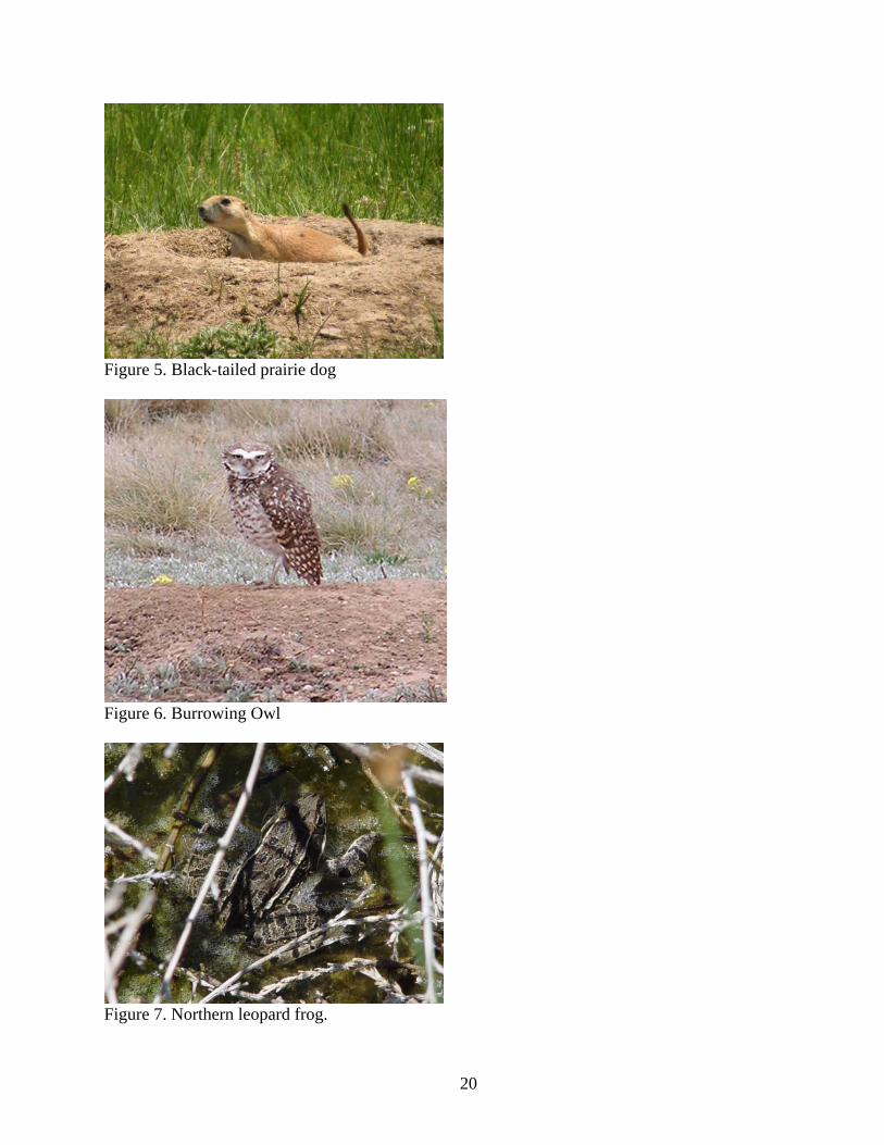
Figure 5. Black-tailed prairie dog
Figure 6. Burrowing Owl
Figure 7. Northern leopard frog.
20

Table 6. Endangered, threatened, and species of conservation concern recorded from SAND. Species Common Name Abundance/
Density1 Heritage Status
Federal and State Status2
CNHP, PIF and SCP Status3
Endangered, Threatened, and Species of Conservation Concern Athene cunicularia
Burrowing Owl
18
G4S4B
FS, ST
CNHP tracked
Charadrius montanus
Mountain Plover
4
G2S2B
FS, BLM, SC
CNHP tracked;
SCP highly imperiled
Cynomys ludovicianus
black-tailed prairie dog north colony south colony
33/ha 49/ha
G4S3
FS, SC
CNHP Tracked
Other Species of Conservation Concern Eustoma grandiflorum
Showy prairie gentian
18
G5S3S4
CNHP watchlisted
Buteo swainsoni
Swainson’s Hawk
8
G5S5B
PIF watch list species
Callipepla squamata
Scaled Quail
2
G5S4
PIF watch list
species Circus cyaneus
Northern Harrier
2
G5S3B
FS
Lanius ludovicianus
Loggerhead Shrike
2
G5S5
FS
PIF stewardship
species Libellula composita
bleached skimmer (a dragonfly)
4
G3S1
CNHP tracked
Melanerpes erythrocephalus
Red-headed Woodpecker
1
G5S3B
PIF watch list
species Plegadis chilis
White-faced Ibis
1
G5S2B
BLM
CNHP tracked
Rana pipiens
northern leopard frog
10
G5S3
FS, BLM, SC
CNHP tracked
1 Abundance: total number of animals observed without accounting for double counting; density was calculated only for the black-tailed prairie dogs.
2 FS = Forest Service sensitive species, BLM = Bureau of Land Management sensitive species, ST = State of Colorado threatened, SC = State of Colorado special concern.
3 CNHP: see Table 1 and the section “Natural Heritage Ranking System” on page 3, PIF: the Partners in Flight Landbird Conservation Plan lists species of landbirds of continental importance that deserve special attention; watch listed species are most in need of conservation action and stewardship species are birds with restricted distributions that merit special attentions for conservation action within their core ranges; SCP: the Shorebird Conservation Plan lists U. S. and Canadian shorebird populations that most urgently need conservation action; highly imperiled shorebirds are all species listed as threatened or endangered nationally, plus all species with significant population declines and either low populations or some other high risk factor.
21

Figure 8. Distribution of endangered, threatened and species of concern at SAND.
22

Other species that have been documented from SAND in previous surveys and that are listed by the Partners in Flight North American Landbird Conservation Plan as either Watch List or Stewardship species because of concern for their continued conservation include Cassin’s Sparrow (Aimophila cassinii), Grasshopper Sparrow (Ammodramus savannarum), Lark Bunting (Calamospiza melanocorys), and Short-eared Owl (Asio flammeus) (Hanni 2007). The Cassin’s Sparrow (G5/S4B) and Short-eared Owl (G5/S2B) are also tracked as species meriting conservation attention by the CNHP. In additional, numerous other animals were observed during field survey work (Table 7). In 2005 showy prairie gentian was recorded at SAND and this population was also observed in 2006. Approximately three plants were observed in 2005 and in 2006 seven plants in fruit (one of which was still in flower) and 11 rosettes, for a total of 18 plants, were recorded. Additional suitable habitats, including additional wet spots, were searched in 2006, but no new locations for the plant were discovered. Species that were not observed, but which were surveyed for extensively were the Arkansas darter (Etheostoma cragini), Ferruginous Hawk (Buteo regalis), although this raptor was observed on lands adjacent to SAND and has been observed by NPS biologists at SAND (Zimmerman personal communication 2008) and probably uses SAND for foraging, Lesser Prairie Chicken (Tympanuchus pallidicinctus), swift fox (Vulpes velox), and Texas horned lizard (Phrynosoma cornutum). Areas that appear suitable for both the Lesser Prairie Chicken (Figure 4) and swift fox do exist on SAND. Table 7. Common animal species observed at Sand Creek National Historic Site during summer 2006. Scientific Name
Common Name
Global Rank1
State Rank1
Federal and State Status1
AMPHIBIANS Ambystoma tigrinum tiger salamander G5 S5 Bufo woodhousii Woodhouse's toad G5 S5 BIRDS2 Agelaius phoeniceus Red-winged Blackbird G5 S5 Anas discors Blue-winged Teal G5 S5 Anas platyrhynchos Mallard G5 S5 Ardea herodias Great Blue Heron G5 S3B Bubo virginianus Great Horned Owl G5 S5 Buteo jamaicensis Red-tailed Hawk G5 S5B Calamospiza melanocorys Lark Bunting G5 S4 Callipepla squamata Scaled Quail G5 S4 Cathartes aura Turkey Vulture G5 S4B Charadrius vociferus Killdeer G5 S5 Chondestes grammacus Lark Sparrow G5 S4 Chordeiles minor Common Nighthawk G5 S5 Colaptes auratus Northern Flicker G5 S5 Columba livia Rock Dove G5 SNA Cyanocitta cristata Blue Jay G5 S5 Dendroica coronata Yellow-rumped Warbler G5 S5 Dendroica petechia Yellow Warbler G5 S5 Eremophila alpestris Horned Lark G5 S5B Euphagus cyanocephalus Brewer’s Blackbird G5 S5B Falco sparverius American Kestrel G5 S5B
23

Scientific Name
Common Name
Global Rank1
State Rank1
Federal and State Status1
Hirundo rustica Barn Swallow G5 S5 Icterus bullockii Bullock's Oriole G5 S5 Icterus spurius Orchard Oriole G5 S4B Mimus polyglottos Northern Mockingbird G5 S5 Molothrus ater Brown-headed Cowbird G5 S5 Phasianus colchicus Ring-necked Pheasant G5 SNA Picoides pubescens Downy Woodpecker G5 S5 Pipilo maculates Spotted Towhee G5 S5 Pooecetes gramineus Vesper Sparrow G5 S5 Sayornis saya Say’s Phoebe G5 S5B Sialia sialis Eastern Bluebird G5 S2B Spizella passerina Chipping Sparrow G5 S4B, S5N Sturnella neglecta Western Meadowlark G5 S5 Sturnus vulgaris European Starling G5 SNA Toxostoma rufum Brown Thrasher G5 S4 Troglodytes aedon House Wren G5 S5 Turdus migratorius American Robin G5 S5 Tyrannus tyrannus Eastern Kingbird G5 S5B Tyrannus verticalis Western Kingbird G5 S5B Zenaida macroura Mourning Dove G5 S5 Zonotrichia leucophrys White-crowned Sparrow G5 S5 Xanthocephalus xanthocephalus Yellow-headed Blackbird G5 S5 FISH Fundulus zebrinuss plains killifish G5 SNA INSECTS BUTTERFLIES Celastrina neglecta summer azure G5 SNR Danaus plexippus monarch G5 S5 Nymphalis antiopa mourning cloak G5 S5 DRAGONFLIES AND DAMSELFLIES
Enallagma civile familiar bluet G5 S5 Erythemis simplicicollis eastern pondhawk G5 S4 Libellula pulchella twelve-spotted skimmer G5 S5 Libellula luctuosa widow skimmer G5 S5 Libellula lydia common whitetail G5 S5 Pachydiplax longipennis blue dasher G5 S3S4 MAMMALS Canis latrans coyote G5 S5 Dipodomys ordii Ord’s kangaroo rat G5 S5 Erethizon dorsatum North American porcupine G5 S5 Lepus californicus black-tailed jackrabbit G5 S5 Mephitis mephitis striped skunk G5 S5 Odocoileus hemionus mule deer G5 S4 Odocoileus virginianus white-tailed deer G5 S5 Procyon lotor raccoon G5 S5 Sylvilagus audubonii desert cottontail G5 S4 Taxidea taxus American badger G5 S4
24

25
Scientific Name
Common Name
Global Rank1
State Rank1
Federal and State Status1
MOLLUSKS Physa sp.
Physid snail
NA
NA
REPTILES Aspidoscelis sexlineata six-lined racerunner G5 S5 Crotalus viridis plains rattlesnake G5 S5 Holbrookia maculate lesser earless lizard G5 S5 Pituophis catenifer bullsnake/gopher snake G5 S5 Terrapene ornata ornate box turtle G5 S5 1 See Table 1 for explanations of global and state imperilment ranks. 2 Ferruginous Hawks were never positively identified at SAND, but were observed on lands adjacent to SAND.

Translocation of Lesser Prairie Chicken Lesser prairie chickens historically occupied the area surrounding SAND and historic lek sites existed on lands adjacent to SAND, to both the west and south of the current Park site. In recent times it appears that none of these lek sites have been active and populations of lesser prairie chicken may be extirpated from SAND and the immediate area surrounding the Park (Figure 5) (Colorado Natural Heritage Program 2006, Colorado Division of Wildlife 2006).
Figure 9. Lek sites, historic lek sites, and production areas (nesting and brood rearing habitat defined as 2.4 km buffer zone around each lek site) of the lesser prairie chicken (after CNHP and CDOW). Prairie grouse (Tympanuchus spp.) populations experienced wide ranging declines in abundance throughout North America in the twentieth century and the conversion of native plant communities to agriculture lands and to pastures for livestock grazing are thought to be an important factor contributing to this decline (Snyder et al. 1999). Attempts to translocate prairie grouse populations into formerly occupied areas have meet with varied success. None of the attempts to translocate lesser prairie chickens in Colorado have been successful, as determined from lek surveys (Giesen 2000). Little information is available on why translocations of prairie grouse succeed or fail, but there is evidence that translocation projects that are of long duration (>6 years), utilize spring releases, release a large total number of grouse (>100 birds), and release grouse using remotely triggered boxes have a greater chance of success (Snyder et al. 1999). Confounding the issue for lesser prairie chicken translocation is that they are not migratory and require a complex of habitats within a relatively limited area to meet their needs across seasons (Finch 2005). One predictor of successful translocation for prairie grouse is the amount of high quality habitat within the
26

release area (Toepfer 1990). Areas of potential habitat may fail to meet species needs if one critical element is missing; conversely, superior habitat may fail to conserve the species if the area is too small to host viable breeding populations and too isolated for dispersal to occur. Invariably, the translocation of birds into areas of too small size, that are overly fragmented, or that will not meet all lesser prairie chicken seasonal needs will fail. Understanding the habitat requirements of lesser prairie chicken and the development of a landscape-level habitat model (Table 5) combined with GIS digitally mapped layers of vegetation type and landuse (Niemuth 2003) would assist in assessing habitat suitability for the potential translocation of lesser prairie chicken at SAND. The habitat requirements for lesser prairie chicken are diverse and a fairly large area is needed to support a populations’ needs. The combined home ranges of all birds at a lek may exceed 12,000 acres, or 19 square miles, and it is estimated that 25,000 acres of contiguous high-quality native rangeland may be the minimum land area required to maintain a healthy and sustainable lesser prairie chicken population (Bidwell et al. 2001); others state that most birds will spend their entire life within a 5 km radius of the lek site (Applegate and Riley 1998). Regardless of the true size needed to support a viable population of lesser prairie chickens, it will out of necessity be large, probably falling somewhere between 19,000 acres and 25,000 acres. To meet the habitat requirements necessary for the successful translocation of lesser prairie chicken at SAND will require the Park to partner with local landowners, governmental agencies including the Colorado Division of wildlife, and non-governmental conservation organizations such as The Nature Conservancy. Table 7. Habitat requirements for the lesser prairie chicken. Life History Stage
Habitat Characteristics
References
General Reguirements
Sandsage or sandshinnery oak grasslands dominated by sand bluestem Andropogon hallii, little bluestem Schizachyrium scoparium, sand dropseed Sporobolus cryptandrus, three-awn Aristida spp., and blue grama; sideoats grama B. curtipendula, hairy grama B. hirsuta and buffalograss may also occur. The combined home ranges of all birds at a lek may exceed 12,000 acres, or 19 square miles. This includes a central 2-4 square mile core of prime nesting and brood-rearing habitat, and a larger surrounding area for year-round foraging. For a LPC population to remain viable even in the short term, breeding must take place across a series or complex of leks. It is estimated that 25,000 acres of contiguous high-quality native rangeland may be the minimum land area required to maintain a healthy and sustainable LPC population.
New Mexico LPC/SLD Working Group 2005, Bidwell et al. 2001, Giesen 1998, Copelin 1963
Lek
Small, elevated areas with bare soils or very sparse vegetation that allows for excellent visibility; the sites are often on elevated knolls or ridges and are always surrounded by sand sagebrush or sand shinnery oak grassland. Disturbed areas created by human activities, such as oil pads, roads, burning, or herbicide treatment, may be used as display sites.
New Mexico LPC/SLD Working Group 2005, Hagen et al. 2004, Giesen 1998, Taylor and Guthery 1980, Copelin 1963, Jones 1963
Nesting
High density sagebrush (>6,500/ha), shrub height > 40cm, moderate sagebrush cover (18–20% cover), moderate grass cover (37%), mixed grass at height >25 cm affording high visual obstruction readings, minimal building, improved road, transmission line,
New Mexico LPC/SLD Working Group 2005, Pitman et al. 2005, Hagen et al.
27

Life History Stage
Habitat Characteristics
References
center-pivot field, and wellhead density (these structures reduce potential nesting habitat for a radius of up to 1 km).
2004
Brooding
High bare ground cover (>50%), moderate density sagebrush (>4,000/ha), shrub height > 30cm, moderate sagebrush cover (18–20% cover), moderate grass cover (37%), mixed grass at height >20 cm, minimal building, improved road, transmission line, center-pivot field, and wellhead density (these structures reduce potential nesting habitat for a radius of up to 1 km).
New Mexico LPC/SLD Working Group 2005, Hagen et al. 2004, Riley and Davis 1993
Wintering
Riparian corridors comprised of deciduous shrubs and young trees in the sand sagebrush regions, grain fields (where available) once harvest has begun if near sandsage rangeland, and when available native tallgrasses >80 cm tall.
New Mexico LPC/SLD Working Group 2005, Hagen et al. 2004
28

Discussion SAND is located in southeastern Colorado in the rain shadow of the Rocky Mountains, receiving on average only 14.87 inches of annual precipitation (High Plains Regional Climate Center 2006). The area in which SAND resides is very dry with little surface water. SAND, however, contains about a 3 mile stretch of Big Sandy Creek running through it from its northwestern border to where the creek exits the Park at its southeastern end. Along the creekbed there are a number of perennial pools that offer habitat to a broad array of wildlife from mule deer and leopard frogs to dragonflies and shorebirds. This abundance of water existing in what is an otherwise arid landscape increases the plant and animal diversity at SAND. The field work completed at SAND demonstrates this through the numerous animal species that were recorded including a number of species of conservation priority. Prairie dogs and there associated species like Mountain Plover and Burrowing Owls are found at SAND. Prairie dogs have undergone declines in Colorado and so have species that rely on their grazing and burrows like the plovers and owls. It appears that on the private lands surrounding SAND many of the landowners intensely control prairie dogs and the populations on SAND and surrounding it are some of the few that still remain in the local area, and they should be conserved. One species that was surveyed for and was not observed is the swift fox. Although swift fox were not detected at SAND the shortgrass prairie at the Park and the occurrence of prairie dogs offers suitable habitat for this rare species of fox. The home ranges of swift fox are larger than SAND and one family of foxes would require a larger territory than could be supported on SAND alone. There is much landscape surrounding SAND that is not, nor has never been cultivated and is still shortgrass prairie. This habitat is suitable for swift fox and there is potential for the fox to occupy the area surrounding SAND and potentially to be using SAND during portions of the year. The wetlands of the Park support populations of northern leopard frogs, tiger salamanders, Woodhouse toads, Plains killifish and dragonflies and damselflies. Northern leopard frogs are becoming rarer in Colorado and seem to be suffering declines that have been reported for other amphibian species from throughout the world (Stuart et al. 2004). Populations of this amphibian should be protected wherever they are found. The wetlands at SAND also support a population of the bleached skimmer, a dragonfly whose populations seem to be stable, but is threatened in the west by incompatible grazing by livestock that eliminates emergent aquatic vegetation essential to the survival of the dragonfly (NaturServe 2009). The bleached skimmer is rare, sporadically distributed across the landscape and populations of this dragonfly should be protected. Numerous species of birds are found at SAND including many rare birds associated with the sandsage shrubland (Scaled Quail), riparian woodlands (red-headed Woodpecker), wetlands (White-faced Ibis), and the abundant prey resources found at SAND (Ferruginous Hawk, Swainsons Hawk, and Northern Harrier). All of the birds just mentioned are species of conservation priority and the habitat supporting their populations should be conserved. One species that was +surveyed for at SAND and that was not observed is the swift fox. Recommended Future Research: Because the success of translocating lesser prairie chickens will ultimately be determined by the quantity and quality of habitat at the translocation site, evaluating habitat at SAND prior to translocation should be a critical consideration. The development of a habitat model identifying suitability of landscapes for greater prairie chickens in southeast Colorado and
29

applying that model to digital landcover data of southeastern Colorado, including the area of SAND, will help to identify suitable unoccupied landscapes for translocation of lesser prairie chickens in the State. The occurrence of permanent wetlands at SAND within what is a relatively dry landscape where water resources are limited represents an opportunity for the occurrence of rare and uncommon vertebrate and invertebrate species including bats, butterflies, dragonflies, and damselflies along with other invertebrates. It is recommended that a future survey for bats and invertebrates also be conducted at SAND.
30

Literature Cited Albertson, F.W. and Weaver, J.E. 1944. Effects of drought, dust, and intensity of grazing on cover and
yield of short-grass pastures. Ecological Monographs 16: 1-29.
Anderson, D.L., Lesh, J.G., and Wickman, D.W. 1981. Soil Survey of Kiowa County, Colorado. U.S.D.A. Soil Conservation Service, [Washington, D.C.?].
Andrew, R., and R. Righter. 1994. Colorado birds: a reference to their distribution and habitat. Published by the Denver Museum of Natural History.
Applegate, R. D., and T. Z. Riley. 1998. Lesser Prairie-Chicken management. Rangelands 20:13-15.
Bidwell, T., S. Fuhlendorf, B. Gillen, S. Harmon, R. Horton, R. Manes, R. Rodgers, S. Sherrod, and D. Wolfe. 2001. Ecology and Management of the Lesser Prairie-Chicken. E-970. Oklahoma Cooperative Extension Service, Division of Agricultural Sciences and Natural Resources, Oklahoma State University.
Clark, D. 2005. Botanist. Personal communication.
Colorado Division of Wildlife. 2006. Colorado species distribution – lesser prairie chicken (production area). Fort Collins, CO. http://ndis.nrel.colostate.edu/ftp/index.html.
Colorado Natural Heritage Program. 2006. Biodiversity Tracking and Conservation System. Colorado Copelin, F. F. 1963. The lesser prairie-chicken in Oklahoma. Oklahoma Wildlife Conservation Department Technical Bulletin Number 6. Oklahoma City, OK.
Copelin, F. F. 1963. The Lesser Prairie Chicken in Oklahoma. ODWC Tech. Bull. No. 6. 58 pp.
Feeney, L. 1992. Site fidelity in burrowing owls. Unpublished paper presented to Raptor Research Annual Meeting, November 1992. Seattle, Washington.
Drennan, J. E., P. Beier, and N. L. Dodd. 1998. Use of track stations to index abundance of sciurids. Journal of Mammalogy. 79: 352-359.
Finch, D. M., Editor. 2005. Assessment of grassland ecosystem conditions in the Southwestern United States: wildlife and fish—volume 2. Gen. Tech. Rep. RMRS-GTR-135-vol. 2. Fort Collins, CO: U.S. Department of Agriculture, Forest Service, Rocky Mountain Research Station. 168 p.
Catherine H. Fowler, C. H., and R. T. Golightly Jr. 1994. Fisher and marten survey techniques on the TahoeNational Forest. The U.S. Forest Service, Redwood Sciences Lab, Arcata, California. 64 p.
Giesen, K. M. 2000. Population Status and Management of Lesser Prairie-chicken in Colorado. The Prairie Naturalist 32: 137-147.
Giesen, K. M. 1998. Lesser Prairie-Chicken (Tympanuchus pallidicinctus) in The Birds of North America, No. 364 (A. Poole and F. Gill, eds.). The Birds of North America, Inc., Philadelphia, PA.
31

Glennon, M. J., W. F. Porter, and C. L. Demers. 2002. An alternative field technique for estimating diversity of small-mammal populations. Journal of Mammalogy. 83: 734–742.
Coffin, D.L. 1967. Geology and ground-water resources of the Big Sandy Creek valley; Lincoln, Cheyenne, and Kiowa counties, Colorado. Geological Survey Water-Supply Paper 1843. U.S. Government Printing Office, Washington, D.C.
Costello, D.F. 1944. Important species of the major forage types in Colorado and Wyoming. Ecological Monographs 14: 107-134.
Hagen, C. A., B. E. Jamison, K. M. Giesen, and T. Z. Riley. 2004. Guidelines for managing lesser prairie-chicken populations and their habitats. Wildlife Society Bulletin. 32: 69-82.
Hammerson, G. A. 1999. Amphibians and reptiles in Colorad: a Colorado field guide. University Press of Colorado and Colorado Division of Wildlife, Boulder, CO.
Hanni, D. 2006. Sand Creek Massacre National Historic Site inventory and monitoring final report. Rocky Mountain Bird Observatory, Fort Collins, Colorado.
Hartman, T. 2006. Running hog wild: Packs of feral pigs sow problems for farmers, wildlife managers in Kiowa County. Rocky Mountain News (June 3, 2006), Denver, CO.
Heske, E. J. 1995. Mammalian abundances on forest-farm edges versus forest interiors in Southern Illinois: is there an edge effect? Journal of Mammalogy. 76: 562-568.
Henke, S. E., and W. S. Fair. 1998. Management of Texas horned lizards. Caesar Kleberg Wildlife Research Institute, Texas A&M University-Kingsville, Kingsville, Texas.
High Plains Regional Climate Center 2006. Historical data summaries. University of Nebraska-Lincoln. Available at http://hprcc.unl.edu/products/historical.htm.
Holmes, A. and McFaul, M. 1999. Geoarchaeological assessment of the Sand Creek Massacre Site, Kiowa County, Colorado. LaRamie Soils Service, Laramie, WY.
Hooglund, J. L. 1995. The black-tailed prairie dog: social life of a burrowing mammal. University of Chicago Press, Chicago Il. 557p.
Jones, R. E. 1963. Identification and analysis of lesser and greater prairie-chicken habitat. Journal of Wildlife Management 27: 757-778.
Kingery, H. E. 1998. Colorado Breeding Bird Atlas. Edited by H. E. Kingery. Published by the Colorado Bird Atlas Partnership; copublished by Colorado Division of Wildlife.
May, D.W. and Holen, S.R. 1985. A chronology of Holocene erosion and sedimentation in the South Loup Valley, Nebraska. Geographical Perspectives 56: 8-12.
32

McWilliams, J. 2003. Artemisia filifolia. In: Fire Effects Information System, [Online]. U.S. Department of Agriculture, Rocky Mountain Research Station, Fire Sciences Laboratory. Available at http://www.fs.fed.us/database/feis/.
NAIP (National Agriculture Imagery Program) 2005. Two-meter ground sample distance ortho imagery compressed county mosaics for Kiowa County, Colorado. U.S. Department of Agriculture. Aerial Photography Field Office, Salt Lake City UT.
NatureServe. 2009. NatureServe Explorer: An online encyclopedia of life [web application]. Version 7.1. NatureServe, Arlington, Virginia. Available http://www.natureserve.org/explorer. (Accessed: April 17, 2009 ).
Neid, S, J. Stevens, K. Forest, and M. Fink. 2007. Sand Creek Massacre National Historic Site: Vegetation Classification and Mapping, A report for the Southern Plains Network. Natural Resource Technical Report NPS/SOPN/NRTR—2007/050.
New Mexico LPC/SLD Working Group. 2005. Collaborative Conservation Strategies for the Lesser Prairie-Chicken and Sand Dune Lizard in New Mexico: Findings and Recommendations of the New Mexico LPC/SDL Working Group.
Niemuth, N. D. 2003. Identifying landscapes for greater prairie chicken translocation using habitat models and GIS: a case study. Wildlife Society Bulletin 31: 145-155.
NRCS (National Resources Conservation Service). 2004a. Ecological Site Description: Loamy. U.S. Department of Agriculture, Washington, D.C.
NRCS (National Resources Conservation Service). 2004b. Ecological Site Description: Sands. U.S. Department of Agriculture, Washington, D.C.
Pitman, J. C., C. A. Hagen, R. J. Robel, T. M. Loughin, R. D. Applegate. 2005. Location and success of ledder prairie chicken nests in relation to vegetation and human disturbance. Journal of Wildlife Management 69: 1259-1269.
Plumb, G. E., G. D. Wilson, K. Kallin, K. Shinn, and W. M. Rizzo. 2001. Black-tailed prairie dog monitoring protocol for seven prairie parks. Northern Prairie Wildlife Research Center Inventory and Monitoring Program, U. S. Department of Interior and U.S. Geological Survey.
Ramaley, F. 1939. Sand-hill vegetation of northeastern Colorado. Ecological Monographs 9: 1-51.
Rich, T. 1984. Monitoring burrowing owl populations: Implications of burrow re-use. Wildlife Society Bulletin 12: 178- 180.
Riley, T. Z., and C. A. Davis. 1993. Vegetative characteristics of lesser prairie-chicken brood foraging sites. The Prairie Naturalist 25:243-248.
Rondeau, R. 2003. Vegetation monitoring at Pueblo Chemical Depot, 1998-2003: 2003 Update. Colorado Natural Heritage Program, Ft. Collins, CO.
33
34
Saunders, E. J. 2001. Population estimation and habitat associations for the Long-billed Curlew (Numenius Americana) in Alberta. Alberta Sustainable Resource Development, Fish and Wildlife Division, Alberta Species at Risk No. 25, Edmonton, Aberta.
Schultz, C.B. and Stout, T.M. 1977. Drought and the model of a Quaternary terrace-cycle. Transactions of the Nebraska Academy of Sciences 4191-201.
Smith, G.A. and Lomolino, M.V. 2003. Black-tailed prairie dogs and the structure of avian communities on the shortgrass prairie. Oecologia 138: 592-602.
Snyder J. W., E. C. Pelren, and J. A. Crawford. 1999. Translocation histories of prairie grouse in the United States. Wildlife Society Bulletin 27: 428-432.
Sovell, J. R. 2006. Rare Species Inventory of Sand Creek Massacre National Historic Site Interim Report (Year 1, 2006). Colorado Natural Heritage Program Report, Fort Collins, CO.
Stuart, S.N., J.S. Chanson, N.A. Cox, B.E. Young, A.S.L. Rodrigues, D.L. Fischman, and R.W. Waller. 2004. Status and trends of amphibian declines and extinctions worldwide. Science 306:1783-1786.
Taylor, B. N. 2003. Population estimates and a survey protocol for ferruginous hawks in Alberta. Alberta species at risk report No. 70. Fish and Wildlife Division, Wildlife Conservation and Biodiversity Section, Alberta Sustainable Resource Development.
Taylor, M. A., and F. S. Guthery. 1980. Status, ecology and management of the Lesser Prairie-Chicken. USDA Forest Service General Technical Report RM-77. Rocky Mountain Forest and Range Experiment Station, For Collins, CO. 15 pages.
Toepfer, E., R. L. Eng, and R. K.Anderson. 1990. Transplanting prairie grouse: what have we learned? Transactions of the North American Wildlife and Natural Resources Conference 55: 569-579.
U. S. Fish and Wildlife Service. 2002. Mountain Plover survey guidelines-Montana. United States Fish and Wildlife Service.
Zarn, M. 1974a. Burrowing owl, Speotyto cunicularia hypugaea. U.S. Dep. Inter., Bur. Land Manage., Wash. DC. Tech. Note No. 250. 25pp.
Zimmerman, K. 2008. Biologist at Sand Creek Massacre National Historic Site.

The Department of the Interior protects and manages the nation’s natural resources and cultural heritage; provides scientific and other information about those resources; and honors its special responsibilities to American Indians, Alaska Natives, and affiliated Island Communities. NPS D-XXX, Month Year

National Park Service U.S. Department of the Interior Natural Resource Program Center Natural Resource Program Center 1201 Oakridge Drive, Suite 150 Fort Collins, CO 80525
www.nature.nps.gov EXPERIENCE YOUR AMERICA TM