rationale for water framework directive freshwater ... · rationale for water framework directive...
TRANSCRIPT
River Basin Management Plans
Rationale for Water Framework Directive Freshwater Classification December 2009
1
Contents Page INTRODUCTION 2 Classification 2 Heavily Modified Water Bodies 4 Monitoring Networks 4 RIVERS 7 Biological Quality Elements 7 General chemical and physiochemical quality elements 10 Specific pollutants 13 Hydromorphology 15 Chemical Status 17 How river water bodies have been classified 18 Overall Classification 22 Cross border classification 22 Confidence in class 24 LAKES 25 Biological Quality Elements 25 General chemical and physiochemical quality elements 28 Specific pollutants 30 Hydromorphology 30 Chemical Status 31 How lake water bodies have been classified 31 Overall classification 32 Cross border classification 32 Confidence in class 32 Appendix 1 – Specific pollutant/Priority substance monitoring programme 35 Appendix 2 – How river water bodies have been classified 38
2
Introduction This document describes how Water Framework Directive (WFD) Freshwater Classification has been undertaken for the first River Basin Plan. It describes the rationale behind classification, the biological, chemical and physical quality elements monitored, the monitoring networks and how classification was produced. . WFD classification is substantially different from previous freshwater classification systems1 in a number of ways including:
• Classification is based around water bodies which are units of area based around river confluences and larger2 lakes,
• Biological, chemical and physical quality elements monitored are
combined to produce an overall classification, • There has been a considerable increase in the number of quality elements
monitored,
• It introduces a formal classification system for lakes. The United Kingdom Technical Advisory Group (UKTAG) has produced guidance on surface water classification - Recommendations on Surface Water Classification Schemes for the purposes of the Water Framework Directive3 (hereafter referred to Classification Guidance) and this has been followed in Northern Ireland. The methodology for the classification of cross-border water bodies has been agreed by the North/South Rivers and Lakes Group which is a sub-group of the North/South WFD Technical Advisory Group. Classification Aquatic systems are complex mixtures of plants and animals each responding to variations in their physical and chemical environments in many and very different ways. For example, the occurrence of specific plants may be constrained as much by geographical location and their dispersal mechanisms as water quality conditions. Plant and animal assemblages represent continua that are seldom identical between sites due to their interactions with prevailing chemical and physical conditions.
1 The previously used rivers General Quality Assessment (GQA) schemes, which ceased following 2007 classification, are not considered here. Full details can be found on our website at www.ni-environment.gov.uk 2 Greater than 50 hectares 3 www.wfduk.org
3
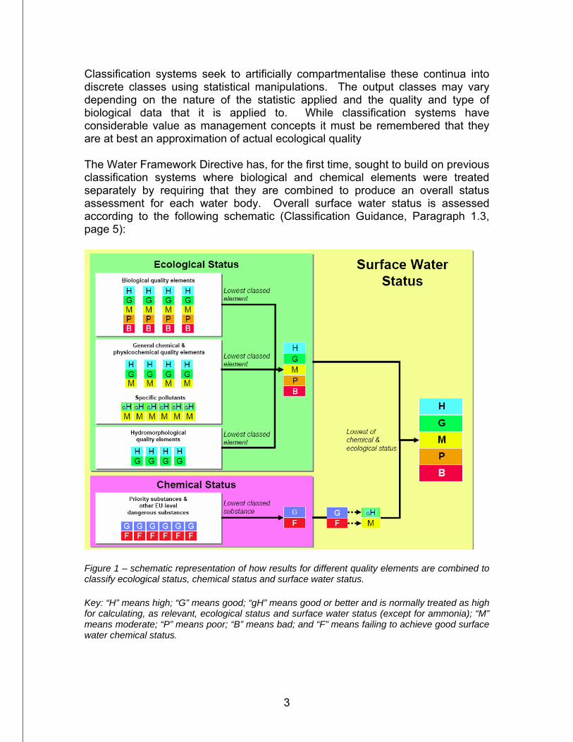
Classification systems seek to artificially compartmentalise these continua into discrete classes using statistical manipulations. The output classes may vary depending on the nature of the statistic applied and the quality and type of biological data that it is applied to. While classification systems have considerable value as management concepts it must be remembered that they are at best an approximation of actual ecological quality The Water Framework Directive has, for the first time, sought to build on previous classification systems where biological and chemical elements were treated separately by requiring that they are combined to produce an overall status assessment for each water body. Overall surface water status is assessed according to the following schematic (Classification Guidance, Paragraph 1.3, page 5):
Figure 1 – schematic representation of how results for different quality elements are combined to classify ecological status, chemical status and surface water status. Key: “H” means high; “G” means good; “gH” means good or better and is normally treated as high for calculating, as relevant, ecological status and surface water status (except for ammonia); “M” means moderate; “P” means poor; “B” means bad; and “F” means failing to achieve good surface water chemical status.
4
The ecological status is the lowest class of the biological, general chemical and physicochemical and hydromorphological quality elements. This is then combined with chemical status with again the lowest class producing the overall surface water status. This is known as the one-out-all-out process and, whilst it is still open to debate as to whether it really does give the best indication of overall water quality, it is the process that has been used to date. Note that chemistry can only downgrade to moderate status overall and that hydromorphology can only downgrade an otherwise high status water body to good. Details of all the quality elements and how they have been assessed are described separately for rivers and lakes. Heavily Modified Water Bodies Designation A Heavily Modified Water Body (HMWB) is defined by the Directive (Article 2, paragraph 9) as ‘a body of surface water which as a result of physical alterations by human activity is substantially changed in character’. The designation and classification of HMWBs has been a complex process and is dealt with in detail in the separate report Identification of Freshwater Heavily Modified and Artificial Water Bodies in Northern Ireland and Classification of Ecological Potential, which is available on our website (www.ni-environment.gov.uk/wfd). Monitoring networks The river and lakes monitoring networks have been largely unaltered for the 2008 WFD Classification other than a few extra stations opened. Amongst other things there was a need to maintain continuity with the old rivers GQA classification system which only ceased in 2007. Normally, a few stations are opened or closed each year because of local issues and health and safety reasons etc. WFD monitoring requirements are detailed in the Common Implementation Strategy Document ‘Guidance on Monitoring for the Water Framework Directive Final Version 23 January 2003’4. WFD monitoring networks were reported to the Commission as required under Article 8 in 2007. Water Framework Directive monitoring stations are sub-divided into three categories:
4http://circa.europa.eu/Public/irc/env/wfd/library?l=/framework_directive/guidance_documents/guidancesnos7smonitoring/_EN_1.0_&a=d
5
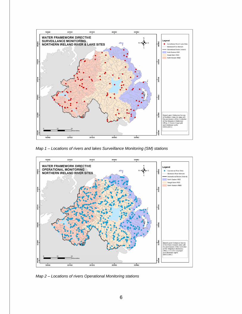
1. Surveillance Monitoring (SM) stations – these were assigned on the basis of water body type (which includes geology, slope and alkalinity) and the pressure status from the 2004 Article 5 Pressures and Impacts report. Also included were stations in the Intercalibration exercise and those also monitored under other schemes such as the UK Environmental Change and Acid Waters Monitoring Networks. SM stations are intended to provide long-term record so ideally shouldn’t be changed if possible. As required by the Directive, the complete range of quality elements are monitored for at SM stations which has lead to a significant increase in the range of quality elements monitored. For example, the WFD introduces the requirement for freshwater fish monitoring and classification for the first time.
There are 96 rivers and 27 lakes SM stations with the lakes stations including the 20 lakes greater than 50 hectares and 7 smaller Intercalibration ones.
2. Operational Monitoring (OM) stations – the rest of the rivers network was
designated for Operational Monitoring and is used for classification and pressure assessment purposes, albeit with a smaller range of quality elements than for the SM stations. There are over 500 rivers OM stations.
3. Investigational Monitoring (IM) stations – principally used to investigate
problems where the source is unknown or not proven. IM stations can therefore come and go and can also be at SM and OM stations.
The maps below show the distribution of Surveillance and Operational monitoring stations.
6
Map 1 – Locations of rivers and lakes Surveillance Monitoring (SM) stations
Map 2 – Locations of rivers Operational Monitoring stations
7
RIVERS - Quality Elements and classification The quality elements monitored for rivers are listed below along with how they have been classified, including the years of data that have been used.
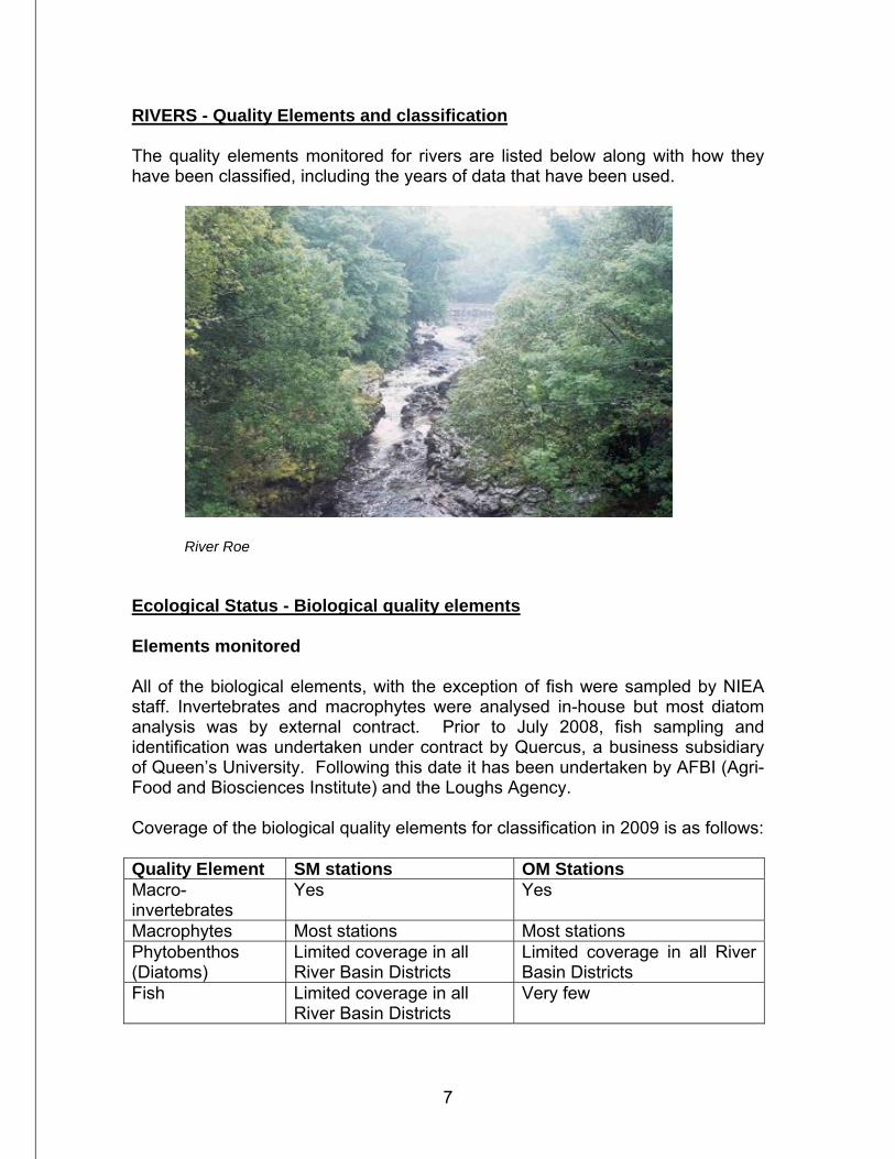
River Roe Ecological Status - Biological quality elements Elements monitored All of the biological elements, with the exception of fish were sampled by NIEA staff. Invertebrates and macrophytes were analysed in-house but most diatom analysis was by external contract. Prior to July 2008, fish sampling and identification was undertaken under contract by Quercus, a business subsidiary of Queen’s University. Following this date it has been undertaken by AFBI (Agri-Food and Biosciences Institute) and the Loughs Agency. Coverage of the biological quality elements for classification in 2009 is as follows: Quality Element SM stations OM Stations Macro-invertebrates
Yes Yes
Macrophytes Most stations Most stations Phytobenthos (Diatoms)
Limited coverage in all River Basin Districts
Limited coverage in all River Basin Districts
Fish Limited coverage in all River Basin Districts
Very few
8
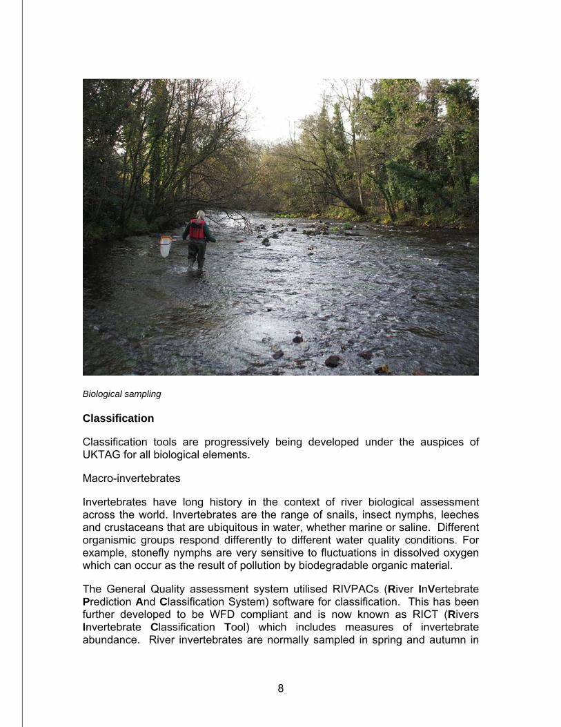
Biological sampling Classification
Classification tools are progressively being developed under the auspices of UKTAG for all biological elements.
Macro-invertebrates
Invertebrates have long history in the context of river biological assessment across the world. Invertebrates are the range of snails, insect nymphs, leeches and crustaceans that are ubiquitous in water, whether marine or saline. Different organismic groups respond differently to different water quality conditions. For example, stonefly nymphs are very sensitive to fluctuations in dissolved oxygen which can occur as the result of pollution by biodegradable organic material.
The General Quality assessment system utilised RIVPACs (River InVertebrate Prediction And Classification System) software for classification. This has been further developed to be WFD compliant and is now known as RICT (Rivers Invertebrate Classification Tool) which includes measures of invertebrate abundance. River invertebrates are normally sampled in spring and autumn in
9
larger rivers with smaller ones done in Spring only. Classification has been assessed from the average of three years data from 2006-2008.
Macrophytes Previously the 3-band Mean Trophic Ranking system was used for Urban Waste Water Treatment Directive5 Sensitive Area reviews and other eutrophic water quality assessments. The WFD classification tool is known as Leafpacs and it considers species sensitivity to pollution and the actual abundance of plants represented in a waterbody which are then collated into a classification system. Macrophyte surveys are undertaken once between May and September in a sampling year and are not normally repeated within three years – this is considered a reasonable period over which any significant changes would be observed. For stations that have been sampled more than once since 2002 the most recent data has been used for classification. Diatoms The old 3-band Trophic Diatom Assessment has been replaced by DARLEQ (Diatoms Assessment for Rivers and Lakes Ecological Quality) which takes species presence and their relative abundance to produce a classification, weighted by degradation indicator species. The developing WFD classification requires a minimum of three and ideally six repeat samples at the same station over several years. As diatom monitoring is relatively new, no station has yet been sampled more than four times. This explains why the number of water bodies classified for diatoms is relatively low. Diatom sampling frequency has now been increased to support future classification. Fish No classification tool is yet available for river fish in Ecoregion 17 (island of Ireland) or Scotland. Work to produce a tool similar to the Fisheries Classification Scheme Version 2 developed by the England and Wales Environment Agency for Scottish and Irish conditions is due to be underway during Autumn 2009. Classification to date has utilised expert judgement by the contractors who undertook the fish monitoring. Virtually all classification for this RBP is for small wadeable streams that can be electrofished by one field team. Development work on methodologies to assess larger rivers is ongoing. Below is a summary of classification tools and the years of data used for classification:
5 Directive 91/291/EEC concerning urban waster water treatment.
10
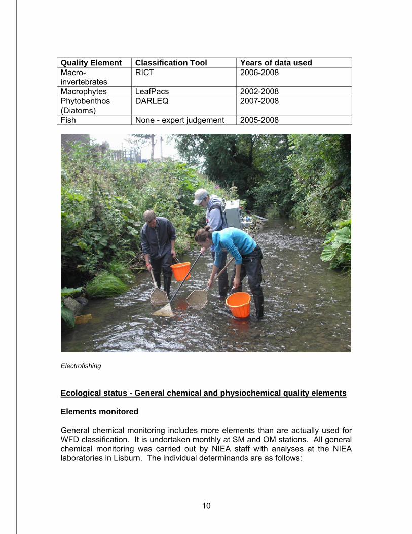
Quality Element Classification Tool Years of data used Macro-invertebrates
RICT 2006-2008
Macrophytes LeafPacs 2002-2008 Phytobenthos (Diatoms)
DARLEQ 2007-2008
Fish None - expert judgement 2005-2008
Electrofishing Ecological status - General chemical and physiochemical quality elements Elements monitored General chemical monitoring includes more elements than are actually used for WFD classification. It is undertaken monthly at SM and OM stations. All general chemical monitoring was carried out by NIEA staff with analyses at the NIEA laboratories in Lisburn. The individual determinands are as follows:
11
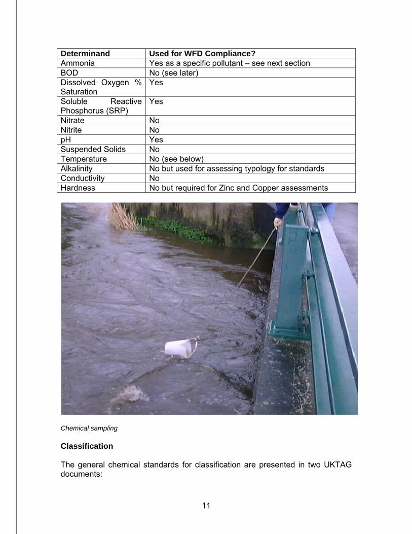
Determinand Used for WFD Compliance? Ammonia Yes as a specific pollutant – see next section BOD No (see later) Dissolved Oxygen % Saturation
Yes
Soluble Reactive Phosphorus (SRP)
Yes
Nitrate No Nitrite No pH Yes Suspended Solids No Temperature No (see below) Alkalinity No but used for assessing typology for standards Conductivity No Hardness No but required for Zinc and Copper assessments
Chemical sampling Classification The general chemical standards for classification are presented in two UKTAG documents:
12
UK Environmental Standards and Conditions (Phase 1) Final Report April 2008, and UK Environmental Standards and Conditions (Phase 2) Final March 2008.6 These documents describe the process of how the standards were derived, the standards themselves and how compliance is assessed. One significant difference from the previous GQA classification system is that BOD is not included. This is explained in the Phase 1 report on page 24: ‘…the standard for dissolved oxygen is used for assessing and reporting compliance of rivers, and that the standard for BOD is used for deciding action to meet the standard for dissolved oxygen in the river. This is because the levels of BOD can be misleading in clean rivers, and because the link between BOD and dissolved oxygen is a complex and uncertain issue if dealt with on a site-by-site basis.’ BOD is still assessed but not included in overall classification as it is still a very important element for regulatory and other water quality purposes. For temperature, the Environmental Standards and Conditions Phase 2 report states on page 25 that ‘the proposed standards…are intended to supersede the standards in the Directives on Freshwater Fish…when these directives are repealed in 2013.’ and ‘The UKTAG proposes that these standards are used in the classification of rivers receiving thermal discharges and in calculating the action needed to achieve a target class for rivers.’ Given the above and with relatively few thermal discharges to freshwaters in Northern Ireland, temperature classification has been assessed but not used for overall physico-chemical status. However, as temperature classification could become increasingly important with climate change, it will likely play a more prominent role in the years to come. No river water bodies have been found to be worse than good status for temperature with the vast majority at high status. Along with BOD full details are available. The importance of phosphorus is recognised by the inclusion SRP in WFD classification. Increasing nutrient concentrations are capable of changing the biomass and composition of biological communities with the most obvious primary impact being enhanced plant and algal production. Secondary impacts can include reduced dissolved oxygen levels caused by the overnight respiration of macrophytes which can lead to problems for fish. Elevated nutrient levels can also cause toxic blooms of blue-green algae leading to potential problems for livestock and other animals as well as overgrowths of other species. The remaining determinands monitored but not included in WFD classification are used for a variety of purposes such as regulation of discharges, reporting under other EU Directives and general water quality issues. They will also be important in formulating and assessing the impact of Programmes of Measures. 6 www.wfduk.org
13
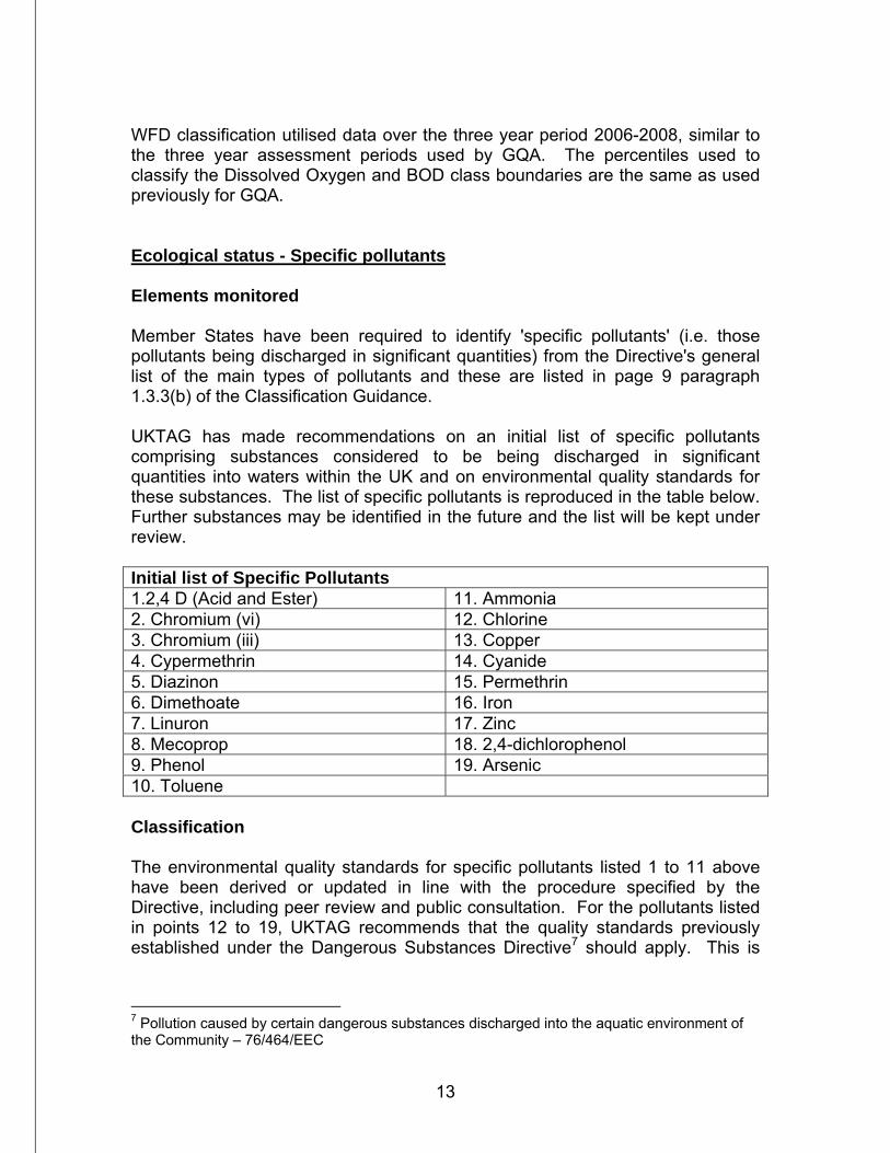
WFD classification utilised data over the three year period 2006-2008, similar to the three year assessment periods used by GQA. The percentiles used to classify the Dissolved Oxygen and BOD class boundaries are the same as used previously for GQA. Ecological status - Specific pollutants Elements monitored Member States have been required to identify 'specific pollutants' (i.e. those pollutants being discharged in significant quantities) from the Directive's general list of the main types of pollutants and these are listed in page 9 paragraph 1.3.3(b) of the Classification Guidance. UKTAG has made recommendations on an initial list of specific pollutants comprising substances considered to be being discharged in significant quantities into waters within the UK and on environmental quality standards for these substances. The list of specific pollutants is reproduced in the table below. Further substances may be identified in the future and the list will be kept under review. Initial list of Specific Pollutants 1.2,4 D (Acid and Ester) 11. Ammonia 2. Chromium (vi) 12. Chlorine 3. Chromium (iii) 13. Copper 4. Cypermethrin 14. Cyanide 5. Diazinon 15. Permethrin 6. Dimethoate 16. Iron 7. Linuron 17. Zinc 8. Mecoprop 18. 2,4-dichlorophenol 9. Phenol 19. Arsenic 10. Toluene Classification The environmental quality standards for specific pollutants listed 1 to 11 above have been derived or updated in line with the procedure specified by the Directive, including peer review and public consultation. For the pollutants listed in points 12 to 19, UKTAG recommends that the quality standards previously established under the Dangerous Substances Directive7 should apply. This is
7 Pollution caused by certain dangerous substances discharged into the aquatic environment of the Community – 76/464/EEC
14
because there are insufficient data available at present to recommend revision of these standards. For good ecological status, the environmental quality standards established for specific pollutants must not be exceeded. With the exception of ammonia, environmental quality standards for the specific pollutants have been set in such a way that, where the standards are met, no adverse effects on aquatic plants and animals should occur. Consequently, UKTAG recommends that in a water body complying with the standards for these specific pollutants, the water quality - as far as these specific pollutants are concerned - is capable of supporting the achievement of high or good ecological status. Ammonia has been included as a specific pollutant (rather than being included with the other general chemical elements) because of its toxicity to fish. The initial proposed standards for specific pollutants are presented in the UKTAG report 'Proposals for Environmental Quality Standards for Annex VIII Substances - Final Draft provided to administrations to brief Ministers'8 of January 2008. With the exception of ammonia, the standards for specific pollutants are expressed as a long term (annual mean) and as a short-term (maximum allowable concentration (MAC) estimated as a 95 percentile (latter not for all determinands). UKTAG recommend that the long-term standards are used for classification and that failure of the MAC is used to trigger additional investigation which, in turn, may lead to further monitoring and, where appropriate, action aimed at preventing deterioration of status. This approach has been followed here. For classification, ammonia was assessed using data from 2006-2008 as per the general chemical elements from surveillance and operational monitoring stations and the more detailed 5-band classification produced with the percentiles used for class boundaries the same as previously for GQA. Zinc and copper have been assessed from around 460 Freshwater Fish Directive9 monitoring stations for the same time period. Assessment for the other specific pollutants (with the exception of Chromium, Cypermethrin, Chlorine, Cyanide, Arsenic, Iron and Permethrin) was done using data from 2005-2008 at 11 stations at the downstream limits of major rivers (stations that have been monitored under the Dangerous Substances Directive and OSPAR convention10). In Northern Ireland, like other regions of the UK and Ireland, a specific list of both specific pollutants and priority substances (described later) has been drawn up by an expert group and consists of those substances that available evidence indicates should be monitored at Surveillance Monitoring stations. This list also
8 www.wfduk.org 9 The quality of fresh waters needing protection or improvement in order to support fish life – 78/659/EEC (revised by 2006/44/EC) 10 The 1992 OSPAR Convention is the current instrument guiding international cooperation on the protection of the marine environment of the North-East Atlantic.
15
includes further substances that have also been considered to pose a potential threat and therefore warrant monitoring. Taking into account available resources and, in particular, the amount of analytical methodology development required, a rolling 4-year specific pollutant/priority substances (SP/PS) monitoring programme at SM stations was introduced in April 2007 with the aim of monitoring for the complete list by March 2011. The complete list of chemicals in the SP/PS monitoring programme is presented in Annex 1. Note that this list is subject to revision and may not proceed as indicated. From this list, the specific pollutants phenol and diazinon have been classified. Specific pollutant monitoring has been done by NIEA staff with analyses at NIEA laboratories in Lisburn and under contract with the Environment Agency for England and Wales. Ecological status - Hydromorphology River habitat modification due to management and engineering practices can potentially have major impacts on river ecology. This is a new and developing science with the interrelationships currently poorly understood but should be investigated through priority research and development over the coming years. Elements monitored and classification There are three hydromorphological elements considered; morphological condition which includes river depth and width variation, structure and substrate of the river bed and structure of the riparian zone, river continuity, and the hydrological regime which includes quantity and dynamics of water flow and connection to the groundwater. Within the UK and Ireland, three systems have been used for assessing river hydromorphological quality. These are the River Habitat Survey (RHS) developed by the Environment Agency for England and Wales, Morphological Impact Assessment MIMAS (Scottish Environmental Protection Agency) and the Rapid Assessment Technique (RAT) from NS Share11 research for the island of Ireland. The RAT procedure was further developed by NIEA to be fully WFD compliant and has been renamed as the River Hydromorphological Assessment Technique (RHAT). As RHAT only became fully operational in 2008, initial river hydromorphological classification was done using a combination of River Habitat Survey studies from 2005-2007 and data from NS Share Further Characterisation work which assessed specific risks from intensive land use and channelisation.
11 NS Share – North South Shared Aquatic Resource – A NI/ROI WFD research project partly funded by the EC Interreg initiative
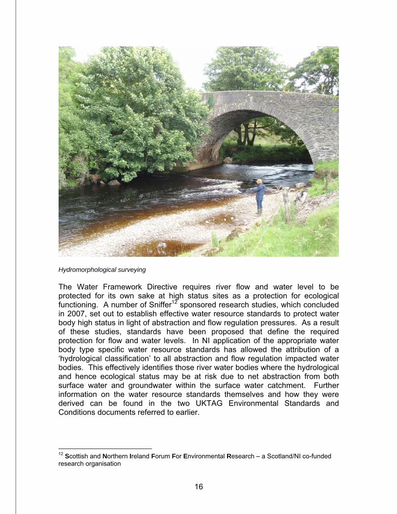
16
Hydromorphological surveying The Water Framework Directive requires river flow and water level to be protected for its own sake at high status sites as a protection for ecological functioning. A number of Sniffer12 sponsored research studies, which concluded in 2007, set out to establish effective water resource standards to protect water body high status in light of abstraction and flow regulation pressures. As a result of these studies, standards have been proposed that define the required protection for flow and water levels. In NI application of the appropriate water body type specific water resource standards has allowed the attribution of a ‘hydrological classification’ to all abstraction and flow regulation impacted water bodies. This effectively identifies those river water bodies where the hydrological and hence ecological status may be at risk due to net abstraction from both surface water and groundwater within the surface water catchment. Further information on the water resource standards themselves and how they were derived can be found in the two UKTAG Environmental Standards and Conditions documents referred to earlier.
12 Scottish and Northern Ireland Forum For Environmental Research – a Scotland/NI co-funded research organisation
17
As for other elements, the lowest class of the hydromorphology and the hydrology has been used to classify overall hydromorphological functioning. Apart from the NS Share Further Characterisation work all classification work has been done by NIEA staff. Chemical Status Priority substances and other EU-level dangerous substances Elements monitored Chemical status is perhaps confusingly named, given that many other chemicals have already been considered. Chemical status is assessed from what are known as priority substances, defined by the Directive as 'those which present a significant risk to or via the aquatic environment'13. An initial list of 33 substances and standards has been drawn up at a European level and are presented in ‘daughter’ Directive 2008/105/EC.14 Classification For classification, as for specific pollutants (except ammonia), assessments were made from 2005-2008 data from the 11 OSPAR stations at downstream locations on major rivers. The substances considered were as follows: Priority substances Gamma-HCH Pentachlorophenol Hexachlorobenzene Trichloromethane (Chloroform) Aldrin Carbon Tetrachloride Isodrin Trifluralin Dieldrin Endosulfan Endrin Hexachlorobutadiene Napthalene Simazine 1,2 Dichloroethane Chlorvenfinvos Atrazine Benzene Classification was also assessed for the following substances from year 1 of the SP/PS monitoring programme. The complete list of chemicals in the SP/PS monitoring programme is presented in Annex 1.
13 Article 16, paragraph 1. 14 Directive 2008/105/EC…on environmental quality standards in the field of water quality…
18
Atrazine 1-2 Dichloroethane Chlorofenvinphos Carbon tetrachloride Chloropyrifos Tetrachloroethene Simazine Trichloroethene Trichloromethane (Chloroform) Priority Substance monitoring has been undertaken by NIEA staff with analyses at NIEA laboratories in Lisburn and under contract with the Environment Agency for England and Wales. How river bodies have been classified One of the major differences between WFD classification and previous systems is that it is based on water bodies, rather than individual river reaches. River water bodies are discrete areas based on river confluences that can contain more than one river and there are therefore a range of possibilities for the number(s) of monitoring stations they contain. The Classification Guidance Section 5 deals with spatial issues with classification, including the impact of tributaries. Modes of river water body classification are summarised as follows: 1) Water body with no monitoring station:
a) Classified by adjacent water body either upstream or downstream, b) If water body is close to headwaters may be classified by a water body
that is more than one ‘empty’ body away, c) If agglomeration with others is not considered appropriate, classified from
either NI or ROI pressures and impacts information,
2) Water body with one monitoring station: a) Classified by that station b) If station is towards extremity of water body it may be necessary to
consider another station in adjacent water body (risk assess if e.g. other station is a very different class),
3) Water body with more than one station:
a) Averaged with other(s) b) May also need to consider stations in adjacent water bodies c) Risk assess the impact of tributary stations (see below)
Not all monitoring stations are monitored for both chemistry and biology. For reasons such as proximity to larger rivers or potential saline intrusion at downstream sites, some, including both SM and OM stations, are monitored for
19
biology or chemistry only. This can mean that different monitoring stations may be used to classify a water body for different quality elements. Given the distribution of the monitoring network and the delineation of the water bodies, a reasonable number of stations are on tributaries. From the Classification Guidance, the following ‘tributary rules’ were produced:
• If the tributary accounts for less than 10% of the water body its overall impact can be disregarded,
• If the tributary represents between 10-25% of the water body then, if the
main station(s) are classified as high and the tributary is less than high (doesn’t matter what), the overall class falls to good. If the other stations are less than high then the tributary has no impact, for example it cannot raise the overall classification,
• If the tributary represents more than 25% of the water body, and if it is a
lower class than the main station(s) then the overall class falls by one class.
In practice, tributary assessments within water bodies are based on the proportion of the tributary flow to the main river. A simple example of how river monitoring stations are considered for classification is provided by the River Tall.
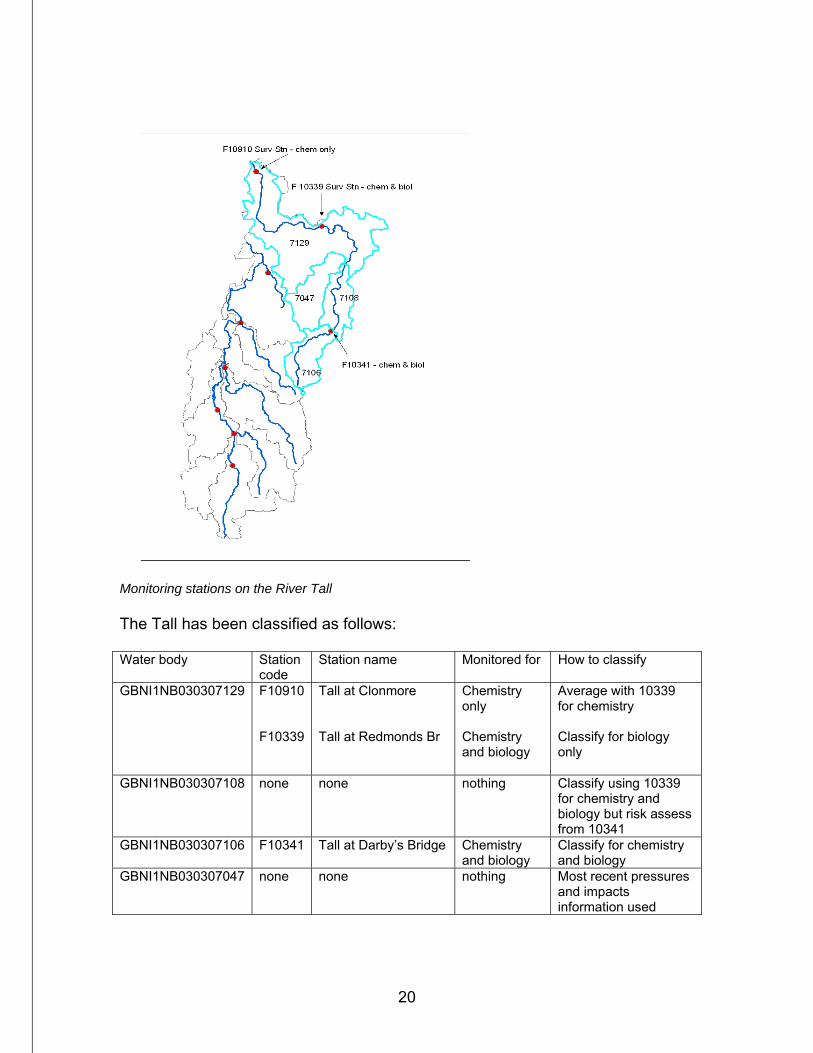
20
Monitoring stations on the River Tall The Tall has been classified as follows: Water body Station
code Station name Monitored for How to classify
GBNI1NB030307129
F10910 F10339
Tall at Clonmore Tall at Redmonds Br
Chemistry only Chemistry and biology
Average with 10339 for chemistry Classify for biology only
GBNI1NB030307108 none none nothing Classify using 10339 for chemistry and biology but risk assess from 10341
GBNI1NB030307106 F10341 Tall at Darby’s Bridge Chemistry and biology
Classify for chemistry and biology
GBNI1NB030307047 none none nothing Most recent pressures and impacts information used
21
The rules above have been followed for most quality elements with the following exceptions:
• Fish – it is not considered appropriate to classify fish other than in the water body in which they have been assessed as variables such as habitat conditions and patterns of fish movement in adjacent water bodies would be unknown. Often fish monitoring has to be done some distance from published locations of monitoring points due to issues such as representative favourable habitat and access etc.
• Hydromorphology – only classified where it has been assessed as it is
unique to each individual location. As stated above, a range of techniques have been used to produce classification for the first River Basin Plan. A procedure has been developed for water body hydromorphological assessment using the Rivers Hydromorphology Assessment technique which includes both desktop and field investigations.
• Specific Pollutants and Priority Substances - With ammonia, copper and
zinc having been monitored at hundreds of stations they have been considered as per the other general chemical elements. With much more limited information available for the other SP/PS it was only considered appropriate to classify them for the water bodies in which they were sampled, i.e. none of these water bodies were agglomerated with others with no monitoring.
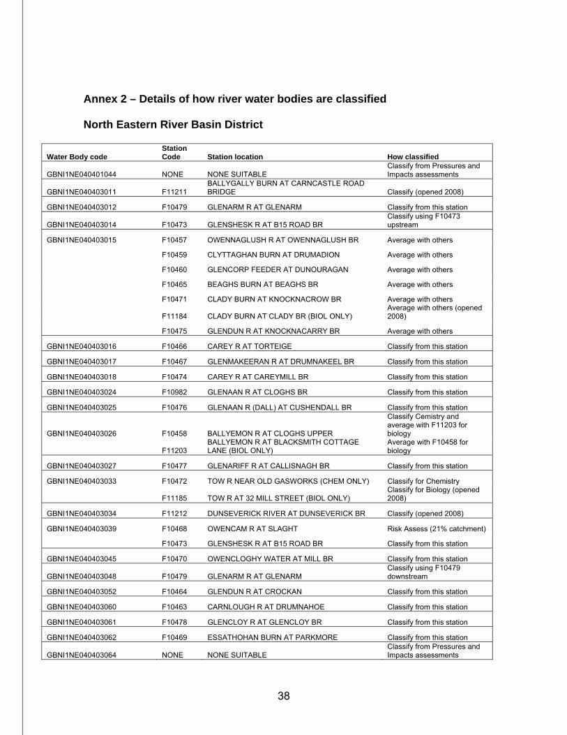
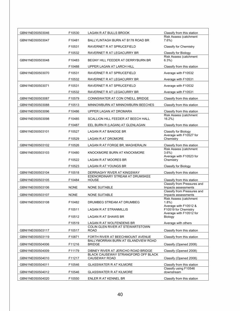
Some water bodies with no monitoring stations are not considered appropriate to agglomerate with others for classification. Such situations can arise, for example, for a water body that is a tributary of a larger river where the tributary would not be considered to be under the same pressure(s) as the main river. These water bodies have been classified by pressures and impacts information. Such information was initially gathered and reported for the WFD Article 5 report in 2004 and it contains information on point and diffuse inputs on rivers and has been regularly updated. Thirty eight water bodies have been classified in this way, including a number of cross-border water bodies which have been assessed by consultants under contract to the ROI EPA. During 2009 the river monitoring network was reviewed in order to reduce the number of water bodies classified in this way (as well as others without monitoring stations). This will lead to some new stations being opened, with some others not playing a significant role in classification either closed or monitored at a reduced frequency. Details of how each water body is classified with respect to monitoring stations are provided in Annex 2.
22
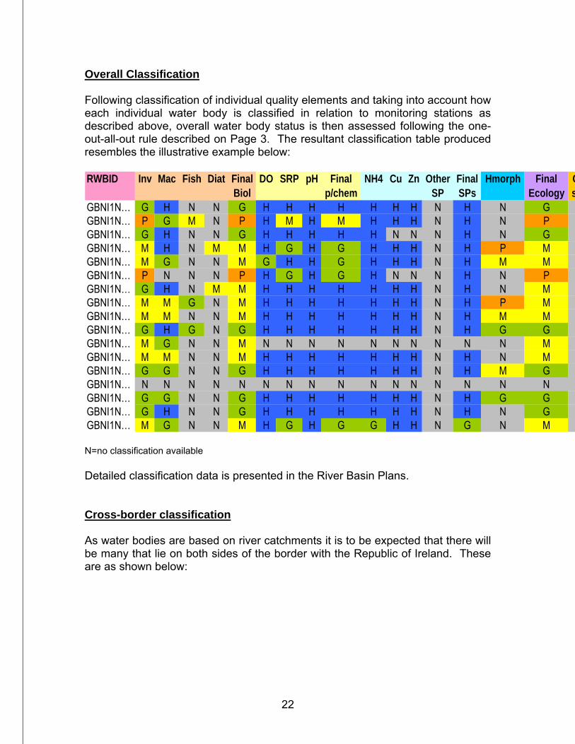
Overall Classification Following classification of individual quality elements and taking into account how each individual water body is classified in relation to monitoring stations as described above, overall water body status is then assessed following the one-out-all-out rule described on Page 3. The resultant classification table produced resembles the illustrative example below: RWBID Inv Mac Fish Diat Final DO SRP pH Final NH4 Cu Zn Other Final Hmorph Final C
Biol p/chem SP SPs Ecology sGBNI1N… G H N N G H H H H H H H N H N GGBNI1N… P G M N P H M H M H H H N H N PGBNI1N… G H N N G H H H H H N N N H N GGBNI1N… M H N M M H G H G H H H N H P MGBNI1N… M G N N M G H H G H H H N H M MGBNI1N… P N N N P H G H G H N N N H N PGBNI1N… G H N M M H H H H H H H N H N MGBNI1N… M M G N M H H H H H H H N H P MGBNI1N… M M N N M H H H H H H H N H M MGBNI1N… G H G N G H H H H H H H N H G GGBNI1N… M G N N M N N N N N N N N N N MGBNI1N… M M N N M H H H H H H H N H N MGBNI1N… G G N N G H H H H H H H N H M GGBNI1N… N N N N N N N N N N N N N N N NGBNI1N… G G N N G H H H H H H H N H G GGBNI1N… G H N N G H H H H H H H N H N GGBNI1N… M G N N M H G H G G H H N G N M N=no classification available Detailed classification data is presented in the River Basin Plans. Cross-border classification As water bodies are based on river catchments it is to be expected that there will be many that lie on both sides of the border with the Republic of Ireland. These are as shown below:
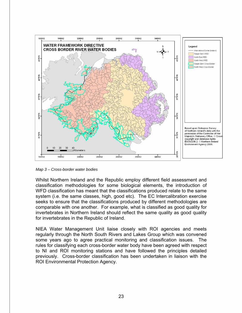
23
Map 3 – Cross-border water bodies Whilst Northern Ireland and the Republic employ different field assessment and classification methodologies for some biological elements, the introduction of WFD classification has meant that the classifications produced relate to the same system (i.e. the same classes, high, good etc). The EC Intercalibration exercise seeks to ensure that the classifications produced by different methodologies are comparable with one another. For example, what is classified as good quality for invertebrates in Northern Ireland should reflect the same quality as good quality for invertebrates in the Republic of Ireland. NIEA Water Management Unit liaise closely with ROI agencies and meets regularly through the North South Rivers and Lakes Group which was convened some years ago to agree practical monitoring and classification issues. The rules for classifying each cross-border water body have been agreed with respect to NI and ROI monitoring stations and have followed the principles detailed previously. Cross-border classification has been undertaken in liaison with the ROI Environmental Protection Agency.
24
Confidence in class The Water Framework Directive requires that ‘Estimates of the level of confidence and precision of the results provided by the monitoring programmes shall be given in the plan.’ (Annex V Paragraph 1.3). The proposed UK approach is presented in Section 4 of the Classification Guidance. However, at this stage, it is not possible to employ a wholly numeric approach, with one of the main reasons being that for some quality elements the software has not yet been developed to enable numeric confidence to be estimated. The system presently used is a simplistic alternative based on the differences between classification classes of individual biological and chemical parameters. It is based around the presumption that the major pressures on all water bodies are either from eutrophic and/or organic pressures, which is a reasonable assumption for rivers and lakes. No detailed analysis is currently available to be more specific than this. This methodology largely relies on the assumption that the individual classifications for each quality element are accurate. Confidence in class will be estimated as high, medium or low as per UKTAG guidance. The methodology involves assessing the confidence in class for each pressure for each water body using the procedure below and then taking the lowest confidence for the two pressures. However, it is also necessary to give weighting to the number of quality elements that have been combined to produce classification for each pressure. The rules are set out as follows: Number of QEs QEs and class differences Confidence 1 n/a Low 2 QEs the same class High 2 QEs cover two classes Medium 2 QEs cover more than two classes Low 3 or more QEs the same or cover two classes High 3 or more QEs cover three classes Medium 3 or more QEs cover four or five classes Low
For eutrophication pressures on rivers, macrophytes, diatoms and soluble reactive phosphorus (SRP) have been considered. For organic pressures in rivers, fish, invertebrates, Dissolved Oxygen, ammonia and BOD have been considered. The lower of the confidence classes for either of the impacts is then assigned as the overall confidence in class for a particular water body.
25
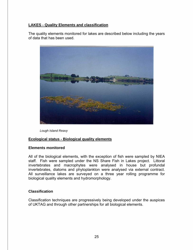
LAKES - Quality Elements and classification The quality elements monitored for lakes are described below including the years of data that has been used.
Lough Island Reavy Ecological status - Biological quality elements Elements monitored All of the biological elements, with the exception of fish were sampled by NIEA staff. Fish were sampled under the NS Share Fish in Lakes project. Littoral invertebrates and macrophytes were analysed in house but profundal invertebrates, diatoms and phytoplankton were analysed via external contract. All surveillance lakes are surveyed on a three year rolling programme for biological quality elements and hydromorphology. Classification Classification techniques are progressively being developed under the auspices of UKTAG and through other partnerships for all biological elements.
26
Macro-invertebrates Lake morphology divides the open water into littoral (shoreline) and profundal (deep) zones and the two areas support very different invertebrate populations due to differences in substrate, oxygen levels and nutrient availability. Work is ongoing to develop separate classification systems for each zone but to date these classification tools are not available and Northern Ireland therefore will not be classifying using lakes macroinvertebrates for this river basin plan. Macrophytes NIEA used the FREE Index developed by the ROI Environmental Protection Agency to classify NI lakes based on their macrophyte assemblages, as this gives the advantage of using the same method throughout Ecoregion 17. The FREE index uses the relative frequency of macrophytes found in each quadrant from all sites surveyed. It uses a combination of metrics to produce an overall FREE index for an individual lake. Boundaries are set using points of ecological change along a TP gradient based on reference sites from the IN-SIGHT15 palaeolimnology work. The FREE index is applicable across all lake types. Macrophyte surveys are carried out once in the maximum growth period generally between June and September and the classification is based on the data from the most recent survey year.
15 Identification of refereNce-Status for Irish lake typoloGies using palaeolimnological metHods and Techniques
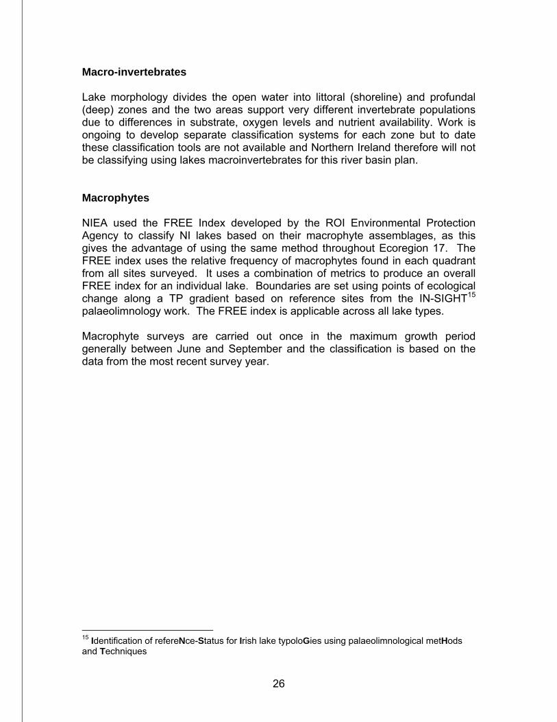
27
Macrophyte sampling Diatoms Diatoms have been assessed using the DARLEQ tool as an assessment of the impact of nutrient enrichment on phytobenthos. Species composition and relative abundance of benthic diatoms are assessed and used to calculate an index as nutrient concentrations increase. This is called the Lake Trophic Diatom Index (LTDI). Diatoms are sampled twice a year in spring and summer at a minimum of four sites per lake in the selected survey year. Phytoplankton Classification of lake phytoplankton is based on two metrics that have been developed and intercalibrated separately.
• Phytoplankton biomass is represented by chlorophyll. • Phytoplankton taxonomic composition and abundance is represented by
the percentage of nuisance cyanobacteria (blue-green algae) as measured by biovolume.
28
Chlorophyll Data was averaged over 2006-2008 from monthly samples taken from the shore. Environmental quality ratios (EQRs) for chlorophyll are then calculated as a ratio of the observed values to the expected values at Reference condition Phytoplankton are sampled three times a year in spring, summer and late summer in the selected survey year corresponding to the natural growth optima of a range of species groups. The measured value of percentage by biovolume of nuisance cyanobacteria, is the percentage of the total biovolume of the sample made up of cyanobacteria against the total biovolume of all phytoplankton taxa present in each sample The overall classification for the lake based on phytoplankton is the lower of the chlorophyll and % cyanobacteria classifications Fish All work on fish classification has been carried out under the NS Share Fish in Lakes project. Only a few lakes have been surveyed to date. Work to fully develop a lakes fish classification tool, building on initial work by the NS Share project, is proposed for 2009-10. Ecological status - General and physicochemical quality elements Total Phosphorous The importance of phosphorus is recognised by the inclusion of total phosphorus as part of the overall WFD Classification for lakes. Increasing nutrient concentrations will change the biomass and composition of biological communities with the most obvious primary impact being enhanced plant and algal production. Secondary impacts can include reduced dissolved oxygen levels caused by the overnight respiration of macrophytes which can lead to problems for fish. Elevated nutrient levels can also cause toxic blooms of blue-green algae leading to potential problems for livestock and other animals. Type specific standards are presented in the UKTAG Environmental Standards and Conditions documents referred to earlier but for our surveillance lakes NIEA used site specific equations to predict a reference TP for each individual lake based on alkalinity, depth and humic (colour) type. Observed TP data for each lake was collected from shoreline monitoring stations and averaged over 2006 to 2008.
29
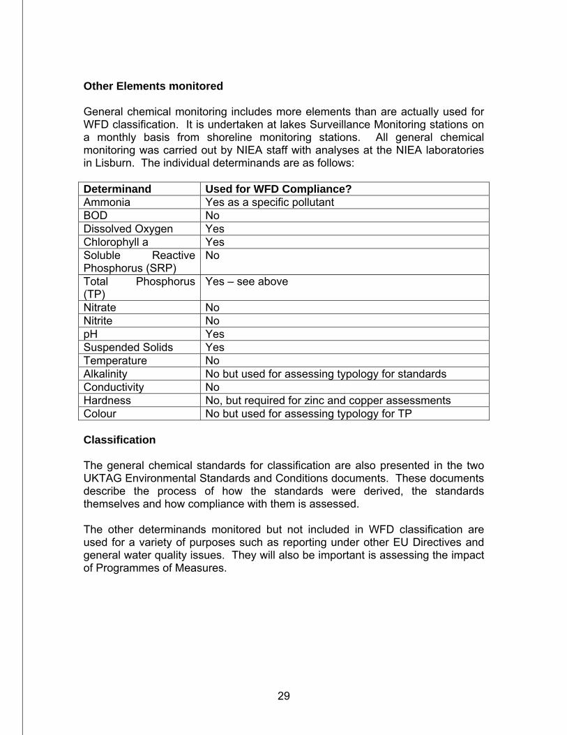
Other Elements monitored General chemical monitoring includes more elements than are actually used for WFD classification. It is undertaken at lakes Surveillance Monitoring stations on a monthly basis from shoreline monitoring stations. All general chemical monitoring was carried out by NIEA staff with analyses at the NIEA laboratories in Lisburn. The individual determinands are as follows: Determinand Used for WFD Compliance? Ammonia Yes as a specific pollutant BOD No Dissolved Oxygen Yes Chlorophyll a Yes Soluble Reactive Phosphorus (SRP)
No
Total Phosphorus (TP)
Yes – see above
Nitrate No Nitrite No pH Yes Suspended Solids Yes Temperature No Alkalinity No but used for assessing typology for standards Conductivity No Hardness No, but required for zinc and copper assessments Colour No but used for assessing typology for TP Classification The general chemical standards for classification are also presented in the two UKTAG Environmental Standards and Conditions documents. These documents describe the process of how the standards were derived, the standards themselves and how compliance with them is assessed. The other determinands monitored but not included in WFD classification are used for a variety of purposes such as reporting under other EU Directives and general water quality issues. They will also be important is assessing the impact of Programmes of Measures.
30
Ecological status - Specific pollutants Specific pollutant classification for lakes has been assessed from the nearest river outflow station. The other details are as for river classification on pages 13-15 above. Ecological status - Hydromorphology Lake Hydromorphology The condition of the lake hydromorphology plays an important role in determining the overall lake ecology. Lake management and engineering activities can have significant impacts on the availability of habitats and species and, therefore, the ability of the lake to support each of the biological elements. As with rivers, the relationship between lake hydromorphology and ecology is poorly understood and will benefit from focused research over the coming years. Elements monitored and classified There are two hydromorphological quality elements; the hydrological regime which includes quantity and dynamics of flow, residence time, connection to groundwater, and morphological condition which includes lake depth variation, quantity and structure of the substrate on the lake bed and the structure of the lake shore. The condition of the quality elements can be altered as result of lake management and engineering activities. Lake hydromorphological data is collected by two key survey protocols. The first is a bathymetric survey which provides information relating to the lake depth variation, including both the maximum and mean depths. From this, calculations can be made to determine the volume and residence time. The second protocol is the Lake Habitat Survey (LHS). This is a systematic method for characterising the physical habitats in lakes and the presence of pressures within and adjacent to the lake that could result in modification to the hydromorphology. Lake-MImAS (Morphological Impact Assessment System) was used to determine whether the hydromorphology was at High Status. This was developed primarily as a risk assessment tool to inform regulatory decisions but provides a consistent and objective framework for determining the hydromorphological condition of a water body and was therefore used in this round of classification. The method will need to be refined when empirical data that link hydromorphological alteration to ecological response becomes available.
31
As for rivers, the application of the appropriate water body type specific water resource standards for lakes has allowed the attribution of a hydrological classification to all abstraction and flow regulation impacted water bodies. However, for lake water bodies two separate hydrological elements were considered. The reduction in lake inflow due to abstraction and the lake level variation due to abstraction and flow regulation pressures were assessed against the developed standards. This identified those lake water bodies where the hydrological and hence ecological status may be at risk due to net abstraction and flow regulation within water body or the surface water catchment. Where a lake water body was deemed to have an un-natural level variation regime due to impoundment or level management, the application of the standards were impractical and it was assumed that standards to protect hydrological high status were not attained. Further information on the water resource standards themselves and how they were derived can be found in the two UKTAG Environmental Standards and Conditions documents. As for other elements, the lowest of the hydromorphology and the hydrology has been used to classify overall hydromorphology. All classification work has been done by NIEA staff. Chemical Status Priority substances and other EU-level dangerous substances Chemical status classification for lakes has been assessed from the nearest river outflow station. The other details are as for river classification on pages 17-18 above. How lake water bodies have been classified Only lakes greater than 50 hectares have been designated as specific water bodies and therefore classified individually. Guidance on spatial issues of classification can be found in the Classification Guidance section 5. Selected monitoring sites must be representative of the ecological quality of the lake. For macroinvertebrates, macrophytes and diatoms a minimum of 4 sites are surveyed per lake with more sites added with increasing lake size and complexity. At this early stage of WFD implementation, classification will not include complete coverage for every element. The Water Framework Directive does not require that a full monitoring programme is undertaken before the start of the next River Basin Plan period in 2010. However, NIEA have been working to
32
achieve as much as possible in the three-year period 2007-2009 (and also utilising older data where appropriate). The Water Framework Directive states that: ‘For surface water categories the ecological status classification for the body of water shall be represented by the lower of the values for the biological and physiochemical monitoring results for the relevant quality elements’. In other words the overall classification willl default to the lowest class produced by the biological quality elements and TP (the one out all out system described earlier) and in accordance with the directive each lake will be assigned an overall class from High, Good, Moderate, Poor and Bad If Hydromorphology is at less than high status it can only downgrade the overall classification from High to Good status. Overall Classification Following classification of individual quality elements and taking into account how each individual water body is classified, overall water body status is assessed following the one-out-all-out rules described on Page 3. Overall classification is then assessed in a similar fashion to that described on page 21 above for rivers. Detailed classification data is presented in the River Basin Plans. Cross-border classification Whilst Northern Ireland and the Republic of Ireland employ different field and assessment methodologies for some biological elements, the WFD Intercalibration exercise seeks to ensure that the classifications produced by different methodologies are comparable with one another. NIEA Water Management Unit liaises closely with ROI agencies and meets regularly through the North South Rivers and Lakes Group which was convened some years ago to agree practical monitoring and classification issues. The rules for classifying each cross-border lake were agreed and cross-border classification has been undertaken in liaison with the ROI Environmental Protection Agency. Confidence in Class As not all the lake classification tools produce a numerical confidence, the approach to confidence in class used by NIEA was similar to that used by the
33
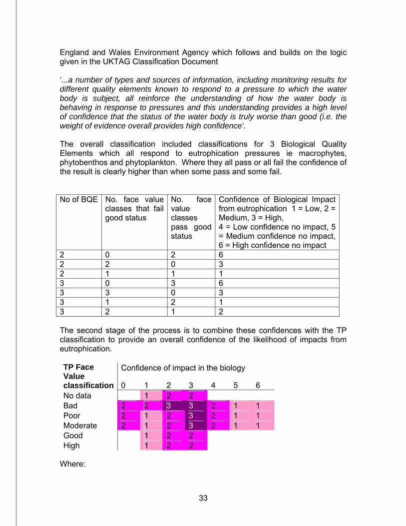
England and Wales Environment Agency which follows and builds on the logic given in the UKTAG Classification Document ‘...a number of types and sources of information, including monitoring results for different quality elements known to respond to a pressure to which the water body is subject, all reinforce the understanding of how the water body is behaving in response to pressures and this understanding provides a high level of confidence that the status of the water body is truly worse than good (i.e. the weight of evidence overall provides high confidence’. The overall classification included classifications for 3 Biological Quality Elements which all respond to eutrophication pressures ie macrophytes, phytobenthos and phytoplankton. Where they all pass or all fail the confidence of the result is clearly higher than when some pass and some fail. No of BQE No. face value
classes that fail good status
No. face value classes pass good status
Confidence of Biological Impact from eutrophication 1 = Low, 2 = Medium, 3 = High, 4 = Low confidence no impact, 5 = Medium confidence no impact, 6 = High confidence no impact
2 0 2 6 2 2 0 3 2 1 1 1 3 0 3 6 3 3 0 3 3 1 2 1 3 2 1 2 The second stage of the process is to combine these confidences with the TP classification to provide an overall confidence of the likelihood of impacts from eutrophication.
Confidence of impact in the biology TP Face Value classification 0 1 2 3 4 5 6 No data 1 2 2 Bad 2 2 3 3 2 1 1 Poor 2 1 2 3 2 1 1 Moderate 2 1 2 3 2 1 1 Good 1 2 2 High 1 2 2
Where:

34
0 No data 1 Low confidence of impact 2 Medium confidence of impact 3 High confidence of impact 4 Low confidence of no impact occurring 5 Medium confidence of no impact occurring 6 High confidence of no impact occurring
Note: Where there are no figures in the matrix the overall class has been high or good status and therefore high confidence that there is no impact
Lower Lough Erne
35
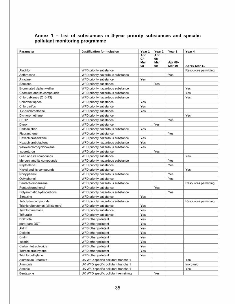
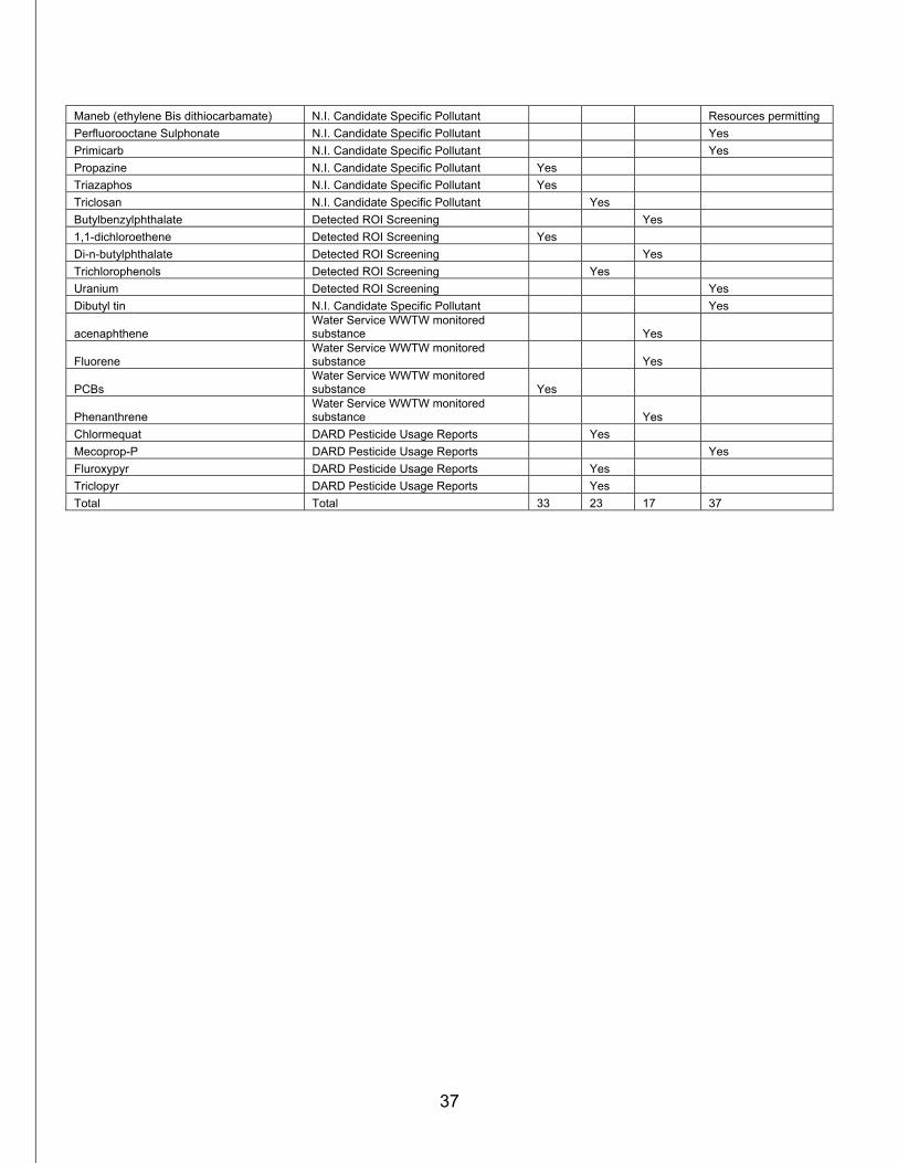
Annex 1 – List of substances in 4-year priority substances and specific pollutant monitoring programme
Parameter Justification for inclusion Year 1 Year 2 Year 3 Year 4
Apr 07- Mar 08
Apr 08-Mar 09
Apr 09-Mar 10 Apr10-Mar 11
Alachlor WFD priority substance Resources permitting Anthracene WFD priority hazardous substance Yes Atrazine WFD priority substance Yes Benzene WFD priority substance Yes Brominated diphenylether WFD priority hazardous substance Yes Cadmium and its compounds WFD priority hazardous substance Yes Chloroalkanes (C10-13) WFD priority hazardous substance Yes Chlorfenvinphos WFD priority substance Yes Chlorpyrifos WFD priority substance Yes 1,2-dichloroethane WFD priority substance Yes Dichloromethane WFD priority substance Yes DEHP WFD priority substance Yes Diuron WFD priority substance Yes Endosulphan WFD priority hazardous substance Yes Fluoranthene WFD priority substance Yes Hexachlorobenzene WFD priority hazardous substance Yes Hexachlorobutadiene WFD priority hazardous substance Yes γ-Hexachlorocyclohexane WFD priority hazardous substance Yes Isoproturon WFD priority substance Yes Lead and its compounds WFD priority substance Yes Mercury and its compounds WFD priority hazardous substance Yes Napthalene WFD priority substance Yes Nickel and its compounds WFD priority substance Yes Nonylphenol WFD priority hazardous substance Yes Octylphenol WFD priority substance Yes Pentachlorobenzene WFD priority hazardous substance Resources permitting Pentachlorophenol WFD priority substance Yes Polyaromatic hydrocarbons WFD priority hazardous substance Yes Simazine WFD priority substance Yes Tributyltin compounds WFD priority hazardous substance Resources permitting Trichlorobenzenes (all isomers) WFD priority substance Yes Trichloromethane WFD priority substance Yes Trifluralin WFD priority substance Yes DDT total WFD other pollutant Yes para-para-DDT WFD other pollutant Yes Aldrin WFD other pollutant Yes Dieldrin WFD other pollutant Yes Endrin WFD other pollutant Yes Isodrin WFD other pollutant Yes Carbon tetrachloride WFD other pollutant Yes Tetrachloroethylene WFD other pollutant Yes Trichloroethylene WFD other pollutant Yes Aluminium - reactive UK WFD specific pollutant tranche 1 Yes Ammonia UK WFD specific pollutant tranche 1 Inorganic Arsenic UK WFD specific pollutant tranche 1 Yes Bentazone UK WFD specific pollutant remaining Yes
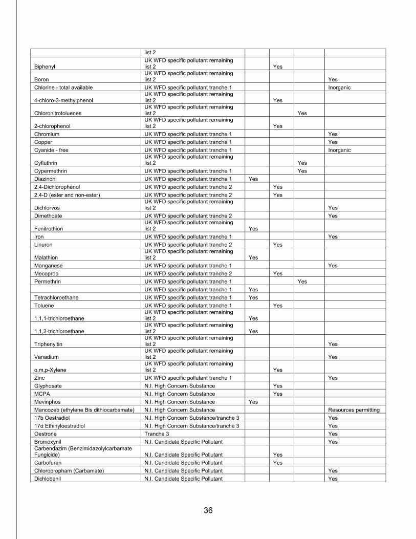
36
list 2
Biphenyl UK WFD specific pollutant remaining list 2 Yes
Boron UK WFD specific pollutant remaining list 2 Yes
Chlorine - total available UK WFD specific pollutant tranche 1 Inorganic
4-chloro-3-methylphenol UK WFD specific pollutant remaining list 2 Yes
Chloronitrotoluenes UK WFD specific pollutant remaining list 2 Yes
2-chlorophenol UK WFD specific pollutant remaining list 2 Yes
Chromium UK WFD specific pollutant tranche 1 Yes Copper UK WFD specific pollutant tranche 1 Yes Cyanide - free UK WFD specific pollutant tranche 1 Inorganic
Cyfluthrin UK WFD specific pollutant remaining list 2 Yes
Cypermethrin UK WFD specific pollutant tranche 1 Yes Diazinon UK WFD specific pollutant tranche 1 Yes 2,4-Dichlorophenol UK WFD specific pollutant tranche 2 Yes 2,4-D (ester and non-ester) UK WFD specific pollutant tranche 2 Yes
Dichlorvos UK WFD specific pollutant remaining list 2 Yes
Dimethoate UK WFD specific pollutant tranche 2 Yes
Fenitrothion UK WFD specific pollutant remaining list 2 Yes
Iron UK WFD specific pollutant tranche 1 Yes Linuron UK WFD specific pollutant tranche 2 Yes
Malathion UK WFD specific pollutant remaining list 2 Yes
Manganese UK WFD specific pollutant tranche 1 Yes Mecoprop UK WFD specific pollutant tranche 2 Yes Permethrin UK WFD specific pollutant tranche 1 Yes
UK WFD specific pollutant tranche 1 Yes Tetrachloroethane UK WFD specific pollutant tranche 1 Yes Toluene UK WFD specific pollutant tranche 1 Yes
1,1,1-trichloroethane UK WFD specific pollutant remaining list 2 Yes
1,1,2-trichloroethane UK WFD specific pollutant remaining list 2 Yes
Triphenyltin UK WFD specific pollutant remaining list 2 Yes
Vanadium UK WFD specific pollutant remaining list 2 Yes
o,m,p-Xylene UK WFD specific pollutant remaining list 2 Yes
Zinc UK WFD specific pollutant tranche 1 Yes Glyphosate N.I. High Concern Substance Yes MCPA N.I. High Concern Substance Yes Mevinphos N.I. High Concern Substance Yes Mancozeb (ethylene Bis dithiocarbamate) N.I. High Concern Substance Resources permitting 17b Oestradiol N.I. High Concern Substance/tranche 3 Yes 17ά Ethinyloestradiol N.I. High Concern Substance/tranche 3 Yes Oestrone Tranche 3 Yes Bromoxynil N.I. Candidate Specific Pollutant Yes Carbendazim (Benzimidazolylcarbamate Fungicide) N.I. Candidate Specific Pollutant Yes Carbofuran N.I. Candidate Specific Pollutant Yes Chloropropham (Carbamate) N.I. Candidate Specific Pollutant Yes Dichlobenil N.I. Candidate Specific Pollutant Yes
37
Maneb (ethylene Bis dithiocarbamate) N.I. Candidate Specific Pollutant Resources permitting Perfluorooctane Sulphonate N.I. Candidate Specific Pollutant Yes Primicarb N.I. Candidate Specific Pollutant Yes Propazine N.I. Candidate Specific Pollutant Yes Triazaphos N.I. Candidate Specific Pollutant Yes Triclosan N.I. Candidate Specific Pollutant Yes Butylbenzylphthalate Detected ROI Screening Yes 1,1-dichloroethene Detected ROI Screening Yes Di-n-butylphthalate Detected ROI Screening Yes Trichlorophenols Detected ROI Screening Yes Uranium Detected ROI Screening Yes Dibutyl tin N.I. Candidate Specific Pollutant Yes
acenaphthene Water Service WWTW monitored substance Yes
Fluorene Water Service WWTW monitored substance Yes
PCBs Water Service WWTW monitored substance Yes
Phenanthrene Water Service WWTW monitored substance Yes
Chlormequat DARD Pesticide Usage Reports Yes Mecoprop-P DARD Pesticide Usage Reports Yes Fluroxypyr DARD Pesticide Usage Reports Yes Triclopyr DARD Pesticide Usage Reports Yes Total Total 33 23 17 37
38
Annex 2 – Details of how river water bodies are classified North Eastern River Basin District
Water Body code Station Code Station location How classified
GBNI1NE040401044 NONE NONE SUITABLE Classify from Pressures and Impacts assessments
GBNI1NE040403011 F11211 BALLYGALLY BURN AT CARNCASTLE ROAD BRIDGE Classify (opened 2008)
GBNI1NE040403012 F10479 GLENARM R AT GLENARM Classify from this station
GBNI1NE040403014 F10473 GLENSHESK R AT B15 ROAD BR Classify using F10473 upstream
GBNI1NE040403015 F10457 OWENNAGLUSH R AT OWENNAGLUSH BR Average with others
F10459 CLYTTAGHAN BURN AT DRUMADION Average with others
F10460 GLENCORP FEEDER AT DUNOURAGAN Average with others
F10465 BEAGHS BURN AT BEAGHS BR Average with others
F10471 CLADY BURN AT KNOCKNACROW BR Average with others
F11184 CLADY BURN AT CLADY BR (BIOL ONLY) Average with others (opened 2008)
F10475 GLENDUN R AT KNOCKNACARRY BR Average with others
GBNI1NE040403016 F10466 CAREY R AT TORTEIGE Classify from this station
GBNI1NE040403017 F10467 GLENMAKEERAN R AT DRUMNAKEEL BR Classify from this station
GBNI1NE040403018 F10474 CAREY R AT CAREYMILL BR Classify from this station
GBNI1NE040403024 F10982 GLENAAN R AT CLOGHS BR Classify from this station
GBNI1NE040403025 F10476 GLENAAN R (DALL) AT CUSHENDALL BR Classify from this station
GBNI1NE040403026 F10458 BALLYEMON R AT CLOGHS UPPER
Classify Cemistry and average with F11203 for biology
F11203 BALLYEMON R AT BLACKSMITH COTTAGE LANE (BIOL ONLY)
Average with F10458 for biology
GBNI1NE040403027 F10477 GLENARIFF R AT CALLISNAGH BR Classify from this station
GBNI1NE040403033 F10472 TOW R NEAR OLD GASWORKS (CHEM ONLY) Classify for Chemistry
F11185 TOW R AT 32 MILL STREET (BIOL ONLY) Classify for Biology (opened 2008)
GBNI1NE040403034 F11212 DUNSEVERICK RIVER AT DUNSEVERICK BR Classify (opened 2008)
GBNI1NE040403039 F10468 OWENCAM R AT SLAGHT Risk Assess (21% catchment)
F10473 GLENSHESK R AT B15 ROAD BR Classify from this station
GBNI1NE040403045 F10470 OWENCLOGHY WATER AT MILL BR Classify from this station
GBNI1NE040403048 F10479 GLENARM R AT GLENARM Classify using F10479 downstream
GBNI1NE040403052 F10464 GLENDUN R AT CROCKAN Classify from this station
GBNI1NE040403060 F10463 CARNLOUGH R AT DRUMNAHOE Classify from this station
GBNI1NE040403061 F10478 GLENCLOY R AT GLENCLOY BR Classify from this station
GBNI1NE040403062 F10469 ESSATHOHAN BURN AT PARKMORE Classify from this station
GBNI1NE040403064 NONE NONE SUITABLE Classify from Pressures and Impacts assessments
39
GBNI1NE040404001 F10452 BUSH R AT CONOGHER BR Classify using F10452 downstream
GBNI1NE040404002 F10455 DERVOCK R AT DERVOCK BR Classify using F10455 downstream
GBNI1NE040404003 F10456 DOUGHERY WATER AT IDEROWN BR Classify from this station
GBNI1NE040404004 F10445 DERVOCK R TRIBUTARY AT DERVOCK Average with F10455
F10455 DERVOCK R AT DERVOCK BR Average with F10445
GBNI1NE040404035 F10442 MOSS-SIDE WATER AT GORTANUEY BR Classify from this station
GBNI1NE040404036 F10444 LISCOLMAN FEEDER AT BALLYMACFIN Classify from this station
GBNI1NE040404037 F10456 DOUGHERY WATER AT IDEROWN BR Classify using F10456 downstream
GBNI1NE040404038 F10448 WELL WATER AT TURNAROBERT Classify from this station
GBNI1NE040404040 F10456 DOUGHERY WATER AT IDEROWN BR Classify using F10456 downstream
GBNI1NE040404042 F10446 BUSH R TRIBUTARY AT WALK MILL Risk Assess (2.4% catchment)
F10449 BUSH R AT BUSHMILLS NEW BR Classify from this station
F10452 BUSH R AT CONOGHER BR Risk Assess
GBNI1NE040404049 F10454 BUSH R AT BALLYHOE BR Classify from this station
GBNI1NE040404050 F10443 FLESK WATER AT FLESK BR Classify from this station
GBNI1NE040404051 F10452 BUSH R AT CONOGHER BR Classify using F10452 downstream
GBNI1NE040404053 F10447 BURN GUSHET R AT BALLYBOGY Classify from this station
GBNI1NE040404054 F10451 BURN GUSHET R AT BURN GUSHET BR Classify from this station
GBNI1NE040404055 NONE NONE SUITABLE Classify from Pressures and Impacts assessments
GBNI1NE040405046 F10552 GLENOE WATER AT GLENOE Risk Assess
F10553 DUNISLAND WATER AT RUNGILL Risk Assess (26.9% catchment)
F10556 GLYNN R AT GLYNN Classify from this station
GBNI1NE040405047 F10551 LARNE R AT BALLYRICKARD BR Risk Assess
F10554 LARNE R AT ROCK FILLING STATION Risk Assess
F10555 LARNE R AT OWENS BR Classify from this station
GBNI1NE050501004 NONE NONE SUITABLE Classify from Pressures and Impacts assessments
GBNI1NE050501082 F10557 KILROOT R AT KILROOT Classify from this station
GBNI1NE050501118 F10560 THREE MILE WATER AT GLENAVNA HOTEL Classify from this station
GBNI1NE050501120 F10559 WOODBURN R AT COURTALDS FACTORY Classify from this station
GBNI1NE050502083 F10576 CRAWFORDSBURN R AT C'BURN COUNTRY PARK Classify from this station
GBNI1NE050502084 F10573 BALLYHOLME BAY STREAM/COTTON R AT COTTON BR
Average with F10574 for Biology
F10574 BALLYHOLME BAY STREAM/COTTON R AT BALLYHOLME BR
Classify Chemistry and average with 10573 for Biology
GBNI1NE050503001 WNEHIL1 HILLSBOROUGH WWTW Classify from Pressures and Impacts assessments
GBNI1NE050503002 F10871 FORTH RIVER AT BEECHMOUNT AVENUE Classify using F10871 and F10494 upstream
F10494 BLACKSTAFF RIVER (BELFAST) AT B'MORAL STMWASH, BOUCHER
Classify using F10871 and F10494 upstream
GBNI1NE050503003 F10494 BLACKSTAFF RIVER (BELFAST) AT B'MORAL STMWASH, BOUCHER Classify (reopened 2008)
40
GBNI1NE050503046 F10530 LAGAN R AT BULLS BROOK Classify from this station
GBNI1NE050503047 F10481 BALLYLINTAGH BURN AT B178 ROAD BR Risk Assess (catchment 7.6%)
F10531 RAVERNET R AT SPRUCEFIELD Classify for Chemistry
F10532 RAVERNET R AT LEGACURRY BR Classify for Biology
GBNI1NE050503048 F10483 BEGNY HILL FEEDER AT DERRYBURN BR Risk Assess (catchment 6.3%)
F10488 UPPER LAGAN AT LARCH HILL Classify from this station
GBNI1NE050503070 F10531 RAVERNET R AT SPRUCEFIELD Average with F10532
F10532 RAVERNET R AT LEGACURRY BR Average with F10531
GBNI1NE050503071 F10531 RAVERNET R AT SPRUCEFIELD Average with F10532
F10532 RAVERNET R AT LEGACURRY BR Average with F10531
GBNI1NE050503087 F10579 CONNSWATER AT CON O'NEILL BRIDGE Classify from this station
GBNI1NE050503088 F10513 MINNOWBURN AT MINNOWBURN BEECHES Classify from this station
GBNI1NE050503096 F10486 UPPER LAGAN AT DROMARA Classify from this station
GBNI1NE050503098 F10485 SCALLION HILL FEEDER AT BEECH HALL Risk Assess (catchment 16.2%)
F10487 EEL BURN R (LAGAN) AT GLENLAGAN Classify from this station
GBNI1NE050503101 F10527 LAGAN R AT BANOGE BR Classify for Biology
F10529 LAGAN R AT DROMORE Average with F10527 for Chemistry
GBNI1NE050503102 F10526 LAGAN R AT FORGE BR, MAGHERALIN Classify from this station
GBNI1NE050503103 F10480 KNOCKMORE BURN AT KNOCKMORE Risk Assess (catchment 3.6%)
F10522 LAGAN R AT MOORES BR Average with F10523 for Chemistry
F10523 LAGAN R AT YOUNGS BR Classify for Biology
GBNI1NE050503104 F10518 DERRIAGHY RIVER AT KINGSWAY Classify from this station
GBNI1NE050503105 F10484 EDENORDINARY STREAM AT DRUMSKEE HOUSE Classify from this station
GBNI1NE050503106 NONE NONE SUITABLE Classify from Pressures and Impacts assessments
GBNI1NE050503107 NONE NONE SUITABLE Classify from Pressures and Impacts assessments
GBNI1NE050503108 F10482 DRUMBEG STREAM AT DRUMBEG Risk Assess (catchment 1.8%)
F10511 LAGAN R AT STRANMILLIS Average with F10512 & F10519 for Chemistry
F10512 LAGAN R AT SHAWS BR Average with F10512 for Biology
F10519 LAGAN R AT WOLFENDENS BR Average with others
GBNI1NE050503117 F10517 COLIN GLEN RIVER AT STEWARTSTOWN ROAD Classify from this station
GBNI1NE050503119 F10871 FORTH RIVER AT BEECHMOUNT AVENUE Classify from this station
GBNI1NE050504006 F11216 BALLYMORRAN BURN AT ISLANDVIEW ROAD BRIDGE Classify (Opened 2008)
GBNI1NE050504009 F11179 DIBNEY RIVER AT JERICHO ROAD BRIDGE Classify (Opened 2008)
GBNI1NE050504010 F11217 BLACK CAUSEWAY STRANGFORD OFF BLACK CAUSEWAY ROAD Classify (Opened 2008)
GBNI1NE050504011 F10546 GLASSWATER R AT KILMORE Classify from this station
GBNI1NE050504012 F10546 GLASSWATER R AT KILMORE Classify using F10546 downstream
GBNI1NE050504020 F10550 ENLER R AT KENNEL BR Classify from this station
41
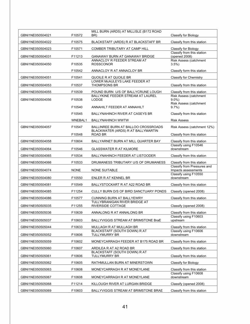
GBNI1NE050504021 F10572 MILL BURN (ARDS) AT MILLISLE (B172 ROAD BR) Classify for Biology
GBNI1NE050504022 F10575 BLACKSTAFF (ARDS) R AT BLACKSTAFF BR Classify from this station
GBNI1NE050504023 F10571 COMBER TRIBUTARY AT CAMP HILL Classify for Biology
GBNI1NE050504031 F11213 GANAWAY BURN AT GANAWAY BRIDGE Classify from this station (opened 2008)
GBNI1NE050504050 F10535 ANNACLOY R FEEDER STREAM AT ROSSCONOR
Risk Assess (catchment 3.5%)
F10542 ANNACLOY R AT ANNACLOY BR Classify form this station
GBNI1NE050504051 F10541 QUOILE R AT QUOILE BR Classify for Chemistry
GBNI1NE050504053 F10537 LOWER McAULEYS LAKE FEEDER AT THOMPSONS BR Classify from this station
GBNI1NE050504055 F10539 POUND BURN U/S OF BALLYCRUNE LOUGH Classify from this station
GBNI1NE050504056 F10538 BALLYKINE FEEDER STREAM AT LAUREL LODGE
Risk Assess (catchment 9.0%)
F10540 ANNAHILT FEEDER AT ANNAHILT Risk Assess (catchment 9.7%)
F10545 BALLYNAHINCH RIVER AT CASEYS BR Classify from this station
WNEBAL1 BALLYNAHINCH WWTW Risk Assess
GBNI1NE050504057 F10547 BALLINREE BURN AT BALLOO CROSSROADS Risk Assess (catchment 12%)
F10548 BLACKWATER (ARDS) R AT BALLYMARTIN ROAD BR Classify from this station
GBNI1NE050504058 F10604 BALLYARNET BURN AT MILL QUARTER BAY Classify from this station
GBNI1NE050504064 F10546 GLASSWATER R AT KILMORE Classify using F10546 downstream
GBNI1NE050504065 F10534 BALLYNAHINCH FEEDER AT LISTOODER Classify from this station
GBNI1NE050504066 F10533 DRUMANESS TRIBUTARY U/S OF DRUMANESS Classify from this station
GBNI1NE050504074 NONE NONE SUITABLE Classify from Pressures and Impacts assessments
GBNI1NE050504080 F10550 ENLER R AT KENNEL BR Classify using F10550 downstream
GBNI1NE050504081 F10549 BALLYSTOCKART R AT A22 ROAD BR Classify from this station
GBNI1NE050504085 F11254 CULLY BURN D/S OF BIRD SANCTUARY PONDS Classify (opened 2008)
GBNI1NE050504086 F10577 CUNNING BURN AT BALLYEWRY Classify from this station
GBNI1NE050505035 F11255 TULLYBRANIGAN RIVER BRIDGE AT RIVERSIDE COTTAGE Classify (opened 2008)
GBNI1NE050505036 F10639 ANNALONG R AT ANNALONG BR Classify from this station
GBNI1NE050505037 F10603 BALLYVIGGIS STREAM AT BRIMSTONE BraE Classify using F10603 upstream
GBNI1NE050505044 F10633 MULLAGH R AT MULLAGH BR Classify from this station
GBNI1NE050505052 F10606 BLACKSTAFF (SOUTH DOWN) R AT TULLYMURRY BR
Classify using F10606 downstream
GBNI1NE050505059 F10602 MONEYCARRAGH FEEDER AT B175 ROAD BR Classify from this station
GBNI1NE050505060 F10607 ARDILEA R AT A2 ROAD BR Classify from this station
GBNI1NE050505061 F10606 BLACKSTAFF (SOUTH DOWN) R AT TULLYMURRY BR Classify from this station
GBNI1NE050505062 F10605 RATHMULLAN BURN AT MINERSTOWN Classify for Biology
GBNI1NE050505063 F10608 MONEYCARRAGH R AT MONEYLANE Classify from this station
GBNI1NE050505067 F10608 MONEYCARRAGH R AT MONEYLANE Classify using F10608 downstream
GBNI1NE050505068 F11214 KILLOUGH RIVER AT LURGAN BRIDGE Classify (opened 2008)
GBNI1NE050505069 F10603 BALLYVIGGIS STREAM AT BRIMSTONE BRAE Classify from this station

42
GBNI1NE050505097 F10641 AUGHRIM R AT KILKEEL Classify from this station
GBNI1NE050505110 F10628 TRASSEY R AT TRASSEY BR Risk Assess (catchment 16%)
F10636 SHIMNA R AT IVY BR, TOLLYMORE FOREST Classify from this station
GBNI1NE050505111 F10635 BURREN R AT BAILEYS BR Classify from this station
GBNI1NE050505113 F10609 CARRIGS R AT MAGHERA BR Classify from this station
GBNI1NE050505114 F10640 KILKEEL R AT A2 ROAD BR, KILKEEL Average with F10981
F10981 BEN CROM STREAM ABOVE SILENT VALLEY Average with F10640
43
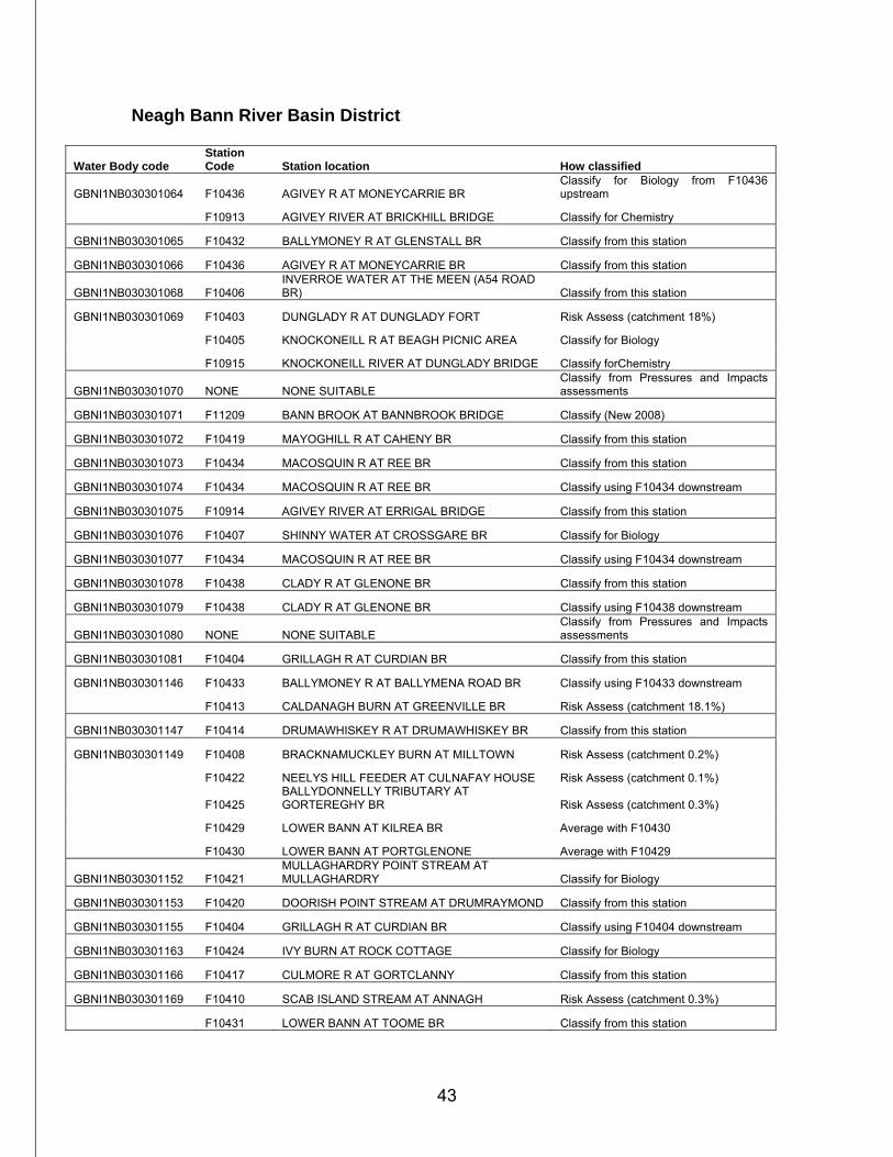
Neagh Bann River Basin District
Water Body code Station Code Station location How classified
GBNI1NB030301064 F10436 AGIVEY R AT MONEYCARRIE BR Classify for Biology from F10436 upstream
F10913 AGIVEY RIVER AT BRICKHILL BRIDGE Classify for Chemistry
GBNI1NB030301065 F10432 BALLYMONEY R AT GLENSTALL BR Classify from this station
GBNI1NB030301066 F10436 AGIVEY R AT MONEYCARRIE BR Classify from this station
GBNI1NB030301068 F10406 INVERROE WATER AT THE MEEN (A54 ROAD BR) Classify from this station
GBNI1NB030301069 F10403 DUNGLADY R AT DUNGLADY FORT Risk Assess (catchment 18%)
F10405 KNOCKONEILL R AT BEAGH PICNIC AREA Classify for Biology
F10915 KNOCKONEILL RIVER AT DUNGLADY BRIDGE Classify forChemistry
GBNI1NB030301070 NONE NONE SUITABLE Classify from Pressures and Impacts assessments
GBNI1NB030301071 F11209 BANN BROOK AT BANNBROOK BRIDGE Classify (New 2008)
GBNI1NB030301072 F10419 MAYOGHILL R AT CAHENY BR Classify from this station
GBNI1NB030301073 F10434 MACOSQUIN R AT REE BR Classify from this station
GBNI1NB030301074 F10434 MACOSQUIN R AT REE BR Classify using F10434 downstream
GBNI1NB030301075 F10914 AGIVEY RIVER AT ERRIGAL BRIDGE Classify from this station
GBNI1NB030301076 F10407 SHINNY WATER AT CROSSGARE BR Classify for Biology
GBNI1NB030301077 F10434 MACOSQUIN R AT REE BR Classify using F10434 downstream
GBNI1NB030301078 F10438 CLADY R AT GLENONE BR Classify from this station
GBNI1NB030301079 F10438 CLADY R AT GLENONE BR Classify using F10438 downstream
GBNI1NB030301080 NONE NONE SUITABLE Classify from Pressures and Impacts assessments
GBNI1NB030301081 F10404 GRILLAGH R AT CURDIAN BR Classify from this station
GBNI1NB030301146 F10433 BALLYMONEY R AT BALLYMENA ROAD BR Classify using F10433 downstream
F10413 CALDANAGH BURN AT GREENVILLE BR Risk Assess (catchment 18.1%)
GBNI1NB030301147 F10414 DRUMAWHISKEY R AT DRUMAWHISKEY BR Classify from this station
GBNI1NB030301149 F10408 BRACKNAMUCKLEY BURN AT MILLTOWN Risk Assess (catchment 0.2%)
F10422 NEELYS HILL FEEDER AT CULNAFAY HOUSE Risk Assess (catchment 0.1%)
F10425 BALLYDONNELLY TRIBUTARY AT GORTEREGHY BR Risk Assess (catchment 0.3%)
F10429 LOWER BANN AT KILREA BR Average with F10430
F10430 LOWER BANN AT PORTGLENONE Average with F10429
GBNI1NB030301152 F10421 MULLAGHARDRY POINT STREAM AT MULLAGHARDRY Classify for Biology
GBNI1NB030301153 F10420 DOORISH POINT STREAM AT DRUMRAYMOND Classify from this station
GBNI1NB030301155 F10404 GRILLAGH R AT CURDIAN BR Classify using F10404 downstream
GBNI1NB030301163 F10424 IVY BURN AT ROCK COTTAGE Classify for Biology
GBNI1NB030301166 F10417 CULMORE R AT GORTCLANNY Classify from this station
GBNI1NB030301169 F10410 SCAB ISLAND STREAM AT ANNAGH Risk Assess (catchment 0.3%)
F10431 LOWER BANN AT TOOME BR Classify from this station
44
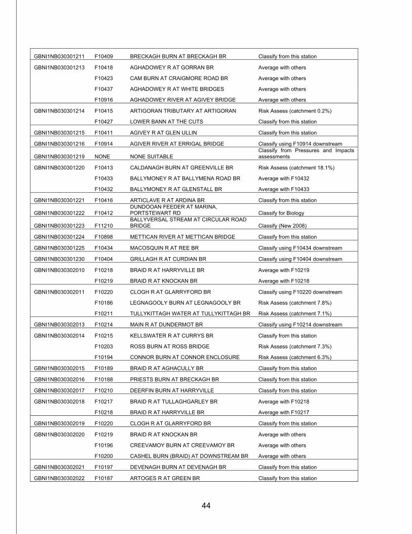
GBNI1NB030301211 F10409 BRECKAGH BURN AT BRECKAGH BR Classify from this station
GBNI1NB030301213 F10418 AGHADOWEY R AT GORRAN BR Average with others
F10423 CAM BURN AT CRAIGMORE ROAD BR Average with others
F10437 AGHADOWEY R AT WHITE BRIDGES Average with others
F10916 AGHADOWEY RIVER AT AGIVEY BRIDGE Average with others
GBNI1NB030301214 F10415 ARTIGORAN TRIBUTARY AT ARTIGORAN Risk Assess (catchment 0.2%)
F10427 LOWER BANN AT THE CUTS Classify from this station
GBNI1NB030301215 F10411 AGIVEY R AT GLEN ULLIN Classify from this station
GBNI1NB030301216 F10914 AGIVER RIVER AT ERRIGAL BRIDGE Classify using F10914 downstream
GBNI1NB030301219 NONE NONE SUITABLE Classify from Pressures and Impacts assessments
GBNI1NB030301220 F10413 CALDANAGH BURN AT GREENVILLE BR Risk Assess (catchment 18.1%)
F10433 BALLYMONEY R AT BALLYMENA ROAD BR Average with F10432
F10432 BALLYMONEY R AT GLENSTALL BR Average with F10433
GBNI1NB030301221 F10416 ARTICLAVE R AT ARDINA BR Classify from this station
GBNI1NB030301222 F10412 DUNDOOAN FEEDER AT MARINA, PORTSTEWART RD Classify for Biology
GBNI1NB030301223 F11210 BALLYVERSAL STREAM AT CIRCULAR ROAD BRIDGE Classify (New 2008)
GBNI1NB030301224 F10898 METTICAN RIVER AT METTICAN BRIDGE Classify from this station
GBNI1NB030301225 F10434 MACOSQUIN R AT REE BR Classify using F10434 downstream
GBNI1NB030301230 F10404 GRILLAGH R AT CURDIAN BR Classify using F10404 downstream
GBNI1NB030302010 F10218 BRAID R AT HARRYVILLE BR Average with F10219
F10219 BRAID R AT KNOCKAN BR Average with F10218
GBNI1NB030302011 F10220 CLOGH R AT GLARRYFORD BR Classify using F10220 downstream
F10186 LEGNAGOOLY BURN AT LEGNAGOOLY BR Risk Assess (catchment 7.8%)
F10211 TULLYKITTAGH WATER AT TULLYKITTAGH BR Risk Assess (catchment 7.1%)
GBNI1NB030302013 F10214 MAIN R AT DUNDERMOT BR Classify using F10214 downstream
GBNI1NB030302014 F10215 KELLSWATER R AT CURRYS BR Classify from this station
F10203 ROSS BURN AT ROSS BRIDGE Risk Assess (catchment 7.3%)
F10194 CONNOR BURN AT CONNOR ENCLOSURE Risk Assess (catchment 6.3%)
GBNI1NB030302015 F10189 BRAID R AT AGHACULLY BR Classify from this station
GBNI1NB030302016 F10188 PRIESTS BURN AT BRECKAGH BR Classify from this station
GBNI1NB030302017 F10210 DEERFIN BURN AT HARRYVILLE Classify from this station
GBNI1NB030302018 F10217 BRAID R AT TULLAGHGARLEY BR Average with F10218
F10218 BRAID R AT HARRYVILLE BR Average with F10217
GBNI1NB030302019 F10220 CLOGH R AT GLARRYFORD BR Classify from this station
GBNI1NB030302020 F10219 BRAID R AT KNOCKAN BR Average with others
F10196 CREEVAMOY BURN AT CREEVAMOY BR Average with others
F10200 CASHEL BURN (BRAID) AT DOWNSTREAM BR Average with others
GBNI1NB030302021 F10197 DEVENAGH BURN AT DEVENAGH BR Classify from this station
GBNI1NB030302022 F10187 ARTOGES R AT GREEN BR Classify from this station
45
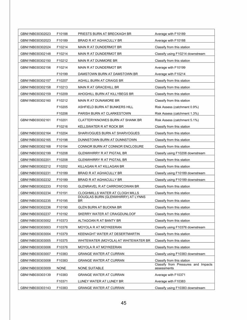
GBNI1NB030302023 F10188 PRIESTS BURN AT BRECKAGH BR Average with F10189
GBNI1NB030302023 F10189 BRAID R AT AGHACULLY BR Average with F10188
GBNI1NB030302024 F10214 MAIN R AT DUNDERMOT BR Classify from this station
GBNI1NB030302148 F10214 MAIN R AT DUNDERMOT BR Classify using F10214 downstream
GBNI1NB030302150 F10212 MAIN R AT DUNMORE BR Classify from this station
GBNI1NB030302156 F10214 MAIN R AT DUNDERMOT BR Average with F10199
F10199 DAMSTOWN BURN AT DAMSTOWN BR Average with F10214
GBNI1NB030302157 F10207 AGHILL BURN AT CRAIGS BR Classify from this station
GBNI1NB030302158 F10213 MAIN R AT GRACEHILL BR Classify from this station
GBNI1NB030302159 F10209 AHOGHILL BURN AT KILLYBEGS BR Classify from this station
GBNI1NB030302160 F10212 MAIN R AT DUNAMORE BR Classify from this station
F10205 ASHFIELD BURN AT BUNKERS HILL Risk Assess (catchment 0.9%)
F10206 PARISH BURN AT CLARKESTOWN Risk Assess (catchment 1.3%)
GBNI1NB030302161 F10201 CLATTERYKNOWES BURN AT SHANK BR Risk Assess (catchment 5.1%)
F10216 KELLSWATER R AT ROCK BR Classify from this station
GBNI1NB030302164 F10204 SHARVOGUES BURN AT SHARVOGUES Classify from this station
GBNI1NB030302165 F10198 DUNNSTOWN BURN AT DUNNSTOWN Classify from this station
GBNI1NB030302168 F10194 CONNOR BURN AT CONNOR ENCLOSURE Classify from this station
GBNI1NB030302199 F10208 GLENWHIRRY R AT PIGTAIL BR Classify using F10208 downstream
GBNI1NB030302201 F10208 GLENWHIRRY R AT PIGTAIL BR Classify from this station
GBNI1NB030302212 F10202 KILLAGAN R AT KILLAGAN BR Classify from this station
GBNI1NB030302231 F10189 BRAID R AT AGHACULLY BR Classify using F10189 downstream
GBNI1NB030302232 F10189 BRAID R AT AGHACULLY BR Classify using F10189 downstream
GBNI1NB030302233 F10193 GLENRAVEL R AT CARROWCOWAN BR Classify from this station
GBNI1NB030302234 F10191 CLOGHMILLS WATER AT CLOGH MILLS Classify from this station
GBNI1NB030302235 F10195 DOUGLAS BURN (GLENWHIRRY) AT LYNNS BR Classify from this station
GBNI1NB030302236 F10190 GLEN BURN AT BUCKNA BR Classify from this station
GBNI1NB030302237 F10192 SKERRY WATER AT CRAIGDUNLOOF Classify from this station
GBNI1NB030303002 F10373 ALTAGOAN R AT BANTY BR Classify from this station
GBNI1NB030303003 F10376 MOYOLA R AT MOYKEERAN Classify using F10376 downstream
GBNI1NB030303004 F10379 KEENAGHT WATER AT DESERTMARTIN Classify from this station
GBNI1NB030303005 F10375 WHITEWATER (MOYOLA) AT WHITEWATER BR Classify from this station
GBNI1NB030303006 F10376 MOYOLA R AT MOYKEERAN Classify from this station
GBNI1NB030303007 F10383 GRANGE WATER AT CURRAN Classify using F10383 downstream
GBNI1NB030303008 F10383 GRANGE WATER AT CURRAN Classify from this station
GBNI1NB030303009 NONE NONE SUITABLE Classify from Pressures and Impacts assessments
GBNI1NB030303139 F10383 GRANGE WATER AT CURRAN Average with F10371
F10371 LUNEY WATER AT LUNEY BR Average with F10383
GBNI1NB030303143 F10383 GRANGE WATER AT CURRAN Classify using F10383 downstream
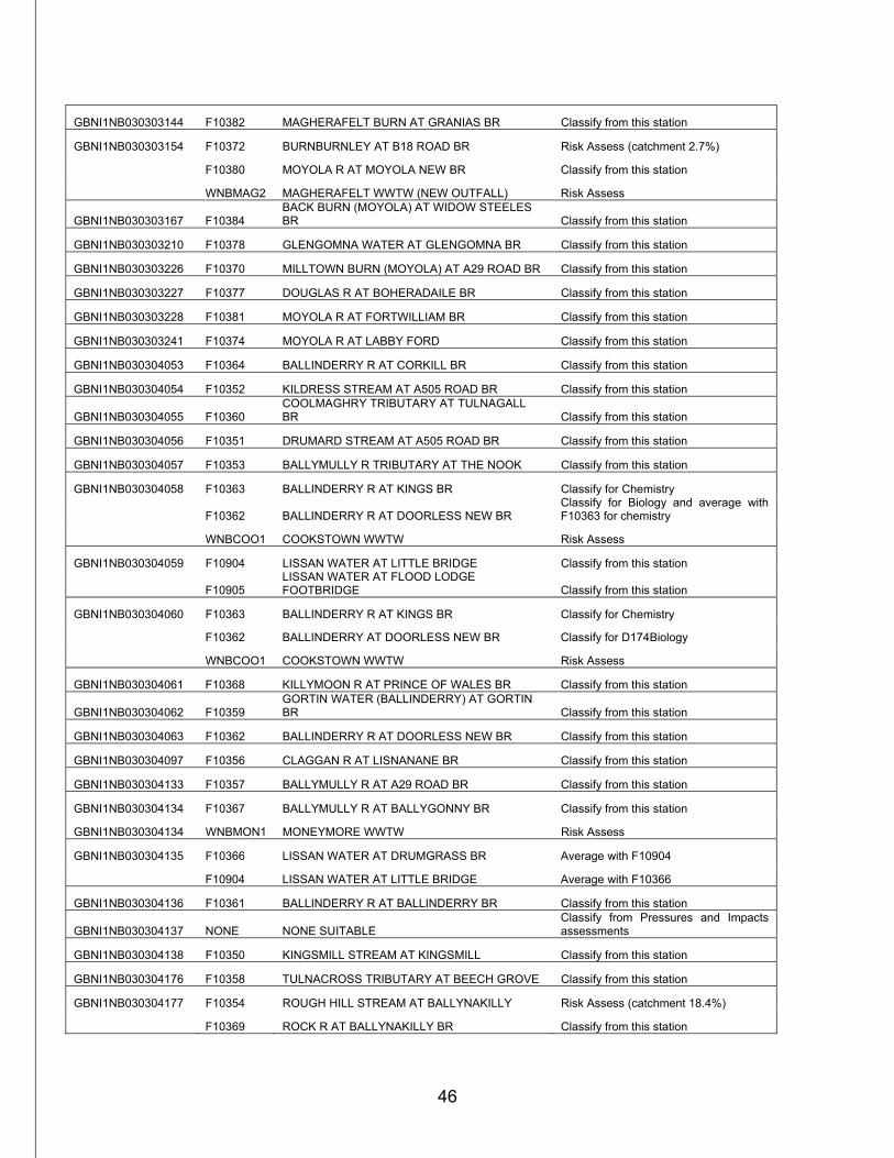
46
GBNI1NB030303144 F10382 MAGHERAFELT BURN AT GRANIAS BR Classify from this station
GBNI1NB030303154 F10372 BURNBURNLEY AT B18 ROAD BR Risk Assess (catchment 2.7%)
F10380 MOYOLA R AT MOYOLA NEW BR Classify from this station
WNBMAG2 MAGHERAFELT WWTW (NEW OUTFALL) Risk Assess
GBNI1NB030303167 F10384 BACK BURN (MOYOLA) AT WIDOW STEELES BR Classify from this station
GBNI1NB030303210 F10378 GLENGOMNA WATER AT GLENGOMNA BR Classify from this station
GBNI1NB030303226 F10370 MILLTOWN BURN (MOYOLA) AT A29 ROAD BR Classify from this station
GBNI1NB030303227 F10377 DOUGLAS R AT BOHERADAILE BR Classify from this station
GBNI1NB030303228 F10381 MOYOLA R AT FORTWILLIAM BR Classify from this station
GBNI1NB030303241 F10374 MOYOLA R AT LABBY FORD Classify from this station
GBNI1NB030304053 F10364 BALLINDERRY R AT CORKILL BR Classify from this station
GBNI1NB030304054 F10352 KILDRESS STREAM AT A505 ROAD BR Classify from this station
GBNI1NB030304055 F10360 COOLMAGHRY TRIBUTARY AT TULNAGALL BR Classify from this station
GBNI1NB030304056 F10351 DRUMARD STREAM AT A505 ROAD BR Classify from this station
GBNI1NB030304057 F10353 BALLYMULLY R TRIBUTARY AT THE NOOK Classify from this station
GBNI1NB030304058 F10363 BALLINDERRY R AT KINGS BR Classify for Chemistry
F10362 BALLINDERRY R AT DOORLESS NEW BR Classify for Biology and average with F10363 for chemistry
WNBCOO1 COOKSTOWN WWTW Risk Assess
GBNI1NB030304059 F10904 LISSAN WATER AT LITTLE BRIDGE Classify from this station
F10905 LISSAN WATER AT FLOOD LODGE FOOTBRIDGE Classify from this station
GBNI1NB030304060 F10363 BALLINDERRY R AT KINGS BR Classify for Chemistry
F10362 BALLINDERRY AT DOORLESS NEW BR Classify for D174Biology
WNBCOO1 COOKSTOWN WWTW Risk Assess
GBNI1NB030304061 F10368 KILLYMOON R AT PRINCE OF WALES BR Classify from this station
GBNI1NB030304062 F10359 GORTIN WATER (BALLINDERRY) AT GORTIN BR Classify from this station
GBNI1NB030304063 F10362 BALLINDERRY R AT DOORLESS NEW BR Classify from this station
GBNI1NB030304097 F10356 CLAGGAN R AT LISNANANE BR Classify from this station
GBNI1NB030304133 F10357 BALLYMULLY R AT A29 ROAD BR Classify from this station
GBNI1NB030304134 F10367 BALLYMULLY R AT BALLYGONNY BR Classify from this station
GBNI1NB030304134 WNBMON1 MONEYMORE WWTW Risk Assess
GBNI1NB030304135 F10366 LISSAN WATER AT DRUMGRASS BR Average with F10904
F10904 LISSAN WATER AT LITTLE BRIDGE Average with F10366
GBNI1NB030304136 F10361 BALLINDERRY R AT BALLINDERRY BR Classify from this station
GBNI1NB030304137 NONE NONE SUITABLE Classify from Pressures and Impacts assessments
GBNI1NB030304138 F10350 KINGSMILL STREAM AT KINGSMILL Classify from this station
GBNI1NB030304176 F10358 TULNACROSS TRIBUTARY AT BEECH GROVE Classify from this station
GBNI1NB030304177 F10354 ROUGH HILL STREAM AT BALLYNAKILLY Risk Assess (catchment 18.4%)
F10369 ROCK R AT BALLYNAKILLY BR Classify from this station
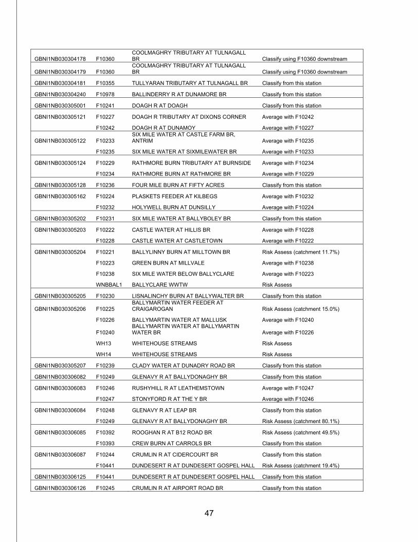
47
GBNI1NB030304178 F10360 COOLMAGHRY TRIBUTARY AT TULNAGALL BR Classify using F10360 downstream
GBNI1NB030304179 F10360 COOLMAGHRY TRIBUTARY AT TULNAGALL BR Classify using F10360 downstream
GBNI1NB030304181 F10355 TULLYARAN TRIBUTARY AT TULNAGALL BR Classify from this station
GBNI1NB030304240 F10978 BALLINDERRY R AT DUNAMORE BR Classify from this station
GBNI1NB030305001 F10241 DOAGH R AT DOAGH Classify from this station
GBNI1NB030305121 F10227 DOAGH R TRIBUTARY AT DIXONS CORNER Average with F10242
F10242 DOAGH R AT DUNAMOY Average with F10227
GBNI1NB030305122 F10233 SIX MILE WATER AT CASTLE FARM BR, ANTRIM Average with F10235
F10235 SIX MILE WATER AT SIXMILEWATER BR Average with F10233
GBNI1NB030305124 F10229 RATHMORE BURN TRIBUTARY AT BURNSIDE Average with F10234
F10234 RATHMORE BURN AT RATHMORE BR Average with F10229
GBNI1NB030305128 F10236 FOUR MILE BURN AT FIFTY ACRES Classify from this station
GBNI1NB030305162 F10224 PLASKETS FEEDER AT KILBEGS Average with F10232
F10232 HOLYWELL BURN AT DUNSILLY Average with F10224
GBNI1NB030305202 F10231 SIX MILE WATER AT BALLYBOLEY BR Classify from this station
GBNI1NB030305203 F10222 CASTLE WATER AT HILLIS BR Average with F10228
F10228 CASTLE WATER AT CASTLETOWN Average with F10222
GBNI1NB030305204 F10221 BALLYLINNY BURN AT MILLTOWN BR Risk Assess (catchment 11.7%)
F10223 GREEN BURN AT MILLVALE Average with F10238
F10238 SIX MILE WATER BELOW BALLYCLARE Average with F10223
WNBBAL1 BALLYCLARE WWTW Risk Assess
GBNI1NB030305205 F10230 LISNALINCHY BURN AT BALLYWALTER BR Classify from this station
GBNI1NB030305206 F10225 BALLYMARTIN WATER FEEDER AT CRAIGAROGAN Risk Assess (catchment 15.0%)
F10226 BALLYMARTIN WATER AT MALLUSK Average with F10240
F10240 BALLYMARTIN WATER AT BALLYMARTIN WATER BR Average with F10226
WH13 WHITEHOUSE STREAMS Risk Assess
WH14 WHITEHOUSE STREAMS Risk Assess
GBNI1NB030305207 F10239 CLADY WATER AT DUNADRY ROAD BR Classify from this station
GBNI1NB030306082 F10249 GLENAVY R AT BALLYDONAGHY BR Classify from this station
GBNI1NB030306083 F10246 RUSHYHILL R AT LEATHEMSTOWN Average with F10247
F10247 STONYFORD R AT THE Y BR Average with F10246
GBNI1NB030306084 F10248 GLENAVY R AT LEAP BR Classify from this station
F10249 GLENAVY R AT BALLYDONAGHY BR Risk Assess (catchment 80.1%)
GBNI1NB030306085 F10392 ROOGHAN R AT B12 ROAD BR Risk Assess (catchment 49.5%)
F10393 CREW BURN AT CARROLS BR Classify from this station
GBNI1NB030306087 F10244 CRUMLIN R AT CIDERCOURT BR Classify from this station
F10441 DUNDESERT R AT DUNDESERT GOSPEL HALL Risk Assess (catchment 19.4%)
GBNI1NB030306125 F10441 DUNDESERT R AT DUNDESERT GOSPEL HALL Classify from this station
GBNI1NB030306126 F10245 CRUMLIN R AT AIRPORT ROAD BR Classify from this station
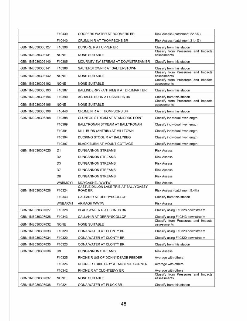
48
F10439 COOPERS WATER AT BOOMERS BR Risk Assess (catchment 22.5%)
F10440 CRUMLIN R AT THOMPSONS BR Risk Assess (catchment 31.4%)
GBNI1NB030306127 F10396 DUNORE R AT UPPER BR Classify from this station
GBNI1NB030306131 NONE NONE SUITABLE Classify from Pressures and Impacts assessments
GBNI1NB030306140 F10385 MOURNEVIEW STREAM AT DOWNSTREAM BR Classify from this station
GBNI1NB030306141 F10386 SALTERSTOWN R AT SALTERSTOWN Classify from this station
GBNI1NB030306142 NONE NONE SUITABLE Classify from Pressures and Impacts assessments
GBNI1NB030306192 NONE NONE SUITABLE Classify from Pressures and Impacts assessments
GBNI1NB030306193 F10387 BALLINDERRY (ANTRIM) R AT DRUMART BR Classify from this station
GBNI1NB030306194 F10390 AGHALEE BURN AT USSHERS BR Classify from this station
GBNI1NB030306195 NONE NONE SUITABLE Classify from Pressures and Impacts assessments
GBNI1NB030306198 F10440 CRUMLIN R AT THOMPSONS BR Classify from this station
GBNI1NB030306208 F10388 CLUNTOE STREAM AT STANIERDS POINT Classify individual river length
F10389 BALLYRONAN STREAM AT BALLYRONAN Classify individual river length
F10391 MILL BURN (ANTRIM) AT MILLTOWN Classify individual river length
F10394 DUCKING STOOL R AT BALLYBEG Classify individual river length
F10397 BLACK BURN AT MOUNT COTTAGE Classify individual river length
GBNI1NB030307025 D1 DUNGANNON STREAMS Risk Assess
D2 DUNGANNON STREAMS Risk Assess
D3 DUNGANNON STREAMS Risk Assess
D7 DUNGANNON STREAMS Risk Assess
D8 DUNGANNON STREAMS Risk Assess
WNBMOY1 MOYGASHEL WWTW Risk Assess
GBNI1NB030307026 F10324 CASTLE DILLON LAKE TRIB AT BALLYGASSY ROAD BR Risk Assess (catchment 5.4%)
F10343 CALLAN R AT DERRYSCOLLOP Classify from this station
WNBARM1 ARMAGH WWTW Risk Assess
GBNI1NB030307027 F10328 BLACKWATER R AT BONDS BR Classify using F10328 downstream
GBNI1NB030307028 F10343 CALLAN R AT DERRYSCOLLOP Classify using F10343 downstream
GBNI1NB030307032 NONE NONE SUITABLE Classify from Pressures and Impacts assessments
GBNI1NB030307033 F10320 OONA WATER AT CLONTY BR Classify using F10320 downstream
GBNI1NB030307034 F10320 OONA WATER AT CLONTY BR Classify using F10320 downstream
GBNI1NB030307035 F10320 OONA WATER AT CLONTY BR Classify from this station
GBNI1NB030307036 D9 DUNGANNON STREAMS Risk Assess
F10325 RHONE R U/S OF DONNYDEADE FEEDER Average with others
F10326 RHONE R TRIBUTARY AT MOYROE CORNER Average with others
F10342 RHONE R AT CLONTEEVY BR Average with others
GBNI1NB030307037 NONE NONE SUITABLE Classify from Pressures and Impacts assessments
GBNI1NB030307038 F10321 OONA WATER AT PLUCK BR Classify from this station
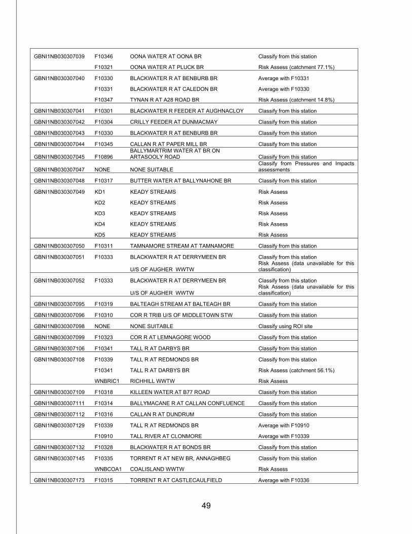
49
GBNI1NB030307039 F10346 OONA WATER AT OONA BR Classify from this station
F10321 OONA WATER AT PLUCK BR Risk Assess (catchment 77.1%)
GBNI1NB030307040 F10330 BLACKWATER R AT BENBURB BR Average with F10331
F10331 BLACKWATER R AT CALEDON BR Average with F10330
F10347 TYNAN R AT A28 ROAD BR Risk Assess (catchment 14.8%)
GBNI1NB030307041 F10301 BLACKWATER R FEEDER AT AUGHNACLOY Classify from this station
GBNI1NB030307042 F10304 CRILLY FEEDER AT DUNMACMAY Classify from this station
GBNI1NB030307043 F10330 BLACKWATER R AT BENBURB BR Classify from this station
GBNI1NB030307044 F10345 CALLAN R AT PAPER MILL BR Classify from this station
GBNI1NB030307045 F10896 BALLYMARTRIM WATER AT BR ON ARTASOOLY ROAD Classify from this station
GBNI1NB030307047 NONE NONE SUITABLE Classify from Pressures and Impacts assessments
GBNI1NB030307048 F10317 BUTTER WATER AT BALLYNAHONE BR Classify from this station
GBNI1NB030307049 KD1 KEADY STREAMS Risk Assess
KD2 KEADY STREAMS Risk Assess
KD3 KEADY STREAMS Risk Assess
KD4 KEADY STREAMS Risk Assess
KD5 KEADY STREAMS Risk Assess
GBNI1NB030307050 F10311 TAMNAMORE STREAM AT TAMNAMORE Classify from this station
GBNI1NB030307051 F10333 BLACKWATER R AT DERRYMEEN BR Classify from this station
U/S OF AUGHER WWTW Risk Assess (data unavailable for this classification)
GBNI1NB030307052 F10333 BLACKWATER R AT DERRYMEEN BR Classify from this station
U/S OF AUGHER WWTW Risk Assess (data unavailable for this classification)
GBNI1NB030307095 F10319 BALTEAGH STREAM AT BALTEAGH BR Classify from this station
GBNI1NB030307096 F10310 COR R TRIB U/S OF MIDDLETOWN STW Classify from this station
GBNI1NB030307098 NONE NONE SUITABLE Classify using ROI site
GBNI1NB030307099 F10323 COR R AT LEMNAGORE WOOD Classify from this station
GBNI1NB030307106 F10341 TALL R AT DARBYS BR Classify from this station
GBNI1NB030307108 F10339 TALL R AT REDMONDS BR Classify from this station
F10341 TALL R AT DARBYS BR Risk Assess (catchment 56.1%)
WNBRIC1 RICHHILL WWTW Risk Assess
GBNI1NB030307109 F10318 KILLEEN WATER AT B77 ROAD Classify from this station
GBNI1NB030307111 F10314 BALLYMACANE R AT CALLAN CONFLUENCE Classify from this station
GBNI1NB030307112 F10316 CALLAN R AT DUNDRUM Classify from this station
GBNI1NB030307129 F10339 TALL R AT REDMONDS BR Average with F10910
F10910 TALL RIVER AT CLONMORE Average with F10339
GBNI1NB030307132 F10328 BLACKWATER R AT BONDS BR Classify from this station
GBNI1NB030307145 F10335 TORRENT R AT NEW BR, ANNAGHBEG Classify from this station
WNBCOA1 COALISLAND WWTW Risk Assess
GBNI1NB030307173 F10315 TORRENT R AT CASTLECAULFIELD Average with F10336
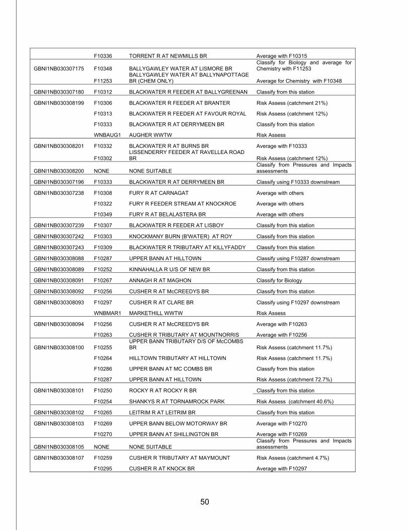
50
F10336 TORRENT R AT NEWMILLS BR Average with F10315
GBNI1NB030307175 F10348 BALLYGAWLEY WATER AT LISMORE BR Classify for Biology and average for Chemistry with F11253
F11253 BALLYGAWLEY WATER AT BALLYNAPOTTAGE BR (CHEM ONLY) Average for Chemistry with F10348
GBNI1NB030307180 F10312 BLACKWATER R FEEDER AT BALLYGREENAN Classify from this station
GBNI1NB030308199 F10306 BLACKWATER R FEEDER AT BRANTER Risk Assess (catchment 21%)
F10313 BLACKWATER R FEEDER AT FAVOUR ROYAL Risk Assess (catchment 12%)
F10333 BLACKWATER R AT DERRYMEEN BR Classify from this station
WNBAUG1 AUGHER WWTW Risk Assess
GBNI1NB030308201 F10332 BLACKWATER R AT BURNS BR Average with F10333
F10302 LISSENDERRY FEEDER AT RAVELLEA ROAD BR Risk Assess (catchment 12%)
GBNI1NB030308200 NONE NONE SUITABLE Classify from Pressures and Impacts assessments
GBNI1NB030307196 F10333 BLACKWATER R AT DERRYMEEN BR Classify using F10333 downstream
GBNI1NB030307238 F10308 FURY R AT CARNAGAT Average with others
F10322 FURY R FEEDER STREAM AT KNOCKROE Average with others
F10349 FURY R AT BELALASTERA BR Average with others
GBNI1NB030307239 F10307 BLACKWATER R FEEDER AT LISBOY Classify from this station
GBNI1NB030307242 F10303 KNOCKMANY BURN (B'WATER) AT ROY Classify from this station
GBNI1NB030307243 F10309 BLACKWATER R TRIBUTARY AT KILLYFADDY Classify from this station
GBNI1NB030308088 F10287 UPPER BANN AT HILLTOWN Classify using F10287 downstream
GBNI1NB030308089 F10252 KINNAHALLA R U/S OF NEW BR Classify from this station
GBNI1NB030308091 F10267 ANNAGH R AT MAGHON Classify for Biology
GBNI1NB030308092 F10256 CUSHER R AT McCREEDYS BR Classify from this station
GBNI1NB030308093 F10297 CUSHER R AT CLARE BR Classify using F10297 downstream
WNBMAR1 MARKETHILL WWTW Risk Assess
GBNI1NB030308094 F10256 CUSHER R AT McCREEDYS BR Average with F10263
F10263 CUSHER R TRIBUTARY AT MOUNTNORRIS Average with F10256
GBNI1NB030308100 F10255 UPPER BANN TRIBUTARY D/S OF McCOMBS BR Risk Assess (catchment 11.7%)
F10264 HILLTOWN TRIBUTARY AT HILLTOWN Risk Assess (catchment 11.7%)
F10286 UPPER BANN AT MC COMBS BR Classify from this station
F10287 UPPER BANN AT HILLTOWN Risk Assess (catchment 72.7%)
GBNI1NB030308101 F10250 ROCKY R AT ROCKY R BR Classify from this station
F10254 SHANKYS R AT TORNAMROCK PARK Risk Assess (catchment 40.6%)
GBNI1NB030308102 F10265 LEITRIM R AT LEITRIM BR Classify from this station
GBNI1NB030308103 F10269 UPPER BANN BELOW MOTORWAY BR Average with F10270
F10270 UPPER BANN AT SHILLINGTON BR Average with F10269
GBNI1NB030308105 NONE NONE SUITABLE Classify from Pressures and Impacts assessments
GBNI1NB030308107 F10259 CUSHER R TRIBUTARY AT MAYMOUNT Risk Assess (catchment 4.7%)
F10295 CUSHER R AT KNOCK BR Average with F10297
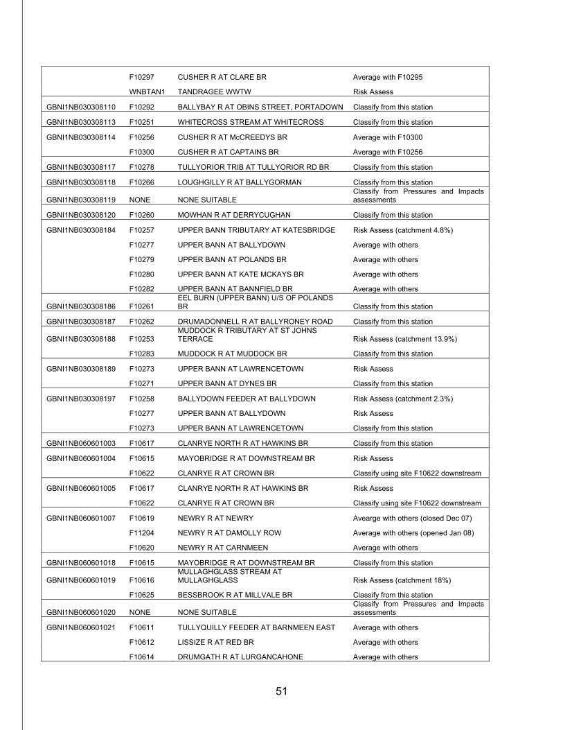
51
F10297 CUSHER R AT CLARE BR Average with F10295
WNBTAN1 TANDRAGEE WWTW Risk Assess
GBNI1NB030308110 F10292 BALLYBAY R AT OBINS STREET, PORTADOWN Classify from this station
GBNI1NB030308113 F10251 WHITECROSS STREAM AT WHITECROSS Classify from this station
GBNI1NB030308114 F10256 CUSHER R AT McCREEDYS BR Average with F10300
F10300 CUSHER R AT CAPTAINS BR Average with F10256
GBNI1NB030308117 F10278 TULLYORIOR TRIB AT TULLYORIOR RD BR Classify from this station
GBNI1NB030308118 F10266 LOUGHGILLY R AT BALLYGORMAN Classify from this station
GBNI1NB030308119 NONE NONE SUITABLE Classify from Pressures and Impacts assessments
GBNI1NB030308120 F10260 MOWHAN R AT DERRYCUGHAN Classify from this station
GBNI1NB030308184 F10257 UPPER BANN TRIBUTARY AT KATESBRIDGE Risk Assess (catchment 4.8%)
F10277 UPPER BANN AT BALLYDOWN Average with others
F10279 UPPER BANN AT POLANDS BR Average with others
F10280 UPPER BANN AT KATE MCKAYS BR Average with others
F10282 UPPER BANN AT BANNFIELD BR Average with others
GBNI1NB030308186 F10261 EEL BURN (UPPER BANN) U/S OF POLANDS BR Classify from this station
GBNI1NB030308187 F10262 DRUMADONNELL R AT BALLYRONEY ROAD Classify from this station
GBNI1NB030308188 F10253 MUDDOCK R TRIBUTARY AT ST JOHNS TERRACE Risk Assess (catchment 13.9%)
F10283 MUDDOCK R AT MUDDOCK BR Classify from this station
GBNI1NB030308189 F10273 UPPER BANN AT LAWRENCETOWN Risk Assess
F10271 UPPER BANN AT DYNES BR Classify from this station
GBNI1NB030308197 F10258 BALLYDOWN FEEDER AT BALLYDOWN Risk Assess (catchment 2.3%)
F10277 UPPER BANN AT BALLYDOWN Risk Assess
F10273 UPPER BANN AT LAWRENCETOWN Classify from this station
GBNI1NB060601003 F10617 CLANRYE NORTH R AT HAWKINS BR Classify from this station
GBNI1NB060601004 F10615 MAYOBRIDGE R AT DOWNSTREAM BR Risk Assess
F10622 CLANRYE R AT CROWN BR Classify using site F10622 downstream
GBNI1NB060601005 F10617 CLANRYE NORTH R AT HAWKINS BR Risk Assess
F10622 CLANRYE R AT CROWN BR Classify using site F10622 downstream
GBNI1NB060601007 F10619 NEWRY R AT NEWRY Avearge with others (closed Dec 07)
F11204 NEWRY R AT DAMOLLY ROW Average with others (opened Jan 08)
F10620 NEWRY R AT CARNMEEN Average with others
GBNI1NB060601018 F10615 MAYOBRIDGE R AT DOWNSTREAM BR Classify from this station
GBNI1NB060601019 F10616 MULLAGHGLASS STREAM AT MULLAGHGLASS Risk Assess (catchment 18%)
F10625 BESSBROOK R AT MILLVALE BR Classify from this station
GBNI1NB060601020 NONE NONE SUITABLE Classify from Pressures and Impacts assessments
GBNI1NB060601021 F10611 TULLYQUILLY FEEDER AT BARNMEEN EAST Average with others
F10612 LISSIZE R AT RED BR Average with others
F10614 DRUMGATH R AT LURGANCAHONE Average with others
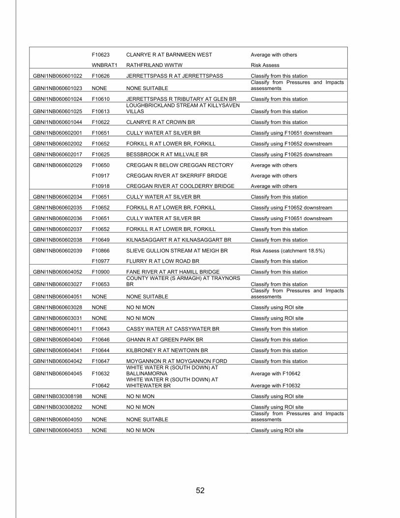
52
F10623 CLANRYE R AT BARNMEEN WEST Average with others
WNBRAT1 RATHFRILAND WWTW Risk Assess
GBNI1NB060601022 F10626 JERRETTSPASS R AT JERRETTSPASS Classify from this station
GBNI1NB060601023 NONE NONE SUITABLE Classify from Pressures and Impacts assessments
GBNI1NB060601024 F10610 JERRETTSPASS R TRIBUTARY AT GLEN BR Classify from this station
GBNI1NB060601025 F10613 LOUGHBRICKLAND STREAM AT KILLYSAVEN VILLAS Classify from this station
GBNI1NB060601044 F10622 CLANRYE R AT CROWN BR Classify from this station
GBNI1NB060602001 F10651 CULLY WATER AT SILVER BR Classify using F10651 downstream
GBNI1NB060602002 F10652 FORKILL R AT LOWER BR, FORKILL Classify using F10652 downstream
GBNI1NB060602017 F10625 BESSBROOK R AT MILLVALE BR Classify using F10625 downstream
GBNI1NB060602029 F10650 CREGGAN R BELOW CREGGAN RECTORY Average with others
F10917 CREGGAN RIVER AT SKERRIFF BRIDGE Average with others
F10918 CREGGAN RIVER AT COOLDERRY BRIDGE Average with others
GBNI1NB060602034 F10651 CULLY WATER AT SILVER BR Classify from this station
GBNI1NB060602035 F10652 FORKILL R AT LOWER BR, FORKILL Classify using F10652 downstream
GBNI1NB060602036 F10651 CULLY WATER AT SILVER BR Classify using F10651 downstream
GBNI1NB060602037 F10652 FORKILL R AT LOWER BR, FORKILL Classify from this station
GBNI1NB060602038 F10649 KILNASAGGART R AT KILNASAGGART BR Classify from this station
GBNI1NB060602039 F10866 SLIEVE GULLION STREAM AT MEIGH BR Risk Assess (catchment 18.5%)
F10977 FLURRY R AT LOW ROAD BR Classify from this station
GBNI1NB060604052 F10900 FANE RIVER AT ART HAMILL BRIDGE Classify from this station
GBNI1NB060603027 F10653 COUNTY WATER (S ARMAGH) AT TRAYNORS BR Classify from this station
GBNI1NB060604051 NONE NONE SUITABLE Classify from Pressures and Impacts assessments
GBNI1NB060603028 NONE NO NI MON Classify using ROI site
GBNI1NB060603031 NONE NO NI MON Classify using ROI site
GBNI1NB060604011 F10643 CASSY WATER AT CASSYWATER BR Classify from this station
GBNI1NB060604040 F10646 GHANN R AT GREEN PARK BR Classify from this station
GBNI1NB060604041 F10644 KILBRONEY R AT NEWTOWN BR Classify from this station
GBNI1NB060604042 F10647 MOYGANNON R AT MOYGANNON FORD Classify from this station
GBNI1NB060604045 F10632 WHITE WATER R (SOUTH DOWN) AT BALLINAMORNA Average with F10642
F10642 WHITE WATER R (SOUTH DOWN) AT WHITEWATER BR Average with F10632
GBNI1NB030308198 NONE NO NI MON Classify using ROI site
GBNI1NB030308202 NONE NO NI MON Classify using ROI site
GBNI1NB060604050 NONE NONE SUITABLE Classify from Pressures and Impacts assessments
GBNI1NB060604053 NONE NO NI MON Classify using ROI site
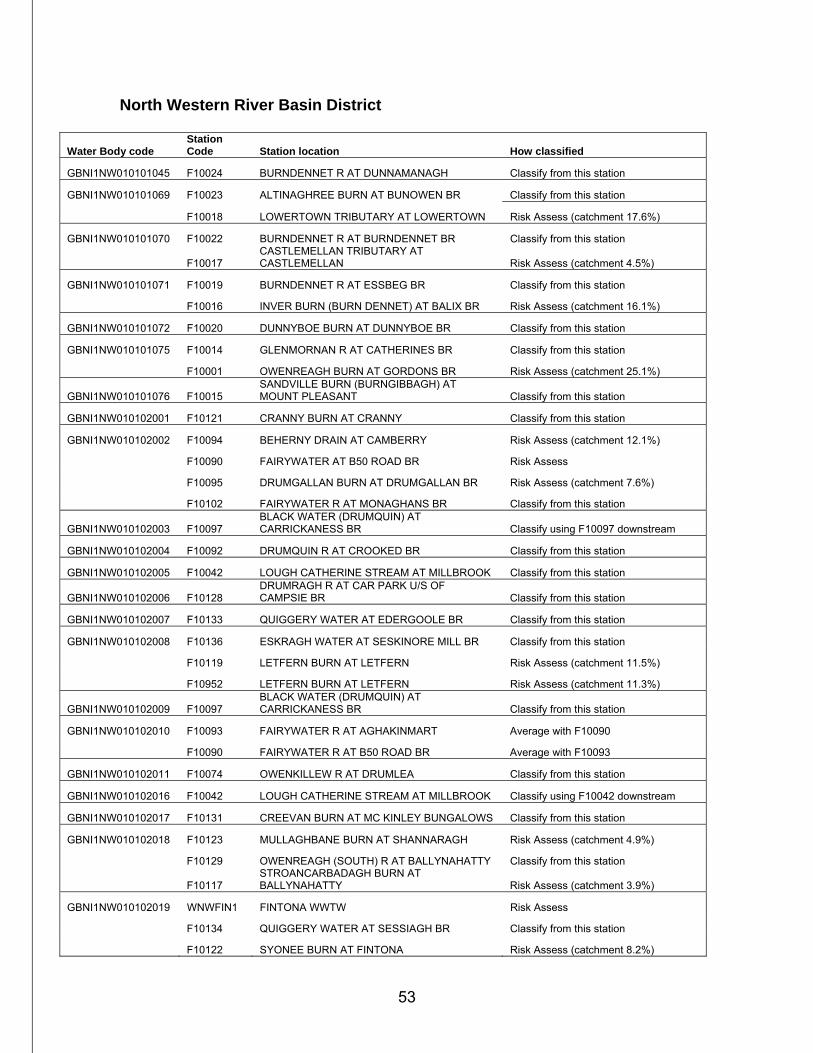
53
North Western River Basin District
Water Body code Station Code Station location How classified
GBNI1NW010101045 F10024 BURNDENNET R AT DUNNAMANAGH Classify from this station
GBNI1NW010101069 F10023 ALTINAGHREE BURN AT BUNOWEN BR Classify from this station
F10018 LOWERTOWN TRIBUTARY AT LOWERTOWN Risk Assess (catchment 17.6%)
GBNI1NW010101070 F10022 BURNDENNET R AT BURNDENNET BR Classify from this station
F10017 CASTLEMELLAN TRIBUTARY AT CASTLEMELLAN Risk Assess (catchment 4.5%)
GBNI1NW010101071 F10019 BURNDENNET R AT ESSBEG BR Classify from this station
F10016 INVER BURN (BURN DENNET) AT BALIX BR Risk Assess (catchment 16.1%)
GBNI1NW010101072 F10020 DUNNYBOE BURN AT DUNNYBOE BR Classify from this station
GBNI1NW010101075 F10014 GLENMORNAN R AT CATHERINES BR Classify from this station
F10001 OWENREAGH BURN AT GORDONS BR Risk Assess (catchment 25.1%)
GBNI1NW010101076 F10015 SANDVILLE BURN (BURNGIBBAGH) AT MOUNT PLEASANT Classify from this station
GBNI1NW010102001 F10121 CRANNY BURN AT CRANNY Classify from this station
GBNI1NW010102002 F10094 BEHERNY DRAIN AT CAMBERRY Risk Assess (catchment 12.1%)
F10090 FAIRYWATER AT B50 ROAD BR Risk Assess
F10095 DRUMGALLAN BURN AT DRUMGALLAN BR Risk Assess (catchment 7.6%)
F10102 FAIRYWATER R AT MONAGHANS BR Classify from this station
GBNI1NW010102003 F10097 BLACK WATER (DRUMQUIN) AT CARRICKANESS BR Classify using F10097 downstream
GBNI1NW010102004 F10092 DRUMQUIN R AT CROOKED BR Classify from this station
GBNI1NW010102005 F10042 LOUGH CATHERINE STREAM AT MILLBROOK Classify from this station
GBNI1NW010102006 F10128 DRUMRAGH R AT CAR PARK U/S OF CAMPSIE BR Classify from this station
GBNI1NW010102007 F10133 QUIGGERY WATER AT EDERGOOLE BR Classify from this station
GBNI1NW010102008 F10136 ESKRAGH WATER AT SESKINORE MILL BR Classify from this station
F10119 LETFERN BURN AT LETFERN Risk Assess (catchment 11.5%)
F10952 LETFERN BURN AT LETFERN Risk Assess (catchment 11.3%)
GBNI1NW010102009 F10097 BLACK WATER (DRUMQUIN) AT CARRICKANESS BR Classify from this station
GBNI1NW010102010 F10093 FAIRYWATER R AT AGHAKINMART Average with F10090
F10090 FAIRYWATER R AT B50 ROAD BR Average with F10093
GBNI1NW010102011 F10074 OWENKILLEW R AT DRUMLEA Classify from this station
GBNI1NW010102016 F10042 LOUGH CATHERINE STREAM AT MILLBROOK Classify using F10042 downstream
GBNI1NW010102017 F10131 CREEVAN BURN AT MC KINLEY BUNGALOWS Classify from this station
GBNI1NW010102018 F10123 MULLAGHBANE BURN AT SHANNARAGH Risk Assess (catchment 4.9%)
F10129 OWENREAGH (SOUTH) R AT BALLYNAHATTY Classify from this station
F10117 STROANCARBADAGH BURN AT BALLYNAHATTY Risk Assess (catchment 3.9%)
GBNI1NW010102019 WNWFIN1 FINTONA WWTW Risk Assess
F10134 QUIGGERY WATER AT SESSIAGH BR Classify from this station
F10122 SYONEE BURN AT FINTONA Risk Assess (catchment 8.2%)
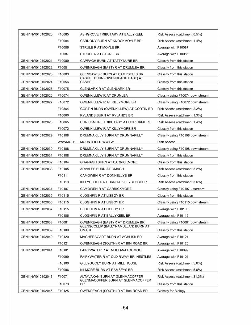
54
GBNI1NW010102020 F10085 ASHGROVE TRIBUTARY AT BALLYKEEL Risk Assess (catchment 0.5%)
F10084 CARNONY BURN AT KNOCKMOYLE BR Risk Assess (catchment 1.4%)
F10086 STRULE R AT MOYLE BR Average with F10087
F10087 STRULE R AT STONE BR Average with F10086
GBNI1NW010102021 F10089 CAPPAGH BURN AT TATTYNURE BR Classify from this station
GBNI1NW010102022 F10081 OWENREAGH (EAST) R AT DRUMLEA BR Classify from this station
GBNI1NW010102023 F10083 GLENSAWISK BURN AT CAMPBELLS BR Classify from this station
GBNI1NW010102024 F10056 CASHEL BURN (OWENREAGH EAST) AT CASHEL Classify from this station
GBNI1NW010102025 F10075 GLENLARK R AT GLENLARK BR Classify from this station
GBNI1NW010102026 F10074 OWENKILLEW R AT DRUMLEA Classify using F10074 downstream
GBNI1NW010102027 F10072 OWENKILLEW R AT KILLYMORE BR Classify using F10072 downstream
F10864 GORTIN BURN (OWENKILLEW) AT GORTIN BR Risk Assess (catchment 2.2%)
F10060 RYLANDS BURN AT RYLANDS BR Risk Assess (catchment 1.3%)
GBNI1NW010102028 F10865 CORICKMORE TRIBUTARY AT CORICKMORE Risk Assess (catchment 1.4%)
F10072 OWENKILLEW R AT KILLYMORE BR Classify from this station
GBNI1NW010102029 F10108 DRUMNAKILLY BURN AT DRUMNAKILLY Classify using F10108 downstream
WNWMOU1 MOUNTFIELD WWTW Risk Assess
GBNI1NW010102030 F10108 DRUMNAKILLY BURN AT DRUMNAKILLY Classify using F10108 downstream
GBNI1NW010102031 F10108 DRUMNAKILLY BURN AT DRUMNAKILLY Classify from this station
GBNI1NW010102032 F10104 GRANAGH BURN AT CARRICKMORE Classify from this station
GBNI1NW010102033 F10105 ARVALEE BURN AT OMAGH Risk Assess (catchment 3.2%)
F10111 CAMOWEN R AT DONNELLYS BR Classify from this station
F10113 KILLYCLOGHER BURN AT KILLYCLOGHER Risk Assess (catchment 3.6%)
GBNI1NW010102034 F10107 CAMOWEN R AT CARRICKMORE Classify using F10107 upstream
GBNI1NW010102035 F10115 CLOGHFIN R AT LISBOY BR Classify from this station
GBNI1NW010102036 F10115 CLOGHFIN R AT LISBOY BR Classify using F10115 downstream
GBNI1NW010102037 F10115 CLOGHFIN R AT LISBOY BR Average with F10106
F10106 CLOGHFIN R AT BALLYKEEL BR Average with F10115
GBNI1NW010102038 F10081 OWENREAGH (EAST) R AT DRUMLEA BR Classify using F10081 downstream
GBNI1NW010102039 F10109 GLENSCOLLIP (BALLYNAMULLAN) BURN AT OMAGH Classify from this station
GBNI1NW010102040 F10120 MAGHERAGART BURN AT AGHLISK BR Average with F10121
F10121 OWENREAGH (SOUTH) R AT B84 ROAD BR Average with F10120
GBNI1NW010102041 F10101 FAIRYWATER R AT MULLANATOOMOG Average with F10099
F10099 FAIRYWATER R AT OLD R'WAY BR, NESTLES Average with F10101
F10100 GILLYGOOLY BURN AT MILL HOUSE Risk Assess (catchment 5.6%)
F10096 KILMORE BURN AT RAMSEYS BR Risk Assess (catchment 5.0%)
GBNI1NW010102043 F10071 ALTAVAKAN BURN AT GLENMACOFFER Risk Assess (catchment 31.3%)
F10073 GLENMACOFFER BURN AT GLENMACOFFER BR Classify from this station
GBNI1NW010102046 F10125 OWENREAGH (SOUTH) R AT B84 ROAD BR Classify for Biology
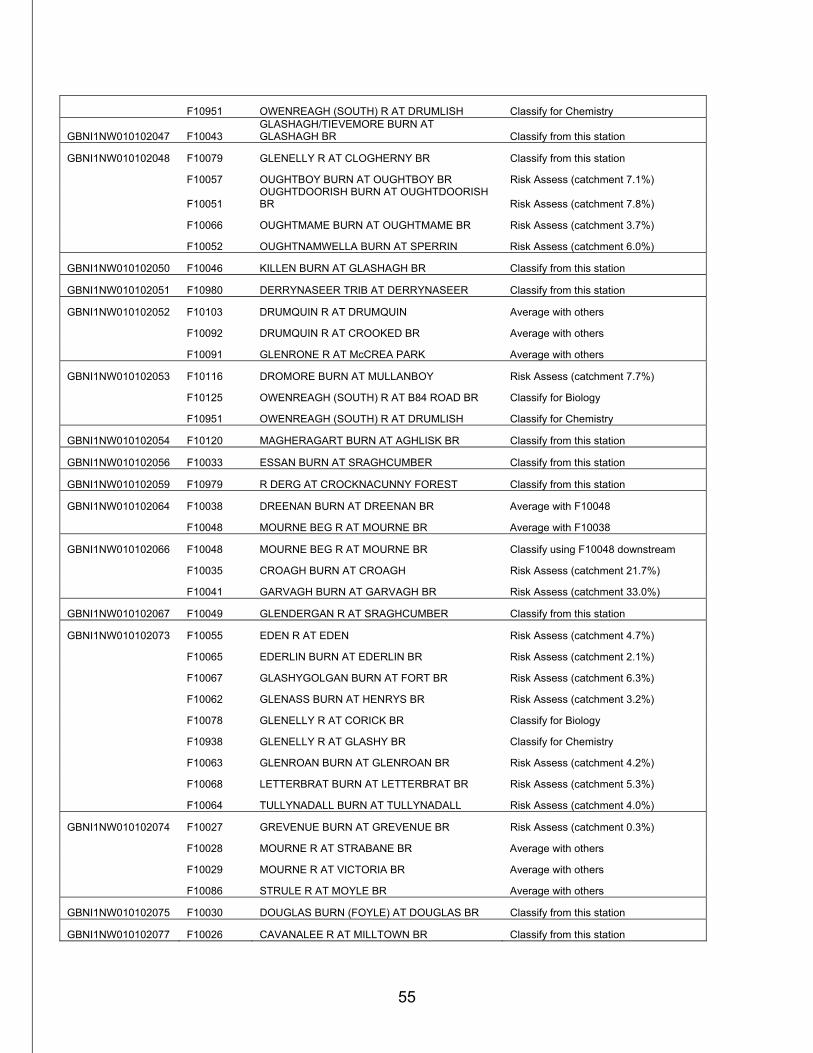
55
F10951 OWENREAGH (SOUTH) R AT DRUMLISH Classify for Chemistry
GBNI1NW010102047 F10043 GLASHAGH/TIEVEMORE BURN AT GLASHAGH BR Classify from this station
GBNI1NW010102048 F10079 GLENELLY R AT CLOGHERNY BR Classify from this station
F10057 OUGHTBOY BURN AT OUGHTBOY BR Risk Assess (catchment 7.1%)
F10051 OUGHTDOORISH BURN AT OUGHTDOORISH BR Risk Assess (catchment 7.8%)
F10066 OUGHTMAME BURN AT OUGHTMAME BR Risk Assess (catchment 3.7%)
F10052 OUGHTNAMWELLA BURN AT SPERRIN Risk Assess (catchment 6.0%)
GBNI1NW010102050 F10046 KILLEN BURN AT GLASHAGH BR Classify from this station
GBNI1NW010102051 F10980 DERRYNASEER TRIB AT DERRYNASEER Classify from this station
GBNI1NW010102052 F10103 DRUMQUIN R AT DRUMQUIN Average with others
F10092 DRUMQUIN R AT CROOKED BR Average with others
F10091 GLENRONE R AT McCREA PARK Average with others
GBNI1NW010102053 F10116 DROMORE BURN AT MULLANBOY Risk Assess (catchment 7.7%)
F10125 OWENREAGH (SOUTH) R AT B84 ROAD BR Classify for Biology
F10951 OWENREAGH (SOUTH) R AT DRUMLISH Classify for Chemistry
GBNI1NW010102054 F10120 MAGHERAGART BURN AT AGHLISK BR Classify from this station
GBNI1NW010102056 F10033 ESSAN BURN AT SRAGHCUMBER Classify from this station
GBNI1NW010102059 F10979 R DERG AT CROCKNACUNNY FOREST Classify from this station
GBNI1NW010102064 F10038 DREENAN BURN AT DREENAN BR Average with F10048
F10048 MOURNE BEG R AT MOURNE BR Average with F10038
GBNI1NW010102066 F10048 MOURNE BEG R AT MOURNE BR Classify using F10048 downstream
F10035 CROAGH BURN AT CROAGH Risk Assess (catchment 21.7%)
F10041 GARVAGH BURN AT GARVAGH BR Risk Assess (catchment 33.0%)
GBNI1NW010102067 F10049 GLENDERGAN R AT SRAGHCUMBER Classify from this station
GBNI1NW010102073 F10055 EDEN R AT EDEN Risk Assess (catchment 4.7%)
F10065 EDERLIN BURN AT EDERLIN BR Risk Assess (catchment 2.1%)
F10067 GLASHYGOLGAN BURN AT FORT BR Risk Assess (catchment 6.3%)
F10062 GLENASS BURN AT HENRYS BR Risk Assess (catchment 3.2%)
F10078 GLENELLY R AT CORICK BR Classify for Biology
F10938 GLENELLY R AT GLASHY BR Classify for Chemistry
F10063 GLENROAN BURN AT GLENROAN BR Risk Assess (catchment 4.2%)
F10068 LETTERBRAT BURN AT LETTERBRAT BR Risk Assess (catchment 5.3%)
F10064 TULLYNADALL BURN AT TULLYNADALL Risk Assess (catchment 4.0%)
GBNI1NW010102074 F10027 GREVENUE BURN AT GREVENUE BR Risk Assess (catchment 0.3%)
F10028 MOURNE R AT STRABANE BR Average with others
F10029 MOURNE R AT VICTORIA BR Average with others
F10086 STRULE R AT MOYLE BR Average with others
GBNI1NW010102075 F10030 DOUGLAS BURN (FOYLE) AT DOUGLAS BR Classify from this station
GBNI1NW010102077 F10026 CAVANALEE R AT MILLTOWN BR Classify from this station
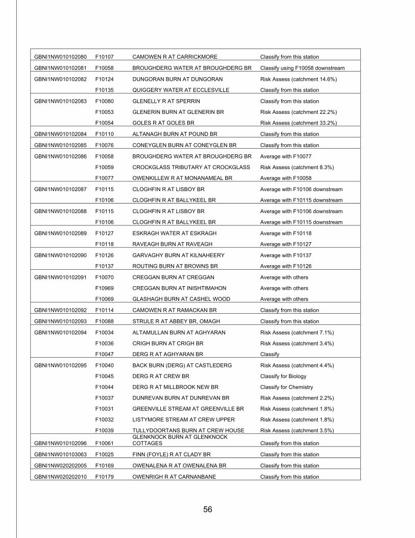
56
GBNI1NW010102080 F10107 CAMOWEN R AT CARRICKMORE Classify from this station
GBNI1NW010102081 F10058 BROUGHDERG WATER AT BROUGHDERG BR Classify using F10058 downstream
GBNI1NW010102082 F10124 DUNGORAN BURN AT DUNGORAN Risk Assess (catchment 14.6%)
F10135 QUIGGERY WATER AT ECCLESVILLE Classify from this station
GBNI1NW010102083 F10080 GLENELLY R AT SPERRIN Classify from this station
F10053 GLENERIN BURN AT GLENERIN BR Risk Assess (catchment 22.2%)
F10054 GOLES R AT GOLES BR Risk Assess (catchment 33.2%)
GBNI1NW010102084 F10110 ALTANAGH BURN AT POUND BR Classify from this station
GBNI1NW010102085 F10076 CONEYGLEN BURN AT CONEYGLEN BR Classify from this station
GBNI1NW010102086 F10058 BROUGHDERG WATER AT BROUGHDERG BR Average with F10077
F10059 CROCKGLASS TRIBUTARY AT CROCKGLASS Risk Assess (catchment 8.3%)
F10077 OWENKILLEW R AT MONANAMEAL BR Average with F10058
GBNI1NW010102087 F10115 CLOGHFIN R AT LISBOY BR Average with F10106 downstream
F10106 CLOGHFIN R AT BALLYKEEL BR Average with F10115 downstream
GBNI1NW010102088 F10115 CLOGHFIN R AT LISBOY BR Average with F10106 downstream
F10106 CLOGHFIN R AT BALLYKEEL BR Average with F10115 downstream
GBNI1NW010102089 F10127 ESKRAGH WATER AT ESKRAGH Average with F10118
F10118 RAVEAGH BURN AT RAVEAGH Average with F10127
GBNI1NW010102090 F10126 GARVAGHY BURN AT KILNAHEERY Average with F10137
F10137 ROUTING BURN AT BROWNS BR Average with F10126
GBNI1NW010102091 F10070 CREGGAN BURN AT CREGGAN Average with others
F10969 CREGGAN BURN AT INISHTIMAHON Average with others
F10069 GLASHAGH BURN AT CASHEL WOOD Average with others
GBNI1NW010102092 F10114 CAMOWEN R AT RAMACKAN BR Classify from this station
GBNI1NW010102093 F10088 STRULE R AT ABBEY BR, OMAGH Classify from this station
GBNI1NW010102094 F10034 ALTAMULLAN BURN AT AGHYARAN Risk Assess (catchment 7.1%)
F10036 CRIGH BURN AT CRIGH BR Risk Assess (catchment 3.4%)
F10047 DERG R AT AGHYARAN BR Classify
GBNI1NW010102095 F10040 BACK BURN (DERG) AT CASTLEDERG Risk Assess (catchment 4.4%)
F10045 DERG R AT CREW BR Classify for Biology
F10044 DERG R AT MILLBROOK NEW BR Classify for Chemistry
F10037 DUNREVAN BURN AT DUNREVAN BR Risk Assess (catchment 2.2%)
F10031 GREENVILLE STREAM AT GREENVILLE BR Risk Assess (catchment 1.8%)
F10032 LISTYMORE STREAM AT CREW UPPER Risk Assess (catchment 1.8%)
F10039 TULLYDOORTANS BURN AT CREW HOUSE Risk Assess (catchment 3.5%)
GBNI1NW010102096 F10061 GLENKNOCK BURN AT GLENKNOCK COTTAGES Classify from this station
GBNI1NW010103063 F10025 FINN (FOYLE) R AT CLADY BR Classify from this station
GBNI1NW020202005 F10169 OWENALENA R AT OWENALENA BR Classify from this station
GBNI1NW020202010 F10179 OWENRIGH R AT CARNANBANE Classify from this station
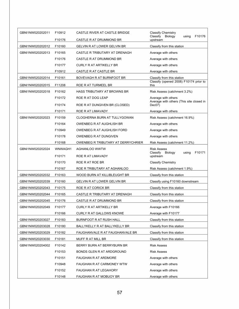
57
GBNI1NW020202011 F10912 CASTLE RIVER AT CASTLE BRIDGE Classify Chemistry
F10176 CASTLE R AT DRUMMOND BR Classify Biology using F10176 upstream
GBNI1NW020202012 F10160 GELVIN R AT LOWER GELVIN BR Classify from this station
GBNI1NW020202013 F10165 CASTLE R TRIBUTARY AT DRENAGH Average with others
F10176 CASTLE R AT DRUMMOND BR Average with others
F10177 CURLY R AT ARTIKELLY BR Average with others
F10912 CASTLE R AT CASTLE BR Average with others
GBNI1NW020202014 F10161 BOVEVAGH R AT BURNFOOT BR Classify from this station
GBNI1NW020202015 F11208 ROE R AT TURMEEL BR Classify (opened 2008) F10174 prior to this
GBNI1NW020202018 F10162 HASS TRIBUTARY AT BROWNS BR Risk Assess (catchment 3.2%)
F10172 ROE R AT DOG LEAP Average with others
F10174 ROE R AT DUNGIVEN BR (CLOSED) Average with others (This site closed in Dec07)
F10171 ROE R AT LIMAVADY Average with others
GBNI1NW020202023 F10159 CLOGHERNA BURN AT TULLYGOWAN Risk Assess (catchment 16.9%)
F10164 OWENBEG R AT AUGHLISH BR Average with others
F10949 OWENBEG R AT AUGHLISH FORD Average with others
F10178 OWENBEG R AT DUNGIVEN Average with others
F10168 OWENBEG R TRIBUTARY AT DERRYCHRIER Risk Assess (catchment 11.2%)
GBNI1NW020202024 WNWAGH1 AGHANLOO WWTW Risk Assess
F10171 ROE R AT LIMAVADY Classify Biology using F10171 upstream
F10170 ROE R AT ROE BR Classify Chemistry
F10167 ROE R TRIBUTARY AT AGHANLOO Risk Assess (catchment 1.9%)
GBNI1NW020202032 F10163 WOOD BURN AT KILLIBLEUGHT BR Classify from this station
GBNI1NW020202039 F10160 GELVIN R AT LOWER GELVIN BR Classify using F10160 downstream
GBNI1NW020202043 F10175 ROE R AT CORICK BR Classify from this station
GBNI1NW020202044 F10165 CASTLE R TRIBUTARY AT DRENAGH Classify from this station
GBNI1NW020202045 F10176 CASTLE R AT DRUMMOND BR Classify from this station
GBNI1NW020202049 F10177 CURLY R AT ARTIKELLY BR Average with F10166
F10166 CURLY R AT GALLOWS KNOWE Average with F10177
GBNI1NW020203027 F10183 BURNFOOT R AT RUSH HALL Classify from this station
GBNI1NW020203028 F10180 BALLYKELLY R AT BALLYKELLY BR Classify from this station
GBNI1NW020203029 F10182 FAUGHANVALE R AT FAUGHANVALE BR Classify from this station
GBNI1NW020203030 F10181 MUFF R AT MILL BR Classify from this station
GBNI1NW020204002 F10142 BERRY BURN AT BERRYBURN BR Risk Assess
F10153 BONDS GLEN R AT ARDGROUND Risk Assess
F10151 FAUGHAN R AT ARDMORE Average with others
F10948 FAUGHAN R AT CARMONEY WTW Average with others
F10152 FAUGHAN R AT LEGAHORY Average with others
F10148 FAUGHAN R AT MOBUOY BR Average with others
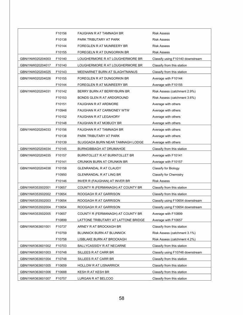
58
F10156 FAUGHAN R AT TAMNAGH BR Risk Assess
F10138 PARK TRIBUTARY AT PARK Risk Assess
F10144 FOREGLEN R AT MUNREERY BR Risk Assess
F10155 FOREGELN R AT DUNGORKIN BR Risk Assess
GBNI1NW020204003 F10140 LOUGHERMORE R AT LOUGHERMORE BR Classify using F10140 downstream
GBNI1NW020204017 F10140 LOUGHERMORE R AT LOUGHERMORE BR Classify from this station
GBNI1NW020204025 F10143 MEENARNET BURN AT SLAGHTMANUS Classify from this station
GBNI1NW020204026 F10155 FOREGLEN R AT DUNGORKIN BR Average with F10144
F10144 FOREGLEN R AT MUNREERY BR Average with F10155
GBNI1NW020204031 F10142 BERRY BURN AT BERRYBURN BR Risk Assess (catchment 2.9%)
F10153 BONDS GLEN R AT ARDGROUND Risk Assess (catchment 3.6%)
F10151 FAUGHAN R AT ARDMORE Average with others
F10948 FAUGHAN R AT CARMONEY WTW Average with others
F10152 FAUGHAN R AT LEGAHORY Average with others
F10148 FAUGHAN R AT MOBUOY BR Average with others
GBNI1NW020204033 F10156 FAUGHAN R AT TAMNAGH BR Average with others
F10138 PARK TRIBUTARY AT PARK Average with others
F10139 SLUGGADA BURN NEAR TAMNAGH LODGE Average with others
GBNI1NW020204034 F10145 BURNGIBBAGH AT DRUMAHOE Classify from this station
GBNI1NW020204035 F10157 BURNTOLLET R AT BURNTOLLET BR Average with F10141
F10141 CRUNKIN BURN AT CRUNKIN BR Average with F10157
GBNI1NW020204038 F10158 GLENRANDAL R AT CLAUDY Classify for Biology
F10950 GLENRANDAL R AT LING BR Classify for Chemistry
F10146 INVER R (FAUGHAN) AT INVER BR Risk Assess
GBNI1NW353502001 F10657 COUNTY R (FERMANAGH) AT COUNTY BR Classify from this station
GBNI1NW353502002 F10654 ROOGAGH R AT GARRISON Classify from this station
GBNI1NW353502003 F10654 ROOGAGH R AT GARRISON Classify using F10654 downstream
GBNI1NW353502004 F10654 ROOGAGH R AT GARRISON Classify using F10654 downstream
GBNI1NW353502005 F10657 COUNTY R (FERMANAGH) AT COUNTY BR Average with F10899
F10899 LATTONE TRIBUTARY AT LATTONE BRIDGE Average with F10657
GBNI1NW363601001 F10737 ARNEY R AT BROCKAGH BR Classify from this station
F10759 BLUNNICK BURN AT BLUNNICK Risk Assess (catchment 3.1%)
F10758 LISBLAKE BURN AT BROCKAGH Risk Assess (catchment 4.2%)
GBNI1NW363601002 F10703 BALLYCASSIDY R AT NECARNE Classify from this station
GBNI1NW363601003 F10748 SILLEES R AT CARR BR Classify using F10748 downstream
GBNI1NW363601004 F10748 SILLEES R AT CARR BR Classify from this station
GBNI1NW363601005 F10659 HOLLOW R AT LISNARRICK Classify from this station
GBNI1NW363601006 F10688 KESH R AT KESH BR Classify from this station
GBNI1NW363601007 F10757 LURGAN R AT BELCOO Classify from this station
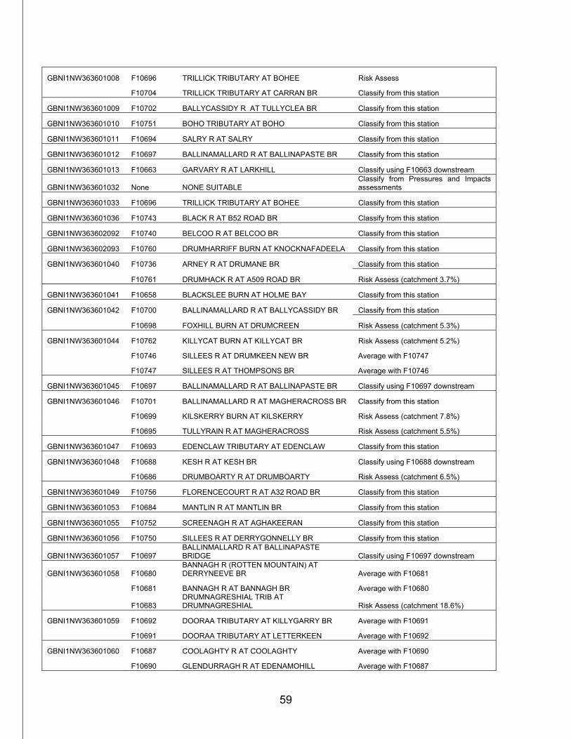
59
GBNI1NW363601008 F10696 TRILLICK TRIBUTARY AT BOHEE Risk Assess
F10704 TRILLICK TRIBUTARY AT CARRAN BR Classify from this station
GBNI1NW363601009 F10702 BALLYCASSIDY R AT TULLYCLEA BR Classify from this station
GBNI1NW363601010 F10751 BOHO TRIBUTARY AT BOHO Classify from this station
GBNI1NW363601011 F10694 SALRY R AT SALRY Classify from this station
GBNI1NW363601012 F10697 BALLINAMALLARD R AT BALLINAPASTE BR Classify from this station
GBNI1NW363601013 F10663 GARVARY R AT LARKHILL Classify using F10663 downstream
GBNI1NW363601032 None NONE SUITABLE Classify from Pressures and Impacts assessments
GBNI1NW363601033 F10696 TRILLICK TRIBUTARY AT BOHEE Classify from this station
GBNI1NW363601036 F10743 BLACK R AT B52 ROAD BR Classify from this station
GBNI1NW363602092 F10740 BELCOO R AT BELCOO BR Classify from this station
GBNI1NW363602093 F10760 DRUMHARRIFF BURN AT KNOCKNAFADEELA Classify from this station
GBNI1NW363601040 F10736 ARNEY R AT DRUMANE BR Classify from this station
F10761 DRUMHACK R AT A509 ROAD BR Risk Assess (catchment 3.7%)
GBNI1NW363601041 F10658 BLACKSLEE BURN AT HOLME BAY Classify from this station
GBNI1NW363601042 F10700 BALLINAMALLARD R AT BALLYCASSIDY BR Classify from this station
F10698 FOXHILL BURN AT DRUMCREEN Risk Assess (catchment 5.3%)
GBNI1NW363601044 F10762 KILLYCAT BURN AT KILLYCAT BR Risk Assess (catchment 5.2%)
F10746 SILLEES R AT DRUMKEEN NEW BR Average with F10747
F10747 SILLEES R AT THOMPSONS BR Average with F10746
GBNI1NW363601045 F10697 BALLINAMALLARD R AT BALLINAPASTE BR Classify using F10697 downstream
GBNI1NW363601046 F10701 BALLINAMALLARD R AT MAGHERACROSS BR Classify from this station
F10699 KILSKERRY BURN AT KILSKERRY Risk Assess (catchment 7.8%)
F10695 TULLYRAIN R AT MAGHERACROSS Risk Assess (catchment 5.5%)
GBNI1NW363601047 F10693 EDENCLAW TRIBUTARY AT EDENCLAW Classify from this station
GBNI1NW363601048 F10688 KESH R AT KESH BR Classify using F10688 downstream
F10686 DRUMBOARTY R AT DRUMBOARTY Risk Assess (catchment 6.5%)
GBNI1NW363601049 F10756 FLORENCECOURT R AT A32 ROAD BR Classify from this station
GBNI1NW363601053 F10684 MANTLIN R AT MANTLIN BR Classify from this station
GBNI1NW363601055 F10752 SCREENAGH R AT AGHAKEERAN Classify from this station
GBNI1NW363601056 F10750 SILLEES R AT DERRYGONNELLY BR Classify from this station
GBNI1NW363601057 F10697 BALLINMALLARD R AT BALLINAPASTE BRIDGE Classify using F10697 downstream
GBNI1NW363601058 F10680 BANNAGH R (ROTTEN MOUNTAIN) AT DERRYNEEVE BR Average with F10681
F10681 BANNAGH R AT BANNAGH BR Average with F10680
F10683 DRUMNAGRESHIAL TRIB AT DRUMNAGRESHIAL Risk Assess (catchment 18.6%)
GBNI1NW363601059 F10692 DOORAA TRIBUTARY AT KILLYGARRY BR Average with F10691
F10691 DOORAA TRIBUTARY AT LETTERKEEN Average with F10692
GBNI1NW363601060 F10687 COOLAGHTY R AT COOLAGHTY Average with F10690
F10690 GLENDURRAGH R AT EDENAMOHILL Average with F10687
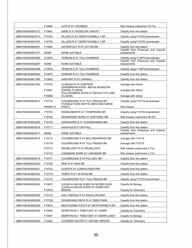
60
F10685 LACK R AT CRONEEN Risk Assess (catchment 35.7%)
GBNI1NW363601072 F10661 ERNE R AT ROSSCOR VIADUCT Classify from this station
GBNI1NW363601073 F10750 SILLEES R AT DERRYGONNELLY BR Classify using F10750 downstream
GBNI1NW363601074 F10750 SILLEES R AT DERRYGONNELLY BR Classify using F10750 downstream
GBNI1NW363602091 F10665 WATERFOOT R AT LETTER BR Classify from this station
GBNI1NW363601077 NONE NONE SUITABLE Classify from Pressures and Impacts assessments
GBNI1NW363602088 F10679 TERMON R AT TULLYHOMMON Classify using F10679 downstream
GBNI1NW363602087 NONE NONE SUITABLE Classify from Pressures and Impacts assessments
GBNI1NW363602089 F10679 TERMON R AT TULLYHOMMON Classify using F10679 downstream
GBNI1NW363602090 F10679 TERMON R AT TULLYHOMMON Classify from this station
GBNI1NW363601080 F10663 GARVARY R AT LARKHILL Classify from this station
GBNI1NW363601084 F10744 CLADAGH R AT GORTEEN Average with others
F10907 OWENBREAN RIVER ABOVE MONASTIR GORGE (CLSD08) Average with others
F10908 POLLASUMERA RIVER AT MCNULTY'S LANE (CLSD08) Average with others
GBNI1NW363602014 F10716 COLEBROOKE R AT TULLYREAGH BR Classify using F10716 downstream
WNWFIV2 FIVEMILETOWN WWTW (NEW DISCHARGE POINT) Risk Assess
GBNI1NW363602094 F10735 SWANLINBAR R AT THOMPSONS BR Classify using F10735 downstream
F10755 DRUMERSEE BURN AT GORTORAL BR Risk Assess (catchment 36.3%)
GBNI1NW363602095 F10754 OWENGARR R AT GLASDRUMMAN BR Classify from this station
GBNI1NW363602016 F10711 AGHAVEA R AT BOYHILL Classify from this station
GBNI1NW363602017 NONE NONE SUITABLE Classify from Pressures and Impacts assessments
GBNI1NW363602018 F10715 COLEBROOKE R AT BALLINDARRAGH BR Average with F10716
F10716 COLEBROOKE R AT TULLYREAGH BR Average with F10715
F10713 DRUMLUGHT R AT DRUMLUGHT Risk Assess (catchment 2.1%)
F10712 LISNABANE BURN AT LISNABANE BR Risk Assess (catchment 2.1%)
GBNI1NW363602019 F10717 COLEBROOKE R AT POLLBOY BR Classify from this station
GBNI1NW363602020 F10705 RAW R AT RAW BR Classify from this station
GBNI1NW363602021 F10722 CLEEN R AT CORRALONGFORD Classify from this station
GBNI1NW363602022 F10718 TEMPO R AT A4 ROAD BR Classify from this station
GBNI1NW363602023 F10716 COLEBROOKE R AT TULLYREAGH BR Classify using F10716 downstream
GBNI1NW363602024 F10672 LOUGH-A-HACHE R BELOW MOORLOUGH Classify for Biology
F10919 LOUGH-A-HACHE RIVER AT DERRYANY BRIDGE Classify for Chemistry
GBNI1NW363602025 F10714 HOLLYBROOK R AT AGHALURCHER Classify from this station
GBNI1NW363602026 F10726 DRUMSHANCORICK R AT DEER PARK Classify from this station
GBNI1NW363602028 F10675 NEWTOWNBUTLER R AT NEWTOWNBUTLER Classify from this station
GBNI1NW363602029 F10903 DERRYHOOLY TRIBUTARY AT CORRY Classify for Chemistry
F10947 DERRYHOOLY TRIBUTARY AT DERRYLANEY Classify for Biology
GBNI1NW363602030 F10922 COONEEN WATER AT GROGEY BRIDGE Classify for Chemistry
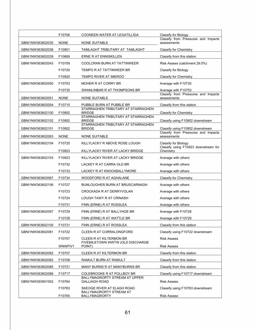
61
F10706 COONEEN WATER AT LEGATILLIDA Classify for Biology
GBNI1NW363602035 NONE NONE SUITABLE Classify from Pressures and Impacts assessments
GBNI1NW363602038 F10901 TAMLAGHT TRIBUTARY AT TAMLAGHT Classify for Chemistry
GBNI1NW363602039 F10669 ERNE R AT ENNISKILLEN Classify from this station
GBNI1NW363602043 F10709 COOLCRAN BURN AT TATTINWEER Risk Assess (catchment 29.0%)
F10720 TEMPO R AT TATTINWEER BR Classify for Biology
F10920 TEMPO RIVER AT IMEROO Classify for Chemistry
GBNI1NW363602050 F10753 MOHER R AT CORRY BR Average with F10735
F10735 SWANLINBAR R AT THOMPSONS BR Average with F10753
GBNI1NW363602051 NONE NONE SUITABLE Classify from Pressures and Impacts assessments
GBNI1NW363602054 F10710 PUBBLE BURN AT PUBBLE BR Classify from this station
GBNI1NW363602100 F10902 STARRAGHEN TRIBUTARY AT STARRAGHEN BRIDGE Classify for Chemistry
GBNI1NW363602102 F10902 STARRAGHEN TRIBUTARY AT STARRAGHEN BRIDGE Classify using F10902 downstream
GBNI1NW363602101 F10902 STARRAGHEN TRIBUTARY AT STARRAGHEN BRIDGE Classify using F10902 downstream
GBNI1NW363602063 NONE NONE SUITABLE Classify from Pressures and Impacts assessments
GBNI1NW363602104 F10725 KILLYLACKY R ABOVE ROSE LOUGH Classify for Biology
F10923 KILLYLACKY RIVER AT LACKY BRIDGE Classify using F10923 downstream for Chemistry
GBNI1NW363602103 F10923 KILLYLACKY RIVER AT LACKY BRIDGE Average with others
F10732 LACKEY R AT CARRA OLD BR Average with others
F10733 LACKEY R AT KNOCKBALLYMORE Average with others
GBNI1NW363602067 F10734 WOODFORD R AT AGHALANE Classify for Chemistry
GBNI1NW363602106 F10727 BUNLOUGHER BURN AT BRUSCARNAGH Average with others
F10723 CROCKADA R AT DERRYVOLAN Average with others
F10724 LOUGH TAWY R AT CRINASH Average with others
F10731 FINN (ERNE) R AT ROSSLEA Average with others
GBNI1NW363602097 F10729 FINN (ERNE) R AT BALLYHOE BR Average with F10728
F10728 FINN (ERNE) R AT WATTLE BR Average with F10729
GBNI1NW363602105 F10731 FINN (ERNE) R AT ROSSLEA Classify from this station
GBNI1NW363602081 F10722 CLEEN R AT CORRALONGFORD Classify using F10722 downstream
F10707 CLEEN R AT KILTERMON BR Risk Assess
WNWFIV1 FIVEMILETOWN WWTW (OLD DISCHARGE POINT) Risk Assess
GBNI1NW363602082 F10707 CLEEN R AT KILTERMON BR Classify from this station
GBNI1NW363602083 F10708 RAMULT BURN AT RAMULT Classify from this station
GBNI1NW363602085 F10721 MANY BURNS R AT MANYBURNS BR Classify from this station
GBNI1NW363602086 F10717 COLEBROOKE R AT POLLBOY BR Classify using F10717 downstream
GBNI1NW393901002 F10764 BALLYMAGRORTY STREAM AT UPPER GALLIAGH ROAD Risk Assess
F10763 SKEOGE RIVER AT ELAGH ROAD Classify using F10763 downstream
F10765 BALLYMAGRORTY STREAM AT BALLYMAGRORTY Risk Assess
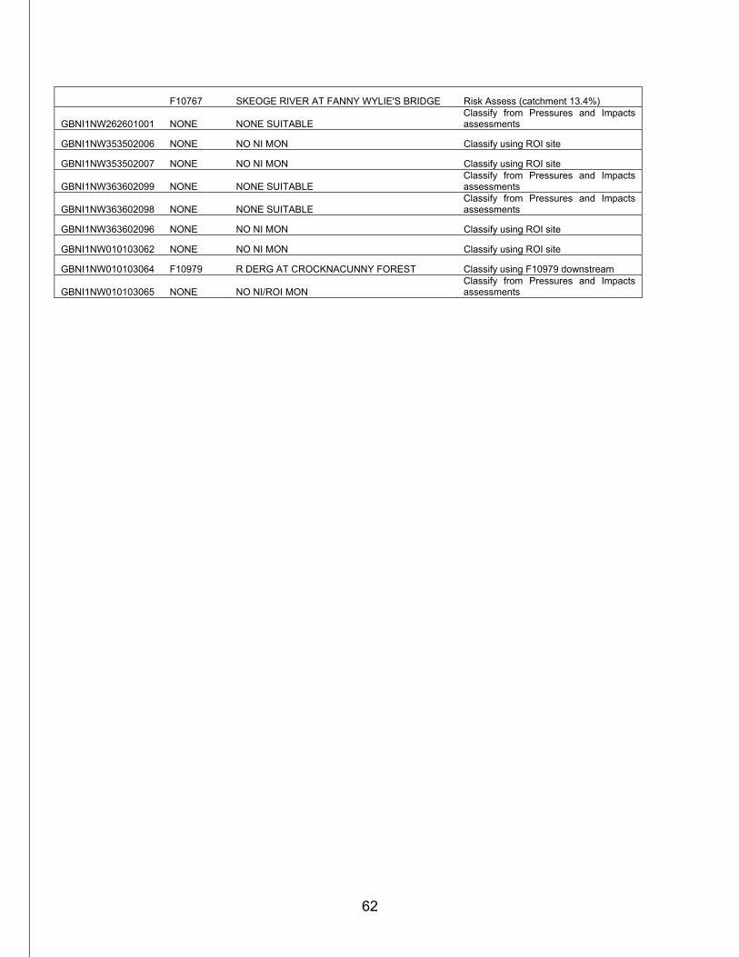
62
F10767 SKEOGE RIVER AT FANNY WYLIE'S BRIDGE Risk Assess (catchment 13.4%)
GBNI1NW262601001 NONE NONE SUITABLE Classify from Pressures and Impacts assessments
GBNI1NW353502006 NONE NO NI MON Classify using ROI site
GBNI1NW353502007 NONE NO NI MON Classify using ROI site
GBNI1NW363602099 NONE NONE SUITABLE Classify from Pressures and Impacts assessments
GBNI1NW363602098 NONE NONE SUITABLE Classify from Pressures and Impacts assessments
GBNI1NW363602096 NONE NO NI MON Classify using ROI site
GBNI1NW010103062 NONE NO NI MON Classify using ROI site
GBNI1NW010103064 F10979 R DERG AT CROCKNACUNNY FOREST Classify using F10979 downstream
GBNI1NW010103065 NONE NO NI/ROI MON Classify from Pressures and Impacts assessments